the status and distribution of green peafowl pavo muticus...
TRANSCRIPT
The Status and Distributionof Green Peafowl Pavo muticus in Dak Lak
Province, Vietnam
by
Nicholas BrickleBirdLife International - Vietnam Programme
Nguyen CuBirdLife International - Vietnam Programme
seconded fromInstitute of Ecology and Biological Resources - Hanoi
and
Ha Quy Quynh, Nguyen Thai Tu Cuong and Hoang Van San
Funded byDanida
This report constitutes the technical annex to the project entitled:Institutional Strengthening of the Institute of Ecology and
Biological Resources including field training in conservationassessment techniques.
Hanoi, 1998
Project Leaders:Nicholas BrickleNguyen Cu
Field Survey Team:Nicholas Brickle (BirdLife International)Nguyen Cu (BirdLife International, seconded from IEBR)Ha Quy Quynh (IEBR)Nguyen Thai Tu Cuong (IEBR)Hoang Van San (DOSTE - Dak Lak)Jonathan Eames (BirdLife International)
Maps:Remote Sensing - Ecology Department, IEBRHa Quy Quynh (IEBR)Tran Thanh Tung (IEBR)
Project funding:Danida
Cover illustration:Green Peafowl from Beebe (1922)
Citation:Brickle, N. W., Nguyen Cu, Ha Quy Quynh, Nguyen Thai Tu Cuong andHoang Van San (1998) The Status and Distribution of Green Peafowl Pavomuticus in Dak Lak Province, Vietnam. BirdLife International - VietnamProgramme, Hanoi, Vietnam
Copies available from:BirdLife InternationalVietnam Programme293B Tay Son, Dong DaHanoi, Vietnam
Tel/Fax: + (84) 4 851 7217E-mail: [email protected]
Copyright:BirdLife International, August 1998
i
Table of contentsi Summary iv
ii Summary of recommendations vii.i High priority issues vii.ii Medium term issues vi
iii Acknowledgements vii
iv Conventions and abbreviations used viii
1 Background - The Green Peafowl 11.1 Global status and distribution 11.2 Status and distribution - Vietnam 11.3 Ecology and habitat use 31.4 Conservation of Green Peafowl 3
2 Background - Dak Lak Province 52.1 General topography and climate 52.2 Habitat 52.3 Human distribution 62.4 Notable fauna and previous biological survey work 6
3 Aims of the survey 8
4 Methods 94.1 Survey methods 94.2 Other bird and mammal species 104.3 Identification of sites and access 104.4 Statistical analysis 11
5 Site descriptions 12
6 Results 136.1 General 136.2 Status by site 136.3 Habitat use 146.3.1 Data analysis 146.3.2 Limitations 156.4 Relative abundance and predicted distribution 176.5 Other bird and mammal species recorded 206.5.1 Birds 206.5.2 Mammals 21
7 Discussion 237.1 Status and distribution 237.2 Habitat use 237.3 Relative abundance and predicted distribution 257.4 Other bird and mammal species 26
ii
8 Key measures for conservation 288.1 Conservation of Green Peafowl 288.2 Key areas for Green Peafowl in Dak Lak 298.3 Other bird and mammal species 31
9 Recommendations for action - High priority 329.1 Protected areas - expansion of Yok Don National Park 329.2 Management recommendations 349.2.1 Planning 349.2.2 Forestry 359.3 Further survey work 359.3.1 Survey in Gia Lai and Kon Tum Provinces 359.3.2 Surveys within Cambodia 35
10 Recommendations for action - Medium term 3610.1 Protected area development 3610.1.1 New reserve establisment in Ea So (Ea Kar District) 3610.1.2 Reserve development in Cambodia 3610.1.3 Protected area in southern Gia Lai 3610.2 Management recommendations 3610.2.1 Reserve management 3610.2.2 Border regions 3710.2.3 Conservation awareness 3710.3 Further survey work 3710.3.1 Monitor Green Peafowl status 3710.3.2 Wet season survey 37
References 38
Appendices1 Site locations 482 Green Peafowl records 493 Bird species recorded during the survey 504 Mammal species recorded during the survey 555 Yok Don National Park proposed extensions 56
List of Maps1 Location of Dak Lak in Vietnam, showing major locations referred to
in the text 402 Forest cover in Dak Lak (1996) 413 Human density by district (1996) 424 Location of survey sites showing main rivers 435 Predicted dry season relative density of Green Peafowl in Dak Lak 446 Predicted wet season relative density of Green Peafowl in Dak Lak 457 Details of north-west Dak Lak showing proposed Yok Don
National Park extensions 468 Yok Don National Park extension details 47

iii
List of Tables
1 Key characteristics of survey sites 122 Green Peafowl presence by site 133 Green Peafowl by habitat 194 Area of important habitats in Dak Lak in the dry season (km2) 195 Area of important habitats in Dak Lak in the wet season (km2) 196 Predicted percentages of Green Peafowl in Dak Lak by habitat 20
iv
i Summary
• This report presents the results of a survey of Green Peafowl in Dak Lak Province, conductedbetween 2 February and 4 May 1998.
• The Green Peafowl has undergone a massive decline across its former range. In Vietnam GreenPeafowl has gone from being widespread across the country at the turn of the century to beingknown only from two provinces: Dak Lak and Dong Nai.
• Green Peafowl are typically found in open forest near water. They are threatened by habitatdestruction and hunting by humans, for food, eggs, feathers and the wild bird trade.
• Dak Lak still contains large areas of forest, particularly open dry deciduous forest. The provinceis however targeted for massive industrial and agricultural development and has the highestimmigration rate of any province in Vietnam.
• This project aimed to survey Green Peafowl in Dak Lak, to determine their status and distribution,and to investigate their habitat use. A methodology based on two-hour morning and eveningpoint counts was employed.
• 26 sites were visited and Green Peafowl were recorded at 13 of them. A minimum of 187 birdswas found. The majority of records were from the north-west of Dak Lak, comprising thedistricts of Ea Sup, Ea H’Leo, Buon Don, Cu Jut, Dak Mil and Cu M’Gar.
• Analysis of habitat use showed that Green Peafowl were recorded in the largest numbers in drydeciduous forest, followed by mixed and then evergreen forest. Green Peafowl numbers werepositively related to the presence of permanent water within 2 km and negatively related to thepresence of human settlement within 2 km.
• Based on analysis of habitat-use a prediction for the distribution of Green Peafowl in the wholeof Dak Lak was made. This predicted that although dry deciduous forest within 2 km of waterand greater than 2 km from people only occupied around 3% of the land area, it was predictedto hold nearly 40 % of the Green Peafowl in Dak Lak.
• The results conclude that large, undisturbed areas of dry deciduous forest with access to permanentwater are essential for Green Peafowl. This habitat is of major importance to large mammalspecies, including wild cattle, as well as several endangered large waterbirds and raptors.
• The conservation of Green Peafowl, and by consequence the conservation of several otherthreatened large mammal and bird species, will involve protection of large, continuous blocksof dry deciduous forest with undisturbed access to permanent water.
• The most important areas of Dak Lak for suitable Green Peafowl habitat are found in thedistricts of Ea Sup, Ea H’Leo, Buon Don, Cu M’Gar, Cu Jut, Dak Mil and Ea Kar. Of vitalimportance are the presently undisturbed permanent forest rivers and streams within thesedistricts including the Ea H’Leo, Ea Khal, Ea Wy, Ya Lop, Dak Dam, Dak Rue, Ea Rok and theSerepok.
v
ii Summary of Recommendations
Recommendations made by this survey are divided into high priority issues and medium term(lower priority) issues. The full text of the recommendations is found in the report text Sections9 and 10.
ii.i High priority issues
ii.i.i Protected areas - Expansion of Yok Don National Park
The expansion scheme proposed by Yok Don National Park authority (1998) as well as threefurther expansion schemes are detailed, and it is recommended that all be immediatelyimplemented.
Plan A, B
Northwards extension through Ea Sup to the Gia Lai provincial border, enclosing a large area ofdry deciduous forest and completely enclosing large sections of the Serepok, Dak Rue, Ea H’Leoand Ya Lop rivers. This extension is predicted to increase the number of Green Peafowl protectedby Yok Don National Park from 11% to 34% of the provincial total, while providing an excellentrefuge for large mammal species.
Plan C
Southwards extension of Yok Don National Park through Cu Jut and Dak Mil. This extensionwould cover much of the dry deciduous forest in the border regions south of Yok Don whileenclosing much of the catchment for rivers and streams flowing north into Yok Don NationalPark, including Dak Dam and Dak Klau. As well as protecting Green Peafowl this extensionwould benefit some other important mammal and bird species recorded here including Tiger,Leopard and White-winged Duck.
Plan D
A huge expansion is proposed to extend over much of eastern Ea Sup and western Ea H’Leo. Thisextension would enclose large areas of dry deciduous forest as well as large areas of mixed forestand areas currently designated as watershed protection forest. This area is predicted to hold 22%of the Green Peafowl in Dak Lak.
ii.i.ii Management Recommendations
Planning issues
Strategic plans should be made and implemented to control the spread of people and agriculturalareas within Dak Lak Province. Settlement of people into areas identified as important for wildlifeshould be prevented. Specifically with reference to this study, this includes along the rivers EaH’Leo, Ya Lop, Serepok, Ea Wy, Ea Hiao, Dak Rue, Dak Ken, Dak Dam and Ea Khal. This landis of exceptional value for wildlife.
vi
Forestry management
Forestry concessions within the dry deciduous forest should be recognized for their highbiodiversity. Forestry compartments should be effectively policed to prevent illegal use outside oflogging periods. Notably: grazing, firewood collection, illegal logging, hunting, fishing and illegalsettlement. Access should be strictly controlled.
ii.i.iii Further survey work
Surveys in eastern Cambodia for Green Peafowl (and large mammals)
All the important deciduous forest areas in Dak Lak adjoin the Cambodian border and there islikely to be a free flow of animals in both directions. Surveys should be conducted in the Cambodianprovinces of Mondulkiri and Ratanakiri with a view to expanding the protected area systemthere.
Surveys in Gai Lai and Kon Tum for Green Peafowl (and large mammals)
To investigate the suitability of habitat and the extent of Green Peafowl in Gia Lai and Kon TumProvinces. These provinces formerly held Green Peafowl, and areas of apparently suitable deciduousforest appear to remain. The survey should be carried out during the dry season using amethodology similar to that used in this survey.
ii.ii Medium term issues
ii.ii.i Protected area development
• Reserve establishment in Ea So, Ea Kar district. The area is of importance for wild cattle aswell as Green Peafowl.
• Reserve development in south Gia Lai. The deciduous forest areas of south Gia Lai that forma continuous block with areas in Dak Lak should be protected.
• Reserve development in Cambodia. Important areas adjoining the Vietnamese border shouldbe included in the protected area system to form a large cross-border reserve.
ii.ii.ii Management recommendations
• Management of border regions. Further restriction of access and use of the border guards inforest protection.
• Conservation awareness. Increasing the awareness of the importance of deciduous forest andthe unique fauna living in it.
ii.ii.iii Further survey work
• Monitoring numbers. Repeat surveys of Green Peafowl to record continuing status.
• Wet season surveys. To investigate the habitat requirements and distribution of Green Peafowlduring the rainy season. To assess the importance of temporary water sources.
vii
iii Acknowledgements
This report comprises the technical annex to the final report of the Danida funded project entitled“Institutional Strengthening of the Institute of Ecology and Biological Resources including fieldtraining in conservation techniques”.
This project was sponsored by Danida through the Royal Danish Embassy in Hanoi. We extendour grateful thanks to them for supporting our work.
We also thank the many people and organisations that helped us during the fieldwork in DakLak Province and while working in Hanoi. In Dak Lak we express our gratitude to the ProvincialPeople’s Committee, the People’s Committees of connected districts, the Provincial PoliceDepartment, the Border Headquarters and connected guard stations. Thanks also go to the ForestProtection Departments of the districts, and the staff of the Forest Enterprises and Sub-Enterpriseswhere fieldwork was conducted. Special thanks are due to Mr Nguyen Huu Tri, Director of DakLak Department of Science, Technology and the Environment and Mr Pham Ngoc Danh, Headof the Environmental Management Section for their assistance and help throughout our time inDak Lak.
In Hanoi, we would like to thank Prof. Dr Cao Van Sung, Director of the Institute of Ecologyand Biological Resources. This report was peer reviewed by Dr Frank Lambert, Dr WilliamDuckworth, Dr Philip McGowan, Frank Rozendaal and Dr David Harper. This report was copy-edited and proof read by Dr William Duckworth.
We would also like to extend our thanks to Dansk Ornitologisk Forening - BirdLife Denmark, andparticularly Anita Pedersen (International Officer), the DOF International Committee and DOFDirector Claus Oppermann, for endorsing this project.
viii
iv Conventions and abbreviations used
Bird names (common and scientific), sequence and species limits follow Inskipp et al. (1996).Scientific names are given at first mention and in Appendix 3.
Mammal names (scientific), sequence and species limits follow Corbet and Hill (1992). Scientificnames are given at first mention and in Appendix 4.
Diacritical marks are omitted from proper names in Vietnamese due to typographical limitationsand the restricted understanding of the international readership.
Locality names follow the Department of Cartography 1:50,000 series maps (1993).
Indochina is used to refer to the biogeographical region including the countries of Vietnam,Cambodia, Laos, Thailand and Myanmar.
Abbreviations and Acronyms used:
a.s.l. above sea levelDOSTE Department of Science, Technology and the EnvironmentDPI Department of Planning and InvestmentFIPI Forest Inventory and Planning Institute, HanoiFPD Forest Protection DepartmentIEBR Institute of Ecology and Biological Resources, HanoiMARD Ministry of Agriculture and Rural DevelopmentMOD Ministry of DefenceMPI Ministry of Planning and InvestmentNGO Non-Governmental Organizations.f. significant figures
1
1 Background - The Green Peafowl
1.1 Global status and distribution
The Green Peafowl Pavo muticus was formerly widespread across much of South-East Asia. At the turnof the century it was resident in north-east India, Bangladesh, Myanmar, Thailand, Malaysia (west),Indonesia (Java), Cambodia, Laos, Vietnam, and southern China (Delacour 1977). In the last fewdecades however, the species has undergone a massive decline and a recent review of status paints ableak picture (McGowan et al. in press). This decline has led to the conservation of the species beingconsidered as one of the highest action priorities by the Pheasant Specialist Group of the World PheasantAssociation, the Species Survival Commission and BirdLife International. Current status assessmentsconsider the species ‘Vulnerable’ (Collar et al. 1994) and ‘Endangered’ (McGowan and Garson 1995).
Information on the current status of Green Peafowl across its historical range is patchy. In north-eastIndia and Bangladesh some recent unconfirmed sightings have been made but there have been nosystematic surveys. Green Peafowl is now considered to be absent from most former sites in the region(McGowan et al. in press). In Thailand, the species is now only known from one location near theMyanmar border, Huai Kha Khaeng Wildlife Sanctuary (Round 1983, Stewart-Cox and Quinnell1990), while the situation in Myanmar itself is largely unknown. Green Peafowl has already becomeextinct from peninsular Malaysia (Davison and Scriven 1987): the last birds were recorded around1960 (Medway and Wells 1976). The somewhat isolated population that exists in Java (Indonesia) isstill relatively widespread, although many local populations are very small (van Balen et al. 1995).
The largest populations of Green Peafowl are thought to remain in eastern Indochina (Cambodia, Laosand Vietnam). At the turn of the century the species was widespread and common across the region.Delacour and Jabouille (1925b) noted that “The peafowl is, with the Red Junglefowl [ Gallus gallus],the commonest game-bird in Indo-China. It is found over the five states of the Union - from Tonkin toCambodia, in Annam, Laos and Cochinchina.” Information on current status again is patchy, but it isclear that a similar statement could not be made today.
Fieldwork carried out in Laos since 1988 has found evidence of small populations of birds at severalsites. Larger numbers may survive only at a few locations and a large decline has clearly occurred (Evansand Timmins 1996). The situation in Cambodia is not clear. Recent surveys in the east of the countrydid however record Green Peafowl at several locations (Desai and Lic Vuthy 1996). Large areas ofsuitable habitat remain in Cambodia and it is possible that further fieldwork may reveal large numbers(McGowan et al. in press).
1.2 Status and distribution - Vietnam
In Vietnam, at the turn of the century, Green Peafowl were present in all regions except those dominatedby wet rice cultivation (Delacour and Jabouille 1925a, Vo Quy 1975). Since then the Green Peafowlhas undergone a massive range contraction to its present-day distribution (Le Trong Trai 1996). Thisrange contraction has been particularly marked in the last 30 years.
Between 1962 and 1973, avifaunal surveys were made in the north of the country and Green Peafowlwas recorded in six provinces: Lai Chau, Son La, Hoa Binh, Nghe An, Ha Tinh and Quang Binh(Dang Huy Huynh et al. 1974). Since 1975 Green Peafowl have only been recorded at one locationwithin these provinces: Muong Nhe Nature Reserve in Lai Chau Province in 1991 (Cox et al. 1992).
Section 1 - Background - The Green Peafowl
2
There have been no more recent sightings and it seems likely that Green Peafowl is now extinct in mostof these northern regions. Many areas however have not been adequately surveyed since 1975 and it ispossible that some birds may still survive along the Laos-Vietnam border in Lai Chau and Son Laprovinces (Le Trong Trai 1997).
Recent records from central Vietnam are restricted to a report by villagers of birds in Ba Long Valley,Quang Tri Province in 1991 and a single sighting near Bach Ma National Park in Thua Thien HueProvince in 1990 (Robson et al. 1991). The Ba Long Valley has not been re-visited by ornithologistsbut no further records have been made at Bach Ma despite survey work and it is possible that GreenPeafowl is now also extinct or nearly extinct in these central provinces.
The greatest potential for surviving populations is in the ‘Western Highlands’ (Tay Nguyen Plateau) ofsouth-central Vietnam and in some of the lowland regions further south. Avifaunal surveys conductedbetween 1976 and 1980 in the western highland provinces of Dak Lak, Gia Lai, Kon Tum and LamDong recorded the presence of Green Peafowl in all four provinces (Truong Van La and Nguyen Cu1981). Subsequently Green Peafowl were recorded again in Kon Tum, at Mom Ray Nature Reserve in1984/5 (Do Tuoc and Ngo Tu 1985) and in Dak Lak at Yok Don National Park in 1989 (Laurie et al.1989). In Yok Don National Park at this time Green Peafowl was said to be commonly seen and heard.In provinces adjacent to the Tay Nguyen Plateau, Green Peafowl have been recorded at Bu Gia MapNature Reserve in Binh Phuoc Province (Anon. 1989) and in 1989/90 at Cat Tien National Park inDong Nai Province. At this time it was estimated that up to 17 calling males were present in a c.13 km2
area of the park (Robson et al. 1991).
Since 1991 the continuing presence of Green Peafowl in Vietnam has only been confirmed at Cat TienNational Park (J. C. Eames pers. comm., Atkins and Tentij pers. comm.) and in Dak Lak Province atfour sites including Yok Don National Park (Le Xuan Canh et al. 1997). Recent unconfirmed reportshave also been made from Mom Ray Nature Reserve (Kon Tum Province) and Bu Gia Map NatureReserve (Binh Phuc Province).
In 1997 fieldwork confirmed that Green Peafowl were still present in small numbers in at least threelocations in Cat Tien National Park (J. C. Eames pers. comm., Atkins and Tentij pers. comm.). Thispopulation has become increasingly isolated however, as much of the area surrounding Cat Tien NationalPark has become seriously degraded, or been converted to agriculture.
Survey work in Dak Lak, also from 1997 (Le Xuan Canh et al. 1997), recorded Green Peafowl at fourlocations. Green Peafowl were recorded despite the fact that this survey was not aimed at birds and wasmade in the wet season when peafowl are less likely to call and so consequently become far moredifficult to record (see Methods). In Yok Don National Park a single bird was seen, and cast featherswere found at two other locations in the park. A sighting, cast feathers and / or footprints were recordedat two sites north of Yok Don National Park, in Ea Sup district. Villages reported the bird at a furthersite in Ea Kar district in the north-east of Dak Lak province.
This spectacular reduction in the Green Peafowl’s distribution in Vietnam from being countrywide toonly being known from two areas since 1991 may not be a complete picture. In particular, large areas ofWestern Highlands have remained unvisited since the 1976-1980 surveys (Truong Van La and NguyenCu 1981) and many parts of the highlands, Dak Lak in particular, still retain much forest (see Section2.2). Although, as mentioned above, much of the area around Cat Tien National Park has becomedegraded or converted to agriculture, the same is not true of Yok Don National Park. The park formspart of a near continuous block of lowland forest extending north into Ea Sup district, south in Cu Jutand Dak Mil district and west into Cambodia. In 1997 Yok Don National Park guards reported GreenPeafowl still present in good numbers in the park, despite the low number recorded during the visit
Section 1 - Background - The Green Peafowl
3
made by Le Xuan Canh et al. (1997). If Green Peafowl remain in good numbers in Yok Don NationalPark, the same may be true of the adjacent areas. Surveying these areas of Dak Lak was identified as akey priority for future work by both Le Trong Trai (1996) and by McGowan et al. (in press).
1.3 Ecology and habitat use
Present knowledge on the ecology and behaviour of Green Peafowl is somewhat limited. Hoogerwerf(1970) observed that birds were most attracted to pastures and park-like surroundings of light or openforest and to forest fringes, noting that birds would penetrate further into the forest if the presence offood or water made it necessary. This need for fresh water was also highlighted by Delacour (1977)describing the habitat of Green Peafowl as wide meandering rivers fringed by park-like areas where longgrass was dotted with trees and forest patches. Johnsgard (1986) also considered good and plentifulsupplies of water to be indispensable.
Recent work on Green Peafowl, particularly in Indochina, has frequently highlighted an apparentpreference for open forest and river valleys. At the only remaining site in Thailand for Green Peafowl,Huai Kha Khaeng Wildlife Sanctuary, birds are found along the length of the Huai Kha Khaeng riverwhich is shallow, sandy bottomed with grassy banks and surrounded by open deciduous forest on bothsides (Round 1983, Stewart-Cox and Quinnell 1990). In Laos, Green Peafowl were most often recordedin areas of open dry deciduous forest, however in many areas rivers were said to dry up outside the rainyseason and the only water sources then were temporary pools (Evans and Timmins 1996).
In Java the situation seems a little different: several Green Peafowl concentrations are in areas of openforest and park-like areas created by cattle grazing, but birds are also frequently recorded in teak andeven rubber plantations, particularly if they are adjacent to suitable natural habitat (van Balen et al.1995). Birds in two main sites do not appear to have year-round access to water and so seem not to havethe high dependence on water mentioned by other authors (van Balen et al. 1995).
Some authors have commented on an apparent preference birds show for low altitudes. The majority ofrecords are from the lowlands (0-500 m), however Green Peafowl have been recorded up to 3,000 m inJava (van Balen et al. 1995). Any apparent preference for lowlands may well be a secondary result ofhabitat preference.
Recent records of Green Peafowl from Vietnam (post-1991) have been from open forest areas, eitherdry deciduous forest or mixed forest, and typically along river valleys. Historical records of GreenPeafowl in Vietnam have also been from lowland and montane evergreen forest as well as areas dominatedby bamboo (Nguyen Cu pers. obs.).
Further work to determine habitat preferences more accurately, in order to investigate possible limitingfactors such as water availability, are vital to developing a conservation strategy for the species. Thispoint is made directly in recommendations for future action for the species by McGowan et al. (inpress).
1.4 Conservation of Green Peafowl
The biggest threats to Green Peafowl across their range are considered to be from habitat loss and directhuman exploitation by hunting birds for food and trade. Threats to Green Peafowl are discussed atlength in McGowan and Garson (1995) and McGowan et al. (in press).
Section 1 - Background - The Green Peafowl
4
The apparent preference birds show for lowland riverine forest and adjacent open forest often bringsthem into direct competition with humans for habitat. These areas are frequently the first areas to becleared by newly arriving people, a fact that has led to a distinct scarcity of this habitat across heavilypopulated regions of South-East Asia.
Direct exploitation by people has been attributed as the main reason for the decline or extinction ofbirds from remaining suitable habitat. In Malaysia, the eventual extinction from what was already adepleted habitat type was attributed to hunting. In Thailand the loss of Green Peafowl over almost theentire country has similarly been attributed to human persecution (Round 1988). Human exploitationof Green Peafowl can take the form of hunting for food, for the captive bird trade (adults, young andeggs) and, especially in Java, China, Laos and Thailand, for the trophy/ornament trade (McGowan etal. in press).
5
2 Background - Dak Lak Province
2.1 General topography and climate
Dak Lak Province lies on the Tay Nguyen Plateau (see Map 1) and is the largest province in Vietnam,covering 19,800 km2. Despite being considered part of the ‘western highlands’, much of it lies between200 m and 400 m above sea level (a.s.l.). Dak Lak Province forms a large basin, bordered to the northby the Annamite Mountains, to the east by the coastal ranges, and to the south by the Da Lat Plateau.In the south the land rises to Vietnam’s third highest mountain, Chu Yang Sin (2,405 m).
Most of the rivers in Dak Lak drain west into Cambodia. The largest river is the Serepok, which is fedby the Krong No and Krong Ana rivers which drain much of the south and east of the provincerespectively. Other smaller rivers such as Ea H’leo, Ea Khal, Ea Wy drain northern parts. These smallerrivers join with the Serepok in Cambodia, the Serepok in turn then joins the Mekong River. The mainrivers in Dak Lak are shown on Map 4.
In the lower altitude parts of Dak Lak rainfall is relatively low and very seasonal. A distinct dry seasonruns from November to April and annual rainfall is less than 1,600 mm/year (MPI et al. 1996). Manyof the smaller rivers dry up completely outside of the rainy season. Rainfall increases with altitude andthe mountain regions receive over 2,400 mm/year (MPI et al. 1996).
2.2 Habitat
Dak Lak still remains one of the most forested provinces of Vietnam. In 1996 the area of forest of alltypes (including plantation) was estimated at 12,232 km2 (MPI et al. 1996). Forest cover in 1996 isshown in Map 2, prepared by the Remote Sensing - Ecology Department of IEBR (1998).
Of the total forested area, 3,511 km2 is dry deciduous forest. This area represents 34% of the total areaof dry deciduous forest in Vietnam (Dang Huy Huynh et al. 1995). This type of forest occurs in otherprovinces on the Tay Nguyen Plateau but by far the largest area exists in Dak Lak.
Dry deciduous forest occurs in lowland areas with low rainfall; leaves are dropped in response to thedrought imposed by the long dry season. Within these deciduous forests, along watercourses smallareas of lowland evergreen forest are supported. These strips of riverine forest represent one of the mostthreatened habitats in South-East Asia. Several rivers within the main deciduous forest areas of Dak Lakstill support good undisturbed areas of riverine forest, particularly the Serepok, Ea H’Leo, Ya Lop andDak Dam. Fires are frequent within the deciduous forest regions and possibly even maintain the climaxvegetation, since most of the tree species present are largely fire resistant. However with the increase inhuman activity in the area, the frequency of fires is likely to have increased dramatically, and the impactof this is little known.
The remaining forested area of the province is predominantly mixed forest and evergreen forest. Muchof the original mixed forest at medium altitudes has been cleared for agriculture as the soil is of verygood quality and the climate is suitable, with higher rainfall than the lowlands. Evergreen and montaneforest remains in higher altitude regions, particularly in the south and east of Dak Lak. Some evergreenforest areas are still quite extensive such as around Chu Yang Sin. Large areas of forest interspersed withgrass and scrub are also present in Dak Lak.
Logging activity has been widespread in Dak Lak and very few areas of primary forest remain. A total of
Section 2 - Background - Dak Lak Province
6
6.8 million m3 of timber were removed from the whole Tay Nguyen plateau between 1976 and 1996,a large proportion of this from Dak Lak (MPI et al. 1996). Most commercial logging has however beenselective, although increasingly it seems that clear felling with subsequent conversion of the land toagriculture is more typical.
2.3 Human distribution
Dak Lak Province has a human population estimated in 1995 to be 1,242,000 (Anon. 1997) and dueto the large size of the province this results in a low human density (61 people/ km2) in comparisonwith most other Vietnamese provinces.
The human population in Dak Lak is not equally distributed across the province; human density variesconsiderably between districts. The district of Ea Sup for example has a density estimated in 1996 to beonly 13.2 people per km2. This makes it among the lowest in Vietnam. The district of Krong Ana bycontrast has a density estimated at 243.7 people per km2, a relatively high figure for an almost entirelyrural district (Anon. 1997). Human density estimated in 1996 is shown for each district in Map 3. Thisclearly shows the uneven distribution of people across the province with a concentration of people inthe central and eastern districts.
Dak Lak is targeted within Vietnam for economic expansion and this has fuelled a very high immigrationrate from other provinces. Between 1979 and 1989 Dak Lak had the highest immigration of anyprovince in Vietnam. The immigration continues, including many people arriving on government-sponsored programmes. In 1990, the population of Dak Lak was estimated at 1,026,000 people, by1995 it had risen to 1,242,000 people and it is predicted to rise by the year 2000 to 1,441,000 people(Anon. 1994).
Another driving force behind the immigration is the quality of much of the province for agriculture.The last 20 years have seen a dramatic rise in the area of the province under agriculture. The present dayfigure of 2,308 km2 is predicted to rise to 3,600 km2 in the year 2000 and to 4,820 km2 by the year2010 (Anon. 1994). Much of this increased acreage is projected to be coffee, rubber, tea, cashew,peanuts, rice and maize.
The province is also targeted for industrial development, with expansion anticipated in hydro-electricpower generation, metal processing, chemical manufacture, wood processing and construction materials.Targets proposed are aiming for a 250 % increase in gross domestic product (GDP) from heavy industry,and a 150 % increase in GDP from agriculture and forestry between 1993 and 2000 (Anon. 1994).
It seems little account has been taken of the environmental impact of the proposed development. Fewstrategic plans seem to have been made to ensure a sustainable use of resources as the human populationgrows and industrial and agricultural expansion continues.
2.4 Notable fauna and previous biological survey work
Much of the biological survey work in Dak Lak has centred on the dry deciduous forest regions. Theseforests are considered nationally and globally important for their populations of large mammals,particularly wild cattle and wild Asian Elephants Elephas maximus.
Of the wild cattle species, Gaur Bos gaurus and Banteng B. javanicus still survive in relatively large
Section 2 - Background - Dak Lak Province
7
numbers and both were recorded extensively by a recent survey (Le Xuan Canh et al. 1997). Reportsalso exist of wild Asian Buffalo Bubalus arnee and of Kouprey Bos sauveli. Both of these may still existbut neither was positively recorded during the survey, and reports by locals remain unsubstantiated (LeXuan Canh 1997). The adjacent dry deciduous forest regions of Cambodia were known historically tosupport all four species (Desai and Lic Vuthy 1996) and so hope still remains that all are present in DakLak. Other mammal species of note recorded within the deciduous forest regions of Dak Lak includeAsian Elephant, Asian Golden Cat Catopuma temmincki, Leopard Panthera pardus, Tiger P. tigris, DholeCuon alpinus and Eld’s Deer Cervus eldi. An extensive review of the large mammal records from DakLak is made by Le Xuan Canh et al. (1997).
Little ornithological survey work has been carried out other than work centred within Yok Don or thepioneering collecting surveys made by Trung Van La and Nguyen Cu (1981). Birds were howeverrecorded during the mammal surveys made by Laurie et al. (1989) and Le Xuan Canh et al. (1997). Thelowland dry deciduous forest regions still support several large waterbirds including Woolly-neckedStork Ciconia episcopus, Lesser Adjutant Leptoptilos javanicus, Masked Finfoot Heliopais personata, andpossibly Black Ibis Pseudibis papillosa davisoni and Giant Ibis P. gigantea. Also in the lowlands severallarge declining raptor species remain including Red-headed Vulture Sarcogyps calvus, White-rumpedVulture Gyps bengalensis and fish eagles Ichthyophaga spp.
The mountainous regions to the south and east of Dak Lak support numerous restricted range andendangered bird species. Chu Yang Sin lies within the Da Lat Plateau Endemic Bird Area (Stattersfieldet al. 1998).
8
3 Aims of the survey
The survey aimed to:
• Investigate the range and status of Green Peafowl in Dak Lak Province
• Investigate habitat use and limiting factors
• Estimate relative density between key habitat types
• Predict the distribution of Green Peafowl across Dak Lak and estimate the population.
• Identify key areas for Green Peafowl
• Identify key management considerations
• Record all bird and mammal species encountered
9
4 Methods
4.1 Survey Methods
Surveying was carried out between 1 February and 4 May 1998. This survey used Green Peafowl callsas the primary tool to investigating distribution, relative density and habitat use of the species. The callsof Green Peafowl are very loud and easily audible in good conditions at distances up to about a kilometre.Green Peafowl give a range of calls, the commonest being the so called “wail”, made predominantly, itis believed, by breeding males (Indrawan 1995). This survey was timed to take place at the period ofmaximum calling in the run-up to the breeding season when mature males are in open competition forfemales and territory. Outside of this period birds can remain very quiet.
A standardised point count methodology was used to record Green Peafowl. The method was designedto be fundamentally simple, as the majority of data were to be collected by previously untrainedfieldworkers, and to allow a large area to be covered in a minimum of time. The method also allowedanalysis on a number of levels.
Counts of two hours duration were made around sunrise (c.05h30-07h30) and dusk (c.16h30-18h30).Dusk counts were timed to extend beyond sunset. Two counts were made as the birds do not typicallycall frequently (see results). Counts were made by two observers. The compass bearing and type of callwere noted for every Green Peafowl call heard. Type of call was described to a previously agreed notationcovering the range of known calls.
At the end of a two hour recording period an estimation was made of the minimum number of callingbirds present. This was based on direction and timing of calls. For example if two calls were heard insuccession at widely differing compass bearings or distances, two birds would be assumed to be present.However if two calls in succession could not confidently be attributed to two birds, then the minimumnumber present was recorded as one. Whenever it was in doubt as to the number of birds calling, theminimum number was always assumed. This method reduces the incidence of double counting of birdswithin a recording period, but may underestimate the number of birds calling: the results are discussedin relation to this.
Sightings of Green Peafowl or their tracks were also recorded (separately) but were seldom made. Sightingsof Green Peafowl are infrequent as the birds can be very cautious. Tracks are a useful indicator ofpresence but are not very suitable for a quantitative survey (Stewart-Cox and Quinnell 1990).
Simple habitat variables were recorded at each point count. These were:
• Forest type (if present) - The broadly defined forest type at the location of the count was defined asdeciduous, evergreen or mixed depending on the dominance.
• Undergrowth type (if present) - The dominance of bamboo, grass or scrub was assessed at the countlocation on a 3 point scale (absent, present, dominant). The extent of recently burnt ground wassimilarly assessed.
• Canopy cover - A rough estimation of percentage canopy cover at the count location was made.Where an area was dominated by deciduous trees which had shed their leaves the estimate attemptedto predict cover as if the trees were in leaf.
• Distance to water - The distance to water, standing or running, was determined as far as possible from
Section 4 - Methods
10
investigating the state of rivers and streams in the survey area and estimating distance, using maps ifnecessary. Dry rivers and streams were not counted. As this survey was conducted at the end of thedry season, in a particularly dry year (an El Nino year), water found was considered to be permanent.In this way this variable was taken to be the distance to permanent water.
• Distance to human settlement - The distance to permanent human settlement was determined byinvestigation, use of maps and discussion with guides and locals.
• Presence of grazing - The presence of domesticated grazing cattle was recorded.
No more detailed habitat variables were recorded, in part because of the need for simplicity, and partlyas it was quite possible that the location of the point count may have been a considerable distance fromthe calling birds that were being recorded, a possibility that is considered in detail in Section 7.2.
Due to the large distance that Green Peafowl can be heard calling from, counts to be treated asindependent data were spaced by at least 2 km. Some deliberate repeat counts were made, but these areanalysed separately.
The location of points counts at a site was neither random nor systematic. This was not consideredlogistically possible, due to the need to cover a large number of sites, nor was it considered necessary tomeet the main aims of the survey, namely to determine presence and absence over a large an area aspossible and to investigate habitat associations. The former is best achieved by covering as many sites aspossible, the latter by collecting as many independent data as possible.
Point counts were conducted simultaneously by three teams of two people on every feasible morningand evening. In order to maintain the distance between each count site a 4X4 vehicle was used todistribute survey teams. The vehicle was used to drop people in position before light (for morningcounts) or in mid afternoon for evening counts. The use of the vehicle in this way may have introducedbias into the results as it virtually restricted surveying to areas that could be approached by vehicle.Survey teams could walk away from the drop off site but it was seldom feasible to proceed more than 1km on foot away from vehicular access. Similarly the presence of the vehicle may have caused disturbanceand affected calling activity. Results are considered in relation to these problems.
Numerous other considerations need to be made in the analysis of calling bird counts apart from thosespecifically mentioned here. These assumptions largely depend on the interpretation that is being madeof the data, and are discussed in Bibby et al. (1992), in relation to point counts generally, and in Gates(1966), Gaston (1979) and Stewart-Cox and Quinnell (1990), with reference to Galliformes in particular.In this report limitations are discussed under the relevant section of the results and within the discussionchapters.
4.2 Other bird and mammal species
All bird and mammal species seen during the survey were recorded by site. No quantitative data werecollected.
4.3 Identification of sites and access
Potential sites of interest were identified from existing forest cover maps (FIPI), topographic maps
Section 4 - Methods
11
(Department of Cartography 1:50,000 series) and land use maps (MPI et al. 1996). Potential sites werethen prioritised on the basis of their likelihood of holding Green Peafowl based on the existing knowledgeof habitat use by the species, such as forest areas, with wide rivers and few villages, and previous recordsfrom Dak Lak (see Section 1.2). Each site was visited for between 1 and 4 days. Camp-sites were madewhere suitable supply of water was available.
4.4 Statistical analysis
Statistical analysis was conducted using Excel Version 97 (Microsoft 1997) and SPSS version 7.0 (SPSSInc. 1995). Map based analysis was made using MapInfo Professional version 4.0 (MapInfo Corporation1995). Parametric statistics were used throughout as were two-tailed tests. Results were consideredsignificant if p < 0.05 and highly significant if p < 0.01. Actual significance levels for all tests are given.
12
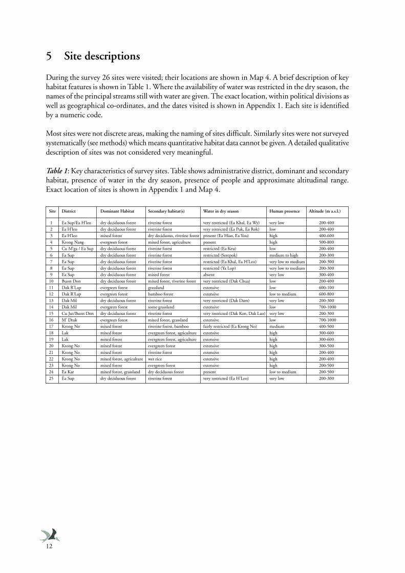
5 Site descriptions
During the survey 26 sites were visited; their locations are shown in Map 4. A brief description of keyhabitat features is shown in Table 1. Where the availability of water was restricted in the dry season, thenames of the principal streams still with water are given. The exact location, within political divisions aswell as geographical co-ordinates, and the dates visited is shown in Appendix 1. Each site is identifiedby a numeric code.
Most sites were not discrete areas, making the naming of sites difficult. Similarly sites were not surveyedsystematically (see methods) which means quantitative habitat data cannot be given. A detailed qualitativedescription of sites was not considered very meaningful.
Table 1: Key characteristics of survey sites. Table shows administrative district, dominant and secondaryhabitat, presence of water in the dry season, presence of people and approximate altitudinal range.Exact location of sites is shown in Appendix 1 and Map 4.
Site District Dominant Habitat Secondary habitat(s) Water in dry season Human presence Altitude (m a.s.l.)
1 Ea Sup/Ea H’leo dry deciduous forest riverine forest very restricted (Ea Khal, Ea Wy) very low 200-400
2 Ea H’leo dry deciduous forest riverine forest very restricted (Ea Puk, Ea Rok) low 200-400
3 Ea H’leo mixed forest dry deciduous, riverine forest present (Ea Hiao, Ea You) high 400-600
4 Krong Nang evergreen forest mixed forest, agriculture present high 500-800
5 Cu M’ga / Ea Sup dry deciduous forest riverine forest restricted (Ea Keu) low 200-400
6 Ea Sup dry deciduous forest riverine forest restricted (Serepok) medium to high 200-300
7 Ea Sup dry deciduous forest riverine forest restricted (Ea Khal, Ea H’Leo) very low to medium 200-300
8 Ea Sup dry deciduous forest riverine forest restricted (Ya Lop) very low to medium 200-300
9 Ea Sup dry deciduous forest mixed forest absent very low 300-400
10 Buon Don dry deciduous forest mixed forest, riverine forest very restricted (Dak Chua) low 200-400
11 Dak R’Lap evergreen forest grassland extensive low 600-100
12 Dak R’Lap evergreen forest bamboo forest extensive low to medium 600-800
13 Dak Mil dry deciduous forest riverine forest very restricted (Dak Dam) very low 200-300
14 Dak Mil evergreen forest some grassland extensive low 700-1000
15 Cu Jut/Buon Don dry deciduous forest riverine forest very restricted (Dak Ken, Dak Lao) very low 200-300
16 M’ Drak evergreen forest mixed forest, grassland extensive low 700-1000
17 Krong No mixed forest riverine forest, bamboo fairly restricted (Ea Krong No) medium 400-500
18 Lak mixed forest evergreen forest, agriculture extensive high 300-600
19 Lak mixed forest evergreen forest, agriculture extensive high 300-600
20 Krong No mixed forest evergreen forest extensive high 300-500
21 Krong No mixed forest riverine forest extensive high 200-400
22 Krong No mixed forest, agriculture wet rice extensive high 200-400
23 Krong No mixed forest evergreen forest extensive high 200-500
24 Ea Kar mixed forest, grassland dry deciduous forest present low to medium 200-500
25 Ea Sup dry deciduous forest riverine forest very restricted (Ea H’Leo) very low 200-300
13
6 Results
6.1 General
A total of 161 independent point counts were made at 26 sites in Dak Lak Province. Green Peafowlwere recorded at 66 counts spread across 13 sites. A total of 356 Green Peafowl contacts were maderepresenting a minimum of 187 birds. Mean number of contacts per point was 2.21 (S.E. = 0.32, range0-23), representing a mean minimum number of birds per point of 1.16 (S.E. = 0.15, range 0-7).
Analysis of data followed three approaches. The first was a simple analysis of Green Peafowl status bysite. The second was an analysis of habitat use and finally a map-based analysis was conducted topredict Green Peafowl distribution and estimate potential abundance in Dak Lak.
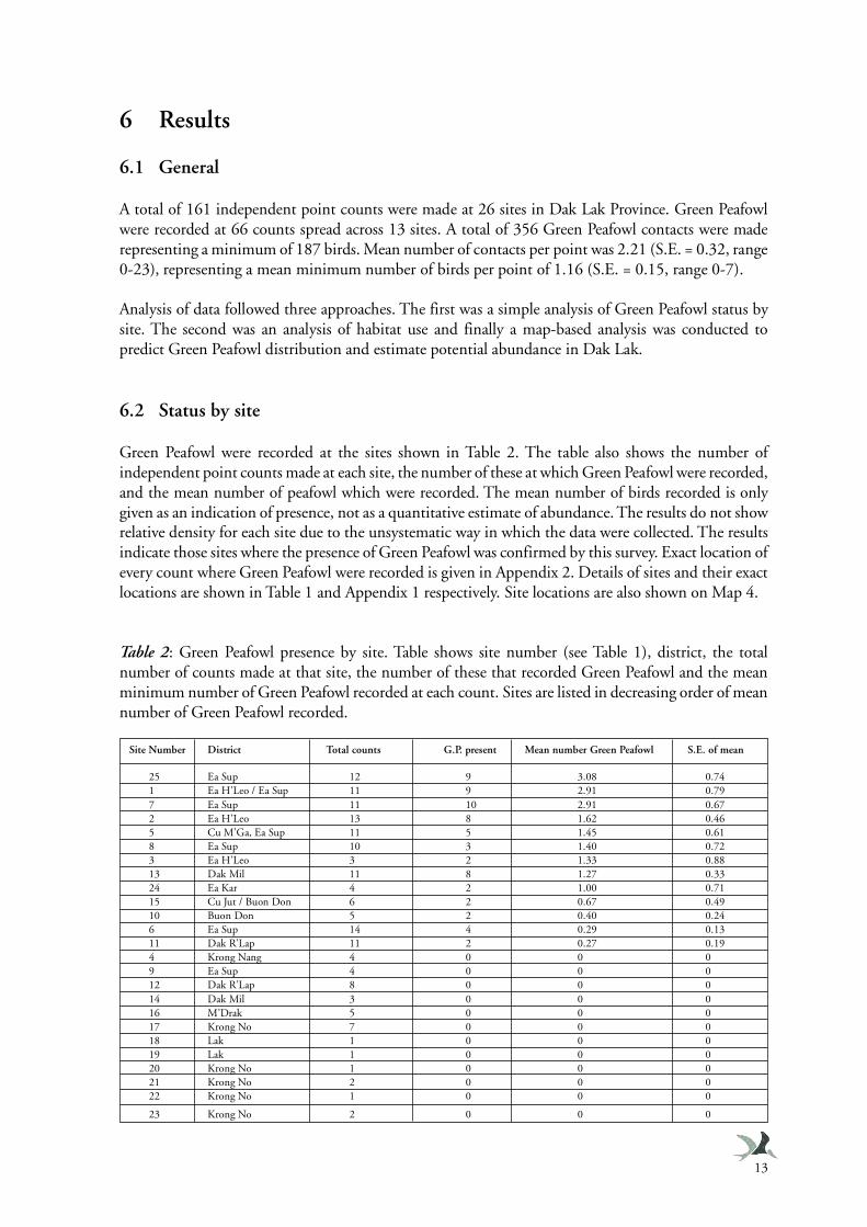
6.2 Status by site
Green Peafowl were recorded at the sites shown in Table 2. The table also shows the number ofindependent point counts made at each site, the number of these at which Green Peafowl were recorded,and the mean number of peafowl which were recorded. The mean number of birds recorded is onlygiven as an indication of presence, not as a quantitative estimate of abundance. The results do not showrelative density for each site due to the unsystematic way in which the data were collected. The resultsindicate those sites where the presence of Green Peafowl was confirmed by this survey. Exact location ofevery count where Green Peafowl were recorded is given in Appendix 2. Details of sites and their exactlocations are shown in Table 1 and Appendix 1 respectively. Site locations are also shown on Map 4.
Table 2: Green Peafowl presence by site. Table shows site number (see Table 1), district, the totalnumber of counts made at that site, the number of these that recorded Green Peafowl and the meanminimum number of Green Peafowl recorded at each count. Sites are listed in decreasing order of meannumber of Green Peafowl recorded.
Site Number District Total counts G.P. present Mean number Green Peafowl S.E. of mean
25 Ea Sup 12 9 3.08 0.741 Ea H’Leo / Ea Sup 11 9 2.91 0.797 Ea Sup 11 10 2.91 0.672 Ea H’Leo 13 8 1.62 0.465 Cu M’Ga, Ea Sup 11 5 1.45 0.618 Ea Sup 10 3 1.40 0.723 Ea H’Leo 3 2 1.33 0.8813 Dak Mil 11 8 1.27 0.3324 Ea Kar 4 2 1.00 0.7115 Cu Jut / Buon Don 6 2 0.67 0.4910 Buon Don 5 2 0.40 0.246 Ea Sup 14 4 0.29 0.1311 Dak R’Lap 11 2 0.27 0.194 Krong Nang 4 0 0 09 Ea Sup 4 0 0 012 Dak R’Lap 8 0 0 014 Dak Mil 3 0 0 016 M’Drak 5 0 0 017 Krong No 7 0 0 018 Lak 1 0 0 019 Lak 1 0 0 020 Krong No 1 0 0 021 Krong No 2 0 0 022 Krong No 1 0 0 0
23 Krong No 2 0 0 0
Section 6 - Results
14
By comparing Green Peafowl by site (Table 2) with the site descriptions (Table 1), it can be seen thatthose sites that recorded Green Peafowl were typically, but not exclusively, dry deciduous forest, oftenwith riverine forest present and a low human population. The relative importance of particular sites isdiscussed at length in Sections 7.1 and 8.2.
6.3 Habitat use
6.3.1 Data analysis
To assess the effect of different habitat variables on the minimum number of Green Peafowl present,multiple regression was used. Due to the large number of factors potentially affecting Green Peafowlnumbers it was necessary to use an analytical technique that could consider the effects simultaneously.Multiple regression (Fry 1993) is a robust tool that allows the relationship of several variables to becompared to a dependent variable at the same time. This is particularly useful when the dependentvariable is likely to be strongly influenced by more than one independent variable.
Initially three independent variables were entered simultaneously, forest type, distance to water anddistance to human settlement. These variables were chosen as it was felt during fieldwork that they maybe important. The results showed all three factors had a highly significant effect on the number ofGreen Peafowl recorded (‘forest’ b = 0.453, t = 6.452, p = 0.000; ‘distance to water’ b = -0.261, t = -3.594, p = 0.000; ‘distance to human settlement’ b = 0.183, t = 2.499, p = 0.013; Overall model R2 =0.242, F3,156 = 16.642, p = 0.000). Distance to humans showed a negative relationship with GreenPeafowl numbers while distance to water showed a positive relationship. The greatest number of GreenPeafowl were found in deciduous forest followed by mixed then evergreen.
Distance to water was the replaced by a dichotomous factor ‘presence of water within 2 km’ and distanceto humans was replaced with a dichotomous factor ‘presence of human settlement within 2 km’. Ananalogous multiple regression analysis was performed again including forest type. The results showed asignificant relationship for each variable again (‘forest’ b = 0.453, t = 6.452, p = 0.000; ‘water presentwithin 2 km’ b = 0.332, t = 4.628, p = 0.000; ‘human settlement present within 2 km’ b = -0.242, t =-3.454, p = 0.001; Overall model R2 = 0.288, F3,156 = 21.035, p = 0.000). The overall model showeda slightly better fit using the factors rather than the actual distance. Again Green Peafowl numbers werepositively related to the presence of water, and negatively related to the presence of human settlementwhile numbers were greatest in deciduous forest followed by mixed then evergreen.
Next the effects of other habitat variables were tested . The following variables were entered simultaneouslyand tested against minimum number of Green Peafowl present:
• Forest type (deciduous/mixed/evergreen)• Presence of humans within 2 km• Presence of water within 2 km• Bamboo (Absent/Present/Dominant)• Grass (Absent/Present/Dominant)• Burnt ground (Absent/Present/Dominant)• Scrub (Absent/Present/Dominant)• Cultivation (Absent/Present/Dominant)
The overall model was highly significant and showed a slightly better fit than did previous models(Overall model R2 = 0.329, F8,123 = 7.549, p = 0.000); however, only the original three variables (forest,
15
Section 6 - Results
water, humans) had a significant effect. Taking these into account, the remaining factors had no significanteffects. Results are shown below:
• Forest type (b = 0.487, t = 5.528, p = 0.000)• Presence of humans within 2 km (b = -0.288, t = -3.132, p = 0.002)• Presence of water within 2 km (b = 0.400, t = 4.968, p = 0.000)• Bamboo (b = 0.028, t = 0.338, p = 0.736)• Grass (b = 0.026, t = 0.323, p = 0.747)• Burnt ground (b = -0.055, t = -0.594, p = 0.554)• Scrub (b = 0.115, t = 1.450, p = 0.149)• Cultivation (b = 0.084, t = 0.913, p = 0.363)
To investigate further the relationship between forest type and the number of Green Peafowl recorded,a regression analysis was made including the variables ‘presence of water within 2 km’ and ‘presence ofhuman settlement within 2 km’ but replacing ‘forest type’ with the estimation made of canopy cover.This analysis found that canopy cover had a significant negative relationship with Green Peafowl numbers(‘Canopy cover’ b = -0.266, t = -2.889, p = 0.005; ‘water present within 2 km’ b = 0.321, t = 3.449,p = 0.001; ‘human settlement present within 2 km’ b = -0.396, t = -4.228, p = 0.001; Overall modelR2 = 0.221, F3,97 = 9.152, p = 0.000). This suggests that it may be the openness of the forest that causesthe relationship between forest type and Green Peafowl.
Comparing mean scores for canopy cover between forest types goes some way to support this. Themean cover scores for each forest type were: deciduous = 36.3% (S.E. = 1.5), mixed = 35.8% (S.E. =4.3), evergreen = 57.2 % (S.E. = 4.4). Cover varied significantly between forest types (One-way ANOVA:F2,97 = 17.300, p = 0.000) while post-hoc tests (Tukey HSD), showed that the cover in deciduous andmixed forest did not differ significantly from each other (p = 0.993) but both varied significantly fromevergreen forest (p = 0.000).
The effect of habitat variables on the presence or absence of Green Peafowl, as opposed to the minimumnumber, was tested by using multiple logistic regression. This works in a similar way but uses adichotomous dependent variable, in this case the presence or absence of Green Peafowl at a count.
The three factors ‘forest type’, ‘humans present within 2 km’ and ‘water present within 2 km’ wereentered simultaneously and a result equivalent to the similar test using number of birds was found.Forest type, presence of water, and humans all affected whether Green Peafowl were present or not(‘forest type’ b = -1.38, Wald = 25.93, p = 0.000; ‘water present within 2 km’ b = -1.93, Wald = 12.11,p = 0.001; ‘human settlement present within 2 km’ b = 1.31, Wald = 8.02, p = 0.005; Overall modelX2
3 = 46.99, p = 0.000).
Overall the results of this study show that of the habitat variables measured, forest type, canopy coverand the presence of water and/or humans have the largest effects on both whether Green Peafowl wererecorded at a site or not and on the number of birds recorded.
6.3.2 Limitations
All above analyses treat each point count (apart from deliberate repeats) as independent samples. Forthis to be true there must be no double counting between point counts. The minimum distance of 2km between point counts was set to avoid incidence of double counting between simultaneous countsand is assumed to have done so adequately. Avoiding double counting between consecutive counts isperhaps more difficult. Consecutive counts made at a site were always greater than 2 km from previouscounts and usually considerably more as different areas were approached for each morning and evening
Section 6 - Results
16
counting session. However, it is impossible to be sure that birds do not travel several kilometres duringthe day or night, and so subsequently be double counted. Indrawan (1995) in his study of GreenPeafowl in Java considered that breeding males (on whose calls this survey was predominantly based;see below) were quite territorial and faithful to an area. This suggests (although does not confirm) thatmales at least do not typically move over the large distances in the short space of time that they wouldneed to do so in order to be double counted.
Using the minimum number of Green Peafowl present to compare the effect of habitat variables makesseveral more important assumptions. In particular, if birds are present they call, calling is independentbetween birds, and double counting of birds within a single count is avoided. All of these amount toquestioning whether the number of birds recorded reflects the number of birds actually present and areexamined below.
It is certainly true that not all birds call. Females and young will not call or call far more infrequentlythan breeding males (Indrawan 1995). The ‘wail’ was the commonest call heard in Indrawan’s study(l,939 ‘wail’ calls compared to 71 calls of all other types). In this study ‘wail’ calls were recorded 342times compared with only 14 calls of other types. In Indrawan’s study ‘wail’ calls were generally attributedto breeding males, based on calls that were made by visible birds and studies of roosting birds. Thissuggests that the analysis made in this study would be based largely on adult males, and the inclusion ofcalls by females and non-breeding males would be minimal. Previous studies have also shown that thepresence of non-breeding males and females held a linear relationship with breeding males (Indrawan1995). It follows from this that if all breeding males present called, then male calling is an index ofoverall abundance.
The second assumption that males call if present and that their calling is independent has been investigatedin previous studies (Stewart-Cox and Quinnell 1990, Indrawan 1995) and was also investigated in thissurvey. Some systematic repeat counts were made by Stewart-Cox and Quinnell (1990) and by Indrawan(1995) and both considered that some variation did occur (suggesting that all birds present do not callor that birds move around), but sample sizes (number of independent locations) were small in bothcases. In this study eight repeat counts were made (at sites where one or more birds were present duringthe first counting period). A repeatability test (Lessells and Boag 1987) was performed on the data. Thetest, although clearly based on a small sample size, found that the results were significantly repeatable(One-way ANOVA, F7,15 = 7.992, p = 0.004). This suggests that only 22 % of variation in counts is dueto variation in calling activity at the count sites.
The study by Stewart-Cox and Quinnell (1990) suggested that calling was socially facilitated (i.e. birdsare more likely to call if more birds are present), although the data presented do not make it clear if thiswas the case. In this study it was investigated whether calling may have been socially facilitated bycomparing the minimum number of birds present and the average number of calls per bird (the totalnumber of contacts divided by the minimum number of birds). This analysis found that the averagenumber of calls per bird was significantly related to the minimum number of birds present. As theminimum number of birds present increased so did the average number of calls per bird (Pearsoncorrelation coefficient 0.397, p = 0.001, n = 66). The relationship was quite weak but the result suggeststhat calling is somewhat socially facilitated. The number of calls per birds would however seem toincrease with the number of birds, if the number of birds present was underestimated when at highdensities, the possibility of which is discussed in Section 7.2. The possibility that calling may sociallyfacilitated does not mean that if very few birds are present they will not call at all, but simply suggeststhat if more birds are present each bird will call more. Looking at the regression line of average calls perbird plotted against minimum number present suggests that when only one bird is present it shouldaverage about 1.5 calls, rising to around 2.5 calls when eight birds are present.
17
Section 6 - Results
Measures taken to reduce the incidence of double counting of birds within a single point count werediscussed in Section 4.1.
Investigations, both in this study and previous work, of the critical assumptions of the analyses are farfrom conclusive. The extent of introduced error is still little known. It is however felt that any errorintroduced by violation of these assumptions would be more likely to lead to Type I errors (erroneouslyaccepting the null hypothesis) rather than Type II errors (erroneously rejecting the null hypothesis).The effect of errors will also be reduced if they remain constant across habitats and a large sample ofindependent data can be collected. All analyses only require that what is recorded is an index of what isactually present rather than an absolute measure of the number present. The results are discussed inlight of possible violations of the assumptions.
6.4 Relative abundance and predicted distribution
Analysis in Section 6.3 identified key factors affecting the distribution of Green Peafowl. In this analysiswe attempt to use this knowledge to predict the extent of suitable Green Peafowl habitat in Dak Lak, toinvestigate the relative abundance between habitat types and assess the value of different habitat typesand areas.
Those factors found to affect the number and presence of Green Peafowl were used to define 12 habitatclasses. These classes were defined on the basis of forest type, presence of water within 2 km and thepresence of permanent human settlement within 2 km. The habitat classes and the mean number (withS.E.) of Green Peafowl recorded at counts within them are shown in Table 3. The sample size of countsis also shown. Several habitat types were not surveyed, this was generally due to the scarcity of thesehabitat types. The effect of this lack of data on subsequent analysis is discussed below.
The mean number of Green Peafowl recorded in each habitat can be taken as a measure of relativedensity. The justification that the mean value represents an index of the actual number of birds presentis the same as that considered when using the number recorded at counts to investigate habitat use(Section 6.3.2). The justification and limitations were discussed at length in that section. It is felt thatthere are reasonable grounds to suppose that the number of birds recorded at a point count is an indexof actual abundance. Given that the detection distance a of Green Peafowl call is broadly the sameacross the majority of habitats (for example it is not changed by the presence or absence of water in agiven forest type), then the mean count of birds within each habitat type can be taken to be a measureof relative density.
It is worth noting that no attempt is made to use the mean number recorded to determine absolutedensities (birds per unit area). To do this would require far more assumptions to be made, such as thatno disturbance is caused by vehicles or observers, all males present call (as opposed to a constantproportion of males). A correction factor would also need to be added to estimate the total populationsize including non-breeding males and females. By only taking the data as relative density many sourcesof bias (discussed in Section 6.3.2) will not greatly affect the results, providing the biases remain constantacross habitats; there is little reason to suspect they do not.
The results show that the highest density of Green Peafowl is in deciduous forest with permanent waterpresent and no people within 2 km. The next highest density, with a value less than half as high, is inmixed forest with water and no people within 2 km. In the absence of permanent water the density indeciduous forest without people falls to a fifth of that when water is present.
Section 6 - Results
18
A map of Dak Lak was then prepared using MapInfo Professional Version 4 (MapInfo Corporation1995) . This map shows habitat type, human settlement and rivers and was used to identify all areaswithin 2 km of people and 2 km of water. The map was based on forest cover, land use and river dataprepared from satellite imagery and existing maps, by the Remote Sensing - Ecology Department ofIEBR in 1998. The accuracy of this map obviously affects the value of the results. The forest cover andland use maps were based on data collected in 1996. The human settlement distribution is definitely anunderestimate as only large blocks are shown and much settlement expansion has occurred in the last 3years (see Section 2.3). The distribution of rivers is of key concern. The map included all main riversand streams, a large proportion of which are seasonal. This survey was undertaken during the dryseason when many streams depicted on the map were dry. To account for this, two versions of the mapwere prepared, one using all rivers and streams, taken to represent the wet season, and a second mapwhere only those rivers that retain water through the dry season were included. To prepare this map itwas necessary to edit out many rivers and streams on the basis of knowledge gathered during fieldwork.The accuracy of these maps and the effect had on results is discussed below (Section 7.3).
Two maps depicting predicted Green Peafowl distribution were then prepared replacing habitat classeswith the relative density estimated for that habitat class. One map was produced using minimum (dryseason) river distribution (Map 5), the second using maximum (wet season) river distribution (Map 6).
Data were collected only during the dry season so it is completely unknown whether birds do in factdisperse into other areas during the wet season; distribution may in fact be limited to the dry seasondistribution (see below). Both maps were produced however, as, although wet season habitat use anddistribution is unknown, there is some value to speculating which areas hold the habitats identified asthe most important in the dry season. This and other factors to be considered in the interpretation ofthe maps is discussed in Section 7.3.
The maps highlight the importance for Green Peafowl in the north-west region of Dak Lak in generaland in particular the rivers Ea H’Leo, Dak Dam, Ya Lop, Ea Wy, Ea Khal and Serepok. These importantareas are discussed at length in Section 8.2.
Based on the maps the area of each habitat type was then calculated and is shown in Table 4 (dryseason) and Table 5 (wet season). The areas are also shown as percentages of Dak Lak.
Using the mean number of birds recorded by habitat (Table 3), the percentage of the total populationpresent in each habitat can be estimated by weighting the area of each habitat by the relative densityrecorded for it. This analysis was made on data for the dry season only as the results of this survey donot allow us to assume that during the wet season all habitat is occupied to the same extent as duringthe dry season.
Where no data existed for the relative density within a particular habitat, a value was estimated basedon the values for other habitats and the results of the habitat use analysis. For example no data existedfor evergreen forest without water but with people but a value was estimated for evergreen forest withwater and with people and this was zero.
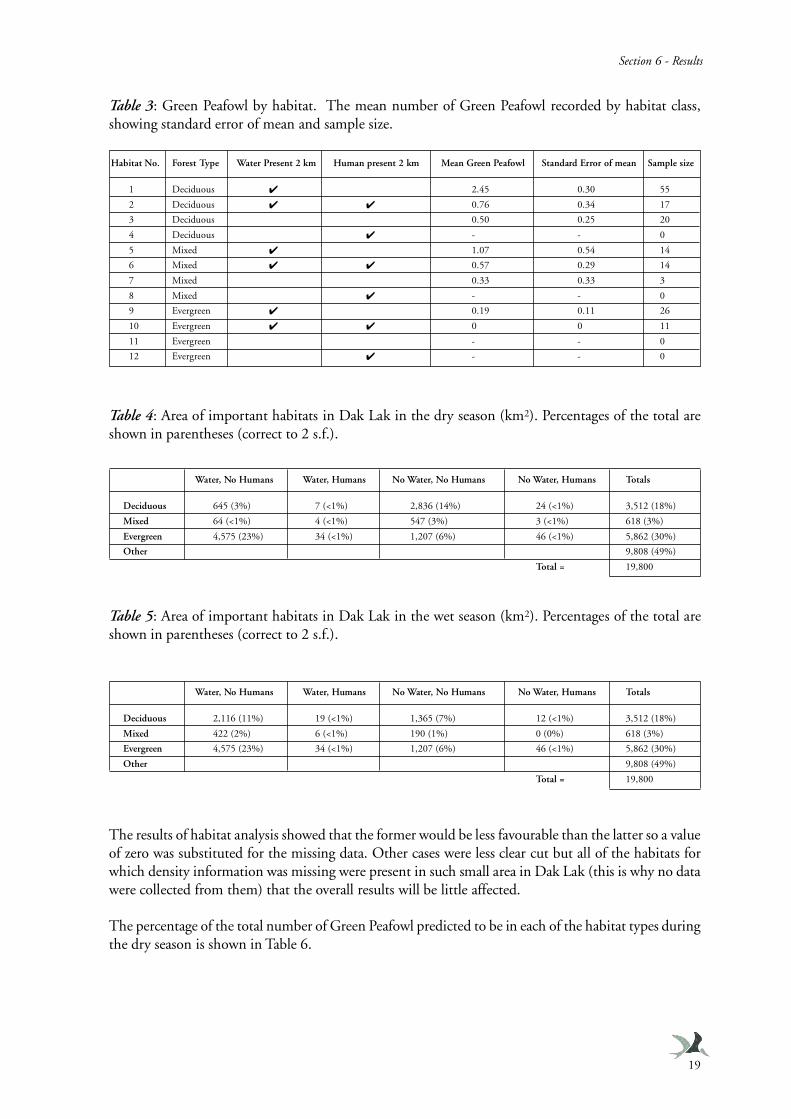
19
Section 6 - Results
Table 3: Green Peafowl by habitat. The mean number of Green Peafowl recorded by habitat class,showing standard error of mean and sample size.
Table 4: Area of important habitats in Dak Lak in the dry season (km2). Percentages of the total areshown in parentheses (correct to 2 s.f.).
Table 5: Area of important habitats in Dak Lak in the wet season (km2). Percentages of the total areshown in parentheses (correct to 2 s.f.).
The results of habitat analysis showed that the former would be less favourable than the latter so a valueof zero was substituted for the missing data. Other cases were less clear cut but all of the habitats forwhich density information was missing were present in such small area in Dak Lak (this is why no datawere collected from them) that the overall results will be little affected.
The percentage of the total number of Green Peafowl predicted to be in each of the habitat types duringthe dry season is shown in Table 6.
Water, No Humans Water, Humans No Water, No Humans No Water, Humans Totals
Deciduous 645 (3%) 7 (<1%) 2,836 (14%) 24 (<1%) 3,512 (18%)
Mixed 64 (<1%) 4 (<1%) 547 (3%) 3 (<1%) 618 (3%)
Evergreen 4,575 (23%) 34 (<1%) 1,207 (6%) 46 (<1%) 5,862 (30%)
Other 9,808 (49%)
Total = 19,800
Water, No Humans Water, Humans No Water, No Humans No Water, Humans Totals
Deciduous 2,116 (11%) 19 (<1%) 1,365 (7%) 12 (<1%) 3,512 (18%)
Mixed 422 (2%) 6 (<1%) 190 (1%) 0 (0%) 618 (3%)
Evergreen 4,575 (23%) 34 (<1%) 1,207 (6%) 46 (<1%) 5,862 (30%)
Other 9,808 (49%)
Total = 19,800
Habitat No. Forest Type Water Present 2 km Human present 2 km Mean Green Peafowl Standard Error of mean Sample size
1 Deciduous ✔ 2.45 0.30 55
2 Deciduous ✔ ✔ 0.76 0.34 17
3 Deciduous 0.50 0.25 20
4 Deciduous ✔ - - 0
5 Mixed ✔ 1.07 0.54 14
6 Mixed ✔ ✔ 0.57 0.29 14
7 Mixed 0.33 0.33 3
8 Mixed ✔ - - 0
9 Evergreen ✔ 0.19 0.11 26
10 Evergreen ✔ ✔ 0 0 11
11 Evergreen - - 0
12 Evergreen ✔ - - 0
Section 6 - Results
20
Table 6: Predicted percentages of Green Peafowl in Dak Lak by habitat. Values marked by “(est.)” areestimated values, see text.This analysis further supports the importance of deciduous forest near water and away from people.
This habitat only occupies around 3 % of Dak Lak in the dry season but is predicted to support 38 %of the Green Peafowl. All types of deciduous forest occupy only 18 % of Dak Lak but hold a predicted72 % of Green Peafowl. These findings are discussed further in Section 7.3 and 8.2.
6.5 Other bird and mammal species recorded
6.5.1 Birds
Approximately 290 bird species were recorded during the survey. A complete list of birds, showing sitesrecorded, is included in Appendix 3.
The records of some notable bird species recorded within habitats and areas shown to be important forGreen Peafowl, particularly the deciduous forest regions, are detailed below. Conservation status ifapplicable is taken from Collar et al. (1994). Additional notes are given for some other notable species(globally/regionally threatened) in Appendix 3.
Siamese Fireback Lophura diardi VulnerableA single bird was seen in deciduous forest near the Dak Dam stream in Dak Mil district. This specieswas also seen frequently outside peafowl areas, in evergreen forest at higher altitudes.
White-winged Duck Cairina scutulata EndangeredA pair was seen on the Dak Dam stream in Dak Mil District on 10 May. The stream forms the borderbetween Vietnam and Cambodia so this sighting constitutes a record for both countries. Only a smalllength of the actual stream could be surveyed and it is possible more birds may be present.
Spot-bellied Eagle Owl Bubo nipalensis Near-threatenedA single bird was heard in Ea So, Ea Kar District on 9 February.
Pale-capped Pigeon Columba punicea VulnerableTwo birds were seen on 4 February and three on 11 February in Ea So in Ea Kar district. A pair was seenat the Dak Dam stream in Dak Mil district on 9 May, before flying into Cambodia.
Grey-headed Fish Eagle Ichthyophaga ichthyaetus Near-threatenedA pair was seen displaying over the Ea H’leo River on the Cambodian border on 16 February. A pairwas seen displaying at Diem lake, about 10 km east of Border Guard Station One on 18 February.
White-rumped Vulture Gyps bengalensis Near-threatenedSingle birds were seen in flight near the Dak Rue stream on 19 February and near Border Guard Station
Water, No Humans Water, Humans No Water, No Humans No Water, Humans Totals
Deciduous 38% <1% 34% <1% (est.) 72%
Mixed 2% <1% 4% <1% (est.) 6%
Evergreen 21% <1% <1% (est.) <1% (est.) 21%
Other <1% (est.)
21
Section 6 - Results
Two on 17 February. Singles were seen at Diem lake and over Guard Station One on 18 February.
Red-headed Vulture Sarcogyps calvus Near-threatenedSingle birds were seen over the Ea Krong Hnang, Ea So in Ea Kar District on 9 February, and overborder Guard Station One in Ea Sup district on 16 and 18 February. Two were seen at Diem lake on 18February.
Rufous-winged Buzzard Butastur liventer Near-threatenedTwo birds were seen near Guard Station Once, Ea Sup District on 16 February. Single birds were seennear the Ea H’Leo River (Site 7) on 21 March and near the Ya Lop River on 24 March.
White-rumped Falcon Polihierax insignis Near-threatenedA single bird was seen near the Ea H’Leo river on 21 March.
Woolly-necked Stork Ciconia episcopusUp to three were seen near Guard Station One, Ea Sup District on 16 February. Birds were seen inpairs or small groups (<4) at Ea H’Leo River, Dak Dam stream, and near Border Guard Station One.Two were seen over Guard Station Two, Ea Sup District on 17 February. One was seen at Diem lake on18 February. Three were seen 10 km east of Guard Station Two on 18 February.
Lesser Adjutant Leptoptilos javanicus VulnerableThree single birds were seen on over the Ea H’Leo River and near Border Guard Stations One and Twoin Ea Sup District on 16 February. Ten were seen near Guard Station Two, Ea Sup District on 17February. A single bird flew over Guard Station One on 18 February. A single bird was seen on theground at Chu M’Lang also in Ea Sup District.
6.5.2 Mammals
Several mammal species were recorded during the survey; the list is short as our survey team containedno-one with a good knowledge of mammal tracks and signs. The records of some notable speciesrecorded within habitats and areas shown to be important for Green Peafowl, particularly the deciduousforest regions, are detailed below. Conservation status if applicable is taken from IUCN (1996). Thefull species list is given in Appendix 4.
[Douc Langur Pygathrix nemaeus EndangeredA local guide from M’Drak reported this species to be uncommon.]
Buff-cheeked Gibbon Hylobates gabriellae Data DeficientThis species was fairly common in some areas. It was heard calling at Ea Wy on 7 March, from GuardStation 11 on 2, 3 and 4 April, in M’Drak forests on 27 and 28 April, and in forests of Krong NoDistrict on 3 May.
Dhole Cuon alpinus VulnerableReported from Ea So. A single animal seen at dawn on 16 February between Guard Stations One andTwo, Ea Sup District.
Asiatic Black Bear Ursus thibetanus VulnerableAn Asiatic Black Bear was seen crossing the main road at 17h30 on 2 April near Border Guard Station11. On 3 April another (or perhaps the same) was seen the same area. A local guide reported that
Section 6 - Results
22
Asiatic Black Bear was also found in the forests of M’Drak District.
[Leopard Panthera pardusFresh tracks were found along the border road 4 km south of Guard Station Six in Dak Mil District on9 May.]
[Tiger Panthera tigris EndangeredSoldiers and forest enterprise staff at Guard Station Six in Dak Mil District consistently reported Tigersto be present in the area; the last record was reported to have been approximately two weeks prior to ourvisit (on 8 May). On the 12 May a call identified as that of a Tiger was heard at a distance of around 100m from the Dak Dam Stream 6 km north of Guard Station Six.]
Asian Elephant Elephas maximus EndangeredElephant tracks were frequently found in the deciduous forest areas but it was not possible to separatewild animals from tamed ones.
[Brow-antlered Deer Cervus eldi VulnerableTracks identified as this species were reported by a local hunter from M’Drak Forest Enterprise on 27and 28 April.]
Gaur Bos gaurus VulnerableMany fresh tracks of this species were found on 5 February within Ea So, Ea Kar District, especially at“Bai Mil.” Also, many tracks were found at Ea Bing/ Ea To Mot between 15 and 19 February.
Banteng Bos javanicus EndangeredOn 6 February in the early morning (06h45), in Ea So, Ea Kar District there were about ten Bantengstill feeding on open grassland near to a forest block within the reserve. These may have been the samegroup (about 20 animals) that Mr Vo Duc Long video taped some months before.
[Wild CattleBos spp. tracks were frequently found throughout much of the deciduous forest regions of north-westDak Lak. Unfortunately no member of our survey team could confidently identify them or separatethem from domestic stock.]
[Asian Buffalo Bubalus arnee EndangeredBuffalo tracks were found in some remote locations, including adjacent to the Cambodian border nearthe Dak Dam stream in Dak Mil, but it is unclear whether they were from wild, domestic or feral stock.However, at Border Guard Station One, on 16 February, Mr Nguyen Minh Khe reported that someyears ago a wild buffalo was shot.]
23
7 Discussion
7.1 Status and distribution
Green Peafowl were recorded during 65 point counts made at 13 sites; an estimated minimum of 187birds were present. Birds were confirmed to be present in Yok Don National Park and at all sites whereevidence was found by Le Xuan Canh et al. (1997) including Ya Lop and Ea So. In addition birds wereconfirmed in the districts of Cu Jut , Dak Mil, Dak R’Lap, Ea H’leo, Cu M’Gar, Buon Don (north-eastof Yok Don), Krong Nang and extensively in Ea Sup. This is quite a widespread distribution in DakLak, covering much of the north and west of the province. Birds were frequently encountered alongrivers in the deciduous forest regions of Ea Sup, Ea H’Leo, Cu Jut, Buon Don, and Dak Mil. Geographiclocations of each of these sites are given in Appendix 1, and shown on Map 4, while the exact locationof every positive count, along with the number recorded, is given in Appendix 2.
The number of Green Peafowl recorded at each site is not considered to be representative of the relativedensity at the site. Point counts were located where access was possible. The state of access variedconsiderably between sites meaning that when a range of habitats existed at a site (such as forest within2 km of water or more than 2 km from water) counts could not always be located so as to represent therange and availability of these habitat types.
The results clearly show the sites where the presence of Green Peafowl has been categorically confirmed.These results are returned to below and the importance of particular sites is discussed at length (Section8.2).
7.2 Habitat Use
Analysis of habitat use by Green Peafowl identified three key factors that were related to the presenceand number of Green Peafowl in the dry season. These factors were forest type, the presence anddistance to water and the presence and distance to permanent human settlement.
Other factors that were found not to have a significant relationship were bamboo, grass, burnt ground,scrub and cultivation.
The results showed that deciduous forest held the most Green Peafowl followed by mixed forest andthen evergreen forest. Green Peafowl numbers also varied with canopy cover, with deciduous forest andmixed forest being significantly more open than evergreen forest. These findings are consistent withprevious studies on Green Peafowl. Hoogerwerf (1970) and Delacour (1977) both considered openforest to be the main habitat of birds.
At known Green Peafowl sites in Laos (Evans and Timmins 1996), Cambodia (Desai and Lic Vuthy1996) and Thailand (Round 1983, Stewart-Cox and Quinnell 1990) the predominant forest type isopen dry deciduous.
One important consideration of the results is whether the forest type recorded at the location of thecount was equivalent to the forest type at the location of the birds. It is felt that due to the deliberatelybroad categorisation of forest type that in general the relationship between numbers and forest types isreal. The same may not however be true when attempting to compare numbers with undergrowth typeor cover, despite the fact that birds probably range over greater distances than we were recording themat (i.e. that the habitat recorded at the point count was in all probability often within the home range
Section 7 - Discussion
24
of birds recorded). Birds may show a preference for particular forest or undergrowth types that thissurvey did not have the resolution to determine. Possibly the only truly accurate way to investigate fine-scale habitat use and requirements would be through radio tracking within a site of which detailedhabitat maps had been prepared.
In the absence of such detailed studies, why Green Peafowl show an apparent preference for deciduousand mixed forest can only be speculated. Several authors have suggested the need for large clear areas inwhich to display gives a requirement for openness. However, in evolutionary terms few examples existwhere it can be shown that the breeding system of a bird dictates the habitat requirements. In far morecases breeding system is believed to have evolved to suit habitat. Large galliformes are found in closedcanopy evergreen forest, and some, such as Crested Argus Rheinardia ocellata and Great Argus Argusianusargus, have flamboyant displays involving very large trains, and loud calls.
The need for cover to hide and nest in and large trees to roost in may account for why peafowl needforested areas but not why open forest areas should be preferred to closed canopy forest.
Birds were occasionally recorded in evergreen forest areas so it would seem that they can survive therebut why these areas apparently hold fewer is not known. It may be that such evergreen areas in whichthey were found held small open areas and so the apparent preference for openness was maintained.This survey method was too crude to be able to account for the presence of such small areas effectively.
It may be that open forest favours Green Peafowl’s feeding methods or reduces the risk from predators.Alternatively it may be that breeding in dry deciduous forest allows large broods to be laid, timed tohatch when a seasonal flush of fallen fruit is available. Such conclusions are however beyond the scopeof this investigation. The results of this study demonstrate a greater use of open deciduous and mixedforest over closed canopy evergreen forest but they say little about possible causal factors for thisdistribution.
It seems that Green Peafowl were present over a wider range of habitats formerly in Vietnam. Historicrecords frequently refer to areas in which the forest ranges from mixed to evergreen. It is however fromthese areas that birds appear to have been lost first. It may be that these were the first areas to beexploited by man, or that hunting birds in them was easier.
Selective logging of the forest appeared to have little adverse affect on the presence of Green Peafowl.No quantitative data were collected but almost every site visited had been selectively logged at leastonce. Even forest compartments that had been logged within the last year held birds. This finding isencouraging as it suggests that the temporary (yet quite extensive) disturbance caused by legal, controlled,logging activities may not have a particularly adverse affect, although more data should be collectedbefore this can be claimed with confidence. The effect that logging has on increasing access to forestareas, and so consequently causing more long-term disturbance, is however a different matter.
The relationship between the number of birds and the presence of water is easier to understand. It hasbeen noted by many previous observers including Hoogerwerf (1970) and Johnsgard (1986). Duringthe dry season, when little water may be available from food, birds may have a daily requirement forrivers, streams or pools. Towards the end of the dry season, when temperatures are highest and water isat its most scarce, the birds begin breeding and in turn probably have a high demand for water tomaintain condition. The requirement for water at this time may effectively restrict breeding birds toareas of year-round water. It is feasible however that when young are hatched birds may move to areaswith temporary water. This survey was conducted at the height of the dry season and very few callingbirds were present in areas where only dry rivers remained.
Section 7 - Discussion
25
This study found a clear relationship between the number of Green Peafowl recorded and the distanceto permanent human settlement, and the number of peafowl with presence of permanent humansettlement within 2 km. A better fit to the model was achieved using the presence of settlement within2 km rather than the distance. This is not entirely unexpected as one would predict beyond a certaindistance, the distance to human settlement would cease to be important.
Why Green Peafowl should avoid human settlement is perhaps less obvious than it would at first seem.Indian Peafowl Pavo cristatus are often found within cultivated areas and even within villages. At theturn of the century Green Peafowl were reported as feeding in cultivated fields (Delacour and Jabouille1925b). It seems likely that constant persecution whenever humans and birds now come into contact,along with a increased availability of guns may well have been the cause of the distribution observedtoday. It is also possible that the relationship between number of Green Peafowl and the proximity ofhumans is an aversion response on the part of the birds but it is as likely that birds close to humans havebeen hunted out.
The causal factors underlying the relationship between Green Peafowl and proximity to humans canonly be speculated from this survey but the results clearly show that in close proximity the numbers ofbirds falls dramatically. The most likely explanation is persecution.
How much the results of this analysis are biased by the limitations of methodology (Sections 6.3.2 and4.1) is unclear. That identical results in the habitat use analysis were achieved using presence/absence ofbirds and using minimum number of birds, supports the assumption that the number calling doesreflect the number present. The small investigation of the repeatability of counts also supported thisassumption.
Birds may have been underestimated in a bid to reduce incidence of double counting but it is likely thatthis affected birds at higher densities more than at lower (this would have the effect of reducing thepower to detect habitat preferences when using minimum number). If calling was socially facilitatedthen it would have the opposite effect to that of underestimating number present when more birdswere calling and in this way these two problems may have gone some way to cancel each other out!
Attempting to maintain true independence between point counts is assumed to have been largelysuccessful, and any error introduced to be minimal.
The potential bias caused by access, both by limiting point counts to areas adjacent to tracks, and bythe physical disturbance cause by the vehicle used to get to points, is likely to lead to underestimationof presence. As this source of bias remained virtually constant across counts (in that all count sites wereapproached by vehicle) it should not have had a large effect on the outcome of analysis. The numbercalling would still be an index of those present even if a constant proportion was disturbed into notcalling each time. This problem would be far more difficult to overcome if the results were beinginterpreted as absolute densities (birds/unit area).
The results make clear the importance of water and humans while showing that deciduous forest ismost used, even if it cannot be stated that such forest is most preferred.
7.3 Relative abundance and predicted distribution
The mean counts of Green Peafowl between habitats found that almost 2 times as many GreenPeafowl were recorded in deciduous forest within 2 km of water and greater than 2 km from permanent
12
Section 7 - Discussion
26
human settlement, than in any other habitat type. The next highest mean count was recorded in mixedforest within 2 km of water and greater than 2 km from settlement.
By taking these mean counts to be an accurate index of actual presence of birds (i.e. relative densities)the value of deciduous forest could be further demonstrated. Deciduous forest occupied only 18 % ofthe total land area of Dak Lak but it was predicted to hold around 70 % of the total number of GreenPeafowl in the province. During the dry season the area of deciduous forest that is within 2 km of waterand greater than 2 km from permanent human settlement was estimated at 3 %. This 3 % of landhowever was predicted to hold 38 % of the Green Peafowl in Dak Lak.
Mixed forest was estimated to only occupy around 3 % of Dak Lak and to hold around 6 % of GreenPeafowl. The total area of mixed forest may however be underestimated as many areas will have beenincluded as evergreen forest due to the accuracy of the maps available (see below). However the estimatesof relative density of Green Peafowl between mixed forest and evergreen forest were both low. Evergreenforest was estimated to occupy 30 % of Dak Lak and to support 21 % of Green Peafowl.
The results clearly show the importance of protecting deciduous forest, and within deciduous forestprotecting those areas near water and away from people.
Maps showing the predicted relative density of Green Peafowl in Dak Lak highlight the importance ofthe north-west of the province. Map 5, showing predicted distribution in the dry season, is basedentirely on the data collected in this survey. Map 6, produced for the wet season, assumes that anyseasonal rivers will be occupied to the same relative density as observed in the dry season. It is unknownwhether this is true as Green Peafowl may be limited to those areas where permanent water is available(Section 7.2). The wet season map does serve to highlight those areas that might hold the most favourablehabitat for Green Peafowl during the wet season. This habitat may be vitally important for newlyhatched birds etc. but only surveys in the wet season could determine this.
The accuracy of the estimates made of percentage population by habitat is most affected by the accuracyof the maps and the accuracy of the density estimates. The accuracy of the maps is unavoidable. Theextent of deciduous forest it was felt was reasonably accurate and this was the most important habitat inthe analysis. The distribution of human settlement on the maps is not particularly accurate. The areacovered by human settlements is almost certainly underestimated (it is partly for this reason that noattempt was made to calculate overall absolute population). The maps only include large areas of humansettlement and do not account for the spread of small hamlets etc., all of which will affect GreenPeafowl.
The accuracy of the relative density estimates is considered more reliable, at least for habitats where themean is based on a reasonable sample size and the standard error is a low proportion of the mean. Thefactors affecting the accuracy of the density estimate are the same as those affecting analysis of numberof calling birds compared with habitat variables (Section 6.3.2). The size of the standard error for amean illustrates to some extent the combined effect of the various biases.
7.4 Other bird and mammal species
The deciduous forest regions of Dak Lak identified as the main areas for Green Peafowl also hold adistinctive community of other bird species. Typical species of this habitat include birds such aswoodshrikes, orioles, and woodpeckers (with 18 species of the latter being recorded). Large areas ofdeciduous forest are also home to several large soaring raptor species including Red-headed Vulture andWhite-rumped Vulture. These birds need large open areas over which to search for carrion. Rufous-
Section 7 - Discussion
27
winged Buzzard Butastur liventer and White-rumped Falcon Polihierax insignis, both categorized asnear-threatened (Collar et al. 1994), were only recorded within the deciduous forests.
Around rivers within the deciduous forest, some important species of large waterbird were recorded.Most notable of these is the endangered White-winged Duck, a pair of which were seen on the DakDam stream. This bird is currently only known in Vietnam with certainty from two other sites (J. C.Eames pers. comm.) and it has not been seen at either for several years, despite searching. White-winged Ducks need slow flowing forest rivers, fringed by trees in which to roost and nest. Such habitatis very vulnerable to disturbance, a factor that has contributed greatly to the decline of the species. TheDak Dam stream is likely to retain birds as it remains little disturbed.
Other large waterbird species recorded along the rivers in the deciduous forest included Lesser Adjutantand Woolly-necked Stork. The rivers and seasonal wetlands of the deciduous forest areas may also behome to large ibis species. None was recorded during this survey but both Giant Ibis and Black Ibis arepossible. Giant Ibis was recently discovered along a river in Ratanakiri Province in Cambodia withindeciduous forest. Some of these wetland birds may conceivably be seasonal migrants, perhaps movingdownstream into Cambodia during the height of the dry season and returning to regions of Dak Lak inthe wet season.
The mammal community within the deciduous forest is notable. A low number of mammals wasrecorded by this survey due to the inexperience in mammal surveying. Previous surveys have made farmore thorough attempts and should be referred to in this respect. Wild cattle species including Bantengand Gaur were recorded frequently in deciduous forest by Le Xuan Canh et al. (1997) and hope stillexists that wild Asian Buffalo and Kouprey may remain. The areas are also home to several deer speciesincluding Indian Muntjac Muntiacus muntjak, Sambar Cervus unicolor and possibly Eld’s Deer Cervuseldi.
Notable mammal species recorded provisionally by this survey did however include both Leopard andTiger, near the Dak Dam stream, again highlighting the value of deciduous forest rivers when they arefree from human disturbance; in this case the proximity to Cambodian border means human activity islow.
Mixed and evergreen forest bird communities were typically more diverse, holding species differentfrom those in the dry deciduous forests. Bird communities in closed canopy forest at higher altitudestypically included more galliform species such as Germain’s Peacock Pheasant, Siamese Fireback andSilver Pheasant Lophura nycthemera as well as numerous passerine species. Notable records includedBlack-hooded Laughingthrush Garrulax milleti at Dak Mol in Dak Mil district, found at the relativelylow altitude of around 900 m. The forests in this region also held a high number of other species (seeAppendix 3).
28
8 Key measures for conservation
8.1 Conservation of Green Peafowl
Investigation of habitat use by Green Peafowl highlighted the importance of deciduous forest, andwithin it, the effects of the proximity to water and human settlement.
Dry deciduous forest with water present within 2 km and no human settlement within 2 km held manymore birds than did the next most occupied habitat type. As a result of this, such habitat during the dryseason is predicted to hold around 40 % of the Green Peafowl in Dak Lak despite only occupying 3 %of the land area.
Other forest types held Green Peafowl but at far lower densities (see Table 3).
Previous studies of Green Peafowl have estimated a population density of birds in favourable habitat tobe around one breeding male per km2, or approximately four birds of all ages per km2 (Stewart-Coxand Quinnell 1990, Indrawan 1995). Due to this low density the species requires large areas of forest tomaintain viable populations. By this approximation of absolute density the prime undisturbed riverineforest of Yok Don National Park would only hold 122 breeding males or around 500 birds of all ages.A population of this size may well not be viable in the long term. It is clear that the existing areas ofprime habitat outside of National Parks should receive immediate protection. Due to the size of thebirds, their reluctance to fly long distances and their aversion to humans, fragmentation of the birds’habitat is likely to have a serious detrimental effect. It is not simply a case of conserving as much area aspossible: the area protected should form a continuous block. Birds will not be able to disperse betweenisolated forest fragments and even small areas of human settlement may act as a barrier to dispersal.
The value of a large area of deciduous forest to Green Peafowl will almost entirely be determined by theavailability of permanent water. Although it is not known if birds will disperse during the wet season touse temporary water supplies, during the dry season birds are effectively confined to where undisturbedaccess to water is available. If a large area of forest is protected but the permanent water supplies withinit are not free from disturbance, the value of the entire forested area will be seriously diminished.
The expansion of humans into Green Peafowl habitat will have a three-fold detrimental effect:
Firstly, a direct loss of habitat. The spread of human settlements invariably brings a need for agriculturalland and for water. The habitat occupied by the highest number of Green Peafowl is therefore also thehabitat most desired by humans.
Secondly, apart from the direct loss of habitat, a wider area will be affected as disturbance is caused byactivities such as wood collecting, grazing, fishing and hunting. Birds will be kept away from the humansettlement. In this way settlements will act as a barrier for dispersal and gene flow. This will be mostmarked when the spread of human settlement follows linear feature such as roads or rivers, a patternfrequently observed.
Thirdly, the increase in human presence in an area will almost invariably lead to a rise in directexploitation. Hunting of fully grown birds for meat and collecting of eggs were all reported whileundertaking the survey.
Commercial selective logging activities appear not to have a large detrimental effect, although in thisbrief survey this could not categorically be stated. A large indirect detrimental affect can be caused by
Section 8 - Key measures for conservation
29
the increased ease of access that results from logging activities. Logging requires the opening of accesstracks to facilitate the removal of timber. Once logging is complete these access tracks are used byhunters to travel further into the forest, for illegal logging and firewood collecting activities and, atworst, by illegal settlers. Nearly all of these activities become centred around permanent water sources.Forest fires also increase as a result of the increased ease of access.
Many Green Peafowl were found in logging concession forest. The value of these areas can remain veryhigh, without the need for further protected area designation, if logging is selective, carried out in strictrotation and access outside of logging periods is strictly prohibited. Many forest enterprise guard stationsexist but more need to be established on all major access routes, patrolling needs to be increased andpenalties for unauthorized intrusion made more severe. Restricting access in this way will increase boththe economic and wildlife values of the forest.
To summarise, the key factor to consider in the conservation of Green Peafowl is to maintain large,continuous areas of deciduous forest with undisturbed access to permanent water. Human disturbanceand illegal exploitation need to be severely controlled or stopped entirely. Ideally this would beimplemented by establishing large protected areas complete with undisturbed permanent water supplies.However, increased protection of forestry concessions to restrict access outside of logging periods willgo a long way to protect wildlife.
8.2 Key areas for Green Peafowl in Dak Lak
The survey recorded Green Peafowl at 13 sites in Dak Lak. Of the 13 sites only two sites did not lie inthe north-west corner of the province in the districts of Ea Sup, Ea H’Leo, Buon Don, Cu Jut, Dak Miland Cu M’Gar. In these districts the habitat is predominantly dry deciduous forest, the human populationis low and areas of forest with undisturbed access to permanent water remain.
The predicted distribution echoed the survey findings, with the greatest concentration predicted in thenorth west corner of Dak Lak within the deciduous forest region and in particular along the rivers YaLop, Dak Dam, Dak Ken, Dak Rue, Ea Wy, Ea Rok, Ea Hiao, Ea Khal, Ea H’Leo and Serepok.Predicted distribution indicates that around 40 % of Dak Lak’s Green Peafowl are present along theserivers.
Human settlements are spreading at an alarming rate, in particular along the Serepok, Ya Lop and EaH’Leo. If this continues unchecked along these three rivers, the loss of Green Peafowl habitat is predictedto reduce the overall population of Green Peafowl by around 20 %. This figure could in fact be muchhigher as the value of adjacent forest away from permanent water would also be seriously reduced.
If human settlement and agricultural expansion is allowed to continue along all permanent rivers in thenorth-west region not currently included on both sides by a protected area, the overall loss to GreenPeafowl numbers will be in excess of 35 %. This loss will be as a result of direct habitat destruction andlikely to be considerably greater as a result of fragmentation, restricted movement and increasedexploitation.
Presently Yok Don National Park is predicted to support to 11 % of birds. This figure may already bean over-estimate due to the recent spread of settlements along the north bank of the Serepok. As itseems unlikely that any Green Peafowl survive in any other established protected area in Dak Lak, thisleaves around 80-90 % of Dak Lak’s Green Peafowl population outside the protected area system.
Section 8 - Key measures for conservation
30
A huge expansion of the current protected area system should be considered. In this report, severalexpansion schemes are proposed and the proportion of the Green Peafowl population that is predictedto be affected by each scheme is estimated.
These schemes are detailed below (Section 9.1.1) and include expansion southward of Yok Don NationalPark to include the border regions of Cu Jut and Dak Mil. This would enclose the Dak Dam streamand several smaller tributaries of the Serepok that flow north through Yok Don National Park such asDak Klau and Dak Ken. The proposal would increase the area of Yok Don National Park by approximately465 km2 and increase the total Green Peafowl population covered by the protected area system to 17 %.This expansion would cover much of the border region to which access is already heavily restricted dueto security reasons. Inclusion of this area in the National Park would give further authority to restrictaccess.
Northwards expansion along the Cambodian border as far as the Gia Lai border is proposed to encloseconsiderable lengths of the Serepok, Ea H’Leo, Dak Rue and Ya Lop rivers as well as a large number ofseasonal streams. This would reach far beyond the existing proposed extension to the Dak Rue stream(Yok Don National Park Authority 1998) and is predicted to enclose 34 % of Dak Lak’s Green Peafowl.This proposal would enclose much of the area recommended for inclusion in Yok Don National Parkby Le Xuan Canh et al. (1997).
Further expansion to include the forested region covering the border between Ea Sup, Ea H’Leo, CuM’Gar and Buon Don is also proposed. This scheme would enclose large sections of the rivers EaH’Leo, Ea Wy, Ea Rok and Ea Khal, as well as large number of seasonal streams. This area alone ispredicted to hold 22 % of the remaining Green Peafowl in the province.
Presently, outside of protected areas, only immediate border regions receive some protection fromhuman exploitation. For security reasons access is severely restricted and the benefit to wildlife is clearlydemonstrated by the number of Green Peafowl and other declining species recorded at border sites(such as Dak Dam stream and border regions in north-west Ea Sup at the confluence of Ea H’Leo andYa Lop) and by the number of Green Peafowl predicted for these regions.
All of these proposals are for extensions along the Cambodian border. No physical barriers exist toGreen Peafowl at the border and seasonal movement and dispersal is very likely to occur across theborder in both directions. Development of the protected area system in Vietnam should be complementedby establishment of a large reserve on the Cambodian side of the border.
Away from the north-west corner of Dak Lak, relative density of Green Peafowl is predicted to be verylow, a conclusion supported by observation. Green Peafowl may once have been present in far largernumbers in southern and eastern regions but the spread of human settlement (particularly along rivers),loss of forest and isolation of forest patches has had its effect.
Green Peafowl were recorded from Ea So sub-district in Ea Kar district. This area is also noted for itswild cattle population and was proposed as a protected area by Le Xuan Canh et al. (1997). Thisproposal is also supported by this survey. The number of Green Peafowl may be low here but theirpresence was confirmed and the area is threatened by agricultural expansion (Le Xuan Canh et al.1997).
Green Peafowl were also recorded in the extreme south-west corner of Dak Lak. Here extensive areas ofevergreen forest interspersed with grass patches remain and human disturbance is minimal due again tothe proximity to the Cambodian border and security considerations. This area was very rich in other
Section 8 - Key measures for conservation
31
bird life and it may be a good candidate for protected area status.
In order to establish or re-establish Green Peafowl in existing protected areas where they are now absent,the main considerations would include having relatively open forest habitat (this may rule out veryclosed canopy montane forest), then a reduction in human disturbance particularly near permanentwater. Many protected areas may well be too small to support viable populations and if they are separatedby areas dominated by people and agriculture then dispersal and movement of Green Peafowl betweenthem is unlikely.
8.3 Other bird and mammal species
The conservation of many of the other key bird and mammal species typical of the deciduous forestregions of Dak Lak will involve many of the same considerations as those towards the conservation ofGreen Peafowl.
The large raptor species such as vultures and eagles all need large areas over which to range. Largewaterbirds, such as storks and ibises, will also be heavily reliant on undisturbed water sources andtemporary wetlands. For these bird species protecting the currently undisturbed waterways within thedeciduous forest is a maximum priority.
The conservation needs of the large mammal community of the deciduous forest is considered in detailin Le Xuan Canh et al. (1997). Prime considerations for many of the large ungulates include a need forvery large areas: Gaur, for example, were estimated to have a home range of 137 km2 (Conry 1989).Access to permanent water was also considered very important for many species.
Many conservation measures advocated in this report regarding the conservation of Green Peafowl willalso be of direct benefit to many of the other bird and mammal species. The deciduous forest regions ofEa Sup, Ea H’Leo, Buon Don, Cu Jut and Cu M’Gar are probably the most important areas in Vietnamfor large mammals particularly cattle, elephants, deer and large cats. The rivers and permanent watersources within these districts will be of key importance to all deciduous forest species.
Two important evergreen forest regions lying outside of reserves were also identified. These were thenorth of Dak R’Lap in south-west Dak Lak, and Dak Mol in Dak Mil district. While not being of keyconservation concern for Green Peafowl, they both held a high diversity of other bird life and bothcontained very good quality forest.
32
9 Recommendations for action - High priority
The following recommendations are based on the conclusions of the survey and address three mainareas: protected area development, management policy and further fieldwork requirements. Whererecommendations are congruent with recommendations of the Biodiversity Action Plan for Vietnam1995 (approved by the Prime Minister, decision number 845/TTg, 22 December 1995) the relevantsection of that report is cited.
Each recommendation is directed towards the authority or authorities with whom responsibility forimplementation would lie.
The recommendations listed in this section are considered of the highest priority. Medium termrecommendations are listed in Section 10.
9.1 Protected areas - expansion of Yok Don National Park
Attn: Central Government - MPI, MARD (FPD)Provincial - People’s Committee, MARD (FPD)
Pursuant with Section 3.2 “Revision of Protected Area System” Biodiversity Action Plan for Vietnam(1995). Specifically, expansion of Yok Don National Park is prioritized as Category A “of GlobalImportance”.
Yok Don National Park should be greatly expanded in the north-west of Dak Lak to include as muchdry deciduous forest as possible within the districts of Ea Sup, Ea H’Leo, Buon Don, Cu Jut, Dak Miland Cu M’gar.
This expansion should be on a large scale containing as a continuous block as much forest as possibleand enclosing completely as many permanent rivers, streams and other water sources as possible. Onlyby protecting a very large area will viable populations of Green Peafowl, wild cattle and other largemammals be safeguarded.
A key consideration with any expansion scheme is that rivers should never be made the boundaries ofa reserve. Particularly in dry deciduous forest the value of a reserve will be determined by the presenceof undisturbed permanent water. Protection of one side of a river with none on the other side amountsto no protection at all. Protected areas should also provide as large a continuous block of habitat aspossible.
Five plans are proposed for expansion of Yok Don National Park (Map 7). The predicted benefit interms of habitat enclosed by these schemes and in terms of the proportion of Green Peafowl present inDak Lak that would be protected by each scheme is shown in Appendix 5 and Map 8.
Plan A is the current expansion plan proposed by Yok Don National Park Authority (1998). Plan B isa proposed expansion that would extend Plan A; this proposal is similar to the expansion plan proposedby Le Xuan Canh et al. (1997). Plan C is a new proposal for a southwards extension to Yok Don thatshould take place in addition to Plan A and B. Plan D is a proposal for a large extension in addition toPlans A, B and C, that should be seriously considered.
Section 10 - Recommendations for action - Medium term
33
Plan A Northwards extension to Dak Rue stream
This is the scheme currently proposed by Yok Don National Park Authority (1998). This schemewould extend Yok Don National Park northwards beyond the Serepok to reach the Dak Rue stream,the western boundary being the Cambodian border and the eastern boundary being the Ea Sup-BuonDon road. While any extension is welcomed it is felt that this is not the best scheme. The extensiondoes include both banks of the Serepok which is very important, but includes very few other permanentwater sources. It also takes the Dak Rue stream to be the boundary (a feature to be strongly avoided; seeabove).
This extension covers approximately 560 km2, but only includes around 50 km2 of deciduous forestwithin 2 km of dry season water (compared with an estimated 123 km2 in the existing Yok DonNational Park). The proposed extension plan could be improved by placing the northern boundary 5-10 km north of the Dak Rue stream, but ideally the scheme should be replaced by a much largerextension north as far as the Gia Lai Province border (Plan B, below).
Any scheme that extends Yok Don National Park north of the Serepok needs to tackle the issue of thespread of human settlement along the river. Presently one small village (Bon Drang Phok) is establishedin what would become part of the park. Measures to contain or even relocate this village need to beseriously contemplated. Additionally, fishing activity along the river, particularly dynamite fishing,causes great disturbance and should be stopped.
Plan B Northward extension to the Gia Lai border
This scheme would extend Yok Don National Park northward from the proposed extension (Plan A) toreach the Ya Lop stream at the border between Dak Lak and Gia Lai. The western boundary would beformed by the Cambodian border. The eastern boundary would extend northwards from the north-east corner of the proposed extension avoiding the agricultural areas around Ea Sup town to meet theEa H’Leo river at Ea Rok town. Northwards beyond Ea Rok the boundary would follow the road tomeet the Gia Lai border where the Ya Lop river diverges from it. This expansion scheme is very similarto that proposed by Le Xuan Canh et al. (1997).
This extension would include a large part of the presently undisturbed dry deciduous forest of Ea Sup.It would completely enclose large sections of the Dak Rue stream, Ea Sup stream and the Ea H’Leoriver, as well as affording some protection to a section of the Ya Lop river. The area enclosed by thisextension, including the Plan A extension above, would be approximately 1,220 km2. Of this nearly200 km2 would be undisturbed dry deciduous forest within 2 km of permanent water. The extendedpark would hold a predicted 34 % of the Green Peafowl in Dak Lak.
This scheme does not provide adequate protection to the Ya Lop river. This could only be achieved byprotecting both sides of it. This would involve the establishment of a reserve in southern Gia LaiProvince; a recommendation for this is made below (Section 10.1.3).
Plan C Southward Extension (Cu Jut, Dak Mil)
Yok Don National Park should be extended southwards along the Cambodian border into Cu Jut andDak Mil districts. The Boundary would run south from Yok Don following the north-south ridge ofhigher land between the streams Dak Klau and Ea N’dri and extending to meet the existing border
Section 9 - Recommendations for action - High priority
34
guard post, some 2 km north of Dak Mil town. The Cambodian border would form the westernboundary of the proposed extension.
This extension would increase the area of Yok Don National Park by approximately 465 km2 and itwould enclose the catchment of several streams that flow north into the existing park. Predictions showthat the extension would give protection to a further 6 % of the Green Peafowl in Dak Lak.
As well as having Green Peafowl, the area adjacent to the Dak Dam stream that would be included inthis extension, was found to be one of the richest sites visited for large mammals, with both Tiger andLeopard being recorded provisionally. The globally endangered White-winged Duck was also recordedhere.
Plan D North-eastwards expansion
A large expansion of Yok Don to cover much of east Ea Sup district, west Ea H’Leo District and smallersections of Buon Don and Cu M’Gar districts is also proposed. The western boundary of this extensionwould follow the eastern boundary of the proposed extension A and B, avoiding present agriculturalareas. The northern boundary would be formed by the Gia Lai border, while the eastern boundarywould follow the north-south ridge of higher land running along the Ea Sup and Ea H’Leo districtborder.
This extension would include large areas of presently undisturbed dry deciduous forest as well as largeareas of mixed forest and areas currently protected as watershed forest. Many small streams and riverswould be enclosed such as Ea Wy, Ea Khal, Ea Hiao and Ea Rok, as well as a large section of the river EaH’Leo. Many of these rivers are currently under great threat from the expanding human population.
This extension would cover around 1,200 km2, of which nearly 200 km2 is undisturbed dry deciduousforest within 2 km of permanent water. This area is predicted to hold 22 % of the Green Peafowl in DakLak.
9.2 Management Recommendations
The following recommendations are made for new or improved management practices that will benefitGreen Peafowl and other wildlife within their range.
9.2.1 Planning
Attn: Central Government - MPI, MARDProvincial - MPI (DPI), MARD, People’s Committee
• Pursuant with Biodiversity Action Plan Section 2.5 “Need for Further Policy Research”• Stop settlement by immigrants in areas identified in this report as important to conservation• Limit agricultural expansion in these areas• Specifically stop expansion of people along the presently undisturbed year-round water-courses in Ea
Sup, Ea H’Leo, Cu M’Gar, Dak Mil, Cu Jut and Buon Don. This includes the rivers Ea H’leo, YaLop, Serepok, Ea Wy, Ea Khal and other rivers detailed above in Section 8.2. This land only occupiesabout 3 % of Dak Lak but it is of exceptional value for biodiversity conservation and is predicted tohold around 40 % of the Green Peafowl in the province
Section 9 - Recommendations for action - High priority
35
• Develop a proper policy for land-use planning that takes account of conservation and natural resources• Relocate illegal settlers
9.2.2 Forestry
Attn: Central Government - MARD (FPD)Provincial - MARD (FPD)
• Pursuant with Biodiversity Action Plan Section 2.3 “Review of Forestry Policy and Practice”.• Forestry concessions or compartments that lie within the dry deciduous forest region of north-west
Dak Lak should be recognized for their high biodiversity value.• Compartments that lie outside of protected areas should be policed efficiently so as to prevent illegal
use of the areas, including burning, grazing, illegal logging fire-wood collection, with particular attentionto watercourses.
• Logging should be selective and carried out in strict rotations.• After logging, access should be guarded or destroyed/blocked, a point specifically made in the
Biodiversity Action Plan.
9.3 Further survey work
Attn: NGOs, FIPI, IEBR, DOSTE
9.3.1 Survey Gia Lai and Kon Tum Provinces
Deciduous forest areas in Gia Lai and Kon Tum should be surveyed as a priority. A method similar tothat used in this survey could be employed to determine the extent of Green Peafowl and suitablehabitat in these two provinces. Due to the development pressure on the whole of the Tay Nguyenplateau such a survey is urgent.
9.3.2 Surveys within Cambodia
Further surveys of Green Peafowl should be conducted in the Cambodian provinces of Mondulkiri andRatanakiri. Extensive areas of suitable habitat appear to remain and should be afforded adequateprotection.
36
10 Recommendations for action - Medium term
10.1 Protected area development
All pursuant with Biodiversity Action Plan Section 3.2 “Review of the Protected Area System”.
10.1.1 New reserve establishment in Ea So (Ea Kar District)
Attn: Central Government - MPI, MARD (FPD)Provincial - People’s Committee, MARD (FPD)
The proposal made by Le Xuan Canh et al. (1997) is fully endorsed by this project.
10.1.2 Reserve development in Cambodia
Attn: NGOs, Ministry of Environment (Cambodia)
The habitat in the adjacent Cambodian province of Mondulkiri forms a continuous area with that inDak Lak. Establishment of this as a nature reserve, perhaps based on northwards extension of PhnomNam Lyr Nature Reserve, would increase dramatically the value of all the area.
10.1.3 Protected area in southern Gia Lai
Attn: : Central Government - MPI, MARD (FPD) Provincial (Gia Lai) - People’s Committee, MARD (FPD)
Following the proposed survey of southern Gia Lai province, proposal should be made for creation ofa protected area that encloses any high value areas of dry deciduous forest identified. This will form acontinuous block with the proposed protected areas in Dak Lak.
10.2 Management recommendations
10.2.1 Reserve management
Attn: Central Government - MARD (FPD)Provincial - MARD (FPD)
• Pursuant with Biodiversity Action Plan Section 3.2 “Strengthening the Management of ProtectedAreas”.
• Prevent the spread of illegal settlements within protected areas.• Relocate illegal settlers.• Control fishing activities: stop dynamite and electro fishing.• Stop illegal wood extraction (for timber and firewood).• Stop illegal hunting activities.• Train staff in effective reserve management.

Section 10 - Recommendations for action - Medium term
37
10.2.2 Border regions
Attn: Central Government - MoD, People’s Committee, Army, Border PoliceProvincial - MoD, People’s Committee, Army, Border Police
• Pursuant with Biodiversity Action Plan Section 2.1 “Institutional Responsibilities”. In that section itis recommended that the armed forces “play a constructive role in ecological reconstruction” by measuresincluding forestry and fishery protection.
• The border regions are some of the richest for wildlife as a result of the low level of human disturbance.• Border guards could then be given the authority to patrol a wider band along the border (20 km) and
authority to police illegal logging and hunting activities within this band.• If reserve extension goes ahead, border guards could be given authority to patrol within the reserve
and to limit access.• Establishment of a reserve and use of the army (including providing them with any training and
resources required) would be efficient use of manpower and give additional security to the borderregions.
10.2.3 Conservation awareness
Attn: Provincial - People’s Committee, Department of Education
• Pursuant with Biodiversity Action Plan Section 2.1 “Institutional Responsibilities”; in that section itis recommended that the Department of Education introduce environmental teaching.
• Awareness campaign to teach a greater understanding of forest ecosystems and their conservation, andto appreciate in particular the value of the deciduous forest areas of Dak Lak. Could be conducted(for example) through schools and through a poster campaign.
10.3 Further survey work
Attn: NGOs, FIPI, IEBR, DOSTE
10.3.1 Monitor Green Peafowl status
Repeated surveys of the same sites visited during this survey could be used to determine if the range ofbirds had contracted at all.
10.3.2 Wet season survey
A repeat survey of Dak Lak conducted in the wet season, concentrating on seasonal streams to try andsee to what extent these areas are occupied. Such a survey would be more difficult as it would be outsideof the main calling period of birds and tracks and signs may need to be relied on to a greater degree. Asurvey timed for the wet season may also yield interesting information regarding the use of the area bybreeding large water birds.
38
References
Anon. (1989) [List of flora and fauna of Bu Gia Map Nature Reserve.] Song Be Forest ProtectionDepartment, Vietnam [in Vietnamese].
Anon. (1994) [Socio-economic planning in Dak Lak: 1994-2010.] Dak Lak People’s Committee, BuonMe Thuot, Vietnam [in Vietnamese].
Anon. (1997) [Directory of statistics, 1996.] Department of Statistics, Dak Lak Province, Vietnam [inVietnamese].
van Balen, S., Prawiradilaga, D. M. and Indrawan, M. (1995) The distribution and status of GreenPeafowl in Java. Biol. Conserv. 71: 289-297.
Beebe, W. (1922) Monograph of the pheasants, vol. 4. Dover Publications (1990 reprint), New York,U.S.A.
Bibby, C. J., Burgess, N. D. and Hill, D. A. (1992) Bird census techniques. Academic Press, London.Collar, N. J., Crosby, M. J. and Stattersfield, A. J. (1994) Birds to watch 2: the world checklist of threatened
birds. BirdLife International, Cambridge, U.K.Conry, P. J. (1989) Gaur Bos gaurus and development in Malaysia. Biol. Conserv. 49: 47-65.Corbet, G. B. and Hill, J. E. (1992) The mammals of the Indomalayan region. Oxford University Press,
Oxford, U.K.Cox, C. R., Vu Van Dung and Pham Mong Giao (1992) Report of a management feasibility study of the
Muong Nhe Nature Reserve, 1991. WWF/Ministry of Forestry, Hanoi.Dang Huy Huynh et al. (1974) [Results of surveying vertebrates in the North of Vietnam, 1962-1974.]
Unpublished report. IEBR, Hanoi [in Vietnamese].Dang Huy Huynh, Cao Van Sung and Le Xuan Canh (1995) A report on the survey for biological
resources in Yok Don National Park, South Vietnam. Institute for Ecology and Biological Resources,Hanoi.
Davison, G. W. H. and Scriven, K. (1987) Recent pheasant surveys in peninsular Malaysia. Pp. 90-101in Savage, C. D. W. and Ridley, M. W. (eds.) Pheasants in Asia 1982. World Pheasant Association,Reading, U.K.
Delacour, J. (1977) Pheasants of the world, 2nd edition. Spur Publications, Hindhead, U.K.Delacour, J. and Jabouille, P. (1925a) Recherches ornithologiques dans la province de Quang-tri (centre
Annam), et quelques autres régions de l’Indochine française. Société Nationale d’Acclimatation de France,Paris.
Delacour, J. and Jabouille, P. (1925b) On the birds of Quang Tri, central Annam with notes on othersfrom other parts of French Indochina. Ibis (12) 1: 209-260.
Desai, A. A. and Lic Vuthy (1996) Status and distribution of large mammals in eastern Cambodia: resultsof the first foot surveys in Mondulkiri and Rattanakiri provinces. IUCN/FFI/WWF Large MammalConservation Project, Phnom Penh.
Do Tuoc and Ngo Tu (1985) Features of fauna in Mom Ray Nature Reserve. Unpublished report, FIPI,Hanoi [in Vietnamese].
Evans, T. D. and Timmins, R. J. (1996) The status of Green Peafowl Pavo muticus in Laos. Forktail 11:11-32.
Fry, J. C. (1993) Biological data analysis. Oxford University Press, Oxford, U.K.Gaston, A. J. (1979) Field survey techniques for censusing pheasants. Pp. 49-51 in Savage, C. W. D.
(ed.) Pheasants in Asia 1979. World Pheasant Association, Reading U.K.Gates, J. M. (1966) Crowing counts as indices to cock pheasant populations in Wisconsin. J. Wildl.
Mngmnt. 30: 735-774.Hoogerwerf, A. (1970) Udjung Kulon: the land of the last rhinoceros. E. J. Brill, Leiden, Netherlands.Indrawan, M. (1995) Behaviour and abundance of Green Peafowl in Baluran National Park, East Jawa.
MSc thesis, Zool. Dept., University of Aberdeen, U.K.Inskipp, T., Lindsey, N. and Duckworth, W. (1996) An annotated checklist of the birds of the Oriental
References
39
region. Oriental Bird Club, Sandy, Bedfordshire, U.K.IUCN (1996) The 1996 IUCN Red List of threatened animals. IUCN, Gland, Switzerland.Johnsgard, P. A. (1986) The pheasants of the world. Oxford University Press, Oxford, U.K.Laurie, A., Ha Dinh Duc and Pham Trong Anh (1989) Survey for Kouprey Bos sauveli in western Dak
Lak Province, Vietnam. Unpublished report to the Kouprey Conservation Trust.Le Trong Trai (1996) Historical and current distribution of Green Peafowl in Vietnam. Tragopan 7: 16-
17.Le Xuan Canh, Pham Trong Anh, Duckworth, J. W., Vu Ngoc Thanh and Lic Vuthy (1997) A survey of
large mammals in Dak Lak Province, Vietnam. WWF/IUCN, Hanoi.Lessells, C. M. and Boag, P. T. (1987) Unrepeatable repeatabilities: a common mistake. Auk 104: 116-
121.MapInfo Professional Version 4.0 (1995) MapInfo Corporation.McGowan, P. J. K. and Garson, P. J. (1995) Pheasants: status survey and conservation action plan 1995-
1999. IUCN, Gland, Switzerland.McGowan, P., Duckworth, W., Wen Xianji, Van Balen, B., Yang Xiaojun, Mohd. Khan Momin Khan,
Siti Hawa Yatim, Thanga, L., Setiawan, I. and Kaul, R. (in press) A review of the status of GreenPeafowl Pavo muticus and recommendations for future action. Bird Conserv. Internat. 8 (3).
Medway, Lord and Wells, D. R. (1976) The birds of the Malay Peninsula, vol. 5. Witherby and UniversitiMalaya, London and Kuala Lumpur.
Microsoft (1997) Excel Version 97. Microsoft Corporation, Seattle, USA.[MPI et al.] Ministry of Planning and Investment, Ministry of Agriculture and Rural Development and
Institute of Planning and Agricultural Development (1996) [General planning and socio-economicdevelopment of the Tay Nguyen Plateau.] Hanoi [in Vietnamese].
Robson, C. R., Eames, J. C., Newman, M., Nguyen Cu and Truong Van La (1991) Forest bird surveysin Vietnam 1989/90: final report. Unpublished report, International Council for Bird Preservation,Cambridge, U.K.
Round, P. D. (1983) A pilot survey of the Green Peafowl (Pavo muticus) in Huai Kha Khaeng WildlifeSanctuary, Uthaithani Province, western Thailand. Unpublished manuscript to the Association forthe Conservation of Wildlife, Bangkok.
Round, P. D. (1988) Resident forest birds of Thailand: their status and conservation. ICBP, Cambridge,U.K.
Stattersfield, A. J., Crosby, M. J., Long, A. J. and Wege, D. C. (1998) Endemic bird areas of the world:priorities for biodiversity conservation. BirdLife International, Cambridge, U.K.
SPSS Version 7.0 (1995) SPSS Inc.Stewart-Cox, B. and Quinnell, R. (1990) Using calls, footprints and sightings to survey Green Peafowl
in western Thailand. Pp. 129-137 in Hill, D. A., Garson, P. J. and Jenkins, D. (eds.) Pheasants inAsia 1989. World Pheasant Association, Reading, U.K.
Truong Van La and Nguyen Cu (1981) [Preliminary results of the reaearch on the avifauna in the TayNguyen region]. Nghien Cuu Khoa Hoc (Sinh Vat Hoc) 1981: 131-135 [in Vietnamese].
Vo Quy (1975) [Birds of Vietnam.] Volume 1. Nha Xuat Ban Khoa Hoc Va Ky Thuat, Hanoi [inVietnamese].
Yok Don National Park Authority (1998) [Proposal for extension of Yok Don National Park.] Yok DonNational Park Authority, Dak Lak Province, Vietnam [in Vietnamese].
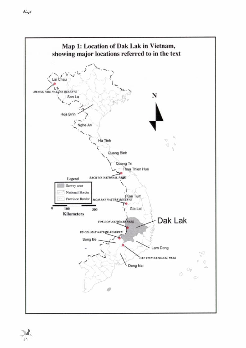
Maps
40
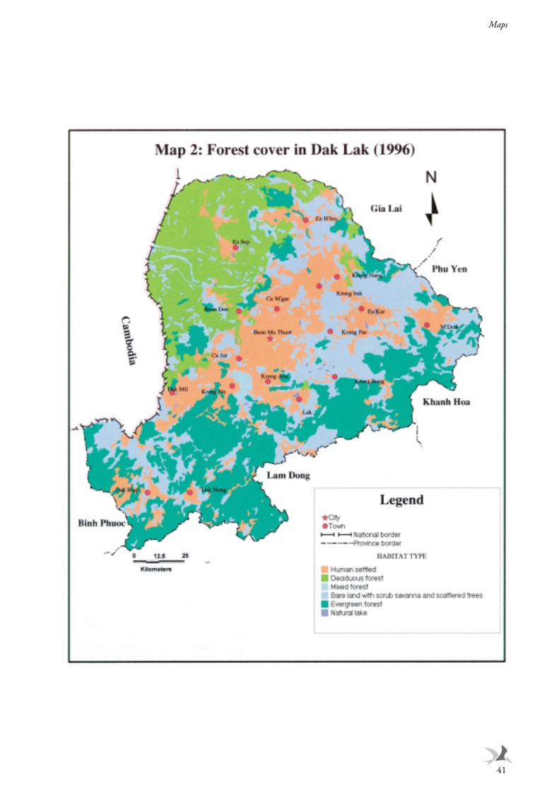
Maps
41
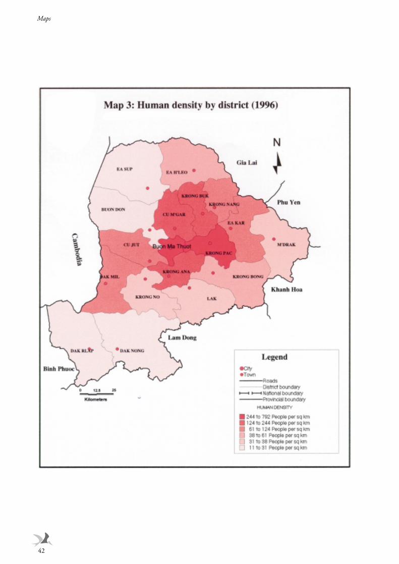
Maps
42
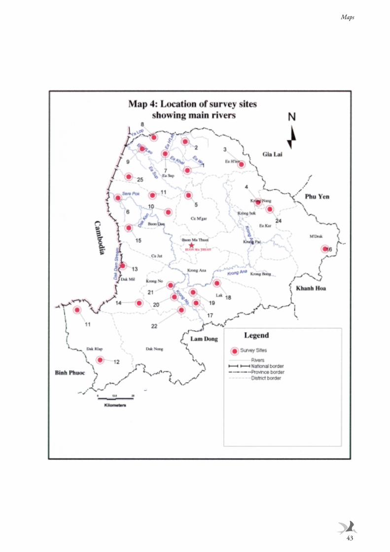
Maps
43
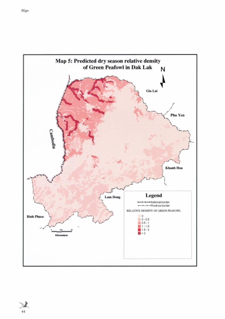
Maps
44
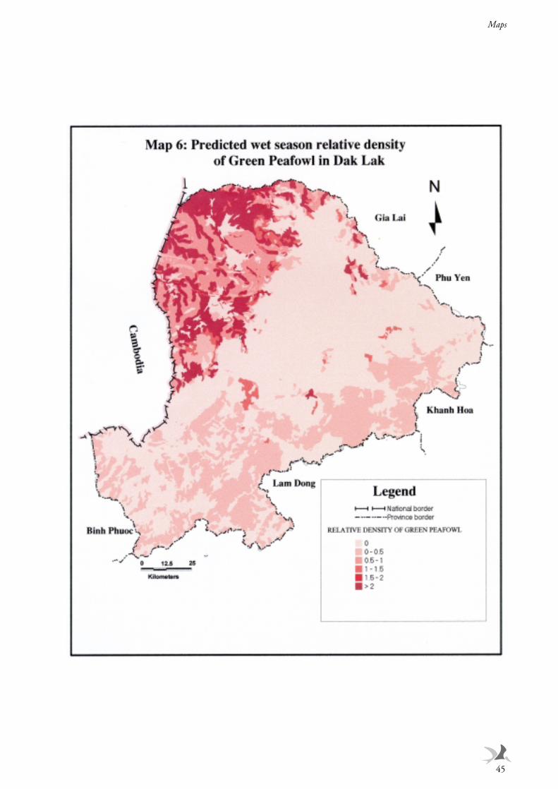
Maps
45
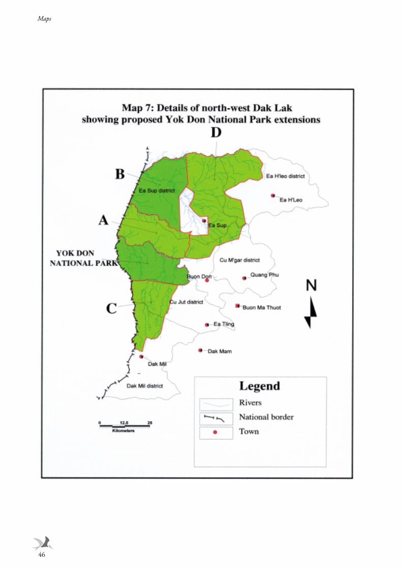
Maps
46
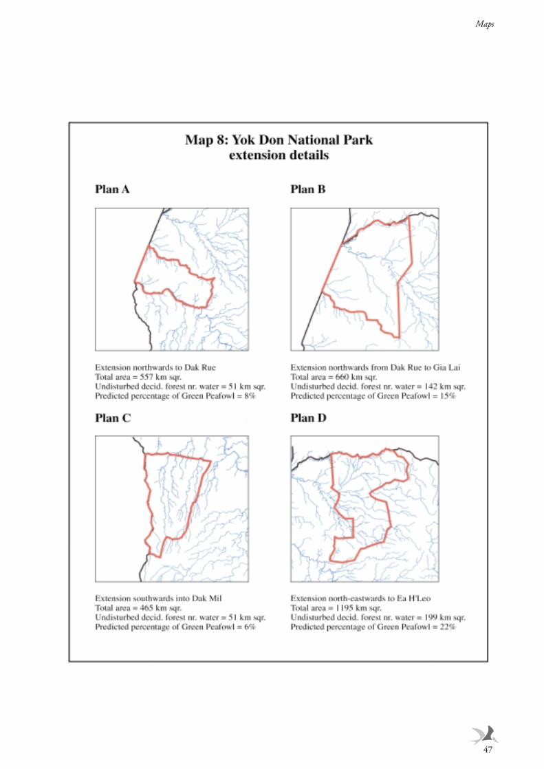
Maps
47
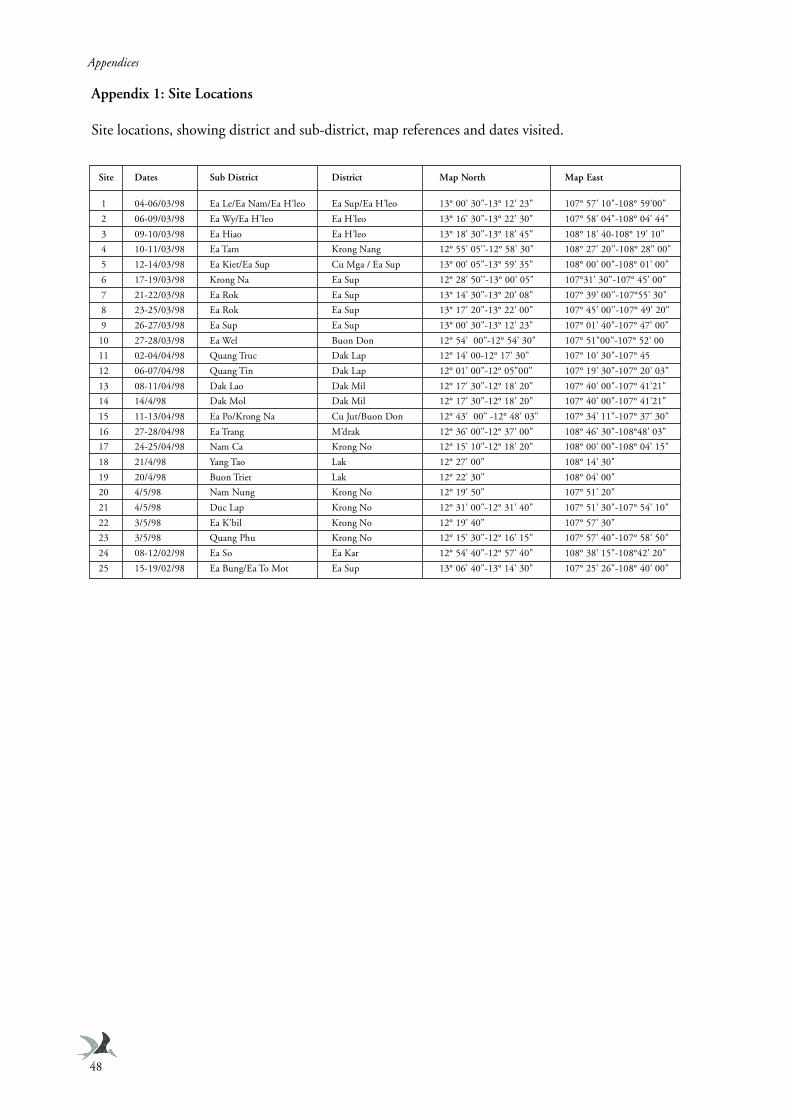
Appendices
48
Appendix 1: Site Locations
Site locations, showing district and sub-district, map references and dates visited.
Site Dates Sub District District Map North Map East
1 04-06/03/98 Ea Le/Ea Nam/Ea H’leo Ea Sup/Ea H’leo 13° 00' 30"-13° 12' 23" 107° 57' 10"-108° 59’00"
2 06-09/03/98 Ea Wy/Ea H’leo Ea H’leo 13° 16' 30"-13° 22' 30" 107° 58' 04"-108° 04' 44"
3 09-10/03/98 Ea Hiao Ea H’leo 13° 18' 30"-13° 18' 45" 108° 18' 40-108° 19' 10"
4 10-11/03/98 Ea Tam Krong Nang 12° 55' 05'’-12° 58' 30" 108° 27' 20'’-108° 28" 00"
5 12-14/03/98 Ea Kiet/Ea Sup Cu Mga / Ea Sup 13° 00' 05"-13° 59' 35" 108° 00' 00"-108° 01' 00"
6 17-19/03/98 Krong Na Ea Sup 12° 28' 50'’-13° 00' 05" 107°31' 30"-107° 45' 00"
7 21-22/03/98 Ea Rok Ea Sup 13° 14' 30"-13° 20' 08" 107° 39' 00'’-107°55' 30"
8 23-25/03/98 Ea Rok Ea Sup 13° 17' 20"-13° 22' 00" 107° 45' 00'’-107° 49' 20"
9 26-27/03/98 Ea Sup Ea Sup 13° 00' 30"-13° 12' 23" 107° 01' 40"-107° 47' 00"
10 27-28/03/98 Ea Wel Buon Don 12° 54' 00"-12° 54' 30" 107° 51"00"-107° 52' 00
11 02-04/04/98 Quang Truc Dak Lap 12° 14' 00-12° 17' 30" 107° 10' 30"-107° 45
12 06-07/04/98 Quang Tin Dak Lap 12° 01' 00"-12° 05"00" 107° 19' 30"-107° 20' 03"
13 08-11/04/98 Dak Lao Dak Mil 12° 17' 30"-12° 18' 20" 107° 40' 00"-107° 41’21"
14 14/4/98 Dak Mol Dak Mil 12° 17' 30"-12° 18' 20" 107° 40' 00"-107° 41’21"
15 11-13/04/98 Ea Po/Krong Na Cu Jut/Buon Don 12° 43' 00" -12° 48' 03" 107° 34' 11"-107° 37' 30"
16 27-28/04/98 Ea Trang M’drak 12° 36' 00"-12° 37' 00" 108° 46' 30"-108°48' 03"
17 24-25/04/98 Nam Ca Krong No 12° 15' 10"-12° 18' 20" 108° 00' 00"-108° 04' 15"
18 21/4/98 Yang Tao Lak 12° 27' 00" 108° 14' 30"
19 20/4/98 Buon Triet Lak 12° 22' 30" 108° 04' 00"
20 4/5/98 Nam Nung Krong No 12° 19' 50" 107° 51' 20"
21 4/5/98 Duc Lap Krong No 12° 31' 00"-12° 31' 40" 107° 51' 30"-107° 54' 10"
22 3/5/98 Ea K’bil Krong No 12° 19' 40" 107° 57' 30"
23 3/5/98 Quang Phu Krong No 12° 15' 30"-12° 16' 15" 107° 57' 40"-107° 58' 50"
24 08-12/02/98 Ea So Ea Kar 12° 54' 40"-12° 57' 40" 108° 38' 15"-108°42' 20"
25 15-19/02/98 Ea Bung/Ea To Mot Ea Sup 13° 06' 40"-13° 14' 30" 107° 25' 26"-108° 40' 00"
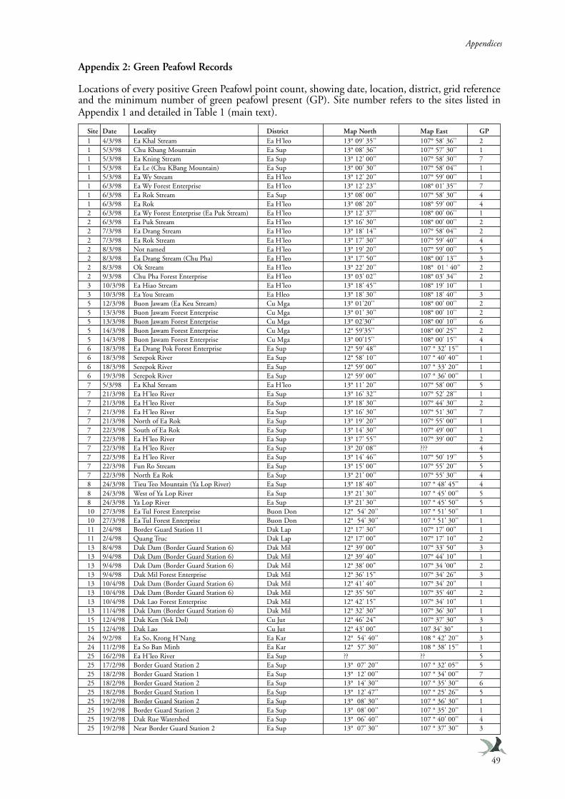
Appendices
49
Appendix 2: Green Peafowl Records
Locations of every positive Green Peafowl point count, showing date, location, district, grid referenceand the minimum number of green peafowl present (GP). Site number refers to the sites listed inAppendix 1 and detailed in Table 1 (main text).
Site Date Locality District Map North Map East GP1 4/3/98 Ea Khal Stream Ea H’leo 13° 09' 35'’ 107° 58' 36'’ 21 5/3/98 Chu Kbang Mountain Ea Sup 13° 08' 36'’ 107° 57' 30'’ 11 5/3/98 Ea Kning Stream Ea Sup 13° 12' 00'’ 107° 58' 30'’ 71 5/3/98 Ea Le (Chu KBang Mountain) Ea Sup 13° 00' 30'’ 107° 58' 04'’ 11 5/3/98 Ea Wy Stream Ea H’leo 13° 12' 20'’ 107° 59' 00'’ 11 6/3/98 Ea Wy Forest Enterprise Ea H’leo 13° 12' 23'’ 108° 01' 35'’ 71 6/3/98 Ea Rok Stream Ea Sup 13° 08' 00'’ 107° 58' 30'’ 41 6/3/98 Ea Rok Ea H’leo 13° 08' 20'’ 108° 59' 00'’ 42 6/3/98 Ea Wy Forest Enterprise (Ea Puk Stream) Ea H’leo 13° 12' 37'’ 108° 00' 06'’ 12 6/3/98 Ea Puk Stream Ea H’leo 13° 16' 30'’ 108° 00' 00'’ 22 7/3/98 Ea Drang Stream Ea H’leo 13° 18' 14'’ 107° 58' 04'’ 22 7/3/98 Ea Rok Stream Ea H’leo 13° 17' 30'’ 107° 59' 40'’ 42 8/3/98 Not named Ea H’leo 13° 19' 20'’ 107° 59' 00'’ 52 8/3/98 Ea Drang Stream (Chu Pha) Ea H’leo 13° 17' 50'’ 108° 00' 13'’ 32 8/3/98 Ok Stream Ea H’leo 13° 22' 20'’ 108° 01 ‘ 40’’ 22 9/3/98 Chu Pha Forest Enterprise Ea H’leo 13° 03' 02'’ 108° 03' 34'’ 23 10/3/98 Ea Hiao Stream Ea H’leo 13° 18' 45'’ 108° 19' 10'’ 13 10/3/98 Ea You Stream Ea Hleo 13° 18' 30'’ 108° 18' 40'’ 35 12/3/98 Buon Jawam (Ea Keu Stream) Cu Mga 13° 01’20'’ 108° 00' 00'’ 25 13/3/98 Buon Jawam Forest Enterprise Cu Mga 13° 01' 30'’ 108° 00' 10'’ 25 13/3/98 Buon Jawam Forest Enterprise Cu Mga 13° 02’30'’ 108° 00' 10'’ 65 14/3/98 Buon Jawam Forest Enterprise Cu Mga 12° 59’35'’ 108° 00' 25'’ 25 14/3/98 Buon Jawam Forest Enterprise Cu Mga 13° 00’15'’ 108° 00' 15'’ 46 18/3/98 Ea Drang Pok Forest Enterprise Ea Sup 12° 59' 48'’ 107 ° 32' 15'’ 16 18/3/98 Serepok River Ea Sup 12° 58' 10'’ 107 ° 40' 40'’ 16 18/3/98 Serepok River Ea Sup 12° 59' 00'’ 107 ° 33' 20'’ 16 19/3/98 Serepok River Ea Sup 12° 59' 00'’ 107 ° 36' 00'’ 17 5/3/98 Ea Khal Stream Ea H’leo 13° 11' 20'’ 107° 58' 00'’ 57 21/3/98 Ea H’leo River Ea Sup 13° 16' 32'’ 107° 52' 28'’ 17 21/3/98 Ea H’leo River Ea Sup 13° 18' 30'’ 107° 44' 30'’ 27 21/3/98 Ea H’leo River Ea Sup 13° 16' 30'’ 107° 51' 30'’ 77 21/3/98 North of Ea Rok Ea Sup 13° 19' 20'’ 107° 55' 00'’ 17 22/3/98 South of Ea Rok Ea Sup 13° 14' 30'’ 107° 49' 00'’ 17 22/3/98 Ea H’leo River Ea Sup 13° 17' 55'’ 107° 39' 00'’ 27 22/3/98 Ea H’leo River Ea Sup 13° 20' 08'’ ??? 47 22/3/98 Ea H’leo River Ea Sup 13° 14' 46'’ 107° 50' 19'’ 57 22/3/98 Fun Ro Stream Ea Sup 13° 15' 00'’ 107° 55' 20'’ 57 22/3/98 North Ea Rok Ea Sup 13° 21' 00'’ 107° 55' 30'’ 48 24/3/98 Tieu Teo Mountain (Ya Lop River) Ea Sup 13° 18' 40'’ 107 ° 48' 45'’ 48 24/3/98 West of Ya Lop River Ea Sup 13° 21' 30'’ 107 ° 45' 00'’ 58 24/3/98 Ya Lop River Ea Sup 13° 21' 30'’ 107 ° 45' 50'’ 510 27/3/98 Ea Tul Forest Enterprise Buon Don 12° 54' 20'’ 107 ° 51' 50'’ 110 27/3/98 Ea Tul Forest Enterprise Buon Don 12° 54' 30'’ 107 ° 51' 30'’ 111 2/4/98 Border Guard Station 11 Dak Lap 12° 17' 30" 107° 17' 00" 111 2/4/98 Quang Truc Dak Lap 12° 17' 00" 107° 17' 10" 213 8/4/98 Dak Dam (Border Guard Station 6) Dak Mil 12° 39' 00" 107° 33' 50" 313 9/4/98 Dak Dam (Border Guard Station 6) Dak Mil 12° 39' 40" 107° 44' 10" 113 9/4/98 Dak Dam (Border Guard Station 6) Dak Mil 12° 38' 00" 107° 34 ’00" 213 9/4/98 Dak Mil Forest Enterprise Dak Mil 12° 36' 15" 107° 34' 26" 313 10/4/98 Dak Dam (Border Guard Station 6) Dak Mil 12° 41' 40" 107° 34' 20" 113 10/4/98 Dak Dam (Border Guard Station 6) Dak Mil 12° 35' 50" 107° 35' 40" 213 10/4/98 Dak Lao Forest Enterprise Dak Mil 12° 42' 15" 107° 34' 10" 113 11/4/98 Dak Dam (Border Guard Station 6) Dak Mil 12° 32' 30" 107° 36' 30" 115 12/4/98 Dak Ken (Yok Dol) Cu Jut 12° 46' 24" 107° 37' 30" 315 12/4/98 Dak Lao Cu Jut 12° 43' 00" 107 34' 30" 124 9/2/98 Ea So, Krong H’Nang Ea Kar 12° 54' 40'’ 108 ° 42' 20'’ 324 11/2/98 Ea So Ban Minh Ea Kar 12° 57' 30'’ 108 ° 38' 15'’ 125 16/2/98 Ea H’leo River Ea Sup ?? ?? 525 17/2/98 Border Guard Station 2 Ea Sup 13° 07' 20'’ 107 ° 32' 05'’ 525 18/2/98 Border Guard Station 1 Ea Sup 13° 12' 00'’ 107 ° 34' 00'’ 725 18/2/98 Border Guard Station 2 Ea Sup 13° 14' 30'’ 107 ° 35' 30'’ 625 18/2/98 Border Guard Station 1 Ea Sup 13° 12' 47'’ 107 ° 25' 26'’ 525 19/2/98 Border Guard Station 2 Ea Sup 13° 08' 30'’ 107 ° 36' 30'’ 125 19/2/98 Border Guard Station 2 Ea Sup 13° 08' 00'’ 107 ° 35' 20'’ 125 19/2/98 Dak Rue Watershed Ea Sup 13° 06' 40'’ 107 ° 40' 00'’ 425 19/2/98 Near Border Guard Station 2 Ea Sup 13° 07' 30'’ 107 ° 37' 30'’ 3
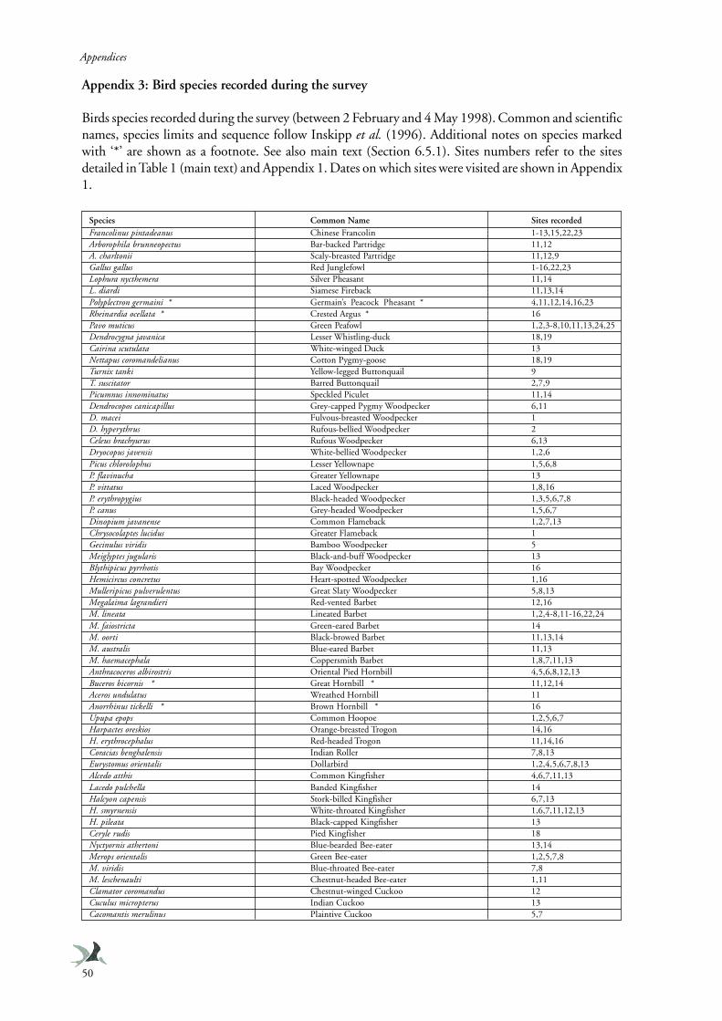
Appendices
50
Appendix 3: Bird species recorded during the survey
Birds species recorded during the survey (between 2 February and 4 May 1998). Common and scientificnames, species limits and sequence follow Inskipp et al. (1996). Additional notes on species markedwith ‘*’ are shown as a footnote. See also main text (Section 6.5.1). Sites numbers refer to the sitesdetailed in Table 1 (main text) and Appendix 1. Dates on which sites were visited are shown in Appendix1.
Species Common Name Sites recordedFrancolinus pintadeanus Chinese Francolin 1-13,15,22,23Arborophila brunneopectus Bar-backed Partridge 11,12A. charltonii Scaly-breasted Partridge 11,12,9Gallus gallus Red Junglefowl 1-16,22,23Lophura nycthemera Silver Pheasant 11,14L. diardi Siamese Fireback 11,13,14Polyplectron germaini * Germain’s Peacock Pheasant * 4,11,12,14,16,23Rheinardia ocellata * Crested Argus * 16Pavo muticus Green Peafowl 1,2,3-8,10,11,13,24,25Dendrocygna javanica Lesser Whistling-duck 18,19Cairina scutulata White-winged Duck 13Nettapus coromandelianus Cotton Pygmy-goose 18,19Turnix tanki Yellow-legged Buttonquail 9T. suscitator Barred Buttonquail 2,7,9Picumnus innominatus Speckled Piculet 11,14Dendrocopos canicapillus Grey-capped Pygmy Woodpecker 6,11D. macei Fulvous-breasted Woodpecker 1D. hyperythrus Rufous-bellied Woodpecker 2Celeus brachyurus Rufous Woodpecker 6,13Dryocopus javensis White-bellied Woodpecker 1,2,6Picus chlorolophus Lesser Yellownape 1,5,6,8P. flavinucha Greater Yellownape 13P. vittatus Laced Woodpecker 1,8,16P. erythropygius Black-headed Woodpecker 1,3,5,6,7,8P. canus Grey-headed Woodpecker 1,5,6,7Dinopium javanense Common Flameback 1,2,7,13Chrysocolaptes lucidus Greater Flameback 1Gecinulus viridis Bamboo Woodpecker 5Meiglyptes jugularis Black-and-buff Woodpecker 13Blythipicus pyrrhotis Bay Woodpecker 16Hemicircus concretus Heart-spotted Woodpecker 1,16Mulleripicus pulverulentus Great Slaty Woodpecker 5,8,13Megalaima lagrandieri Red-vented Barbet 12,16M. lineata Lineated Barbet 1,2,4-8,11-16,22,24M. faiostricta Green-eared Barbet 14M. oorti Black-browed Barbet 11,13,14M. australis Blue-eared Barbet 11,13M. haemacephala Coppersmith Barbet 1,8,7,11,13Anthracoceros albirostris Oriental Pied Hornbill 4,5,6,8,12,13Buceros bicornis * Great Hornbill * 11,12,14Aceros undulatus Wreathed Hornbill 11Anorrhinus tickelli * Brown Hornbill * 16Upupa epops Common Hoopoe 1,2,5,6,7Harpactes oreskios Orange-breasted Trogon 14,16H. erythrocephalus Red-headed Trogon 11,14,16Coracias benghalensis Indian Roller 7,8,13Eurystomus orientalis Dollarbird 1,2,4,5,6,7,8,13Alcedo atthis Common Kingfisher 4,6,7,11,13Lacedo pulchella Banded Kingfisher 14Halcyon capensis Stork-billed Kingfisher 6,7,13H. smyrnensis White-throated Kingfisher 1,6,7,11,12,13H. pileata Black-capped Kingfisher 13Ceryle rudis Pied Kingfisher 18Nyctyornis athertoni Blue-bearded Bee-eater 13,14Merops orientalis Green Bee-eater 1,2,5,7,8M. viridis Blue-throated Bee-eater 7,8M. leschenaulti Chestnut-headed Bee-eater 1,11Clamator coromandus Chestnut-winged Cuckoo 12Cuculus micropterus Indian Cuckoo 13Cacomantis merulinus Plaintive Cuckoo 5,7
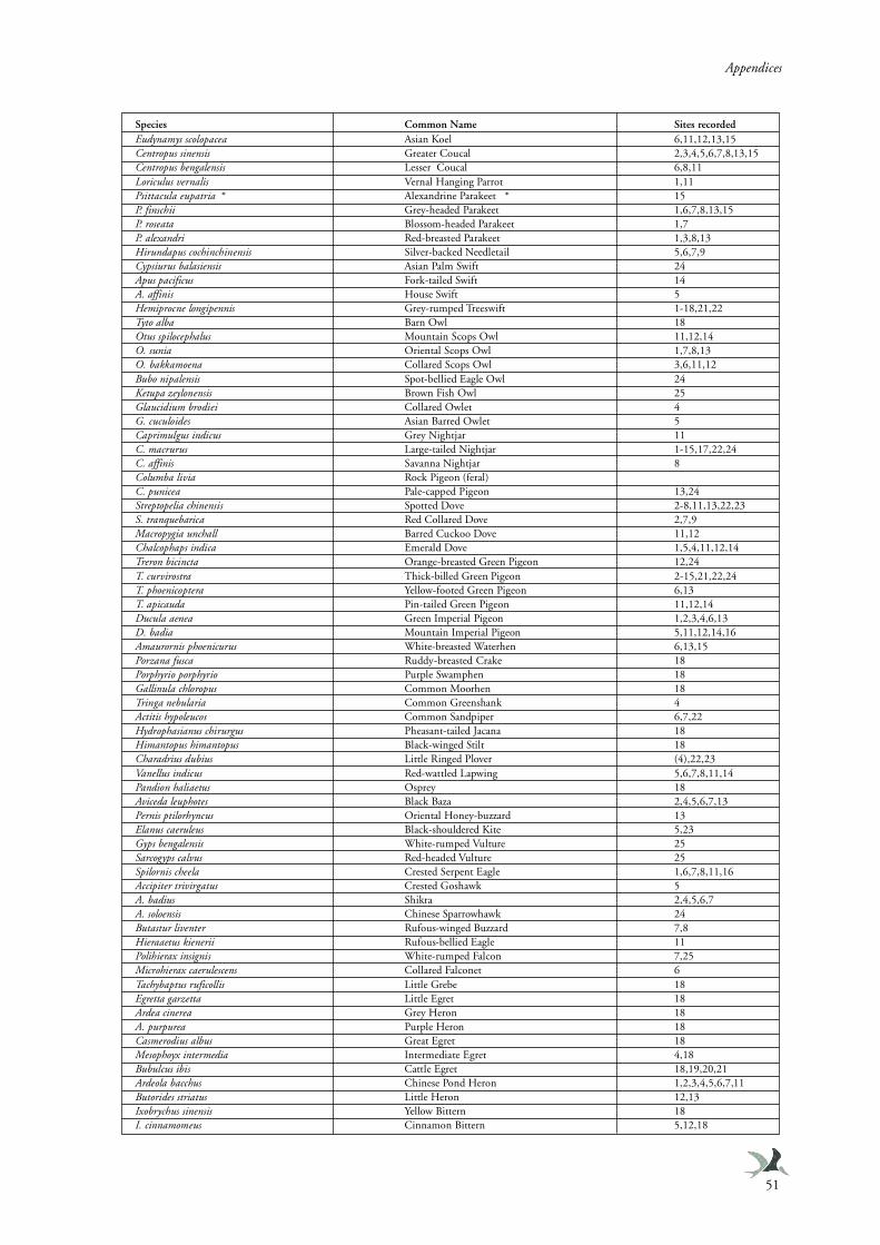
Appendices
51
Species Common Name Sites recordedEudynamys scolopacea Asian Koel 6,11,12,13,15Centropus sinensis Greater Coucal 2,3,4,5,6,7,8,13,15Centropus bengalensis Lesser Coucal 6,8,11Loriculus vernalis Vernal Hanging Parrot 1,11Psittacula eupatria * Alexandrine Parakeet * 15P. finschii Grey-headed Parakeet 1,6,7,8,13,15P. roseata Blossom-headed Parakeet 1,7P. alexandri Red-breasted Parakeet 1,3,8,13Hirundapus cochinchinensis Silver-backed Needletail 5,6,7,9Cypsiurus balasiensis Asian Palm Swift 24Apus pacificus Fork-tailed Swift 14A. affinis House Swift 5Hemiprocne longipennis Grey-rumped Treeswift 1-18,21,22Tyto alba Barn Owl 18Otus spilocephalus Mountain Scops Owl 11,12,14O. sunia Oriental Scops Owl 1,7,8,13O. bakkamoena Collared Scops Owl 3,6,11,12Bubo nipalensis Spot-bellied Eagle Owl 24Ketupa zeylonensis Brown Fish Owl 25Glaucidium brodiei Collared Owlet 4G. cuculoides Asian Barred Owlet 5Caprimulgus indicus Grey Nightjar 11C. macrurus Large-tailed Nightjar 1-15,17,22,24C. affinis Savanna Nightjar 8Columba livia Rock Pigeon (feral)C. punicea Pale-capped Pigeon 13,24Streptopelia chinensis Spotted Dove 2-8,11,13,22,23S. tranquebarica Red Collared Dove 2,7,9Macropygia unchall Barred Cuckoo Dove 11,12Chalcophaps indica Emerald Dove 1,5,4,11,12,14Treron bicincta Orange-breasted Green Pigeon 12,24T. curvirostra Thick-billed Green Pigeon 2-15,21,22,24T. phoenicoptera Yellow-footed Green Pigeon 6,13T. apicauda Pin-tailed Green Pigeon 11,12,14Ducula aenea Green Imperial Pigeon 1,2,3,4,6,13D. badia Mountain Imperial Pigeon 5,11,12,14,16Amaurornis phoenicurus White-breasted Waterhen 6,13,15Porzana fusca Ruddy-breasted Crake 18Porphyrio porphyrio Purple Swamphen 18Gallinula chloropus Common Moorhen 18Tringa nebularia Common Greenshank 4Actitis hypoleucos Common Sandpiper 6,7,22Hydrophasianus chirurgus Pheasant-tailed Jacana 18Himantopus himantopus Black-winged Stilt 18Charadrius dubius Little Ringed Plover (4),22,23Vanellus indicus Red-wattled Lapwing 5,6,7,8,11,14Pandion haliaetus Osprey 18Aviceda leuphotes Black Baza 2,4,5,6,7,13Pernis ptilorhyncus Oriental Honey-buzzard 13Elanus caeruleus Black-shouldered Kite 5,23Gyps bengalensis White-rumped Vulture 25Sarcogyps calvus Red-headed Vulture 25Spilornis cheela Crested Serpent Eagle 1,6,7,8,11,16Accipiter trivirgatus Crested Goshawk 5A. badius Shikra 2,4,5,6,7A. soloensis Chinese Sparrowhawk 24Butastur liventer Rufous-winged Buzzard 7,8Hieraaetus kienerii Rufous-bellied Eagle 11Polihierax insignis White-rumped Falcon 7,25Microhierax caerulescens Collared Falconet 6Tachybaptus ruficollis Little Grebe 18Egretta garzetta Little Egret 18Ardea cinerea Grey Heron 18A. purpurea Purple Heron 18Casmerodius albus Great Egret 18Mesophoyx intermedia Intermediate Egret 4,18Bubulcus ibis Cattle Egret 18,19,20,21Ardeola bacchus Chinese Pond Heron 1,2,3,4,5,6,7,11Butorides striatus Little Heron 12,13Ixobrychus sinensis Yellow Bittern 18I. cinnamomeus Cinnamon Bittern 5,12,18
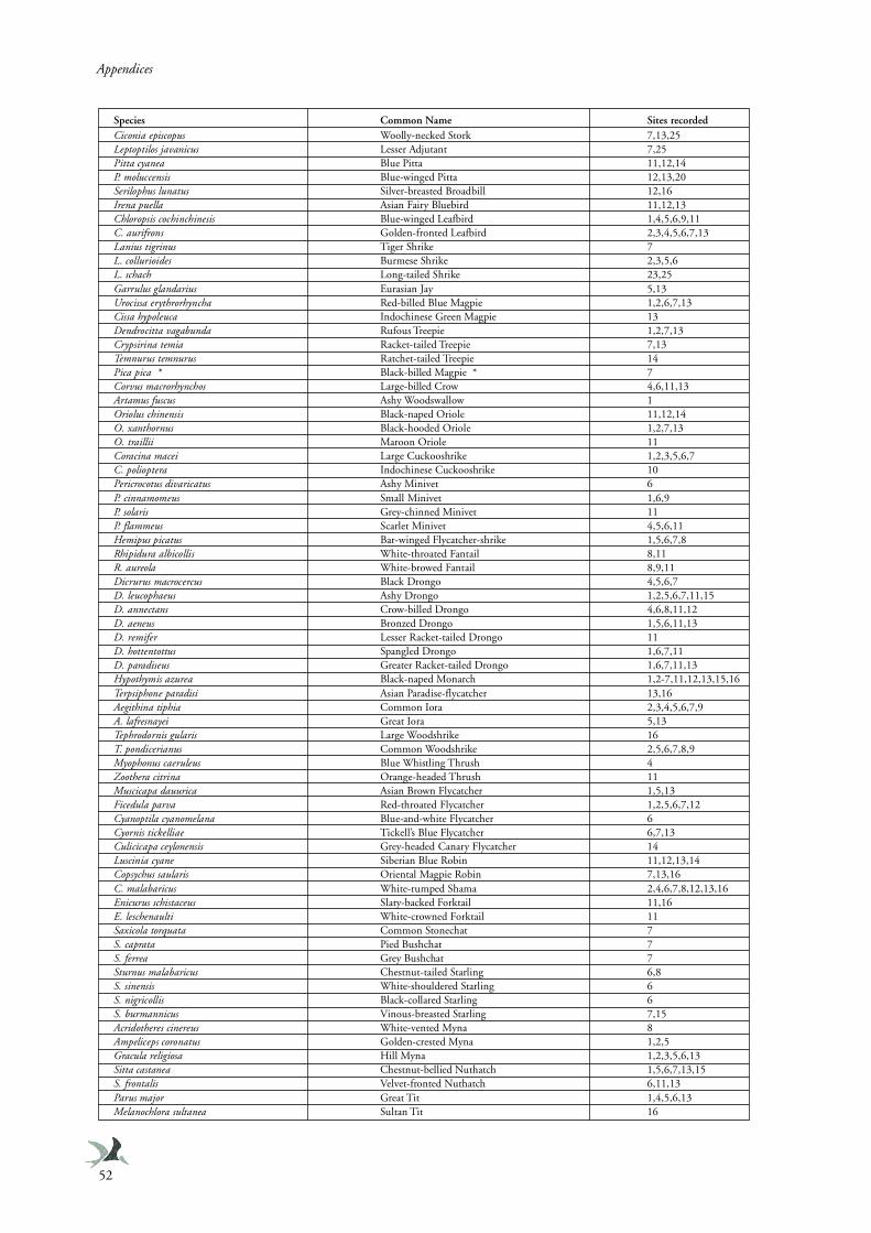
Appendices
52
Species Common Name Sites recordedCiconia episcopus Woolly-necked Stork 7,13,25Leptoptilos javanicus Lesser Adjutant 7,25Pitta cyanea Blue Pitta 11,12,14P. moluccensis Blue-winged Pitta 12,13,20Serilophus lunatus Silver-breasted Broadbill 12,16Irena puella Asian Fairy Bluebird 11,12,13Chloropsis cochinchinesis Blue-winged Leafbird 1,4,5,6,9,11C. aurifrons Golden-fronted Leafbird 2,3,4,5,6,7,13Lanius tigrinus Tiger Shrike 7L. collurioides Burmese Shrike 2,3,5,6L. schach Long-tailed Shrike 23,25Garrulus glandarius Eurasian Jay 5,13Urocissa erythrorhyncha Red-billed Blue Magpie 1,2,6,7,13Cissa hypoleuca Indochinese Green Magpie 13Dendrocitta vagabunda Rufous Treepie 1,2,7,13Crypsirina temia Racket-tailed Treepie 7,13Temnurus temnurus Ratchet-tailed Treepie 14Pica pica * Black-billed Magpie * 7Corvus macrorhynchos Large-billed Crow 4,6,11,13Artamus fuscus Ashy Woodswallow 1Oriolus chinensis Black-naped Oriole 11,12,14O. xanthornus Black-hooded Oriole 1,2,7,13O. traillii Maroon Oriole 11Coracina macei Large Cuckooshrike 1,2,3,5,6,7C. polioptera Indochinese Cuckooshrike 10Pericrocotus divaricatus Ashy Minivet 6P. cinnamomeus Small Minivet 1,6,9P. solaris Grey-chinned Minivet 11P. flammeus Scarlet Minivet 4,5,6,11Hemipus picatus Bar-winged Flycatcher-shrike 1,5,6,7,8Rhipidura albicollis White-throated Fantail 8,11R. aureola White-browed Fantail 8,9,11Dicrurus macrocercus Black Drongo 4,5,6,7D. leucophaeus Ashy Drongo 1,2,5,6,7,11,15D. annectans Crow-billed Drongo 4,6,8,11,12D. aeneus Bronzed Drongo 1,5,6,11,13D. remifer Lesser Racket-tailed Drongo 11D. hottentottus Spangled Drongo 1,6,7,11D. paradiseus Greater Racket-tailed Drongo 1,6,7,11,13Hypothymis azurea Black-naped Monarch 1,2-7,11,12,13,15,16Terpsiphone paradisi Asian Paradise-flycatcher 13,16Aegithina tiphia Common Iora 2,3,4,5,6,7,9A. lafresnayei Great Iora 5,13Tephrodornis gularis Large Woodshrike 16T. pondicerianus Common Woodshrike 2,5,6,7,8,9Myophonus caeruleus Blue Whistling Thrush 4Zoothera citrina Orange-headed Thrush 11Muscicapa dauurica Asian Brown Flycatcher 1,5,13Ficedula parva Red-throated Flycatcher 1,2,5,6,7,12Cyanoptila cyanomelana Blue-and-white Flycatcher 6Cyornis tickelliae Tickell’s Blue Flycatcher 6,7,13Culicicapa ceylonensis Grey-headed Canary Flycatcher 14Luscinia cyane Siberian Blue Robin 11,12,13,14Copsychus saularis Oriental Magpie Robin 7,13,16C. malabaricus White-rumped Shama 2,4,6,7,8,12,13,16Enicurus schistaceus Slaty-backed Forktail 11,16E. leschenaulti White-crowned Forktail 11Saxicola torquata Common Stonechat 7S. caprata Pied Bushchat 7S. ferrea Grey Bushchat 7Sturnus malabaricus Chestnut-tailed Starling 6,8S. sinensis White-shouldered Starling 6S. nigricollis Black-collared Starling 6S. burmannicus Vinous-breasted Starling 7,15Acridotheres cinereus White-vented Myna 8Ampeliceps coronatus Golden-crested Myna 1,2,5Gracula religiosa Hill Myna 1,2,3,5,6,13Sitta castanea Chestnut-bellied Nuthatch 1,5,6,7,13,15S. frontalis Velvet-fronted Nuthatch 6,11,13Parus major Great Tit 1,4,5,6,13Melanochlora sultanea Sultan Tit 16
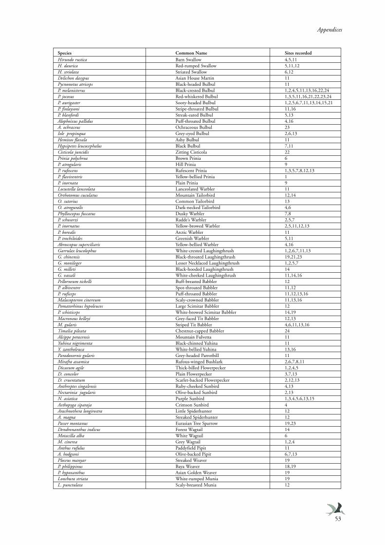
Appendices
53
Species Common Name Sites recordedHirundo rustica Barn Swallow 4,5,11H. daurica Red-rumped Swallow 5,11,12H. striolata Striated Swallow 6,12Delichon dasypus Asian House Martin 11Pycnonotus atriceps Black-headed Bulbul 11P. melanicterus Black-crested Bulbul 1,2,4,5,11,13,16,22,24P. jocosus Red-whiskered Bulbul 1,3,5,11,16,21,22,23,24P. aurigaster Sooty-headed Bulbul 1,2,5,6,7,11,13,14,15,21P. finlaysoni Stripe-throated Bulbul 11,16P. blanfordi Streak-eared Bulbul 5,13Alophoixus pallidus Puff-throated Bulbul 4,16A. ochraceus Ochraceous Bulbul 23Iole propinqua Grey-eyed Bulbul 2,6,13Hemixos flavala Ashy Bulbul 11Hypsipetes leucocephalus Black Bulbul 7,11Cisticola juncidis Zitting Cisticola 22Prinia polychroa Brown Prinia 6P. atrogularis Hill Prinia 9P. rufescens Rufescent Prinia 1,3,5,7,8,12,13P. flaviventris Yellow-bellied Prinia 1P. inornata Plain Prinia 9Locustella lanceolata Lanceolated Warbler 11Orthotomus cuculatus Mountain Tailorbird 12,14O. sutorius Common Tailorbird 13O. atroguralis Dark-necked Tailorbird 4,6Phylloscopus fuscatus Dusky Warbler 7,8P. schwarzi Radde’s Warbler 2,5,7P. inornatus Yellow-browed Warbler 2,5,11,12,13P. borealis Arctic Warbler 11P. trochiloides Greenish Warbler 5,11Abroscopus superciliaris Yellow-bellied Warbler 4,16Garrulax leucolophus White-crested Laughingthrush 1,2,6,7,11,13G. chinensis Black-throated Laughingthrush 19,21,23G. monileger Lesser Necklaced Laughingthrush 1,2,5,7G. milleti Black-hooded Laughingthrush 14G. vassali White-cheeked Laughingthrush 11,14,16Pellorneum tickelli Buff-breasted Babbler 12P. albiventre Spot-throated Babbler 11,12P. ruficeps Puff-throated Babbler 11,12,13,16Malacopteron cinereum Scaly-crowned Babbler 11,13,16Pomatorhinus hypoleucos Large Scimitar Babbler 12P. schisticeps White-browed Scimitar Babbler 14,19Macronous kelleyi Grey-faced Tit Babbler 12,13M. gularis Striped Tit Babbler 4,6,11,13,16Timalia pileata Chestnut-capped Babbler 24Alcippe peracensis Mountain Fulvetta 11Yuhina nigrimenta Black-chinned Yuhina 11Y. zantholeuca White-bellied Yuhina 13,16Paradoxornis gularis Grey-headed Parrotbill 11Mirafra assamica Rufous-winged Bushlark 2,6,7,8,11Dicaeum agile Thick-billed Flowerpecker 1,2,4,5D. concolor Plain Flowerpecker 3,7,13D. cruentatum Scarlet-backed Flowerpecker 2,12,13Anthreptes singalensis Ruby-cheeked Sunbird 4,13Nectarinia jugularis Olive-backed Sunbird 2,13N. asiatica Purple Sunbird 1,3,4,5,6,13,15Aethopyga siparaja Crimson Sunbird 4Arachnothera longirostra Little Spiderhunter 12A. magna Streaked Spiderhunter 12Passer montanus Eurasian Tree Sparrow 19,23Dendronanthus indicus Forest Wagtail 14Motacilla alba White Wagtail 6M. cinerea Grey Wagtail 1,2,4Anthus rufulus Paddyfield Pipit 11A. hodgsoni Olive-backed Pipit 6,7,13Ploceus manyar Streaked Weaver 19P. philippinus Baya Weaver 18,19P. hypoxanthus Asian Golden Weaver 19Lonchura striata White-rumped Munia 19L. punctulata Scaly-breasted Munia 12
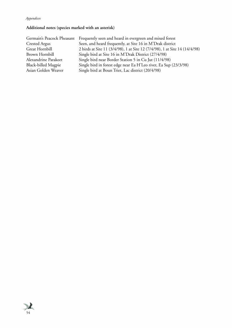
Appendices
54
Additional notes (species marked with an asterisk)
Germain’s Peacock Pheasant Frequently seen and heard in evergreen and mixed forestCrested Argus Seen, and heard frequently, at Site 16 in M’Drak districtGreat Hornbill 2 birds at Site 11 (3/4/98), 1 at Site 12 (7/4/98), 1 at Site 14 (14/4/98)Brown Hornbill Single bird at Site 16 in M’Drak District (27/4/98)Alexandrine Parakeet Single bird near Border Station 5 in Cu Jut (11/4/98)Black-billed Magpie Single bird in forest edge near Ea H’Leo river, Ea Sup (23/3/98)Asian Golden Weaver Single bird at Boun Triet, Lac district (20/4/98)
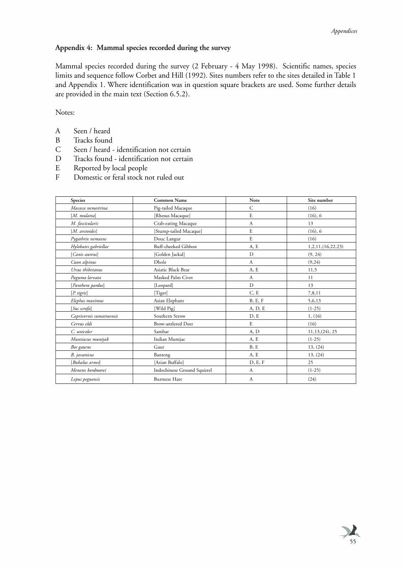
Appendices
55
Appendix 4: Mammal species recorded during the survey
Mammal species recorded during the survey (2 February - 4 May 1998). Scientific names, specieslimits and sequence follow Corbet and Hill (1992). Sites numbers refer to the sites detailed in Table 1and Appendix 1. Where identification was in question square brackets are used. Some further detailsare provided in the main text (Section 6.5.2).
Notes:
A Seen / heardB Tracks foundC Seen / heard - identification not certainD Tracks found - identification not certainE Reported by local peopleF Domestic or feral stock not ruled out
Species Common Name Note Site number
Macaca nemestrina Pig-tailed Macaque C (16)
[M. mulatta] [Rhesus Macaque] E (16), 6
M. fascicularis Crab-eating Macaque A 13
[M. arctoides] [Stump-tailed Macaque] E (16), 6
Pygathrix nemaeus Douc Langur E (16)
Hylobates gabriellae Buff-cheeked Gibbon A, E 1,2,11,(16,22,23)
[Canis aureus] [Golden Jackal] D (9, 24)
Cuon alpinus Dhole A (9,24)
Ursus thibetanus Asiatic Black Bear A, E 11,5
Paguma larvata Masked Palm Civet A 11
[Panthera pardus] [Leopard] D 13
[P. tigris] [Tiger] C, E 7,8,11
Elephas maximus Asian Elephant B, E, F 5,6,13
[Sus scrofa] [Wild Pig] A, D, E (1-25)
Capricornis sumatraensis Southern Serow D, E 1, (16)
Cervus eldi Brow-antlered Deer E (16)
C. unicolor Sambar A, D 11,13,(24), 25
Muntiacus muntjak Indian Muntjac A, E (1-25)
Bos gaurus Gaur B, E 13, (24)
B. javanicus Banteng A, E 13, (24)
[Bubalus arnee] [Asian Buffalo] D, E, F 25
Menetes berdmorei Indochinese Ground Squirrel A (1-25)
Lepus peguensis Burmese Hare A (24)
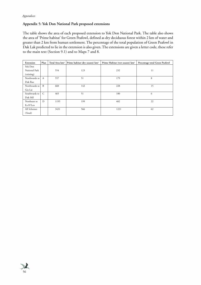
Appendices
56
Appendix 5: Yok Don National Park proposed extensions
The table shows the area of each proposed extension to Yok Don National Park. The table also showsthe area of ‘Prime habitat’ for Green Peafowl, defined as dry deciduous forest within 2 km of water andgreater than 2 km from human settlement. The percentage of the total population of Green Peafowl inDak Lak predicted to lie in the extension is also given. The extensions are given a letter code, these referto the main text (Section 9.1) and to Maps 7 and 8.
Extension Plan Total Area km2 Prime habitat (dry season) km2 Prime Habitat (wet season) km2 Percentage total Green Peafowl
Yok Don
National Park 554 123 232 11
(existing)
Northwards to A 557 51 179 8
Dak Rue
Northwards to B 660 142 228 15
Gia Lai
Southwards to C 465 51 180 6
Dak Mil
Northeast to D 1195 199 402 22
Ea H’Leo
All Schemes 3431 566 1221 62
(Total)