the urgent project for rehabilitation of yangon port and main
TRANSCRIPT

JREI
15-025
Ministry of TransportMyanma Port AuthorityInland Water TransportThe Republic of The Union of Myanmar
The Urgent Projectfor
Rehabilitation of Yangon Portand
Main Inland Water Transportin
The Republic of The Union of Myanmar
FINAL REPORT
SUMMARY
January 2015
JAPAN INTERNATIONAL COOPERATION AGENCY (JICA)
Nippon Koei Co., Ltd. (NK)Overseas Coastal Area Development Institute of Japan (OCDI)

Gulf of Mottama(also: Gulf of Martaban)
Sat Thwar
Doe Tan
Plyin Ma KhonGwa
Da Ni
Thar Paung Lay
Hpan Khar Pin
Myaung Hmaw
Ah Nan Kone
Thabaung
Zin Pyun Kone
Bei Ga Yet Gyi
Tha Yet Kone
Ywar Thit Paik Tan
Ah Gat
Sat Hltone
Sin Tar
Kyee Chaung
Ka Nyin Kone (S/N)
Myin Ka Seik
Hlwa Zin Kone
Kan Gyi
Ta Zin
Kun Thee Taw
Ta Zine Kone
Taung Ka Lay Htone Bo
Kyaung Su
Da Yei Bauk
Leik Ka Bar
Hpa Yar Gyi Su
Sar Hpyu Su
Kyar Chaung
Ma Yan Kone
Pyaung Pyan
San GyiMa Gyi Pin
Nga Pye Ma (U/L)
Hpa Yar Hla (N/S)
Thet KeiThaung
Oke Kan
Thin Gan gyi
Sa Lu Seik
Seik Gyi
Kone Gyi
Bi Tut
Thin Gan Kone
Bo Kone
Da None
Kyet Shar
Htaung Paing
Ma YanSeik Ma
Myo Kone
La Mu Gyi
Ah Wa Myei
Kyon Ka Dun
Ah Hpaung
Taw Chaik
Ah Lel
Twa Chaung
Kawhmu
Hpa Yar Gyi
Kha Yan Gyi
Ga Lone
War Taw
Ah Lel ChaungWei Daunt
Inn Ma
Ah Kwi
Shwe Pan Kone
Ah Hltaung
Ka Ni Su
Jone Jone Kya
Aing ZaukAh Lel Su
Aung Sa Kwin
Lemyethna
Gyo Kone
IngapuKha Mon Seik
Thar Ra Waw
Daunt Gyi
Da Nu Bay Ywar Ma
Hle Lan Ku
Dawei
Zaung Tu
Baw Ni
Kyaik Sa Kaw (E)
Moke Shit Wa
Taw Sun
Auk Ta Kei
Ah Du
Taw GyiLay Ein Su
Nyaung Kone
Ah Laing Ni
Gwayt tan Shey
Hltone Gyi
Aye
Day Zat
Thu Htay Kwin
Ah Lun Zoke
Kan PyaungKyauktan
Mee PyaShan Chaung
Ah Se
Ka Dat Pa Na
Thongwa
Daunt Gyi
Aung Thar
Yae Kyaw
Tha Ma Seik Ta
Ma Har Meik
Thar Ga Ya
Oke Kan Ywar Ma
Min Hla Wa
Inn Kan
Inn Tan
Daunt Gyi
Kyauk Taing
Ta Pe Ka Lar
Kin Pa Ti
Dan Mi
Daw Tha Yaw
Ah Nauk Chin Kwin
Aing Ma
Hnget Gyi Taung
Thea Kone Tan
Ah Se
Kyone Ma Ngay
Po Laung
Pyin Kha YaingWar Kone
Lel Taw
Zee Chaing
Sa Par Kyi
Kyar Ni Kan
Wet Gyi Kwin
Gway Kone
Ah Pin Hnit Se
Gon Hnyin Tan
Twan Tay
Kyaik Kaw
Daik-U
Hpaung Taw Thi
Thaik Tu Kone
Hpa Yar Gyi
Thanatpin
Ka Mar Sei
Ohn Hne
Thet Ka La
Kayan
Thanlyin
Mingaladon
Dar Pein (S)
Sat Thwar Taw
Hmawbi Hlegu
Taikkyi
Thayarwady
Letpadan
Danubyu
Nyaungdon
Pantanaw
Dedaye
Kangyidaunt
Kyaunggon
Ah Thoke
Pyaw Bwe Gyi
Waw
Kanbet
Maubin
BAGO
GWAGWAGWA
INGAPUINGAPUINGAPU
HINTHADAHINTHADAHINTHADA
ZALUNZALUNZALUNTAIKKYITAIKKYITAIKKYI
DAIK-UDAIK-UDAIK-U
BAGOBAGOBAGO WAWWAWWAW
THANATPINTHANATPINTHANATPIN
HLEGUHLEGUHLEGUHMAWBIHMAWBIHMAWBI
HTANTABINHTANTABINHTANTABIN
TWANTAYTWANTAYTWANTAY
KAWHMUKAWHMUKAWHMU
KUNGYANGONKUNGYANGONKUNGYANGON
KAWAKAWAKAWA
KAYANKAYANKAYAN
THONGWATHONGWATHONGWA
THANLYINTHANLYINTHANLYIN
KYAUKTANKYAUKTANKYAUKTAN
LETPADANLETPADANLETPADAN
THAYARWADYTHAYARWADYTHAYARWADY
LEMYETHNALEMYETHNALEMYETHNA
YEGYIYEGYIYEGYI
THABAUNGTHABAUNGTHABAUNG
KYAUNGGONKYAUNGGONKYAUNGGON
EINMEEINMEEINMEPATHEINPATHEINPATHEIN
NGAPUDAWNGAPUDAWNGAPUDAW MYAUNGMYAMYAUNGMYAMYAUNGMYA
WAKEMAWAKEMAWAKEMA
MAWLAMYINEGYUNMAWLAMYINEGYUNMAWLAMYINEGYUN
LABUTTALABUTTALABUTTA
KYONPYAWKYONPYAWKYONPYAW
DANUBYUDANUBYUDANUBYU
NYAUNGDONNYAUNGDONNYAUNGDONPANTANAWPANTANAWPANTANAW
MAUBINMAUBINMAUBIN
KYAIKLATKYAIKLATKYAIKLAT
DEDAYEDEDAYEDEDAYE
PYAPONPYAPONPYAPONBOGALEBOGALEBOGALE
RAKHINESTATE
RAKHINESTATE
RAKHINESTATE BAGO WEST
DIVISIONBAGO WEST
DIVISIONBAGO WEST
DIVISION
BAGO EASTDIVISION
BAGO EASTDIVISION
BAGO EASTDIVISIONYANGON
DIVISIONYANGONDIVISIONYANGONDIVISION
AYEYARWADY
DIVISION
AYEYARWADY
DIVISION
AYEYARWADY
DIVISION
Pyapon
Hinthada
Ngathaingchaung
Kyaiklat
Bogale
Mawlamyinegyun
PATHEIN
Myaungmya
Labutta
Hainggyikyun
Kyarkan
Wakema
Kyon Ma Ngay
Einme
Shwe Laung
YANGON
94°30'0''E
17°3
0'0'
'N17
°0'0
''N16
°30'
0''N
16°0
'0''N
17°3
0'0'
'N17
°0'0
''N16
°30'
0''N
16°0
'0''N
95°0'0''E 95°30'0''E 96°0'0''E 96°30'0''E
94°30'0''E 95°0'0''E 95°30'0''E 96°0'0''E 96°30'0''E
Major Landing Stations of IWT
State\Division Capital
Main Town
Other Town
International Airport
Domestic Airport
International Port
State/Region Boundary
Township Boundary
Railway
Road
Main Inland Waterway Route
Legend
Scale
10 20 30 40 50 km0
N
China
Thailand
Laos
Vietnam
Cambodia
Bangladesh
Bhutan
Malaysia
Maypyidaw
Yangon
MYANMARMYANMAR
MAIN INLANDWATERWAYS
ANDMAJOR
LANDING STATIONSOF
IWT IN DELTA

BM 59007
BM
BM
BM
BM
BM
BM
BM
BM
1011
1213
12
34
56
78
9
22232425
2627
2829
3031
3233
34
35
36
37
14
15
16
17
18
19
20
21
YangonInternational
Airport
YangonInternational
Airport
Geodetic station
Dock yard
Survey Dept.
Yangon Central RS
IBC
YIT
MPF
GTC
Estate
MRTV
NationalStadium No.1
Mingalardon
DALLA
MITT
Shwepyithar
Mayangon
Hlaing
Sanchaung
Kamayut
Bahan
Dagon
Lanmadaw
AhlonePabedan
Latha
Kyauktada
Seikkan
Pazundaung
Botataung
Thaketa
Dawbon
Thingangyun
South Okkalapa
Dagonmyothit(North)
Yankin
Seikkyikanaungdo
Kyimyindaing
Hlaingtharyar
North Okkalapa
Insein
Mingalataungnyunt
Tarmway
Dagonmyothit(East)
Dagonmyothit(South)
Dagonmyothit(Seikkan)
Kyimyindaing
Dagonmyothit(East)
Dagonmyothit(Seikkan)
Dagonmyothit(South)
Taw kyaik
Ma yan
Myauk su
Taw paung sein
Kyun bin
Ale kyun
Taw pa lwe
Kya dan
Oak aw lan
Byu gyaung
Htan daw
Shan gan
Toe kwin
Bo te gon
Khon hnet ein dan
INYA LAKE
KAN DAW GYI LAKE
Ta ma ta kawC
Lat that Y
To gyaung ga lay C
Kyaik ka san C
Bogyok C
Ko po C
Ta gu gyan C
Ata
ik y
o C
U pe yo
Da
niyo
C
In k
yan
C
Kun
ta C
Letpan
binC
Tam
an
gyiC
Tadagki Y
Yab aukkyi C
Nga moe yeik C
TWA NTE C ANAL
PAZUNDAUNG C
Ka naung do
Creek
S hwe lin bam C
HLAING
RIVER
Ky it
an Y
Phyat lan Y
Sin pon C
Alat C
Wela C
Let p
an gw
a C
Htone C
Min ga iun C
Nyaung C
Su la kan C
Pa ya C
BalaC
Pet inn C
Htain hn
api
nC
Yewe
C
Sobo
nC
Lwin
gyi C
Kaka
iuC
Konyw
a C
Gya
ung
wine
Ye ng
anY
ThaunggyiC
Ka sin C
Kon daing C
Kaw hm
u C
Apyauk C
Sa daing mut C
Yan
gon
bauk
C
Shit pe C
Pa ya gyi C
Let p
an go
n C
Ohn bin C
Kyaik tha le C
Pein ne gon C
Ywa dan she C
Ta da C
Seik gyi C
Ayun
zok
C
Pa ya gyi C
Nyau
ng le
bin
C
Kun gyan gon C
Myauk C
Let kaik C
Ka bin Y
Kyon da ye C
Tan
ma
nain
g C
Ano gyaung CYe byu dwin C
Htan ma naing C
Chaung gauk C
Tha kut pin (B assein)
Creek
Ka ma aung
Pyaw bwe C
Kha ya C
Po
mau
ng C
In ga bo Y
Ko daun C
Le b
o C
Ma-e-myaung C
Htaw auk C
Nyan gyaung C
YANGON RIVER
Ka wet C
Chaung gyi C
Taw kha yan C
Taw
ku
C
Hnget kyi daung C
Nyaung bin C
Pa kauk C
Kya bin gan C
Sapa
gan
C
Let kalk C
Da y e lu
C
Taw
dun
C
Kyo
ngya
n C
Ale gya u ng C
Ze po thwe ga le C
Ze po thwe ga le C
Taung gon C
Sa g
yin C
Dat taw C
Minga lun C
Ye ngan C
Taw
pa lw
e C
Thon
gw
a C
Tha
kut p
in C
TOE RIVER
Tawthur C
Nga pa C
We gyi Y
Ninbaing C
Kamon C
Myoyo C
Be in daw C
Aie
ywa C
Ma
so Y
Towthur C
Baw C
Kondan C
Kamataw Y
Thon gwa C
La ha
yet C
Min gyaung C
Pet let Yo
Min ga lun Y
Hle lan Yo
Nyaung ni C
Ma gyi gan C
Win yo C
Min we C
Ka wet C
Maung m
a ga le Y
Pauk pin C
Win ka ni C
Maung m
a C
Ba yet C
Win
gau
k C
Ka yan C
Pa gan daung C
Baw C
BAGO R
IVER
BAGO RI V
E R
Kayin gyaung C
Kan byaung C
Ye-nwe C
Pyin ma gan C
Hie
Yo
Zwe ka na C
Kyon pe C
Kayat C
Pa lan C
Shwe byauk C
Seikgyi C
Myoyo C
Thon
gw
a Y
Pa-aung gyi Y
Pi la kat C
Da min zeik C
Ka ia ma C
Baw ka lut C
Ka lauk swe C
San di CChaung bya C
Ase-m
in ga lun C
Kam
akan
a C
Ka ma ian C
Kon da
n C
Kya gan C
Aingnla Y
Kaw dun
C
Kam
apayon C
Ka ma ka lok Y
Kyon don C
San di C
Kya win C
Sin m
a kaw C
Be in daw C
Kunhnl C
Tu myaung C
Pa da gyi C
Ayun zok C
SIN KAN LAKE
Ta taik chaung
Hmaw wun
C
Ka naung C
Hmaw wun C
Pi la kat C
Taw ka laik C
Pa
kauk C
YANGON RIVER
Y A N G O N R I V E R
HLAING RIVER
PANHLAING RIV E R
Twan te Canal
Za Ma Ni Dam
Thi la wa Dam
Ban bwe gon Dam
2.0
3.0
6.4
1.3
4.1
3.3
3.2
2.5
1.6
3.7
3.7
3.5
2.63.3
3.1
2.4
1.9
1.7
0.32.1
0.8
4.0
2.8
1.9
2.0
5.3
3.1
5.5
3.8
2.9
3.5
3.2
6.5
4.7
4.2
4.7
4.5
2.0
5.2
4.6
3.0
3.7
4.5
3.5
2.4
2.8
1.5
2.1
1.9
1.1
1.1
1.4
2.9
3.1
2.5
2.3
2.7
0.9
1.7
1.2
2.1
2.2
2.2
3.0
3.0
3.12.4
3.8
2.3
2.7
1.6
3.5
2.3
3.0
2.5
3.1
2.7
4.2
3.1
1.9
0.4
12.6
9.9
25.9
28.0
20.4
24.0
27.3
14.3
19.0
14.4
26.5
16.9
12.0
4.0
2.5
2.6
4.7
7.1
4.8
8.8
12.6
6.6
3.6
3.3
3.2
4.6
4.8
15.3
24.2
3.7
4.8
4.4
3.5
4.9
5.2
4.4
1.1
3.6
2.1
2.5
3.1
2.8
4.5
3.2
4.5
4.2
4.8
6.5
2.7
1.0
4.0
3.0
3.7
3.2
3.7
4.7
3.2
1.6
3.1
2.1
3.3
3.8
4.0
3.2
5.4
4.54.83.4
2.8
2.9
2.1
1.1
2.5
2.4
3.9
4.5
21.2
8.0
3.0
1.6
2.9
5.7
5.03.5
5.9
5.2
5.3
4.1
5.0
4.6
4.8
5.4
10.3
3.2
3.7
4.0
4.6
4.6
4.6
6.9
4.9
8.3
5.5
4.33.7
4.03.0
3.6
3.8
3.96.3
4.4
6.1
4.2
2.2
11.0
18.07.7
8.5
14.7
22.4
22.4
16.0
8.7
3.92.8
6.3
5.2
5.3
4.8
5.0
2.2
4.2
4.8
3.6
4.5
6.3
4.5
1.4
23.4
20.7
29.2
26.7
19.7
14.5
13.2
14.5
7.4
3.2
5.7
9.6
4.7
1.4
0.5
2.0
2.2
1.9
4.0
3.6
6.6
2.32.3
4.8
3.7
2.6
2.5
2.3
4.8
5.5
5.7
4.5
2.9
2.8
1.8
2.4
3.92.2
4.3
1.8
4.1
3.9
14.3
2.7
6.8
9.7
10.9
18.3
14.2
31.9
26.3
0.9
2.6
2.0
3.9
3.2
2.4
3.0
4.2
5.2
4.5
3.1
2.5
4.7
6.3
22.0
1.1
1.5
1.7
1.3
1.6
1.8
0.70.6
1.51.4
1.7
0.6
1.2
1.6
1.7
0.6
1.8
1.7
1.8
1.6
0.8
1.1
1.6
1.5
1.3
1.7
1.2
4.4
4.4
2.0
3.3
2.3
2.4
2.5
3.2
2.7
4.5
3.5
5.0
6.0
5.3
5.4
6.3
5.4
6.3
7.7
7.9
8.0
1.8
4.5
2.8
2.6
2.1
3.4
1.9
2.4
2.0
2.1
2.5
1.9
2.9
2.9
3.1
2.1
2.5
2.5
2.3
2.6
2.3
2.0
1.9
2.2
1.9
2.4
2.5
2.6
1.9
1.9
3.0
3.3
2.7
3.1
2.9
2.7
3.5
4.0
4.8
4.3
3.8
3.5
4.0
3.5
3.5
4.6
4.7
3.6
4.1
3.8
3.7
4.5
2.2
2.3
2.6
2.2
2.0
2.6
2.0
2.6
2.4
2.3
2.4
2.4
2.9
3.0
3.1
2.9
3.4
3.2
2.7
2.7
2.6
2.5
3.3
2.7
3.3
3.4
2.0
2.2
1.9
2.6
2.5
2.7
3.5
3.3
3.1
2.9
2.7
3.9
3.9
4.0
3.5
4.0
3.7
3.9
4.4
4.5
4.9
4.5
3.5
4.7
3.8
4.1
4.2
3.7
3.6
4.1
5.8
5.2
6.2
7.3
1.6
1.6
1.0
1.4
1.1
1.6
1.3
1.5
1.2
1.8
1.7
1.7
2.5
1.9
2.6
3.2
2.4
2.0
2.9
2.8
3.1
3.2
3.4
2.9
3.1
3.2
3.0
2.2
2.2
2.6
3.2
2.5
2.3
2.9
3.3
3.3
4.5
3.8
3.8
4.0
3.6
3.7
3.8
4.5
4.9
4.4
4.8
4.3
4.4
5.4
5.4
12.1
8.8
8.9
10.6
11.6
11.2
14.1
20.5
21.2
20.9
16.6
18.8
16.1
26.6
22.6
24.6
24.5
23.6
28.2
29.0
28.8
29.1
31.0
31.3
32.6
34.0
35.1
36.3
42.3
9.0
3.8
4.2
4.0
7.2
5.8
3.4
3.9
3.3
13.9
4.1
3.1
3.9
3.9
3.72.8 3.0
4.24.0
4.0
4.14.7 3.7
3.44.5
2.8 2.6
2.9
3.2
3.3
4.1
4.8
3.2
5.1
4.0
3.7
4.6
4.9
3.4
3.5
3.2
3.4 2.0
3.2
1.5
2.7
3.2
2.9 3.9
3.6
2.5
2.1
1.7
3.0
3.3
5.3 3.5
3.4
3.43.2
2.62.9
1.12.2
1.2
1.4
1.31.5
2.9 2.8
2.63.0 3.0 2.8
1.6
2.4
0.70.3
4.1
1.6 1.3
1.3
1.1 0.71.4
0.91.5
1.31.4
1.1
2.9
4.9
1.6
4.5
1.6
3.0
2.2
3.8
2.1
4.0
0.7
2.8 4.3
3.6
3.7
2.8
4.1
3.7
4.3
3.4
1.7
2.1
2.6
2.2
1.4
2.3
2.9
2.2
1.9
2.7
3.6
3.4
3.3
4.3
4.8
3.9
3.6
2.1
3.5
4.1
2.52.7
4.3
4.2 4.3
1.6
3.8
3.9
3.1
2.2
4.1
1.4
3.3
3.8
3.3
1.4
3.1
4.6
4.8
4.3
4.1
4.5
4.8
2.2
3.1
3.6
3.8
1.5
1.7
3.8
4.4
4.8
2.0
4.0
2.0
2.8
4.3
3.3
4.1
2.9
2.5
2.8
4.7
3.6
4.2
3.9
3.2
3.3
2.6
3.5
2.5
2.6
2.2
0.8
3.7
3.7
2.9
2.7
2.0
1.3
1.2
4.2
2.6
4.2
4.6
4.8
3.8
0.5
1.2
1.6
4.0
5.7
5.5
3.5
2.2
4.7
4.2
3.7
2.9
3.5
3.6 2.6
1.50.4
0.7
1.3
4.5 3.4
4.2
5.3
4.4
4.9
2.0
2.8
2.2
2.8
2.4
3.3
3.8
5.7
5.8
4.8
3.7
2.4
2.7
4.2
5.0
24.3
23.3
3.7
2.1
3.8
4.0
2.8
4.0
3.7
3.9
3.7
5.51.2
1.1
2.2
2.6
3.1
5.2
3.0
3.2
1.7
3.3
3.2
3.2
2.6
3.03.5
4.8
5.3
4.9
2.5
1.6
24.6
1.5 2.5
1.3
1.4
1.0
1.1
3.0
3.1
0.6
0.9
1.4
1.1
13.7
22.5
25.6
9.2
6.0
6.0
1.9
3.8
2.3
1.9
1.2
3.9
2.0
3.5
3.8
1.5
1.0
3.3
2.2
3.7
2.8
2.3
0.4
1.6
3.8
8.0
12.8
21.9
12.7
2.6
4.5
5.3
2.8
6.5
1.99.9
22.9
16.7
25.9
3.3
1.1
2.2
3.6
2.4
2.9
4.2
2.8
1.6
1.9
2.4
1.92.0
0.9
4.5
3.9
1.1
3.8
2.6
2.1
1.1
2.9
2.6
3.9
2.1
2.1
2.7
1.7
0.9
1.4
3.9
2.3
3.0
1.9
4.2
4.2
2.6
2.1
3.9
2.1
4.9
4.3
2.9
3.7
2.7
3.5
6.2
4.6
6.6
3.3
3.6
4.7
10.28.15.4
1.5 5.0
4.5
4.7
4.5
3.44.4
3.6
4.4
4.6
3.3
3.1
2.6
2.8
4.9
3.6
1.3
3.2
1.0
3.2
3.7
2.8
4.3
3.3
1.5
4.7
4.7
1.9
2.2
2.7
2.0
0.8
3.5
3.7
2.7
2.1
1.4
4.8
1.5
2.3
2.2
1.6
1.7
2.9
5.2
3.1
1.5
3.1
3.0
0.9
1.9
5.4
4.3
1.9
3.2
1.3
3.3 1.2
0.6
1.0
3.2
1.7
0.8
2.3
1.0
1.5
1.3
1.0
1.2
1.4
1.1
1.0
1.4
1.7
1.3
1.3
1.2
1.3
1.5
1.3
1.4
1.3
1.3
1.5
1.61.6
1.2
1.6
1.9
1.9
2.0
2.0
2.1
2.2
2.1
2.2
2.3
2.5
2.5
2.6
2.6 2.6
2.7
2.7
2.9
3.0
2.9
3.3
4.33.4
5.5
GULF OF MOTTAMA
MYET SEIN KYUN
KYUN GYA
YELE KYUN
KYUN GYA
MYET SEIN KYUN
Creek Point
Entail Point
Elephant Point
Rattery Point
Than lyin Point
Bago Point
Monkey Point
Thi la wa Jetty
Thi la wa Jetty
Ferry
Ferry
Ferry
Ferry
Ferry
Ferry
Ferry
Ferry
Ferry
Ferry
Ferry
Ferry
Ferry
10
20
10
10
20
10
10
20
30
20
10
5
5
30
5
5
5
5
5
5
10
10
10
5
5
5
10
5
5
5
5
5
2020
10
20
20
5
10
5
5
5
5
5
5
5
5
5
5
5
55
5
5
5
5
5
25
25
5
5
25
15
15
15
5
5
5
5
5
5
5
5
5
5
15
5
25
5
5
5
5
5
20
20
20
20
10
10
30
20
20
20
20
20
20
20
10
10
10
10
10
10
10
10
10
10
10
10
20
10
15
15
25
35
35
25
25
25
5
5
5
5
5
15
15
15
15
15
15
5
5 10 15
10 515
5
5
5
5
55
5
5
30
5
5
5
5
10 10
10
10
10
5
5
5
5
5
5
10
5
5
5
5
Shwe pyi tha Brid
ge
Ba yint naung Bridge
Aung ze ya Bridge
Yangon-Than Lyin Bridge
Wa ta ya ashe
Wa ta ya anauk
Ye dwin gon
Deik kon
Ya kaing yo gyiAle ywa
Htein gon
Tu gyaung
Kha yan wa
Kha yan gyi
Kha lauk chaik
Wa yon zeik
Kha yan ga lay
Ta man gyi
Alat chaung
Gyaung waing
Kyun ka layPyauk yo
Kan ywa
Kyi dan
Let pan gwa
Ta ma ta kaw atet
Pa ya gyi
Pyaw bwe ga le
Pa yar ngok to
Peik swe
Kan be
San ywa
Pauk taw
Yan gon bauk
Tha yaw dan
Pein ne gon
Ywa dan she
Apyauk
Nat sin gon
Kaw hmu myauk gyaung
Kaw hmu taung gyaung
San kauk
La wa di Wa ba lauk thauk
Ka yaik ka ni
Kyu daw chaung
Kha ma kha ni
Da not
Tha kut pin
Nyaung gyaung
Ya kaing gyaung
Ton tin kan taung
Kha naung
Kha naung shan su
Ta da chaung
Tha bye gon
Nuaung ngok to
Ye gyaung gyiYe gyaung wa
Htwe auk
Tu gyi
Pyaw bwe gyi
Shwe hle gyaung
Kywe lu aing
Nyaung bin
Myat san ni
Ko daung
Kan thon gan
Pha yon chaung
Tan ma naing
Kywe lu aing
Ma-wun
Kya gan
Ye byu dwin
Kyon da ye
Bo gyoke
Ma gyi gan
Seik kyi
In ga lon
De da naw
Nyaung ngu
Ka ma ba
Ma yan
Taung gon
Chaung gyi
Ka wet
Ta ma ta kaw
Taw pya
Taw lan anauk
Me ya gon
Hnget kyi daung
Kya khat kon gyi
Wet kaik
Kan ya she
Let kok kon
Ka nyin gon
Hmaw bi
Bo din
Nyaung bin tha
Pya mut
Pyi daw tha
Taw kha yan anauk
Mya le yon
Kya khat kon lay
Kant ma larTaw kha yan ashe
Kaw dun
Hna khaung gyaung
Pauk pin
Maung ma
Kyu daw
Ka mar chaik
Hla ba lu
Ma gyi gan
Zwe ka daw
Nyaung ni
Pa le
Aye ywaPa gan daung
Ale ywaTha bye gon
Ka yin zeik
Baw tha bye gan
Ka dat pya
De zat
Tha yet pin chaung
Nyaung bin
Pha gu anuk
Pha gu ashe
Win ka ni
Le daung gan
Thon gwa
Ywa tha gyi
Ka la we
Nga bye ma
Tha nat pin
Ba yet Sit pin kwin
Nyaung thon bin
Nyaung le bin
Tha bye gan
Tha htay gwin
Yo gyi
Pein kan
Min gyaung
Pa ya gonKyaung gon seik gyi
Let yet san
Ayun zok
Nyaung waing
Pa da gyi
Shwe pyi tha ya
Se lon gyi
Baw ka lut
Chaung wa
Mi bya
Chaung zauk
Kan myin
Kan byaung
Ye gyaw
Kya gan
Pan daw
Kyan bin
Ywa thit ga le
Ka ma ka lok
Zwe ba kon dan
Thaik tu gan
Pyin ma gan
Kya win
Ban bwe
Nyaung waing
We gyi
Ywa thit gyi
Min ga lun
Aye mya thi da
Kyon gan
Taw ka lu
Kha lauk ta
Thaung khon
Si pin tha gyi
Si pin tha lay
Bon she gon
Zie gon
Sit pin myauk
Sit pin taung (Ahtet)
Sit pin taung (Auk)
Akauk yone
Wai bar gi myo thit
Apyin padan
Le ein
Awa set ga le
Nga zin Seik kyi
Kha naung to
Ta gyi
Pauk tan
Sin pon
Shwe pauk kan myo thit
Nin gyan
Ya kaing yo ga lay
Kon ta li
Ye ta li
Ka byo
Kin ywa
Ka lauk ka lu
Pa ya ngu
Hting zu
Mi gyaung wa
Ma myo asu
Ma nge
Ale ywa
Htein gon
Ta man gyi ka naung
Ta gun daing
Ye gyaw ohn bin zu
Ye gyaw
Kan ywa ka yin zuKun ta
Aing gyi
Myet ni gon
U-pelaw-asu
Daing zu
Aye ywa
Set ga lay
Kon ywa
Kayin zu
Kan hla
Ka naung do
Kan gyi gon
Seik kyi
Pyin ma gon
Aye myo ywa
Ta ma ta kaw auk
Pa le myo thit
Pauk ngu
Thin gan gyun
Tan bin gan
Let kaik
Ka mar pat
The ganThe gon
Pa ya lay ngu
Tha yet thon bin Le bo
Kwin waing
Za lok kyi
Nyaung le bin
Don nyo zuWe gyi gwa
Kyi zu
Kon dan
That kai kwin
Shan gan
Ya gyaw zu
Than byu yonThan ban gyaung
Sat chaung
Po myat ni su
E-ywa
Tha min gon
Sin gyan Chaw le
We gyi
Gat ywa Leik kon
Ano gyaung ga le
Shwe ga byan
Ano gyaung gyiNga phaw
Ze gon
Za yat gon
Be zu
Da ni daw
Gat kon
Ka bin
Ywa thit ga lay
Hle zeik
Kya byu gan
Nga dan ta yar
Ka la asuGwa Seik gyi
Pyin ma gon
Let pan gon
Wet su
Daung gwe
Tha zi
Ka la dan
Than byu yon
Thon ein
Chaung oo
Shan su
Ta gu gyan
Htan pin gyaung
Bi lin
Banbwe ngu
Kun gyan su
Ye da she
Chaung kaw gyan
Tar taik
Set su
Kha naung chaung wa
Min su
Taung than gyo
Hin tha gon
Taung ma yo gon
A kauk yone
Pa ya gyi
Kha lauk ka le
Pain ne gan
Tha yet taw
Hla ka bon
Pauk kon
Hle seik
Ale ywa
Tha ya gon
Yo kant lant
Ma ke
Ya khaing chaung wa
Ta gyi
Kyaik tha le
O bo
Chaung wa
Kya bin gan
Shan kan
Taw ku ashe
Taw ku anauk
Ka lauk ta ya
Pauk taw
Gu gyi gonYe dwin kon
Sun pa lun kon
Ye ngan chaung zu
Kyi zu
Kyauk sa rit (Ase le)
Pa zun myaung
Ale ywa Se ein dan
Chaung wa auk seik
Pi kon
Pin le kon
Ain hint kon
Aung ze yaMyaing tha ya
Ye da gar
Kan gyi kwin
Abyit kon
Anauk kon
Kha ye gon
Myo nwe gon
Let kok kan
Tan bin ganTar taikBi lin
Kyaik pat
Myo gon
Ta yoke kon
Sa pa gan
Ka lauk ka me
Ye de in
Ka ya zu
Hnget kwa
Kye ta ya
Htan ta binTha min gyan
Po thi gon
Taw lan ashe
Taw ya gon
The kon dan
Pon gyi gon
Taik kon
Baw sa gaing
Ale gyaung
Dat taw
Da ye lu
Awaing gyaung
Po loung
Myauk zu
Kya gaik
Taw twin gon
Ta man gyi
Ywa thit
Seik gyi
Kyun gyaung
Kan waing
Ka nyin bin
Kya khat wa
Tha ya gon
Ywa thit kon
Taik kon
Kyaung gon
Kywe gyan kwin
Tu myaung
Ka thit kon
Thit kya gon
Yan gyi aung
Mye ni gon
Htan taw
Taw da ye gon
Adat ywa
Seik kan tha
Baw di gon
Hle seik
Pa zun chaung
U-do
Tha ya ayeAhtet seik
Sa gyin
Toe kwinKyon ka nan chaung wa
Nyaung bin
Shwe hle
Kyu chaung
Taung ta lok
Kya ni gan
Tha ya gonKyaung ywa
Min we
Da la ban
Aye ywa
Maung gwe
Kyaung sha kan
Ok pho
Ka ma sein
Ma so
Kyi zu
La ha yet
Ka ma ka leik
Win gyi
Ta ma ta kaw
Nyaung bin
Chaung wa
Let pan
Ywa thit
Kywe gu zeik
Nga pa
Nyaung lan gan
Tan bin chaung
Nyaung gale
Ma U ta thi
Ywa thit ga le
Tha yet kon
Ka lar te waing gyi
U yin daw
On hne gan
Ma gyi pauk gan
Auk te zu
Kyon ma yan
Ywa thit gyi
Nyaung pin gyi su
Kan hla
U yin
Kan gyi su
Hla kyu win
Taung ywa
Se gon
Pyi taw tha
Ka mar ka lok
Nan yaw in
Htaw thun
Kan tha myint
Pauk taw
Kun daing
Nyaung Waing
Ma gyi gan
Ye kyaw Te su
Pa don gyaung
The byu gyaung
Nat sin gon
Kan nyin bin gyaung
Kyauk ye dwin
Kun gyan gonKyaik ain
Pyin daung gyaung
Ale ywa
Ohn hne gon
Kun bo dein
Ta man gyi
U yin
Kwin bauk
Pan chaung
Kayin gyaung Zwe ka na
Ase ywa
Kwa hne
Ka ma lan
Ka la htan
Kyaung kan
Shan zu
Shwe byauk
A dut taw
Kya gan deik
Kyaik ka maw
Pa da wa
Kyauk ma ye
Thaung gyi
Kun ga lay
A ngu
Tha nat pin gyin
Ka me
Pa ya ngok to
Ka lauk swe
Sa daing hmu
Pi la kat
San di
Kya gan
The gon
Tha yet taw
Min ya za
Htan pin zeik
Hta ma lon
Kya kan gyi gon
Te waing gyi
Ka lar tan
Taung gon lay
Taw ta lok
Tan te zu
Myaing tha ya
Thi da myaing
Ka la pi la khat
Kon gyi
Tan te zu Gar te zu
Ashe swe taw
Ngwe thaung yan
Anauk swe taw
Ze gon
Pi la kat
Ale gon
Taw ka laik
Taw ka
Taw ka sauk
Pa kauk
Shan gyi gon
Ywa thit kon
Kywe kan gon
Aung ze ya
Thanlyin
Kawhmu
Kungyangon
Thanlyin
Thanlyin
Kyauktan
YANGON CITY
SOUTHERN YANGON DISTRICT
WESTERN
YANGO
NDISTRICT
NORTHERN
YANGO
NDISTRICT
NORT
HERN
YANGON DISTRICT
EAST
ERN
YANG
ON DIS TRICT
NORTHERN YANGON DISTRICT
PYAPON DISTRICT
SOUTHERN YANGON DISTRICT
BAGO DISTRICTSOUTHERN YANGON DISTRICT
SOU
THERN YANGO
N D
ISTRIC
T
NORTHER N YANGON DISTRICT
EASTERN YANGON DISTRICT
WES
TERN
CH
ANN
EL
THILAWATHILAWAAREA PORTAREA PORT
YANGONYANGONMAIN PORTMAIN PORT
YANGONYANGON
Port Limit
Port Limit
Port Limit
Port Limit
0 2 10 km4 6 8
SCALE
N
Copyright © 2010-2015 NIPPON KOEI CO., LTD. All right reserved.
LOCATION MAP OF YANGON PORT

S
Htee Dan Rice Berth
Round Chy
Square Chy
Aisa World Port Terminal
Chy
Seik
Gyi
Bn
West
Bagayar
Ahlone
Reach
Fisheries Dept Jetty
Fish
Jetty
Obstn
Timber Yard
KAMAKASIT
Se
i k G
y
i T r a i n i n g W a l l
Spire
AHLONE
Power
Station
LATHA
MEPE Done
C
o
n
t
a
i
n
e
r
s
Wk
Wk
Obstns
Obstn
Obstn
Obstn
Obstns
Obstn
Obstns
Obstns
Obstn
Obstn
Obstn
Obstns
Obstn
Fl.5s
RT.Wall
Wk
Wk
Wks
Wks
Dalla Dockyard
DALLA
Dalla Pagoda
S
u
le
W
h
a
r
v
e
s
W
h
a
rv
e
s
B
S
W
Tel
Pylons
Obstn
Obstns
Obstn
Botahtaung
Pagoda
Containers
Containers
SS (Storm)
MPA Office Tower
MEB Dome
Freedom Monument
Sule Pagoda
T a n k s
Pyl
Monkey Point
Thanlyetsoon Point Channel
Tide gauge
SS(Tide)
RTA
Wk
Wk
CCA
C a r g o
B o a t
Wk
Wk(awash)
Wk
Obstns
AINGYI
Obstns
Fl.R2s
Fl.G2s
Obstns
Obstns
Wk
Wk
Assama
UMP
Fl.4s
LMP
Shukhintha
Mahabadoola Bridge
Thaketa Bridge
East Pylon
Signal Pagoda
Chys
West Pylon
B A
G O R
I V
E R
T
h
a
n
l
y
i
n
F
l
a
t
Ferris
Wheel
Bago Point
Hasting No1
Hasting No 2
Obstn
Hasting No 3
Obstns
Obstn
Wk
Kvartia
Q.G
Depths and Aids to Navigation
(see Note)
Survey Bn
No. 10
New Wall Lt Bn
(exiting)
Foul
S
h
ip
s
Thanlyin Point
THANLYIN
Back Mark
Front Mark
Passenger Jetty
Crane Jetty
TANKS
Black Chimney
Passenger Jetty
LUB Oil Jetty
Wk
(awash)
West Bn Section 3
Sunken
Wrecks
Fl.2s
Upper Hastings
Petroleum
HASTINGS SAND
LPG Jetty
THAKETA
DAWBON
Chy
Yuzana
Jetty
Obstn
Obstn
Obstns
MFSL Jetty
MOGE Wharf
Tanks
P A Z U N D A U N G C R E E K
P
o
r
t
a
n
d
H
a
r
b
o
u
r
L
i
m
i
t
2
9
0
1
5
0
0
350
3
4
0
3
3
0
3
2
0
3
1
0
3
0
0
2
8
0
270
260
2
5
0
2
4
0
2
3
0
2
2
0
2
1
0
2
0
0
1
9
0
180
170
1
6
0
1
4
0
1
3
0
1
2
0
1
1
0
1
0
0
090
0
8
0
0
7
0
0
6
0
0
5
0
0
4
0
0
3
0
0
2
0
0
1
0
1Á00'W 2010 (4'W)
Spires
O
b
s
t
n
A
h
l
o
n
e
S
h
o
a
l
12
0
10
116
175
172
16
Shwe Dagon Pagoda
(143)
500 0 1000 m
123
138
55
5
10
7
106
1512
13
24
95
149
25
23
122
822
191 8
6
1
0
133
033
5
25
2
5
24
2
0
133
1
0
0
12
12
37
245 1
524
195
2115
5
54 15
4
5
10
21
92
46
5
10
36
56
58
93
147 14
6
155
188
2117
73 3
1
27
185
185
159
5
22 4Twan
te
Canal 4
52
58
137 11
8
61
135
167
136
104
3.6kn
107
108
96
136
125
103
1
0
5
105
05
1
0
108
11
135
111
119
118
113
112
111
64
64
61
67
9
58
128
79
73
74
62
58
23
67
76
67
58 9
3
7
96
55
7
73
23
5
3
61
9
M
26
86 7
8
18
75
7
63
63
58
57
15
49
09
3
55
58
51
79
52
12
39
6
5
5
52
51
44
45
45
5
22
53
M
3.3kn
57
27
35
25
33
3
.5
k
n
3
51
41
45
42
11
25
47
47
47
35
23
17
15
17
2
12
25
03
06
( )
36
48
3
2
1
0
125
52
54
71
21
21
09
08
59
21
17
12
08
1
5
2
32
2 13
11 2
4
25
25
35
29
56
86
67
33
59
39
543
7
29
09
03
02
28
25
42
42 2
4
27
3
32
25
24
3
18
02
02
03
03
01
2
( )
09
09
15
16
15
18
13
14
14
24
2
5
21
3
55
78
85
82
87
87
78
58
13
18
18
18
16
05 07
05
04
03
32
32
52 3
8
21
88
87
61
61
61
62
69
54
12
23
35
32
36
25
37
2
0
0
05
5
4
42M
29
45
23
18
47
05
2
5
68
29
51
19
2
54
93
10
57
02
5
06
05
89
5
1
625
27
5
82
1
4
34
38
32
23
52
44
4
4
29
29
29
32
3
66
93 5
8
32
1
0
2
0
14
19
14
24
42
5
37
71
71
12410
4
914
5
128
132
57
25
122
102
9
31
12
53
63
98
06
( )
116
52
83
105
67
0
07
17
21
21
07
1
62
93
71
72
718
9
76
67
67
35
18
59
73
61
11
29
12
13
05
02
03
05
08
01
1
3
.
2
k
n
5
15
49
67
91
92
43
78
38
02
22
14
12
13
02
0
2
04
98
51
03
509
12
31
76
6
37
22
22
2
29
25
39
17
3
.
6
k
n
Mowe r ' s Po i n t
2
0
73
37
0
4
B
D
D
C
A
A
A
1000 m
B
C
to MITT
SUMMARY OF 2 CAPACITY DEVELOPMENTS, 2 STUDIES AND 1 PILOT PROJECT
Study on Marine Disaster Risk Management
To supplement the programme and guidelines of Myanmar by
analyzing the risk of cyclones, storm surges and tsunamis and some
parts of risk evaluation and countermeasure
A
Capacity Development
for Ship Crew and Navigation
For the safety of inland waterway transport and
Yangon Port;
Step 1: Transfer navigation skills to IWT ship crew
through lecture and practical training, and
provide navigation instruments
Step 2: Transfer knowledge to MPA on
international regulation of navigation aids
system and Restore two leading lights and
one sector light destroyed by cyclone
Nargis.
Step 3: Transfer navigation skills to IWT ship crew
through lecture and provide auto-recorded
eco-sounder with GPS
B
Capacity Development
for Repairing Ships and Metal Structures
For the improvement of repairing and construction
skills through lecture and practical training;
Step 1: Transfer welding skills to engineer and
skilled technicians and provide welding
machines
Step 2: To achieve sustainable education from
skilled technicians to unskilled workers
through cradle construction practice
Step 3: Transfer CO2 welding and the
testing/inspection skills
Step 4: Transfer up to date construction method
(Block method) to IWT
C
Study of Tide Observation System
Technological transfer for improving ability of tide
gauge utilization
Install automatic recording tide gauges at Monkey
Point and MITT for establishing the future tide
observation system
D
Design and Implementation
of Pilot Project for Jetty Restoration
Plan, design and tender for Botahtaung Jetty
Restoration
Design and implementation of Pilot Project for
Dalla Ferry Terminal Restoration
Technical transfer for design, construction,
maintenance, environmental and safety of port
facilities

1
2(1a)
3(1b)
4(2)
8(2d)
7(2c)
5(2a)
10(3a)
9(3)
12(3c)
11(A-5)
6(2b)
18(4a)
13�•14(3d �•e)
15(3f)
16(3g)
19(A-6)
17(4)
20(5)
21(6)
22(7)
23(8)
24(9)
27(10b)
25(10)
26(10a)
28(11)29(12)
30(12a)
46(24)
47(23)
43(21)
42(20)
31(13)
32(13b)
33(14)
34(16)
35(16a)
36(16b)
44(22)
37(16c)
45(23)
38(17)39(18)
40(19)
41(19m)
48(26)
49(26a)
50(27)
51(27a)
55(29)
53(28a)
54(28e)
58(30a) 59(30b)
61(31a)56(29a)
57(30)
65(32)
68(34b)
66(33)
62(31b)
60(31)
63(31d)64(31e)
67(34)69(34d)
52(28)
-10m
-10m
-10m
-10m
-5m
-10m
-5m
-15m
-15m
-10m
-10m
-10m
-5m
-10m
-15m
-5m
-15m
-20m
-15m
-20m
-30m
-20m
-15m
-15m
-10m
-5m
-15m
-10m
-15m
-10m
-5m-20m
-25m
-30m
-25m
-20m
-15m
-15m
-10m
-15m
-15m
-10m
-5m
-20m
-25m
-25m
-20m
-15m-10m
-5m
-15m
-10m
-15m
-10m
-5m
-10m
-10m
-10m-10m
-10m
-10m
-15m
-15m
-10m
-5m
-5m
-5m
-5m
-10m
-5m
-5m 0m 0
m
-5m
-5m
-10m
-10m
-5m
-10m
-5m
-10m
-5m
0m
-5m
-5m
-5m -
5m
-5m
-10m
-10m-5m
-5m
-5m
-15m
-0m-5m
-15m
-15m
-15m
0m
-5m
-20m
-5m
-5m
-10m
-15m
-5m
-10m
-13m
-14m
-12m
-17m
-9m
-3m
-12m
-11m
-16m
-7m
-23m
-3m
-4m
-2m
-4m
-7m
-6m
-6m
-7m
-8m
-9m
-9m
-6m
-6m
-6m
-6m
-7m
-8m
-7m
-8m
-9m
-4m
-3m
-2m
-13m
-7m
-3m-2m
-1m
-4m
-6m
-12m
-8m
-9m
-9m
-8m -
7m -6m
P
A
N
H
L
A
I
N
G
R
I
V
E
R
K
A
N
A
U
N
G
ID
T
W
A
N
T
E
C
A
N
A
L
P
A
Z
U
N
D
A
U
N
G
C
R
E
E
K
B
A
G
O
R
I
V
E
R
C
R
E
E
K
Y
A
N
G
O
N
R
IV
E
R
Y
A
N
G
O
N
R
I
V
E
R
39(18)
8
B
A
Z
A
R
J
E
T
T
Y
(
K
Y
E
E
M
Y
I
N
D
I
N
E
)
A
H
L
O
N
E
W
H
A
R
F
(
A
S
I
A
W
O
R
L
D
)
M
Y
A
N
M
A
R
I
N
D
U
S
T
R
I
A
L
P
O
R
T
(
M
I
P
)
S
U
L
E
W
H
A
R
V
E
S
M
P
A
O
F
F
I
C
E
T
O
W
E
R
P
O
R
T
H
E
A
L
T
H
J
E
T
T
Y
2
B
O
A
U
N
G
G
Y
A
W
C
O
N
T
A
I
N
E
R
Y
A
R
D
MONKEY
POINT
M
Y
A
N
M
A
R
F
I
V
E
S
T
A
R
L
I
N
E
S
E
I
K
G
Y
I
T
R
A
I
N
I
N
G
W
A
L
L
P
O
R
T
H
E
A
L
T
H
J
E
T
T
Y
3
N
A
N
T
H
I
D
A
2
N
A
N
T
H
I
D
A
3
&
4
T
H
E
I
N
B
Y
U
J
E
T
T
Y
M
P
A
(
S
H
I
P
Y
A
R
D
)
M
P
A
(
C
I
V
I
L
D
E
P
T
.
D
O
C
K
Y
A
R
D
)
B
O
T
A
H
T
A
U
N
G
3
B
O
T
A
H
T
A
U
N
G
4
B
O
T
A
H
T
A
U
N
G
5
H
O
T
E
L
(
V
I
N
T
A
G
E
L
U
X
U
R
Y
)
I
W
T
D
O
C
K
Y
A
R
D
A
N
T
G
Y
I
J
E
T
T
Y
K
I
N
G
'
S
B
A
N
K
J
E
T
T
Y
C
R
A
N
E
J
E
T
T
Y
M
I
N
Y
E
K
Y
A
W
T
H
U
J
E
T
T
Y
M
.
O
.
G
.
E
J
E
T
T
Y
W
A
D
A
N
J
E
T
T
Y
1
&
2
,
3
&
4
,
5
&
6
,
Y
O
Y
O
J
E
T
T
Y
S
I
N
O
H
D
A
N
G
1
S
H
W
E
T
A
U
N
G
D
A
N
1
H
L
E
D
A
N
1
L
A
N
T
H
I
T
K
A
I
N
G
D
A
N
J
E
T
T
Y
2
K
A
I
N
G
D
A
N
J
E
T
T
Y
1
H
L
E
D
A
N
2
S
H
W
E
T
A
U
N
G
D
A
N
2
S
I
N
O
H
D
A
N
G
2
M
E
C
W
H
A
R
F
F
I
S
H
E
R
Y
D
E
P
T
.
J
E
T
T
Y
M
E
C
W
H
A
R
V
E
S
B
A
G
A
Y
A
J
E
T
T
Y
1
&
2
&
3
C
E
N
T
R
A
L
F
I
S
H
M
A
R
K
E
T
J
E
T
T
Y
P
A
N
S
O
D
A
N
J
E
T
T
Y
L
A
N
M
A
D
A
W
1
&
2
P
H
O
E
G
Y
I
L
A
N
1
&
2
K
Y
E
E
M
Y
I
N
D
I
N
E
J
E
T
T
Y
3
&
5
C
H
A
U
N
G
W
A
M
Y
A
N
M
A
R
S
H
I
P
Y
A
R
D
A
N
T
G
Y
I
D
O
C
K
Y
A
R
D
J
E
T
T
Y
T
H
E
I
N
B
Y
U
D
O
C
K
Y
A
R
D
S
A
T
S
A
N
D
O
C
K
Y
A
R
D
N
Y
A
U
N
G
D
A
N
J
E
T
T
Y
(
M
P
A
L
I
G
H
T
H
O
U
S
E
D
E
P
T
.
J
E
T
T
Y
)
D
A
L
A
P
O
R
T
J
E
T
T
Y
B
A
G
A
Y
A
C
O
N
C
R
E
T
E
S
H
O
R
T
J
E
T
T
Y
C
O
N
C
R
E
T
E
J
E
T
T
Y
N
o
.
4
C
O
N
C
R
E
T
E
J
E
T
T
Y
N
o
.
5
(
P
R
I
V
A
T
E
:
S
H
W
E
P
Y
I
T
A
N
)
(
B
O
T
A
H
T
A
U
N
G
6
)
D
A
L
A
Y
O
Y
O
J
E
T
T
Y
(
B
O
T
A
H
T
A
U
N
G
2
)
(
W
O
R
K
S
H
O
P
P
O
N
T
O
O
N
J
E
T
T
Y
)
C
O
N
C
R
E
T
E
J
E
T
T
Y
(
B
A
G
A
Y
A
N
o
.
4
)
N
1000 20000
SCALE
LOCATION AND NAME OF PORT FACILITIES IN YANGON MAIN PORT

The Urgent Project for Rehabilitation of Yangon Port and FINAL REPORT Main Inland Water Transport in the Republic of the Union of Myanmar SUMMARY
Nippon Koei/OCDI S-i
The Urgent Project for Rehabilitation of
Yangon Port and Main Inland Water Transport in
the Republic of the Union of Myanmar
FINAL REPORT
Summary
Main Inland Waterways and Major Landing Stations of IWT in Delta Location Map of Yangon Port Summary of 2 Capacity Developments, 2 Studies and 1 Pilot Project Location and Name of Port Facilities in Yangon Main Port
Table of Contents
CHAPTER 1 INTRODUCTION ........................................................................................................ 1 1.1 Background ............................................................................................................................ 1 1.2 Project Objectives ................................................................................................................... 1 1.3 Project Area, Scope and Schedule .......................................................................................... 1 1.4 Counterpart Agency ............................................................................................................... 3 1.5 Report Composition ............................................................................................................... 4 1.6 Project Team ........................................................................................................................... 6
CHAPTER 2 SITUATION OF WATERBORNE TRANSPORT IN MYANMAR ....................... 8 2.1 Waterborne Transport ............................................................................................................. 8 2.2 Organizations .......................................................................................................................... 8 2.3 Facilities ................................................................................................................................. 9 2.4 Operation .............................................................................................................................. 12
CHAPTER 3 CYCLONE NARGIS .................................................................................................. 13 3.1 Characteristics of Nargis ...................................................................................................... 13 3.2 Damages ............................................................................................................................... 14
CHAPTER 4 MEASURES FOR SAFE NAVIGATION IN YANGON PORT ............................ 15 4.1 Navigation Channel .............................................................................................................. 15 4.2 Salvage Work ....................................................................................................................... 16 4.3 Navigation Condition ........................................................................................................... 16 4.4 Channel Dredging ................................................................................................................. 16 4.5 Navigation Buoys ................................................................................................................. 17 4.6 Leading Lights ...................................................................................................................... 17 4.7 Evaluation of Navigation Facilities ...................................................................................... 18 4.8 Recovery Plan ....................................................................................................................... 19
CHAPTER 5 RECOVERY PLAN FOR YANGON PORT ........................................................... 21 5.1 MPA Jetties and Dockyards ................................................................................................. 21 5.2 Structure of the MPA Jetty ................................................................................................... 21 5.3 Conditions of MPA Facilities ............................................................................................... 21 5.4 IWT Cargo Transport ........................................................................................................... 22 5.5 Evaluation of MPA Facilities ............................................................................................... 22 5.6 Cause of Damage to Jetty ..................................................................................................... 22 5.7 Concept of Restoration ......................................................................................................... 23

The Urgent Project for Rehabilitation of Yangon Port and FINAL REPORT Main Inland Water Transport in the Republic of the Union of Myanmar SUMMARY
Nippon Koei/OCDI S-ii
5.8 Problems to be Solved .......................................................................................................... 23 5.9 Recovery Plan ....................................................................................................................... 24
CHAPTER 6 RECOVERY PLAN OF MAIN INLAND WATER TRANSPORT ....................... 27 6.1 Cargo and Passenger Transport ............................................................................................ 27 6.2 Inland Waterway Network ................................................................................................... 28 6.3 Facilities ............................................................................................................................... 29 6.4 IWT Fleet and its Damage .................................................................................................... 29 6.5 Dockyards ............................................................................................................................. 30 6.6 Nautical Instrument .............................................................................................................. 31 6.7 Concept of Restoration ......................................................................................................... 31 6.8 Recovery Plan ....................................................................................................................... 32
CHAPTER 7 CAPACITY DEVELOPMENT SCHEME AND COMPONENT .......................... 34 7.1 Pilot Project And Capacity Development Training .............................................................. 34 7.2 Capacity Development Training ........................................................................................... 35 7.3 Further Study ........................................................................................................................ 36 7.4 Pilot Project .......................................................................................................................... 37
CHAPTER 8 ENVIRONMENTAL AND SOCIAL CONDITIONS ............................................. 40
CHAPTER 9 CAPACITY DEVELOPMENT FOR SHIP CREW AND NAVIGATION ........... 41 9.1 Capacity Development of Ship Crew of IWT Ships (Step 1) ............................................... 41 9.2 Capacity Development of Ship Navigation System (Step 2) ............................................... 44 9.3 Capacity Development of Ship Crew of IWT Ships (Step 3) ............................................... 47
CHAPTER 10 CAPACITY DEVELOPMENT FOR REPAIRING SHIPS AND METAL STRUCTURES ........................................................................................................... 50
10.1 Capacity Development for Repairing Ships and Metal Structures (Step 1) ......................... 50 10.2 Capacity Development for Repairing Ships and Metal Structures (Step 2) ......................... 52 10.3 Capacity Development for Repairing Ships and Metal Structures (Step 3) ......................... 54 10.4 Capacity Development for Repairing Ships and Metal Structures (Step 4) ......................... 57
CHAPTER 11 STUDY ON DISASTER RISK MANAGEMENT ................................................... 60 11.1 Background and Objective of the Study ............................................................................... 60 11.2 Disaster Risk and Crisis Management .................................................................................. 61 11.3 Maritime Disaster Prevention Programme and Plan in Myanmar ........................................ 61 11.4 Analysis of Cyclone and Storm Surge in Yangon Port ........................................................ 62 11.5 Analysis of Damage by Cyclone and Storm Surge in Yangon Port ..................................... 64 11.6 Study of Countermeasure on Cyclone and Storm Surge in Yangon Port ............................. 66 11.7 Tsunami Simulation and Damage Estimation in Yangon Port ............................................. 67 11.8 Storm Surge and Tsunami Simulation in Delta Area ........................................................... 68 11.9 Recommendations and Suggestions for the Maritime Disaster Prevention Programme in
Myanmar .............................................................................................................................. 72
CHAPTER 12 STUDY OF TIDE OBSERVATION SYSTEM........................................................ 73 12.1 Tide Observation System in Myanmar ................................................................................. 73 12.2 Analysis of Tide Observation Data ...................................................................................... 73 12.3 Prediction of Tide Level ....................................................................................................... 74 12.4 Characteristics and Applicability of Existing Tide Tables and
Tide Table Prepared in the Project ....................................................................................... 75 12.5 Proposal of Tide Observation System in Myanmar .............................................................. 77

The Urgent Project for Rehabilitation of Yangon Port and FINAL REPORT Main Inland Water Transport in the Republic of the Union of Myanmar SUMMARY
Nippon Koei/OCDI S-iii
CHAPTER 13 DESIGN AND IMPLEMENTATION OF PILOT PROJECT FOR JETTY RESTORATION ......................................................................................................... 78
13.1 General ................................................................................................................................. 78 13.2 Natural Condition ................................................................................................................. 79 13.3 Botahtaung Jetty Restoration (only Plan, Design and Tender)............................................. 81 13.4 The Pilot Project (Dalla Ferry Terminal) ............................................................................. 85 13.5 Seminars and Workshops ..................................................................................................... 90
CHAPTER 14 SUMMARY (OUTPUT AND EVALUATION) ....................................................... 92 14.1 Report Outline ...................................................................................................................... 92 14.2 Environmental and Social Conditions (Chaper 8) ................................................................ 92 14.3 Capacity Development for Ship Crew and Navigation (Chapter 9) ..................................... 93 14.4 Capacity Development for Repairing Ships and Metal Structures (Chapter 10) .................. 93 14.5 Study on Disaster Risk Management (Chapter 11) .............................................................. 95 14.6 Study of Tide Observation System (Chapter 12) .................................................................. 95 14.7 Design and Implementation of Pilot Project for Jetty Restoration (Chapter 13) .................. 96

The Urgent Project for Rehabilitation of Yangon Port and FINAL REPORT Main Inland Water Transport in the Republic of the Union of Myanmar SUMMARY
Nippon Koei/OCDI S-iv
List of Tables
Table 2.1 Name of Port Facilities ......................................................................................................... 9 Table 2.2 Cargo Handling Volume at Yangon Port ............................................................................ 12 Table 2.3 Inland Water Transport Cargo Handling Volume at Yangon Port ...................................... 12 Table 2.4 Inland Water Transport Passenger at Yangon Port ............................................................. 12 Table 3.1 Estimated Human Damage by Nargis (as of June 2008) .................................................... 14 Table 4.1 Sunken and Stranded Ships in Yangon Port ....................................................................... 16 Table 4.2 Evaluation of Navigation Facilities (as of July 2009) ......................................................... 18 Table 4.3 Definition of Phased Plans .................................................................................................. 19 Table 4.4 Recovery Plans for Safe Navigation in Yangon Port .......................................................... 20 Table 5.1 Schedule of Recovery Plans for Yangon Port ..................................................................... 26 Table 6.1 Status of IWT Jetties in Yangon Port .................................................................................. 29 Table 6.2 Condition of IWT Fleet and Pontoon before and after Nargis ............................................ 30 Table 6.3 Installation of Nautical Instruments .................................................................................... 31 Table 6.4 Schedule of Recovery Plans for Main Inland Water Transport .......................................... 33 Table 7.1 Implementation Schedule of Capacity Development Scheme ............................................ 39 Table 9.1 Location and Schedule of Training ..................................................................................... 42 Table 9.2 Location and Schedule of Training ..................................................................................... 45 Table 10.1 Location and Schedule of Training ..................................................................................... 51 Table 10.2 Location and Schedule of Training ..................................................................................... 53 Table 10.3 Post Evaluation Results of DC Arc Welding Training ....................................................... 54 Table 10.4 Post Evaluation Results of Cradle Construction ................................................................. 54 Table 10.5 Location and Schedule of Training ..................................................................................... 56 Table 10.6 Instruction Contents ............................................................................................................ 57 Table 11.1 Pressure, Wind Velocity and Landing Time of Typical Cyclones ...................................... 62 Table 11.2 Summary of Simulated Cyclones by MRI/JMA ................................................................. 62 Table 11.3 Number of Cyclones Formed in Bay of Bengal and Landing in Myanmar ........................ 63 Table 11.4 Storm Surge Simulation in Yangon Port ............................................................................. 63 Table 11.5 Summary of Ship Drift Simulation Output in Yangon Port ................................................ 64 Table 11.6 Cases of Storm Surge Building Damage Estimation in Yangon Port ................................. 64 Table 11.7 Number of Inundated Buildings Classified into Four Inundation Ranges and
Corresponding Building Damage Rate ............................................................................... 65 Table 11.8 Estimation of Building Damage by Tsunami in Yangon Port ............................................ 68 Table 11.9 Seminar on Disaster Risk Management .............................................................................. 72 Table 12.1 Comparison of Chart Datum ............................................................................................... 74 Table 12.2 Errors of Tide Tables .......................................................................................................... 75 Table 12.3 Comparison of Predicted and Observed Tide Levels .......................................................... 76 Table 12.4 Proposal of Tide Observation System ................................................................................. 77 Table 13.1 Past Earthquakes Recorded in Myanmar ............................................................................ 80 Table 13.2 Dimensions of Target Ship for the Pilot Project ................................................................. 82 Table 13.3 Design Conditions for the Jetty ........................................................................................... 83 Table 13.4 Design Conditions for the Access Bridge and Porter Way ................................................. 83 Table 13.5 Design Conditions for the Dolphins .................................................................................... 84 Table 13.6 Major Scope of Project ....................................................................................................... 85 Table 13.7 Design Soil Condition ......................................................................................................... 86 Table 13.8 Dimensions of Target Ships for the Pilot Project ................................................................ 87 Table 13.9 Design Conditions for the Porter Way ................................................................................ 87 Table 13.10 Design Conditions for Movable Steel Bridge ..................................................................... 88 Table 13.11 Design Conditions of Pontoon ............................................................................................ 88 Table 13.12 Mitigations and Monitoring Activities ................................................................................ 90 Table 13.13 Seminar of Port Facilities Construction .............................................................................. 91 Table 13.14 Workshop about Maintenance for Reinforced Concrete ..................................................... 91

The Urgent Project for Rehabilitation of Yangon Port and FINAL REPORT Main Inland Water Transport in the Republic of the Union of Myanmar SUMMARY
Nippon Koei/OCDI S-v
List of Figures
Figure 2.1 Location Map of MPA Jetties (as of 2009) ......................................................................... 11 Figure 2.2 Location of Dockyards in Yangon (as of 2009) .................................................................. 11 Figure 3.1 The Course of Nargis and Inundation Depth in the Delta Area .......................................... 13 Figure 4.1 Alignment of Approach Channel ........................................................................................ 15 Figure 4.2 Location of Buoys and Leading Lights at Monkey Point Channel ..................................... 17 Figure 5.1 Structure of the MPA Jetty .................................................................................................. 21 Figure 6.1 Monthly Movement of Cargo Volume Transported by IWT Ships .................................... 27 Figure 6.2 Monthly Movement of Passenger Traffic Transported by IWT Ships ................................ 28 Figure 6.3 Inland Waterway System .................................................................................................... 28 Figure 7.1 General Layout (Botahtaung Jetty) ..................................................................................... 38 Figure 9.1 Leading Lights System at Monkey Point Channel .............................................................. 44 Figure 10.1 Diagonal Chart of Understanding Level Classified in Five Categories .............................. 51 Figure 10.2 Practical Welding Results of Skilled/Group Leaders .......................................................... 52 Figure 10.3 Practical Training Results of CO2 Welding ........................................................................ 56 Figure 11.1 Task of JICA Project Team for Preparation of Risk Management System ........................ 60 Figure 11.2 Disaster Prevention and Reduction by Hard and Soft Countermeasures ............................ 61 Figure 11.3 Storm Surge Simulation Outputs in Yangon Port ............................................................... 63 Figure 11.4 Number of Inundated Buildings Classified into Three Inundation Ranges and
Corresponding Death Rate .................................................................................................. 65 Figure 11.5 Safety and Importance Evaluation of Evaluation Anchorages in Yangon Port .................. 66 Figure 11.6 Results of Tsunami Simulation in Yangon Port .................................................................. 67 Figure 11.7 Tsunami Hazard Map in Yangon Port ................................................................................ 68 Figure 11.8 Storm Surge Simulation Output in Delta Area ................................................................... 69 Figure 11.9 Fault Model for Tsunami Simulation in Delta Area ........................................................... 70 Figure 11.10 Results of Tsunami Simulation in Delta Area (Snapshot) .................................................. 71 Figure 11.11 Results of Tsunami Simulation in Delta Area (Time Series) .............................................. 71 Figure 12.1 Observation Period of Tidal Gauges installed by JICA Project Team ................................ 73 Figure 12.2 Scatter Diagrams of Predicted and Observed Tide Levels (with Correction) ..................... 74 Figure 13.1 Location of Botahtaung Jetty and Dalla Ferry Terminal .................................................... 78 Figure 13.2 3D View of the Planned Botahtaung Jetty .......................................................................... 79 Figure 13.3 3D View of the Dalla Ferry Terminal ................................................................................. 79 Figure 13.4 Layout of the Planned Botahtaung Jetty ............................................................................. 81 Figure 13.5 Construction Work Schedule .............................................................................................. 84 Figure 13.6 Layout Plan and Project Components of the Restoration Works at Dalla .......................... 85 Figure 13.7 Profile of Soil Investigations ............................................................................................... 86 Figure 13.8 Overall Organization ........................................................................................................... 89 Figure 13.9 Actual Progress Bar-Chart .................................................................................................. 89

The Urgent Project for Rehabilitation of Yangon Port and FINAL REPORT Main Inland Water Transport in the Republic of the Union of Myanmar SUMMARY
Nippon Koei/OCDI S-vi
List of Photos
Photo 6.1 Damaged Botahtaung Jetty ................................................................................................. 29 Photo 6.2 Damaged Phonegyilan Jetty ................................................................................................ 29 Photo 6.3 IWT Passenger Ship ............................................................................................................ 30 Photo 6.4 IWT Cargo Ship .................................................................................................................. 30 Photo 9.1 Training on Navigation Safety and Nautical Instruments ................................................... 43 Photo 9.2 Training on Safe Navigation and Leading Light ................................................................. 46 Photo 9.3 Training on Navigation Safety and Nautical Instruments ................................................... 49 Photo 10.1 Photos of Training (Left: Lecture and Discussion, Right: Practical Training) ................... 55 Photo 10.2 Pontoon Construction .......................................................................................................... 58

The Urgent Project for Rehabilitation of Yangon Port and FINAL REPORT Main Inland Water Transport in the Republic of the Union of Myanmar SUMMARY
Nippon Koei/OCDI S-1
SUMMARY
CHAPTER 1 INTRODUCTION
1.1 BACKGROUND
On the 2nd and 3rd of May 2008, Cyclone Nargis struck the coastal areas of Myanmar and moved inland across the Ayeyarwady Delta, causing considerable human loss and damage to properties. The disaster caused widespread destruction of homes and vital infrastructures, including road and port facilities. The facilities and fleets of inland water transport were also battered severely, paralyzing its operation and the distribution of basic human needs and commodities.
In response to the official request of the Government of the Republic of the Union of Myanmar (hereinafter referred to as “the GOM”) for the rehabilitation of Yangon Port and the main inland water transport, the Government of Japan (hereinafter referred to as “the GOJ”) decided to conduct “the Urgent Project for Rehabilitation of Yangon Port and Main Inland Water Transport” (hereinafter referred to as “the Project”), in accordance with the relevant laws and regulations enforced in Japan.
Accordingly, the Japan International Cooperation Agency (hereinafter referred to as “JICA”), the official agency undertaking the implementation of the technical cooperation programs of the GOJ, has conducted the Project in close cooperation with the concerned authorities of the GOM.
On the part of GOM, the Myanma Port Authority (hereinafter referred to as “MPA”) and Inland Water Transport (hereinafter referred to as “IWT”) have acted as the representatives of counterpart agencies to the designated Japanese Project Team (hereinafter referred to as “the JICA Project Team”). They were the coordinating body in relation with other concerned government and non-governmental organizations, to ensure smooth implementation of the Project.
1.2 PROJECT OBJECTIVES
The original objectives of the Project were:
To make recovery plans of the Yangon Port facilities (Phase 1), To make recovery plans of the main inland water transport in the Project area
(Phase 1), To develop the capacity of MPA and IWT, through the technical transfer to be provided in
the course of JICA study by on-the-job training and the implementation of the pilot project (Phases 1 and 2),
To ensure the performance of the pilot project facilities through maintenance inspection and the subsequent recovery work for defects, if found (Phase 3).
1.3 PROJECT AREA, SCOPE AND SCHEDULE
1.3.1 PROJECT AREA
The Project area shall cover Yangon Port and main routes of the inland water transport ways, operated by IWT and damaged by Nargis as shown in the frontispiece map.

The Urgent Project for Rehabilitation of Yangon Port and FINAL REPORT Main Inland Water Transport in the Republic of the Union of Myanmar SUMMARY
Nippon Koei/OCDI S-2
1.3.2 PROJECT SCOPE
The Project work for Phase 1 was performed in ten months. It was started at the end of February 2009, and completed after discussions on the Interim Report in November 2009.
The project work for Phase 1 was composed of following major work items:
Submission and Discussion of Inception Report Collection and Analysis of Relevant Data and Information Recommendation of Urgent Measure in Securing Safety Navigation in Yangon Port Preparation of Recovery Plan of Port Facilities in Yangon Port Preparation of Recovery Plan of Main Inland Waterways in the Project Area Submission and Discussion of Progress Report Preparation of Disaster Prevention Program/Guideline against Cyclone in Yangon Port Preparatory of Pilot Project (Phase 1) Social and Environmental Considerations Capacity Development of Ship Crew of IWT Ships (Step 1) Capacity Development for Repairing Ships and Metal Structures (Step 1) Submission and Discussion of Interim Report
The Project work for Phase 2, which started in January 2010 was composed of following major
work items:
Capacity Development for Ship Crew and Navigation (Step 2 to 3) Capacity Development for Repairing Ships and Metal Structures (Step 2 to 4) Study on Marine Disaster Risk Management Enhancement Study of Tide Observation System Preparation and Implementation of Pilot Project Social and Environmental Considerations Submission and Discussion of Draft Final Report and Preparation and Submission of Final Report.
Phase 3 work is assistance to JICA Myanmar Office in performing technical inspection and
advice in response to possible requests, if any.
Table 1.1 shows the work flow showing duration and timing of each phase.
1.3.3 SCHEDULE OF THE PROJECT
It is expected that the Project will be implemented within 81 months, and shall be carried out in three phases, as follows:
Phase 1: Preparation of urgent measures in securing safety navigation, and recovery plans for the Yangon Port facilities and for the main inland water transport in the project area. (Mar. 2009 to Dec. 2009, 10 months)
Phase 2: Execution of the recovery plans as defined in Phase 1 (Jan. 2010 to Feb. 2015, 63 months).
Phase 3: Defect liability period of the pilot project (Nov. 2014 to Nov. 2015, 12 months). If any defects are found, the situation and cause of the damage are investigated. However, should there be no defects, the inspection of completion are conducted at the end of the defect liability period.

The Urgent Project for Rehabilitation of Yangon Port and FINAL REPORT Main Inland Water Transport in the Republic of the Union of Myanmar SUMMARY
Nippon Koei/OCDI S-3
The flowchart for the implementation of the Recovery Plans is shown in Figure 1.1. The contents of the individual work items are described in the succeeding chapters.
Table 1.1 Schedule of the Project
Source: JICA Project Team
Source: JICA Project Team
Figure 1.1 Flowchart of the Execution of the Recovery Plans
1.4 COUNTERPART AGENCY
The counterpart agencies to the JICA Project Team are MPA and IWT.
The GOM and GOJ agreed to set up a steering committee and working group in order to implement the Project effectively and smoothly. The reports prepared by the JICA Project Team shall be presented and discussed in steering committee meetings to be held at each Project stage.
The steering committee was chaired by the Vice Minister of the Ministry of Transport (hereinafter referred to as “MOT”).
Year 2010 2011 2012 2013
Month 3 4 5 6 7 -- 11 12 1 -- 11 12 1 2 3 -- 11
Phase 1
Phase 2
Phase 3
Report ∆IC/R ∆PR/R ∆IT/R ∆DF/R ∆F/R
2009 2014 2015
IC/R; Inception Report , PR/R; Progress Report, IT /R; Interim Report, DF/R; Draft Final Report, F/R; Final Report
Phase 1 Phase 32009 2010 2011 2012 2013 2014 2015
Capacity Development forShip Crew and Navigation
Capacity Development forRepairing Ships and MetalStructures
Study on Disaster RiskManagement
Study of Tide ObservationSystem
Design and Implementationof Pilot Project for JettyRestoration
Phase 2
Step‐1Ship Crew
Step‐2Navigation System
Step‐1Arc Welding (Basic)
Step‐2Sustainable Arc Welding & Cradle
Step‐3CO2 Welding & Test
Installation of 2 ATG at MP & MITT
Analysis for 1 year's data
Analysis for confirmation for Yangon and Tide Analysis for Delta
Design (1)
PQ (1)
Tender(1)
Tender (2)
PQ (2)
Relocation(Botahtaung to Dalla)
PQ & Tender(3)
Construction
Defect liability period
Tide Observation in Yangon
Seminar Seminar Seminar
Design (2)
Step‐3Ship Crew
Step‐4Pontoon Construction
Tide Observation in Delta 3 time for 1 month
Simulation of Nargis
Analysis of Future Cyclone & Tsunami(Yangon)
Analysis of Future Cyclone & Tsunami (Delta Area)

The Urgent Project for Rehabilitation of Yangon Port and FINAL REPORT Main Inland Water Transport in the Republic of the Union of Myanmar SUMMARY
Nippon Koei/OCDI S-4
The steering committee is comprised of the following authorities and organizations:
- Representative of MOT - Representative of MPA - Representative of IWT - Representative of Embassy of Japan - Representative of JICA Myanmar Office - Members of JICA Project Team
1.5 REPORT COMPOSITION
The scope of the Project is divided into the following two parts, which has been mentioned in Section 1.3.
Part 1: Preparation of Recovery Plan for Nargis (2009) Part 2: Capacity Development for the Counterpart (part of 2009 and afterward)
The “Preparation of Recovery Plan for Nargis”, organization and responsibility of waterborne
transportation in Myanmar is discussed in Chapter 2, and the characteristics of Nargis are presented in Chapter 3.
The details of the facilities and damages of MPA and IWT, and the recovery plan, which was prepared in 2009, are elaborated in Chapter 4 to Chapter 6. The present data analysis, explanation of the problems, list-up of recovery plan, and the result of prioritization on the recovery list (emergency, short and medium –long term) are described in each chapter.
1) Securing Safety on Marine Traffic in Yangon Port (Chapter 4) 2) Recovery Plan for Yangon Port and Port Facilities (Chapter 5) 3) Recovery Plan for Main Inland Water Transport in the Project Area (Chapter 6)
Capacity development for the counterpart through the recovery, and the background and
summary of selected packages from the recovery plan based on the necessity and urgency for the capacity development of the counterpart is discussed in Chapter 7.
The implementation of the following five packages (two types of training, two types of survey, one type of pilot project) has been decided in 2nd Steering Committee. The extracted packages are as shown below. The study of environmental and social considerations for each package is presented in Chapter 8.
4) Capacity Development for Ship Crew and Navigation (Chapter 9) 5) Capacity Development for Repairing Ships and Metal Structures (Chapter 10) 6) Study on Maritime Disaster Risk Management (Chapter 11) 7) Study of Tide Observation System (Chapter 12) 8) Design and Implementation of Pilot Project for Jetty Restoration (Chapter 13) 9) Summary (Output and Evaluation) (Chapter 14)

The Urgent Project for Rehabilitation of Yangon Port and FINAL REPORT Main Inland Water Transport in the Republic of the Union of Myanmar SUMMARY
Nippon Koei/OCDI S-5
Table 1.2 Report Composition
Chapter Title Main Components
1 Introduction Background, Project Objectives, Project Area, Scope and Schedule, Counterpart Agency, Report Composition, Project Team
2 Situation of Waterborne Transport in Myanmar before Nargis
General, Coastal/ Domestic Transport, Inland Waterway Transport, Recent Situation of Transport Sector
3 Cyclone Nargis Past Cyclones Experienced in Myanmar, Cyclone Nargis, Impact of Nargis, Post Nargis Recovery Plan
4 Measure for Safety Navigation in Yangon Port
Navigation Assistance in Yangon Port, Issues Related to Safe Navigation, Recommendations on Measures for Safe Navigation, Recovery Plan for Safe Navigation
5 Recovery Plan of Yangon Port Situation of Waterborne Transport, Basic Concept for Restoration of Port Capacity, Examination and Recommendation for Solving Problems, Preparation of Recovery Plan of Port Facilities
6 Recovery Plan of Main Inland Water Transport
Situation of Main Inland Water Transport, Basic Concept for Restoration of Inland Water Transport, Recovery Plan of Main Inland Water Transport
7 Capacity Development Scheme and Component
Pilot Project and Capacity Development Training, Capacity Development Training, Further Study, Pilot Project
8 Environmental and Social Considerations
Environmental Conditions for the Project, Existing Environmental Conditions
9 Capacity Development for Ship Crew and Navigation
Capacity Development of Ship Crew of IWT Ships (Step 1), Capacity Development of Ship Navigation System (Step 2) Capacity Development of Ship Crew of IWT Ships (Step 3)
10 Capacity Development for Repairing Ships and Metal Structures
Capacity Development for Repairing Ships and Metal Structures (Step 1), Capacity Development for Repairing Ships and Metal Structures (Step 2), Capacity Development for Repairing Ships and Metal Structures (Step 3), Capacity Development for Repairing Ships and Metal Structures (Step 4),
11 Study on Disaster Risk Management
Background and Objective of the Study, Disaster Risk and Crisis Management, Maritime Disaster Prevention Programme and Plan in Myanmar, Analysis of Cyclone and Storm Surge in Yangon Port, Analysis of Damage by Cyclone and Storm Surge in Yangon Port, Study of Countermeasures against Cyclones and Storm Surges in Yangon Port, Tsunami Damage Estimation in Yangon Port, Storm Surge and Tsunami Simulation in Delta Area, Recommendations and Suggestions to Maritime Disaster Prevention Programme in Myanmar
12 Study of Tide Observation System
Tide Observation System, Tidal Observation Data Analysis, Prediction of Tide Level, Current Tide Tables and Applicability of the Predicted Tide Level, Enhancement of Tide Observation System in Myanmar
13 Design and Implementation of Pilot Project for Jetty Restoration
General, Natural Conditions, Botahtaung Jetty Restoration (Only Plan, Design and Tender), The Pilot Project (Dalla Ferry Terminal), Construction, Seminar and Workshop
14 Summary (Output and Elevation) Report Outline, Environmental and Social Consideration, Capacity Development for Ship Crew and Navigation, Capacity Development for Repairing Ships and Metal Structures, Study on Maritime Disaster Risk Management, Study of Tide Observation System, Design and Implementation of Pilot Project for Jetty Restoration
Source: JICA Project Team

The Urgent Project for Rehabilitation of Yangon Port and FINAL REPORT Main Inland Water Transport in the Republic of the Union of Myanmar SUMMARY
Nippon Koei/OCDI S-6
1.6 PROJECT TEAM
The Project is implemented by the JICA Project Team, which is composed of 41 members as listed below.
Table 1.3 Project Members and Task Matrix
No. Position Name
Ove
rall
Pro
gres
s M
anag
emen
t
Dat
a C
olle
ctio
n (T
rans
port
atio
n,
Dis
aste
r, N
atur
al C
ondi
tion
)
Urg
ent M
easu
re in
Sec
urin
g S
afet
y N
avig
atio
n in
Yan
gon
Por
t
Rec
over
y P
lan
of Y
ango
n P
ort
Rec
over
y P
lan
of M
ain
Inla
nd W
ater
T
rans
port
Cap
acit
y D
evel
opm
ent S
chem
e fo
r S
hip
Cre
w a
nd N
avig
atio
n
Cap
acit
y D
evel
opm
ent S
chem
e fo
r R
epai
ring
Shi
ps a
nd M
etal
Str
uctu
re
Stu
dy o
f T
ide
Obs
erva
tion
Sys
tem
Stu
dy o
f E
nhan
cem
ent o
n M
arit
ime
Dis
aste
r R
isk
Man
agem
ent
Des
ign
and
Impl
emen
tati
on o
f P
ilot
Pr
ojec
t
Env
iron
men
tal a
nd S
ocia
l C
onsi
dera
tion
s
1 Team Leader/ Inland Water Transport Planner
Ryoichi NISHIMURA
X
X
2
Team Leader/ Disaster Risk Management Expert/ Marine Civil Engineer
Kazuhisa IWAMI
X X
X X
3 Co-Team Leader/ Port Planner/Port Institution Expert
Tadahiko YAGYU
X
X
4
Document & Procurement Specialist/Oceanographer/ Cost Estimate
Kentaro KIMURA
X
X X
X X
5 Senior Marine Civil Engineer (1)
Toshihiro KATO
X
6 Senior Marine Civil Engineer (2)
Tesuo KAWAI
X
7 Port Engineer (1) Yushi ANDO
X
8 Port Engineer (2) Nobuhiro OCHI
X
9 Port Engineer (3)/ Procurement Specialist (2)
Thiha
X
10 Senior Civil Engineer Hiroshi OTANI
X
11 Building Engineer Masami YONEZAWA
X
12 Bridge Designer Aoki MARUYAMA
X
13 Bridge Installation Expert
Naomi YOSHIDA
X
14 RC Maintenance Expert (1)
Kimitoshi MATSUYAMA
X
15 RC Maintenance Expert (2)
Norihiro IKAWA
X
16 Port Engineer Masahiro YOKOGAWA
X
X

The Urgent Project for Rehabilitation of Yangon Port and FINAL REPORT Main Inland Water Transport in the Republic of the Union of Myanmar SUMMARY
Nippon Koei/OCDI S-7
17 Environmentalist Shigeru KANAYA
X
18 Shipyard Operation Expert (1)
Yu IMAOKA
X
19 Welding Training Expert
Yasuo NAMBA
X
20 Dockyard Facility Expert
Hiroshi OOYAMA
X
21 Inspection Expert Toshitaka NAMBA
X
22 Metal Structure Expert Susumu NOGAMI
X
23 Ship Construction Expert (2)
Kazuhisa MATSUSAKA
X
24 Pontoon Designer Yoshiaki MITSUMORI
X
25 Paint Specialist Yu SANYA X
26 Shipbuilding and Dock Expert
Kojiro EMOTO
X
27 Salvage Expert Shinsuke SAKAI
X
28 Ship Navigation/ Channel Expert
Yusei SAKAE
X
X
29 Ship Navigation Aid Expert
Jihei TAMATANI
X
30 Ship Maneuvering/ Safety Navigation Expert
Hisashi OKUBO
X
31 Nautical Instruments Expert
Kosuke KAWAGUCHI
X
32 Storm Surge and Tsunami Expert
Masaaki SAKURABA
X
33 Disaster Risk Evaluation Expert
Hisanari USHIROOKA
X
34 Earthquake Analyst Seiichi SATO
X
35 Meteorological Expert Minoru SUGIYAMA
X
36 Flood Expert Tsutomi MIKAMI
X
37 Oceanographer Daisuke TOYAMA
X
38 Tide Analysis Specialist
Katsumi AOKI
X X
39 Natural Condition/ Tide Observation Expert
Masaaki UEHARA
X
X
40 Logistic Planner Shojiro KOGA
X
41 Transport Planner Tsuyoshi YAMASAKI
X
Source: JICA Project Team

The Urgent Project for Rehabilitation of Yangon Port and FINAL REPORT Main Inland Water Transport in the Republic of the Union of Myanmar SUMMARY
Nippon Koei/OCDI S-8
CHAPTER 2 SITUATION OF WATERBORNE TRANSPORT IN MYANMAR
2.1 WATERBORNE TRANSPORT
The Myanma Port Authority (MPA) and Inland Water Transport (IWT) play important roles in the waterborne transport in Myanmar. MPA is responsible for providing terminal facilities and necessary services such as pilotage, water supply, fuel bunkering and cargo handling. IWT is responsible for providing river transport services which include transport of passengers, freight and vehicles along the navigable waterways of the Ayeyarwady River, the Chindwin River, and Rakhine, Mon and Kayin States.
2.2 ORGANIZATIONS
(1) MPA
The MPA has eight departments and eight divisions. Summary of particular relationship department with JICA Project Team is as follows.
The Civil Engineering Department is responsible for planning, construction, maintenance and repair of all civil engineering works in the ports including Yangon and other out-ports. Through the dredging and survey division under it, the department also undertakes the dredging and survey works in the channels and basins along wharves and other required sites in the ports.
The Mechanical Department undertakes all mechanical and electrical engineering works, namely building, maintenance and repair of service ships and other floating crafts, buoys and electrical installations.
The Marine Department provides pilotage, navigation lights and light houses, communications, mooring for ships and salvage of wrecks within the port limits.
(2) IWT
IWT has nine departments, twelve divisions and eight dockyards. Summary of particular relationship department with JICA Project Team is as follows.
The Transport Department is responsible for river transport to carry passengers and cargoes in inland waterways. The department also operates ferry services for the convenience of passengers and vehicles.
The Engineering Department is responsible for performing the repair of ships, annual docking surveys, design and construction of ships.
The Cargo Transport Department is responsible for the transport of break-bulk, bulk and liquid cargoes as well as the operation of market ships and the examination of cargo transport performance.
The Marine Department undertakes recruitment and training of ship crew, ensuring safety of its own ships and securing safe navigation.

The Urgent Project for Rehabilitation of Yangon Port and FINAL REPORT Main Inland Water Transport in the Republic of the Union of Myanmar SUMMARY
Nippon Koei/OCDI S-9
2.3 FACILITIES
The name and location of port facilities in Yangon Port as of 2009 are shown in Table 2.1 and Figure 2.1, respectively. Location of dockyards is shown in Figure 2.2.
Table 2.1 Name of Port Facilities
No. Name of Jetty Remark
1 Chaungwa Jetty Coastal
2 Kyeemyindine No. 3 Jetty Delta
3 Kyeemyindine No. 5 Jetty Delta
4 Kyeemyindine Bazar Jetty Delta
5 Bagaya No. 1 Jetty Coastal
6 Bagaya No. 2 Jetty Coastal
7 Bagaya No. 3 Jetty Coastal
8 Concrete Short Jetty Public/Delta
9 Wardan No. 1 Jetty Delta
10 Wardan No. 2 Jetty Delta
11 Wardan No. 3 Jetty Coastal/Delta
12 Wardan No. 4 Jetty Coastal/Delta
13 Wardan Ro/Ro Jetty Public
14 Wardan No. 6 Jetty Coastal
15 Between Wardan No. 6 & Kaingdan No. 1 Concrete Short Jetty Public
16 Kaingdan No. 1 Jetty Coastal/Passenger
17 Between Kaingdan No. 1 & No. 2 Short Jetty Public
18 Kaingdan No. 2 Jetty Delta
19 Between Kaingdan No. 2 & Lan Thit Street Pier Public
20 Lan Thit Street Jetty IWT/Delta/Passenger
21 Hledan No. 1 Jetty IWT/Delta/Passenger
22 Between Hledan No. 1 & No. 2 Short Jetty Public
23 Hledan No. 2 Jetty Public/Delta
24 Between Hledan No. 2 & Phoegyilan Street No. 1 Short Jetty Public
25 Phoegyilan Street No. 1 Jetty Delta
26 Between Phoegyilan Street No. 1 & No. 2 Short Jetty Public
27 Phonegyi Street No. 2 Jetty IWT/Delta
28 Shwee Taung Dan No. 1 Jetty IWT/Delta
29 Shwee Taung Dan No. 2 Jetty IWT/Delta/Passenger
30 Lanmadaw No. 1 Jetty Delta
31 Lanmadaw No. 2 Jetty Delta
32 Sin Oh Dan No. 1 Jetty Delta
33 Sin Oh Dan No. 2 Jetty Delta
34 Port Health No. 2 Jetty Coastal
35 Port Health No. 3 Jetty Coastal

The Urgent Project for Rehabilitation of Yangon Port and FINAL REPORT Main Inland Water Transport in the Republic of the Union of Myanmar SUMMARY
Nippon Koei/OCDI S-10
No. Name of Jetty Remark
36 Pansodan Jetty IWT/Passenger
37 Nam Thi Da Jetty MPA/Official
38 Ship yard Jetty MPA
39 Botahtaung No. 3 Jetty (upper) MPA/Public 40 Botahtaung No. 3 Jetty (lower)
41 Botahtaung No. 4 Jetty (upper) Public 42 Botahtaung No. 4 Jetty (lower)
43 Botahtaung No. 5 Jetty (upper) IWT/Public 44 Botahtaung No. 5 Jetty (lower)
45 Botahtaung No. 6 Jetty (upper) IWT/Public 46 Botahtaung No. 6 Jetty (lower)
47 Nyaungdan Jetty Bridge
48 Min Ye Kyaw Thu Jetty IWT/Passenger
49 Dalla Ro/Ro Jetty IWT
50 Dalla Passenger Jetty IWT/Passenger
51 Ant Gyi Jetty Public
52 Thamada Beach Jetty Not MPA own
53 Tak Wai Phyo Company Ltd. (Shwe Pyi Thar Industrial) Private
54 Family Win Co. Ltd. (Aung Zeya Industrial) Private
55 Shwe Zin Yaw Hein Company Ltd. (Yazak Win Kamayut) Private
56 Thein Oo Co. Ltd. (Chaung Wa Kamayut ) Private
57 Myanmar Millennium Group Co. Ltd. (No. 1 Jetty of Kyeemyindine fish market) Private
58 Myanmar Millennium Group Co. Ltd. (No. 1 Jetty of Kyeemyindine fish market) Private
59 Sanpya Shwe Nga Co. Jetty Bridge (Kyeemyindine fish market) Private
60 Man Myanmar General Trading Jetty (Kyeemyindine fish market) Private
61 Htay Myanmar Trading Co. Jetty Bridge Private
62 Yazana Industrial Fishiyng Products Co, Ltd Jetty (Nyaung Dan) Private
63 Vicking Marine Products Co, Ltd Jetty (Thida port) Private
64 Vicking Marine Products Co, Ltd Jetty (Pyidawthit) Private
65 Yazana Edible Oil Alongside Jetty (Takeda) Private
Source: MPA

The Urgent Project for Rehabilitation of Yangon Port and FINAL REPORT Main Inland Water Transport in the Republic of the Union of Myanmar SUMMARY
Nippon Koei/OCDI S-11
Source: JICA Project Team
Figure 2.1 Location Map of MPA Jetties (as of 2009)
Source: JICA Project Team
Figure 2.2 Location of Dockyards in Yangon (as of 2009)

The Urgent Project for Rehabilitation of Yangon Port and FINAL REPORT Main Inland Water Transport in the Republic of the Union of Myanmar SUMMARY
Nippon Koei/OCDI S-12
2.4 OPERATION
Records of cargo volume handled, and the cargo volume and passengers handled by inland water transport at Yangon Port are as shown in Table 2.2, Table 2.3 and Table 2.4, respectively.
Table 2.2 Cargo Handling Volume at Yangon Port
(Unit: ton)
2004 2005 2006 2007 2008 2009
Outshipment
Total 4,773,347 4,724,960 5,332,093 5,619,362 6,165,473 6,655,371
Petrol Oil and Lubricants 66,135 69,491 69,070 61,090 61,730 43,624
Rice and Rice Products 221,943 221,335 38,177 389,678 742,310 920,289
Minerals 53,102 42,426 21,938 29,261 36,049 32,703
Timber 1,599,518 1,730,382 1,776,002 1,693,284 1,301,746 1,514,721
General Cargo 2,832,649 2,661,326 3,426,906 3,446,049 4,023,638 4,144,034
Inshipment
Total 5,207,580 5,513,755 5,622,693 6,240,124 6,150,475 9,492,079
Petrol Oil and Lubricants 1,508,994 1,618,868 1,286,630 1,293,394 1,184,468 1,259,189
General Cargo 3,698,586 3,894,887 4,336,063 4,946,730 4,966,007 8,232,890
Source:Statistical Yearbook 2010
Table 2.3 Inland Water Transport Cargo Handling Volume at Yangon Port
(Unit: ton)
2003 2004 2005 2006 2007 2008 2009 2010 2011
Unload 832,530 722,282 613,116 576,657 492,561 453,130 370,890 379,050 403,692
Load 652,055 442,860 443,416 378,135 365,621 178,911 226,905 214,957 171,043
Total 1,484,585 1,165,142 1,056,532 954,792 858,182 632,041 597,795 594,007 574,735
Source:MPA
Table 2.4 Inland Water Transport Passenger at Yangon Port
2005 2006 2007 2008 2009 2010
Passenger 25,345,000 26,328,000 26,886,000 27,418,000 27,109,000 27,571,000
Source:IWT

The Urgent Project for Rehabilitation of Yangon Port and FINAL REPORT Main Inland Water Transport in the Republic of the Union of Myanmar SUMMARY
Nippon Koei/OCDI S-13
CHAPTER 3 CYCLONE NARGIS
3.1 CHARACTERISTICS OF NARGIS
A maximum wind speed of 59.2 m/s was recorded, the center atmospheric pressure was 937 hPa and the travelling speed was 17 km/h when Nargis landed at around noon on the 2nd of May 2008. The course and inundation depth in the delta area is shown in Figure 3.1. A huge area was inundated with the maximum inundation depth reaching 7 m.
Source: Seminar on Storm Surge Mechanism and Its Mitigation by PARI at MPA
Figure 3.1 The Course of Nargis and Inundation Depth in the Delta Area
0
2
4
6
8
I. Hai
ngyi
II. P
yinka
yaine
III. L
abutta
IV. S
alzeik
u
V. Pym
salu
VI. M
awlam
yineg
unn
VII. B
ogal
ay
VIII. K
yonk
adun
Location
Inun
datio
n D
epth
(m)

The Urgent Project for Rehabilitation of Yangon Port and FINAL REPORT Main Inland Water Transport in the Republic of the Union of Myanmar SUMMARY
Nippon Koei/OCDI S-14
3.2 DAMAGES
Nargis extended significant adverse effects in Ayeyarwady and Yangon Divisions. The most severe damages occurred in the Ayeyarwady Delta region, an area covering 23,500 km2 and is famous as a rice production area.
Nargis caused extensive loss of life and physical damage as shown in Table 3.1. Estimated casualties were 84,537 people, another 53,836 went missing, and 33,754 suffered injuries.
Table 3.1 Estimated Human Damage by Nargis (as of June 2008)
Type of Damage Number of People
Casualty 84,537
Missing 53,836
Injury 33,754
Source: PONJA
The estimated total value added loss in the FY2008/09 from Nargis amounted to 857 billion kyats. The economic losses are estimated at about 2.7% of the officially projected national GDP in 2008.
The Post-Nargis Response and Preparedness Plan (PONREPP) was launched in February 2009 under a three-year framework to guide recovery efforts following the devastating impact of Nargis and the assessment done by the Post-Nargis Joint Assessment (PONJA). Covering the period from January 2009 through December 2011, PONREPP provided a platform for the transition from emergency relief and early recovery towards medium-term recovery and for guiding these efforts across nine sectors. The needed recovery amounted to USD 691 million over three years.

The Urgent Project for Rehabilitation of Yangon Port and FINAL REPORT Main Inland Water Transport in the Republic of the Union of Myanmar SUMMARY
Nippon Koei/OCDI S-15
CHAPTER 4 MEASURES FOR SAFE NAVIGATION IN YANGON PORT
4.1 NAVIGATION CHANNEL
The approach channel extends from the pilot station point to Yangon Main Port over a distance of about 35 miles (63 km) as shown in Figure 4.1. There are some shallow water areas on the channel, namely the Outer Bar at the estuary of the Yangon River and the Inner Bar near the Monkey Point at the entrance of the main port area.
Source: JICA Project Team
Figure 4.1 Alignment of Approach Channel
Pilotage is compulsory for calling ships of over 200GRT. Navigation is generally conducted at flood tides to secure sufficient water depth at both the Inner Bar and the Outer Bar.
The most difficult navigation points are the Western Channel near the Elephant Point and Monkey Point of entrance of Yangon Main Port due to the narrow width and strong current. In order to maintain navigational safety, MPA has been making efforts to carry out dredging works and install navigation buoys.
To: Monkey Point
Outer Bar
Yangon River
Elephant point Western Channel

The Urgent Project for Rehabilitation of Yangon Port and FINAL REPORT Main Inland Water Transport in the Republic of the Union of Myanmar SUMMARY
Nippon Koei/OCDI S-16
4.2 SALVAGE WORK
Bathymetric survey of Yangon Port was carried out by prior JICA study teams to identify the location and characteristics of shipwrecks. Field survey was conducted between July and August 2008, and the final report was prepared in November 2008. It revealed that a total of 99 shipwrecks and/or underwater objects were found.
In order to salvage sunken ships and other riverbed obstacles caused by Nargis, a coordination committee was formed under the chairmanship of MPA by inviting related organizations and agencies as well as private ship owners. The committee also monitored the progress of salvaging work. A total of 208 ships were either sunken or stranded (137 sunken and 71 stranded) as shown in Table 4.1.
Table 4.1 Sunken and Stranded Ships in Yangon Port
Stranded Sunken GrandTotal MPA IWT NAVY
Fishing Boat
Others Total MPA IWT NAVYFishing
Boat Others Total
10 30 9 1 21 71 18 37 6 10 66 137 208
Source: MPA
4.3 NAVIGATION CONDITION
General conditions relevant to navigation are:
The average tidal range at spring tide is about 5.13 m at Monkey Point and 5.76 m at Elephant Point.
The velocity of the ebb current at Yangon River is about 4 to 6 knots at the spring. The flood stream continues for about 1 hour after the high water and the ebb current for
about 30 minutes after the low water. Waves by usual weather condition at the Yangon River do not hinder ship operations. The
wave height at the river mouth is lower than 2 m. Yangon Main Port accommodates ships of about of 15,000 DWT with 167 m LOA and 9 m Thilawa Area Port accommodates ships of about 20,000 DWT with 200 m LOA and 9 m
draft. There were 4 mooring buoys for ocean going ships and 10 mooring buoys for IWT ships at
Yangon Port.
4.4 CHANNEL DREDGING
The Monkey Point Channel is located at the confluence point of the Yangon River and the Bago River. Consequently, the channel flow becomes very complicated due to the meeting of the two river flows and severe siltation is a serious problem.
In order to maintain the channel depth of 4.5 m, MPA dredges a channel one mile (1,850 m) in length and 100 m in width at Monkey Point every day.

The Urgent Project for Rehabilitation of Yangon Port and FINAL REPORT Main Inland Water Transport in the Republic of the Union of Myanmar SUMMARY
Nippon Koei/OCDI S-17
4.5 NAVIGATION BUOYS
There are 2 navigation buoys, i.e. UMP Buoy and LMP Buoy, in the Monkey Point Channel to indicate the southern limit of the narrow channel. These buoys are very important for identifying the channel and consequently preventing the grounding of ships. Both buoys seem to be in good condition but both are painted brown. It is recommended to use red paint to help identify the portside limit of the channel for entering ships. In addition, a red light signal should be installed on the buoy for safe navigation at night.
Navigation buoys are located at the Cross Sand Shoal, the Chokey Shoal, the D’silva Shoal, the Hmawun Lumps, the Middle Bank Shoal and the Western Channel. Many navigation buoys have been placed at the approach channel between the Outer Bar and Monkey Point. It is preferable to distinguish all navigation buoys by painting and lighting (either red or green) in addition to the installation of a top mark on the buoy in accordance with regulation and guidline of IALA.
4.6 LEADING LIGHTS
Ships entering Yangon Port from the Outer Bar must pass through narrow channels such as the Western Channel, the Middle Bank Channel and the Monkey Point Channel. In order to maintain safe navigation at these channels, MPA had installed six leading lights (installation at the Monkey Point Channel is shown in Figure 4.2) along the 35-mile stretch from the river mouth to the port, but all leading lights were damaged by Nargis.
Source: JICA Project Team
Figure 4.2 Location of Buoys and Leading Lights at Monkey Point Channel
UMP Buoy
Assama Buoy
LMP Buoy
Monkey Point Leading Light
Monkey Point Channel No go area
No go area
Signal Station
No go area
No go area
Thanlyin Point Leading Light
Light damage
Light damage
Total loss

The Urgent Project for Rehabilitation of Yangon Port and FINAL REPORT Main Inland Water Transport in the Republic of the Union of Myanmar SUMMARY
Nippon Koei/OCDI S-18
4.7 EVALUATION OF NAVIGATION FACILITIES
Navigation-related facilities were evaluated by the JICA Project Team. The results are as shown in Table 4.2.
Table 4.2 Evaluation of Navigation Facilities (as of July 2009)
No. Location Navigation Facilities/Aids Software Nos./Particular Rating Remark 1 Inner Harbor Mooring buoy for MPA 4 Buoys 3 2 Mooring buoy for IWT 7 Buoys 2 IWT needs 10 Buoys 3 Maneuvering Area for MPA 3 4 Maneuvering Area for IWT 3 5 Anchorage 3 6 RTA Anchorage 1 3 7 CCA Anchorage 1 3 8 Dredger 4 3 9 Tug Boat 6 2 200HP - 1100HP 10 Pilot Boat 2 11 Communication (VHF) (Port Tower) 1 2 12 Pilotage Criteria (Cyclone/Emergency) Nil 1 13 Guidelines for Maneuvering Nil 1 14 Pilot Training 2 15 Tug master Training Nil 1 16 Monkey Point Channel Channel Depth 13.5 ft 3 17 Channel Width 95 m 2 18 Dredging every day 3 19 Signal Station 1 3 20 Leading Light 4 1 damaged 21 Navigation Buoy UMP 2 22 Cross Sands Shoal and
Channel Navigation Buoy Kyartia 2
23 LH 2 24 ULS 2 25 LS 2 26 Chokey Shoal Navigation Buoy UC 2 27 MC 2 28 LC 2 29 Leading Light WT Front, Pivot, St Front 3 1 damaged 30 D'Silva Shoal Navigation buoy D'Silva 1 31 Leading Light D'Silva Front/back 2 2 damaged 32 Hmawun lumps Nabigation Buoy Khing Kyaw San 2 33 Hmawun Lump 2 34 Leading Light HmawunFront/Back 2 1 damaged 35 Middle Bank Channel Navigation Buoy UMB 2 36 CMB 2 37 LMB 2 38 Leading Post Back South Post 1 1 damaged 39 Western Channel Elephant Point Tower 1 1 damaged 40 Navigation Buoy UW 2 41 CW 2 42 UP 2 43 LW 2 44 CS 2 45 LS 2 46 ALW 2 47 Intermediate 2 48 Outer Bar Navigation Buoy Upper Float 2 49 Lower Float 2 50 Pilot Vessel 1 2 51 Dagon Light Ship 1 3
Source: JICA Project Team

The Urgent Project for Rehabilitation of Yangon Port and FINAL REPORT Main Inland Water Transport in the Republic of the Union of Myanmar SUMMARY
Nippon Koei/OCDI S-19
Among the evaluated navigation facilities, those which need to be restored preferentially are selected and a recovery plan is proposed as follows.
4.8 RECOVERY PLAN
Considering urgent needs of restoring damaged facilities, the restoration works was/shall be implemented in accordance with phase-wise recovery plans as shown in Table 4.3.
Table 4.3 Definition of Phased Plans
Phased Plan Target
Urgent Recovery Plan Restoration for securing basic needs of the peoples’ life urgently with small budget and relatively easy way (implementation before 2011)
Short-term Recovery Plan Restoration for recovering original functions and capacities in shorter time (implementation up to 2014)
Medium- to Long-term Recovery Plan Complete restoration taking account future needs in the medium to longer time with necessary budget allocation (implementation after 2014)
Source: JICA Project Team
4.8.1 URGENT RECOVERY PLAN (BEFORE 2011)
(1) Leading Lights
Since navigation at Monkey Point is most important for Yangon Port, restoration works for the leading light and sector light are high priority, thus, these works fall under the Urgent Recovery Plan, and are recommended to teach international regulations and provide lights as a model for the recovery plan for the pilot project. However, total restoration of other leading lights may take longer to complete; this recovery work will be continued in the stage of short-term recovery period.
4.8.2 SHORT-TERM RECOVERY PLAN (UP TO 2014)
(1) Navigation Buoys
There are 48 navigation buoys along the approach channels to Yangon Port, which indicate the navigation limit of the narrow channels. These buoys are very important to avoid grounding of ships. All buoys seem to be in good condition but it is recommended that these be painted with red color to indicate the portside limit of the channel for entering ships. In addition, lights shall be installed on buoys for night navigation in accordance with international regulations.
It is necessary that training on IALA regulations and guidelines be given to MPA officials. MPA’s navigation buoy system should be consistent with IALA standards.
4.8.3 MEDIUM TO LONG-TERM RECOVERY PLAN (AFTER 2014)
(1) Fire-Fighting Ship
A fire-fighting ship was used as a tugboat, but it sank during Nargis. The tugboats owned by MPA are old and lack sufficient power to cope with the increase in size of calling ships. Accordingly, it is necessary to procure new tugboats. In order to recover the fire-fighting function at the port, the new tugboat is recommended to be equipped with fire-fighting equipment/capacity.

The Urgent Project for Rehabilitation of Yangon Port and FINAL REPORT Main Inland Water Transport in the Republic of the Union of Myanmar SUMMARY
Nippon Koei/OCDI S-20
(2) Replacement of Light Ships
Dagon light ships are aged and are using a very old system. It is necessary to replace the light ships. The schedule of recovery plans for safe navigation is shown in Table 4.4.
Table 4.4 Recovery Plans for Safe Navigation in Yangon Port
Recovery Work Components Urgent Recovery Plan (before
2011) Short-term Recovery Plan
(up to 2014)
Medium to Long-term Recovery Plan
(after 2014)
Leading Lights Provide leading lights for Monkey and Thanlyin points and teach planning and design of navigation aids
Restoration of remaining leading lights by MPA
Navigation Buoys Provide buoys with lights on top and teach planning and design of navigation aids
Tugboat/Fire-fighting ship Procurement of tug boat with fire-fighting equipment
Renewal or replacement of light ships
Renewal or replacement of light ships
Source: JICA Project Team

The Urgent Project for Rehabilitation of Yangon Port and FINAL REPORT Main Inland Water Transport in the Republic of the Union of Myanmar SUMMARY
Nippon Koei/OCDI S-21
CHAPTER 5 RECOVERY PLAN FOR YANGON PORT
5.1 MPA JETTIES AND DOCKYARDS
Jetties and piers are mainly situated on the left bank of the Yangon River. Wharves, including privately operated ones for ocean-going containers or general cargo ships, are located at five different locations.
Main jetties or piers for coastal or delta ships are situated at widely spread areas across a distance of about 13 km. Major structures of jetties are composed of a set of an access pier, a truss bridge, a sponson and a pontoon or tank pontoon.
MPA has three dockyards in Yangon, namely Thein Byu, Satsan, and Angyt dockyards, under the administration of its Mechanical Engineering Department. They are engaged in mostly ship repair works for the ships belonging to MPA.
5.2 STRUCTURE OF THE MPA JETTY
A typical MPA jetty is composed of a landside concrete pier, a metal truss bridge, a steel sponson, a steel pontoon and a tank pontoon as illustrated in Figure 5.1.
The landside pier is a construction of cast-in-place reinforced structure on RC piles. The sponson is a construction to support the bridge. The structure is a steel pontoon of 10 m in length,6 m in width and 2.5 m in depth. The sponson is anchored by four anchor chains. The bridge is made up of an steel truss structure supported on each end by a pier and a sponson. The pontoon is a construction of steel structure with a length of 36 m, width of 6 m and depth of 2.5 m. The pontoon is anchored by four anchor chains.
Source: MPA
Figure 5.1 Structure of the MPA Jetty
5.3 CONDITIONS OF MPA FACILITIES
After the Nargis disaster, JICA study teams investigated the conditions of the damaged port facilities on two occasions; namely, in May 2008 immediately after the incident and in November 2008. The current JICA Project Team investigated the condition of the port facilities of MPA including conditions of temporary repair works undertaken by MPA since then.
According to these surveys, 26 jetties equivalent to about 54% of the total 48 MPA jetties have been damaged by Nargis. Six months following the disaster in November 2008, five jetties, out of the 26 damaged jetties, have been repaired for temporary use. Urgently needed repair works to the damaged jetties have been conducted by MPA in all but about 12 jetties.

The Urgent Project for Rehabilitation of Yangon Port and FINAL REPORT Main Inland Water Transport in the Republic of the Union of Myanmar SUMMARY
Nippon Koei/OCDI S-22
Yangon Port has suffered from siltation for a long time due to sediments coming from the Yangon River. In the late 18th century, the right bank of the Yangon River near the Kanaungto Creek was significantly eroded by the river current due to a sharp left bend of the river. This erosion was supposed to be the cause of siltation in Yangon Port. Therefore, in 1904, the Rangoon Port Trust (present MPA) decided to construct a training wall on an alignment at the bent portion in an attempt to reverse the effects of erosion. This resulted in increasing the river flow velocity and subsequently reducing siltation at Yangon Port. This wall is called Seikkyi River Training Wall.
5.4 IWT CARGO TRANSPORT
IWT cargoes are transported mainly by a ‘market ship’, which is composed of two barges of 65 m in length and 2.5 m in draft with one pusher. Due to the destruction of the jetties at Botahtaung where IWT cargo transport had been performed, IWT cargo was handled at Lanmadan area. It was the desire of IWT, however, to use the berthing facilities in Botahtaung where their field office for the cargo handling operation management was located.
IWT’s passenger-related transport involved about 4,400 persons with 550 tons of cargo per day through eight incoming and outgoing trips. IWT desired to use jetties such as Kaingdan No.1, Kaingdan No.2, Lan Thit, Hledan No.1, Phoegyilan No.1 and Phoegyilan No.2 for passenger-related transport where their field office for the passenger transport operation was located.
5.5 EVALUATION OF MPA FACILITIES
Steel structures were suffering from severe corrosion which results in making holes on the top or the side of pontoons and sponsons. Immediate repair works were required for some parts. Some concrete structures have also heavily deteriorated.
About 1,000 m out of the approximately 3,000 m long Seikkyi River Training Wall, constructed in 1914, was damaged by ships which had drifted from the port and were stranded at this portion of the river due to Nargis.
5.6 CAUSE OF DAMAGE TO JETTY
When Nargis came close to Yangon, the water level was at a state of high water spring level astronomically. Due to Nargis, the water level in Yangon Port was estimated to have risen about 1.0m to 1.5m above the normal astronomical water level.
As there are limited allowances in the vertical displacement of pontoon exceeding the normal water level fluctuations which are estimated during spring tides, the additional water level rise due to Nargis forced the chains of pontoons to become elongated. This resulted in exerting excess strain over the breaking stress on the anchor chains of the pontoons.
During the onslaught of Nargis, some ships were anchored at the midstream of the Yangon River. Due to strong winds, waves and currents, anchored ships received forces exceeding the holding capacity of their anchors. Those excessive forces finally resulted in the drifting of the ships. Some drifted ships were stranded on the banks and some ships collided with the jetties. The collision of ships with the jetties was the other cause of damage to the jetties.

The Urgent Project for Rehabilitation of Yangon Port and FINAL REPORT Main Inland Water Transport in the Republic of the Union of Myanmar SUMMARY
Nippon Koei/OCDI S-23
In terms of geographical distribution of the damaged pontoons, the Botahtaung area was located at the eastern end of the group of jetties in Yangon Port and faced the long fetch over the Yangon River was entirely damaged. Due to differences in geographical location, the Botahtaung Jetties area is exposed to rough water conditions with higher waves and stronger water currents compared to other jetties located at the inner part of the port.
5.7 CONCEPT OF RESTORATION
The basic concept for the restoration was described in the interim report as follows:
The Botahtaung Jetty area, which faces the most severe natural conditions, suffered heavy damage. In the future, this jetty may experience similar or more severe natural conditions. In order to avoid a recurrence of the damage to the structure of the jetty due to possible cyclones in future, it is recommended to use a stronger structure than the previously installed tank pontoon structure in the recovery works. Concrete-pier type and concrete pile supported pontoon type structures are considered the most recommendable structures, among others. For the implementation of cost effective and prompt recovery works, it is necessary to apply up-to-date technology, including technology being used in Japan. The up-to-date technology to be demonstrated in pilot projects can be transferred to MPA. Through the application of the transferred technology, MPA will be able to implement recovery works economically, efficiently and promptly.
Due to changes in the land use plan of Botahtaung area during the implementation of the pilot project, the concept of restoration was obliged to be revised as described in Chapter 13. A similar concept is to be applied for the restoration of facilities at the new site of Dalla area.
5.8 PROBLEMS TO BE SOLVED
(1) In Respect to Facilities Damaged by Nargis
The issues raised in the interim report relevant to the restoration works for damaged facilities caused by Nargis are as follows:
1) Restoration work of Botahtaung Jetties No. 5 and 6, 2) Restoration work of five jetties at Workshop Pontoon Jetty No. 2, Nan Thi Da Jetty No. 1,
Thein Byu Jetty, Ant Gyi Jetty and Botahtaung Jetty No. 2, 3) Permanent restoration of temporarily restored port facilities in Botahtaung area, Port Health
Jetty and Sin Oh Dan Jetty, 4) Restoration of jetties with fixed concrete deck type in future, and 5) Repair of the Seikkyi River Training Wall.
As of January 2015, work items 2) and 3) are almost completed and work item 5) is in progress
by MPA.
(2) In Respect to Facilities Not Damaged by Nargis
The following issues have adversely affected the port operation for a long time even before Nargis.
1) Recovery of the capacity of two heave-up boats (used for lifting chain and/or anchor) including replacement of winches and engines,

The Urgent Project for Rehabilitation of Yangon Port and FINAL REPORT Main Inland Water Transport in the Republic of the Union of Myanmar SUMMARY
Nippon Koei/OCDI S-24
2) Capacity development on tidal level prediction knowledge, 3) Proper maintenance of steel-structure repair facilities and equipment in the MPA ship yards
in connection with the reconstruction works of jetties, 4) Renewal of heave-up boats, and 5) Formulation of a port master plan for Yangon Port.
As of January 2015, work items 1) and 2) are almost completed and work item 3) is in progress
by MPA.
5.9 RECOVERY PLAN
Considering urgent needs of the restoration of damaged facilities, the restoration works shall be implemented in accordance with the phase-wise recovery plans as described below:
5.9.1 URGENT RECOVERY PLAN (BEFORE 2011)
(1) Restoration Work for Botahtaung Jetties No. 5 and 6
The following plan has been recommended in the interim report:
A concrete pier-type structure is considered suitable for this site. Contrary to the pontoon-type structure which can accommodate ships at any tidal situation, the high crown elevation concrete pier-type structure would make it difficult for small ships or ships without cargo-handling gears to use during a low tide situation in particular. In order to overcome this drawback, it is recommended to provide a pontoon pier with rigid anchoring device in the vicinity of the concrete pier to be used for berthing and cargo handling corresponding to any tide situation.
Due to the change of situation related to the pilot project, the above recommendation shall be reviewed and revised as detailed below.
Through discussions of the steering committee meetings about the candidate location of the pilot project, the Dalla ferry terminal area was selected as an appropriate site. At this location, only a pontoon pier is considered suitable structure taking into account the type of ship design, namely, a ferry boat with a small freeboard while a coastal ship with a large freeboard was expected to use Botahtaung Jetty.
As of January 2015, Botahtaung Jetty has rehabilitated for berthing of hotel ship by a private company.
The restoration work has been completed at the end of October 2014.
(2) Restoration Work for Six Jetties
Out of 26 jetties damaged by Nargis, MPA completed the restoration of about 19 jetties by November 2009. MPA was working on the restoration of Workshop Pontoon Jetty No. 2, Nan Thi Da Jetty No. 1, Thein Byu Jetty, Ant Gyi Jetty and Botahtaung No. 2 Jetty. It was expected to be completed in the first quarter of 2010.
As of January 2015, the above restoration work has been completed.

The Urgent Project for Rehabilitation of Yangon Port and FINAL REPORT Main Inland Water Transport in the Republic of the Union of Myanmar SUMMARY
Nippon Koei/OCDI S-25
(3) Permanent Restoration of Temporarily Restored Port Facilities
As of the end of 2009, temporary restoration works in Botahtaung area have been conducted with smaller pontoons at jetties No. 3, 4 and 6. Also at Sin Oh Dan Jetty berth No.2 has been restored. Port Health Jetty No. 3 was operated temporarily by connecting with Jetty No. 2, thus it was required to conduct permanent restoration in the future. MPA planned to replace through temporarily installed smaller pontoons when original size pontoons would have been available.
As of January 2015, this measure has been completed.
(4) Repair of the Seikkyi River Training Wall
The hundred-year old Seikkyi River Training Wall, which has deteriorated with subsidence, was damaged in a total 1,000-m length by ships that drifted and were stranded on the training wall by Nargis. This facility plays an important role in reducing the siltation at Yangon Port.
In order to maintain the function of Yangon Port, it is very important to repair the damaged training wall with a durable structure as soon as possible.
As of January 2015, this repair work is in progress.
5.9.2 SHORT-TERM RECOVERY PLAN (UP TO 2014)
(1) Restoration of Jetties with Fixed Concrete Deck Type
As of the end of 2009, MPA had a plan to restore some jetties with fixed concrete jetty type. Such remodeling work were planned to be carried out at Wardan jetties No. 3 to 6, Sin Oh Dan Jetty No. 2, and Botahtaung Jetties No. 3 and 4.
Since then, MPA changed their objective at them invested by private fund. As of January 2015, most of the projects have not started.
(2) Renewal of Heave-up Boats
MPA needs grade-up capacity and renew the winches of its heave-up boats to perform replacement of anchor chains of pontoons and sponsons safety and effectively. Since it was recognized that Yangon Port was experiencing comparatively higher corrosion rate probably due to mixture of sea water and fresh water from the river, high temperature, high turbidity and fast current, the function of the heave-up boats is important for Yangon Port. The winches and other mechanical equipment were aged and lowered their capacity, thus it was necessary to renew or replace winches of the heave-up boats.
As of January 2015, renewal of equipment has been completed.
5.9.3 MEDIUM TO LONG-TERM RECOVERY PLAN (AFTER 2014)
(1) Formulation of Port Master Plan of Yangon Port
The existing Yangon Port facilities are located within a strip of narrow land area adjacent to the present business district of town area. In the existing port area, several port master plans are prepared for small coastal shipping and trade with inland regions. On the other hand, a port development plan exists in the Thilawa area to accommodate larger ships up to 15,000DWT.

The Urgent Project for Rehabilitation of Yangon Port and FINAL REPORT Main Inland Water Transport in the Republic of the Union of Myanmar SUMMARY
Nippon Koei/OCDI S-26
In the above circumstances, it is urgently necessary to prepare a port master plan harmonizing the development in both Yangon main port area and Thilawa area. The port master plan shall include necessary improvement of the land transport infrastructure between Thilawa and Yangon.
The schedule of recovery plans for Yangon Port is shown in Table 5.1.
Table 5.1 Schedule of Recovery Plans for Yangon Port
Recovery Work Components Urgent Recovery Plan
(before 2011) Short-term Recovery Plan
(up to 2014)
Medium to Long-term Recovery Plan (after 2014 )
1) Restoration work of Botahtaung Jetties No. 5 and 6
Restore damaged facility with rigid structure by JICA (location changed to Dalla ferry terminal)
2) Restoration work of six jetties
Pontoon restoration works is to be conducted by MPA
3) Permanent restoration of temporarily restored port facilities
Restore temporarily recovered facilities by MPA
4) Repair of the Seikkyi River Training Wall
Restore damaged portions of facility by MPA
5) Restoration of jetties with fixed concrete deck-type
Restore jetties with rigid concrete structure
6) Renewal of heave-up boats
Replace winches with new ones
7) Formulation of port master plan for Yangon Port
Providing a master plan to avoid duplication of investment in the future by utilizing foreign financial assistance
Source: JICA Project Team

The Urgent Project for Rehabilitation of Yangon Port and FINAL REPORT Main Inland Water Transport in the Republic of the Union of Myanmar SUMMARY
Nippon Koei/OCDI S-27
CHAPTER 6 RECOVERY PLAN OF MAIN INLAND WATER TRANSPORT
6.1 CARGO AND PASSENGER TRANSPORT
As of 2009, IWT Delta Division operated 16 long distance inland waterway routes by its own passenger/cargo ships and five short crossing routes by RoRo and passenger ships.
Figure 6.1 shows the monthly movement of cargo volume for the four service routes. The cargo volume dropped to a low of 4,000 tons in May 2008. In the months between August 2008 and January 2009, the cargo volume recovered, ranging between 8,000 to 9,000 tons (65 – 75% of the level before Nargis). The cargo volume then exceeded 12,000 tons in March 2009. As far as cargo volume of the main inland water transport is concerned, it fully recovered to the pre-Nargis level and no significant bottleneck in inland water transport could be observed.
Source : IWT
Figure 6.1 Monthly Movement of Cargo Volume Transported by IWT Ships
Similarly, Figure 6.2 shows the monthly movement of passenger traffic in the main inland waterways in the Delta Division. The passenger volume recovered two months after Nargis and exceeded the pre-Nargis record in February 2009.
CARGO (ton)
0
2,000 4,000
6,000 8,000
10,000 12,000
14,000 16,000 18,000
Apr. '07 June Aug. Oct. Dec. Feb. April '08 June Aug. Oct. Dec. Feb.
Yangon/Bogale Service Yangon/Phyarpon Service Yangon/Myaungmya Service Yangon/Labutta Service Total

The Urgent Project for Rehabilitation of Yangon Port and FINAL REPORT Main Inland Water Transport in the Republic of the Union of Myanmar SUMMARY
Nippon Koei/OCDI S-28
Source: IWT
Figure 6.2 Monthly Movement of Passenger Traffic Transported by IWT Ships
6.2 INLAND WATERWAY NETWORK
The inland waterway network is shown in Figure 6.3. IWT is operating cargo ship and passenger ferry services mainly between Yangon and the delta areas as a public service.
Source : IWT
Figure 6.3 Inland Waterway System
PASSENGER
0
20,000
40,000
60,000
80,000
100,000
120,000
Apr. '07 June Aug. Oct. Dec. Feb. April '08 June Aug. Oct. Dec. Feb.
Yangon/Bogale Service Yangon/Phyarpon Service Yangon/Myaungmya Service Yangon/Labutta Service Total

The Urgent Project for Rehabilitation of Yangon Port and FINAL REPORT Main Inland Water Transport in the Republic of the Union of Myanmar SUMMARY
Nippon Koei/OCDI S-29
6.3 FACILITIES
Before Nargis attacked Yangon Port, IWT had used two jetties for cargo ships and five jetties for passenger/cargo ferries. Nargis destroyed three jetties (see Photo 6.1 and Photo 6.2). One jetty was quickly restored but three jetties remained damaged as of June 2009 as shown in Table 6.1.
Table 6.1 Status of IWT Jetties in Yangon Port
No. Cargo/Passenger Name of Jetty Before NargisDamaged by
Nargis Use as of June
2009
1 Cargo Botahtaung No.5
2 Cargo Botahtaung No.6
3 Cargo Botahtaung No.3
4 Passenger/Cargo Shwetaungdan 1 and 2
5 Passenger/Cargo Phonegyilan 1
6 Passenger/Cargo Hledan 1
7 Passenger/Cargo Hledan 2
8 Passenger/Cargo Kaidan 1
Total 7 3 5
Source: JICA Project Team
Source: JICA Project Team
Photo 6.1 Damaged Botahtaung Jetty
Photo 6.2 Damaged Phonegyilan Jetty
6.4 IWT FLEET AND ITS DAMAGE
IWT operates passenger ships and cargo ships as shown in Photo 6.3 and Photo 6.4.

The Urgent Project for Rehabilitation of Yangon Port and FINAL REPORT Main Inland Water Transport in the Republic of the Union of Myanmar SUMMARY
Nippon Koei/OCDI S-30
Source: JICA Project Team
Photo 6.3 IWT Passenger Ship Photo 6.4 IWT Cargo Ship
The IWT fleet was damaged heavily by Nargis. Table 6.2 shows the number of the fleet before and after Nargis. At the Delta Division, about 23% of powered ship was damaged.
Table 6.2 Condition of IWT Fleet and Pontoon before and after Nargis
IWT Division Powered Ship
Before Nargis After Nargis Ratio (%)
Cargo Division 96 90 93.8
Delta Division 93 71 76.8
Ayeyar Division 46 46 100.0
Chindwin Division 27 27 100.0
Thanlwin Division 20 20 100.0
Rakhaine Division 26 22 84.6
G. Total 308 276 89.6
Source: IWT Source: Date: Before Nargis (31st March 2008), After Nargis (31st May 2009)
Among 278 IWT-powered ships, 207 ships (75%) were over 41 years and 173 (62%) were over 21 years. The aging of the IWT fleets continues.
6.5 DOCKYARDS
There are two dockyards owned by IWT in Yangon Port, namely Dalla Dockyard and Ahlone Dockyard as shown in Figure 2.2.
Major problems of the dockyards are:
Lack of technical skills of workers for accomplish repair work of damaged ships and for new shipbuilding,
Lack of manpower and facilities for normal execution of annual survey/inspection, Restoration of aged dock facilities to undertake effective repair and maintenance work,
which include capacity development on naval architecture and shipbuilding skills, Increase of docking capacity is essential for improving capacity on ship repair, maintenance
of ships, and annual survey/inspection of their own ships.

The Urgent Project for Rehabilitation of Yangon Port and FINAL REPORT Main Inland Water Transport in the Republic of the Union of Myanmar SUMMARY
Nippon Koei/OCDI S-31
6.5.1 PROBLEMS TO BE SOLVED URGENTLY
Capacity development of ship’s crew in securing safe navigation skill is necessary, Improvement of technical skills of dockyard workers is urgently needed, Acceleration of delayed annual inspection of IWT fleets is needed, Introduction of new cradles and hauling winch system is required for Dalla Dockyard, and Capacity development on ship design and new shipbuilding skills are required.
Operation of Ahlone Dockyard has been terminated and its function has been shifted to Dagon
Dockyard which is located at Dagon Seikkan Township and faces the right bank of the Bago River. This dockyard was constructed in 2013. Therefore, any recovery plans below related to Ahlone Dockyard are no longer needed.
6.6 NAUTICAL INSTRUMENT
The installation ratio of nautical instruments for the IWT fleet is very minimal as shown in Table 6.3. Thus, IWT ships are obliged to navigate with danger. Consequently, it is necessary to install nautical instruments on the ships to improve safe navigation. In addition, it is necessary to perform a capacity development-type training of ship crew for them to acquire skills in using nautical instruments.
Table 6.3 Installation of Nautical Instruments
IWT Division No. of Ship
Gyro Mag. Radar GPS Echo Anemo Barom Bino Radio
Cargo Division 90 0 2 6 0 0 0 0 11 5
Delta Division 71 0 11 5 0 5 0 0 21 12
Ayeyar Division 46 0 9 0 0 0 0 3 14 6
Chindwin Division 27 0 6 0 0 0 0 0 6 6
Thanlwin Division 20 0 0 0 0 0 0 0 0 0
Rakhaine Division 22 0 9 0 0 0 0 0 9 9
Total 276 0 37 11 0 5 0 3 61 38
Installation Ratio (%) 0 13.4 4.0 0 1.8 0 1.1 22.1 13.8
Gyro: Gyro Compass Barom: Barometer Mag: Magnet Compass Bino: Binocular Radar: Marine Radar Radio: VHF and/or HF GPS: Geographic Positioning System Anemo: Anemometer Echo: Echo Sounder Source: DWIR
6.7 CONCEPT OF RESTORATION
Due to aging of experienced engineers working at the dockyards, IWT has a lack of engineers familiar with new shipbuilding technology. Thus, it is necessary to transfer naval architectural design and other skills of new shipbuilding to new staff.
No proper chart of inland waterways is available. DWIR is responsible for the development and maintenance of river channels and navigation aids. To enhance navigation safety, it is necessary to develop a navigation chart in coordination with DWIR.

The Urgent Project for Rehabilitation of Yangon Port and FINAL REPORT Main Inland Water Transport in the Republic of the Union of Myanmar SUMMARY
Nippon Koei/OCDI S-32
6.8 RECOVERY PLAN
6.8.1 URGENT RECOVERY PLAN (BEFORE 2011)
(1) Capacity Development for Captains and Ship Crew of IWT Ships
In order to secure safe navigation, it is necessary to maintain high-level maneuvering skills of captains under difficult navigation conditions. Therefore, education and training for captains and other ship crew is indispensable.
(2) Capacity Development for Repairing Ships and Metal Structures
Both Dalla and Ahlone dockyards were used to repair a large number of damaged ships. Under this situation, many other ships which need annual inspection survey have to wait until a dock becomes available. As a result, many ships were obliged to wait to obtain their operating licenses for a long time. This situation should be avoided to secure the safe navigation of ships.
In order to increase the productivity of ship repair works, the enhancement of engineers’ quality is an important factor. Therefore, IWT needs to be provided with systematic technical training including transfer of know-how and skills as part of human resources development.
(3) Introduction of Steel Cradle for Dalla Dockyard
The wooden cradles from No. 7 to No. 12 slipways were damaged by a collision with drifting ships due to Nargis. An emergency repair of the cradles was carried out, however, it is necessary to replace these cradles with steel-made and stable ones immediately to recover and improve the capacity of facilities.
The IWT engineers who may be trained by the above mentioned program “2) Capacity Development for Repairing Ships and Metal Structures” will be able to produce a steel-made cradle.
6.8.2 SHORT-TERM RECOVERY PLAN (UP TO 2014)
(1) Acceleration of Delayed Annual Inspection of IWT Fleet
The Nargis disaster had a great impact on the safe navigation of the many IWT fleet as ships were operated without inspection. According to the report of the Marine Department, 109 ships were at non-licensed states at the end of April, 2009.
In order to accelerate annual docking work and inspection of larger ships, it is necessary to provide a capacity development training program aimed at improving welding skills and transferring ship design technology by the JICA-trained IWT engineers.
(2) Master Plan Study of Dalla Dockyard
In order to rehabilitate the dock facilities, it is important to take into consideration the future facility utilization plan to avoid duplicated investment in the future. From this point of view, a master plan study of the Dalla Dockyard is needed by utilizing foreign financial assistance.
(3) Improvement of Navigation Aids along Inland Waterways
DWIR is responsible for the provision and maintenance of navigational aids. In providing sufficient navigation aids along the inland waterway channel, it is necessary to provide necessary assistance to DWIR.

The Urgent Project for Rehabilitation of Yangon Port and FINAL REPORT Main Inland Water Transport in the Republic of the Union of Myanmar SUMMARY
Nippon Koei/OCDI S-33
It will take a long time and involve a significant investment to complete all steps and thus, it is recommended to apply foreign financial assistance.
6.8.3 MEDIUM TO LONG-TERM RECOVERY PLAN (AFTER 2014)
(1) Improvement of Facilities for Ahlone Dockyard
Ahlone Dockyard is used for the repair and survey of smaller-sized ships of IWT. But several slipways were damaged and not usable. It is necessary to improve facilities including the provision of an additional slipway by utilizing foreign financial assistance.
Implementation of this plan is no longer needed because the functions of Ahlone Dockyard were moved to Dagon Dockyard.
The schedule of recovery plans for main inland water transport is shown in Table 6.4.
Table 6.4 Schedule of Recovery Plans for Main Inland Water Transport
Recovery Work Components Urgent Recovery Plan (before
2011) Short-term Recovery Plan
(up to 2014)
Medium to Long-term Recovery Plan
(after 2014 )
1) Capacity Development of Captains and Ship Crew of IWT Ships
Training by JICA on high-level maneuvering skills under difficult navigation condition
2) Capacity Development for Repairing Ships and Metal Structures
Training by JICA including transfer of know-how and skills on repair works
3) Introduction of Steel Cradle for Dalla Dockyard
Replacing wooden cradle with steel-made one by IWT engineers
4) Acceleration of Delayed Annual Inspection of IWT Fleet
Enhancing repair capacity of damaged ships to allow acceptance of ships for annual inspection by IWT
5) Master Plan Study on Dalla Dockyard
Providing a master plan to avoid duplication of investment in the future by utilizing foreign financial assistance
6) Improvement of Navigation Aids along Inland Waterways
Provide navigational aids to DWIR by utilizing foreign financial assistance
7) Improvement of Facilities for Ahlone Dockyard (Implementation of this plan is no longer needed because Ahlone Dockyard moved to Dagon Dockyard)
Provide slipway to increase repair capacity for small ships by utilizing foreign financial assistance
Source: JICA Project Team

The Urgent Project for Rehabilitation of Yangon Port and FINAL REPORT Main Inland Water Transport in the Republic of the Union of Myanmar SUMMARY
Nippon Koei/OCDI S-34
CHAPTER 7 CAPACITY DEVELOPMENT SCHEME AND COMPONENT
7.1 PILOT PROJECT AND CAPACITY DEVELOPMENT TRAINING
For the possible assistance to MPA and IWT by the Japanese government within the framework of technical assistance and humanitarian support, the following three types of the assistance have been proposed as appropriate:
Capacity development training, Further study for providing effective assistance to MPA and IWT in implementing their
recovery plans of Nargis damages, and A pilot project implementation, constructing a model component of restoration works out of
the whole recovery plans.
In selecting the adequate components of the above technical assistance schemes to be extended under the Project, high priority has been given to those categorized and listed as the urgent recovery plan and with due consideration of the following selection criteria:
Urgency of recovery plans in resolving bottlenecks of inland waterway transport system damaged by Nargis,
Significance and effectiveness with respect to technical transfer for capacity development of MPA and IWT, and
Sustainability of skills and capacities to be transferred focusing on possible self-help efforts by MPA and IWT.
Considering the above and also the efficient use of the budget allocated for the Project, the following recovery components of the respective schemes, by which the urgent recovery plans are duly covered, have been recommended by the JICA Project Team and agreed in the 1st Steering Committee meeting held in July 2009;
(1) Capacity Development Training
1) Capacity development of ship safety and navigation 2) Capacity development for repairing ships and metal structures (IWT and MPA).
(2) Study
1) Further Study on Maritime Disaster Risk Management, and 2) Further Study of Tide Observation System.
(3) Pilot Project: Reconstruction of Botahtaung Jetties No.5 and 6
From the importance and urgency of the restoration of the jetties, Botahtaung jetties No.5 and 6 were recommended as the pilot project through use of a different type of jetty structure, which is a rigid concrete jetty-type as more stable than the conventional pontoon type against such adverse conditions.
At a later stage however, the location of this pilot project has been shifted from the Botahtaung Jetty to Dalla Ferry Terminal.
The Urgent Project for Rehabilitation of Yangon Port and FINAL REPORT Main Inland Water Transport in the Republic of the Union of Myanmar SUMMARY
Nippon Koei/OCDI S-35
7.2 CAPACITY DEVELOPMENT TRAINING
7.2.1 CAPACITY DEVELOPMENT FOR SHIP CREW AND NAVIGATION SYSTEM
(1) Capacity Development of Ship Crew of IWT Ships (Step 1)
When Nargis attacked Yangon Port, IWT was not able to take proper emergency response and action having no adequate aids to acknowledge and assess the impact of the cyclone. Further, defects and insufficiency of basic nautical instruments such as anemoscope, barometer, radar, and communication devices worsened the situation.
In order to improve the above situation, it was essential to provide such training that develops safe ship maneuvering capacity of IWT crews through use of appropriate navigation system and equipment by JICA Project Team.
(2) Recovery of Navigation System of Yangon Port (Step 2)
In order to secure safe navigation along three channels, namely Western Channel, Middle Bank Channel and Monkey Point Channel, MPA had installed leading lights at six locations along these 35-mile channels, but all the lights were damaged by Nargis.
Further, the lighting system used for the leading lights in the Yangon Port area was an old gas-powered system, which was not an eco-friendly type system commonly used in these days. It was therefore proposed to transfer a modern technology of navigation aids system and equipment through seminars and workshops arranged by the JICA Project Team. In addition, three sets of navigation lights at selected model locations, Monkey Point and Thanlyin Point, were to be provided by JICA, while MPA was requested to reconstruct three light towers at the locations where the navigation lights were to be installed.
(3) Capacity Development of Ship Crew of IWT Ships (Step 3)
Navigable route of the inland waterways in Myanmar suffer from frequent changes. The river configurations are surveyed at the interval of several years at limited routes, thus the water depths of some routes are not completely recognized by the vessel captains. IWT vessels use probe rods to gauge the water depths, but often the vessels go aground, resulted in navigation delay.
Thus, automatic GPS tide gauges were provided to the IWT vessels for the safe navigation. The obtained data will be utilized for the maintenance for the navigation routes.
7.2.2 CAPACITY DEVELOPMENT FOR REPAIRING SHIPS AND METAL STRUCTURES
In order to improve the productivity, the JICA Project Team has proposed to assist IWT/MPA in performing capacity development of their work skills and improving their capability on dockyard work through technology transfer in a form of training.
The training has been so planned to take place mainly at Dalla and Ahlone dockyards and performed in four (4) steps as follows:
(1) Step 1
The JICA Project Team conducts the training of basic welding skills for repairing ships and steel structures, by adopting the Arc Welding method. This training is performed to selected candidates for training instructors of IWT and MPA during Step 1.

The Urgent Project for Rehabilitation of Yangon Port and FINAL REPORT Main Inland Water Transport in the Republic of the Union of Myanmar SUMMARY
Nippon Koei/OCDI S-36
(2) Step 2
Following the training in Step 1, the JICA Project Team provides further training to dockyard workers by the instructors trained in Phase 1 and performs technology transfer to the officers who formulate and establish the routine training program of IWT. The objectives of the training at this stage include:
To assist IWT and MPA in performing training of their dockyard workers by IWT/MPA instructors in order to improve repairing skills on ships and steel structures,
To prepare the training curriculum and text for its own annual training program to be implemented in the future.
To design a steel-made cradle for Dalla dockyard and manufacture the steel cradle as an actual training, together with further welding skills such as Sustainable Arc Welding and CO2 Welding, and in collaboration between the experts of the JICA Project Team and IWT dockyard workers, and
To transfer planning know-how of dockyard expansion and improvement to IWT engineers and staff.
(3) Step 3
Training on CO2 welding (semi auto welding) is important for efficiency improvement. The efficiency of the CO2 welding is two to three times of that of normal hand welding. Due to the lack of inspection equipment and technique, the welding quality was not able to be inspected. Thus, the inspection equipment was provided.
(4) Step 4
As the part of the pilot project, pontoons were manufactured at the Dalla Dockyard. The guidance was made to IWT engineers on method of blocking manufacturing, block assembling, welding method, and quality control. Furthermore, a lecture on pontoon design as conducted. The pontoon manufacturing was engaged by the trainees who have completed Step 3 training.
7.3 FURTHER STUDY
7.3.1 STUDY ON MARITIME DISASTER RISK MANAGEMENT
In Phase 1, under the study of prevention of recurrence of cyclone damage, forecast on inundation damage at high tide was carried out. Also it was confirmed that the knowledge about disaster forecast was insufficient in the disaster prevention plan and guideline of Myanmar. Thus, in Phase 2 vessel drifting simulation in ports during cyclone and high tide was conducted. The safety on the vessels and anchorages was evaluated by storm surge simulation at Yangon Main Port. As the simulation revealed that the Delta region was especially vulnerable, Tsunami height and the arrival time were calculated.
7.3.2 STUDY OF TIDE OBSERVATION SYSTEM
In Phase 1, automatic tide gauges were installed at Monkey Point and MITT. In Phase 2, technical assistance and equipment procurement were conducted in order to establish the tidal observation and maintenance system. In addition, the observation data obtained in Phase 1 were processed by harmonic analysis, and the tidal constituents were calculated. The tide forecast table was made by use of the constituents, and crosschecks were conducted among the published tide table, actual data, and the newly estimated data.

The Urgent Project for Rehabilitation of Yangon Port and FINAL REPORT Main Inland Water Transport in the Republic of the Union of Myanmar SUMMARY
Nippon Koei/OCDI S-37
7.4 PILOT PROJECT
The selected pilot project was originally the reconstruction of damaged Botahtaung jetties No.5 and No.6 according to the decision of the 1st Steering Committee meeting held in July 2009. In December 2011 however, the change in location of the pilot project was requested by MPA. It was then officially agreed in the 3rd Steering Committee meeting held in March 2012 that the pilot project has to be shifted to the Dalla Ferry Terminal. In spite of the above, this chapter describes the design concept of the original pilot project at Botahtaung jetties, and design details are described in Chapter 13.
(1) Concept of the Pilot Project at Botahtaung Jetties (only Plan, Design and Tender)
Considering the design ships and the purpose of the pilot project, the following mooring pier construction was requested:
A mooring pier of 127 m long in total, constructed with a combination of floating type pier and a rigid concrete piled pier type, in which three types of landing facilities were involved, being composed of the following pier structures:
A 78 m long section of floating type pier built with two units of pontoon, 36 m x 6 m in its size, for receiving IWT market ships. The pontoons were to be provided by MPA. And, this pier section needs three RC dolphins for anchoring the two pontoons;
A 30 m long section of piled concrete pier with a 15-m long lower platform at elevation + 5.0 m above CDL, as a minimum necessary part of the 172-m long rigid pier;
A total of 49 m long section of rigid concrete deck at elevation +7.5 m above CDL; Access bridge for workers and vehicles, 95 m long and 8.4 m wide; Porter way, 35.1 m long and 4.5 m wide; Movable access steel bridge (24 m x 3.25 m) with associated sponson (10 m x 6m), both to
be provided and installed by MPA; and Associated pier accessories such as mooring bollards, fenders, and other miscellaneous
items. The layout plan of the Project is shown in Figure 7.1.
(2) Concept of the Pilot Project at Dalla Ferry Terminal
Due to the type of target vessel and the objective of the pilot project, the scope of the project was decided as follows:
Total jetty length is 72 m Floating structure, which is robust during disaster hit and easy for maintenance Construction of two-way jetty access and expansion of ferry terminal building for easing of
the passenger congestion.
The facilities constructed in the project have been summarized below:
Concrete-coated pontoon, 2 sets (36 m x 6 m) Movable steel structure truss bridge, 2 sets (length: 22.78m, width: 3.25m) Porter Way, 2 sets (length: 25m, width:4.5m) Interlocking concrete block pavement (448m2) Slipway (length: 38m, width: 2.5m) Terminal building (18.5m x 21.6m) and Public toilet (4.2m x 10.2m) Revetment and fence (50m and 70m, respectively)
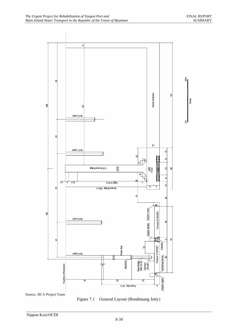
The Urgent Project for Rehabilitation of Yangon Port and FINAL REPORT Main Inland Water Transport in the Republic of the Union of Myanmar SUMMARY
Nippon Koei/OCDI S-38
Source: JICA Project Team
Figure 7.1 General Layout (Botahtaung Jetty)

The Urgent Project for Rehabilitation of Yangon Port and FINAL REPORT Main Inland Water Transport in the Republic of the Union of Myanmar SUMMARY
Nippon Koei/OCDI S-39
Table 7.1 Implementation Schedule of Capacity Development Scheme
Source: JICA Project Team
Packages 2009 2010 2011 2012 2013 2014
Steering Committee Meeting
Ship Crew of IWT (Step 1)
Navigation System of Yangon Port (Step 2)
Ship Crew of IWT (Step 3)
Step 1: Arc Welding (Basic)
Step 2: Sustainable Arc Welding & Cradle
Step 3: CO2 welding and Test
Step 4: Pontoon Construction
Instalation of ATG
Observation by ATG
Analysis
Seminar
Study of disaster prevention program, Fieldsurvey of damage truck and simulation of Nargis
Storm surge and Tsunami Risk in Yangon
Storm surge and Tsunami Risk in Delta
Seminar
Design (Botahtaung)
Tender (Botahtaung)
Relocation
Design (Dalla)
Tender (Dalla)
Construction (Dalla)
Seminar/Workshop/Lecture
Study on Maritime Disaster Risk Management
Study of Tide Observation System
Preparation and Implementation of Pilot Project
Implementation of Capacity Development Scheme for Ship Crew and Navigation
Implementation of Capacity Development Scheme for Repairing Ships and Metal Structure

The Urgent Project for Rehabilitation of Yangon Port and FINAL REPORT Main Inland Water Transport in the Republic of the Union of Myanmar SUMMARY
Nippon Koei/OCDI S-40
CHAPTER 8 ENVIRONMENTAL AND SOCIAL CONDITIONS
The pilot project is required to meet the stipulations in the JICA’s environmental and social considerations. Though in Myanmar environmental law was announced, promotion of environmental protection and the establishment of environmental management have just commenced. In the environmental law, MOECAF was designated as the authority for environmental management. The law consists of 14 chapters, including introduction of IEE and EIA, environmental management plan, public hearing, and monitoring. This EIA/IEE system was made after the commencement of pilot project.
The content of IEE for the pilot project is summarized below:
Investigation of areas affected directly and indirectly by the project Defying of the salient social environmental issues due to the project Proposal of mitigation plans against the anticipated adverse environmental impacts Making of scoping matrix including alternative project
One of the drawbacks of the current environmental law is that the critical values in regard to air,
water, noise, and vibration are not defined. No definite critical values are applied to the construction site.
For this pilot project, environmental monitoring plan for the issues that are expected to cause medium to large impacts has been established. This plan covers pre-construction stage, construction stage, and operation stage.
Major monitoring items are as follows:
Traffic condition of the access for delivery of construction materials to the site Traffic condition of access at operation stage (port operation may increase the neighboring
traffic) Nose during construction (pile driving machine, concrete batching plant)

The Urgent Project for Rehabilitation of Yangon Port and FINAL REPORT Main Inland Water Transport in the Republic of the Union of Myanmar SUMMARY
Nippon Koei/OCDI S-41
CHAPTER 9 CAPACITY DEVELOPMENT FOR SHIP CREW AND NAVIGATION
9.1 CAPACITY DEVELOPMENT OF SHIP CREW OF IWT SHIPS (STEP 1)
9.1.1 TRAINING SCHEME
(1) Purpose of the Training
For the purpose of navigation safety of IWT ships, the training for ship crew was carried out. Two model ships of IWT were equipped with nautical instruments before the start of the training. A basic course on safe navigation for IWT ship crew was performed by JICA Project Team to educate potential IWT instructors first; and selected IWT instructors would then perform training of the IWT ship crew, with assistance and through supervision of JICA Project Team.
(2) Principal Syllabus of the Training
The principal syllabus of the training includes the subjects shown below.
1) To study outline of safe navigation; 2) To select two model ships and equip them with nautical instruments; and study the
operational procedures of these instruments; and 3) To select IWT instructors to educate the potential instructors, and to train the IWT ship crew
and evaluate their performance.
Major subjects of the training syllabus for safe navigation are:
ISM Code and BRM/BTM Rules and Regulations for Navigation and Ship Operation Navigation Ship Operation Meteorology and River Natural Conditions Nautical Instruments Normal Operation and Emergency Operation Communications between IWT and Ship, Ship to Ship, and Ship to Station
9.1.2 PROCUREMENT OF TRAINING MATERIALS AND EQUIPMENT
The nautical instruments used for the training and equipped onboard two model ships are listed below:
Radar: 2 sets GPS 2 sets Echo-Sounder 2 sets Radio (HF) 1 set Radio (VHF) 1 set Transceiver 3 sets Anemometer 2 sets Barometer 2 sets

The Urgent Project for Rehabilitation of Yangon Port and FINAL REPORT Main Inland Water Transport in the Republic of the Union of Myanmar SUMMARY
Nippon Koei/OCDI S-42
9.1.3 TRAINING SCHEDULE
(1) Training Program
With technical transfer as the main objective, the training was broadly carried out in three stages in accordance with the following schedule:
1) Stage 1: Preparation for Training (September 2009)
To prepare educational materials and text for the training and procure nautical instruments
2) Stage 2: Training of Instructors (October 2009)
To train and educate the Assistant Marine Superintendent (AMS), captains and helmsmen who were anticipated to become potential instructors for further training of captains and deck crews of IWT during the period from October to November 2009;
Candidates of the Stage 2 training were selected from the officials or group leaders of crew engaged in the Marine Department of IWT who have the potentials to become instructors of further training for Stage 3 of the training of IWT crew.
3) Stage 3: Training of Seafarers and Crew/Evaluation of training/Correction
(November 2009)
To implement education and training for IWT crew by instructors of IWT trained in Stage 2, and to verify the condition and evaluate the training carried out by the Myanmar instructor(s) selected by Japanese instructors. Advice and further instructions may be proposed, if necessary.
(2) Training Place and Time Schedule
Training took place at two locations, i.e., at the IWT headquarters and on model ships.
Training was performed in accordance with the time schedule below.
Table 9.1 Location and Schedule of Training
Stage Location of Training
At IWT Headquarters On Model Ships
Stage 2: Training of Instructors
Between 20th and 27th October 2009 Between 28th and 30th October 2009
Stage 3: Training of Ship Crew /Evaluation/Correction
Between 2nd and 10th November 2009 Between 4th and 13th November 2009
Source: JICA Project Team

The Urgent Project for Rehabilitation of Yangon Port and FINAL REPORT Main Inland Water Transport in the Republic of the Union of Myanmar SUMMARY
Nippon Koei/OCDI S-43
Training at IWT Headquarters
Training at Model Ship
Closing Ceremony of 2nd Stage
Onboard Training at Model Ship: Study on Radar
Operation Source: JICA Project Team
Photo 9.1 Training on Navigation Safety and Nautical Instruments
9.1.4 PARTICIPANTS OF TRAINING
(1) Participants of the 2nd Stage Training
There were 15 participants who were selected for the Stage 2 training by IWT. They were expected to become potential instructors for further stages of training performed for the education and capacity development of IWT crew.
(2) IWT Instructors and Participants of the 3rd Stage Training
Among the trainees educated and trained during Stage 2 training, four persons (1-assistant marine superintendent, 2-fleet officers and 1-captain) were selected as the instructors for the 3rd stage training. There were also 15 trainees who were selected by IWT for Stage 3 training. These included ten captains and five helmsmen.
9.1.5 POST EVALUATION OF CAPACITY DEVELOPMENT TRAININGS
The 30 ship crew members selected by IWT were divided into two groups. Education and training were carried out continuously for two weeks (10 days), respectively. Recalling the training duration of these four weeks, all trainees appeared to try hard by making the best possible use of this program on the first time of IWT crew training. According to their self-evaluations after completion of the course, all trainees showed extremely high understanding level compared with before the start of this program. Furthermore, through the JICA Project Team’s evaluation, it is recognized that these crew members’ education and training program had been successfully completed in general.

The Urgent Project for Rehabilitation of Yangon Port and FINAL REPORT Main Inland Water Transport in the Republic of the Union of Myanmar SUMMARY
Nippon Koei/OCDI S-44
9.2 CAPACITY DEVELOPMENT OF SHIP NAVIGATION SYSTEM (STEP 2)
9.2.1 TRAINING SCHEME
(1) Purpose of the Training
The purpose of training was to make MPA officers familiar with leading lights. Thus, prior to training, LED leading lights were installed on the three towers at the Monkey Point Channel.
(2) Leading Light System at Monkey Point Channel
Based on the discussion between the JICA Project Team and Marine Department of MPA, leading lights were introduced as follows:
1) Monkey Point Tower (No.1 in the Figure 9.1)
LED Sector Light Light Color: Green/White/Red Sector Angle: each 10 degrees, total 30 degrees of horizontal angle Luminous Range 5 Nautical Mile
2) Thanlyin Point Tower (No. 2 and No. 3 in the Figure 9.1)
LED Range Light Light Color: White Sector Angle: 20 degrees of horizontal angle Luminous Range: 6 Nautical Mile Light Character: Isophase Light 4 seconds (2 seconds on+2 seconds
off) Synchronizing Front Light and Rear Light
Source: JICA Project Team
Figure 9.1 Leading Lights System at Monkey Point Channel

The Urgent Project for Rehabilitation of Yangon Port and FINAL REPORT Main Inland Water Transport in the Republic of the Union of Myanmar SUMMARY
Nippon Koei/OCDI S-45
(3) Principal Syllabus of the Training
1) To study outline of safe navigation 2) To study navigation aids for narrow channel based on IALA 3) To furnish the lights on the three towers 4) To study how to use above instruments
Major subjects of the training syllabus on safe navigation are:
Rules and Regulations for Navigation General Instructions for Navigation Aids How to Use Sector Lights and Range Lights Installation of the Lights on Three Towers Operation and Maintenance of the Lights
(4) Training Program
The training program is broadly implemented in three stages in accordance with the following schedule and the main objective of technical transfer:
Stage-1 Preparing for Training: May to September 2010 Stage-2 Training for MPA officers: September to October 2010 Stage-3 Check and Evaluation: October to December 2010
9.2.2 PROCUREMENT OF TRAINING MATERIALS AND EQUIPMENT
LED Sector Light with Battery Case 1 units LED Range Light with Battery Case 2 units
9.2.3 TRAINING SCHEDULE
(1) Training Place
Second-stage training took place as shown in the table below. Three locations were used for training: MPA office, the site of the leading light tower, and on MPA ships.
Table 9.2 Location and Schedule of Training
Date Training Content Location
2010/10/1 Introduction of safe navigation MPA head office
2010/10/5 Introduction of navigation aids MPA head office
2010/10/6 Operation and maintenance method of sector light Tower and ship
2010/10/7 Operation and maintenance method of range light Tower and ship
2010/10/8 Question and answers, closing session MPA head office
Source: JICA Project Team
(2) Training Participants
The total number of the training participants from MPA was 14.

The Urgent Project for Rehabilitation of Yangon Port and FINAL REPORT Main Inland Water Transport in the Republic of the Union of Myanmar SUMMARY
Nippon Koei/OCDI S-46
Navigation Safety Training at MPA Office Training on Sector Light
LED Sector Light for Monkey Point and Range Lights for Thanlyin Point
Monkey Point Sector Light Properly Workingat Night Time
Source: JICA Project Team Photo 9.2 Training on Safe Navigation and Leading Light
9.2.4 POST EVALUATION OF CAPACITY DEVELOPMENT TRAININGS
In order to evaluate the effectiveness of the training, which is similar to the one carried out at IWT in 2009, questionnaire and self-evaluation surveys were conducted to obtain the impression of each trainee about the improvement of his knowledge after the training course.
(1) Summary
Eleven pilots and captains who have duties directly related to this training and two engineers who are in charge of installation and maintenance of navigational aids, totalling 13 trainees, were selected by MPA, and participated in the six-day training from October 1 to 8 2010.
Subjects of the training are:
Important points on safe navigation International Association of Lighthouse Authorities (IALA) rules including those for leading
lights Efficient way to use leading light at Monkey Point
Because it was the first training from Japan, all the trainees were very keen on the lecture and
practice, and it proved that the training was beneficial. Regarding the contents, most of participants answered that it was good to learn current situations and trends of international treaty or international standards related to safe navigation.

The Urgent Project for Rehabilitation of Yangon Port and FINAL REPORT Main Inland Water Transport in the Republic of the Union of Myanmar SUMMARY
Nippon Koei/OCDI S-47
Furthermore, participants indicated strong interest to study about AIS (Automatic Identification System). According to the SOLAS regulation, activation of the AIS construction of shore station to exchange information between ships and shore station is necessary. It would be needed to have a training course on AIS and to construct the shore station.
In addition, 14 of the trainees mentioned in the questionnaires that they wanted to have similar JICA training continuously in the future.
Analyzing the result of the self-assessment, it was observed that although the training was short, the knowledge and skills of all the trainees have increased with respect to all the training items. Thus, the training was considered very beneficial for them.
(2) Hand-Over Ceremony for Leading Lights for Navigation Aids
Both handing over ceremony for leading lights for navigation aids and the closing ceremony for capacity development of ships and metal structures (Step 2) was held on the 25th of November 2010 at the Dalla Dockyard. Outline of the ceremony is as follows:
1) Principal Attendant:
IWT: Managing Director and General Manager MPA: General Manager and Harbour Master Embassy of Japan: Second Secretary JICA: Chief Representative, Co-Team Leader of the Project
2) Principal Agenda:
Speech: Managing Director of IWT, Chief Representative of JICA Handing over of leading lights for navigation aids, welding equipment and related
documents to MPA and IWT by JICA. Presenting certificates to the trainees Observation of leading lights, welding equipment and cradle.
9.3 CAPACITY DEVELOPMENT OF SHIP CREW OF IWT SHIPS (STEP 3)
9.3.1 TRAINING SCHEME
Nautical instruments (Automatic echo sounder recording type with GPS) were handed-over to IWT, and installed on the two model ships of IWT during the training. Training and education on basics of safe navigation to IWT ship crew was performed by JICA Project Team. Most of syllabus for the training was the same as the Step 1 training in 2009.
The purpose of the equipment hand-over and installation was to get annual data of time, location and depth on the route of the ship maneuvering. This is because the bathymetric survey at the hazards points by DWIR does not cover the overall routes of inland transport. In addition, a navigation route map has not been prepared yet. The observation data will show annual depth variations (between dry and rainy season) of the routes and will help in the preparation of the future navigation route map.
9.3.2 PROCUREMENT OF TRAINING MATERIALS AND EQUIPMENT
The nautical instruments used for the training and equipped on two model ships are listed below:
- Automatic recording-type of GPS and echo sounder 2 sets

The Urgent Project for Rehabilitation of Yangon Port and FINAL REPORT Main Inland Water Transport in the Republic of the Union of Myanmar SUMMARY
Nippon Koei/OCDI S-48
9.3.3 TRAINING PROGRAM AND CHEDULE
(1) Training Program
The training was carried out in the following three stages:
1) Stage 1 - Preparation of Training:
- To prepare education materials and text for the training - To procure nautical instruments
2) Stage 2 - Installation of Echo Sounder and Training of Instructors:
- To install the echo sounder with GPS to IWT ferries - To train and educate potential instructors for further training of captains and the deck
department seafarers of IWT
3) Stage 3 - Evaluation of Training/Correction:
- To explore participants’ level of understanding - To evaluate effectiveness of the training program - Candidates of the training were selected from the officials and group leaders of crew of IWT
(2) Training Place and Time Schedule
The trainings were conducted on the 15th of December 2014 at the IWT Meeting Room and on the16th of December 2014 on the model ships.
9.3.4 OUTLINE OF STEP 3 TRAINING
(1) Participants
A total of 10 participants were selected for the Stage 2 training by IWT. They were expected to become instructors for further-stage training of IWT crew.
(2) Contents of Training
Theme of Training: Navigation Safety and Nautical Instruments Contents of Training at IWT Headquarters:
ISM Code (Background, Object, Outline)
Navigation Safety Planning, IMO (International Maritime Organization), COLREG (International Regulation for Preventing Collisions at Sea), Seamanship, Passage Planning
Bridge Resource Management (BRM), Bridge Team Management (BTM)
Theory and Demonstration of Global Positioning System (GPS) and Echo Sounder
Contents of Training on Board How to use GPS and Echo Sounder

The Urgent Project for Rehabilitation of Yangon Port and FINAL REPORT Main Inland Water Transport in the Republic of the Union of Myanmar SUMMARY
Nippon Koei/OCDI S-49
Training at IWT Headquarters Training at Model Ship Photo 9.3 Training on Navigation Safety and Nautical Instruments
9.3.5 POST EVALUATION OF CAPACITY DEVELOPMENT TRAININGS
Self-assessment was carried out on two aspects of the evaluation. One is on the safe navigation lecture in the IWT classroom, and the other is the handling, operation and maintenance lecture onboard. According to the participants’ self-evaluation, they considered themselves to have high-level understanding. This means all participants perfectly understood the lecture. The JICA Project Team recognized that these crew member’s education and training program had been successfully completed.

The Urgent Project for Rehabilitation of Yangon Port and FINAL REPORT Main Inland Water Transport in the Republic of the Union of Myanmar SUMMARY
Nippon Koei/OCDI S-50
CHAPTER 10 CAPACITY DEVELOPMENT FOR REPAIRING SHIPS AND METAL STRUCTURES
10.1 CAPACITY DEVELOPMENT FOR REPAIRING SHIPS AND METAL Structures (STEP 1)
(1) Purpose of the Training
Because of sudden increase in work volume such as ship repair and inspection at IWT dockyards due to the damages of their vessels and fleets caused by Nargis, the improvement of productivity of inspection and maintenance repair was urgently required. As for the productivity, two main problems were pointed out; one is the shortage of manpower, and the other is insufficiencies in technical know-how and work skills. Therefore, training on DC arc welding was carried out to the potential instructors of the IWT and MPA welding group leaders to improve their know-how and skills.
(2) Principal Syllabus of the Training
In the Step 1 training scheme, Program Modules 1 and 2A were prepared for all candidates, while Program Module 2B was the training for the skilled technicians/group leaders who shall be the potential training instructors for further training scheme of Step 2.
1) Program Module 1 (1 week)
Lecture was performed in the IWT Ahlone Dockyard to provide basic knowledge, international regulations and standards as well as management skills needed for operating a dockyard.
Attendants of this Program Module 1 were management officials/engineers who are the policy makers of each organization and skilled technicians /group leaders of IWT and MPA, who had been trained as the potential instructors for the Step 2 training scheme.
2) Program Module 2A (1 week)
Basic practice training of welding for engineers and group leaders was performed in a half day session at the Dalla Dockyard (morning session) and Ahlone Dockyard (afternoon session). The attendants were the same as in Program Module 1.
3) Program Module 2B (2 weeks)
Advanced practice training for group leaders was performed. Attendants of this Program Module 2B were skilled technicians/group leaders of IWT and MPA who have been trained as the potential instructors of further training schemes.
(3) Training Schedule
The training was conducted based on the time schedule below (Table 10.1).
(4) Training Results
In order to verify the effectiveness of the training, JICA Project Team provided two kinds of questionnaires and performed practical tests to the trainees as post evaluation of training. The evaluation points covered general questions, knowledge questions and practical welding test.

The Urgent Project for Rehabilitation of Yangon Port and FINAL REPORT Main Inland Water Transport in the Republic of the Union of Myanmar SUMMARY
Nippon Koei/OCDI S-51
As for knowledge questions in Figure 10.1, the categories of welding defect, quality control, nondestructive test, and welding method/ procedure achieved high score. The score on the categories of steel material/welding material, and welding machine and electric arc phenomenon were comparatively low. As for the practical welding results in Figure 10.2, some of the trainees were not good at vertical welding at the beginning of the training, but all trainees finally passed each test.
Table 10.1 Location and Schedule of Training
Stage Location of Training
Dalla Dockyard Ahlone Dockyard
Program Module 1 Guidance and General Lecture
9:00AM – 4:00PM at Ayar auditorium room of IWT Ahlone Dockyard Between 20th and 26th October, 2009 Training of management officials/engineers/group leaders of IWT and MPA to educate potential instructors for Phase 2 and future education plan by themselves
Program Module 2A Basic Practical Training
Morning Session (8:00AM – 11:00AM) Between 28th October and 3rd November, 2009 Training for 8 officials and 8 technicians of Dalla Dockyard, IWT
Afternoon Session (13:00PM – 16:00PM) Between 28th October and 3rd November, 2009 Training for 7 officials and 7 technicians of Ahlone Dockyard, IWT and MPA
Program Module 2B Advanced Practical Training
Morning Session (8:00AM – 11:00AM) Between 4th and 17th November, 2009 Training for 8 officials and 8 technicians of Dalla Dockyard, IWT
Afternoon Session (13:00PM – 16:00PM) Between 4th and 17th November, 2009 Training for 7 officials and 7 technicians of Ahlone Dockyard, IWT and MPPA
Source: JICA Project Team
Source: JICA Project Team
Figure 10.1 Diagonal Chart of Understanding Level Classified in Five Categories
02468
101214161820
Welding method and procedure
steel material and welding material
welding machine and arc phenomenon
welding defect and deformation
Quality control and nondestructive testing
1st test
2nd test
Fair line

The Urgent Project for Rehabilitation of Yangon Port and FINAL REPORT Main Inland Water Transport in the Republic of the Union of Myanmar SUMMARY
Nippon Koei/OCDI S-52
No. of Participants Flat Vertical Horizontal Overhead
Fair (5 - 5) 0 3 4 8
Good (7 - 8) 11 10 8 7
Excellent 4 2 3 0 Source: JICA Project Team
Figure 10.2 Practical Welding Results of Skilled/Group Leaders
10.2 CAPACITY DEVELOPMENT FOR REPAIRING SHIPS AND METAL STRUCTURES (STEP 2)
(1) Purpose of the Training
Through the Step 1 training scheme, 15 management officials/engineers and 15 skilled technicians/group leaders of IWT and MPA were trained and educated as future welding instructors to achieve sustainable education system in their organizations.
In the Step 2 training scheme, these 30 instructors who have been already educated in Step 1 gave the arc welding training to their workers in each dockyard for planning and executing the practical training by themselves. Finally, a steel cradle was constructed by the trainees trained in the Step 2 training scheme as practical training on their welding skills.
(2) Principal Syllabus of the Training
1) Program Module 3A (2 weeks):
Planning of the training was performed in the IWT meeting room to arrange the training schedule, instructors cast and selection of trainees. Instruction materials were translated to Myanmar language from English by each instructor for two months.
2) Program Module 3B (2 weeks half day for 1st Group and 1 week full day for 2nd Group):
The practical training was executed to five groups each of 15 trainees by the instructors trained with the Step 1 training scheme. Training places were the Dalla Dockyard and Ahlone Dockyard. For the 1st Group, the training period was two weeks at half a day in order for the JICA Project Team to attend training at two centers. For the 2nd Group, the training period was one week at full day and the JICA Project Team alternately visited two training centers and guided the instructors.
0
2
4
6
8
10
12
Flat Vertical Horizontal Overhead

The Urgent Project for Rehabilitation of Yangon Port and FINAL REPORT Main Inland Water Transport in the Republic of the Union of Myanmar SUMMARY
Nippon Koei/OCDI S-53
3) Program Module 4A (2 weeks):
The steel cradle construction was prepared as the object lesson in the Step 2 training scheme. The JICA Project Team explained the planning, scheduling, production method, welding method, painting method, and safety precaution in constructing the cradle to the management officials/engineers in IWT and MPA. And in the Dalla Dockyard, the JICA Project Team explained the details of design and construction planning, and discussed the scheduling, preparation of facility, improvement of the slipway rail condition, and necessary materials with management officials/engineers.
4) Program Module 4B (6 months):
The steel cradles were constructed by the instructors and trainees trained in Steps 1 and 2. Construction of cradles was performed by the trainees through the lead of group leaders under the instruction of the JICA Project Team.
(3) Training Schedule
The training was conducted based on the time schedule shown in the following Table 10.2.
(4) Training Results
Both of the experienced and inexperienced persons achieved certain skills as shown in Table 10.3. Several persons got excellent grades. The attitude in which some officers tried to participate in the training and to acquire the technology is appreciable.
Then, in constructing the steel cradle, Dalla Dockyard staffs and workers fully understood the construction procedures and the difficulties of the process, but the trainees did their best to meet the permissible tolerance.
Table 10.2 Location and Schedule of Training
Stage Location and Schedule
Program Module 3A Welding Training Planning &Preparation
Period: Between 15th and 29th of March 2010 Homework for the instructors (translation of training text) until end of May 2010
Place: IWT meeting room Member: Instructors trained with Step 1 Training Scheme of 15 Officials/Engineers and
15 Group Leaders of IWT and MPA
Program Module 3B Welding Training Practice in Training Center
Period: Between 29th of July and 8th of August 2010 Practice: 1st Batch : Between 9th Aug. and 20th Aug. 2010 2nd Batch : Between 23rd
Aug. and 27th Aug. 2010 3rd Batch : Between 30th Aug. and 3rd Sep. 2010 4th Batch : Between 6th Sep. and 10th Sep. 2010 5th Batch : Between 13th Sep. and 17th Sep. 2010
Place: Training Center in Dalla Dockyard Training Center in Ahlone Dockyard
Member: 15 Officials/Engineers & 15 Group Leaders of IWT and MPA Trainees: Total of 72 trainees attended composed of:
Dalla Dockyard 8p x 3 Groups/ 7p x 1 Group 6p x 1Group Ahlone Dockyard 4p x 5 Groups Theinohyu Dockyard 1p x 5 Groups Satsan Dockyard 1p x 5 Group Angyi Dockyard 1p x 5 Group JICA Project Team had fully attended to Group 1 and alternately attended to Groups 2, 3 and 4 in order to support the instructors.

The Urgent Project for Rehabilitation of Yangon Port and FINAL REPORT Main Inland Water Transport in the Republic of the Union of Myanmar SUMMARY
Nippon Koei/OCDI S-54
Stage Location and Schedule
Program Module 4A Cradle Construction Planning by lecture
Period: Between 15th and 29th of March 2010 Place: IWT meeting room of Dalla Dockyard Member: 15 Officials/Engineers & 15 Group Leaders of IWT and MPA
JICA Project Team explained the cradle construction methods, drawings, construction schedule and safety precautions.
Program Module 4B Cradle Construction at Dockyard
Period: Between June and November 2010 Place: Dalla Dockyard and meeting room for short lectures Member: Officials/Engineers and Group Leaders in Dalla Dockyard
Trainees who were trained with Step 2 Scheme JICA Project Team instructed the cradle construction method, parts control, painting methods, cradle construction schedule, safety precaution, etc. on the course of progress of cradle construction.
Source: JICA Project Team
Table 10.3 Post Evaluation Results of DC Arc Welding Training
Evaluation Point
Evaluation
Excellent or Very Good
Good Enough Not
Sufficient Not
Good
Status of Skills 6p
(6%) 30p
(24%) 33p
(70%) 0 0
Status of Attitude 13p
(15%) 41p
(53%) 16p
(32%) 0 0
Total Result of Training 15p (6%)
29p (46%)
27p (48%)
0 0
Source: JICA Project Team
Table 10.4 Post Evaluation Results of Cradle Construction
Welding Painting
Surface Preparation Paint Application
No. 1 cradle unit Good Good Good
No. 2 cradle unit Good Good Good
No. 3 cradle unit Good Good Good
No. 4 cradle unit Good Good Good
Source: JICA Project Team
10.3 CAPACITY DEVELOPMENT FOR REPAIRING SHIPS AND METAL STRUCTURES (STEP 3)
(1) Purpose of the Training
The purposes of Step 3 training are 1) to master CO2 arc welding as a progressed technology to improve the speed of ship repair and shipbuilding, and 2) to study testing and inspection to improve the quality of ships. CO2 arc welding is the welding method using CO2 welding machine. The speed of the welding is about 2 to 3 times of normal hand arc welding. IWT had long planned to deploy CO2 welding machine to improve the welding efficiency, but was vain due to lack of technology.

The Urgent Project for Rehabilitation of Yangon Port and FINAL REPORT Main Inland Water Transport in the Republic of the Union of Myanmar SUMMARY
Nippon Koei/OCDI S-55
In this Step 3 training scheme, 12 management officials/engineers and 20 skilled technicians/group leaders of IWT studied the theories of CO2 arc welding and the testing and inspection method, and underwent practical training on CO2 arc welding and penetrant testing (PT).
(2) Principal Syllabus of the Training
The Step 3 training scheme is subdivided into two training program modules 5 and 6.
1) Program Module 5A (to 3 groups of 32 trainees in total for each 2 days)
The lecture on the theory of CO2 arc welding and its application method to shipbuilding was carried out in three groups of each 11, 12 and 9 trainees for two days, respectively.
2) Program Module 5B (to 8 groups of 32 trainees in total for each 5 days at half day)
The practical training of CO2 arc welding was carried out in eight groups of each four trainees for five days at half day in the morning and afternoon.
3) Program Module 6A (to 2 groups of total 16 trainees for each 5 days)
The lecture on the theory of testing & inspection method in detail was conducted for two groups of eight Management officials/ Engineers/ Group leaders each for 5 days in order to study in detail including the practical training of the PT.
4) Program Module 6B (to 2 groups of total 16 trainees for each 2 days)
The lecture of the theory of testing & inspection method was conducted for two groups of eight skilled technicians each in order to study the outline of testing & inspection method including the practical training on the PT.
(3) Training Schedule
The training was conducted based on the time schedule presented in the following Table 10.5.
Source: JICA Project Team
Photo 10.1 Photos of Training (Left: Lecture and Discussion, Right: Practical Training)

The Urgent Project for Rehabilitation of Yangon Port and FINAL REPORT
Main Inland Water Transport in the Republic of the Union of Myanmar SUMMARY
Nippon Koei/OCDI
S-56
Table 10.5 Location and Schedule of Training
Stage Location and Schedule
Module 5A
CO2 Arc Welding
Lecture of the theory of CO2 arc
welding and the application to
the shipbuilding
Period: Between the 28th of September and 5th of October 2012
1st Batch (11 persons): 28th Sep. and 1st Oct. 2012
2nd Batch(12 persons): 2nd Oct. and 3rd 2012
3rd Batch (9 persons): 4th Oct. and 5th 2012
Place: Ayeyar Auditorium in Ahlone Dockyard
Trainees 12 Officials/Engineers & 20 Group Leaders/ Skilled Technicians of Dalla
Dockyard and Ahlone Dockyard in IWT.
Module 5B
CO2 Arc Welding
Practical Training
Period: Between the 9th of October and 6th of November 2012
1st Batch: Between 9th Oct. and 15th 2012 at a.m.
2nd Batch: do. at p.m.
3rd Batch: Between 16th Oct. and 22nd 2012 at a.m.
4th Batch: do. at p.m.
5th Batch: Between 23rd Oct. and 29th Oct. 2012 at a.m.
6th Batch: do. at p.m.
7th Batch: Between 31st Oct. and 5th Nov. 2012 at a.m.
8th Batch: do. at p.m.
(each 4 persons)
Place: Training Room in Ahlone Dockyard
Training Center in Ahlone Dockyard
Trainees: 12 Officials/Engineers & 20 Group Leaders/ Skilled Technicians of Dalla
Dockyard and Ahlone Dockyard in IWT.
Module 6A
Testing & Inspection method
Lecture and Practice to Officials/
Engineers/Group Leaders
Period: Between the 7th and 20th of November 2012
1st Batch (8 persons): Between 7th Nov. and 13th 2012
2nd Batch (8 persons): Between 14th Nov. and 20th 2012
Place: Ayeyar Auditorium in Ahlone Dockyard
Trainees: 12 Officials/Engineers & 4 Group Leaders of Dalla Dockyard and Ahlone
Dockyard in IWT.
Module 6B
Testing & Inspection method
Lecture and Practice to Group
Leaders/ Skilled Technicians
Period: Between the 21st and 29th of November 2012
1st Batch (6 persons): 21st Nov. and 22nd 2012
2nd Batch (6 persons): 23rd Nov. and 26th 2012
3rd Batch (6 persons): 27th Nov. and 29th 2012
Place: Ayeyar Auditorium in Ahlone Dockyard
Trainees: 18 Group Leaders/ Skilled Technicians of Dalla Dockyard and Ahlone
Dockyard in IWT.
Source: JICA Project Team
(4) Training Results
In order to evaluate the improvement of technical skills, a welding test at flat position and vertical
position for CO2 Arc Welding was conducted. Four persons for the flat position and three persons for
the vertical butt welding were evaluated as “Excellent”.
Source: JICA Project Team
Figure 10.3 Practical Training Results of CO2 Welding

The Urgent Project for Rehabilitation of Yangon Port and FINAL REPORT Main Inland Water Transport in the Republic of the Union of Myanmar SUMMARY
Nippon Koei/OCDI S-57
10.4 CAPACITY DEVELOPMENT FOR REPAIRING SHIPS AND METAL STRUCTURES (STEP 4)
(1) Purpose of the Training
Among the pilot projects, the construction of pontoon at Dalla Shipyard was decided as part of the technical transfer. The purposes of the training were 1) to introduce a new shipbuilding method for IWT (block method), 2) to improve the technical know-how on shipbuilding, and 3) to reduce the annual maintenance costs of pontoons at IWT by introducing Japanese technology.
(2) Principal Syllabus of the Training
There are three important issues for IWT due to lack of experiences before.
The first issue is the knowledge on mold loft which is an interface of design and construction site. Detailed technical standards will be set and then this information will be put in mold loft for each stage of foldout marking, cutting, assembling, welding, and general assembly.
The second issue is the preparation of construction plan. First, construction principles will be decided based on the condition of work space and capacity of facilities. Working instruction is made based on the abovementioned basic principle. In this working instruction, overall procedures until complete, block division, built-up order of block and joint geometry will be described.
The third issue is schedule making. The master schedule, which can cover overall works, was made after the main schedule has been decided. In here, schedule of each stage and each block were described.
According to abovementioned issues, the following instruction topics were set in this training.
Table 10.6 Instruction Contents
No. Instruction Theme
Detail Article Contents
1 Construction Principle Apply block method Workplace and bench, check up the facility
schedule Manpower and ability
2 Production Procedure Block division Power of crane, size of materials
Built-up procedure From making panel to built-up block, describe at working instruction
Loading procedure Loading procedure of block
Accuracy standard Measurement method of shrink
3 Making Schedule Master schedule Overall schedule and loading schedule
Schedule at each stage Cutting, built-up (small & large), rigging schedule
4 Working Schedule (Hull)
Manufacture NC marking/cutting, manual cutting
Built-up block Built-up trans frame, making panel, combine of blocks
Loading Loading procedure, air tightness test, quality check, installation of anode
5 Working Schedule (Rigging, Painting)
Rigging Making concrete steel mold for fender and fence etc.
Painting Shot blasting and painting primer, painting block, clear coat
Source: JICA Project Team

The Urgent Project for Rehabilitation of Yangon Port and FINAL REPORT Main Inland Water Transport in the Republic of the Union of Myanmar SUMMARY
Nippon Koei/OCDI S-58
(3) Training Schedule
Basic design was started from October 2013 and bidding documents were distributed on December 13, 2013. Then, detailed design was continuously conducted. After contract on January 2014, steel plate was ordered sequentially and deliveries of materials were started from February 1, 2014. In February 2014 manufacturing of body parts started, and assembling of small, medium, and large blocks followed. From July 2014, installation of accessories started. From August 2014, JFE concurrently started construction works related to concrete casting. In September 2014, IWT finished the fabrication work of the pontoon and then, its installation work was done in October 2014.
(4) Implementation
Pontoon construction was implemented based on abovementioned procedure.
1) Before Building Stage
Understanding the principle of block method by using a prepared model is part of the training. Understanding the method of reverse block by using two cranes by a model.
2) Fabrication Stage
Marking/ cutting NC machine based on NC data
3) Built-up Stage
Build a bottom shell (BS) first. Then, side shell and trans-bulkhead are fitted to upper deck (UD). Weld four panels of one UD, one trans-bulkhead TB, two side shell, and then inverted and loaded to BS. One pontoon is composed of six blocks and one sponson. After completion of the main body, the necessary rigging was installed.
4) After Building Stage
In order to confirm the air-tightness inside the float structure like pontoon, air leak has to be confirmed by pressurizing the float structure inside.
Source: JICA Project Team
Photo 10.2 Pontoon Construction
(5) Training Result
The block method was already explained in Step 1 of the previous training. In this time, members at the IWT site became aware of the advantage of “block method” because of their practical

The Urgent Project for Rehabilitation of Yangon Port and FINAL REPORT Main Inland Water Transport in the Republic of the Union of Myanmar SUMMARY
Nippon Koei/OCDI S-59
works through this training. In this training, construction method of pontoon and the procedures of fabrication of the block were learned through the production procedure. There was no common awareness of work progress until now and it was dependent on the practical knowledge and experience of engineer. However, in this training, specific skills (efficiency), awareness of deadline, efficient use of the yard, clarifications of work delay, and awareness of the critical path became clear through the detailed work schedule. These led to a common awareness of the work progress by all engineers.
As for quality management, IWT had had no enough knowledge of quality standards and no understanding of the troubleshooting method. However, IWT passively followed the error treating method, and up skilling in error treating technique was recognized. IWT has not carried out any air tightness leak test until now and so inspection related to air leakage cannot be done. It caused poor verification of quality control. In this technical transfer, the air leak test was introduced and hence, the quality management awareness of IWT was improved.

The Urgent Project for Rehabilitation of Yangon Port and FINAL REPORT Main Inland Water Transport in the Republic of the Union of Myanmar SUMMARY
Nippon Koei/OCDI S-60
CHAPTER 11 STUDY ON DISASTER RISK MANAGEMENT
11.1 BACKGROUND AND OBJECTIVE OF THE STUDY
In the project, the JICA Project Team had scheduled the study to formulate the maritime disaster prevention programme and guidelines before coming to Myanmar. However, the programme and guidelines had been formulated by the Government of Myanmar. The JICA Project Team reviewed the programme and guidelines of Myanmar, and concluded that organizations, evacuation anchorages and disaster alarm were described, but the description of disaster risk analysis was inadequate. Therefore, the scope of works of the JICA Project Team studied to supplement the programme and guidelines of Myanmar by analyzing the risk of cyclones, storm surges and tsunamis. The risk evaluation and countermeasure had been included in the maritime disaster prevention programme, although some parts of them have been studied by JICA Project Team.
Source: JICA Project Team
Figure 11.1 Task of JICA Project Team for Preparation of Risk Management System
Risk assessment (event provability, disaster level)
Scenario analysis
Weak point analysis
Effect analysis
Prevention Risk retainment
Reduction Transfer
Risk evaluation (countermeasure selection)
Risk analysis
Risk Assessment
To specify risk factor
Basic concept Guideline
Risk management policy
Countermeasure
・ Hard measure ・ Soft measure
Insurance
Prepared by MDPC
Supported by JICA Project Team
Prepared by MDPC

The Urgent Project for Rehabilitation of Yangon Port and FINAL REPORT Main Inland Water Transport in the Republic of the Union of Myanmar SUMMARY
Nippon Koei/OCDI S-61
11.2 DISASTER RISK AND CRISIS MANAGEMENT
11.2.1 PROCESS OF PREPARING DISASTER PREVENTION PROGRAM/GUIDELINES
With the data collected for the disaster conditions due to cyclone, the causes of damages on the port facilities are analyzed. From the results of the analysis of damage caused by each factor of storm surge carried out in the course of preparing the hazard map, the relationship between the scale of damages and countermeasures are identified.
11.2.2 DISASTER RISK AND CRISIS MANAGEMENT
Structural measures for disaster prevention approach protect properties and people from natural hazards, of which force is below the design safety level. From the viewpoint of economic efficiency, it is not realistic to implement structural measures against all of natural hazards. Therefore, countermeasures to the natural hazards exceeding the design safety level are recommended, which are only non-structural measures.
Source: JICA Project Team
Figure 11.2 Disaster Prevention and Reduction by Hard and Soft Countermeasures
11.3 MARITIME DISASTER PREVENTION PROGRAMME AND PLAN IN MYANMAR
11.3.1 MARITIME DISASTER PREVENTION PROGRAMME
The Ministry of Transportation formed a “Maritime Disaster Prevention Committee (MDPC)” chaired by MPA after Nargis. MDPC formulated the “Maritime Disaster Prevention Programme”.
The Maritime Disaster Prevention Programme described evacuation anchorages around the Yangon Main Port designated by ship size, and the disaster risk levels in five stages of yellow, orange, red, brown and green.
Counter Measure
Limit
No damage Damage Huge Damage
Eve
nt P
roba
bilit
y
ExternalForce
Hard Measure (by Structure)
Disaster Prevention
Soft Measure (by Information)
The larger property accumulation
Target on Design Level of Structure for Prevention
Target on Soft Measure for Prevention
Tolerable Limit
Huge Disaster
Approach to tolerable limit
Disaster Reduction
Acceptable Risk

The Urgent Project for Rehabilitation of Yangon Port and FINAL REPORT Main Inland Water Transport in the Republic of the Union of Myanmar SUMMARY
Nippon Koei/OCDI S-62
11.3.2 MARITIME DISASTER PREVENTION IMPLEMENTATION PLAN FOR INLAND WATERWAY
IWT formulated the Maritime Disaster Prevention Implementation Plan for Inland Waterway under the Maritime Disaster Prevention Programme. The purpose of the plan is to secure passengers’ safety, to prevent damages on IWT crafts and buildings, and to enhance the safety mindset of the staffs in Ayeyarwady Division, Yangon Division, Mon State and Rakhine State.
11.4 ANALYSIS OF CYCLONE AND STORM SURGE IN YANGON PORT
11.4.1 STUDY OF CYCLONE IN MYANMAR
According to the data of cyclone tracks of the Joint Typhoon Warning Center of the U. S. Navy (JTWC), the strongest cyclones from 1945 to 2009 were Nargis in 2008 and Cyclone Mala in 2006. Nargis recorded a minimum center pressure of 937 hPa, maximum wind of 57.5 m/s and the landing duration in Myanmar of 36 hours. The landing duration of 36 hours was extremely long. Cyclone Mala recorded a minimum center pressure of 922 hPa, maximum wind of 60.0 m/s and the landing duration in Myanmar of 18 hours. However, the damage caused by Mala was negligible in comparison with Nargis.
Table 11.1 Pressure, Wind Velocity and Landing Time of Typical Cyclones
Year Minimum Pressure
(hPa) Maximum Wind
(m/s) Landing Duration
(hour) Remarks
1992 994 17.5 6
1994 940 57.5 5
1995 978 32.5 3
1996 1000 15.0 3
2002 997 17.5 12
2003 991 22.5 6
2004 976 32.5 12
2006 922 60.0 18 Cyclone Mala
2008 937 57.5 36 Cyclone Nargis
Source: JTWC
Simulated cyclones were extracted from the numerical model experiment outputs of the present and future climate by the Meteorological Research Institute and Japan Meteorological Agency (MRI/JMA) as summarized in Table 11.2. In Case 1 and Case 2, all of cyclones and strong cyclones were extracted, respectively. A comparison of present and future strong cyclones in Case 2 indicated an increase in the number and magnitude of strong cyclones.
Table 11.2 Summary of Simulated Cyclones by MRI/JMA
Number of Cyclones in Bengal Bay
Minimum Center Pressure (hPa)
Mean Center Pressure(hPa)
Present Cyclones (1979-2003)
Case 1 57 983.1 1,002.6
Case 2 8 980.8 991.0
Near Future Cyclones (2015-2039)
Case 1 46 962.7 1,001.2
Case 2 13 945.8 980.9
Source: JICA Project Team

The Urgent Project for Rehabilitation of Yangon Port and FINAL REPORT Main Inland Water Transport in the Republic of the Union of Myanmar SUMMARY
Nippon Koei/OCDI S-63
The number of cyclones in the data of JTWC cyclone track records and MRI/JMA numerical experiments was summarized in Table 11.3. The historical data of JTWC indicates 290 cyclones in the last 65 years in the Bay of Bengal, of which 29 cyclones landed in Myanmar. Annually 4.5 cyclones, which is 10% of cyclones formed in the Bay of Bengal, lands in Myanmar. In addition, the prediction data of MRI/JMA indicates about 10% of cyclones formed in the Bay of Bengal will land on Myanmar area.
Table 11.3 Number of Cyclones Formed in Bay of Bengal and Landing in Myanmar
Total Number of
Cyclones in Bay of Bengal (A)
Total Number of Cyclones Landed
around Myanmar (B)
Average Number of Cyclones in Bay of
Bengal per Year
Proportion (B/A)
JTWC 1945-2009 (65 years)
290 29 4.5 10.0%
MRI/JMA 2015-2039 (25 years)
46 4 1.8 8.7%
Source: JICA Project Team
11.4.2 STORM SURGE SIMULATION IN YANGON PORT
The storm surge simulation in Yangon Port was conducted as shown in Table 11.4 and Figure 11.3. The storm surge simulation of Nargis indicated a storm surge deviation of 2.5 m, or sea level departure from astronomical tide, around the Yangon Main Port. The sensitivity analysis of traveling routes of Nargis in Cases 1, 2 and 3 resulted in the maximum storm surge deviation around the Yangon Main Port in Case 2 of 1 degree shifting to the east. Cases 4 and 5 simulated the storm surge with the pressure of predicted cyclone by MRI/JMA, and showed a storm surge deviation of 20 or 30 cm in addition to Nargis.
Table 11.4 Storm Surge Simulation in Yangon Port
Case Case Name Pressure Course
1 Nargis Nargis Nargis
2 Nargis + 1 degree Nargis Nargis + 1 degree
3 Nargis – 1 degree Nargis Nargis - 1 degree
4 Nargis Future AGCM Output Nargis
5 Nargis Future + 1 degree (Assumed strongest cyclone in future)
AGCM Output Nargis + 1 degree
Source: JICA Project Team
Source: JICA Project Team
Figure 11.3 Storm Surge Simulation Outputs in Yangon Port
‐0.5
0.0
0.5
1.0
1.5
2.0
2.5
3.0
4000 5000 6000 7000 8000 9000 10000 11000 12000
Hei
ght[
m]
Time[m]
Nargis
Nargis+1deg
Nargis‐1deg
Nargis‐Future
Nargis‐Future+1deg

The Urgent Project for Rehabilitation of Yangon Port and FINAL REPORT Main Inland Water Transport in the Republic of the Union of Myanmar SUMMARY
Nippon Koei/OCDI S-64
11.5 ANALYSIS OF DAMAGE BY CYCLONE AND STORM SURGE IN YANGON PORT
11.5.1 SIMULATION OF SHIP DRIFTING
Damages on ships were estimated through the ship drifting simulation during storm surges. The initial condition of ships’ positions was obtained from satellite images. Table 11.5 shows the simulation outputs of 40% stranding and 20% sinking.
Table 11.5 Summary of Ship Drift Simulation Output in Yangon Port
Phenomena Damaged/Total Ships
(Percentage) Description
Collision ((between ships)
642/949 (68%)
In almost all areas, there were many collisions, especially in the Yangon Main Port.
Collision (between ship and embankment)
105/949 (11%)
There were a lot of collisions in the Yangon Main Port.
Sinking 211/949 (22%)
There was a lot of sinking in Yangon Main Port and upstream of Hlaing River. There was a few sinking in Pazundaung Creek.
Stranding 351/949 (37%)
In almost all areas excluding Pazundaung Creek, there was many stranding.
Source: JICA Project Team
11.5.2 EFFECT OF WIND
The breaking of mooring rope was not considered in the ship drifting simulation due to difficulty of consideration of small-scale wind effects. Therefore, the drag force by the size of ship was studied. When wind speed reaches approximately 40 m/s and 60 m/s, the mooring ropes with diameters of 50 mm and 100 mm broke, respectively.
11.5.3 STUDY OF HUMAN LOSS AND DAMAGES ON STRUCTURES
(1) Study of Building Damage
Two cases of building damage estimation were studied. Case 1 is for Nargis, and Case 2 is for the predicted cyclone by MRI/JMA. The case settings of damage estimation are shown in Table 11.6.
Table 11.6 Cases of Storm Surge Building Damage Estimation in Yangon Port
Case Name Storm Surge High Tide
1 Nargis + high tide +2.3 – 2.7m +3.0 m (+MSL)
2 Assumed strongest cyclone + high tide +2.7 – 3.1 m +3.0 m (+MSL)
Source: JICA Project Team
It was estimated that lots of buildings would be damaged by storm surges as shown in Table 11.7. The applied damage rate in the estimation was developed in Japan. If the conditions of the buildings in Myanmar were considered in the damage rates, the estimates may be more serious.

The Urgent Project for Rehabilitation of Yangon Port and FINAL REPORT
Main Inland Water Transport in the Republic of the Union of Myanmar SUMMARY
Nippon Koei/OCDI
S-65
Table 11.7 Number of Inundated Buildings Classified into Four Inundation Ranges and
Corresponding Building Damage Rate
Inundation Depth
Less than 50cm 50 – 99cm 100 – 199cm 200 – 299cm 300cm over
Damage Rate
Not applied
in this study
11.9% 26.6% 58.0% 83.4%
Case 1 217 buildings
(217)
50 buildings
(267)
4 buildings
(271)
2 buildings
(273)
Case 2 575 buildings
(575)
217 buildings
(792)
50 buildings
(842)
6 buildings
(848)
Note: The accumulated number of inundated buildings is shown in parentheses.
Ex) 50+217=267, in Case1, for less than 200 cm.
Source: JICA Project Team
(2) Study of Human Loss
Death tolls due to storm surges were estimated with the method of the National Disaster
Prevention Council of Japan. Case A (without countermeasures) and Case B (with evacuation) were
studied on each of building damage estimation case of Case 1 and Case 2. The buildings with more than
90% of mortality rate were six in Case 1/Case A and 56 in Case 2/ Case A. On the other hand, the
mortality rate became almost zero in Case B with evacuation to higher ground.
Source: JICA Project Team
Figure 11.4 Number of Inundated Buildings Classified into Three Inundation Ranges
and Corresponding Death Rate
(3) Damage of Yangon Port Facility
Storm surges damaged facilities in Yangon Port. The water level rises and the rapid flow result
in damages of pontoons, drifting and out-flowing of containers, and damages on cargos and equipment
such as forklifts.

The Urgent Project for Rehabilitation of Yangon Port and FINAL REPORT Main Inland Water Transport in the Republic of the Union of Myanmar SUMMARY
Nippon Koei/OCDI S-66
11.6 STUDY OF COUNTERMEASURE ON CYCLONE AND STORM SURGE IN YANGON PORT
11.6.1 SAFETY ASSESSMENT OF EVACUATION ANCHORAGES IN YANGON PORT
Safety and importance of evacuation anchorages designated in the Maritime Disaster Prevention Programme of MPA were assessed based on the results of the storm surge simulation. Figure 11.5 indicates the highest safety of P2-P7, next safe in P1, H3-H5, K1, and the lowest safety in H1, H2, H6, K2, K3. The Yangon Main Port was assessed as high risk area, and the upstream of tributaries were safer, designated as evacuation anchorages. Therefore, the JICA Project Team concluded that evacuation anchorages were located in appropriate places. However, it is noted that the safety at H1, H2, H6, K2, K3 is still lower than other evacuation anchorages, and that K2 is also with high importance.
Source: JICA Project Team
Figure 11.5 Safety and Importance Evaluation of Evaluation Anchorages in Yangon Port
11.6.2 SHIP OPERATION FOR EVACUATION
When Nargis came, large ships in Yangon Port departed the port following MPA instructions. Accidents such as collisions or stranding did not occur. However, the port was mired in confusion as ferries, small cargo ships, and barges were in collisions, sinking, or stranding by strong winds and storm surges.
As to factors related to software, there was no evacuation guideline for cyclones. Evacuation anchorages were not designated clearly. The contents of the evacuation alarm and its dissemination method and timing were not specified clearly. For factors related to hardware, there were many old ships with 50 years of age such as IWT ferries. In addition, lack of hardware in the port was also the major cause such as pontoon jetties weak to gales and storm surges, lack of mooring buoys, and lack of supporting ships and communication facilities.
As the situation during Nargis was compared with the ship evacuation in Japan, the studies on the points listed below are recommended:
Improvement of rules and regulations on ship evacuation,
H2
H3
H4
H5
H6
K1
K3
P1P2
P3P4 P5
P6P7
5 0 5 10km5 0 5 10kmK2
H1
< Safety Level >Level 1 LowLevel 2Level 3
Rank 1 LowRank 2Rank 3 High
Level 4Level 5 High
< Important Level >
< Safety Level >Level 1 LowLevel 2Level 3
Rank 1 LowRank 2Rank 3 High
Level 4Level 5 High
< Important Level >

The Urgent Project for Rehabilitation of Yangon Port and FINAL REPORT Main Inland Water Transport in the Republic of the Union of Myanmar SUMMARY
Nippon Koei/OCDI S-67
Improvement of data collection and analysis methods of weather and sea conditions, and Implementation of regular public-private joint disaster drill based on the Maritime Disaster
Prevention Programme.
11.7 TSUNAMI SIMULATION AND DAMAGE ESTIMATION IN YANGON PORT
11.7.1 EARTHQUAKE IN MYANMAR
Myanmar is located at the boundary of the India-Australia Plate and the Eurasia Plate. The Fault run Myanmar from North to South. The Rangoon Earthquake in 1970 struck Yangon and caused huge damage.
11.7.2 TSUNAMI IN MYANMAR
The 2004 Indian Ocean Earthquake Tsunami struck Myanmar. A death toll of 60, 3600 affected people, and damages amounting to USD 265 million were recorded.
11.7.3 FAULT MODEL
The fault model of the 2004 Indian Ocean Earthquake studied by Tohoku University was applied. In addition, coupling fault model of the northern part structure line and the 2004 Indian Ocean Earthquake were selected for one of simulation cases.
11.7.4 TSUNAMI SIMULATION
Totally, eight cases of tsunami simulation were conducted as shown in Figure 11.6. Case 7 with the coupling fault model of the northern part structure line and the 2004 Indian Ocean Earthquake indicated the maximum tsunami height of 0.6 m.
Source: JICA Project Team
Figure 11.6 Results of Tsunami Simulation in Yangon Port
11.7.5 TSUNAMI DAMAGE ESTIMATION
(1) Study of Building Damage
Building damages were estimated with 0.6 m of tsunami height in addition to 3.0 m of high tide level. The inundated buildings were estimated to four buildings as shown in Table 11.8.
The highest tsunami height case: Case 7 - Tsunami height: 0.6 m - Tide level: 3.0 m - Total height: 3.6 m

The Urgent Project for Rehabilitation of Yangon Port and FINAL REPORT Main Inland Water Transport in the Republic of the Union of Myanmar SUMMARY
Nippon Koei/OCDI S-68
Table 11.8 Estimation of Building Damage by Tsunami in Yangon Port
Inundation Depth
Wooden House Non Wooden House Inundated Building Damage
Classification Damage
Rate Damage
Classification Damage
Rate
0.5– 1m* Slight Damage 20.5% Slight Damage 20.5% 4
1 – 2m Major Damage 38.2% Slight Damage 20.5% 0
2m over Destroyed 100.0% Slight Damage 20.5% 0
Total 4
*: The topographic data applied in the analysis is in the format of 1 m interval of elevation. The elevation data of less than 0.5 m was counted as 0.5-1 m.
Source: JICA Project Team
(2) Study of Human Loss
Human loss due to the tsunami was estimated to 0%.
11.7.6 TSUNAMI HAZARD MAP IN YANGON PORT
A tsunami hazard map was prepared based on the simulation output as shown in Figure 11.7.
Source: JICA Project Team
Figure 11.7 Tsunami Hazard Map in Yangon Port
11.8 STORM SURGE AND TSUNAMI SIMULATION IN DELTA AREA
11.8.1 SITE SURVEY
(1) Geodetic Survey
Geodetic surveys were conducted in the Delta area; bathymetric surveys in the Ywe River, Pathein River, Pya Ma Law River, and topographical survey in the town of Labutta, the major town in the Delta area.
TSUNAMI HAZARD MAP IN YANGON
■ Inundation Prediction Area■ Low elevation Area
Port Facility
Sule Pagoda wharves
Bo Aung KyawContainer Yard
This map is intended to notice the dangerous area in case that tsunami occurred.
There is not so large inundation in case a tsunami occurs from Indian Ocean. However, the inundation risk is high at low elevation area of Yangon river side (■area).
Some jetties and vessels

The Urgent Project for Rehabilitation of Yangon Port and FINAL REPORT Main Inland Water Transport in the Republic of the Union of Myanmar SUMMARY
Nippon Koei/OCDI S-69
(2) Tide Observation
Tide observations were conducted in the Ywe River, Pathein River, and Pya Ma Law River. The astronomical tides on the day of the 2004 Indian Ocean Earthquake Tsunami and Nargis were calculated based on the above observation data.
11.8.2 STORM SURGE SIMULATION IN DELTA AREA
The simulation of Nargis and sensitivity analysis of storm surge deviation on the traveling course were conducted, and the case of Nargis showed the maximum water level. The storm surge deviation by Nargis was simulated to about 2.0 m in the river mouth of Ywe River. According to the interview survey in the site, the inundation depth was approximately 8 feet (2.4 m), which was higher than the simulation. The difference of simulation and actual would be due to the effects of waves.
Source: JICA Project Team
Figure 11.8 Storm Surge Simulation Output in Delta Area
11.8.3 MAGNITUDE OF EARTHQUAKE AND TSUNAMI FOR SIMULATION
The 2011 Tohoku Earthquake Tsunami struck the pacific coast of northeastern Japan. The port structures were destroyed by the tsunami exceeding the design level. This experience led to the new design guideline for breakwaters.
The Policy for Tsunami-Resistant Design of Breakwaters designated two levels of tsunamis by its magnitude and recurrence, which are L1 and L2. Level 1 (L1) Tsunami is the tsunami that occurs frequently. The countermeasures to L1 Tsunami are “disaster prevention”. The Government of Japan (GoJ) makes efforts to protect human lives and properties by structures as much as possible. Level 2 (L2) Tsunami is the tsunami that rarely occurs, but causes catastrophic damages. The countermeasures to L2 are “disaster mitigation”. The GoJ makes efforts to protect the lives at least, and to minimize the damages on properties.
In the vast delta area, structural countermeasures are not economically feasible due to immeasurable costs. Thus, mitigation measures mainly consisting of soft countermeasures are necessary considering L2 Tsunami.
Ywe River

The Urgent Project for Rehabilitation of Yangon Port and FINAL REPORT Main Inland Water Transport in the Republic of the Union of Myanmar SUMMARY
Nippon Koei/OCDI S-70
11.8.4 FAULT MODEL
Selected fault models for the tsunami simulation were two cases. Case 1 was for the 2004 Indian Ocean Earthquake and Case 2 was for the coupled fault model of the 2004 Indian Ocean Earthquake, the Northern Part Structure Line, and the West Myanmar Subduction. The fault model of Case 2 included a wider area than the one in the simulation of Yangon Port to consider L2 Tsunami. The Case 2 earthquake indicated a moment magnitude of 9.4 and the return period between 90 and 1000 years.
Source: USGS (http://walrus.wr.usgs.gov/tsunami/sumatraEQ/seismo.html), edited by JICA Project Team Figure 11.9 Fault Model for Tsunami Simulation in Delta Area
Fault Model of Indian Ocean Earthquake
Northern Part Structure Line (Considered in Section 11.7)
West Myanmar Subduction (Additionally considered in Section 11.8)
Segment-5
Segment-4
Segment-3
Segment-2
Segment-1

The Urgent Project for Rehabilitation of Yangon Port and FINAL REPORT Main Inland Water Transport in the Republic of the Union of Myanmar SUMMARY
Nippon Koei/OCDI S-71
11.8.5 RESULTS OF TSUNAMI SIMULATION
The tsunami simulation for Case 1 showed the water levels almost consistent with flood marks.
The tsunami simulation for Case 2 resulted in 4.3 m of tsunami height in the river mouth of Ywe River, and 3.0 m in Labutta as shown in Figure 11.10 and Figure 11.11. The tsunami waves arrived to the river mouth in about one hour after the shock and to the Labutta area in about two hours.
Source: JICA Project Team
Figure 11.10 Results of Tsunami Simulation in Delta Area (Snapshot)
Source: JICA Project Team
Figure 11.11 Results of Tsunami Simulation in Delta Area (Time Series)
‐2.0
0.0
2.0
4.0
6.0
0 1 2 3 4 5 6 7 8 9 10 11 12
水位
(m
)
時間
Labutta
Wat
er L
evel
(m
)
time
‐2.0
0.0
2.0
4.0
6.0
0 1 2 3 4 5 6 7 8 9 10 11 12
水位
(m
)
時間
YWE River
Wat
er L
evel
(m
)
time
58 minutes after shock 2 hours and 13 minutes after shock
Ywe River Mouth Labutta

The Urgent Project for Rehabilitation of Yangon Port and FINAL REPORT Main Inland Water Transport in the Republic of the Union of Myanmar SUMMARY
Nippon Koei/OCDI S-72
11.9 RECOMMENDATIONS AND SUGGESTIONS FOR THE MARITIME DISASTER PREVENTION PROGRAMME IN MYANMAR
11.9.1 RECOMMENDATION AND SUGGESTION
The JICA Project team has prepared recommendations and suggestions for maritime disaster prevention and reduction in Myanmar, which include several focal points as discussed below.
It is pre-requisite to establish appropriate and reliable observation/ record system of natural conditions to prepare countermeasures of disaster reduction based on appropriate analysis and forecast of future possible disasters.
It is advisable to add simulation results and the hazard map from the JICA study into the maritime disaster prevention programme of Myanmar.
It is necessary to develop knowledge of disaster risk management through reinforcement of soft component parts.
11.9.2 SEMINAR
A total of three seminars were held for discussion of the disaster prevention and management.
Table 11.9 Seminar on Disaster Risk Management
Date Number of Participant
Seminar Content
1st Seminar November 25,
2009 80
Basic concept about disaster risk management and Japanese management method. Simulation of high tide damage at the Yangon Port by Nargis.
2nd Seminar January 25 and 26,
2011 114
Examples of Japanese disaster risk management. Safety evaluation of vessel evacuation anchorages against cyclone damage. Tsunami risks for the port facilities. Basic concept about tide. Results of tidal observations at Yangon Port and the characteristics of tides.
3rd Seminar September 15,
2014 138
Port damages caused by 2011 Tohoku Earthquake Tsunami, and rehabilitation plan. Lessons learned by this disaster. Tsunami and high tide simulation at the Delta region, and prevention and reduction of the damages.
Source: JICA Project Team

The Urgent Project for Rehabilitation of Yangon Port and FINAL REPORT Main Inland Water Transport in the Republic of the Union of Myanmar SUMMARY
Nippon Koei/OCDI S-73
CHAPTER 12 STUDY OF TIDE OBSERVATION SYSTEM
12.1 TIDE OBSERVATION SYSTEM IN MYANMAR
Tidal observation has been carried out at the Yangon Port near the junction of the Yangon River and Bago River called Monkey Point. However, the observation is only conducted on diurnal period.
There are several ports scattered along the coastal area in Myanmar, but tidal observation has not been conducted. Although some ports for inland water transport have established water level gauging stations, these are not being operated.
The tide table currently used by MPA was predicted by India. It is known that the actual tide levels of the Yangon Port may differ from the tide table by several dozen cm, and the tidal times are sometimes delayed by more than 30 minutes. Therefore, it is considered desirable to carry out long-term observation and prepare the environment for accurate tidal prediction.
In view of these present conditions, two sets of tidal gauges with digital recording systems were supplied by the JICA Project Team in 2009. The JICA Project Team installed one at Monkey Point which was regarded as the upper river basin of the Yangon River, and the other at MITT of Thilawa, which was regarded as the middle part of the river. The type of the tide gauge was selected such that the observation period is 1 to 2 years. Obtained data were analyzed, and the characteristics of the Yangon River were defined. Proposal for the tide observation system in Myanmar was made in the study.
12.2 ANALYSIS OF TIDE OBSERVATION DATA
The data acquisition period is shown in Figure 12.1. Tidal observation at MITT was started in July 2009, and data was satisfactorily acquired until September the following year. However, due to the faults of the equipment and repair, there are missing observation data until January 2011. Tidal observation at MITT was terminated in May 2011. On the other hand, tidal observation at Monkey Point was started in September 2009. Since the waveform of the data acquired from around August 2011 became unstable, the observation had missing data since October 2011. In addition, missing data of one month in June 2010 was due to a cable obstacle.
Source: JICA Project Team
Figure 12.1 Observation Period of Tidal Gauges installed by JICA Project Team
Table 12.1 shows the chart datum at the Monkey Point of the MPA tide table and that of the observation in the Project. The mean water level (M.S.L.) and Indian Spring Low Water (N.L.L.W) mark can be compared directly. The N.L.L.W of the observation data is 0.24 meter higher than that of
MonthYear
Jan. Feb. Mar. Apr. May Jun. Jul. Aug. Sep. Oct. Nov. Dec. Remark
2009 Start July 2th
MITT 2010Missing between September 23th toJanuary 20th 2011
2011 Missing from May 2th
2009 Start September 25th
Monkey Point 2010 Missing between May.28th to July 1th
2011Unstable Recording from AugustMissing from September 28th

The Urgent Project for Rehabilitation of Yangon Port and FINAL REPORT Main Inland Water Transport in the Republic of the Union of Myanmar SUMMARY
Nippon Koei/OCDI S-74
the MPA tide table. On the other hand, M.S.L. of the observation data is higher than all of four components shown in the MPA tide table.
Table 12.1 Comparison of Chart Datum
Datum MPA
Tide Table Monkey Point Observation
Highest H-W at Sule Pagoda Wharf (1899) +6.74
Highest H-W at Bo Aung Kyaw Street Wharf (1939) +6.664
H.W.L. +6.441
N.H.H.W. +6.188
M.S.L.(Mean Water Level) +3.384
Mean Water Level at No.7 Sule Pagoda Wharf(1954) +3.234
Mean Water Level at Bo Aung Kyaw Street Wharf(1936) +3.121
Mean Water Level at Pilakat Creek +2.966
Amherst M.S.L +2.73
L.W.L. +0.640
N.L.L.W.( Indian Spring Low Water Mark) +0.338 +0.58
Datum of soundings=L.W.S.T(Dry season) +0.000
Lowest L.W at Bo Aung Kyaw Street Wharf(1902) -0.24
Source: JICA Project Team
12.3 PREDICTION OF TIDE LEVEL
Tide levels were predicted through the harmonic analysis with the observed tide data. The comparison of prediction and observation showed errors in tide level and tidal time, and the errors were corrected by the regression analysis. The corrected tide prediction and observed tide levels are shown in the scatter diagrams of Figure 12.2.
Source: JICA Project Team
Figure 12.2 Scatter Diagrams of Predicted and Observed Tide Levels (with Correction)
Table 12.2 shows the errors between the tide levels by observation and predictions from the MPA tide table, the Navy tide table, and the tide table prepared in the Project. The average of the errors may be around zero, since plus and minus value can cancel each other out. Therefore, the standard deviation
0
100
200
300
400
500
600
700
800
0 100 200 300 400 500 600 700 800
Obs
erva
tion(
cm)
Prediction(cm)
0
100
200
300
400
500
600
700
800
0 100 200 300 400 500 600 700 800
Obs
erv
atio
n(c
m)
Prediction(cm)
High Tide High Tide
Low Tide Low Tide
MITTMonkey Point708
689 (before 679)
693
100cm100cm
683 (before665)

The Urgent Project for Rehabilitation of Yangon Port and FINAL REPORT Main Inland Water Transport in the Republic of the Union of Myanmar SUMMARY
Nippon Koei/OCDI S-75
of gaps must be an important indicator. In the comparison among the three cases at Monkey Point, the standard deviation of the MPA tide table was almost the same as that of this analysis result. The average error from the tide table in the Project was the smallest with correction. The errors from the Navy tide table were the largest.
Table 12.2 Errors of Tide Tables
(Unit: cm)
Site Tide Table Average Standard Deviation
MITT Tide table based on the observation in the Project (with correction)
2.2 (-1.1)
19 (15.5)
Monkey Point
MPA Tide Table 11.5 19
Navy Tide Table -3.3 36
Tide table based on the observation in the Project (with correction)
-6 (0.0)
20 (17.4)
Average: Prediction - Observation Data Source: JICA Project Team
12.4 CHARACTERISTICS AND APPLICABILITY OF EXISTING TIDE TABLES AND TIDE TABLE PREPARED IN THE PROJECT
12.4.1 CHARACTERISTICS OF EXISTING TIDE TABLES AND THEIR APPLICABILITY
(1) Tide Level and Tidal Times
In regard to the MPA tide table, high water levels at the spring tide were calculated low. The accuracy at the neap tide was not high. The margin of error and its features vary with the seasons. The time gaps were within about 30 minutes during high tides, but sometimes it became about 50 minutes during low tides.
Although the Navy tide table had similar tendency with the MPA tide table, the errors of Navy tide table were large through the year. According to the comparison in 2009 and 2010, there were some periods in which the data of the Navy tide table was remarkably different from the observation data. Tidal time for high tides averagely consistent with the actual tidal time at the Yangon Port, but as for low tides, the time gaps reached about one hour. These errors will easily pose problems in cargo handling plan, etc.
Therefore, the MPA tide table had higher applicability than the Navy tide table in Yangon Port. However, it is necessary to recognize that high water level at the spring tide is set lower and the tidal time is delayed for more than 30 minutes. Attention should be paid to the fact that the gaps of the tide level varied with the seasons. Moreover, comparison with the observation data should be studied again when the longer term observational data is acquired.
(2) Mean Water Level and Chart Datum
The mean water level even in an open ocean varies with the seasons. For example, the gap of mean water level is 0.2-0.4m in the seas around Japan, while its gap reaches 0.7m in the Yangon Port. This is clearly caused by the difference in the precipitation by season. For this reason, it is necessary to calculate the mean water level in the Yangon River including Yangon Port from the observation data for at least one year.
The existing chart datum was calculated based on the old data, and expected to be updated by statistical analyses. For this purpose, long-term tidal observation is indispensable. At least one year is needed to get the mean water level, while theoretically, 19 years of observation data is needed.

The Urgent Project for Rehabilitation of Yangon Port and FINAL REPORT Main Inland Water Transport in the Republic of the Union of Myanmar SUMMARY
Nippon Koei/OCDI S-76
12.4.2 APPLICABILITY OF PREDICTED TIDE LEVEL
It was confirmed that the predicted tide level by the harmonic constants calculated from the data of the tide observation started from 2009 had equivalent or more level of accuracy as the tide levels in the MPA Tide Table. The accuracy had few differences by seasons and tidal fluctuation at the neap tide was also more accurate than the one in the existing tide tables. However, there was still the issue that the tidal times for low tides deviated from the actual state. The time gaps reached to 60 minutes. The errors were corrected by the regression analysis to be less than 30 minutes. Continuous observation and further update of analysis for practical use are recommended.
The major reason for the underestimation of high water levels at the spring tide is estimated to be seasonal fluctuations of the tide. It is necessary to investigate such characteristics by using the longer term data in order to improve the accuracy of tidal prediction.
Moreover, the phenomenon that the downward speed of water level at the spring tide decreases is common in river mouths. The phenomenon was the reason for the time deviation during low tides in the tidal prediction. Since such kind of tidal fluctuation has a great impact to tide prediction in Yangon Port, it is important to devise a new method based on long term observation and not only by means of correction method.
12.4.3 IMPORTANCE OF TIDE OBSERVATION IN YANGON PORT
Table 12.3 shows the qualitative comparison between the tide tables and the observation data. The accuracy of tide predictions were judged not only from the errors of prediction or standard deviation but also from the scatter diagrams.
In regard to the existing tide tables, the MPA Tide Table seemed better than the Navy Tide Table. However, there were also many points to be considered as described above. On the other hand, the prediction value by the harmonic constants based on the observation data was almost at equivalent level to the MPA Tide Table. Although the accuracy of prediction was improved by the correction, the regression coefficients studied were not universal constants. Long term observation is therefore necessary for further improvement.
Table 12.3 Comparison of Predicted and Observed Tide Levels
Site Comparison
Object Tidal
Division Comparison with the Observation
Tidal Level Tidal Hour
MITT This Analysis
Result
High Tide Lower Accurate ±5 minutes (Dominant) (-5) ~ (+25) minutes (90 %)
Low Tide Accurate Earlier (-35) ~ (-25) minutes (Dominant) (-45) ~ (-5) minutes (90%)
Monkey Point
MPA Tide Table High Tide Higher Later
(+15) ~ (+25) minutes (Dominant) (-5) ~ (+25) minutes (70 %)
Low Tide Accurate Accurate ±5 minutes (Dominant) (-5) ~ (+25) minutes (90 %)
Naval Tide Table High Tide Vary Later
±5 minutes (Dominant) (-15) ~ (+25) minutes (70 %)
Low Tide Vary Later (-35) ~ (-25) minutes (Dominant) (-45) ~ (-5) minutes (80 %)
This Analysis Result
High Tide Lower Accurate ±5 minutes (Dominant) (-15) ~ (+25) minutes (90 %)
Low Tide Accurate Earlier (-45) ~ (-35) minutes (Dominant) (-55) ~ (-15) minutes (85 %)
Source: JICA Project Team

The Urgent Project for Rehabilitation of Yangon Port and FINAL REPORT Main Inland Water Transport in the Republic of the Union of Myanmar SUMMARY
Nippon Koei/OCDI S-77
12.5 PROPOSAL OF TIDE OBSERVATION SYSTEM IN MYANMAR
(1) Mid/Long-Term Plan
Tide observation is important not only for the establishment of chart datum, but also for the disaster prevention information system. Continuous observations are necessary in major ports. Therefore, the JICA Project Team proposed medium/long-term plans for improvement of the tide observation system in Myanmar. Tide observation for 19 years is theoretically required for tide analysis. On the other hand, the chart datum is practically prepared based on a five-year observation, like in the case of the Japan Meteorological Agency. Update of the tide tables in the major ports through the analysis of five-year records of above proposed stations is recommended.
- Tide stations observed regularly with the function of disaster prevention are installed. The system for disaster prevention includes automatic measuring, recording and transmission of meteorological and hydrographic data for disasters by tsunamis, storm surges, or floods.
- Tide fluctuations can be different among neighbouring points due to topography or resonance phenomenon in inner bays or rivers. The installation of supplemental stations densely on the coast line or the Ayeyarwaddy Delta and continuous observation for more than one year in each point are proposed.
(2) Short-Term Plan
1) Yangon Port
The Yangon Port is the most important port among the nine international ports in Myanmar, which deals 90% in cargo. The implementation of a tide observation system in Yangon Port should be prioritized. In the Project, the temporal tide stations in Monkey Point and MITT, located upstream and midstream of the Yangon River respectively, were installed and tide observation by automatic gauges granted by the Project, was conducted. Consequently, the existing tide tables were verified with the observation data, and the comparison revealed the characteristics of the tide in Yangon Port. The importance of tide observation systems was also recognized.
2) Other Ports
In the Project, Yangon Port was mainly studied due to the limitation of the study area and transportation to rural areas. However, the JICA Project Team recognized the importance of the tide observation system in the other ports as described in the proposal of medium/long-term plan. As a first step for the establishment of tide observation system, temporal observations for one month for each port in sequence with the automatic gauge granted by the Project is proposed. The importance of ports, construction costs, and accuracy of existing data compared to the observed data are analyzed. The installation priority order of each station is finally studied.
Table 12.4 Proposal of Tide Observation System
Yangon Port Short-Term Construction of tide station (M.P. & E.P.)Medium-Term Update of tide table with 5-year data Long-Term Update of tide table with 19-year data
Other Ports
Short-Term Temporal observation for one month Short-Term Study of construction sites and Priority order for construction of stationsMedium-Term Construction of stations in studied sequence Long-Term Update of tide table with 5-year data Long-Term Update of tide table with 19-year data
Source: JICA Project Team

The Urgent Project for Rehabilitation of Yangon Port and FINAL REPORT Main Inland Water Transport in the Republic of the Union of Myanmar SUMMARY
Nippon Koei/OCDI S-78
CHAPTER 13 DESIGN AND IMPLEMENTATION OF PILOT PROJECT FOR JETTY RESTORATION
13.1 GENERAL
The steering committee meeting held on the 22nd of July 2009 selected the restoration work of Botahtaung Jetty as a pilot project to be implemented in Phase 2. The aim of the pilot project is to introduce an advanced engineering technology which is not common in Myanmar but will be effective for MPA in implementing further recovery works. The points of technology transfer cover aspects of port planning, design and construction.
The location of the pilot project was changed from Botahtaung Jetty to Dalla Ferry Terminal at the 3rd Steering Committee meeting held on the 31st of March 2013.
Source: JICA Project Team
Figure 13.1 Location of Botahtaung Jetty and Dalla Ferry Terminal
The name of the pilot project was “Restoration Works of the Dalla Jetty at Dalla Side”. IWT ferries carry around 30,000 passengers per day between Dalla and Pansodan Ferry Terminal Jetty and the ferry connection is thereby an important link in the transportation lines in Yangon.
Chapter 13 describes the design of the port facilities of the planned Botahtaung Jetty and the Pilot Project of Dalla Ferry Terminal.

The Urgent Project for Rehabilitation of Yangon Port and FINAL REPORT Main Inland Water Transport in the Republic of the Union of Myanmar SUMMARY
Nippon Koei/OCDI S-79
Source: JICA Project Team
Figure 13.2 3D View of the Planned Botahtaung Jetty
Source: JICA Project Team
Figure 13.3 3D View of the Dalla Ferry Terminal
13.2 NATURAL CONDITION
(1) Rainfall, Temperature, Humidity and Wind
Statistical data of monthly rainfall, monthly mean temperature and humidity between 2006 and 2008 were collected from data recorded at Kaba Aye Station which is located at the head office of the Department of Meteorology and Hydrology, Ministry of Transport. The detailed data sheets are included in the full Chapter 13.

The Urgent Project for Rehabilitation of Yangon Port and FINAL REPORT Main Inland Water Transport in the Republic of the Union of Myanmar SUMMARY
Nippon Koei/OCDI S-80
(2) Wind
Statistical data of mean and maximum wind velocity and direction between 2006 and 2008 were also collected from records at Kaba Aye Station.
Maximum wind speed recorded by Nargis before landfall on the delta area was 59 mi/sec (132 mph) of sustained wind and 72 mi/sec (161 mph) of gust wind. The maximum wind speed was reduced after landfall and recorded winds in Yangon Airport on May 3, 2008 were 31 mi/sec (111 km/hour) of maximum sustained wind and 62 mi/sec (222 km/hr) of maximum gust wind
(3) Tide Level
Tide levels of Yangon Port at No.1 Berth of Sule Pagoda Wharf were collected from tables published by MPA from 2007 to 2009.
From the above tide level data, the average of high water spring level and low water spring level at Yangon Port were estimated to be around 6.2 m and 0.7 m, respectively.
(4) Tidal Currents
The maximum river current at Yangon Port is estimated at around 3.1 m/sec (6 knots), according to information obtained from MPA.
(5) Soil conditions
The JICA Project Team carried out geological investigation at three points at Botahtaung Jetty site and two at the Dalla Ferry Jetty site to obtain geotechnical situation of the sites which were needed for the design of the pilot project.
(6) Earthquake
Earthquakes occurring in the proximity of Yangon were not frequent. During the period between 1900 and 2009, Yangon experienced six large earthquakes with magnitude of more than 5.0 on the Richter scale within a 600-km radius from the city. Among those earthquakes, the Bago earthquake in 1930 caused huge damage in Bago, which was measured in Yangon also.
Table 13.1 Past Earthquakes Recorded in Myanmar
Earthquake Period: 1900 – 2009, Magnitude: over 5.0, Distance from Yangon: less than 600 km) Source: Department of Meteorology and Hydrology, MOT
Myanmar is divided into five earthquake intensity levels based on the earthquake factors and the Yangon region is classified as level II. From this classification, the horizontal seismic coefficient of the Yangon region is estimated at between 0.10 and 0.15.
Year/Month /Date Latitude Longitude Magnitude
(Richter Scale)Distance from
Yangon Remarks
1912.05.23 21° 00' 00"N 97° 00' 00"E 8.0 475 km Mandalay, Mogok
1930.05.05 17° 00' 00"N 96° 30' 00"E 7.3 68 km Bago casualty 500
1930.12.03 18° 12' 00"N 96° 24' 00"E 7.3 159 km Pyu
1943.10.23 21° 30' 00"N 93° 30' 00"E 7.2 592 km Swa
1975.07.08 21° 29' 00"N 94° 42' 00"E 6.5 542 km Pagan
2003.09.21 19° 55' 01N" 95° 40' 19"E 6.6 351 km

The Urgent Project for Rehabilitation of Yangon Port and FINAL REPORT Main Inland Water Transport in the Republic of the Union of Myanmar SUMMARY
Nippon Koei/OCDI S-81
13.3 BOTAHTAUNG JETTY RESTORATION (ONLY PLAN, DESIGN AND TENDER)
The main features of the originally planned pilot project at Botahtaung Jetty site is shown in Figure 13.4.
Source: JICA Project Team
Figure 13.4 Layout of the Planned Botahtaung Jetty
A 78-m long pontoon section composed of two units of 36 m x 6 m pontoon (to be provided by MPA). Three numbers of dolphins for anchoring two pontoons;
A 15-m long reinforced concrete landing platform section at 5.0 m elevation above water; A 49-m long reinforced concrete landing platform section at 7.5 m elevation above water ; A 95 m long and 8.4 m wide access bridge for laborers, passengers and vehicles; Porter way access of 35.1 m long and 4.5 m wide as the pontoon jetty section; Steel truss movable access bridge (22.78 m x 3.25 m) with sponson (10 m x 6 m), which are
expected to be provided and installed by MPA; and Pier accessories such as mooring bollards, fenders, and other miscellaneous items.

The Urgent Project for Rehabilitation of Yangon Port and FINAL REPORT Main Inland Water Transport in the Republic of the Union of Myanmar SUMMARY
Nippon Koei/OCDI S-82
13.3.1 OPERATIONAL CONDITIONS
(1) Ships Subject to Design
Table 13.2 Dimensions of Target Ship for the Pilot Project
Target Ship 1 Target Ship 2
Structure For Jetty Berth For Pontoon Berth
Type of Ship Coastal cargo ship Delta ship (bazaar ship) with abreast two barges
Dead Weight Tonnage 1,200 DWT 400+ 300x2=1,000 DWT
Overall Length 200 ft (60 m) 200 ft (60 m)
Width 32 ft (9.6 m) 32 ft (9.6 m)
Full Load Draft 16 ft (4.8 m) 1.7 m
Depth N/A 2.9 m
Source: JICA Project Team
(2) Berthing Speed
None of the market ships and coastal cargo ships use tug boats at Yangon Port. The berthing speed for design is assumed at 15 cm/sec based on Japanese standards and the hearing results from MPA.
(3) Live Load
The design load is assumed at 20 tons of truck load on full load condition for the access bridge and concrete jetty.
(4) Surcharge
The design surcharge load is assumed at 1.0 ton/m2 in normal conditions and 0.0 ton/m2 in the seismic condition.

The Urgent Project for Rehabilitation of Yangon Port and FINAL REPORT Main Inland Water Transport in the Republic of the Union of Myanmar SUMMARY
Nippon Koei/OCDI S-83
13.3.2 DESIGN OF JETTY, ACCESS BRIDGE AND PORTER WAY
(1) Design Conditions for the Jetty, Access Bridge and Porter Way
Table 13.3 Design Conditions for the Jetty
Tide HHWL = +7.1 m, HWL=+6.20 m, MSL = +3.23 m, LWL = +0.34 m
Maximum Current 6 knots (3 m/s)
Significant Wave Height 1.90 m
Wave Period 3.5 sec
Ship Size 1 General Cargo Ship (1,200 DWT)
Berthing Speed 0.15 m/sec
Fender Size H=300 mm
Bollard Size 25 ton
Live Load T20 Truck
Surcharge 1.0 ton/m2 for ordinary condition and 0 ton/m2 for seismic condition
Crown Level +7.5 m and +5.0 m
Existing Riverbed Level -5.0 m ~ -2.4 m CDL
Subsoil Conditions Soft clayey SILT, N average = 2 (riverbed ~ -7.6m CDL) Silty SAND, N average = 15 (-7.6 m ~ -16 m CDL) SAND with Gravel, N average = 30 (below -16 m CDL)
Seismic Coefficient Kh=0.15
Source: JICA Project Team
Table 13.4 Design Conditions for the Access Bridge and Porter Way
Tide HHWL = +7.1 m, HWL=+6.20 m, MSL = +3.23 m, LWL = +0.34 m
Live Load T20 Truck (only for Access Bridge)
Surcharge 0.5 ton/m2 for ordinal condition and 0.0 ton/m2 for seismic condition
Crown Level +7.5 m
Existing Riverbed Level -3.0 m ~ +5.0 CDL
Subsoil Conditions
Soft clayey SILT, N average = 2 (riverbed ~ 6 m from the riverbed level) Silty SAND, N average = 15 (6 m ~ 12 m) Silty SAND or SAND with Gravel, N average = 30 (12 m ~ 18 m) Dense SAND or Sand with Gravel, N average > 50 (below 18 m)
Seismic Coefficient Kh=0.15
Source: JICA Project Team
(2) Calculation
The pier structures were designed by 3-dimensional frame analysis method.
(3) Design of Dolphins
The summary of design conditions is shown in Table 13.5.

The Urgent Project for Rehabilitation of Yangon Port and FINAL REPORT Main Inland Water Transport in the Republic of the Union of Myanmar SUMMARY
Nippon Koei/OCDI S-84
Table 13.5 Design Conditions for the Dolphins
Tide HHWL = +7.1 m, HWL=+6.20 m, MSL = +3.23 m, LWL = +0.34 m
Maximum Current 6 knots (3 m/sec)
Significant Wave Height 1.90 m
Wave Period 3.5 sec
Ship Size 3 Market Ships, 400 DWT + 300 DWT + 300 DWT
Berthing Speed 0.15 m/sec
Pontoon Size W6.10 m x H2.00 m x L36.50 m
Existing Riverbed Level -5.0 m ~ -2.0 m
Subsoil Conditions Soft clayey SILT, N average = 2 (riverbed ~ 5 m from the riverbed level) Silty SAND, N average = 15 (5 m ~ 12 m) SAND with Gravel, N average = 30 (12 m ~ 17 m)
Seismic Coefficient Kh=0.15
Source: JICA Project Team
Dolphin structures were designed through the structural calculation by 3-dimensional Radosavljevic analysis method.
(4) Construction Method and Cost Estimate
The construction work schedule was estimated as shown in Figure 13.5. The total construction period was estimated at 16 months from the notice of the commencement work. The construction method was determined in a manner to consider the site condition and the construction methods commonly used in Myanmar. The main equipment required are piling barge, crane barge, diver equipment, trucks and agitator (concrete) trucks.
Source: JICA Project Team
Figure 13.5 Construction Work Schedule
3 4 5 6 7 8 9 10 11 12 1 2 3 4 5 6Contract Notice of Commencement Mobilization Construction method
site clearanceTemp. yard, officeTrial Mix
Jetty Pile fabrication 218.4 m3Pile driving 65.0 nos.Pile head casting 63.9 m3Lower beam casting 104.3 m3Pillar casting 50.7 m3diagonel casting 39.1 m3Upper beam casting 104.3 m3Slab casting 220.5 m3Fender 26.0 nos.Grating 100.0 m2
Access Bridge Pile fabrication 189.2 m3Pile driving 65.0 nos.Pile head casting 49.9 m3Lower beam casting 79.8 m3Pillar casting 41.6 m3diagonel casting 24.7 m3Upper beam casting 79.8 m3Slab casting 241.3 m3
Porter Way Pile fabrication 57.3 m3Pile driving 20.0 nos.Pile head casting 15.4 m3Lower beam casting 24.8 m3Pillar casting 11.5 m3diagonel casting 9.7 m3Upper beam casting 24.8 m3Slab casting 50.8 m3
Pontoon DevicePile fabrication 128.9 m3Pile driving 46.0 nos.Pile head casting 119.0 m3Coping casting 326.5 m3Devices & Catwalk fabricatio 5.0 nos.Pontoon Installation 2.0 nos.
2010 2011WorkStructure Q'ty unit

The Urgent Project for Rehabilitation of Yangon Port and FINAL REPORT Main Inland Water Transport in the Republic of the Union of Myanmar SUMMARY
Nippon Koei/OCDI S-85
13.4 THE PILOT PROJECT (DALLA FERRY TERMINAL)
Main features of the finally planned pilot project are shown in Figure 13.6. The scope of the pilot project is summarized in Table 13.6.
Source: JICA Project Team
Figure 13.6 Layout Plan and Project Components of the Restoration Works at Dalla
Table 13.6 Major Scope of Project
No. Item Dimension
1 Two moveable steel bridges Truss-type Steel Bridge (Length: 22.78 m, Width: 3.25 m)
2 Concrete coating of two pontoons Sides and tops of 2 nos. of steel pontoons
3 Porter way (West) 14 nos. of concrete piles (0.5 m x 0.5 m x 19.4 m) Concrete deck slab (24.85 m x 4.5 m x 0.3m)
4 Porter way (East) 14 nos. of concrete piles (0.5 m x 0.5 m x 19.4 m) Concrete deck slab (25.45 m x 4.5 m x 0.3 m )
5 Walkway with interlocking concrete pavement Length of pavement 67 m (Area 448 sq-m)
6 Slipway with piles 18 nos. of concrete piles (0.4 m x 0.4 m x 11.5 m) Concrete deck slab (2.5 m x 38 m x 0.4 m )
7 Passenger terminal building and toilet Single story Building (18.5 m x 21.6 m) Single story Building (4.2 m x 10.2 m)
8 Revetment & fence Length: about 50 m and 70 m each
9 Demolishing works Same as existing porter way, terminal building and toilet.
10 Supply of material for pontoons Steel plate, welding rod, paint, anode, etc.
Note: Fabrication of two steel pontoons was carried out by IWT Dalla Dockyard. Source: JICA Project Team

The Urgent Project for Rehabilitation of Yangon Port and FINAL REPORT Main Inland Water Transport in the Republic of the Union of Myanmar SUMMARY
Nippon Koei/OCDI S-86
(1) Design Criteria
1) Natural Conditions
Natural conditions such as wind, tide level, tidal current and earthquake determined for Botahtaung Jetty were applied to Dalla Ferry Terminal. Soil profile and design soil condition of Dalla Ferry Terminal are shown in Figure 13.7 and Table 13.7, respectively.
Source: JICA Project Team
Figure 13.7 Profile of Soil Investigations
Table 13.7 Design Soil Condition
Soil Mean
N value Cohesion C (kN/m2)
Internal friction angle φ(°)
Unit Weight γ (kN/m3)
Clayey SILT 5 47.6 18
Silty SAND 20 - 29 20
SAND 40 - 35 20
Source: JICA Project Team
2) Operational Conditions
(a) Design Ships
The ships using the project site are mainly IWT’s passenger and cargo ships. Dimensions of these ships are summarized in Table 13.8.

The Urgent Project for Rehabilitation of Yangon Port and FINAL REPORT Main Inland Water Transport in the Republic of the Union of Myanmar SUMMARY
Nippon Koei/OCDI S-87
Table 13.8 Dimensions of Target Ships for the Pilot Project
Structure For Pontoon Berth Slipway
Type of Ship Passenger / Cum Cargo Small Passenger Boat
Reg. Tonnage 257.14 N/A
Overall Length 41.3 m 9.1 m
Width 9.0 m 1.8 m
Full Load Draft 1.0 m N/A
Depth 1.8 m 0.9 m
Source: JICA Project Team
(b) Berthing Speed
The ferry boats do not use tug boats in Yangon Port. The berthing speed for design is assumed at 15 cm/sec based on Japanese standards and the hearing results from MPA.
(c) Live Load
Design live load of steel movable bridge and pontoon is 5.0 kN/m2
(d) Material Conditions
Structural steel types: SS400, SM400, SMA400 Concrete strengths applied: Standard concrete: 24 N/mm2 and for pile concrete: 40 N/mm2 Thickness of concrete surface subject to contact with sea water or at splash zones: 70 mm For other concrete surfaces: 50 mm
(2) Design of Facilities
1) Pier Structures (Porter Way)
The summary of the design conditions for the porter way is shown in Table 13.9.
Table 13.9 Design Conditions for the Porter Way
Tide HHWL = +7.1 m, HWL=+6.20 m, MSL = +3.23 m, LWL = +0.34 m
Live Load 0.0 (not considered)
Surcharge 5 kN/m2 for normal condition and 0.0tons for seismic condition
Crown Level +7.1 m
Existing Riverbed Level +2 m ~ +4.1 m CDL
Subsoil Conditions Clayey SILT, N average = 5 (riverbed 8m~10m from the riverbed level) Silty SAND, N average = 20 (8 m ~ 10 m) SAND, N average = 40 (below 10 m)
Seismic Coefficient Kh=0.15
Source: JICA Project Team
2) Movable Steel Bridge
The summary of the design conditions for the movable steel bridge is shown in Table 13.10.

The Urgent Project for Rehabilitation of Yangon Port and FINAL REPORT Main Inland Water Transport in the Republic of the Union of Myanmar SUMMARY
Nippon Koei/OCDI S-88
Table 13.10 Design Conditions for Movable Steel Bridge
Load Type Load Description Value
Dead Loads Steel Weight 77.0 kN/m3
Wooden Floor (t = 50 mm) 0.25 kN/m2
Live Load For Floor design 5.0 kN/m2
For Main Framing 3.5 kN/m2
Seismic Load 0.15 x G
Wind Load Continuous Velocity 60 m/sec
Source: JICA Project Team The local floor beams were calculated by simple beam theory, whereas the steel framing was
calculated by using the 3-dimensional structural analysis program “NX/NASTRAN”.
3) Pontoon
The summary of the design conditions for the pontoon is shown in Table 13.11.
Table 13.11 Design Conditions of Pontoon
Tide HWL=+6.20 m, LWL = +0.00 m
Maximum Current 4 knots (2.06 m/sec)
Significant Wave Height 1.00 m
Maximum Wave Height 1.86 m
Wind Speed 30m/sec
Ship Size 400 G.T.
Pontoon Size W=6.00 m x H= 2.50 m x L= 36.80 m, draft =1.4 m
Surcharge 5.0 kN/m2 for structure calculation 3.0 kN/m2 for stability analysis
Riverbed Condition Clay
Source: JICA Project Team
(3) Project Organization
The overall Project organization is depicted in Figure 13.8. IWT and MPA are also involved as the project counterparts. Since IWT and MPA are the recipients of the project facilities (land facilities by IWT, and riverside facilities by MPA), they have participated in many aspects of the project proactively1. JFE Engineering Corporation was selected as the result of tender.
1 Under this pilot project, JICA Myanmar Office was the client of the project who signed the construction contract with the
contractor. Unlike the normal construction supervision, the duty of the consultant was mainly the schedule monitoring. As for the quality control, the consultant provided the appropriate technical guidance to the contractor and inspects the completed works, but did not directly supervise the ongoing works.

The Urgent Project for Rehabilitation of Yangon Port and FINAL REPORT Main Inland Water Transport in the Republic of the Union of Myanmar SUMMARY
Nippon Koei/OCDI S-89
Source: JICA Project Team
Figure 13.8 Overall Organization
(4) Construction Progress
The actual progress of the work is depicted in Figure 13.9. The work commenced on February 1, 2014, and completed on October 28, 2014, which was within the stipulated construction duration.
Source: JICA Project Team
Figure 13.9 Actual Progress Bar-Chart
ID Task Name
1
2
3 Pi l e Manufacturi ng work
4 Cons truti on of New Sl i pway
5
6
7
8
9
10
11
12
13
14
15
16
17
18
19
20
Insta l l ati on of New Pontoon and Steel
Bri dge at Porter Way (east)
Return Old Pontoon & Old Steel Bri dge
to MPA Dockyard
Ins ta l l ati on of New Pontoon and Steel
Bri dge at Porter Way (west)
Commiss ioning , Handing Over & Project
Completi on
Demobl i zati on of a l l s i te faci l i ti es
and Cleaning work
Construction Programme for The Pilot Project of Restoration of The Dalla Ferry Terminal Jetty at Dalla Side
New Passenger Termina l Bui l d i ng
Cons tructi on of new wal k way
Cons tructi on of New Publ ic Toi l et,
Water Tres tl e
Passenger Ferry Serv ice Temporary
Divers ion New Poeter Way (West)
Jun Ju ly Aug Sep Oct NovFeb Mar Apr May
Temporary Faci l i ti es Preparati on
and Mobi l i zati on Work
Fabri cati on of Steel Bri dge & Roof
Structure for Steel Bri dge Eas t&West
Concrete Coating for 2xPontoon at IWT
Dockyard Dal l a and Launching
Work
Concrete Tria l Mix
Ex i s ti ng bri dge & pontoon trans fer to
new porter way (west)
Demol i shing Ex i s ti ng Porterway
Cons truti on of New Porter Way (West)
Cons tructi on of New Porter Way (East)
Demol i shing ex i s ti ng passenger
termina l bui ld i ng
Consultant
NIPPON KOEI
Contractor
JFE Engineering Corporation
Client
JICA
Counter Part
MPA
Counter Part
IWT

The Urgent Project for Rehabilitation of Yangon Port and FINAL REPORT Main Inland Water Transport in the Republic of the Union of Myanmar SUMMARY
Nippon Koei/OCDI S-90
(5) Environmental Monitoring
The Environment Management and Monitoring Plan (EMMP) prepared for the implementation of the project was approved by the Consultant. All of the environmental management and monitoring work were conducted by the Contractor based on this approved EMMP.
Mitigations and monitoring activities during the construction phase is shown in Table 13.12. The key elements in the Environmental Management Plan were the proposed mitigation measures that were incorporated in the detailed design. During the construction phase, the environmental impact caused no serious troubles on safety and health matters. The Contractor has conducted proper countermeasures for prevention of any troubles. Treatment and control of environmental impact were carried out by mitigation and countermeasures. Obtained data and information was shared in weekly meetings and submitted to concerned members of the environmental organization.
Table 13.12 Mitigations and Monitoring Activities
Issue Impact to be Mitigated Monitoring Activities
Traffic and Public Facilities
Nuisance or danger of traffic accidents caused to local residents near the port access road due to construction vehicular traffic.
- Speed control of construction vehicles. - Timing/scheduling of construction vehicles. - Traffic control and site attention signs/traffic
flag man. - Visual inspection
Air Pollution
Dust and air pollutant emission due to construction equipment, vehicles, and activities like land clearing, transport/storage of dust-prone materials at the site.
- Monitoring of proper operational functioning of all heavy equipment/vehicles, transport/storage of materials and regular water sprinkling of site.
- Regular ambient air quality monitoring at site.- Visual inspection
Noise and Vibration Nuisance caused to nearby residences due to construction equipment and heavy vehicles, and construction activities.
- Check of heavy vehicles and construction equipment and timing of high noise/vibration activity.
- Visual inspection
Water Quality Monitoring
Pollution caused to water. The procedures for sampling, storage and transport of samples and analysis were in accordance with the Standard Methods for Examination of Water approved by MOECAF. Water quality monitoring was completed by the following two organizations: Laboratory Technical Consultant and the National Health Laboratory (Department of Health, Ministry of Health).
- Water Temperature °C - Turbidity NTU - Total Suspended Solids (TSS) mg/l - pH Value at Ambient Temperature - Biochemical Oxygen Demand (BOD5) mg/l - Dissolved Oxygen (DO) mg/l - Chemical Oxygen Demand (COD) mg/l - Nitrate (N) mg/l
Source: JICA Project Team
13.5 SEMINARS AND WORKSHOPS
Two seminars and two workshops were held in the course of the implementation of the pilot project.
(1) Port Facility Design Seminar
The seminar on construction of port facilities was held on the 25th of March 2010, from 9:00 AM to 2:30 PM and attended by 40 MPA staff. The design process of a pilot project facility was explained as an example to understand the procedure and the content of a general quay design.
The seminar covered the following topics:

The Urgent Project for Rehabilitation of Yangon Port and FINAL REPORT Main Inland Water Transport in the Republic of the Union of Myanmar SUMMARY
Nippon Koei/OCDI S-91
1) Flow of design work, 2) Setting of design condition, 3) Determination of acting forces, 4) Inspection of structure, 5) Inspection of material, and 6) Design drawings
(2) Port Facility Construction Seminar
This seminar was held on the 15th of July 2010, from 1:00 PM to 4:30 PM and split in two sections, namely “Concrete” and “Piling”. The contents of the seminar are shown in Table 13.13.
Table 13.13 Seminar of Port Facilities Construction
Section-1 CONCRETE Section-2 PILING
Content
Characteristics of concrete such as materials, water cement ratio, strength of concrete, slump and workability
Procedure on making design mix Procedure of the trial mix and its relation with
design mix were explained. Daily controls of concrete quality such as material
test, site test, and strength test
Survey for pile position, pile verticality and pile elevation
Method of piling completion (final setting) based on the pile penetration and bearing capacity.
Characteristics of each element of piling such as ram weight, ram height, penetration, rebound and their relationship.
Mechanism, procedure and important points on the PDA test.
Source: JICA Project Team
(3) Workshop about Maintenance of Reinforced Concrete
In Yangon Port, many jetties are made of reinforced concrete and have been used for a long time. Some of the jetties need maintenance, because they are deteriorated. JICA Project Team evaluated deteriorated concrete through this workshop, their knowledge was transferred to enhance MPA and IWT engineer’s technologies of investigation, evaluation, repair and maintenance for reinforced concrete jetties. The contents of the workshop are shown in Table 13.14.
Table 13.14 Workshop about Maintenance for Reinforced Concrete
Lectures on Concrete Test Items Other Workshop Lectures
Visual Test (Cracking, Corrosion of Re-bar) Hammer test (Peeling of concrete) Carbonation (CO2 attack) Chloride (Salt attack) Concrete (Thickness of concrete cover, depth of re-bar) Evaluation of deteriorated concrete
Characteristics of reinforced concrete and maintenance Inspection and Evaluation of Reinforced Concrete Results of Inspection and Evaluation of Jetties (Wadan
Jetty 6 and Dalla Port Jetty) Repair and Maintenance of Reinforced Concrete (Showing
examples of Kaindan Jetty and Dalla Port Jetty)
Source: JICA Project Team
(4) Workshop on Environment and Social Considerations
The lecture was held on 3rd November 2014, from 10:15 AM to 11:15 AM and attended by four MPA and IWT staff. The environment and social considerations for the pilot project was explained. The lecture covered following topics:
1) JICA’s environmental policy, 2) Current situation of legislation for environmental law and regulation in Myanmar, and 3) Environmental consideration for the port project

The Urgent Project for Rehabilitation of Yangon Port and FINAL REPORT Main Inland Water Transport in the Republic of the Union of Myanmar SUMMARY
Nippon Koei/OCDI S-92
CHAPTER 14 SUMMARY (OUTPUT AND EVALUATION)
14.1 REPORT OUTLINE
This Project consists of two parts: Establishment of recovery plan from the damages caused by Cyclone Nargis (Part 1) and Capacity development of counterparts through the recovery measures (Part 2). This chapter delineates the output and evaluation of the capacity development.
14.1.1 PART 1
The organizations that are involved in the waterway transport in Myanmar and the services were explained in Chapter 2. Characteristics of Nargis were indicated in Chapter 3. Details of the facilities operated by MPA and IWT, and the damages caused by Nargis were explained in Chapter 4 to 6. In each chapter, present state analysis, definition of problems, listing of recovery plan, and prioritization of recovery projects (urgent, short-term, and long-term) were listed.
Chapter 4: Measure for Safe Navigation in Yangon Port
Chapter 5: Recovery Plan for Yangon Port
Chapter 6: Recovery Plan of Main Inland Water Transport
14.1.2 PART 2
In Chapter 7, procedures for selecting the project packages depending on the urgency and the necessity by the counterpart for capacity development were depicted in Chapter 7. At the second steering committee, the following five packages (two trainings, and one pilot project) were decided, shown below. In Chapter 8, environmental consideration investigation was summarized, which was carried out in accordance with the Myanmar laws.
Chapter 9: Capacity Development for Ship Crew and Navigation
Chapter 10: Capacity Development of Repairing Ships and Metal Structures
Chapter 11: Study on Maritime Disaster Risk Management
Chapter 12: Study of Tide Observation System
Chapter 13: Design and Implementation of Pilot Project for Jetty Restoration
14.2 ENVIRONMENTAL AND SOCIAL CONDITIONS (CHAPER 8)
When JICA Project Team commenced the services in 2009, there was no environmental law and the public perception of environmental and social consideration was scarce. During the course of implementation of the investigation and the preparation of the interim report, the counterparts had acquired such knowledge. Furthermore, during the execution of the pilot project, which started after the Myanmar environmental law had been introduced in 2014, environmental issues including Myanmar law and JICA’s guidelines were lectured in the seminar. Judging from the interests that the counterparts showed in the regular progress meetings of the pilot project, the perception of environmental and social consideration seems to have increased.

The Urgent Project for Rehabilitation of Yangon Port and FINAL REPORT Main Inland Water Transport in the Republic of the Union of Myanmar SUMMARY
Nippon Koei/OCDI S-93
14.3 CAPACITY DEVELOPMENT FOR SHIP CREW AND NAVIGATION (CHAPTER 9)
Trainings for safety navigation include Capacity Development for Ship Crew of IWT Ships, Capacity Development on Ship Navigation Training, and Capacity Development of Ship Crew of IWT Ships. Through these trainings, the safety of inland waterway transport was improved. Also it is believed that the perception of importance of statistical data such as tidal elevations has increased.
When JICA’s granting a leading light, the counterparts initially requested a low-cost China made model. However, after negotiation between the counterparts and the JICA Project Team, a Japan made leading light was finally selected. After four-year operation of the leading light without breakdown, it was proved that the life cost of such equipment could be economized, resulted in the eradication of MPA’s financial burden.
In Japan where road and railway transportation have well developed, surprisingly about 40% of the domestic cargo transportation is handled by waterway transport. In Myanmar, where there are over 6,500km waterway network and about 300 inland ports, the waterway transport will be still the major mode of the transport. However, the present state is that the navigation channels are not maintained properly and the navigating is depended on the captain’s experience and intuition. As for the passenger and cargo transportation, punctuality, speed, safety, and reliability are the important factors. Thus, for future, establishment of navigation channel maintenance management including safe navigation system will be necessary.
14.4 CAPACITY DEVELOPMENT FOR REPAIRING SHIPS AND METAL STRUCTURES (CHAPTER 10)
The Project conducted four trainings for capacity development of repairing ships and metal structure.
As of 2008, IWT owned 476 vessels, which were deployed for inland waterway transport for passenger and cargo. Nargis inflicted damages on 121 vessels, and the repair works were conducted at the Dalla and Ahlone dockyards. By 2009 repair of 84 vessels had been completed, but the repair of remaining 25 vessels, which had suffered severe damages, was anticipated for a long time.
When the JICA Project Team commenced the services in 2009, the IWT dockyards were fully occupied with the repairing vessels. Regular checkup and repair for the operating vessels became a backlog, since the priority was given to the repair of vessels. Furthermore, IWT had to deploy the retired vessels to supplement the shortage of vessels. There were imminent concerns about the service and safety conditions.
According to the IWT’s records and schedules, the regular repair of a large cargo-passenger vessel took as long as three to four months. The cause of this long repair time was, apart from the slow procurement of the materials and equipment, the inefficiency of the work due to the lack of skills of the IWT employees. Especially, it was evident in the welding and steel cutting skills. IWT had no systematic technical training schemes to the employees then. The employees had learned the skills only through the on-the-job trainings, resulted in limited abilities of the employees.
Training of the techniques of ship repair and welding started as “Capacity Development of Repairing Ships and Metal Structures” in October 2009. The objectives of the training were to guide the skills of welding, steel structure manufacturing, and quality assurance to IWT. Especially, during the pontoon manufacturing as a part of the pilot project, the skills acquired in the trainings were fully utilized. In addition, the pilot project offered a precious opportunity to learn actual application of the block method.

The Urgent Project for Rehabilitation of Yangon Port and FINAL REPORT Main Inland Water Transport in the Republic of the Union of Myanmar SUMMARY
Nippon Koei/OCDI S-94
The capacity development of the project started to aim the improvement of technical knowledge and skill for the IWT employees. The trainings were such a style that problems encountered at dockyard were highlighted and sought the solutions during the seminar.
Welding training started with lecture and practice of arc welding, which was the basic of the welding. Then, the JICA Project Team assisted IWT to establish the education system. Finally, CO2 welding techniques were guided in the seminar. The knowledge and skill acquired in the trainings were applied to the manufacturing of steel cradles at slipway and Japanese-design hybrid steel pontoon at jetty.
Transferring the new welding skills was highly appreciated by the counterpart. Furthermore, the JICA Project Team assisted the counterpart in the improvement of the management capabilities. Knowledge about “mold loft”, which is an interface of design and construction site, was introduced in the seminars. Detailed technical standards were set and this information was put into “mold loft” at each stage of foldout marking, cutting, assembling, welding, and assembling, rigging, and painting. Making of the construction plan was also stressed in the seminars. Construction plan was decided based on the condition of work space and capacity of facilities. In the construction plan, overall procedures, such as block division, built-up order of block, and joint geometry were described. Making of effective construction schedule was also transferred in the project. In manufacturing of pontoons in the pilot project, master and breakdown schedules were made to control the construction process. It is believed that IWT has understood the importance of making effective construction schedule, and IWT’s management skill has improved.
Through this capacity development, IWT has understood the importance of implementing the construction under the detailed construction plan and schedule. IWT learned that effective plan and schedule defined the construction ability and efficiency, confirmed the delivery time of materials and equipment, defined the delayed activities, defined the critical path of the activities, and shared the information by the people involved in the construction. It is believed that the lessons learned will enable IWT to manage the construction effectively.
As for quality management, IWT had shortage of quality standards and understanding of the troubleshooting method. However, IWT passively followed the error treating method, and up skilling in error treating technique was recognized. IWT has not carried out any air tightness test until it was introduced in the project and so inspection related to air leakage could not be done. It caused poor verification of quality control. In this technical transfer, the air tightness leak test was introduced, thus the quality management awareness of IWT was improved. IWT learned the importance of conducting the manufacturing inspections through the trainings about general inspection methods or nondestructive test like coloring welding test. IWT also learned in the pilot project the techniques to construct less-maintenance pontoon such as the painting method, and the concrete coating method including manufacturing of its steel formwork. As a result, IWT has recognized the importance of reduction of life cycle cost through the proper quality management.
Trainings were especially appreciated by the participants: attendance ratio was more than 99%. The proactive learning attitudes of the participants were observed in all training courses. This is believed to contribute the improvement of work efficiency and quality thus the IWT’s profitability, and the safety navigation.
Through the training IWT’s work efficiency was improved to a certain extent. For further improvement of efficiency, planning and equipping of infrastructure equipment such as lifting crane to be used for block manufacturing method will be necessary. By doing so, the productivity will be increased more than 50%, which will result in increasing profitability and securing safe navigation.

The Urgent Project for Rehabilitation of Yangon Port and FINAL REPORT Main Inland Water Transport in the Republic of the Union of Myanmar SUMMARY
Nippon Koei/OCDI S-95
14.5 STUDY ON DISASTER RISK MANAGEMENT (CHAPTER 11)
The study results were unveiled to the public in the three seminars, and the number of the participants were 80 (first), 114 (second), and 138 (third). The large number of the participants indicated the high appreciations by the Myanmar side. Among the participated organizations were Department of Meteorology and Hydrology, Myanmar Maritime University, Yangon Institute of Technology, Myanmar Economic Corporation, private port operators, and shipping companies. Judging from many questions raised by the participants during the seminars, their interests were very high.
The studies were carried out by the Research and Development Center of Nippon Koei in cooperation with Hiroshima University (Cyclone and High Tide), Tohoku University (Tsunami), Kyoto University (Disaster Prevention), as well as Myanmar Maritime University and Department of Meteorology and Hydrology in Myanmar. Cooperation with many universities enabled the study results at high technological level. Especially, it was the first attempt to forecast the degrees of high tide and Tsunami in the Delta region such that the extent of disaster damages could be estimated. It is expected that the study results are published in the academic papers and utilized for the establishment of disaster prevention and reduction plans.
In this study, simulation of the propagation of Tsunami and high tide in the Delta was carried out. Since there was no information about the river bed configurations in the Delta region, the sounding surveys were carried out at the Ywe River system. The type of the river configurations was classified into several patterns by use of the survey results, and these patterns were applied to the rivers in the Delta for the simulation. This newly established method will be able to be applied to other countries that have vast delta areas. Furthermore, the JICA Project Team carried out short-term tidal observations at various locations in the Delta region to grasp the tidal characteristics in this region. Understanding the tidal characteristics is very important for establishment of disaster prevention plan, and the method used in the study will be utilized in the future similar studies.
Damages caused by the 2011 Tohoku Earthquake Tsunami were delineated in the seminar. The participants appeared to have understood that if there were no education or evacuation drill for disaster, the damages could be more severe. The counterparts and the seminar participants have understood the importance of education and drill as well as establishment of disaster prevention and reduction plans. It is expected that this study results and the weather radar, which was provided and installed by Japanese Grant Aid, will improve the methods of collecting and analyzing the weather data and then will be utilized for establishment of Business Continuity Plan (BCP).
14.6 STUDY OF TIDE OBSERVATION SYSTEM (CHAPTER 12)
As a technological transfer of the improvement of the ability for utilization of the tide gauge, automatic recording tide gauges were installed for establishing the future tide gauge installation plan. Tide levels had been observed visually prior to installation of tide gauges. Two sets of tide gauges with digital recording systems were supplied by the JICA fund in 2009. The JICA Project Team installed one at Monkey Point, where the Yangon River, the Bago River, and the Pazundan Creek converged, and the other at Thilawa Area Port.
Unlike rivers in Japan, the characteristics of tide vary by seasons (rainy and dry). Also the specific tidal characteristics in river make the tide level forecast and its correction difficult. After tidal observations in the Delta region, it was learned that the each river in Myanmar possesses unique characters. In this project, due to limitations of budget and time and restriction of import custom clearance, pressure type automatic tide gauges were selected. However, due to the turbidity, current, and salinity of the Yangon River, the deterioration at the sensor part was obvious. For the future permanent observation, the type of the tide gauge shall be selected to meet the natural conditions.

The Urgent Project for Rehabilitation of Yangon Port and FINAL REPORT Main Inland Water Transport in the Republic of the Union of Myanmar SUMMARY
Nippon Koei/OCDI S-96
Since the tidal constituents used in the published “Tide Table” appear to have become obsolete, these shall be revised by use of statistical method. The JICA Project Team proposes to conduct continuous tidal observations, and revise the tide tables at major ports in Myanmar. Theoretically, 19-year observation data are recommended, however five year observation will suffice to produce a reliable tidal forecast. For example, in Japan to obtain the mean water level, average of five year tidal levels is used.
Tidal observation is used not only to determine the chart datum level, but also to establish the disaster prevention plan. Making of the tide tables at major ports are currently being outsourced to the Indian Government, though there are drawbacks in terms of national security. In short-term, continuous tidal observations at major ports are necessary. For the mid-term and long-term, there will be a need for establishing the observation plan including observations at local ports in addition to Yangon Port. The JICA Project Team has explained to the counterpart the data analysis and management in order to obtain the accurate tidal forecast. Though the counterpart has understood the importance of establishing the observation plan, the observation system has not yet been established. In the near future, mid-term and lone-term as well as short-term observation system shall be established.
During the disaster prevention seminars, the topic about the tidal observation was also raised in order to develop capacity of the counterpart and to disseminate the knowledge to the related government authorities. As stated in Chapter 11, the tidal observations were conducted at various locations in the Delta region, and the tidal characteristics, which were not known well, were characterized by use of the observed data.
14.7 DESIGN AND IMPLEMENTATION OF PILOT PROJECT FOR JETTY RESTORATION (CHAPTER 13)
At the steering committee meeting held on July 22, 2009, restoration of Botahtaung jetty was selected as the pilot project. Preparation of detailed design and tender documents were conducted under the project. Though the tender was conducted, the tender was nullified partly due to the sudden change of exchange rate between Myanmar kyat and US dollar. MPA, then, requested the change of the project site. Among the alternative locations, Dalla ferry terminal was selected, and the steering committee accepted the location at the meeting held on March 31, 2013. The JICA Project Team made new designs, and tender was conducted and the contractor was selected. The construction work was commenced on February 1, 2014 and completed on the prescribed date of October 28, 2014.
The objective of the pilot project was to apply a new technology in Myanmar, which can contribute to the efficient maintenance of the jetty facilities.
It was intended that the construction materials could be procured in Myanmar, so that the counterpart can apply the same technology for future. For example, the steel pipe pile was not designed, though the robust jetty structure can be constructed. This was due to the fact that the maintenance was difficult, and the import of the piles was costly. Within the limitation of the materials, the structure type was determined such that the maintenance cost is minimal, which resulted in lowering the life cycle cost.
Various new technologies were applied in the pilot project. For example, the splicing method of concrete pile was introduced. In Myanmar proper splicing method had not been applied for the concrete piles. Also, concrete pile with octagonal cross-section was applied, which could save the volume of concrete without sacrificing the strength of the piles. The porter way structure was designed such that the structures withstand the severe earthquakes. Slipway was designed to be a piling foundation type. Due to the rigid foundation, settlement of the slipway could be avoided, thus the maintenance cost would be minimal. In the terminal building, the applied roof type enabled large space, which kept comfortable temperature in the hall. The floor tiles made the maintenance easy and added the beauty of the building. As for the operation aspect, two-way pedestrian access to the jetty enabled the smooth exchange of the

The Urgent Project for Rehabilitation of Yangon Port and FINAL REPORT Main Inland Water Transport in the Republic of the Union of Myanmar SUMMARY
Nippon Koei/OCDI S-97
passenger. The interval of ferry service reduced from 20 to 15 minutes after the completion of pilot project. Not only efficiency of the ferry service was improved, but also the safety for the passengers became secured.
As mentioned above, new technologies but could be constructed locally was applied. The counterparts participated in construction stage proactively. Upon requests, new technologies were transferred to the counterparts. The official seminars and workshops are listed below.
1) Port Facility Design Seminar
In order to improve the design capability, by using the Japan’s port design standard, the seminars for design of port facilities were conducted. The content of the seminar included design flow, determination of design conditions, determination of external forces, structure inspection, material inspection, making and reading of drawings. The design calculations of the jetty design were provided to MPA for future use.
2) Port Facility Construction Seminar
In order to improve the construction supervision skills, seminar about the port facility construction was conducted. Major supervision items for concreting, such as characteristics and mix design of concrete, trail concrete mix, and quality control, were lectured in the seminars. As for the piling, which required high technical skills, lecture items included piling method, pile penetration confirmation, and piling monitoring.
3) Workshop about Maintenance of Reinforced Concrete
Most jetties in Yangon Port were made of reinforced concrete, which had been made as old as 70 years ago. Deterioration of the structure is at the critical stage, and most jetties need urgent rehabilitation. The JICA Project Team conducted the jetty soundness investigation. In the workshop, trainings to MPA staff were made on the subject of inspections (appearance, hammer knocking, carbonation, chloride, thickness of concrete cover), evaluation method of deteriorated concrete, characteristics and repairs of reinforced concrete, and maintenance method.
4) Workshop on Environment and Social Conditions
Topics of environmental seminars conducted during the pilot project contained (i) JICA’s environmental policy, (ii) Current situation of legislation for environmental law and regulation in Myanmar, and (iii) Environmental consideration for the port project.
The counterparts have increased the understandings in various aspects through the abovementioned seminars and workshops.
As for the construction safety, the counterparts have learned the safety management skills thorough the weekly and monthly safety meetings and the safety patrols. The safety awareness had gradually been increased during the course of the project: wearing ratio of PPE (Personal Protective Equipment) was satisfactory level at the end. Through this project it was found out that Yangon Port was susceptible to disaster. Since the Yangon Port handles 90% of import and export cargos in Myanmar, it is imminent to reinforce the deteriorating facilities. It would be desirable that the port facility soundness investigations would be carried out, and targeted facilities be selected. Selection of the targeted facilities would be utilized for MPA’s Business Continuity Plan (BCP). Japanese assistance to establish BCP is highly expected.