the virginia vol. 19, no. 2 wetlands report
TRANSCRIPT

VWR — 1
The VirginiaWetlands ReportThe VirginiaWetlands Report
Summer 2004Vol. 19, No. 2
T he shores of the Chesapeake Bay,and in particular the myriad of
smaller creeks and guts that run inlandoff its four major rivers, have for thou-sands of years been buffered and pro-tected from the forces of erosion bycommunities of salt tolerantgrasses, sedges and shrubs, collec-tively called tidal marshes. At thesame time, these natural communi-ties have served important ecologi-cal functions, as nurseries, habitatand primary food source for valu-able bay fauna such as fishes andblue crabs. They also serve to filtersediments and other pollutantsrunning off the adjacent uplands.
With the development of thebay watershed over time, land usehas changed and forested uplandbuffers have been replaced byfarms, housing developments, in-dustries, marinas and other forms ofeconomic growth. Growth haschanged the bay landscape and led tosignificant loss of living resources overtime, including non-tidal wetlands andtidal fringing marshes. Unfortunately,these anthropogenic losses have oc-curred concurrently with sea level risewhich has served not only to increasenatural shoreline erosion rates andmarsh loss but also lead to acceleratedattempts by homeowners to protecttheir upland and thus further exacerbateshoreline marsh losses.
Only relatively recently have scien-tists demonstrated many of the ecologi-cal functions performed by thesenatural shoreline communities and, in
particular, the complex interrelated na-ture of the upland and aquatic systems.However, the “armoring” of the shore-line against erosion, with the accompa-nying loss of most of the living aspectsof the shoreline, continues at an ex-
tremely high rate. In 2002 and 2003, theCommonwealth of Virginia permittedconstruction of shoreline erosion con-trol structures along 14.4 and 17.7 milesof bay shoreline, respectively. Thesenumbers alone are alarming but VIMS’data further indicate that over the lastten years, Virginia has permitted the“hardening” of an average 18.5 miles ofshoreline per year (VIMS ShorelinePermit Data Base).
Much of this shoreline loss is un-necessary or structurally over-designedfor the level of erosion involved. Purelystructural approaches tend to cut offthe connections and natural interac-
tions between the upland riparian envi-ronments (e.g. the forested buffer) andthe marshes, tidal flats and shallowwater habitat. This, in turn, can lead tothe drowning of fringe wetlands as sealevel rises and the marsh can not move
landward (up slope) or trap sedi-ments running off the land, to com-pensate for the rising water levels.The eventual result is that themarsh is drowned and lost from thesystem. There are alternative ap-proaches available which utilize“softer” more natural shorelinetreatments or incorporate aspectsof the living landscape while mini-mizing engineered, structural ero-sion control.
Many shorefront landownersare unaware of these techniquesand would prefer a natural shore-line to hardened shorelines such asstone revetments or bulkheads.Private waterfront property owners
collectively control the majority ofMaryland and Virginia’s shoreline andthus, represent a significant opportu-nity to improve the water quality andhabitat of the Chesapeake and CoastalBays. For this reason, a Living Shore-lines Stewardship Initiative (LSSI) hasbeen set in motion.
Originally begun in Maryland withfunding from The Keith CampbellFoundation for the Environment, theinitiative has grown into a bi-state,multi-agency collaborative effort in-volving the states of Maryland andVirginia. Funding now is also beingprovided by the Maryland Department
Preserving The Bay’s Living ShorelinesA Growing Grass-roots Effort
By Tom Barnard
Erosion control using low profile rock riprapwith planted marsh.

2 — VWR
The Virginia Wetlands Report is aquarterly publication of the WetlandsProgram at the Virginia Institute ofMarine Science of the College ofWilliam and Mary. Subscriptions areavailable without charge upon writtenrequest to: Wetlands Program, VirginiaInstitute of Marine Science, P.O. Box1346, Gloucester Pt, VA 23062 USA.Address corrections requested.
Program Director: Dr. Carl HershnerHead, Wetlands Advisory Program: Thomas A. Barnard, Jr.Produced by: VIMS Publication Center
In this Issue:Preserving the Bay’sLiving Shoreline ................................ 1Celebrating a Wetland WildflowerSeashore MallowKosteletzkya virginica ..................... 3Snakehead InvadesPotomac River ................................... 4Dunkin .............................................. 5New and Interesting Web Sites ......... 6Calendar of Upcoming Events .......... 6
This report was funded, in part, by theVirginia Institute of Marine Scienceand by the Virginia Coastal Re-sources Management Program ofthe Department of Environmen-tal Quality through Grant#NA03NOS4190104 - Task #11 of the Na-tional Oceanic and Atmospheric Administra-tion, Office of Ocean and Coastal ResourcesManagement, under theCoastal Zone ManagementAct, as amended.
The views expressed herein are those of theauthors and do not necessarily reflect theviews of NOAA or any of its subagencies orDEQ.
Printed on recycled paper Continued on page 5
of Natural Resources and the Chesa-peake Bay Trust. Supporting the initia-tive presently are Anne ArundelCounty, several federal agencies, inde-pendent contractors, university re-search groups and non-governmentalenvironmental organizations. The over-all goal of the Living Shorelines Stew-ardship Initiative is to improve waterquality and enhance habitat for livingresources in the Chesapeake Baythrough the shoreline managementefforts of individual waterfront propertyowners. Key strategies to reaching the
goal include: using science to driveappropriate types of, and locations for“living shorelines” treatments; andfacilitating the institutionalization ofliving shoreline approaches throughcontractors and shoreline managementpolicy makers. The ultimate desiredoutcome is to have: “Maryland andVirginia shorefront property ownersroutinely consider and frequentlychoose living shoreline alternatives astheir preferred shoreline managementtreatment.”
These “softer” more natural shore-line treatments involve the use of marshreestablishment, beach nourishmentand low profile rock structures com-bined with biotic elements such asmarsh toe protection and shallow watersills as well as the use of properly em-ployed organic materials such as fiberlogs. Besides attenuating shorelineerosion, these treatments facilitatenatural coastal functions and processessuch as nutrient recycling, sand andsediment deposition, the movement ofdetritus within the littoral zone and theprotection of the natural shoreline habi-tat. These treatments may not be appro-priate for all shorelines, high energybeaches for example, but where theycan be utilized, the discerning propertyowner may benefit from reduced costs,creating or maintaining habitat andconditions that contribute to maintain-ing and restoring water quality alongwith important Chesapeake Bay habi-tats.
The University of Maryland Centerfor Environmental Studies (UMCES)Horn Pt. Lab has received funding fromMaryland Department of Natural Re-sources and the Chesapeake Bay Trustto conduct a detailed field assessmentand documentation of 8 shoreline ero-sion control projects in Marylandwhich incorporate marsh creation orprotection as a key element of the de-sign. The team, which will also includeexperts from Virginia and Marylandfunded by the Campbell Foundation,will evaluate a variety of factors thatmay vary from site to site. Factors to beassessed may include:
Physical Effectiveness AssessmentFactors:
!Shoreline wave exposure/fetch.
!Physical integrity of original designincluding configuration and place-ment of original materials.
!Changes in elevations and slope offill containment area, displacement ofstructural features (stone groins,sills, breakwaters etc.).
!Changes in shoreline profilenearshore, shore zone, bank erosionor deposition on-site, updrift &downdrift areas.
!Design features in relationship towave climate, reach characteristics,shore type and substrate composi-tion.
!Variations in treatment type designs,maintenance & other factors affect-ing results.
Biological Effectiveness Factors:
!Emergent wetland plant communitycharacteristics species composition(tide-range variable), width of marsh,percent cover, plant height.
!SAV historical presence, species,percent cover, canopy height, flower-ing, maximum depth of distribution.
!Associated fauna use of the site bybirds, reptiles, invertebrates etc.
!Habitat suitability water quality (dis-solved inorganic nitrogen and phos-phorus), epiphytic loading.
The Virginia Institute of MarineScience (VIMS) has been funded by theKeith Campbell Foundation for theEnvironment to conduct field surveysin Virginia focusing on the effective-ness of existing low profile marsh toeprotection structures identified throughtheir Tidal Shoreline Permit Data Base.The assessment team will use many ofthe same criteria, listed above, to de-velop a site-specific profile of eachmarsh toe structure and photographicexhibits that will be used to producepresentation materials for a spring 2005workshop. The workshop will be spon-sored by the National Estuarine Re-search Reserve System and the Centerfor Coastal Resources Management atVIMS and should be of interest to ma-rine contractors, waterfront propertyowners, environmental consultants,

VWR — 3
T he Virginia Native Plant Society(VNPS) has declared the seashore
mallow Kosteletzkya virginica to beVirginia’s Wildflower of the Year for2004. The Virginia Native Plant Societyadvocates community understandingand appreciation for native plants andnatural habitats. Members of the orga-nization can nominate any non-inva-sive, native plant each year. Accordingto their web site, the Wildflower of theYear should ideally tie into the VNPSemphasis on habitat. Each winner alsohas unique characteristics that interestpeople, such as attractive color, abun-dance, rarity or other feature.
The 2004 winner, seashore mallowKosteletzkya virginica, certainly fitsthe qualifying criteria perfectly. Theaward announcement accurately de-scribes it as a “common summer high-light of the marshes in the Tidewaterregion…”, “…identifiable even from aspeeding car” and it “brightens the wayof all who dare to slog through themuck of the marshes.” Another naturalhistory summary described seashoremallow and other mallows as “a realshowcase” of the marsh.
Also known as Virginia salt-marshmallow, seaside mallow, marsh mallow,and pink mallow, seashore mallow isfound in brackish wetlands, salt-marshes, ditch banks and tidal riparianareas. No matter what interchangeablenames are used, this pink wildflower isindeed a recognizable symbol for thisimportant coastal habitat.
Seashore mallow shares a uniquedistinction with four other previousWildflower of the Year winners - Hama-melis virginiana (witch hazel - 2002),Chionanthus virginicus (fringe tree-1997), Claytonia virginica (springbeauty-1990) and Mertensia virginica(Virginia bluebells-1989). The Latinnames for these wildflowers include aderivation of “Virginia” because they
were originally discovered here or theymainly occur in the Mid-Atlantic re-gion. Seashore mallow also occurs onthe outer coastal plain from Long Is-land to the Gulf of Mexico.
Botanical InterestKosteletzkya virginica is a member
of the cotton family, Malvaceae, whichincludes more than 1,000 species. Theoriginal source of paste used to makethe confection “marshmallow” camefrom the root of another member of thisfamily, the European marsh mallowAlthaea officinalis. This wetlandnamesake is no longer an ingredient inmodern marshmallow treats.
Seashore mallow is an herbaceousperennial. It disappears below groundin the fall then appears in late springand grows 3-5 feet high. Dainty flow-ers 2-3 inches long are visible from Julythrough September. The pink blooms
are a vivid contrast to the sea of greenin the summer marsh formed by grasses,rushes and sedges. Descriptive termslike hot pink, bright pink, and rosy pinkparade are used to portray the visualeffect of seashore mallow blooming in asalt marsh.
Hibiscus moscheutos, sometimescalled marsh hibiscus or rose mallow, isanother coastal mallow that grows insimilar habitats and blooms at the sametime as Kosteletzkya virginica. Sea-shore mallow can be distinguished fromHibiscus mainly by the size of theleaves and flowers. The flowers andgeneral habit of Hibiscus moscheutosare noticeably larger.
Ecological InterestWhile people derive visual pleasure,
seashore mallow also serves its ownpurpose as a member of a functioningmarsh community. Its value as a foodsource for wildlife is limited, but as anherbaceous perennial it contributes tothe overall species diversity and pri-mary productivity of the marsh. It alsoparticipates in valuable water qualityfunctions through sediment trapping,uptake and storage of nutrients, as wellas reducing the flow rate and energy ofstormwater runoff and floodwaters.
HorticultureEven though it grows naturally in
brackish marshes, it is possible topropagate and grow seashore mallow inthe home garden. This plant needs fullsun and rich, fertile soil with lots oforganic matter. The soil should be keptevenly moist. It is highly suitable forrain and water gardens, creek and pondedges and other shorelines. As acoastal plant, it is also tolerant of windblown and soil borne salt.
The Virginia Native Plant Societysuggests mixing seashore mallow with
Celebrating a Wetland WildflowerSeashore Mallow Kosteletzkya virginica
Virginia’s Wildflower of the Year - 2004By Karen Duhring
Continued on page 6

4 — VWR
Snakehead Invades Potomac RiverH aving already established a repro-
ducing population in BrowardCounty, Florida, the Asian fish knownas the Northern Snakehead is now be-ing caught by fishermen and state wild-life managers in a freshwater section ofthe Potomac River. It is too early to saythat this is a reproducing populationbut concern about the potential ad-verse impact of this invasive speciesgrows each time another specimen isreported. Here is the latest informationfrom the Virginia Department of Gameand Inland Fisheries.
As of July 9, 2004, the number ofnorthern snakehead fish caught in thePotomac River is rising. A fisheriesbiologist with the Virginia Dept of Gameand Inland Fisheries (VDGIF) caughtthe 14th fish while electrofishing inDogue Creek. That fish came in at justover 16 inches in length. Fish number13, which was caught at the same loca-tion, measured just over 17 inches inlength and was a mature female full ofeggs. This is the second female witheggs that has been caught. The otherwas caught on June 23 in Little HuntingCreek.
All have been caught in a 14-milestretch of the Potomac River. Fivesnakehead fish have been caught inDogue Creek and three have been
caught in Little HuntingCreek so far. All have beencaught in shallow, grassywater. Like the earlier speci-mens, these fish will betaken to the SmithsonianInstitution for genetic test-ing. Fisheries biologists areconducting additional teststo determine age and sex ofthe fish.
Virginia Department ofGame and Inland Fisheries,Maryland Department ofNatural Resources and theU.S. Fish & Wildlife Serviceare coordinating their effortsto confirm if there is an es-tablished reproducing popu-lation of northern snakeheadfish in the Potomac River.Some anglers who caughtsnakehead fish reportedseeing a second adult fish inthe area where they caughttheir fish. Fisheries biolo-gists have also observedadditional adult snakeheadfish in the water while sam-pling these areas. Thesesightings may indicate thatsome adults are spawning;however, at this point, no
nest sites,eggs, oryoung-of-the-year fishhave been found.
Northern snakeheadfish are an invasive spe-cies and a top-tier preda-Pelvic fins close to
pectoral fins and gillsExtended anal fin
Snakehead fish
Snakehead Fish Facts
"As a family, snakeheads are native to parts ofAsia and Africa. The northern snakehead isnative to China, and possibly Korea and Russia.
"Typically found in a wide variety of habitats"Northern snakeheads grow to a maximum length
of about 33 inches" Generally tan in appearance, with dark brown
mottling; body somewhat elongated; long dorsalfin; jaws contain numerous canine-like teeth(similar to pike or pickerel)
" Capable of breathing air using an air bladder thatworks as a primitive lung (not found in most fish)
"Able to hibernate in cracks and crevices duringcold temperatures and to go dormant in the mudduring droughts
"Voracious top-level predator, eating mostly fish,but also eats other aquatic wildlife and frogs
"Capable of moving short distances on land usingits pectoral fins; can live out of water for as manyas three days
"Favored as a food fish throughout southeastAsia; also believed to have curative powers.Also sold in the aquarium trade.
"Four species have been found in the U.S., ineight states, probably the result of releases frompersonal aquariums or to develop local foodsources
"No natural predators in the U.S.
tor in the ecosystem. If a populationwere successfully established, it woulddisrupt the ecosystem in the PotomacRiver by displacing native fish andcompeting for habitat. Northernsnakeheads prefer shallow vegetatedwaters and do not tolerate saltwater.
The VDGIF reminds anglers thatthey remain the best source of informa-tion regarding the collection of theseexotic fish. Anglers are asked NOT TORELEASE a suspect fish, but to kill ithumanely with a blow to the head andto get it on ice as quickly as possible.Anglers should report their catches toauthorities immediately: Call the VirginiaDepartment of Game and Inland Fisher-ies in state, toll-free at 1-800-770-4951.Out-of-state callers reporting snake-head fish caught in Virginia watersshould call directly to 804-367-1258.
VWR — 5
Beaks & Bills
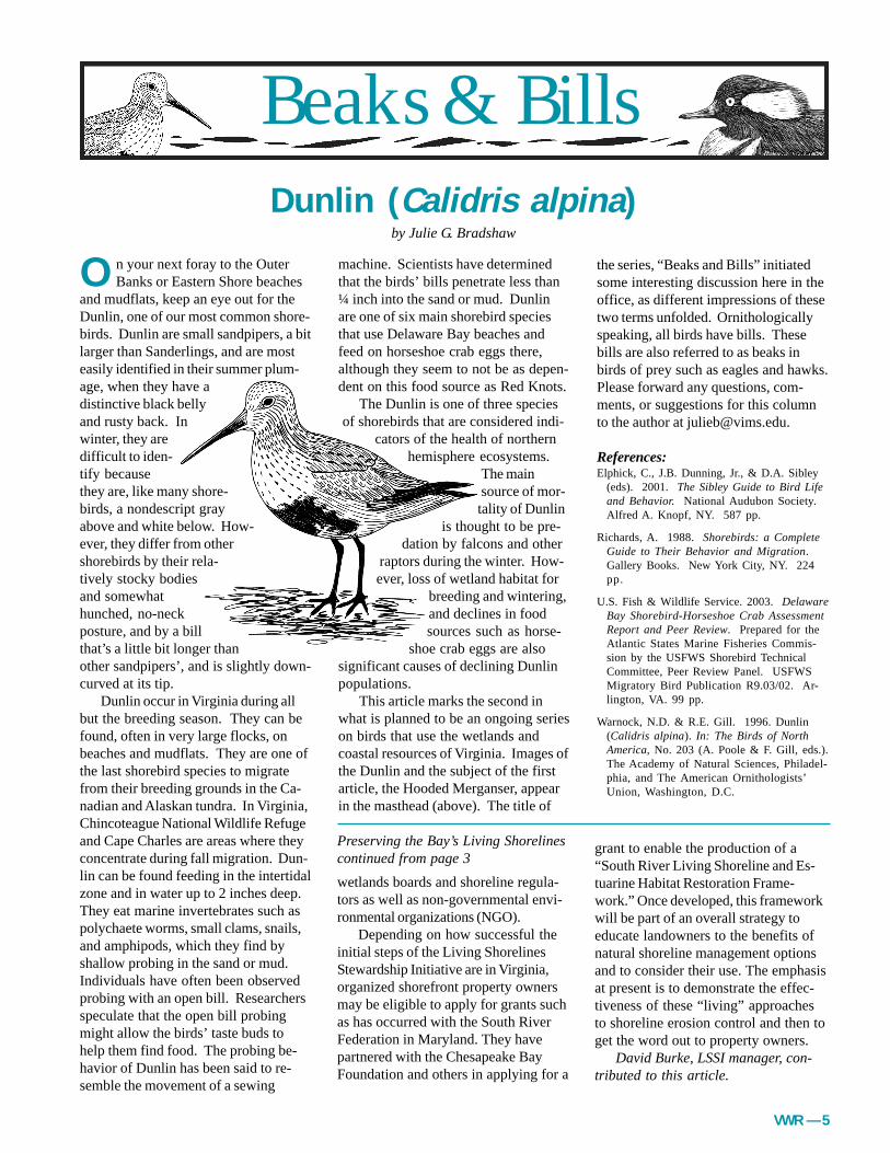
O n your next foray to the Outer Banks or Eastern Shore beaches
and mudflats, keep an eye out for theDunlin, one of our most common shore-birds. Dunlin are small sandpipers, a bitlarger than Sanderlings, and are mosteasily identified in their summer plum-age, when they have adistinctive black bellyand rusty back. Inwinter, they aredifficult to iden-tify becausethey are, like many shore-birds, a nondescript grayabove and white below. How-ever, they differ from othershorebirds by their rela-tively stocky bodiesand somewhathunched, no-neckposture, and by a billthat’s a little bit longer thanother sandpipers’, and is slightly down-curved at its tip.
Dunlin occur in Virginia during allbut the breeding season. They can befound, often in very large flocks, onbeaches and mudflats. They are one ofthe last shorebird species to migratefrom their breeding grounds in the Ca-nadian and Alaskan tundra. In Virginia,Chincoteague National Wildlife Refugeand Cape Charles are areas where theyconcentrate during fall migration. Dun-lin can be found feeding in the intertidalzone and in water up to 2 inches deep.They eat marine invertebrates such aspolychaete worms, small clams, snails,and amphipods, which they find byshallow probing in the sand or mud.Individuals have often been observedprobing with an open bill. Researchersspeculate that the open bill probingmight allow the birds’ taste buds tohelp them find food. The probing be-havior of Dunlin has been said to re-semble the movement of a sewing
machine. Scientists have determinedthat the birds’ bills penetrate less than¼ inch into the sand or mud. Dunlinare one of six main shorebird speciesthat use Delaware Bay beaches andfeed on horseshoe crab eggs there,although they seem to not be as depen-dent on this food source as Red Knots.
The Dunlin is one of three speciesof shorebirds that are considered indi-
cators of the health of northernhemisphere ecosystems.
The mainsource of mor-tality of Dunlin
is thought to be pre-dation by falcons and other
raptors during the winter. How-ever, loss of wetland habitat for
breeding and wintering,and declines in foodsources such as horse-
shoe crab eggs are alsosignificant causes of declining Dunlinpopulations.
This article marks the second inwhat is planned to be an ongoing serieson birds that use the wetlands andcoastal resources of Virginia. Images ofthe Dunlin and the subject of the firstarticle, the Hooded Merganser, appearin the masthead (above). The title of
the series, “Beaks and Bills” initiatedsome interesting discussion here in theoffice, as different impressions of thesetwo terms unfolded. Ornithologicallyspeaking, all birds have bills. Thesebills are also referred to as beaks inbirds of prey such as eagles and hawks.Please forward any questions, com-ments, or suggestions for this columnto the author at [email protected].
References:Elphick, C., J.B. Dunning, Jr., & D.A. Sibley
(eds). 2001. The Sibley Guide to Bird Lifeand Behavior. National Audubon Society.Alfred A. Knopf, NY. 587 pp.
Richards, A. 1988. Shorebirds: a CompleteGuide to Their Behavior and Migration.Gallery Books. New York City, NY. 224pp.
U.S. Fish & Wildlife Service. 2003. DelawareBay Shorebird-Horseshoe Crab AssessmentReport and Peer Review. Prepared for theAtlantic States Marine Fisheries Commis-sion by the USFWS Shorebird TechnicalCommittee, Peer Review Panel. USFWSMigratory Bird Publication R9.03/02. Ar-lington, VA. 99 pp.
Warnock, N.D. & R.E. Gill. 1996. Dunlin(Calidris alpina). In: The Birds of NorthAmerica, No. 203 (A. Poole & F. Gill, eds.).The Academy of Natural Sciences, Philadel-phia, and The American Ornithologists’Union, Washington, D.C.
Dunlin (Calidris alpina)by Julie G. Bradshaw
wetlands boards and shoreline regula-tors as well as non-governmental envi-ronmental organizations (NGO).
Depending on how successful theinitial steps of the Living ShorelinesStewardship Initiative are in Virginia,organized shorefront property ownersmay be eligible to apply for grants suchas has occurred with the South RiverFederation in Maryland. They havepartnered with the Chesapeake BayFoundation and others in applying for a
Preserving the Bay’s Living Shorelinescontinued from page 3
grant to enable the production of a“South River Living Shoreline and Es-tuarine Habitat Restoration Frame-work.” Once developed, this frameworkwill be part of an overall strategy toeducate landowners to the benefits ofnatural shoreline management optionsand to consider their use. The emphasisat present is to demonstrate the effec-tiveness of these “living” approachesto shoreline erosion control and then toget the word out to property owners.
David Burke, LSSI manager, con-tributed to this article.

6 — VWR
Calendar of Upcoming Events
July 21, 2004 VIMS Tidal Wetlands Seminar. VIMS’ Center for Coastal Resources Education, Gloucester Pt., VAFor additional information, contact: Dawn Fleming at (804) 684-7380 or [email protected]
August 3-6, 2004 Hydric Soils Workshop. Norfolk, VA. Contact: Ralph Spagnolo, [email protected]
September 12-15, 2004 2nd National Conference on Coastal and Estuarine Habitat Restoration. Seattle, Washington.Call: (703) 524-0248.
September 19-24, 2004 23rd Annual International Submerged Lands Conference. Halifax, Nova Scotia, Canada.For information call 902-424-3160 or <[email protected]>
October 25-28, 2004 7th Annual Wetlands Workshop. Atlantic City, NJ.The Protection of Aquatic Ecosystems Using Watershed-based Approaches.Contact: Frank J. Reilly, Jr. 540-286-6072 or <[email protected]>
early spring blooming plants that dieback in midsummer. Other suitablenative species to combine with sea-shore mallow include grasses, sunflow-ers, boltonia and goldenrods, especiallythose with a similar preference for wetsoils. Native plants used in the homegarden should always be nursery-propagated, not collected from the wild.
Join in the CelebrationThe seashore mallow deserves to be
recognized as Virginia’s Wildflower ofthe Year for 2004. Join in the celebra-tion, explore and discover a coastalwetland this summer.
Visit the Virginia Native Plant Soci-ety web site (www.vnps.org) to read acomplete description and to view previ-ous winners. A list of retail sources ofnursery-propagated plants and respon-sibly collected seeds is also available.
ReferencesNeal, Bill. 1992. Gardener’s Latin.
Algonquin Books of Chapel Hill.
Shetler, Stanwyn G. 2004 Wildflower of theYear brochure, Virginia Native Plant Soci-ety.
Silberhorn, Gene M. 1999. Common Plantsof the Mid-Atlantic Coast. Johns HopkinsUniversity Press.
Van Scoyoc, Jill. 1993. Would a Mallow byAny Other Name Taste So Sweet? ThePiping Plover, June-July-August 1993,Chincoteague Natural History Association.
Marsh Mallowcontinued from page 3
www.nos.noaa.gov
The featured web page for this is-sue of the VWR is one that all whowork with shorelands and wetlandsshould find useful and interesting. Theaddress shown above is that of theNational Ocean Service. Here one canfind information, news and links to allmanner of web sites dealing withcoastal issues and projects.
Want information on sea level risein Chesapeake Bay? Click on “Sea Lev-els on Line.” Want to know when highor low tide is predicted to occur todayor in the future? Go to “Tidal and Cur-rent Information.” Interested in realtime tide heights compared to pre-dicted? Go to the “Center for Opera-tional Oceanographic ProductsServices” (Co-ops).
Maybe your interests go more to-ward coastal habitats, their protectionand restoration. Or maybe “smartgrowth” or coastal hazards increaseyour pulse rate. If so, click on theCoastal Services Center.
One can also find information oncoral reefs, National Marine Sanctuar-ies, nautical charts and marine resourceeconomics......enjoy!
www.ocean.udel.edu/horseshoecrab
This newsletter has featured in pastissues the plight of the horseshoe crab
New and Interesting Web Sitesand the management efforts takingplace in several mid-Atlantic coastalstates. Now there is a new web site forthe critter that is really more closelyrelated to spiders, ticks and scorpions(arachnids) than crustaceans. It turnsout that the horseshoe crab isDelaware’s state marine animal and theweb site is produced by the Universityof Delaware Marine Public InformationOffice in cooperation with Sea Grantprograms throughout the mid-Atlantic.
The new site discusses in a veryinteresting fashion all aspects of theCritter=s existence which is complicatedby a myriad of factors, including itsshorebird connection, human use(medical) and fisheries managementefforts. The site also features the his-tory and biology of the animal, where itspawns, a variety of other fun factsand where you can go for more infor-mation.
www.floatline.com
Another new web site; this one isdesigned to be a clearing house fornews items and any and all informationpertaining specifically to ChesapeakeBay activities. Here is listed specialevents, ongoing environmental andpolitical issues and items pertaining tothe health of the Bay. The site is to bekept updated on a regular basis andshould be an excellent resource for Bayenthusiasts.