thematic history of walgett shire sep2003 final b
TRANSCRIPT

A Thematic History of Walgett Shire
- Final Report - Terry Kass Historian & Heritage Consultant 32 Jellicoe Street Lidcombe NSW 2141 (02) 9749 4128 For Walgett Shire Council September 2003

Walgett Thematic History – Terry Kass 2 ___________________________________________________________________________________
Table of Contents Introduction ................................................................................................................. 4
Natural Background .................................................................................................... 7
1.0 Occupation by Aboriginal/Murri groups ................................................................ 9
2.0 Settling upon/Managing the Land....................................................................... 13
3.0 Making a Living................................................................................................... 46
4.0 Housing the People ............................................................................................ 54
5.0 Servicing the Population..................................................................................... 60
6.0 Evolving Community ........................................................................................... 72
Historical Themes for Walgett Compared with National and State Themes............ 80
Guides to Historical Research .................................................................................. 89
Bibliography .............................................................................................................. 90
Appendix 1 - Walgett Shire - Population and Dwellings........................................... 99
Appendix 2 - Walgett Shire - Material of Outer Walls of Occupied Dwellings........ 100
Appendix 3 – Sample Historic Maps of Walgett Shire............................................ 101

Walgett Thematic History – Terry Kass 3 ___________________________________________________________________________________
Abbreviations CRS Commonwealth Record Series C T Certificate of Title DP Deposited Plan (LTO) JRAHS Journal of the Royal Australian Historical Society ML Mitchell Library LTO Land Titles Office NAA National Archives of Australia NSWGG New South Wales Government Gazette Pearson, 1885-1935 A Pearson, Walgett and District Happenings 1885-1935 Pearson, 1936-85 A Pearson, Walgett and District Happenings 1936-1985 SMH Sydney Morning Herald SR Map State Records Map SRNSW State Records, New South Wales V & P L A N S W Votes & Proceedings, Legislative Assembly, NSW

Walgett Thematic History – Terry Kass 4 ___________________________________________________________________________________
Introduction
This thematic history has been prepared as part of the Community Heritage Study for Walgett Shire which commenced in 2002. It is not meant to be comprehensive history of the Walgett Shire and all aspects of its history. It has been framed in the light of the methodology recommended by the NSW Heritage Office for Community Heritage Studies. It seeks to identify the processes and developmental forces, which have shaped the landscapes and townscapes of the area and have left physical evidence of past activities and lifestyles throughout the district. Limitations of time and budget and the competing needs of a comprehensive Brief have ensured that this Thematic History cannot be a full or detailed history of the shire. This history has been organised around major themes or dynamic forces, which have moulded the people and environment of Walgett into the form we know today. Any attempt to break up this list of major themes into a host of smaller themes would make this history unreadable. In an attempt to draw the reader’s attention to an associated array of forces, which have shaped the area within broader themes, a set of sub-themes has been developed for each major theme. Each sub-theme has an indicative list of the types of places or “sites” which are found in other areas and which may have examples in Walgett. The reader is asked to consider these sub-themes and suggest examples in the Walgett area, which might survive of past activity. I wish to acknowledge the assistance, which I have received from various people in the shire who gave me the benefit of their knowledge of the shire, such as Barbara Moritz, Jo Wooldridge, Noreen Dunn, Elaine Duncan, Jack Baker, Orel Lea, Jan Cooper, Margaret Weber, Meriel Mace, Joan Treweeke, Clare H Copeman and Helen Allerton. A very special acknowledgment must be made of the assistance provided by Noreen Dunn, who mapped the town and villages from Walgett Shire Council’s Rate Assessment Books for this study. Although this history has been focussed around themes, experience had shown that any attempt to write it solely as a catalogue of elements which have shaped the area, makes it disjointed and difficult to follow. Too close a focus on themes tears the people and places of the district out of their context, so that events and forces become isolated and incomprehensible. Above all, history is a story and it should always attempt to remain readable. In this light, the words of historian, Paul Johnson are relevant here, “One impression the historian must always convey is this sense of the turning of the years, sometimes slow, sometimes fast, always relentless in its motion. While dealing with all aspects of society, I have tried to show the world as dynamic, driven forward by a succession of major events – mass emigration, war, unprecedented economic expansion, followed by financial disaster, depression and anguished popular unrest.”1 More significantly, a narrative enables connections to be made, matters and events to be placed in context. Narrative is not the refuge of the sloppy or lazy. A good narrative will tell far more than a catalogue of events. This is why, centuries ago, the antiquarian and chronicler were separated from the historian. The historian analyses events and sets out linkages. The antiquarian or chronicler merely formulates a listing of events, with little analysis. In the words, of Tom Griffiths, an award-winning historian, when he analysed Eric
1 Paul Johnson, The Birth of the Modern: World Society 1815-1830, Harper Collins, New York, 1991, p xix

Walgett Thematic History – Terry Kass 5 ___________________________________________________________________________________
Rolls’ A Million Wild Acres, “Narrative is not just the means, it is a method, and a rigorous and demanding one.”1
1 T Griffiths, ‘The writing of A Million Wild Acres’, in John Dargavel, Diane Hart, Brenda Libbis (ed), Perfumed Pineries: Environmental History of Australia’s Callitris forests, Centre for Resource and Environmental Studies, ANU, Canberra, 2001, p 192

Walgett Thematic History – Terry Kass 6 ___________________________________________________________________________________
Walgett Shire Source: Map prepared by Walgett Shire Council using data supplied by NSW Department of Lands

Walgett Thematic History – Terry Kass 7 ___________________________________________________________________________________
Natural Background
The study area is bisected by a series of slow flowing rivers. The main rivers are the Namoi and the upper reaches of the Darling River, known here as the Barwon River. Once the Culgoa and Bogan Rivers join the Barwon, halfway between Brewarrina and Bourke, it becomes the upper Darling River. The Narran River forms the western boundary of the shire. The river systems of the Shire include the Moonie River, which runs from Queensland on the north and western side to the Barwon River, joining it above Mogil Mogil and the Mehi River which comes down the watercourse country of the east, forms part of the north-eastern boundary of the Shire and joins the Barwon above Collarenebri. The Castlereagh and Macquarie Rivers and Marthaguy Creek drain into the Barwon. The Namoi River joins the Barwon just west of Walgett. Most of the land near the Namoi River consists of gravel and sand beds laid down in the Pleistocene period.1 Well before man and marsupials roamed the plains, other life forms inhabited the area. In August 1972, a jawbone found near Goangra was identified as part of a Diptrodon who lived in the area from 500,000 to 1,000,000 years ago. 2 Cuddie Springs near Carinda has been known as the site of fossils dating back from over 1,000,000 years from the Pleistocene period since 1876. It was the site of major archaeological dig in 1933 by scientists from the Australian Museum, Sydney, who uncovered fossils of the Diptrodon, Phascolonus or giant wombat and the giant bird, Genyornis newtoni.3 More recently, archaeological investigations in the Walgett area have expanded our knowledge of earlier periods markedly. Today, the climate is characterised by warm winters and hot to very hot summers. Much of the region has a drought period in winter and/or spring. Rainfall decreases markedly as you move further west, dropping from 18.5 inches to 15 inches (470 mm to 380 mm) at Boorooma. In many ways, the climate is comparable to that of Texas and Mexico.4 Soils near the rivers are often solodised soils with deep sandbeds. These soils have a loose sandy loam in the upper horizons but become more clayey in lower layers. The lower layers usually form a hardpan. 5 Gilgai formations are common. These consist of soils with a regular formation of hollows and humps created by the forcing up of large blocks of sub-soil, which form the humps. 6 East and south of the Barwon, the land consists of plains with a heavy grey self-mulching soil, with lighter red soils on higher land, which dry to become quite hard. Dry creeks and warrambools, which run only after heavy rain or flood, criss-cross these plains. Rain brings on the natural grasses, which sprout amidst the Coolabah, Belah, Myall, Boonery, Whitewood, Leopardwood and Suplejack trees and shrubs. On higher land, the vegetation consists of Currant Bush, Sandalwood, Wild Orange, Warrior Bush, Fushia and Marzipan.
1 NSW – Premier’s Department, The Namoi Region: A preliminary survey of Resources, Government Printer, Sydney, 1952, p 9 2 A Pearson, Walgett and District Happenings 1936-1985, Author, Sydney, Jan 1999, p 87 3 M Johnstone, The history of Carinda as it was, and is now, M Johnstone & K Masman, Carinda, 1998, pp 194-8 4 NSW – Premier’s Department, The Namoi Region: A preliminary survey of Resources, Government Printer, Sydney, 1952, p 9-10 5 NSW – Premier’s Department, The Namoi Region: A preliminary survey of Resources, Government Printer, Sydney, 1952, p 18 6 NSW – Premier’s Department, The Namoi Region: A preliminary survey of Resources, Government Printer, Sydney, 1952, p 15

Walgett Thematic History – Terry Kass 8 ___________________________________________________________________________________
White Gum Trees are found where water lies beneath the surface, such as near Carinda. Cypress pines are found near Carinda and towards Pilliga.1 The area west of the Barwon in the County of Finch, is largely characterised by black soil plains with creeks and rivers fringed with coolabah and black box woodland. Higher land usually consists of softer red soil, usually carrying a scrub of gidgee, brigalow and some open grass plains.2 The original vegetation pattern in the area between the Narran and the Barwon, as seen by various surveys completed by 1885, mainly comprised scrub of various forms, with grassland predominating near the Narran.
1 Information from Margaret Weber, Walgett, November 2002 2 R L Heathcote, Back of Bourke: A Study of Land Appraisal and Settlement in Semi-arid Australia, Melbourne University Press, Melbourne, 1965, p 7-8

Walgett Thematic History – Terry Kass 9 ___________________________________________________________________________________
1.0 Occupation by Aboriginal/Murri groups
Occupation of the area by Aborigines or Murris, as they sometimes prefer to be called, has existed for many thousands of years. Their diet focused on fish, waterfowl, plants and the hunting of small animals.1 With the entry of white settlers into the area, there was fierce competition for access to the land and its resources, which resulted in the ousting of Aborigines from control of the land. Cattle and later sheep monopolised the waterholes and damaged the existing plant and animal life so that there was less food for the Murri inhabitants. Additionally, since they tended to frighten the livestock, which were not used to them, stockmen and settlers shooed Aborigines away, using firearms if they did not comply fast enough. Initial contacts between the invading white man and the Aborigines/Murris were not violent. As Major Mitchell’s party trekked northwards along the Narran River in 1846, they met Murris on the way. Further north, near the Queensland border, they passed Narrangadool, later known as Angledool.2 Although most clashes between black and white were not recorded, some are well known. Possibly the most notorious occurred in January 1838, when there was a major clash between Major Nunn’s Native police with local Murris at the Gwydir River. This resulted in the massacre of number of the Murris.3 In the early 1840s, there was strong opposition from the Murris between the Barwon and McIntyre Rivers to the white settlers. They had been affected by both Major Nunn’s Gwydir River massacre and the events at Myall Creek of 1838. They kept up a guerrilla war against the settlers for some years, with the whites fighting back. Often reprisals by white settlers were indiscriminate, since they were unable or unwilling to distinguish between the different groups and unable to ascertain responsibility.4 In response to continuing Aboriginal resistance, Major Nunn’s Native Police commenced a sweep through the area in May 1849 in order to pacify the Murri opposition. By 1850, they had succeeded and all was “perfectly quiet”.5 By the 1850s, the number of Murris in the district was in decline. The annual estimates of their number furnished by Crown Lands Commissioners to the Colonial Secretary showed their numbers falling every year. Not only did violence reduce their numbers. Apart from stress induced by inadequate diet since they could not obtain their normal foods, disease also afflicted them. Since none of the Murris had previously been exposed to any of the exotic diseases, which the white men brought, they suffered disproportionately. Severe losses came from diseases brought from physical contact, most notably syphilis. However, airborne and waterborne diseases also had a strong impact. Diseases, such as smallpox and measles were dangerous to white people, but with no experience or resistance at all, the Murris succumbed in large numbers. Diseases less fatal to white men, such as influenza, decimated Murri communities, which had no inbuilt resistance to any strain of the disease. 1 J Ferry, Walgett, p 62, 157 2 J Ferry, Walgett, p 35 3 J Ferry, Walgett, p 66 4 J Ferry, Walgett, p 69-71 5 J Ferry, Walgett, p 73

Walgett Thematic History – Terry Kass 10 ___________________________________________________________________________________
Previously despised as labour, the Murri inhabitants suddenly became useful in the 1850s when they began to return to camps near the river, seeking to live in co-existence with the white invader. Discovery of gold further south drew off most European workers and made them hard to replace. In their stead, squatters employed Murris who were willing to work. Though Aborigines often did not understand the import of a legally binding labour contract, and suffered as a result, this process, enabled the Murris to commence an interaction with the invader, which was not simply one mediated across the sights of a gun.1 Though white labour returned once the lure of gold waned when it proved that digging for it was less rewarding than hoped, Murris remained as a part of the workforce. They also began to achieve a presence in the living area of the white man. Camps were set up near stations where work was available, such as Gingi and Dungalear. Additionally, Murri encampments also developed near towns such as Walgett and later Collarenebri.2 Until the 1880s, the European settlers simply regarded the Murris as an ancient race slowly dying out. However, when the newly appointed Protector of Aborigines took a census of them across the state, instead of the 1,000 or so believed to still be alive, the returns showed that there were 9,000 Aborigines in the state, including 6,500 full blooded ones. Walgett had one of the highest populations of Murris in the state, with 188 persons.3 After the Aborigines Protection Board was established on 2 June 1883, it set about creating reserves for their charges across the state. One was created near Walgett in September 1889, near the site of the golf course but was moved to higher ground north of the river in 1895. Another such reserve was created near Gingi in 1895. The Collarenebri Reserve was gazetted on 13 May 1899.4 Prior to 1917, Aboriginal children attended the Walgett Public School but in March 1917, the Walgett Parents’ and Citizens’ Association requested that they be excluded. There were too few to establish a special Aboriginal school so the Department of Education asked that the families be sent to New Angledool but the Aboriginal Protection Board refused. Nonetheless, the children remained officially excluded from the school although some were quietly admitted if they were judged to be of good character and clean. 5 Gingi Gingi Aboriginal School opened in 1927 and operated until 1935, taking most of the Aboriginal pupils. After 1940, the Department of Education usually enrolled them in mainstream public schools but acceded to pressure from white parents to exclude some when requested. 6 Many labour tasks on the stations were still undertaken by local Aborigines. Major stations such as Dungalear found them a useful source of labour. Despite their numbers and their economic importance, Aborigines in Walgett and the district continued to suffer discrimination.
1 J Ferry, Walgett, p 162 2 J Ferry, Walgett, p 164 3 J Ferry, Walgett, p 165 4 NSWGG, 13 May 1899, p 3852; J Ferry, Walgett, p 166 5 J Ferry, A Century of Education: Walgett Public Schools 1876-1976, Tamworth, 1976, no pagination 6 J Ferry, A Century of Education: Walgett Public Schools 1876-1976, Tamworth, 1976, no pagination
Walgett Thematic History – Terry Kass 11 ___________________________________________________________________________________
Initially there were major camps at Dungalear and Gundabloui. However, once the pastoral leases were reduced in area by closer settlement policies applied by the crown, the Aboriginal camps were disbanded and the inhabitants shifted to nearby towns. After the closer settlement legislation was passed in 1934, properties in the Walgett North land district such as Dunumbral, Bangate, Gingie and Dungalear were reduced in area.1 At Angledool, the Reserve for Aborigines was situated near New Angledool north of the Narran River and was occupied by some families. In 1911, the Public Works Department erected 6 huts for accommodation, with galvanised iron walls and dirt floors. On the southern side of the river, there was another camp occupied by the Aborigines.2 Attempts by the Aboriginal Welfare Board to restrict them to camps, such as Brewarrina, particularly in locations away from their own country were resisted. Use of the Board’s powers to remove children from their families and send them to training camps as a way of pressuring their parents was used in 1917 to discipline less malleable Aborigines. When the Board wanted to shift the Walgett Aborigines to Angledool in 1923, they used this power to pressure the adults to shift along with their families. 3 The attempt made in 1923 to shift all of the Walgett Aborigines to Angledool and restrict their movements, failed simply because many walked back to their land near Walgett. 4 They settled near Nicholl’s Bend on the river near Walgett, especially since they were discouraged from living in town. They were actively excluded from many activities and there was de facto segregation in many areas, such as at entertainment facilities and in their living areas.5 By 1964, the idea had grown amongst black and white activists that attention needed to be drawn to the entrenched racism in some towns where segregation was actively enforced and Aborigines were forced to accept a lesser standard of living. The idea of the Freedom Ride became reality in February 1965 when the bus with Charles Perkins and white students visited towns such as Moree, Wilcannia and Walgett. The clashes were most intense in Walgett where the active obstruction of access to facilities for Aborigines by whites attracted a considerable share of adverse press attention. It was in Walgett too that an attempt was made by whites to force the Freedom Ride bus off the road. Subsequently, the Walgett Aboriginal community became more assertive and successfully pushed for their rights. 6 It was announced in March 1969 that an Aboriginal community centre to be established in Walgett.7 A similar situation was apparent at Collarenebri, with white restrictions on Murris. In that town, the Aboriginal cemetery became a focus for Aboriginal custom and remembrance. Most notable is the use of coloured glass prepared in various ways, which is used to ornament their graves along with other artefacts.8
1 H Goodall, Invasion to Embassy: Land in Aboriginal Politics in New South Wales, 1770-1972, Allen & Unwin, St Leonards, 1996, p 198 2 Education, School Files, Angledool, 1884-1912, SRNSW 5/14652.2 3 H Goodall, Invasion to Embassy, p 132-4 4 H Goodall, Invasion to Embassy, p 194 5 H Goodall, Invasion to Embassy, p 282-3 6 H Goodall, Invasion to Embassy, p 322-3 7 A Pearson, Walgett and District Happenings 1936-1985, Author, Sydney, Jan 1999, p 79 8 H Goodall, ‘Mourning, remembrance and the politics of place; A study in the significance of Collarenebri Aboriginal cemetery’, Public History Review, 9, 2001, pp 72-96

Walgett Thematic History – Terry Kass 12 ___________________________________________________________________________________
An Aboriginal land claim was lodged in 1996 for 4107 square kilometres of land around Lightning Ridge. It was lodged on behalf of the Euaylay-I people for native title rights to land held as perpetual Western Lands Leases. It was found in the High Court decision in the case Wilson v Anderson on which a decision was handed down early in August 2002 that all native title rights had been extinguished to any land held under Western Lands Leases.1 Sub-themes
Occupying the Land
Potential sites: axe sharpening sites, ceremonial sites, carved trees, occupation sites, fish traps, middens, Aboriginal burial grounds
Interacting with the Invader
Potential sites: massacre sites, fringe camps, Aboriginal reserves or missions, Dungalear camp site, Collarenebri Aboriginal cemetery, Gingi Reserve
1 SMH, 9 August 2002, p 1

Walgett Thematic History – Terry Kass 13 ___________________________________________________________________________________
2.0 Settling upon/Managing the Land
Accounts of the initial penetration of any area by white men traditionally commence with a recital of the different explorations of the district by official exploring parties. In the case of Walgett, the initial occupation by Aborigines should be acknowledged, as it should across Australia. Additionally, the official explorers could not have located the major topographical features of the area without the aid of Aboriginal guides. Early in March 1829, Charles Sturt, who was on an expedition to locate the mythical inland sea, came close to the current site of the town of Walgett.1 His explorations and those of others had some impact on opening up the area, but the spread of pastoral settlement was already nudging the area as he made his traverse of the district. In fact, the site of the village of Walgett and the surrounding area has no official discoverer, since the spread of pastoral settlement meant that stockmen and others were the first to see the site. By the late 1830s, the reconnaissance parties of the squatters commenced taking up land in the Walgett area. One wave of settlers came from the east down the Namoi and Gwydir Rivers. They had connections with the Hunter valley and Maitland. From the south, another group came up from the Bathurst and Mudgee areas. By 1839, Burren run was in the hands of John Eckford, Crayon/Cryon was held by Helenus Scott and Cubbaroo by John Button. James White held a licence for Boorooma, apparently the first run to be taken up on the Barwon River. 2 Much of the area was taken up in the 1840s. Since the 1840s was a time of severe economic slump it meant that the men who took up stations near Walgett were usually the most secure financially. They included some of the most prominent pioneer families of the colony, though very few of them occupied the actual stations, preferring to live in comfort on their head stations closer to civilisation and leaving the running of these outlying properties to their managers and their men. The stations were huge properties, largely stocked with cattle since there was a belief that the plains were too hot and dry for sheep.3 During the 1850s, Thomas Dangar built the largest stockyards in Australia at Gingi, covering six and half acres, which could handle 10,000 head of cattle. 4 Stock from the stations in the area, which lay within the Liverpool Plains and Bligh Squatting Districts, were driven to market up the Namoi and across the Liverpool Range to the Hunter valley, sometimes stopping at the boiling down works at Tamworth. Cattle taken by the alternative route to Bathurst and Sydney were driven down the Castlereagh and Macquarie Rivers.5 The first major threat to the security of the squatters’ hold upon their runs came in the mid 1860s when their leases began to expire. Under the new Crown Lands Alienation Act of 1861, their runs could be acquired by free selection as smaller holdings by other people seeking to settle on the land. But, as John Ferry has duly pointed out, the land was not very attractive for small selectors. Near Walgett, large areas were needed to make a viable holding, and the maximum 640 acre selection was simply too small to serve as a family
1 J Ferry, Walgett, p 25 2 J Ferry, Walgett, p 40 3 J Ferry, Walgett, p 50-1 4 J Ferry, Walgett, p 52-3 5 J Ferry, Walgett, p 56

Walgett Thematic History – Terry Kass 14 ___________________________________________________________________________________
farm. The first selections in September 1866 by John and Robert Kerrigan on the Culgoa were for hotels.1 Hence, with little to attract small selectors, squatters were able to obtain five-year leases over their runs. After being duly appraised for their holding capacity, these runs were again available to the squatters.2 However, the 1870s, when the market for wool was buoyant and when many new owners came into the area from Victoria and Riverina, also coincided with a rise in number of free selections as squatters defended their runs against selectors.3 Pleuro-pneumonia had broken out amongst cattle in the Walgett area in 1864. Combined with a drought during the same period, this led to the opening up of the back country away from the rivers. In turn, the paucity of water in the back blocks inspired the construction of wells and tanks for holding water.4 An associated change was the shift from cattle to sheep. Sheep had been shown to be ideal for the dry area, with the climate inducing the flocks to produce finer wool. William Brocklehurst of Euroka initiated the trend in the early 1860s. By the mid 1860s, the holders of Ningear, Pier Pier and Nugal had also followed suit. In order to better manage their flocks and to save on labour costs, property holders began to fence their runs.5 Fencing initially served to keep sheep and other livestock hemmed in for better control. But, as predators and other pests became a nuisance, specially designed fences emerged. Some were built to keep rabbits out of grazing country. Other fences were designed to keep dingoes away from vulnerable livestock. All leave a particular imprint on the landscape. Fences were regularly patrolled by boundary riders to keep them in order. Some trial boring for water had been undertaken in the area in the 1870s, but the discovery that a large artesian basin underlay the area began the tapping of this resource. This ready water supply, which initially seemed endless, confirmed the opening up of the back country, which had formerly been unused. The first successful bore is traditionally ascribed to that at Kallara station between Bourke and Wilcannia in 1879. Trial bores in the Walgett area confirmed that it too was underlain by water-bearing strata.6 The combination of the opening up of the back country, the sinking of bores and the excavation of tanks, coupled with the installation of fencing transformed the stations from rough and ready pasture into capital intensive holdings. Stockholders with ready money from Victoria and the Riverina began to enter the area to acquire runs in the district.7 On 5 October 1860, James Tyson had opened his newly built dam on his property near Deniliquin. It was not very successful in the end, but its size demonstrated the possibility of providing farm water on such a scale. Tyson's example showed how the drier backblocks could be utilised even during summer when there was little precipitation.8 With the influx of men from Victoria and the Riverina, familiar with this means of conserving water into the
1 J Ferry, Walgett, p 111-3 2 J Ferry, Walgett, p 113 3 J Ferry, Walgett, p 124-5 4 J Ferry, Walgett, p 115-6 5 J Ferry, Walgett, p 118-9 6 J Ferry, Walgett, p 120 7 J Ferry, Walgett, p 121 8 C. J. Lloyd, Either Drought or Plenty pp. 50-2
Walgett Thematic History – Terry Kass 15 ___________________________________________________________________________________
Namoi and Barwon country, the use of tanks and wells was also applied there to conserve water. New men replaced a number of run holders. Many sold out to other squatters. Some retained their holdings until the 1880s when they came under pressure for closer settlement. Thomas Dangar acquired a number of runs notably Gungi and Cumboderry in the 1850s. The Glass family took control of a number of runs, which were consolidated as Eurie Eurie under Mrs Glass, widow of Alexander Glass. The family remained a local dynasty into the twentieth century. 1 In defending their runs against selectors, squatters used their right to acquire key elements of their runs by their right to purchase parts of the land on the basis of improvements made. The process by which run holders were using improvements to secure key parts of their runs can be clearly seen in the records of the Improvement Purchases made at the Walgett Lands Office in the early 1880s. The value of homesteads, shearers’ quarters, woolsheds, tanks, woolscours, sheep yards and other improvements were used to secure their land. Some tried, usually without success, to obtain more land on the basis of hotels, which they had built to serve the passing trade.2 Small service centres began to arise around officially laid out and gazetted towns and villages. The locality around Walgett was variously known as Wallgett, Walchate, Wingate, Warrena as well as Walgett. On 21 December 1846, a Court of Petty Sessions commenced operating at Pokataroo.3 However, it was unpopular with local squatters who sought a settlement near the confluence of the Barwon and Namoi. This was later partially fulfilled by the establishment of a post office near that river junction.4 Early surveyors were instructed to report on the physical nature of the country and to assess its crop or stock carrying capacity, as well as to map streams and geology, and to note precious metals or ores. They were also instructed to set aside suitable sites for future water reserves, towns and villages. 5 Thus, in 1848, surveyor J V Gorman traced the Barwon and the Namoi recommending reserves as sites for future sites for towns and villages. These were mostly later gazetted and often became the site for towns.6 One of these was at Walgett. On 28 March 1851, a postal service had commenced at “Wallgett – On the Barwin River”, close to where the river could be forded.7 This attracted a future town. In October 1859, acting upon the official instructions of the Surveyor-General, surveyor Arthur Dewhurst from Tamworth surveyed a town site where the squatter Doyle had his hut. In accordance with standard practice, he laid out a grid pattern of streets, with sites set aside for Public Recreation, Public Buildings, a market and churches. The main road from Wee Waa to Euroka and the post office near the river wandered across the site. In later
1 J Ferry, Walgett, p 107 2 Lands, Walgett Lands Office, Improvement Purchase Registers, 1880-84, SRNSW 10/1372 3 H Golder, High and Responsible Office: A History of the NSW Magistracy, Sydney University Press, Sydney, 1991, p 247 4 J Ferry, Walgett, p 100 5 R L Heathcote, Back of Bourke: A Study of Land Appraisal and Settlement in Semi-arid Australia, Melbourne University Press, Melbourne, 1965, p 33 6 J Jervis, ‘ Exploration and Settlement of the North-Western Plains’, JRAHS, 48, 1962, p 382 7 J Ferry, Walgett, p 76

Walgett Thematic History – Terry Kass 16 ___________________________________________________________________________________
years, these meandering routes were to be regulated as the street pattern was formally laid out and aligned.1 The town was officially proclaimed on 26 October 1859 as Walgett and the first sale of allotments was held in December. The establishment of a police station shortly afterwards served to heighten the importance of the town and in the following year, Walgett became a place for holding Courts of Petty Sessions on 9 August 1860.2 The opening of a store and hotel by George and John Hoath soon afterwards set the commercial life of the town on its way.3 By 1874, not only were there public buildings such as the courthouse, police station, but there was also a small town of eighteen streets with about a half a dozen houses, but no school or church.4 Further north near Pokataroo, William Earl had commenced a hotel known as the “Squatter’s Arms” where the Barwon could be crossed. As land settlement increased around the Barwon and Narran Rivers, this ford was increasingly used to cross the river.5 In 1867, Collarenebri was measured out as a town and was duly proclaimed on 12 July 1867.6 The town emerged along a site where tracks converged to cross the Barwon River. Stockyards and a few huts were positioned both in the new village and just to the east of it.7 Before 1866, Edward Fletcher and Mr Smith had applied for and had been approved to receive a Conditional Purchase of 40 acres on the eastern side of the Barwon River. Fletcher commenced a store on this land.8 Collarenebri had a store, a post office and a punt to aid river crossings. William Earl died in 1868 and when his widow remarried a man named Reed, the hotel acquired new owners who ran it for many years. John Brasen, the local storekeeper, commenced a rival hotel, the “Happy Home” about 10 miles below Mogil Mogil, which acquired a post office after the post office in Collarenebri closed.9 A town called Mogul had been measured and laid out at Mogil Mogil in October 1869.10 It became the site of the gaol but did not grow. Further north of the gazetted town, the real town of Mogul emerged. It grew around the inn, which was sited near the punt used by the mail traffic between Mungindi and Gundabloui and Yarrawa. It was joined by a post office, bank, store and residences. Until the Gladstone Bridge was completed at Collarenebri in 1886, it was a busy functioning community.11 Another township was laid out in 1869 at Gundabloui near Bagot’s run.12 Henry Davis had a Conditional Purchase nearby and was later an innkeeper there. 13 These newly gazetted towns of the dry plains, watered by speculation, and nourished by commerce, blossomed briefly, only to wither as they were stifled by the growth of other
1 J Ferry, Walgett, p 78; Walgett, Town Map, 1859 2 H Golder, High and Responsible Office: A History of the NSW Magistracy, Sydney University Press, Sydney, 1991, p 255 3 J Ferry, Walgett, p 79 4 Australian Town and Country Journal, 7 Feb 1874, p 220 5 J Ferry, Walgett, p 101-2 6 NSWGG, 12 July 1867, p 1632 7 Collarenebri Town Map, 1867, SR Map 2449 8 C Newman, Collarindabri 1861-1886: The Years of Struggle, p 3 9 J Ferry, Walgett, p 102-3 10 Mogul Town Map, 1869, SR Map 10564 11 Information from Clare Copeman, Moree, 8 January 2003 12 C Newman, Collarindabri 1861-1886: The Years of Struggle, p 5 13 C Newman, Collarindabri, p 19

Walgett Thematic History – Terry Kass 17 ___________________________________________________________________________________
towns. Mogil Mogil was a viable settlement for some years. A police station was established there in 1876, the first permanent force in the district. The police building was still standing in 1979. By 1892-3, there were two hotels in Mogil Mogil, Mary McPherson’s Royal and Hugh McPherson’s Mogil Mogil Hotel.1 A Chinese garden, operated by Yet Poy and Harry Ah Choy supplied local inhabitants. Yet the settlement declined as the importance of Collarenebri rose. 2 Slow development characterised the town of Walgett for some years but from 1876, it began to boom, due to an influx of private capital from Victoria and the Riverina into pastoral property near the town. This was followed by re-invigorated commercial development with banks and new public buildings in the town and the construction of a bridge across the Barwon.3 The Dangar Bridge across the Barwon at Walgett was opened in 1877.4 Collarenebri grew very slowly, but its growth began to accelerate in the 1880s. The post office became a permanent office. A police station was established on 30 August 1882.5 In 1885, the public school opened. The Gladstone Bridge, the first across the river at Collarenebri opened in 1886 and confirmed the role of the town in the district. It also provided a secure river crossing to the west. By 1886, there was John Brasen’s Royal Hotel in Wilson and Walgett Streets, plus his store in Walgett Street. A Chinese market garden operated by Wong Bew, and later by Kong Hing, supplied vegetables. The cordial factory, conducted by an American, Steve Grey, was busy and functioned until about 1910. 6 Collarenebri acquired a new post office in 1898.7 In 1900, Collarenebri had five stores, two hotels, a butcher, a baker, two blacksmiths, and other services as well as a doctor and its own newspaper.8 The opening up of 50,000 acres nearby for selection in 1897 had a stimulating effect on the town.9 In 1898, the town was experiencing some expansion as new residences were built, as were a new post office, public school and teacher’s residence and additions to the school of arts. 10 By 1900, storekeeper W H Wordsworth claimed that since the land was first cut into smaller holdings from the early 1890s onwards, trade in the town had increased ten times.11 Transport and communications into the area were poor. Roads were the main routes into the area, but they were poorly made and maintained. River transport promised to overcome this impediment. The first steamer to reach Walgett, the Gemini, skippered by William Randell, arrived on September 1861. Thereafter there was a steady stream of boats up the river to Walgett. The clearing of obstructions in the river at Brewarrina in 1879 made the passage up river more certain. In September 1879, the first steamer the Brewarrina, reached Collarenebri, a feat, which was usually only feasible when the river was in flood. River
1 C Newman, Collarindabri, p 26-8 2 C Newman, Collarindabri, p 33 3 J Ferry, Walgett, p 89-90 4 J Ferry, Walgett, p 90 5 C Newman, Collarindabri, p 40 6 C Newman, Collarindabri, p 53 7 J Jervis, ‘ Exploration and Settlement of the North-Western Plains’, JRAHS, 48, 1962, p 455 8 J Ferry, Walgett, p 104 9 J Jervis, ‘ Exploration and Settlement’, p 454 10 J Jervis, ‘ Exploration and Settlement, p 455 11 ‘Report … Proposed Railway from Narrabri to Walgett, with Branch to Collarendabri’, V & P L A N S W, 1900, vol 5, p 64 (of report)

Walgett Thematic History – Terry Kass 18 ___________________________________________________________________________________
steamers were a major factor in driving down the cost of goods and making shipping of bulky items more convenient.1 However, the river and its stream favoured Bourke, which was the head of navigation under normal conditions. Amongst the cargoes carried by the steamers were sleepers for the railway lines built into the district most notably to reach Bourke. When the railway reached Bourke, its dominance of the river trade was reinforced. With the decline of the river steamer trade, the boats became hawking or fishing vessels. The last vessel to visit Walgett was the Wandering Jew, overseen by Captain White, which last visited Walgett in 1912.2 More severe competition, for passenger traffic, at least, came when in 1874 when the mail, taken previously by horse, was elevated to a mail coach service. In June 1877, the first Cobb and Co coach arrived in Walgett, despite being hindered en route by landowner F Y Wolseley whose manager would not let it pass through the Euroka run.3 The taking up of land for pastoral holdings inspired the reservation of stock routes across the state, which became known as Travelling Stock Routes. They usually followed the rivers and other water sources of the district. They converged on major centres such as Walgett and Collarenebri but then moved onwards to other centres such as Wee Waa, Euroka or Goodooga. Along these stock routes, inns were established usually on land leased from the crown. Small settlements grew on the stock routes, often around one of these inns. Villages such as Goangra and Carinda emerged, some to be later graced by a proper official village or town survey. Other villages, such as Come-by-Chance, simply emerged from pastoral landholdings along the route. Along many of these stock routes, roads were later laid out. The road from Walgett to Coonamble via the Nugal pastoral property was measured in 1876.4 Inns and their various roles were best described by Margaret Weber who noted in her comments on the initial draft of this report,
Inns along the roads were usually there for the comfort of families travelling to and from the outlying properties to the towns and villages for provisions. In those early days, the mother and girls would ride in the buggies and the father and boys would ride their horses. It was always a long trip because of distances, having only tracks for roads and the means of transport available. It often meant for some families that they had one or two nights at an inn along the way and again on their way home. (The Inns were not specifically for the drovers, who did it fairly hard, always looking for a paddock where they could leave the travelling stock and horses to feed overnight or for a few days. They would have undoubtedly visited the inn for socialising, but they usually returned to their camps at night).5
A Travelling Stock Route ran along the western side of the Namoi River, which had been officially proclaimed on 19 February 1878. Within a few years, a reserve had been
1 J Ferry, Walgett, p 148 2 Information from Margaret Weber, Walgett, November 2002 3 J Ferry, Walgett, p 141-2 4 J Ferry, Walgett, p 142 5 Information from Margaret Weber, Walgett, November 2002

Walgett Thematic History – Terry Kass 19 ___________________________________________________________________________________
established beside the river and the village of Goangra emerged.1 In 1882, Edward Nash built a hotel at Goangra, which continued to operate for many years. 2 On 19 April 1880, the Travelling Stock Route through the Parish of Carinda, which ran through the site of the village, was proclaimed.3 There was already an inn conducted by Thomas McNamara on the spot since 1869. His inn with a house and stockyards near the Marthaguy River was shown on the original portion survey.4 The village of Carinda was proclaimed on 8 February 1890. In February 1898, a Savings Bank opened there. 5 In November 1911, it was reported that the new police station at Carinda was almost complete.6 In January 1913, Carinda was gazetted as an urban area.7 Establishment of a village or settlement as a place for holding courts of petty sessions reinforced the primacy of such emerging settlements. In some cases, the establishment of such courts preceded creation of an official village. Pokataroo was taken up as a station in 1842. A court of petty sessions operated briefly there from 1847 until 1848. A village was later surveyed enabling a small settlement to form.8 As the drier parts of the area well away from the rivers developed such as north of the Barwon in the County of Finch, stock routes stretched out from one bore or tank to another. The government had a policy of putting down artesian bores along these stock routes to supply water.9 In 1876, T G Dangar suggested that a Reserve be established at Boro where a water hole, which filled in wet weather, was the only permanent water between Walgett and Goodooga. This was duly done. It later became the site of one of the tanks on the Narran Road.10 Near some of the tanks and bores, inns and then little villages emerged. In the County of Finch, William Simpson was allowed to take up a Special Lease on 2 acres at Simpson’s Well on the Travelling Stock Route on Dungalear Back Block No 3 on 21 February 1879. Here he established a hotel.11 This was the Gooraway Hotel.12 It remained open from 1878 until 1919.13 James Fickling took out a Special Lease over 40 acres at Weetaliba Waterhole, in 1891, to establish to hotel. 14 At Moongulla, the tank attracted the Moongulla Hotel as well as leading to the laying out of the village of Moongulla. In 1880, John Doyle was given a licence for the Moongulla Hotel. 15 Charles Seymour, licensee of the Moongulla Hotel, noted in 1900 how a considerable traffic in wool came through Moongulla going south to Collarenebri, rather than to Walgett.
1 Parish of Goangra, S R Map 17206 2 A Pearson, Walgett and District Happenings 1936-1985, Author, Sydney, Jan 1999, p 17 3 Parish map, Carinda, 1909 4 Town map, Carinda, 1891; M Johnstone, The history of Carinda as it was, and is now, Carinda, 1998, p 60 5 Pearson, 1885-1935, p 1 6 Spectator, 9 Nov 1911, p 4 7 Pearson, 1885-1935, p 24 8 J Jervis, ‘ Exploration and Settlement, p 452 9 R L Heathcote, Back of Bourke, p 151 10 At Ms. 91/10125, Lands, Miscellaneous Branch, Correspondence, SRNSW 20/7297 11 NSWGG, 21 Feb 1879, p 831; Lands, Walgett Lands Office, Special Lease Register, 1897-1921, SRNSW 10/1366 12 County Map, Co Finch, 1898, SR Map 23911 13 Pearson, 1885-1935, p 87 14 NSWGG, 1 May 1891; Lands, Walgett Lands Office, Special Lease Register, 1897-1921, SRNSW 10/1366 15 C Newman, Collarindabr, p 46

Walgett Thematic History – Terry Kass 20 ___________________________________________________________________________________
1 Later, Pearse, Pickersgill and Pearse sank a bore in order to conduct their woolscour there. 2 A woolscour was operating in 1900 under the control of Roger Close. 3 Privately established villages were relatively few. George and William Colless took up part of a remnant piece of land ignored by other squatters about 1862 calling their choice of a run by the name of “Come By Chance”. A village later emerged on part of this station with the same name. 4 The land on which the village emerged was granted to William Colless on 28 December 1869.5 By 1888, there was a hotel at that site and the needs of local settlers and the stockmen which passed in some number along the TSR through the district inspired Arthur Colless to seek a post office in the village. The postal inspector was opposed to creating an official post office, but he observed that “Mr Colless is a very enterprising liberal gentleman” and he hoped that some arrangement could be made with him. It was and a post office commenced at Come-By-Chance on 8 September 1890. A branch of the Government Savings Bank opened at the post office on 15 July 1895.6 Come-By-Chance remained a small privately owned village. However, the family later sold parts of the village, such as the store.7 When Arthur Colless died in 1921, he still owned the village, which consisted of a post office conducted by Thomas McGee, a police station conducted in one of his cottages, the Come-By-Chance hotel plus another cottage.8 Ten years later, when the village was again being valued after the death of William Arthur Colless, the village was described as “a few old houses and a store and land there is practically valueless”.9 Angledool emerged as a small village on the Narran River, along what later became the boundary of Walgett Shire. The older settlement called Angledool lies within the boundaries of Walgett Shire. The current newer settlement of New Angledool is across the river out of the shire. It serviced the large pastoral properties in the district and by the 1880s, the village was lobbying government in order to obtain a more assured water supply.10 A Court of Petty Sessions had been gazetted there on 28 November 1882. 11 Its police station oversaw a large area, which received little government attention. The police station buildings had been completed in 1883 for a cost of £125.12 A public school commenced in January 1884. After suffering from droughts, H G Hatfield moved from Mehi to Angledool and set up a hotel. According to the memories of Jim Harper, this early hotel, erected from round pine logs with a bark roof dated from 1878 and the licensee was John Merry.13 Hatfield acquired land and in 1884, he had it surveyed for sale. This subdivision became Angledool. Some lots were 1 ‘Report … Proposed Railway from Narrabri to Walgett, with Branch to Collarendabri’, V & P L A N S W, 1900, vol 5, p 65 (of report) 2 C Newman, Collarindabri, p 46 3 NSWGG, 24 Jan 1900, p 636; Lands, Walgett Lands Office, Special Lease Register, 1897-1921, SRNSW 10/1366 4 J Jervis, ‘ Exploration and Settlement, p 453 5 C T 95 f 195 6 Come By Chance PO history file, 1913-87, NAA, CRS C3629/1, 197; Come-By-Chance PO file, NAA, CRS SP 32/1 7 C T 1193 f 242 8 Stamp Duties Office, Deceased Estate Files, Arthur Colless, Come-By-Chance, grazier, 1921, No 21725, SRNSW 20/1127 9 Stamp Duties Office, Deceased Estate Files, William Arthur Colless, Come-By-Chance, grazier, 1931, No 61265, SRNSW 20/1587 10 Australian Town and Country Journal, 3 July 1886, p 15 11 H Golder, High and Responsible Office, p 229 12 NSW - Department of Public Works, Annual Reports, 1892, p 64 13 J Harper, Memories of Angledool, edited by Pat Cross, Walgett, 1997, pp 2-3

Walgett Thematic History – Terry Kass 21 ___________________________________________________________________________________
sold and he built houses to let on others. In the 1890s, he established a store there. A key local notable, he donated land for churches and public facilities such as the hospital. He also built the buildings in which other businesses such as the blacksmith operated.1 By 1890, there were two settlements, Old Angledool and New Angledool, about one mile apart, both north of the Narran River. South of the river, situated within what is now Walgett Shire, was Angledool station and some of the residences of the local inhabitants. 2 An Aboriginal School was later established at New Angledool. It was also a centre for Aboriginal/Koori people due to its mission and their role in local properties. By the 1910s, the hospital had difficulty obtaining any medical aid of consistent quality. Matron Stead was often called upon to minister to patients, often with good results.3 A bridge finally crossed the Narran River in 1925. 4 Since it became the mail centre for the area in 1851, all mail routes converged on Walgett, thereby enhancing its importance. In 1873, a telegraph line was opened to Sydney via Narrabri. The township of Walgett grew from 81 persons in 1871 to 375 in 1881 and then jumped to 742 by 1891.5 The residents of the town lived in 136 dwellings in 1891.6 Collarenebri on the other hand in 1891, consisted of 127 people occupying 24 dwellings.7 There had been a considerable surge in building in Walgett in 1882-3. New construction included a new Commercial Bank premises, a new gaol, the Imperial Hotel, an Oddfellows’ hall, Simpson’s brewery as well as a number of residences.8 The 1901 census showed that there were 3076 people in the district including 186 Chinese and 252 Aborigines. The town of Walgett had 779 people, including 12 Chinese and 39 Aborigines. There were 597 dwellings in the district and 137 in town.9 The streets of Walgett and Burren Junction were officially aligned in 1921, making it illegal to drive on footpaths.10 This also simplified any repair work or formation of the surface since there was no dispute as to what constituted the official road. In all the towns of the plains, fires were major influences upon the towns and their streetscapes. A major fire in Walgett in January 1884 wiped out much of the main street.11 Due to the prevalence of timber, which constituted the main construction material of buildings in the area, either as framing or as cladding, coupled with a dry climate, fires periodically depleted the building stock of all settlements and rural properties. The danger of floods in this flat landscape was another influence on building once the likelihood of flooding was realized. In February 1864, a major flood on the Namoi flooded the Walgett area making the dangers clear. 12 The major flood of 1890 was so high that it was not to be
1 P Cross, History of Angledool, Walgett Shire Council, n.d. [c. 1999?], p 14 2 Education, School Files, Angledool, 1884-1912, SRNSW 5/14652.2 3 Angeldool Hospital, Annual Reports, 1913-18, ML 4 P Cross, History of Angledool, Walgett Shire Council, n.d. [c. 1999?], p 14, 141 5 Census of NSW, 1901, p 547 6 Census of NSW, 1891, p 538 7 Census of NSW, 1891, p 541 8 J Jervis, ‘ Exploration and Settlement’, p 444 9 Pearson, 1885-1935, p 6 10 Spectator, 29 Sept 1921, p 2 11 J Ferry, Walgett, p 90 12 J Ferry, Walgett, p 171

Walgett Thematic History – Terry Kass 22 ___________________________________________________________________________________
exceeded until 1976.1 Depending on where the reading was taken, the height of the 1976 flood varied as being above or below the 1890 height due to land developments and changes.2 Both fire and flood were major determinants of the streetscapes and rural landscapes of the Walgett area. A cottage on the land next to the Walgett Brewery occupied by Emma Dodd was swept away in the 1890 flood.3 By 1883, the impact of settlement was apparent on the vegetation of the area west of the Barwon in the County of Finch where the grasses were becoming less nutritious as they were heavily used. Saltbush, a reserve feed in bad seasons, was being eaten out, leaving a thinner margin of secure feed for bad seasons.4 By this time, there were also a number of failures amongst landholders on properties between the Narran and the Barwon, due to stock losses and the loss of their properties to banks or mortgagees as a result of financial stress. 5 The 1880s witnessed major changes in land legislation, which had a marked impact on the way land was held. The Crown Lands Act of 1884 revised the 1861 Crown Lands Acts. No longer were squatters able to hold on to all of their land. About half of the area of all runs was to be resumed by the Crown. It was then to be surveyed ready for disposal to selectors. Such was the demand for these portions, that they often needed to be balloted due to an excess of applicants. Selectors had to pay the value of any improvements already on the land such as fencing as well as to pay off the land. Run holders also made use of provisions in the Act to purchase parts of their runs on the basis of improvements such as homesteads, tanks, dams, stockyards, shearing sheds and so on. The impact of the legislation was strongest east and south of the Barwon, upon land lying in the Central Division of the state, since, alienation of land was possible and even viable. Pastoral holdings near Walgett were consolidated temporarily by the legislation, but much of the area was now available for Conditional Purchase. The timing of occupation of land by selectors taking possession as Conditional Purchases varied. The area was marginal for many purposes, notably agricultural and for genuine seekers of farmland, there was more suitable land closer to Sydney with better transport. West of the Barwon, on less suitable land, freehold purchases were often made in order to secure a good site for a hotel. 6 Not all land takers were looking to run livestock. In 1889, a man named Durand was using a small irrigation plant near Walgett to grow grapes, tomatoes, melons, vegetables, oranges and fruit on 10 acres. 7 Later, when it was realized that landholdings in the Central Division based on the newer tenures were insufficient to sustain a viable family holding, the landholders of the Central Division were encouraged to enter ballots for land in the Western Division to make their combined holdings a viable economic enterprise. Since these additional blocks were at some distance from the original holding, the owners needed to build stockyards, shearing sheds, dams and to make other improvements in order to make them viable. Land in the Central
1 J Ferry, Walgett, p 172 2 Information from Margaret Weber, Walgett, November 2002 3 Land Titles Office, Real Property Applications, RPA 17936, SRNSW K 261299 4 R L Heathcote, Back of Bourke, p 121 5 R L Heathcote, Back of Bourke, p 126 6 R L Heathcote, Back of Bourke, p 123 7 J Jervis, ‘ Exploration and Settlement, p 444

Walgett Thematic History – Terry Kass 23 ___________________________________________________________________________________
Division, east and south of the Barwon River, was more reliable and of better value, with rainfall more certain and the tenures more secure. 1 Land seekers were able to take up land as Conditional Purchases more readily under the 1884 Act. However, a surge in Conditional Purchases did not occur immediately in the Walgett Land District. It was not until 1890 when the number of Conditional Purchases skyrocketed with a fourfold increase, which was exceeded the following year. By the middle years of the 1890s, the number of Conditional Purchases had died down, with minor surges over the next few years. The relatively better watered land just south of Walgett was the focus of much of this attention, notably in the County of Leichhardt, around the parishes of Trielmon, Colmia, Ularbie and Amos, as well as the parish of Merritombea in County Baradine.2 Whether these Conditional Purchases were taken up by genuine land seekers, or by squatters or their dummies seeking to defend their runs is not clear and can only be clarified by detailed research. The Walgett area boomed as pastoralists poured money into their land and the government spent loan funds on public buildings and other infrastructure improvements such as better telegraph services, new bridges, etc. Private capital also entered the townships as banks arrived in the towns. Squatters were able to use their right to purchase an area of their run equal in value to improvements they had already made on the land. If the value of the improvements were rated at £60, they could effectively take up 60 acres around these improvements. For example, on 2 November 1883, squatters Blackwood and Moore, holders of the Euroka run applied for a grant of 200 acres in the parish of Ularbie, next to Baroka Creek, on the basis of improvements they had made, consisting of a house, woolscour and horse paddock, valued at £200 in total. Their improvements were mapped and charted on the draft of the parish map as well as valued. When surveyor G E Webb visited the property on 3 December 1884, he found a cottage worth £100 completed in March 1884, a hut dating from 1881 worth £30, a shed built in May 1884 worth £60, yards completed in July 1883 worth £10, a woolwash of the same vintage worth £20 and fencing from 1881 worth £30, making a total of £250. However, since the improvements were made after the applicants had applied for the land, their application was disallowed.3 From 1881, pastoralists were able to claim ringbarking of their runs as an improvement, which ignited a fierce debate as to the merits of this activity. Chinese became prominent as ringbarkers. A head contractor would take up a contract to clear an area, and would bring along his gang, which undertook the work. Gangs of Chinese ringbarkers became a notable feature of some districts.4 The rate of improvements can be seen on a property such as “Dungalear”. In 1886, Inspector William Broughton noted that there were two tanks holding 13,000 yards of water, plus another 19 tanks all of various capacities on the property, By October 1890, a further 6 tanks had been added, all on Crown land. There had been 6 wells in 1886. There was an additional
1 Information from Margaret Weber, Walgett, November 2002 2 Lands, Sales, Conditional Purchase Registers, Walgett, 1885-1911, SRNSW 7/4818 3 At Ms. 85/15332, Lands, Miscellaneous Branch, Correspondence, SRNSW 10/3641 4 W Frost, ‘ Migrants and Technological Transfer: Chinese farming in Australia, 1850-1920’, Australian Economic History Review, 42, 2, July 2002, p121-2

Walgett Thematic History – Terry Kass 24 ___________________________________________________________________________________
one in 1890. Contractors, such as M Ryan, Fraser and Co, R H Duncan and others constructed many of the tanks.1 The good years of the 1880s came to an end late in the decade, with drought in 1888, severe floods in 1890 and the entry of rabbits into the area about 1891. Coupled with the severe drought of the 1890s, which lasted into the early twentieth century, the area came under severe stress. Pastures dried up. Overstocked runs came under severe stress as livestock and rabbits ate into the more permanent, slower growing native vegetation after devouring all they could of the annual plants. Stock, which normally ate the foot high grasses known locally as Yabila or Coolabah grass, survived by eating saltbush.2 Yet, even that ran out. Once there was no more saltbush to cut down for feed, the sheep simply starved.3 However, R L Heathcote who examined the impact of the drought across the northern part of the Western Division noted that its impact was diminished in the County of Finch (between the Narran and Barwon Rivers) by the scale of improvements, which had already been carried out by the pastoralists and by the presence of edible coolabah shrubs. 4 Later observers noted how this area still did relatively well in times of drought. The little rain that fell in the Western Division fell almost all in the County of Finch leaving none for areas further west. Further west stock had water from bores but there was no herbage to eat due to the lack of rain. Stock simply starved to death.5 It was probably for this reason that the area was still well stocked with sheep in 1900 when a list of rural stations was compiled along with the number of sheep on each. This list was used to justify the building of the railway line to the region. Smaller properties such as Wemit, Long Swamp, and Barragon ran 2,000 or 3,000 sheep, but the big stations ran many thousands. Dunumbral ran 80,000 sheep; Angledool ran 87,000 and Llandilo, 85,000. The largest of all, however, was the network of stations owned by the Australian Pastoral Co, which ran a total of 1,000,000 sheep in all, many of them in Queensland.6 The widely varying numbers of sheep demonstrate that some smaller properties had emerged as a result of the changes in legislation, In 1900, C S Haigh, storekeeper of Walgett, claimed that his trade had increased markedly, “Now that the district is becoming so thickly populated by small holders”.7 From Burren Junction to Walgett, new holdings emerged, as land was taken up. Properties such as Lezayne, North Lynne, Millie View and Silverlee emerged from selections taken up from the 1880s onwards. Meanwhile, older properties, such as Drildool and Bugilbone, were reduced to rumps with their traditional names intact, but not their landholdings.8 In the County of Finch, once the Western Lands Act had been passed, there was greater certainty for landholders. With security of tenure, landholders put money into improvements. 1 R H Spence, “Dungalear”: A Pastoral Holding, Author, Dubbo, April 1998, pp 186-90 2 Australian Town and Country Journal, 10 Feb 1909, p 24 3 R Moyse, Inspector of Stock, Walgett, ‘Report … Proposed Railway from Narrabri to Walgett, with Branch to Collarendabri’, V & P L A N S W, 1900, vol 5, p 73 (of report) 4 R L Heathcote, Back of Bourke, p 153 5 R L Heathcote, Back of Bourke, p 165-6 6 ‘Report … Proposed Railway from Narrabri to Walgett, with Branch to Collarendabri’, V & P L A N S W, 1900, vol 5, p55-6, 65 (of report) 7 ‘Report … Proposed Railway from Narrabri to Walgett, with Branch to Collarendabri’, V & P L A N S W, 1900, vol 5, p 71 (of report) 8 J Field, Visions of the Plains: A history of Burren Junction and district, Burren Junction, c. 1989, pp 42-4

Walgett Thematic History – Terry Kass 25 ___________________________________________________________________________________
Near Angledool, Mr McLeod of “Inverness” had turned an unimproved lease into a “Model holding” with homestead, tanks and sub-artesian wells by 1911. Closer to Collarenebri, Anthony Brazen had just erected a new homestead on “Maryvale” for Pat Barrett.1 West of the Barwon, the year 1884 had terminated the initial settlement phase. From 1884 until 1901, there was a period of transition as landholders consolidated their hold on the land and erected improvements. This phase came to an end with the drought of the 1890s followed by the 1901 Inquiry into the Western Division, which created a new form of tenure with stronger controls over land use. The Crown set this system in place, in the period from 1902 until 1911, which was coupled with recuperation by the pastoralists. From 1912 until 1956, there was a period of retrenchment and consolidation settling into a scheme of perpetual grazing whereby pastoralists learned to apply opportunistic grazing policies with their stock chasing feed wherever it appeared after rains in order to derive some benefit from the land. 2 In the 1930s, scientists discovered that the Mitchell grass plains, which characterised the area, had a “fluctuating climax”. This meant that there was rarely a stable “climax” community of plants. A true climax, in which all plant life was in equilibrium, with no species competing to occupy a “niche” in the ecosystem, might never occur. Hence, opportunistic use of the grassland by pastoralists was viable and in many ways reproduced the “fluctuating climax” of that ecosystem. 3 The 1884 Lands Act established the concept of the minimum living area, which gradually became a basis for the determination of optimum holding size. Coupled with the growing realization that permanent pastoralism was the only viable use for land in the Western Division this had a major impact on the landscape. 4 By the 1950s, it had become clear that the County of Finch was the most favoured part of the Western Division. Not only was it the best supplied with rain. In times of drought stock were less likely to die of starvation from lack of feed than in areas further west.5 Despite the drought of the 1890s, the town of Walgett still grew markedly from 742 people in 1891 to 1075 in 1901.6 The establishment of an artesian bore supplying the town with water probably underpinned the expansion of Walgett. Contractors G Hodgson and Co struck water on 18 July 1901 at 204 feet drawing up a supply rated at 3 million gallons per day.7 There were two major stock routes running from the north towards Walgett. One was the Wilby Wilby route and the other the Lightning Ridge track. Along these stock routes, livestock walked down from Queensland.8 Provision of water on these tracks was undertaken by the NSW Department of Public Works. In 1888, the Public Works Department constructed an oblong tank lined with stone for watering stock on the route through Lightning Ridge capable of holding 11208 cubic yards of water. Public Watering
1 Spectator, 26 Oct 1911, p 4 2 R L Heathcote, Back of Bourke, p 42-3, 197-9 3 R L Heathcote, Back of Bourke, p 172 4 R L Heathcote, Back of Bourke, p 58 5 R L Heathcote, Back of Bourke, p 172-3, 180 6 Census of NSW, 1901, p 547 7 Australian Town and Country Journal, 10 Aug 1901, p 24 8 R Moyse, Inspector of Stock, Walgett, ‘Report … Proposed Railway from Narrabri to Walgett, with Branch to Collarendabri’, V & P L A N S W, 1900, vol 5, p 74 (of report)

Walgett Thematic History – Terry Kass 26 ___________________________________________________________________________________
Place No 115, the Lightning Ridge Tank, as it was called possessed a 4-roomed cottage plus some rudimentary equipment in 1903. In 1909, another tank, the Wallangulla tank, was built nearby, but by then, the area was no longer a mere stock route. It hummed with the busy burrowing of opal miners.1 Opal forms when silica seeps through layers of sedimentary rock until it is trapped in suspension as a gel. As water is lost from the mix, a hard mass forms over thousands of years to become opal. Opal consists of tiny spheres of silica around a central core or nucleus. The peculiar form of each opal sphere refracts light passing through it to produce a brilliant array of colour. Opal was first discovered at Lightning Ridge in the 1880s but even though opal was then being mined at White Cliffs, the importance of the discovery was not realized. About 1901 or 1902, local boundary rider, Jack Murray put down a shaft at Lightning Ridge and began to mine. He was soon joined by Charles Nettleton, a Bathurst miner, who commenced a shaft and then sold the opals he found thus attracting attention to the field.2 Knowledge of the discovery of opals locally was apparent by mid 1903.3 On 1 July 1903, local mining warden, T A Ridley visited the area where he found 18 men prospecting, a number of shafts, one of them 25 feet deep. He took some samples and reported to the head office.4 In 1905, the first rush for opals focused on Sims Hill at the highest elevation in the area. A settlement called Wallangulla formed nearby close to Wallangulla Tank in Bundinbarrina Station.5 Problems soon arose, with poor sanitation in these temporary huts, situated close to the only water source for the miners. 6 In February 1905, storekeeper George Darby, passed on a petition requesting a postal service to the area. Many signatories were from Goodoga, but over 40 gave their address as “Wallangulla”.7 By 1906 the boom in opal mining at Lightning Ridge was well under way. In June 1906, an area of 2,000 acres was withdrawn from Western Lands Lease 544 to allow opal mining.8 Mining Warden T A Ridley reported in November 1906, that the main workings were still in the same location as originally. There was a small settlement of two streets and there were seven buildings of timber and galvanised iron, sixteen of timber and bark, plus 20 to 30 tents. There were three stores, a bakery, boarding house, “cool drinks shop”, three billiard saloons, one with a hairdresser attached, a butcher and an opal cutter. Significantly, he recommended that the workings were of such a permanent nature that the formation of a village was justified and that it be named “Wallangulla”.9 In 1907, the value of opal won on the field had doubled to £13,000, largely due to the discovery of “black opal” which is found in few other localities. The number of miners at the field averaged 125 with their numbers swelling to 300 when work was unavailable on pastoral properties nearby. In that year, more permanent buildings were making an appearance on the field and a public school had commenced with 40 pupils.10 By 1909, the value of opal won at the field had skyrocketed to £40,000. Whilst the Three-Mile Field was
1 Public Works Dept, Returns of Public Watering Places, 1897-1913, SRNSW 7/395 2 Minfact 95, Dec 2000 3 Pearson, 1885-1935, p 8 4 Mines 03/11533, in Mines, Special Files, File 168A, Lightning Ridge Opal, 1903-14, SRNSW 9/1939.2 5 B Moritz, Lightning Ridge: Turning Back Time, Development & Advisory Publications, Dubbo, 1998, p 2 6 Mines, Special Files, File 168A, Lightning Ridge Opal, 1903-14, SRNSW 9/1939.2 7 Lightning Ridge Post Office file, NAA, CRS SP 32/1 8 Spectator, 30 June 1906, p 2 9 Mines 06/7299, in Mines, Special Files, File 168A, Lightning Ridge Opal, 1903-14, SRNSW 9/1939.2 10 NSW - Department of Mines, Annual Report, 1907, p 59

Walgett Thematic History – Terry Kass 27 ___________________________________________________________________________________
proving to be the most profitable, other worthwhile finds had been made at Grawin and at Nine-mile. Numbers of miners on the field now fluctuated from 500 to 800, according to one estimate.1 In December 1909, another estimate put the number at 1,000. 2 By 1910, the Grawin field was being abandoned but new finds at the Six-mile, the Four-mile and the Five-mile kept miners busy.3 The First World War had a depressing effect on mining especially since Germany took a good share of the opal, but by 1915, lower qualities of opal were being actively sought for button making, ensuring the survival of the field.4 In 1918, there were hopes that the field would revive. 5 The discovery of opal at Grawin in 1926 started another opal field in the district. Surveyor AW Mullen laid out an official township on ground, which was not likely to bear opals in 1908. This became the New Town and the former informal mining village of Wallangulla became the Old Town. Stiff competition to become the main settlement was provided by the opal field at Nettleton Flat near the Three Mile and this settlement was three times larger than the New Town.6 The officially laid out village was proclaimed as “Wallangulla” on 18 March 1908. Most of titles to the half-acre lots in this village were held as Western Lands Leases. Arrangements were in train to permit local miners and business people to take up land in the settlement as Special Leases either for residential or business purposes. But the passion for prospecting almost overturned the new town. The Lightning Ridge Progress Association had to discourage opal seekers from digging in the newly proclaimed town when a new rush commenced in April 1908. Once the bona fides of the applicants had been established and it was ascertained that they were not about to leave the field, a large number of leases were approved by the Executive Council on 6 April 1909.7 They were subsequently proclaimed. All leases were to run until 30 June 1943, with rental at 5/- per annum, with review every ten years. Some leases were forfeited but many early leases were transferred to new owners over the years.8 Holders of blocks in the village were able to purchase their holdings on the basis of improvements, such as in other mining settlements. By November 1910, some businesses had shifted to the New Town, such as Cormie and Younger, and the Imperial Hotel. A post office was functioning satisfactorily. New buildings were being erected including a courthouse.9 There was a good deal of resistance from businessmen at the old workings and at the 3-Mile to being forced to move to the new town, which was opposed by people who had taken up land legally in the new town and were paying rent to the Crown and had spent considerable sums of money erecting permanent buildings.10 It was not until 1912 that most settlement shifted to the official township known locally as the New Town. Most of the early buildings, which survive in Lightning Ridge date from this time. 11 Morilla Street attracted most of the early takers of town lots.1 On these lots
1 NSW - Department of Mines, Annual Report, 1909, p 54 2 Lightning Ridge Post Office file, NAA, CRS SP 32/1 3 NSW - Department of Mines, Annual Report, 1910, p 52-3 4 NSW - Department of Mines, Annual Report, 1914, p 60; 1915, p 55 5 NSW - Department of Mines, Annual Report, 1918, p 47 6 B Moritz, Lightning Ridge: Turning Back Time, Development & Advisory Publications, Dubbo, 1998, p 2 7 At WLB 09/2519, Western Land Commission, Correspondence, SRNSW 10/43575 8 At WLB 09/8055, Western Land Commission, Correspondence, SRNSW 10/43575; WLB 10/11171, SRNSW 10/43576 9 Spectator, 18 Nov 1910, p 2 10 Mines, Special Files, File 168A, Lightning Ridge Opal, 1903-14, SRNSW 9/1939.2 11 B Moritz, Lightning Ridge: Turning Back Time, Development & Advisory Publications, Dubbo, 1998, p 2

Walgett Thematic History – Terry Kass 28 ___________________________________________________________________________________
lots were built many of the main commercial and service buildings of the town. The Canfell House, erected by Tom Urwin in 1914 became the post office. The Bruce House also built by Tom Urwin became the police station from 1916 until 1944. The Imperial Hotel at the corner of Morilla and Opal Streets burned down in 1927 only to be replaced by a very similar building.2 Opal mining had its peaks and troughs with every new find causing a rush to the new field, just as gold had done in the nineteenth century. By 1957, the town was again in the doldrums with little activity – “At that time, it was almost ‘dead’. Only a few old-timers and the odd younger mis-fit chose to stay in its inhospitable environment”.3 The installation of power and piped water and the construction of paved roads in Lightning Ridge in the early 1960s gave a burst of prosperity to the town and assisted in its modernization. By the 1980s, rich opal finds such as the Halley’s Comet black opal, drew the attention of tourists to the area. Tourist numbers doubled. By mid 1988, there were two applications to erect another two motels in the town in addition to the eight existing accommodation complexes in the town. Land for building within the town was becoming scarce leading Walgett Council to release additional building land.4 On the southernmost Travelling Stock Route from Wilby Wilby to Walgett, another watering place became the focus for a small settlement. It was to be called Cumborah. A Travelling Stock and Camping Reserve was proclaimed at the Cumborah Springs, on 27 October 1888.5 A Public Watering Place was established there in 1889, and fencing was installed around the springs. This reserve was partially intended to serve the settlers of Cumborah who dipped their buckets into it for water. It was only sufficient for them and “the few head of village stock”.6 A post office operated from Robert Lindores’ store from 1 April 1892. 7 A town was gazetted at Cumborah on 7 November 1896.8 Edward Young obtained a license for the Comborah Hotel in July 1898.9 A small village emerged and included a store by 1899.10 A Provisional school commenced in January 1899. 11 After the Comborah Hotel burned down, a new hotel was under construction in 1900.12 The town did well initially, with reports of cottages being built and a strong demand for building supplies. 13 The holders of Homestead Leases in the vicinity of Cumborah were taking up land, which was formerly part of the property Llannillo. Since they tended to be genuine settlers, there was stability in the locality not found elsewhere.14
1 Town Map, Wallangulla (Co Finch: Ph Wallangulla) 1910; Western Land Commission, Registers of Western Lands Leases, 1909-21, SRNSW 3/2187 2 B Moritz, Lightning Ridge: Turning Back Time, Development & Advisory Publications, Dubbo, 1998, pp 12, 14, 7 3 Archie Kalokerinos, Medical Pioneer of the 20th Century: An autobiography, Biological Therapies, Melbourne, 2000, p 59 4 SMH, 21 June 1988, p 32 5 NSWGG, 27 Oct1888, p 7608 6 Public Works Dept, Returns of Public Watering Places, 1897-1913, SRNSW 7/395, No 37 7 M Betts, Glimpses of the past at Cumborah, Walgett Shire Council , 1996, p 44 8 M Betts, Glimpses, p 4 9 NSWGG, 26 August 1898, p 6856 10 M Betts, Glimpses, p 4 11 M Betts, Glimpses, p 10 12 J Ferry, Walgett, p 186 13 M Betts, Glimpses, p 5 14 Information from Jan Cooper, Lightning Ridge, November 2002

Walgett Thematic History – Terry Kass 29 ___________________________________________________________________________________
As late as 1921, Cumborah was still being supplied by the spring alone and the newly reformed Progress Association was seeking both a water supply tank and a windmill to ensure a better supply. Local residents fondly desired an artesian well. They felt that it would guarantee the village’s expansion. When James McIvor and his family settled in Cumborah in October 1921, all houses were reported to be fully occupied.1 Bores tapping the artesian water which underlay the area, proved to be significant in determining the viability of properties. Additionally, they had a distinct impact on the landscape. Around every bore, a network of bore drains was established to carry the water to distant paddocks. Under the Artesian Wells Act, Bore Trust Districts were formed to manage the bores and the associated networks of drains. By 1912, Bore Trusts had been established for Come-By-Chance, Goangra, Youendah, Ulumbie, Eurie Eurie, Pagan Creek, Drildool, Bugilbone, Nowley, Bulyeroi, Sherwood, Rowena, Oreel No 1, and Mercadool.2 From 1884 onwards, Walgett had made periodic efforts to obtain a railway connection with the existing railway system. The battle to obtain the line flowed back and forth with various routes being proposed and different towns achieving ascendancy in the battle for the line as their parliamentary representatives rose or fell in influence. Finally, a line was commenced. In September 1900, money was voted for a line from Narrabri to Walgett and Collarenebri. The line was carried forward in fits and starts. Every time construction halted, a new village emerged at the temporary terminus, drawing its vigour from the livestock loaded onto the trains at that halt and from the passengers disembarking to transfer to other transport to continue their journeys. The railway line did not even reach Collarenebri. It terminated at Pokataroo, 13 kilometres south-east of Collarenebri.3 The Railway Department sought to avoid the cost of building a number of expensive bridges between Pokataroo and Collarenebri. 4 The train finally steamed into Walgett on 7 November 1908.5 The first rail motor arrived in Walgett on 2 December 1924.6 Train services sustained the town and district for many years, but the route was a long and circuitous one and by the 1950s, with the availability of motor transport and an aerial service to the town, the railway was becoming a joke, as its services grew ever slower and more unreliable. The abandonment of railway passenger services was announced in February 1974. 7 The last passenger train ran in December 1983.8 The establishment of a rail connection in 1908 fostered a building boom in the town of Walgett. The arrival of the railway was coupled with the return of good seasons. It revitalised predictions of the coming prosperity of the area.9 A number of new businesses opened in the town including Permewan Wright, which was to stay for many years. From
1 Spectator, 6 Oct 1921, p 2 2 NSW – Government Printer, Map Showing the Bore Trust Districts… under the Artesian Wells Act, ML Map M2 815.2gdw/1912/1 3 Information from Margaret Weber, Walgett, November 2002 4 Information from Clare Copeman, Moree, 8 January 2003 5 J Ferry, Walgett, p 155 6 Picman, ML BCP 03317 7 A Pearson, Walgett and District Happenings 1936-1985, Author, Sydney, Jan 1999, p 90 8 A Pearson, Walgett and District Happenings 1936-1985, Author, Sydney, Jan 1999, p 106 9 Australian Town and Country Journal, 10 Feb 1909, p 24

Walgett Thematic History – Terry Kass 30 ___________________________________________________________________________________
1905 to 1910, the number of businesses in the town jumped from just less then 50 to nearly 100.1 Yet, the train had arrived too late. Already, the petrol driven motorcar was available and the better off townspeople were buying them. Motorcars arrived in the district in ever growing numbers. In September 1912, Donald Macarthur & Co announced they were opening a motor garage in a former cordial factory in Pitt Street, Walgett.2 There was now enough custom to make such a venture viable. Construction of the railway also created a new line of small villages. The right of way of the railway ran further south than the traditional routes through the area, which were situated closer to the Namoi.3 Budding centres such as Old Burren and Bugilbone, anchored around an existing hotel or store withered and died, sometimes leaving a building or two but often only the site remains.4 Burren Junction where the railway line branched to serve Collarenebri and Walgett was proclaimed as a village on 26 September 1903.5 A major sale of Crown allotments in the village was held on 8 October 1910.6 A town emerged with banks, school and a thriving commercial life, serving the surrounding area in which the large pastoral holdings had been cut into smaller holdings creating a denser population than before. It later became a major centre for shipping stock where livestock were loaded onto trains for shipment to saleyards such as Flemington at Sydney. This was reflected in the Reserve for teamsters in the town. William Houlahan had converted some of his Conditional Lease south of the village into a Conditional Purchase and obtained a grant of that land in 1921. This land lay between the village and the main road, so a good deal of the village developed on this land, which was later formally subdivided in 1928.7 For a short time, Cryon was the railway terminus. An accommodation house was erected there to cater for travellers changing from one mode of transport to another. It was completed early in 1906 and was claimed to have eleven rooms. In time, the settlement had a hotel, general store, fruit shop, post office, school and railway buildings. It was known as far as Queensland as the main shipping point for cattle to Sydney markets.8 After a severe wind storm on the evening of 7 October 1911, there was a flurry of activity as repairs were made to the buildings of the village, but the railway goods shed was not replaced, prompting the local news correspondent to remark that there no one ever seemed to know what it was needed for.9 On 25 March 1927, part of Michael McMahon’s Settlement Lease adjoining the railway was withdrawn in order to lay out a small hamlet to be known as Cryon.10 A hall
1 Sands, Directory, 1905, p 193a; 1910, pp 203a-204a 2 Pearson, 1885-1935, p 24 3 A Wilson, Map Showing proposed connections between the Western and Northern Railway Systems of New South Wales, ML Map M3 813gme/1903?/1 4 J Field, Visions of the Plains, pp 100-2 5 NSWGG, 26 Sept 1903, p 7137 6 ML Map, Country Towns Subdivisions, Burren Junction, TP:B64/1 7 CP 09/23, Lands, Sales, Conditional Purchase Registers, Narrabri, SRNSW 7/4712; C T 3174 f 165; C T 3310 f 1 & 3 8 J Field, Visions of the Plains, p 104 9 Spectator, 7 Dec 1911, p 4 10 NSWGG, 25 March 1927, p 1603

Walgett Thematic History – Terry Kass 31 ___________________________________________________________________________________
was erected in the 1920s. 1 The hall and the accommodation house appear to be all that now survives of the hamlet. Rowena was proclaimed as a village on 22 December 1909.2 A post office had operated since 1901. The railway brought enough trade for a hotel and shop.3 In 1911, the town was described as being built, “as most stations on the north-west are, right in the middle of a plain, the wind blows dry and dusty all day long, while the heat in summer and the cold in winter are said to be fair extremes.” Only three of the recently sold town lots had been built on, one of the buildings being E R Hardy’s Rowena Hotel, of a single storey with 18 rooms, with its own gas lighting plant. Hardy was also building a blacksmith’s shop. The post office and C Malouf’s branch store was on the other side of the railway line. There were optimistic expectations that that the police station and court house at Bulyeroi would be moved to Rowena.4 On 23 May 1912, E R Hardy and Amos Gordon registered a partnership for a store at Rowena, called A H Gordon & Co.5 The Rowena police station operated until 1942. A shire hall was built in 1934 and the hotel was rebuilt after destruction by fire. 6 A road network was already in place following the Travelling Stock Routes across the district. The major one was the Travelling Stock Route from Gilgandra to Walgett. In 1928, the newly formed Main Roads Board classified it as a Trunk Road. In 1938, it was reclassified as a State Highway.7 The impact of white settlement was evident on the vegetation of the area. Large areas were ringbarked in order to bring on the grass needed by the livestock. Mitchell grass retreated. Saltbush and other nutritious shrubs had been cut back by men and animals. By 1910, prickly pear was beginning to invade the area coming down the Barwon with floods. 8 Soils eroded away even though there was relatively little cropping. However, earlier records showed that huge quantities of sand and soils came down the rivers in times of flood even in the very early years of white settlement so the erosion which became evident may not have necessarily been initiated by white men.9 Generally, it is believed that the condition of the country deteriorated due to the 1890s drought. However, one commentator who has studied the stock returns and other data has noted that stock carrying capacities remained about the same. He has suggested though that this may have been the result of improvements by landholders ameliorating the loss of the original condition. 10 Walgett was sustained by its role as the “capital” of a vast area reaching from Coonamble in the south, Brewarrina in the west, and Moree in the east, and the Queensland border in the north.11 However, it never achieved a wider dominance. Bourke grew as the head of river
1 J Field, Visions of the Plains, p 105 2 NSWGG, 22 Dec 1909, p 6889 3 J Field, Visions of the Plains, p 105 4 Spectator, 2 Nov 1911, p 4 5 Registrar-General, Registers of Firms, SRNSW 2/8543, No 21725 6 J Field, Visions of the Plains, p 105 7 ‘The Castlereagh Highway’, Main Roads, March 1961, p 89 8 R L Heathcote, Back of Bourke, p 54 9 R L Heathcote, Back of Bourke, p 93 10 R L Heathcote, Back of Bourke, p 54-7 11 Australian Town and Country Journal, 10 Feb 1909, p 24

Walgett Thematic History – Terry Kass 32 ___________________________________________________________________________________
navigation. Its key role was strengthened when the railway was built to Bourke in 1885. Bourke became the major western centre on the Darling River. In 1906, when Walgett became the headquarters of the shire bearing its name, commercial development was largely confined to Fox Street between Warrena Street and Wee Waa Street, with an extension eastwards along Wee Waa Street. Administrative buildings mainly stood in Fox Street, between Wee Waa and Euroka Streets, with the gaol on the north-west corner of Euroka and Pitt Streets. Residential housing was largely confined to an area bounded by Warrena, Namoi, Wee Waa, and Peel Streets, with cottages scattered about the rest of the township. Despite Walgett being overtaken by Bourke, the town did not stand still. By 1943, it had grown. Whilst the commercial and administrative areas in the town were still much the same, with the addition of the hospital, the Roman Catholic Church and the Bore Baths, the residential part of the town had expanded considerately. Whereas in 1906, much of the town was effectively confined within half a dozen blocks, the residential part was much larger in 1943. Now the residential part of Walgett had grown to an area bounded by Montkeila, Pitt, Warrena, Namoi, Arthur (both sides), Duff, Euroka and Peel Streets.1 Thus, although the shire had only grown by 100 buildings between the 1911 and 1947 censuses, it seems that much of the development took place in the town itself. (See Population Tables – Appendix 1) Work commenced on building levee banks around Walgett in 1955.2 The experience of floods gave the impetus to the work. Initially viewed as an expensive luxury, the work soon became vital. When completed in 1961, the levee banks gave security to the town. The shire was awarded the Bluett Award for its foresight in construction of the levee, which gave the town an important community benefit. 3 They are also a major landscape element in the town, and mark the transition from “town” to “country” most dramatically. Continuing closer settlement schemes aimed at putting more people on the land had some impact, but the reality that larger scale pastoral land use was the most suitable for large areas near Walgett meant that once the peak of closer settlement was surpassed, then decline was likely. The increasing use of machinery for farm tasks meant that fewer hands were needed for rural jobs. The motorcar allowed people to travel more easily to larger centres where they could obtain a greater range of goods and services, undertake comparison shopping, and chase the bargain more easily. Together, they undercut the viability of smaller centres, which set into decline. The 1930s and 1940s drew people away to larger centres for work or for better support in times of crisis. Many did not come back. Walgett could hold its own as a larger centre but the smaller villages could not. Burren Junction declined from a population of 460 people in 1911 to 275 in 1947. Carinda dropped from 211 to 131 in the same period. 4 This decline was seen most clearly in Carinda. In 1906, there were a few houses along Wilga, Colin and Oliver Streets, near McNamara Street. By 1943, the town had acquired a police station and courthouse and two shops, a church and a hospital but the number of houses now numbered only four. Burren Junction had expanded since 1906 across Alma Street to take in the blocks towards Slack-Smith
1 Analysis based on mapping of Walgett Shire Council’s Rate Assessment Books, undertaken by Noreen Dunn, of Walgett. 2 J Ferry, Walgett, p 177 3 Information from Margaret Weber, Walgett, November 2002 4 NSW – Premier’s Department, The Namoi Region: A preliminary survey of Resources, Government Printer, Sydney, 1952, p 121

Walgett Thematic History – Terry Kass 33 ___________________________________________________________________________________
Street, but there was relatively little additional residential building. There was now a courthouse, a bank, eleven shops, a police station, a school, a post office and a hotel, but from 1906 to 1943 the number of residences had only grown from 27 to 33.1 Cumborah’s hotel was finding trading slow by 1918. By 1933, with the motorcar taking potential patrons on to larger centres such as Goodooga, there was no sense in persisting. The licensee, R A Evans, applied to surrender his licence. He successfully received the necessary compensation for giving it up.2 Come-by-Chance acquired village status in the 1960s, when electricity was connected for residential users, as well as the shop and the post office. The Post Office closed on 29 September 1987. 3 By the 1930s and 1940s, the number of agricultural holdings at Walgett (east of the Barwon) remained steady at about 320 to 340. 4 The machinery used on these holdings reflected the nature of land use. Whereas in other areas, machines associated with cropping such as harrows and ploughs far outnumbered shearing machines, in Walgett, the situation was reversed. In 1949, there were a mere 118 ploughs, and 85 harrows in Walgett Shire against 773 shearing stands.5 Running counter to these trends was greater diversification in the range of rural products. A dairying industry survived for some years but by the 1950s was largely moribund. The introduction of wheat cropping shifted land-use in the district towards the production of a different staple product. Wheat growing had been attempted by Charles Seymour at the Moongulla Bore in the 1890s. There was some talk that the box and budda scrub found in parts of the area, known as “Bully” would be good wheat country. The land where this vegetation association was found ran from near Walgett to Mogil Mogil.6 Experiments in irrigation had been conducted there. 7 William Webster, the government’s Conditional Purchase Inspector, was certain in 1900, that even if the land was cut up into smaller holdings that grazing rather than agriculture would be the main pursuit of most landholders. 8 His comments were proved by later experience. By 1950, most of the closer settlement in the County of Finch had been along the rivers, but it was the pastoralists who had acquired the use of, if not always the ownership of most of this land.9 Yet, by the early 1950s, wheat was being sown at Walgett, even though it was in what was then thought of as a marginal area with low yields per acre.10 The area remained as a major
1 Analysis based on mapping of Walgett Shire Council’s Rate Assessment Books, undertaken by Noreen Dunn, of Walgett. 2 M Betts, Glimpses, p 5-6 3 Information from Helen Allerton, Come-by-Chance, 9 July 2003 4 NSW – Premier’s Department, The Namoi Region, p 84 5 NSW – Premier’s Department, The Namoi Region, p 90 6 ‘Report … Proposed Railway from Narrabri to Walgett, with Branch to Collarendabri’, V & P L A N S W, 1900, vol 5, p 60-1, 65 (of report) 7 ‘Report … Proposed Railway from Narrabri to Walgett, with Branch to Collarendabri’, V & P L A N S W, 1900, vol 5, p 109 (of report) 8 ‘Report … Proposed Railway from Narrabri to Walgett, with Branch to Collarendabri’, V & P L A N S W, 1900, vol 5, p89-91 (of report) 9 R L Heathcote, Back of Bourke, p 182-4 10 NSW – Premier’s Department, The Namoi Region, p 23
Walgett Thematic History – Terry Kass 34 ___________________________________________________________________________________
wool producer turning out 9.4 million pounds of wool from 1936 to 1941.1 However, by the 1960s, wheat was being cultivated. Gradually, during the 1950s increasing numbers of farmers tried to grow wheat, with increasing success. A grain silo was erected in 1963 at Burren Junction with a capacity of 500,000 bushels. A grain bulkhead store holding 150,000 bushels was completed at Merrywinebone in 1964.2 In November 1966, there were sufficient growers to form the Walgett Wheatgrower’s Association. 3 Over the next few years, the acreage sown to wheat grew dramatically.4 Walgett’s wheat storage facility opened in December 1976. 5 Walgett Special One Co-operative, which commenced in 1986, became a major focus for wheat growers, undertaking marketing, research, and the provision of farm needs and management advice. It also erected the Beanbri wheat silo.6 The usual sequence of the evolution in transport was not followed at Walgett. The motorcar arrived before the railway train. Indeed, man had flown in powered heavier than air machines, not only in foreign parts, but also in Australia, before Walgett had a train service. Flight in one form came very soon after the train. Captain Taylor Penfold gave a demonstration of an ascent by balloon at the Walgett Show in June 1911.7 He was daredevil showman who specialised in these daring flights, thrilling spectators across the state. In December 1921, after the Great War had sped up the evolution of the aeroplane markedly so that it was much more sophisticated than it had been ten years earlier, Captain Wilson was giving joy flights in his Avro aeroplane to people in Walgett.8 Smaller airfields also came into use. In November 1937, it was reported that the first aircraft had landed on Ulumbie airstrip.9 More serious use of the aeroplane for commercial travel was slow to arrive. From the late 1930s onwards, Walgett Council developed the Walgett aerodrome for commercial flights. Butler Air Transport commenced an aerial service to Walgett in December 1946.10 They replaced the Dragon aircraft, which inaugurated the service with Avro Ansons in 1948.11 In 1952, Walgett aerodrome could handle Avro Anson aircraft and was serviced by regular flights. An airfield capable of taking Ansons was then being built at Collarenebri. 12 Other aircraft which were used on the route over the decades included the DC-3, the Heron, the Elizabethan and the Fokker Friendship.13 In April 1950, a site was selected for an airfield at Carinda. 14 By September 1953, it was being serviced by a weekly flight. 1 A 5000 feet long runway was completed at Lightning Ridge in January 1967. 2
1 NSW – Premier’s Department, The Namoi Region, p 29 2 NSW - Grain Elevators Board, Report, 1966-7, pp 26-7 3 A Pearson, Walgett and District Happenings 1936-1985, Author, Sydney, Jan 1999, p 74 4 A Pearson, Walgett and District Happenings 1936-1985, Author, Sydney, Jan 1999, p 76 5 A Pearson, Walgett and District Happenings 1936-1985, Author, Sydney, Jan 1999, p 95 6 Information from Elaine Duncan, Walgett, and Margaret Weber, Walgett, November 2002 7 Pearson, 1885-1935, p 22 8 Spectator, 1 Dec 1921, p 2 9 A Pearson, Walgett and District Happenings 1936-1985, Author, Sydney, Jan 1999, p 7 10 A Pearson, Walgett and District Happenings 1936-1985, Author, Sydney, Jan 1999, p 32 11 A Pearson, Walgett and District Happenings 1936-1985, Author, Sydney, Jan 1999, p 35 12 NSW – Premier’s Department, The Namoi Region, p 47 13 Information from Margaret Weber, Walgett, November 2002 14 A Pearson, Walgett and District Happenings 1936-1985, Author, Sydney, Jan 1999, p 41

Walgett Thematic History – Terry Kass 35 ___________________________________________________________________________________
The use of irrigation water from the river to grow crops was most usually associated with Chinese who established market gardens in the area. Yet, they were not the only irrigators. In 1896, a 100-acre irrigation farm on the Namoi was fully operational and offered for sale. 3
Artesian water supplies underpinned a large expansion of pastoral occupation in the area. However, by the 1930s, extravagant and inefficient use of the artesian resource had lowered the level of the aquifer and reduced pressures. Artesian water no longer seemed adequate to sustain the area’s economy. After a conference was held in Narrabri in 1935 regarding the problems of domestic and stock water supply on the north-west of NSW, the government commenced investigations for river supply to replace the failing artesian bore supply. These investigations eventuated in the decision to erect the Keepit Dam. 4 Additionally, a programme of capping bores to curtail waste aided in maintaining pressure and cut usage to what was actually needed.5 In the Namoi Valley, water from Keepit Dam is used to augment river flows in order to ensure more secure dry land farming. No public irrigation schemes are supplied with water from the Keepit Dam. Private irrigation works along the Namoi River developed on land, which had previously had an insecure return. Irrigation allowed farmers to grow a range of unusual and profitable crops, namely cotton, and oilseeds as well as the more traditional vegetables. Cotton growing commenced on land near the river with a more secure supply or water from the Keepit Dam after it was completed in 1958. Wee Waa is the centre of the industry but cotton growing has stretching down the Namoi River.6 One of the main cotton gins is at Merrywinebone, within Walgett shire.7 Even as far up the Barwon as Mogul, Ken and Dick Copeman successfully irrigated 37 acres of lucerne from the late 1950s through the 1960s, making them the earliest irrigators in an area dismissed as useless for irrigation in the 1890s. 8 Dry land farmers on other rivers witnessed the success of the ways in which water from the Keepit Dam bolstered the incomes of farmers downriver. Landholders along the Macquarie River also began to operate in a similar manner, using water from the Burrendong and Copeton Dams.9 Even most of the water from the Keepit Dam, used along the Namoi is not devoted to high profile cotton crops. In 1979, 95% of the water from the dam was used in dry land farming to ensure more secure returns. 10
1 A Pearson, Walgett and District Happenings 1936-1985, Author, Sydney, Jan 1999, p 46 2 A Pearson, Walgett and District Happenings 1936-1985, Author, Sydney, Jan 1999, p 75 3 Pearson, 1885-1935, p 1 4 Water Resources Commission, Annual Report, 1940 p 25 5 Information from Margaret Weber, Walgett, November 2002 6 K Jeffcoat, Inland Rivers of New South Wales, Dept of Land and Water Conservation, Parramatta, 1996, p 31 7 K Jeffcoat, More Precious Than Gold: An Illustrated history of water in New South Wales, Dept of Water Resources, Parramatta, 1988, p 122 8 Information from Clare Copeman, Moree, 8 January 2003 9 Laurie, Montgomerie & Pettit, Benefits of large water storages in New South Wales: a review prepared for the Water Resources Commission, New South Wales, Water Resources Commission, Sydney, 1979, p 66 10 Laurie, Montgomerie & Pettit, Benefits of large water storages, p 72

Walgett Thematic History – Terry Kass 36 ___________________________________________________________________________________
In October 1953, a weir was completed on the Barwon River below its junction with the Namoi and it was used to store water partially for town use.1 The Collarenebri weir on the Barwon River between Collarenebri and Walgett opened in 1967, followed in 1980 by the Calmundi weir on the same stream.2 From 1995 onwards, the NSW state government has had three goals in its water management including, to better share the state’s water; to enhance government support for the rural water sector; and to refashion water management. Environmental flow rules have been negotiated for a number of the rivers regulated by dams, more particularly the Macquarie and Gwydir Rivers where the protection of water bird habitats and wetlands is of prime importance. Community consultation to determine river needs and water qualities has been undertaken. Water management plans were prepared for all rivers. From July 1998, a structural adjustment scheme to improve the efficiency of irrigators has been operating. Monitoring of the socio-economic impacts of the changes has also been underway. Legislation passed in November 1997 ensures that the principles of ecologically sustainable development are applied in all water management.3 A new Water Management Act was passed on 28 November 2000, coming into operation on 1 January 2001. It superseded all earlier Acts, pinpointing the environment as a major consideration in all activities involving water. It also established processes for allocating water between users and the environment. Following on from the Act, a State Water Management Outcomes Plan was formulated. Water sharing plans are being developed for each catchment to ensure better management.4 The Department of Land and Water Conservation is preparing a series of “Catchment Blueprints” in consultation with stakeholders in order to provide goals and management options for all rivers catchments in order to guide investment in works, improve water management and redress past adverse impacts. 5 Sub-themes
Mapping the new land
Potential sites: explorer's camps, survey marks, named natural features
Taking occupation
Potential sites: squatter’s stations, shepherd's huts, fencing, hedges,
Running livestock
1 A Pearson, Walgett and District Happenings 1936-1985, Author, Sydney, Jan 1999, p 46 2 Information from Leila Osburn, 7 March 2003 3 ‘Water Sharing the way forward: Overview of the NSW Water initiatives’, on DLWC web site www.dlwc.nsw.gov.au 4 DLWC, Annual Report, 2000-1, p 10 5 ‘Draft Catchment Blueprints’, on DLWC web site www.dlwc.nsw.gov.au
Walgett Thematic History – Terry Kass 37 ___________________________________________________________________________________
Potential sites: cattle yards, sheep dips, saleyards, slaughter houses woolsheds
Laying down transport routes
Potential sites: Travelling Stock Routes, roads, camping grounds, coaching stations, stables
Sharing the benefits of the land
Potential sites Water reserves, camping reserves, reserves from flood, commons
Manipulating water
Potential sites: dams, tanks, wells, bores, canals, Walgett Weir
Testing the new environment
Potential sites: sites of experimental crops such as tobacco or grapes,
Using flora and fauna
Potential sites: forests, hunter's camps, eucalyptus refineries, sawmills
Developing a full range of products
Potential sites: forests, orchards, market gardens
Changing tenures and land-use
Potential sites: closer settlement schemes; soldier settlements
Changing the environment
Potential sites: ringbarking, clearing impacts, erosion, changes in stream courses, siltation, re-growth, shelter belts
Caring for the land

Walgett Thematic History – Terry Kass 38 ___________________________________________________________________________________
Potential sites: Arbor Day tree planting; erosion control measures such as contour ploughing; wildlife refuges; flora reserves
Extracting wealth from the earth
Potential sites: mining shafts, mullock heaps, quarries, open cut mines, Nettleton’s shaft, Lightning Ridge
Excluding the undesirable
Potential sites: Aboriginal reserves
Establishing service centres
Potential sites: villages, towns, inns, coaching stations, streetscapes such as Burren Junction
Coping with new modes of transport
Potential sites: railway stations; motorcar garages; aerodromes, navigation beacons

Walgett Thematic History – Terry Kass 39 ___________________________________________________________________________________
Mogul 1869 Mogul was laid out as a town near the Barwon River. A number of squatter’s buildings and yards already existed on the town site and they are visible on the first town survey. Source: Mogul Town Map 1869

Walgett Thematic History – Terry Kass 40 ___________________________________________________________________________________
Improvement Purchase, Euroka 1883 Once owners Blackwood and Moore applied to purchase 200 acres of Euroka run near the creek, their improvements were charted on the parish map. Source: Parish Map, Ularbie, Co Leichhardt, 1884.

Walgett Thematic History – Terry Kass 41 ___________________________________________________________________________________
Moongulla, c. 1905 The tank at Moongulla served as the focus for a watering place for stock, a stopping place for stockmen, a small farm and the Moongulla Hotel, as well as a surveyed village. Source: Public Works Department, Returns of Public Watering Places, 1897-1913, SRNSW 7/395, No 103.

Walgett Thematic History – Terry Kass 42 ___________________________________________________________________________________
Thomas McNamara at Carinda, 1870 Many villages grew around hotels. McNamara’s property at Carinda with a house stables and cottages served as the focus for what would later become a village named Carinda, established immediately south of his portion. Source: Crown Plan, C.12.1828.
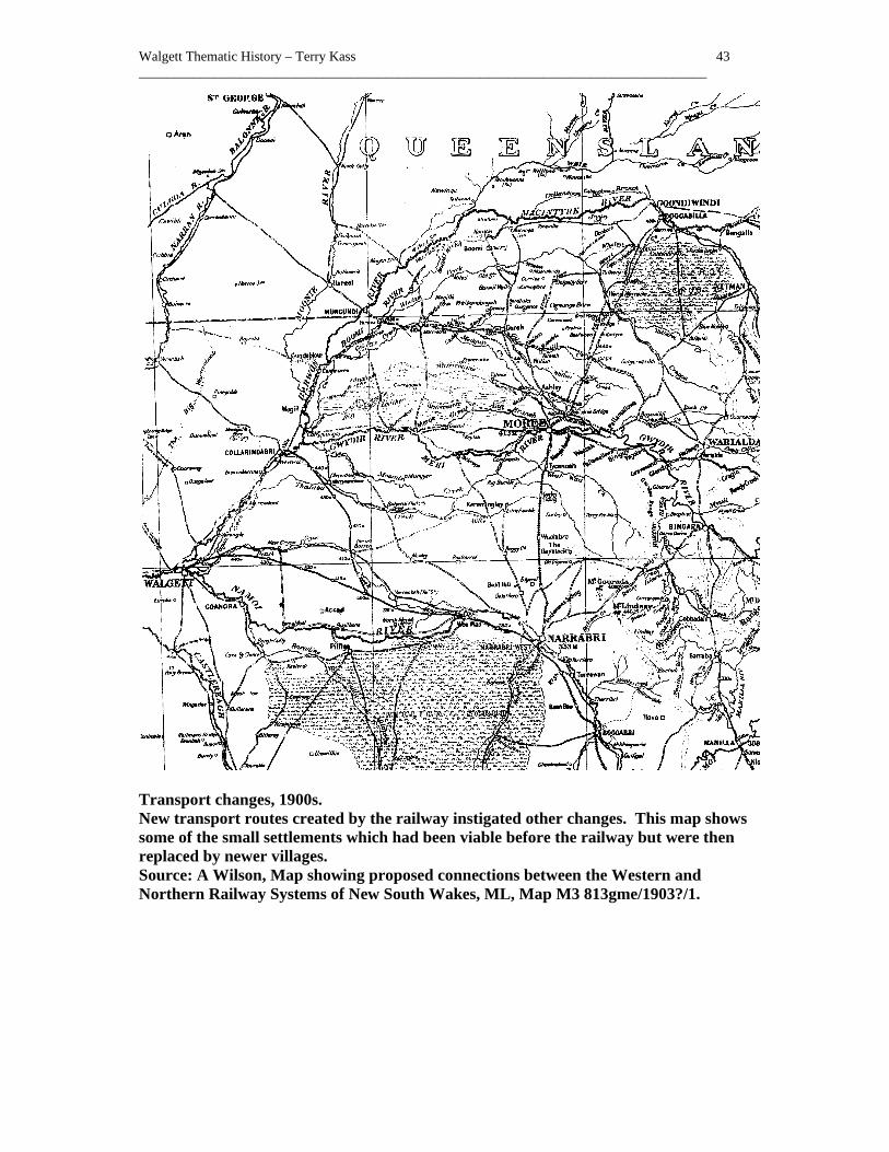
Walgett Thematic History – Terry Kass 43 ___________________________________________________________________________________
Transport changes, 1900s. New transport routes created by the railway instigated other changes. This map shows some of the small settlements which had been viable before the railway but were then replaced by newer villages. Source: A Wilson, Map showing proposed connections between the Western and Northern Railway Systems of New South Wakes, ML, Map M3 813gme/1903?/1.
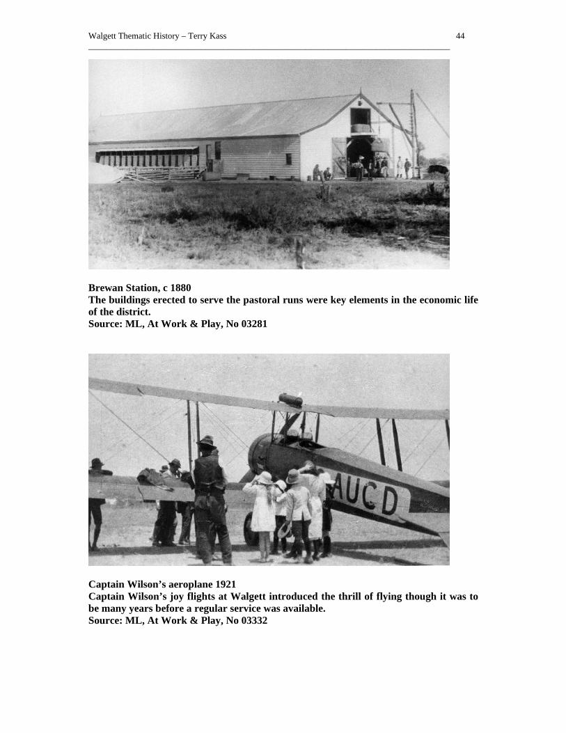
Walgett Thematic History – Terry Kass 44 ___________________________________________________________________________________
Brewan Station, c 1880 The buildings erected to serve the pastoral runs were key elements in the economic life of the district. Source: ML, At Work & Play, No 03281
Captain Wilson’s aeroplane 1921 Captain Wilson’s joy flights at Walgett introduced the thrill of flying though it was to be many years before a regular service was available. Source: ML, At Work & Play, No 03332

Walgett Thematic History – Terry Kass 45 ___________________________________________________________________________________
Fox Street, Walgett, c 1925 A prosperous main street busy with cars was a sight to please any businessman’s heart. Source: ML, At Work & Play, No 03166
Walgett, 1960 The main street of Walgett was an impressive site in the 1960s, lined with notable buildings and busy with cars. Source: main Roads, March 1961, p 88

Walgett Thematic History – Terry Kass 46 ___________________________________________________________________________________
3.0 Making a Living
I’m trav’ling down the Castlereagh and I’m a station hand, I’m handy with the roping pole I’m handy with the brand And I can ride a rowdy colt or swing an axe all day But there’s no demand for station hands along the Castlereagh.1
This popular Australian folk song not only focuses on the Walgett area but also emphasises the nature of work for many within the region where the pastoral industry provided the bulk of economic activity. The range of places associated with this work force achieves significance for its links to the development of the economy and of its links to a particular way of life. Shearing sheds, workers’ barracks, stockyards and woolscours are all associated with this range of activity. Work ranges from professional occupations through commercial activities with their own special forms of knowledge and expertise, notably in small business through to the skilled, semi-skilled and unskilled. Even the ostensibly “unskilled” jobs, such as horse breaking, droving or as a general hand on a property had their distinct sets of special knowledge. Skills emerging from specialised forms of production were applied in creative ways to make mundane tasks more efficient. The most notable and best known instance of this from the Walgett area is the invention of mechanical shearing appliances. In 1885, Frederick York Wolseley perfected his machine sheep shears. The patent was taken out for them on 8 June 1887. Its introduction caused considerable opposition from shearers used to blade shears. The machines were successfully used in other areas but Walgett was initially slow to take up the invention. The first station to use them near Walgett was Burren, which commenced using them about 1888. In 1889, Wolseley sold Euroka station and went to Britain where he was involved with a company to manufacture them. His manager, Herbert Austin, was also involved in the development of a self-propelled motorcar.2 Local blacksmith, George Gray, had fashioned the components for the first mechanical shears. He is also believed to have been the first man to use mechanical shears to shear a sheep. He did not take up Wolseley’s later offer to accompany him to England for further development of the shears, and died at Walgett in 1932.3 The collection and display of machine shearing equipment and hand pieces held by the Walgett Historical Society has a direct and significant relationship with the history of the district. The introduction of mechanical shears was not the only matter which divided workers and master. As opportunities for upward mobility closed off in the colony, the antagonism between hired hand and owner became more overt. The clash between pastoralist and worker came to blows at times in this area. As our anonymous station hand sang in a later verse,
I asked a cove for shearing once along the Marthaguy: ‘We shear non-union here says he. ‘I call it scab,’ says I. 4
Apart from rural based employment, the development of towns and the emergence of some basic processing industry to handle the products of the land, created other forms of work, in 1 J Manifold, Penguin Australian Song Book, Harmondsworth, & Melbourne, 1964, p 158-9 2 J Ferry, Walgett, p 126-8 3 F Wheelhouse, Digging Stick to Rotary Hoe; Men and machines in rural Australia, Rigby, Adelaide, 1972, p 129 4 J Manifold, Penguin Australian Song Book, Harmondsworth, & Melbourne, 1964, p 158-9

Walgett Thematic History – Terry Kass 47 ___________________________________________________________________________________
order to cater for the consumption needs of local residents. In 1882-3, there was considerable building under way in Walgett.1 This all meant more jobs for local people. Building under way in Walgett in 1882 included the erection of Simpson’s brewery.2 The brewery was soon in production and was to remain as a viable local industry, supplying the demands of thirsty drinkers in the district until the arrival of the railway undercut its market with beer from outside the area. In 1884, Simpson’s brewery was producing ale and porter, which was already gaining a good reputation. 3 Simpson came from Wilcannia where he had conducted a cordial works and brewery. He sold it in 1887 to Charles Collins and Henry Joseph. When the site was surveyed in November 1910, the buildings were still standing. Two years later, the buildings were described as being “old, and are not, taken as a whole, in a very good state of repair”.4 The business closed about 1913, after passing through the hands of various owners.5 In December 1918, there was a proposal by A H Rose to build three houses on the former brewery site. 6 A cordial factory operated at Walgett, followed by the Walgett Cordial works, both of which later closed down.7 S A Gray conducted a cordial factory at Collarenebri in 1900. 8 Other small enterprises commenced to service local needs. In 1888, a soap factory commenced operations at Walgett. 9 Coachbuilder Terence Fagan commenced business at Walgett about 1890. 10 Plants which processed the products of the land locally, such as slaughteryards and woolscours, were also active. Whilst the market for the slaughteryards had to be local due to problems in preservation, the products of the woolscours often went across the sea to Europe. Initially, woolscouring was completed on the property, often with primitive equipment. By washing the fleeces in warm water and a mixture of various detergents, the dirt and grease was removed from the wool making it lighter and easier to transport. Centralised plants came later and a number of these were busy in the district. Even when closed down and long defunct, woolscours tend to leave more permanent evidence of their presence, and have archaeological potential.11 By June 1900, Suttor and Mortimer were conducting the woolscour at Walgett.12 In 1901, there was a woolscour and slaughteryard at Bulyeroi Bore, Carinda Bore and Combogolong operated by Pearce, Pickersgill and Pearce. 13 A woolscour operated at Carinda during the 1 J Jervis, ‘ Exploration and Settlement, p 444 2 J Jervis, ‘ Exploration and Settlement, p 444 3 J Jervis, ‘ Exploration and Settlement, p 444 4 Land Titles Office, Real Property Applications, RPA 17937, SRNSW K 261300 5 K M Deutsher, The Breweries of Australia: A History, Lothian, Melbourne, 1999, p 82 6 Pearson, 1885-1935, p 36 7 Information from Margaret Weber, Walgett, November 2002 8 J Ferry, Walgett, p 104 9 J Jervis, ‘ Exploration and Settlement, p 444 10 ‘Report … Proposed Railway from Narrabri to Walgett, with Branch to Collarendabri’, V & P L A N S W, 1900, vol 5, p 78 (of report) 11 J Birmingham, I Jack, D Jeans, Australian Pioneer Technology: Sites and relics, Heineman, Melbourne, 1979, p 142; M Pearson, ‘The Excavation of the Mount Wood Woolscour, Tibooburra, New South Wales’, Australian Journal of Historical Archaeology, 2, Oct 1984, pp 38-41 12 Pearson, 1885-1935, p 6 13 Pearson, 1885-1935, p 7

Walgett Thematic History – Terry Kass 48 ___________________________________________________________________________________
1910s operated by H T Pearce. The plant consisting of a steam engine, wool dryer, tanks tubs etc, plus, all tools, wagons etc were offered for sale at auction on 1 October 1921. 1 Woolscours were not immune from industrial trouble. Hayes Brothers Walgett woolscour was affected by a strike by members of the Australian Workers Union in August 1913. 2 The Walgett woolscour was totally destroyed by fire in November 1944.3 Slaughteryards serving a more local market were scattered over the area. Charles MacCauley was granted a Special Lease on 100 acres (Portion 40) of the parish of Merritombea, for a slaughteryard from 1 January 1901 to December 1910. The area was increased in 1902 and the slaughteryard continued to operate into the late 1920s at least.4 Charles Thomas was granted a Special Lease over Portion 58 of the same parish for a slaughteryard, which functioned from 1909 until 1924. George Thomas Sykes Wilson was given a Special Lease of Portion 53 in the parish of Walgett for a slaughteryard. It operated from 1913 until 1923 when the land was forfeited for arrears of rent. James Clark was granted a Special Lease for portion 35 in the parish of Carinda, which lay immediately west of the town on Marthaguy Creek for a slaughteryard, which operated from 1907 until 1925. 5 Once the technology for cooling and refrigeration was available, enterprising men commenced iceworks. Lambros Conomos announced that he would start an iceworks in Warrena Street Walgett in 1927. It produced its first ice in November. 6 By 1936, an ice works operated by Theo and Bill Conomos was functioning at Carinda as well.7 Ice from local plants was used to pack Murray Cod caught in the area, which were sent off to Sydney in the early twentieth century. 8 The emergence of a trade in kangaroos for human and animal consumption has benefited Carinda. Since 1964, chillers have operated near the village in order to handle the product. Locally based shooters supplied them with their kill. The National Parks and Wildlife Service control culling of kangaroos on station properties. Two chillers were in operation in the area by the late 1990s, respectively supplying the pet food market and that for human consumption. By that time, the culling had “become big business in Carinda, bringing in approximately $100,000 a year”.9 At Walgett a kangaroo processing works was established, later succeeded by the Game Meat Abattoir on the same site. Once the human consumption of kangaroo meat was approved, the Game Meat Abattoir became a major local employer and a business with markets across the world. 10
1 Spectator, 29 Sept 1921, p 5 2 Pearson, 1885-1935, p 25 3 A Pearson, Walgett and District Happenings 1936-1985, Author, Sydney, Jan 1999, p 26 4 Lands, Walgett Lands Office, Special Lease Register, 1897-1921, SRNSW 10/1366 5 Lands, Walgett Lands Office, Special Lease Register, 1897-1921, SRNSW 10/1366 6 Pearson, 1885-1935, p 59-60 7 A Pearson, Walgett and District Happenings 1936-1985, Author, Sydney, Jan 1999, p 1 8 Information from Margaret Weber, Walgett, November 2002 9 M Johnstone, The history of Carinda as it was, and is now, M Johnstone & K Masman, Carinda, 1998, p 188 10 Information from Margaret Weber, Walgett, November 2002

Walgett Thematic History – Terry Kass 49 ___________________________________________________________________________________
Mining remains a major employer in Walgett Shire, particularly at Lightning Ridge and its outlying opal centres. “Employment” may be too formal a term for the lifestyles of most opal miners, working on their own claims and suspicious of any large enterprise. Autonomous individual miners needed small easily managed equipment to work their claims, but often had little spare cash to obtain lavish equipment. Hence, opal mining is characterised by both the messiness typical of all mining, but a further idiosyncratic layer has been added by the bush skills which have turned disused machines and metallic cast-offs into functional and cheap mining machinery. Lightning Ridge is, according to some, a world leader in innovative technology for small-scale mining.1 The impact of widespread unemployment was traditionally alleviated by government relief schemes providing work for the unemployed. There appears to have been some of this type of work in the area. Thus, in 1932, an additional classroom for Walgett Public School was completed under the government’s Unemployment Relief Scheme.2 Men were also employed on street works.3 Women’s work has been associated with places of paid or vocational employment. The young girl serving in the town shop before getting married was a constant factor in the life of country towns. Often they came back when they needed more money for the family. Nurses employed at the local hospital or teachers at local schools were the main skilled and professional women seen in towns. Yet, more widespread and less well recognised since it was so pervasive was the labour of women in the home. Domestic labour for husband and family constituted the major work for most women, even if it was not recognised. The background to these domestic chores was the home and kitchen, which also provides evidence of women’s lives and their economic importance. Sub-themes
Distributing goods
Potential sites: silos, railway networks, warehouses
Hunting and fishing
Potential sites: fishing spots, freezers
Processing animal products
Potential sites: abattoirs, tanneries, freezing works, woolscouring works slaughteryards, wool scours at Walgett, Carinda, Moongulla
Processing agricultural products 1 Information from Joan Treweek, January 2003 2 J Ferry, A Century of Education: Walgett Public Schools 1876-1976, Tamworth, 1976, no pagination 3 Pearson, 1885-1935, p 68

Walgett Thematic History – Terry Kass 50 ___________________________________________________________________________________
Potential sites: flour mills, wineries, canneries, sawmills
Processing mineral products
Potential sites: assay offices; gasworks, smelters
Working with hand and eye
Potential sites: blacksmith's shops; tailoring shops; wood turning works, plaster works, cabinet making
Working with sophisticated machinery
Potential sites: foundries engineering works, railway workshops cordial making
Training for life and work
Potential sites: agricultural colleges, technical colleges, public schools
Enduring unemployment
Potential sites: public buildings or works erected with 1890s and 1930s Unemployed Relief funds
Working women
Potential sites: cafes, shops, woollen or weaving mills, childcare facilities hospitals, domestic interiors
Changing the nature of work
Potential sites: telecommunications or computing facilities

Walgett Thematic History – Terry Kass 51 ___________________________________________________________________________________
Walgett Brewery, 26 November 1910 Though worn-out and ready for demolition, the buildings which comprised the brewery were still carefully recorded in this survey. Source: DP17937, LTO
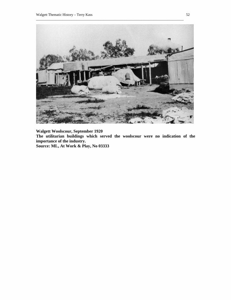
Walgett Thematic History – Terry Kass 52 ___________________________________________________________________________________
Walgett Woolscour, September 1920 The utilitarian buildings which served the woolscour were no indication of the importance of the industry. Source: ML, At Work & Play, No 03333

Walgett Thematic History – Terry Kass 53 ___________________________________________________________________________________
Walgett Woolscour Machinery, c 1912 These machines powered the woolscour. Source: ML, At Work & Play, No 03262

Walgett Thematic History – Terry Kass 54 ___________________________________________________________________________________
4.0 Housing the People
Squatters and selectors setting up their first shelter from the vagaries of the weather and diggers rushing to their next claim were little concerned with comfort. Squatters had little interest in building better accommodation on land to which they had no secure title. Rough and temporary accommodation was all that they had, whether the comfort of a canvas tent of a bark shelter did not matter. Selectors were most concerned with getting their land into production to produce a cash crop. In time though, better housing was built. Initially it might be of split timber slabs or maybe earth or pise. Machine sawn timber and sheets of corrugated iron, imported from overseas gave them a more reliable material with which to build. A good deal of timber came from the locally available cypress pine, which not only had the advantage that it was the most readily available timber which could be easily milled, but it had the ability to resist termite infestation. Across the district, settlers occupied various sites, which were later abandoned. The ruins of their habitations mark many of these sites. Others lack even that, but all of them provide evidence of the movement of a new wave of people into the district and of their attempts to mould the landscape to their use. Timber was by far the most common building material used in the area. The censuses from 1921 onwards show how prevalent it was. Even by the 1950s, fibro was only making a modest inroad into the dominance of timber. Iron walling was also used for permanent buildings, and was the second most common building material. Yet even the modest impact of fibro was challenged by the number of tents or other canvas structures, providing temporary accommodation for workers and possibly miners. (See Appendix 2) Brick and occasionally stone was used for building, but it tended to be most commonly seen on public buildings or commercial premises. A new brick courthouse was being erected in Walgett in 1876-7 using locally burned bricks.1 It was reported in December 1881 that the first business premises in Walgett to be built of brick had been completed.2 Walgett as the largest settlement had the largest number of houses and other buildings, but in 1883 when Walgett was most certainly a timber town, it was ironic that the nearest sawmill was 70 miles away. 3 The Eumanbah sawmills operated by Collins and Joseph were advertising in Walgett in 1885.4 G Wilkins conducted the Perseverance sawmills at Come By Chance in 1900 and was arranging a yard to stock his timber in Walgett.5 Nevertheless, one of the reasons for the distance between town and timber mill was the fact that the area was poorly endowed with timber resources. In 1952, there were only two state forests, Carinda and Gilwarney, which lay within the shire. They held a total of 700,000 super feet of millable timber, mainly cypress pine. 6 A single sawmill operated by Tanner Middleton Pty Ltd, used this timber. 7 Timber also dominated the other towns as did iron walling. In Burren Junction, for example, the offices of stock and station agent Tom Atkinson and Hector Radford, now in Alma 1 J Ferry, A Century of Education: Walgett Public Schools 1876-1976, Tamworth, 1976, no pagination 2 J Jervis, ‘ Exploration and Settlement’, p 443 3 J Jervis, ‘ Exploration and Settlement ‘, p 444 4 Pearson, 1885-1935, p 2 5 J Ferry, Walgett, p 187 6 NSW – Premier’s Department, The Namoi Region, p 111 7 NSW – Premier’s Department, The Namoi Region, p 112

Walgett Thematic History – Terry Kass 55 ___________________________________________________________________________________
Street, were built of metal walling, possibly manufactured by Wunderlich. This office was moved to its current location by a bullock team in 1937.1 Other building materials, such as brick, were still used. As early as 1882, there was an attempt to make Goangra into a brick town. John Unsworth and a party of other working men applied for a Special Lease for 2 acres near the lagoon in September 1882, but were stymied by the sloth of bureaucracy. Within a month, the lagoon had dried up, and the venture looked less promising. When the lease was approved in November, he and his men had moved on.2 A brick kiln conducted by Thomas Cawdell Smith, commenced operations near Walgett on 3 acres of land (portion 50) in 1904 but only operated briefly before the lease was withdrawn for non-payment of rent.3 Rather more successful was the brickyard commenced by Charles Green, on 5 acres near Pockataroo in 1911, which was still in operation in the late 1930s. 4 A brick kiln owned by Mr Isaacs was reported to have operated near the 2 Mile Warrambool some time before the 1930s.5 Older residents remember this site as being situated on the 2 Mile Warrambool on the Brewarrina Road.6 Walgett Shire was created as one of a batch of local government authorities created in 1906 by the State Government. The Local Government Act of 1906 gave councils control over building and subdivision. With the associated powers it gave council for matters of health and the licensing of trades such as butchers and hairdressers, Council was better able to control the health of the community. Plans for buildings had to be submitted to Council and be passed before construction could commence. On the western side of the Barwon River, which lay within the County of Finch, the population was outside any control over building. The area was unincorporated and control over such matters was light. The result was poor building. In March 1930, the NSW Department of Health investigated health matters at Collarenebri. Apart from finding rubbish dumped close to residences and decrepit lavatories, the investigators observed insanitary dwellings roughly built of kerosene tins and corrugated iron.7 Even within Walgett, it took some time for higher standards of construction and ventilation to apply. In October 1911, obstetric nurse, Julia Apted, complained about the ill-ventilated shops and dwellings in Fox Street, opposite the Sub-Inspector’s residence, which she had to enter on her professional rounds.8 When novelist Katharine Susannah Pritchard visited Walgett about 1916, she took away memories of a town “perched at the end of the railway: no more than a collection of weatherboard and corrugated iron shacks, battered and beaten by dust-storms to the same colour as the surrounding earth”. 9
1 J Field, Visions of the Plains, pp 116-7 2 At Occ 83/2604, Lands, Occupation Branch, Correspondence, SRNSW 14/4449 3 NSWGG, 7 Dec 1904, p 8999; Lands, Walgett Lands Office, Special Lease Register, 1897-1921, SRNSW 10/1366 4 Lands, Walgett Lands Office, Special Lease Register, 1897-1921, SRNSW 10/1366 5 A Pearson, Walgett and District Happenings 1936-1985, Author, Sydney, Jan 1999, p 1 6 Letter from E. Duncan, Walgett, 1 August 2003 who checked this with older residents 7 Health, Special Bundles, Sanitation Files - Collarenebri, SRNSW 12/5572.1 8 Spectator, 26 Oct 1911, p 4 9 P Pierce, (ed), The Oxford Literary Guide to Australia, Oxford University Press, Melbourne, 1993, p 147

Walgett Thematic History – Terry Kass 56 ___________________________________________________________________________________
Nevertheless, the demand for accommodation was such that many houses could be let, when there was sufficient demand. In December 1910, it was reported that there was a shortage of houses in Walgett.1 Late in 1921, there was again a shortage of accommodation in Walgett, with vacant houses being snapped up by new tenants.2 Houses ranged in size, condition and facilities. In January 1922, one landowner held a number of houses in Walgett, which included a four roomed cottage in Euroka Street in poor order, a three roomed cottage in Arthur Street, a very old 4 roomed cottage in Arthur Street, another cottage in Euroka Street which was so old that it was “falling down”, yet was still tenanted, plus another which was “very old and dilapidated”.3 An example of a larger and better-maintained house was seen when Arthur Dodd left Walgett in 1921 and sold his house in Warrena Street near the school by auction. The dwelling stood on one acre and had eight rooms, including four bedrooms. 4 A short time later, a cottage with 165 feet frontage to Pitt Street and 132 feet to Warrena Street, was offered at auction. The cottage was of six rooms, with a verandah enclosed with wire gauze on three sides, plus a tank, well, workshops and stable. 5 More modest houses such as a pair of semi-detached cottages with four rooms and kitchen and water laid on situated on lots 13 and 14, Section 2, Warrena Street, Walgett were also for sale.6 Apart from hotels, there was temporary or permanent accommodation for those needing it such as itinerant pastoral workers, skilled or semi-skilled tradesmen working temporarily on a contract in the area, single men, or those not requiring a larger permanent home. Their needs were served by lodging or boarding houses. Harry Wharton bought a house at the corner of Warrena and Pitt Streets in September 1925, which he operated as a boarding house for many years.7 Hotels served as accommodation houses for others. More recently the former Cryon Hotel has became an accommodation house serving the needs of travellers, backpackers and itinerant seasonal labour. Occupied dwellings within the Shire ranged in number from between 650 to 950 from the 1910s into the 1950s. The addition of the County of Finch added further dwellings to the shire. (See Appendix 1) In 1963, there were approximately 400 houses in the town of Walgett itself.8 Sub-themes
Sheltering the Settler/Miner
Potential sites:
1 Pearson, 1885-1935, p 21 2 Spectator, 22 Sept 1921 3 Stamp Duties Office, Deceased Estate Files, Arthur Colless, Come-By-Chance, grazier, 1921, No 21725, SRNSW 20/1127 4 Spectator, 29 Sept 1921, p 5 5 Spectator, 3 Nov 1921, p 5 6 Spectator, 3 Nov 1921, p 5 7 Pearson, 1885-1935, p 53 8 A Pearson, Walgett and District Happenings 1936-1985, Author, Sydney, Jan 1999, p 67
Walgett Thematic History – Terry Kass 57 ___________________________________________________________________________________
shepherd's huts, miners’ huts, sites of mining communities Housing the Elite
Potential sites: grand homesteads, houses
Housing Citizens
Potential sites: dwellings
Living on the Fringe
Potential sites: Aboriginal camps, shanty towns
Using available materials
Potential sites: pise buildings rubble or cement houses
Supplying building materials
Potential sites: brick pits, sawmills
Accommodating group communities
Potential sites: Convents, gaols
Responding to need
Potential sites: Housing Commission developments

Walgett Thematic History – Terry Kass 58 ___________________________________________________________________________________
Burren Junction 2002 Tom Atkinson’s original stock and station agency office, now in Alma Street, Burren Junction, demonstrates the former commercial importance of the town, the ease with which timber framed buildings could be moved, and the use of pressed metal for decorative building materials at a suitable price. Source: Author’s photo
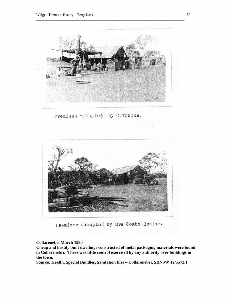
Walgett Thematic History – Terry Kass 59 ___________________________________________________________________________________
Collarenebri March 1930 Cheap and hastily built dwellings constructed of metal packaging materials were found in Collarenebri. There was little control exercised by any authority over buildings in the town. Source: Health, Special Bundles, Sanitation files – Collarenebri, SRNSW 12/5572.1

Walgett Thematic History – Terry Kass 60 ___________________________________________________________________________________
5.0 Servicing the Population
Commercial and administrative services were essential for the establishment and the sustained vitality of settlements both large and small. A place of business such as a hotel or store, or alternately a courthouse or post office often preceded the formal establishment of many settlements. A Court of Petty Sessions commenced at Pokataroo in 21 December 1846, but it did not result in the emergence of a large settlement.1 That came at Walgett. A post office was established near Walgett in 1851 where the river could be forded. Two slab huts were erected for the police force stationed in the town in 1859.2 A Court of Petty Sessions commenced at Walgett on 9 August 1860.3 The District Court began at Walgett some years later. In 1881, a number of public buildings were completed in Walgett including a new Court House, Police Station and Post Office.4 Facilities for law and order were important elements in many small settlements particularly when travel was difficult and residents needed such services close at hand. A Court of Petty Sessions commenced at Mogil Mogil in 28 March 1878, but closed on 1 March 1904.5 Its major rival, Collarenebri, did not acquire a Court of Petty Sessions until 25 March 1884, but it lasted longer and only closed on 15 August 1980.6 The newer towns and villages of the twentieth century also acquired courts and police services. The rapid growth of Lightning Ridge resulted in the complaint early in 1910, that, even though its population had surpassed that of Walgett, it still lacked police protection. 7 A Court of Petty Sessions commenced at Lightning Ridge on 12 June 1911.8 A Court of Petty Sessions commenced at Burren Junction on 18 August 1911.9 Distance and the lack of transport ensured that a gaol was needed at Walgett. One was established by the 1880s but it was in very poor condition. A new one was completed in 1886. 10 After its closure, the gaol was eventually demolished and the site cleared of rubble by November 1954. 11 Other government agencies were established in the area. A Department of Main Roads depot was opened at Walgett in March 1945. 12 As the main centre, Walgett was favoured with educational facilities from early on. In October 1875, a Public School commenced operations at Walgett.13 New weatherboard school buildings were completed at Walgett in 1903, finally being were demolished in
1 H Golder, High and Responsible Office: A History of the NSW Magistracy, Sydney University Press, Sydney, 1991, p 247 2 J Ferry, Walgett, p 78 3 H Golder, High and Responsible Office, p 255 4 J Ferry, Walgett, p 90 5 H Golder, High and Responsible Office, p 244 6 H Golder, High and Responsible Office, p 234 7 Spectator, 21 Jan 1910, p 8 8 H Golder, High and Responsible Office, p 242 9 H Golder, High and Responsible Office, p 233 10 J Jervis, ‘ Exploration and Settlement ‘, p 444 11 A Pearson, Walgett and District Happenings 1936-1985, Author, Sydney, Jan 1999, p 48 12 A Pearson, Walgett and District Happenings 1936-1985, Author, Sydney, Jan 1999, p 27 13 J Ferry, A Century of Education: Walgett Public Schools 1876-1976, Tamworth, 1976, no pagination

Walgett Thematic History – Terry Kass 61 ___________________________________________________________________________________
1974.1 From 1928 onwards, Walgett Public School conducted some secondary school classes for older pupils. The school was raised to Central School status in 1944. When the High School opened in 1972, these classes were discontinued.2 As the population settled on the land in sufficient numbers to warrant a school and after sufficient pressure had been put on the authorities, a host of small schools were opened to serve small rural communities and the villages. Small settlements such as mining camps were often provided with schools, which lasted only as long as the payable ore. For instance, a public school operated briefly at the “3-Mile” diggings near Lightning Ridge, later known officially as Nettleton’s. It closed on 4 April 1913, and its furniture was sent to equip the Lightning Ridge Public School. The Department of Education sought to retain the site and buildings but as early as March 1914, the buildings were being looted for building materials for miners’ huts. The iron was later sold.3 A provisional school operated at Come-By-Chance. After its closure, from 1908 until 1923, the Eton-Harrow Travelling School provided education for the children of the locality. Correspondence lessons from the Blackfriars Correspondence School in Sydney then schooled the children until the school children’s hostel opened in Walgett in 1966. 4 The decline in the number of people in villages and on the land ensured the closure of many such schools. By 1949, the main schools operating were at Walgett, Collarenebri, Burren Junction, Carinda and Rowena. St Joseph’s Roman Catholic Convent School provided private education. 5 Pokataroo school continued into the mid 1960s, its numbers bolstered by busloads of children from Collymongle.6 From 1968, children were being bussed to Walgett schools from Cumborah, Lightning Ridge and Carinda.7 To house those children who came from further afield or who did not travel on the buses, a school children’s hostel was established in 1966 opposite the High School. After its closure, the building became the Western Institute of TAFE, catering to the need for vocational and other post-school educational needs. 8 Private education was also available, initially from small private schools and later from larger institutions. A Roman Catholic Convent was erected in Walgett by 1896. A Roman Catholic primary school with over 100 pupils was operating. 9 By 1900, the sisters of St Joseph’s Convent in Walgett were advertising their educational services and offering places for boarders. 10 Commerce and administration were the two props, which supported viable townships. Walgett acquired commercial facilities. About 1860, the opening of a store and hotel by
1 J Ferry, A Century of Education, no pagination 2 J Ferry, A Century of Education, no pagination 3 Education, School Files, Nettleton, 1911-13, SRNSW 5/17092.2 4 Information from Helen Allerton, Come-by-Chance, December 2002 5 NSW – Premier’s Department, The Namoi Region, p 153-4 6 Information from Leila Osburn, 7 March 2003 7 Pearson, 1936-1985, p 77 8 Information from Margaret Weber, Walgett, November 2002 9 J Jervis, ‘ Exploration and Settlement ‘, p 444 10 Pearson, 1885-1935, p 6

Walgett Thematic History – Terry Kass 62 ___________________________________________________________________________________
George and John Hoath commenced the commercial life of the town.1 Banks reinforced the economic importance of the town. The Commercial Bank opened in Walgett in 1876.2 A new building for the Commercial Bank was opened in November 1933. 3 The Bank of New South Wales opened in Walgett in 1881. 4 The bank’s premises were destroyed by fire on 11 December 1926 along with Tattersall’s Hotel and new premises were built. By the early twentieth century, Walgett was booming commercially. In 1907, Permewan Wright commenced operating a store in Walgett taking over the business of Wright Heaton & Co. Other stores at that time were Pedley and Haigh, Yee War & Co.5 Permewan Wright remained in the area for many years. In June 1958, a new store erected for Permewan Wright in Fox Street was opened. 6 Comino and Panaretto opened their oyster saloon opposite the Royal Hotel in March 1908.7 Cassimatis and Conomos took over an existing business. 8 The Conomos brothers were to become a major influence in the district, expanding their range of activities as new opportunities emerged. In August 1949, Conomos Brothers sold their interest in the Barwon Café but retained their interest in their wine saloon and the Luxury Theatre.9 Water supply in Walgett was long a problem. As an essential need for all living things, its availability ensured the continued success of settlement on the drier plains. In June 1883, enterprising John Thompson applied for a Special Lease on part of the Reserve along the Namoi River between Pitt and Namoi Streets in order to erect a pump to supply the town with water for “domestic purposes”. He argued that since the current supply was “at a distance”, it would be a boon to the town. Unable to grant leases for such a purpose, the Lands Department declined his request.10 On 23 January 1894, a contract was signed with A G P Creed to construct the Walgett bore.11 A few years later, contractors G Hodgson and Co struck water on 18 July 1901 at 204 feet and drew up a supply rated at 3 million gallons per day to supply the town.12 On 27 May 1921, the Walgett Bore Water Trust District, which covered the township, was proclaimed.13 Collarenebri was covered by a Bore Water Trust, which was gazetted on 13 March 1931.14 By 1937, however, as the aquifer from which Walgett drew its supply was depleted by heavy use, the flow of water declined and the townspeople began to complain to council about the supply. 15 By 1952, Walgett and Carinda had a reticulated water supply supplied from
1 J Ferry, Walgett, p 79 2 J Ferry, Walgett, p 90 3 Pearson, 1885-1935, p 73 4 J Ferry, Walgett, p 90 5 A Pearson, Walgett and District Happenings 1936-1985, Author, Sydney, Jan 1999, p 53 6 A Pearson, Walgett and District Happenings 1936-1985, Author, Sydney, Jan 1999, p 57 7 Pearson, 1885-1935, p 15 8 Pearson, 1885-1935, p 38 9 A Pearson, Walgett and District Happenings 1936-1985, Author, Sydney, Jan 1999, p 38 10 At Occ 83/1805, Lands, Occupation Branch, Correspondence, SRNSW 14/4449 11 NSW - Department of Public Works, Annual Reports, 1893-4, p 19 12 Australian Town and Country Journal, 10 Aug 1901, p 24 13 NSWGG, 27 May 1921, p 3082 14 NSWGG, 13 March 1931, p 1048 15 A Pearson, Walgett and District Happenings 1936-1985, Author, Sydney, Jan 1999, p 4

Walgett Thematic History – Terry Kass 63 ___________________________________________________________________________________
artesian bores, which were under the control of Water Trusts.1 In January 1960, the Shire Council took over the Walgett water supply. 2 Following from this, the establishment of sewerage was sought. Construction of a sewerage scheme for Walgett commenced in June 1966.3 By November 1968, the scheme was operational with 95 services provided. 4 Walgett Shire Council commenced moves to supply electricity in the early 1920s. In October 1923, it bought land in Wee Waa Lane from C E Tee for the power station. 5 The first supply in December 1925 came from G A Baker’s garage. 6 It was later replaced by power from the generators at Council’s power station. By 1952, Walgett and Collarenebri were supplied with electricity. Carinda also had a supply from private sources from T E Conomos with its own power station. 7 Land was reserved for a fire station in Walgett in 1913. In March 1918, a fire station was completed in Walgett. A second fire station was erected in June 1960.8 Hotels were a fundamental element of the community, preceding almost all other commercial activities. Hoath’s business, which started the town’s commercial life, was both a store and hotel. Other hotels were added over the years, some in the towns, but many were set up along the tracks frequented by drovers as they moved livestock through the area. By 1 July 1898, the inns and hotels within the Walgett Licensing District included the Australian Arms, Royal Hotel, and Commercial Hotel, at Walgett. Other hotels were the Royal Hotel, and Tattersall’s at Collarenebri. Elsewhere the Mercadool Hotel was in business at Mercadool, and other hotels included the Mogil Mogil Hotel, the Gooroway Hotel, the British Arms Hotel at Goondoobluie, the Moongulla Hotel and the Barwon Inn near the Dangar Bridge at Walgett.9 The Come-by-Chance Hotel lay within the Narrabri Licensing District.10 Within a month, Edward Maguire had obtained a license for the Two-mile Hotel at Warrambool, which was located north of Walgett on the road to Lightning Ridge and Edmund Young had one for the Comborah Hotel.11 After the original hotel was destroyed by fire, a new hotel was under construction at Cumborah in 1900.12 The new Grand Hotel at Carinda owned by Goldman and Falstein in January 1904 had opened with a number of private rooms. As a multi-storey building in a small settlement, it had a decided impact on the village.13 The prosperity of Bernhard Goldman and Abraham Falstein did not last long, as they were bankrupted the following year. The newer settlements of the twentieth century also acquired hotels. Applications by Henry Crothers for the Wallangulla Hotel and C E Thomas for the Imperial Hotel at
1 NSW – Premier’s Department, The Namoi Region, p 48 2 A Pearson, Walgett and District Happenings 1936-1985, Author, Sydney, Jan 1999, p 60 3 A Pearson, Walgett and District Happenings 1936-1985, Author, Sydney, Jan 1999, p 72 4 A Pearson, Walgett and District Happenings 1936-1985, Author, Sydney, Jan 1999, p 78 5 Pearson, 1885-1935, p 49 6 Pearson, 1885-1935, p 51 7 NSW – Premier’s Department, The Namoi Region, p 49, 152 8 Board of Fire Commissioners, Information relating to fire stations, c. 1955 - card index SRNSW 14/1737.2 9 NSWGG, 26 August 1898, p 6850 10 NSWGG, 26 August 1898, p 6847 11 NSWGG, 26 August 1898, p 6856 12 J Ferry, Walgett, p 186 13 Pearson, 1885-1935, p 11

Walgett Thematic History – Terry Kass 64 ___________________________________________________________________________________
Lightning Ridge were made in March 1909.1 Charles Edward Thomas was granted a licence for the Imperial Hotel from 26 November 1909 onwards.2 Hotels opened and closed as their clientele changed and as the fortunes of publicans varied. The loss of hotels from the early twentieth century onwards was due to a number of factors. The impact of the Licences Reduction Board was a strong factor, but there was also the influence of motorcar taking trade to larger centres nearby. Most severely affected were the hotels to the north and north-west on the tracks leading out of Walgett across the County of Finch on the opposite bank of the Barwon River. The Grawin Hotel closed on 20 January 1920, followed by the Gooraway Hotel on 20 March 1920 and the Mogil Mogil Hotel on 14 December 1920. The Weetalibah Hotel closed on 30 June 1921, and the British Arms at Gundabloui followed on 30 June 1924. The remaining hotels survived a little longer, though the Boorooma closed on 30 June 1926. In January 1927, the Carinda Hotel was destroyed by fire but a new hotel was built and the hostelry continued to trade. Less successful was the Grand Hotel at Carinda which closed in November 1932 after a fire had destroyed the building in December 1931. The federal Hotel at Cumborah closed in February 1934, followed in February 1937 by the Commercial Hotel at Old Angledool. 3 Of the hotels in Walgett, the Barwon Inn near the Dangar Bridge burned down on 5 February 1925. After the licensee, John F Nicholas, traded from temporary premises for some time, the police opposed renewal of the licence. Thus the licence was surrendered in June 1925.4 The Commercial surrendered its licence and closed on 30 December 1922. The Tattersall’s Hotel closed on 14 June 1927. Hotels in the smaller centres suffered even more severely. The Commercial Hotel at Burren Junction closed on 10 April 1922. The Come-by-Chance Hotel surrendered its licence on 24 December 1924. The Federal Hotel at Pokataroo closed on 23 April 1926. The Rowena Hotel was deprived of its licence in January 1937 for not meeting minimum standards.5 The Come-By-Chance Hotel was destroyed by fire in 1929, but managed to trade from a temporary bar until 1932, when the licence was sold to a hotel in Austinmer. 6 A new Imperial Hotel was opened in Walgett in December 1936, one of the landmarks of the town but it later suffered from inadequate foundations on the black soil and had to be demolished. 7 After the earlier building was lost to fire, a new Tattersall’s hotel opened in Collarenebri in March 1938. 8 Newer modes of accommodation for travellers emerged with the growth of motor traffic. Walgett Motel was the first to open for business.9 Construction of the Coolabah Motel in
1 Pearson, 1885-1935, p 17 2 NSWGG, 22 Dec 1909, p 6822 3 Licences Reduction Board, Hotel Cards, 1920-37, Sturt Electorate, SRNSW 3/7886 4 Licences Reduction Board, Terminated Hotel Files, Barwon Inn, Walgett, SRNSW 14/2543.2 5 Licences Reduction Board, Hotel Cards, 1920-37, Namoi Electorate, SRNSW 3/7885 6 Information from Helen Allerton, Come-by-Chance, December 2002 7 A Pearson, Walgett and District Happenings 1936-1985, Author, Sydney, Jan 1999, p 4 8 A Pearson, Walgett and District Happenings 1936-1985, Author, Sydney, Jan 1999, p 7 9 Information from Elaine Duncan, Walgett, November 2002

Walgett Thematic History – Terry Kass 65 ___________________________________________________________________________________
Wee Waa Street, Walgett commenced in September 1960. It opened in May 1961.1 Leisure World Park with cabin style accommodation opened in 1975. 2 Walgett has one of the oldest Ford car dealerships in Australia, which is still in business at Walgett. The business belongs to Duncan and Duncan. In 2002, the Ford Motor Company honoured the family at a function held in Sydney. 3 Churches to cater for the various denominations commenced their ministry. About 1883, a Presbyterian Church opened in Walgett. A new Presbyterian church opened in Walgett on 1 September 1907.4 St Peter’s Anglican church officially opened at Walgett on 17 September 1893 costing £1,000. 5 By May 1917, a new Walgett Roman Catholic Church was well advanced. 6 It opened in July 1918. 7 The other centres were also religiously active. In April 1898, Collarenebri became the headquarters for a Methodist missionary district. An Anglican minister was living in the town. He held the first service there on 3 July 1898.8 An Anglican Church was built in Morilla Street in Lightning Ridge in 1912, being replaced in 1937 by a weatherboard church.9 Construction of Carinda’s Anglican Church commenced in February 1934.10 Medical attention was difficult to find in the early days, so incentives were provided to entice doctors to the area. In December 1876, medical services were acquired for Walgett. After seeking applications from medical practitioners to work in Walgett, the town obtained the services of Dr Sutherland.11 It was reported in March 1878 that a site for Walgett Hospital was soon to be acquired and building would commence but in September 1879, the contractor had yet to commence work.12 Collarenebri Hospital was completed in 1898.13 Walgett remained as the principal district medical centre. The Governor of NSW opened a new Hospital in August 1938. 14 A new maternity ward opened at Walgett in June 1945.15 In 1950, Walgett Hospital had 50 beds. Apart from its two doctors, there was a dentist, pharmacy and an ambulance in Walgett in 1952. 16 Aged care facilities have also been provided in Walgett. Kookaburra Court aged hostel opened on 29 March 1992.17 Other aged accommodation was erected at Lightning Ridge and Collarenebri.
1 A Pearson, Walgett and District Happenings 1936-1985, Author, Sydney, Jan 1999, p 62-3 2 A Pearson, Walgett and District Happenings 1936-1985, Author, Sydney, Jan 1999, p 92 3 Information from Margaret Weber, Walgett, November 2002 4 Pearson, 1885-1935, p 14 5 J Jervis, ‘ Exploration and Settlement ‘, p 444 6 Pearson, 1885-1935, p 35 7 Pearson, 1885-1935, p 37 8 J Jervis, ‘ Exploration and Settlement ‘, p 454-5 9 B Moritz, Lightning Ridge: Turning Back Time, Development & Advisory Publications, Dubbo, 1998, p 24 10 Pearson, 1885-1935, p 74 11 J Ferry, A Century of Education, no pagination 12 J Jervis, ‘ Exploration and Settlement ‘, p 443 13 J Jervis, ‘ Exploration and Settlement ‘, p 454 14 A Pearson, Walgett and District Happenings 1936-1985, Author, Sydney, Jan 1999, p 9 15 A Pearson, Walgett and District Happenings 1936-1985, Author, Sydney, Jan 1999, p 27 16 NSW – Premier’s Department, The Namoi Region’ p 50-1 17 Information from Elaine Duncan, Walgett, November 2002

Walgett Thematic History – Terry Kass 66 ___________________________________________________________________________________
Dentists regularly visited Walgett and later others set up practice locally. Arthur Brigg who had his practice in Walgett in the early twentieth century, was reputed to have bought one of the first cars in the area in order to service his outlying patients.1 Assured medical advice was less certain in the smaller centres. Carinda was one of the first four districts to apply for a Bush Nurse in 1911. Nurse Joan Twynam commenced her appointment in the village on 8 January 1912. A weatherboard and fibro cottage was built for the nurse and opened in May 1929.2 A Bush Nurse was operating at Lightning Ridge from 1914 onwards.3 In town of roughly built shanties, the nurse’s compact and comfortable weatherboard cottage was a sharp contrast to the rest of Lightning Ridge. Health insurance or a modest form of superannuation for old age or illness was provided through friendly societies, in an age where there was no government assistance. The Manchester Unity Order of Oddfellows formed the first branch of a friendly society in Walgett in November 1879. 4 Private hospitals also provided for a particular type of care, Usually, they were aimed at catering for women needing maternity care. By 1929, Melrose Private Hospital operated by Sister Connery was in business in Walgett in Pitt Street.5 In 1957, Dr Archie Kalokerinos arrived in Collarenebri, the only doctor for miles around. Experience of the living conditions of both Aboriginal and white children, especially babies, lead him to significant conclusions about early nutrition, which were published in his path breaking account, Every Second Child, which highlighted the importance of vitamin C in early childhood nutrition. His achievements in making these discoveries were later hailed by Dr Linus Pauling, a Nobel Prize-winning scientist who also made significant discoveries about the role of vitamin C.6 Another medical practitioner associated with Walgett was the controversial and flamboyant doctor, Dr Geoffrey Edelsten, who had a practice in the town in the late 1960s. His later entrepreneurial activities and other matters in which he was involved made him one of the most notorious medicos of the later twentieth century. By 1938, there was a network of small villages with commercial and service functions as well as the larger towns across the district. Walgett had two banks, two solicitors, accountants, a doctor, Dr E Schwartz, a dentist, R J Tickle, the Spectator newspaper, 5 firms of stock and station agents, as well as a range of commercial enterprises. Collarenebri had one bank, one doctor, Dr Hinds, 3 stock and station agents and an ice works, plus a range of other commercial firms. Lightning Ridge had no higher order professional services, though the opal cutters and buyers located there gave it a distinctly different commercial tone. Smaller centres such as Cryon and Come-by-Chance had a general store, post office and
1 Spectator, 15 Oct 1969 2 M Johnstone, The history of Carinda as it was, and is now, M Johnstone & K Masman, Carinda, 1998, pp 147-9 3 B Moritz, Lightning Ridge: Turning Back Time, Development & Advisory Publications, Dubbo, 1998, p 11 A Pearson, Walgett and District Happenings 1936-1985, Author, Sydney, Jan 1999, p 81 4 J Jervis, ‘ Exploration and Settlement ‘, p 443 5 Pearson, 1885-1935, p 63 6 Archie Kalokerinos, Every Second Child, Nelson, Melbourne; Archie Kalokerinos, Medical Pioneer of the 20th Century: An autobiography, Biological Therapies, Melbourne, 2000

Walgett Thematic History – Terry Kass 67 ___________________________________________________________________________________
little else, but the range of services available in some of the smaller centres demonstrated their local importance. Burren Junction had the CWA Hospital staffed by Sister Green, a doctor, Dr Ritchie, and the Commercial Bank. Carinda not only possessed a cinema conducted by T & B Conomos, but also a signwriter, an insurance agent and a “Wireless Expert”. Tiny Cryon possessed both Mrs McAulley’s general store and Henry Ryan’s radio dealership. Rowena not only had a store, but also a garage, a machinery agent, a confectioner and a commission agent.1 Sub-themes
Establishing community services
Potential sites: post offices, libraries, Schools of Arts, rubbish dumps, ambulances, fire stations
Supplying retail needs
Potential sites: general stores, markets, restaurants, cafes, fish and chip shops, take away food bars, advertising signage, Barwon Inn site
Extending utility services
Potential sites: electricity power stations, sub-stations, pumping stations, telephone exchanges
Financing the community
Potential sites: banks, insurance offices, building societies,
Tendering professional advice
Potential sites: accountancy firms, surveying firms, solicitors, doctors
Caring for health
Potential sites: doctor's surgeries, hospitals (both public and private), aged care facilities, dental surgeries, homes of noted philanthropists
Extending the boundaries of knowledge and expertise
1 Merchants' and Traders' Association Pty Ltd, Country Trade Directory, Sydney, July 1938

Walgett Thematic History – Terry Kass 68 ___________________________________________________________________________________
Potential sites: agricultural experimental stations
Enhancing family values
Potential sites: churches, schools,
Suffering calamity
Potential sites: memorials,

Walgett Thematic History – Terry Kass 69 ___________________________________________________________________________________
Walgett’s Public Buildings, 1898 The block bounded by Wee Waa, Fox, Euroka and Pitt Streets was established as the site for public buildings in the town. It retains that role today. In 1898 the gaol, courthouse, police station and post office were all sited there. Source: Crown Plan W.14.1702

Walgett Thematic History – Terry Kass 70 ___________________________________________________________________________________
Cumborah School, 16 December 1907 Teacher Harold Chapman taught his pupils in this mud schoolhouse at Cumborah. Source: ML, At Work & Play, No 03311
Walgett, 22 December 1922 Even in the main commercial streets of Walgett, timber remained the main building material. The National Bank was later built on this site. Source: ML, At Work & Play, No 03335

Walgett Thematic History – Terry Kass 71 ___________________________________________________________________________________
Walgett Hospital, c 1905 The hospital was one of the most prominent places where women were engaged in paid work. The nurses are seen here away from their duties. Source: ML, At Work & Play, No 03159

Walgett Thematic History – Terry Kass 72 ___________________________________________________________________________________
6.0 Evolving Community
Even before there were townships, there were horse races. Before the town of Collarenebri was surveyed, the local inhabitants held a race meeting in August 1867. 1 In an age when horses were the fastest and most reliable form of transport, it was little wonder that there was such fascination with competition between horses. It was a passion, which survived well into the twentieth century. Subsequently, the motorcar attracted some of the passion of horse racing and competitions of all sorts of wheeled and tracked vehicles were started to cater for the adherents of the motor craze. They still occur regularly. The Walgett Jockey Club formed in 1876 held its first meetings in January 1877.2 Race clubs were also formed in smaller settlements. The Carinda and District Race Club evolved from a meeting held at Carinda on 17 and 18 March 1913. These races became a regular event. After being held on a private course near the Marthaguy Creek, the racecourse was moved in 1920 and then again in 1939 or 1940. An officially gazetted reserve was set aside for the racecourse.3 Showgrounds catered for a range of events, some competitive, some to dispense information and advice and others just for fun. Walgett showground was dedicated on 8 February 1890.4 Schools of Arts were started in order in provide intellectual stimulation for the working man, often through courses of lectures and the provision of a lending library. Usually though, the billiard room proved to be the most popular of all the facilities offered by Schools of Arts. A School of Arts was completed at Walgett in 1889.5 Sports, both individualised and relaxed or team based and competitive, were major leisure activities. The more traditional rural pastimes of fishing and shooting attracted their followers. Gun and rifle clubs were active for many years. Walgett and the rivers nearby has long been recognised as a good fishing spot. The Murray cod of the Barwon attracted keen anglers from far away. With live carp, which he would use for bait, Eric Rolls would drive up from far-away Boggabri, in order to fish the Barwon.6 A football club was formed at Walgett in June 1911, along with others at Lightning Ridge and Rowena. 7 Tennis, which had been a sport since the 1890s with a following in places as isolated as Cumborah, also grew in popularity.8 Tennis boomed in the 1920s, with clubs being formed across the state, and many of the smaller centres followed. By the 1930s, major competitions were being held in Burren Junction, for instance. A bowling club was formed at Walgett in March 1939. 9 The Walgett Bore baths opened on 8 December 1933.10 Over the years until its closure it was a popular recreation site in a warm climate. Lightning
1 C Newman, Collarindabri, p 8 2 J Ferry, A Century of Education, no pagination 3 K Barton, Carinda and District Race Club, September 1976, p 2 4 NSWGG, 8 Feb 1890, p 1192 5 J Jervis, ‘ Exploration and Settlement ‘, p 444 6 E Rolls, They All Ran Wild: The story of pests on the land of Australia, Angus & Robertson, paperback, London, 1977, pp 266-7 7 Pearson, 1885-1935, p 22 8 M Betts, Glimpses, p 78 9 A Pearson, Walgett and District Happenings 1936-1985, Author, Sydney, Jan 1999, p 11 10 Pearson, 1885-1935, p 74

Walgett Thematic History – Terry Kass 73 ___________________________________________________________________________________
Ridge’s bore baths were also a popular recreation spot, and remain so today. Similarly, the Burren Bore Baths still operate. 1 Before the days of mass-produced entertainment, the circus was a major drawcard in any town. World famous tightrope walker, Con Colleoni (baptised Cornelius Sullivan) lived in Lightning Ridge for some years from 1907 onwards, and it was there that he commenced his training and career.2 Halls served to cater for meetings and functions and were often community based, such as the hall at Cryon. Other halls were private ventures, usually built in towns or villages large enough to provide a clientele. A hall was built for H Amiet, at Carinda, in 1930, as well as a store for Mrs A S Wilson.3 A more widespread movement had emerged, which created halls, and other public facilities, initially just for members but later for a wider community were the returned servicemen’s organisations. On 5 April 1919, a meeting of returned men in Walgett resolved to form a sub branch of the Returned Soldiers and Sailors Imperial League of Australia. It held its first meeting soon afterwards.4 General Gordon Bennett opened the Walgett Memorial Hall in March 1953.5 The Carinda Diggers Memorial Hall opened in August 1948.6 The Country Women’s Association was a significant organisation, which had been formed to provide services for the women of country areas, who were often forgotten by centralised government. As an organisation based upon robust self-help, it fought for facilities. When none came, they provided the facilities themselves. During the 1940s, the Walgett CWA was granted a parcel of Crown Land adjoining the courthouse, paying £101 for the site. CWA rooms were built there in the 1950s, which were opened by the local Member of Parliament, Jack Renshaw, who later became Premier. The rooms were used for hairdressing and church services as well. Its users now include the Walgett CWA Pre-school as well as many other CWA associated roles.7 Cinema arrived early in the district, mirroring the rapid expansion of a highly popular entertainment medium. Johnson’s travelling picture show was being screened at the Walgett School of Arts in May 1911 and there were plans for the entourage to return weekly. 8 The Victoria Theatre opened on 26 November 1921 with screenings of films to a full capacity house. 9 In March 1928, C E Thomas announced that he would build a cinema in Fox Street. 10 Probably, the most notable new cinema was the one named the Luxury Theatre, which was owned by Lambros Conomos. It opened in Walgett in April 1937. 11 It was destroyed by fire, along with the Conomos Barwon Café in October 1979. 12 Come-By-Chance first saw
1 Information from Meriel Mace, Walgett, November 2002 2 M St Leon, The Wizard of the Wire: The Story of Con Colleoni, Aboriginal Studies Press, Canberra, 1993, p 35-6 3 Pearson, 1885-1935, p 67 4 Pearson, 1885-1935, p 39 5 A Pearson, Walgett and District Happenings 1936-1985, Author, Sydney, Jan 1999, p 45 6 A Pearson, Walgett and District Happenings 1936-1985, Author, Sydney, Jan 1999, p 36 7 Information from Margaret Weber, Walgett, August 2003 8 Pearson, 1885-1935, p 23 9 Spectator, 1 Dec 1921, p 2 10 Pearson, 1885-1935, p 61 11 A Pearson, Walgett and District Happenings 1936-1985, Author, Sydney, Jan 1999, p 5 12 A Pearson, Walgett and District Happenings 1936-1985, Author, Sydney, Jan 1999, p 99
Walgett Thematic History – Terry Kass 74 ___________________________________________________________________________________
films screened by Ferdy Plank from the back of his truck onto a makeshift screen. A screening box was later added to the Come-By-Chance School of Arts to permit the films to be shown. 1 Even by the 1950s, cinema was not accessible across the district. Mark Cutler’s Collarenebri-based Mobile Movie Theatre and Open-Air Theatre was providing entertainment to those unable to see movies locally.2 Television later superseded cinema in popularity although even that dominance has been challenged by the emergence of video and digital video disk. By 1966, television transmissions could be received at Walgett.3 Television later became a major medium of entertainment. Literature was another form of amusement for many, relying upon libraries to provide their books. Walgett and district also inspired writers. The best-known literary productions associated with the district are a number of poems by A B (“Banjo”) Paterson. These were inspired by the town and use the locality’s natural environment as part of their impact. Nobel Prize winning author Patrick White worked on the property of an uncle near Walgett, subsequently using his experiences in a number of his novels such as the Twyborn Affair.4 Lightning Ridge was the setting of one of Katharine Susannah Pritchard’s novels titled Black Opal. 5 Until the creation of local government, the area was controlled directly by the New South Wales government. A good deal of the administration of the area was handled through the local courthouse and the Lands Office, as well as the district office of the Public Works Department which was responsible for roads, water supply and other public works such as public buildings. The need for involvement in political affairs as political paries emerged was reflected locally. In March 1906, a meeting decided to form a Walgett branch of the Political Labor League. 6 Political beliefs of a different hue were the province of the New State movement, which voiced the dissatisfaction of distant rural electorates with the deliberations and disdain of distant Sydney. Meetings were being held in Walgett in 1921 by the Northern New State movement seeking to obtain signatures for petitions. The Shire President, J T O’Brien spoke in support of the matters.7 Many years later, a local committee of the New State Movement was formed at Walgett in June 1950. 8 To some extent, distant Sydney became much less relevant after the achievement of local government. Yet, even this was not the boon that it seemed. The compulsory creation of local government authorities for rural areas known as shires in 1906 was a direct attempt to shift some of the burden of the upkeep of roads and other facilities from the Public Works Department onto local communities. Despite the grants made to these shires, the need to collect taxes in the form of rates lessened the burden for central government. Walgett was
1 Information from Helen Allerton, Come-by-Chance, December 2002 2 Information from Clare Copeman, Moree, 8 January 2003 3 A Pearson, Walgett and District Happenings 1936-1985, Author, Sydney, Jan 1999, p 74-5 4 P Pierce, (ed), The Oxford Literary Guide to Australia, Oxford University Press, Melbourne, 1993, p 147 5 P Pierce, The Oxford Literary Guide to Australia, p 70 6 Pearson, 1885-1935, p 11 7 Spectator, 24 Nov 1921, p 2 8 A Pearson, Walgett and District Happenings 1936-1985, Author, Sydney, Jan 1999, p 40

Walgett Thematic History – Terry Kass 75 ___________________________________________________________________________________
incorporated as a shire on 9 June 1906. The initial meeting of the shire council was held on 8 December 1906.1 Thereafter the maintenance of roads, the supervision of health matters, building regulation, the provision of services, such as water, sewerage, drainage, electricity and other services devolved to the shire council. Over the decades, as the need arose or, as the shire’s ability to provide these services matured, it took on a greater range of responsibilities. One example of Council undertaking its responsibilities at the urging of the central government in Sydney was Council’s resolution following State Government initiatives that all verandah posts should be removed by 31 August 1961.2 Over the decades, the possibility of enlarging the shire to take in the County of Finch on the western side of the Barwon River arose. A Commission was finally set up to examine the matter in the 1950s. The Report of the Commission into the incorporation of the County of Finch into Walgett Shire recommended incorporation in January 1957. By May 1957, incorporation had been completed.3 In December 1957, Collarenebri, which lies within the County of Finch, was declared as a Town Improvement District.4 Walgett Council decided to prepare a town and country planning scheme in July 1967.5 Local history tends to focus on what unites the community. Yet, issues, which divide communities, are often equally important. Nothing about the response of the people of the district to the conscription referenda of 1916 and 1917 during the Great War has been located in any of the local histories. Equally, publications which cover the later period, skirt the Freedom Ride of the 1960s, which has been recognised as a major turning point in black-white relations. Walgett is arguably one of the most significant places affected by the Ride and had a strong influence on the outcomes of that event. Despite the Anglo-Celtic derivation and orientation of Australian society, the Walgett area had a large composition of non-Anglo-Celtic people. The most obvious were the original Aboriginal inhabitants of the area. The Chinese were also a constant element in the mix of population for many decades. In 1883, Chinese were farming a small area of 1 1/2 acres at Goangra as a market garden.6 There were Chinese market gardeners in many smaller towns and villages, such as Collarenebri, Mogil Mogil and Gundabloui. Chinese were allowed to rent land along the river in the park in Walgett at about £3 to £4 per acre. Their rent was used to beautify the park but they had no security of tenure.7 Often, the Chinese were used as cheap rural labour. In 1901, the collectors of the census found groups of Chinese in ringbarking gangs along the Barwon River.8
1 Pearson, 1885-1935, p 13 2 A Pearson, Walgett and District Happenings 1936-1985, Author, Sydney, Jan 1999, p 64 3 A Pearson, Walgett and District Happenings 1936-1985, Author, Sydney, Jan 1999, p 52-3 4 NSWGG, 27 Dec 1957, p 4289 5 A Pearson, Walgett and District Happenings 1936-1985, Author, Sydney, Jan 1999, p 76 6 At Occ 83/285, Lands, Occupation Branch, Correspondence, SRNSW 14/4448 7 ‘Report … Proposed Railway from Narrabri to Walgett, with Branch to Collarendabri’, V & P L A N S W, 1900, vol 5, p 76 (of report) 8 1901 Census, Collector’s Books, Walgett, Area 74, Book D, SRNSW 2/8465

Walgett Thematic History – Terry Kass 76 ___________________________________________________________________________________
Chinese businesses operated in the towns. Yee War and Co was a firm of shopkeepers in Walgett by 1901.1 By 1909, there was a definite “Chinese quarter” in Walgett. 2 Houses occupied by Chinese in Montkeila Street were used as opium dens.3 The riverside Chinese gardens in Walgett continued for many decades. War Hop and Co was granted a five-year lease of part of Warrena Park in March 1914. The firm supplied fruit and vegetables for many years. This part of the Park was later sold to them.4 In April 1946 War Hop and Co announced that they were closing their gardens and that their workers were returning to China. 5 Equally notable were the “Afghans” of the area, usually Arabs of either Muslim or Christian persuasion from the Middle East or Muslims and Sikhs from pre-partition India. In January 1900, amongst the hawkers’ licences issued in Walgett, the names of Allah Dah, Delan Khan, Pheroe Abraham, attest to the origins of local travelling salesmen.6 At Lightning Ridge, the names Mandy Khan and Nabob Khan amongst the earliest lessees of town allotments for business purposes signified their presence there as well. At Cumborah, Omear Khan and Fatten Jany took up town lots.7 In July 1923, G Mahomed opened a store in Fox Street, Walgett. 8 Opal mining at Lightning Ridge has attracted its share of eccentrics, which give the town its special character. Many residents do not come from Anglo-Saxon backgrounds. Peoples from all nations and races who have been attracted to Australia have settled in Lightning Ridge or make periodic trips there to work their claims. Such a cosmopolitan mix would not be remarkable in any major capital of the nation, such as Melbourne or Sydney, but, in a town in the Western Division of New South Wales, it is unusual and a major element in the character of the town. Needless to say, a number of the eccentrics of “characters” who have enlivened the town come from these non-Anglo-Saxon groups, such as Alex Szperlak, builder of the Astronomer’s Monument or “Amigo” of the famous “Amigo’s Castle”. 9 Whilst birth continues to be managed and celebrated at the hospital, deaths continue and the establishment of graveyards to cater for these needs has created major sites of remembrance, as well as of mourning. The emergence of these associations can be seen at Cumborah when the burial of the infant son of the Tierney family at the cemetery on 24 July 1900, became the first interment there.10 Cemeteries are major repositories of historical, archaeological and genealogical information. This fact has been recognised by the team compiling the records of the cemeteries of Walgett and the outlying townships as well as isolated graves across the locality.11
1 Pearson, 1885-1935, p 5 2 Pearson, 1885-1935, p 18 3 Information from Elaine Duncan, Walgett, November 2002 4 Pearson, 1885-1935, p 27-8 5 A Pearson, Walgett and District Happenings 1936-1985, Author, Sydney, Jan 1999, p 31 6 Pearson, 1885-1935, p 4 7 M Betts, Glimpses, pp 9-10 8 Pearson, 1885-1935, p 48 9 Information from Joan Treweek, January 2003 10 J Ferry, Walgett, p 189 11 H Allerton, L Cormie & K Radford, The Cemeteries at Come-by Chance and Goangra including Isolated Graves on properties in the district, Woy Woy 1997; H Allerton, L Cormie & K Radford, Walgett Cemetery, Hornsby 1998

Walgett Thematic History – Terry Kass 77 ___________________________________________________________________________________
The 1905 edition of the Walgett town map showed graves on the north side of Montkeila Street near the bridge. These historical graves appear to have been the source of care and attention over the years. In June 1969, the Rotary Club restored the old graves of Mary Cross, (d. 1866) and Henrietta Hoath (d. 1866) at the northern end of Pitt Street. 1 Another aspect of remembrance was the creation of the war memorial in the centre of Walgett, which celebrates the role and occasional sacrifice of men and women who went to war from the district. Equally significant is the Collarenebri Aboriginal cemetery which links place, family, kin, and remembrance in a place with unique cultural practices of celebration and grave decoration.2 Sub-themes
Uniting for a Common Cause
Potential sites: local government, Country Women's Association, clubs, trade union offices
Diversifying the Population
Potential sites: Chinese burial grounds, joss houses, Lebanese or Greek cafes of 1930s, Chinese market gardens, accommodation for Italian POWs working on farms, refugee camps
Extending government and bureaucracy
Potential sites: police stations, courthouse, Lands Office, gaol
Enjoying leisure
Potential sites: cinemas, hotels, sports fields, music halls, television studios, brothels, bandstands, dance halls, Railway Institute
Living and dying
Potential sites: churches, cemeteries, funeral parlours, Collarenebri Aboriginal cemetery
1 A Pearson, Walgett and District Happenings 1936-1985, Author, Sydney, Jan 1999, p 80 2 H Goodall, ‘Mourning, remembrance and the politics of place; A study in the significance of Collarenebri Aboriginal cemetery’, Public History Review, 9, 2001, pp 92-3
Walgett Thematic History – Terry Kass 78 ___________________________________________________________________________________
Dividing the community
Potential sites: sites of conflict, massacre sites, lock-out sites, sites associated with the Freedom Ride
Defending the nation
Potential sites: rifle ranges, drill halls, parade grounds, barracks, military training grounds and airfields
Remembering and celebrating
Potential sites: Anzac memorials, monuments to Aboriginal resistance, Walgett War Memorial
Beautifying the environment
Potential sites: parks, gardens, street trees
Caring for the unfortunate
Potential sites: asylums, refuges
Developing an attachment to place
Potential sites: historical societies

Walgett Thematic History – Terry Kass 79 ___________________________________________________________________________________
Former Walgett Shire Council chambers, Fox Street, Walgett, c 2002 Now the home of the Historical Society, the former shire Council building not only provides a major streetscape element. Its internal linings and other fittings demonstrate the use of pressed metal as a major decorative element of early twentieth century buildings. Source: Author’s photo
Tennis in Pitt Street, Walgett, c 1905 With little traffic to pose a hazard to players, the paved surface of Pitt Street was an ideal tennis court. Source: ML, At Work & Play, No 03200

Walgett Thematic History – Terry Kass 80 ___________________________________________________________________________________
Historical Themes for Walgett Compared with National and State Themes
Australian Theme NSW Theme Local Themes for Walgett
Notes Examples
1 Tracing the natural evolution of Australia
Environment - naturally evolved
Natural Background There are two aspects to this theme: (1) Features occurring naturally in the physical environment which have significance independent of human intervention (2) Features occurring naturally in the physical environment which have shaped or influenced human life and cultures.
A geological formation, fossil site, ecological community, island, soil site, river flats, estuary, mountain range, reef, lake, woodland, seagrass bed, wetland, desert, alps, plain, valley, headland, evidence of flooding, earthquake, bushfire and other natural occurrences.
2 Peopling Australia Aboriginal cultures and interactions with other cultures
Occupation by Aboriginal/Murri groups – Occupying the Land Occupation by Aboriginal/Murri groups – Interacting with the Invader Housing the Population –Living on the Fringe
Activities associated with maintaining, developing, experiencing and remembering Aboriginal cultural identities and practises, past and present; with demonstrating distinctive ways of life; and with interactions demonstrating race relations.
place name, camp site, midden, fish trap, trade route, massacre site, shipwreck contact site, missions and institutions, whaling station, pastoral workers camp, timber mill settlement, removed children’s home, town reserve, protest site, places relating to self-determination, keeping place, resistance & protest sites, places of segregation, places of indentured labour, places of reconciliation
2 Peopling Australia Convict Activities relating to incarceration, transport, reform, accommodation and working during the convict period in NSW (1788-1850) – does not include activities associated with the conviction of persons in NSW that are unrelated to the imperial ‘convict system’: use the theme of Law & Order for such activities
Prison, convict shipwreck, convict system document, ticket-of-leave and probationary living quarters, guards uniform, landscapes-of-control, lumber yard, quarry, gallows site, convict-built structure, convict ship arrival site, convict barracks, convict hospital, estate based on convict labour, place of secondary punishment.

Walgett Thematic History – Terry Kass 81 ___________________________________________________________________________________
Australian Theme NSW Theme Local Themes for Walgett
Notes Examples
2 Peopling Australia Ethnic influences Evolving Community – Diversifying the Population
Activities associated with common cultural traditions and peoples of shared descent, and with exchanges between such traditions and peoples.
Blessing-of-the-fleet site, ethnic community hall, Chinese store, place or object that exhibits an identifiable ethnic background, marriage register, olive grove, date palm plantation, citizenship ceremony site, POW camp, register of ship crews, folk festival site, ethnic quarter in a town.
2 Peopling Australia Migration Evolving Community – Diversifying the Population
Activities and processes associated with the resettling of people from one place to another (international, interstate, intrastate) and the impacts of such movements
Migrant hostel, customs hall, border crossing, immigration papers, bus depot, emigrant shipwreck, Aboriginal mission, quarantine station, works based on migrant labour, detention centre.
3 Developing local, regional and national economies
Agriculture Settling Upon/Managing the Land – Developing a Full Range of Products Settling Upon/Managing the Land – Manipulating Water
Activities relating to the cultivation and rearing of plant and animal species, usually for commercial purposes, can include aquaculture
Hay barn, wheat harvester, silo, dairy, rural landscape, plantation, vineyard, farmstead, shelterbelt, silage pit, fencing, plough markings, shed, fish farm, orchard, market garden, piggery, common, irrigation ditch, Aboriginal seasonal picking camp.
3 Developing local, regional and national economies
Commerce Servicing the Population Activities relating to buying, selling and exchanging goods and services
Bank, shop, inn, stock exchange, market place, mall, coin collection, consumer wares, bond store, customs house, trade routes, mint, Aboriginal trading places, Aboriginal ration/blanket distribution points, Aboriginal tourism ventures
3 Developing local, regional and national economies
Communication Settling Upon/Managing the Land – Laying Down Transport Routes
Activities relating to the creation and conveyance of information
Post office, telephone exchange, printery, radio studio, newspaper office, telegraph equipment, network of telegraph poles, mail boat shipwreck, track, airstrip, lighthouse, stamp collection.

Walgett Thematic History – Terry Kass 82 ___________________________________________________________________________________
Australian Theme NSW Theme Local Themes for Walgett
Notes Examples
3 Developing local, regional and national economies
Environment - cultural landscape
Settling Upon/Managing the Land – Changing the Environment
Activities associated with the interactions between humans, human societies and the shaping of their physical surroundings
A landscape type, bushfire fighting equipment, soil conservation structures, national park, nature reserve, market garden, land clearing tools, evidence of Aboriginal land management, avenue of trees, surf beach, fishing spot, plantation, place important in arguments for nature or cultural heritage conservation.
3 Developing local, regional and national economies
Events Servicing the Population – Suffering calamity Evolving Community – Remembering & Celebrating
Activities and processes that mark the consequences of natural and cultural occurrences
Monument, photographs, flood marks, memorial, ceremonial costume, honour board, blazed tree, obelisk, camp site, boundary, legislation, place of pilgrimage, places of protest, demonstration, congregation, celebration.
3 Developing local, regional and national economies
Exploration Settling Upon/Managing the Land – Mapping the New Land
Activities associated with making places previously unknown to a cultural group known to them.
Explorers route, marked tree, camp site, explorer’s journal, artefacts collected on an expedition, captain’s log, surveyor’s notebook, mountain pass, water source, Aboriginal trade route, landing site, map.
3 Developing local, regional and national economies
Fishing Making a Living – Hunting and fishing
Activities associated with gathering, producing, distributing, and consuming resources from aquatic environments useful to humans.
Fishing boat, whaling station, marine reserve, fisher camp, seafood factory, fish shop, oyster lease, artificial reef, fishing boat wreck, mooring, dock, marina, wharf, fish farm, fish trap
3 Developing local, regional and national economies
Forestry
Settling Upon/Managing the Land – Using Flora & Fauna
Activities associated with identifying and managing land covered in trees for commercial timber purposes.
Forested area, forest reserve, timber plantation, forestry equipment, saw mill, mill settlement, arboretum, charcoal kiln, coppiced trees, forest regrowth, timber tracks, whim.

Walgett Thematic History – Terry Kass 83 ___________________________________________________________________________________
Australian Theme NSW Theme Local Themes for Walgett
Notes Examples
3 Developing local, regional and national economies
Health Servicing the Population – Caring for Health Servicing the Population – Tendering Professional Advice
Activities associated with preparing and providing medical assistance and/or promoting or maintaining the well being of humans
Hospital, sanatorium, asylum, surgical equipment, ambulance, nurses quarters, medical school, baby clinic, hospital therapy garden, landscaped grounds, herbalist shop, pharmacy, medical consulting rooms.
3 Developing local, regional and national economies
Industry Making a Living – Processing Animal Products Making a Living – Processing Agricultural Products Making a Living – Processing Mineral Products Making a Living – Working with Hand and Eye Making a Living – Working with Sophisticated Machinery
Activities associated with the manufacture, production and distribution of goods
Factory, workshop, depot, industrial machinery, timber mill, quarry, private railway or wharf, shipbuilding yard, slipway, blacksmithy, cannery, foundry, kiln, smelter, tannery, brewery, factory office, company records.
3 Developing local, regional and national economies
Mining Settling Upon/Managing the Land – Extracting Wealth from the Earth
Activities associated with the identification, extraction, processing and distribution of mineral ores, precious stones and other such inorganic substances.
Mine, quarry, race, mining field or landscape, processing plant, manager’s office, mineral specimen, mining equipment, mining license, ore laden shipwreck, collier, mine shaft, sluice gate, mineral deposit, slag heap, assay office, water race.
3 Developing local, regional and national economies
Pastoralism Settling Upon/Managing the Land – Taking Occupation Settling Upon/Managing the Land – Running Livestock
Activities associated with the breeding, raising, processing and distribution of livestock for human use
Pastoral station, shearing shed, slaughter yard, stud book, photos of prize-winning stock, homestead, pastoral landscape, common, fencing, grassland, well, water trough, freezer boat shipwreck, wool store.

Walgett Thematic History – Terry Kass 84 ___________________________________________________________________________________
Australian Theme NSW Theme Local Themes for Walgett
Notes Examples
3 Developing local, regional and national economies
Science Servicing the Population – Extending the Boundaries of Knowledge & Expertise Settling Upon/Managing the Land – Testing the New Environment
Activities associated with systematic observations, experiments and processes for the explanation of observable phenomena
Laboratory, experimental equipment, text book, observatory, botanical garden, arboretum, research station, university research reserve, weather station, soil conservation area, fossil site, archaeological research site.
3 Developing local, regional and national economies
Technology Making a Living – Working with Hand and Eye Making a Living – Working with Sophisticated Machinery Making a Living – Changing the Nature of Work
Activities and processes associated with the knowledge or use of mechanical arts and applied sciences
Computer, telegraph equipment, electric domestic appliances, underwater concrete footings, museum collection, office equipment, Aboriginal places evidencing changes in tool types.
3 Developing local, regional and national economies
Transport Settling Upon/Managing the Land – Laying Down Transport Routes Settling Upon/Managing the Land – Coping with New Modes of Transport Making a Living – Distributing Goods
Activities associated with the moving of people and goods from one place to another, and systems for the provision of such movements
Railway station, highway, lane, train, ferry, wharf, tickets, carriage, dray, stock route, canal, bridge, footpath, aerodrome, barge, harbour, lighthouse, shipwreck, canal, radar station, toll gate, horse yard, coach stop.
4 Building settlements, towns and cities
Towns, suburbs and villages
Settling Upon/Managing the Land – Establishing Service Centres
Activities associated with creating, planning and managing urban functions, landscapes and lifestyles in towns, suburbs and villages
Town plan, streetscape, village reserve, concentrations of urban functions, civic centre, subdivision pattern, abandoned town site, urban square, fire hydrant, market place, abandoned wharf, relocated civic centre, boundary feature.
4 Building settlements, towns and cities
Land tenure Settling Upon/Managing the Land – Changing Tenures and Land Uses Settling Upon/Managing the Land – Sharing the Benefits of the Land
Activities and processes for identifying forms of ownership and occupancy of land and water, both Aboriginal and non-Aboriginal
Fence, survey mark, subdivision pattern, land title document, boundary hedge, , stone wall, shelterbelt, cliff, river, seawall, rock engravings, shelters & habitation sites, cairn, survey mark, trig station, colonial/state border markers.

Walgett Thematic History – Terry Kass 85 ___________________________________________________________________________________
Australian Theme NSW Theme Local Themes for Walgett
Notes Examples
4 Building settlements, towns and cities
Utilities Servicing the Population – Extending Utility Services
Activities associated with the provision of services, especially on a communal basis
Water pipeline, sewage tunnel, gas retort, powerhouse, County Council office, garbage dump, windmill, radio tower, bridge, culvert, weir, well, cess pit, reservoir, dam, places demonstrating absence of utilities at Aboriginal fringe camps
4 Building settlements, towns and cities
Accommodation
Housing the People Activities associated with the provision of accommodation, and particular types of accommodation – does not include architectural styles – use the theme of Creative Endeavour for such activities.
Terrace, apartment, semi-detached house, holiday house, hostel, bungalow, mansion, shack, house boat, caravan, cave, humpy, migrant hostel, homestead, cottage, house site (archaeological).
5 Working Labour Making a Living Activities associated with work practises and organised and unorganised labour
Trade union office, bundy clock, time-and-motion study (document), union banner, union membership card, strike site, staff change rooms, servants quarters, shearing shed, green ban site, brothel, kitchen, nurses station, hotel with an occupational patronage.
6 Educating Education Making a Living – Training for Life and Work
Activities associated with teaching and learning by children and adults, formally and informally.
School, kindergarten, university campus, mechanics institute, playground, hall of residence, text book, teachers college, sail training boat wreck, sports field, seminary, field studies centre, library, physical evidence of academic achievement (e.g. a medal or certificate).

Walgett Thematic History – Terry Kass 86 ___________________________________________________________________________________
Australian Theme NSW Theme Local Themes for Walgett
Notes Examples
7 Governing Defence Evolving Community – Defending the Nation
Activities associated with defending places from hostile takeover and occupation
Battle ground, fortification, RAAF base, barracks, uniforms, military maps and documents, war memorials, shipwreck lost to mines, scuttled naval vessel, POW camp, bomb practice ground, parade ground, massacre site, air raid shelter, drill hall,
7 Governing Government and administration
Evolving Community – Uniting for a Common Cause Evolving Community – Extending Government & Bureaucracy
Activities associated with the governance of local areas, regions, the State and the nation, and the administration of public programs – includes both principled and corrupt activities.
Municipal chamber, County Council offices, departmental office, legislative document, symbols of the Crown, State and municipal flags, ballot box, mayoral regalia, places acquired/disposed of by the state, customs boat, pilot boat, site of key event (eg federation, royal visit), protest site, physical evidence of corrupt practises.
7 Governing Law and order Evolving Community – Extending Government & Bureaucracy Evolving Community – Dividing the Community
Activities associated with maintaining, promoting and implementing criminal and civil law and legal processes
Courthouse, police station, lock-up, protest site, law chambers, handcuffs, legal document, gaol complex, water police boat, police vehicle, jail, prison complex (archaeological), detention centre, judicial symbols
7 Governing Welfare Making a Living – Enduring Unemployment Housing the People – Responding to Need
Activities and process associated with the provision of social services by the state or philanthropic organisations
Orphanage, retirement home, public housing, special school, trades training institution, employment agency,
8 Developing Australia’s cultural life
Domestic life Housing the People Evolving Community – Developing an Attachment to Place
Activities associated with creating, maintaining, living in and working around houses and institutions.
Domestic artefact scatter, kitchen furnishings, bed, clothing, garden tools, shed, arrangement of interior rooms, kitchen garden, pet grave, chicken coop, home office, road camp, barrack, asylum.

Walgett Thematic History – Terry Kass 87 ___________________________________________________________________________________
Australian Theme NSW Theme Local Themes for Walgett
Notes Examples
8 Developing Australia’s cultural life
Creative endeavour
Evolving Community – Enjoying Leisure
Activities associated with the production and performance of literary, artistic, architectural and other imaginative, interpretive or inventive works; and/or associated with the production and expression of cultural phenomena; and/or environments that have inspired such creative activities.
Opera house, theatre costume, film studio, writer’s studio, parade tableau, manuscripts, sound recording, cinema, exemplar of an architectural style, work of art, craftwork, and/or public garden, bandstand, concert hall, rock art site, rotunda, library, public hall; and/or a, particular place to which there has been a particular creative, stylistic or design response.
8 Developing Australia’s cultural life
Leisure Evolving Community – Enjoying Leisure
Activities associated with recreation and relaxation
Resort, ski lodge, chalet, cruise ship, passenger rail carriage, swimming pool, dance hall, hotel, caravan park, tourist brochures, park, beach, clubhouse, lookout, common, bush walking track, Aboriginal Christmas camp site, fishing spot, picnic place, swimming hole.
8 Developing Australia’s cultural life
Religion Servicing the Population – Enhancing Family Values
Activities associated with particular systems of faith and worship
Church, monastery, convent, rectory, presbytery, manse, parsonage, hall, chapter house, graveyard, monument, church organ, synagogue, temple, mosque, madrasa, carved tree, burial ground
8 Developing Australia’s cultural life
Social institutions Evolving Community – Uniting for a Common Cause
Activities and organisational arrangements for the provision of social activities
CWA Room, Masonic hall, School of Arts, Mechanic’s Institute, museum, art gallery, RSL Club, public hall, historical society collection, public library, community centre, Aboriginal mission hall or school room.
8 Developing Australia’s cultural life
Sport Evolving Community – Enjoying Leisure
Activities associated with organised recreational and health promotional activities
Oval, race course, swimming pool, bowling club, bowling green, trophies, calendar of fixtures, cricket set, yacht pens, tennis court, rugby field, speedway, sporting equipment, bocce court.

Walgett Thematic History – Terry Kass 88 ___________________________________________________________________________________
Australian Theme NSW Theme Local Themes for Walgett
Notes Examples
9 Marking the phases of life
Birth and Death Evolving Community – Living & Dying
Activities associated with the initial stages of human life and the bearing of children, and with the final stages of human life and disposal of the dead.
Birth control clinic, maternity hospital, nursery, baby clinic, baptism register, circumcision equipment, and Hospice, nursing home, funeral parlour, grave furnishings, cremation site, cemetery, burial register, disaster site, memorial plantings, shipwreck with loss of life,
9 Marking the phases of life
Persons Evolving Community Activities of, and associations with, identifiable individuals, families and communal groups
A monument to an individual, a family home, a dynastic estate, private chapel, a birthplace, a place of residence, a gendered site, statue, commemorative place name, place dedicated to memory of a person (e.g. hospital wing).

Walgett Thematic History – Terry Kass 89 ___________________________________________________________________________________
Guides to Historical Research
RAHS Technical Information Service Booklets No 4 Researching Old Buildings, Carol Liston, Sept 1986 No 7 Local Government Records and the Local Historian, R Ian Jack and Terry Kass, February 1987 Lands Department Records The only available guide relating to using the archival records of the Lands Department held at NSW State Records is the web site:
cadfl.uws.au/wslh (Note that this is not a www site. Once in the site, navigate your way to the “Guide to using Lands Department Records, by Terry Kass”)

Walgett Thematic History – Terry Kass 90 ___________________________________________________________________________________
Bibliography
Maps – State Records of NSW Town Maps Burren Junction Village map, 1923, SR Map 51822 Burren Junction Village map, 1923-66, SR Map 23831 Carinda Village Map, 1923-72, SR Map 52364 Collarenebri Town Map, 1888, SR Map 877 Collarenebri Town Map, 1867, SR Map 2449 Goangra Town Map, 1924-72, SR Map 23752 Mogul Town Map, 1869, SR Map 10564 Walgett Town Map, 1889, SR Map 10105, 80384 Walgett Town Map, 1905, SR Map 80385 Walgett Town Map, 1925, SR Map 23770 Parish Maps County Baradine
Parish Goangra, 1884, SR Map 17206 Parish Goangra, 1902-19, SR Map 17207 Parish Goangra, 1918-61, SR Map 17208
County Clyde
Parish Carinda, 1886, SR Map 20673 County Finch
Parish Elphinstone, 1886, SR Map 27124 Parish Moongulla, 1886, SR Map 27122 Parish Mooni, 1888, SR Map 27075
County Maps County Finch
1871, SR Map 6351, 23912 1882, SR Map 23915, 32515 1898, SR Map 23911
Maps – Mitchell Library Country Property Maps County Baradine, ZCP:B1a/1-4 County Clyde, ZCP:C3c/1-7 County Finch, ZCP:F7/2-20 County Leichhardt, ZCP:L1/1-29 County Narran, ZCP:N1b/1-5

Walgett Thematic History – Terry Kass 91 ___________________________________________________________________________________
Country Towns Subdivisions Burren Junction, TP:B64/1 County Maps County Baradine, 1878, 1907 County Benarba, 1904, 1907, 1950 County Clyde, 1902, 1907, 1931 County Denham, 1886, 1902, 1907, 1933 County Finch, 1940 (Sheet 1 only) County Jamison, 1903, 1907 County Leichhardt, 1897, 1908, 1931 County Narran, 1899 Parish Maps Co Clyde Parish Carinda, 1909, 1940 Town Maps Burren Junction (Jamison: Dewhurst), 1903, 1911 Mogul (Finch: Mogil), 1869 Rowena (Jamison: Oreel) 1910, 1931 Walgett (Baradine: Walgett), 1859, 1905, Wallangulla (Finch: Wallangulla) 1910 Other NSW – Government Printer, Map Showing the Bore Trust Districts under the Artesian Wells Act, ML Map M2 815.2gdw/1912/1 Wilson, Alex, Map Showing proposed connections between the Western and Northern Railway Systems of New South Wales, M3 813gme/1903?/1 & 2 Maps & Plans – Dept of Land and Water Conservation Crown Plans Pictorial – Mitchell Library Picman collection Small Picture File
Walgett Land Titles Office Certificates of Title, 1863 onwards Plans, Plans Room Manuscript Sources – National Archives of Australia C3629/1
Come By Chance PO history file, 1913-87, 197

Walgett Thematic History – Terry Kass 92 ___________________________________________________________________________________
Lightning Ridge PO History file 1914-86, NN C4076/1
Walgett PO photos, HN5629 pt C SP 32/1
Come-By-Chance PO file, 1890- Lightning Ridge PO file 1903-14 Walgett PO file, 1862-
SP 1107/1
Plans of Walgett PO and Telephone Exchange, 1919-37, Item 524 Manuscript Sources – State Records 1901 Census, Collector’s Books, Walgett, 2/8465 Board of Fire Commissioners, Information relating to fire stations, c. 1955 - card index 14/1737.2 Education, Register of School Sites, 11/15322 Education, School Files
Angledool, 1884-1912, 5/14652.2 Nettleton, 1911-13, 5/17092.2
Health, Special Bundles, Sanitation Files - Collarenebri, 12/5572.1 Lands, Miscellaneous Branch, Dedication Registers, 11/22028-9 Lands, Miscellaneous Branch, Correspondence
Ms 67/1598 (Collarenebri proclamation) 2/1036 Ms 67/1615 (Collarenebri town design) 2/1036 Ms. 85/15332 (Euroka run, Improvement Purchase) 10/3641 Ms. 91/10125 (Boro tank) 20/7297
Lands, Occupation Branch, Correspondence
Occ 83/285 (Occupation by Chinese at Goangra) 14/4448 Occ 83/1369 (Illegal occupation at Walgett Reserve) 14/4448 Occ 83/1805 (Application for irrigation at Walgett) 14/4449 Occ 83/2604 (Brickyard at Goangra) 14/4449
Lands, Roads Branch, Plan Catalogue Books, 2/35-2/39 Lands, Sales, Conditional Purchase Registers
Narrabri, 7/4712 Walgett, 1885-1911 7/4818

Walgett Thematic History – Terry Kass 93 ___________________________________________________________________________________
Lands, Walgett Lands Office Register of returned soldiers special group purchases, 1922-3, 10/1361 Special Lease Registers, 1897-1921, 10/1366 Improvement Purchases Registers, 1876-84, 10/1371-2
Land Titles Office, Real Property Applications,
RPA 17936 (Walgett brewery), 6/10214 RPA 17937 (Walgett brewery), 6/10214
Land Titles Office, Real Property Applications,
RPA 17936 (Walgett brewery), K 261299 RPA 17937 (Walgett brewery), K 261300
Licences Reduction Board, Hotel Cards, 1920-37, 3/7885-3/7886 Licences Reduction Board, Terminated Hotel Files
Barwon Inn, Walgett 14/2543.2 Local Government, Card Register of Local Government Representatives, 1908 ff, 6/21605 Mines, Special Files,
168A, Lightning Ridge Opal, 1903-14, 9/1939.2 Mines, Lightning Ridge, Register of Mining Tenements, 1921-41, 7/10109 Public Works Dept, Returns of Public Watering Places, 1897-1913, 7/395 Registrar-General, Registers of Firms, 1912, 2/8543 Registrar-General, Stock Mortgages, 1882, 6/5794 Stamp Duties Office, Deceased Estate Files,
Colless, Arthur, Come-By-Chance, grazier, 1921, No 21725, 20/1127 Colless, William Arthur, Come-By-Chance, grazier, 1931, No 61265, 20/1587
Surveyor-General, Sketchbooks, X751-X778 Western Land Commission, Registers of Western Lands Leases, 1909-21, 3/2187 Western Land Commission, Correspondence, 10/43575-6, 1909-11 Government Publications Australia, Census, 1911, 1921, 1933, 1947, 1954, 1961 NSW - Department of Lands, Annual Reports, 1880-1970 NSW - Department of Main Roads, The Roadmakers - A History of Main Roads in New South Wales, Department of Main Roads, Sydney, 1976 NSW - Department of Mines, Annual Reports, 1906-18

Walgett Thematic History – Terry Kass 94 ___________________________________________________________________________________
NSW - Department of Public Works, Annual Reports, 1889ff NSW - Water Resources Commission, The Role of Water in the Development of New South Wales, Sydney, July 1984, NSW – Water Conservation and Irrigation Commission, Annual Reports, 1935-41; 1953-95 NSW, Census, 1891, 1901 New South Wales Government Gazette, 1831 to date Official Year Book of New South Wales, 1904-05; 1917, Government Printer, Sydney ‘Report … Proposed Railway from Narrabri to Walgett, with Branch to Collarendabri’, V & P L A N S W, 1900, vol 5, pp 945-1086 Newspapers Australian Town and Country Journal Illustrated Sydney News Spectator (Walgett), 1908-11, 1921 Sydney Morning Herald Primary Sources – Printed Books and Articles Allerton, Helen, Lola Cormie & Kay Radford, The Cemeteries at Come-by Chance and Goangra including Isolated Graves on properties in the district, Woy Woy 1997 Allerton, Helen, Lola Cormie & Kay Radford, Walgett Cemetery, Hornsby 1998 Angeldool Hospital, Annual Reports, 1913-18 Hall’s country business, professional and pastoral directory and gazetteer of New South Wales for 1899-1900, A Staines Manders, Sydney Hanson, William, The Pastoral Possessions of New South Wales, Gibbs Shallard & Co, Sydney, 1889 Idriess, Ion, ‘The Black Opal – How Australia’s Unique Gem is Mined at Lightning Ridge’, Lone Hand, May 1912, pp 65-70 Manifold, John, Penguin Australian Song Book, Harmondsworth & Melbourne, 1964 Merchants' and Traders' Association Pty Ltd, Country Trade Directory, July 1938 NSW - Grain Elevators Board, Report, 1966-7 Sands, John, NSW Directory, 1900-1932/3, Sydney
Walgett Thematic History – Terry Kass 95 ___________________________________________________________________________________
Yewen's Directory of the Landholders of New South Wales, 1900, Farm & Dairy Publishing Co, Sydney, 1900 Secondary Sources Allerton, Helen, Lola Cormie, They Stopped a While in Come-by-Chance, Hornsby 1997 Baldwin, Susan J, Euroka: Home of the Wolseley Sheep Shearing Invention 1877-1887, Second edition, Walgett. 1996 Barton, Kathleen, Carinda and District Race Club, September 1976 Betts, Marianne, Glimpses of the past at Cumborah, Walgett Shire Council, 1996 Birmingham, Judy, Ian Jack, Dennis Jeans, Australian Pioneer Technology: Sites and relics, Heineman, Melbourne, 1979 Bridges, Peter, Historic Court Houses of New South Wales, Hale & Iremonger, Sydney, 1986 Butlin, N G Investment in Australian Economic Development 1861-1900, Cambridge University Press, Cambridge, 1964. Campbell, J. F, 'Squatting' on Crown Land in New South Wales, Royal Australian Historical Society, Sydney, 1968 ‘The Castlereagh Highway’, Main Roads, March 1961, pp 84-9 Connolly, C N, Biographical Register of the New South Wales Parliament 1856-1901, Australian National University Press, Canberra, 1983 Cross, Pat, History of Angledool, Walgett Shire Council, n.d. [c. 1999?] Deutsher, Keith M, The Breweries of Australia: A History, Lothian, Melbourne, 1999 Dunsdorfs, Edgars, The Australian Wheat-growing Industry 1788-1948, Melbourne University Press, Melbourne, 1956 Farrer, K T H, A Settlement Amply Supplied: Food technology in nineteenth century Australia, Melbourne University Press, Melbourne, 1980 Ferry, John, Walgett Before the Motor Car, Walgett, 1978 Ferry, John, A Century of Education: Walgett Public Schools 1876-1976, Tamworth, 1976 Field, Judy, Visions of the Plains: A history of Burren Junction and district, Burren Junction, c. 1989 Frost, Warwick, ‘ Migrants and Technological Transfer: Chinese farming in Australia, 1850-1920’, Australian Economic History Review, 42, 2, July 2002

Walgett Thematic History – Terry Kass 96 ___________________________________________________________________________________
Gibbney, H J & A G Smith, A Biographical Register 1788-1939, Anutech, Canberra, 1987 Golder, Hilary, High and Responsible Office: A History of the NSW Magistracy, Sydney University Press, Sydney, 1991 Goodall, Heather, Invasion to Embassy: Land in Aboriginal Politics in New South Wales, 1770-1972, Allen & Unwin, St Leonards, 1996 Goodall, Heather, ‘Mourning, remembrance and the politics of place; A study in the significance of Collarenebri Aboriginal cemetery’, Public History Review, 9, 2001, pp 72-96 Gunn, John, Along Parallel Lines: A history of the railways of New South Wales, Melbourne University Press, Melbourne, 1989 Harper, Jim, Memories of Angledool, edited by Pat Cross, Walgett, 1997 Heathcote, R. L., Back of Bourke: A Study of Land Appraisal and Settlement in Semi-arid Australia, Melbourne University Press, Melbourne, 1965 Regional Histories of New South Wales, (written by R. Ian Jack & Dennis N. Jeans), Heritage Office and Dept of Urban Affairs and Planning, Sydney, October 1996 Jeans, D N, An Historical Geography of New South Wales to 1901, Reed, Sydney, 1972 Jeffcoat, Kevin, Inland Rivers of New South Wales, Dept of Land and Water Conservation, Parramatta, 1996 Jeffcoat, Kevin, Major Rural Dams in New South Wales, Dept of Land and Water Conservation, Parramatta, 1996 Jeffcoat, Kevin, More Precious Than Gold: An Illustrated history of water in New South Wales, Dept of Water Resources, Parramatta, 1988 Jervis, James, ‘ Exploration and Settlement of the North-Western Plains’, JRAHS, 48, 1962, pp 377-94; 436-457 Johnstone, Margaret, The history of Carinda as it was, and is now, M Johnstone & K Masman, Carinda, 1998 Kalokerinos, Archie, Every Second Child, Nelson, Melbourne, Kalokerinos, Archie, Medical Pioneer of the 20th Century: An autobiography, Biological Therapies, Melbourne, 2000 King, C J, An Outline of Closer Settlement in New South Wales, Part 1, The Sequence of the Land Laws 1788-1956, NSW Dept of Agriculture, Div of Marketing and Agricultural Economics, Sydney, 1957 Landers, John M, An Old Chum Remembers: The Story of Lightning Ridge 1906-1921, edited by Barbara Moritz, Lightning Ridge Historical Society, Lightning, 2002

Walgett Thematic History – Terry Kass 97 ___________________________________________________________________________________
Lang, Andrew G, Crown Land in New South Wales, Butterworths, Sydney, 1973 Laurie, Montgomerie & Pettit, Benefits of large water storages in New South Wales: a review prepared for the Water Resources Commission, New South Wales, Water Resources Commission, Sydney, 1979 Linge, G J R, Industrial Awakening - A Geography of Australian Manufacturing 1788 to 1890, Australian National University Press, Canberra, 1979 Lloyd, C J, Either Drought or Plenty: Water Development and Management in New South Wales, Dept of Water Resources, NSW, Parramatta, 1988 Moritz, Barbara, Lightning Ridge: Turning Back Time, Development & Advisory Publications, Dubbo, 1998 Newman, Charles, Collarindabri 1861-1886: The Years of Struggle, Author, Dubbo, 1985 NSW – Premier’s Department, The Namoi Region: A preliminary survey of Resources, Government Printer, Sydney, 1952 Pearson, Allen, Walgett and District Happenings 1885-1935, Author, Sydney, Dec 1996 Pearson, Allen, Walgett and District Happenings 1936-1985, Author, Sydney, Jan 1999 Pearson, Michael, ‘The Excavation of the Mount Wood Woolscour, Tibooburra, New South Wales’, Australian Journal of Historical Archaeology, 2, Oct 1984, pp 38-50 Pierce, Peter (ed), The Oxford Literary Guide to Australia, Oxford University Press, Melbourne, 1993 Plains of Colour: Northwest New South Wales Australia, Robert Brown & Assoc, Carina, Queensland, 1989 Roberts, Stephen H, A History of Australian Land Settlement 1788-1920, new edition 1968, Johnson Reprint Corp, New York, 1968 Robinson, M E, The New South Wales Wheat Frontier 1851 to 1911, Australian National University, Canberra, 1976 Rolls, Eric, They All Ran Wild: The story of pests on the land of Australia, Angus & Robertson, paperback, London, 1977 St Leon, Mark, The Wizard of the Wire: The Story of Con Colleoni, Aboriginal Studies Press, Canberra, 1993 Spence, R H, “Dungalear”: A Pastoral Holding, Author, Dubbo, April 1998 Ville, Simon, The Rural Entrepreneurs: A History of the Stock and Station Agent Industry in Australia and New Zealand, Cambridge University Press, Cambridge, 2000

Walgett Thematic History – Terry Kass 98 ___________________________________________________________________________________
Weate, Bill, Tales of Bygone Days, Walgett, 1993 Weate, Bill, Walgett’s Early History, Coonabarabran Wells, T le M, The Practice of the Registrar-General's Department, Law Book Co, Sydney, 1953 Wheelhouse, Frances, Digging Stick to Rotary Hoe; Men and machines in rural Australia, Rigby, Adelaide, 1972 Whiting, J W & R E Relph, The Occurrence of Opal at Lightning Ridge and Grawin with Geological Notes on County Finch, Dept of Mines, Sydney, c. 1964

Walgett Thematic History – Terry Kass 99 ___________________________________________________________________________________
Appendix 1 - Walgett Shire - Population and Dwellings
1911 1921 1933 1947 1954 1961
Males 1983 1838 2096 1881 2430 2508
Females 1217 1321 1565 1508 1747 1964
Total Population 3200 3159 3661 3389 4177 4472
Inhabited Dwellings 648 622 765 748 931 -
* From 1921, "Occupied Private Dwellings" Source: Census, 1911-1961

Walgett Thematic History – Terry Kass 100 ___________________________________________________________________________________
Appendix 2 - Walgett Shire - Material of Outer Walls of Occupied Dwellings
1921 1933 1947 1954
Stone 3 - - -
Brick 8 7 10 8
Concrete, Adobe, Pise
Concrete 4 2 3 1
Iron 33 77 58 93
Wood, Slabs 526 598 591 661
Lath & plaster; Wattle & Daub
Sun-dried bricks 1
Pise 1 1
Lath & plaster
Wattle & daub
Fibro-cement 5 18 49 88
Canvas, hessian 33 56 35 65
Bark
Rubberoid, Malthoid 1
Other 2
Not specified 6 6 1 10
Total 622 765 748 931 * Wall materials not recorded in 1911 Source: Census, 1921-54

Walgett Thematic History – Terry Kass 101 ___________________________________________________________________________________
Appendix 3 – Sample Historic Maps of Walgett Shire
Maps of Walgett 1859 1905 1921 Street alignment survey
Town Maps Collarenebri
1867 1888
Mogul (Mogil Mogil)
1869 Burren Junction
1903 1911
Rowena
1910 1931
Lightning Ridge
1910 County Maps County Finch
1898 (part of map – SR Map 23911) Parish Maps Carinda, Co Clyde
1909 1940
Rural Property Maps Gingie, Western Division Holding 208, n. d. (ML Map ZCP:F7/2) Dunumbral, Western Division Holding 1209, n. d. (ML Map ZCP:F7/14)

Walgett Thematic History – Terry Kass 103 ___________________________________________________________________________________
Walgett Thematic History – Terry Kass 104 ___________________________________________________________________________________

Walgett Thematic History – Terry Kass 105 ___________________________________________________________________________________

Walgett Thematic History – Terry Kass 106 ___________________________________________________________________________________

Walgett Thematic History – Terry Kass 107 ___________________________________________________________________________________

Walgett Thematic History – Terry Kass 108 ___________________________________________________________________________________

Walgett Thematic History – Terry Kass 109 ___________________________________________________________________________________

Walgett Thematic History – Terry Kass 110 ___________________________________________________________________________________

Walgett Thematic History – Terry Kass 111 ___________________________________________________________________________________

Walgett Thematic History – Terry Kass 112 ___________________________________________________________________________________

Walgett Thematic History – Terry Kass 113 ___________________________________________________________________________________

Walgett Thematic History – Terry Kass 114 ___________________________________________________________________________________

Walgett Thematic History – Terry Kass 115 ___________________________________________________________________________________

Walgett Thematic History – Terry Kass 116 ___________________________________________________________________________________

Walgett Thematic History – Terry Kass 117 ___________________________________________________________________________________