thinking accessibility towards excellence in … · 1368 md. nazmul hoque nayeem facilitating the...
TRANSCRIPT
THINKING ACCESSIBILITY TOWARDS EXCELLENCE IN SCHOOL
BUILDINGS IN RELATION TO THE EXISTING AND PROPOSED
SPATIAL ORGANIZATION USING SPACE SYNTAX Md. Nazmul Hoque Nayeem
Lecturer, Department of Architecture, Daffodil International University,
Dhaka-1207, Bangladesh
E-mail: [email protected]
Abstract: Rajshahi city is the fourth largest metropolitan city of the country experiencing
slow and steady urban growth, sharing about 0.5% of the national rural-urban migration.
Being one of the most recent City Corporations of Bangladesh, the city is blessed with so
many Educational Institute at the centre of its city heart and known as “Educational City” of
Bangladesh. But often it is observed that these Institutes are not used to its full potential
due to insufficient accessibility to these areas from rest of the city. This paper aims to
study the integration and accessibility of the selected Schools of Rajshahi City Corporation
with “Space syntax” methodology by using different Urban Intervention Strategies for
increasing the integration of the specific area. Through comparison and analysis, this paper
thrives to find out some Strategic guidelines to be implemented for the utmost use of the
selected Schools and to increase the intelligibility of these educational Institutes within the
future Master Plan of Rajshahi City Corporation.
Keywords: Accessibility, Educational Institute, Connectivity, Integration.
Introduction
The city as a collective project exists because its public spaces exist as well (Rubén, 2012).
These public spaces have an important role regarding the environmental, economic and social
context in the city as well as sources or providers of life, quality and sustainability
(Chiesura,2004).Basically, the public spaces are spaces of socialization where the
interpersonal relationships are generated and these relationships and different kinds of
them or their intensity may vary regarding place characteristics, time of use and
frequency of social interactions (Gehl,1956).
Among these public spaces, a large number are Educational Institutes. According to Roger,
“A clear articulation of public space connects neighborhoods to connect to each other and
link people within localities to their social institutions” (Rogers,1999).In fact, educational
institutes which are accessible to general public, provide an integral and necessary part of
urban living and an indispensable element within urban region. With a better urban design
and environmental quality, the streets may be enhanced as “great streets” (Jacobs, 1996),
International Journal of Science, Environment ISSN 2278-3687 (O)
and Technology, Vol. 6, No 2, 2017, 1367 – 1378 2277-663X (P)
Received Mar 15, 2017 * Published Apr 2, 2017 * www.ijset.net
1368 Md. Nazmul Hoque Nayeem
facilitating the urban legibility and their own identity (Lynch, 1960) and so, improving an
attractive image of the city. In this way, streets as connectors among public spaces
should be considered, analyzed, treated and designed as public spaces (Rubén, 2012).
By using ‘Space Syntax’ this paper intends to identify the Institutional spaces at the central
area of Rajshahi City Corporation and to analyze these spaces in terms of accessibility as
many of these are not potentially used because of inadequate accessibility (Rajshahi
Structure Plan). In order to assess how these areas are connected within the city, this paper
will consider the followings:
_ Identifying the Integration Core of the Rajshahi City.
_ Identifying the areas of educational Institutes and their connectivity to the city.
_ Analyzing the integration of some selected schools and to assess the accessibility of
these schools using “Space Syntax”.
_ Assessing the proposals of Rajshahi Metropolitan Development Plan (volume_01) to
increase the potential accessibility and use of these schools.
The present study only focuses on the educational institutes of Rajshahi City Corporation
within its limited scope. A sample of eight schools has been selected to analyze with the
help of “Space Syntax”.
Methodology: Space Syntax analysis
The pedestrian accessibility to public spaces is usually analyzed in terms of time or
distance of trips along the pedestrian network. This network and its configuration is a
key factor to collect the pedestrian flows at different scales in the city; neighborhoods,
quarter, district or city. Therefore, a planning process that analyzes these structural
implications on the city could plan public spaces with better criteria (Rubén, 2012). This
paper is developed on two key ideas: accessibility and spatial configuration. In
application of these ideas or its measures it is going to link other concept,
integration. Accessibility refers to the ease to arrive to facilities, activities or goals, which
could be appointed in general as opportunities. In addition accessibility could be defined as
“the intensity of the possibility of interaction” (Hansen, 1959) and interchange (Engwicht,
1993). The spatial configuration plays a primitive or principal role for the pedestrian
mobility (Hillier et al, 1993).
To undertake spatial configuration analysis based on street network, different measures of
axial map have been used here as provided by the spatial configuration software Depth
Map, developed by Alasdair Turner. Local-global integration and intelligibility are some of
Thinking Accessibility Towards Excellence in School …. 1369
the most interesting measures that could be used to analyze spatial configuration in
the Rajshahi city. These measures of spatial configuration in the axial map are put in
together with the diversity of public space and their capacity to offer accessibility. Then
analysis with Space Syntax has been done on two phases.
Phase 01: The configurational properties of the Rajshahi City have been analyzed by “Space
Syntax”. Then eight schools have been selected as educational spaces. The location and
accessibility of these schools have been analyzed. Phase 02: By creating different options of
Urban Interventions, results have been analysed. Then the findings of the syntactic analysis
are triangulated with some proposals of Rajshahi Metropolitan Development Plan (volume-
_01) which offers some Guidelines to increase the integration and accessibility of the selected
area.
Case Of Study_ Educational Institutes of Rajshahi City: Often referred to as Silk City and
Education City, Rajshahi is located at 24.40°N 88.50°E and is situated on the northern banks
of the river Padma. It is one of the division of Bangladesh and consists of nine Upazilas, 14
Pourasavas and seventy one unions. Though an epigraphic record engraved on the Dargah of
the famous saint Hazrat Shah Makdhum (Rh.) indicates that the antiquity of Rajshahi goes
back to at least 1634 A.D. The town was given importance in 1825, when the East India
Company shifted the administrative headquarters of the district of Rajshahi from Natore to
then Rampur Boalia, mainly for the ease of communication from Calcutta through the
Hooghly river, Bhairab River and Padma river. Besides the City Corporation, a governing
body named Rajshahi Unnayan Kortripokhkho (Rajshahi Development Authority-RDA) is
there to plan the development of the city and to coordinate all the development related work.
Besides the beautiful Mango Orchards and river beaches, it is home to renowned educational
institutions covering almost all of professional and cultural fields available within the
country. A comprehensive socio-economic household survey revealed that 55% of daily trips
in Rajshahi are made by rickshaws/vans and bicycles while another 29% are made on foot.
Average journey time within RDA area is around 22 mins and 69% of all trips are related to
either home or work, leaving another 15% which are made to schools, colleges and
universities. (Source_Rajshahi Metropolitan Development Plan_volume 1)
It has been revealed that major movements within the urban perimeter takes place between
certain selected destinations. These are Shaheb Bazar, Harogram, Kazihata, Laxmipur,
chhoto Bonogram, Paba, Rajshahi University, Seroil, Binodpur, Budhpara, Upashahar, Hatem
Kha, Rajshahi court. The highest no. of trips per day was found to be around 6890 over a
1370 Md. Nazmul Hoque Nayeem
period of 14 hours between Shaheb Bazar and Chhoto Bonogram. (Source_Rajshahi
Metropolitan Development Plan_volume 1).
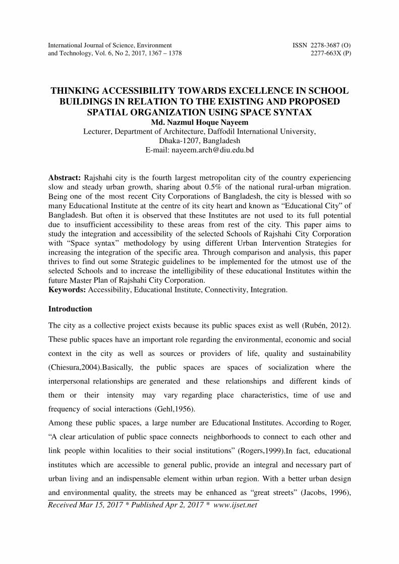
Fig: Location of selected schools
Analysis and findings
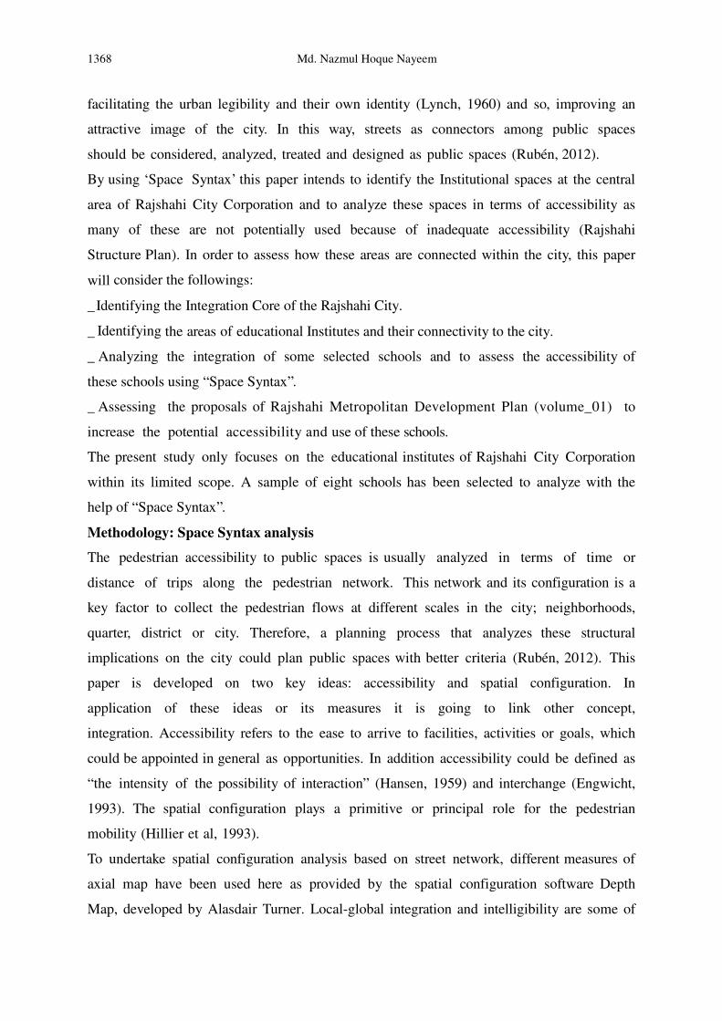
a) General spatial character of Rajshahi City: The general spatial character of Rajshahi
can be understood by the following Depthmap analysis. The location of selected 8 school is
placed here with the marking of green circle. Blue and white circle indicate the most
Integrated and Connected roads in Rajshahi city.
Fig: Global Integration (Existing) Fig: Local Integration (Existing)
Fig: Connectivity (Existing) Table-1.1
The axial map of Rajshahi City has been analyzed by Depthmap and Global Integration
(R=n), Local Integration (R=3) and Connectivity measures are considered. The high value
lines (marked with red by space syntex) of Global Integration, Local Integration and
A,B,C,D Most Integrated Road, R=n
E,F,G,H Most Integrated Road, R=3
I,J,K, Roads with maximum
connectivity
Thinking Accessibility Towards Excellence in School …. 1371
Connectivity are compared with corresponding 10% core. It is found that all the red marked
lines in Global context (road no.A,B,C,D), in Local context (road no.E,F,G,H) and for
connectivity (road no.I,J,K) are within the 10% core of corresponding measure of Rajshahi
City.
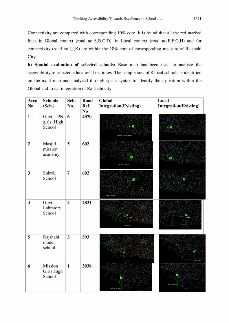
b) Spatial evaluation of selected schools: Base map has been used to analyze the
accessibility to selected educational institutes. The sample area of 8 local schools is identified
on the axial map and analyzed through space syntax to identify their position within the
Global and Local integration of Rajshahi city.
Area
No.
Schools
(Sch.)
Sch.
No.
Road
Ref.
No
Global
Integration(Existing)
Local
Integration(Existing)
1 Govt. PN
girls High
School
6 4370
2 Masjid
mission
academy
5 602
3 Shiroil
School
7 602
4 Govt.
Labratory
School
4 2831
5 Rajshahi
model
school
3 593
6 Mission
Girls High
School
1 3038

1372 Md. Nazmul Hoque Nayeem
Table-1.2
c) Identifying access road to sample area
School
No.
Area name schools Road Road
Ref.No
HH HH
R/3
Conn-
ctivity
1 Saheb
Bazar(Ganak
Para)
Govt. PN
girls High
School
1 4370 0.625 2.906 12
2 Shiroil Masjid
mission
academy
2 602 0.528 1.868 2
3 Shiroil Shiroil
School 3 602 0.528 1.868 2
4 Lakshipur
mor
Govt.
Labratory
School
4 2831 0.638 2.468 7
5 Mission mor Rajshahi
model
school
5 593 0.526 1.402 3
6 Court road Mission
Girls High
School
6 3038 0.5 1.814 4
7 Helenabad Rajshahi
Govt.Girls
High
School
7 4106 0.474 1.33 3
8 Rajshahi
University
Rajshahi
University
School
8 2276 0.528 1.57 2
7 Rajshahi
Govt.Girl-
s High
School
2 4106
8 Rajshahi
Universiy
School
8 2276
Thinking Accessibility Towards Excellence in School …. 1373
Max 0.625 2.906 12
Min 0.474 1.33 2
Mean 0.543 1.903 4.375
Table-1.3
Integration and connectivity of the access roads of these 8 schools are analyzed to understand
how these sample area is integrated to the whole city.
d) Analysis of access road to sample area
d-1. Global Integration of access road: The mean Global Integration is 0.543.Now the
Global Integrations of the access roads to the schools are compared below.
Govt. PN girls High School, Saheb Bazar (Ganak Para) _Road Ref. No 4370: The average
integration value of this school is 0.625 that is higher than mean global Integration value
(0.543).So this school is well integrated to the whole city. Masjid mission academy, Shiroil_
Road Ref. No 602: The Global integration value of this school is 0.528 that is below mean
global Integration value (0.543).So this school should be more integrated to the whole city
to attract more students. Shiroil School , Shiroil_ Road Ref. No 602: The average integration
value of this school is 0.528 that is below mean global Integration value (0.543).So this
school need more integration to the whole city to attract more students. Govt. Labratory
School, Lakshipur mor _ Road Ref. No 2831: The Global integration value of this school is
0.638 that is more than mean global Integration value (0.543).So this school is more
integrated to the whole city and attract more students. Rajshahi model school, Mission mor_
Road Ref. No 593: The Global integration value of this school is 0.526 that is below mean
global Integration value (0.543).So this school should be more integrated to the whole city.
Mission Girls High School, Court road_ Road Ref. No 3038: The average integration value
of this school is 0.5 that is below mean global Integration value (0.543). So this school need
more integration to the whole city to attract more students. Rajshahi Govt.Girls High
School, Helenabad_ Road Ref.No 4106: The average integration value of this school is 0.474
that is below mean global Integration value (0.543).So this school need more integration to
the whole city to attract more students. Rajshahi University School, Rajshahi University_
Road Ref.No 2276: This school is situated within the Rajshahi University area. The average
integration value of this school is 0.528 that is below mean global Integration value. Need a
little bit integration with city to make the school more accessible.
1374 Md. Nazmul Hoque Nayeem
d-2. Local Integration of access road: The mean Local Integration is 1.903.Now the Local
Integrations of the access roads to the schools are compared below.
Govt. PN girls High School ,Saheb Bazar (Ganak Para) _Road Ref.No 4370: The average
integration value of this school is 2.903- that is higher than mean Integration value (1.903).So
this school is well integrated to the whole city . Masjid mission academy, Shiroil_ Road
Ref.No 602: The local integration value of this school is 1.868 that is below mean local
Integration value (1.903).So this school should be more integrated to the whole city to
attract more students. Shiroil School, Shiroil_ Road Ref.No 602: The average integration
value of this school is 1.868 that is below mean local Integration value (1.903).So this school
need more integration to the whole city to attract more students. Govt. Labratory School,
Lakshipur mor _ Road Ref.No 2831: The local integration value of this school is 2.468 that is
more than mean local Integration value (1.903).So this school is more integrated to the whole
city and attract more students. Rajshahi model school, Mission mor_ Road Ref.No 593: The
local integration value of this school is 1,402 that is below mean Integration value (1.903).So
this school should be more integrated to the whole city. Mission Girls High School, Court
road _ Road Ref.No 3038: The average local integration value of this school is 1.814 that is
below mean Integration value (1.903).So this school need more integration to the whole city
to attract more students. Rajshahi Govt. Girls High School, Helenabad_ Road Ref.No 4106:
The average integration value of this school is 1.33 that is below mean local Integration value
(1.903).So this school need more integration to the whole city to attract more students.
Rajshahi University School, Rajshahi University_Road Ref.No 2276: This school is situated
within the Rajshahi University area. The average integration value of this school is 1.57 that
is below mean Integration value. Need a little bit integration with city to make the school
more accessible.
d-3. Connectivity of access road
From table-1.3 we can see that the most connected road is the access road to Govt. PN girls
High School, (Saheb bazar road).Second highest connectivity has the access road to Govt.
Labratory School. It has higher Global Integration and Local Integration also. So These 2
schools has more accessibility and from local source it is found that they have more students
than others. Mission Girls High School has a connectivity of 4 with higher Global and local
integration value than mean. This is also well accessible.
Thinking Accessibility Towards Excellence in School …. 1375
Masjid mission academy, Rajshahi University School and Shiroil School has connectivity
below mean value.Their Global and Local Integration value is also below mean level. So they
supposed to be less connected to the city and that has an impact on their accessibility too.
Proposed spatial interventions and their effect:
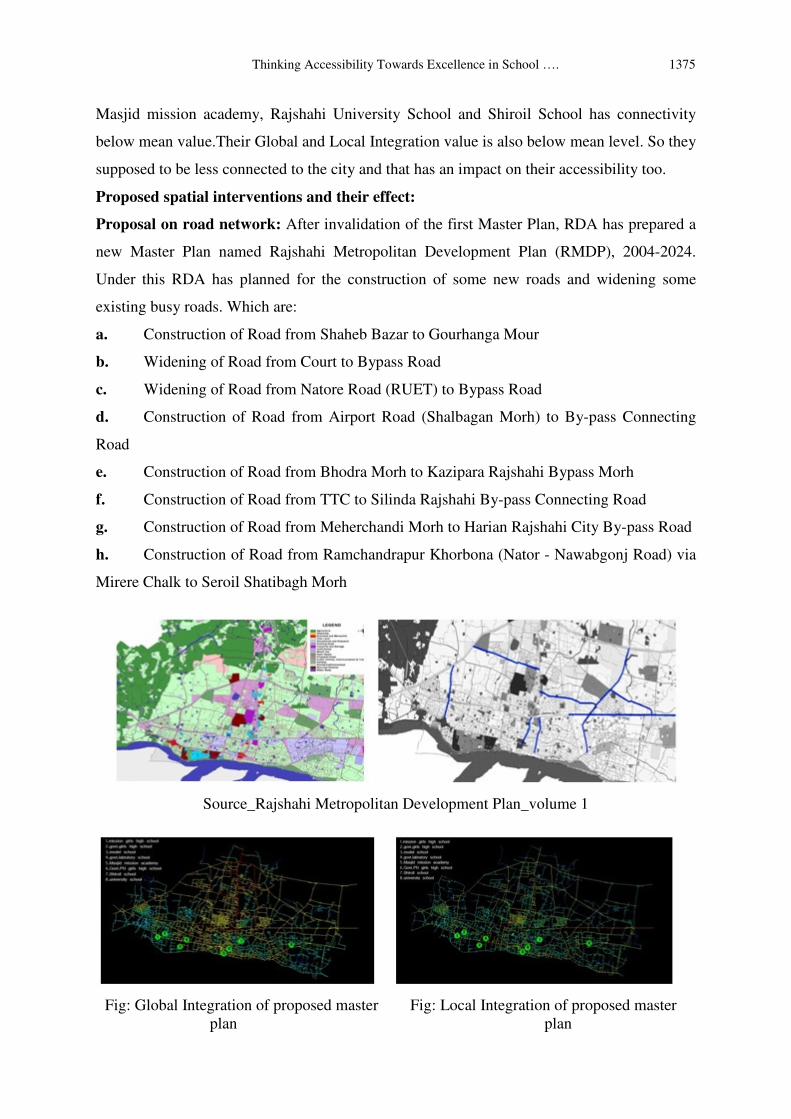
Proposal on road network: After invalidation of the first Master Plan, RDA has prepared a
new Master Plan named Rajshahi Metropolitan Development Plan (RMDP), 2004-2024.
Under this RDA has planned for the construction of some new roads and widening some
existing busy roads. Which are:
a. Construction of Road from Shaheb Bazar to Gourhanga Mour
b. Widening of Road from Court to Bypass Road
c. Widening of Road from Natore Road (RUET) to Bypass Road
d. Construction of Road from Airport Road (Shalbagan Morh) to By-pass Connecting
Road
e. Construction of Road from Bhodra Morh to Kazipara Rajshahi Bypass Morh
f. Construction of Road from TTC to Silinda Rajshahi By-pass Connecting Road
g. Construction of Road from Meherchandi Morh to Harian Rajshahi City By-pass Road
h. Construction of Road from Ramchandrapur Khorbona (Nator - Nawabgonj Road) via
Mirere Chalk to Seroil Shatibagh Morh
Source_Rajshahi Metropolitan Development Plan_volume 1
Fig: Global Integration of proposed master Fig: Local Integration of proposed master
plan plan

1376 Md. Nazmul Hoque Nayeem
Fig: Connectivity of proposed master plan
No. Area name schools Road
(Rd)
Rd.Ref.
No
HH HH
R/3
Connec
-tivity
1 Saheb Bazar
(Ganak Para)
Govt. PN girls
High School 1 4370 0.68 3.103 13
2 Shiroil Masjid mission
academy 2 602 0.57 1.989 2
3 Shiroil Shiroil School 3 602 0.57 2.398 2
4 Lakshipur
mor
Govt.Labratory
School 4 2831 0.701 2.869 8
5 Mission mor Rajshahi model
school 5 593 0.557 2.102 3
6 Court road Mission Girls
High School 6 3038 0.608 2.214 5
7 Helenabad Rajshahi
Govt.Girls
High School
7 4106 0.543 1.76 4
8 Rajshahi
University
Rajshahi
University
School
8 2276 0.528 1.57 2
Max 0.701 3.103 13
Min 0.57 1.76 2
Mean 0.556 2.003 4.875
Thinking Accessibility Towards Excellence in School …. 1377
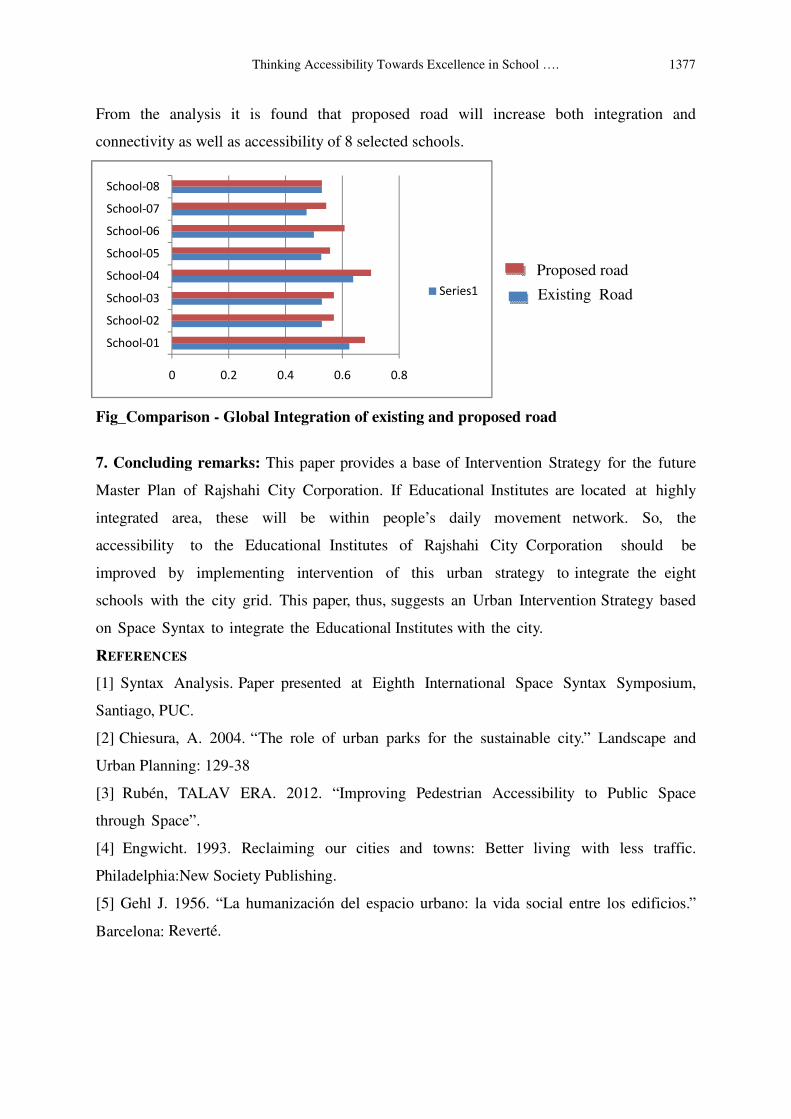
0 0.2 0.4 0.6 0.8
School-01
School-02
School-03
School-04
School-05
School-06
School-07
School-08
Series2
Series1
From the analysis it is found that proposed road will increase both integration and
connectivity as well as accessibility of 8 selected schools.
Fig_Comparison - Global Integration of existing and proposed road
7. Concluding remarks: This paper provides a base of Intervention Strategy for the future
Master Plan of Rajshahi City Corporation. If Educational Institutes are located at highly
integrated area, these will be within people’s daily movement network. So, the
accessibility to the Educational Institutes of Rajshahi City Corporation should be
improved by implementing intervention of this urban strategy to integrate the eight
schools with the city grid. This paper, thus, suggests an Urban Intervention Strategy based
on Space Syntax to integrate the Educational Institutes with the city.
REFERENCES
[1] Syntax Analysis. Paper presented at Eighth International Space Syntax Symposium,
Santiago, PUC.
[2] Chiesura, A. 2004. “The role of urban parks for the sustainable city.” Landscape and
Urban Planning: 129-38
[3] Rubén, TALAV ERA. 2012. “Improving Pedestrian Accessibility to Public Space
through Space”.
[4] Engwicht. 1993. Reclaiming our cities and towns: Better living with less traffic.
Philadelphia:New Society Publishing.
[5] Gehl J. 1956. “La humanización del espacio urbano: la vida social entre los edificios.”
Barcelona: Reverté.
Existing Road
Proposed road
1378 Md. Nazmul Hoque Nayeem
[6] Government of The People’s Republic of Bangladesh Ministry of Local
Government, Rural Development & Cooperatives Local Government Engineering
Department. “Preparation of Master Plan For Rajshahi Metropolitan Development Plan”
Jacobs, A. B. 1996. Grandes Calles. Ed. Universidad de Cantabria.
[7] Urban Development Directorate, Ministry of Works, U.N. Centre for Human Settlements
(HABITAT) and U.N. Development Programme. 1986. “Rajshahi Structure Plan: Rajshahi
pourashava, Bangladesh National Physical Planning Project.”