thrusting of a volcanic arc: a new structural model for javasearg.rhul.ac.uk/pubs/clements_etal_2009...
TRANSCRIPT

Thrusting of a volcanic arc: a new structural model for Java
Benjamin Clements1,*, Robert Hall1, Helen R. Smyth2 and Michael A. Cottam1
1SE Asia Research Group, Department of Earth Sciences, Royal Holloway University of London, Egham,Surrey TW20 0EX, UK
2Present address: CASP, University of Cambridge, West Building, 181a Huntingdon Road, Cambridge CB3 0DH,UK
*Corresponding author (e-mail: [email protected])
ABSTRACT: Java is part of a volcanic island arc situated in the Indonesianarchipelago at the southern margin of the Eurasian Plate. Sundaland continentalcrust, accreted to Eurasia by the Early Mesozoic, now underlies the shallow seas tothe north of Java where there has been considerable petroleum exploration. Java hasan apparently simple structure in which the east–west physiographic zones identifiedby van Bemmelen broadly correspond to structural zones. In the north there is themargin of the Sunda Shelf and, in southern Java, there are Cenozoic volcanic arcrocks produced by spatially and temporally discrete episodes of subduction-relatedvolcanism. Between the Sunda Shelf and the volcanic rocks are Cenozoic depocen-tres of different ages containing sedimentary and volcanic material derived fromnorth and south. This simplicity is complicated by structures inherited from theoldest period of subduction identified beneath Java, in the Cretaceous, by extensionrelated to development of the volcanic arcs, by extension related to development ofthe Makassar Straits, by late Cenozoic contraction, and by cross-arc extensionalfaults which are active today. Based on field observations in different parts of Java,we suggest that major thrusting in southern Java has been overlooked. The thrustinghas displaced some of the Early Cenozoic volcanic arc rocks northwards by 50 kmor more. We suggest Java can be separated into three distinct structural sectors thatbroadly correspond to the regions of West, Central and East Java. Central Javadisplays the deepest structural levels of a series of north-directed thrusts, andCretaceous basement is exposed; the overthrust volcanic arc has been largelyremoved by erosion. In West and East Java the overthrust volcanic arc is stillpreserved. In West Java the arc is now thrust onto the shelf sequences that formedon the Sundaland continental margin. In East Java the volcanic arc is thrust onto athick volcanic/sedimentary sequence formed north of the arc in a flexural basin duelargely to volcanic arc loading. All the components required for a petroleum systemare present. This hypothesis is yet to be tested by seismic studies and drilling, but, ifcorrect, there may be unexplored petroleum systems in south Java that are worthinvestigating.
KEYWORDS: Sundaland, Java structure, thrusting, volcanic arc
INTRODUCTION
Java (Fig. 1) is one of the many islands at the Eurasian marginin Indonesia in which subduction has been an importantinfluence on geological history and consequently the dev-elopment of petroleum systems. Subduction is active todayall around the SE Asian archipelago, from Sumatra to thePhilippines, and has been almost continuous for much ofthe Cenozoic, particularly in Indonesia. Sumatra and thePhilippines, where subduction is oblique, are characterized byfeatures such as major strike-slip faults, displaced and frag-mented terranes, and bends in faults that may be associatedwith sedimentary basins or folding and thrusting, depending on
the geometry of the bend. Volcanic activity is also oftenlocalized at fault bends or tips, and complexities in volcanicactivity with time have been interpreted to result from obliquesubduction of major features on the downgoing slab, such asfractures or ridges, or tearing of the subducting slab, openingslab windows, causing seismic gaps or anomalous heat flows.Overall, it is reasonable to expect oblique subduction toproduce a complex geology as features migrate along subduc-tion margins which, in turn, can be expected to influencepetroleum systems and their prospectivity.
In contrast, Java is often cited as an example of the productof orthogonal subduction and the volcanic island appears tohave a relatively simple structure. The physiographic zones
Petroleum Geoscience, Vol. 15 2009, pp. 159–174 1354-0793/09/$15.00 � 2009 EAGE/Geological Society of LondonDOI 10.1144/1354-079309-831

recognized by van Bemmelen (1949) were identified by him asstructural units, and they are broadly parallel to the east–westelongation of the island and the strike of the subduction trenchsouth of Java. He recognized some deformation on Java and,although it is sometimes difficult to interpret his ideas in termsof modern tectonic processes, van Bemmelen evidently sawdeformation as predominantly vertical responses to magmaticgrowth of geanticlinal features, which could result in thrustingand folding due to gravity-driven movements. He consideredthat the Sunda mountain system was typified by outwardmigration of orogenic deformation with time, said by him to beseen clearly in Sumatra. However, according to van Bemmelen,Java showed a contrary inward migration of deformation fromthe Indian Ocean, which he appears to attribute (e.g. vanBemmelen 1949, p. 658) to deep crustal or mantle processesassociated with volcanic activity. The main episode of defor-mation he identified, which did produce ‘northward folding andthrusts’ in north Java ‘had the character of backward- orhinterland folding’.
The idea that Java lacks significant deformation hasbeen passed down from van Bemmelen, and major thrusts arenot shown on most geological maps, except in north Java.Simandjuntak & Barber (1996) interpret a major backthrust, theBarabis–Kendeng thrust, to run the length of the island andreport that some segments are currently active. They interpretthere to have been ‘a change from an extensional to acompressional regime across the subduction system’ and sug-gest this could be a consequence of subduction of features suchas the Roo Rise on the Indian Plate (Fig. 1), or that localizationof compression may be due to magmatic intrusion and conse-quent uplift of the arc. This suggestion implies that thenorthward thrusting in north Java is part of contractional
deformation of a large wedge north of the trench, withcompression between the trench and a backstop. The reasonfor a backstop in north Java is not clear; usually in arcs, theinterpreted backstop is between the arc and the trench, notbehind the arc. The concept of such a large wedge is alsounusual, and suggests that the entire block is being pushednorthward, with deformation localized at its northern margin.
Oil company geologists in Indonesia are very familiar withthe significant thrusting in north Java and, with a few excep-tions, this represents the southern limit of extensive subsurfaceexploration which has been mainly offshore north of the island.The subsurface structure of the island, and certainly the crustsouth of the island, is less well known, because of problemswith exposure, difficulties in mapping structures at the surface,and the paucity of seismic data. However, as a result of ourfieldwork on Java in the last few years, we suggest that there ismore thrusting than previously recognized, which is of greatimportance in understanding the structure of the arc and maybe of interest to exploration geologists investigating frontierplays. The onshore geology of West Java is very different to thatfurther north. The petroleum systems of the shallow seas to thenorth of Java are covered elsewhere (e.g. Longley 1997; Doust& Sumner 2007) but there is much less information on land.What little subsurface data do exist in SW Java (e.g. Yuliantoet al. 2007) are further to the west in the Malingping Block(Fig. 1), where the geology is different to that of the regiononshore.
In this paper we identify important features that we suggestare better explained by a thrust model for Java. We proposethat Palaeogene arc rocks have been thrust northwards towardsthe Sunda Shelf and that a modern analogue of the Eocene toEarly Miocene sedimentary and tectonic setting is found at the
Fig. 1. Major features of the Javaregion between Borneo and the IndianOcean. Topography from SRTM andGTOPO30 and bathymetry fromSandwell & Smith (1997). Boxes arenumbered with the figures to whichthey refer in this paper. Towns andlocation names discussed are labelled.Arrow shows the current IndianOcean–Eurasia convergence vector atthe Java Trench from McCaffrey(1996).
B. Clements et al.160
present day in the East Java–Bali region. We first discuss WestJava, and then discuss thrusting and related deformation fromother parts of Java and, finally, consider briefly the implicationsfor hydrocarbon exploration.
WEST JAVA
The Ciletuh–Bayah area (Fig. 2) contains key features that weconsider make the case for thrusting in southern Java mostclearly. We therefore first summarize the geology of that areaand then discuss previous and new interpretations, followed bybriefer descriptions of examples of thrusting and deformationin other parts of West Java.
Ciletuh–Bayah
The Ciletuh area (Fig. 2) is well known for its exposures of theoldest rocks in West Java, which include rocks interpreted to beMesozoic. The ‘Pre-Tertiary’ of Ciletuh Bay was reported byvan Bemmelen (1949) to consist of ‘metamorphic basic andultra-basic rocks (gabbro, peridotite, serpentine) with chloriticschists and phyllites’. Schiller et al. (1991) described an ophi-olitic assemblage of peridotites, gabbros, pillow lava basalts andserpentinites associated with greenschists, mica-schists, amphi-bolite schists and quartzites, which has often been interpretedas a tectonic melange (e.g. Endang Thayyib 1977; Martodjojoet al. 1978; Parkinson et al. 1998). Little is known about the agesof these rocks. Schiller et al. (1991) reported that radiometricdating using the K–Ar method yielded very few conclusiveresults due to alteration. A pebble of basalt from a conglomer-ate of the Ciletuh Formation yielded a Late Cretaceous age,whereas plagioclase and whole-rock ages from a gabbro gavePaleocene to Middle Eocene ages. By comparison with theLok Ulo complex of Central Java (Parkinson et al. 1998), aCretaceous age for the ophiolitic rocks is likely.
The Middle and possibly Upper Eocene sediments of theCiletuh area have been assigned to the Ciletuh Formation,between 400 m and 1500 m thick, and are generally regardedas having been deposited on Cretaceous basement (vanBemmelen 1949; Marks 1957; Sukamto 1975; Endang Thayyib1977; Martodjojo et al. 1978; Schiller et al. 1991). Most authorshave interpreted the contact to be unconformable, althoughMartodjojo et al. (1978) suggested that the Ciletuh Forma-tion rested conformably on the melange complex and vanBemmelen (1949) reported local thrust contacts between thepre-Tertiary and the Ciletuh Formation. The Ciletuh Formationhas been separated into two main lithofacies (van Bemmelen1949; Marks 1957; Sukamto 1975; Schiller et al. 1991). Thepre-Tertiary rocks are ‘unconformably and transgressively cov-ered by the Eocene: sandstones and conglomerates with boul-ders of the Pre-Tertiary, mudstones, breccias and graywackes’(van Bemmelen 1949). Schiller et al. (1991) described ‘aquartzose lithofacies composed of mostly quartz and a widevariety of lithic rock fragments; and a less pervasive volcaniclithofacies composed entirely of volcaniclastic sediments’.The rocks of the Ciletuh Formation were suggested by vanBemmelen (1949) to be shallow-marine deposits, but Schilleret al. (1991) reinterpreted them as a sand-dominated submarinefan deposited in deep water in a forearc or interarc position.
About 20 km northwest of Ciletuh in the Bayah area thereare more than 1000 m of Eocene quartzose conglomer-ates, sandstones and mudstones of the Bayah Formation(Koolhoven 1933; Sukarna et al. 1993) divided into a southernand northern facies. The southern facies is predominantlyconglomerates and sandstones, and van Bemmelen (1949)remarked on its similarity to the Ciletuh quartzose lithofacies.
The northern facies, or Cipageur Member (Sukarna et al. 1993),consists of clays and quartz sandstones with intercalated lime-stones of Late Eocene age (Koolhoven 1933). The BayahFormation is interpreted as fluvio-deltaic and shallow-marinedeposits; van Bemmelen (1949) also noted the presence ofsome tuff intercalations. Schiller et al. (1991) suggested theBayah Formation is a shallow-water equivalent of the CiletuhFormation. Koolhoven (1933) noted that ‘a few observationsstrongly favour equal age’, although van Bemmelen (1949)observed that the southern facies of the Bayah Formation isprobably younger. This is reportedly the case in the UjungKulon-1 well (offshore SW Java), where the Upper EoceneBayah Formation lies immediately above a ‘heavily tectonizedand intensely fractured’ basement (Sukarno et al. 1999), indicat-ing that sedimentation probably commenced later in this part ofJava than in the Ciletuh area.
Just west of Bayah, between the Cimadur and Cidikit Rivers,the Upper Eocene Cicarucup Formation is exposed in the coresof anticlines (Sukarna et al. 1993). Its thickness was estimatedby Koolhoven (1933) to be at least 400 m, although this isuncertain because of faulting and folding (Sukarna et al. 1993).The formation includes andesitic conglomerates, quartz sand-stones, clays, limestones and thick tuff units deposited in alittoral to shallow-marine environment (Koolhoven 1933;Sukarna et al. 1993). Koolhoven (1933) suggested that theformation indicated that West Java was largely emergent in theLate Eocene, in contrast to the Middle Eocene, and vanBemmelen (1949) observed that andesitic detritus indicatedthat volcanic activity had begun in this part of West Java earlierthan elsewhere in Java.
In the Ciletuh area, the Ciletuh Formation is overlain byvolcanic rocks of the Jampang Formation which are part of the‘Old Andesites’ of Dutch workers. The formation is consideredto be Lower Miocene based on biostratigraphic analysis oflimestone lenses in the formation (Sukamto 1975; M.Boudagher-Fadel pers. comm. 2007) and was estimated byDutch workers (e.g. Verbeek & Fennema 1896; Koolhoven1933; van Bemmelen 1949) to be up to 5 km thick. There must,therefore, be a major break as the Upper Eocene and Oligoceneis missing. The formation consists largely of basaltic to daciticvolcanic breccias, tuffs and lavas. In the Ciletuh area theJampang Formation forms a dramatic amphitheatre, up to500 m high, with steep-sided cliffs, particularly along thenorthern boundary, surrounding a window of the older Ciletuhand Ciemas formations (Clements & Hall 2007). Close to thecoast at Ciletuh Bay are well-bedded tuffs and breccio-conglomerates several metres thick, which are predominantlybasaltic andesites and andesites. These types of rock arecommon in the Southern Mountains of West Java and repre-sent the most proximal deposits of the ‘old volcanic arc’ andmust have been deposited relatively close to the volcaniccentres. Thus, for the Early Miocene, the position of thevolcanic arc is known; for earlier times it is less clear.
Interpretation of the Ciletuh–Bayah region
All previous explanations of the geological relationships in theCiletuh–Bayah area of West Java have been essentially strati-graphic and autochthonous. Schiller et al. (1991) give a clearlyillustrated explanation of the Eocene, shown in Figure 3. Theysuggested the quartz-rich material of the Bayah and Ciletuhformations was derived from a Sundaland continental source tothe north. They interpreted the Bayah Formation as shelf-edgedeposits and their Ciletuh Formation as a sand-dominatedsubmarine fan deposited in deeper water to the south in aforearc or interarc position. Possible equivalents of these
Thrusting of a volcanic arc: Java 161

Fig. 2. West Java, Ciletuh region: SRTM image, key map and cross-sections showing the structural interpretation discussed in this paper.
B. Clements et al.162

sequences in the offshore region north of West Java are(?)Upper Eocene–Lower Oligocene proximal alluvial depositsand associated lacustrine shales (Pertamina 1996a). These arethe lowermost parts of the Talang Akar Formation and restdirectly on basement rocks. Equivalents of the thick Middle andUpper Eocene sequences exposed on land in West Java areprobably only very thin or not present in the offshore to thenorth. It appears that sedimentation started earlier at themargins of Sundaland in SW Java than further north (Clements& Hall 2008).
The Ciletuh amphitheatre has been interpreted as an inlierwith Eocene and older rocks in the centre, overlain unconform-ably by the Miocene Jampang Formation. Our observationssuggest a number of problems with the autochthonous inter-pretation. The character of the two Middle Eocene lithofaciesin the Ciletuh Formation is quite different. One is quartz-dominated and the other is composed of volcaniclastic debris.There is no transition observed between the two lithologiesand, in the Ciletuh area, where the two lithofacies are foundclose to one another in outcrop, there is no sign of mixing ofquartz-rich and volcaniclastic material. For this reason weassign the two lithofacies to different formations (Clements &Hall 2007): a volcaniclastic Ciletuh Formation and a quartz-richCiemas Formation. The material in the Ciletuh Formation isalmost all derived from ophiolitic basement, or volcaniclasticsources, with rare epidote amphibolites and shallow-marinelimestones; quartzose material is typically chert fragments andno material resembling the quartz of the Ciemas Formation isseen. Blocks of Nummulites limestones, and some volcaniclasticsandstones, were incorporated when incompletely lithified andshow soft sediment deformation typical of rapidly slumpedmaterial. In the interpreted submarine fan of Schiller et al.(1991) not only is the most distal material completely differentfrom the supposed source and more proximal material, it is alsothe coarsest (blocks up to 10 m across) and is highly angular.
We suggest these two formations are better interpreted ascontemporary but deposited in separate settings (Fig. 3). TheCiemas Formation, as suggested by Schiller et al. (1991), doesrepresent a transition from shelf-slope to deeper-water fan.Quartz-dominated material was derived from the Sundalandcontinent to the north and deposited on the shelf, some ofwhich was transported into deeper water. Much further southin the forearc was the site of formation and deposition of thevolcaniclastic Ciletuh Formation. Many features of the forma-tion indicate active tectonism. The size and angularity of blocksrequire steep submarine fault scarps, exposing basement, downwhich was carried partly lithified volcaniclastic material and rareshallow-marine limestones as debris flows, into a rift in whichbasaltic lavas were erupting. The association of deep-marinedeposits, active faulting of basement and steep slopes,accompanied by volcanic activity, slumping and syn-sedimentary deformation is interpreted here as due to extensionin a deep-marine forearc setting accompanying the onset ofsubduction and the initiation of the volcanic arc. Such featurescan be observed today in places such as Tonga, or theIzu–Bonin–Marianas arcs. The original large distance betweenthe Ciemas and Ciletuh formations is now reduced to zero. Weinterpret the juxtaposition to be the result of major northwardthrusting of the Southern Mountains arc. We suggest the thrustfront follows the northern edge of the Jampang Formationalong the Cimandiri Valley (Fig. 2). In the Ciletuh area, thecontact between the Jampang Formation and the underlyingCiletuh Formation is a thrust and the amphitheatre is thereforenot an inlier but a thrust window.
We suggest that the thrust hypothesis offers a simplerexplanation of apparent stratigraphic complexities requiring
large vertical movements and relative sea-level changes. Thefield relationships can be explained assuming normal strati-graphic contacts, unconformities and special arguments aboutsediment distribution but, in our view, they require someunlikely patterns of uplift and subsidence. For example, theabsence of the Upper Eocene and Oligocene at Ciletuh can beexplained if the area was elevated in the Late Eocene andbecame a structural high on which no rocks were deposited.This would require a rapid emergence from several kilometresof water depth and a major tectonic event. There is no evidenceon seismic lines a short distance to the west in the offshoreMalingping block (Keetley et al. 1997; Yulianto et al. 2007) forsuch an event. Indeed, less than 20 km to the north of Ciletuh,in the Bayah area, there is a thick sequence of Upper Eoceneshallow-marine quartz-rich clastic rocks, implying continuedsubsidence. If the Ciletuh block was a rapidly elevated topo-graphic high, it would have been a source of sediment, yet thereis almost no sign of Ciletuh-derived sediment in the BayahFormation, and relatively small amounts of volcaniclastic orbasement material are present in Oligocene formations north ofthe Cimandiri River.
The character of the Jampang Formation indicates a calc-alkaline arc, suggesting a prolonged period of volcanism evolv-ing from the deep-water basalts of the Middle Eocene CiletuhFormation to the largely emergent andesites and pyroclastics ofthe Jampang Formation. The apparent absence of UpperEocene and Oligocene volcanic material has led to suggestionsthat volcanic activity, and possibly subduction, did not beginuntil the Late Oligocene (e.g. Hamilton 1988) although, asnoted above, van Bemmelen (1949) observed that volcanicactivity had begun in the Bayah area ‘in the lower part of thePaleogene, that is earlier than in the rest of Java’. We suggestthat the paucity of volcanic debris to the north was, in part,because during most of the Palaeogene the Southern Mountainsarc in West Java was submerged, relatively non-explosive, butmost importantly, relatively distant from the Bayah area andCimandiri Valley. The Southern Mountains Arc and the shelfsequences dominated by quartzose Sundaland-derived materialwere originally separated by tens of kilometres rather than thefew kilometres of the present day, and have been broughtcloser together or juxtaposed by northward thrusting.
DEFORMATION ELSEWHERE IN SOUTH JAVA:WEST JAVA
Northern Jampang Plateau
The plateau that forms the amphitheatre around Ciletuh Bayextends towards the southeast, east and northeast forming theJampang Plateau (Figs 2A and 4). The Jampang Formationcomprises volcanic breccias, andesite and basalt flows, tuffs,lapilli tuffs, pumiceous tuffs, volcaniclastic sandstones andmudstones and intercalated limestones. Dips of bedding in thiscentral part, and in many other areas of the Southern Moun-tains, are broadly toward the south at low angles (5–15�).However, in the northern part of the Jampang Plateau, near thenorthern edge of the Jampang Formation, these gentle south-ward dips are not observed and, instead, steep dips, folding andthrusting are typical. Figure 4 is a geological map of the area(Sukamto 1990); the Jampang Formation is exposed over alarge part of the map, terminating in the north along theCimandiri Valley and to the east beneath the volcanic productsof the Upper Miocene Beser Formation. Two large anticlinesare shown and are further highlighted by interbedded brecciaand tuff members of the formation. These structures trendWNW–ESE and are associated with reverse faults that diptowards the south and southwest. We suggest that these folds
Thrusting of a volcanic arc: Java 163

Fig. 3. West Java, Ciletuh region. (A) Interpretation of the Ciletuh Formation of Schiller et al. (1991) compared to (B) the new interpretationof the Ciemas and Ciletuh formations discussed in this paper.
B. Clements et al.164

are close to the thrust front and formed as the result ofthrusting of the Jampang Formation northwards.
The Middle Miocene (van Bemmelen 1949; Marks 1957)Lengkong Formation is a thin (c. 200 m), well-bedded sequenceof calcareous and non-calcareous tuffaceous epiclastic volcano-genic sandstones, mudstones, Globigerina marls and sandy lime-stones that were deposited above the Jampang Formation inthis area. These are marine deposits that were sourced from thesurrounding arc rocks and represent minor subsidence of thevolcanic arc once volcanism ceased. The Lengkong Formationis preserved only in the cores of E–W-trending synclines of theJampang Formation, and preserves the same dips as thesurrounding strata, suggesting that deformation post-dates theirdeposition.
Bayah region
Over much of the Bayah region steep dips and repetition oflithologies due to faulting are common. The region can bedivided into three WNW–ESE-trending zones, the SouthernZone (SZ), Central Zone (CZ) and Northern Zone (NZ). TheSZ comprises predominantly Eocene to Lower Miocene sedi-mentary rocks; Koolhoven (1933) drew attention to the lack ofandesites. These include the Upper Eocene quartz-rich sand-stones and coals of the Bayah Formation. These coals areworked locally but operations are always small because ofconsistently steep dips (>40�), and discontinuity of coals, someof which are due to thrusting (Ziegler 1916). Oligocene coals ofthe Cimandiri and Cikarang coal fields in the Bayah region arepart of the Cijengkol Formation, have similar steep dips and arelocated within northerly verging asymmetric anticlines andsynclines. The SZ is intensely folded and a number of reversefaults exist, typically trending E–W to ESE–WNW. The MZ isseparated from the SZ by ‘fault and reverse fault contacts’
(Koolhoven 1933) and comprises predominantly Oligo-Miocene volcanic rocks. Eocene and Oligocene sedimentaryrocks are also exposed; no significant deformation is observed.The NZ comprises a conformable, moderately deformedMiocene sequence of volcanogenic, siliciclastic and carbonaterocks; the zone is characterized by numerous diorite intrusions;a number of asymmetric folds exist and structures trend E–Wto ESE–WNW (Koolhoven 1933). In the south of the area, therelatively undeformed Lower Pliocene Cimanceuri Formationand Malingping Tuff rest unconformably over formations thatwere subject to this major phase of deformation (Clements2008), and include the Middle Miocene Sareweh Formation.This major phase of deformation is therefore considered tohave occurred during the Late Miocene.
Cimandiri Valley, Cikalong Formation
Lower Oligocene clastic sedimentary rocks are exposed overan area of several square kilometres southwest of Sukabuminear the village of Warungkiera. They were assigned to theRajamandala Formation by Sukamto (1975) and the CiletuhFormation by Kusumahbrata (1994); we assign them to theCikalong Formation (Clements & Hall 2007; Clements 2008).There are pebbly conglomerates with highly rounded pebblesup to 3 cm long, bedded quartz-rich sandstones, calcareoussandstones and limestones, tuffaceous sandstones and darkmudstones. Channels, load casts, normal grading and fluidescape structures suggest rapid deposition. There are severalhundred metres of sediments, although observed structuralrepetition by folding and faulting means that thickness esti-mates are uncertain. The rocks are deformed and, throughoutthe area, bedding dips are consistently greater than 60�; alongthe Cimandiri River quartz-rich sandstones and mudstonesstrike approximately 055�.
Fig. 4. Geological map of the northern Jampang Plateau, West Java. Cikarang and Jampang members highlight E–W-trending folds. These vergenorthwards and are associated with reverse faults (after Sukamto 1975).
Thrusting of a volcanic arc: Java 165

Similar rocks are exposed further east, to the south ofCianjur and at Padalarang. At these localities the CikalongFormation lies beneath folded Oligo-Miocene limestones of theRajamandala Formation, in anticlinal cores (see below). Rarelimestone olistoliths are present both at Cikalong and in theCisukarama valley, south of Cianjur. These are typically coral-line limestones with abundant foraminifera of Middle Eoceneage (Clements 2008). The presence of agglutinated foraminiferain Cikalong Formation mudstones (P. Lunt, pers. comm. 2006)suggests a deep-water environment. We suggest that theshallow-water limestones were transported as olistoliths intodeeper water down a steep slope south of a narrow shelf.
Cikalong Formation rocks are exposed along the line ofthe Cimandiri Fault, which extends from Pelabuhanratu toBandung (Schiller et al. 1991; Dardji et al. 1994; Martodjojo1984, 2003). This is also the northern edge of the Oligo-Miocene Jampang Formation and a steep scarp of SouthernMountains volcanic rocks rises abruptly from the southernbank of the Cimandiri River. The line of the valley has beeninterpreted as a strike-slip fault (Dardji et al. 1994) thatinfluenced sedimentation in the Eocene and/or Oligocene(Martodjojo 1984, 2003; Schiller et al. 1991). It is often said tobe an active strike-slip fault and has been traced offshore(Schlüter et al. 2002; Susilohadi et al. 2005), although on SRTM(NASA Shuttle Radar Topography Mission) images it does nothave the sharp linear character of strike-slip faults, such as thePalu-Koro Fault in Sulawesi or the Sumatran Fault Zone. Wesuggest it is a thrust, and is not an active fault. The fieldrelationships in the Cimandiri Valley are ambiguous and canbe interpreted to indicate either Early Miocene thrusting orpost-Middle Miocene thrusting.
Rajamandala Ridge
The Rajamandala Formation includes shallow-marine algal,reefal and reworked reefal limestones with abundant shell, coraland foraminiferal material of Late Oligocene to Early Mioceneage (Baumann et al. 1973; M. BouDagher-Fadel, pers. comm.2006; Clements 2008). The limestones form a prominent ridgethat can be traced ENE–WSW from just west of Bandung tothe south of Cianjur where the ridge terminates and thelimestones disappear under younger rocks. Similar limestonesalong-strike in the Sukabumi area are generally accepted to be acontinuation of the Rajamandala Formation. The limestonesdip steeply and are tightly folded in the Rajamandala area westof Bandung; the major fold is overturned to the north and thenorthern limb is locally thrust northwards over younger rocks(Fig. 5). The ridge was described by van Bemmelen (1949) as asteep anticline or anticlinorium overturned to the north, and hereported that the core of Oligocene flysch has been squeezedout diapirically on the road to Cianjur to form a northwardoverthrust. In places elsewhere, the structure may be morecomplicated, with low dips on the limestones, but generally dipsare steep, folds verge towards the NW and there is thrusting ofRajamandala Limestone over the Lower–Middle MioceneCitarum Formation towards the NW.
Cimapag Formation
On the south coast, in the Bayah region, between TanjungLayar and Ujung Lengonwaru the Tuff Member of the CimapagFormation (Sudjatmiko & Santosa 1992) is well exposed. TheCimapag Formation is the equivalent of the upper parts of theJampang Formation in the Southern Mountains. At TanjungLayar there is a spectacular coastal section with 100 m ofbedded units exposed in small cliffs and the modern wave-cut
platform. At the base of the section are well-bedded volcani-clastic sediments which are typically laterally discontinuous andchannelized. There are many conglomeratic debris flows whichcontain clasts of tuffaceous sandstones, calcareous sandstones,and large boulders of basalt that appear to have been dumpedinto finer material. The sandstones are cross-bedded, havescoured bases with load casts and contain abundant plant andcharcoal fragments up to several centimetres long, and com-mon vertical and horizontal burrows. There are many featuresindicating rapid deposition, perhaps as lahars. These rocks passup into a number of thickly bedded ignimbrites. These are10–15 m thick and typically have a breccio-conglomeraticpumice-rich basal unit with an erosional base, containing somereworked angular lithic, and well-rounded siliciclastic and cal-careous clasts up to 40 cm across. The ignimbrites grade upinto several metres of finer block and ash material with diffuselamination which, in turn, grade into several metres of fine ashwith very fine convolute lamination. Spectacular flame struc-tures seen in the unit indicate the direction of transport wasbroadly to the west. The rocks are pyroclastic flow deposits,overlain by ash fall layers which were later deformed byproducts of subsequent explosive events; there are at least fourof these events recorded at Tanjung Layar. These rocks havebeen deformed since the Early Miocene since they are nowsub-vertical and strike east–west parallel to the coast.
Cinambo and Halang formations
To the northeast of Bandung, and in a more extensive area thatextends further westwards towards Bumiayu in Central Java,
Fig. 5. West Java, Rajamandala Limestone. Map and cross-sectionsshowing folding and thrusting of limestones west of Bandung (seeFig. 1 for location).
B. Clements et al.166

the Cinambo and Halang formations are well exposed. TheMiddle Miocene Cinambo Formation comprises well-beddedvolcanogenic and calcareous sandstones and mudstones thatare interpreted as turbidites. Calcareous sandstones containforaminiferal, coral, algal and shelly detritus. The UpperMiocene Halang Formation comprises predominantly volcano-genic conglomerates, sandstones and siltstones interpreted asturbidites and debrites. In an area that extends from Sumedangto Bumiayu there are some excellent exposures of intenselydeformed Cinambo and Halang Formation rocks. These formpart of a more extensive zone of deformed rocks that extendstowards Bumiayu, Central Java. The formation has beenintensely folded and faulted and bedding is of variable dip andtypically strikes E–W; reverse faults commonly dip southward.All deformation is consistent with northerly tectonic transportand this deformation must, therefore, be Late Miocene oryounger.
DEFORMATION ELSEWHERE IN SOUTH JAVA:EAST JAVA
In the southern part of East Java the case for northwardthrusting is less obvious than in West Java. The Eocene toMiocene arc rocks of the Southern Mountains are relatively wellexposed, but the equivalent age rocks to the north are generallynot exposed, neither is the contact between them and theSouthern Mountains Arc. The structure and stratigraphy ofEast Java appears relatively simple (Smyth et al. 2005, 2008). Inthe north the southern edge of the Palaeogene Sunda Shelf canbe traced from west to east along the Rembang Hills wherethere is now a northward-vergent fold-and-thrust belt. To thesouth of the shelf was the Kendeng Basin, largely filled with theEocene to Miocene volcaniclastic products of the SouthernMountains Arc, which was situated south of the basin. TheKendeng Basin is very poorly exposed, and there is littlesubsurface information, but the basin sequence is interpretedto thicken southwards towards the Southern Mountains(Pertamina 1996b). The physiographic trough of the KendengBasin deepened towards the south during the Palaeogene.Today, the rocks of the Southern Mountains Arc dip at a lowangle southwards and their northern contact with the KendengBasin is not exposed. Previously we have interpreted thestructure of the Southern Mountains Arc and southernKendeng Basin to be a largely undeformed stratigraphic tran-sition from basin to arc (Smyth 2005; Smyth et al. 2005, 2008),simply tilted to the south as the result of the uplift andemergence of East Java, although the Pertamina (1996b)cross-section shows thrusting at this contact. There are twolocations, at Prigi and Wonosari, near the northern edge of theSouthern Mountains that support a thrust interpretation.
Prigi
In the Southern Mountains around Prigi are carbonate rocks ofthe Lower Miocene Campurdarat Formation, volcanic rocks ofthe Mandalika Formation and many small hills which are smallandesite intrusions (Samodra et al. 1992a, b; Rahardjo et al.1995). In a small quarry near Prigi, about 5 km from the nearestoutcrop of the Campurdarat Formation, there are blacklimestones with volcaniclastic interbeds assigned to the PrigiMember of the Campurdarat Formation (Smyth 2005) exposedin a small quarry. The limestones contain volcaniclastic debrisas well as a diverse faunal assemblage, including corals, redalgae, ostracods, echinoid spines and benthic foraminiferaindicating a Middle Miocene (N8) age. They are interbeddedwith graded crystal-lithic volcaniclastic sandstones with scoured
bases and tuffaceous muds, which show evidence of slumpingand dewatering. These rocks are interpreted to have beendeposited close to an active volcanic source, where volcanicdebris was mixed with shallow-marine bioclasts on a narrowshelf, with debris flows carrying all this material downslope.What is unusual is the strongly deformed character of theserocks. Nearby exposures of the Mandalika Formation and theCampurdarat Formation are undeformed and dip gentlytowards the south. In contrast, in the Prigi Quarry the beds aretightly folded, with overturned axial planes dipping eastwards,and folds plunging at a low angle towards the northwest. Nosuch folding has been seen elsewhere. We suggest it may be aresult of deformation at or near a thrust at the base of theSouthern Mountains Arc.
Wonosari
At the eastern end of the Southern Mountains is an extensivearea of limestones, modern karst and caves in the WonosariHills to the south of the Jiwo Hills and Batu Agung Escarp-ment. The Upper Oligocene to Lower Miocene volcanic rocksof the Batu Agung Escarpment were deposited in a subaerial toshallow-marine setting. Volcanic activity culminated in a majorexplosive eruptive phase (Smyth et al. 2005, 2008) at about20 Ma, and then ceased for about 10 Ma. During the periodwhen there was little or no volcanic activity, the Lower toMiddle Miocene Sambipitu, Kepek and Wonosari formationswere deposited unconformably on volcanic rocks of the BatuAgung Group (Smyth 2005). The Sambipitu, Kepek andWonosari formations dip at less than 10� towards the south,much less steeply than the underlying volcanic rocks of theBatu Agung Group (25–35�).
The Sambipitu and Kepek formations interdigitate and havebeen interpreted as the deposits of the ‘Wonosari Trough’(Lokier 2000a, b). This trough is suggested to have been anarrow (5–10 km wide and 45 km long), deep (c. 1 km) basinbounded to the north by the Batu Agung Group volcanics and,to the south, by a fault-bounded block on which the platformcarbonates of the Wonosari Formation were deposited (Lokier2000a, b). The carbonate platform supplied abundant materialto the Kepek Formation, a sequence of turbidites containingredeposited carbonate debris and volcaniclastic material, on itsnorthern flank. To the north of this was the SambipituFormation, a series of calcareous volcanogenic turbidites thatnow occupies the area of low topographic relief of the northernWonosari Plain, south of the Batu Agung Escarpment. Theserocks have more volcanic debris, less carbonate and have amore distal character than the Kepek Formation.
There are some problems with this simple stratigraphicinterpretation. The southern side of the Wonosari Trough ispreserved and there is a transition to the Wonosari Platform,but on the north side of the trough there is no obvioustransition from the deep-water deposits of the SambipituFormation to the eroding volcanic source area inferred to thenorth. The Kepek and Sambipitu formations record a signifi-cant increase in water depth at the site of the previouslyemergent Early Miocene arc. The dimensions of the WonosariTrough imply rapid localized subsidence immediately south ofthe arc following the cessation of arc activity. For its depth thetrough is exceptionally narrow and, although there are deepelongate basins in the present-day Java forearc (van der Werff1996; Kopp et al. 2002), they are much wider.
These problems could be explained if the Wonosari Plat-form has been thrust northwards, stacking the underlyingKepek and Sambipitu formations, and reducing the apparentwidth of the basin. This interpretation is consistent with the
Thrusting of a volcanic arc: Java 167

structure of the area, with thrusts parallel to the low dips ofthe sediments, but would be difficult to prove without verydetailed dating. Biostratigraphic studies are hampered by diage-netic alteration of carbonate-rich lithologies, lack of criticalage-diagnostic faunas, and faunal reworking.
DEFORMATION ELSEWHERE IN SOUTH JAVA:CENTRAL JAVA
Central Java includes the most extensive area of basement rocksknown in Java, the Lok Ulo Complex (van Bemmelen 1949;Asikin et al. 1992). This is usually regarded as the imbricatedproduct of Cretaceous deformation (e.g. Parkinson et al. 1998;Wakita 2000) at a subduction margin that extended from WestJava, through the Lok Ulo Complex, to the Meratus Mountains.Parkinson et al. (1998) suggested that subduction ceased in theCretaceous after collision of a Gondwana continental fragmentthat is now beneath most of West Sulawesi. In contrast,Sribudiyani et al. (2003) suggested that subduction was continu-ous from the Cretaceous to the Eocene. They proposed thatthere is a continental fragment beneath most of East Java thatcollided with a volcanic arc, represented by the JatibarangFormation, at the end of the Eocene, and they interpretthe Karangsambung Formation and associated rocks that over-lie the Lok Ulo Complex as forearc deposits. Northwardthrusting and largely north-vergent folds are known from theKarangsambung region (Fig. 6). Thrusts cut Middle Miocenestrata and Miocene and Pliocene formations are folded (Asikinet al. 1992), suggesting that some of the deformation was morerecent. In marked contrast to West and East Java, in CentralJava there are no Southern Mountains and the Palaeogene arcrocks are absent.
We too consider there is Gondwana crust beneath parts ofEast Java, and dating of recycled zircons (Smyth et al. 2005,
2007) indicates that there is a continental crust beneath theSouthern Mountains that extends west almost to Yogyakarta.However, like Parkinson et al. (1998), we suggest this fragmentcollided in the Cretaceous and terminated subduction at thattime (Smyth et al. 2007). In East Java the oldest Cenozoicsedimentary rocks above basement, in the Nanggulan area, arefluviatile quartzose conglomerates and sandstones lacking vol-canic debris, and it is difficult to reconcile such a terrestrialfluviatile setting with the deep forearc basin a short distance tothe west in the Karangsambung area, proposed by Sribudiyaniet al. (2003). This would require a trench to be situated inCentral Java along-strike from a volcanic arc in the SouthernMountains.
In East Java, the Eocene terrestrial rocks pass rapidly upinto volcaniclastic-rich marine deposits, indicating a deepeningbasin to the north of the Southern Mountains Arc, theKendeng Trough. In Central Java, the Eocene–OligoceneKarangsambung and Totogan formations are also deep-waterdeposits, and include scaly clays with Nummulites limestoneblocks, polymict conglomerates and basalt blocks, interpretedas olistostromes (A. H. Harsolumakso, pers. comm. 2005) ormud volcanoes (A. J. Barber, pers. comm. 2007). However, incontrast to similar age rocks further east, they do not containabundant volcanic material, but do contain large amounts ofdebris derived from continental sources. The stratigraphicobservations in East and Central Java can be reconciled if theKarangsambung rocks were deposited in a deep basin thatwas the western continuation of the Kendeng Trough, butsupplied with sediment derived largely from the Sunda Shelf tothe north, whereas in East Java the Kendeng Trough wassupplied with debris derived predominantly from the SouthernMountains Arc to the south. We interpret the Kendeng Troughas a flexural response to volcanic loading by the SouthernMountains Arc (Smyth et al. 2005; Waltham et al. 2008), which
Fig. 6. Central Java, Karangsambungregion. Geological map and cross-section (simplified from Asikinet al. 1992) showing north-directedthrusting and folding of Eocene toPliocene formations.
B. Clements et al.168
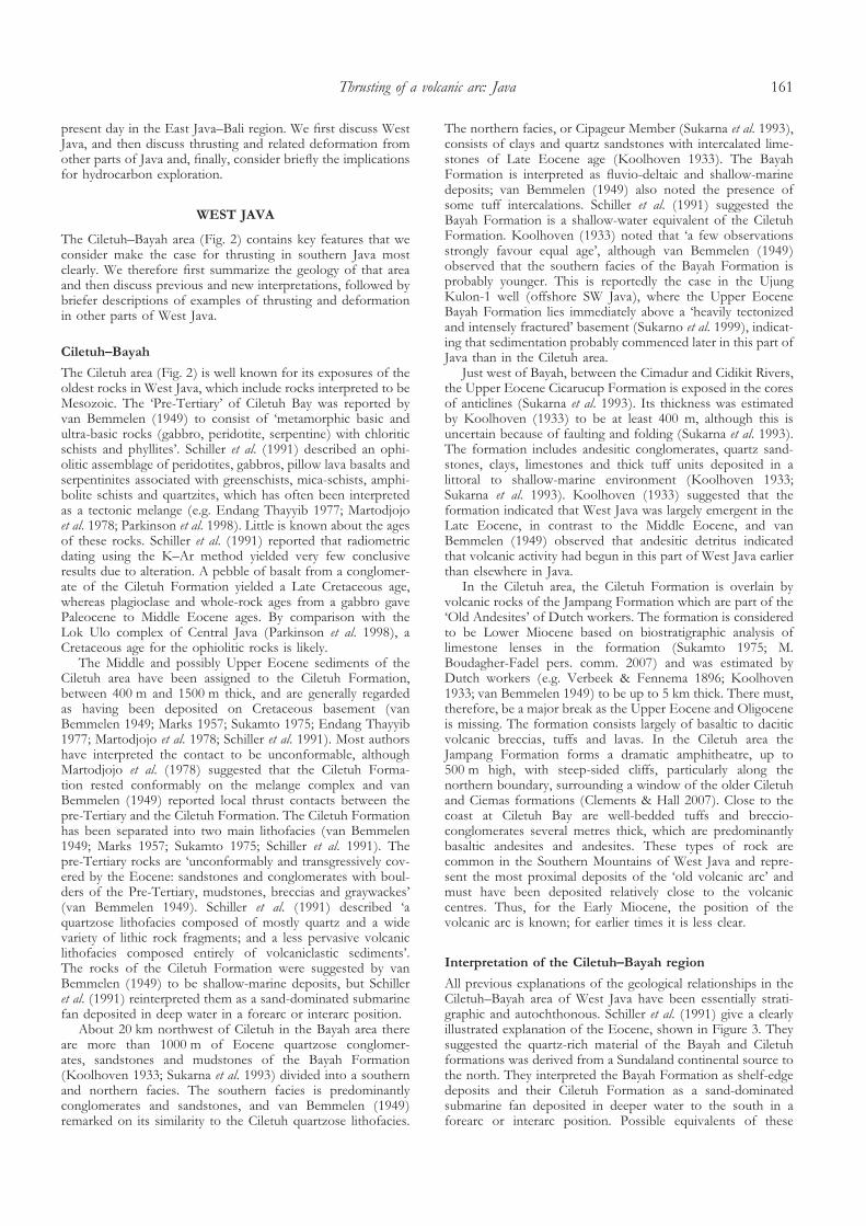
raises the question: where is the arc that produced the flexuralbasin in Central Java? We suggest that the Southern Mountainsarc was originally present in this area but was subsequentlythrust northwards and removed by erosion. Central Javaexposes a deeper structural level than either East or West Java;the upper thrust sheet of the volcanic arc has been removedand now exposes the rocks of the deep-marine trough, and theunderlying basement is exposed (Fig. 7).
DISCUSSION
Modern analogue
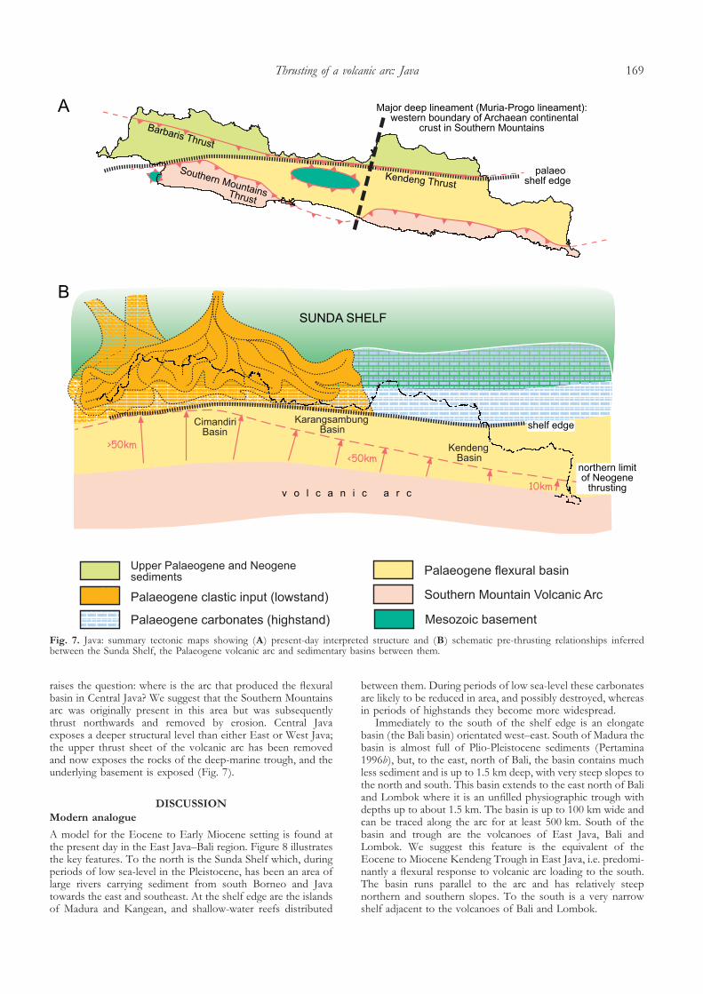
A model for the Eocene to Early Miocene setting is found atthe present day in the East Java–Bali region. Figure 8 illustratesthe key features. To the north is the Sunda Shelf which, duringperiods of low sea-level in the Pleistocene, has been an area oflarge rivers carrying sediment from south Borneo and Javatowards the east and southeast. At the shelf edge are the islandsof Madura and Kangean, and shallow-water reefs distributed
between them. During periods of low sea-level these carbonatesare likely to be reduced in area, and possibly destroyed, whereasin periods of highstands they become more widespread.
Immediately to the south of the shelf edge is an elongatebasin (the Bali basin) orientated west–east. South of Madura thebasin is almost full of Plio-Pleistocene sediments (Pertamina1996b), but, to the east, north of Bali, the basin contains muchless sediment and is up to 1.5 km deep, with very steep slopes tothe north and south. This basin extends to the east north of Baliand Lombok where it is an unfilled physiographic trough withdepths up to about 1.5 km. The basin is up to 100 km wide andcan be traced along the arc for at least 500 km. South of thebasin and trough are the volcanoes of East Java, Bali andLombok. We suggest this feature is the equivalent of theEocene to Miocene Kendeng Trough in East Java, i.e. predomi-nantly a flexural response to volcanic arc loading to the south.The basin runs parallel to the arc and has relatively steepnorthern and southern slopes. To the south is a very narrowshelf adjacent to the volcanoes of Bali and Lombok.
Fig. 7. Java: summary tectonic maps showing (A) present-day interpreted structure and (B) schematic pre-thrusting relationships inferredbetween the Sunda Shelf, the Palaeogene volcanic arc and sedimentary basins between them.
Thrusting of a volcanic arc: Java 169
During periods of explosive volcanic activity, volcanicdebris would be fed rapidly into the basin as debris flows andturbidites. South of Madura it is likely that the basin was filledfrom the west by debris carried by rivers draining East Java,from the south by volcanic debris derived straight offshorefrom the volcanoes, and from the north by carbonate carrieddownslope from Madura; the greater part of the basin fill islikely to be reworked volcanic material. The basin fill is likely tobe very similar to the fill of the Eocene to Miocene KendengBasin north of the Southern Mountains Arc.
On the north side of the basin is the wide shallow-marineSunda Shelf. During periods of highstands, such as the presentday, much of the sediment carried downslope into the basin isprobably carbonate derived from the islands, such as Kangeanand Madura, and the carbonate reefs between the islands.During periods of lowstands, such as the Last Glacial Maxi-mum, most of the shelf would have been emergent and therewould have been much more quartzose continental clasticmaterial carried by rivers, probably from greater distanceswithin Sundaland, such as south Borneo and West Java. Whenthese rivers carrying coarse rounded quartzose clastic materialreached the coast, there was a rather narrow shelf and a steepslope, and much of this material would have been transportedrapidly downslope into deep water, particularly during storms.There would be sandstones and conglomerates, debris flows
and olistostromes, possibly including blocks of limestoneseroded from the emergent carbonate islands. All these depositswould be very similar to those known from the Eocene toMiocene of West Java, such as the Ciemas Formation sub-marine fan and the Cikalong Formation olistostromes, and ofCentral Java, in the Karangsambung and Totogan formations.
Thrusting of the arc
In West Java the flexural basin is almost completely missing(Fig. 7), but its deposits are preserved, mainly in a narrow zonebetween the Jampang Formation of the Southern MountainsArc and the shelf sequences north of the Cimandiri Valley.They are commonly steeply dipping but, despite this, andevidence of locally deep-water deposition, they are regarded asautochthonous deposits, and variations in interpreted waterdepths have been suggested to be due to contemporaneousvertical tectonic movements and changing eustatic sea-level(van Bemmelen 1949; Sukamto 1975; Martodjojo 1984; Susilo-hadi et al. 2005; P. Lunt pers. comm. 2006). We suggest thatsuch interpretations are improbable. They require unlikely rapidvertical movements, invoke narrow elongate physiographicfeatures unlike anything observed around Java at present, andignore evidence of deformation. We suggest that all thesefeatures can be explained using the modern analogue for thesetting outlined above, with an elongate flexural basin formednorth of the volcanic arc (which we term the Cimandiri Basin;Fig. 7) that has subsequently been overthrust by the SouthernMountains Arc. This suggests total northward displacement ofthe order of 50 km to 100 km.
In Central Java, the deposits of the flexural basin, which weterm the Karangsambung Basin (Fig. 7), are preserved in theKarangsambung and Totogan formations, and overlain by theMiocene to Pliocene volcaniclastic turbidites that later filledthe basin. These rocks are thrust northwards, but the overlyingoverthrust volcanic arc has been almost entirely removed byerosion on land. It is possible that in Central Java there was noequivalent of the Southern Mountains Arc of West and EastJava and hence no significant overthrust arc. Volcanic arcs dooften have significant gaps between volcanoes for uncertainreasons, and the load imposed by the volcanoes in West andEast Java may have been sufficient to produce the flexuralbasin in Central Java. However, we suggest that it is more likelythat in Central Java a deeper structural level is seen, assuggested by the more extensive exposures of pre-Cenozoicbasement, and that the remnants of the arc are present offshoreto the south.
In East Java, the deposits of the flexural basin are preservedin the Kendeng Basin (Fig. 7). Although the basin had a similarform to that in West and Central Java, the basin fill is different.In West and Central Java most of the fill was sediments carriedsouth from the Sunda Shelf, and the Cimandiri and Karang-sambung basins contain mainly quartzose material with subor-dinate volcanic debris. In East Java there was an extensivecarbonate shelf to the north of the Kendeng Basin andrelatively small amounts of continental clastic material werecarried south into the basin, probably mainly during lowstands.Most of the fill, therefore, came from the volcanic arc to thesouth, which for much of the Oligocene and Early Miocenewas emergent and explosive, providing immense amounts ofvolcanic debris, particularly abundant volcanic quartz. Becauseof poor exposure of the Kendeng Basin sequences, it is difficultto estimate the amount of thrusting along its southern edge. Weestimate that there was only a few kilometres of thrusting of theSouthern Mountains Arc in East Java.
Fig. 8. East Java: topography from SRTM and GTOPO30 andbathymetry from Sandwell & Smith (1997) to show modern ana-logue of the relationships between Sunda Shelf, the volcanic arc andsedimentary basins in the Palaeogene, discussed in text. SurmisedPleistocene rivers are based on Voris (2000).
B. Clements et al.170

Age of thrusting
The thrusting is Middle Miocene or younger, but at present wecannot be certain of its exact age, nor if there was more thanone episode of thrusting. This is largely due to the absence ofcritical dates at thrust contacts; in most cases it is possible onlyto determine that rocks older than Early Miocene have beenthrust. A Middle Miocene age could indicate that thrusting islinked to the termination of the Palaeogene phase of arc activityon Java. There was regional plate reorganization at this time,following Australian continental collision in eastern Indonesia,which is suggested to have initiated counter-clockwise rotationof Borneo and Java (Hall 1996, 2002), and contributed tocessation or diminution of arc volcanic activity (Macpherson &Hall 1999, 2002) from Java eastwards in the Sunda Arc.
In the Cimandiri Valley, field relationships indicate eitherEarly Miocene or post-Middle Miocene thrusting. In theJampang Plateau, field relationships indicate post-MiddleMiocene thrusting. In the Bayah Dome and at Padalarang, fieldrelationships indicate post-Middle Miocene thrusting and, inSumedang to Bumiayu and in the Bayah Dome, field relation-ships indicate thrusting occurred since the mid-Late Miocene.In northern Java, van Bemmelen (1949) gives several examplesof thrusting or associated deformation that are Late Miocene orPliocene. Thrusting at this time could be associated with theshift of the location of arc activity to the north from theSouthern Mountains to its present-day position (Smyth et al.2005; Hall & Smyth 2008). In East Java this is particularly clearsince the modern arc volcanoes follow a simple linear trend,and the modern arc is parallel to, and about 50 km north of, thePalaeogene arc. In Central and West Java the arc also movednorth by a similar distance but the modern volcanoes aredistributed over a much wider zone than in East Java. Thecause of the arc shift is unclear. Simandjuntak & Barber (1996)suggested that a change from extension to contraction could bea consequence of subduction of the Roo Rise on the IndianPlate. There are certainly features south of Java that suggestthat collision of the Roo Rise, or similar topographic features, isimportant (Figs 1 and 9); the forearc basins to the west and eastdisappear, the forearc is elevated, the trench shallows, and thereis a change from subduction accretion to subduction erosionclose to the trench (Kopp et al. 2006). However, it is not knownwhen the Roo Rise arrived at the trench, nor why this wouldhave caused the arc to shift north throughout Java.
Finally there are a number of mud volcanoes towards theeast of the Kendeng Basin. Best known perhaps is the Lusi mudvolcano, which is located at the western margin of the Strait ofMadura, at Sidoarjo (Fig. 1) and has erupted unabated for morethan two years, flooding an area in excess of 7 km anddisplacing more than 25 000 people (Mazzini et al. 2007; Davieset al. 2008; Tingay et al. 2008). Mud volcanoes are the surfaceexpression of overpressure, which commonly reflects rapidsedimentation or thrusting. Mud volcanism in East Java is anindication of active tectonic change in the recent past.
Structural division of Java
We suggest Java can be separated structurally into three distinctparts that broadly correspond to the regions of West, Centraland East Java (Fig. 7). As explained above, in West and EastJava the overthrust volcanic arc is still preserved, whereasCentral Java displays deeper structural levels below the volcanicarc, which has been largely removed by erosion. However, themost important differences are between West-Central and EastJava. The East Java Palaeogene Southern Mountains volcanicarc was built on continental crust (Fig. 10; Smyth 2005; Smythet al. 2005, 2007, 2008). This had two important consequences:
first, volcanoes were built from a base on land or close tosea-level and, hence, were emergent at their earliest stages; and,secondly, the volcanic activity was explosive Plinian-type formost of the Eocene to Early Miocene. The volcanic arcprovided large quantities of debris in the form of volcanic ashto the Kendeng Basin from the Late Eocene until the EarlyMiocene. In contrast, the evidence from Ciletuh suggests thatthe volcanoes of West and Central Java were built on ophioliticbasement, the earliest volcanic activity was in a deep-watersetting and the volcanic activity was basaltic and non-explosive.It was not until the Late Oligocene that the volcanoes hadbecome emergent and were more explosive, as the crust
Fig. 9. (A) Major features of the Java and forearc region. Topogra-phy from SRTM and GTOPO30 and bathymetry from Sandwell &Smith (1997). Position of Muria–Progo lineament is marked by theline of black dots and 2006 Yogyakarta earthquake shown. (B) Sharpchange in S-wave velocities beneath East and Central Java at35–70 km depth range (indicated by black arrows; S-wave tomo-graphic model). Question mark conveys uncertainty in interpretationof S-wave anomalies – from Widiyantoro (2006). (C) Bouguergravity map of Java and (D) our shelf edge and that of Hamilton(1979).
Thrusting of a volcanic arc: Java 171

thickened and the volcanic edifice became more substantial.Thus, the flexural character of the Kendeng Basin is moreobvious because the basin formed on crust initially at sea-level.In West and Central Java, the flexural contribution by volcanicloading to subsidence of the basin north of the arc would haveincreased with time, but the Karangsambung and Cimandiribasins formed south of the shelf edge where there was alreadya slope and deepening to the south. Because of this morpho-logy these basins were fed mainly by quartzose debris fromSundaland until the arc became sufficiently mature to be animportant source of material.
We therefore consider that the most fundamental structuraldivision in Java is between Central and East Java (Fig. 10), atthe western limit of the old continental basement (Smyth et al.2008). Smyth (2005) interpreted a major NNE–SSW lineamentat approximately 110.5�E (Figs 9 and 10), which we call theMuria–Progo lineament. This lineament links several majorfeatures onshore and offshore (Fig. 9): a structural high in theJava forearc, the centres of three Oligo-Miocene volcanoes (vanBemmelen 1949) in the West Progo Mountains, Mount Merapiand the unusual K-rich volcano of Mount Muria. To the east ofthis line the basement of the Southern Mountains is oldcontinental crust (Fig. 10), whereas to the west it is Cretaceousophiolitic rocks. Widiyantoro (2006) has observed a sharpboundary between low and high S-wave velocities in the depthrange of 35–70 km below Central Java in his S-wave tomo-graphic model (Fig. 9B). He suggested that this was theapproximate edge of continental shelf during the Oligo-Miocene, based on Hamilton (1979; Fig. 9D). However, we donot agree that there was a sudden change in orientation of theshelf edge and we suggest this seismic discontinuity is morelikely to reflect the difference between old continental crust and
younger thinner ophiolitic crust and their underlying mantle.The orientation of the lineament is quite similar to manycross-arc normal faults in East Java, and the normal fault thatresulted in the 2006 Yogyakarta earthquake (Widiyantoro 2006;Fig. 10) suggests active arc-parallel extension at the present day.Satyana (2007) suggested that a NE–SW fault in a similarposition to the Muria–Progo lineament is one of a conjugatepair of strike-slip faults that bound Central Java. There is nosurface evidence of strike-slip movement on either of the faults,but they have a similar orientation to the cross-arc normal faultsin East Java, and could be extensional faults. Normal faultingon these faults would be consistent with the deeper structurallevels exposed in Central Java and their position could bedetermined by changes in the character of the deeper crust, assuggested above.
Significance for hydrocarbon exploration
The hypothesis of significant northward thrusting offers somenew play concepts in southern Java. In East Java, Eocene clasticsedimentary rocks containing coals would be buried moredeeply near the thrust front, but the abundance of volcanicmaterial in the Kendeng Basin could make reservoir rocksunattractive for exploration. However, in West Java the arc isthrust further northwards, the flexural basin sequence is likelyto be shortened and stacked beneath the arc rocks and at thebase of this thrust pile would be quartz-rich clastic rocks withabundant coals of Eocene and Oligocene age belonging to thesouthern Sunda Shelf (Fig. 11). The seismic data from theoffshore Malingping block suggest that the shelf marginsequences include a number of stratigraphic and structuraltraps, and these could be preserved below the thrusts. Moresubsurface information is required to test these suggestions.
CONCLUSIONS
After Cretaceous collision of an Australian microcontinentalfragment with the Java–Meratus subduction system, subductionceased and there was a passive margin south of Java until theEocene (Fig. 10). In the Middle Eocene, subduction resumedand a new arc developed south of the Sunda Shelf. The load ofvolcanoes contributed to the development of a flexural basinbetween the arc and the shelf that was between 50 km and100 km wide, and followed the shelf edge running ENE thelength of Java. From the Late Eocene to Early Miocene thebasin was supplied with quartz-rich clastic sediments by riversdraining the Sunda Shelf in West and Central Java, withsubordinate amounts of volcanic debris supplied from the arcvolcanoes, which were largely submarine and non-explosive. InEast Java, volcanoes were emergent earlier and erupted explo-sively and supplied greater amounts of volcanic debris to thebasin to the north. Arc activity ceased for a period in the EarlyMiocene and resumed again in the Late Miocene at a locationnorth of the site of the Palaeogene arc. At some time betweenthe Early Miocene and Pliocene, the Palaeogene sequence wasthrust northwards, by more than 50 km in West Java, but withprobably much smaller displacements in East Java. Java can beseparated into three structural sectors of West, Central and EastJava. Central Java displays the deepest structural levels ofthrusting and Cretaceous basement is exposed; the overthrustvolcanic arc has been largely removed by erosion but may bepresent to the south of Java. In West and East Java theoverthrust volcanic arc is still preserved. In West Java the arc isnow thrust onto the shelf sequences that formed on theSundaland continental margin. Northward thrusting of thePalaeogene volcanic arc rocks of the Southern Mountains offers
Fig. 10. (A) The character of crust beneath East Java and (B) theextent of the E Java–W Sulawesi basement block at 45 Ma. Notethat latitudes and longitudes are those for 45 Ma (based on recon-structions by Hall 2002).
B. Clements et al.172

a simpler explanation than autochthonous models for strati-graphic and structural relationships in southern Java. Over-thrusting of the arc may have contributed to overpressure in thesubsurface, as now well documented for East Java. Structuraland stratigraphic traps beneath the overthrust arc may also offernew hydrocarbon exploration possibilities as both source andreservoir lithologies are present.
The authors are grateful to the consortium of oil companies whohave supported projects in SE Asia for many years. Thanks go toAgus Harsolumakso, Benyamin Sapiie and other ITB geologists forintroducing us to the Karangsambung area, for their co-operation inour work in Java and for many interesting discussions; DjadjangSukarna and the Pusat Survei Geologi (former GRDC); and EkoLelono and Lemigas for their co-operation, help and support. IvanYulianto and Edy Slameto and numerous Lemigas counterpartsprovided invaluable field support. Peter Lunt helped with discussionsof Java geology, many suggestions for research and practical assist-ance. Marcelle BouDagher-Fadel, Bob Morley, Bernhard Seubert,Colin Macpherson and Moyra Wilson have all assisted in differentways.
REFERENCES
Asikin, S. Handoyo, A. Busono, H. & Gafoer, S. 1992. Geology of the KebumenQuadrangle, Jawa. Quadrangle 1401-1. Scale 1:100,000. Geological Researchand Development Centre, Bandung, Indonesia.
Baumann, P. de Genevraye, P. Samuel, L. & Mudjito, S.S. 1973. Contributionto the geological knowledge of south west Java. In: Indonesian PetroleumAssociation, Proceedings 2nd Annual Convention, 105–108.
Clements, B. 2008. Paleogene to Early Miocene tectonic and stratigraphic evolution ofWest Java, Indonesia. PhD thesis, University of London, London.
Clements, B. & Hall, R. 2007. Cretaceous to Late Miocene stratigraphic andtectonic evolution of West Java, Indonesia. In: Indonesian Petroleum Associ-ation, Proceedings 31st Annual Convention, 87–104.
Clements, B. & Hall, R. 2008. U–Pb dating of detrital zircons from West Javashow complex Sundaland provenance. In: Indonesian Petroleum Association,Proceedings 32nd Annual Convention, IPA08-G-115, 1–18.
Dardji, N. Villemin, T. & Rampnoux, J.P. 1994. Paleostress and strike-slipmovement: the Cimandiri Fault Zone, West Java, Indonesia. Journal of
Southeast Asian Earth Sciences, 9, 3–11.Davies, R.J. Brumm, M. Manga, M. Ubiandini, R. Swarbrick, R. & Tingay, M.
2008. The East Java Mud Volcano (2006 to Present): An earthquake ordrilling trigger? Earth and Planetary Science Letters, 272, 627–638.
Doust, H. & Sumner, H.S. 2007. Petroleum systems in rift basins – acollective approach in Southeast Asian basins. Petroleum Geoscience, 13,127–144.
Endang Thayyib, S. 1977. The status of the melange complex in Ciletuh area,Southwest Java. In: Indonesian Petroleum Association, Proceedings 6th Annual
Convention, 241–254.Hall, R. 1996. Reconstructing Cenozoic SE Asia. In: Hall, R. & Blundell, D.J.
(eds) Tectonic Evolution of SE Asia. Geological Society, London, SpecialPublications, 106, 153–184.
Hall, R. 2002. Cenozoic geological and plate tectonic evolution of SE Asiaand the SW Pacific: computer-based reconstructions, model and anima-tions. Journal of Asian Earth Sciences, 20, 353–434.
Hall, R. & Smyth, H.R. 2008. Cenozoic arc processes in Indonesia: identifi-cation of the key influences on the stratigraphic record in active volcanicarcs. In: Draut, A.E. Clift, P.D. & Scholl, D.W. (eds) Formation and
Applications of the Sedimentary Record in Arc Collision Zones. Geological Societyof America, Special Publications, 436, 27–54.
Hamilton, W. 1979. Tectonics of the Indonesian region. USGS Professional Paper,1078.
Hamilton, W. 1988. Plate tectonics and island arcs. Geological Society of America
Bulletin, 100, 1503–1527.Keetley, J.T. Cooper, G.T. Hill, K.C. Kusumabrata, Y. O’Sullivan, P.B. &
Saefudin, I. 1997. The structural development of the Honje High, BayahHigh and adjacent offshore areas, West Java, Indonesia. In: Howes, J.V.C.& Noble, R.A. (eds) Proceedings of the International Conference on Petroleum
Systems of SE Asia & Australia, 21–23 May, Jakarta, Indonesia. IndonesianPetroleum Association, 655–665.
Koolhoven, W.C.B. 1933. Geological Map of Java, Explanatory Notes to Sheet 14
(Bayah), 1:100,000. Mining Bureau of the Netherlands Indies.Kopp, H. Klaeschen, D. Flueh, E.R. Bialas, J. & Reichert, C. 2002. Crustal
structure of the Java margin from seismic wide-angle and multichannelreflection data. Journal of Geophysical Research, 107, DOI: 10.1029/2000JB000095.
Fig. 11. Regional cross-section through the West Java margin. Forearc structure is from Kopp et al. (2002). Estimates of crustal thickness arefrom Hamilton (1979). Inset is a schematic cross-section showing potential hydrocarbon plays (hypothetical accumulations shown in green)discussed in the text.
Thrusting of a volcanic arc: Java 173

Kopp, H. Flueh, E.R. Petersen, C.J. Weinrebe, W. Wittwer, A. & MeramaxScientists. 2006. The Java margin revisited: Evidence for subductionerosion off Java. Earth and Planetary Science Letters, 242, 130–142.
Kusumahbrata, Y. 1994. Sedimentology and stratigraphy of the Bayah, Walat andCiletuh Formations, SW Java Basins, Indonesia. PhD thesis, University ofWollongong, NSW, Australia.
Lokier, S.W. 2000a. The development of the Miocene Wonosari Formation,south Central Java. In: Indonesian Petroleum Association, Proceedings 27th AnnualConvention, 217–222.
Lokier, S.W. 2000b. The Miocene Wonosari Formation, Java, Indonesia: volcaniclasticinfluences on carbonate platform development. PhD thesis, University of London,London.
Longley, I.M. 1997. The tectonostratigraphic evolution of SE Asia. In: Fraser,A.J. Matthews, S.J. & Murphy, R.W. (eds) Petroleum Geology of Southeast Asia.Geological Society, London, Special Publications, 126, 311–339.
Macpherson, C.G. & Hall, R. 1999. Tectonic controls of geochemicalevolution in arc magmatism of SE Asia. In: Proceedings 4th PACRIMCongress, Bali Indonesia. Australian Institute of Mining and Metallurgy,359–368.
Macpherson, C.G. & Hall, R. 2002. Timing and tectonic controls onmagmatism and ore generation in an evolving orogen: evidence fromSoutheast Asia and the western Pacific. In: Blundell, D.J. Neubauer, F. &von Quadt, A. (eds) The Timing and Location of Major Ore Deposits in anEvolving Orogen. Geological Society, London, Special Publications, 204,49–67.
Marks, P. 1957. Stratigraphic lexicon of Indonesia. Publikasi Keilmuan DjawatanGeologi Bandung, Seri Geologi, 31.
Martodjojo, S. 1984. Evolusi Cekungan Bogor. Thesis, ITB, Bandung.Martodjojo, S. 2003. Evolusi Cekungan Bogor. ITB Press, Bandung.Martodjojo, S. Suparka, S. & Hadiwasastra, S. 1978. Status Formasi Ciletuh
dalam evolusi Jawa Barat. Geologi Indonesia, 5, 29–38.Mazzini, A. Svensen, H. Akhmanov, G.G. Aloisi, G. Planke, S.
Malthe-Sørenssen, A. & Istadi, B. 2007. Triggering and dynamic evolutionof the LUSI mud volcano, Indonesia. Earth and Planetary Science Letters, 261,375–388.
McCaffrey, R. 1996. Slip partitioning at convergent plate boundaries of SEAsia. In: Hall, R. & Blundell, D.J. (eds) Tectonic Evolution of SE Asia.Geological Society, London, Special Publications, 106, 3–18.
Parkinson, C.D. Miyazaki, K. Wakita, K. Barber, A.J. & Carswell, D.A. 1998.An overview and tectonic synthesis of the pre-Tertiary very-high-pressuremetamorphic and associated rocks of Java, Sulawesi andKalimantan, Indonesia. Island Arc, 7, 184–200.
Pertamina, B.P.P.K.A. 1996a. Petroleum Geology of Indonesian Basins, Principles,Methods and Application. Volume III: West Java Sea Basins. Pertamina,BPPKA, Jakarta.
Pertamina, B.P.P.K.A. 1996b. Petroleum Geology of Indonesian Basins, Principles,Methods and Application. Volume IV: East Java Basins. Pertamina, BPPKA,Jakarta.
Rahardjo, W. Sukandarrumidi & Rosidi, H.M.D. 1995. Geological Map of theYogyakarta Quadrangle, Java. Geological Research and Development Centre,Bandung.
Samodra, H. Gafoer, S. & Tjokrosapoetro, S. 1992a. Geology of the PacitanQuadranglem, Jawa (1507-4). Geological Research and Development Centre,Bandung.
Samodra, H. Suharsono, G.S. & Suwarti, T. 1992b. Geology of the TulugagungQuadrangle, Jawa. (quadrangle 1057-5). scale 1:100,000. Geological Researchand Development Centre, Bandung.
Sandwell, D.T. & Smith, W.H.F. 1997. Marine gravity anomaly from Geosatand ERS 1 satellite altimetry. Journal of Geophysical Research, 102, 10 039–10054.
Satyana, A.H. 2007. Central Java, Indonesia – a “terra incognita” in petroleumexploration. New considerations on the tectonic evolution and petroleumimplications. In: Indonesian Petroleum Association, Proceedings 31st AnnualConvention, 105–129.
Schiller, D.M. Garrard, R.A. & Prasetyo, L. 1991. Eocene submarine fansedimentation in southwest Java. In: Indonesian Petroleum Association, Proceed-ings 20th Annual Convention, 125–182.
Schlüter, H.U. Gaedicke, C. & Roeser, H.A. et al. 2002. Tectonic features ofthe southern Sumatra–western Java forearc of Indonesia. Tectonics, 21,1047–1062.
Simandjuntak, T.O. & Barber, A.J. 1996. Contrasting tectonic styles in theNeogene orogenic belts of Indonesia. In: Hall, R. & Blundell, D.J. (eds)Tectonic Evolution of SE Asia. Geological Society, London, Special Publica-tions, 106, 185–201.
Smyth, H. 2005. Eocene to Miocene basin history and volcanic activity in East Java,
Indonesia. PhD thesis, University of London, London.Smyth, H. Hall, R. Hamilton, J.P. & Kinny, P. 2005. East Java: Cenozoic
basins, volcanoes and ancient basement. In: Indonesian Petroleum Association,
Proceedings 30th Annual Convention, 251–266.Smyth, H.R. Hamilton, P.J. Hall, R. & Kinny, P.D. 2007. The deep crust
beneath island arcs: Inherited zircons reveal a Gondwana continentalfragment beneath East Java, Indonesia. Earth and Planetary Science Letters,258, 269–282.
Smyth, H.R. Hall, R. & Nichols, G.J. 2008. Early Cenozoic volcanic archistory of East Java, Indonesia: the stratigraphic record of eruptions on acontinental margin in a tropical setting. In: Draut, A.E. Clift, P.D. & Scholl,D.W. (eds) Formation and Applications of the Sedimentary Record in Arc Collision
Zones. Geological Society of America Special Publication, 436, 199–222.Sribudiyani, Muchsin, N. & Ryacudu, R. et al. 2003. The collision of the East
Java Microplate and its implication for hydrocarbon occurrences in theEast Java Basin. In: Indonesian Petroleum Association, Proceedings 29th Annual
Convention, 335–346.Sudjatmiko & Santosa. 1992. Geological map of the Leuwidimar quadrangle, Java,
Geological Research and Development Centre, Bandung.Sukamto, R. 1975. Geologic Map of the Jampang and Balekambang quadrangles, Java
1:100,000. Geological Research and Development Centre, Bandung.Sukamto, R. 1990. Geology of the Jampang and Balekambang Sheet area, West Jawa
1:100,000. Geological Research and Development Centre, Bandung.Sukarna, D. Mangga, S.A. & Brata, K. 1993. Geology of the Bayah area:
implications for the Cenozoic evolution of West Java, Indonesia. Bulletin of
the Geological Society of Malaysia, 33, 163–180.Sukarno, Wantoro, Pane, Y.A. Noon, S. & Hulsbos, R. 1999. Well
Cipatulah-1, Malingping Block, Offshore Southwest Java. Unpublished,confidential well report.
Susilohadi, S. Gaedicke, C. & Ehrhardt, A. 2005. Neogene structures andsedimentation history along the Sunda forearc basins off southwestSumatra and southwest Java. Marine Geology, 219, 133–154.
Tingay, M. Heidbach, O. Davies, R. & Swarbrick, R. 2008. Triggering of theLusi mud eruption: Earthquake versus drilling initiation. Geology, 36,639–642.
van Bemmelen, R.W. 1949. The Geology of Indonesia. Government PrintingOffice, Nijhoff, The Hague.
van der Werff, W. 1996. Variation in the forearc basin development along theSunda Arc, Indonesia. Journal of Southeast Asian Earth Sciences, 14, 331–349.
Verbeek, R.D.M. & Fennema, R. 1896. Geologische beschrijving van Java en
Madoera. J. G. Stemler Cz, Amsterdam.Voris, H.K. 2000. Maps of Pleistocene sea levels in Southeast Asia:
shorelines, river systems and time durations. Journal of Biogeography, 27,1153–1167.
Wakita, K. 2000. Cretaceous accretionary-collision complexes in centralIndonesia. Journal of Asian Earth Sciences, 18, 739–749.
Waltham, D. Hall, R. Smyth, H.R. & Ebinger, C. 2008. Basin formation byvolcanic arc loading. In: Draut, A.E. Clift, P.D. & Scholl, D.W. (eds)Formation and Applications of the Sedimentary Record in Arc Collision Zones.Geological Society of America Special Paper, 436, 11–26.
Widiyantoro, S. 2006. Learning from the May 27, 2006 Yogya-Central JavaDestructive Earthquake. In: Proceedings, 31st HAGI Annual Convention and
Exhibition, Semarang.Yulianto, I. Hall, R. Clements, B. & Elders, C. 2007. Structural and
stratigraphic evolution of the offshore Malingping Block, West Java,Indonesia. In: Indonesian Petroleum Association, Proceedings 31st Annual Conven-
tion, 171–183.Ziegler, K.G.J. 1916. Report on the results of mining geological investigations
in South Bantam. Jaarboek Mijnwozen, 1, 97.
Received 12 November 2008; revised typescript accepted 2 March 2009.
B. Clements et al.174