title 250 – department of environmental ......freshwater invertebrates”, second edition, march...
TRANSCRIPT

250-RICR-150-05-1
TITLE 250 – DEPARTMENT OF ENVIRONMENTAL MANAGEMENT
CHAPTER 150 – WATER RESOURCES
SUBCHAPTER 05 – WATER QUALITY
PART 1 – Water Quality Regulations
1.1 Purpose
It is the purpose of these regulations to establish water quality standards for the State's surface waters. These standards are intended to restore, preserve and
enhance the physical, chemical and biological integrity of the waters of the State,to maintain existing water uses and to serve the purposes of the Clean Water Act
and R.I. Gen. Laws Chapter 46-12. These standards provide for the protection of the surface waters from pollutants so that the waters shall, where attainable, be
fishable and swimmable, be available for all designated uses, taking into consideration their use and value for public water supplies, propagation of fish
and wildlife, recreational purposes, and also taking into consideration their use and value for navigation, and thus assure protection of the public health, safety,
welfare, a healthy economy and the environment.
1.2 Legal Authority
The authority for these regulations is vested in the Director by R.I. Gen. Laws
Chapters 46-12, 42-17.1, and 42-17.6. These rules and regulations are further promulgated pursuant to the requirements and provisions of all chapters of the
State of Rhode Island General Laws relating to the duties and responsibilities of the Director for the waters of the State, and in accordance with the requirements
of R.I. Gen. Laws Chapter 42-35.
1.3 Incorporated Materials
A. These regulations hereby adopt and incorporate 40 C.F.R. § 136 (2018) by
reference, not including any further editions or amendments thereof and only to the extent that the provisions therein are not inconsistent with these regulations.
B. These regulations hereby adopt and incorporate the “Methods for Measuring the Toxicity and Bioaccumulation of Sediment-associated Contaminants with
Freshwater Invertebrates”, Second Edition, March 2000, EPA/600/R-99/064 by

reference, not including any further editions or amendments thereof and only to the extent that the provisions therein are not inconsistent with these regulations.
C. These regulations hereby adopt and incorporate 40 C.F.R. § 404(b)(1) (2018) by reference, not including any further editions or amendments thereof and only to
the extent that the provisions therein are not inconsistent with these regulations.
D. These regulations hereby adopt and incorporate the “Assessing Human Health
Risk from Chemically-Contaminated Fish and Shellfish”, September 1989, EPA/503/8-89-002 by reference, not including any further editions or
amendments thereof and only to the extent that the provisions therein are not inconsistent with these regulations.
E. These regulations hereby adopt and incorporate the "Water Quality Criteria Documents; Availability," Appendix C - "Guidelines and Methodology used in
Preparation of Health Effect Assessment Chapters of the Consent Decree Water Criteria Documents," November 28, 1980, 45 FR 79347 by reference, not
including any further editions or amendments thereof and only to the extent that the provisions therein are not inconsistent with these regulations.
F. These regulations hereby adopt and incorporate 40 C.F.R. § 131.12(a)(1) (2018) by reference, not including any further editions or amendments thereof and only
to the extent that the provisions therein are not inconsistent with these regulations.
G. These regulations hereby adopt and incorporate 40 C.F.R. § 423 (2018) by reference, not including any further editions or amendments thereof and only to
the extent that the provisions therein are not inconsistent with these regulations.
H. These regulations hereby adopt and incorporate 40 C.F.R. § 116.4 (2018) by
reference, not including any further editions or amendments thereof and only to the extent that the provisions therein are not inconsistent with these regulations.
1.4 Definitions
A. For the purposes of these regulations, the following terms shall have the following meanings:
1. "Acute toxicity" means lethal or sublethal severe adverse effect(s) to an organism when exposed to a toxic pollutant(s) for a relatively short period
of time. In aquatic toxicity tests, an effect observed in 96 hours or less is typically considered acute.
2. "Administrator" means the administrator of the United States Environmental Protection Agency or any subordinate or subordinates to

whom the Administrator delegates the powers and duties vested in that office.
3. "Applicable standards and limitations" means all state, interstate and federal standards and limitations to which a discharge or activity is subject
under the Clean Water Act Federal Water Pollution Control Act, 33 U.S.C.
§ 1251 et seq. or any State Acts
4. "Applicant" means a person who applies for any approvals for any discharge, activities, projects, or facilities in accordance with the
requirements of these regulations.
5. "Application" means all forms, documents, and other information required
by the Department to apply for a permit, order, certificate, or other approval from the Department in accordance with the requirements of
these regulations.
6. "Approval" means an authorization, Order of Approval, permit,
certification, license or equivalent determination issued pursuant to regulations promulgated by the Department.
7. "Aquaculture facility" means a defined managed water area or facility for the maintenance or production of harvestable freshwater, estuarine or
marine plants and/or animals. Defined managed water area as used in thisdefinition, means the portions of the waters of the state within which the
permittee or permit applicant confines and/or plans to confine the cultivated species, using a method or plan of operation (including but not
limited to, physical confinement) which, on the basis of reliable scientific evidence, is expected to ensure that specific individual organisms
comprising an aquaculture crop will enjoy increased growth and be harvestable within a defined geographical area.
8. "Aquatic research related activities" means an activity in which research isconducted to evaluate the effect of various factors on the health, growth,
or reproduction of aquatic organisms.
9. "Assimilative capacity" means the amount of a pollutant or pollutants that
can safely be released to a waterbody or segment of a waterbody under the most adverse conditions, as defined in § 1.10(C) of this Part, which will
not cause any violations of applicable water quality criteria nor cause measurable harm or alteration to the natural biological community found
therein.
10. "Background" means the water quality upstream of all point and nonpoint
sources of pollution.

11. "Best Management Practices” or “BMPs" means schedules of activities, prohibitions of practices, maintenance procedures, and other management
practices to prevent or reduce the pollution of and impacts upon waters of the State. BMPs also include treatment requirements, operating
procedures, and practices to control site runoff, spillage or leaks, sludge orwaste disposal, or drainage from raw material storage.
12. "Best Professional Judgment” or “BPJ" means a determination, based on best engineering and/or scientific practices and best management
practices, involving any pollutant, combination of pollutants or practice(s), on a case by case basis, which is determined by the Director to be
necessary to carry out the provisions of the Clean Water Act and any applicable chapters of the Rhode Island General Laws. BPJ can be used
to set Best Available Technology Economically Achievable, Best Conventional Pollutant Control Technology, Best Practicable Control
Currently Available or Best Management Practices limitations pursuant to
the Clean Water Act 33 U.S.C. § 1251 et seq. either in the absence of an
applicable promulgated effluent guideline or where promulgated effluent limitation guidelines only apply to certain aspects of the discharge's
operation or to certain pollutants.
13. "Bioassay" means a toxicity testing procedure using aquatic organisms to
determine the concentration or amount of a toxic pollutant(s) causing a specified response in the test organisms under stated test conditions.
14. "Brackish water" means those waters of the state in which the natural levelof salinity is greater than 1 (one) part per thousand but less than 10 (ten)
parts per thousand, 95 percent or more of the time.
15. "C.F.R." means the Code of Federal Regulations.
16. "Chronic toxicity" means lethal or sublethal adverse effect(s) to an organism or its progeny, based on various physiological measurements
including but not limited to growth, survival, or reproductive success when exposed to a toxic pollutant(s) for a relatively long period of time. The
methods commonly used to estimate chronic effects involve exposures of typically seven (7) days or less.
17. "Clean Water Act” or “CWA" means the Federal Water Pollution Control
Act 33 U.S.C. § 1251 et seq. .
18. “Coldwater fishery” means waters in which naturally occurring water quality and/or habitat allow the maintenance of naturally reproducing
indigenous coldwater fish populations.
19. "Combined sewer" means a sewer which serves as a sanitary sewer and a storm sewer.
20. "Combined Sewer Overflow” or “CSO" means flow from a combined sewerthat is discharged into a receiving water without going to a treatment
works. A CSO is distinguished from bypasses which are diversions of waste streams from any portion of a treatment works.
21. "Contiguous zone" means the entire zone established by the United States under Article 24 of the Convention on the Territorial Sea and the
Contiguous Zone.
22. "Controlled relay" means the transplant of shellfish from certain waters to
Class SA waters suitable for shellfish harvesting under the coordination and authority of the RIDEM for the purpose of natural purification and
controlled harvest, consistent with the National Shellfish Sanitation Program guidance.
23. "Cultural eutrophication" means the human-induced acceleration of primary productivity in a surface waterbody resulting in nuisance
conditions of algal blooms and/or dense macrophytes.
24. "Department" or "Departmental" or "DEM" or "RIDEM" or "Director" means
the Rhode Island Department of Environmental Management or the Director of the Department of Environmental Management or any
designee to whom the Director delegates the powers and duties vested in that office.
25. "Depuration" means the artificial holding of shellfish for purification purposes.
26. “Designated bathing beach” means bathing beaches licensed by the Rhode Island Department of Health.
27. "Designated uses" means those uses specified in water quality standards for each waterbody or segment whether or not they are being attained. In
no case shall assimilation or transport of pollutants be considered a designated use.
28. "Discharge" means to cause or allow the addition or release of any pollutants to the waters of the State or placement of any pollutant where it
is likely to enter the waters of the State and includes but is not limited to surface water runoff, spilling, depositing, placing, leaking, pumping,
pouring, emitting, emptying, or dumping. This definition includes additions of pollutants into waters of the State from both point and nonpoint sources.

This term does not include an addition of pollutants by an indirect discharge.
29. "Discharger" means any person who causes, or allows, any discharge.
30. "Dredging" means the excavation of sediments from beneath surface
waters by mechanical or hydraulic means.
31. "EC50" means the concentration of a test material in a suitable diluent at
which 50 percent of the exposed organisms exhibit a specified response during a specified time period.
32. "Effluent limitations" means any restriction imposed by the Director on quantities, discharge rates, and concentrations of pollutants which are
discharged from point sources into surface waters of the state or the contiguous zone.
33. "Effluent limitation guidelines" means a regulation published by the Administrator under Section 304(b) of the Clean Water Act, 33 U.S.C. §
1314 to adopt or revise effluent limitations.
34. "Effluent limited waters" means any segment of a surface waterbody
where the water quality currently meets or is expected to meet applicable water quality standards after the application of the technology-based
effluent limitations required by Sections 301(b) (33 U.S.C. § 1311) and 306 (U.S.C. § 1316) of the Act.
35. "EPA" means the United States Environmental Protection Agency.
36. "Existing use" means those designated uses and any other uses that do
not impair the designated uses and that are actually attained in a waterbody on or after November 28, 1975; except that in no case shall
assimilation or transport of pollutants be considered an existing use.
37. "Facility" means any building, structure and operation, including land or
appurtenances thereto, on one contiguous site.
38. "Filling" means to place dirt, soil, stones, gravel, sand, sediment, tree
stumps, brush, leaves, solid waste, debris, garbage, trash, pollutants, or any other material, substance, or structure, either foreign or related, on or
in any waters of the state or in such a way as to alter the natural character, function or value of any waters of the State.

39. "Fish and wildlife" means birds, fish, shellfish, mammals and all other classes of wild aquatic and land organisms and all types of vegetation
upon which they are dependent, including all indigenous species.
40. "Flow alteration" means the withdrawal of water from a surface water,
either directly or indirectly, or the alteration of the normal flow patterns of asurface water due to a project which diverts or holds the surface water.
41. "Freshwater" means those waters of the State in which the natural level of salinity is equal to or less than one (1) part per thousand, 95 percent or
more of the time.
42. "Groundwater" means water found underground which completely fills the
open spaces between particles of soil and within rock formations.
43. "Habitat" means the area which provides direct support for a given
species, population or community. It includes all environmental features that comprise an area such as air, water, vegetation, soil, substrate and
hydrologic characteristics.
44. "Hazardous substance" means any substance designated under
Designation of Hazardous Substances, 40 C.F.R. § 116.4, incorporated above in § 1.3(H) of this Part, pursuant to Section 311 of the Clean Water
Act, 33 U.S.C. § 1321.
45. "Hazardous waste" means any waste as defined in accordance with R.I.
Gen. Laws § 23-19.1-4 and regulations adopted pursuant thereto.
46. "High quality waters" means all Class A and SA surface waters as well as
other surface waters whose quality exceeds the minimum water quality criteria for any State aquatic life and/or human health criteria or water
quality standards assigned to them; or whose quality and characteristics make them critical to the propagation or survival of important living natural
resources; or those waters constituting a Special Resource Protection Water or an Outstanding National Resource Water.
47. "Indirect discharge" means any discharge into a treatment works.
48. "Kettlehole" means a pond or freshwater wetland in a depression in the
earth's surface formed by the melting of a wholly or partially buried block of glacial ice.
49. "Lake, pond or reservoir" means any body of water, whether naturally occurring or created in whole or in part, excluding sedimentation control or

stormwater retention/detention basins, unless constructed in waters of the State.
50. "LC50" means the concentration of a test material in a suitable diluent at which 50 percent of the exposed organisms die during a specified time
period.
51. "Load allocation" means the portion of a receiving water's loading capacity
that is attributed either to one of its nonpoint sources of pollution or to natural background sources.
52. "Loading capacity" means the maximum amount of loading that a surface water can receive without violating water quality standards.
53. "Low quality waters" or "degraded" means any water whose quality falls below any of the criteria of § 1.10(B) of this Part in accordance with
Applicable Conditions of § 1.10(C) of this Part and corresponding to its classification as designated in § 1.9(E) of this Part, as determined by the
Director, shall be considered degraded for that particular criterion and in violation of its water quality standards and, therefore, unsatisfactory for
any designated uses which the Director determines are affected by the particular criterion which is violated. Waters in their natural hydraulic
condition may fail to meet their assigned water quality criteria from time to time due to natural causes, without necessitating the modification of
assigned water quality standard. Such waters will not be considered to be violating their water quality standards if violations of criteria are due solely
to naturally occurring conditions unrelated to human activities.
54. "Marina" means:
a. A dock, pier, wharf, float or combination of such facilities that may accommodate five (5) or more recreational vessels as a
commercial operation or in association with a club; or
b. Any dock, pier, wharf, float or combination of such facilities used as
a commercial operation, aside from a) above, at which any vessel is serviced or maintained.
55. "Marine Sanitation Device (MSD)-Type I" means a marine toilet which, under prescribed test conditions, will produce an effluent that will not
exceed a fecal coliform bacteria count of one thousand (1,000) parts per hundred (100) milliliters, and have no visible solids.
56. "Marine Sanitation Device (MSD)-Type II" means a marine toilet which, under prescribed test conditions, will produce an effluent that will not

exceed a fecal coliform bacteria count of two hundred (200) parts per hundred (100) milliliters, and have suspended solids not greater than one
hundred and fifty (150) milligrams per liter.
57. "Marine Sanitation Device (MSD)-Type III" means a marine toilet which is
designed to prevent the discharge from the vessel of any treated or untreated sewage, or any waste derived from sewage.
58. "Marine toilet" means any toilet or receptacle for the containment of human wastes located on or within any vessel, as defined herein, not
including a portable potty.
59. "Mixing zone" means a limited area or volume in the immediate vicinity of
a discharge where mixing occurs and the receiving surface water quality isnot required to meet applicable standards or criteria, provided the
minimum conditions described in §§ 1.10(B)(5) and (6) of this Part are attained.
60. "Municipality" means a quasi-governmental corporation, association or other public body created by or under State law and having jurisdiction
over disposal of sewage, industrial wastes, or other wastes; a city, town, county, district, or a designated and approved management agency under
Section 208 of the Clean Water Act, 33 U.S.C. § 1288.
61. "Natural background conditions" means all prevailing dynamic
environmental conditions in a waterbody or segment thereof, other than those human-made or human-induced.
62. "New discharge" means any discharge which commenced subsequent to November 28, 1975, unless appropriate approvals had been granted.
63. "No discharge area/zone" means an area of the surface waters of the State which has been requested by the Director of the Department of
Environmental Management and declared by the United States Environmental Protection Agency, pursuant to Section 312 of the Clean
Water Act, 33 U.S.C. § 1322, to be an area in which any discharge of sewage from vessels is prohibited.
64. "Non-contact cooling water" means water which is used to reduce temperature and does not come into direct contact with any raw material,
intermediate product (other than heat), or finished product.
65. "Nonpoint Source" or "NPS" means any discharge of pollutants that does
not meet the definition of Point Source in Section 502(14) of the Clean Water Act, 33 U.S.C. § 1362, and these regulations. Such sources are

diffuse, and often associated with land-use practices, and carry pollutants to the waters of the State, including but not limited to, non-channelized
land runoff, drainage, or snowmelt; atmospheric deposition; precipitation; and seepage.
66. "Nutrient" means a chemical element or compound such as but not limitedto nitrogen or phosphorous which is essential to and promotes the growth
and development of marine or freshwater plant species.
67. "Outstanding National Resource Waters” or “ONRW” means waters of
National and State Parks, Wildlife Refuges, and other such waters designated as having special recreational or ecological value.
68. "Person" means an individual, trust, firm, joint stock company, corporation (including a quasi-governmental corporation), partnership, association,
syndicate, municipality, municipal or state agency, fire district, club, non-profit agency or any subdivision, commission, department, bureau,
agency or department of state or federal government (including any quasi-governmental corporation) or of any interstate body.
69. "Point source" means any discernible, confined, and discrete conveyance,including but not limited to any pipe, ditch, channel, tunnel, conduit, well,
discrete fissure, container, rolling stock, concentrated animal feeding operation or vessel, or other floating craft, from which pollutants are or
may be discharged. This term does not include return flows from irrigated agriculture.
70. "Pollutant" means any dredged material, solid waste, incinerator residue, sewage, garbage, sewage sludge, sediment, filter backwash, munitions,
chemical wastes, biological materials, radioactive materials, heat, wreckedor discarded equipment, rock, sand, cellar dirt, industrial or municipal or
agricultural waste or effluent, petroleum or petroleum products, including but not limited to oil; or any material which will likely alter the physical,
chemical, biological or radiological characteristics and/or integrity of water.
71. "Pollution" means the human-made or human-induced alteration of the
physical, chemical, biological or radiological characteristics and/or integrityof water.
72. "Pretreatment requirements" means any limitation or prohibition on quantities, quality, rates, and/or concentrations of pollutants directly or
indirectly discharged into or otherwise introduced into a treatment works that are imposed by federal or state regulation or by the treatment works.

73. "Primary contact recreational activities" means any recreational activities in which there is prolonged and intimate contact by the human body with
the water, involving considerable risk of ingesting water, such as swimming, diving, water skiing and surfing.
74. "Priority pollutant" means those pollutants listed pursuant to Section 307(a)(1) of the Clean Water Act, 33 U.S.C. § 1317.
75. "Public drinking water supplier" means any city, town, district, or other municipal, public, private corporation or company, or non-profit entity
authorized to engage in the collection and treatment of surface water for the purposes of distribution of drinking water in Rhode Island and whose
source of drinking water is a surface water in Rhode Island.
76. "Public drinking water supply" or “PDWS” means the source of surface
water for a public drinking water supplier.
77. "Pycnocline" means a steep density gradient in an estuary caused by
differences in temperature or salinity between the bottom and surface layers of water that limits mixing of the two layers.
78. "Rhode Island Pollutant Discharge Elimination System” or “RIPDES" means the Rhode Island system for issuing, modifying, revoking and
reissuing, terminating, monitoring and enforcing point source discharge permits and imposing and enforcing pretreatment requirements pursuant
to R.I. Gen. Laws Chapter 46-12 and the federal Clean Water Act.
79. "RIPDES regulations" means the Rhode Island Pollutant Discharge
Elimination System Regulations promulgated by the Department and any amendments thereto.
80. "Runoff" means water that drains from an area as surface flow.
81. "Sanitary sewer" means a sewer which conveys sewage.
82. "Seawater” or “Saltwater" means those waters of the State in which the natural level of salinity is equal to or greater than ten (10) parts per
thousand, 95 percent or more of the time.
83. "Secondary contact recreational activities" means any recreational
activities in which there is minimal contact by the human body with the water, and the probability of ingestion of the water is minimal, such as
boating and fishing.

84. "Sewage” or “wastewater" means human waste, or wastes from toilets andother receptacles intended to receive or retain body waste, and any
wastes, including wastes from households, commercial establishments, and industries.
85. "Sewage from vessels" means human body wastes and the wastes from toilets and other receptacles intended to receive or retain body wastes that
are discharged from vessels, and regulated under Section 312 of the Clean Water Act, 33 U.S.C. § 1322 or under R.I. Gen. Laws Chapter 46-
12.
86. "Sewage sludge” or “sludge" means residue, partially solid, or solid,
treated or untreated, resulting from the treatment of sewage, including such residues from the cleaning of sewers, by processes such as settling,
flotation, filtration and centrifugation, and does not meet the criteria for a hazardous waste.
87. "Sewer" means a pipe or conduit that conveys wastewater or stormwater.
88. "Site" means the land or water area where any facility or activity is
physically located or conducted, including adjacent land used in connection with the facility or activity.
89. "Special Resource Protection Waters” or “SRPW" means surface waters identified by the Director as having significant recreational or ecological
uses, and may include but are not limited to: wildlife refuge or management areas; public drinking water supplies; State and Federal
Parks; State and Federal designated Estuarine Sanctuary Areas; waterbodies containing critical habitats, including but not limited to
waterbodies identified by the RIDEM Natural Heritage Program as critical habitat for rare or endangered species; wetland types or specific wetlands
listed as rare, threatened, endangered, of special interest or of special concern by the Rhode Island Natural Heritage Program; waterbodies
identified by the U. S. Department of the Interior on the Final List of Riversfor potential inclusion in the National Wild and Scenic Rivers System.
90. "State guide plan" means goals, policies, or plan elements for the physical, economic, and social development of the State, adopted by the
State Planning Council in accordance with R.I. Gen. Laws § 42-11-10.
91. "Storm sewer" means a sewer which conveys stormwater.
92. "Stormwater" means precipitation induced runoff.
93. "Surface water" means any waters of the State that are not groundwaters.

94. "Total Maximum Daily Load" or "TMDL" means the amount of a pollutant that may be discharged into a waterbody and still maintain water quality
standards. The TMDL is the sum of the individual wasteload allocations forpoint sources and the load allocations for nonpoint sources and natural
background taking into account a margin of safety.
95. "Toxicity" means the chemical, biological or biochemical adverse effect(s)
of a pollutant or combination of pollutants on organisms.
96. "Toxic pollutant" means any pollutant that has the potential to cause
toxicity.
97. "Treatment works" means any devices and systems for the storage,
treatment, recycling, and reclamation of wastewater; any devices and systems for the storage, treatment, recycling and reclamation of sewage
from vessels used to implement Section 201 of the Clean Water Act, 33 U.S.C. § 1281; or any devices and systems necessary to recycle or reuse
water at the most economical cost over the design life of the works. Theseinclude intercepting sewers, outfall sewers, sewage collection systems,
pumping, power, and other equipment, and their appurtenances, extensions, improvements, remodeling, additions, and alterations thereof;
elements essential to provide a reliable recycled supply such as standby treatment units and clear well facilities; and any works, including
acquisition of the land that will be an integral part of the treatment process or is used for ultimate disposal of residues resulting from such treatment
(including land for composting sludge, temporary storage of such compostand land used for the storage of treated wastewater in land treatment
systems prior to land application); or any other method or system for preventing, abating, reducing, storing, treating, separating, or disposing of
wastewater, including wastewater in combined sewers.
98. "Undesirable species” or “nuisance species" means any plant or animal
aquatic species which becomes so numerous due to pollutants or physicalor hydrological modifications that it interferes with, or indicates an
impairment of, the designated use(s) of a waterbody.
99. "Use attainability analyses" or “UAA” means a structured scientific
assessment of the factors affecting the attainment of a use which may include physical, chemical, biological, and economic factors. The physical,
chemical and biological factors affecting the attainment of a use shall be evaluated through a waterbody survey and assessment. Waterbody
surveys and assessments shall be sufficiently detailed to evaluate at a minimum:

a. Current aquatic uses achieved in the waterbody;
b. Causes of any impairment of the aquatic uses and why the
impairment cannot be rectified; and
c. Aquatic uses(s) that can be attained based on the physical,
chemical, and biological characteristics of the water body.
100. "Vessel" means any boat or other watercraft whether moved by oars,
paddles, sails or other power mechanism, inboard or outboard, or any other boat or structure floating upon the water whether or not capable of
self-locomotion, including house boats, floating businesses, barges and similar floating objects.
101. “Warmwater fishery” means waters in which naturally occurring water quality and/or habitat support populations of warmwater fish.
102. "Wasteload allocation" means the portion of a receiving water's loading capacity that is allocated to one of its point sources of pollution.
103. "Wastewater" mean the definition of sewage.
104. "Waterbody segment" means a defined section or described area which is
part of a larger surface waterbody of the State.
105. "Water quality criteria" means elements of the State water quality
standards, expressed as constituent concentrations, levels, or narrative statements, representing a quality of water that supports a particular use.
106. "Water quality limited waters" means any segment of a surface waterbody where the water quality does not meet applicable water quality standards,
and is not expected to meet applicable water quality standards, even after the application of the technology-based effluent limitations required by
Sections 301(b) (33 U.S.C. § 1311) and 306 (33. U.S.C. § 1316) of the Clean Water Act.
107. "Water quality standard" means provisions of state or federal law which consist of a designated use(s) and water quality criteria for the waters of
the State. Water quality standards also consist of an antidegradation policy.
108. "Waters of the State" or "the waters" means all surface water and groundwater of the State of Rhode Island, including all tidewaters,
territorial seas, wetlands, and land masses partially or wholly submerged in water; and both inter- and intra-state bodies of water which are, have

been or will be used in commerce, by industry, for the harvesting of fish and shellfish or for recreational purposes.
109. "Wetlands" means those areas that are inundated or saturated by surface or groundwater at a frequency and duration sufficient to support, and that
under normal circumstances do support, a prevalence of vegetation typically adapted for life in saturated soil conditions. Wetlands generally
include swamps, marshes, bogs and similar areas. Freshwater wetlands are determined by the Department in accordance with the Rules and
Regulations Governing the Administration and Enforcement of the Fresh Water Wetlands Act. Coastal wetlands are determined by rules and
regulations under the jurisdiction of the Coastal Resources Management Council.
1.5 Liberal Application
The terms and provisions of these rules and regulations shall be liberally construed to allow the Department to effectuate the purposes of state law.
1.6 Severability
If any provision of these rules and regulations or the application thereof to any person or circumstance is held invalid by a court of competent jurisdiction, the
remainder of the rules and regulations shall not be affected thereby. The invalidity of any rule or rules or parts of any rule or rules shall not affect the
validity of the remainder of these rules and regulations.
1.7 Application of these Regulations
A. Nothing in these rules and regulations shall be deemed to interfere with the
Director's power and duty to issue an immediate order pursuant R.I. Gen. Laws §46-12-10.
B. These regulations apply to all waters of the State, all systems or means of wastewater treatment, including sewers, all discharges into surface waters, all
activities which will likely impact water quality and/or activities that will likely cause or contribute to flow alterations. These regulations shall also apply to
those activities regulated by the federal government, other state agencies, and programs within the Department and/or local governmental entities. All
departmental regulations should be construed to be consistent and/or complementary and any perceived conflicts are unintentional. Should a perceived
conflict arise between or among these regulations and the requirements imposedby the other departmental regulations or other governmental entities, the most
stringent requirement shall govern.
1.8 Surface Water Quality Standards
A. Purpose - A water quality standard defines the water quality goals of a surface waterbody, or portion thereof, by designating the use or uses of the water and by
setting criteria necessary to protect the uses. Water quality standards are intended to protect public health, safety and welfare, enhance the quality of water
and serve the purposes of the Clean Water Act and R.I. Gen. Laws Chapter 46-12. "Serve the purposes of the Act" as defined in Section 101(a)(2) (33 U.S.C. §
1251) and 303(c) (33 U.S.C. § 1313) of the Clean Water Act means that water quality standards should, whenever attainable, provide water quality, including
quantity, for the protection and propagation of fish and wildlife and for recreation in and on the water and take into consideration their use and value as public
water supplies, propagation of fish and wildlife, recreation in and on the water, agricultural, industrial, and other purposes including navigation.
B. Such standards serve the dual purposes of establishing the water quality goals for a specific surface water body or waterbody segment and serve as the
regulatory basis for the establishment of water-quality-based-treatment controls and strategies beyond the technology-based levels of treatment required by
Sections 301(b) (33 U.S.C. § 1311) and 306 (33 U.S.C. §1316) of the Clean Water Act.
C. Federal Approval and Periodic Review - These water quality standards are subject to approval by the Administrator pursuant to Section 303(c) of the Clean
Water Act, 33 U.S.C. § 1313. In accordance with paragraph 303(c)(1) of the Act, 33 U.S.C. § 1313, the water quality standards shall be reviewed periodically but
at least once every three years, and amended as necessary.
D. Symbolic Representative of Water Quality Standards - The Director shall issue
maps from time to time which indicate assigned water use classification.
1.9 Water Use Classification
A. The surface waters of the State shall be assigned to one of the classes listed
below. Each class is defined by the designated uses, which are the most sensitive and therefore governing water uses which it is intended to protect.
Surface waters may be suitable for other beneficial uses, but shall be regulated to protect and enhance the designated uses. In no case shall waste assimilation
or waste transport be considered a designated use.
B. Freshwater:
1. Class AA - These waters are designated as a source of public drinking water supply (PDWS) or as tributary waters within a public drinking water

supply watershed (the terminal reservoir of the PDWS are identified in § 1.25 of this Part), for primary and secondary contact recreational activities
and for fish and wildlife habitat. These waters shall have excellent aesthetic value.
a. Class AA waters used for public drinking water supply may be subject to restricted recreational use by State and local authorities.
2. Class A - These waters are designated for primary and secondary contact recreational activities and for fish and wildlife habitat. They shall be
suitable for compatible industrial processes and cooling, hydropower, aquacultural uses, navigation, and irrigation and other agricultural uses.
These waters shall have excellent aesthetic value.
3. Class B - These waters are designated for fish and wildlife habitat and
primary and secondary contact recreational activities. They shall be suitable for compatible industrial processes and cooling, hydropower,
aquacultural uses, navigation, and irrigation and other agricultural uses. These waters shall have good aesthetic value.
a. Certain waterbody segments may have partial use designations assigned to them as noted in § 1.9(D) of this Part.
4. Class B1 - These waters are designated for primary and secondary contact recreational activities and fish and wildlife habitat. They shall be
suitable for compatible industrial processes and cooling, hydropower, aquacultural uses, navigation, and irrigation and other agricultural uses.
These waters shall have good aesthetic value. Primary contact recreational activities may be impacted due to pathogens from approved
wastewater discharges. However all Class B criteria must be met.
a. Certain waterbody segments may have partial use designations
assigned to them as noted in § 1.9(D) of this Part.
5. Class C - These waters are designated for secondary contact recreational
activities and fish and wildlife habitat. They shall be suitable for compatibleindustrial processes and cooling, hydropower, aquacultural uses,
navigation, and irrigation and other agricultural uses. These water shall have good aesthetic value.
C. Seawater:
1. Class SA - These waters are designated for shellfish harvesting for direct
human consumption, primary and secondary contact recreational activities, and fish and wildlife habitat. They shall be suitable for

aquacultural uses, navigation and industrial cooling. These waters shall have good aesthetic value.
a. Waterbody segments may have partial use designations assigned to them as noted in § 1.9(D) of this Part.
b. Some Class SA waters contain Closed Safety Zones which are waters in the vicinity of an approved sanitary discharge which may
be impacted in the event of complete failure of treatment and are therefore, currently prohibited to shellfishing. Although shellfishing
use is restricted, all SA criteria must be met.
2. Class SB - These waters are designated for primary and secondary
contact recreational activities; shellfish harvesting for controlled relay and depuration; and fish and wildlife habitat. They shall be suitable for
aquacultural uses (other than shellfish for direct human consumption), navigation, and industrial cooling. These waters shall have good aesthetic
value.
a. Waterbody segments may have partial use designations assigned
to them as noted in § 1.9(D) of this Part.
3. Class SB1 - These waters are designated for primary and secondary
contact recreational activities and fish and wildlife habitat. They shall be suitable for aquacultural uses (other than shellfish for direct human
consumption), navigation, and industrial cooling. These waters shall have good aesthetic value. Primary contact recreational activities may be
impacted due to pathogens from approved wastewater discharges. However all Class SB criteria must be met.
a. Waterbody segments may have partial use designations assigned to them as noted in § 1.9(D) of this Part.
4. Class SC - These waters are designated for secondary contact recreational activities, and fish and wildlife habitat. They shall be suitable
for aquacultural uses, navigation, and industrial cooling. These waters shall have good aesthetic value.
D. Partial Uses - In accordance with § 1.21 of this Part, the Department may designate a partial use for the above listed water use classifications. Partial use
denotes specific restrictions of use assigned to a waterbody or waterbody segment that may affect the application of criteria. Additional partial uses may be
so designated by the Director if provided in accordance with § 1.21 of this Part.

1. CSO - These waters will likely be impacted by combined sewer overflows in accordance with approved CSO Facilities Plans and in compliance with
rule § 1.21(E)(1) of this Part. Therefore, primary contact recreational activities; shellfishing uses; and fish and wildlife habitat will likely be
restricted.
2. Concentration of Vessels - Waters in the vicinity of marinas and/or
mooring fields are subject to seasonal shellfishing closures as determined by RIDEM pursuant to R.I. Gen. Laws Chapter 20-8.1;All Class SA criteria
must be attained.
3. Partial use designations are represented by the lower case letters, "a" or
"b", which appear in brackets {} next to the classification as found in § 1.25of this Part.
E. Water Quality Classifications - All surface waters of the State have been categorized according to the water use classification of §§ 1.9(B), (C), and (D) of
this Part based on considerations of public health, safety and welfare, recreation,propagation and protection of fish and wildlife, and economic and social benefit.
The surface waters of the State are classified according to the list of water segments in § 1.25 of this Part. For waterbodies not listed in § 1.25 of this Part,
the following apply:
1. All streams tributary to Class A waters shall be Class A.
2. All waters tributary to Class AA waters shall be Class AA.
3. All freshwaters hydrologically connected by surface waters and upstream
of Class B, B1, SB, SB1, C or SC waters shall be Class B unless otherwise identified in § 1.25 of this Part.
4. All other fresh waters, including, but not limited to, ponds, kettleholes and wetlands not listed in § 1.25 of this Part shall be considered to be Class A.
5. All seawaters not listed in § 1.25 of this Part shall be considered to be Class SA. All saltwater and brackish wetlands contiguous to seawaters not
listed in § 1.25 of this Part shall be considered to be Class SA.
6. All saltwater and brackish wetlands contiguous to seawaters listed in §
1.25 of this Part shall be considered the same class as their associated seawaters.

1.10 Water Quality Criteria
A. The following physical, chemical and biological criteria are parameters of the minimum water quality necessary to support the surface water use classifications
of §§ 1.9(B), 1.9(C), and 1.9(D) of this Part and shall be applicable to all waters of the State.
B. General Criteria - The following minimum criteria are applicable to all waters of the State, unless criteria specified for individual classes are more stringent:
1. At a minimum, all waters shall be free of pollutants in concentrations or combinations or from anthropogenic activities subject to these regulations
that:
a. Adversely affect the composition of fish and wildlife;
b. Adversely affect the physical, chemical, or biological integrity of the habitat;
c. Interfere with the propagation of fish and wildlife;
d. Adversely alter the life cycle functions, uses, processes and
activities of fish and wildlife; or
e. Adversely affect human health.
2. Aesthetics - all waters shall be free from pollutants in concentrations or combinations that:
a. Settle to form deposits that are unsightly, putrescent, or odorous to such a degree as to create a nuisance, or interfere with the existing
or designated uses;
b. Float as debris, oil, grease, scum or other floating material
attributable to wastes in amounts to such a degree as to create a nuisance or interfere with the existing or designated uses;
c. Produce odor or taste or change the color or physical, chemical or biological conditions to such a degree as to create a nuisance or
interfere with the existing or designated uses; or,
d. Result in the dominance of species of fish and wildlife to such a
degree as to create a nuisance or interfere with the existing or designated uses.

3. Radioactive substances - The level of radioactive materials in all waters shall not be in concentrations or combinations which will likely be harmful
to humans, fish and wildlife, or result in concentrations in organisms producing undesirable conditions.
4. Nutrients - Nutrients shall not exceed the limitations specified in §§ 1.10(D)(1) and 1.10(E)(1) of this Part and/or more stringent site-specific
limits necessary to prevent or minimize accelerated or cultural eutrophication.
5. Thermal Mixing Zones - In the case of thermal discharges into tidal rivers, fresh water streams or estuaries, where thermal mixing zones are allowed
by the Director, the mixing zone will be limited to no more than one quarter (1/4) of the cross sectional area and/or volume of river flow,
stream or estuary, leaving at least three quarters (3/4) free as a zone of passage. In wide estuaries and oceans, the limits of mixing zones will be
established by the Director.
6. Non-thermal Mixing Zones - In the case of non- thermal discharges, in
applying these standards the Director may recognize, where appropriate, a limited acute and/or chronic mixing zone(s) on a case-by-case basis.
The locations, size and shape of these zones shall provide for the maximum protection of fish and wildlife.
7. At a minimum, all mixing zones must:
a. Meet the criteria for aesthetics, in accordance with § 1.10(B)(2) of
this Part;
b. Be limited to an area or volume that will prevent interference with
the existing and designated uses in the associated waterbody segment and beyond;
c. Allow an appropriate zone of passage for migrating fish and other organisms, prohibit lethality to organisms passing through the
mixing zone, and protect for spawning and nursery habitat; and
d. Not allow substances to accumulate in sediments, fish and wildlife
or food chains such that known or predicted safe exposure levels for the health of humans or fish and wildlife will be exceeded.
8. For activities that will likely cause or contribute to flow alterations, streamflow conditions must be adequate to support existing and
designated uses.

C. Applicable Conditions – The water quality standards apply under the most adverse conditions, as determined by the Director according to sound
engineering and scientific practices on a case-by-case basis unless defined below. The ambient water quality criteria are applicable at or in excess of the
following flow conditions:
1. Aquatic Life Criteria - The acute and chronic aquatic life criteria for
freshwaters shall not be exceeded at or above the lowest average 7 consecutive day low flow with an average recurrence frequency of once in
10 years (7Q10). The acute and chronic aquatic life criteria for seawater shall not be exceeded beyond the boundary of the mixing zone(s), as
defined and determined by §§ 1.10(B)(5) and (6) of this Part, and thence throughout the waterbody. If a mixing zone has not been established,
these criteria shall not be exceeded in any portion of the receiving water.
2. Human Health Criteria - The freshwater human health criteria for non-
carcinogens and carcinogens are applicable at or in excess of the harmonic mean flow, which is a long-term mean flow value calculated by
dividing the number of daily flows analyzed by the sum of the reciprocals of those daily flows. For seawaters, the ambient human health water
quality criteria for carcinogens and non-carcinogens are applicable when the most adverse hydrographic and pollution conditions occur at the
particular point of evaluation.
D. Class Specific Criteria-Freshwaters
1. The table below presents the class-specific criteria for freshwaters, classifications AA, A, B, B1, and C and any partial use designation
freshwaters.
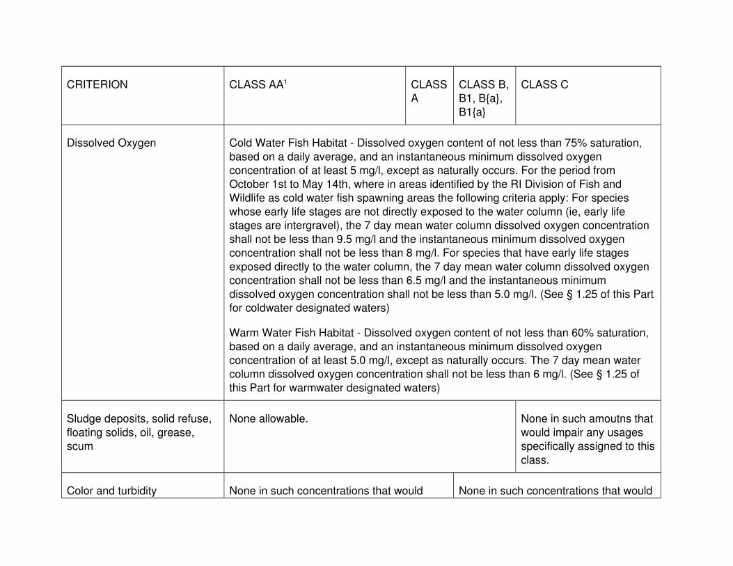
CRITERION CLASS AA1 CLASSA
CLASS B,B1, B{a},
B1{a}
CLASS C
Dissolved Oxygen Cold Water Fish Habitat - Dissolved oxygen content of not less than 75% saturation,
based on a daily average, and an instantaneous minimum dissolved oxygen concentration of at least 5 mg/l, except as naturally occurs. For the period from
October 1st to May 14th, where in areas identified by the RI Division of Fish and Wildlife as cold water fish spawning areas the following criteria apply: For species
whose early life stages are not directly exposed to the water column (ie, early life stages are intergravel), the 7 day mean water column dissolved oxygen concentration
shall not be less than 9.5 mg/l and the instantaneous minimum dissolved oxygen concentration shall not be less than 8 mg/l. For species that have early life stages
exposed directly to the water column, the 7 day mean water column dissolved oxygen concentration shall not be less than 6.5 mg/l and the instantaneous minimum
dissolved oxygen concentration shall not be less than 5.0 mg/l. (See § 1.25 of this Partfor coldwater designated waters)
Warm Water Fish Habitat - Dissolved oxygen content of not less than 60% saturation, based on a daily average, and an instantaneous minimum dissolved oxygen
concentration of at least 5.0 mg/l, except as naturally occurs. The 7 day mean water column dissolved oxygen concentration shall not be less than 6 mg/l. (See § 1.25 of
this Part for warmwater designated waters)
Sludge deposits, solid refuse,
floating solids, oil, grease, scum
None allowable. None in such amoutns that
would impair any usages specifically assigned to this
class.
Color and turbidity None in such concentrations that would None in such concentrations that would

impair any usages specifically assigned to this class. Turbidity not to exceed 5 NTU
over background.
impair any usages specifically assignedto this class. Turbidity not to exceed 10
NTU over natural background.
Fecal Coliform Bacteria
(MPN/100ml)
Drinking Water Supply Criteria: -
applied at the terminal reservoir of the system – Not to exceed a
geometric mean value of 20 MPN/100 ml and not more than
10% of the samples shall exceed a value of 200.
None in such
concentrations that would impair any usages
specifically assigned to thisclass.
Primary Contact Recreational/Swimming Criteria – Not toexceed a geometric mean value of 200 MPN/100 ml and
not more than 10% of the total samples taken shall exceed 400 MPN/100 ml, applied only when adequate
enterocci data are not available
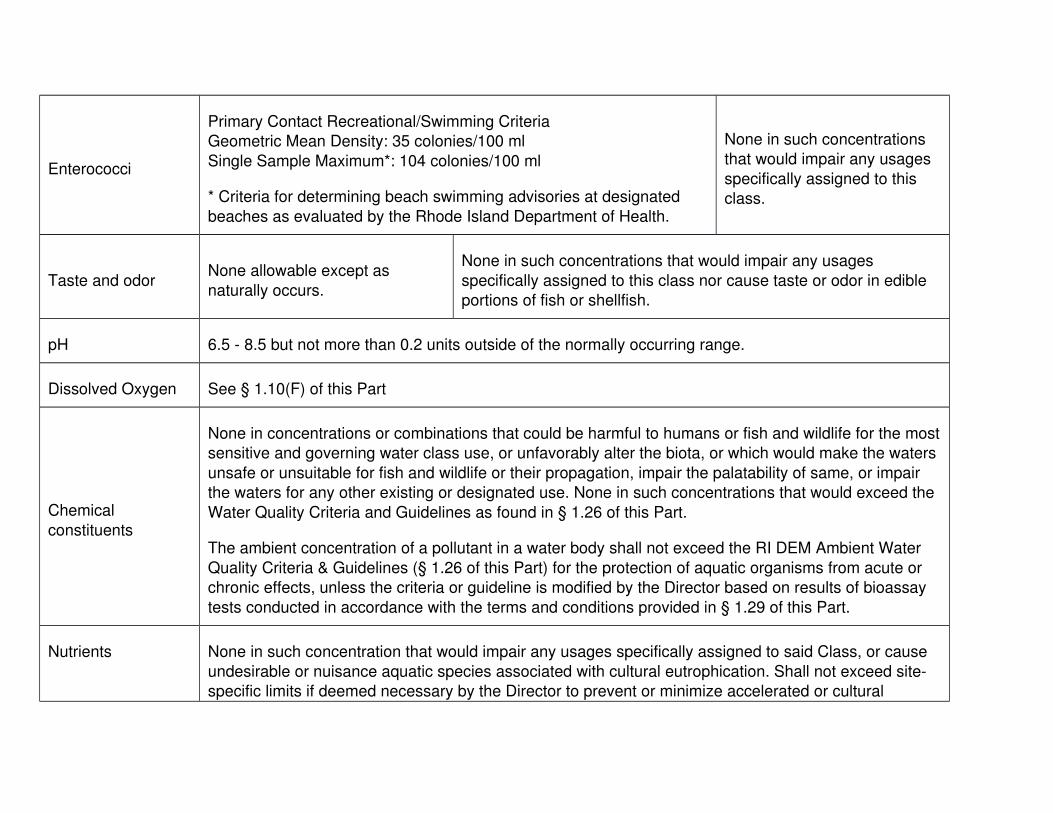
Enterococci Primary Contact Recreational/Swimming Criteria
Non-Designated Bathing Beach Waters Geometric MeanDensity: 54 colonies/100 ml
Designated Bathing Beach Waters Geometric Mean Density: 33 colonies/100 ml
Single Sample Maximum*: 61 colonies/100 ml
* Criteria for determining beach swimming advisories at designated beaches as evaluated by Health.
None in such
concentrations that would impair any usages
specifically assigned to thisclass.

Taste and odor None other than of natural origin and none associated with nuisance algal species.
None in such concentrations that would impair any usages specifically assigned
to this class nor cause taste or odor in edible portions of fish.
pH (Standard Units) 6.5 – 9.0 or as naturally occurs.
Temperature/Temperature
increase
No activity shall raise the temperature of the receiving waters above the recommended
limit on the most sensitive receiving water use nor cause the growth of undesirable or nuisance species of biota. In no cases shall an activity cause the temperature to
exceed 83 degrees F. Heated discharges into designated coldwater habitats (See § 1.25 of this Part for coldwater designated waters) shall not raise the temperature
above 68 degrees F outside an established thermal mixing zone. In no case shall the temperature of the receiving water be raised more than 4 degrees F.
Chemical constituents None in concentrations or combinations that could be harmful to humans or fish and wildlife for the most sensitive and governing water class use, or unfavorably alter the
biota, or which would make the waters unsafe or unsuitable for fish and wildlife or theirpropagation, impair the palatability of same, or impair waters for any other existing or
designated use. None in such concentrations that would exceed the Water Quality Criteria and Guidelines as found in § 1.26 of this Part.
The ambient concentration of a pollutant in a water body shall not exceed the Ambient Water Quality Criteria and Guidelines, (§ 1.26 of this Part) for the protection of aquatic
organisms from acute or chronic effects, unless the criteria or guidelines are modified by the Director based on results of bioassay tests conducted in accordance with the
terms and conditions provided in § 1.29 of this Part.
Nutrients Average Total Phosphorus shall not exceed 0.025 mg/l in any lake, pond, kettlehole or

reservoir, and average Total P in tributaries at the point where they enter such bodies of water shall not cause exceedance of this phosphorus criteria, except as naturally
occurs, unless the Director determines, on a site-specific basis, that a different value for phosphorus is necessary to prevent cultural eutrophication.
None in such concentration that would impair any usages specifically assigned to said Class, or cause undesirable or nuisance aquatic species associated with cultural
eutrophication, nor cause exceedance of the criterion above in a downstream lake, pond, or reservoir. New discharges of wastes containing phosphates will not be
permitted into or immediately upstream of lakes or ponds. Phosphates shall be removed from existing discharges to the extent that such removal is or may become
technically and reasonably feasible.
1 Class AA waters used for public drinking water supply may be subject to restricted recreational use by State and local
authorities.
E. Class Specific Criteria-Saltwaters
1. The table below presents the class-specific criteria for saltwaters, classifications SA, SB, SB1, and SC and any partial use designation saltwaters.

CRITERION CLASS SA, SA{b} CLASS SB, SB1, SB{a}, SB1{a} CLASS SC
Sludge deposits, solid refuse, floating
solids, oil, grease, scum
None allowable.
None in such amounts that
would impair any usages specifically assigned to this
class.
Color and turbidity
None in such concentrations that would impair any usages
specifically assigned to this class. Turbidity not to exceed 5
NTU over background.
None in such concentrations that would impair any usages
specifically assigned to this class. Turbidity not to exceed 10 NTU over background.
Fecal Coliform Bacteria
Shellfishing Criteria: - Not to
exceed a geometric mean MPN or MF (mTEC) value of 14 per
100ml and not more than either 10% of the estimated 90th
percentile of the samples shall exceed an MPN value of 49 per
100ml for a three-tube decimal dilution or 31 cfu per 100ml for
MF (mTEC).
None in such concentrations that would impair any usages
specifically assigned to this class.
Primary Contact Recreational/Swimming Criteria - Not to exceed a geometric mean value of 50 MPN/100 ml and not more than 10% of
the total samples taken shall exceed 400 MPN/100 ml, applied only when adequate enterococci data are not available.
Enterococci
Primary Contact Recreational/Swimming CriteriaGeometric Mean Density: 35 colonies/100 ml
Single Sample Maximum*: 104 colonies/100 ml
* Criteria for determining beach swimming advisories at designated
beaches as evaluated by the Rhode Island Department of Health.
None in such concentrations that would impair any usages
specifically assigned to this class.
Taste and odorNone allowable except as
naturally occurs.
None in such concentrations that would impair any usages
specifically assigned to this class nor cause taste or odor in edible portions of fish or shellfish.
pH 6.5 - 8.5 but not more than 0.2 units outside of the normally occurring range.
Dissolved Oxygen See § 1.10(F) of this Part
Chemical
constituents
None in concentrations or combinations that could be harmful to humans or fish and wildlife for the mostsensitive and governing water class use, or unfavorably alter the biota, or which would make the waters
unsafe or unsuitable for fish and wildlife or their propagation, impair the palatability of same, or impair the waters for any other existing or designated use. None in such concentrations that would exceed the
Water Quality Criteria and Guidelines as found in § 1.26 of this Part.
The ambient concentration of a pollutant in a water body shall not exceed the RI DEM Ambient Water
Quality Criteria & Guidelines (§ 1.26 of this Part) for the protection of aquatic organisms from acute or chronic effects, unless the criteria or guideline is modified by the Director based on results of bioassay
tests conducted in accordance with the terms and conditions provided in § 1.29 of this Part.
Nutrients None in such concentration that would impair any usages specifically assigned to said Class, or cause
undesirable or nuisance aquatic species associated with cultural eutrophication. Shall not exceed site-specific limits if deemed necessary by the Director to prevent or minimize accelerated or cultural

eutrophication. Total phosphorus, nitrates and ammonia may be assigned site-specific permit limits based on reasonable Best Available Technologies. Where waters have low tidal flushing rates,
applicable treatment to prevent or minimize accelerated or cultural eutrophication may be required for regulated nonpoint source activities.
Temperature/
Temperature Increase
Activities shall not increase the temperature except where the increase will not exceed the recommended limit on the most sensitive receiving water use and in no case shall an activity cause the
temperature to exceed 83 degrees F nor raise the normal temperature more than 1.6 degrees F, 16 June through September and not more than 4 degrees F from October through 16 June. All
measurements shall be made at the boundary of such mixing zones as is found to be reasonable by theDirector.

F. Saltwater Dissolved Oxygen Criteria - The following information details the use ofcontinuous dissolved oxygen data in estuarine waters.
1. For surface waters above a seasonal pycnocline, not less than an instantaneous value of 4.8 mg/l more than once every three years, except
as naturally occurs.
2. For waters below the seasonal pycnocline, Aquatic Life Uses are
considered to be protected if conditions do not fail to meet protective thresholds, as described below, more than once every three years. DO
criteria presented here shall be protective of the most sensitive life stage –survival effects on larvae which affects larval recruitment – for both
persistent and cyclic conditions. This criteria evaluates effects of exposureto low DO over time on larval recruitment. Because larval recruitment
occurs over the whole season, the low DO exposure effects are cumulative. Exposures are evaluated on a daily basis to determine the
total seasonal exposure. The criteria to protect larval survival is established to limit the number of exposure days over the range of low DO
conditions such that the cumulative percentage of larvae affected shall notexceed a 5% reduction in larval recruitment over the season. If the
Director determines that a smaller percent impairment on larval recruitment is necessary on a site specific basis, a criteria modification will
be process in accordance with § 1.21(F) of this Part. Protection of larval survival will also afford adequate protection of juvenile and adult life
stages. The critical recruitment season for evaluation of DO exposure is defined as May 1 through October 31. While recruitment may occur at
other periods of the year, this timeframe reflects periods when hypoxia aremost prevalent. Waters with a DO concentration above an instantaneous
value of 4.8 mg/l shall be considered protective of Aquatic Life Uses. When instantaneous DO values fall below 4.8 mg/l, the waters shall not
be:
a. Less than 2.9 mg/l for more than 24 consecutive hours during
recruitment season; nor
b. Less than 1.4 mg/l for more than 1 hour more than twice during the
recruitment season; nor
c. Shall they exceed the cumulative exposure presented in § 1.10(F)
(3) of this Part.
d. The method for calculating cumulative low DO exposure throughout
the recruitment season is as follows:
(1) For persistent low DO conditions (low DO conditions that
vary little within a day, e.g., <0.5 mg/l), the limit represents

allowable DO conditions below 4.8 mg/l provided the exposure duration (number of days observed) does not
exceed the corresponding allowable number of days (as presented in § 1.10(F)(2)(d)(1)(AA) of this Part) that ensure
adequate larval recruitment over the course of the season. The cumulative seasonal low DO effects are evaluated by
totaling the fractions of the observed (or projected) exposureduration (in days) divided by the allowable number of days
for each DO concentration. The sum of the decimal fractions shall not exceed 1.0. The minimum daily DO measurement
is used to represent the daily DO value. The criteria for 24 hour DO concentration and allowable number of days as
presented in § 1.10(F)(2)(d)(1)(AA) of this Part are calculated using the following equations:
(AA) Saltwater DO Criteria for Waters Below the Seasonal Pycnocline
24 Hour (Daily) DO Exposure
Concentration (mg/L)
Daily Percent Larval
Mortality (%)
Allowable Number of Days Without
Exceeding a 5% Reduction in Seasonal
Larval Recruitment
4.6 4.96 42
4.5 6.05 30
4.4 7.36 24
4.3 8.93 20
4.2 10.79 18

4.1 12.98 16
4 15.55 14
3.9 18.51 12
3.8 21.88 10
3.7 25.69 9
3.6 29.89 8
3.5 34.47 7
3.4 39.36 6
3.3 44.46 5
3.2 49.69 4
3.1 54.92 3
3 60.05 2
2.9 64.97 1
(2) For cyclic low DO conditions (DO conditions that fluctuate
broadly within a day, e.g.>0.5 mg/l), the limit represents the allowable number of days as a given daily larval percent
mortality that protects against great than 5% cumulative impairment of larval recruitment over a recruitment season.
The maximum daily percent larval mortality is a function of DO minimum for any exposure interval/range (mg/l) and the
duration of the interval (hours) and is determined using the Time-to-death (TTD) curves presented in § 1.10(F)(2)(d)(2)
(AA) of this Part The maximum daily percent larval mortality from cyclic exposures is determined from the observed data
point falling closest to a TTD curve of greatest effect (ie., highest percent mortality). The calculated maximum daily
percent larval mortality shall not exceed the allowable number of days as presented in § 1.10(F)(2)(d)(1)(AA) and §
1.10(F)(2)(d)(2)(BB) of this Part. Cumulative cyclic low DO

effects observed over the course of the season are evaluated by tallying the number of days at each percent
mortality observed for the season. The observed number of days at each percent mortality are divided by the allowable
number of days for each percent mortality. The sum of the decimal fraction shall not exceed 1.0.
(AA) Time To Death (TTD) Curves for 5-60% Mortality
(BB) Cyclic Translator for Waters Below the Seasonal
Pycnocline
(3) For seasons with both cyclic and persistent cycles of low
DO, all data will be treated as cyclic exposure patterns with the persistent data set at the 24 hour/1-day exposure

duration. Daily percent mortalities will be determined from § 1.10(F)(2)(d)(2)(AA) and § 1.10(F)(2)(d)(1)(AA) of this Part
will be used to determine the acceptable number of days the low DO pattern can occur over the course of the season.
3. For waters without a seasonal pycnocline, DO concentrations above 4.8 mg/l shall be considered protective of Aquatic Life Uses. When
instantaneous DO values fall below 4.8 mg/l, the water shall not be:
a. Less than 3.0 mg/l for more than 24 consecutive hours during the
recruitment season; nor
b. Less than 1.4 mg/l for more than 1 hour more than twice during the
recruitment season; nor
c. Shall they exceed the cumulative DO exposure presented in §
1.10(F)(2)(d)(1)(AA) of this Part.
d. Cumulative low DO exposures in the 2.95 – 4.8 mg/l range shall be
evaluated as described above in § 1.10(F)(2) of this Part but shall not exceed the information presented in § 1.10(F)(3)(e)(1)(AA) of
this Part.
e. The method for calculating cumulative low DO exposure is as
follows:
(1) For persistent low DO conditions in water without a seasonal
pycnocline, the criteria for 24 hours DO concentration and allowable number of days as presented in § 1.10(F)(3)(e)(1)
(AA) of this Part are calculated using the following equation:
(AA) Saltwater DO Criteria for Waters without a Seasonal
Pycnocline
24 Hour (Daily)
DO Exposure Concentration
(mg/L)
Daily Percent Larval Mortality (%)
Allowable Number of
Days Without Exceeding a 5%
Reduction in Seasonal Larval Recruitment

4.6 4.96 16
4.5 6.05 14
4.4 7.36 12
4.3 8.93 11
4.2 10.79 10
4.1 12.98 8
4.0 15.55 7
3.9 18.51 6
3.8 21.88 5
3.7 25.69 4
3.6 29.89 3
3.5 34.47 2
3.4 39.36 1
(2) For cyclic low DO conditions in waters without a seasonal
pycnocline, the daily percent mortalities for observed data are determined from § 1.10(F)(2)(d)(2)(AA) of this Part and
shall not exceed the allowable number of days presented in § 1.10(F)(3)(e)(1)(AA) and § 1.10(F)(3)(e)(2)(AA) of this
Part.
(AA) Cyclic Translator for Waters Without a Seasonal
Pycnocline

(3) For seasons with both cyclic and persistent cycles of low DO, all data will be treated as cyclic exposure patterns with
the persistent data set at the 24 hours/1-day exposure duration. Daily percent mortalities will be determined from §
1.10(F)(2)(d)(2)(AA) and § 1.10(F)(3)(e)(1)(AA) of this Part will be used to determine the acceptable number of days the
low DO pattern can occur over the course of the season.
1.11 Effect of Activities on Water Quality Standards
A. Activities Shall Not Violate Water Quality Standards - No person shall discharge pollutants into any waters of the State or perform any activities alone or in
combination which the Director determines will likely result in the violation of any State water quality criterion or interfere with one or more of the existing or
designated uses assigned to the receiving waters or to downstream waters in accordance with §§ 1.9, 1.10, and 1.20 of this Part. In addition, Best
Management Practices, as determined by the Director, shall be used to control erosion, sedimentation and runoff in accordance with § 1.17 of this Part.
B. Activities Shall Not Further Degrade Low Quality Waters - No person shall discharge pollutants into any waters of the State, or perform any activities alone
or in combination which the Director determines will likely result in the additional degradation of water quality of the receiving waters or downstream waters which
are already below the water quality standard assigned to such waters.

C. Activities Shall Not Violate Antidegradation - No person shall discharge pollutantsinto any waters of the State, or perform any activities alone or in combination
which the Director determines will likely result in a violation of the Antidegradation provisions of these regulations (§ 1.20 of this Part).
D. Mixing Zone - Due to discharges to surface waters, the Director may recognize, where appropriate, a limited mixing zone on a case-by-case basis. In no case
may a mixing zone cause a loss of, or impair, any existing or designated use.
E. Restrictions to New Discharges - New discharges into Class AA, A or SA waters
(refer to § 1.25 of this Part) or into waters designated Class B, C, SB or SC whichhave attained the Class A or SA standard shall be allowed, provided the
discharge will not impair existing uses nor attainment of designated uses and all other provisions of these regulations are complied with including all required
approvals, and it complies with the following restrictions:
1. New discharges into the terminal reservoir of a, public drinking water
supply shall be prohibited with the exception of discharges of stormwater drainage. New discharges into all other waters of the public drinking water
supply shall be prohibited with the exception of the types listed in §§ 1.11(E)(2)(a) through (f) of this Part. Notification will be made to the
affected public drinking water supplier and the Department of Health of a proposed new discharge to a public drinking water supply which is under
review by this Department in accordance with these regulations.
2. New discharges into waters that are not public drinking water supplies
may include:
a. discharges of stormwater drainage;
b. discharges from industrial non-contact cooling water;
c. discharges from construction site dewatering provided that the
applicant has demonstrated to the satisfaction of the Director that no reasonable alternatives exist;
d. discharges from groundwater remediation projects provided that theapplicant has demonstrated to the satisfaction of the Director that
no reasonable alternatives exist;
e. discharges from aquaculture facilities as appropriately authorized
by all required state agencies;
f. discharges from water main maintenance such as main flushing
and cleaning operations;
g. discharges of dredged material;

h. discharges from farming activities into surface waters which are hydrographically disconnected from all other surface waters;
i. placement of suitable solid materials in appropriate amounts for thepurpose of the formation of an artificial reef as approved by the
Director;
j. discharges from aquatic research related activities provided that the
applicant has demonstrated to the satisfaction of the Director that no reasonable alternatives exist;
k. discharges from desalination facilities into seawaters; and
l. other new discharges provided the applicant demonstrates to the
satisfaction of the Director that:
(1) the discharge serves a compelling public purpose which
provides benefits to the public as a whole as opposed to individual or private interests;
(2) there is no reasonable alternative means of, or location for, serving the compelling public purpose cited; and
(3) the discharge will not impair existing uses nor attainment of designated uses.
1.12 Procedures for Determining Additional Requirements for
Effluent Limitations, Treatment and Pretreatment
A. Effluent Limited and Water Quality Limited Waters - No person shall discharge pollutants into any surface waters of the State or discharge to a treatment works
unless the discharge complies with any additional effluent limitations and receives any additional treatment/pretreatment which the Director determines is
necessary to comply with § 1.11 of this Part, or to prevent overloading or damaging effect upon a treatment works. In order to determine which waters
require additional effluent limitations, treatment or pretreatment to comply with § 1.11 of this Part, or to prevent overloading or damaging effects upon a treatment
works, the Director will categorize the surface waters of the State into effluent limited and water quality limited waters. Such classifications will be recorded in
Section 305(b) of the Clean Water Act, 33 U.S.C. § 1315, biennial State of the State's waters reports, and will be revised as necessary.
B. Total Maximum Daily Loads in Water Quality Limited Waters - For water quality limited waters, the Director shall identify those pollutants within discharges to the
water quality limited waters which do or have the reasonable potential to cause or contribute to a violation of § 1.11 of this Part. The Director shall develop a total
maximum daily load (TMDL) for each of these pollutants. The TMDL shall

determine the maximum amount of the pollutant that can be discharged into the water quality limited waters and be in compliance with § 1.11 of this Part. The
TMDL shall be based on best available scientific information and allocation of theTMDL may be based on, but not limited to, technical feasibility of pollutant
removal, the relative costs of treatment to the contributing discharges, and the relative contribution from each source. The Director shall not be required to
allocate the full amount of the pollutant specified in § 1.11 of this Part, but may designate a portion of the allocation as a reserve or margin of safety as deemed
necessary.
1.13 Prohibited Discharges
A. General - The prohibitions enumerated in this rule apply to all pollutants,
regardless of the effect on water quality standards or the treatment which the pollutants receive.
B. Pollutants - No person shall discharge pollutants into the waters of the State except as in compliance with the provisions of R.I. Gen. Laws Chapter 46-12, or
other applicable chapters, of the Rhode Island General Laws or these regulations, and pursuant to the terms and conditions of an approval issued by
DEM thereunder.
C. Urban Runoff - No person shall discharge storm water, gutter runoff, sump
discharges, or street runoff to a treatment works designed to receive only wastewater.
D. Hazardous Waste and Hazardous Substances - No person shall discharge hazardous waste or hazardous substances into any waters of the State or
discharge hazardous waste or hazardous substances into a wastewater treatment works, except as in compliance with the provisions of R.I. Gen. Laws
Chapter 46-12, or other applicable chapters of the Rhode Island General Laws orthese regulations, and in accordance with the terms and conditions of an
approval issued by the Director or municipality as may be required under the Rhode Island Pretreatment Regulations.
E. Oil, Petroleum Products, Solvents - No person shall discharge oil, petroleum products or industrial solvents into treatment works designed to treat or control
only wastewater or stormwater unless it conforms with federal, state and local pretreatment requirements. No person shall discharge oil or petroleum products
into the waters of the State except as in compliance with the provisions of R.I. Gen. Laws Chapter 46-12, or other applicable chapters of the Rhode Island
General Laws or these regulations, and in accordance with the terms and conditions of an approval issued by DEM thereunder.
F. Discharges of Sewage from Vessels

1. No person shall discharge any sewage from a vessel into the waters of theState.
2. No person shall operate or moor in the waters of the State a vessel equipped with a marine toilet that is:
a. Not a type approved pursuant to the CWA;
b. An approved type that is not in proper working condition; or
c. That does not have the vessel's marine toilets properly sealed to prevent overboard discharges by one of the following means: the
through-hull fitting is plugged; or the Y-valve is secured to the holding tank position by means of a padlock, wire tie, or by
removing the seacock handle.
3. All sewage must be discharged to an approved marina pump-out facility.
1.14 Strategic Plan Consistency
In addition to the other requirements of these regulations, no person shall discharge any pollutants into any waters of the State so as to violate any legally
applicable requirements of a plan approved by the Governor of Rhode Island andthe Administrator pursuant to Sections 208(6) (33 U.S.C. § 1288), 319 (33 U.S.C.
§ 1329), and 320 (33 U.S.C. § 1330) of the Clean Water Act.
1.15 Approvals
A. No person shall: discharge any pollutant into, or conduct any activity which will
likely cause or contribute pollution to, the waters of the State; or construct, install,or modify any treatment works including the extension of sewers to an existing
sewer system, without having obtained all required approvals from the Director. The types of approval for the purposes of these regulations may include the
following:
1. Rhode Island Pollutant Discharge Elimination System (RIPDES) permit by
DEM, Water Resources in accordance with the RIPDES Regulations.
2. Order of Approval from DEM, Water Resources for any treatment works in
accordance with §§ 1.16 though 1.19 of this Part.
3. Water Quality Certificate (WQC) - the activity(ies) listed below require
approval in the form of a certification by DEM, Water Resources that the proposed activity(ies) does not violate these regulations. A WQC shall
have the full force and effect of a permit issued by the Director. The permitrequired under the Rhode Island Pollutant Discharge Elimination System
Regulations may act as the Water Quality Certification for the discharge.

a. In accordance with Section 401 of the Clean Water Act, 33 U.S.C. §1341, applicants for any project which may result in a discharge to
waters of the State and which requires a federal permit must directly apply for and receive a Water Quality Certification from
DEM, Water Resources, except as described in § 1.15(A)(3)(b)(1)(AA) of this Part.
b. Those projects involving one or more of the activities listed below which are within the jurisdiction of the Rhode Island Coastal
Resources Management Council in accordance with R.I. Gen. LawsChapter 46-23, and which do not require an approval in accordance
with the R.I. Gen. Law § 2-1-18 et. seq. or any rules and regulations promulgated thereto, must directly apply for and receive
Water Quality Certification from DEM, Water Resources except as described in § § 1.15(A)(3)(b)(1)(AA) and 1.15(A)(3)(b)(4)(AA)of
this Part.
(1) Dredging and Dredged Material Disposal
(AA) With regard to marine dredging, discharge of dredge material and placement of dredge material in tidal
waters, the application process and decision for the water quality review will be conducted in accordance
with Part 2 of this Subchapter.
(2) Filling of Waters of the State
(3) Marinas and Mooring Fields - construction of new facilities orexpansion of existing facilities
(4) Flow Alterations
(AA) Flow Alterations for agricultural irrigation will be
managed through coordination with DEM/Agriculture.
(5) Harbor Management Plans for those elements which will
likely affect water quality
c. The permit required under the RIDEM Rules and Regulations
Governing the Administration and Enforcement of the Fresh Water Wetlands Act (Fresh Water Wetlands Regulations) may act as the
Water Quality Certification for the discharge, including stormwater discharge.
d. Where a project or activity listed in § 1.15(A)(3) of this Part also requires a permit by any one of the following DEM permit programs,

the WQC decision may be incorporated into the decision issued under said program:
(1) Wetlands permit or determination in accordance with the Rules and Regulation Governing the Administration and
Enforcement of the Freshwater Wetlands Act
(2) ISDS permit or determination in accordance with regulations
Establishing Minimum Standards Relating to the Location, Design, Construction and Maintenance of Onsite
Wastewater Treatment Systems
(3) RIPDES permit in accordance with the Regulations for the
Rhode Island Pollutant Discharge Elimination System
(4) Marine dredging and dredged material disposal permit in
accordance with the Part 2 of this Subchapter.
(5) UIC permit in accordance with the Part 4 of this Subchapter.
e. Where the Director determines that a WQC decision will be incorporated with one of the above permit decisions, the
corresponding public notice requirements and appeal procedures contained in the regulations of the associated permit program will
apply in lieu of those contained in §§ 1.17 and 1.23 of this Part herein, respectively. However, when the activity is subject to §
1.15(A)(3)(a) of this Part, and the listed permit decision does not require public notification, the requirements of § 1.17 of this Part
will be applied. All other provisions contained in these regulations shall apply.
1.16 Application for Approvals
A. Application - More than one of the approvals noted in § 1.15 of this Part may be required. Applications for RIPDES permits shall be submitted and processed in
accordance with the Regulations for the Rhode Island Pollutant Discharge Elimination System RIPDES. Applications for Orders of Approval and Water
Quality Certifications will be on forms provided by or in the manner prescribed by,DEM, to be submitted to the Director and shall contain such documentation
and/or information as the Director may require, including but not limited to:
1. When applicable, documentation that the proposed project is consistent
with the currently approved wastewater facility plan or information necessary to modify an approved wastewater facility plan, including but
not limited to the project needs, conformance with State Guide Plan policies, goals, and objectives, the basis of design, including design
assumptions, data, and calculations;

2. Comprehensive engineering report and detailed engineering plans and specifications for the proposed project;
3. Timetable for and duration of the proposed construction or other activity;
4. Any additional information as may be deemed necessary by the Director
to fully assess the impact of the proposed activity upon the waters of the State or to support any changes in the scope of the project, actual or
anticipated;
5. Any additional information including proprietary data, where, in the opinion
of the Director, such information is necessary to fully disclose all relevant facts concerning the application for an approval. The applicant may assert
a claim of confidentiality for proprietary data as defined in R.I. Gen. Laws § 38-2-2 provided said information is clearly marked and segregated
within the total information requested by the Department; and
6. A preponderance of clear and scientifically valid evidence having a
probative value demonstrating, to the satisfaction of the Director, that the activity will not violate the surface water quality standards established by
these Water Quality Regulations, and amendments thereto.
B. Professional Certification for Plans and Specifications - All engineering plans and
specifications required under § 1.16(A) of this Part shall be certified by a professional engineer registered in the State pursuant to R.I. Gen. Laws Chapter
5-8.
C. Failure of the applicant to submit information deemed necessary by the
Department in order to fully assess the impact of the proposed project on waters of the State or to support any changes in the scope of the proposed project,
actual or anticipated, shall constitute valid cause for denial of the application.
D. The requirements of the 2010 Stormwater Design and Installation Standards
Manual as amended in March 2015 shall apply to all applications proposing the generation of stormwater discharges on any applicable project listed in § 1.15 of
this Part.
1.17 Procedures for Review of Applications for Orders of Approval
and Water Quality Certifications
A. In consideration of the application, the Department may use, but is not limited to,
the following documents: Guides for the Design of Wastewater Treatment Works (TR-16, 2011 Edition as Revised in 2016), published by the New England
Interstate Water Pollution Control Commission; Design of Water Resource Recovery Facilities (WEF Manual of Practice #8 & ASCE Manual and Report on
Engineering Practice #76), jointly published by the Water Environment Federation and the American Society of Civil Engineers (Sixth Edition); Rhode

Island Soil Erosion and Sediment Control Handbook, developed jointly by R.I. DEM and U.S. Department of Agriculture Natural Resources Conservation
Service (2016); State of Rhode Island Stormwater Design and Installation Standards Manual (2010 version amended March 2015), developed jointly by R.I.
DEM and Coastal Resources Management Council; ; the Technical Support Document for Water Quality-based Toxics Control, March 1991, EPA/505/2-90-
001; Evaluation of Dredged Material Proposed for Ocean Disposal Testing Manual, February 1991, EPA-503/8-91/001; Interim Regional Policy for New
England Stream Flow Recommendations, U. S. Department of Interior, Fish and Wildlife Service; Water Quality Standards Handbook, 2nd. Ed., August 1994,
EPA-823-B-94-005a.
B. Application Completeness
1. Upon receipt of an application, the Department will review the application for completeness and shall notify the applicant in writing whether the
application is complete. Where the Department has deemed an application to be deficient, the processing of the application will be
suspended and the applicant shall correct said deficiencies to the satisfaction of the Department.
C. At any time during review, the Director may:
1. Require that the applicant provide such information as the Director deems
necessary for the review of the application;
2. Issue an approval requiring such terms, conditions, management practices
and operation and maintenance requirements as deemed necessary to comply with the requirements of applicable state or federal laws; or
3. Deny the application for failure to satisfy the requirements of applicable state or federal laws and advise the applicant of the right to appeal under
§ 1.23 of this Part. A denial may be based on, but is not limited to any or all of the following:
a. A treatment works which is overloaded or inadequate to accept andtreat any additional load of pollutants in which case the Director,
shall, where appropriate, also deny applications for new sewer connection or additional discharges to the system;
b. An activity or a treatment works or any part thereof, which is likely to substantially contribute to an increase in non-point source
pollution which will likely result in a violation of state or federal laws or these regulations or any other regulations of the Department;
c. A treatment works or any part thereof, or a project which is not consistent with the approved Wastewater Facilities Plan;

d. Failure to submit any information required by the Department; or
e. Failure to provide a preponderance of clear and scientifically valid
evidence having a probative value demonstrating, to the satisfaction of the Director, that the activity will not violate the
surface water quality standards established by these Water Quality Regulations, and amendments thereto.
D. Public Notice and Consideration of Public Comment for Applications for Water Quality Certification
1. Certification Public Notice - Upon determination that an application for water quality certification is complete, the Director shall provide or have
the applicant provide in a form approved in writing by the Department, written notice of the proposed project to all abutters of any property upon
which the activity will occur, and to any other such persons, agencies or organizations deemed appropriate by the Director. At a minimum the chief
elected officer of the city or town within which the activity will be conducted, shall be notified.
a. For projects that the Director determines have the potential to resultin impacts beyond the abutting property(ies) or that notification of
abutters is impracticable, the notice shall be published in a daily or weekly newspaper with circulation in the involved area. The
Department may also require the applicant to publish notice, in a form approved in writing by the Department, in an additional daily or
weekly newspaper with circulation that includes the community nearest the proposed location, or statewide.
2. Comment Period - The notice will provide for a thirty-day comment period during which time any person may provide written comments which may
include a request for a hearing on the project or activity proposed by the application.
3. Public Hearing - The Director shall provide an opportunity for oral comments if a hearing is requested by twenty-five (25) persons, or by a
governmental subdivision or agency, or by an association having not less than twenty-five (25) members. The applicant, all persons receiving notice
under § 1.17(D)(1) of this Part, and all persons submitting comments or requesting a hearing under § 1.17(D)(2) of this Part shall be notified
consistent with the requirements of § 1.17(D)(1) of this Part, at least fourteen (14) days in advance, of the time and place of the hearing.
4. Consideration of Comments - The Director shall consider all written and oral comments and may approve modifications to the application package
made in response to comments received, without requiring another notice

and comment period, provided the modifications are minor in nature and will have little or no adverse environmental impact.
5. Notice of Decision - All persons who submit comments, either orally at the hearing or in writing, shall receive written notice of the final agency
decision on the application.
6. Modifications - The Director may approve modifications to an approved
project or activity without further notice, provided that the project had beennoticed in accordance with § 1.17(D) of this Part, and such modifications
are minor in nature and will have little or no adverse environmental impact.
1.18 Effect of Approval
A. The issuance of an approval mandates compliance with all terms, conditions,
management practices and operation and maintenance requirements set forth in the approval. Any violation of these may result in the finding of a prohibited
discharge as set forth in § 1.13 of this Part.
B. The issuance of an approval does not relieve any person of the continuing
responsibility to comply with any applicable rule of these regulations or applicablesections of the Clean Water Act.
C. The issuance of an approval by the Department does not relieve any person of the responsibility for obtaining any other necessary permits or approvals from
any federal, state, regional, or local agency.
D. The issuance of an approval does not authorize any injury to persons or property
or invasion of other private rights, or any infringement of Federal, State or local law or regulations.
1.19 Modification, Expiration, Suspension or Revocation of Approval
A. The Director may modify, suspend, or revoke, in whole or in part, an approval for cause, including, but not limited to:
1. Information indicating that the project will likely result in probable harm to the environment or pose a threat to the health, safety and/or welfare of the
public;
2. The existence of a factor or factors which, if properly and timely brought to
the attention of the Director, would have justified the application of more orless stringent conditions than required by these regulations, but only if
such factor(s) arose after the approval was issued;

3. Changes in effluent limitations in accordance with § 1.12 of this Part, or changes in the definition(s) of such limitations in the Clean Water Act or
applicable Environmental Protection Agency regulations;
4. Where circumstances on which the approval was based have materially
and substantially changed since the approval was issued, including, but not limited to, a change in category of waters from effluent limited to water
quality limited, or amendment of these regulations;
5. The information or data submitted by the applicant or permittee either on
the form(s) required or in any other material in support of the application isfound to be false, misleading or erroneous; or
6. The project is not undertaken in strict compliance with the conditions or provisions of any approval issued by the Department.
B. A Notice of Revocation/Suspension of an approval will be in the form of a letter notifying the permittee or subsequent transferee of the revocation or suspension
and the reasons why the approval is being revoked or suspended.
C. The party served with a Notice of Revocation/Suspension of an approval may
request an adjudicatory hearing to contest the revocation as set forth in the provisions of § 1.23 of this Part. A Notice of Revocation/Suspension of an
approval automatically becomes a final order of the Director enforceable in Superior Court upon failure to request said adjudicatory hearing.
D. Request for modification of approval shall be in accordance with §§ 1.16 and 1.17 of this Part.
1.20 Antidegradation of Water Quality Standards
A. Purpose - The State Antidegradation Regulations are based on the federal Antidegradation Policy requirements, Antidegradation Policy and Implementation
Methods, 40 C.F.R. § 131.12 and have as their objective the maintenance and protection of various levels of surface water quality and uses. Antidegradation
applies to all projects or activities subject to these regulations which will likely lower water quality or affect existing or designated water uses, including but not
limited to all Water Quality Certification reviews and any new or modified RIPDES permits. For the disposal of dredged or fill material into the waters of the
State, Guidelines for Specification of Disposal Sites for Dredged or Fill Material, 40 C.F.R. § 404(b)(1), incorporated above in § 1.3(C) of this Part, guidelines
shall be followed in the evaluation of 40 C.F.R. § 131.12(a)(1), incorporated above in § 1.3(F) of this Part, and the State’s Antidegradation Policy. The
Antidegradation regulations consist of four (4) tiers of water quality protection.

B. Tier 1 - Protection of Existing Uses - Any existing in situ water uses and level of surface water quality necessary to protect the existing uses, shall be maintained
and protected.
C. Tier 2 - Protection of Water Quality in High Quality Waters - With the exception of
Outstanding National Resource Waters, in surface waters where the existing water quality exceeds levels necessary to support propagation of fish and wildlife
and recreation in and on the water, that quality shall be maintained and protected, except for insignificant changes in water quality as determined by the
Director and in accordance with § 1.27 of this Part. An exception to this level of protection may only be allowed if it can be proven to the Director by a
preponderance of clear and scientifically valid evidence having a probative value,and the Director finds, after full satisfaction of the intergovernmental coordination
and public participation provisions of the RI Continuing Planning Process, that allowing significant water quality degradation is necessary to accommodate
important economic and social benefit in the area in which the receiving waters are located. In allowing such significant degradation or lower water quality, the
Director shall assure water quality adequate to fully protect existing and designated uses. In allowing a change in water quality, significant or insignificant,
all reasonable measures to minimize the change shall be implemented. Adequate scientifically valid documentation shall be provided to the Director
demonstrating that designated and existing uses, water quality to protect those uses, and all applicable water quality standards, will be fully protected. Further,
the highest statutory and regulating requirements for all new and existing point sources and all cost-effective and reasonable best management practices for
nonpoint source control shall apply.
D. Tier 2½ - Protection of Water Quality for SRPWs - Where high quality waters
constitute a SRPW, there shall be no measurable degradation of the existing water quality necessary to protect the characteristic(s) which cause the
waterbody to be designated as an SRPW. Notwithstanding that all public drinkingwater supplies are SRPWs, public drinking water suppliers may undertake
temporary and short term activities within the boundary perimeter of a public drinking water supply impoundment for essential maintenance or to address
emergency conditions in order to prevent adverse effects on public health or safety, provided that these activities comply with the requirements set forth in §
1.20(B) of this Part (Tier 1 Protection of Existing Uses) and § 1.20(C) of this Part (Tier 2 Protection of Water Quality in High Quality Waters).
E. Tier 3 - Protection of Water Quality for ONRWs - Where high quality waters constitute an Outstanding National Resource, as defined in § 1.7 of this Part, that
water quality shall be maintained and protected. The State may allow some limited activities that result in temporary and short-term changes in the water
quality of an ONRW. Such activities must not permanently degrade water quality or result in water quality lower than that necessary to protect the existing uses in
the ONRW.

F. Implementation - The Antidegradation provisions shall be implemented in accordance with the Antidegradation Implementation Policy § 1.27 of this Part.
1.21 Modification of Water Quality Standards
A. Authority - The Director has the power and duty in accordance with § 1.2 of this Part and R.I. Gen. Laws § 46-12-3 to promulgate water quality standards.
B. Request for Modification - Any person may request that the Director modify a water quality standard. The request must include a preponderance of clear and
scientifically valid evidence having a probative value to demonstrate that such modification is consistent with these regulations. In addition, a Use Attainability
Analyses (UAA) must be conducted:
1. for a request to remove a designated use specified in Section 101(a)(2) of
the Clean Water Act, 33 U.S.C. § 1251; or
2. to propose a subcategory of uses specified in Section 101(a)(2) of the
Clean Water Act, 33 U.S.C. § 1251, which require less stringent criteria.
C. Promulgation of Modifications - If the Director determines that modification is
appropriate the Director shall initiate promulgation of such modification in accordance with R.I. Gen. Laws Chapter 42-35.
D. General Standards for Conducting the Review - Water quality standards shall protect the public health, safety and welfare, enhance the quality of water and
serve the purpose of the Clean Water Act.
1. The Director will take into consideration the conservation, protection, use
and value of the waters for public water supplies, propagation of fish and wildlife, recreational purposes, agricultural, industrial, and other purposes,
and for navigation.
2. The Director shall attempt to establish water quality standards which will
result in the achievement of the national water quality goal specified in Secton 101(a)(2) (33 U.S.C. § 1251) of the Clean Water Act, wherever
attainable. In determining whether such standards are attainable for any particular segment, the Director shall take into consideration
environmental, technological, social, and economic factors.
3. Designation of uses which do not support the protection and propagation
of fish and wildlife, and recreation in and on the water, Section 101(a)(2) (33 U.S.C. § 1251) of the Clean Water Act, may be granted if supported
by a Use Attainability Analyses to the satisfaction of the Director.

4. The Director shall take into consideration the water quality standards of downstream waters and shall assure that water quality standards provide
for the attainment of the water quality standards of downstream waters.
5. The Director shall adhere to the antidegradation principles of the
Antidegradation Policy described in § 1.20 of this Part.
E. Modifications of Designated Uses - Modifying a designated use may result in
modifying the applicable criteria of the affected/identified water segment, to criteria necessary to protect the new designated use of that affected/identified
water segment. In no case may a criteria be modified if it would adversely affect existing uses or other designated uses.
1. Downgrading Designated Uses
a. In waters in which the designated use(s) is not the existing use(s),
any person may request that the Director, or the Director may propose, that the designated use be downgraded, or may designate
a partial use (§ 1.9(D) of this Part), only where it is demonstrated through the UAA process (except as noted in § 1.21(E)(1)(c) of this
Part) by a preponderance of clear and scientifically valid evidence having a probative value to the satisfaction of the Director that
attaining the designated use is not feasible because:
(1) Naturally occurring background pollutant concentrations or
natural background conditions prevent the attainment of the use;
(2) Naturally occurring ephemeral, intermittent or low flow conditions or water levels not human-made or human-
induced prevent the attainment of the use, unless these conditions may be compensated for by the discharge of
sufficient volume of effluent discharges without violating state water conservation requirements to enable uses to be
met;
(3) Human-made or human-induced conditions prevent the
attainment of the use and cannot be remedied per item § 1.21(E)(1)(a)(6) of this Part, or would cause more
environmental damage to correct than to leave in place;
(4) Existing dams, diversions or other types of permitted
hydrologic modifications which meet all applicable permit and/or water quality certificate requirements preclude the
attainment of the use, and it is not feasible to restore the water body to its original condition or to operate such

modification in a way that would result in the attainment of the use;
(5) Physical conditions related to the naturally occurring featuresof the water body, such as the lack of a proper substrate,
cover, flow, depth, pools, riffles, and the like, unrelated to water quality and not human-made or human-induced,
preclude attainment of aquatic life protection uses; or
(6) Controls more stringent than those required by Sections
301(b)(1)(A) and (B) (33 U.S.C. § 1311) and 306 of the Clean Water Act (33 U.S.C. § 1316) for point source
dischargers, and reasonable best management practices for nonpoint source dischargers, would result in substantial and
widespread economic and social impact.
b. It must also be demonstrated to the Director's satisfaction that
downgrading or altering the water quality use will not affect the quality of waters beyond the area in which §§ 1.21(E)(1)(a)((1))
through ((6)) of this Part applies nor violate § 1.20 of this Part (Antidegradation of Water Quality Standards) of these regulations.
The Director shall hold a public hearing on such downgrading requests that are determined to have merit.
c. For the following waters, a partial use designation of SA{b} may be proposed and will not be considered a downgrade and will not
require a use attainability analysis, unless the Director determines itis necessary to comply with § 1.20 of this Part (Antidegradation of
Water Quality Standards):
(1) SA waters along the western shore of Aquidneck Island
located between a straight line extending northerly from the boundary of Lots 8 and 9, Portsmouth Town Map 17 to the
end of Coddington Cove Breakwater in Middletown, that extend 500 feet seaward from the mean high water mark.
(2) SA waters along the western shore of Warwick Neck from the southern most point of the Harbor Light Marina parking
lot to the northern side of the end of Randall Street, that extend 500 feet seaward from the mean high water mark.
(3) SA waters along the eastern shore of Horse Neck from the eastern most extension of Burr Avenue, to the eastern most
groin at Oakland Beach, that extend 500 feet seaward from the mean high water mark.

(4) SA waters from the northernmost point along the east bulkhead wall in the small embayment on the south side on
the Allens Harbor entrance channel to the extension of a linefrom nun buoy 10 through FG Buoy 11 to the shore at
Quonset Point, that extend 500 feet seaward from the mean high water mark.
d. A designated use may not be downgraded if such uses will be attained by implementing effluent limits required under Sections
301(b) (33 U.S.C § 1311) and 306 (33 U.S.C. § 1316) of the Clean Water Act for point sources and by implementing cost-effective and
reasonable best management practices for nonpoint source control.
2. Upgrading Designated Uses
a. Any person may request that the Director or the Director may propose to upgrade the classification of a water quality segment,
including a request to designate a waterbody or waterbody segment as a Special Resource Protection Water (SRPW) or an
Outstanding National Resource Water (ONRW).
b. Where current water use classifications specify water uses less
sensitive than those which are presently being achieved, the Director shall propose to upgrade the classification of the waters in
question to reflect the uses actually being attained.
c. The Director shall hold a public hearing on such requests that are
determined to have merit.
(1) At the hearing, the applicant must prove by a preponderance
of clear and scientifically valid evidence having probative value to the satisfaction of the Director that such a
reclassification satisfies the standards of §§ 1.21(D) or 1.20 of this Part applies.
F. Modification of Criteria - Any person may request that the Director, or the Directormay propose to modify an aquatic life water quality criteria. The request and
development of site specific criteria shall be in accordance with § 1.29 of this Part. If the Director determines the criteria modification is appropriate, the
Director shall promulgate such modification in accordance with R.I. Gen. Laws Chapter 42-35.
1. Modification of criteria of a water segment shall not result in a modificationof the designated use of the water segment. Newly developed criteria
must still protect the existing and designated uses of the water segment.

1.22 Variances from Water Quality Standards
A. Conditions for Granting Variances - A variance from the water quality standards may be granted by the Director when the Director has a reasonable belief that
the standard can ultimately be attained. A variance from meeting the standard is granted to the discharger for the particular constituent that is causing non-
attainment of the standard. All other applicable criteria and standards must be met by the discharger. The criteria protective of the standard must be maintained
for all other dischargers on the waterbody. A variance can be granted only under the following conditions:
1. Non-attainment of the standard is attributed to one of the following:
a. Naturally occurring background pollutant concentrations or natural
background conditions prevent the attainment of the use;
b. Naturally occurring ephemeral, intermittent or low flow conditions or
water levels not human-made or human-induced prevent the attainment of the use, unless these conditions may be
compensated for by the discharge of sufficient volume of effluent discharges without violating state water conservation requirements
to enable uses to be met;
c. Human-made or human-induced conditions prevent the attainment
of the use and cannot be remedied per § 1.22(A)(1)(f) of this Part, or would cause more environmental damage to correct than to
leave in place;
d. Existing dams, diversions or other types of permitted hydrologic
modifications which meet all applicable permit and/or water quality certificate requirements preclude the attainment of the use, and it is
not feasible to restore the water body to its original condition or to operate such modification in a way that would result in the
attainment of the use;
e. Physical conditions related to the naturally occurring features of the
waterbody, such as the lack of a proper substrate, cover, flow, depth, pools, riffles, and the like, unrelated to water quality and not
human-made or human-induced, preclude attainment of aquatic lifeprotection uses; or
f. Controls more stringent than those required by Sections 301(b)(1)(A) and (B) (33 U.S.C. § 1311) and § 306 (33 U.S.C. § 1316) of the
Clean Water Act for point source dischargers, and reasonable best management practices for nonpoint source dischargers, would
result in substantial and widespread economic and social impact.
2. Treatment more advanced than that required by section 301(b)(1)(A) and (B) (33 U.S.C. § 1311) has been carefully considered, and that alternative
effluent control strategies have been evaluated.
B. Time Limit for Variances - Variances from the water quality standards shall be for
a specific period of time not to exceed three (3) years. A variance may be reinstated only upon demonstration that the conditions for granting the variance
still apply and reasonable progress toward meeting the standard has been made.
C. Public Notice - The Director may grant a variance, in accordance with this rule,
only after public notice, opportunity for comment and a public hearing, in accordance with R.I. Gen. Laws Chapter 42-35.
D. Variances for RIPDES Permitted Discharges - Those persons holding a RIPDES permit, or applying for a RIPDES permit, must request a variance in accordance
with the Regulations for the Rhode Island Pollutant Discharge Elimination System RIPDES.
E. Compliance With Other Water Quality Regulations - Issuance of a variance pursuant to this rule does not relieve the holder of the variance from complying
with requirements of these regulations which have not been the subject of a variance.
1.23 Appeals
A. General - The procedures for appeal of Departmental decisions pursuant to the provisions of R.I. Gen. Laws Chapter 42-35 are contained in Part 10-00-1 of this
Title.
B. Appeal Procedures for Applications for Orders of Approval and Water Quality
Certifications - The applicant may appeal to the Director for review of the decision on an application for approval by filing an appeal with
DEM/Administrative Adjudication.
1. Filing of Appeal - All appeals shall be in writing and shall be filed with and
received by DEM/Administrative Adjudication within thirty (30) days after the effective date of the denial of the subject application.
2. Contents of Appeal - Every appeal shall comply in all respects with Part 10-00-1 of this Title and at a minimum contain the following:
a. A detailed basis upon which the appeal is taken;
b. A plat plan of the area of the subject application; and
c. A list of the names and addresses of the applicant, the municipality in which the property is located and all abutters.
3. Notice of Administrative Hearing - Upon the filing of an appeal with DEM/ Administrative Adjudication, and once the hearing schedule allows,
DEM/Administrative Adjudication shall notify the following, by first class mail, of the date, time and place of the adjudicatory hearing, in
conformance with R.I. Gen. Laws § 42-35-9:
a. The applicant,
b. The municipality in which the property is located,
c. All abutters and all other persons who received notice pursuant to §
1.17(D)(1) of this Part.
C. Appeal Procedure for Notice of Violations, Suspensions or Revocations - Any
person who has received a Notice of Violation (NOV) alleging violation of these regulations, or whose approval has been suspended or revoked, may appeal to
the Director for review of the decision on which the NOV, suspension or revocation is based by filing an appeal with DEM/Administrative Adjudication.
1. Filing of Appeal - All appeals shall be in writing and shall be filed with and received by DEM/Administrative Adjudication within twenty (20) days after
the date of the receipt of the subject NOV, revocation or suspension.
2. Contents of Appeal - Every appeal shall contain a detailed basis upon
which the appeal is taken.
1.24 Sampling
A. Water Quality Testing - Surface water samples shall be collected, preserved, and
analyzed in accordance with 40 C.F.R. § 136, incoprorated above in § 1.3(A) of this Part, Guidelines establishing Test Procedures for the Analysis of Pollutants.
Other methods recommended by the EPA may be used, if legally acceptable.
B. Bioassays - Bioassays shall be performed in accordance with protocols listed in
40 C.F.R. § 136, incorporated above in § 1.3(A) of this Part,and Methods for Measuring the Toxicity and Bioaccumulation of Sediment-associated
Contaminants with Freshwater Invertebrates, incorporated above in § 1.3(B) of this Part, or other methods if approved by the Director and legally acceptable. A
more detailed explanation of state requirements pertaining to bioassays is given in the most recent RIDEM bioassay protocol.
1.25 Water Quality Classifications
A. General - This waterbody classification listing is consistent with the geographical/numerical waterbody listing in the State of the State's Waters
Report, also known as the 305(b) Report. The waters included generally conformto those shown on United States Geological Survey 1:24,000 Topographic Maps
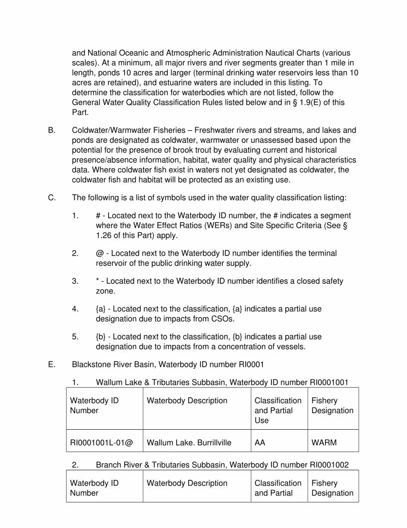
and National Oceanic and Atmospheric Administration Nautical Charts (various scales). At a minimum, all major rivers and river segments greater than 1 mile in
length, ponds 10 acres and larger (terminal drinking water reservoirs less than 10acres are retained), and estuarine waters are included in this listing. To
determine the classification for waterbodies which are not listed, follow the General Water Quality Classification Rules listed below and in § 1.9(E) of this
Part.
B. Coldwater/Warmwater Fisheries – Freshwater rivers and streams, and lakes and
ponds are designated as coldwater, warmwater or unassessed based upon the potential for the presence of brook trout by evaluating current and historical
presence/absence information, habitat, water quality and physical characteristics data. Where coldwater fish exist in waters not yet designated as coldwater, the
coldwater fish and habitat will be protected as an existing use.
C. The following is a list of symbols used in the water quality classification listing:
1. # - Located next to the Waterbody ID number, the # indicates a segment where the Water Effect Ratios (WERs) and Site Specific Criteria (See §
1.26 of this Part) apply.
2. @ - Located next to the Waterbody ID number identifies the terminal
reservoir of the public drinking water supply.
3. * - Located next to the Waterbody ID number identifies a closed safety
zone.
4. {a} - Located next to the classification, {a} indicates a partial use
designation due to impacts from CSOs.
5. {b} - Located next to the classification, {b} indicates a partial use
designation due to impacts from a concentration of vessels.
E. Blackstone River Basin, Waterbody ID number RI0001
1. Wallum Lake & Tributaries Subbasin, Waterbody ID number RI0001001
Waterbody ID
Number
Waterbody Description Classification
and Partial Use
Fishery
Designation
RI0001001L-01@ Wallum Lake. Burrillville AA WARM
2. Branch River & Tributaries Subbasin, Waterbody ID number RI0001002
Waterbody ID Number
Waterbody Description Classification and Partial
Fishery Designation
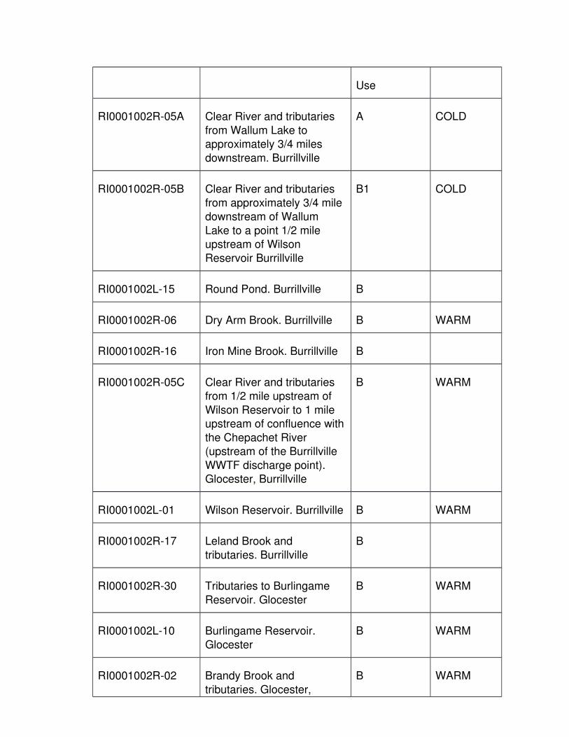
Use
RI0001002R-05A Clear River and tributaries
from Wallum Lake to approximately 3/4 miles
downstream. Burrillville
A COLD
RI0001002R-05B Clear River and tributaries
from approximately 3/4 mile downstream of Wallum
Lake to a point 1/2 mile upstream of Wilson
Reservoir Burrillville
B1 COLD
RI0001002L-15 Round Pond. Burrillville B
RI0001002R-06 Dry Arm Brook. Burrillville B WARM
RI0001002R-16 Iron Mine Brook. Burrillville B
RI0001002R-05C Clear River and tributaries from 1/2 mile upstream of
Wilson Reservoir to 1 mile upstream of confluence with
the Chepachet River (upstream of the Burrillville
WWTF discharge point). Glocester, Burrillville
B WARM
RI0001002L-01 Wilson Reservoir. Burrillville B WARM
RI0001002R-17 Leland Brook and
tributaries. Burrillville
B
RI0001002R-30 Tributaries to Burlingame
Reservoir. Glocester
B WARM
RI0001002L-10 Burlingame Reservoir.
Glocester
B WARM
RI0001002R-02 Brandy Brook and
tributaries. Glocester,
B WARM

Burrilville
RI0001002L-03 Echo Lake (Pascoag
Reservoir). Burrillville, Glocester
B WARM
RI0001002R-09 Pascoag River. Burrillville B WARM
RI0001002R-18 Mowry Brook and
tributaries. Burrillville
B COLD
RI0001002R-11 Round Top Brook and
tributaries. Burrillville
A WARM
RI0001002L-12 Round Top State Pond.
Burrillville
A
RI0001002R-04 Chocalog River and
tributaries. Burrillville
A COLD
RI0001002R-08 Nipmuc River and
tributaries. Burrillville
A COLD
RI0001002L-04 Spring Lake (Herring Pond).
Burrillville
B WARM
RI0001002R-15 Herring Brook. Burrillville B
RI0001002R-25 Bettey Brook. Burrillville B COLD
RI0001002R-05D Clear River from the
Burrillville WWTF discharge point to the confluence with
the Chepachet River. Glocester, Burrillville
B1 WARM
RI0001002L-14 Cherry Valley Pond. Glocester
B
RI0001002R-19 Peckham Brook and tributaries. Glocester
B

RI0001002R-12 Saunders Brook and tributaries. Glocester
B WARM
RI0001002R-32 Tributaries to Keech Pond. Glocester
B
RI0001002L-11 Keech Pond. Glocester B WARM
RI0001002R-33 Tributaries to Smith &
Sayles Reservoir. Glocester
B COLD
RI0001002L-07 Smith & Sayles Reservoir.
Glocester
B WARM
RI0001002R-34 Tributaries to Shingle Mill
Pond. Glocester
B WARM
RI0001002L-16 Shingle Mill Pond. Glocester B WARM
RI0001002R-20 Stingo Brook and tributaries. Glocester
B WARM
RI0001002R-35 Tributaries to Spring Grove Pond. Glocester
B COLD
RI0001002L-06 Spring Grove Pond. Glocester
B
RI0001002L-05 Sucker Pond. Burrillville B
RI0001002R-22 Sucker Brook and
tributaries. Burrillville, Glocester
B COLD
RI0001002R-03 Chepachet River and tributaires. Glocester,
Burrillville
B COLD
RI0001002R-01A Branch River and tributaries
from the confluence of the Clear River and Chepachet
B WARM
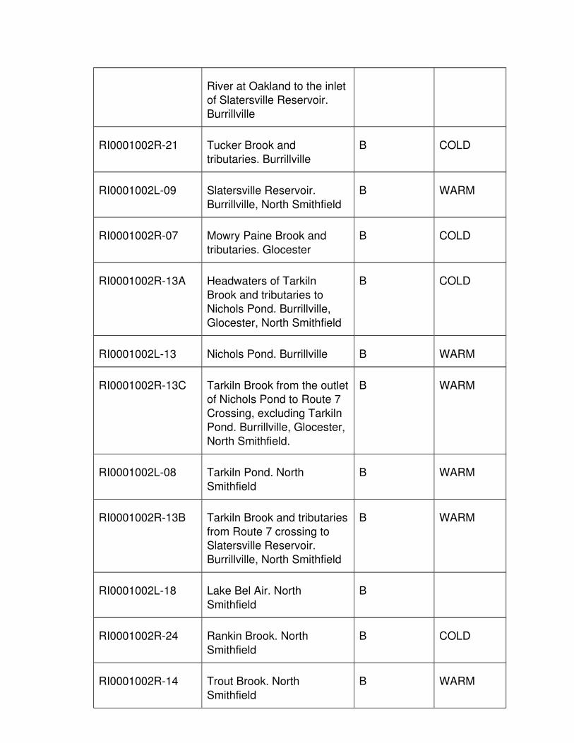
River at Oakland to the inletof Slatersville Reservoir.
Burrillville
RI0001002R-21 Tucker Brook and
tributaries. Burrillville
B COLD
RI0001002L-09 Slatersville Reservoir.
Burrillville, North Smithfield
B WARM
RI0001002R-07 Mowry Paine Brook and
tributaries. Glocester
B COLD
RI0001002R-13A Headwaters of Tarkiln
Brook and tributaries to Nichols Pond. Burrillville,
Glocester, North Smithfield
B COLD
RI0001002L-13 Nichols Pond. Burrillville B WARM
RI0001002R-13C Tarkiln Brook from the outletof Nichols Pond to Route 7
Crossing, excluding Tarkiln Pond. Burrillville, Glocester,
North Smithfield.
B WARM
RI0001002L-08 Tarkiln Pond. North
Smithfield
B WARM
RI0001002R-13B Tarkiln Brook and tributaries
from Route 7 crossing to Slatersville Reservoir.
Burrillville, North Smithfield
B WARM
RI0001002L-18 Lake Bel Air. North
Smithfield
B
RI0001002R-24 Rankin Brook. North
Smithfield
B COLD
RI0001002R-14 Trout Brook. North
Smithfield
B WARM
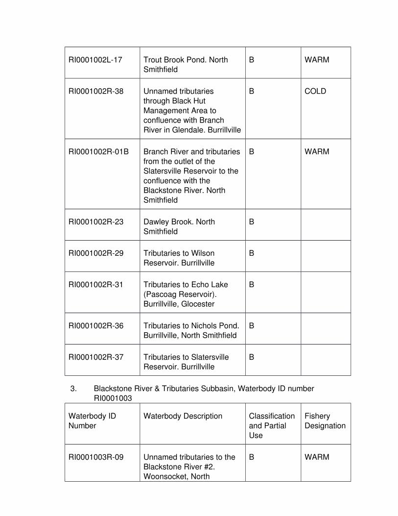
RI0001002L-17 Trout Brook Pond. North Smithfield
B WARM
RI0001002R-38 Unnamed tributaries through Black Hut
Management Area to confluence with Branch
River in Glendale. Burrillville
B COLD
RI0001002R-01B Branch River and tributaries
from the outlet of the Slatersville Reservoir to the
confluence with the Blackstone River. North
Smithfield
B WARM
RI0001002R-23 Dawley Brook. North
Smithfield
B
RI0001002R-29 Tributaries to Wilson
Reservoir. Burrillville
B
RI0001002R-31 Tributaries to Echo Lake
(Pascoag Reservoir). Burrillville, Glocester
B
RI0001002R-36 Tributaries to Nichols Pond. Burrillville, North Smithfield
B
RI0001002R-37 Tributaries to Slatersville Reservoir. Burrillville
B
3. Blackstone River & Tributaries Subbasin, Waterbody ID number RI0001003
Waterbody ID Number
Waterbody Description Classification and Partial
Use
Fishery Designation
RI0001003R-09 Unnamed tributaries to the
Blackstone River #2. Woonsocket, North
B WARM
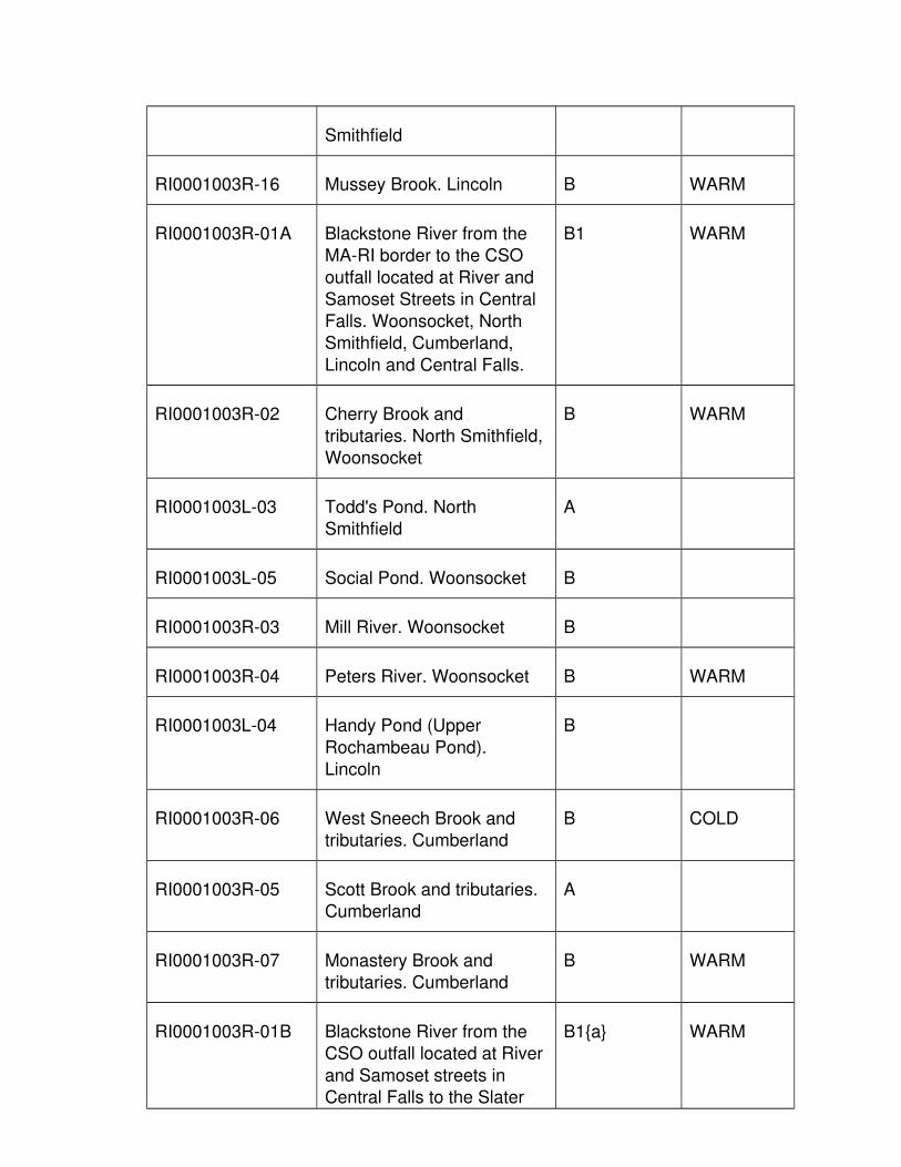
Smithfield
RI0001003R-16 Mussey Brook. Lincoln B WARM
RI0001003R-01A Blackstone River from the MA-RI border to the CSO
outfall located at River and Samoset Streets in Central
Falls. Woonsocket, North Smithfield, Cumberland,
Lincoln and Central Falls.
B1 WARM
RI0001003R-02 Cherry Brook and
tributaries. North Smithfield,Woonsocket
B WARM
RI0001003L-03 Todd's Pond. North Smithfield
A
RI0001003L-05 Social Pond. Woonsocket B
RI0001003R-03 Mill River. Woonsocket B
RI0001003R-04 Peters River. Woonsocket B WARM
RI0001003L-04 Handy Pond (Upper
Rochambeau Pond). Lincoln
B
RI0001003R-06 West Sneech Brook and tributaries. Cumberland
B COLD
RI0001003R-05 Scott Brook and tributaries. Cumberland
A
RI0001003R-07 Monastery Brook and tributaries. Cumberland
B WARM
RI0001003R-01B Blackstone River from the CSO outfall located at River
and Samoset streets in Central Falls to the Slater
B1{a} WARM

Mill Dam. Central Falls, Pawtucket.
RI0001003L-01 Scott Pond. Lincoln B
RI0001003L-02 Valley Falls Pond.
Cumberland
B1 WARM
RI0001003R-08 Unnamed tributaries to
Blackstone River #1. Woonsocket
B
RI0001003R-10 Unnamed tributaries to Blackstone River #3.
Cumberland, Woonsocket
B
RI0001003R-12 Unnamed tributaries to
Blackstone River #5. Lincoln
B
4. Woonsocket Reservoir #3 & all Tributaries Subbasin, Waterbody ID number RI0001004
Waterbody ID Number
Waterbody Description Classification and Partial
Use
Fishery Designation
RI0001004L-01@ Woonsocket Reservoir #3.
North Smithfield, Smithfield
AA
RI0001004L-02@ Woonsocket Reservoir #1.
North Smithfield
AA COLD
RI0001004L-03 Woonsocket Reservoir #2.
North Smithfield
AA COLD
RI0001004L-04 Laporte's Pond. Lincoln A
RI0001004R-01 Crookfall Brook and tributaries. North Smithfield
AA COLD
RI0001004R-02 Spring Brook and AA WARM

tributaries. North Smithfield
5. Sneech Pond & Tributaries Subbasin, Waterbody ID number RI0001005
Waterbody ID Number
Waterbody Description Classification and Partial
Use
Fishery Designation
RI0001005L-01@ Sneech Pond. Cumberland AA
6. Abbott Run Brook & Tributaries Subbasin, Waterbody ID number RI0001006
Waterbody ID Number
Waterbody Description Classification and Partial
Use
Fishery Designation
RI0001006L-08 Carl’s Pond. Cumberland A
RI0001006R-05 Indian Brook. Cumberland AA
RI0001006R-06 Burnt Swamp Brook and
tributaries. Cumberland
AA WARM
RI0001006L-01 Diamond Hill Reservoir.
Cumberland
AA WARM
RI0001006L-05 Miscoe Lake. Cumberland AA
RI0001006R-07 Catamint Brook. Cumberland
AA
RI0001006R-09 Sylvyns Brook. Cumberland AA WARM
RI0001006R-04 Ash Swamp Brook and
tributaries. Cumberland
AA
RI0001006R-03 East Sneech Brook.
Cumberland
AA WARM
RI0001006L-09 Little Pond. Cumberland AA

RI0001006R-02 Long Brook and tributaries. Cumberland
AA WARM
RI0001006L-02 Arnold Mills Reservoir (Pawtucket Reservoir).
Cumberland
AA
RI0001006R-01A Abbott Run Brook North and
tributaries. Cumberland
AA WARM
RI0001006L-06 Rawson Pond. Cumberland AA
RI0001006L-07 Howard Pond. Cumberland AA
RI0001006R-01B Abbott Run Brook South
and tributaries. Abbot Run Brook in MA, back in RI and
to confluence with Blackstone Rv. Cumberland
AA WARM
RI0001006R-08 Millers River. Cumberland AA COLD
RI0001006L-04 Robin Hollow Pond.
Cumberland
AA WARM
RI0001006L-03@ Happy Hollow Pond.
Cumberland
AA WARM
F. Woonasquatucket River Basin, Waterbody ID number RI0002
1. Woonasquatucket River & Tributaries Subbasin, Waterbody ID number RI0002007
Waterbody ID Number
Waterbody Description Classification and Partial
Use
Fishery Designation
RI0002007L-11 Primrose Pond. North
Smithfield
B
RI0002007R-10A Woonasquatucket River
headwaters including
B WARM

tributaries to Georgiaville Pond, excluding reservoirs
and ponds. North Smithfield, Smithfield
RI0002007R-05 Latham Brook and tributaries. Smithfield
B
RI0002007L-08 Woonasquatucket Reservoir(Stump Pond/Stillwater
Reservoir). Smithfield
B WARM
RI0002007R-13 Unnamed tributaries to
Woonasquatucket Reservoir. Johnston
B
RI0002007R-07 Shincott Brook and tributaries. Glocester,
Smithfield
B WARM
RI0002007R-11 Nine Foot Brook and
tributaries. Smithfield, Glocester
B WARM
RI0002007R-02 Cutler Brook and tributaries.Glocester
B WARM
RI0002007R-14 Unnamed tributaries to Waterman Reservoir.
Glocester, Smithfield
B
RI0002007L-04 Waterman Reservoir.
Glocester, Smithfield
B WARM
RI0002007R-09 Stillwater River and
tributaries. Smithfield
B WARM
RI0002007L-05 Upper Sprague Reservoir.
Smithfield
B WARM
RI0002007L-06 Lower Sprague Reservoir.
Smithfield
B WARM
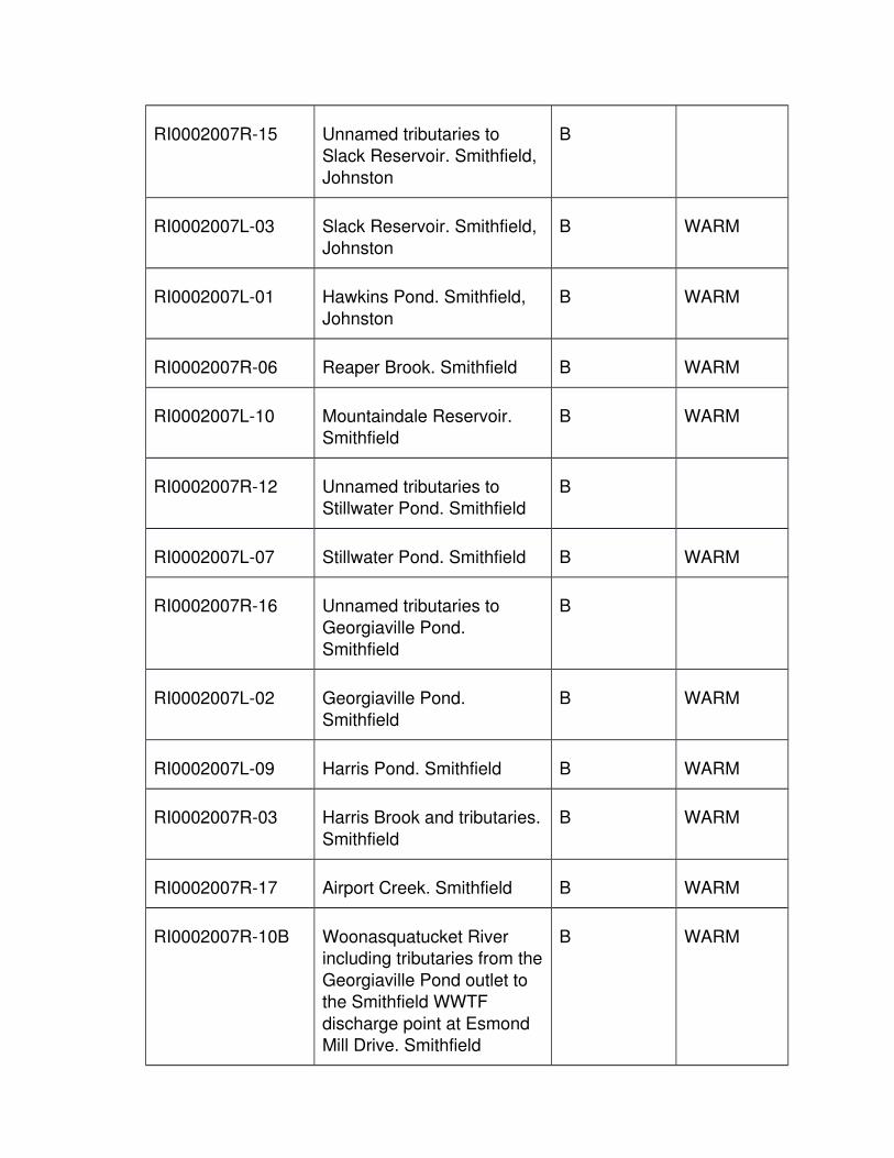
RI0002007R-15 Unnamed tributaries to Slack Reservoir. Smithfield,
Johnston
B
RI0002007L-03 Slack Reservoir. Smithfield,
Johnston
B WARM
RI0002007L-01 Hawkins Pond. Smithfield,
Johnston
B WARM
RI0002007R-06 Reaper Brook. Smithfield B WARM
RI0002007L-10 Mountaindale Reservoir. Smithfield
B WARM
RI0002007R-12 Unnamed tributaries to Stillwater Pond. Smithfield
B
RI0002007L-07 Stillwater Pond. Smithfield B WARM
RI0002007R-16 Unnamed tributaries to
Georgiaville Pond. Smithfield
B
RI0002007L-02 Georgiaville Pond. Smithfield
B WARM
RI0002007L-09 Harris Pond. Smithfield B WARM
RI0002007R-03 Harris Brook and tributaries.
Smithfield
B WARM
RI0002007R-17 Airport Creek. Smithfield B WARM
RI0002007R-10B Woonasquatucket River including tributaries from the
Georgiaville Pond outlet to the Smithfield WWTF
discharge point at Esmond Mill Drive. Smithfield
B WARM

RI0002007R-04 Hawkins Brook and tributaries. Smithfield
B
RI0002007R-01 Assapumpset Brook and tributaries. Johnston
B WARM
RI0002007R-10C
Woonasquatucket River andtributaries from the
Smithfield WWTF dischargepoint at Esmond Mill Drive
to the CSO outfall at Glenbridge Avenue in
Providence. Smithfield, North Providence,
Providence, Johnston
B1 WARM
RI0002007R-10D Woonasquatucket River
from the CSO outfall at Glenbridge Avenue to the
confluence with the Moshassuck River.
Providence
B1{a} WARM
G. Moshassuck River Basin, Waterbody ID number RI0003
1. Moshassuck River & Tributaries Subbasin, Waterbody ID number RI0003008
Waterbody ID Number
Waterbody Description Classification and Partial
Use
Fishery Designation
RI0003008R-01A Moshassuck River
headwaters including tributaries, to inlet of Barney
Pond. Lincoln
B COLD
RI0003008R-01B Moshassuck River and
tributaries from Barney Pond outlet to the first CSO
discharge point at Weeden Street Bridge. Lincoln,
Central Falls, Pawtucket
B WARM

RI0003008L-02 Barney Pond. Lincoln B WARM
RI0003008L-01 Olney Pond. Lincoln B WARM
RI0003008R-02 Threadmill Brook. Lincoln B WARM
RI0003008R-01C Moshassuck River and
tributaries from the first CSO discharge point at
Weeden Street Bridge to the confluence with the
Woonasquatucket River. Central Falls, Pawtucket,
Providence
B{a} WARM
RI0003008R-03A West River headwaters,
including tributaries to the inlet of Wenscott Reservoir.
Providence, North Providence
B WARM
RI0003008L-05 Wenscott Reservoir (Twin Rivers). North Providence,
Smithfield, Lincoln
B WARM
RI0003008R-03B West River and tributaries
from the outlet of Wenscott Reservoir, including Geneva
and Whipple ponds, to the first CSO discharge point
located south of the Branch Avenue crossing, off of
Vandewater street. North Providence, Providence.
B WARM
RI0003008L-04 Canada Pond. North Providence, Providence
B
RI0003008R-03C West River and tributaries from the first CSO
discharge point located south of the Branch Avenue
crossing, off of Vandewater.
B{a}
WARM
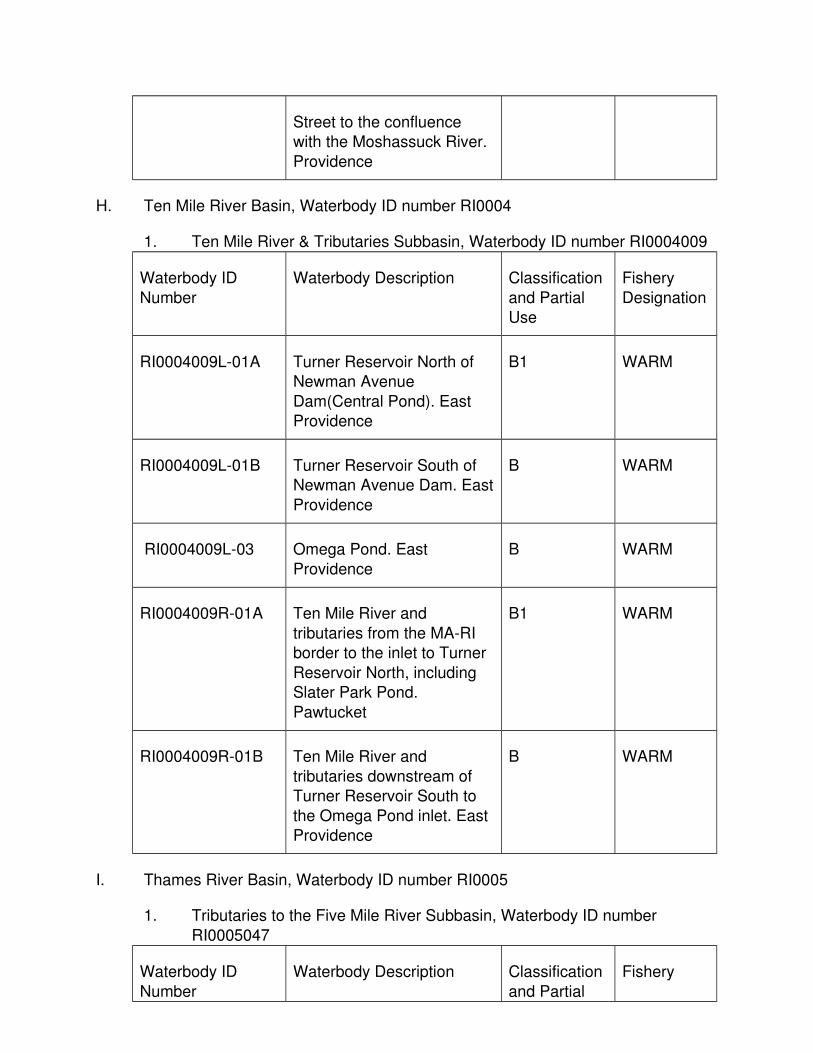
Street to the confluence with the Moshassuck River.
Providence
H. Ten Mile River Basin, Waterbody ID number RI0004
1. Ten Mile River & Tributaries Subbasin, Waterbody ID number RI0004009
Waterbody ID
Number
Waterbody Description Classification
and Partial Use
Fishery
Designation
RI0004009L-01A Turner Reservoir North of Newman Avenue
Dam(Central Pond). East Providence
B1 WARM
RI0004009L-01B Turner Reservoir South of Newman Avenue Dam. East
Providence
B WARM
RI0004009L-03 Omega Pond. East
Providence
B WARM
RI0004009R-01A Ten Mile River and
tributaries from the MA-RI border to the inlet to Turner
Reservoir North, including Slater Park Pond.
Pawtucket
B1 WARM
RI0004009R-01B Ten Mile River and
tributaries downstream of Turner Reservoir South to
the Omega Pond inlet. East Providence
B WARM
I. Thames River Basin, Waterbody ID number RI0005
1. Tributaries to the Five Mile River Subbasin, Waterbody ID number
RI0005047
Waterbody ID
Number
Waterbody Description Classification
and Partial
Fishery

Use Designation
RI0005047R-06 Leeson Brook. Burrillville B
RI0005047R-05 Cold Spring Brook. Burrillville
B
RI0005047R-04 Croff Farm Brook. Burrillville B WARM
RI0005047L-05 Cedar Swamp Pond.
Burrillville
B
RI0005047L-01 Wakefield Pond. Burrillville B WARM
RI0005047R-02 Keach Brook and tributaries. Burrillville
B WARM
RI0005047L-02 Peck Pond. Burrillville B WARM
RI0005047R-10 Unnamed tributary to Lake
Washington. Glocester
B
RI0005047L-04 Lake Washington. Glocester B WARM
RI0005047L-10 Wilbur Pond. Burrillville B
RI0005047L-03 Bowdish Reservoir.
Glocester
B WARM
RI0005047L-08 Clarksville Pond. Glocester B WARM
RI0005047R-01 Brown Brook and tributaries. Glocester,
Burrillville
B
RI0005047L-09 Hawkins Pond. Glocester B
RI0005047R-14 Unnamed tributaries through White’s Pond to
confluence with Mowry Meadow Brook. Glocester
B COLD
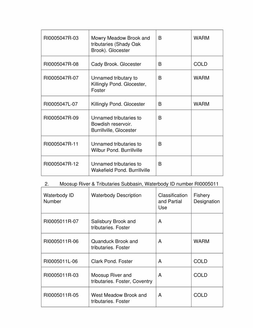
RI0005047R-03 Mowry Meadow Brook and tributaries (Shady Oak
Brook). Glocester
B WARM
RI0005047R-08 Cady Brook. Glocester B COLD
RI0005047R-07 Unnamed tributary to Killingly Pond. Glocester,
Foster
B WARM
RI0005047L-07 Killingly Pond. Glocester B WARM
RI0005047R-09 Unnamed tributaries to Bowdish reservoir.
Burrillville, Glocester
B
RI0005047R-11 Unnamed tributaries to
Wilbur Pond. Burrillville
B
RI0005047R-12 Unnamed tributaries to
Wakefield Pond. Burrillville
B
2. Moosup River & Tributaries Subbasin, Waterbody ID number RI0005011
Waterbody ID Number
Waterbody Description Classification and Partial
Use
Fishery Designation
RI0005011R-07 Salisbury Brook and
tributaries. Foster
A
RI0005011R-06 Quanduck Brook and
tributaries. Foster
A WARM
RI0005011L-06 Clark Pond. Foster A COLD
RI0005011R-03 Moosup River and tributaries. Foster, Coventry
A COLD
RI0005011R-05 West Meadow Brook and tributaries. Foster
A COLD

RI0005011L-07 Briggs Pond. Coventry A
RI0005011L-02 Waterman Pond (Sisson
Pond). Coventry
A
RI0005011R-02 Warwick Brook and
tributaries. Coventry
A COLD
RI0005011R-10 Unnamed tributary to
Koszela Pond. Coventry
A COLD
RI0005011L-08 Koszela Pond. Coventry A
RI0005011R-09 Sawmill Brook and tributaries. Coventry
A
RI0005011R-01 Bucks Horn Brook and tributaries. Coventry
A COLD
RI0005011L-01 Carbuncle Pond. Coventry A WARM
RI0005011L-05 Great Grass Pond.
Coventry, West Greenwich
A
RI0005011L-04 Whitford Pond. Coventry A
RI0005011L-09 Little Grass Pond. Coventry A
RI0005011L-03 Arnold Pond. Coventry A
RI0005011R-04 Roaring Brook and tributaries. Coventry
A WARM
3. Beach Pond & Tributaries Subbasin, Waterbody ID number RI0005010
Waterbody ID
Number
Waterbody Description Classification
and Partial Use
Fishery
Designation
RI0005010L-01 Beach Pond. Exeter B WARM

RI0005010R-01 Unnamed tributary to BeachPond. Exeter
B
J. Pawtuxet River Basin, Waterbody ID number RI0006
1. Big River & Tributaries Subbasin, Waterbody ID number RI0006012
Waterbody ID Number
Waterbody Description Classification and Partial
Use
Fishery Designation
RI0006012L-03 Milbrook Pond. Exeter A COLD
RI0006012R-04 Congdon River and tributaries. Exeter, West
Greenwich
A COLD
RI0006012R-05 Nooseneck River and
tributaries. West Greenwich
A COLD
RI0006012R-06 Raccoon Brook. West
Greenwich
A COLD
RI0006012R-02 Big River and tributaries.
West Greenwich
A
RI0006012L-01 Carr Pond. West Greenwich A WARM
RI0006012L-02 Tarbox Pond. West Greenwich
A WARM
RI0006012R-03 Carr River and tributaries. West Greenwich
A WARM
RI0006012R-07 Mud Bottom Brook. West Greenwich
A
RI0006012L-04 Capwell Mill Pond. West Greenwich
A WARM
RI0006012L-05 Reynolds Pond to the Harkney Hill Road highway
A WARM

bridge. West Greenwich, Coventry
RI0006012R-01 Bear Brook and tributaries. West Greenwich, Coventry
A COLD
2. Flat River Reservoir & Tributaries Subbasin, Waterbody ID number RI0006013
Waterbody ID Number
Waterbody Description Classification and Partial
Use
Fishery Designation
RI0006013R-10 Turkey Meadow Brook and
tributaries. Scituate, Coventry
B COLD
RI0006013R-04 Negro Sawmill Brook. Coventry
B COLD
RI0006013R-06 Pine Swamp Brook. Foster, Coventry
B COLD
RI0006013R-02 Flat River and tributaries. Coventry
B COLD
RI0006013R-03 McCuster Brook and tributaries. Coventry
B COLD
RI0006013R-09 Whaley Brook and tributaries. Foster, Coventry
B COLD
RI0006013L-01 Flat River Reservoir (Johnson Pond). Coventry
B WARM
RI0006013R-05 Pierce Brook and tributaries. Scituate,
Coventry
B COLD
RI0006013R-01 Boyd Brook. Scituate,
Coventry
B COLD

RI0006013L-13 Carr Pond. Coventry B
RI0006013L-04 Quidneck Reservoir.
Coventry
B WARM
RI0006013R-08A Quidneck Brook headwaters
and tributaries to Quidneck Reservoir. Coventry
B
RI0006013R-08B Quidneck Brook from the outlet of Quidneck
Reservoir to Coventry Reservoir (Stump Pond).
Coventry
B COLD
RI0006013R-08C Quidneck Brook from the
outlet of Coventry Reservoir(Stump Pond) to Flat River
Reservoir. Coventry
B
RI0006013L-03 Coventry Reservoir (Stump
Pond). Coventry
B
RI0006013R-07 Poor Farm Brook and
tributaries. Coventry
B
RI0006013L-14 Hall Pond. Coventry B
RI0006013L-12 Maple Root Pond. Coventry B
3. Pawtuxet River South Branch & Tributaries Subbasin, Waterbody ID
number RI0006014
Waterbody ID
Number
Waterbody Description Classification
and Partial Use
Fishery
Designation
RI0006014R-04A Pawtuxet River South Branch from the Flat River
Reservoir dam to the Quidnick Dye Mill dam.
Coventry
B WARM
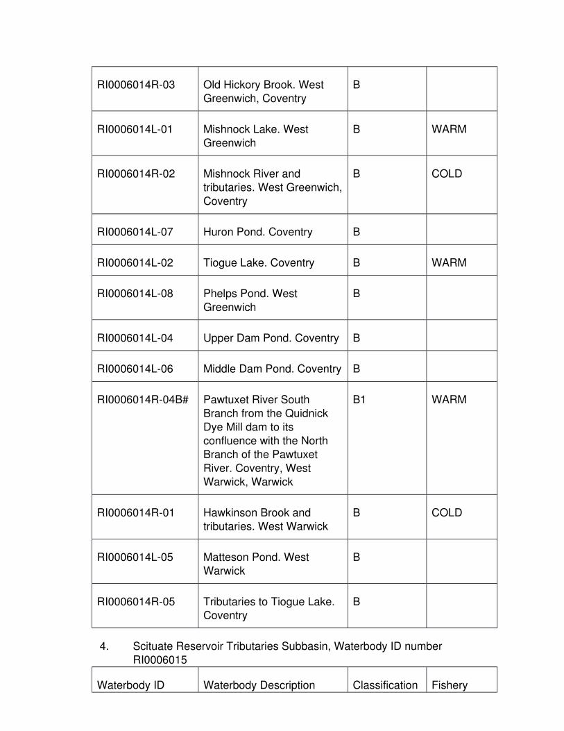
RI0006014R-03 Old Hickory Brook. West Greenwich, Coventry
B
RI0006014L-01 Mishnock Lake. West Greenwich
B WARM
RI0006014R-02 Mishnock River and tributaries. West Greenwich,
Coventry
B COLD
RI0006014L-07 Huron Pond. Coventry B
RI0006014L-02 Tiogue Lake. Coventry B WARM
RI0006014L-08 Phelps Pond. West
Greenwich
B
RI0006014L-04 Upper Dam Pond. Coventry B
RI0006014L-06 Middle Dam Pond. Coventry B
RI0006014R-04B# Pawtuxet River South
Branch from the Quidnick Dye Mill dam to its
confluence with the North Branch of the Pawtuxet
River. Coventry, West Warwick, Warwick
B1 WARM
RI0006014R-01 Hawkinson Brook and tributaries. West Warwick
B COLD
RI0006014L-05 Matteson Pond. West Warwick
B
RI0006014R-05 Tributaries to Tiogue Lake. Coventry
B
4. Scituate Reservoir Tributaries Subbasin, Waterbody ID number RI0006015
Waterbody ID Waterbody Description Classification Fishery

Number and Partial Use
Designation
RI0006015L-02 Ponagansett Reservoir. Glocester
AA
RI0006015R-20A Ponagansett River headwaters and tributaries
from the outlet of Ponagansett Reservoir to
the confluence with ShippeeBrook. Glocester, Foster
AA WARM
RI0006015R-23 Shippee Brook and tributaries. Foster
AA COLD
RI0006015R-34 Huntington Brook. Foster AA COLD
RI0006015R-20B Ponagansett River and
tributaries from the confluence with Shippee
Brook to Scituate Reservoir,excluding Barden Reservoir.
Glocester, Foster
AA COLD
RI0006015L-05 Shippee Saw Mill Pond.
Foster
AA WARM
RI0006015R-09 Hannah Brook. Glocester AA COLD
RI0006015R-01 Allen Richard Brook. Glocester
AA
RI0006015R-13 Killy Brook. Glocester, Foster
AA
RI0006015R-30 Windsor Brook and tributaries. Glocester,
Foster
AA COLD
RI0006015L-09 Brush Meadow Pond. AA

Foster, Scituate
RI0006015R-08 Dolly Cole Brook and
tributaries. Glocester, Foster, Scituate
AA WARM
RI0006015L-06 Barden Reservoir. Foster, Scituate
AA
RI0006015R-17 Paine Brook and tributaries.Foster
AA COLD
RI0006015R-10 Hemlock Brook and tributaries. Foster
AA COLD
RI0006015R-26 Swamp Brook. Scituate AA COLD
RI0006015R-27 Westconnaug Brook and
tributaries. Foster
AA
RI0006015L-03 Westconnaug Reservoir.
Foster, Scituate
AA
RI0006015R-28 Westconnaug Stream and
tributaries. Foster, Scituate
AA
RI0006015R-02 Bear Tree Brook. Foster,
Scituate
AA COLD
RI0006015L-10 King Pond. Scituate AA
RI0006015R-14 King Brook. Scituate AA
RI0006015R-06 Cork Brook. Scituate AA COLD
RI0006015R-32 Potterville Brook and tributaries. Foster, Scituate
AA WARM
RI0006015R-29 Wilbur Hollow Brook and tributaries. Scituate
AA WARM

RI0006015L-07@ Scituate Reservoir. Scituate AA
RI0006015R-25 Spruce Brook and
tributaries. Scituate
AA COLD
RI0006015R-31 Hunt Brook. Glocester AA COLD
RI0006015R-19A Peeptoad Brook headwaters and tributaries
to Coomer Lake. Glocester
AA COLD
RI0006015L-08 Coomer's Lake. Glocester AA
RI0006015R-19B Peeptoad Brook and tributaries from the outlet of
Coomer Lake to Regulating Reservoir. Glocester,
Scituate.
AA WARM
RI0006015R-18 Mosquitohawk Brook and
tributaries. Glocester, Scituate
AA COLD
RI0006015L-13 Lake Aldersgate. Glocester AA COLD
RI0006015R-11 Huntinghouse Brook.
Glocester, Scituate
AA COLD
RI0006015R-22 Rush Brook and tributaries.
Scituate
AA COLD
RI0006015R-24 Soak Hide Brook. Scituate AA COLD
RI0006015L-01 Regulating Reservoir. Scituate
AA
RI0006015R-03 Blanchard Brook. Scituate AA WARM
RI0006015L-14 Kimball Reservoir. Johnston AA
RI0006015R-16 Moswansicut Stream. AA

Scituate
RI0006015L-04 Moswansicut Pond.
Scituate, Johnston
AA
RI0006015R-05 Bullhead Brook. Scituate AA
RI0006015R-04 Brandy Brook. Scituate AA
RI0006015L-11 Pine Swamp Pond. Scituate AA
RI0006015R-21 Quonopaug River and tributaries. Scituate
AA
RI0006015L-12 Betty Pond. Scituate AA
RI0006015R-12 Kent Brook and tributary.
Scituate
AA
RI0006015R-07 Coventry Brook. Scituate AA
RI0006015R-33 Unnamed tributaries to Ponagansett Reservoir.
Glocester
AA
RI0006015R-35 Unnamed tributaries to
Westconnaug Reservoir. Foster
AA
RI0006015R-36 Unnamed tributaries to Scituate Reservoir. Scituate
AA
RI0006015R-37 Unnamed tributaries to Betty Pond. Cranston,
Scituate
AA
5. Pawtuxet River North Branch & Tributaries Subbasin, Waterbody ID
number RI0006016
Waterbody ID
Number
Waterbody Description Classification
and Partial
Fishery
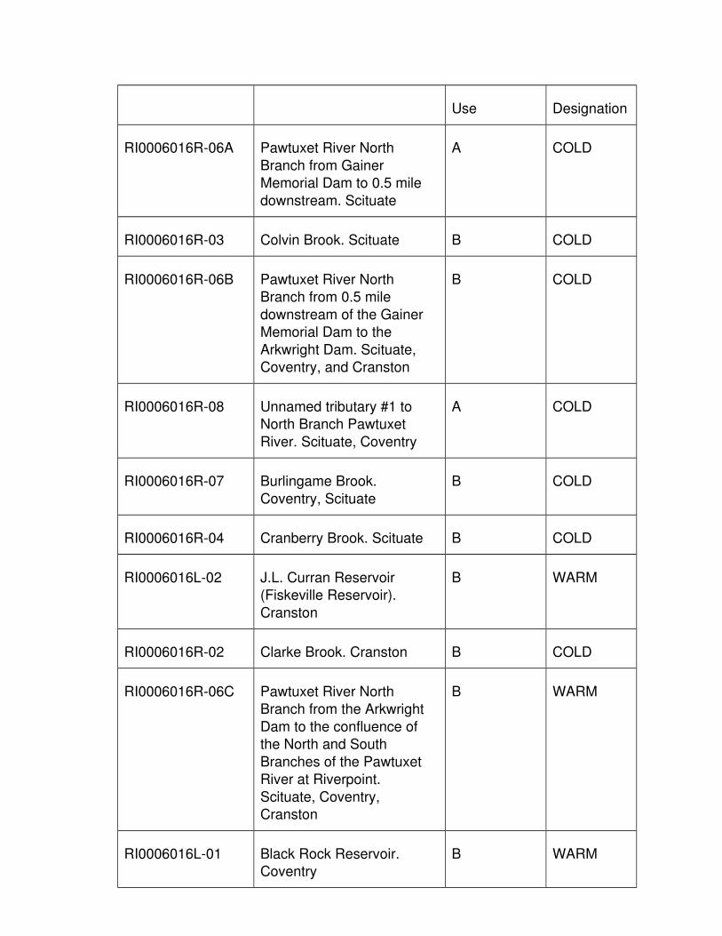
Use Designation
RI0006016R-06A Pawtuxet River North
Branch from Gainer Memorial Dam to 0.5 mile
downstream. Scituate
A COLD
RI0006016R-03 Colvin Brook. Scituate B COLD
RI0006016R-06B Pawtuxet River North Branch from 0.5 mile
downstream of the Gainer Memorial Dam to the
Arkwright Dam. Scituate, Coventry, and Cranston
B COLD
RI0006016R-08 Unnamed tributary #1 to North Branch Pawtuxet
River. Scituate, Coventry
A COLD
RI0006016R-07 Burlingame Brook.
Coventry, Scituate
B COLD
RI0006016R-04 Cranberry Brook. Scituate B COLD
RI0006016L-02 J.L. Curran Reservoir (Fiskeville Reservoir).
Cranston
B WARM
RI0006016R-02 Clarke Brook. Cranston B COLD
RI0006016R-06C Pawtuxet River North Branch from the Arkwright
Dam to the confluence of the North and South
Branches of the Pawtuxet River at Riverpoint.
Scituate, Coventry, Cranston
B WARM
RI0006016L-01 Black Rock Reservoir. Coventry
B WARM

RI0006016R-01 Black Rock Brook and tributaries. Coventry
B WARM
RI0006016L-03 Fones Pond. Coventry B
RI0006016R-05 Lippet Brook and tributaries.
Cranston, West Warwick
B WARM
RI0006016R-10 Unnamed tributary #3 to
North Branch Pawtuxet River. Coventry
A
6. Pawtuxet River Main Stem & Tributaries Subbasin, Waterbody ID number RI0006017
Waterbody ID Number
Waterbody Description Classification and Partial
Use
Fishery Designation
RI0006017R-03# Pawtuxet River from the
confluence of the North and South Branches at
Riverpoint to the Pawtuxet Cove Dam at Pawtuxet.
West Warwick, Warwick, Cranston
B1 WARM
RI0006017R-01 Furnace Hill Brook and tributaries. Johnston,
Cranston
B COLD
RI0006017L-01 Meshanticut Pond.
Cranston
B WARM
RI0006017R-02 Meshanticut Brook and
tributaries. Cranston, Warwick
B WARM
RI0006017L-02 Three Ponds. Warwick B
RI0006017R-04 Three Pond Brook. Warwick B

RI0006017L-10 Tongue Pond. Cranston B
RI0006017L-07 Spectacle Pond. Cranston B
RI0006017L-06 Mashapaug Pond. Providence
B WARM
RI0006017L-05 Roger Williams Park Ponds.Providence
B WARM
RI0006017L-08 Fenner Pond. Cranston B
RI0006017L-09 Sand Pond (N. of Airport).
Warwick
B
RI0006017R-05 Lakewood Brook. Warwick. B
7. Pocasset River & Tributaries Subbasin, Waterbody ID number RI0006018
Waterbody ID
Number
Waterbody Description Classification
and Partial Use
Fishery
Designation
RI0006018R-03A Pocasset River and tributaries from the
headwaters to the inlet of Printworks Pond. Johnston,
Cranston
B WARM
RI0006018L-01 Oak Swamp Reservoir.
Johnston
B WARM
RI0006018R-02A Dry Brook and tributaries
from the outlet of Oak Swamp Reservoir to a point
0.3 miles below Almy Reservoir at the discharge
point of Medical Homes of R.I., excluding Almy
Reservoir. Johnston
B WARM
RI0006018L-02 Almy Reservoir. Johnston B WARM

RI0006018R-02B Dry Brook and tributaries from a point 0.3 miles below
Almy Reservoir to its confluence with the
Pocasset River. Johnston
B1
RI0006018R-01 Cedar Swamp Brook and
tributaries. Johnston
B WARM
RI0006018L-03 Simmons Reservoir.
Johnston
B WARM
RI0006018R-04 Simmons Brook and
tributaries. Johnston
B WARM
RI0006018L-08 Stone Pond. Cranston B
RI0006018L-04 Randall Pond. Cranston B WARM
RI0006018L-07 Dyer Pond. Cranston B
RI0006018L-05 Print Works Pond. Cranston B WARM
RI0006018R-03B Pocasset River and
tributaries from the outlet of Printworks Pond to the
confluence with the Pawtuxet River. Cranston
B WARM
RI0006018L-06 Blackamore Pond. Cranston B WARM
RI0006018R-05 Unnamed tributaries to
Summons Reservoir. Johnston, Cranston
B
K. Narragansett Basin, Waterbody ID number RI0007
1. Seekonk River Subbasin, Waterbody ID number RI0007019
Waterbody ID Number
Waterbody Description Classification and Partial
Use
Fishery Designation

RI0007019E-01 Seekonk River from the Slater Mill Dam at Main
Street in Pawtucket to India Point in Providence.
Pawtucket, Providence, andEast Providence
SB1{a}
2. Providence River Subbasin, Waterbody ID number RI0007020
Waterbody ID
Number
Waterbody Description Classification
and Partial Use
Fishery
Designation
RI0007020E-01B Providence River from its confluence with the
Moshassuck and Woonasquatucket Rivers in
Providence south and southof a line from India Point to
Bold Point (across the mouth of the Seekonk
River), to a line extending from a point on shore due
east of Naushon Avenue in Warwick to the western
terminus of beach Road in East Providence, including
Watchemoket Cove. East Providence, Providence,
Cranston and Warwick.
SB1{a}
RI0007020E-01A Providence River south of a
line from a point on shore due east of Naushon
Avenue in Warwick to the western terminus of Beach
Road in East Providence and north of a line from
Conimicut Point in Warwick to Old Tower at Nayatt Point
in Barrington. East Providence, Warwick,
Barrington
SB{a}

RI0007020R-08 Tributary to OccupessatuxetCove. Warwick
B WARM
RI0007020R-05 Mosskettuash Brook and tributaries. East Providence
B WARM
RI0007020R-02 Annawomscott Brook. East Providence, Barrington
B WARM
RI0007020L-04 Posnegansett Pond. Warwick
A
RI0007020L-06 Prince's Pond (Tiffany Pond). Barrington
SA
RI0007020L-02 Brickyard Pond. Barrington B WARM
RI0007020R-01 Mussuchuck Creek.
Barrington
B
RI0007020R-03 Tributaries to Echo Lake.
Barrington
B WARM
RI0007020L-07 Echo Lake. Barrington B WARM
RI0007020R-07 Tributaries to PasseonkquisCove. Warwick
B
3. Upper Narragansett Bay Subbasin, Waterbody ID number RI0007024
Waterbody ID
Number
Waterbody Description Classification
and Partial Use
Fishery
Designation
RI0007024E-01 Upper Narragansett Bay from Conimicut Point-Nayatt
Point boundary south, including waters south of a
line from Adams Point, Barrington to Jacobs Point,
Warren, to a line from Warwick Point in Warwick
SA

through Providence Point on Prudence Island, to
Popasquash Point in Bristol.Warwick, Barrington, Bristol,
Portsmouth, Warren
RI0007024R-06 Rumstick Run. Barrington A
RI0007024L-01 Sandy Pond (Little Pond, south of airport). Warwick
B WARM
RI0007024R-10 Unnamed tributary to SpringGreen Pond. Warwick
B WARM
RI0007024L-03 Spring Green Pond. Warwick
B WARM
RI0007024R-05 Tributaries to Warwick Pond. Warwick
B WARM
RI0007024L-02 Warwick Pond. Warwick B WARM
RI0007024R-01 Buckeye Brook and
tributaries. Warwick
B WARM
RI0007024R-02 Parsonage (Knowles)
Brook. Warwick
B WARM
RI0007024R-04 Warner Brook. Warwick B WARM
RI0007024R-03 Lockwood Brook and tributaries. Warwick
B WARM
RI0007024E-02 Old Mill Creek. Warwick SA
RI0007024R-08 Tributaries to Mill Gut, Colt
State Park. Bristol
A
4. Barrington & Runnins Rivers Subbasin, Waterbody ID number RI0007021
Waterbody ID Number
Waterbody Description Classification and Partial
Fishery

Use Designation
RI0007021R-01 Runnins River and
tributaries from the MA-RI border to the Mobil Dam in
East Providence. Providence, East
Providence
B WARM
RI0007021R-02 Tributaries to Barrington
River. Barrington
A WARM
RI0007021E-01A Barrington River from the
Mobil Dam in East Providence to the East Bay
Bike Path trestle in Barrington approximately
2500 feet north of the confluence with the Palmer
River. East Providence, Barrington
SA
RI0007021E-01B Barrington River from the East Bay Bike Path trestle,
south approximately 2500 feet to the confluence with
the Palmer River. Barrington
SB1
5. Palmer River Subbasin, Waterbody ID number RI0007022
Waterbody ID
Number
Waterbody Description Classification
and Partial Use
Fishery
Designation
RI0007022E-01A Palmer River from the MA-RI border to the East Bay
Bike Path trestle in Warren, approximately 2500 feet
north of the confluence with the Barrington River.
Warren, Barrington
SA

RI0007022E-01B Palmer River from the East Bay Bike Path trestle in
Warren, south approximately 2500 feet to
the confluence with the Barrington River. Warren,
Barrington
SB1
RI0007022R-02 Unnamed tributary #2 to
Palmer River. Warren
A
6. Warren River Subbasin, Waterbody ID number RI0007023
Waterbody ID Number
Waterbody Description Classification and Partial
Use
Fishery Designation
RI0007023E-01A Warren River from the
confluence with the Barrington and Palmer
Rivers, approximately 2500 feet south of the East Bay
Bike Path trestles, south to a line between the concrete
jetty at the north end of the Warren Town Beach
through Nun Buoy 18 and its extension to the
Barrington Shore. Barrington, Warren.
SB1
RI0007023E-01B Warren River waters south of a line from the concrete
jetty at the north end of the Warren Town Beach
through Nun Buoy 18 and its extension to the
Barrington shore and north of a line from Adams Point
in Barrington to Jacobs Point in Warren. Warren,
Barrington.
SB

RI0007023R-01 Tributaries to Warren River. Warren, Bristol
B
7. Greenwich Bay Subbasin, Waterbody ID number RI0007025
Waterbody ID
Number
Waterbody Description Classification
and Partial Use
Fishery
Designation
RI0007025R-02 Cedar Brook and tributaries.West Warwick
B
RI0007025R-01 Hardig Brook and tributaries. West Warwick,
Warwick
B WARM
RI0007025R-14 Mill Brook. Warwick B
RI0007025R-13 Gorton Pond tributary. Warwick
B
RI0007025L-01 Gorton Pond. Warwick B WARM
RI0007025R-11 Greenwood Creek. Warwick B
RI0007025E-01 Apponaug Cove waters north and west of a line
from the RIDEM range marker located at the end of
Neptune Lane in Chepiwanoxet to the
RIDEM range marker located at Cedar Tree Point.
Warwick
SB
RI0007025E-07 Mary’s Creek. Warwick SB
RI0007025E-04A Greenwich Bay waters northand west of a line from the
eastern extremity of Sandy Point on Potowomut Neck,
East Greenwich, to the flag
SA

pole located at the Warwick Country Club on Warwick
Neck; east of a line from thenortherly point of Long Point
to the southerly point of Chepiwanoxet Point, and
east of a line from the RIDEM range marker
located on the NECO Pole #6 at the end of Neptune St.
in Chepiwanoxet to the RIDEM range marker
located at the extension of Capron Farm Drive in
Nausauket. Warwick, East Greenwich
RI0007025E-04B Greenwich Bay waters northand west of a line from the
RIDEM range marker located on the NECO
Pole#6 at the end of Neptune Street in
Chepiwanoxet to the RIDEM range marker
located at the extension of Capron Farm Drive in
Nausauket, , and east of a line from the RIDEM range
marker located at the end ofNeptune St. in
Chepiwanoxet to the RIDEM range marker
located at Cedar Tree Point.Warwick
SA
RI0007025R-06 Baker Creek. Warwick A
RI0007025R-05 Tuscatucket Brook.
Warwick
A WARM
RI0007025R-09 Southern Creek (Carpenter
Brook). Warwick
A WARM

RI0007025E-02 Brushneck Cove. Warwick SA
RI0007025E-03 Buttonwoods Cove.
Warwick
SA
RI0007025R-07 Fosters Brook. Warwick B
RI0007025R-08 Oakside Street Brook. Warwick
B
RI0007025E-06A Warwick Cove north of a line from the easternmost
extension of Burr Avenue on Horse Neck to the
westernmost extension of Meadow Avenue on the
east shore. Warwick
SB
RI0007025E-06B Warwick Cove south of a
line from the easternmost extension of Burr Avenue
on Horse Neck to the southernmost point of the
Harbor Light Marina parkinglot on the east shore and
north of a line from the southeastern most riprap
jetty at the entrance of Warwick Cove, located at
the southeastern end of Oakland Beach to the
southern (landward) end of Dorr's Dock on Warwick
Neck, excluding the waters noted below in
RI0007025E-06C. Warwick
SA
RI0007025E-06C Warwick Cove in the vicinity
of Captain’s Shellfish. Warwick
SB
RI0007025R-16 Saddle Brook. West Warwick, Warwick, East
B COLD

Greenwich
RI0007025R-03 Maskerchugg River.
Warwick, East Greenwich
B WARM
RI0007025R-17 Nichols River. East
Greenwich
B WARM
RI0007025R-04 Dark Entry Brook. Warwick,
East Greenwich
B WARM
RI0007025E-05A Greenwich Cove south of
Long Point. East Greenwich, Warwick
SB1
RI0007025E-05B Greenwich Cove north of Long Point and west of a
line extending from the northerly point of Long Point
to the southerly point of Chepiwanoxet Peninsula.
East Greenwich, Warwick
SB
RI0007025R-12 Unnamed Brook to Gorton
Pond. Warwick
B
8. Potowomut River Subbasin, Waterbody ID number RI0007028
Waterbody ID Number
Waterbody Description Classification and Partial
Use
Fishery Designation
RI0007028R-06 Scrabbletown Brook. East
Greenwich, North Kingstown
A COLD
RI0007028R-03A Hunt River headwaters to Frenchtown Road. East
Greenwich, North Kingstown
A COLD
RI0007028R-01 Frenchtown Brook and A COLD

tributaries. West Greenwich,East Greenwich
RI0007028R-04 Mawney Brook and tributaries. East Greenwich
A COLD
RI0007028R-03B Hunt River and tributaries from Frenchtown Road to
the Brown and Sharpe discharge point located
approximately 0.55 miles downstream of Frenchtown
Road. East Greenwich, North Kingstown
B COLD
RI0007028R-02 Fry Brook and tributaries. West Warwick, East
Greenwich
B COLD
RI0007028R-03C Hunt River from the Brown
and Sharpe discharge point located approximately 0.55
miles downstream of Frenchtown Road to Austin
Road. East Greenwich, North Kingstown
B1 COLD
RI0007028R-07 Pierce Brook. East Greenwich
B
RI0007028L-01 Potowomut Pond. North Kingstown
B COLD
RI0007028R-03D Hunt River, excluding Potowomut Pond, from
Austin Road to the tidal waters of the Potowomut
River approximately 1000 feet south of the Forge
Road Bridge. East Greenwich, North
Kingstown
B COLD

RI0007028R-05 Sandhill Brook and tributaries. North Kingstown
B WARM
RI0007028E-01A The water of the PotowomutRiver west of a line from the
RIDEM range marker (41 39.364’N and 71 24.947’W)
on the northern shoreline to the southwestern landward
end of the stone jetty and CRMC Dock #1971 on the
opposite southern shoreline at 51 Pojac Point Road
North Kingstown. East Greenwich, North
Kingstown
SA
RI0007028E-01B The waters of the
Potowomut River east of a line from the RIDEM range
marker (41 39.364’N and 7124.947’W) on the northern
shoreline to the southwestern landward end
of the stone jetty and CRMCDock #1971 on the opposite
southern shoreline at 51 Pojac Point Road North
Kingstown. East Greenwich,North Kingstown
SA
9. West Passage Narragansett Bay Subbasin, Waterbody ID number RI0007027
Waterbody ID Number
Waterbody Description Classification and Partial
Use
Fishery Designation
RI0007027E-03A West Passage waters south
of a line extending from the shore in the vicinity of High
Bank Ave, North Kingstown,running due east through
buoy N”6” and terminating
SA

at the shoreline of PrudenceIsland; west of a line from
the southernmost point on Prudence Island to the
northernmost point on Jamestown, and north of a
line from Cormorant Point atthe mouth of
Pettaquamscutt River, Narragansett to Beavertail,
Jamestown, excluding all the West Passage, Allen's
Harbor and Wickford Harborwaters. Warwick, East
Greenwich, Portsmouth, North Kingstown,
Jamestown, Narragansett.
RI0007027R-10 Tibbets Creek and
tributaries. North Kingstown
A
RI0007027E-01A Allen's Harbor waters north
of a line extending from the westernmost indentation of
the cove which is immediately north of the
easternmost curve of Westcott Road to the
northernmost point of land on the south side of the
mouth of Allen's Harbor. North Kingstown
SA{b}
RI0007027E-01B Allen's Harbor waters south and east of a line extending
from the westernmost indentation of the cove
which is immediately north of the easternmost curve of
Westcott Road to the northernmost point of land
on the south side of the mouth of Allen's Harbor.
North Kingstown
SB
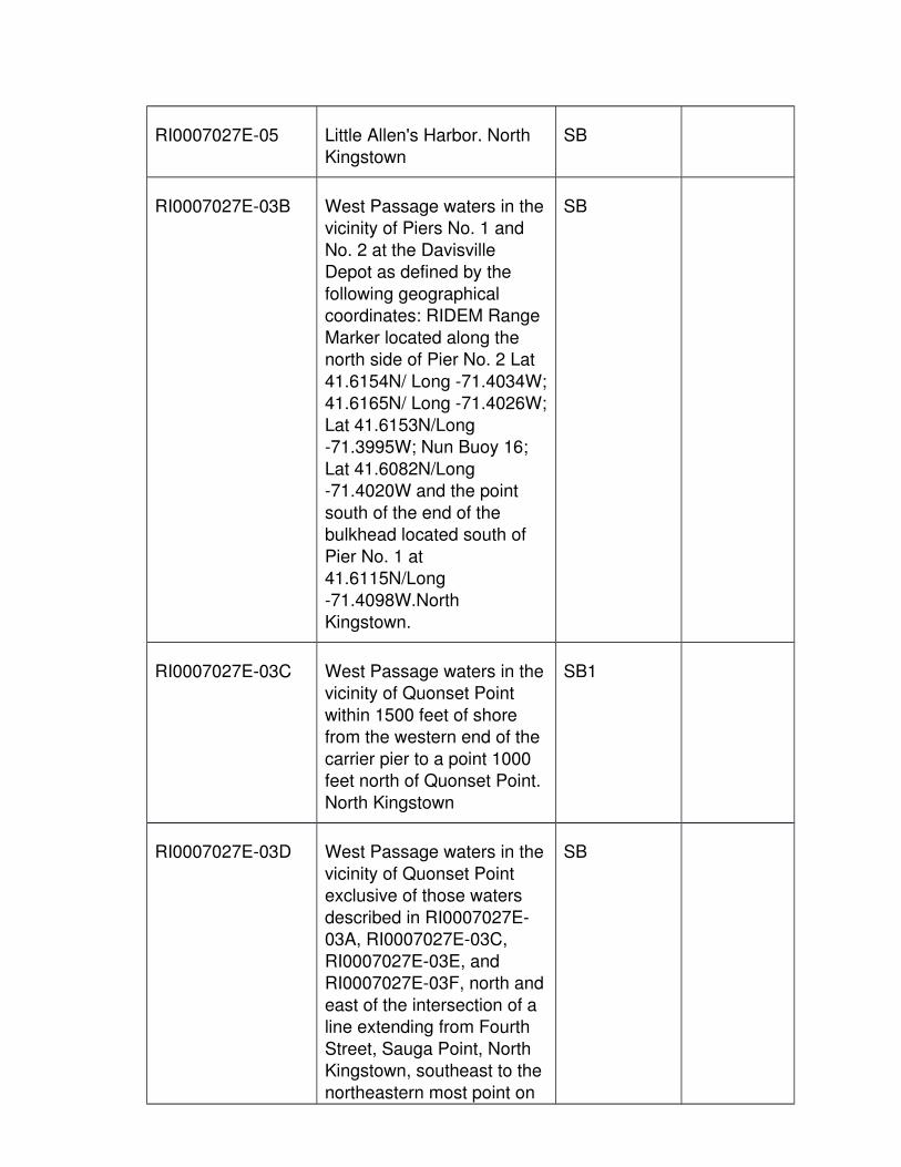
RI0007027E-05 Little Allen's Harbor. North Kingstown
SB
RI0007027E-03B West Passage waters in thevicinity of Piers No. 1 and
No. 2 at the Davisville Depot as defined by the
following geographical coordinates: RIDEM Range
Marker located along the north side of Pier No. 2 Lat
41.6154N/ Long -71.4034W;41.6165N/ Long -71.4026W;
Lat 41.6153N/Long -71.3995W; Nun Buoy 16;
Lat 41.6082N/Long -71.4020W and the point
south of the end of the bulkhead located south of
Pier No. 1 at 41.6115N/Long
-71.4098W.North Kingstown.
SB
RI0007027E-03C West Passage waters in thevicinity of Quonset Point
within 1500 feet of shore from the western end of the
carrier pier to a point 1000 feet north of Quonset Point.
North Kingstown
SB1
RI0007027E-03D West Passage waters in the
vicinity of Quonset Point exclusive of those waters
described in RI0007027E-03A, RI0007027E-03C,
RI0007027E-03E, and RI0007027E-03F, north and
east of the intersection of a line extending from Fourth
Street, Sauga Point, North Kingstown, southeast to the
northeastern most point on
SB

Fox Island and a line drawn from the Wickford
Lighthouse to Buoy R 6, west of a line from Buoy R 6
to Nun Buoy 10, south of a line from Nun Buoy 10
through F G Buoy 11 extended to the shore.
North Kingstown.
RI0007027E-03E* West Passage waters in the
vicinity of Quonset Point that are south of a line from
the northeastern end of the bulkhead at Quonset State
Airport to Nun Buoy 10; andnorth of a line from Nun
Buoy 10 through F G Buoy 11 extended to the shore.
North Kingstown
SA
RI0007027E-03F* West Passage waters in the
vicinity of Quonset Point that lie within the following
intersection of lines: south of a line from the Wickford
Lighthouse to Buoy R 6; west of a line from Fox
Island to Nun Buoy 8; east and north of a line from the
Southerly extension of Second Street in the Sauga
Point area in North Kingstown, to the western
extremity of Sand Point on Jamestown. North
Kingstown
SA
RI0007027E-03G* West Passage waters in the
vicinity of Sauga Point, North Kingstown defined by
the intersection of a line from the southerly extension
of Second Street in the
SA

Sauga Point area to the western extremity of Sand
Point on Jamestown, with a line extending from Fourth
Street in the Sauga Point area, southeast to the
northeastern most point on Fox Island. North Kingstown
RI0007027L-05 Davol Pond. North Kingstown
A
RI0007027L-06 Frys Pond. North Kingstown A
RI0007027R-11 Hall Creek. North Kingstown B
RI0007027R-05 Pine River from headwatersto confluence with Mill
Creek. North Kingstown
B WARM
RI0007027R-06 Mill Creek and tributaries
from headwaters to Camp Avenue culvert. North
Kingstown
B WARM
RI0007027R-03 Cocumcussoc Brook and
tributaries. North Kingstown
B COLD
RI0007027E-04B Wickford Harbor including
Mill Cove and the estuarine portion of Mill Creek, west
of a line extending from the northern extremity of Big
Rock Point to the southern extremity of Cornelius
Island, and west and south of a line extending from the
northern extremity of Cornelius Island, to a point
1000 feet north of Calf Neck. North Kingstown
SB

RI0007027E-04A Wickford Harbor outer waters and Fishing Cove
east of a line extending fromthe northern extremity of Big
Rock Point to the southern extremity of Cornelius
Island, and east and north of a line extending from the
northern extremity of Cornelius Island to a point
1000 feet north of Calf Neck, and west of Sauga
point breakwater and a line from the light at the
southern end of Sauga Point breakwater to the
northern end of the Poplar Point breakwater. North
Kingstown
SA{b}
RI0007027R-02 Belleville Upper Pond Inlet.
North Kingstown
B COLD
RI0007027L-02 Belleville Ponds. North
Kingstown
B WARM
RI0007027L-04 Kettle Hole Pond. North
Kingstown
B
RI0007027R-04 Kettle Hole Pond to Secret
Lake and tributaries. North Kingstown
B
RI0007027L-03 Secret Lake. North Kingstown
B WARM
RI0007027R-07 Oak Hill Brook. North Kingstown
B
RI0007027R-01 Annaquatucket River and tributaries. North Kingstown
B WARM
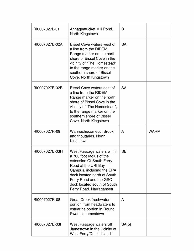
RI0007027L-01 Annaquatucket Mill Pond. North Kingstown
B
RI0007027E-02A Bissel Cove waters west of a line from the RIDEM
Range marker on the north shore of Bissel Cove in the
vicinity of “The Homestead",to the range marker on the
southern shore of Bissel Cove. North Kingstown
SA
RI0007027E-02B Bissel Cove waters east of a line from the RIDEM
Range marker on the north shore of Bissel Cove in the
vicinity of ‘The Homestead",to the range marker on the
southern shore of Bissel Cove. North Kingstown
SA
RI0007027R-09 Wannuchecomecut Brook and tributaries. North
Kingstown
A WARM
RI0007027E-03H West Passage waters within
a 700 foot radius of the extension Of South Ferry
Road at the URI Bay Campus, including the EPA
dock located north of South Ferry Road and the GSO
dock located south of SouthFerry Road. Narragansett
SB
RI0007027R-08 Great Creek freshwater portion from headwaters to
estuarine portion in Round Swamp. Jamestown
A
RI0007027E-03I West Passage waters off Jamestown in the vicinity of
West Ferry/Dutch Island
SA{b}

Harbor, from a point on the shore of the western coast
of Jamestown which is due east of the Dutch Island
pier, to the Fort Getty Pier on Beaverhead Point, to a
point at the southern terminus of Maple Avenue.
Jamestown
RI0007027E-07 Wesquage Pond.
Narragansett
SA
RI0007027E-03J West Passage waters south
of a line from the eastern extremity of Sandy Point on
Potowomut Neck, East Greenwich, to the flagpole
located at the Warwick Country club on Warwick
Neck; south of a line from the southernmost extremity
of Warwick Point on Warwick Neck, to the
northernmost point on Prudence Island
(Providence Point); north of a line extending from the
shore in the vicinity of High Bank Ave, North Kingstown,
running due east through buoy N”6” and terminating
at the shoreline of PrudenceIsland. Warwick, East
Greenwich, North Kingstown, Portsmouth.
SA
RI0007027E-03K Fox Hill Pond in its entirety. Jamestown
SA
RI0007027E-03L Sheffield Cove waters in Jamestown south of a line
from the range marker located at the western
SA

extension of Maple Avenue to the range marker located
at the northernmost point of land on the opposite
western shore at the entrance to the cove.
Jamestown.
RI0007027E-06 Jenny Pond, Prudence
Island. Portsmouth
SA
RI0007027R-18 Unnamed Tributary #2 to
Allen's Harbor. North Kingstown
B
RI0007027R-22 Unnamed Tributaries to Wesquage Pond.
Narragansett
A
10. Bristol Harbor Subbasin, Waterbody ID number RI0007026
Waterbody ID Number
Waterbody Description Classification and Partial
Use
Fishery Designation
RI0007026E-01B Bristol Harbor waters west
of a line from range marker located on Pole #20
Popasquash Rd. at the northernmost indentation of
Bristol Harbor to the RIDEMrange marker located at the
northernmost extremity of Hog Island and north of a
line from the CRMC Permitted Dock #419
located at 163 Poppasquash Rd to the
most north-western corner of the Rockwell Pier
municipal parking lot in Bristol Harbor. Bristol
SA{b}

RI0007026E-01A Bristol Harbor waters north of a line extending from
Popasquash Point to the northernmost extremity of
Hog Island and west of a line from the northernmost
extremity of Hog Island to the northernmost
indentation of the harbor and south of a line from the
CRMC Permitted Dock #419 located at 163
Poppasquash Rd to the most north-western corner
of the Rockwell Pier municipal parking lot in
Bristol Harbor. Bristol
SA
RI0007026E-01C Bristol Harbor waters east
of a line extending from the northernmost indentation of
Bristol Harbor to the northeast extremity of Hog
Island and west of a line extending from McKee's
Warf on Bristol Neck to the Coast Guard dock and north
of a line extending from the northeast extremity of Hog
Island to Mckee's Wharf on Bristol Neck. Bristol
SB
RI0007026E-01D Bristol Harbor waters east of a line extending from
McKee's Wharf north to the Coast Guard dock. Bristol
SB1
RI0007026R-01 Silver Creek. Bristol B WARM
RI0007026R-02 Walker Creek and tributary.
Bristol
B
RI0007026E-02 Mill Pond. Bristol SB

11. East Passage Narragansett Bay Subbasin, Waterbody ID number RI0007029
Waterbody ID Number
Waterbody Description Classification and Partial
Use
Fishery Designation
RI0007029E-01A East Passage waters south
of a line extending from the southernmost tip of Gull
Point, Prudence Island, to the southernmost tip of
Popasquash Point, Bristol, to the northern tip of Hog
Island, to McKee’s Wharf onBristol Neck; west of a line
across the mouth of Mt Hope Bay; south of a line
from the southern point on Prudence Island to the
northernmost point on Jamestown; north of a line
from the southernmost pointof Beavertail on Jamestown
to the southernmost tip of Brenton Point, Newport;
exclusive of the East Passage waters, Coasters
Harbor and Coddington Cove waters (RI0007029E-
01D, RI0007029E-01N, RI0007029E-01C,
RI0007029E-01B, RI0007029E-01E,
RI0007029E-01F, RI0007029E-01G,
RI0007029E-01H, RI0007029E-01I,
RI0007029E-01J, RI0007029E-01K,
RI0007029E-01L, RI0007029E-01M,
RI0007029E-01O, RI0007030E-01A,
RI0007030E-01B,
SA

RI0007030E-01C, and RI0007030E-01D) .
Portsmouth, Middletown, Newport, Jamestown.
RI0007029R-05 Mill Creek. Prudence Island,Portsmouth.
A COLD
RI0007029E-03 Potter Cove. Prudence Island, Portsmouth
SA{b}
RI0007029E-04 Nag Pond. Prudence Island,Portsmouth
SA
RI0007029R-02 Barker Brook. Portsmouth A WARM
RI0007029R-03 Bloody Brook. Portsmouth A WARM
RI0007029L-01 Melville Ponds. Portsmouth A
RI0007029R-04 Melville Ponds tributary.
Portsmouth
A WARM
RI0007029R-08 Unnamed tributary #1 to
East Passage. Portsmouth
A WARM
RI0007029E-01D East Passage waters east
of a line drawn from Coggeshall Point
southwesterly to the southeastern most point of
Dyer Island and the area east of a line drawn from
Carr Point northwesterly to the southeastern most point
of Dyer Island. Portsmouth
SB1
RI0007029R-01B Mother of Hope Brook from
Redwood Road, Portsmouth, to East
Passage, Narragansett Bay.Portsmouth.
B1 WARM

RI0007029R-01A Mother of Hope Brook from the headwaters south of
Greene Lane, Middletown, to Redwood Road,
Portsmouth. Middletown, Portsmouth
B WARM
RI0007029E-01N* East Passage waters south of a line from the RIDEM
range marker located just south of Carr Point to Buoy
"GR C" located at Fiske Rock, and north and east of
a line from the RIDEM range marker located
approximately 2,300 feet north of the former Blue
Gold Pier, to Nun Buoy "22". Portsmouth,
Middletown
SA
RI0007029R-09 Unnamed tributary #2 to
East Passage. Middletown
A WARM
RI0007029R-10 Unnamed tributary #3 to
East Passage. Middletown
A WARM
RI0007029E-01C East Passage waters in the
vicinity of McAlister Point. Middletown
SA
RI0007029E-01B* East Passage waters east of a line from range marker
painted on the shoreline approximately 500 feet west
of the monument flagpole located in Fort Adams State
Park to the Rose Island light, east of a line from the
Rose Island light to Navy buoy W or "D" located at the
southeast side of Gould Island, east of a line from
SA

Navy buoy W or "D" off Gould Island to buoy GR C
at Fiske Rock, south of a line from buoy GR C at
Fiske Rock to the eastern (landward) end of the
former dock site located approximately 800 feet
north of Greene Lane, Middletown, and west of the
Newport Harbor/CoddingtonCove SB and SB1 waters
described in waterbody ID's RI0007030E-01A,
RI0007030E-01B, RI0007030E-01C, and
RI0007030E-01D. Newport, Middletown
RI0007029E-01E East Passage waters within 500 feet of the firing pier at
the U.S. Navy torpedo testing station at the
northern end of Gould Island. Jamestown
SB
RI0007029E-01F East Passage waters in the vicinity of Taylor Point which
are within a 300 foot radius of the Jamestown WWTF
outfall. Jamestown
SB1
RI0007029E-01G East Passage waters in the
vicinity of Taylor Point, exclusive of those waters
described directly above, south of a line extending
from the northernmost extremity of Taylor Point to
Can Buoy 13, north of a linefrom a point of land on the
Jamestown shore approximately 1000 feet
south of the Newport Bridge
SB

extending eastward to the northernmost extremity of
Rose Island and within 1000feet of the shoreline of
Jamestown. Jamestown
RI0007029E-01H East Passage waters in the
vicinity of East Ferry, Jamestown, and west of a
line from Bryer Point to Lincoln Street. Jamestown
SB
RI0007029E-01I East Passage waters in the vicinity of Wharton's
Shipyard which are south and west of a line from a
point of land approximately 3000 feet north of Bull Point
to the northernmost of "The Dumplings", and west of a
line from the northernmost of "The Dumplings" to a
point of land approximately 1000 feet north of Bull
Point. Jamestown
SB
RI0007029E-01J East Passage waters bound
on the north by a line extending 1000 feet
seaward from shore at the base of the Newport Bridge;
bound to the east by a line extending 1000 feet
seaward of the shoreline and bound to the south by a
line extending from Bull Point to buoy G"11",
excluding the Class SB waters described in
RI0007029E-01H and RI0007029E-01I.
Jamestown
SA{b}

RI0007029E-01K East Passage waters in the vicinity of the Fort Wetherill
Boat Basin that are west of the extension of a line from
the southeast corner of the pier at Forth Wetherill,
through the northeast corner of the pier at Fort
Wetherill to the opposite northern shore. Jamestown
SB
RI0007029E-01L Castle Hill Cove. Newport SB
RI0007029E-01M* East Passage waters in the
vicinity of Taylor Point and East Ferry, Jamestown,
south of a line from the northern most tip of Taylor
Point to buoy R14 located off Coasters Harbor in
Newport; west of a line frombuoy N2 located at the
south end of Gould Island through buoy C13, to the
House on the rocks located in "The Dumplings"; east of
a line from the northernmosttip of Taylor Point to Bull
Point which is 1000 feet seaward of the shoreline
exclusive of the SB and SA{b} waters described in
waterbody ID's: RI0007029E-01K,
RI0007029E-01J, RI0007029E-01I,
RI0007029E-01H, RI0007029E-01G, and
RI0007029E-01F. Jamestown
SA
RI0007029E-02 Mackerel Cove. Jamestown SA
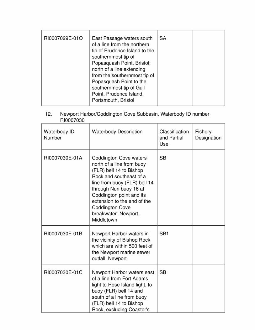
RI0007029E-01O East Passage waters south of a line from the northern
tip of Prudence Island to thesouthernmost tip of
Popasquash Point, Bristol; north of a line extending
from the southernmost tip ofPopasquash Point to the
southernmost tip of Gull Point, Prudence Island.
Portsmouth, Bristol
SA
12. Newport Harbor/Coddington Cove Subbasin, Waterbody ID number
RI0007030
Waterbody ID
Number
Waterbody Description Classification
and Partial Use
Fishery
Designation
RI0007030E-01A Coddington Cove waters north of a line from buoy
(FLR) bell 14 to Bishop Rock and southeast of a
line from buoy (FLR) bell 14through Nun buoy 16 at
Coddington point and its extension to the end of the
Coddington Cove breakwater. Newport,
Middletown
SB
RI0007030E-01B Newport Harbor waters in
the vicinity of Bishop Rock which are within 500 feet of
the Newport marine sewer outfall. Newport
SB1
RI0007030E-01C Newport Harbor waters eastof a line from Fort Adams
light to Rose Island light, to buoy (FLR) bell 14 and
south of a line from buoy (FLR) bell 14 to Bishop
Rock, excluding Coaster's
SB

Harbor (RI0007030E-01D) and the inner Newport
Harbor waters (RI0007030E-01E).
Newport
RI0007030E-01D Coaster's Harbor waters
east of a line from Bishop Rock to the northernmost
point of Coaster's Harbor Island and north of the
Training Station Road bridge. Newport
SB
RI0007030R-01 Unnamed tributary to Newport Harbor. Newport
B WARM
RI0007030E-01E Newport Harbor waters eastand south of a line from the
southernmost point of Coaster’s Harbor Island to
the northern most point of Goat’s Island, then from the
southwestern most point of Goat’s Island to the
northern most of Fort Adams. Newport
SB
13. Jamestown Water Supply Subbasin, Waterbody ID number RI0007036
Waterbody ID
Number
Waterbody Description Classification
and Partial Use
Fishery
Designation
RI0007036L-01@ North Carr Pond. Jamestown
AA
RI0007036L-02@ South Watson Pond. Jamestown
AA
RI0007036R-01 Jamestown Brook. Jamestown
AA WARM

14. Aquidneck Water Supply Tributaries Subbasin, Waterbody ID number RI0007035
Waterbody ID Number
Waterbody Description Classification and Partial
Use
Fishery Designation
RI0007035L-05@ Saint Mary's Pond.
Portsmouth
AA WARM
RI0007035L-10 Sisson Pond. Portsmouth AA WARM
RI0007035R-06 Sisson Pond Brook. Portsmouth
AA WARM
RI0007035R-07 Unnamed tributary to Lawton Valley Reservoir.
Portsmouth
AA WARM
RI0007035L-06@ Lawton Valley Reservoir.
Portsmouth
AA WARM
RI0007035R-04 Lawton Brook. Portsmouth A WARM
RI0007035R-01 Bailey's Brook and tributaries. Middletown
AA WARM
RI0007035L-03@ North Easton Pond (Green End Pond). Middletown,
Newport
AA WARM
RI0007035R-05 Tributaries to South Easton
Pond. Middletown
AA WARM
RI0007035L-04@ South Easton Pond.
Middletown, Newport
AA WARM
RI0007035R-02A Maidford River from the
headwaters to the water supply diversion near
Paradise Ct. Middletown
AA WARM
RI0007035L-02@ Nelson Paradise Pond. AA WARM

Middletown
RI0007035R-03 Paradise Brook. Middletown AA WARM
RI0007035L-01@ Gardiner Pond. Middletown AA WARM
RI0007035R-02B Maidford River from the
water supply diversion near Paradise Ct. to Hanging
Rock Rd., Middletown.
AA WARM
RI0007035L-07@ Watson Reservoir. Little
Compton
AA WARM
RI0007035L-08@ Nonquit Pond. Tiverton AA WARM
RI0007035E-01 Maidford River from Hanging Rock Rd to Third
Beach. Middletown
SA
15. Warren Reservoir Subbasin, Waterbody ID number RI0007034
Waterbody ID Number
Waterbody Description Classification and Partial
Use
Fishery Designation
RI0007034R-01 Upper Kickemuit River from
the Kickemuit (Warren) Reservoir north to the RI-
MA border. Warren
AA
RI0007034L-01@ Kickemuit Reservoir
(Warren Reservoir). Warren
AA
16. Kickemuit River Subbasin, Waterbody ID number RI0007033
Waterbody ID Number
Waterbody Description Classification and Partial
Use
Fishery Designation
RI0007033E-01A Kickemuit River from the
Child Street bridge (Route
SA

103) in Warren, south to theriver mouth at "Bristol
Narrows" excluding the waters in RI0007033E-01B
and RI0007033E-01C. Bristol, Warren
RI0007033E-01B Kickemuit River south of a line from the eastern
extension of Kickemuit Avenue in Bristol to the
DEM range marker located on the western tip of Little
Neck in Touisset, and north of a line from the DEM
range markers located on the east shore and west
shore at the entrance to the Kickemuit River including
the "Bristol Narrows" in its entirety. Bristol, Warren
SA{b}
RI0007033E-01C Kickemuit River west of a line from the DEM range
marker located on the western tip of Little Neck in
Touisset to the brick stack located at 426 Metacom
Avenue in Warren (formally known as the Carol Cable
Building), north of a line from the eastern extension
of Sherman Avenue in Bristol to the western
extension of Chase Avenue Touisset, and south of a line
from the eastern extension of Harris Avenue in Warren
to the "5 MPH No Wake" buoy. Bristol, Warren
SA{b}
RI0007033R-01 Tributaries to Kickemuit River. Warren
A

17. Mt. Hope Bay Subbasin, Waterbody ID number RI0007032
Waterbody ID
Number
Waterbody Description Classification
and Partial Use
Fishery
Designation
RI0007032E-01D Mt. Hope Bay waters south and west of the MA-RI
border and north of a line from Borden's Wharf,
Tiverton to buoy R "4" and east of a line from buoy R
"4" to Brayton Point in Somerset, MA. Bristol,
Portsmouth and Tiverton.
SB1
RI0007032E-01C Mt. Hope Bay waters south
of a line from Borden's Wharf, Tiverton, to buoy R
"4" and west of a line from buoy R "4" to Brayton Point,
Somerset, MA., and east of a line from the end of
Gardiner's Neck Road in Swansea to buoy N "2",
through buoy C “3” to Common Fence Point,
Portsmouth, and north of a line from Portsmouth to
Tiverton at the railroad bridge at "The Hummocks"
on the northeast point of Portsmouth. Portsmouth
SB
RI0007032E-01A* Mt. Hope Bay south and west of the MA/RI border,
and east of a line from Touisset Point to the
channel marker buoy R "4" and south and east of a line
from buoy R "4" to the southernmost landward end
of Bristol Point and south of a line from Bristol Point to
the Hog Island shoal light,
SA

to the southwestern extremity of Arnold Point in
Portsmouth where a RIDEMrange marker has been
established; and west of a line from the end of
Gardiner's Neck Road, Swansea to buoy N"2",
through buoy C”3” to Common Fence Point,
Portsmouth excluding the waters defined in
RI0007032E-01E. Warren, Portsmouth
RI0007032R-06 Unnamed tributary #5 to Mt.Hope Bay. Portsmouth
A WARM
RI0007032R-07 Unnamed tributary #6 to Mt.Hope Bay. Portsmouth
A WARM
RI0007032R-08 Unnamed tributary #7 to Mt.Hope Bay. Portsmouth
A WARM
RI0007032E-01B Mt. Hope Bay waters north and west of a line from the
southernmost landward endof Bristol Point to buoy R "4"
and west of a line from buoyR "4" to the DEM range
marker on Touisset Point, and south of the Bristol
Narrows. Bristol, Warren
SA
RI0007032E-01E Waters approximately 85
feet off the Weyerhauser Dock as defined by the
following geographical coordinates:-71.265042
west longitude 41.625144 north latitude;-71.265032
west longitude 41.627148 north latitude;-71.264225
SB

west longitude 41.627147 north latitude;-71.264177
west longitude 41.625455 north latitude. Portsmouth
RI0007032R-01 Founders Brook. Portsmouth
A WARM
18. Stafford Pond Subbasin, Waterbody ID number RI0007037
Waterbody ID
Number
Waterbody Description Classification
and Partial Use
Fishery
Designation
RI0007037L-01@ Stafford Pond. Tiverton AA WARM
RI0007037R-01 Sucker Brook. Tiverton A WARM
RI0007037R-03 Unnamed tributary #1 to South Watuppa Pond, MA.
Tiverton
A
L. Pawcatuck River Basin, Waterbody ID number RI0008
1. Pawcatuck River & Tributaries Subbasin, Waterbody ID number RI0008039
Waterbody ID Number
Waterbody Description Classification and Partial
Use
Fishery Designation
RI0008039L-21 The Reservoir. Exeter A WARM
RI0008039R-06D Chipuxet River headwaters to the entrance of The
Reservoir. Exeter
A COLD
RI0008039R-06A Chipuxet River from the
outlet of The Reservoir to the entrance of Yawgoo Mill
Pond. North Kingstown, Exeter
A WARM

RI0008039L-16 Yawgoo Mill Pond. Exeter A
RI0008039R-06B Chipuxet River and
tributaries from outlet of Yawgoo Mill Pond to the
entrance of Hundred Acre Pond. Exeter, South
Kingstown
B COLD
RI0008039L-13 Hundred Acre Pond. South
Kingstown
B WARM
RI0008039R-06C Chipuxet River from outlet
of Hundred Acre Pond to the entrance into Worden
Pond, excluding Thirty Acre Pond. South Kingstown
B WARM
RI0008039L-12 Thirty Acre Pond. South Kingstown
B WARM
RI0008039L-07 Worden Pond. South Kingstown
B WARM
RI0008039R-27A White Horn Brook headwaters to Route 138.
South Kingstown
A WARM
RI0008039R-08 Genessee Brook and
tributaries. South Kingstown
B WARM
RI0008039R-27B White Horn Brook and
tributaries from Route 138 to the wetlands associated
with and due east of, Worden Pond. South
Kingstown
B WARM
RI0008039L-11 Larkin Pond. South
Kingstown
B WARM
RI0008039R-15 Mink Brook. South B

Kingstown
RI0008039L-08 Tucker Pond. South
Kingstown
B WARM
RI0008039R-01 Alewife Brook. South
Kingstown
B
RI0008039R-18A Pawcatuck River from
Warden Pond to the dam at Kenyon. South Kingstown,
Charlestown
B WARM
RI0008039R-05A Chickasheen Brook
headwaters to Yawgoo Pond. Exeter
A WARM
RI0008039L-15 Yawgoo Pond. Exeter, South Kingstown
A WARM
RI0008039R-39 Mud Brook. Exeter, South Kingstown
B
RI0008039L-14 Barber Pond. South Kingstown
B WARM
RI0008039R-05B Chickasheen Brook and tributaries from the Yawgoo
Pond outlet to the confluence with the
Usquepaug river. South Kingstown, Richmond
B COLD
RI0008039R-21A Queens River from headwaters south to its
entrance into Bear Swamp in Exeter. West Greenwich,
Exeter
A COLD
RI0008039R-21B Queens River from its
entrance into Bear Swamp to its confluence with
A COLD

Queens Fort Brook. Exeter
RI0008039R-29 Pendock River. West
Greenwich, Exeter
A
RI0008039R-07 Fisherville Brook and
tributaries. West Greenwich,Exeter
A COLD
RI0008039R-30 Dutemple Brook. Exeter A COLD
RI0008039R-22 Sodom Brook. Exeter A COLD
RI0008039L-25 Dawley Pond. Exeter A
RI0008039R-31A Queens Fort Brook
headwaters to 3/4 mile south of Victory Highway
(Route 102). Exeter
A COLD
RI0008039R-33 Reuben Brown Brook.
Exeter
A COLD
RI0008039R-31B Queens Fort Brook from 3/4
mile south of Victory Highway (Route 102) to the
confluence with the QueensRiver. Exeter.
B COLD
RI0008039R-21C Queens River and tributaries from its
confluence with Queens Fort Brook to Glen Rock
Reservoir. Exeter
A COLD
RI0008039R-10 Locke Brook and tributaries.
Exeter
B COLD
RI0008039R-32 Rake Factory Brook. Exeter,
South Kingstown
B COLD
RI0008039R-34 Sherman Brook. Exeter, B COLD

South Kingstown
RI0008039R-09 Glen Rock Brook and
tributaries. Richmond, South Kingstown
B COLD
RI0008039L-19 Glen Rock Reservoir. SouthKingstown
B COLD
RI0008039R-25 Usquepaug River from GlenRock Reservoir to the
confluence with the Pawcatuck River.
Richmond, Charlestown, South Kingstown
B COLD
RI0008039R-18B Pawcatuck River and tributaries from the dam at
Kenyon to the beginning of the Carolina Mill Pond in
Carolina. Richmond, Charlestown
B1 WARM
RI0008039L-20 James Pond. Exeter A
RI0008039R-03 Beaver River and
tributaries. Exeter, Richmond
A COLD
RI0008039L-06 Pasquiset Pond. Charlestown
A WARM
RI0008039R-17 Pasquiset Brook. Charlestown
A COLD
RI0008039L-22 Maple Lake. Charlestown A
RI0008039R-18C Pawcatuck River and
tributaries from the entranceto the Carolina Mill Pond to
the Bradford Dyeing Associates WWTF
B WARM
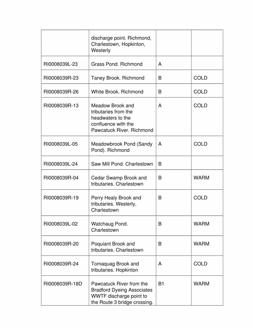
discharge point. Richmond, Charlestown, Hopkinton,
Westerly
RI0008039L-23 Grass Pond. Richmond A
RI0008039R-23 Taney Brook. Richmond B COLD
RI0008039R-26 White Brook. Richmond B COLD
RI0008039R-13 Meadow Brook and tributaries from the
headwaters to the confluence with the
Pawcatuck River. Richmond
A COLD
RI0008039L-05 Meadowbrook Pond (Sandy
Pond). Richmond
A COLD
RI0008039L-24 Saw Mill Pond. Charlestown B
RI0008039R-04 Cedar Swamp Brook and tributaries. Charlestown
B WARM
RI0008039R-19 Perry Healy Brook and tributaries. Westerly,
Charlestown
B COLD
RI0008039L-02 Watchaug Pond.
Charlestown
B WARM
RI0008039R-20 Poquiant Brook and
tributaries. Charlestown
B WARM
RI0008039R-24 Tomaquag Brook and
tributaries. Hopkinton
A COLD
RI0008039R-18D Pawcatuck River from the
Bradford Dyeing AssociatesWWTF discharge point to
the Route 3 bridge crossing.
B1 WARM

Hopkinton, Westerly
RI0008039R-12 McGowan Brook. Westerly B
RI0008039L-01 Chapman Pond. Westerly B WARM
RI0008039R-35 Aguntaug Brook. Westerly B WARM
RI0008039R-14 Mile Brook. Hopkinton B
RI0008039R-38 Wine Brook. Hopkinton A COLD
RI0008039R-37 Parmenter Brook and tributaries. Hopkinton
A COLD
RI0008039R-02A Ashaway River headwaters including tributaries, south
to the Ashaway Road highway bridge. Hopkinton
A COLD
RI0008039R-02B Ashaway River and tributaries from the
Ashaway Road highway bridge to its confluence with
the Pawcatuck River. Hopkinton
B COLD
RI0008039R-18E Pawcatuck River and tributaries from the Route 3
bridge crossing to the Route1 highway bridge at the
junction of Main Street and Broad Street in Westerly.
Westerly
B COLD
RI0008039R-11 Mastuxet Brook and
tributaries. Westerly
B COLD
RI0008039R-41 Spring Brook and
Tributaries. Westerly
B
2. Wood River & Tributaries Subbasin, Waterbody ID number RI0008040

Waterbody ID Number
Waterbody Description Classification and Partial
Use
Fishery Designation
RI0008040R-20 White Brook. West
Greenwich
A
RI0008040R-02 Breakheart Brook and
tributaries. West Greenwich,Exeter
A COLD
RI0008040R-21 Unnamed tributary to Breakheart Pond. Exeter
A COLD
RI0008040L-15 Breakheart Pond. West Greenwich, Exeter
A WARM
RI0008040R-01 Acid Factory Brook and tributaries. West Greenwich
A COLD
RI0008040L-16 Eisenhower Lake. West Greenwich
A WARM
RI0008040R-19 Factory Brook. West Greenwich
A COLD
RI0008040R-14 Phillips Brook and tributaries. West Greenwich
A COLD
RI0008040R-08 Flat River. West Greenwich,Exeter
A COLD
RI0008040L-19 Tillinghast Pond. West Greenwich
A WARM
RI0008040R-05 Coney Brook and tributaries. West Greenwich
A COLD
RI0008040L-18 Wickaboxet Pond. West Greenwich
A

RI0008040R-10 Kelley Brook. West Greenwich
A COLD
RI0008040L-21 Hazard Pond. West Greenwich
A
RI0008040R-07 Falls River and tributaries. West Greenwich, Exeter
A COLD
RI0008040R-16A Wood River and tributaries from the headwaters
starting at confluence of Flatand Falls Rivers, to the
confluence with Roaring Brook. Exeter, Hopkinton,
Richmond.
A COLD
RI0008040L-17 Tippencansett Pond. West
Greenwich
A WARM
RI0008040R-13 Parris Brook and tributaries.
West Greenwich, Exeter
A COLD
RI0008040L-12 Deep Pond. Exeter A
RI0008040R-17 Woody Hill Brook and tributaries. Exeter
A WARM
RI0008040L-14 Boone Lake. Exeter B WARM
RI0008040R-15 Roaring Brook. West
Greenwich, Exeter, Richmond
B COLD
RI0008040L-13 Browning Mill Pond (ArcadiaPond). Exeter, Richmond
B WARM
RI0008040L-22 Frying Pan Pond. Richmond, Hopkinton
B
RI0008040R-16B Wood River from confluence with Roaring
B COLD

Brook to the inlet of Wyoming Pond. Richmond,
Hopkinton
RI0008040R-18 Baker Brook. Richmond B COLD
RI0008040R-22 Moonshine Creek. Richmond
B
RI0008040L-23 Canob Pond. Richmond B
RI0008040R-23 Canob Brook. Richmond B
RI0008040L-11 Wyoming Pond. Hopkinton B WARM
RI0008040R-16C Wood River and tributaries
from the outlet of Wyoming Pond to the inlet of Alton
Pond. Richmond, Hopkinton
B COLD
RI0008040L-07@ Yawgoog pond. Hopkinton AA WARM
RI0008040L-06 Wincheck Pond. Hopkinton B WARM
RI0008040L-08 Grassy Pond. Hopkinton A
RI0008040R-09 Grassy Brook and tributaries. Hopkinton
A
RI0008040R-12 Moscow Brook and tributaries. Hopkinton
B WARM
RI0008040R-11 Log House Brook. Hopkinton
B
RI0008040L-09 Moscow Pond. Hopkinton B WARM
RI0008040R-03A Brushy Brook headwaters
including tributaries to Sawmill Road. Exeter,
Hopkinton
A COLD

RI0008040R-03B Brushy Brook from Sawmill Road to the entrance of
Locustville Pond. Hopkinton
B
RI0008040L-10 Locustville Pond. Hopkinton B WARM
RI0008040R-03C Brushy Brook from the outlet of Locustville Pond to
the confluence with the Wood River. Hopkinton
B COLD
RI0008040R-06 Diamond Brook and tributaries. Richmond
B COLD
RI0008040L-02 Carolina Trout Pond. Richmond
A COLD
RI0008040L-05 Ell Pond. Hopkinton B
RI0008040L-20 Long Pond. Hopkinton B
RI0008040R-24 Glade Brook. Hopkinton A
RI0008040R-04A Canonchet Brook
headwaters including tributaries, excluding all
ponds, to Route 3 in Hopkinton. Hopkinton
B COLD
RI0008040L-04 Ashville Pond. Hopkinton B WARM
RI0008040R-04B Canonchet Brook from
Route 3 in Hopkinton to the confluence with the Wood
River. Hopkinton
B COLD
RI0008040R-25 Unnamed tributary to the
Wood River below Alton Pond. Hopkinton
B COLD
RI0008040R-16D Wood River and tributaries from the Alton Pond dam to
B WARM

the confluence with the Pawcatuck River.
Richmond, Hopkinton, Charlestown
RI0008040L-01 Alton Pond. Hopkinton B WARM
3. Tidal Pawcatuck River/Little Narragansett Bay Subbasin, Waterbody ID
number RI0008038
Waterbody ID
Number
Waterbody Description Classification
and Partial Use
Fishery
Designation
RI0008038E-01A Tidal Pawcatuck River from Route 1 highway bridge to
Pawcatuck Rock. Westerly
SB1
RI0008038E-01B Tidal Pawcatuck River from
Pawcatuck Rock to a line from Rhodes Point, RI to
Pawcatuck Point, CT. Westerly
SB
RI0008038E-02A Waters of Little Narragansett Bay within the
State of Rhode Island whichare north and east of Sandy
Point to the state line; and northeast of a line from the
RIDEM pole (41° 19’ 17” North, Longitude -71°52’47”
West) near the southeastern extremity of
Sandy Point to a RIDEM pole (Latitude 41°18’37”
North, Longitude -71°52’39”West) on the northern
shoreline of Napatree Point;and north of a line from the
northernmost extension of land that forms Napatree
Point to the westernmost point of land on the south
SA

side of the mouth of FostersCove; and west of a line
extending from Pawcatuck Point in Connecticut to
Rhodes Point in Rhode Island., Westerly
RI0008038E-02B Little Narragansett Bay including Watch Hill Cove
and the waters of “The Kitchen”, southeast of a line
from the northernmost extension of land that forms
Napatree Point to the westernmost point of land
on the south side of the mouth of Fosters Cove.
Westerly
SA{b}
M. Westport River Basin, Waterbody ID number RI0009
1. Adamsville Brook & Tributaries Subbasin, Waterbody ID number RI0009041
Waterbody ID Number
Waterbody Description Classification and Partial
Use
Fishery Designation
RI0009041R-01 Adamsville Brook and
tributaries. Tiverton, Little Compton
B COLD
N. Coastal Waters, Waterbody ID number RI0010
1. Southwest Coastal Ponds Subbasin, Waterbody ID number RI001043
Waterbody ID Number
Waterbody Description Classification and Partial
Use
Fishery Designation
RI0010043E-03 Maschaug Pond. Westerly SA
RI0010043L-18 Little Maschaug Pond. Westerly
A
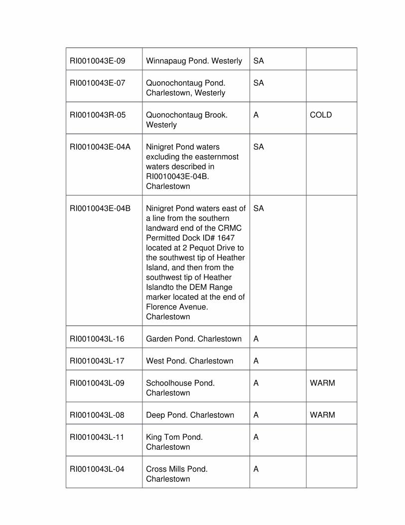
RI0010043E-09 Winnapaug Pond. Westerly SA
RI0010043E-07 Quonochontaug Pond.
Charlestown, Westerly
SA
RI0010043R-05 Quonochontaug Brook.
Westerly
A COLD
RI0010043E-04A Ninigret Pond waters
excluding the easternmost waters described in
RI0010043E-04B. Charlestown
SA
RI0010043E-04B Ninigret Pond waters east ofa line from the southern
landward end of the CRMC Permitted Dock ID# 1647
located at 2 Pequot Drive tothe southwest tip of Heather
Island, and then from the southwest tip of Heather
Islandto the DEM Range marker located at the end of
Florence Avenue. Charlestown
SA
RI0010043L-16 Garden Pond. Charlestown A
RI0010043L-17 West Pond. Charlestown A
RI0010043L-09 Schoolhouse Pond. Charlestown
A WARM
RI0010043L-08 Deep Pond. Charlestown A WARM
RI0010043L-11 King Tom Pond.
Charlestown
A
RI0010043L-04 Cross Mills Pond.
Charlestown
A
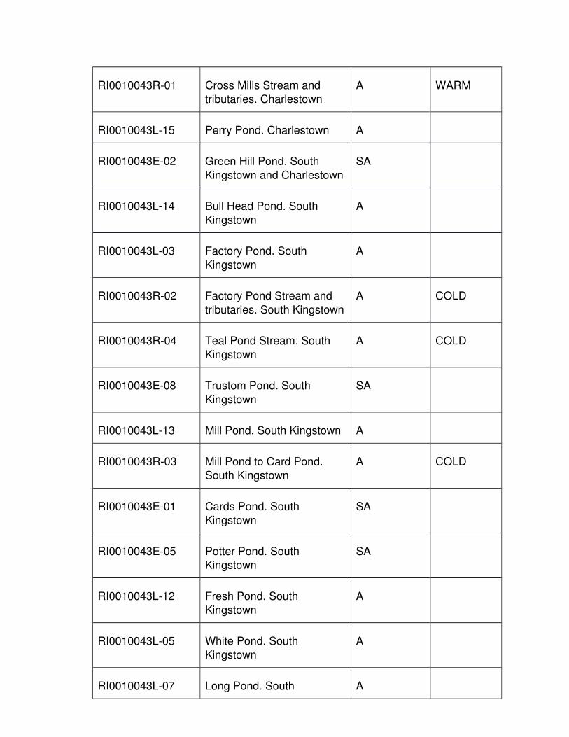
RI0010043R-01 Cross Mills Stream and tributaries. Charlestown
A WARM
RI0010043L-15 Perry Pond. Charlestown A
RI0010043E-02 Green Hill Pond. South
Kingstown and Charlestown
SA
RI0010043L-14 Bull Head Pond. South
Kingstown
A
RI0010043L-03 Factory Pond. South
Kingstown
A
RI0010043R-02 Factory Pond Stream and
tributaries. South Kingstown
A COLD
RI0010043R-04 Teal Pond Stream. South
Kingstown
A COLD
RI0010043E-08 Trustom Pond. South
Kingstown
SA
RI0010043L-13 Mill Pond. South Kingstown A
RI0010043R-03 Mill Pond to Card Pond. South Kingstown
A COLD
RI0010043E-01 Cards Pond. South Kingstown
SA
RI0010043E-05 Potter Pond. South Kingstown
SA
RI0010043L-12 Fresh Pond. South Kingstown
A
RI0010043L-05 White Pond. South Kingstown
A
RI0010043L-07 Long Pond. South A

Kingstown
RI0010043L-01 Hothouse Pond. South
Kingstown
A
RI0010043L-02 Cedar Swamp Pond. South
Kingstown
A
RI0010043L-06 Wash Pond. South
Kingstown
A
RI0010043E-06A Point Judith Pond waters
exclusive of those describedin RI0010043E-06B,
RI00140043E-06C, RI0010043E-06D,
RI0010043E-06E, RI0010043E-06F,
RI0010043E-06G, RI0010043E-06H,
RI0010043E-06I, RI0010043E-06J, and
RI0010043E-06K. Narragansett, South
Kingstown
SA
RI0010043E-06B Upper Point Judith Pond
from the mouth of the Saugatucket River at
Warner Avenue, downstream to Can Buoy
33. Narragansett, South Kingstown
SB
RI0010043E-06C Upper Point Judith Pond, south of Can Buoy 33 and
north and east of a line fromButtonwood Point to the
southern extremity of Cummock Island, to the
flagpole at the northwest extremity of Betty Hull Point,
excluding the marina area
SA

described in RI0010043E-06D. Narragansett, South
Kingstown
RI0010043E-06D Point Judith Pond waters in
the vicinity of Billington Cove Marina as shown on
the plan entitled "Billington Cove Marina: Marina
Perimeter Plan", dated August 1994 by Coastal
Engineering Group, Inc., east of a line from the
western edge of the rip-rap retaining wall, 221 feet
seaward, and west of a line from the flagpole, 280 feet
seaward, and north of the line that connects these two
lines. South Kingstown
SA{b}
RI0010043E-06E Point Judith Pond waters in
the vicinity of Galilee within 500 feet of the shore from
the northern end at the breachway to the western
side of the Great Island Road Bridge. Narragansett
SB
RI0010043E-06F Point Judith Pond waters in the vicinity of Jerusalem
within 500 feet of the shore from the breachway to a
point approximately 1000 feet north of the State Pier.
South Kingston
SB
RI0010043E-06G Point Judith Pond waters in
the vicinity of Snug harbor within 500 feet of shore
from Gooseberry Road to High Point. South
Kingstown
SB

RI0010043E-06H Point Judith Pond waters in the channel to Potter Pond
east of a line across the western end of the Potter
Pond entrance channel located approximately 500
feet west of Succotash Road and west of a line
from a point of land on the northern shore of the
channel approximately 700 feet east of Succotash Road
to a point of land on the southern shore of the
channel, exclusive of the waters noted in
RI0010043E-06I, RI0010043E-06J, and
RI0010043E-06K. South Kingstown
SA
RI0010043E-06I Point Judith Pond waters in the channel to Potter Pond
in the vicinity of the Captain Jacks and Kenport marinas
as shown on the plans entitled "Captain Jacks
Marina: Marina Site Plan forJack Piemonte", approved
by CRMC on November 15, 1994; and "Marina
Perimeter limit for Kenport Marina" approved by CRMC
on April 28, 1994. South Kingstown
SB
RI0010043E-06J Point Judith Pond waters in the channel to Potter Pond
east of a line from a point ofland on the northern shore
of the channel approximately 700 feet east
of Succotash Road to a point of land on the
SA

southern shore of the channel; and west of a line
across the mouth of the channel from Gooseberry
Road due south to Succotash Road including
the waters of Succotash Salt Marsh. South
Kingstown
RI0010043E-06K Point Judith Pond waters in
the vicinity of Champlin's Cove, north of a line from
the westernmost extension of Delray Drive to the
easternmost extension of Flint Stone Road, located
on Harbor Island. Narragansett
SA
RI0010043R-06 Browns Brook. South Kingstown
A COLD
RI0010043R-07 Smelt Brook and tributaries.South Kingstown
A COLD
2. Saugatucket River & Tributaries Subbasin, Waterbody ID number RI0010045
Waterbody ID Number
Waterbody Description Classification and Partial
Use
Fishery Designation
RI0010045R-05A Saugatucket River
headwaters to the Rose Hill Landfill property. South
Kingstown
B COLD
RI0010045L-04 Indian Lake. South
Kingstown
B WARM
RI0010045R-01 Fresh Meadow Brook &
tributaries. South Kingstown
B COLD

RI0010045R-03A Mitchell Brook headwaters to the Rose Hill Landfill
property. South Kingstown
B COLD
RI0010045R-03B Mitchell Brook from the
Rose Hill Landfill to the confluence with the
Saugatucket River. South Kingstown
B COLD
RI0010045R-05B Saugatucket River and tributaries from the Rose
Hill Landfill property to Saugatucket Pond in
Wakefield. South Kingstown
B WARM
RI0010045L-01 Saugatucket Pond. South
Kingstown
B WARM
RI0010045R-02 Indian Run Brook and
tributaries. South Kingstown
B WARM
RI0010045L-02 Asa Pond. South Kingstown B WARM
RI0010045L-03 Peace Dale Reservoir. South Kingstown
B WARM
RI0010045R-04 Rocky Brook and tributaries.South Kingstown
B WARM
RI0010045R-05C Saugatucket River from below Saugatucket Pond to
the Main Street Dam in Wakefield . South
Kingstown
SB
RI0010045L-05 Silver Lake. South
Kingstown
B
RI0010045E-01 Saugatucket River from the
main Street Dam in Wakefield to the Route 1
SB

overpass. South Kingstown
RI0010045R-07 Tributary to Saugatucket
Pond. South Kingstown
B
3. Coastal Shoreline Subbasin, Waterbody ID number RI0010042
Waterbody ID Number
Waterbody Description Classification and Partial
Use
Fishery Designation
RI0010042C-01 Coastal Waters off the
southwestern shoreline fromWatch Hill, Westerly to
Point Judith, Narragansett extending seaward to 10
meters in depth.
SA
RI0010042C-02 Coastal Waters from
Brenton Point, Newport; along the Newport/
Middletown shoreline to Sachuest Point inclusive of
Beavertail, Jamestown
SA
RI0010042C-03 Coastal Waters from
Sakonnet Point, Little Compton and along the
southeastern shoreline to the RI/MA border extending
seaward to 10 meters in depth.
SA
RI0010042E-01A Coastal Waters in the vicinity of Tucker's Dock
which are within a 500 foot radius of the South
Kingstown/Narragansett Regional Wastewater
Treatment Facility outfall. Narragansett
SB1
RI0010042E-01B Coastal Waters in the SB

vicinity of Tucker's Dock, exclusive of those waters
described above, within 2500 feet of any point on
the shoreline between Continental Road and
Hazard Avenue. Narragansett
RI0010042E-01C* Coastal Waters in the vicinity of Tucker's Dock,
exclusive of those describedabove, within 4000 feet of
the marine WWTF discharge. Narragansett
SA
RI0010042E-02A Coastal Waters in the vicinity of Scarborough
within 500 feet of the Narragansett-Scarborough
WWTF outfall located approximately 2000 feet
from a point of land at the northern boundary of Fort
Nathaniel Greene. Narragansett
SB1
RI0010042E-02B Coastal Waters in the vicinity of Scarborough that
are more than 500 feet but less than 1500 feet away
from the WWTF outfall located approximately 2000
feet from a point of land at the northern boundary of
Fort Nathaniel Greene. Narragansett
SB
RI0010042E-02C* Coastal Waters in the vicinity of Scarborough,
exclusive of those waters described above, which are
within 5600 feet of the
SA

WWTF outfall. Narragansett
RI0010042E-03 Lake Canochet/Little Neck
Pond. Narragansett
SA
RI0010042M-01 Waters off the southwestern
shoreline greater than 10 meters in depth to three
miles offshore from Watch Hill, Westerly to Point
Judith, Narragansett
SA
RI0010042M-02 Waters extending up the
coast from Point Judith, Narragansett to a point just
north of Pettaquamscutt (Narrow) River near
Cormorant Point to Sakonnet Point, Little
Compton excluding the waters described in
RI0010042E-01A, RI0010042E-01B,
RI0010042E-01C, RI0010042E-02A,
RI0010042E-02B, RI0010042E-02C, and
RI0010042C-02.
SA
RI0010042M-03 Waters off the southeastern
shoreline greater than 10 meters in depth to three
miles offshore from Sakonnet Point, Little
Compton and along the southeastern shoreline to
the RI/MA border
SA
RI0010042R-01 Deadman Brook and
tributaries. Narragansett
A
4. Tributaries to Pettaquamscutt River Subbasin, Waterbody ID number
RI0010044

Waterbody ID Number
Waterbody Description Classification and Partial
Use
Fishery Designation
RI0010044L-02 Silver Spring Lake. North
Kingstown
B WARM
RI0010044R-02 Mattatuxet River and
tributaries. North Kingstown
B WARM
RI0010044R-04 Unnamed tributary to Carr
Pond. North Kingstown
B WARM
RI0010044L-03 Carr Pond. North Kingstown B WARM
RI0010044R-01 Gilbert Stuart Stream. NorthKingstown
A
RI0010044E-01A Pettaquamscutt (Narrow) River exclusive of the
waters noted in RI0010044E-01B, from the
headwaters at the end of Gilbert Stuart Stream to the
mouth of the river including Pettaquamscutt Cove. North
Kingstown, South Kingstown, Narragansett
SA
RI0010044E-01B Pettaquamscutt (Narrow) River waters in the vicinity
of the marina at Middle Bridge. Narragansett
SA{b}
RI0010044R-03 Crooked Brook. Narragansett
A WARM
RI0010044R-11 Sprague Brook. Narragansett
A WARM
RI0010044L-04 Sprague Pond. Narragansett
A WARM

RI0010044R-10 Mumford Brook. South Kingstown, Narragansett
A
RI0010044R-05 Unnamed Tributary #1 to Pettaquamscutt River. North
Kingstown
A
5. Coastal Aquidneck Subbasin, Waterbody ID number RI0010047
Waterbody ID Number
Waterbody Description Classification and Partial
Use
Fishery Designation
RI0010047L-02 Lily Pond. Newport A WARM
RI0010047R-03 Tributaries to Almy Pond. Newport
A WARM
RI0010047L-01 Almy Pond. Newport A WARM
RI0010047R-01 Unnamed tributary #1.
Newport
A WARM
RI0010047R-02 Unnamed tributary #2.
Newport
A WARM
6. Sakonnet River Subbasin, Waterbody ID number RI0010031
Waterbody ID Number
Waterbody Description Classification and Partial
Use
Fishery Designation
RI0010031E-01C Sakonnet River from the
railroad bridge at the Hummock Point south to the
Stone Bridge on Almy Neck in Portsmouth and its
extension from the Tiverton shore. Portsmouth, Tiverton
SB
RI0010031R-19 Tributaries to The Cove, Island Park. Portsmouth
A WARM

RI0010031E-03A The Cove, Island Park northof a line from the southern
end of Hummock Point to the RIDEM range marker
located at the eastern extremity of a point of land
on the western shore of TheCove. Portsmouth
SA
RI0010031E-03B The Cove, Island Park south of a line from the
southern end of Hummock Point to the RIDEM Range
marker located at the eastern extremity of a point
of land on the western shore of The Cove.
Portsmouth
SA
RI0010031E-01B Sakonnet River waters from
the Stone Bridge in Portsmouth/Tiverton south
to a line at the mouth of the river extending from
Sachuest Point in Middletown to Sakonnet
Point in Little Compton, excluding the Portsmouth
Park area described in RI0010031E-01A, and the
Sakonnet Point marina areadescribed in RI0010031E-
01D. Portsmouth, Middletown, Tiverton, Little
Compton
SA
RI0010031R-07 Unnamed tributary #1 to
Sakonnet River. Portsmouth
A WARM
RI0010031R-08 Unnamed tributary #2 to
Sakonnet River. Portsmouth
A WARM
RI0010031R-09 Unnamed tributary #3 to A WARM

Sakonnet River. Portsmouth
RI0010031R-10 Unnamed tributary #4 to
Sakonnet River. Portsmouth
A WARM
RI0010031R-11 Unnamed tributary #5 to
Sakonnet River. Portsmouth
A WARM
RI0010031R-12 Unnamed tributary #6 to
Sakonnet River. Portsmouth
A WARM
RI0010031E-01A Sakonnet River waters in
the vicinity of Portsmouth Park north of a line
extending from the southwestern most corner
of the Stone Bridge in Tiverton to the easternmost
extension of Morningside Lane in Portsmouth.
Portsmouth, Tiverton
SA
RI0010031E-01D Sakonnet River south of a
line from the light at the endof the Sakonnet breakwater
to the point of land at the end of Goodrich Lane, Little
Compton, on the eastern shore of the harbor. Little
Compton
SA{b}
RI0010031L-01 Creamer Pond. Tiverton A
RI0010031R-05A Sin & Flesh Brook from headwaters to Fish Street.
Tiverton
B1 WARM
RI0010031R-05B Sin & Flesh Brook from Fish
Street to main Road (Route 77). Tiverton
B WARM
RI0010031E-02A Nannaquaket Pond east of SB

a line extending from the northwesternmost point of
Nannaquaket Neck to the Rhode Island Department of
Environmental ManagementRange Marker and west to
the easternmost side of the Nannaquaket Bridge.
Tiverton
RI0010031E-02B Nannaquaket Pond south
and east of the Nannaquaket Bridge,
excluding the waters noted immediately below. Tiverton
SA
RI0010031E-02C Nannaquaket Pond waters of the area called "The Gut",
located at the north end of Nannaquaket Pond, north of
the northern side of Route 77 (Main Road). Tiverton
SA
RI0010031R-06 White Wine Brook. Tiverton A
RI0010031R-01 Borden Brook and
tributaries. Tiverton
AA WARM
RI0010031R-04 Quaker Creek. Tiverton AA
RI0010031E-04 Sapowet Creek and tributaries. Tiverton
SA
RI0010031R-03 Pachet Brook. Little Compton, Tiverton
AA WARM
RI0010031R-02 Little Creek. Portsmouth, Middletown
B WARM
RI0010031R-16 Unnamed Tributary #10 to Sakonnet River. Little
Compton
A
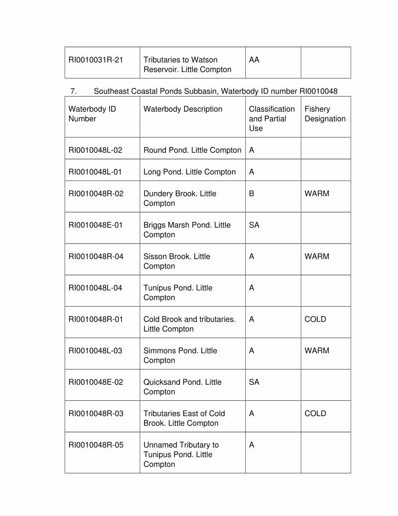
RI0010031R-21 Tributaries to Watson Reservoir. Little Compton
AA
7. Southeast Coastal Ponds Subbasin, Waterbody ID number RI0010048
Waterbody ID
Number
Waterbody Description Classification
and Partial Use
Fishery
Designation
RI0010048L-02 Round Pond. Little Compton A
RI0010048L-01 Long Pond. Little Compton A
RI0010048R-02 Dundery Brook. Little Compton
B WARM
RI0010048E-01 Briggs Marsh Pond. Little Compton
SA
RI0010048R-04 Sisson Brook. Little Compton
A WARM
RI0010048L-04 Tunipus Pond. Little Compton
A
RI0010048R-01 Cold Brook and tributaries. Little Compton
A COLD
RI0010048L-03 Simmons Pond. Little Compton
A WARM
RI0010048E-02 Quicksand Pond. Little Compton
SA
RI0010048R-03 Tributaries East of Cold Brook. Little Compton
A COLD
RI0010048R-05 Unnamed Tributary to Tunipus Pond. Little
Compton
A

RI0010048R-06 Unnamed Tributary #1. Little Compton
A
RI0010048R-08 Tributaries to Briggs Marsh Pond. Little Compton
A
8. Block Island Waters Subbasin, Waterbody ID number RI0010046
Waterbody ID
Number
Waterbody Description Classification
and Partial Use
Fishery
Designation
RI0010046C-01 Coastal Waters off the shoreline of Block Island
extending seaward to 10 meters in depth exclusive of
the waters in RI0010046E-02A, RI0010046E-02B,
RI0010046E-02C, and RI0010046E-02D.
SA
RI0010046L-03 Sachem Pond. New Shoreham
A
RI0010046L-04 Middle Pond. New Shoreham
A
RI0010046E-01A Great Salt Pond north of a line from the northern most
extremity of Cormorant Point to the northern most
landward dock located at the Block Island Club. New
Shoreham
SA
RI0010046E-01B Great Salt Pond south of a
line from the northern most extremity of Cormorant
Point to the northern most landward dock located at
the Block Island Club excluding the waters
described in waterbody
SA{b}

ID#s RI0010046E-01C and RI0010046E-01D. New
Shoreham
RI0010046E-01C Great Salt Pond, Trim’s
Pond and Harbor Pond NewShoreham
SA{b}
RI0010046E-01D Great Salt Pond waters south of a line from the end
of Payne’s Dock to the end of Block Island Marina dock.
New Shoreham
SA{b}
RI0010046E-02A Block Island Waters in the
vicinity of Pebbly Beach, within a 500 foot radius of
the New Shoreham marine sewer outfall. New
Shoreham
SB1
RI0010046E-02B Block Island Waters in the
vicinity of Pebbly Beach exclusive of the waters
described in RI0010046E-02A, which are within 1000
feet of the New Shoreham marine sewer outfall to a
point 1000 feet south of the marine sewer outfall. New
Shoreham
SB
RI0010046E-02C Block Island Waters in the
vicinity of Old Harbor west of a line from the fixed red
light at the end of the northern breakwater to the
seaward end of the southern breakwater. New
Shoreham
SB
RI0010046E-02D* Block Island Waters along
the eastern coast exclusive
SA

of the waters described in RI0010046E-02A,
RI0010046E-02B, and RI0010046E-02C, which are
within 5,900 feet of the NewShoreham marine sewer
outfall. Block Island
RI0010046L-02@ Fresh Pond. New
Shoreham
AA
RI0010046L-01@ Sands Pond. New
Shoreham
AA
RI0010046M-01 Waters greater than 10
meters in depth to three miles offshore off the
shoreline of Block Island exclusive of the waters in
RI0010046E-02A, RI0010046E-02B,
RI0010046E-02C, and RI0010046E-02D.
SA
Rhode Island Sound. Block
Island Sound.
.
SA
1.26 RIDEM Ambient Water Quality Criteria and Guidelines for Toxic
Pollutants
A. General - Section 304(a)(1) of the Clean Water Act, 33 U.S.C. § 1314, requires the USEPA to develop and publish water quality criteria. The USEPA has
published criteria for a number of the pollutants listed pursuant to Section 307(a)(1) of the Clean Water Act, 33 U.S.C. § 1317, as well as for other toxic
substances, based on available toxicological information on the pollutants. Section 303(c)(2)(B) of the Clean Water Act, 33 U.S.C. § 1313, requires States to
adopt numeric criteria to protect the uses of their waters from all toxic pollutants listed pursuant to Section 307(a)(1) (33 U.S.C. § 1317) for which criteria have
been published pursuant to Section 304(a)(1) (33 U.S.C. § 1314), and which are present, or could reasonably be expected to be present, at levels that would

impair the uses. A complete list of “priority pollutants” is contained in 40 C.F.R. § 423, incorporated above in § 1.3(G) of this Part. § 1.26 of this Part contains the
ambient chemical-specific numeric criteria and guidelines for aquatic life and human health which satisfies the requirements of Section 303(c)(2)(B) (33 U.S.C.
§ 1313). Certain criteria in the table have been modified and approved by EPA in accordance with applicable EPA guidance.
B. § 1.26(J) of this Part contains the acute and chronic aquatic life criteria and minimum data base guidelines for freshwater and saltwater and two sets of
human health criteria.
1. The first column of human health criteria represents criteria applicable to
waters where the designated route of exposure is due to consumption of drinking water and aquatic organisms.
2. The second column under human health represents criteria applicable to waters where the designated route of exposure is due only to consumption
of aquatic organisms.
C. For parameters which have both aquatic life and human health criteria or
guidelines, the applicable criteria or guideline is determined by using the more stringent of the aquatic life or human health criteria or guidelines, according to
the use of the waterbody.
D. Aquatic Life Criteria - The aquatic life criteria in § 1.26(J) of this Part represents
the EPA water quality criteria for the protection of aquatic life, pursuant to Section304(a) of the Clean Water Act, 33 U.S.C. § 1314, for acute and chronic exposure
to toxics in freshwater and saltwater. These toxics are priority metals, organics, pesticides, PCBs, and cyanide.
1. To protect aquatic life, the one hour average concentration of a pollutant should not exceed the acute criteria more than once every three years on
the average.
a. An exclusion to this rule are the pesticides and PCBs acute criteria
which are considered instantaneous values (§§ 1.26(J)(1) of this Part 1.26(J) of this Part).
2. The four day average concentration of a pollutant should not exceed the chronic criteria more than once every three years on the average.
3. These aquatic life criteria shall be achieved in all waters, except mixing zones, regardless of the waters' classification.
4. The acute and chronic aquatic life criteria for freshwaters shall not be exceeded at or above the lowest average 7 consecutive day low flow with
an average recurrence frequency of once in 10 years (7Q10).

5. For non-flowing freshwaters, the acute and chronic aquatic life criteria shall not be exceed under the most adverse conditions which will be
determined on a case-by case basis.
6. The acute and chronic aquatic life criteria for seawater shall not be
exceeded beyond the boundary of the mixing zone(s), as defined and determined by §§ 1.10(B)(5) and 1.10(B)(6) of this Part, and thence
throughout the waterbody.
a. If a mixing zone has not been established, these criteria shall not
be exceeded in any portion of the receiving water.
7. For purposes of calculating freshwater aquatic life criteria for metals from
the equations in § 1.26(M) of this Part, the ambient hardness values shall be used, and shall be consistent with the design flow conditions
established by § 1.10 of this Part.
8. For waters in which the salinity is equal to or less than one part per
thousand, the applicable criteria are the freshwater criteria.
9. For waters in which the salinity is equal to or greater than ten parts per
thousand, the applicable criteria are the saltwater criteria.
10. For waters in which the salinity is between one and ten parts per thousand
(brackish), the applicable criteria are the more stringent of the freshwater or saltwater criteria. However, for those waters between one and ten parts
per thousand (brackish), the Department may deviate from the general rule if scientifically defensible information and data demonstrates that on a
site-specific basis the biology of the waterbody is dominated by freshwateraquatic life and that freshwater criteria are more appropriate; or
conversely, the biology of the waterbody is dominated by saltwater aquaticlife and that saltwater criteria are more appropriate.
11. The acute and chronic freshwater criteria for 10 metals and the acute and chronic saltwater criteria for 11 metals listed in § 1.26(J) of this Part are
presented as dissolved metal criteria (see #5 and #6 § 1.26(J)(1) of this Part). For these metals, the dissolved metal, as opposed to the total
recoverable metal, more closely approximates the bioavailable fraction of the metal in the water column.
E. Human Health Criteria - The human health criteria in § 1.26(J) of this Part represent the highest concentration of a pollutant in surface waters that is not
expected to pose a significant risk to human health as determined by EPA. For almost all of the pollutants, bioaccumulation properties are used to assess the
relative extent of human exposure to the pollutant either directly through ingestion or indirectly through consumption of aquatic organisms. These criteria
represent the chronic criteria necessary to protect human health.

1. Ambient water quality criteria for human health are primarily based on two types of biological endpoints:
a. Carcinogenicity and;
b. Toxicity (i.e., all other adverse effects other than cancer).
2. There are essentially two procedures for assessing health effects; one which addresses carcinogens and one which addresses non-carcinogens.
The reason for having two methodologies is that, for the purpose of deriving ambient water quality criteria, carcinogenicity is regarded as a
non-threshold phenomenon, whereas toxicity is regarded as having a threshold below which there will not be an effect.
a. For those toxic substances which are identified as carcinogens, the criteria have been established at a risk level of 10-5 assuming a
lifetime exposure to a 70 kg male consuming 17.5 grams per day offish and shellfish product and ingesting 2.0 liters of water per day.
b. For those toxic substances which are identified as non-carcinogens, the human health criteria are best estimates of
concentrations which are not expected to produce adverse effects in human health assuming a lifetime exposure of a 70 kg male
consuming 17.5 grams per day of fish and shellfish products and ingesting 2.0 liters of water per day.
3. The concentration of these pollutants should not exceed criteria under stream conditions that represent long-term average conditions.
a. The stream design flow to be used to implement both carcinogen and noncarcinogen human health criteria is the harmonic mean
flow which is a long term mean flow value calculated by dividing thenumber of daily flows analyzed by the sum of the reciprocals of
those daily flows.
b. For non-flowing freshwaters, the human health criteria shall not be
exceed under the most adverse conditions which will be determinedon a case-by case basis.
4. For seawaters, the ambient human health water quality criteria for carcinogens and non-carcinogens are applicable when the most adverse
hydrographic and pollution conditions occur at the particular point of evaluation.
F. Ammonia Criteria – The criteria presented in § 1.26 (L) of this Part represent the ammonia criteria for aquatic life use.
1. Averaging Periods and Frequency of Exceedances

a. Chronic criteria - The ambient concentration, averaged over a period of 30 days, shall not exceed the chronic criterion more than
once every three years on average. The highest four-day average ambient concentration should not exceed a concentration 2.5 times
greater than the chronic criterion.
b. Acute – The ambient concentrations, averaged over one hour shall
not exceed the acute criterion more than once every three years onaverage.
2. Early Life Stage Absent (ELS-Absent) Provision
a. This provision allows for a relaxation of the chronic criteria when
early life stages (ELS) of fish are not present, since at low ambient water temperatures, adult and juvenile fish are less sensitive to
ammonia toxicity than are early life stages of fish. As ambient watertemperature decreases, it is appropriate to relax the ammonia
chronic criterion in waterbodies where it is determined, to the Director’s satisfaction, that early life stages are not present. The
chronic criteria applicable when ELS are absent are found in § 1.26(L)(1)(c) of this Part.
b. The Director has determined that the ELS-Absent Provision appliesto:
(1) The entire Blackstone River during the period November 1 toApril 30.
(2) The main stem of the Pawtuxet River during the period November 1 to April 30.
(3) The Woonasquatucket River from Georgiaville Pond to the confluence with the Mosshasuck River during the period
November 1 to April 30.
G. Site Specific Criteria
1. Criteria, 40 C.F.R. § 131.11(b)(1)(ii) provides States with the opportunity to adopt water quality criteria that are modified to reflect local
environmental conditions. Certain criteria are developed as site specific criteria in accordance with State and EPA procedures and guidance.
a. Aquatic life criteria may be subject to site-specific modification procedures. Aquatic life guidelines may be modified following the
procedures outlined in § 1.26(H) of this Part.
(1) Aquatic life site specific criteria modification procedures are
based on EPA's "Interim Guidance on Determination and
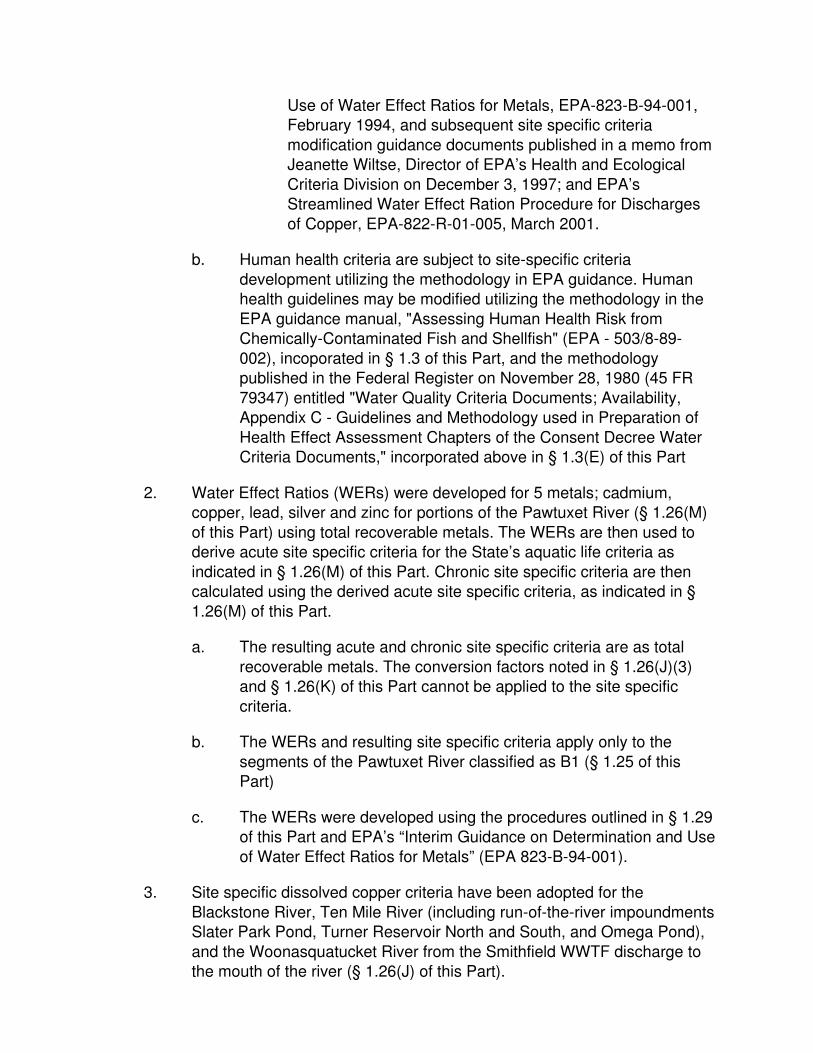
Use of Water Effect Ratios for Metals, EPA-823-B-94-001, February 1994, and subsequent site specific criteria
modification guidance documents published in a memo from Jeanette Wiltse, Director of EPA’s Health and Ecological
Criteria Division on December 3, 1997; and EPA’s Streamlined Water Effect Ration Procedure for Discharges
of Copper, EPA-822-R-01-005, March 2001.
b. Human health criteria are subject to site-specific criteria
development utilizing the methodology in EPA guidance. Human health guidelines may be modified utilizing the methodology in the
EPA guidance manual, "Assessing Human Health Risk from Chemically-Contaminated Fish and Shellfish" (EPA - 503/8-89-
002), incoporated in § 1.3 of this Part, and the methodology published in the Federal Register on November 28, 1980 (45 FR
79347) entitled "Water Quality Criteria Documents; Availability, Appendix C - Guidelines and Methodology used in Preparation of
Health Effect Assessment Chapters of the Consent Decree Water Criteria Documents," incorporated above in § 1.3(E) of this Part
2. Water Effect Ratios (WERs) were developed for 5 metals; cadmium, copper, lead, silver and zinc for portions of the Pawtuxet River (§ 1.26(M)
of this Part) using total recoverable metals. The WERs are then used to derive acute site specific criteria for the State’s aquatic life criteria as
indicated in § 1.26(M) of this Part. Chronic site specific criteria are then calculated using the derived acute site specific criteria, as indicated in §
1.26(M) of this Part.
a. The resulting acute and chronic site specific criteria are as total
recoverable metals. The conversion factors noted in § 1.26(J)(3) and § 1.26(K) of this Part cannot be applied to the site specific
criteria.
b. The WERs and resulting site specific criteria apply only to the
segments of the Pawtuxet River classified as B1 (§ 1.25 of this Part)
c. The WERs were developed using the procedures outlined in § 1.29 of this Part and EPA’s “Interim Guidance on Determination and Use
of Water Effect Ratios for Metals” (EPA 823-B-94-001).
3. Site specific dissolved copper criteria have been adopted for the
Blackstone River, Ten Mile River (including run-of-the-river impoundmentsSlater Park Pond, Turner Reservoir North and South, and Omega Pond),
and the Woonasquatucket River from the Smithfield WWTF discharge to the mouth of the river (§ 1.26(J) of this Part).

H. Freshwater Minimum Data Base Guidelines - RIDEM has derived freshwater guidelines for many pollutants for which EPA water quality criteria are not
available. In order for guidelines to be derived, the toxicity data base for the pollutants must meet minimum requirements. These guidelines are given in §
1.26(J) of this Part and are marked with an asterisk (*), which is in § 1.26(J)(1) of this Part. The data base must contain at least two acute toxicity test results
expressed as either an EC50 or an LC50. The two acute toxicity test results shallconsist of:
1. One daphnid (D. magna or D. pulex)
2. One fish, either:
a. fathead minnow (Pimephales promelas)
b. bluegill (Lepomis macrochirus)
c. rainbow trout (Salmo gairdneri)
3. For every pollutant which meets these minimum data requirements, acute
and chronic guidelines are derived using the following equations:
a. The uncertainty factor, 0.05, is intended to provide an adequate
margin of safety to protect most aquatic organisms from acutely toxic effects.
b. The acute guideline is divided by an acute to chronic ratio of 45 to yield the chronic guideline.
I. Priority Pollutants Without Criteria or Guidelines - Any pollutant listed on the mostrecent EPA priority pollutant list published in accordance with Section 307(a)(1)
of the Clean Water Act, 33 U.S.C. § 1317 (listed in 126 Priority Pollutants, 40 C.F.R. § 423, incorporated above in § 1.3(G) of this Part) or additional criteria
EPA has established for non-priority pollutants, for which there is no RIDEM ambient water quality criteria or guideline, shall be regulated in accordance with
§§ 1.8(D)(2) and (3) of this Part.

J. Table of Acute and Chronic Aquatic Life Criteria and Minimum Database Guidelines for Freshwater and Saltwater and Human Health Criteria
1. Priority Pollutant: Toxic Metals and Cyanide
CHEMICAL
NAME
CAS
Number
AQUATIC LIFE CRITERIA (µg/l) CARCINOGEN HUMAN HEALTH
CRITERIA (µg/l)2
FRESHWATER SALTWATER For Consumption of:
ACUTE
CHRONIC
ACUTE
CHRONIC
Water andAquatic
Organisms
Aquatic Organism
s Only
Antimony 7440360 450* 10* - - No 5.6 640
Arsenic5,6 7440382 340 150 69 36 Yes 0.18 1.4
Asbestos 1332214 - - - - Yes 7x10⁶ fibers/l
Beryllium 7440417 7.5* 0.17* - - Yes - -
Cadmium 5,6 7440439 @ @ 40 8.8 No - -
Chromium III 5 1606583 @ @ - - No - -

Chromium VI 5,6
18540299 16 11 1100 50 No - -
Copper 5,6 7440508 @ @ 4.8 3.1 No 1300 -
Copper (Site
Specific) 7
7440508 20.41 14.45 - - No 1300 -
Cyanide 57125 22 5.2 1.0 1.0 No 140 140
Lead 5,6 7439921 @ @ 210 8.1 No - -
Mercury 5,6 7439976 1.4 0.77 1.8 0.94 No 0.14 0.15
Nickel 5,6 7440020 @ @ 74 8.2 No 610 4600
Selenium 6 7782492 20 5 290 71 No 170 4200
Silver 5,6 7440224 @ - 1.9 - No - -
Thallium 7440280 46* 1.0* - - No 0.24 0.47
Zinc 5,6 7440666 @ @ 90 81 No 7400 26000
2. Priority Pollutant: Volatile Organic Compounds
CHEMICAL NAME CAS AQUATIC LIFE CRITERIA (µg/l) CARCINOGEN HUMAN HEALTH

Number
? CRITERIA (µg/l)2
For Consumption of:
FRESHWATER SALTWATER Water andAquatic
Organisms
Aquatic Organism
s OnlyACUT
E
CHRONI
C
ACUT
E
CHRONI
C
Acrolein 107028 2.9* 0.06* - - No 190 290
Acrylonitrile 107131 378* 8.4* - - Yes 0.51 2.5
Benzene 71432 265* 5.9* - - Yes 22 510
Bromoform 75252 1465* 33* - - Yes 43 1400
Carbon Tetrachloride 56235 1365* 30* - - Yes 2.3 16
Chlorobenzene 108907 795* 18* - - No 130 1600
Chlorodibromomethan
e
124481 4.0 130
Chloroform 67663 1445* 32* - - Yes 57 4700
Dichlorobromomethane 75274 - - - - Yes 5.5 170

1,2-Dichloroethane 107062 5900* 131* - - Yes 3.8 370
1,1-Dichloroethylene 75354 580* 13* - - Yes 330 7100
1,2-Dichloropropane 78875 2625* 58* - - Yes 5.0 150
1,3-Dichloropropene 542756 - - - - No 0.34 21
Ethylbenzene 100414 1600* 36* - - No 530 2100
Methyl bromide 74839 - - - - No 47 1500
Methyl chloride 74873 - - - - Yes - -
Methylene chloride 75092 9650* 214* - - Yes 46 5900
1,1,2,2-tetrachloroethane
79345 466* 10* - - Yes 1.7 40
Tetrachloroethylene 127184 240* 5.3* - - Yes 6.9 33
Toluene 108883 635* 14* - - No 1300 15 mg/l
1,2-trans-dichloroethylene
156605 - - - - No 140 10 mg/l
1,1,1-trichloroethane 71556 - - - - No - -

1,1,2-trichloroethane 79005 900* 20* - - Yes 5.9 160
Trichloroethylene 79016 1950* 43* - - Yes 25 300
Vinyl chloride 75014 - - - - Yes 0.025 2.4
3. Priority Pollutants: Acid Organic Compounds
CHEMICAL NAME CAS Number
AQUATIC LIFE CRITERIA (µg/l) CARCINOGEN? HUMAN HEALTH CRITERIA (µg/l)2
For Consumption of:
FRESHWATER SALTWATER Water and
Aquatic Organism
s
Aquatic
Organisms OnlyACUT
ECHRONIC
ACUTE
CHRONIC
2-chlorophenol 95578 129* 2.9* - - No 81 150
2,4-dichlorophenol 120832 101* 2.2* - - No 77 290
2,4-dimethylphenol 105679 106* 2.4* - - No 380 850
2-methyl-4,6-
dinitrophenol
534521 13 280
2,4-dinitrophenol 51285 31* 0.69* - - No 69 5300

4-nitrophenol 88755 - - - - - -
Pentachlorophenol 87865 @ @ 13 7.9 Yes 2.7 30
Phenol 108952 251* 5.6* - - No 21 mg/l 1700 mg/l
2,4,6-
trichlorophenol
88062 16* 0.36* - - Yes 14 24
4. Priority Pollutants: Base Neutral Compounds
CHEMICAL NAME CAS Numbe
r
AQUATIC LIFE CRITERIA (µg/l) CARCINOGEN?
HUMAN HEALTH CRITERIA (µg/l)2
For Consumption of:
FRESHWATER SALTWATER Water and
Aquatic Organism
s
Aquatic
Organisms OnlyACUT
ECHRONIC
ACUTE
CHRONIC
Acenapthene 83329 85* 1.9* - - No 670 990
Anthracene 120127 - - - - No 8300 40 mg/l
Benzidine 92875 - - - - Yes 0.86 ng/l 2.0 ng/l
Polycyclic Aromatic - - - - Yes 0.038 0.18

Hydrocarbons4
Bis(2-Chloroethyl)ether 111444 - - - - Yes 0.30 5.3
Bis(2-Chloroisopropyl)ether 108601 - - - - No 1400 65 mg/l
Bis(2-Ethylhexyl)phthalate 117817 555* 12* - - Yes 12 22
Butyl Benzyl Phthalate 85687 85* 1.9* No 1500 1900
2-Chloronaphthalene 91587 - - - - No 1000 1600
1,2-Dichlorobenzene 95501 79* 1.8* - - No 420 1300
1,3-Dichlorobenzene 541731 390* 8.7* - - No 320 960
1,4-Dichlorobenzene 106467 56* 1.2* - - No 63 190
3,3’-Dichlorobenzidene 91941 - - - - Yes 0.21 0.28
Diethyl Phthalate 84662 2605* 58* - - No 17 mg/l 44 mg/l
Dimethyl Phthalate 131113 1650* 37* - - No 270 mg/l 1.1 g/l
Di-n-Butyl Phthalate 84742 - - - - No 2000 4500
2,4-Dinitrotoluene 121142 1550* 34* - - Yes 1.1 34

1,2-Diphenylhydrazine 122667 14* 0.31* - - Yes 0.36 2.0
Fluoranthene 206440 199* 4.4* - - No 130 140
Fluorene 86737 - - - - No 1100 5300
Hexachlorobenzene 118741 - - - - Yes 2.8 ng/l 2.9 ng/l
Hexachlorobutadiene 87683 - - - - Yes 4.4 180
Hexachlorocyclopentadien
e
77474 0.35* 0.008* - - No 40 1100
Hexachloroethane 67721 49* 1.1* - - Yes 14 33
Isophorone 78591 5850* 130* - - Yes 350 9600
Napthalene 91203 115* 2.6* - - - -
Nitrobenzene 98953 1350* 30* - - No 17 690
N-Nitrosodimethylamine 62759 - - - - Yes 6.9 ng/l 30
N-Nitrosodi-N-Propylamine 621647 - - - - Yes 0.05 5.1
N-Nitrosodiphenylamine 86306 293* 6.5* - - Yes 33 60

Pyrene 129000 - - - - No 830 4000
1,2,4-Trichlorobenzene 120821 75* 1.7* - - 35 70
5. Priority Pollutants: Pesticides/PCBs
CHEMICAL
NAME
CAS Number AQUATIC LIFE CRITERIA (µg/l) CARCINOGEN? HUMAN HEALTH
CRITERIA (µg/l)2
For Consumption of:
FRESHWATER SALTWATER Water andAquatic
Organisms
Aquatic Organism
s OnlyACUT
E
CHRONI
C
ACUT
E
CHRONI
C
Aldrin 309002 3.0$ - 1.3$ - Yes 0.49 ng/l 0.5 ng/l
alpha BHC 319846 - - - - Yes 26 ng/l 49 ng/l
beta BHC 319857 - - - - Yes 91 ng/l 170 ng/l
gamma BHC (Lindane)
58899 0.95$ 0.16$ - Yes 0.98 1.8
Chlordane 57749 2.4$ 0.0043 0.09$ 0.004 Yes 8.0 ng/l 8.1 ng/l
4,4-DDT 50293 1.1$ 0.001 0.13$ 0.001 Yes 2.2 ng/l 2.2 ng/l

4,4-DDE 72559 - - - - Yes 2.2 ng/l 2.2 ng/l
4,4-DDD 72548 - - - - Yes 3.1 ng/l 3.1 ng/l
Dieldrin 60571 0.24 0.056 0.71$ 0.0019 Yes 0.52 ng/l 0.54 ng/l
Endosulfan alpha 959988 0.22$ 0.056 0.034$ 0.0087 No 62 89
Endosulfan, beta 33213659 0.22$ 0.056 0.034$ 0.0087 62 89
Endosulfan
(sulfate)
1031078 - - - - No 62 89
Endrin 72208 0.086$ 0.036 0.037$ 0.0023 No 0.059 0.06
Endrin Aldehyde 7421934 - - - - No 0.29 0.30
Heptachlor 76448 0.52$ 0.0038 0.053$ 0.0036 Yes 0.79 ng/l 0.79 ng/l
Heptachlor Epoxide
1024573 0.52$ 0.0038 0.053$ 0.0036 Yes 0.39 ng/l 0.39 ng/l
Polychlorinated Biphenyls
(PCBs)3
1336363 - 0.014 - 0.03 Yes 0.64 ng/l 0.64 ng/l
2,3,7,8-TCDD 1746016 - - - - Yes 5 x 10⁻⁸ 5.1 x 10⁻⁸

(Dioxin)
Toxaphene 8001352 0.73 0.0002 0.21 0.0002 Yes 2.8 ng/l 2.8 ng/l
Tributyltin ** 0.46 0.072 0.42 0.0074 No - -
6. Non Priority Pollutants: Other Substances
CHEMICAL NAME CAS Number
AQUATIC LIFE CRITERIA (µg/l) CARCINOGEN? HUMAN HEALTH CRITERIA (µg/l)2
For Consumption of:
FRESHWATER SALTWATER Water and
Aquatic Organism
s
Aquatic
Organisms OnlyACUTE CHRONI
CACUTE
CHRONIC
Aluminum 7429905 750^ 87^ - - - -
Ammonia 7664417 # # # # No - -
4-Bromophenyl Phenyl Ether
18* 0.4* - - - -
Chloride 16887006 860,000
230,000

Chlorine 7782505 19 11 13 7.5
4-Chloro-2-
Methylphenol
15* 0.32* - - - -
1-Chloronaphthalene 80* 1.8* - - - -
4-Chlorophenol 106489 192* 4.3* - - - -
2,4-Dichloro-6-
Methylphenol
22* 0.48* - - - -
1,1-Dichloropropane 1150* 26* - - - -
1,3-Dichloropropane 142289 303* 6.7* - - - -
2,3-Dinitrotoluene 17* 0.37* - - - -
2,4-Dinitro-6-Methyl Phenol
12 0.26 - - - -
Iron 7439896 1000 300
Pentachlorobenzene 608935 13* 0.28* - - - -
Pentachloroethane 362* 8.0* - - - -

1,2,3,5-Tetrachlorobenzene
321* 7.1* - - - -
1,1,1,2-Tetrachloroethane
630206 980* 22* - - - -
2,3,4,6-Tetrachlorophenol
58902 7* 0.16* - - - -
2,3,5,6-Tetrachlorophenol
8.5* 0.19* - - - -
2,4,5-Trichlorophenol
95954 23* 0.51* - - - -
2,4,6-Trinitrophenol 88062 4235 94 - - - -
Xylene 1330207 133* 3.0* - -

7. Key for § 1.26(J) of this Part
Symbol Meaning
* RIDEM minimum database guidelines.
**
Only data generated in toxicity and bioconcentration tests on TBTCl (tributyltin chloride; CAS 1461-22-9), TBTF (tributyltin floride; CAS 1983-10-
4), TBTO [bis(tributyltin) oxide; CAS 56-35-9], commonly called “tributyltin oxide” and TBTS[bis(tributyltin) sulfide; CAS 4808-30-4], commonly called
“tributyltin sulfide” were used in the derivation of the water quality criteria concentrations for aquatic life presented herein. All concentrations from
such tests are expressed as TBT, not as tin and not as the chemical tested.
^
Freshwater criteria for aluminum are for waters in which the pH is between
6.5 and 9
# See § 1.26(L) of this Part for ammonia criteria
@ See § 1.26(K) of this Part for criteria equations
- No criteria recommendation.
$
The aquatic life criteria for these compounds were issued in 1980 utilizing the 1980 Guidelines for criteria development. The acute values shown are
final acute values which, by the 1980 Guidelines, are instantaneous values as contrasted with a Criteria Maximum Concentration (CMC)which is a one-
hour average.
1 Carcinogens calculated at 10-5 risk
2Criteria are in µg/l unless otherwise noted: µg/l = micrograms/liter, ng/l = nanograms/liter, mg/l = milligrams/liter
3Polychlorinated Biphenyl criteria apply to total PCBs (e.g. the sum of all cogener or all isomer or homolog or Aroclor analyses.)
4 Polycyclic Aromatic Hydrocarbons criteria apply to each of the following: indeno(1,2,3-cd)pyrene (CAS Number 193395), dibenzo(ah)anthracene
(CAS Number 53703), benzo(a)anthracene (CAS Number 56553), benzo(a)pyrene (CAS Number 50328), benzo(b)fluoranthene (CAS Number

205992), benzo(k)fluoranthene (CAS Number 207089), chrysene (CAS
Number 218019)
5
Freshwater aquatic life criteria values in § 1.26(J) of this Part for the
following parameters are presented as dissolved criteria using the EPA recommended conversion factors (CF), as listed in § 1.26(J)(2) of this Part
6
Saltwater aquatic life criteria values in § 1.26(J) of this Part for the following parameters are presented as dissolved criteria using the EPA
recommended conversion factors, as listed in § 1.26(J)(3) of this Part
7
Site specific criteria for dissolved copper apply for the following waters:
Blackstone River (RI0001003R-01A and RI0001003R-01B) From the MA/RI border to the mouth of the river, Ten Mile River (RI0004009R-01A and
RI0004009R-01B) From the MA/RI border to the mouth of the river includingSlater Park Pond (included in Ten Mile River (RI0004009R-01A), Turner
Reservoir North (RI0004009L-01A) and South (RI0004009L-01B), and Omega Pond (RI0004009L-03). Woonasquatucket River (RI0002007R-10C
and RI0002007R-10D) From the Smithfield WWTF discharge to confluence with Moshassuck River.
8. Table of EPA Recommended Conversion Factors (CF)-Freshwater Values
Metal Acute CF Chronic CF
Arsenic 1.000 1.000
Cadmium 1.136672 - [(ln H) x 0.041838] 1.101672 - [(ln H) x 0.041838]
ChromiumIII
0.316 0.86
ChromiumVI
0.982 0.962
Copper 0.96 0.96
Lead 1.46203 - [(ln H) x 0.145712] 1.46203 - [(ln H) x 0.145712]
Mercury 0.85 0.85

Nickel 0.998 0.997
Silver 0.85 (no freshwater criteria)
Zinc 0.978 0.986
NOTE: (ln H) = natural log of Hardness, using any hardness as appropriate.
9. Table of EPA Recommended Conversion Factors (CF)-Saltwater Values
Metal Conversion Factor
Arsenic 1
Cadmium 0.994
Chromium III (no saltwater criteria)
Chromium VI 0.993
Copper 0.83
Lead 0.951
Mercury 0.85 (see Note below)
Nickel 0.99
Selenium 0.998
Silver 0.85
Zinc 0.946

Note: Conversion factors on this table were calculated for acute criteria only. Conversion factors for chronic criteria are
not currently available. In the absence of chronic conversion factors saltwater acute conversion factors are used. Chronic
criteria for mercury cannot be converted to dissolved because it is based on mercury residues rather than toxicity.
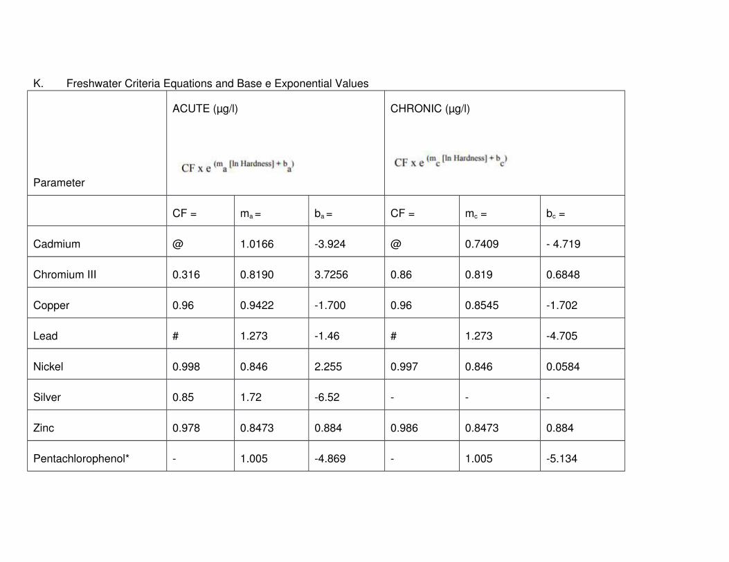
K. Freshwater Criteria Equations and Base e Exponential Values
Parameter
ACUTE (µg/l) CHRONIC (µg/l)
CF = ma = ba = CF = mc = bc =
Cadmium @ 1.0166 -3.924 @ 0.7409 - 4.719
Chromium III 0.316 0.8190 3.7256 0.86 0.819 0.6848
Copper 0.96 0.9422 -1.700 0.96 0.8545 -1.702
Lead # 1.273 -1.46 # 1.273 -4.705
Nickel 0.998 0.846 2.255 0.997 0.846 0.0584
Silver 0.85 1.72 -6.52 - - -
Zinc 0.978 0.8473 0.884 0.986 0.8473 0.884
Pentachlorophenol* - 1.005 -4.869 - 1.005 -5.134

1. Hardness values in § 1.26(K) of this Part are in mg/l as CaCO3
2. Key for § 1.26(K) of this Part
Symbol Meaning
*
substitute pH for hardness in the equations for
pentachlorophenol
- no recommended value
@
Cadmium conversion Factors:
acute CF = 1.136673 - [(ln H) x 0.041838)]
chronic CF = 1.101672 - [(ln H) x 0.041838]
[ln H] natural log of hardness
#
Lead conversion factors
acute and chronic CF = 1.46203 - [(ln H) x 0.145712]
NOTE: When an ambient hardness of less than 25 mg/l is used to establish for lead or cadmium, the hardness dependent Conversion
Factor (CF) should not exceed one.

L. Ammonia Criteria
1. Freshwater
a. Acute Criteria as Total Ammonia Nitrogen (mg N/L)
pH
Acute Criterion with
Salmonids present
Acute Criterion with
Salmonids absent
6.5 32.6 48.8
6.6 31.3 46.8
6.7 29.8 44.6
6.8 28.1 42.0
6.9 26.2 39.1
7.0 24.1 36.1
7.1 22.0 32.8
7.2 19.7 29.5
7.3 17.5 26.2
7.4 15.4 23.0
7.5 13.3 19.9
7.6 11.4 17.0
7.7 9.65 14.4
7.8 8.11 12.1
7.9 6.77 10.1
8.0 5.62 8.40

8.1 4.64 6.95
8.2 3.83 5.72
8.3 3.15 4.71
8.4 2.59 3.88
8.5 2.14 3.20
8.6 1.77 2.65
8.7 1.47 2.20
8.8 1.23 1.84
8.9 1.04 1.56
9.0 0.885 1.32
b. Chronic Criteria for Fish Early Life Stages Present, mg N/L
Temperature and pH-Dependent Values of the Chronic Criterion for Fish Early Life Stages Present
pH
Temperature, C
0 14 16 18 20 22 24 26 28 30
6.5 6.67 6.67 6.06 5.33 4.68 4.12 3.62 3.18 2.80 2.46
6.6 6.57 6.57 5.97 5.25 4.61 4.05 3.56 3.13 2.75 2.42
6.7 6.44 6.44 5.86 5.15 4.52 3.98 3.50 3.07 2.70 2.37
6.8 6.29 6.29 5.72 5.03 4.42 3.89 3.42 3.00 2.64 2.32
6.9 6.12 6.12 5.56 4.89 4.30 3.78 3.32 2.92 2.57 2.25

7.0 5.91 5.91 5.37 4.72 4.15 3.65 3.21 2.82 2.48 2.18
7.1 5.67 5.67 5.15 4.53 3.98 3.50 3.08 2.70 2.38 2.09
7.2 5.39 5.39 4.90 4.31 3.78 3.33 2.92 2.57 2.26 1.99
7.3 5.08 5.08 4.61 4.06 3.57 3.13 2.76 2.42 2.13 1.87
7.4 4.73 4.73 4.30 3.78 3.32 2.92 2.57 2.26 1.98 1.74
7.5 4.36 4.36 3.97 3.49 3.06 2.69 2.37 2.08 1.83 1.61
7.6 3.98 3.98 3.61 3.18 2.79 2.45 2.16 1.90 1.67 1.47
7.7 3.58 3.58 3.25 2.86 2.51 2.21 1.94 1.71 1.50 1.32
7.8 3.18 3.18 2.89 2.54 2.23 1.96 1.73 1.52 1.33 1.17
7.9 2.80 2.80 2.54 2.24 1.96 1.73 1.52 1.33 1.17 1.03
8.0 2.43 2.43 2.21 1.94 1.71 1.50 1.32 1.16 1.02 0.897
8.1 2.10 2.10 1.91 1.68 1.47 1.29 1.14 1.00 0.879 0.773
8.2 1.79 1.79 1.63 1.43 1.26 1.11 0.973 0.855 0.752 0.661
8.3 1.52 1.52 1.39 1.22 1.07 0.941 0.827 0.727 0.639 0.562
8.4 1.29 1.29 1.17 1.03 0.906 0.796 0.700 0.615 0.541 0.475
8.5 1.09 1.09 0.990 0.870 0.765 0.672 0.591 0.520 0.457 0.401
8.6 0.920 0.920 0.836 0.735 0.646 0.568 0.499 0.439 0.386 0.339
8.7 0.778 0.778 0.707 0.622 0.547 0.480 0.422 0.371 0.326 0.287
8.8 0.661 0.661 0.601 0.528 0.464 0.408 0.359 0.315 0.277 0.244
8.9 0.565 0.565 0.513 0.451 0.397 0.349 0.306 0.269 0.237 0.208

9.0 0.486 0.486 0.442 0.389 0.342 0.300 0.264 0.232 0.204 0.179
c. Chronic Criteria for Fish Early Life Stages Absent, mg N/L
Temperature and pH-Dependent Values of the CCC (Chronic Criterion) for Fish Early
Life Stages Absent
pH
Temperature, C
0-7 8 9 10 11 12 13 14 15* 16*
6.5 10.8 10.1 9.51 8.92 8.36 7.84 7.35 6.89 6.46 6.06
6.6 10.7 9.99 9.37 8.79 8.24 7.72 7.24 6.79 6.36 5.97
6.7 10.5 9.81 9.20 8.62 8.08 7.58 7.11 6.66 6.25 5.86
6.8 10.2 9.58 8.98 8.42 7.90 7.40 6.94 6.51 6.10 5.72
6.9 9.93 9.31 8.73 8.19 7.68 7.20 6.75 6.33 5.93 5.56
7.0 9.60 9.00 8.43 7.91 7.41 6.95 6.52 6.11 5.73 5.37
7.1 9.20 8.63 8.09 8.58 7.11 6.67 6.25 5.86 5.49 5.15
7.2 8.75 8.20 7.69 7.21 6.76 6.34 5.94 5.57 5.22 4.90
7.3 8.24 7.73 7.25 6.79 6.37 5.97 5.60 5.25 4.92 4.61
7.4 7.69 7.21 6.76 6.33 5.94 5.57 5.22 4.89 4.59 4.30
7.5 7.09 6.64 6.23 5.84 5.48 5.13 4.81 4.51 4.23 3.97
7.6 6.46 6.05 5.67 5.32 4.99 4.68 4.38 4.11 3.85 3.61
7.7 5.81 5.45 5.11 4.79 4.49 4.21 3.95 3.70 3.47 3.25
7.8 5.17 4.84 4.54 4.26 3.99 3.74 3.51 3.29 3.09 2.89
7.9 4.54 4.26 3.99 3.74 3.51 3.29 3.09 2.89 2.71 2.54

8.0 3.95 3.70 3.47 3.26 3.05 2.86 2.68 2.52 2.36 2.21
8.1 3.41 3.19 2.99 2.81 2.63 2.47 2.31 2.17 2.03 1.91
8.2 2.91 2.73 2.56 2.40 2.25 2.11 1.98 1.85 1.74 1.63
8.3 2.47 2.32 2.18 2.04 1.91 1.79 1.68 1.58 1.48 1.39
8.4 2.09 1.96 1.84 1.73 1.62 1.52 1.42 1.33 1.25 1.17
8.5 1.77 1.66 1.55 1.46 1.37 1.28 1.20 1.13 1.06 0.990
8.6 1.49 1.40 1.31 1.23 1.15 1.08 1.01 0.951 0.892 0.836
8.7 1.26 1.18 1.11 1.04 0.976 0.915 0.858 0.805 0.754 0.707
8.8 1.07 1.01 0.944 0.885 0.829 0.778 0.729 0.684 0.641 0.601
8.9 0.917 0.86 0.806 0.756 0.709 0.664 0.623 0.584 0.548 0.513
9.0 0.790 0.740 0.694 0.651 0.610 0.572 0.536 0.503 0.471 0.442
* At 15 C and above, the criterion for fish ELS absent is the same as the criterion for fish ELS present.
2. Saltwater: criteria as total ammonia (mg/l)
a. Acute Water Quality Criteria for Saltwater Aquatic Life Based on
Total Ammonia (mg/l).
Temperature, (°C)
0 5 10 15 20 25 30 35
pH Salinity = 10 g/kg
7.0 270 191 131 92 62 44 29 21

7.2 175 121 83 58 40 27 19 13
7.4 110 77 52 35 25 17 12 8.3
7.6 69 48 33 23 16 11 7.7 5.6
7.8 44 31 21 15 10 7.1 5.0 3.5
8.0 27 19 13 9.4 6.4 4.6 3.1 2.3
8.2 18 12 8.5 5.8 4.2 2.9 2.1 1.5
8.4 11 7.9 5.4 3.7 2.7 1.9 1.4 1.0
8.6 7.3 5.0 3.5 2.5 1.8 1.3 0.98 0.75
8.8 4.6 3.3 2.3 1.7 1.2 0.92 0.71 0.56
9.0 2.9 2.1 1.5 1.1 0.85 0.67 0.52 0.44
Salinity = 20 g/kg
7.0 291 200 137 96 64 44 31 21
7.2 183 125 87 60 42 29 20 14
7.4 116 79 54 37 27 18 12 8.7
7.6 73 50 35 23 17 11 7.9 5.6
7.8 46 31 23 15 11 7.5 5.2 3.5
8.0 29 20 14 9.8 6.7 4.8 3.3 2.3
8.2 19 13 8.9 6.2 4.4 3.1 2.1 1.6
8.4 12 8.1 5.6 4.0 2.9 2.0 1.5 1.1
8.6 7.5 5.2 3.7 2.7 1.9 1.4 1.0 0.77

8.8 4.8 3.3 2.5 1.7 1.3 0.94 0.73 0.56
9.0 3.1 2.3 1.6 1.2 0.87 0.69 0.54 0.44
Salinity = 30 g/kg
7.0 312 208 148 102 71 48 33 23
7.2 196 135 94 64 44 31 21 15
7.4 125 85 58 40 27 19 13 9.4
7.6 79 54 37 25 21 12 8.5 6.0
7.8 50 33 23 16 11 7.9 5.4 3.7
8.0 31 21 15 10 7.3 5.0 3.5 2.5
8.2 20 14 9.6 6.7 4.6 3.3 2.3 1.7
8.4 12.7 8.7 6.0 4.2 2.9 2.1 1.6 1.1
8.6 8.1 5.6 4.0 2.7 2.0 1.4 1.1 0.81
8.8 5.2 3.5 2.5 1.8 1.3 1.0 0.75 0.58
9.0 3.3 2.3 1.7 1.2 0.94 0.71 0.56 0.46
To convert these values to mg/liter N, multiply by 0.822
b. Chronic Water Quality Criteria for Saltwater Aquatic Life Based on Total Ammonia (mg/l).
Temperature (°C)
0 5 10 15 20 25 30 35
pH Salinity = 10 g/kg

7.0 41 29 20 14 9.4 6.6 4.4 3.1
7.2 26 18 12 8.7 5.9 4.1 2.8 2.0
7.4 17 12 7.8 5.3 3.7 2.6 1.8 1.2
7.6 10 7.2 5.0 3.4 2.4 1.7 1.2 0.84
7.8 6.6 4.7 3.1 2.2 1.5 1.1 0.75 0.53
8.0 4.1 2.9 2.0 1.40 0.97 0.69 0.47 0.34
8.2 2.7 1.8 1.3 0.87 0.62 0.44 0.31 0.23
8.4 1.7 1.2 0.81 0.56 0.41 0.29 0.21 0.16
8.6 1.1 0.75 0.53 0.37 0.27 0.20 0.15 0.11
8.8 0.69 0.50 0.34 0.25 0.18 0.14 0.11 0.08
9.0 0.44 0.31 0.23 0.17 0.13 0.10 0.08 0.07
Salinity = 20 g/kg
7.0 44 30 21 14 9.7 6.6 4.7 3.1
7.2 27 19 13 9.0 6.2 4.4 3.0 2.1
7.4 18 12 8.1 5.6 4.1 2.7 1.9 1.3
7.6 11 7.5 5.3 3.4 2.5 1.7 1.2 0.84
7.8 6.9 4.7 3.4 2.3 1.6 1.1 0.78 0.53
8.0 4.4 3.0 2.1 1.5 1.0 0.72 0.50 0.34
8.2 2.8 1.9 1.3 0.94 0.66 0.47 0.31 0.24
8.4 1.8 1.2 0.84 0.59 0.44 0.30 0.22 0.16
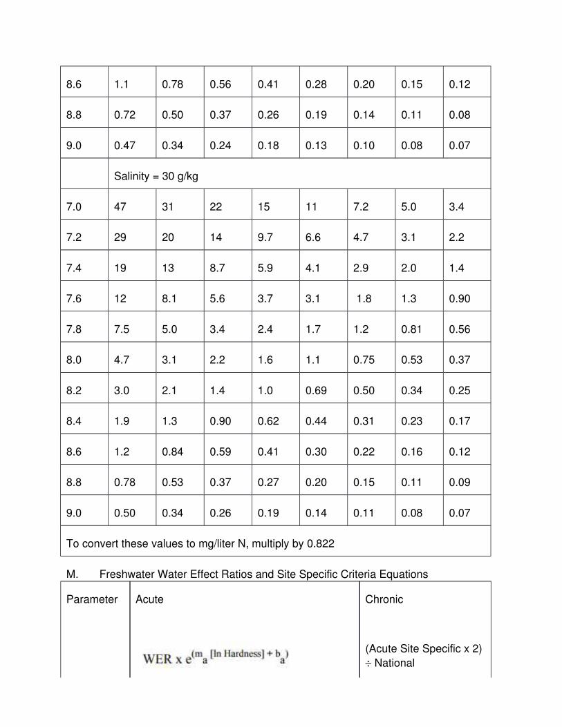
8.6 1.1 0.78 0.56 0.41 0.28 0.20 0.15 0.12
8.8 0.72 0.50 0.37 0.26 0.19 0.14 0.11 0.08
9.0 0.47 0.34 0.24 0.18 0.13 0.10 0.08 0.07
Salinity = 30 g/kg
7.0 47 31 22 15 11 7.2 5.0 3.4
7.2 29 20 14 9.7 6.6 4.7 3.1 2.2
7.4 19 13 8.7 5.9 4.1 2.9 2.0 1.4
7.6 12 8.1 5.6 3.7 3.1 1.8 1.3 0.90
7.8 7.5 5.0 3.4 2.4 1.7 1.2 0.81 0.56
8.0 4.7 3.1 2.2 1.6 1.1 0.75 0.53 0.37
8.2 3.0 2.1 1.4 1.0 0.69 0.50 0.34 0.25
8.4 1.9 1.3 0.90 0.62 0.44 0.31 0.23 0.17
8.6 1.2 0.84 0.59 0.41 0.30 0.22 0.16 0.12
8.8 0.78 0.53 0.37 0.27 0.20 0.15 0.11 0.09
9.0 0.50 0.34 0.26 0.19 0.14 0.11 0.08 0.07
To convert these values to mg/liter N, multiply by 0.822
M. Freshwater Water Effect Ratios and Site Specific Criteria Equations
Parameter Acute Chronic
(Acute Site Specific x 2)
÷ National

Acute:Chronic Ratio
WER@ ma = ba =National Acute:Chronic
Ratio
Cadmium 2.2 1.0166 -3.924 --
Copper 4.77 0.9422 -1.700 2.823
Lead 0.19 1.273 -1.46 51.29
Silver 2.85 1.72 -6.52 --
Zinc 1.63 0.8473 0.8840 2.208
@WER=Water Effect Ratio
--=no recommended value, use chronic value as calculated in Table 2.
1.27 The Implementation of the Antidegradation Provisions of the
Rhode Island Water Quality Regulations
A. Introduction - Antidegradation Standard
1. § 1.20 of this Part is based on the Federal Antidegradation Policy
requirements, 40 C.F.R. § 131.12 and adopted under the authority of R.I. Gen. Laws Chapters 46-12, 42-17.1 and 42-35.
2. Antidegradation is one of the minimum elements required in state water quality standards. The provisions of the State Antidegradation Regulations
have as their objective the maintenance and protection of various levels ofwater quality and uses.
3. The Rhode Island Antidegradation provisions consist of four (4) tiers of water quality protection which are defined in general terms in § 1.20 of this
Part.
B. Applicability - Antidegradation applies to all new or increased projects or activities
which may lower water quality or affect existing water uses, including but not limited to all 401 Water Quality Certification reviews and any new, reissued, or
modified RIPDES permits. This Antidegradation Implementation Policy describes

the general strategy the State will use to determine on a case-by-case basis whether, and to what extent, water quality may be lowered.
C. Preconditions for Implementation of Antidegradation Procedures
1. At the onset of the antidegradation review, a determination by the State, of
whether the proposed activity can be considered a new or increased activity, must be made.
a. A new activity in terms of application of this Antidegradation Implementation Policy shall refer to any activity which commenced
after November 28, 1975.
b. An increased activity shall refer to:
(1) A proposed increase in loadings to a waterbody.
(2) For discharges covered by existing RIPDES permits an
evaluation of an increased loading shall constitute a comparison of the present permit limit with the newly
calculated permit limit. If the new permit limit is less than or equal to the old limit, it would not be considered an
increased activity. If the comparison indicates that the new permit limit is greater than the old limit, it would be
considered an increased activity.
(3) An increase in a flow alteration over the existing use.
2. If the above evaluations result in a determination that the proposed activityis not a new or increased activity, then there would be no further review of
the proposed activity under the Antidegradation Implementation Policy. If the above evaluations result in a determination that the proposed activity
is a new or increased activity, then the activity will be reviewed for consistency with this Antidegradation Implementation Policy.
D. Antidegradation Protections for Tier 1 and Tier 2
1. Tier 1 - Protection of Existing Uses
a. General - This provision applies to all surface waters.
(1) An existing use can be established by demonstrating that a
use(s) has actually occurred since November 28, 1975, and the water quality is suitable to allow the existing use or;
(2) By demonstrating that although a designated use(s) has not occurred the water quality is suitable to allow such a use(s)

to occur, unless there are physical problems which prevent the use and which cannot be remedied.
b. Under Tier 1, a proposed activity or discharge cannot partially or completely eliminate any existing uses nor the water quality needed
to maintain and protect those uses.
c. The proposed activity cannot violate the class-specific criteria for
minimum water quality of the assigned water quality standard of a waterbody.
(1) The more stringent of instream aquatic life criteria or applicable human health criteria for toxic pollutants must be
met in all waters, regardless of the classification.
d. The Department may make requests for evidence/data for
applications of proposed activities or discharges in accordance with§ 1.27(E)(3) of this Part.
2. Tier 2 - Protection of Water Quality in High Quality Waters
a. General - In a waterbody where, for any parameter, the existing
water quality exceeds that level necessary to support the propagation of fish and wildlife and recreation in and on the waters,
regardless of the use designation, that water shall be considered high quality for that parameter.
(1) All parameters do not need to be better quality than the ambient criteria for the water to be deemed a "high quality
water". Instead, a waterbody is assessed as being high quality on a parameter-by-parameter basis.
b. That high quality shall be maintained and protected, except for insignificant changes in water quality as determined by the Director
and in accordance with § 1.27(E) of this Part.
c. Significant changes in water quality may be allowed if it can be
proven to the Director by a preponderance of clear and scientificallyvalid evidence having a probative value, and the Director finds,
after full satisfaction of the intergovernmental coordination and public participation provisions of the RI Continuing Planning
Process, that allowing the water quality degradation is necessary toaccommodate important economic and social benefit in the area in
which the receiving waters are located § 1.27(E)(5) of this Part.

(1) In allowing any such significant change in water quality, the Director shall assure water quality adequate to fully protect
existing and designated uses.
d. In allowing a change in water quality, significant or insignificant, all
reasonable measures to minimize the change shall be implemented.
(1) Adequate scientifically valid documentation shall demonstrate that existing and designated uses, water quality
to protect those uses, and all applicable water quality standards, will be fully protected.
(2) Achievement of the highest statutory and regulatory requirements for all new and existing point sources and all
cost effective and reasonable best management practices for nonpoint source controls, shall be assured.
3. Special Resource Protection Water - If the waterbody is a Special Resource Protection Water (SRPW), a special subset of High Quality
Waters, additional requirements appear in Tier 2½ of this Antidegradation Policy.
4. Outstanding National Resource Water - If the waterbody is an OutstandingNational Resource Water (ONRW), a special subset of High Quality
Waters, additional requirements appear in Tier 3 of this Antidegradation Policy.
E. Assessment Process for Determining Special Resource Protection and Outstanding National Resource Waters
1. Assess waterbody for high quality on a parameter-by-parameter basis:
a. Characterize the existing instream water quality and compare to the
State's instream water quality criteria to assess for high quality water on a parameter-by-parameter basis.
(1) Instream water quality is characterized by the applicable flows associated with the most adverse conditions as stated
in § 1.10(C) of this Part, background water quality levels (as determined by the Director), and all point source loadings
and nonpoint source contributions and in accordance with § 1.12(B) of this Part.
(2) If this analysis indicates that the water is not high quality, then Tier 1 of the policy is the applicable level of protection.

(3) If this analysis indicates that the water is high quality, then continue with the Tier 2 antidegradation evaluation.
2. Define the remaining assimilative capacity of the receiving water:
a. The remaining assimilative capacity or buffer of the receiving water
is equivalent to the difference between the State's instream water quality criteria and the existing instream water quality.
3. Request and obtain evidence/data for applications involving activities potentially impacting High Quality Waters:
a. If it is determined that a high quality water is involved in a request for an approval of a discharge or other activity, and sufficient
supplemental data is not available, RIDEM may request that the applicant provide, at a minimum, the following information prepared
by a qualified professional. All engineering analyses and documentation must be prepared, stamped, and signed by a
professional engineer registered in the State pursuant to R.I. Gen. Laws Chapter 5-8. All biological and scientific analyses and
documentation shall be prepared by individuals qualified in the scientific field.
(1) Adequate recent instream water quality data, and engineering analyses to calculate probable water quality
impacts due to the discharge or activity, and evidence that the existing instream water uses, and the level of water
quality necessary to protect those uses will be maintained and protected.
(2) Adequate scientific/engineering-based evidence describing the magnitude and duration of any lowering of water quality
due to the discharge or activity by itself, and in combination with other discharges or activities presently occurring. Such
evidence must also show that all water quality criteria applicable to the High Quality Water in question will not be
violated.
(3) All documentation required by any other applicable RI Water
Quality Regulation or which the Director determines is necessary.
(4) Where RIDEM determines that the information/documentation provided by the applicant is
insufficient to make a valid determination, the Department has the authority to require additional information from the

applicant before a decision is made. Failure to provide the required information shall result in denial of all approvals for
the activity or discharge.
4. Determine if the discharge or activity will significantly impact the
waterbody:
a. For any water quality parameter, increments of water quality within
any High Quality Water which exceed the minimum water quality criteria of that water's assigned water quality standard. Degradation
of water quality increments by the applicant shall only be allowed if the extent of degradation expected can be adequately documented,
and it can be demonstrated by the applicant through full intergovernmental coordination and public participation process that
the discharge or activity is necessary to achieve important economic or social benefit to the State, as required in § 1.27(D)(2)
of this Part.
b. Any new or increased discharge or activity could lower existing
water quality and thus require the important benefit demonstration. RIDEM will:
(1) Evaluate applications on a case-by-case basis, using BPJ and all pertinent and available facts, including scientific and
technical data and calculations as provided by the applicant; and
(2) Determine whether the incremental loss is significant enoughto require the important benefits demonstration described
below.
c. Some of the considerations which will be made to determine if an
impact is significant in each site specific decision are:
(1) Percent change in water quality parameter value and their
temporal distribution;
(2) Quality and value of the resource;
(3) Cumulative impact of discharges and activities on water quality to-date;
(4) Measurability of the change;
(5) Visibility of the change;
(6) Impact on fish and wildlife habitat; and

(7) Impact on potential and existing uses.
d. As a general guide, any discharge or activity which consumes
greater than 20% of the remaining assimilative capacity § 1.27(E)(2) of this Part will be considered a significant impact and will be
required to demonstrate important economic or social benefits to justify the activity § 1.27(E)(5) of this Part.
e. Any proposed percent consumption of the remaining assimilative capacity may be deemed significant and invoke full requirements to
demonstrate important economic or social benefits.
5. Demonstration that the discharge or activity is necessary to achieve
important economic or social benefits to the State:
a. When the Department determines from BPJ and documentation
provided by the applicant that a proposed new or increased discharge or activity would result in a significant impact to the
existing water quality of a High Quality waterbody, the Department requires that the applicant demonstrate by a preponderance of
clear and scientifically valid evidence having a probative value that the discharge or activity is necessary to achieve important
economic or social benefits to the State. The applicant shall submit evidence to the Department, including but not limited to:
(1) Adequate scientific and technical evidence describing the magnitude and duration of the lowering of water quality.
(2) Adequate evidence detailing the extent of the important economic or social benefits that will accrue to the State from
the proposed activity.
(3) Adequate scientific and technical evidence which
demonstrates that the discharge or activity is necessary and methods of alternative production, alternative methods of
treatment, or alternative sites for the activity will not achieve the important social or economic benefits.
b. Where RIDEM determines that the information/documentation provided by the applicant is insufficient to make a valid
determination, the Department has authority to require additional information from the applicant before a decision is made.
c. Upon receipt and review of the applicant's antidegradation socioeconomic benefits demonstration, the Department may either
determine that the significant change in water quality is not necessary to provide important economic or social benefit and deny
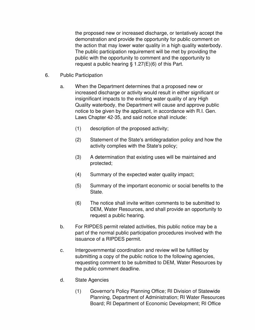
the proposed new or increased discharge, or tentatively accept the demonstration and provide the opportunity for public comment on
the action that may lower water quality in a high quality waterbody. The public participation requirement will be met by providing the
public with the opportunity to comment and the opportunity to request a public hearing § 1.27(E)(6) of this Part.
6. Public Participation
a. When the Department determines that a proposed new or
increased discharge or activity would result in either significant or insignificant impacts to the existing water quality of any High
Quality waterbody, the Department will cause and approve public notice to be given by the applicant, in accordance with R.I. Gen.
Laws Chapter 42-35, and said notice shall include:
(1) description of the proposed activity;
(2) Statement of the State's antidegradation policy and how the activity complies with the State's policy;
(3) A determination that existing uses will be maintained and protected;
(4) Summary of the expected water quality impact;
(5) Summary of the important economic or social benefits to the
State.
(6) The notice shall invite written comments to be submitted to
DEM, Water Resources, and shall provide an opportunity to request a public hearing.
b. For RIPDES permit related activities, this public notice may be a part of the normal public participation procedures involved with the
issuance of a RIPDES permit.
c. Intergovernmental coordination and review will be fulfilled by
submitting a copy of the public notice to the following agencies, requesting comment to be submitted to DEM, Water Resources by
the public comment deadline.
d. State Agencies
(1) Governor's Policy Planning Office; RI Division of Statewide Planning, Department of Administration; RI Water Resources
Board; RI Department of Economic Development; RI Office

of Drinking Water Quality, Department of Health; RI Coastal Resources Management Council (as applicable).
e. Federal Agencies
(1) US EPA Region I; US Army Corps of Engineers; US Fish
and Wildlife Service; National Marine Fisheries Service; National Park Service (as applicable).
(2) Once all public comment has been received (following the comment deadline), the Director of RIDEM or the Director's
designee will respond to all significant comments. If significant evidence of need in terms of public interest,
significant new technical information, or significant and valid disagreement as to technical conclusions exist, the Director
or the Director's designee will hold a public hearing.
(3) Following this public participation process, the Director or the
Director's designee will render a decision as to the allowanceor denial for such activity to take place. If the application is
denied, the applicant may revise the submittal to decrease oreliminate the projected impact to High Quality Waters, and
resubmit the application for consideration under the full review process.
F. Antidegradation Protections for Tier 2½ and Tier 3
1. Tier 2½ - Protection of Water Quality for SRPWs
a. Special Resource Protection Waters (SRPWs) are a special subset of High Quality Waters. SRPWs are subject not only to Tier 2
protection but also special protection under Tier 2½ of the Antidegradation Policy. Waterbodies which have been designated
as SRPWs are listed in § 1.28 of this Part.
b. Under Tier 2½, there shall be no measurable degradation of the
existing water quality necessary to protect the characteristic(s) which cause the waterbody to be designated as a SRPW. The new
or increased discharge or activity will not be allowed unless the applicant can provide adequate scientific and technical
documentation and engineering plans which can prove, to the satisfaction of the Director, that specific pollution controls and/or
other mitigation measures and BMPs will completely eliminate any measurable impacts to water quality necessary to protect the
characteristics which cause the waterbody to be designated a SRPW.

c. If the RIDEM, using BPJ and scientific and technical knowledge of proper modern pollution control engineering practices, agrees that
the specified pollution controls and/or BMPs will protect the SRPW from all measurable degradation, those agreed-to measures will be
conditions required of the applicant in an approval. Any avoidance of such conditions by the applicant will result in automatic
revocation of the approval and potential enforcement action. The burden of proof rests on the applicant.
d. Notwithstanding that all public drinking water supplies are SRPWs, public drinking water suppliers may undertake temporary and short
term activities within the boundary perimeter of a public drinking water supply impoundment for essential maintenance or to address
emergency conditions in order to prevent adverse effects on public health or safety, provided that these activities comply with the
requirements set forth in § 1.20(B) of this Part (Tier 1 Protection of Existing Uses) and § 1.20(C) of this Part (Tier 2 Protection of Water
Quality in High Quality Waters).
2. Tier 3 - Protection of Water Quality for ONRWs
a. Outstanding National Resource Waters (ONRWs) are a special subset of High Quality Waters. ONRWs are subject not only to Tier
2 protection but also special protection under Tier 3 of the Antidegradation Policy.
b. Under Tier 3, the State cannot allow any degradation of the existingwater quality necessary to protect and maintain ONRWs. There
shall be no new or increased discharge to ONRWs or to tributaries to ONRWs that would result in lower water quality in the ONRW.
c. The State may allow some limited activities that result in temporary and short-term changes in the water quality of an ONRW. Such
activities must not permanently degrade water quality or result in water quality lower than that necessary to protect the existing uses
in the ONRW. During any period of time when, after opportunity for public participation in the decision, the State allows temporary
degradation, all practical means of minimizing such degradation shall be implemented.
1.28 Special Resource Protection Waters (SRPWs)
A. The following list contains surface waters of the State which have been designated by the Department as SRPWs. RIDEM objectively established a list
of SRPWs. This list of designated SRPWs includes the waterbody name, location

and water quality classification for each SRPW. Additional information on SRPWs is available from RIDEM.
B. Special Resource Protection Waters (SRPWs) are high quality surface waters identified by the Director as having significant ecological or recreational uses,
which may include but are not limited to: wildlife refuge or management areas; public drinking water supplies; State and Federal parks; State and Federal
designated Estuarine Sanctuary Areas; waterbodies containing critical habitats, which may include but are not limited to waterbodies identified by the RIDEM
Natural Heritage Program as critical habitat for rare or endangered species; wetland types or specific wetlands listed as rare, threatened, endangered, of
special interest or of special concern by the RI Natural Heritage Program; waterbodies identified by the U.S. Department of the Interior on the Final List of
Rivers for potential inclusion in the National Wild and Scenic Rivers System.
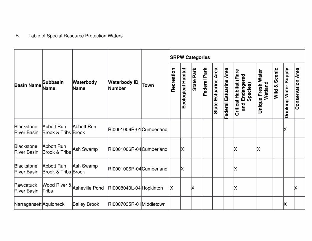
B. Table of Special Resource Protection Waters
Basin NameSubbasin
Name
Waterbody
Name
Waterbody ID
NumberTown
SRPW Categories
Re
cre
ati
on
Ec
olo
gic
al H
ab
ita
t
Sta
te P
ark
Fe
de
ral
Pa
rk
Sta
te E
stu
ari
ne
Are
a
Fe
de
ral
Es
tua
rin
e A
rea
Cri
tic
al H
ab
ita
t (R
are
an
d E
nd
an
ge
red
Sp
ec
ies
)
Un
iqu
e F
res
h W
ate
r
We
tla
nd
Wil
d &
Sc
en
ic
Dri
nk
ing
Wa
ter
Su
pp
ly
Co
ns
erv
ati
on
Are
a
Blackstone
River Basin
Abbott Run
Brook & Tribs
Abbott Run
BrookRI0001006R-01Cumberland X
Blackstone River Basin
Abbott Run Brook & Tribs
Ash Swamp RI0001006R-04Cumberland X X X
Blackstone
River Basin
Abbott Run
Brook & Tribs
Ash Swamp
BrookRI0001006R-04Cumberland X X
Pawcatuck River Basin
Wood River &Tribs
Asheville Pond RI0008040L-04 Hopkinton X X X X
Narragansett Aquidneck Bailey Brook RI0007035R-01Middletown X

Basin NameSubbasin
Name
Waterbody
Name
Waterbody ID
NumberTown
SRPW Categories
Re
cre
ati
on
Ec
olo
gic
al H
ab
ita
t
Sta
te P
ark
Fe
de
ral
Pa
rk
Sta
te E
stu
ari
ne
Are
a
Fe
de
ral
Es
tua
rin
e A
rea
Cri
tic
al H
ab
ita
t (R
are
an
d E
nd
an
ge
red
Sp
ec
ies
)
Un
iqu
e F
res
h W
ate
r
We
tla
nd
Wil
d &
Sc
en
ic
Dri
nk
ing
Wa
ter
Su
pp
ly
Co
ns
erv
ati
on
Are
a
: BasinWater Supply
& Tribs
Pawtuxet River Basin
Scituate Reservoir &
Tribs
Barden Reservoir
RI0006015L-06 Scituate X
Narragansett: Basin
Barrington & Runnins
Rivers
Barrington RiverEstuary
RI0007021E-01A/B,
RI0007021R-01
Barrington,
East
Providence
X X X X
Thames River Basin
Beach Pond & Tribs
Beach Pond RI0005010L-01 Exeter X X X
Narragansett
: Basin
West
Passage
Belleville Pond RI0007027L-02 North
Kingstown
X X X

Basin NameSubbasin
Name
Waterbody
Name
Waterbody ID
NumberTown
SRPW Categories
Re
cre
ati
on
Ec
olo
gic
al H
ab
ita
t
Sta
te P
ark
Fe
de
ral
Pa
rk
Sta
te E
stu
ari
ne
Are
a
Fe
de
ral
Es
tua
rin
e A
rea
Cri
tic
al H
ab
ita
t (R
are
an
d E
nd
an
ge
red
Sp
ec
ies
)
Un
iqu
e F
res
h W
ate
r
We
tla
nd
Wil
d &
Sc
en
ic
Dri
nk
ing
Wa
ter
Su
pp
ly
Co
ns
erv
ati
on
Are
a
Narragansett
Basin
Pawtuxet River Basin
Big River & Tribs
Big River RI0006012R-02West Greenwich
X X
Thames
River Basin
Tribs to Five
Mile
Bowdish
ReservoirRI0005047L-03 Glocester X X X X
Coastal Waters
Southeast Coastal
Ponds
Briggs Marsh RI0010048E-01Little Compton
X X X X
Coastal Waters
Sakonnet River
Brown Point Marsh
No WBIDLittle Compton
X
Coastal Southwest Cards Pond RI0010043E-01South X

Basin NameSubbasin
Name
Waterbody
Name
Waterbody ID
NumberTown
SRPW Categories
Re
cre
ati
on
Ec
olo
gic
al H
ab
ita
t
Sta
te P
ark
Fe
de
ral
Pa
rk
Sta
te E
stu
ari
ne
Are
a
Fe
de
ral
Es
tua
rin
e A
rea
Cri
tic
al H
ab
ita
t (R
are
an
d E
nd
an
ge
red
Sp
ec
ies
)
Un
iqu
e F
res
h W
ate
r
We
tla
nd
Wil
d &
Sc
en
ic
Dri
nk
ing
Wa
ter
Su
pp
ly
Co
ns
erv
ati
on
Are
a
WatersCoastal
PondsKingstown
Thames River Basin
Tribs to Five Mile
Cedar Swamp Pond
RI0005047L-05 Burrillville X X
Pawcatuck
River Basin
Pawcatuck
River & Tribs
Chapman Pond/
Crandall SwampRI0008039L-01 Westerly X X X
Coastal Waters
Southeast Coastal
Ponds
Cold Brook RI0010048R-01Little Compton
X
Thames River Basin
Tribs to Five Mile
Cold Spring Brook
RI0005047R-05Burrillville X X

Basin NameSubbasin
Name
Waterbody
Name
Waterbody ID
NumberTown
SRPW Categories
Re
cre
ati
on
Ec
olo
gic
al H
ab
ita
t
Sta
te P
ark
Fe
de
ral
Pa
rk
Sta
te E
stu
ari
ne
Are
a
Fe
de
ral
Es
tua
rin
e A
rea
Cri
tic
al H
ab
ita
t (R
are
an
d E
nd
an
ge
red
Sp
ec
ies
)
Un
iqu
e F
res
h W
ate
r
We
tla
nd
Wil
d &
Sc
en
ic
Dri
nk
ing
Wa
ter
Su
pp
ly
Co
ns
erv
ati
on
Are
a
Thames
River Basin
Tribs to Five
Mile
Croff Farm
BrookRI0005047R-04Burrillville X X
Blackstone River Basin
Woonsocket Reservoir #3
& all Tribs
Crookfall Brook RI0001004R-01North Smithfield,
Cumberland
X
Coastal Waters
Southwest Coastal
Ponds
Deep Pond RI0010043L-08 Charlestown X X X
Blackstone River Basin
Abbott Run Brook & Tribs
Diamond Hill Reservoir
RI0001006L-01 Cumberland X
Pawcatuck
River Basin
Wood River &
Tribs
Diamond
Pond/Bog Complex
RI0008040R-06Richmond X X X
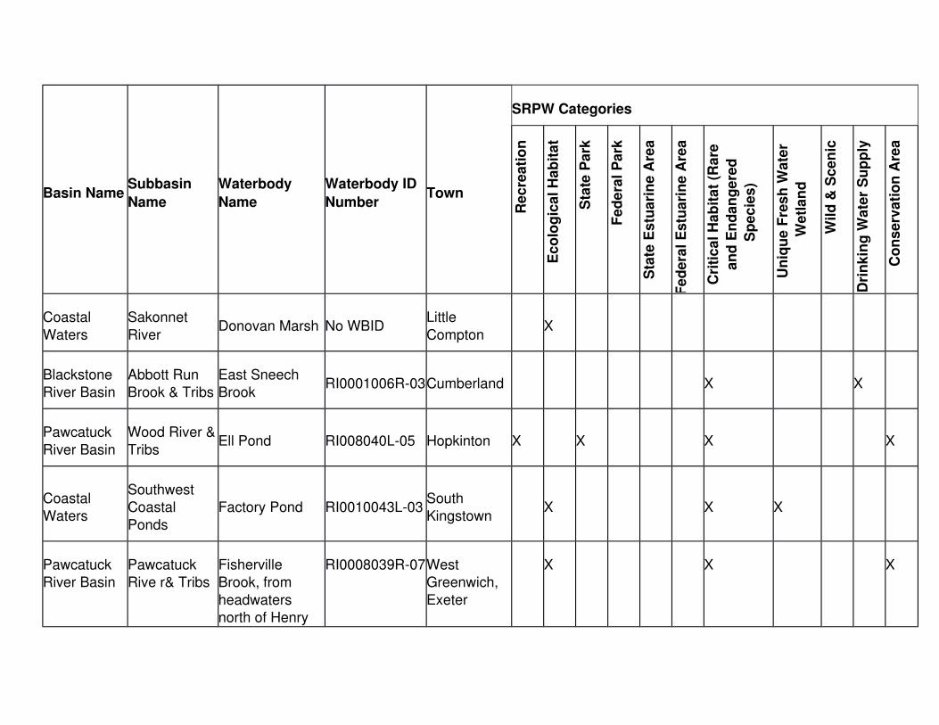
Basin NameSubbasin
Name
Waterbody
Name
Waterbody ID
NumberTown
SRPW Categories
Re
cre
ati
on
Ec
olo
gic
al H
ab
ita
t
Sta
te P
ark
Fe
de
ral
Pa
rk
Sta
te E
stu
ari
ne
Are
a
Fe
de
ral
Es
tua
rin
e A
rea
Cri
tic
al H
ab
ita
t (R
are
an
d E
nd
an
ge
red
Sp
ec
ies
)
Un
iqu
e F
res
h W
ate
r
We
tla
nd
Wil
d &
Sc
en
ic
Dri
nk
ing
Wa
ter
Su
pp
ly
Co
ns
erv
ati
on
Are
a
Coastal
Waters
Sakonnet
RiverDonovan Marsh No WBID
Little
ComptonX
Blackstone River Basin
Abbott Run Brook & Tribs
East Sneech Brook
RI0001006R-03Cumberland X X
Pawcatuck
River Basin
Wood River &
TribsEll Pond RI008040L-05 Hopkinton X X X X
Coastal Waters
Southwest Coastal
Ponds
Factory Pond RI0010043L-03South Kingstown
X X X
Pawcatuck River Basin
Pawcatuck Rive r& Tribs
Fisherville Brook, from
headwaters north of Henry
RI0008039R-07West Greenwich,
Exeter
X X X

Basin NameSubbasin
Name
Waterbody
Name
Waterbody ID
NumberTown
SRPW Categories
Re
cre
ati
on
Ec
olo
gic
al H
ab
ita
t
Sta
te P
ark
Fe
de
ral
Pa
rk
Sta
te E
stu
ari
ne
Are
a
Fe
de
ral
Es
tua
rin
e A
rea
Cri
tic
al H
ab
ita
t (R
are
an
d E
nd
an
ge
red
Sp
ec
ies
)
Un
iqu
e F
res
h W
ate
r
We
tla
nd
Wil
d &
Sc
en
ic
Dri
nk
ing
Wa
ter
Su
pp
ly
Co
ns
erv
ati
on
Are
a
Brown Rd. in
West Greenwichto Route 102 in
Exeter
Coastal Waters
Sakonnet River
Fogland Point Marsh
No WBID Tiverton X X
Coastal
Waters
Block Island
WatersFresh Pond RI0010046L-02
New
ShorehamX
Coastal Waters
Southwest Coastal
Ponds
Fresh Pond No WBID Charlestown X X
Coastal Waters
Southwest Coastal
Galilee Bird Sanctuary
RI0010043E-06A/E
Narragansett, South
X X

Basin NameSubbasin
Name
Waterbody
Name
Waterbody ID
NumberTown
SRPW Categories
Re
cre
ati
on
Ec
olo
gic
al H
ab
ita
t
Sta
te P
ark
Fe
de
ral
Pa
rk
Sta
te E
stu
ari
ne
Are
a
Fe
de
ral
Es
tua
rin
e A
rea
Cri
tic
al H
ab
ita
t (R
are
an
d E
nd
an
ge
red
Sp
ec
ies
)
Un
iqu
e F
res
h W
ate
r
We
tla
nd
Wil
d &
Sc
en
ic
Dri
nk
ing
Wa
ter
Su
pp
ly
Co
ns
erv
ati
on
Are
a
Ponds Kingstown
Narragansett
: Basin
Aquidneck
Water & Supply Tribs
Gardiner Pond RI0007035L-01 Middletown X X X
Pawcatuck
River Basin
Pawcatuck
River & Tribs
Gennesee
SwampRI0008039R-08
South
KingstownX X
Narragansett: Basin
Greenwich Bay
Gorton Pond RI0007025L-01 Warwick X X X X X
Pawcatuck
River Basin
Wood River &
TribsGrass Pond RI0008039L-23 Richmond X X X X
Coastal Waters
Block Island Waters
Great Salt Pond and Marshes
RI0010046E-01A
New Shoreham
X

Basin NameSubbasin
Name
Waterbody
Name
Waterbody ID
NumberTown
SRPW Categories
Re
cre
ati
on
Ec
olo
gic
al H
ab
ita
t
Sta
te P
ark
Fe
de
ral
Pa
rk
Sta
te E
stu
ari
ne
Are
a
Fe
de
ral
Es
tua
rin
e A
rea
Cri
tic
al H
ab
ita
t (R
are
an
d E
nd
an
ge
red
Sp
ec
ies
)
Un
iqu
e F
res
h W
ate
r
We
tla
nd
Wil
d &
Sc
en
ic
Dri
nk
ing
Wa
ter
Su
pp
ly
Co
ns
erv
ati
on
Are
a
Pawcatuck
River Basin
Pawcatuck
River & TribsGreat Swamp RI0008039L-07
South
KingstownX X X
Coastal Waters
Southwest Coastal
Ponds
Green Hill Pond RI0010043E-02South Kingstown
X
Blackstone River Basin
Abbott Run Brook & Tribs
Happy Hollow Pond
RI0001006L-03 Cumberland X
Narragansett
: Basin
Potowomut
RiverHunt River
RI0007028R-
03B
North
KingstownX X X
Pawtuxet River Basin
Scituate Reservoir &
Tribs
Huntinghouse Brook
RI0006015R-11Scituate X X

Basin NameSubbasin
Name
Waterbody
Name
Waterbody ID
NumberTown
SRPW Categories
Re
cre
ati
on
Ec
olo
gic
al H
ab
ita
t
Sta
te P
ark
Fe
de
ral
Pa
rk
Sta
te E
stu
ari
ne
Are
a
Fe
de
ral
Es
tua
rin
e A
rea
Cri
tic
al H
ab
ita
t (R
are
an
d E
nd
an
ge
red
Sp
ec
ies
)
Un
iqu
e F
res
h W
ate
r
We
tla
nd
Wil
d &
Sc
en
ic
Dri
nk
ing
Wa
ter
Su
pp
ly
Co
ns
erv
ati
on
Are
a
Narragansett
: Basin
Jamestown
Water Supply
Jamestown
BrookRI0007036R-01Jamestown X
Narragansett: Basin
Warren Reservoir
Kickemuit Reservoir
RI0007034L-01 Warren X X X
Narragansett
: Basin
Aquidneck
Water Supply & Tribs
Lawton Valley
ReservoirRI0007035L-06 Portsmouth X
Coastal
Waters
Southwest
Coastal Ponds
Little Maschaug
PondRI0010043L-18 Westerly X
Pawcatuck
River Basin
Tidal
Pawcatuck River/Little
Little
Narragansett Bay
RI0008038E-
02A/B
Westerly X X

Basin NameSubbasin
Name
Waterbody
Name
Waterbody ID
NumberTown
SRPW Categories
Re
cre
ati
on
Ec
olo
gic
al H
ab
ita
t
Sta
te P
ark
Fe
de
ral
Pa
rk
Sta
te E
stu
ari
ne
Are
a
Fe
de
ral
Es
tua
rin
e A
rea
Cri
tic
al H
ab
ita
t (R
are
an
d E
nd
an
ge
red
Sp
ec
ies
)
Un
iqu
e F
res
h W
ate
r
We
tla
nd
Wil
d &
Sc
en
ic
Dri
nk
ing
Wa
ter
Su
pp
ly
Co
ns
erv
ati
on
Are
a
Narragansett
Bay
Blackstone River Basin
Abbott Run Brook & Tribs
Long Brook RI0001006R-02Cumberland X X
Pawcatuck
River Basin
Wood River &
TribsLong Pond RI0008040L-20 Hopkinton X X X X
Coastal Waters
Southeast Coastal
Ponds
Long Pond RI0010048L-01Little Compton
X X X
Blackstone
River Basin
Blackstone
River & Tribs
Lonsdale Marsh Complex
(Blackstone River)
RI0001003R-
01A
Lincoln, Central Falls,
Cumberland
X X X

Basin NameSubbasin
Name
Waterbody
Name
Waterbody ID
NumberTown
SRPW Categories
Re
cre
ati
on
Ec
olo
gic
al H
ab
ita
t
Sta
te P
ark
Fe
de
ral
Pa
rk
Sta
te E
stu
ari
ne
Are
a
Fe
de
ral
Es
tua
rin
e A
rea
Cri
tic
al H
ab
ita
t (R
are
an
d E
nd
an
ge
red
Sp
ec
ies
)
Un
iqu
e F
res
h W
ate
r
We
tla
nd
Wil
d &
Sc
en
ic
Dri
nk
ing
Wa
ter
Su
pp
ly
Co
ns
erv
ati
on
Are
a
Narragansett
: Basin
Aquidneck
Water Supply & Tribs
Maidford RiverRI0007035R-
02A/BMiddletown X X
Coastal
Waters
Southwest
Coastal Ponds
Maschaug Pond RI0010043E-03Westerly X
Pawcatuck River Basin
Pawcatuck River & Tribs
Matunuck Hills Complex- Long,
White, Spectacle, Hot
House and Lily Ponds
RI0010043L-07
(Long), RI0010043L-05
(White), RI0010043L-01
(Hothouse),
No WB ID for
Spectacle and Lily Ponds
South Kingstown
X X X X

Basin NameSubbasin
Name
Waterbody
Name
Waterbody ID
NumberTown
SRPW Categories
Re
cre
ati
on
Ec
olo
gic
al H
ab
ita
t
Sta
te P
ark
Fe
de
ral
Pa
rk
Sta
te E
stu
ari
ne
Are
a
Fe
de
ral
Es
tua
rin
e A
rea
Cri
tic
al H
ab
ita
t (R
are
an
d E
nd
an
ge
red
Sp
ec
ies
)
Un
iqu
e F
res
h W
ate
r
We
tla
nd
Wil
d &
Sc
en
ic
Dri
nk
ing
Wa
ter
Su
pp
ly
Co
ns
erv
ati
on
Are
a
Pawcatuck
River Basin
Pawcatuck
River & Tribs
McGowan
SwampRI0008039R-12Westerly X X
Pawcatuck River Basin
Pawcatuck River & Tribs
Meadowbrook Pond
RI0008039L-05 Richmond X X X
Pawtuxet River Basin
Pawtuxet
River South Branch &
Tribs
Mishnock Swamp
RI0006014L-01 Coventry X
Pawtuxet River Basin
Scituate Reservoir &
Tribs
Moswansicut Pond
RI0006015L-04 Scituate X
Narragansett: Basin
Aquidneck Water Supply
Nelson Pond RI0007035L-02 Middletown X X

Basin NameSubbasin
Name
Waterbody
Name
Waterbody ID
NumberTown
SRPW Categories
Re
cre
ati
on
Ec
olo
gic
al H
ab
ita
t
Sta
te P
ark
Fe
de
ral
Pa
rk
Sta
te E
stu
ari
ne
Are
a
Fe
de
ral
Es
tua
rin
e A
rea
Cri
tic
al H
ab
ita
t (R
are
an
d E
nd
an
ge
red
Sp
ec
ies
)
Un
iqu
e F
res
h W
ate
r
We
tla
nd
Wil
d &
Sc
en
ic
Dri
nk
ing
Wa
ter
Su
pp
ly
Co
ns
erv
ati
on
Are
a
Tribs
Coastal
Waters
Southwest
Coastal Ponds
Ninigret PondRI0010043E-
04ACharlestown X X X X X X
Narragansett
: Basin
Aquidneck
Water Supply & Tribs
Nonquit Pond RI0007035L-08 Tiverton X X
Narragansett
: Basin
Aquidneck
Water Supply & Tribs
North Easton
PondRI0007035L-03 Middletown X
Narragansett
: Basin
Jamestown
Water SupplyNorth Carr Pond RI0007036L-01 Jamestown X

Basin NameSubbasin
Name
Waterbody
Name
Waterbody ID
NumberTown
SRPW Categories
Re
cre
ati
on
Ec
olo
gic
al H
ab
ita
t
Sta
te P
ark
Fe
de
ral
Pa
rk
Sta
te E
stu
ari
ne
Are
a
Fe
de
ral
Es
tua
rin
e A
rea
Cri
tic
al H
ab
ita
t (R
are
an
d E
nd
an
ge
red
Sp
ec
ies
)
Un
iqu
e F
res
h W
ate
r
We
tla
nd
Wil
d &
Sc
en
ic
Dri
nk
ing
Wa
ter
Su
pp
ly
Co
ns
erv
ati
on
Are
a
Narragansett
: BasinPalmer River Palmer River
RI0007022E-
01A/B
Barrington,
WarrenX X X
Narragansett: Basin
Aquidneck Water Supply
& Tribs
Paradise Brook RI0007035R-03Middletown X
Blackstone
River Basin
Abbott Run
Brook & Tribs
Pawcatuck Reservoir
(Arnold Mills Reservoir)
RI0001006L-02 Cumberland X
Pawcatuck
River Basin
Pawcatuck
River & Tribs
Pawcatuck RiverRI0008039R-
18A/C/E
Charlestown,
Westerly,
South
Kingstown,
X X X

Basin NameSubbasin
Name
Waterbody
Name
Waterbody ID
NumberTown
SRPW Categories
Re
cre
ati
on
Ec
olo
gic
al H
ab
ita
t
Sta
te P
ark
Fe
de
ral
Pa
rk
Sta
te E
stu
ari
ne
Are
a
Fe
de
ral
Es
tua
rin
e A
rea
Cri
tic
al H
ab
ita
t (R
are
an
d E
nd
an
ge
red
Sp
ec
ies
)
Un
iqu
e F
res
h W
ate
r
We
tla
nd
Wil
d &
Sc
en
ic
Dri
nk
ing
Wa
ter
Su
pp
ly
Co
ns
erv
ati
on
Are
a
Richmond,
Hopkinton
Coastal
Waters
Tribs to
Pettaquamscutt River
Pettaquamscutt
River (Narrow River)
RI0010044E-
01A
North Kingstown,
South Kingstown,
Narragansett
X X X X
Pawcatuck River Basin
Wood River &Tribs
Phantom Bog No WBID Hopkinton X X X
Coastal
Waters
Southwest
Coastal Ponds
Point Judith
Pond
RI0010043E-
06A-I
South
Kingstown, Narragansett
X X X
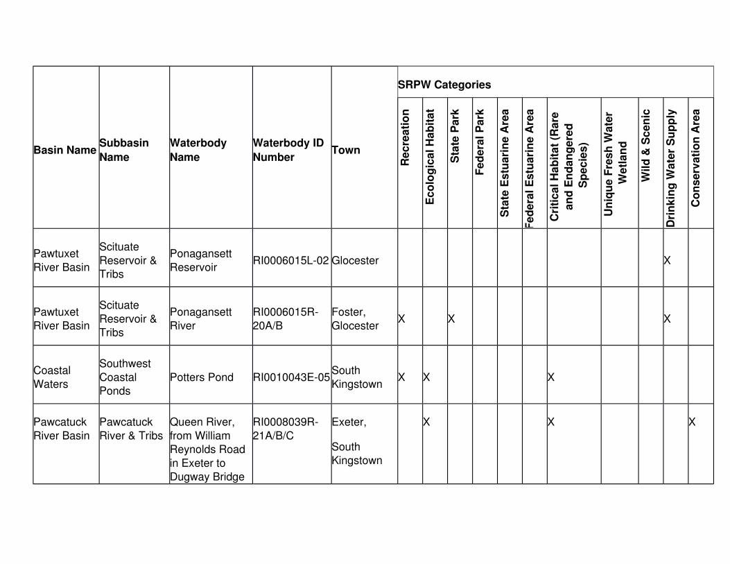
Basin NameSubbasin
Name
Waterbody
Name
Waterbody ID
NumberTown
SRPW Categories
Re
cre
ati
on
Ec
olo
gic
al H
ab
ita
t
Sta
te P
ark
Fe
de
ral
Pa
rk
Sta
te E
stu
ari
ne
Are
a
Fe
de
ral
Es
tua
rin
e A
rea
Cri
tic
al H
ab
ita
t (R
are
an
d E
nd
an
ge
red
Sp
ec
ies
)
Un
iqu
e F
res
h W
ate
r
We
tla
nd
Wil
d &
Sc
en
ic
Dri
nk
ing
Wa
ter
Su
pp
ly
Co
ns
erv
ati
on
Are
a
Pawtuxet
River Basin
Scituate
Reservoir & Tribs
Ponagansett
ReservoirRI0006015L-02 Glocester X
Pawtuxet
River Basin
Scituate
Reservoir & Tribs
Ponagansett
River
RI0006015R-
20A/B
Foster,
GlocesterX X X
Coastal
Waters
Southwest
Coastal Ponds
Potters Pond RI0010043E-05South
KingstownX X X
Pawcatuck
River Basin
Pawcatuck
River & Tribs
Queen River,
from William Reynolds Road
in Exeter to Dugway Bridge
RI0008039R-
21A/B/C
Exeter,
South Kingstown
X X X

Basin NameSubbasin
Name
Waterbody
Name
Waterbody ID
NumberTown
SRPW Categories
Re
cre
ati
on
Ec
olo
gic
al H
ab
ita
t
Sta
te P
ark
Fe
de
ral
Pa
rk
Sta
te E
stu
ari
ne
Are
a
Fe
de
ral
Es
tua
rin
e A
rea
Cri
tic
al H
ab
ita
t (R
are
an
d E
nd
an
ge
red
Sp
ec
ies
)
Un
iqu
e F
res
h W
ate
r
We
tla
nd
Wil
d &
Sc
en
ic
Dri
nk
ing
Wa
ter
Su
pp
ly
Co
ns
erv
ati
on
Are
a
Road in South
Kingstown.
Coastal Waters
Southeast Coastal
Ponds
Quicksand Pond RI0010048E-02Little Compton
X X X
Coastal Waters
Southwest Coastal
Ponds
Quonochontaug Pond
RI0010043E-07Charlestown,Westerly
X X X
Pawtuxet River Basin
Scituate Reservoir &
Tribs
Regulating Reservoir
RI0006015L-01 Scituate X
Blackstone River Basin
Abbott Run Brook & Tribs
Robin Hollow Pond
RI0001006L-04 Cumberland X

Basin NameSubbasin
Name
Waterbody
Name
Waterbody ID
NumberTown
SRPW Categories
Re
cre
ati
on
Ec
olo
gic
al H
ab
ita
t
Sta
te P
ark
Fe
de
ral
Pa
rk
Sta
te E
stu
ari
ne
Are
a
Fe
de
ral
Es
tua
rin
e A
rea
Cri
tic
al H
ab
ita
t (R
are
an
d E
nd
an
ge
red
Sp
ec
ies
)
Un
iqu
e F
res
h W
ate
r
We
tla
nd
Wil
d &
Sc
en
ic
Dri
nk
ing
Wa
ter
Su
pp
ly
Co
ns
erv
ati
on
Are
a
Narragansett: Basin
Barrington & Runnins River
Runnins River RI0007021R-01
Barrington,
East Providence X
Coastal Waters
Block Island Waters
Sachem Pond RI0010046L-03New Shoreham
X X
Coastal
Waters
Sakonnet
River
Sakonnet River -
waters in the vicinity of
Sachuest Point and Third
Beach, Middletown, RI
as defined under
RI0010031E-
01B
X X X X
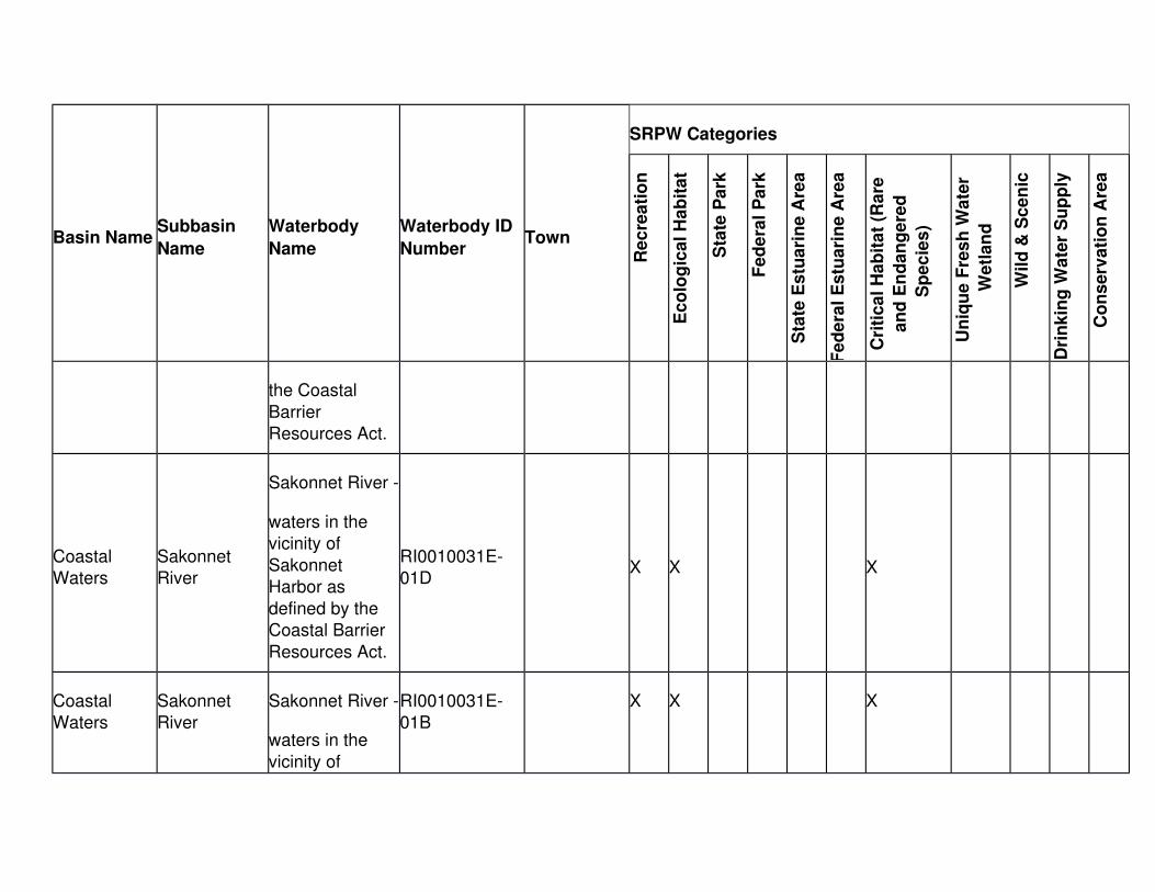
Basin NameSubbasin
Name
Waterbody
Name
Waterbody ID
NumberTown
SRPW Categories
Re
cre
ati
on
Ec
olo
gic
al H
ab
ita
t
Sta
te P
ark
Fe
de
ral
Pa
rk
Sta
te E
stu
ari
ne
Are
a
Fe
de
ral
Es
tua
rin
e A
rea
Cri
tic
al H
ab
ita
t (R
are
an
d E
nd
an
ge
red
Sp
ec
ies
)
Un
iqu
e F
res
h W
ate
r
We
tla
nd
Wil
d &
Sc
en
ic
Dri
nk
ing
Wa
ter
Su
pp
ly
Co
ns
erv
ati
on
Are
a
the Coastal
Barrier Resources Act.
Coastal Waters
Sakonnet River
Sakonnet River -
waters in the vicinity of
Sakonnet Harbor as
defined by the Coastal Barrier
Resources Act.
RI0010031E-01D
X X X
Coastal Waters
Sakonnet River
Sakonnet River -
waters in the
vicinity of
RI0010031E-01B
X X X

Basin NameSubbasin
Name
Waterbody
Name
Waterbody ID
NumberTown
SRPW Categories
Re
cre
ati
on
Ec
olo
gic
al H
ab
ita
t
Sta
te P
ark
Fe
de
ral
Pa
rk
Sta
te E
stu
ari
ne
Are
a
Fe
de
ral
Es
tua
rin
e A
rea
Cri
tic
al H
ab
ita
t (R
are
an
d E
nd
an
ge
red
Sp
ec
ies
)
Un
iqu
e F
res
h W
ate
r
We
tla
nd
Wil
d &
Sc
en
ic
Dri
nk
ing
Wa
ter
Su
pp
ly
Co
ns
erv
ati
on
Are
a
Sakonnet Point
as defined by the Coastal
Barrier Resources Act
and the US Fish and Wildlife's
designation of Significant
Coastal Habitat for the Rhode
Island Sound - Buzzards Bay
Beach Complex under the
Northeast Coastal Areas
Study.
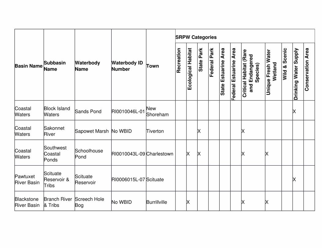
Basin NameSubbasin
Name
Waterbody
Name
Waterbody ID
NumberTown
SRPW Categories
Re
cre
ati
on
Ec
olo
gic
al H
ab
ita
t
Sta
te P
ark
Fe
de
ral
Pa
rk
Sta
te E
stu
ari
ne
Are
a
Fe
de
ral
Es
tua
rin
e A
rea
Cri
tic
al H
ab
ita
t (R
are
an
d E
nd
an
ge
red
Sp
ec
ies
)
Un
iqu
e F
res
h W
ate
r
We
tla
nd
Wil
d &
Sc
en
ic
Dri
nk
ing
Wa
ter
Su
pp
ly
Co
ns
erv
ati
on
Are
a
Coastal
Waters
Block Island
WatersSands Pond RI0010046L-01
New
ShorehamX
Coastal Waters
Sakonnet River
Sapowet Marsh No WBID Tiverton X X
Coastal
Waters
Southwest
Coastal Ponds
Schoolhouse
PondRI0010043L-09 Charlestown X X X X
Pawtuxet
River Basin
Scituate
Reservoir & Tribs
Scituate
ReservoirRI0006015L-07 Scituate X
Blackstone
River Basin
Branch River
& Tribs
Screech Hole
BogNo WBID Burrillville X X X

Basin NameSubbasin
Name
Waterbody
Name
Waterbody ID
NumberTown
SRPW Categories
Re
cre
ati
on
Ec
olo
gic
al H
ab
ita
t
Sta
te P
ark
Fe
de
ral
Pa
rk
Sta
te E
stu
ari
ne
Are
a
Fe
de
ral
Es
tua
rin
e A
rea
Cri
tic
al H
ab
ita
t (R
are
an
d E
nd
an
ge
red
Sp
ec
ies
)
Un
iqu
e F
res
h W
ate
r
We
tla
nd
Wil
d &
Sc
en
ic
Dri
nk
ing
Wa
ter
Su
pp
ly
Co
ns
erv
ati
on
Are
a
Blackstone
River Basin
Branch River
& Tribs
Scwindels
Swamp Preserve
No WBID Glocester X X
Pawtuxet
River Basin
Scituate
Reservoir & Tribs
Shippee Saw
Mill PondRI0006015L-05 Foster X X
Coastal
Waters
Southeast
Coastal Ponds
Sisson Pond RI0007035L-10 Portsmouth X
Blackstone
River Basin
Branch River
& Tribs
Smith & Sayles
ReservoirRI0001002L-07 Glocester X X X
Blackstone River Basin
Sneech Pond & Tribs
Sneech Pond RI0001005L-01 Cumberland X

Basin NameSubbasin
Name
Waterbody
Name
Waterbody ID
NumberTown
SRPW Categories
Re
cre
ati
on
Ec
olo
gic
al H
ab
ita
t
Sta
te P
ark
Fe
de
ral
Pa
rk
Sta
te E
stu
ari
ne
Are
a
Fe
de
ral
Es
tua
rin
e A
rea
Cri
tic
al H
ab
ita
t (R
are
an
d E
nd
an
ge
red
Sp
ec
ies
)
Un
iqu
e F
res
h W
ate
r
We
tla
nd
Wil
d &
Sc
en
ic
Dri
nk
ing
Wa
ter
Su
pp
ly
Co
ns
erv
ati
on
Are
a
Narragansett
: Basin
Aquidneck
Water Supply & Tribs
South Easton
PondRI0007035L-04 Newport X
Narragansett
: Basin
Jamestown
Water Supply
South Watson
PondRI0007036L-02 Jamestown X X X
Narragansett: Basin
Aquidneck Water Supply
& Tribs
St. Mary’s Pond RI0007035L-05 Portsmouth X
Narragansett: Basin
Stafford Pond Stafford Pond RI0007037L-01 Tiverton X X X
Coastal
Waters
Southwest
Coastal Ponds
Succotash
MarshNo WBID
South
KingstownX

Basin NameSubbasin
Name
Waterbody
Name
Waterbody ID
NumberTown
SRPW Categories
Re
cre
ati
on
Ec
olo
gic
al H
ab
ita
t
Sta
te P
ark
Fe
de
ral
Pa
rk
Sta
te E
stu
ari
ne
Are
a
Fe
de
ral
Es
tua
rin
e A
rea
Cri
tic
al H
ab
ita
t (R
are
an
d E
nd
an
ge
red
Sp
ec
ies
)
Un
iqu
e F
res
h W
ate
r
We
tla
nd
Wil
d &
Sc
en
ic
Dri
nk
ing
Wa
ter
Su
pp
ly
Co
ns
erv
ati
on
Are
a
Pawcatuck
River Basin
Wood River &
Tribs
Tippencansett
PondRI0008040L-17
West
Greenwich, Exeter
X X X
Coastal
Waters
Southwest
Coastal Ponds
Trustom Pond RI0010043E-08South
KingstownX X
Coastal
Waters
Southeast
Coastal Ponds
Tunipus Pond RI0010048L-04Little
ComptonX
Coastal
Waters
Southwest
Coastal Ponds
Twin Pond No WBID Narragansett X
Blackstone Blackstone Valley Falls RI0001003L-02 Cumberland X X

Basin NameSubbasin
Name
Waterbody
Name
Waterbody ID
NumberTown
SRPW Categories
Re
cre
ati
on
Ec
olo
gic
al H
ab
ita
t
Sta
te P
ark
Fe
de
ral
Pa
rk
Sta
te E
stu
ari
ne
Are
a
Fe
de
ral
Es
tua
rin
e A
rea
Cri
tic
al H
ab
ita
t (R
are
an
d E
nd
an
ge
red
Sp
ec
ies
)
Un
iqu
e F
res
h W
ate
r
We
tla
nd
Wil
d &
Sc
en
ic
Dri
nk
ing
Wa
ter
Su
pp
ly
Co
ns
erv
ati
on
Are
a
River Basin River & Tribs Pond
Blackstone
River Basin
Wallum Lake
& TribsWallum Lake RI0001001L-01 Burrillville X X X X
Pawcatuck River Basin
Pawcatuck River & Tribs
Watchaug Pond RI0008039L-02 Charlestown X X X X X X
Narragansett
: Basin
Aquidneck
Water Supply & Tribs
Watson
ReservoirRI0007035L-07
Little
ComptonX
Narragansett: Basin
West
Passage Narragansett
Bay
Wesquage PondRI0007027E-07Narragansett X X

Basin NameSubbasin
Name
Waterbody
Name
Waterbody ID
NumberTown
SRPW Categories
Re
cre
ati
on
Ec
olo
gic
al H
ab
ita
t
Sta
te P
ark
Fe
de
ral
Pa
rk
Sta
te E
stu
ari
ne
Are
a
Fe
de
ral
Es
tua
rin
e A
rea
Cri
tic
al H
ab
ita
t (R
are
an
d E
nd
an
ge
red
Sp
ec
ies
)
Un
iqu
e F
res
h W
ate
r
We
tla
nd
Wil
d &
Sc
en
ic
Dri
nk
ing
Wa
ter
Su
pp
ly
Co
ns
erv
ati
on
Are
a
Pawtuxet
River Basin
Scituate
Reservoir & Tribs
Westconnaug
ReservoirRI0006015L-03
Scituate,
FosterX
Pawcatuck
River Basin
Wood River &
Tribs
Wickaboxet
PondRI0008040L-18
West
GreenwichX X X
Coastal Waters
Southwest Coastal
Ponds
Winnapaug Pond & Salt
Marsh
RI0010043E-09Westerly X X
Pawcatuck River Basin
Wood River &Tribs
Wood RiverRI0008040R-16A/B/C/D
Richmond, Hopkinton,
Westerly
X X X
Blackstone River Basin
Woonsocket Reservoir #3
Woonsocket Reservoir #1
RI0001004L-02 North Smithfield
X

Basin NameSubbasin
Name
Waterbody
Name
Waterbody ID
NumberTown
SRPW Categories
Re
cre
ati
on
Ec
olo
gic
al H
ab
ita
t
Sta
te P
ark
Fe
de
ral
Pa
rk
Sta
te E
stu
ari
ne
Are
a
Fe
de
ral
Es
tua
rin
e A
rea
Cri
tic
al H
ab
ita
t (R
are
an
d E
nd
an
ge
red
Sp
ec
ies
)
Un
iqu
e F
res
h W
ate
r
We
tla
nd
Wil
d &
Sc
en
ic
Dri
nk
ing
Wa
ter
Su
pp
ly
Co
ns
erv
ati
on
Are
a
& all Tribs
Blackstone
River Basin
Woonsocket
Reservoir #3 & all Tribs
Woonsocket
Reservoir #3RI0001004L-01
North
SmithfieldX
Pawcatuck
River Basin
Pawcatuck
River & TribsWorden Pond RI0008039L-07
South
KingstownX X X X X X
Pawcatuck River Basin
Wood River &Tribs
Wyoming Pond RI0008040L-11 Hope Valley X
Pawcatuck
River Basin
Wood River &
TribsYawgoog Pond RI0008040L-07 Hopkinton X X

1.29 Rhode Island Site Specific Aquatic Life Water Quality Criteria
Development Procedure
A. Introduction - There is valid scientific rationale for the contention that the Nationalcriteria derived using the November 28, 1980 National guidelines, 45 FR 79341,
may be underprotective or overprotective at specific sites. National water quality criteria proposed under Section 304(a) (33 U.S.C. § 1314) or Section 307(a)(1)
(33 U.S.C. § 1317) toxic pollutants are based on laboratory toxicity tests in which aquatic organisms were exposed to known concentration of toxicants in
laboratory water and, thus, may not adequately represent site water and effluent effects. The underlying intent of adopting water quality criteria into the State’s
standards is to establish a set of conditions which, if consistently achieved, will not impair the biological integrity of the aquatic community residing in the
waterbody.
B. A prominent aspect of the National criteria is a provision allowing for modification
to reflect local environmental conditions. Incorporating site specific water quality criteria into discharge permits will still ensure that the aquatic community is
adequately protected from the effects of toxic pollutant discharges, while considering the mitigation of toxicity due to characteristics of a local waterbody
and effluent. The need to reevaluate the National criteria and develop site specific criteria can emerge from many factors including:
1. High natural ambient concentrations relative to standards or criteria.
2. The presence of substances for which water quality based effluent limits
are below analytical detectability.
3. The possibility of complex or synergistic interactions of chemicals within
the effluent and/or site water.
4. Observed beneficial or detrimental effects on the receiving water biota.
C. RIDEM developed this site specific criteria procedure using a Mostly Sanitary Secondary Treatment Plant's (MSSTP) effluent and designated site water in
1990. Due to the uncertainties associated with the instream fate of pollutant loading after discharge, RIDEM will not allow for unchecked or maximum
attenuation of toxicity by various physical/chemical parameters in every effluent. Using a MSSTP effluent will afford a consistent, predictable baseline behavior of
specific pollutants when attenuated by standard sanitary, secondary effluent components (TSS, alkalinity, pH etc.) This procedure will allow for a moderate
amount of attenuation of toxicity by a discharge and site water while addressing the concern of instream fate of pollutant loadings. Site specific criteria may also
be developed using the procedures outlined in the EPA document entitled InterimGuidance on Determination and Use of Water-Effect Ratios for Metals (EPA-823-

B-94-001). Since the EPA WER Guidance procedures allow for the evaluation of more site specific characteristics (which may attenuate toxicity) than the RIDEM
policy, a more rigorous testing program may be required when following the EPA WER Guidance than that described herein.
D. The new criteria developed will be applied only to sites where there are existing discharges and will be administered uniformly to disallow any significant
fluctuations in toxicity that may occur due to inconsistencies in the influent component or overall treatment.
E. Documentation of the factors that exist at a facility or within a basin, which necessitate site specific criteria development, shall be submitted to RIDEM. This
documentation shall include:
1. Any previous effluent or instream bioassay test results and/or evaluation
of the impact of the discharge on the resident aquatic community.
2. Characterization of existing water quality conditions at the site or within
the basin.
3. The parameters for which site specific criteria are to be developed should
be listed with an explanation of why the National criteria for these parameters can not be met.
4. An indication of what levels of the parameters of concern could be attained after institution of an aggressive pretreatment program and
exploration of other municipal standard treatment controls.
F. The municipal effluent and site water data generated from this procedure will be
applied to industries as a baseline for permit derivation.
G. The criteria developed from one site may be applied to additional sites, if it is
demonstrated to the satisfaction of the Director that the hydrologic, ecological and physiographic conditions are consistent between the two sites.
H. New permit limits will be developed in accordance with applicable federal and state regulations and laws, including antibacksliding and antidegradation
prohibitions.
I. Necessary modifications to all permits will be based on compliance bioassay
monitoring results.
J. Methodology - The RIDEM site specific criteria testing protocol narrowly limits the
degree to which mitigation of toxicity may be considered. The RIDEM policy allows that the criteria may be applicable to a number of discharges and site
waters. However, the RIDEM protocol is expected to result in more stringent criteria compared to the criteria resulting from following the EPA WER Guidance.

EPA's WER Guidance (EPA-823-B-94-001) should be consulted for further information concerning alternative testing and data analysis procedures.
1. The site specific criteria shall be developed using a Mostly Sanitary Secondary Treatment Plant's (MSSTP, as designated by RIDEM) effluent
with site water. This MSSTP will be a standard secondary facility with little or no industrial input. An efficient Wastewater Treatment facility which
handles primarily domestic flow will offer the situation of limited buffering of toxicity due to chemicals from industrial inputs and/or domestic organic
loadings to the WWTF. This set of tests will represent a best case scenario which can be applied to almost all facilities in the State. Future
routine toxicity test results shall be used to monitor continued compliance and may determine if more stringent or lenient permit limits and/or
requirements are needed for all facilities.
2. The site should be defined on the basis of expected changes in the
relevant parameters' biological availability and/or toxicity due to physical and chemical variability of the site water.
a. These changes in toxicity cannot result from components present inthe effluent of an upstream discharge.
b. Due to the complexity of factors, RIDEM will be responsible for delineating sites.
c. It is expected that a site and site water will be defined on a basin-wide level.
3. These bioassay tests shall be conducted in accordance with protocol listed in as specified in § 1.29 of this Part. Additional methods such as
protocols listed in 40 C.F.R. § 136, incorporated above in § 1.3(A) of this Part, may be considered at the discretion of the Director
a. At a minimum, these tests shall consist of acute toxicity testing of 2
species including a fish (freshwater = fathead minnow, Pimephales
promelas; marine = silversides, Menidia spp.) and an invertebrate
(freshwater = Ceriodaphnia spp.; marine = shrimp, Mysidopsis
bahia).
b. Effluent testing shall be conducted on a pre-chlorinated, 24 hour
flow proportioned (samples collected hourly), composite effluent sample of the MSSTP. A 100% effluent sample shall be analyzed to
determine the concentration(s) of the parameter(s) of concern.
4. Acute tests shall be run on the MSSTP effluent diluted with a designated
site water (MSSTP mixture) at a ratio of 20 site water:1 effluent, because it

represents 75% of the dilution factors established for discharges in Rhode Island.
a. The Director may approve a testing protocol which is based upon the actual ratio of effluent and site water which will result under the
receiving water design flow specified in § 1.10(C) of this Part. In this case, the site specific criteria will only be applicable to the
particular site evaluated.
b. An acute screening test shall be conducted on the MSSTP mixture
sample, by spiking with one toxicant of concern at concentrations high enough to determine a statistically valid LC50, which is
<100%, for that toxicant relevant to each species being tested. Then at least five toxicant concentrations, spaced evenly above
and below the previously determined LC50, and a control shall be tested.
(1) Two replicates per concentration are required and the number of organisms per replicate will depend on the
species being tested.
c. In the case of freshwater testing, the hardness of the site water
must be monitored at the time the tests are conducted to allow for calculations of the criteria based on hardness.
d. Each complete set of tests shall be conducted on three different occasions (dates).
(1) Chemical analyses, including hardness, of the site water andMSSTP effluent combined sample will have to be conducted
to confirm the concentration of the spiked chemical on selected dilutions during each testing occasion.
e. Selected dilutions shall include low, medium, and high concentrations on one replicate and one species.
(1) Chemical analyses of these dilutions shall be conducted on a portion of the sample taken immediately prior to the
addition of the organisms.
f. Dissolved metal analyses must be conducted if the results of the
toxicity testing will be used to establish site specific criteria for dissolved metals.
g. Similar tests shall be conducted on a control of laboratory water spiked with the toxicant of concern at concentrations not only

equivalent to those observed in the effluent, but also which will allow for a statistical comparison with the National criteria.
h. Using the data from both sets of replicates, the LC50, standard deviation, and 95% confidence intervals shall be obtained for each
species tested in the laboratory water, relative to each toxicant of concern, for each of the three testing occasions. The laboratory
water LC50 test results shall be compared to the National acute LC50 values obtained for each testing occasion to confirm the
validity of these site specific tests.
i. Using the data from both sets of replicates, the LC50, standard
deviation, and 95% confidence intervals shall be obtained for each species tested in the MSSTP mixture, relative to each toxicant of
concern for each of the valid testing occasions.
j. Species-specific water effect ratio shall be calculated for each of
the valid testing occasions by dividing the laboratory water LC50 into the MSSTP mixture LC50.
k. Two species-specific final WER shall be calculated as the geometric mean of the valid WERs (from each species).
(1) These two specific WERs shall be compared to see if they are significantly different (p < 0.05). If these two species-
specific WERs are not different, then the final site specific WER is the geometric mean of these two WERs. If the two
species-specific water effect ratios are statistically different, then the WER from the most sensitive species shall be the
final site specific WER.
l. If the final site specific WER is not significantly different from a
value of one (1.0), then the National Acute Criteria is the Site Specific acute criteria. If the final site specific WER is significantly
different from a value of one (1.0), then the Site Specific Criteria shall be calculated by multiplying the final site specific WER times
the National freshwater acute criteria formula or the National saltwater acute criteria, as appropriate.
m. The Director may determine not to use all of the valid testing occasions to calculate the final site specific WER if necessary to
protect aquatic life.
5. If a National acute/chronic ratio was used to develop the National chronic
criteria for the chemical of interest, the site specific chronic criteria is

calculated by multiplying the site specific acute criteria by 2 and then dividing by the National acute/chronic ratio.
6. If the National acute/chronic ratio for the toxicant of concern does not exist, a site specific chronic criteria can also be obtained by testing
species for chronic toxicity. Tests shall be conducted using the same species requirements within §§ 1.29(I)(3)(a) and 1.27(I)(4) of this Part.
a. The Director may approve a testing protocol which is based upon the actual ratio of effluent and site water which will result under the
receiving water design flow specified in § 1.10(C) of this Part. In this case the site specific criteria will only be applicable to the
particular site evaluated.
b. The chronic tests shall be conducted in accordance with protocol
listed in 40 C.F.R. § 136, incorporated above in § 1.3(A) of this Part, , incorporating any deviations from protocol listed below.
c. A chronic screening test shall be conducted on the MSSTP and sitedilution water mixture by spiking with one toxicant of concern at
concentrations high enough to determine a statistically valid chronictoxic effect value for that toxicant relevant to each species being
tested. Then at least five toxicant concentrations, spaced evenly above and below the previously determined chronic toxic effect
value, and a control, shall be tested.
(1) The number of replicates per concentration and the number
of organisms per replicate will depend on the species being tested in accordance with the EPA protocol.
d. Chronic testing will also follow the requirements listed in §§ 1.29(I)(4)(c) through (e) of this Part.
e. Using the data from all sets of replicates, the No Observed Effect Concentration (NOEC), Lowest Observed Effect Concentration
(LOEC), and Maximum Acceptable Toxicant Concentration (MATC)for each species tested in the lab water tests, relative to each
toxicant of concern, for each of the three testing occasions. The results of the laboratory water test obtained for each testing
occasion are compared with the National chronic value to determine the validity of these site specific tests.
f. Using the data from all sets of replicates, the No Observed Effect Concentration (NOEC), Lowest Observed Effect Concentration
(LOEC), and Maximum Acceptable Toxicant Concentration (MATC)shall be obtained for each species tested in the MSSTP effluent,

relative to each toxicant of concern for each of the valid testing occasions.
g. Species-specific water effect ratios shall be calculated for each of the valid occasions by dividing the chronic value from the laboratory
water test into the chronic value from the MSSTP effluent test.
h. Two species-specific final WERs shall be calculated as the
geometric mean of the valid WERs (from each species).
(1) If the two species-specific WERs are not significantly
different (confidence limits overlap), then the final site specific WER is the geometric mean of these two WERs. If
the two species-specific final WERs are significantly differentfrom each other, then the WER from the most sensitive
species shall be the final site specific WER.
i. If the final site specific WER is not significantly different from a
value of one (1.0), then the National chronic criteria equals the site specific chronic criteria. If the final site specific WER is significantly
different from a value of one (1.0), the site specific Chronic Criteria can be calculated by multiplying the final site specific WER by the
National Freshwater Chronic Criteria Formula or the National Saltwater Chronic Criteria, as appropriate.
j. The Director may determine not to use all of the valid testing occasions to calculate the final site specific WER if necessary to
protect aquatic life.
K. Permit Limits and Requirements
1. The information obtained from the three testing occasions will be reviewedby RIDEM to determine the Final Site Specific criteria for each parameter
evaluated.
2. If the results from these test procedures do not change the National
criteria, the National criteria would apply to all dischargers on the waterbody and would be used to derive permit limits where necessary.
Chemical specific limits will be developed for those pollutants which wouldcause an excursion above the National criteria and will be incorporated
into permits on a case-by-case basis.
a. Dischargers would be required to redesign their facility, if
necessary, to ensure compliance with the National criteria and permit limits. Bioassay monitoring requirements and whole effluent
toxicity (WET) limits may be developed and incorporate into

permits, as necessary, based on previous bioassay test results, continual toxicity during compliance monitoring and new data from
dilution studies.
3. If the results from these test procedures justify changing the National
criterion to a site specific criterion, these new ambient criteria would apply to all dischargers on within the designated site and would be used to
derive permit limits.
a. For freshwaters, the site specific criteria will be established by
multiplying the National criteria, determined at the hardness anticipated during the design receiving water flow, by the final water
effect ratio(s).
b. These permits may include chemical specific limits and/or whole
effluent toxicity limits. Whole effluent toxicity limits and specifics of bioassay monitoring requirements will be based on previous
bioassay test results, continual toxicity during compliance monitoring and new data from dilution studies.
4. If toxicity testing is incorporated into a permit,
a. Facilities with 20:1, or less dilution may be required to conduct
chronic toxicity tests.
b. Facilities with a 20.1-100:1 dilution may be required to conduct
acute tests.
c. Facilities with greater than 100:1 dilution may also be required to
conduct acute toxicity tests.
d. WET limits may be developed based on EPA's acute and/or chronic
Toxic Units Method although meeting a minimum LC50 may be required if best professional judgement deems it is necessary.
e. Toxicity Identification Evaluations (TIE) and Toxicity Reduction Evaluations (TRE) may be required of any discharger if bioassay
compliance monitoring indicates continual toxicity.
f. Bioassessment studies may be required to ensure the integrity of
the instream aquatic community.

250-RICR-150-05-1
TITLE 250 - DEPARTMENT OF ENVIRONMENTAL MANAGEMENTCHAPTER 150 - WATER RESOURCES
SUBCHAPTER 05 - WATER QUALITY
PART 1 - WATER QUALITY REGULATIONS (250-RICR-150-05-1)
Type of Filing: Post Promulgation Technical Revision
Department of State
____________________________ ____________________________
Regulation Effective Date Original Signing Date
_______________________________________________________________
Department of State Initials Department of State Date