title seven - land development - allentown
TRANSCRIPT

March 2013 Land Development 1
TITLE SEVEN - LAND DEVELOPMENT
ARTICLE 1385 Land Development Controls
1385.01 Short Title 1385.02 Scope 1385.03 Validity 1385.04 Interpretation; Conflict with Other Laws 1385.05 Definitions 1385.06 Plan Requirement 1385.07 General Requirements 1385.08 Erosion and Sedimentation Control Plan 1385.09 Erosion and Sedimentation Control Measures and Facilities 1385.10 Grading 1385.11 Protection of Adjacent Properties and Utilities 1385.12 Vegetative Cover 1385.13 Transportation of Material 1385.14 Plan Submission 1385.15 Data Required 1385.16 Approval or Denial 1385.17 Responsibility of Developer 1385.18 Revocation or Suspension 1385.19 Plan Modifications 1385.20 Time Extension 1385.21 Performance Bonds and Insurance 1385.22 Maintenance Requirements 1385.23 Appeals, Variances and Exceptions 1385.24 Enforcement 1385.99 Penal
_________________________________________________________________
1385.01 SHORT TITLE
This Article shall be known and may be cited as the "Land Development Controls Ordinance". (12009 §101 6/13/73)
1385.02 SCOPE From and after the effective date of this Article (July 3, 1973), no land development as defined herein, where the nature, extent, degree, volume or quantity or any part thereof to be conducted or undertaken exceeds the limitations specified herein, shall be conducted or undertaken within the City, unless and until appropriate plans have been submitted and approved by the City. This Article shall also apply to any existing land development where the nature, extent, volume, degree or quantity of the development to be performed after the effective date of this Article (July 3, 1973) exceeds the limits specified herein, or to any existing development that has become a hazard to life or property, or affects the safety, use or stability of property, public street or way, or otherwise constitutes a public nuisance. (12009 §102 6/13/73)
1385.03 VALIDITY
If any part of this Article is for any reason held to be unconstitutional or invalid, such decision shall not affect the remainder of this Land Development Controls Ordinance. Council declares that it would have passed the Land Development Controls Ordinance and each section and subsection thereof, irrespective of the fact that any one or more of the sections, subsections, sentences, clauses or phrases may be declared unconstitutional or invalid. (12009 §103 6/13/73)
1385.04 INTERPRETATION; CONFLICT WITH OTHER LAWS
In their interpretation and application, the provisions of this Article shall be held to be the minimum requirements adopted for the promotion of the public health, safety, morals and/or general welfare. Whenever the requirements of this Article are at variance with the requirements of any lawfully adopted rules, regulations or ordinances applicable to this City or with one another, the most restrictive or that imposing the higher standards, shall be controlling. (12009 §104 6/13/73)
March 2013 Land Development 2
1385.05 DEFINITIONS Wherever used in this Article, the following words and phrases shall have the meanings indicated, except where the context clearly indicates a different meaning: 1. Accelerated erosion means the removal of the surface of the land through the combined action of man's activities and the natural processes at a rate greater than would occur because of the natural process alone. 2. Cut means an excavation, the difference between a point on the original ground surface and a designated point of lower elevation on the final grade surface; also, the material removed in excavating. 3. Diversion terrace means a channel or dike constructed up-slope of a project for the purpose of diverting storm water away from the unprotected slope. 4. Earth moving activity means any construction or other activity which disturbs the surface of the land, including but not limited to, excavations, embankments, land development, subdivision development, mineral extraction and the moving, disposition or storage of soil, rock or earth. 5. Embankment means a deposit of soil, rock or other material placed by man, whose surface makes an angle with the plane of the horizon. 6. Erosion means the natural process by which the surface of the land is worn away by the action of water, wind or chemical action. 7. Excavating or excavation means any act by which earth, sand, gravel, rock or any other similar material is dug into, cut, quarried, uncovered, removed, displaced, relocated or bulldozed and shall include the conditions resulting therefrom. 8. Filling or fill means any act by which earth, sand, gravel, rock or any other material is placed, pushed, dumped, pulled, transported or moved to a new location above the natural surface of the ground or on top of the stripped surface and shall include the conditions resulting therefrom. 9. Gradient means the degree of inclination of a slope, expressed in terms of the percentage of the vertical elevation to the horizontal distance (e.g., a gradient of fifteen (15%) percent means a difference in vertical elevation of fifteen (15') feet in a horizontal distance of one hundred (100') feet.) 10. Grading means excavating or filling or any combination thereof. 11. Interceptor channel means a channel or dike constructed across a slope for the purpose of intercepting storm water, reducing the velocity of flow and diverting it to outlets where it can be disposed. 12. Land developer means any person who is engaged in land development as the principal rather than as an agent or contractor. 13. Land development means: a. The improvement of one lot, or two (2) or more contiguous lots, tracts or parcels of land for any purpose involving: 1. A group of two (2) or more buildings, or 2. The division or allocation of land or space between or among two (2) or more existing or prospective occupants by means of, or for the purpose of streets, common areas, leaseholds, condominiums, building groups or other features. b. A subdivision of land; land development shall include but not be limited to the constructing, installing, placing, planting or building of surface and/or subsurface structures, utility lines, shopping centers and malls, golf courses, residential structures, industrial complexes, schools, roads, parking areas or any other similar activity. 14. Registered professional means a person registered with the Commonwealth of Pennsylvania in one or more of the design professions, with specialized experience in soil mechanics and foundation investigation, such as a registered professional engineer, architect or landscape architect, whose qualifications are acceptable to the City.

March 2013 Land Development 3
15. Runoff means the surface water discharge or rate of discharge of a given watershed, after a fall of rain or snow, that does not enter the soil but runs off the surface of the land. 16. Sediment means soils or other surficial materials transported by surface waters as a product of erosion. 17. Sedimentation means the process by which mineral or organic matter is accumulated or deposited by moving wind, water or gravity. 18. Site means a lot or parcel of land, or a series of lots or parcels of land, considered as a single unit upon which a land development is to be performed or is being performed. 19. Site plan means a drawing or drawings which indicate details of existing and intended development of a particular site in relationship to its surroundings, including details of land use, topography, landscaping and structures. 20. Slope means the face of an embankment or cut section; any ground whose surface makes an angle with the plane of the horizon. 21. Soil stabilization means the proper placing, grading and/or covering of soil, rock or earth to insure their resistance to erosion, sliding or other movement. 22. Structure means any man-made object having an ascertainable stationary location on or in land or water, whether or not affixed to the land. 23. Subdivision means the division or re-division of a lot, tract or parcel of land by any means into two (2) or more lots, tracts, parcels or other divisions of land including changes in existing lot lines for the purpose, whether immediate or future, of lease, transfer of ownership or building or lot development; provided, however, that the division of land for agricultural purposes into parcels of more than ten (10) acres, not involving any new street or easement of access, shall be exempted. 24. Transporting operation means the conveyance of material for disposal or fill purposes from one site to another site, over a public street or streets. 25. Watercourse means a permanent stream, intermittent stream, river, brook, creek, channel, swale or ditch for water whether natural or man-made. 26. Water table means the upper limit of the portion of the ground wholly saturated with water. (12009 6/13/73)
1385.06 PLAN REQUIREMENT A. Prior to the initiation of any phase of a land development project, plans as specified herein shall be submitted to the City for review and approval in the following instances: 1. Grading, involving:
a. The following: 1. More than 200 cubic yards on slopes of zero to five (O - 5%) percent. 2. More than fifty (50) cubic yards on slopes of six to fifteen (6 - 15%) percent. 3. More than twenty (20) cubic yards on slopes of fifteen (15%) percent or greater; b. An excavation or fill, five (5') feet or more in vertical depth at its deepest point as measured from the natural ground surface of any slope with a gradient of fifteen (15%) percent or more; c. Excavation below finished grade for basement, cellar and/or foundation of any aboveground structure, swimming pool or underground structure on a lot with an average existing slope with a gradient of fifteen (15%) percent or more; d. An easement for a public sewer, water main, storm drain or power line; e. An encroachment on or alteration of an existing drainage channel or watercourse.

March 2013 Land Development 4
2. Removal of trees, vegetation or other natural ground cover: a. Over an area in excess of 45,000 square feet on slopes of zero to five (0 - 5%) percent. b. Over an area in excess of 10,000 square feet on slopes of six to fifteen (6 - 15%) percent. c. On any slope with a gradient in excess of fifteen (15%) percent. 3. Surfacing and paving of land other than streets or ways with hard surface or compacted nonpermeable material such as asphalt, concrete or slag, with area in excess of 10,000 square feet. 4. Transportation of any material for disposal purposes over public streets, in excess of fifty (50) cubic yards total quantity. 5. Any major excavating, grading or filling project as stated in the definitions section of this Article. B. Plans shall not be required by virtue of this Article for any of the following: 1. Grading or paving for street improvement, when such improvement is covered by other regulations and permits of the City. 2. An excavation or fill below finished grade for basement and/or foundation of an aboveground structure, swimming pool or underground structure, other than on a lot with an average gradient of fifteen (15%) percent or more. 3. When otherwise authorized by a valid building permit and when the plan of such excavation is included in the building permit evaluation and has been approved. (12009 §301 6/13/7)
1385.07 GENERAL REQUIREMENTS All earth-moving activities and land development projects as defined herein shall be conducted in such a way as to prevent accelerated erosion and the resulting sedimentation. To accomplish this, all persons engaged in earth-moving activities and land development projects shall design, implement and maintain erosion and sedimentation control measures which effectively prevent accelerated erosion and sedimentation. These erosion and sedimentation control measures must be set forth in a plan as described in Sections 1385.14 through 1385.23 and must be available at all times at the site of the activity. (12009 6/13/73)
1385.08 EROSION AND SEDIMENTATION CONTROL PLAN
A. The erosion and sedimentation control plan shall be prepared by a registered professional, as defined herein, trained and experienced in erosion and sedimentation control methods and techniques. B. The erosion and sedimentation control plan shall be designed to prevent accelerated erosion and sedimentation and shall consider all factors which contribute to erosion and sedimentation including, but not limited to, the following: 1. Hydrology. Analysis of natural drainage patterns and water resources including an analysis of streams, natural drainage swales, ponds or lakes, marsh areas, flood plain areas, permanent high water table areas, seasonal high water table areas throughout the site and amount of runoff from the project area and the upstream watershed area. 2. Geology. Analysis of characteristics of rock formations underlying the site including defining aquifers, particularly those locally subject to pollution, shallow bedrock areas and areas in which rock formations are unstable. 3. Soils. Analysis of types of soils present in the site area including delineation of prime agricultural soil areas, aquifer recharge soil areas, unstable soils, soils most susceptible to erosion and soil limitations for urban development. The analysis of soils will be based on the County Soil Survey of the United States Department of Agriculture Soil Conservation Service. 4. Topography. Analysis of terrain of the site including delineation of elevation and slope areas. 5. Vegetation. Analysis of tree and plant cover of the site, emphasizing plant species to be retained. 6. The proposed alteration to the site. 7. The staging of earth-moving activities.

March 2013 Land Development 5
8. Temporary control measures and facilities for use during earth moving. 9. Permanent control measures and facilities for long term protection. 10. A maintenance program for the control facilities including disposal of materials removed from the control facilities or project area. (12009 §401 6/13/73)
1385.09 EROSION AND SEDIMENTATION CONTROL MEASURES AND FACILITIES The erosion and sedimentation control facilities set forth herein shall be appropriately incorporated into all earth-moving activities, unless the designer of the erosion and sedimentation control plan shows to the satisfaction of the City that alteration of these measures and facilities or inclusion of other measures and facilities will prevent accelerated erosion and sedimentation. A. Control Measures 1. All earth-moving activities shall be planned in such a manner as to minimize the extent of disturbed land. 2. All surface water shall be diverted away from the project area in such a manner as to minimize erosion but not create a hazard to persons or property. 3. All permanent facilities for the conveyance of water around, through or from the project area shall be designed or contain facilities to limit the velocity of flow in the facilities to less than 1.5 feet per second. 4. All slopes, channels, ditches or any disturbed area shall be stabilized as soon as possible after the final grade or final earth moving has been completed. 5. Where it is not possible to permanently stabilize a disturbed area immediately after the final earth moving has been completed, or where the activity ceases for more than (20) days, interim stabilization measures shall be implemented promptly. 6. All runoff from a project area shall be collected and diverted to facilities for removal of sediment. 7. Runoff from a project area shall not be discharged into any watercourse as defined herein without means to control sedimentation. 8. Measures for the control of runoff or collection of sediment shall be established prior to any other earth-moving activity on the site. B. Control Facilities
1. Diversion terraces a. Diversion terraces shall be constructed upgrade of a project area to convey runoff around the project area. For temporary diversion the channel shall have a capacity to convey 1.6 cubic feet per second per acre of land tributary to it. For permanent diversion, the channel shall have a capacity to convey 2.75 cubic feet per second per acre of land tributary to it. b. Diversion terraces shall be grassed or lined with erosion-resistant material to prevent accelerated erosion within the channel. c. Outlet structures shall be designed to maintain a discharge velocity of less than 3.0 feet per second and shall be stabilized before use.
2. Interceptor channels a. Interceptor channels may be used within a project area to reduce the velocity of flow and thus prevent accelerated erosion. b. Water collected by interceptor channels shall be conveyed to sedimentation basins or to vegetated areas but not directly to streams. c. Outlets to vegetated areas shall be designed to have a velocity of less than three (3') feet per second.

March 2013 Land Development 6
3. Channels of conveyance a. All channels used to convey water through a project area shall be designed to have a velocity of less than 1.5 feet per second. Where this is not possible, the channel shall be grassed or lined with erosion resistant material.
4. Sedimentation basins a. A sedimentation basin shall have a capacity of 7,000 cubic feet for each acre of project area tributary to it, and shall be provided with a twenty-four (24") inch freeboard. b. The basin shall be cleaned when the storage capacity of the basin is reduced to 5,000 cubic feet per acre of project area tributary to it. c. Outlet structures shall be designed to pass a minimum flow of 2.0 cubic feet per second for each acre of project area tributary to d. The discharge from a sedimentation basin shall be to a watercourse as defined herein. e. Sedimentation basins shall be structurally sound and protected from unauthorized acts of third parties.
5. Stabilization a. Upon completion of the project, all areas where disturbed by the project shall be stabilized so that accelerated erosion will be prevented.
6. Interim control measures a. Any erosion and sedimentation control facility required or necessary to protect areas from erosion during the stabilization period shall be maintained until stabilization is completed.
7. Final measures a. Upon completion of stabilization, all unnecessary or unusable control facilities shall be removed, the areas shall be graded and the soils shall be stabilized. (12009 §402-404 6/13/73)
1385.10 GRADING A. The slope of a finished cut of any excavation shall not be steeper than one and one-half horizontal to one vertical, and the finished slope of a fill shall not be steeper than two (2) horizontal to one vertical, unless a different ratio is recommended by a registered professional and is approved by the City. The City may require flatter slopes on cuts and fills if deemed necessary to insure stability and safety and to avoid possible damage to property or persons. B. No fill shall be placed over trees, stumps or other organic and unstable material which would be hazardous, create a nuisance or be susceptible to attracting rodents, termites or other pests. C. All fill shall be compacted to provide stability of material and to prevent undesirable settlement; and proper benching shall be provided, as required, in accordance with the recommendations of a registered professional, or as may be approved by the City. (12009 §405 6/13/73)
1385.11 PROTECTION OF ADJACENT PROPERTIES AND UTILITIES A. Materials shall not be permitted to roll, slide, flow or wash onto adjacent private or public property, including streets; and, where necessary, walls or benching shall be utilized to comply with this requirement. B. The horizontal distance from either the toe or top of an excavation or fill slope line shall be five (5') feet or one-half (½) the vertical height of the fill or excavation from any adjoining property or easement line, whichever is greater. The City shall have the authority to modify this requirement in instances where it is demonstrated that such modification is needed to secure desirable inter-relationships between properties and will not result in a condition detrimental to the adjacent property. C. A land development agreement shall be in effect for proper support and protection from drainage resulting from the project, for all public and private utilities, whether on the surface, beneath the ground surface or overhead, and when necessary, for the repair, replacement or relocation of such utilities subject to City approval. The surface and other facilities of public streets shall be fully restored by the developer, in the event of such damage.

March 2013 Land Development 7
D. Should the nature of the land development, in the opinion of the City, create a hazard to persons or property, the developer shall construct fences or guard rails as safeguards to persons using adjoining property. (12009 §406 6/13/73)
1385.12 VEGETATIVE COVER A. In any area where the existing vegetative ground cover is to be removed in whole or in part for construction purposes, the amount of vegetation to be removed shall be kept to a minimum and confined to that portion of the site upon which the building(s) and appurtenances are to be placed, including parking areas, streets, drives and utilities. B. In order to prevent the denuding of the landscape, clear cutting of the site shall be limited and no living tree with a diameter of more than six (6") inches shall be removed except where buildings and appurtenances are to be placed. The natural features which constitute physical, aesthetic and economic assets to the community shall be preserved and shall be protected during earth-moving activities. C. Protective vegetation and/or mulching or artificial cover shall be established on all areas where soil is to be exposed for more than thirty (30) days, including topsoil stockpiles and borrow pits. D. Permanent final vegetation or other ground cover shall be installed as soon as practical in the development. Upon completion of the operation, the entire site shall be ground covered in conformity with a landscape plan as required herein and approved by the City to further avoid storm water runoff, erosion and sedimentation. (12009 §407 6/13/73)
1385.13 TRANSPORTATION OF MATERIAL A. The proposed use of public streets for the transportation of material for disposal or fill purposes shall have the approval of the Department of Operations. B. The size and type of vehicles used and the hours of operation shall be as approved by such Department, as related to the capacity of the streets to be used and traffic volumes thereon. C. Wheel and truck cleaners shall be required on the site of any transportation origin and destination point within the City, and all vehicles shall be scraped and cleaned before leaving the site. D. The transporter shall take reasonable measures including, but not limited to, wetting down or other treatment before leaving the site to insure that during transit no material being transported shall flow or spill over upon public or private property. E. In the event that earth, dust, powder, mud, sludge or any other debris from the operation involved accumulates in or on any street, catch basin or sewer line, the transporter shall be required to remove the same upon notification by the City. (12009 §408 6/13/73)
1385.14 PLAN SUBMISSION Any person involved in land development activities as defined herein shall be required to submit plans to the City for review and approval prior to the initiation of any earth-moving activities. Five (5) copies of required plans, specifications, timing schedules and cost estimates shall be filed with the City. Plans shall be signed by the owner of the property or an authorized agent. If the owner is a corporation, the plans must be signed by the president or vice-president, attested by the secretary or assistant secretary and the corporate seal affixed. The seal of a registered professional must also be affixed to all plans. (12009 §501 6/13/73)
1385.15 DATA REQUIRED The plans specifications, timing schedule and cost estimate shall include the following data: A. A vicinity map drawn to a scale of not less than two thousand (2,000') feet to one (ln) inch showing the relationship of the site to its general surroundings; B. A plan of the site drawn to a scale of not less than one hundred (100') feet to one (1") inch showing: 1. The boundary lines of the site on which the work is to be performed, including the approximate acreage of the site; 2. Existing topography on the site and on land adjacent to the site within one hundred (100') feet of the site boundaries, including location of any buildings, structures, utilities, sewers, water and storm drains, wooded areas and other significant natural features. The topographic map shall show one-foot (1') contour intervals where the natural slope does not exceed five (5%) percent, two-feet (2') contour intervals where the natural slope is between five (5%) and ten (10%) percent, and five-feet (5') contour intervals where the natural slope is in excess of ten (10%) percent, and any unusual or sudden variations in terrain. Such topography shall be delineated for the land area within an adjacent to the site for a minimum distance of one hundred (100') feet. All elevations shall be based on City datum;

March 2013 Land Development 8
3. Proposed improvements on the site including present development and future utilization, if known; 4. All drainage provisions, erosion and sedimentation control measures, vegetative practices or other protective devices to be constructed in connection with or as a part of the proposed work; 5. Provisions for erosion control during construction (temporary) and during the life of the facility (permanent) as specified in Sections 1385.08 through 1385.13. Such provisions shall include a timing schedule and sequence of operations indicating the anticipated starting and completion dates of the particular development sequence. Included also shall be the estimated time of exposure of each area prior to the completion of effective erosion and sedimentation control measures; 6. A complete and adequate grading plan for the site; 7. A general description and location of predominant soil types on the site; 8. The name and address of the owner; and 9. Title, scale, north arrow, date and name of individual or organization preparing plans. C. Detailed plans of all drainage provisions, retaining walls, cribbing, vegetative practices, erosion and sediment control measures, location of approved fences around sediment basins, steep slopes, or ponding areas and other protective devices to be constructed in connection with or as a part of the proposed work, together with a map showing the drainage area of the land tributary to the site and estimated cubic foot per second runoff of the area served by any watercourse, computed in accordance with current City storm drainage criteria. D. The estimated quantity and cost, including materials and installation costs, of the required erosion controls. E. The plans and specifications shall be supported by such supplemental reports, data and additional information as the City may reasonably require, including but not limited to the following: 1. Finished contours at the same interval required or used for existing topography, proposed building and pavement grades and the elevations, dimensions, locations, extent and slope of all proposed grading; 2. Storm drainage computations and studies including the estimated runoff from the area served by any grains, ditch and pipe computations, and map showing the drainage area of land tributary to the site; 3. Field investigation reports indicating the nature, conditions and characteristics of existing drainage and flooding conditions; 4. Results from actual soils investigations, reports or test borings, if applicable; and 5. A plan indicating the disposition of all trees and other vegetative cover to be removed for construction purposes and a final landscaping plan indicating location, number and type of trees and other vegetation to be placed on the site. F. The plans and specifications shall be prepared and certified by a registered professional as defined herein. G. All plans and specifications shall include provisions for erosion and sedimentation controls as required by this Article, and shall be in accordance with the latest revised issue of the "Erosion and Sediment Control Handbook" developed by the Lehigh County Soil and Water Conservation district in cooperation with the United States Department of Agriculture, Soil Conservation Service, together with any other applicable standards as Council may adopt by resolution, which are hereby incorporated in this Article by reference. (12009 §502 6/13/73)
1385.16 APPROVAL OR DENIAL A. In granting any approval the City may attach such conditions thereto as may be deemed necessary to prevent damage or danger to public or private property, or any sewer, storm drain or watercourse, or to prevent the operation from being conducted in a manner hazardous to life or property, or in a manner likely to create a nuisance. Such conditions may include but are not limited to the erection or installation of walls, drains, dams and structures, plantings, and vegetation, erosion and sediment control measures or devices, furnishing necessary easements, and a specified method of performing the work. No plans shall be approved nor permits issued until grading, erosion and sediment control plans, specifications, timing schedule and cost estimate are approved by the City and the developer certified that all work shall be performed pursuant to the approved plans, specifications and schedules.

March 2013 Land Development 9
B. If the plans conform to the requirements of this Article, the City shall approve the same and forward one (1) copy to the developer within forty-five (45) days. If the plans do not conform, they shall be disapproved by the City and the written reasons shall be forwarded to the developer without unreasonable delay. C. After actual work begins, the City may require additional or revised controls from time to time in the event the originally approved plans prove to be inadequate. (12009 §503 6/13/73)
1385.17 RESPONSIBILITY OF DEVELOPER During any earth-moving operation as defined herein, the developer shall be responsible for: A. Carrying out the proposed work in accordance with the approved plans, specifications and timing schedule, and in compliance with all the requirements of this Article; B. The prevention of damage to any public utilities or the interruption of services within the limits of the site, adjacent to the site or along any routes of travel of construction equipment; C. The prevention of damage to adjacent property: no person shall conduct any earth-moving activity on a site so close to property lines as to endanger any adjoining public street, sidewalk, alley or any public or private property without supporting and protecting such property from damage which might result from such activity; D. The prompt removal of all soil, miscellaneous debris or other material spilled, dumped or otherwise deposited on public streets, highways, sidewalks or other public thoroughfares during transit to and from the construction site; and E. The prevention of sediment from entering into any sewer system or watercourse. (12009 §504 6/13/73)
1385.18 REVOCATION OR SUSPENSION Any plans approved by the City under provisions of this Article may be revoked or suspended by the City after due notice for: A. Violation of any conditions imposed by the City; B. Violation of any provision of this Article or any other applicable law, ordinance, rule or regulation relating to the subject; and C. Existence of any condition or the committing of any act constituting or creating a nuisance, hazard or endangering human life or the property of others. (12009 §505 6/13/73)
1385.19 PLAN MODIFICATIONS All modifications to the approved plans, specifications, timing schedule and cost estimate shall be submitted to and approved by the City. Major modifications of the approved plans shall be reprocessed in the same manner as the original plan. (12009 §506 6/13/73)
1385.20 TIME EXTENSION If the developer is unable to complete the work within the time specified in the timing schedule he may, prior to the expiration of such time, present in writing a request for an extension of time, setting forth the reasons for the requested extension. If the City finds that such an extension is warranted, additional time may be granted for the completion of the project subject to any additional measures the City may reasonably require. (12009 §507 6/13/73)
1385.21 PERFORMANCE BONDS AND INSURANCE A. The City shall, before authorizing issuance of permits necessary to initiate any construction, require a cash bond or corporate bond in a form satisfactory to the Bureau of Law, conditioned upon the faithful performance of the requirements in the erosion and sediment control measures specified in the approved plans, specifications and timing schedule or within any extension thereof granted by the City, in the amount of the total estimated cost of all erosion and sediment control measures and safeguards for adjoining property and removal or replacement of trees or other natural ground cover which may be required. The total bond shall be equal to the sum of the bond, as determined above, plus one (1%) percent of this amount, conditioned upon the faithful performance of the provisions of Section 1385.17(d). B. If the City finds that the nature of the work is such that it may create a hazard to human life, endanger adjoining property or property at a higher or lower elevation, or any street or street improvement, or any other public or private property or

March 2013 Land Development 10
watercourse, the City may, before issuing any permits, require that the developer file a certificate of insurance showing that he is insure against claims for personal injury and property damage in an amount not less than One Hundred Thousand ($100,000) Dollars, including damage to the City by deposit or washing of material onto City streets or other public improvements which may arise from or out of the performance of the work, whether such performance be by himself, his subcontractor or any person directly or indirectly employed by him, and the amount of such insurance shall be prescribed by the City in accordance with the nature of the risks involved. Such insurance shall be written by a company licensed to do business in the Commonwealth of Pennsylvania and approved by the City. Neither issuance of permits nor compliance with the provisions hereto or any condition imposed by the City shall relieve any person from any responsibility for damage to persons or property otherwise imposed by law nor impose any liability upon the City for damages to persons or property. (12009 §508 6/13/73)
1385.22 MAINTENANCE REQUIREMENTS The developer of any property on which work has been done pursuant to plans approved under the provisions of this Article, or any other persons or agent in control of such property, shall maintain in good condition and promptly repair or restore all grade surfaces, walls, drains, dams and structures, plantings, vegetation, erosion and sediment control measures and other protective devices. Such repair and/or restoration and maintenance shall be in accordance with the approved plans and specifications as required by this Article until permanent measures are accepted by the City. (12009 §509 6/13/73)
1385.23 APPEALS, VARIANCES AND EXCEPTIONS A. Appeals, where it is alleged there is an error in any order, requirement, decision or determination made by the City in the enforcement of this Article, and applications for variance and exception of any of the provisions of this Article shall be taken to a Board of Appeals as provided below. Such Board shall have the authority to hear and decide appeals where it is alleged there is an error in any order, requirement, decision or determination made by the City in the enforcement of this Article, and shall have authority to interpret this Article and may, upon application, grant variances and exceptions to any of the provisions of this Article, provided such variance or exception is in harmony with its general purpose and intent. B. Any person claiming to be aggrieved by any order, requirement, decision or determination made by the City may file an appeal with the City. Such appeal shall be taken within twenty (20) days of the date of decision by filing with the City a notice of appeal specifying the ground thereof. The City shall transmit to the Board all of the papers constituting the record upon which the action appeal is taken. C. Any aggrieved land developer may file an application with the City for variances and/or exceptions from the provisions of this Article. Such application shall refer to the specific provisions of this Article, and set forth exactly a clear description of the land involved, the interpretation that is claimed, the details of the variance requested or the reasons justifying the exception. D. All appeals and requests for variances and exceptions shall be accompanied by a deposit of Sixty ($60.00) Dollars payable to the City Treasurer. E. The Mayor shall appoint a Board to hear appeals. The Board shall be composed of three ( 3 ) members who shall be residents of the City, not in the employ of the City or of the appellant/applicant. The Board shall establish its own rules and procedures governing the conduct of its business. Decisions of the Board shall be by a majority and shall be signed by the members and filed with the City records. F. The Board shall fix a reasonable time, not to exceed ninety (90) days from the date of application, for the hearing of an appeal, give public notice thereof as well as due notice at least six (6 ) days prior to the hearing, by mail, to the parties in interest at the address filed with the appeal, and decide the same within forty-five (45) days from the date of hearing completion. Upon the hearing any party may appear in person, by agent or by attorney. G. Any person or persons jointly or severally aggrieved by any decision of the Board may present to the Court of Common Pleas of Lehigh County a petition duly verified, setting forth that such decision is illegal in whole or in part, specifying the grounds of the illegality. (12009 §510 6/13/73)
1385.24 ENFORCEMENT Any authorized representative of the City shall inspect the work done under the approved plans, specifications and timing schedule from time to time as may be deemed advisable. Whenever it is found that work fails to comply with the approved plans, specifications and timing schedule, the City may, as deemed reasonably necessary, by written order, direct conformance, direct suspension of other work until conformance has been achieved or direct such other measures deemed necessary for compliance with the provisions of this Article. (12009 §601 6/13/73)

March 2013 Land Development 11
1385.99 PENALTY A. Any person, firm or corporation violating any of the provisions of this Article shall, upon conviction thereof in a summary proceeding, be fined not more than Six Hundred ($600.00) Dollars plus costs of prosecution and, in default of payment thereof, shall be imprisoned for not more than ninety (90) days. Each day that a violation is continued shall constitute a separate offense. (12009 §602 6/13/73; 13198 §1 5/20/93) B. However, any violation relating to stormwater discharge which results in damaging effects to human health or aquatic ecosystems through the introduction of pollutants of high volumes causing physical modifications shall result in a fine of not more than One Thousand ($1,000) Dollars plus the costs of prosecution and, in default of payment, imprisonment for not more than ninety (90) days. (13198 §1 5/20/93)

March 2013 Land Development 12
1387 The City of Allentown’s Act 167 – Stormwater Management Ordinance Replaced by Ordinance No. 14476 and passed on April 19, 2007
1387.01 General Provisions
1387.01.1 Short Title 1387.01.2 Statement of Findings 1387.01.3 Purpose 1387.01.4 Statutory Authority 1387.01.5 Applicability 1387.01.6 Exemptions 1387.01.7 Repealer 1387.01.8 Severability 1387.01.9 Compatibility with Other Ordinance Requirements 1387.01.10 Duty of Persons Engaged in the Development of Land 1387.02.1 Definitions 1387.03 Stormwater Management Requirements 1387.03.1 General Requirements 1387.03.2 Permit Requirements by Other Government Entities 1387.03.3 Erosion and Sediment Control During Regulated Earth Disturbance Activities 1387.03.4 Post Construction Water Quality Criteria 1387.03.5 Stormwater Management Districts 1387.03.6 Stormwater Management District Implementation Provisions 1387.03.7 Calculation Methodology 1387.04 Drainage Plan Requirements 1387.04.1 General Requirements 1387.04.2 Exemptions 1387.04.3 Drainage Plan Contents 1387.04.4 Plan Submission 1387.04.5 Drainage Plan Review 1387.04.6 Modification of Plans 1387.04.7 Hardship Waiver procedure 1387.05 Inspections 1387.05.1 Schedule of Inspections 1387.06 Fees and Expenses 1387.06.1 General 1387.06.2 Expenses Covered by Fees 1387.07 Stormwater BMP Operations and Maintenance Plan Requirements 1387.07.1 General Requirements 1387.07.2 Responsibilities for Operations and Maintenance of BMPS 1387.07.3 Adherence to Approved BMP Operations and Maintenance Plan
1387.07.4 Operations and Maintenance Agreement for Privately Owned Stormwater BMPS 1387.07.5 Stormwater Management Easements
1387.07.6 Recording of Approved BMP Operations and Maintenance Plan and Related Agreements 1387.07.7 Municipal Stormwater BMP Operation and Maintenance Fund 1387.08 Prohibitions 1387.08.1 Prohibited Discharges 1387.08.2 Prohibited Connections 1387.08.3 Roof Drains 1387.08.4 Alteration of BMPS 1387.09 Right of Entry, Notification and Enforcements 1387.09.1 Right of Entry 1387.09.2 Notification 1387.09.3 Public Nuisance 1387.09.4 Suspension and Revocation of Permits and Approvals 1387.09.5 Penalties 1387.09.6 Appeals

March 2013 Land Development 13
1387 GENERAL PROVISIONS
1387.01.1 Short Title This Ordinance shall be known and may be cited as the “City of Allentown’s (Act 167) Stormwater Management Ordinance”, which includes a portion of the following watersheds: Jordan Creek, Little Lehigh Creek, Monocacy Creek, and Lehigh river Sub-basins.
1387.01.2 Statement of Findings The governing body of the municipality finds that: A. Inadequate management of accelerated runoff of stomwater resulting from development throughout a watershed increases flood flows and velocities, contributes to erosion and sedimentation, changes the natural hydrologic patterns, destroys aquatic habitat, elevates aquatic pollutant concentrations and loadings, overtaxes the carrying capacity of streams and storm sewers, greatly increases the cost of public facilities to carry and control stormwater, undermines floodplain management and flood control efforts in downstream communities, reduces groundwater recharge, and threatens public health and safety. B. A comprehensive program of stormwater management, including reasonable regulation of development and activities causing accelerated erosion and loss of natural infiltration, is fundamental to the public health, safety and welfare and the protection of the people of the municipality and all of the people of the Commonwealth, their resources and the environment. C. Stormwater can be an important resource by providing groundwater recharge for water supplies and baseflow of streams, which also protects and maintains surface water quality. D. Public education on the control of pollution from stormwater is an essential component in successfully addressing stormwater. E. Federal and state regulations require certain municipalities to implement a program of stormwater controls. These municipalities are required to obtain a permit for stormwater discharges from their separate storm sewer systems under the National Pollutant Discharge Elimination System (NPDES). F. Non-stormwater discharges to municipal separate storm sewer systems can contribute to pollution of waters of the Commonwealth by the municipality.
1387.01.3 Purpose The purpose of this Ordinance is to promote the public health, safety and welfare within the City by minimizing the damages and maximizing the benefits described in Section 1387.01.2 of this Ordinance by provisions designed to: A. Manage stormwater runoff impacts at their source by regulating activities which cause such problems. B. Utilize and preserve the desirable existing natural drainage systems. C. Encourage infiltration of stormwater, where appropriate, to maintain groundwater recharge, to prevent degradation of surface and groundwater quality and to otherwise protect water resources. D. Maintain the existing flows and quality of streams and watercourses in the municipality and the Commonwealth. E. Preserve and restore the flood carrying capacity of streams. F. Provide for proper maintenance of all permanent stormwater management BMPs that are implemented in the municipality. G. Provide review procedures and performance standards for stormwater planning, design and management. H. Manage stormwater impacts close to the runoff source which requires a minimum of structures and relies on natural processes. I. Meet legal water quality requirements under state law, including regulations at 25 Pa. Code Chapter 93.4a to protect and maintain “existing uses” and maintain the level of water quality to support those uses in all streams and to protect and maintain water quality in “special protection” streams. J. Prevent scour and erosion of streambanks and streambeds.

March 2013 Land Development 14
K. Provide standards to meet the NPDES permit requirements.
1387.01.4 Statutory Authority The City is empowered to regulate these activities by the authority of the Act of October 4, 1978, P.L. 864 (Act 167), 32 P.S. Section 680.1, et seq., as mentioned, the “Stormwater Management Act” and the “Pennsylvania Municipalities Code”, 53, P.S. Section 10101, et seq.
1387.01.5 Applicability This Ordinance shall only apply to those areas of the City which are located within the Jordan Creek, Little Lehigh Creek, Monocacy Creek, and Lehigh River Sub-basins Watershed(s) as delineated on an official map available for inspection at the municipal office. The following activities are defined as Regulated Activities and shall be governed by this Ordinance: A. Land development. B. Subdivision. C. Construction of new or additional impervious surfaces (driveways, parking lots, etc.). D. Construction of new buildings or additions to existing buildings. E. Diversion of piping of any natural or man-made stream channel. F. Installation of stormwater systems or appurtenances thereto. G. Regulated Earth Disturbance Activities.
1387.01.6 Exemptions A. Impervious Cover – Any proposed Regulated Activity, except those defined in Section 1387.01.5 (E) and 1387.01.5(F), which would create 10,000 square feet or less of additional impervious cover is exempt from the Drainage Plan preparation provisions of this Ordinance. All of the impervious cover added incrementally to a site above the initial 10,000 square feet shall be subject to the Drainage Plan preparation provisions of this Ordinance. If a site has previously received an exemption and is proposing additional development such that the total impervious cover on the site exceeds 10,000 square feet, the total impervious cover on the site proposed since the original ordinance date must meet the provisions of this Ordinance. 1. The date of the municipal Ordinance adoption of the original Act 167 Stormwater Management Ordinance shall be the starting point from which to consider tracts as “parent tracts” in which future subdivisions and respective impervious area computations shall be cumulatively considered. 2. Watershed Watershed Plan Date Jordan Creek 5/1992 Little Lehigh Creek 3/1988 Monocacy Creek 9/1988 Lehigh River Sub-basins 2/1997 3. For development taking place in stages, the entire development plan must be used in determining conformance with these criteria. 4. Additional impervious cover shall include, but not be limited to, additional indoor living spaces, decks, patios, garages, driveways, storage sheds and similar structures, any roof, parking or driveway areas and any new streets and sidewalks constructed as part of or for the proposed Regulated Activity. 5. Any additional areas proposed to initially be gravel, crushed stone, porous pavement, etc. shall be assumed to be impervious for the purposes of comparison to the exemption criteria. Any existing gravel, crushed stone or hard packed soil areas on a site shall be considered as pervious cover for the purpose of exemption evaluation. B. Prior Drainage Plan Approval – Any Regulated Activity for which a Drainage Plan was previously prepared as part of a subdivision or land development proposal that received preliminary plan approval from the municipality prior to the effective date of this Ordinance is exempt from the Drainage Plan preparation provisions of this Ordinance, except as cited in Section 1387.01.6(C), provided that the approved Drainage Plan included design of stormwater facilties to control runoff from the site currently proposed for Regulated Activities consistent with ordinance provisions in effect at the time of approval and the approval has not lapsed under the Municipalities Planning Code. If significant revisions are made to the Drainage Plan after both the preliminary plan approval and the effective date of this Ordinance, preparation of a new Drainage Plan, subject to the provisions of this Ordinance, shall be required. Significant revisions would include a change in control methods or techniques, relocation or redesign of control measures or changes necessary because soil or other conditions are not as stated on the original Drainage Plan.

March 2013 Land Development 15
C. These exemptions shall not relieve the applicant from implementing such measures as are necessary to protect health, safety, property, and State Water Quality Requirements. These measures include adequate and safe conveyance of stormwater on the site and as it leaves the site. These exemptions shall not relieve the applicant from meeting the water quality standards in the Ordinance for all development proposed since municipal adoption date of this ordinance and the responsibility to secure required permits or approvals for activities regulated by any other applicable code, rule, act or ordinance. D. No exemptions shall be provided for Regulated Activities as defined in Sections 105(E) and 105(F).
1387.01.7 Repealer Any ordinance of the municipality inconsistent with any of the provisions of this Ordinance is hereby repealed to the extent of the inconsistency only.
1387.01.8 Severability Should any section or provision of this Ordinance be declared invalid by a court of competent jurisdiction, such decision shall not affect the validity of any of the remaining provisions of this Ordinance.
1387.01.9 Compatibility with Other Ordinance Requirements Approvals issued pursuant to this Ordinance do not relieve the applicant of the responsibility to secure required permits or approvals for activities regulated by any other applicable code, rule, act or ordinance.
1387.01.10 Duty of Persons Engaged in the Development of Land Notwithstanding any provisions of this Ordinance, including exemption and waiver provisions, any landowner and any person engaged in the alteration or development of land which may affect stormwater runoff characteristics shall implement such measures as are reasonably necessary to prevent injury to health, safety or other property. Such measures shall include such actions as are required to manage the rate, volume, direction and quality of resulting stormwater runoff in a manner which otherwise adequately protects health and property from possibly injury.
1387.02 Definitions For the purposes of this Ordinance, certain terms and words used herein shall be interpreted as follows: A. Words used in the present tense include the future tense; the singular number includes the plural, and the plural number includes the singular; words of masculine gender include feminine gender; and words of feminine gender include masculine gender. B. The word “includes” or “including” shall not limit the term to the specific example but is intended to extend its meaning to all other instances of like kind and character. C. The words “shall” and “must” are mandatory; the words “may” and “should” are permissive. Accelerated Erosion. The removal of the surface of the land through the combined action of human activities and natural processes, at a rate greater than would occur because of the natural processes alone. Act 167. Act of October 4, 1978, P.L. 864, the “Stormwater Management Act”. Act 247. Act of 1968, P.L. 805, No. 247, “Pennsylvania Municipalities Planning Code.” Best Managemenet Practice (BMP). Activities, facilities, measures or procedures used to manage stormwater quantity and quality impacts from the Regulated Activities listed in Section 105, to meet State Water Quality Requirements, to promote groundwater recharge and to otherwise meet the purposes of this Ordinance. Best Management Practice operations and Maintenance Plan. Documentation, included as part of a Drainage Plan, detailing the proposed BMP’s, how they will be operated and maintained and who will be responsible. Bioretention. Densely vegetated, depressed features that store stormwater and filter it through vegetation, mulch, planting soil, etc. Ultimately stormwater is evapotranspirated, infiltrated, or discharged. Optimal bioretention areas mimic natural forest ecosystems in terms of species diversity, density, distribution, use of native plants, etc. Buffer. (1) Streamside Buffer. A zone of variable width located along a stream that is vegetated and is designed to filter pollutants from runoff.
March 2013 Land Development 16
(2) Special geologic Feature Buffer. A required isolation distance from a special geologic feature to a proposed BMP needed to reduce the risk of sinkhole formation due to stormwater management activities. Capture/Reuse. Stormwater management techniques such as cisterns and rain barrels which direct runoff into storage devices, surface or sub-surface, for later re-use, such as for irrigation of gardens and other planted areas. Because this stormwater is utilized and no pollutant discharge results, water quality performance is superior to other non-infiltration BMP’s. Carbonate Bedrock. Rock consisting chiefly of carbonate minerals, such as limestone and dolomite; specifically, a sedimentary rock composed of more than 50% by weight of carbonate minerals that underlies soil or other unconsolidated, superficial material. Cistern. An underground reservoir or tank for storing rainwater. City of Allentown. Closed Depression. A distinctive bowl-shaped depression in the land surface. It is characterized by internal drainage, varying magnitude, and an unbroken ground surface. Conservation District. The Lehigh County Conservation District. Constructed Wetlands. Constructed wetlands are similar to wet ponds (see below) and consist of a basin which provides for necessary stormwater storage as well as a permanent pool or water level, planted with wetland vegetation. To be successful, constructed wetlands must have adequate natural hydrology (both runoff inputs as well as soils and water table which allow for maintenance of a permanent pool of water). In these cases, the permanent pool must be designed carefully, usually with shallow edge benches, so that water levels are appropriate to support carefully selected wetland vegetation. Culvert. A pipe, conduit or similar structure including appurtenant works which carries surface water. Dam. An artificial barrier, together with its appurtenant works, constructed for the purpose of impounding or storing water or another fluid or semifluid or a refuse bank, fill or structure for highway, railroad or other purposes which does or may impound water or another fluid or semifluid. DEP. The Pennsylvania Department of Environmental Protection. Design Storm. The depth and time distribution of precipitation from a storm event measured in probability of occurrence (e.g., 100 year storm) and duration (e.g., 24 hour) and used in computing stormwater management control systems. Detention Basin. A basin designed to retard stormwater runoff by temporarily storing the runoff and releasing it at the appropriate Release Rate. Developer. A person, partnership, association, corporation or other entity, or any responsible person therein or agent thereof, that undertakes any Regulated activity of this Ordinance. Development Site (Site). The specific tract of land for which a Regulated activity is proposed. Diffused Drainge. See Sheet Flow. Drainage Easement. A right granted by a land owner to a grantee, allowing the use of private land for stormwater management purposes. Drainage Plan. The documentation of the proposed stormwater quantity and quality management controls to be used for a given development site, including a BMP Operations and Maintenance Plan, the contents of which are established in Section 1387.04.3. Earth Disturbance Activity. A construction or other human activity which disturbs the surface of the land, including, but not limited to, clearing and grubbing, grading, excavations, embankments, road maintenance, building construction and the moving, depositing, stockpiling or storing of soil, rock or earth materials. Erosion. The removal of soil particles by the action of water, wind, ice, or other geological agents.

March 2013 Land Development 17
Existing Uses. Those uses actually attained in the water body on or after November 28, 1975, whether or not they are included in the water quality standards. (25 Pa. Code Chapter 93). Fill. Man-made deposits of natural soils or rock products and waste materials. Filter strips. See Vegetated Buffers. Freeboard. The incremental depth in a stormwater management structure, provided as a safety factor of design, above that required to convey the design runoff event. Groundwater Recharge. Replenishment of existing natural underground water supplies. Hardship Waiver Request. A written request for a waiver alleging that the provisions of this ordinance inflict unnecessary hardship upon the applicant. A Hardship Waiver does not apply to and is not available from the water quality provisions of this Ordinance and should not be granted. Hydrologic Soil Group (HSG). Soils are classified into four HSG’s (A, B, C and D) to indicate the minimum infiltration rates, which are obtained for bare soil after prolonged wetting. The Natural resources Conservation Service (NRCS) of the U.S. Department of Agriculture defines the four groups and provides a list of most of the soils in the United States and their group classification. The soils in the area of the development site may be identified from a soil survey report that can be obtained from local NRCS offices or conservation district offices. Soils become less permeable as the HSG varies from A to D. Hot Spot Land Uses. A land use or activity that generates higher concentrations of hydrocarbons, trace metals or other toxic substances than typically found in stormwater runoff. These land uses are listed in Sectioin 1387.03.4(P). Impervious Surface (Impervious Cover). A surface which prevents the percolation of water into the ground. Infiltration Practice. A practice designed to direct runoff into the ground, e.g., French drain, seepage pit, seepage trench or bioretention area. Infiltration Structure. A structure designed to direct runoff into the ground, e.g., French drain, seepage pit, seepage trench or bioretention area. Karst, A type of topography or landscape characterized by depressions, sinkholes, limestone towers and ssteep-sided hills, underground drainage and caves. Karst is usually formed on carbonate rocks, such as limestones or dolomites and sometimes gypsum. Land Development. Any of the following activities: (1) The improvement of one lot or two or more contiguous lots, tracts or parcels of land for any purpose involving (i) a group of two or more residential or nonresidential buildings, whether proposed initially or cumulatively, or a single nonresidential building on a lot or lots regardless of the number of occupants or tenure; or (ii) the division or allocation of land or space, whether initially or cumulatively, between or among two or more existing or prospective occupants by means of, or for the purpose of streets, common areas, leaseholds, condominiums, building groups or other features. (2) A subdivision of land. (3) Development in accordance with Section 503(1.) of the Pennsylvania Municipalities Planning Code. Loading Rate. The ratio of the land area drainage to the system, as modified by the weighting factors in Section 1387.03.7(B), compared to the base area of the infiltration system. Low Impact Development. A development approach that promotes practices that will minimize post-development runoff rates and volumes thereby minimizing needs for artificial conveyance and storage facilities. Site design practices include preserving natural drainage features, minimizing impervious surface area, reducing the hydraulic connectivity of impervious surfaces and protecting natural depression storage. “Local” Runoff Conveyance Facilties. Any natural channel or man-made conveyance system which has the purpose of transporting runoff from the site to the Mainstream. LVPC. Lehigh Valley Planning Commission of Lehigh and Northampton Counties. Mainstream (Main Channel). Any stream segment or other conveyance used as a reach in any given Watershed hydrologic model.

March 2013 Land Development 18
Manning Equation (Manning formula). A method of calculation of velocity of flow (e.g., feet per second) and flow rate (e.g., cubic feet per second) in open channels based upon channel shape, roughness, depth of flow and slope. “Open channels” may include closed conduits so long as the flow is not under pressure. Maryland Stormwater Design Manual. A stormwater design manual written by the Maryland Department of the Environment and the Center for Watershed Protection. As of January 2004, the Manual can be obtained through the following website: www.mde.state.md.us. Minimum Disturbance/Minimum Maintenance practices (MD/MM). Site design practices in which careful limits are placed on site clearance prior to development allowing for maximum retention of existing vegetation (woodlands and other), minimum disturbance and compaction of existing soil mantle and minimum site application of chemicals post-development. Typically, MD/MM includes disturbance setback criteria from buildings as well as related site improvements such as walkways, driveways, roadways, and any other improvements. These criteria may vary by community context as well as by type of development being proposed. Additionally, MD/MM also shall include provisions (e.g., deed restrictions, conservation easements) to protect these areas from future disturbance and from application of fertilizers, pesticides, and herbicides. Municipality. City of Allentown, Lehigh County, Pennsylvania. No Harm Option. The option of using a less restrictive runoff quantity control if it can be shown that adequate and safe runoff conveyance exists and that the less restrictive control would not adversely affect health, safety and property. NPDES. National Pollutant Discharge Elimination System. NRCS. Natural Resources Conservation Service, U.S. Department of Agriculture. (Formerly the Soil Conservation Serivce.) Oil/Water Separator. A structural mechanism designed to remove free oil and grease (and possibly solids) from stormwater runoff. Outfall. “Point sources” as described in 40 CFR §122.2 at the point where the municipality’s storm sewer system discharges to surface waters of the Commonwealth. Owner. One with an interest in and often dominion over a property. Peak Discharge. The maximum rate of flow of stormwater runoff at a given location and time resulting from a specified storm event. Penn State runoff Model (PSRM). The computer-based hydrologic modeling technique adapted to each watershed for the Act 167 Plans. The model was “calibrated” to reflect actual flow values by adjusting key model input parameters. Person. An individual, partnership, public or private association or corporation, firm, trust, estate, municipality, governmental unit, public utility or any other legal entity whatsoever which is recognized by law as the subject of rights and duties. Point Source. Any discernible, confined and discrete conveyance, including, but not limited to, any pipe, ditch, channel, tunnel or conduit from which stormwater is or may be discharged, as defined in State regulations at 25 Pa. Code §92.1. Preliminary Site Investigation. The determination of the depth to bedrock, the depth to the seasonal high water table and the soil permeability for a possible infiltration location on a site through the use of published data and on-site surveys. In carbonate bedrock areas, the location of special geologic features must also be determined along with the associated buffer distance to the possible infiltration area. See Appendix G. Public Water Supplier. A person who owns or operates a Public Water System. Public Water System. A system which provides water to the public for human consumption which has at least 15 service connections or regularly serves an average of at least 25 individuals daily at least 60 days out of the year. (See 25 Pa. Code Chapter 109) Qualified Geotechnical Professional. A licensed professional geologist or a licensed professional engineer who has a background or expertise in geology or hydrogeology. Rational Method. A method of peak runoff calculation using a standardized runoff coefficient (rational ‘c’), acreage of tract and rainfall intensity determined by return period and by the time necessary for the entire tract to contribute runoff. The rational

March 2013 Land Development 19
method formula is stated as follows: Q = ciA, where “Q” is the calculated peak flow rate in cubic feet per second, “c” is the dimensionless runoff coefficient (see Appendix C), “I” is the rainfall intensity in inches per hour, and “A” is the area of the tract in acres. Reach. Any of the natural or man-made runoff conveyance channels used for watershed runoff modeling purposes to connect the subareas and transport flows downstream. Recharge Volume (Rev). The portion of the water quality volume (WQv) used to maintain groundwater recharge rates at development sites. (See Section 1387.03.4(J). Regulated Activities. Actions or proposed actions which impact upon proper management of stormwater runoff and which are governed by this Ordinance as specified in Section 1387.05. Regulated Earth Disturbance Activities. Each disturbance activity other than agricultural plowing or tilling of one acre or more with a point source discharge to surface waters or to the municipality’s storm sewer system or earth disturbance on any portion of, part or during any stage of a larger common plan of development. Release Rate. The percentage of the pre-development peak rate of runoff for a development site to which the post-development peak rate of runoff must be controlled to avoid peak flow increases throughout the watershed. Return Period. The average interval in years over which an event of a given magnitude can be expected to recur. For example, the twenty-five year return period rainfall or runoff event would be expected to recur on the average once every twenty-five years. Road Maintenance. Earth disturbance activities within the existing road cross-section such as grading and repairing existing unpaved road surfaces, cutting road banks, cleaning or clearing drainage ditches and other similar activities. Runoff. That part of precipitation which flows over the land. Sediment Traps/Catch Basin Sumps. Chambers which provide storage below the outlet in a storm inlet to collect sediment, debris and associated pollutants, typically requiring periodic clean out. Seepage Pit/Seepage Trench. An area of excavated earth filled with loose stone or similar material and into which surface water is directed for infiltration into the ground. Separate Storm Sewer System. A conveyance or system of conveyances (including roads with drainage systems, municipal streets, catch basins, curbs, gutters, ditches, man-made channels or storm drains) primarily used for collecting and conveying stormwater runoff. Sheet Flow. Stormwater runoff flowing in a thin layer over the ground surface. Soil-Cover Complex Method. A method of runoff computation developed by NRCS which is based upon relating soil type and land use/cover to a runoff parameter called a Curve Number. Special Geologic Features. Carbonate bedrock features, including but not limited to closed depressions, existing sinkholes, fracture traces, lineaments, joints, faults, caves, pinnacles and geologic contacts between carbonate and non-carbonate bedrock which may exist and must be identified on a site when stormwater management BMP’s are being considered. Spill Prevention and Response Program. A program that identifies procedures for preventing and, as needed, cleaning up potential spills and makes such procedures known and the necessary equipment available to appropriate personnel. State Water Quality Requirements. As defined under State regulations – protection of designated and existing uses. (See 25 Pa. code Chapters 93 and 96) – including: A. Each stream segment in Pennsylvania has a “designated use,” such as “cold water fishes” or “potable water supply”, which is listed in Chapter 93. These uses must be protected and maintained, under State regulations. B. “Existing uses” are those attained as of November 1975, regardless whether they have been designated in Chapter 93. Regulated Earth Disturbance activities must be designed to protect and maintain existing uses and maintain the level of water quality necessary to protect those uses in all streams and to protect and maintain water quality in special protection streams.

March 2013 Land Development 20
C. Water quality involves the chemical, biological and physical characteristics of surface water bodies. After Regulated Earth disturbance activities are complete, these characteristics can be impacted by addition of pollutants such as sediment, and changes in habitat through increased flow volumes and/or rates as a result of changes in land surface area from those activities. Therefore, permanent discharges to surface waters must be managed to protect the stream bank, streambed and structural integrity of the waterway, to prevent these impacts. Storage Indication Method. A method of routing or moving an inflow hydrograph through a reservoir or detention structure. The method solves the mass conservation equation to determine an outflow hydrograph as it leaves the storage facility. Storm Drainage Problem Areas. Areas which lack adequate stormwater collection and/or conveyance facilities and which present a hazard to persons or property. These areas are either documented in Appendix B of this Ordinance or identified by the municipality or municipal engineer. Storm Sewer. A system of pipes or other conduits which carries intercepted surface runoff, street water and other wash waters, or drainage, but excludes domestic sewage and industrial wastes. Stormwater. The surface runoff generated by precipitation reaching the ground surface. Stormwater Filters. Any number of structural mechanisms such as multi-chamber catch basins, sand/peat filters, sand filters, and so forth which are installed to intercept stormwater flow and remove pollutants prior to discharge. Typically, these systems require periodic maintenance and clean out. Stormwater Management Plan. The plan for managing stormwater runoff adopted by Lehigh County for Watershed situated within the City as required by the Act of October 4, 19778, P.L. 864, (Act 167), as amended, and known as the “Stormwater Management Act.” Stream. A Watercourse. Subarea. The smallest unit of watershed breakdown for hydrologic modeling purposes for which the runoff control criteria have been established in the Stormwater Management Plan. Subdivision. The division or redivision of a lot, tract or parcel of land by any means into two or more lots, tracts, parcels or other divisions of land including changes in existing lot lines for the purpose, whether immediate or future, of lease, partition by the court for distribution to heirs or devisees, transfer of ownership or building or lot development: Provided, however, that the subdivision by lease of land for agricultural purposes into parcels of more than ten acres, not involving any new street or easement of access or any residential dwelling, shall be exempted. Surface Waters of the Commonwealth. Any and all rivers, streams, creeks, rivulets, impoundments, ditches, watercourses, storm sewers, lakes, dammed water, wetlands, ponds, springs and all other bodies or channels of conveyance of surface water, or parts thereof, whether natural or artificial, within or on the boundaries of this Commonweath. Swale. A low-lying stretch of land which gathers or carries surface water runoff. See also Vegetated Swale. Technical Best Management Practice Manual and Infiltration Feasibility Report, November 2002. The report written by Cahill Associates that addresses the feasibility of infiltration in carbonate bedrock areas in the Little Lehigh Creek Watershed. The report is available at the Lehigh Valley Planning Commission offices. Trash/Debris Collectors. Racks, screens or other similar devices installed in a storm drainage system to capture coarse pollutants (trash, leaves, etc.) Vegetated Buffers. Gently sloping areas that convey stormwater as sheet flow over a broad, densely vegetated earthen area, possibly coupled with the use of level spreading devices. Vegetated buffers should be situated on minimally disturbed soils, have low-flow velocities and extended residence times. Vegetated Roofs. Vegetated systems installed on roofs that generally consist of a water proof later, a root-barrier, drainage layer (optional), growth media, and suitable vegetation. Vegetated roofs store and eventually evapotranspirate the collected rooftop rainfall; overflows may be provided for larger storms. Vegetated Swales. (1) Vegetated earthen channels designed to convey stormwater. These swales are not considered to be water quality BMP’s.

March 2013 Land Development 21
(2) Broad, shallow, densely, vegetated, earthen channels designed to treat stormwater while slowly infiltrating, evapotranspirating, and conveying it. Swales should be gently sloping with low flow velocities to prevent erosion. Check dams may be added to enhance.
Water Quality Inserts. Any number of commercially available devices that are inserted into storm inlets to capture sediment, oil, grease, metals, trash, debris, etc. Water Quality Volume (WQv). The volume needed to capture and treat 90% of the average annual rainfall volume. (See Section 1387.03.4(B). Watercourse. Any channel of conveyance of surface water having defined bed and banks, whether natural or artificial, with perennial or intermittent flow. Watershed. The entire region or area drained by a river or other body of water, whether natural or artificial. Wet Detention Ponds. Basins that provide for necessary stormwater storage as well as a permanent pool of water. To be successful, wet ponds must have adequate natural hydrology (both runoff inputs as well as soils and water table which allow for maintenance of a permanent pool of water) and must be able to support a healthy aquatic community so as to avoid creation of mosquito and other health and nuisance problems.
1387.03 Stormwater Management Requirements
1387.03.1 General Requirements A. All storm drainage systems shall be constructed as necessary to convey the flow of surface waters without damage to persons or property. These drainage systems shall be constructed as approved by the City engineer to drain the storm water runoff from the applicant’s land, as well as the collected runoff from development(s) at higher elevations, in the same watershed. Should the land at a higher elevation be undeveloped, the design of the storm drainage system local to the applicant shall be designed as if the land above were fully developed in accordance with current zoning regulations and assuming that required runoff controls are in effect in all tributary areas. B. Storm drainage systems shall be provided to permit unobstructed flow in natural watercourses except as modified by stormwater detention facilities, recharge facilities, water quality facilities, pipe systems or open channels consistent with this Ordinance. Storm drainage systems shall provide positive drainage away from buildings and on-site sewerage disposal systems and prevent overloading of downstream drainage systems and watercourses as a result of increased rate of runoff controls are in effect in all tributary areas. C. The existing locations of concentrated drainage discharge onto adjacent property shall not be altered without written approval of the affected property owner(s) and the City Engineer. D. Areas of existing diffused drainage discharge onto adjacent property shall be managed such that, at minimum, the peak diffused flow does not increase in the general direction of discharge, except as otherwise provided in this Ordinance. If diffused flow is proposed to be concentrated and discharged onto adjacent property, the developer must document that there are adequate downstream conveyance facilities to safely transport the concentrated discharge to the point of pre-development flow concentration, to the stream reach or otherwise prove that no harm will result from the concentrated discharge. Areas of existing diffused drainage discharge shall be subject to any applicable release rate criteria in the general direction of existing discharge whether they are proposed to be concentrated or maintained as diffused drainage areas. E. Where a site is traversed by watercourses other than those for which a 100 year floodplain is defined by the City, there shall be provided drainage easements conforming substantially with the line of such watercourses. The width of any easement shall be adequate to provide for unobstructed flow of storm runoff based on calculations made in conformance with Section 1387.03.7 for the 100 year return period runoff and to provide a freeboard allowance of one-half (0.5) foot above the design water surface level. The terms of the easement shall prohibit excavation, the placing of fill or structures, and any alterations which may adversely affect the flow of stormwater within any portion of the easement. Also, periodic maintenance of the easement to ensure proper runoff conveyance shall be required. Watercourses for which the 100 year floodplain is formally defined are subject to the applicable municipal floodplain regulations. F. When it can be shown that, due to topographic conditions, natural drainage swales on the site cannot adequately provide for drainage, open channels may be constructed conforming substantially to the line and grade of such natural drainage swales. Capacities of open channels shall be calculated using the Manning Equation.
March 2013 Land Development 22
G. Post construction BMP’s shall be designed,, installed, operated and maintained to meet the requirements of the Clean Streams Law and implementing regulations, including the established practices in 25 Pa. Code Chapter 102 and the specifications of this Ordinance as to prevent accelerated erosion in watercourse channels and at all points of discharge. H. No Earth Disturbance Activities associated with any Regulated Activities shall commence until approval by the City of a plan which demonstrates compliance with the requirements of this Ordinance. I. Techniques described in Appendix F (Low Impact Development) of this Ordinance are encouraged because they reduce the costs of complying with the requirements of this Ordinance and the State Water Quality Requirements. J. Infiltration for stormwater management is encouraged where soils and geology permit, consistent with the provisions of this Ordinance and, where appropriate, the Recommendation Chart for Infiltration Stormwater Management BMP’s in Carbonate Bedrock in Appendix D.
1387.03.2 Permit Requirements By Other Government Entities A. The following permit requirements apply to certain Regulated and Earth Disturbance Activities and must be met prior to commencement of Regulated and Earth Disturbance activities, as applicable: 1. All Regulated and Earth Disturbance activities subject to permit requirements by DEP under regulations at 25 Pa. Code Chapter 102. 2. Work within natural drainageways subject to permit by DEP under 25 Pa. Code Chapter 102 and Chapter 105. 3. Any stormwater management facility that would be located in or adjacent to surface waters of the Commonwealth, including wetlands, subject to permit by DEP under 25 Pa. Code Chapter 105. 4. Any stormwater management facility that would be located on a State highway right-of-way or require access from a State highway shall be subject to approval by the Pennsylvania Department of Transportation (PennDOT). 5. Culverts, bridges, storm sewers or any other facilities which must pass or convey flows from the tributary area and any facility which may constitute a dam subject to permit by DEP under 25 Pa. Code Chapter 105.
1387.03.3 Erosion and Sediment Control During Regulated Earth Disturbance Activities A. No regulated Earth Disturbance Activities within the City shall commence until approval by the City of an Erosion and Sediment Control Plan for construction activities. Written approval by DEP or a delegated County Conservation District shall satisfy this requirement. It is the intent of this section of this Ordinance to require that property erosion control be maintained on all land regardless of the area of land intentionally disturbed (if any) and regardless of the status of any construction on the land. Should he City engineer, and/or an LCC D representative, determine that erosion control on any area of land is deficient and impacting or threatening to impact on offsite land, either directly or indirectly (such as through the creation of sinkholes that may travel offsite), the City engineer will require that corrective action be taken in an expeditious manner. This corrective action shall be completed as soon as possible, but no later than ten days from the date of notification of the deficiency. Should the City Engineer determine that erosion control is deficient during construction, the City Engineer may pull all construction permits acquired from the City and except for corrective erosion control work-stop the job until, in the opinion of the City Engineer, adequate correction of erosion control deficiencies has been made. B. An Erosion and Sediment Control Plan is required by DEP regulations for any Earth Disturbance Activity of 5,000 square feet or more under Pa. Code §102.4(b). C. A DEP NPDES Stormwater Discharges Associated with Construction Activities Permit is required for regulated Earth Disturbance Activities under Pa. Code Chapter 92. D. Evidence of any necessary permit(s) for Regulated Earth Disturbance Activities from the appropriate DEP regional office or County Conservation District must be provided to the City before the commencement of an Earth Disturbance Activity. E. A copy of the Erosion and Sediment Control Plan and any permit, as required by DEP regulations, shall be available at the project site at all times.
1387.03.4 Post Construction Water Quality Criteria
A. No Regulated Earth Disturbance Activities within the municipality shall commence until approval by the municipality of a Drainage Plan which demonstrates compliance with this Ordinance. This Ordinance provides standards to meet NPDES Permit requirements associated with construction activities and MS4 permit requirements.

March 2013 Land Development 23
B. The Water Quality Volume (WQv) shall be captured and treated. The WQv shall be calculated two ways. First, WQv shall be calculated using the following formula: (c)(P)(A) WQv =_______ 12 Second, the WQv shall be calculated as the difference in runoff volume from pre-development to post-development for the two year return period storm. The effect of closed depressions on the site shall be considered in this calculation. The larger of these two calculated volumes shall be used as the WQv to be captured and treated, except that in no case shall the WQv be permitted to exceed 1.25 inches of runoff over the site area. This standard does not limit the volume of infiltration an applicant may propose for purposes of water quantity/peak rate control. C. The WQv shall be calculated for each post-development drainage direction on a site for sizing BMP’s. Site areas having no impervious cover and no proposed disturbance during development may be excluded from the WQv calculations and do not require treatment. D. If an applicant is proposing to use a dry extended detention basin, wet pond, constructed wetland or other BMP that ponds water on the land surface and may receive direct sunlight, the discharge from that BMP must be treated by infiltration, a vegetated buffer, filter strip, bioretention, vegetated swale or other BMP that provides a thermal benefit to protect the High Quality waters of the Little Lehigh and Monocacy Creek from thermal impacts. E. The WQv for a site as a result of the Regulated activities must either be treated with infiltration or two acceptable BMP ’s such as those listed in section 1387.03.4, except for minor areas on the periphery of the site that cannot reasonably be drained to an infiltration facility or other BMP. F. Infiltration BMP’s shall not be constructed on fill unless the applicant demonstrates that the fill is stable and otherwise meets the infiltration BMP standards of this Ordinance. G. The applicant shall document the bedrock type(s) present on the site from published sources. Any apparent boundaries between carbonate and non-carbonate bedrock shall be verified through more detailed site evaluations by a qualified geotechnical professional. H. For each proposed Regulated Activity in the watershed where an applicant intends to use infiltration BMP’s, the applicant shall conduct a Preliminary Site Investigation., including gathering data from published sources, a field inspection of the site, a minimum of one test pit and a minimum of two percolation tests, as outlined in Appendix G. This investigation will determine depth to bedrock, depth to the seasonal high water table, soil permeability and location of special geologic features, if applicable. This investigation may be done by a certified Sewage Enforcement Officer (SEO) except that the location(s) of special geologic features shall be verified by a qualified geotechnical professional. I. Sites where applicants intend to use infiltration BMP’s must meet the following criteria:
Depth to bedrock below the invert of the BMP greater than or equal to 2 feet;
Depth to seasonal high water table below the invert of the BMP greater than or equal to three feet; except for infiltration of residential roof runoff where the seasonal high water table must be below the invert of the BMP. (If the depth to bedrock is between two and three feet and the evidence of the seasonal high water table is not found in the soil, no further testing to locate the depth to seasonal high water table is required.)
Soil permeability (as measured by the adapted 25 Pa. Code §73.15 percolation test in Appendix (G) greater than or equal to 0.5 inches/hour and less than or equal to 12 inches per hour;
Setback distances or buffers as follows; -- 100 feet from water supply wells
-- 15 feet downgradient or 100 feet upgradient from building foundations; except for residential development where the required set back is 15 feet downgradient or 40 feet upgradient from building foundations; -- 50 feet from septic system drainfields; except for residential development where the required setback is 25 feet from septic system drainfields. -- 50 feet from a geologic contact with carbonate bedrock unless a Preliminary Site Investigation is done in the carbonate bedrock to show the absence of special geologic features within 50 feet of the proposed infiltration area.

March 2013 Land Development 24
-- 100 feet from the property line unless documentation is provided to show that all setbacks from existing or potential future wells, foundations and drainfields on neighboring properties will be met; except for one and two family residential dwellings where the required setback is 40 feet unless documentation is provided to show that all setbacks from existing or potential future wells, foundations and drainfields on neighboring properties will be met.
J. For entirely non-carbonate sites, the Recharge Volume (REv) shall be infiltrated unless the applicant demonstrates that it is infeasible to infiltrate the Rev for reasons of seasonal high water table, permeability rate, soil depth or setback distances; or except as provided in Section 1387.03.4(U). 1. The REv shall be calculated as follows:
REv = (0.25) * (I)/12 Where REv = Recharge Volume in acre-feet I = impervious area in acres 2. The Preliminary Site Investigation described in Section 1387.03.4(H) is required and shall continue on different areas of the site until a potentially suitable infiltration location is found or the entire site is determined to be infeasible for infiltration. For infiltration areas that appear to be feasible based on the preliminary site investigation, the Additional Site Investigation and Testing as outlined in Appendix G shall be completed. 3. If an Applicant proposes infiltration, the municipality may determine infiltration to be infeasible if there are known existing conditions or problems that may be worsened by the use of infiltration. 4. The site must meet the conditions listed in Section 1387.03.4(I). 5. If it is not feasible to infiltrate the full Rev, the applicant shall infiltrate that portion of the REv that is feasible based on the site characteristics. If none of the REv can be infiltrated, REv shall be considered as part of the WQv and shall be captured and treated as described in Section 1387.03.4(O). 6. In REv is infiltrated, it may e subtracted from the WQv required to be captured and treated. K. In entirely carbonate areas, where the applicant intends to use infiltration BMP’s, the Preliminary Site Investigation described in Section 1387.03.4.4(H) shall be conducted. For infiltration areas that appear feasible based on the Preliminary Site Investigation, the applicant shall conduct the Additional Site Investigation and Testing as outlined in Appendix G. The soil depth, percolation rate and proposed loading rate, each weighted as described in Section 1387.03.7, along with the buffer from special geologic features shall be compared to the Recommendation Chart for Infiltration Stormwater Management BMP’s in Carbonate Bedrock in Appendix D to determine if the site is recommended for infiltration. In addition to the recommendation from Appendix D, the conditions listed in Section 1387.03.4(I) are required for infiltration in carbonate areas. Applicants are encouraged to infiltrate the REv, as calculated in Section 1387.03.4(J), but are not required to use infiltration BMP’s on a carbonate site even if the site falls in the “Recommended” range on the chart in Appendix D. Any amount of volume infiltrated can be subtracted from the WQv to be treated by non-infiltration BMP’s. if infiltration is not proposed, the full WQv shall be treated by two acceptable BMP’s, as specified in Section 1387.03.4(O) L. If a site has both carbonate and non-carbonate areas, the applicant shall investigate the ability of the non-carbonate portion of the site to fully meet this Ordinance to meet the requirements for REv for the whole site through infiltration. If that proves infeasible, infiltration in the carbonate area as described in Section 1387.03.4(K) or two other non-infiltration BMP’s as described in Section 1387.03.4(O) must be used. No infiltration structure in the non-carbonate area shall be located within 50 feet of a boundary with carbonate bedrock, except when a Preliminary site Investigation has been done showing the absence of special geologic features within 50 feet of the proposed infiltration area. M. If infiltration BMP’s are proposed in carbonate areas, the post-development two year runoff volume leaving the site shall be 80% or more of the pre-development runoff volume for the carbonate portion of the site to prevent infiltration of volumes far in excess of the pre-development infiltration volume. N. Site areas proposed for infiltration shall be protected from disturbance and compaction except as necessary for construction of infiltration BMP’s.
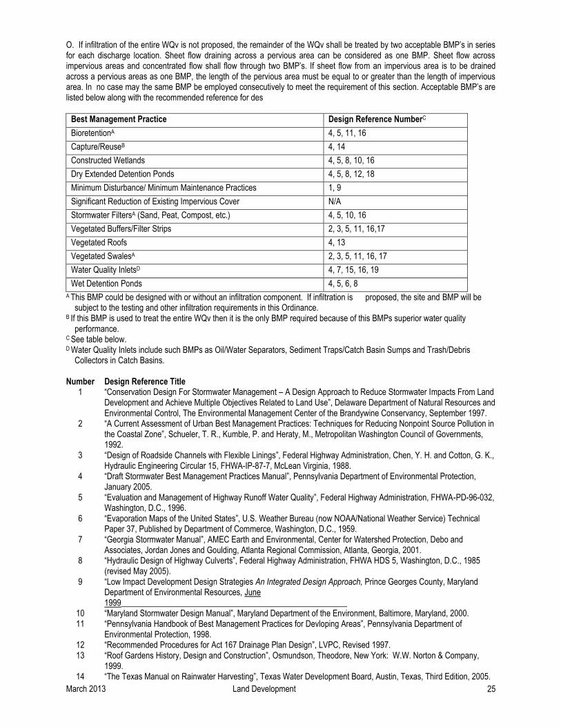
March 2013 Land Development 25
O. If infiltration of the entire WQv is not proposed, the remainder of the WQv shall be treated by two acceptable BMP’s in series for each discharge location. Sheet flow draining across a pervious area can be considered as one BMP. Sheet flow across impervious areas and concentrated flow shall flow through two BMP’s. If sheet flow from an impervious area is to be drained across a pervious areas as one BMP, the length of the pervious area must be equal to or greater than the length of impervious area. In no case may the same BMP be employed consecutively to meet the requirement of this section. Acceptable BMP’s are listed below along with the recommended reference for des
Best Management Practice Design Reference NumberC
BioretentionA 4, 5, 11, 16
Capture/ReuseB 4, 14
Constructed Wetlands 4, 5, 8, 10, 16
Dry Extended Detention Ponds 4, 5, 8, 12, 18
Minimum Disturbance/ Minimum Maintenance Practices 1, 9
Significant Reduction of Existing Impervious Cover N/A
Stormwater FiltersA (Sand, Peat, Compost, etc.) 4, 5, 10, 16
Vegetated Buffers/Filter Strips 2, 3, 5, 11, 16,17
Vegetated Roofs 4, 13
Vegetated SwalesA 2, 3, 5, 11, 16, 17
Water Quality InletsD 4, 7, 15, 16, 19
Wet Detention Ponds 4, 5, 6, 8
A This BMP could be designed with or without an infiltration component. If infiltration is proposed, the site and BMP will be subject to the testing and other infiltration requirements in this Ordinance.
B If this BMP is used to treat the entire WQv then it is the only BMP required because of this BMPs superior water quality performance.
C See table below. D Water Quality Inlets include such BMPs as Oil/Water Separators, Sediment Traps/Catch Basin Sumps and Trash/Debris
Collectors in Catch Basins. Number Design Reference Title
1 “Conservation Design For Stormwater Management – A Design Approach to Reduce Stormwater Impacts From Land Development and Achieve Multiple Objectives Related to Land Use”, Delaware Department of Natural Resources and Environmental Control, The Environmental Management Center of the Brandywine Conservancy, September 1997.
2 “A Current Assessment of Urban Best Management Practices: Techniques for Reducing Nonpoint Source Pollution in the Coastal Zone”, Schueler, T. R., Kumble, P. and Heraty, M., Metropolitan Washington Council of Governments, 1992.
3 “Design of Roadside Channels with Flexible Linings”, Federal Highway Administration, Chen, Y. H. and Cotton, G. K., Hydraulic Engineering Circular 15, FHWA-IP-87-7, McLean Virginia, 1988.
4 “Draft Stormwater Best Management Practices Manual”, Pennsylvania Department of Environmental Protection, January 2005.
5 “Evaluation and Management of Highway Runoff Water Quality”, Federal Highway Administration, FHWA-PD-96-032, Washington, D.C., 1996.
6 “Evaporation Maps of the United States”, U.S. Weather Bureau (now NOAA/National Weather Service) Technical Paper 37, Published by Department of Commerce, Washington, D.C., 1959.
7 “Georgia Stormwater Manual”, AMEC Earth and Environmental, Center for Watershed Protection, Debo and Associates, Jordan Jones and Goulding, Atlanta Regional Commission, Atlanta, Georgia, 2001.
8 “Hydraulic Design of Highway Culverts”, Federal Highway Administration, FHWA HDS 5, Washington, D.C., 1985 (revised May 2005).
9
10
“Low Impact Development Design Strategies An Integrated Design Approach, Prince Georges County, Maryland Department of Environmental Resources, June 1999______________________________________________________ “Maryland Stormwater Design Manual”, Maryland Department of the Environment, Baltimore, Maryland, 2000.
11 “Pennsylvania Handbook of Best Management Practices for Devloping Areas”, Pennsylvania Department of Environmental Protection, 1998.
12 “Recommended Procedures for Act 167 Drainage Plan Design”, LVPC, Revised 1997. 13 “Roof Gardens History, Design and Construction”, Osmundson, Theodore, New York: W.W. Norton & Company,
1999. 14 “The Texas Manual on Rainwater Harvesting”, Texas Water Development Board, Austin, Texas, Third Edition, 2005.

March 2013 Land Development 26
15 “VDOT Manual of Practice for Stormwater Management:, Virginia Transportation Research Council, Charlottesville, Virginia, 2004.
16 “Virginia Stormwater Management Handbook”, Virginia Department of Conservation and Recreation, Richmond, Virginia, 1999.
17 “Water Resources Engineering”, Mays, L. W., John Wiley & Sons, Inc., 2005. 18 “Urban Hydrology for Small Watersheds”, Technical Report 55, US Department of Agriculture, Natural Resources
Conservation Service, 1986. 19 US EPA, Region 1 New England web site (as of August 2005)
http://www.epa.gov/NE/assistance/ceitts/stormwater/techs/html.
P. Stormwater runoff from Hot Spot land uses shall be pre-treated. In no case, may the same BMP be employed consecutively to meet this requirement and the requirement in Section 1387.03.4O. Acceptable methods of pre-treatment are listed below.
Hot Spot Land Use Pre-treatment Method(s)
Vehicle Maintenance and Repair Facilities including Auto Parts Stores
-Oil/Water Separators -Use of Drip Pans and/or Dry Sweep Material Under
Vehicles/Equipment -Use of Absorbent Devices to Reduce Liquid Releases -Spill Prevention and Response Program
Vehicle Fueling Stations -Water Quality Inlets -Spill Prevention and Response Program
Hot Spot Land Use Pre-treatment Method(s)
Storage Areas for Public Works - Water Quality Inlets - Use of Drip Pans and/or Dry Sweep Material Under Vehicles/Equipment - Use of Absorbent Devices to Reduce Liquid Releases - Spill Prevention and Response Program - Diversion of Stormwater away from Potential Contamination Areas
Outdoor Storage of Liquids - Spill Prevention and Response Program
Salvage Yards and Recycling Facilities* - BMPs that are a part of a Stormwater Pollution Prevention Plan under an NPDES Permit
Fleet Storage Yards and Vehicle Cleaning Facilities* - BMPs that are a part of a Stormwater Pollution Prevention Plan under an NPDES Permit
Facilities that Store or Generate Regulated Substances* - BMPs that are a part of a Stormwater Pollution Prevention Plan under an NPDES Permit
Marinas* - BMPs that are a part of a Stormwater Pollution Prevention Plan under an NPDES Permit
Certain Industrial Uses (listed under NPDES)* - BMPs that are a part of a Stormwater Pollution Prevention Plan under an NPDES Permit
*Regulated under the NPDES Stormwater Program
Design references for the pre-treatment methods, as necessary, are listed below. If the applicant can demonstrate to the satisfaction of the municipality that the proposed land use is not a Hot Spot, then the pre-treatment requirement would not apply.
Pre-treatment Method Design ReferenceA
Constructed Wetlands 4, 5, 8, 10, 16
Diversion of Stormwater away from Potential Contamination Areas 4, 11
Stormwater Collection and Reuse (especially for irrigation) 4, 14

March 2013 Land Development 27
Stormwater Filters (Sand, Peat, Compost, etc.) 4, 5, 10, 16
Vegetated Swales 2, 3, 5, 11, 16, 17
Water Quality Inlets 4, 7, 15, 16, 19
AThese numbers refer to the Design Reference Title Chart in Section 304.O. above.
Q. The use of infiltration BMPs is prohibited on Hot Spot land use areas.
R. Stormwater infiltration BMPs shall not be placed in or on a special geologic feature(s). Additionally, stormwater runoff shall not be discharged into existing on-site sinkholes.
S. Applicants shall request, in writing, Public Water Suppliers to provide the Zone I Wellhead Protection radius,
as calculated by the method outlined in the Pennsylvania Department of Environmental Protection Wellhead Protection regulations, for any public water supply well within 400 feet of the site. In addition to the setback distances specified in Section 304.I., infiltration is prohibited in the Zone I radius as defined and substantiated by the Public Water Supplier in writing. If the applicant does not receive a response from the Public Water Supplier, the Zone I radius is assumed to be 100 feet.
T. The volume and rate of the net increase in stormwater runoff from the Regulated Activities must be managed
to prevent the physical degradation of receiving waters from such effects as scour and streambank destabilization, to satisfy State Water Quality Requirements, by controlling the 2-year post-development runoff to a 30% Release Rate.
U. The City may, after consultation with DEP, approve alternative methods for meeting the State Water Quality
Requirements other than those in this Section, provided that they meet the minimum requirements of and do not conflict with State law including but not limited to the Clean Streams Law.
1387.03.5 Stormwater Management Districts
A. Mapping of Stormwater Management Districts - To implement the provisions of the City’s Watershed Stormwater Management Plan, the City is hereby divided into Stormwater Management Districts consistent with the Jordan Creek, Little Lehigh Creek, Monocacy Creek and Lehigh River Sub-basins Release Rate Maps presented in the Plan Update. The boundaries of the Stormwater Management Districts are shown on an official map which is available for inspection at the City Engineer’s office. A copy of the official map at a reduced scale is included in Appendix A for general reference.
B. Description of Stormwater Management Districts - Two types of Stormwater Management Districts may be
applicable to the municipality, namely Conditional No Detention Districts and Dual Release Rate Districts as described below.
1. Conditional/Provisional No Detention Districts - Within these districts, the capacity of the “local” runoff
conveyance facilities (as defined in Article 2) must be calculated to determine if adequate capacity exists. For this determination, the developer must calculate peak flows assuming that the site is developed as proposed and that the remainder of the local watershed is in the existing condition. The developer must also calculate peak flows assuming that the entire local watershed is developed per current zoning and that all new development would use the runoff controls specified by this Ordinance. The larger of the two peak flows calculated will be used in determining if adequate capacity exists. If adequate capacity exists to safely transport runoff from the site to the main channel (as defined in Article 2), these watershed areas may discharge post-development peak runoff without detention facilities. If the capacity calculations show that the “local” runoff conveyance facilities lack adequate capacity, the developer shall either use a 100% release rate control or provide increased capacity of downstream elements to convey increased peak flows consistent with Section 1387.03.6P. Any capacity improvements must be designed to convey runoff from development of all areas tributary to the improvement consistent with the capacity criteria specified in Section 306.D. By definition, a storm drainage problem area associated with the “local” runoff conveyance facilities indicates that adequate capacity does not exist. Sites in these districts are still required to meet all of the water quality requirements in Section 1387.03.4.
March 2013 Land Development 28
2. Dual Release Rate Districts - Within these districts, the 2-year post-development peak discharge must be controlled to 30% of the pre-development 2-year runoff peak. Further, the 10-year, 25-year and 100-year post-development peak runoff must be controlled to the stated percentage of the pre-development peak. Release Rates associated with the 10- through 100-year events vary from 50% to 100% depending upon location in the watershed. (For the Monocacy Creek Watershed, the original Single Release Rate Districts become Dual Release Rate Districts due to the channel protection standard requiring developments to meet a 2-year 30% Release Rate).
1387.03.6 Stormwater Management District Implementation Provisions
A. Applicants shall provide a comparative pre- and post-construction stormwater management hydrograph analysis for each direction of discharge and for the site overall to demonstrate compliance with the provisions of this Ordinance.
B. Any stormwater management controls required by this Ordinance and subject to a dual release rate criteria
shall meet the applicable release rate criteria for each of the 2-, 10-, 25- and 100-year return period runoff events consistent with the calculation methodology specified in Section 1387.03.7.
C. The exact location of the Stormwater Management District boundaries as they apply to a given development
site shall be determined by mapping the boundaries using the two-foot topographic contours provided as part of the Drainage Plan. The District boundaries as originally drawn coincide with topographic divides or in certain instances, are drawn from the intersection of the watercourse and a physical feature such as the confluence with another watercourse or a potential flow obstruction (e.g. road, culvert, bridge, etc.). The physical feature is the downstream limit of the subarea and the subarea boundary is drawn from that point up slope to each topographic divide along the path perpendicular to the contour lines.
D. Any downstream capacity analysis conducted in accordance with this Ordinance shall use the following
criteria for determining adequacy for accepting increased peak flow rates:
1. Natural or man-made channels or swales must be able to convey the increased runoff associated with a 2-year return period event within their banks at velocities consistent with protection of the channels from erosion. Acceptable velocities shall be based upon criteria included in the most current DEP Erosion and Sediment Pollution Control Program Manual. Permissible velocities from the DEP manual for selected channels are presented in Appendix C of this Ordinance.
2. Natural or man-made channels or swales must be able to convey the increased 25-year return period runoff without creating any hazard to persons or property. A one hundred (100) year design storm is required where a storm of this return period would likely cause damage to existing or future structures or their contents were it not for implementation of proper storm water management provisions.
3. Culverts, bridges, storm sewers or any other facilities which must pass or convey flows from the tributary area must be designed in accordance with DEP Chapter 105 regulations (if applicable) and at minimum, pass the increased 25-year return period runoff.
E. For a proposed development site located within one release rate category subarea, the total runoff from the
site shall meet the applicable release rate criteria. For development sites with multiple directions of runoff discharge, individual drainage directions may be designed for up to a 100% release rate so long as the total runoff from the site is controlled to the applicable release rate.
F. For a proposed development site located within two or more release category subareas, the peak discharge
rate from any subarea shall be the pre-development peak discharge for that subarea multiplied by the applicable release rate. The calculated peak discharges shall apply regardless of whether the grading plan changes the drainage area by subarea. An exception to the above may be granted if discharges from multiple subareas re-combine in proximity to the site. In this case, peak discharge in any direction may be a 100% release rate provided that the overall site discharge meets the weighted average release rate.

March 2013 Land Development 29
G. For a proposed development site located partially within a release rate category subarea and partially within a Conditional/Provisional No Detention subarea, the size of the pre-development drainage area on a site may not be changed post-development to create potentially adverse conditions on downstream properties except as part of a “No Harm” or Hardship waiver procedure.
H. No portion of a site may be regraded between adjacent watersheds except as part of a “No Harm” or
Hardship Waiver procedure.
I. Within a release rate category area, for a proposed development site which has areas which drain to a closed depression(s), the design release from the site will be the lesser of (a) the applicable release rate flow assuming no closed depression(s) or (b) the existing peak flow actually leaving the site. In cases where (b) would result in an unreasonably small design release, the design discharge of less than or equal to the release rate will be determined by the available downstream conveyance capacity to the main channel calculated using Section 1387.03.6D. and the minimum orifice criteria.
J. Off-site areas which drain through a proposed development site are not subject to release rate criteria when
determining allowable peak runoff rates. However, on-site drainage facilities shall be designed to safely convey off-site flows through the development site using the capacity criteria in Section 1387.03.6D. and the detention criteria in Section 1387.03.7.
K. For development sites proposed to take place in phases, all detention ponds shall be designed to meet the
applicable release rate(s) applied to all site areas tributary to the proposed pond discharge direction. All site tributary areas will be assumed as developed, regardless of whether all site tributary acres are proposed for development at that time. An exception shall be sites with multiple detention ponds in series where only the downstream pond must be designed to the stated release rate.
L Where the site area to be impacted by a proposed development activity differs significantly from the total site
area, only the proposed impact area shall be subject to the release rate criteria. The impact area includes any proposed cover or grading changes.
M. Development proposals which, through groundwater recharge or other means, do not increase either the
rate or volume of runoff discharged from the site compared to pre-development are not subject to the release rate provisions of this Ordinance.
N. “No Harm” Water Quantity Option - For any proposed development site not located in a
Conditional/Provisional No Detention District, the developer has the option of using a less restrictive runoff control (including no detention) if the developer can prove that special circumstances exist for the proposed development site and that “no harm” would be caused by discharging at a higher runoff rate than that specified by the Plan. Special circumstances are defined as any hydrologic or hydraulic aspects of the development itself not specifically considered in the development of the Plan runoff control strategy. Proof of “no harm” would have to be shown from the development site through the remainder of the downstream drainage network to the confluence of the creek with the Lehigh River. Proof of “no harm” must be shown using the capacity criteria specified in Section 1387.03.6D. if downstream capacity analysis is a part of the “no harm” justification.
Attempts to prove “no harm” based upon downstream peak flow versus capacity analysis shall be governed by the following provisions:
1. The peak flow values to be used for downstream areas for the design return period storms (2-, 10-, 25-
and 100-year) shall be the values from the calibrated PSRM Watershed Model or as calculated by an applicant using an alternate method acceptable to the City and LVPC. The flow values from the PSRM Model would be supplied to the developer by LVPC upon request.
2. Any available capacity in the downstream conveyance system as documented by a developer may be
used by the developer only in proportion to his development site acreage relative to the total upstream

March 2013 Land Development 30
undeveloped acreage from the identified capacity (i.e. if his site is 10% of the upstream undeveloped acreage, he may use up to 10% of the documented downstream available capacity).
3. Developer-proposed runoff controls which would generate increased peak flow rates at storm drainage
problem areas would, by definition, be precluded from successful attempts to prove “no harm”, except in conjunction with proposed capacity improvements for the problem areas consistent with Section 1387.03.6P.
Any “no harm” justifications shall be submitted by the developer to LVPC and the City Engineer for review as part of the Drainage Plan submission per Article.
4. Developers submitting “no harm” justifications must still meet all of the water quality requirements in Section 1387.03.4.
O. Regional Detention Alternatives - For certain areas within the study area, it may be more cost-effective to
provide one control facility for more than one development site than to provide an individual control facility for each development site. The initiative and funding for any regional runoff control alternatives are the responsibility of prospective developers. The design of any regional control basins must incorporate reasonable development of the entire upstream watershed. The peak outflow of a regional basin would be determined based on the required release rate at the point of discharge.
P. Capacity Improvements - In certain instances, primarily within the Conditional/Provisional No Detention
areas, local drainage conditions may dictate more stringent levels of runoff control than those based upon protection of the entire watershed. In these instances, if the developer could prove that it would be feasible to provide capacity improvements to relieve the capacity deficiency in the local drainage network, then the capacity improvements could be provided by the developer in lieu of runoff controls on the development site. Peak flow calculations shall be done assuming that the local watershed is in the existing condition and then assuming that the local watershed is developed per current zoning and using the specified runoff controls. Any capacity improvements would be designed using the larger of the above peak flows and the capacity criteria specified in Section 1387.03.6D. All new development in the entire subarea(s) within which the proposed development site is located shall be assumed to implement the developer’s proposed discharge control, if any.
Capacity improvements may also be provided as necessary to implement any regional detention alternatives or to implement a modified “no harm” option which proposes specific capacity improvements to provide that a less stringent discharge control would not create any harm downstream.
1387.03.7 Calculation Methodology
A. Stormwater runoff from all development sites shall be calculated using either the rational method or the soil-cover-complex methodology.
B. Infiltration BMP loading rate percentages in the Recommendation Chart for Infiltration Stormwater
Management BMPs in Carbonate Bedrock in Appendix D shall be calculated as follows:
The area tributary to the infiltration BMP shall be weighted as follows: All disturbed areas to be made impervious: weight at 100% All disturbed areas to be made pervious: weight at 50% All undisturbed pervious areas: weight at 0% All existing impervious areas: weight at 100%
C. Soil thickness is to be measured from the bottom of any proposed infiltration system. The effective soil
thickness in the Recommendation Chart for Infiltration Stormwater Management BMPs in Carbonate Bedrock in Appendix D is the measured soil thickness multiplied by the thickness factor based on soil permeability (as measured by the adapted 25 PA Code § 73.15. percolation test in Appendix G), as follows:

March 2013 Land Development 31
PERMEABILITY RANGE* THICKNESS FACTOR
6.0 to 12.0 inches/hour 0.8
2.0 to 6.0 inches/hour 1.0
1.0 to 2.0 inches/hour 1.4
0.75 to 1.0 inches/hour 1.2
0.5 to 0.75 inches/hour 1.0
*If the permeability rate (as measured by the adapted 25 PA Code § 73.15. percolation test in Appendix G) falls on a break between two thickness factors, the smaller thickness factor shall be used.
Sites with soil permeability greater than 12.0 in./hr. or less than 0.5 in./hr. as measured by the adapted 25 PA Code § 73.15. percolation test in Appendix G, are not recommended for infiltration.
D. The design of any detention basin intended to meet the requirements of this Ordinance shall be verified by
routing the design storm hydrograph through the proposed basin using the storage indication method or other methodology demonstrated to be more appropriate. For basins designed using the Rational Method technique, the design hydrograph for routing shall be either the Universal Rational Hydrograph or the Modified Rational Method trapezoidal hydrograph which maximizes detention volume. Use of the Modified Rational hydrograph shall be consistent with the procedure described in Section “PIPE.RAT” of the Users’ Manual for the Penn State Urban Hydrograph Method (1987).
E. BMPs designed to store or infiltrate runoff and discharge to surface runoff or pipe flow shall be routed using
the storage indication method.
F. BMPs designed to store or infiltrate runoff and discharge to surface runoff or pipe flow shall provide storage volume for the full WQv below the lowest outlet invert.
G. Wet Detention Ponds designed to have a permanent pool for the WQv shall assume that the permanent pool
volume below the primary outlet is full at the beginning of design event routing for the purposes of evaluating peak outflows.
H. All stormwater detention facilities shall provide a minimum 1.0 foot freeboard above the maximum pool
elevation associated with the 2- through 25-year runoff events. A 0.5 foot freeboard shall be provided above the maximum pool elevation of the 100-year runoff event. The freeboard shall be measured from the maximum pool elevation to the invert of the emergency spillway. The 2- through 100-year storm events shall be controlled by the primary outlet structure. An emergency spillway for each basin shall be designed to pass the 100-year return frequency storm peak basin inflow rate with a minimum 0.5 foot freeboard measured to the top of basin. The freeboard criteria shall be met considering any offsite areas tributary to the basin as developed, as applicable. If this detention facility is considered to be a dam as per DEP Chapter 105, the design of the facility must be consistent with the Chapter 105 regulations and may be required to pass a storm greater than the 100-year event.
I. The minimum circular orifice diameter for controlling discharge rates from detention facilities shall be three
(3) inches. Designs where a lesser size orifice would be required to fully meet release rates shall be acceptable with a 3-inch orifice provided that as much of the site runoff as practical is directed to the detention facilities. The minimum 3-inch diameter does not apply to the control of the WQv.
J. Runoff calculations using the soil-cover-complex method shall use the Natural Resources Conservation
Service Type II 24-hour rainfall distribution. The 24-hour rainfall depths for the various return periods to be used consistent with this Ordinance may be taken from NOAA Atlas 14, Volume 2 Version 2.1, 2004 or the PennDOT Intensity - Duration - Frequency Field Manual (“PDT-IDF”) (May 1986) for Region 4. The following values are taken from the PDT-IDF Field Manual:

March 2013 Land Development 32
Return Period 24-Hour Rainfall Depth 1-year 2.40 inches 2-year 3.00 inches 5-year 3.60 inches 10-year 4.56 inches 25-year 5.52 inches 50-year 6.48 inches 100-year 7.44 inches
A graphical and tabular presentation of the Type II-24 hour distribution is included in Appendix C.
K. Runoff calculations using the Rational Method shall use rainfall intensities consistent with appropriate times of concentration and return periods and NOAA Atlas 14, Volume 2 Version 2.1, 2004 or the Intensity-Duration-Frequency Curves as presented in Appendix C.
L. Runoff Curve Numbers (CN’s) to be used in the soil-cover-complex method shall be based upon the matrix
presented in Appendix C.
M. Runoff coefficients for use in the Rational Method shall be based upon the table presented in Appendix C. N. All time of concentration calculations shall use a segmental approach which may include one or all of the
flow types below:
1. Sheet Flow (overland flow) calculations shall use either the NRCS average velocity chart (Figure 3-1, Technical Release-55, 1975) or the modified kinematic wave travel time equation (equation 3-3, NRCS TR-55, June 1986). If using the modified kinematic wave travel time equation, the sheet flow length shall be limited to 50 feet for designs using the Rational Method and limited to 150 feet for designs using the Soil-Cover-Complex method.
2. Shallow Concentrated Flow travel times shall be determined from the watercourse slope, type of
surface and the velocity from Figure 3-1 of TR-55, June 1986.
3. Open Channel Flow travel times shall be determined from velocities calculated by the Manning Equation. Bankfull flows shall be used for determining velocities. Manning ‘n’ values shall be based on the table presented in Appendix C.
4. Pipe Flow travel times shall be determined from velocities calculated using the Manning Equation
assuming full flow and the Manning ‘n’ values from Appendix C.
O. If using the Rational Method, all pre-development calculations for a given discharge direction shall be based on a common time of concentration considering both on-site and any off-site drainage areas. If using the Rational Method, all post-development calculations for a given discharge direction shall be based on a common time of concentration considering both on-site and any off-site drainage areas.
P. The Manning Equation shall be used to calculate the capacity of watercourses and Stormwater Conveyance
Systems. Manning ‘n’ values used in the calculations shall be consistent with the table presented in Appendix C or other appropriate standard engineering ‘n’ value resources. Pipe capacities shall be determined by methods acceptable to the municipality.
Q. The Pennsylvania DEP, Chapter 105, Rules and Regulations, apply to the construction, modification, operation or maintenance of both existing and proposed dams, water obstructions and encroachments throughout the watershed. Criteria for design and construction of stormwater management facilities according to this Ordinance may differ from same criteria that are used in the permitting of dams under the Dam Safety Program.

March 2013 Land Development 33
1387.04 Drainage Plan Requirements
1387.04.1 General Requirements For any of the Regulated Activities of this Ordinance, prior to the final approval of subdivision and/or land development plans or the issuance of any permit or the commencement of any Regulated Earth Disturbance activity, the owner, subdivider, developer or his agent shall submit a Drainage Plan and receive City approval of the Plan.
1387.04.2 Exemptions
Exemptions from the Drainage Plan Requirements are as specified in Section 106.
1387.04.3 Drainage Plan Contents The following items shall be included in the Drainage Plan:
A. General
1. General description of project.
2. General description of proposed permanent stormwater controls.
3. The name and address of the project site, the name and address of the owner of the property and the name of the individual or firm preparing the Drainage Plan.
B. Map(s) of the Project Area Showing:
1. The location of the project relative to highways, municipalities or other identifiable landmarks.
2. Existing contours at intervals of two (2) feet. In areas of steep slopes (greater than 15%), five-foot contour intervals may be used. Off-site drainage areas impacting the project including topographic detail.
3. Streams, lakes, ponds or other bodies of water within the project area.
4. Other features including flood hazard boundaries, existing drainage swales, wetlands, closed
depressions, sinkholes and areas of natural vegetation to be preserved.
5. Locations of proposed underground utilities, sewers and water lines. The locations of all existing and proposed utilities, sanitary sewers and water lines within 50 feet of property lines of the project site.
6. An overlay showing soil types and boundaries based on the Lehigh County Soil Survey latest edition. Any hydric soils present on the site should be identified as such.
7. An overlay showing geologic types, boundaries and any special geologic features present on the site..
8. Proposed changes to land surface and vegetative cover.
9. Proposed structures, roads, paved areas and buildings.
10. Final contours at intervals of two (2) feet. In areas of steep slopes (greater than 15%) five-foot contour intervals may be used.
11. Stormwater Management District boundaries applicable to the site.
12. Clear identification of the location and nature of permanent stormwater BMPs.
13. An adequate access easement around all stormwater BMPs that would provide City ingress to and egress from a public right-of-way.

March 2013 Land Development 34
14. A schematic showing all tributaries contributing flow to the site and all existing man-made features beyond the property boundary that would be affected by the project.
15. The location of all public water supply wells within 400 feet of the project and all private water supply wells within 100 feet of the project.
C. Stormwater Management Controls and BMPs
1. All stormwater management controls and BMPs shall be shown on a map and described,
including:
a. Groundwater recharge methods such as seepage pits, beds or trenches. When these structures are used, the locations of septic tank infiltration areas and wells shall be shown.
b. Other control devices or methods such as roof-top storage, semi-pervious paving
materials, grass swales, parking lot ponding, vegetated strips, detention or retention ponds, storm sewers, etc.
2. All calculations, assumptions and criteria used in the design of the BMPs shall be shown. 3. All site testing data used to determine the feasibility of infiltration on a site. 4. All details and specifications for the construction of the stormwater management controls and
BMPs.
D. The BMP Operations and Management Plan, as required in Article 7, describing how each permanent stormwater BMP will be operated and maintained and the identity of the person(s) responsible for operations and maintenance. A statement must be included, signed by the landowner, acknowledging that the stormwater BMPs are fixtures that cannot be altered or removed without approval by the City.
E. An Environmental Resources Site Design Assessment that describes the following:
1. The extent to which the proposed grading and impervious cover avoid disturbance of significant environmental resources and preserve existing site hydrology.
2. As assessment of whether alternative grading and impervious cover site design could lessen the
disturbance of significant environmental resources and/or make better use of the site hydrologic resources.
3. A description of how the proposed stormwater management controls and BM’s serve to mitigate
any adverse impacts on environmental resources on the site. Significant environmental resources considered in the site design assessment include but are not limited to, steep slopes, ponds, lakes, streams, wetlands, hydric soils, floodplains, riparian vegetation, native vegetation and special geologic features.
1387.04.4 Plan Submission
A. For Regulated Activities specified in Sections 1387.01.5A and 1387.01.5B: 1. The Drainage Plan shall be submitted by the developer to the City’s Planning Bureau as part of
the Plan submission for the subdivision or land development. 2. Two (2) copies of the Drainage Plan shall be submitted to the City. 3. Distribution of the Drainage Plan to the City will be as follows:

March 2013 Land Development 35
a. One (1) copy to the City’s Planning Bureau. b. One (1) copy to the City’s Bureau of Engineering.
4. Drainage Plans involving more than 10,000 square feet of additional impervious cover shall be submitted by the developer to the Lehigh Valley Planning Commission as part of the Plan submission. The Lehigh Valley Planning Commission will conduct an advisory review of the Drainage Plan for consistency with the City’s Watershed Stormwater Management Plan. The LVPC will not review details of the Erosion and Sedimentation Plan or the BMP Operations and Maintenance Plan.
a. Two (2) copies of the Drainage Plan shall be submitted. b. The LVPC will provide written comments to the developer and the City, within a time frame
consistent with established procedures under the Municipalities Planning Code, as to whether the Drainage Plan has been found to be consistent with the Stormwater Management Plan.
B. For Regulated Activities specified in Sections 1387.01.5C. and 1387.01.5D., the Drainage Plan shall be
submitted by the developer to the City’s building permit officer as part of the building permit application.
C. For Regulated Activities specified in Sections 1387.01.5E, F. and G.: 1. The Drainage Plan shall be submitted by the developer to the Lehigh Valley Planning Commission for
coordination with the DEP permit application process under Chapter 105 (Dam Safety and Waterway Management), Chapter 106 (Flood Plain Management) of DEP’s Rules and Regulations and the NPDES regulations.
2. One (1) copy of the Drainage Plan shall be submitted.
D. Earthmoving for all regulated activities under Section 105 shall be conducted in accordance with the current federal and State regulations relative to the NPDES andDEP Chapter 102 regulations.
1387.04.5 Drainage Plan Review
A. The City Engineer shall review the Drainage Plan, including the BMP Operations and Maintenance Plan, for consistency with the adopted Watershed Stormwater Management Plan as embodied by this Ordinance and with any permits issued by DEP. The City shall also review the Drainage Plan against any additional storm drainage provisions contained in the City subdivision and land development or zoning ordinance, as applicable.
B. The City shall notify the applicant in writing whether the Drainage Plan, including the BMP Operations and
Maintenance Plan, is approved. C. The City shall not approve any subdivision or land development (Regulated Activities 1387.01.5A and B.) or
building permit application (Regulated Activities 1387.01.5C and D.) if the Drainage Plan has been found to be inconsistent with the Stormwater Management Plan.
D. The municipality will require an “As-Built Survey” of all stormwater BMPs and an explanation of any
discrepancies with the Drainage Plan.
1387.04.6 Modification of Plan A modification to a submitted Drainage Plan for a proposed development site which involves a change in control methods or techniques or which involves the relocation or redesign of control measures or which is necessary because soil or other conditions are not as stated on the Drainage Plan (as determined by the municipality) shall require a resubmission of the modified Drainage Plan consistent with Section 138.04.4 subject to review per Section 1387.04.5 of this Ordinance.

March 2013 Land Development 36
1387.04.7 Hardship Waiver Procedure The City may hear requests for waivers where it is alleged that the provisions of this Ordinance inflict unnecessary hardship upon the applicant. The waiver request shall be in writing and accompanied by the requisite fee based upon a fee schedule adopted by the City. A copy of the waiver request shall be provided to each of the following: City Planning Bureau, City engineer, City Solicitor and Lehigh Valley Planning Commission. The request shall fully document the nature of the alleged hardship. The municipality may grant a waiver provided that all of the following findings are made in a given case:
1. That there are unique physical circumstances or conditions, including irregularity of lot size or shape or exceptional topographical or other physical conditions peculiar to the particular property and that the unnecessary hardship is due to such conditions and not the circumstances or conditions generally created by the provisions of this Ordinance in the Stormwater Management District in which the property is located;
2. That because of such physical circumstances or conditions, there is no possibility that the property can
be developed in strict conformity with the provisions of this Ordinance, including the “no harm” provisions and that the authorization of a waiver is therefore necessary to enable the reasonable use of the property;
3. That such unnecessary hardship has not been created by the applicant; 4. That the waiver, if authorized, will represent the minimum waiver that will afford relief and will represent
the least modification possible of the regulation in issue; and
5. That financial hardship is not the criteria for granting of a hardship waiver.
In granting any waiver, the City may attach such conditions and safeguards as it may deem necessary to implement the purposes of this Ordinance. If a Hardship Waiver is granted, the applicant must still manage the quantity, velocity, direction and quality of resulting storm runoff as is necessary to prevent injury to health, safety or other property.
A. For regulated activities described in Section 1387.01.5A and B, the [City] shall hear requests for and decide
on hardship waiver requests on behalf of the City. B. For regulated activities in Section 138701.5C, D, E, F and G the Zoning Hearing Board shall hear requests
for and decide on hardship waiver requests on behalf of the City.
C. The City shall not waive the water quality provisions of this Ordinance.
1387.05 Inspections
1387.05.1 Schedule of Inspections A. DEP or its designees (e.g. County Conservation District) normally ensure compliance with any permits
issued, including those for stormwater management. In addition to DEP compliance programs, the City Engineer or its designee may inspect all phases of the construction, operations, maintenance and any other implementation of stormwater BMPs. The City Engineer or his designee may also check that as-built records are being maintained on-site.
B. During any stage of the Regulated Earth Disturbance activities, if the City Engineer or its designee
determines that any BMPs are not being implemented in accordance with this Ordinance, the City Engineer may suspend or revoke any existing permits issued by the City or other approvals issued by the City until the deficiencies are corrected.
March 2013 Land Development 37
1387.06 Fees and Expenses
1387.06.1 General The City may charge a reasonable fee for review of the Drainage Plan, including the BMP Operations and Maintenance Plans, to defray review costs incurred by the City. The applicant shall pay all such fees.
1387.06.2 Expenses Covered by Fees The fees required by this Ordinance shall at a minimum cover: A. The review of the Drainage Plan, including BMP Operations and Maintenance Plan by the City Engineer or
his representative.
B. The site inspection.
C. The inspection of required controls and improvements during construction.
D. The final inspection upon completion of the controls and improvements required in the plan.
E. Administrative and clerical costs. F. Each applicant shall receive an invoice, which explains the labor, material and equipment cost at the
conclusion of the review and processing.
1387.07 Stormwater BMP Operations and Maintenance Plan Requirements
1387.07.1 General Requirements A. No Regulated Earth Disturbance Activities within the City shall commence until approval by the City of the
BMP Operations and Maintenance Plan which describes how the permanent (e.g. post-construction) stormwater BMPs will be properly operated and maintained.
1387.07.2 Responsibilities for Operations and Maintenance of BMP’S
A. The BMP Operations and Maintenance Plan for the project site shall establish responsibilities for the continuing operation and maintenance of all permanent stormwater BMPs, as follows:
1. If a Plan includes structures or lots which are to be separately owned and in which streets, sewers and
other public improvements are to be dedicated to the City, stormwater BMPs may also be dedicated to and maintained by the City;
2. If a Plan includes operations and maintenance by a single owner or if sewers and other public
improvements are to be privately owned and maintained, then the operation and maintenance of stormwater BMPs shall be the responsibility of the owner or private management entity.
B. The City shall make the final determination on the continuing operations and maintenance responsibilities.
The City reserves the right to accept or reject the operations and maintenance responsibility for any or all of the stormwater BMPs.
1387.07.3 Adherence to Approved BMP Operations and Maintenance Plan
It shall be unlawful to alter or remove any permanent stormwater BMP required by an approved BMP Operations and Maintenance Plan or to allow the property to remain in a condition which does not conform to an approved BMP Operations and Maintenance Plan unless an exception is granted in writing by the City.
1387.07.4 Operations and Maintenance Agreement for Privately Owned Stormwater BMPS A. The property owner shall sign an operations and maintenance agreement with the City covering all
stormwater BMPs that are to be privately owned. The agreement shall be substantially the same as the agreement in Appendix E of this Ordinance.

March 2013 Land Development 38
B. Other items may be included in the agreement where determined by the City to be reasonable or necessary to guarantee the satisfactory operation and maintenance of all permanent stormwater BMPs. The agreement shall be subject to the review and approval of the City.
1387.07.5 Stormwater Management Easements
Stormwater management easements shall be provided by the property owner if necessary for access for inspections and maintenance or for preservation of stormwater conveyance, infiltration, detention areas and other BMPs by persons other than the property owner. The purpose of the easement shall be specified in any agreement under Section 1387.07.4.
1387.07.6 Recording of Approved BMP Operations and Maintenance Plan and Related Agreements A. The owner of any land upon which permanent BMPs will be placed, constructed or implemented, as
described in the BMP Operations and Maintenance Plan, shall record the following documents in the Office of the Recorder of Deeds for Lehigh County, as applicable, within 90 days of approval of the BMP Operations and Maintenance Plan by the City:
1. The Operations and Maintenance Plan or a summary thereof 2. Operations and Maintenance Agreements under Section 1387.07.4 3. Easements under Section 1387.07.5
B. The City may suspend or revoke any approvals granted for the project site upon discovery of the failure of the owner to comply with this Section.
1387.07.7 Municipal Stormwater BMP Operation and Maintenance Fund
A. If stormwater BMPs are accepted by the City for dedication, the City may require the applicant to pay a specified amount to the Municipal Stormwater BMP Operations and Maintenance Fund to help defray costs of operations and maintenance activities. The amount may be determined as follows:
1. If the BMP is to be owned and maintained by the City, the amount shall cover the estimated costs for
operation and maintenance in perpetuity, as determined by the municipality. 2. The amount shall then be converted to present worth of the annual series values.
B. If a BMP is proposed that also serves as a recreation facility (e.g. ball field, lake), the City may adjust the
amount due accordingly.
1387.08 Prohibitions
1387.08.1 Prohibited Discharges A. No person in the City shall allow or cause to allow stormwater discharges into the City’s separate storm
sewer system which are not composed entirely of stormwater except as provided in subsection B below or as allowed under a State or Federal permit.
B. Discharges that may be allowed based on the City finding that the discharge(s) do not significantly contribute
pollution to surface waters of the Commonwealth are listed below.
1. Discharges from fire fighting activities 2. Potable water sources including dechlorinated water line and fire hydrant flushings 3. Irrigation drainage
4. Routine external building washdown which does not use detergents or other compounds 5. Air conditioning condensate
March 2013 Land Development 39
6. Water from individual residential car washing
7. Springs
8. Water from crawl space pumps
9. Uncontaminated water from foundation or footing drains
10. Flows from riparian habitats and wetlands 11. Lawn watering
12. Pavement washwaters where spills or leaks of toxic or hazardous materials have not occurred (unless
all spill material has been removed) and where detergents are not used
13. Dechlorinated swimming pool discharges 14. Uncontaminated groundwater
C. In the event that the City determines that any of the discharges identified in Section 1387.08.1B significantly
contribute to pollution of waters of the Commonwealth or is so notified by DEP, the City will notify the responsible person to cease the discharge.
D. Upon notice provided by the City under Section 1387.08.1C, the discharger will have a reasonable time, as
determined by the City, to cease the discharge consistent with the degree of pollution caused by the discharge.
E. Nothing in this Section shall affect a discharger’s responsibilities under state law.
1387.08.2 Prohibited Connections
A. The following connections are prohibited, except as provided in Section 1387 above:
1. Any drain or conveyance, whether on the surface or subsurface, which allows any non-stormwater discharge including sewage, process wastewater and wash water to enter the separate storm sewer system and any connections to the storm drain system from indoor drains and sinks.
2. Any drain or conveyance connected from a commercial or industrial land use to the separate storm
sewer system which has not been documented in plans, maps or equivalent records and approved by the City.
1387.08.3 Roof Drains
A. Roof drains shall not be connected to streets, sanitary or storm sewers or roadside ditches, except as provided in Section 1387.08.3B.
B. When it is more advantageous to connect directly to streets or storm sewers, connections of roof drains to
streets or roadside ditches may be permitted by the City.
C. Roof drains shall discharge to infiltration areas or vegetative BMPs to the maximum extent practicable.
1387.08.4 Alteration of BMPS A. No person shall modify, remove, fill, landscape or alter any existing stormwater BMP without the written
approval of the City unless it is part of an approved maintenance program.

March 2013 Land Development 40
B. No person shall place any structure, fill, landscaping or vegetation into a stormwater BMP or within a drainage easement, which would limit or alter the functioning of the BMP, without the written approval of the City.
1387.09 Right of Entry, Notification and Enforcement
1387.09.1 Right of Entry
A. Upon presentation of proper credentials and with the consent of the land owner, duly authorized representatives of the municipality may enter at reasonable times upon any property within the municipality to inspect the implementation, condition or operation and maintenance of the stormwater BMPs or to investigate or ascertain the condition of the subject property in regard to any aspect regulated by this Ordinance.
B. In the event that the land owner refuses admission to the property, duly authorized representatives of the
City may seek an administrative search warrant issued by a district justice to gain access to the property.
1387.09.2 Notification A. Whenever the City finds that a person has violated a prohibition or failed to meet a requirement of this
Ordinance, the City may order compliance by written notice to the responsible person. Such notice may require without limitation:
1. The name of the owner of record and any other person against whom the Municipality intends to take
action 2. The location of the property in violation 3. The performance of monitoring, analyses and reporting 4. The elimination of prohibited connections or discharges 5. Cessation of any violating discharges, practices or operations 6. The abatement or remediation of stormwater pollution or contamination hazards and the restoration of
any affected property
7. Payment of a fine to cover administrative and remediation costs
8. The implementation of stormwater BMPs
9. Operation and maintenance of stormwater BMPs
B. Such notification shall set forth the nature of the violation(s) and establish a time limit for correction of the violation(s). Said notice may further advise that should the violator fail to take the required action within the established deadline, the work will be done by the City or designee and the expense thereof, together with all related lien and enforcement fees, charges and expenses, shall be charged to the violator.
C. Failure to comply within the time specified shall also subject such person to the penalty provisions of this
Ordinance. All such penalties shall be deemed cumulative and shall not prevent the municipality from pursuing any and all other remedies available in law or equity.
1387.09.3 Public Nuisance
A. The violation of any provision of this Ordinance is hereby deemed a Public Nuisance. B. Each day that an offense continues shall constitute a separate violation.

March 2013 Land Development 41
1387.09.4 Suspension and Revocation of Permits and Approvals
A. Any building, land development or other permit or approval issued by the City may be suspended or revoked by the City for:
1. Non-compliance with or failure to implement any provision of the permit 2. A violation of any provision of this Ordinance 3. The creation of any condition or the commission of any act during construction or development which constitutes or creates a hazard or nuisance, pollution or which endangers the life or property of others.
B. A suspended permit or approval shall be reinstated by the City when:
1. The City Engineer or designee has inspected and approved the corrections to the stormwater BMPs or the elimination of the hazard or nuisance.
2. The City is satisfied that the violation of the ordinance, law or rule and regulation has been corrected. 3. Payment of all City fees, costs and expenses related to or arising from the violation has been made.
C. A permit or approval which has been revoked by the City cannot be reinstated. The applicant may apply for a
new permit under the procedures outlined in this Ordinance.
1387.09.5 Penalties A. Any person, partnership or corporation who or which has violated the provisions of this Ordinance shall,
upon being found liable therefore in a civil enforcement proceeding commenced by the municipality, pay a judgment of not more than Five Hundred ($500.00) Dollars plus all court costs, including reasonable attorney’s fees incurred by the municipality as a result thereof. No judgment shall commence or be imposed, levied or payable until the date of the determination of a violation by the district justice. If the defendant neither pays nor timely appeals the judgment, the municipality may enforce the judgment pursuant to a separate violation, unless the district justice, determining that there has been a violation, further determines that there was a good faith basis for the person, partnership or corporation violating this Chapter to have believed that there was no such violation, in which event there shall be deemed to have been only one such violation until the fifth (5th) day following the date of the determination of a violation by the district justice and thereafter each day that a violation continues shall constitute a separate violation.
B. The court of common pleas, upon petition, may grant an order of stay upon cause shown, tolling the per
diem judgment pending a final adjudication of the violation and judgment. C. Nothing contained in this Section shall be construed or interpreted to grant to any person or entity other than
the City the right to commence any action for enforcement pursuant to this Section. D. District justices shall have initial jurisdiction in proceedings brought under this Section. E. In addition, the City, through its solicitor, may institute injunctive, mandamus or any other appropriate action
or proceeding at law or in equity for the enforcement of this Ordinance. Any court of competent jurisdiction shall have the right to issue restraining orders, temporary or permanent injunctions, mandamus or other appropriate forms of remedy or relief.
1387.09.6 Appeals Any person aggrieved by any action of the municipality or its designee relevant to the provisions of this Ordinance may appeal using the appeal procedures established in the Pennsylvania Municipalities Planning Code. APPENDIX A (Not Included in Plan Copy of Ordinance)

March 2013 Land Development 42
A-1 Map of Little Lehigh Creek Watershed A-2 Municipal Map of Stormwater Management Districts APPENDIX B (Not Included in Plan Copy Text) B-1 Map of Storm Drainage Problem Areas B-2 Description of Storm Drainage Problem Areas APPENDIX C C-1 NRCS Type II 24-Hour Rainfall Distribution (Graphic & Tabular) C-2 Intensity-Duration-Frequency Curves C-3 Runoff Curve Numbers and Percent Imperviousness Values C-4 Runoff Coefficients for the Rational Method C-5 Manning ‘n’ Values
C-2 C-3 RUNOFF CURVE NUMBERS AND PERCENT IMPERVIOUSNESS VALUES*
Curve numbers for Cover Description hydrologic soil group** Average percent Land Use/Cover Type impervious area A B C D Open space (lawns, parks, golf courses, cemeteries, etc.): Good condition (grass cover greater than 75%)...... 39 61 74 80 Impervious areas: Paved parking lots, roofs, driveways, etc. (excluding right-of-way)....................... 98 98 98 98 Streets and roads: Paved; curbs and storm sewers (excluding right-of-way)..... 98 98 98 98 Paved; open ditches (including right-of-way)....................... 83 89 92 93 Gravel (including right-of-way) 76 85 89 91 Urban districts: Commercial and business......... 85 89 92 94 95 Industrial................................... 72 81 88 91 93 Residential districts by average lot size: c acre or less (townhouses) 65 77 85 90 92 ¼ acre.................................. 38 61 75 83 87 a acre.................................. 30 57 72 81 86 ½ acre.................................. 25 54 70 80 85 1 acre................................... 20 51 68 79 84 2 acres................................. 12 46 65 77 82 Woods 30 55 70 77 Agriculture Refer to Table 2-2b in source document (TR55) by crop type and treatment. *Source: Natural Resources Conservation Service Technical Release No. 55, Second Edition, June 1986. **Hydrologic Soil Group based on the County Soil Survey latest edition.C-4
RUNOFF COEFFICIENTS FOR THE RATIONAL METHOD* HYDROLOGIC SOIL GROUP AND SLOPE RANGE**
LAND USE
A B C D
0-2%
2-6% 6%+ 0-2%
2-6% 6%+
0-2%
2-6% 6%+ 0-2% 2-6% 6%+
CultivatedA
a0.18
b0.23
0.23 0.29
0.28 0.34
0.24 0.30
0.29 0.36
0.33 0.40
0.30 0.36
0.34 0.41
0.38 0.45
0.33 0.39
0.37 0.44
0.41 0.48

March 2013 Land Development 43
PastureB
0.09 0.12
0.13 0.17
0.17 0.23
0.19 0.24
0.24 0.30
0.29 0.36
0.27 0.33
0.31 0.38
0.36 0.43
0.31 0.37
0.35 0.42
0.39 0.46
Meadow, LawnC
0.05 0.07
0.08 0.12
0.12 0.17
0.15 0.19
0.20 0.25
0.24 0.30
0.23 0.28
0.28 0.34
0.32 0.39
0.28 0.33
0.32 0.39
0.36 0.43
Forest, Woods 0.03 0.04
0.05 0.08
0.08 0.12
0.11 0.15
0.16 0.21
0.20 0.26
0.20 0.25
0.25 0.31
0.29 0.36
0.25 0.31
0.30 0.37
0.34 0.41
Gravel 0.24 0.30
0.29 0.36
0.33 0.40
0.32 0.38
0.36 0.43
0.40 0.47
0.35 0.42
0.39 0.46
0.43 0.50
0.37 0.44
0.41 0.48
0.44 0.51
Parking, Other Impervious
0.85 0.95
0.86 0.96
0.87 0.97
0.85 0.95
0.86 0.96
0.87 0.97
0.85 0.95
0.86 0.96
0.87 0.97
0.85 0.95
0.86 0.96
0.87 0.97
Residential, Commercial, Industrial And Other “Developed”
Runoff coefficients should be calculated based upon weighted average of impervious area coefficients and pervious area coefficients from above based upon soil type, slope and the particular development proposal.
*Based on Rossmiller Equation for translating NRCS curve numbers into Rational Method ‘c’ values. **Hydrologic Soil Group based on the county soil survey latest edition. a – Runoff coefficients for storm recurrence intervals less than 25 years. b – Runoff coefficients for storm recurrence intervals of 25 years or more. ARepresents average of cultivated land with and without conservation treatment from TR-55, January 1975. These
values are consistent with several categories of cultivated lands from TR-55, June 1986. BRepresents grasslands in fair condition with 50% to 75% grass cover.
CRepresents grasslands in good condition with greater than 75% grass cover.
C-5 MANNING ‘n’ VALUES BY TYPICAL REACH DESCRIPTION
Reach Description Manning ‘n’
Natural stream, clean, straight, no rifts Or pools Natural stream, clean, winding, some pools And shoals Natural stream, winding, pools, shoals, Stony with some weeds Natural stream, sluggish with deep pools And weeds Natural stream or swale, very weedy or With timber under brush
0.030 0.040 0.050 0.070 0.100
Concrete pipe, culvert or channel Corrugated metal pipe
0.012 0.012-0.027*
*Depending upon type and diameter.

March 2013 Land Development 44
ROUGHNESS COEFFICIENTS (MANNING ‘n’) FOR SHEET FLOW
Surface Description Manning ‘n’1
Smooth surfaces (concrete, asphalt, gravel, or bare soil) 0.011
Fallow (no residue) 0.050
Cultivated soils: Residue cover <= 20% Residue cover > 20%
0.060 0.170
Grass: Short grass prairie
Dense grasses2 Bermuda grass
0.150 0.240 0.410
Range (natural) 0.130
Woods:3 Light underbrush Dense underbrush
0.400 0.800
1The n values are a composite of information compiled by Engman (1986). 2Includes species such as weeping lovegrass, bluegrass, buffalo grass, blue grama grass and native grass
mixtures. 3When selecting n, consider cover to a height of about 0.1 ft. this is the only part of the plant cover that will
obstruct street flow.
APPENDIX E STORMWATER BEST MANAGEMENT PRACTICES OPERATIONS AND MAINTENANCE AGREEMENT
THIS AGREEMENT, made and entered into this ____________ day of _________, 200__, by and between ____________________________________, (hereinafter the “Landowner”), and________________________________, ___________________________ County, Pennsylvania, (hereinafter “municipality”);
WITNESSETH WHEREAS, the Landowner is the owner of certain real property as recorded by deed in the land records of
________________ County, Pennsylvania, Deed Book ___________ at Page ______, (hereinafter “Property”). WHEREAS, the Landowner is proceeding to build and develop the Property; and WHEREAS, the stormwater management BMP Operations and Maintenance Plan approved by the
municipality (hereinafter referred to as the “Plan”) for the property identified herein, which is attached hereto as Appendix A and made part hereof, as approved by the municipality, provides for management of stormwater within the confines of the Property through the use of Best Management Practices (BMP’s); and
WHEREAS, the municipality, and the Landowner, his successors and assigns, agree that the health, safety,
and welfare of the residents of the municipality and the protection and maintenance of water quality require that on-site stormwater Best Management Practices be constructed and maintained on the Property; and
WHEREAS, for the purposes of this agreement, the following definitions shall apply:
• BMP – “Best Management Practice;” activities, facilities, designs, measures or procedures used to manage stormwater impacts from land development, to protect and maintain water quality and groundwater recharge and to

March 2013 Land Development 45
otherwise meet the purposes of the Municipal Stormwater Management Ordinance, including but not limited to infiltration trenches, seepage pits, filter strips, bioretention, wet ponds, permeable paving, rain gardens, grassed swales, forested buffers, sand filters and detention basins.
• Infiltration Trench – A BMP surface structure designed, constructed, and maintained for the purpose of providing infiltration or recharge of stormwater into the soil and/or groundwater aquifer,
• Seepage Pit – An underground BMP structure designed, constructed, and maintained for the purpose of providing infiltration or recharge of stormwater into the soil and/or groundwater aquifer,
• Rain Garden – A BMP overlain with appropriate mulch and suitable vegetation designed, constructed, and maintained for the purpose of providing infiltration or recharge of stormwater into the soil and/or underground aquifer, and
WHEREAS, the municipality requires, through the implementation of the Plan, that stormwater management
BMPs as required by said Plan and the Municipal Stormwater
Management Ordinance be constructed and adequately operated and maintained by the Landowner, his successors and assigns. And
NOW, THEREFORE, in consideration of the foregoing promises, the mutual covenants contained herein, and the following terms and conditions, the parties hereto agree as follows:
1. The BMPs shall be constructed by the Landowner in accordance with the plans and specifications identified in the
Plan. 2. The Landowner shall operate and maintain the BMP(s) as shown on the Plan in good working order acceptable to the
municipality and in accordance with the specific maintenance requirements noted on the Plan. 3. The Landowner hereby grants permission to the municipality, its authorized agents and employees, to enter upon the
property, at reasonable times and upon presentation of proper identification, to inspect the BMP(s) whenever it deems necessary. Whenever possible, the municipality shall notify the Landowner prior to entering the property.
4. In the event the Landowner fails to operate and maintain the BMP(s) as shown on the Plan in good working order acceptable to the municipality, the municipality or its representatives may enter upon the Property and take whatever action is deemed necessary to maintain said BMP(s). This provision shall not be construed to allow the municipality to erect any permanent structure on the land of the Landowner. It is expressly understood and agreed that the municipality is under no obligation to maintain or repair said facilities, and in no event shall this Agreement be construed to impose any such obligation on the municipality.
5. In the event the municipality, pursuant to this Agreement, performs work of any nature, or expends any funds in performance of said work for labor, use of equipment, supplies, materials, and the like, the Landowner shall reimburse the municipality for all expenses (direct and indirect) incurred within 10 days of receipt of invoice from the municipality and if not timely paid, a municipal lien shall be placed upon the premises for 110% of the invoice amount, plus statutorily allowed fees, expenses and costs.
6. The intent and purpose of this Agreement is to ensure the proper maintenance of the onsite BMP(s) by the Landowner; provided, however, that this Agreement shall not be deemed to create or effect any additional liability of any party for damage alleged to result from or be caused by stormwater runoff.
7. The Landowner, its executors, administrators, assigns, and other successors in interests, hereby release and hold harmless the municipality’s employees and designated representatives from all damages, accidents, casualties, occurrences or claims which might arise or be asserted against said employees and representatives from the construction, presence, existence, or maintenance of the BMP(s) by the Landowner or municipality. In the event that a claim is asserted against the municipality, its designated representatives or employees, the municipality shall promptly notify the Landowner and the Landowner shall defend, at his own expense, any suit based on the claim. If any judgment or claims against the municipality’s employees or designated representatives shall be allowed, the Landowner shall pay all costs and expenses regarding said judgment or claim.
8. The municipality shall inspect the BMP(s) as necessary to ensure their continued functioning. This Agreement shall be recorded at the Office of the Recorder of Deeds of ______________ County, Pennsylvania, and shall constitute a covenant running with the Property and/or equitable servitude, and shall be binding on the Landowner, his administrators, executors, assigns, heirs and any other successors in interests, in perpetuity.

March 2013 Land Development 46
ATTEST:
WITNESS the following signatures and seals:
(SEAL) For the municipality:
(SEAL) For the Landowner:
ATTEST:
_____________________________ (City, Borough, Township)
County of ___________________________, Pennsylvania
I, _______________________________________, a Notary Public in and for the County and State aforesaid, whose
commission expires on the __________ day of __________________, 20__, do hereby certify that
________________________________________ whose name(s) is/are signed to the foregoing Agreement bearing
date of the ___________ day of ___________________, 20__, has acknowledged the same before me in my said
County and State.
GIVEN UNDER MY HAND THIS _____________ day of ___________, 200_.
________________________________ ____________________________________
NOTARY PUBLIC (SEAL)

March 2013 Land Development 47
F-1 APPENDIX F
LOW IMPACT DEVELOPMENT PRACTICES ALTERNATIVE APPROACH FOR
MANAGING STORMWATER RUNOFF Natural hydrologic conditions may be altered radically by poorly planned development practices, such as introducing unneeded impervious surfaces, destroying existing drainage swales, constructing unnecessary storm sewers, and changing local topography. A traditional drainage approach of development has been to remove runoff from a site as quickly as possible and capture it in a detention basin. This approach leads ultimately to the degradation of water quality as well as expenditure of additional resources for detaining and managing concentrated runoff at some downstream location. The recommended alternative approach is to promote practices that will minimize post-development runoff rates and volumes, which will minimize needs for artificial conveyance and storage facilities. To simulate pre-development hydrologic conditions, forced infiltration is often necessary to offset the loss of infiltration by creation of impervious surfaces. The ability of the ground to infiltrate depends upon the soil types and its conditions. Preserving natural hydrologic conditions requires careful alternative site design considerations. Site design practices include preserving natural drainage features, minimizing impervious surface area, reducing the hydraulic connectivity of impervious surfaces, and protecting natural depression storage. A well-designed site will contain a mix of all those features. The following describes various techniques to achieve the alternative approach: • Preserving Natural Drainage Features. Protecting natural drainage features, particularly vegetated drainage swales
and channels, is desirable because of their ability to infiltrate and attenuate flows and to filter pollutants. However, this objective is often not accomplished in land development. In fact, commonly held drainage philosophy encourages just the opposite pattern -- streets and adjacent storm sewers typically are located in the natural headwater valleys and swales, thereby replacing natural drainage functions with a completely impervious system. As a result, runoff and pollutants generated from impervious surfaces flow directly into storm sewers with no opportunity for attenuation, infiltration, or filtration. Developments designed to fit site topography also minimizes the amount of grading on site. • Protecting Natural Depression Storage Areas. Depressional storage areas have no surface outlet, or drain very slowly following a storm event. They can be commonly seen as ponded areas in farm fields during the wet season or after large runoff events. Traditional development practices eliminate these depressions by filling or draining, thereby obliterating their ability to reduce surface runoff volumes and trap pollutants. The volume and release-rate characteristics of depressions should be protected in the design of the development site. The depressions can be protected by simply avoiding the depression or by incorporating its storage as additional capacity in required detention facilities
F-2 • Avoiding Introduction of Impervious Areas. Careful site planning should consider reducing impervious coverage to the
maximum extent possible. Building footprints, sidewalks, driveways and other features producing impervious surfaces should be evaluated to minimize impacts on runoff.
• Reducing the Hydraulic Connectivity of Impervious Surfaces. Impervious surfaces are significantly less of a problem if they are not directly connected to an impervious conveyance system (such as storm sewer). Two basic ways to reduce hydraulic connectivity are routing of roof runoff over lawns and reducing the use of storm sewers. Site grading should promote increasing travel time of stormwater runoff, and should help reduce concentration of runoff to a single point in the development.
• Routing Roof Runoff Over Lawns. Roof runoff can be easily routed over lawns in most site designs. The practice discourages direct connections of downspouts to storm sewers or parking lots. The practice also discourages sloping driveways and parking lots to the street. By routing roof drains and crowning the driveway to run off to the lawn, the lawn is essentially used as a filter strip.
• Reducing the Use of Storm Sewers. By reducing use of storm sewers for draining streets, parking lots, and back yards, the potential for accelerating runoff from the development can be greatly reduced. The practice requires greater use of swales and may not be practical for some development sites, especially if there are concerns for areas that do not drain in a “reasonable” time. The practice requires educating local citizens and public works officials, who expect runoff to disappear shortly after a rainfall event.
• Reducing Street Widths. Street widths can be reduced by either eliminating on-street parking or by reducing roadway widths. Municipal planners and traffic designers should encourage narrower neighborhood streets which ultimately could lower maintenance.

March 2013 Land Development 48
• Limiting Sidewalks to One Side of the Street. A sidewalk on one side of the street may suffice in low-traffic neighborhoods. The lost sidewalk could be replaced with bicycle/recreational trails that follow back-of-lot lines. Where appropriate, backyard trails should be constructed using pervious materials.
• Using Permeable Paving Materials. These materials include permeable interlocking concrete paving blocks or porous bituminous concrete. Such materials should be considered as alternatives to conventional pavement surfaces, especially for low use surfaces such as driveways, overflow parking lots, and emergency access roads.
• Reducing Building Setbacks. Reducing building setbacks reduces driveway and entry walks and is most readily accomplished along low-traffic streets where traffic noise is not a problem.
• Constructing Cluster Developments. Cluster developments can also reduce the amount of impervious area for a given number of lots. The biggest savings is in street length, which also will reduce costs of the development. Cluster development clusters the construction activity onto less-sensitive areas without substantially affecting the gross density of development.
G-1
APPENDIX G PRELIMINARY SITE INVESTIGATION AND TESTING REQUIRMENTS
Required Data and Site Information: The following data shall be gathered utilizing standard testing procedures as part of a Preliminary Site Investigation: • Bedrock composition – Any apparent boundaries between carbonate and non-carbonate bedrock must be verified by
a qualified geotechnical professional. • Bedrock structural geology – This includes the possible presence of faults and mapping of conspicuous fracture
traces or lineaments. • Overburden and soil mantle composition and thickness • Permeability of the soil • Depth to the seasonal high water table • Presence of special geologic features – This includes sinkholes, closed depressions, fracture traces, lineaments and
geologic contacts between carbonate and non-carbonate bedrock Investigation Required for All Sites Review of Available Data, Maps and Reports: Some of the required information, as listed above, can be found in existing published data. Suggested resources include the following: • Geologic maps and references for the development area • The Little Lehigh Creek Basin Carbonate Prototype Area Closed Depression Map – available at the LVPC • USGS topographic maps • Lehigh and Berks County soil survey maps • Aerial photographs from the LVPC or other sources • Relevant Pennsylvania Geologic Survey Open File Reports (Kochanov 1987a, 1987b) that provide maps of sinkholes
and Karst features for Lehigh and Berks counties Field Inspections: In addition to gathering data from published sources, a field inspection of the proposed site is required. A field inspection can provide additional information relating to site features such as carbonate bedrock features, indicators of seasonal high stream-level or water table levels, streams, springs, etc. Soil Test Pit and Percolation Test Requirements: A minimum of one test pit and a minimum of 2 percolation tests are required for every site. A test pit is a 2-3 foot wide, 8 foot deep trench excavated with a backhoe for observing subsurface conditions. The test pits will be used to describe soil depth and quality, including soil horizons, and testing of permeability or percolation rates. Percolation tests are to be conducted as follows (adapted from § 73.15. “Percolation Tests” of the Pennsylvania Code)
1. The percolation tests shall be made in separate holes uniformly spaced over the possible infiltration area. 2. An “Initial Presoak” should not be performed.
G-2 3. Percolation holes located within the possible infiltration area shall be used in the calculation of the average
percolation rate. 4. Holes having a uniform diameter of 6 to 10-inches shall be bored or dug as follows:
a. To the depth of the bottom of the possible infiltration BMP

March 2013 Land Development 49
b. Alternate depths if the test pits/auger holes indicate that the soils are more suitable at a different depth (i.e., if a clay horizon is identified and more suitable soils are located beneath the horizon, and infiltration test should be performed in the suitable horizon).
5. The bottom and sides of the hole shall be scarified with a knife blade or sharp-pointed instrument to completely remove any smeared soil surfaces and to provide a natural soil interface into which water may percolate. Loose material shall be removed from the hole. Two inches of coarse sand or fine gravel shall be placed in the bottom of the hole to protect the soil from scouring and clogging of the pores.
6. Immediately before the percolation test, as a final presoak, water shall be placed in the hole to a minimum depth of 6-inches over the gravel and readjusted every 30 minutes for 1 hour.
7. The drop in the water level during the last 30 minutes of the final presoaking period shall be applied to the following standard to determine the time interval between readings for each percolation hole: a. If water remains in the hole, the interval for readings during the percolation test shall be 30
minutes. b. If no water remains in the hole, the interval for readings during the percolation test may be
reduced to 10 minutes. 8. After the final presoaking period, water in the hole shall again be adjusted to approximately 6-inches over
the gravel and readjusted when necessary after each reading. a. Measurement to the water level in the individual percolation holes shall be made from a fixed
reference point and shall continue at the interval determined from step No. 7 (above) for each individual percolation hole until a minimum of eight readings are completed or until a stabilized rate of drop is obtained, whichever occurs first. A stabilized rate of drop means a difference of ¼-inch or less of drop between the highest and lowest readings of four consecutive readings.
b. The drop that occurs in the final period in percolation test holes, expressed as inches per hour, shall be used to calculate the average percolation rate.
c. When the rate of drop in a percolation test is too slow to obtain a measurable rate, the rate of 0.25 inches per hour shall be assigned to that hole for use in calculating the average percolation rate. The infiltration area may be placed over holes with no measurable rate when the average percolation rate for the possible infiltration area is within the acceptable range.
G-3 When a percolation test hole yields a percolation rate of greater than 12-inches per hour, the proposed infiltration area may not be designed or installed within 25-feet of this hole unless the municipality determines that a testing anomaly caused the fast percolation rate and a retest of the area yields acceptable percolation rates. This percolation rate limit is established to protect groundwater quality and to minimize the risk of subsidence. Additional Site Investigation and Testing Required if Infiltration is Proposed Soil Test Pit Requirements: The required number of test pits varies with Effective Soil Thickness. As risk factors increase, the number of test pits increases. A minimum of 2 test pits, uniformly spaced within the proposed infiltration area (e.g. the 2 pits should be centered on each half of the proposed infiltration area), are required for any site proposing infiltration unless the applicant can demonstrate that one test pit is adequately representative of the area proposed for infiltration. For larger infiltration areas, multiple test pits shall be developed at the densities as listed below:
Effective Soil Thickness (ft.)
Test Pit Density (per acre of proposed infiltration area)*
Percolation Tests (per acre of proposed infiltration area)**
Auger Grid Spacing (Feet On-Center)
8 4 8 50
4 to 8 6 12 35
2 to 4 8 16 25
*No. of Test Pits required = Infiltration sq. ft./43,560 sq. ft. x test pit density from chart rounded up to the nearest whole number

March 2013 Land Development 50
** No. of Percolation Tests required = Infiltration sq. ft./43,560 sq. ft. x percolation tests from chart rounded up to the nearest whole number Soil Auger Testing Requirements for Carbonate Areas: Because soil depth is not uniform in many carbonate areas, test pits will not be sufficient to accurately determine the depth to bedrock. Augering provides this essential data as inexpensively as possible. Track-rig rotary soil auger test drilling allows relatively inexpensive, qualitative determination of the presence of overburden voids and will generally penetrate to the top-of-bedrock. Augers typically extend to depths of 20 feet. Special augers extend to as much as 50 feet. Augers do not extend into the bedrock. Auger testing should be performed in a grid pattern across the proposed infiltration area, spaced as indicated in the above table. Percolation Testing Requirements: A minimum of six percolation tests shall be conducted in accordance with the procedures listed above unless the applicant can demonstrate that fewer tests accurately represent the percolation rate of the proposed infiltration area. Additional testing shall be required if the initial test results show significant variability in percolation rate. For larger infiltration areas, percolation tests shall be conducted at the densities listed in the table above.