title use of gnss for future space operations and science ... · title use of gnss for future space...
TRANSCRIPT

Title Use of GNSS for Future Space Operations and Science Missions
Name Frank van Graas, Ph.D.
Institute of Navigation S&T Policy Fellow
Date 5 November 2009Keeping the universe connected.

Acknowledgments
• This presentation uses materials from:– Mr. James J. Miller, NASA
– Dr. Lawrence Young, JPL
– Dr. Yoaz Bar-Sever, JPL
– Dr. John Carl Adams, NASA
– Dr. Michael Moreau, NASA
– Dr. James Carpenter, NASA
– Mr. Thomas vonDeak, NASA
– Dr. A.J. Oria, Overlook Systems
Slide 2
• Current NASA use of GNSS: Autonomous navigation and experiment control, attitude determination, docking initial approach, timing, space shuttle orbit and re-entry, aeronautical, earth science
• Upcoming missions that rely on GNSS: Glory, LandSat, COSMIC IIA/IIB, Jason III, GPM, Orion Crew Vehicle, MMS, CLARREO, GOES-R, DESDynl
• GPS/GNSS supports/enables: Smart sensor webs, advanced climate studies, common docking system, conjunction analyses, redundancy for autonomous operations, GPS Metric Tracking, space weather monitoring, TDRS Augmentation Satellite System, accurate PNT
• Most missions also rely on ground-based correction networks for accuracy enhancements (Global Differential GPS)
Executive Summary
Slide 3
• Background– GPS terrestrial and space service volumes– Current NASA use of GNSS– GPS-dependent missions/programs
• Opportunities/Risks– Technologies under development– Applications to upcoming missions– Emerging space use of GPS/GNSS– GPS/GNSS risk areas
• Investments– Existing and planned space GNSS receivers– Technology development areas– Standards/testing/monitoring
Overview
Slide 4
Opportunities/Risks InvestmentsBackground
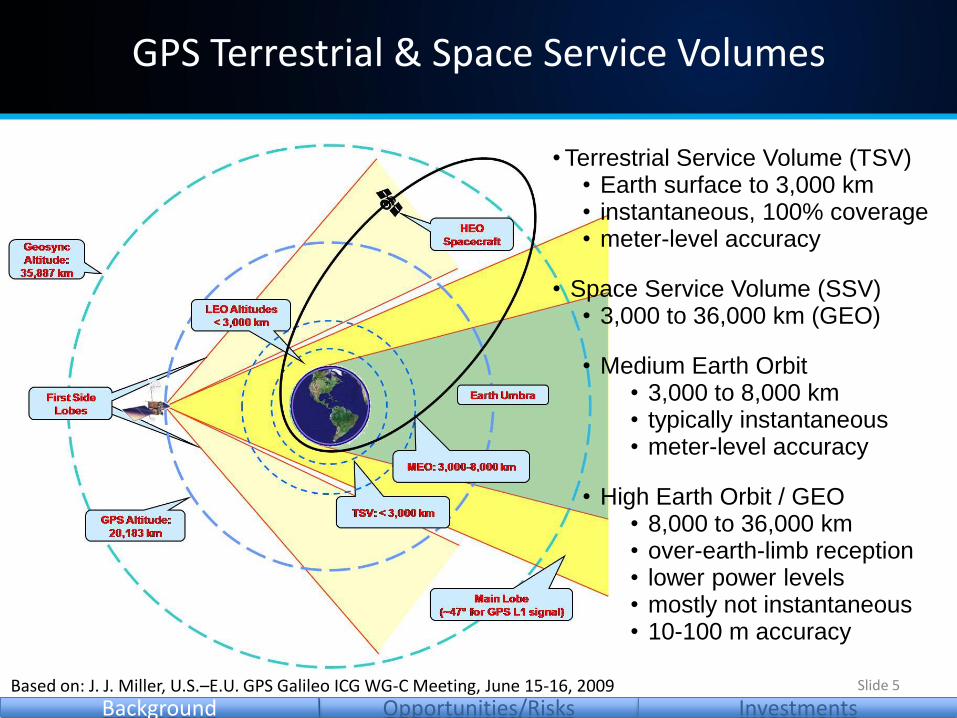
GPS Terrestrial & Space Service Volumes
•Terrestrial Service Volume (TSV)• Earth surface to 3,000 km• instantaneous, 100% coverage• meter-level accuracy
• Space Service Volume (SSV)• 3,000 to 36,000 km (GEO)
• Medium Earth Orbit• 3,000 to 8,000 km• typically instantaneous• meter-level accuracy
• High Earth Orbit / GEO• 8,000 to 36,000 km• over-earth-limb reception• lower power levels• mostly not instantaneous• 10-100 m accuracy
Slide 5Based on: J. J. Miller, U.S.–E.U. GPS Galileo ICG WG-C Meeting, June 15-16, 2009
Opportunities/Risks InvestmentsBackground
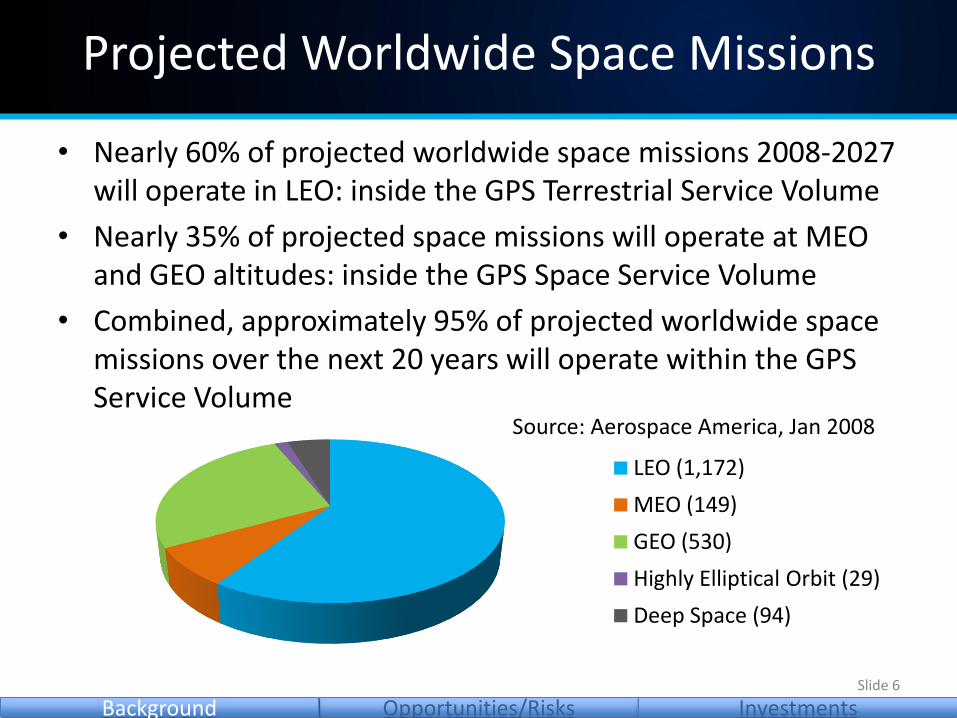
• Nearly 60% of projected worldwide space missions 2008-2027 will operate in LEO: inside the GPS Terrestrial Service Volume
• Nearly 35% of projected space missions will operate at MEO and GEO altitudes: inside the GPS Space Service Volume
• Combined, approximately 95% of projected worldwide space missions over the next 20 years will operate within the GPS Service Volume
Projected Worldwide Space Missions
LEO (1,172)
MEO (149)
GEO (530)
Highly Elliptical Orbit (29)
Deep Space (94)
Source: Aerospace America, Jan 2008
Slide 6
Opportunities/Risks InvestmentsBackground
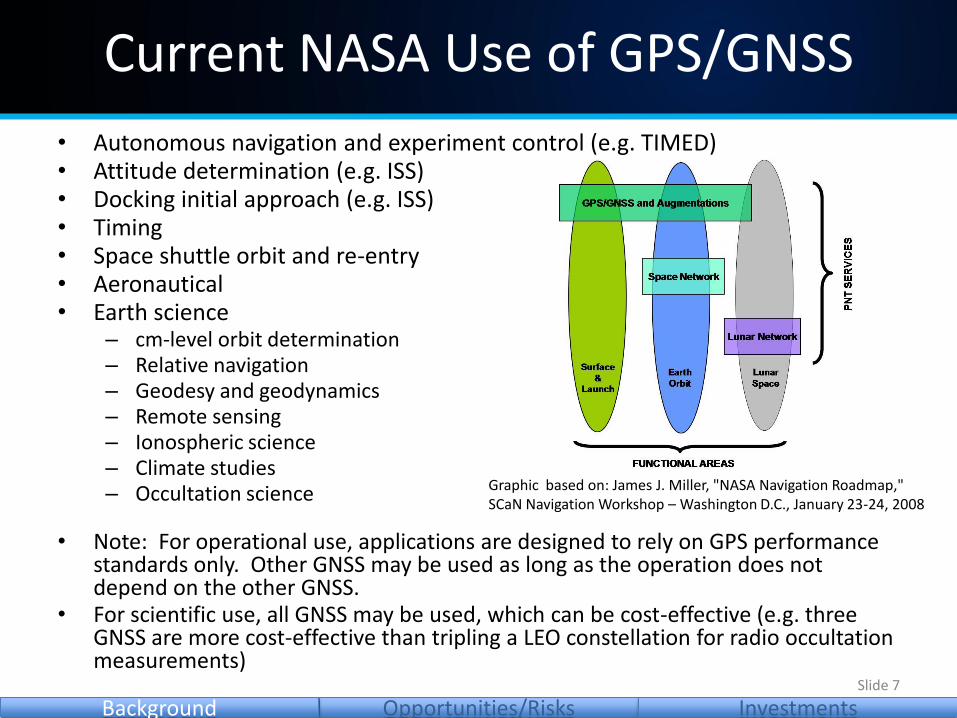
• Autonomous navigation and experiment control (e.g. TIMED)• Attitude determination (e.g. ISS)• Docking initial approach (e.g. ISS)• Timing• Space shuttle orbit and re-entry• Aeronautical• Earth science
– cm-level orbit determination– Relative navigation– Geodesy and geodynamics– Remote sensing– Ionospheric science– Climate studies– Occultation science
• Note: For operational use, applications are designed to rely on GPS performance standards only. Other GNSS may be used as long as the operation does not depend on the other GNSS.
• For scientific use, all GNSS may be used, which can be cost-effective (e.g. three GNSS are more cost-effective than tripling a LEO constellation for radio occultation measurements)
Current NASA Use of GPS/GNSS
Slide 7
Opportunities/Risks InvestmentsBackground
Graphic based on: James J. Miller, "NASA Navigation Roadmap," SCaN Navigation Workshop – Washington D.C., January 23-24, 2008
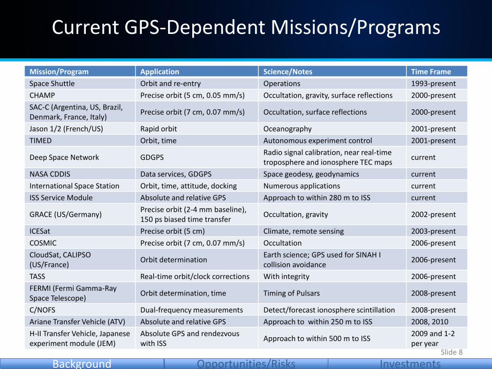
Mission/Program Application Science/Notes Time Frame
Space Shuttle Orbit and re-entry Operations 1993-present
CHAMP Precise orbit (5 cm, 0.05 mm/s) Occultation, gravity, surface reflections 2000-present
SAC-C (Argentina, US, Brazil, Denmark, France, Italy)
Precise orbit (7 cm, 0.07 mm/s) Occultation, surface reflections 2000-present
Jason 1/2 (French/US) Rapid orbit Oceanography 2001-present
TIMED Orbit, time Autonomous experiment control 2001-present
Deep Space Network GDGPSRadio signal calibration, near real-time troposphere and ionosphere TEC maps
current
NASA CDDIS Data services, GDGPS Space geodesy, geodynamics current
International Space Station Orbit, time, attitude, docking Numerous applications current
ISS Service Module Absolute and relative GPS Approach to within 280 m to ISS current
GRACE (US/Germany)Precise orbit (2-4 mm baseline),150 ps biased time transfer
Occultation, gravity 2002-present
ICESat Precise orbit (5 cm) Climate, remote sensing 2003-present
COSMIC Precise orbit (7 cm, 0.07 mm/s) Occultation 2006-present
CloudSat, CALIPSO (US/France)
Orbit determinationEarth science; GPS used for SINAH I collision avoidance
2006-present
TASS Real-time orbit/clock corrections With integrity 2006-present
FERMI (Fermi Gamma-Ray Space Telescope)
Orbit determination, time Timing of Pulsars 2008-present
C/NOFS Dual-frequency measurements Detect/forecast ionosphere scintillation 2008-present
Ariane Transfer Vehicle (ATV) Absolute and relative GPS Approach to within 250 m to ISS 2008, 2010
H-II Transfer Vehicle, Japanese experiment module (JEM)
Absolute GPS and rendezvouswith ISS
Approach to within 500 m to ISS2009 and 1-2 per year
Current GPS-Dependent Missions/Programs
Slide 8
Opportunities/Risks InvestmentsBackground

• GPS modernization: new signals (L5/L2C/L1C), retro-reflectors, well-defined Space Service Volume
• GLONASS modernization, Galileo, Compass
• Advanced space GNSS receivers– Software radios; multiple frequencies, multiple GNSS
– High-sensitivity processing
– Beam-forming/steering antennas
– Onboard Kalman filter for accurate orbit/trajectory estimation
– Acquisition and tracking algorithms for GEO/HEO dynamics
– Onboard processing (requires accurate orbit/time)
• Advanced space clock: Mercury-Ion (10-15)– Enables positioning and improved geometry with 3 GPS satellites
• TDRS Augmentation Satellite System (TASS)
Technologies under Development
Slide 9
Opportunities/Risks InvestmentsBackground

• Use of GPS satellites– Trans-lunar navigation (Orion)
• Trans-lunar injection and cruise
• Out to Earth-Moon L1 libration point
• Use of GPS signal structure– TDRS broadcast of GPS signal structure
– Moon/Mars Relay Satellites with a GPSsignal structure
– Moon/Mars beacons with a GPS signalstructure
– GRAIL lunar gravity mission will use theGPS signal structure to transfer timebetween the pair of spacecraft
• Clock distribution– Time dissemination system with characteristics suitable for solar-system-
wide operations
• One-way navigation, VLBI, sensor webs, enhanced radio-science
GPS concepts beyond the SSV
Slide 10
Opportunities/Risks InvestmentsBackground

Mission GNSS Application Orbit Receiver Signals Launch
Glory GPS Orbit LEO BlackJack L1 2010
LandSat GPS Orbit LEO GD Viceroy L1 2012
COSMIC IIAGPS, GLONASS,Galileo
Occultation LEO TriG (potential)L1, L2, L5, Galileo, GLONASS
2013
Jason IIIGPS, GLONASS, Galileo
Oceanography LEO TriG (potential)L1, L2, L5, Galileo, GLONASS
2013
GPM GPS Orbit, time GEO Navigator L1 C/A 2013
COSMIC IIBGPS, GLONASS, Galileo
Occultation LEO TriG (potential)L1, L2, L5, Galileo, GLONASS
2014
Orion Crew Vehicle
GPSOrbit,trajectory
LEO, MEO,GEO,trans-lunar
2 HI(Navigator)
L1 C/A 2014
MMS GPSRel. range, orbit, time
up to 30 Re Navigator L1 C/A 2014
CLARREOGPS, GLONASS, Galileo
Occultation LEO TriG (potential)L1, L2, L5, Galileo, GLONASS
2015
GOES-R GPS Orbit GEO Navigator L1 C/A 2015
DESDynl GPS Precise orbit LEO TriG (potential)L1, L2, L5, Galileo, GLONASS
2016
Applications to Upcoming Missions
Slide 11
Opportunities/Risks InvestmentsBackground

Occultation Example
FORMOSAT-3/COSMICGPS
COSMIC-IIAGPS/GLONASS/Galileo
Different color shows availability of Radio Occultation (RO) soundings at different hours of the day.
Graphics from: Bill Kuo, et al., UCAR COSMIC Team
Key applications:• water vapor, temp profile• tropopause altitude• gravity waves• ionosphere (nav, comm,
physics)• ocean height• typhoon prediction
Slide 12
Opportunities/Risks InvestmentsBackground
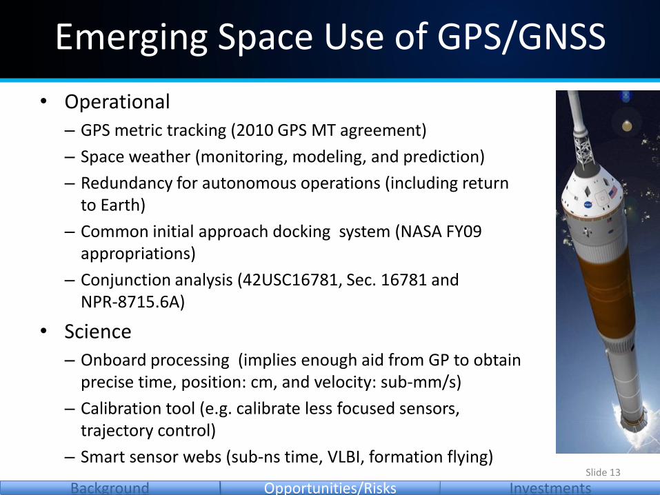
• Operational– GPS metric tracking (2010 GPS MT agreement)
– Space weather (monitoring, modeling, and prediction)
– Redundancy for autonomous operations (including returnto Earth)
– Common initial approach docking system (NASA FY09 appropriations)
– Conjunction analysis (42USC16781, Sec. 16781 andNPR-8715.6A)
• Science– Onboard processing (implies enough aid from GP to obtain
precise time, position: cm, and velocity: sub-mm/s)
– Calibration tool (e.g. calibrate less focused sensors,trajectory control)
– Smart sensor webs (sub-ns time, VLBI, formation flying)
Emerging Space Use of GPS/GNSS
Slide 13
Opportunities/Risks InvestmentsBackground

• Technical/Policy/Standards– Pro-active involvement to mitigate risks
– Modernization: new signals, new opportunities,new risks (e.g. GPS SVN49, phase anomalies,GLONASS frequencies)
• Space Service Volume– Satellite antenna patterns (sidelobes), group/phase delay variations
– Guaranteed performance in the SSV: partly mitigated by TASS• Ground monitoring (Global Differential GPS) upgrades (new signals,
incorporate additional GNSS)– Essential for high accuracy and performance assurance
• Data integrity– Clock/orbit/status anomalies: can be mitigated by TASS
• Timely space receiver development
– Advanced receivers (multi-freq, multi-GNSS, high-accuracy/sensitivity)
GPS/GNSS Risk Areas
Slide 14
Opportunities/Risks InvestmentsBackground
TASS – TDRS Augmentation Satellite System

• Navigator GPS Receiver: GPS L1 C/A– Flew on Hubble Space Telescope SM4 (May 2009), planned
for MMS, GOES, GPM, Orion/CEV
– Onboard Kalman filter for orbit/trajectory estimation, fastacquisition, RAD hard, unaided acquisition at 25 dB-Hz
– Honeywell is developing commercial version for Orion
• Possible Future Capabilities– High-sensitivity Signal Acquisition and Tracking
• Acquisition thresholds down to 10-12 dB-Hz
• Applicable to HEO, lunar, and cislunar orbits for CxP
• GPS is a near term, complementary navigation solution for CxP
– Reception of New GPS Signals: L2C and L5
– GPS-derived Ranging Crosslink Communications (TRL 6)• Developed for MMS Interspacecraft Ranging and Alarm System (IRAS)• S-band communications link with code phase ranging• Signal processing and RF down conversion integrated into receiver design• Applicable to future spacecraft formation flying missions and CxP automated
rendezvous and docking sensing needs.
Existing and Planned Space GPS/GNSS Rx
Slide 15
Opportunities/Risks InvestmentsBackground
Information from: Dr. John Carl Adams, "Navigator Spaceflight GPS Receiver," January 23-24, 2008

• BlackJack Flight GPS Receiver: GPS L1 C/A, P(Y) and L2 P(Y)– Precise orbit determination (JASON, ICESat, SRTM missions)– Occultation science (CHAMP, SAC-C, FedSat, 2 GRACE , 6 COSMIC)– Gravity field (CHAMP, GRACE)– Surface reflections (SAC-C, CHAMP)– 18 BlackJack receivers launched
• IGOR: Commercial version fromBroad Reach Engineering
• CoNNeCT SDR: GPS L1, L2, L5
• TriG is under development: GPS L1, L2(C), L5, Galileo E1, E5a, GLONASS (CDMA)– Features: open-loop tracking, beam-forming
2-8 antennas, 36 channels, RAD hard– Engineering models: 2011– Production schedule: 2013
Existing and Planned Space GPS/GNSS Rx
Slide 16
Opportunities/Risks InvestmentsBackground
Information from: Larry Young, JPL, "Navigation Developments in BlackJackFlight GPS Receiver," January 23-24, 2008 and "TriG Performance Capabilities," June 2009.

• Toolbox for GPS/GNSS analyses– Support standards development: coverage, accuracy, receiver requirements
• Enabling of smart sensor webs and advanced climate studies(sub-ns time, cm position, sub-mm/s velocity)
• Advanced space GPS/GNSS receivers– Software radios; multiple frequencies, multiple GNSS; high-sensitivity processing– Onboard Kalman filter for accurate orbit/trajectory estimation– Acquisition and tracking algorithms for GEO/HEO dynamics– Onboard processing (requires accurate orbit/time)– Ultra-stable clock integration
• Use of GPS and/or GPS signal structure beyond the SSV• Time dissemination• Common docking initial approach system using international GNSS signals (L1C)• Maximize autonomous conjunction information (GNSS-based: improved space
situational awareness, false alarm reduction, fast detection of spacecraft upset)• Upgrade GPS/GNSS signal monitoring and corrections (GDGPS) for autonomous
and safety operations; combine with receiver autonomous integrity monitoring• Integration of international monitoring networks• TASS orbit, clock & space weather dissemination
Technology/Development Areas
Slide 17
Opportunities/Risks InvestmentsBackground

• Standards to be maintained/developed– GPS Standard Positioning Service Performance Standard
– GPS Interface Specifications
– GNSS standards as they are developed
– GNSS space receiver standards (new)
• GNSS minimum performance standards to support conjunction analyses
• GPS metric tracking implementation
• GNSS performance standards for docking to within 250 m or better
• Testing/Monitoring– GPS/GNSS signal monitoring
– Increased use of clock: one-way ranging, availability, improved position/velocity
Standards/Testing/Monitoring
Slide 18
Opportunities/Risks InvestmentsBackground
Summary
Slide 19
• GPS/GNSS are important to NASA operations and science missions
– PNT architecture is dependent on GPS and monitoring/correction networks (Global Differential GPS)
– Essential area for NASA involvement
• Maintain current GNSS-supported capabilities
• Enable new applications: GPS Metric Tracking, space weather monitoring, TDRS Augmentation Satellite System, redundancy for autonomous operations, advanced climate studies, common docking system initial approach, conjunction analysis, accurate PNT, smart sensor webs