town of cazenovia agricultural & farmland protection plan
TRANSCRIPT

Town of Cazenovia Agricultural & Farmland
Protection Plan
February 2013

Acknowledgements
The following people have provided invaluable assistance in the preparation of the Town of Nelson/ Cazenovia/ Lincoln Farmland Agricultural Preservation Plan:
Steering Committee Participants
Ralph Monforte
Gene Smith
Pete Holmes
Paul Pushlar
Ben Riley
Anastasia Urtz
Cazenovia Town Board
Ralph Monforte, Supervisor Patrick Race Kristi Andersen Elizabeth C. Moran Bill Zupan
Town of Cazenovia Officials
Roger Cook, Zoning Officer Barbara Howland,
Administrative Assistant to the Town Supervisor
Farmers and Farmland Owners – Town of Cazenovia
Madison County Agricultural and Farmland Protection Board
Madison County Soil & Water Conservation District
Steve Lorraine
Cornell Cooperative Extension of Madison County
Karen Baase, Association Issue Leader – Agriculture Beth McKellips, Agricultural Economic Development Specialist
Madison County Planning Department
Scott Ingmire, Director Jamie Hart, Senior Planner
NYS Department of Agriculture & Markets
John Brennan Planning Consultant: Barbara Johnston, AICP

Town of Cazenovia Agricultural & Farmland Protection Plan
Table of Contents
A. Introduction and Methodology .............................................................................................. 1
B. Farmland and Agricultural Resources ..................................................................................... 2
C. Farmland targeted for protection ......................................................................................... 11
D. Extent of development pressure on farmland ..................................................................... 14
E. Strengths, Weaknesses, Opportunities and Threats (SWOT) ............................................... 20
F. Overview of existing plans, programs and regulations ........................................................ 22
G. Evaluation of agricultural preservation techniques ............................................................. 27
H. Policies/ Issues and Opportunities Analysis.......................................................................... 43
I. Policies and Recommended Actions ..................................................................................... 56
Implementation Strategy .............................................................................................................. 67
List of Maps
1. Regional Setting
2. Topography
3. Active Farmland
4. Agricultural Parcels
5. Agricultural Soils
6. Agricultural Districts
7. Farmland Suitable for Protection
8. Agricultural Rating – Farm Parcels
9. Residential, Business and Public Parcels
10. Protected Lands

Town of Cazenovia Agricultural & Farmland Protection Plan
List of Appendices
A. Farmland owner survey results
B. Circular 1150: NYS Agriculture & Markets Law
C. Farm Parcel List with Agricultural Ratings
D. Zoning Audit, Excerpts from regulations and NYS Agriculture & Markets Guidance
E. Madison County Agricultural & Farmland Protection Plan: Summary of Recommendations
F. Existing Programs to Support Agriculture 1. American Farmland Trust Landowner Guide 2. Land Trust information: Cazenovia Preservation Foundation and NY
Agricultural Land Trust 3. Business Development Grant Information 4. Sustainable Energy Grants Information
G. Sample Right to Farm Laws
H. Agricultural Data Statement – Model Form
I. Gas drilling guidance – NYS Department of Agriculture & Markets
J. Sample Cost of Community Services Studies
K. Model Resolution to Establish Agricultural Advisory Committee

Town of Cazenovia Agricultural & Farmland Protection Plan
February 2013 1
A. Introduction and Methodology
The Town of Cazenovia initiated work on its Agricultural & Farmland Protection Plan in early 2010 as a cooperative effort with the Towns of Nelson and Lincoln. Each Town received funding from the NYS Department of Agriculture and Markets to support the preparation of the Plan. Nelson and Cazenovia applied for and received a grant jointly and the Town of Lincoln received a grant individually. All three towns agreed to retain the consulting firm of Stuart I. Brown Associates to assist in the preparation of the Plan and to prepare the plans simultaneously.
1. Steering Committee
Each Town appointed a Steering Committee to guide the process. The three Steering Committees met jointly to provide information to the consultant, assist with outreach to the communities, establish policies and review drafts.
2. Landowner meetings
In April 2011, the Towns invited all farmers and farmland owners as well as the general public to participate in one of two public workshops to kick off the planning process. The workshops, held in the Nelson Town Hall and the Lincoln Town Hall, were facilitated by the three Towns’ planning consultant. Participants were encouraged to discuss the future of farming in the Towns and identify opportunities and concerns.
A second series of public workshops were held in the Nelson and Lincoln Town Halls on November 8 and 9, 2011, respectively. These workshops featured presentations by Beth McKellips on agricultural Economic Development, by Judy Wright of American Farmland Trust on conservation easements and purchase of development rights, and by Barbara Johnston on the use of zoning and subdivision techniques to support agriculture and protect farmland.
A public informational meeting was held in on June 27, 2012 at the Nelson Town Hall to review and discuss the preliminary findings and recommendations of the plans.
3. Farmer interviews
The Town’s consultant visited several farms and interviewed several farmers and farmland owners, in person and via telephone, during the course of the planning process. Operators of various types of farms were interviewed, including large and medium‐sized dairy operations, equine operations, and small‐scale vegetable and livestock producers. The interviews helped to identify significant issues as well as appropriate techniques to support agriculture. In order to preserve the anonymity of those who participated in the interviews, their responses have been incorporated into the identification of issues and the evaluation of alternatives.

Town of Cazenovia Agricultural & Farmland Protection Plan
February 2013 2
4. Farmer Questionnaire
A questionnaire was distributed to all farmland owners during April 2011. Although the number returned was too small to be statistically significant, the responses do provide informal guidance regarding issues of concern and potential support for various approaches to farmland protection. The results of the survey are included in Appendix A.
B. Farmland and Agricultural Resources
1. Community Description
The Town of Cazenovia is located in Madison County approximately 22 miles southeast of Syracuse (see Map 1: Regional Setting). The Village of Cazenovia is located in the central part of the Town. The Town is bordered on the north by the Town of Sullivan; on the east by the Towns of Fenner and Nelson, on the south by the Town of DeRuyter, and on the west by the Town of Pompey in Onondaga County.
Agriculture is the predominant land use in the Town of Cazenovia. Of the 30,912 acres in the Town outside the Village, 16,828 acres (54%) are in parcels that are used in part for agricultural production.
New York State Routes 13 and 20 are the major State highways that pass through the Town. Commercial businesses are concentrated along the Route 20 corridor east of the Village, with several small businesses in the hamlet of New Woodstock.
Cazenovia College, a private college, is located in the Village of Cazenovia. The college is a significant employer as well as a center of cultural activities. Cazenovia Lake has attracted seasonal and year‐round residences. Other regional facilities in the Town include Lorenzo State Historic Site. The Hamlet of New Woodstock is a community focal point for the southern part of the Town.
The population of the Town of Cazenovia outside the Village in 2010, according to the U.S. Census, was 4,251. This represents an increase of 382 (9.9%) from the 3,869 reported in the 2000 Census.
There were 1,794 housing units in the Town outside the Village in 2010, an increase of 255 (16.6%) since 2000. Residences are located throughout the Town, with concentrations along Cazenovia Lake, in the hamlet of New Woodstock and in several residential subdivisions.
The landscape in Cazenovia consists of rolling hills that afford scenic views of farmland and Cazenovia Lake. The high point of the Town is at 1680 feet above sea level in the southeast

Town of Cazenovia Agricultural & Farmland Protection Plan
February 2013 2
corner of the Town south of Hardscrabble Road. The topography of the Town is depicted in Map 2: Topography.
Cazenovia Lake, located in the northern part of the Town is a significant hydrological, scenic and cultural feature in the Town. Cazenovia Lake is fed primarily by surface runoff and groundwater; there are few significant tributaries to Cazenovia Lake. Water flows out from Cazenovia Lake into Chittenango Creek, which flows northward through the Town toward Oneida Lake.
The East Branch of Limestone Creek flows westerly over Delphi Falls toward the main branch of Limestone Creek just west of the Town line. Limestone Creek meanders into Cazenovia just north of Delphi Station Road and flows generally northward toward Oneida Lake. All of the streams in Cazenovia are part of the Oswego River watershed.
The elevations and climate in the Town are highly suitable for farming. There are few droughts and events that cause crop damage, although long winters and short growing season limit the types of products that can be produced successfully in the area.
2. Active farmland
Approximately 16,828 acres in the Town of Cazenovia consist of actively farmed land or other open land that may be suitable for agriculture, based on an analysis of aerial photographs taken in 2009 and 2008 by New York State. This land represents approximately 26% of the total land area of the Town. (See Map 3: Active Farmland).
Farmland in the Town of Cazenovia is located on 451 individual tax parcels, which comprise 16,828 acres. Most of the parcels with active farmland also include buildings as well as forested land or hillsides that are not actively farmed.
Table 1: Land in Farm Parcels
Land Area in: Acres % of Town's Total Land Area
Entire Town (Excluding Village and Cazenovia Lake)* 30,877 100%
Parcels with Active Agricultural Land 16,828 55%
Active Agricultural/ Other Open Land** 8,138 26%
*Based on calculations using GIS software by Stuart I. Brown Associates
** Calculated from areas of Active Farmland or Other Open Land that may be Suitable for Agricultural Production, digitized from aerial photos by Stuart I. Brown Associates.

Town of Cazenovia Agricultural & Farmland Protection Plan
February 2013 3
Farms in the Town of Cazenovia include both large commercial farms as well as small part‐time operations. These farms produce dairy products, cattle, and other livestock, field crops such as corn and soybeans, and horticultural products such as Christmas trees.
Several large and medium‐sized dairy farms operate in the Town of Cazenovia, including the Holmes farm which milks more than 600 cows. Dairy farms require large amounts of land to grow corn and grain that is fed to the cattle and typically fertilize crops by spreading manure. Many dairy farms rely on rented land to supplement the land they own for crop production. Most of the Town’s dairy farms are located in the southern part of the Town (See Map 4: Agricultural Parcels.)
Several farmers specialize in cash crops such as corn, soybeans and wheat or other field crops such as hay. With the recent high prices for these crops, many fields that had been fallow have been used for crop production. Demand for rented land, and competition among farmers for land, has increased in recent years.
Some farmers in the Town raise cattle, calves, sheep and other livestock. Many of these farms are part‐time operations. Some produce diverse products on a small scale for sale to the public. Others focus on breeding and showing specialty animals.
Several Cazenovia residents maintain large parcels that house horses for their private enjoyment. These private horse farms contribute to the agricultural economy through the purchase of supplies and services.
Cazenovia is home to many diversified farms that produce value‐added products and market directly to restaurants and the public. These include: Meadowood Farms on Ridge Road, which raises Belted Galloway cattle and produces sheep dairy products and meat; Brick Farm on Rathbun Road, which produces organic eggs and goat meat, and Lucky Moon Farm, which produces organic vegetables and flowers that are sold primarily through a Community Supported Agriculture (CSA) arrangement.
Several agriculture‐related tourism‐oriented (agritourism) businesses are located in the Town of Cazenovia. Critz Farms on Rippleton Road devotes much of its land to producing Christmas trees, but also produces nursery plants, apples, apple cider, pumpkins,and maple syrup and operates agri‐tourism activities such as a corn maze, petting zoo and farm tours. Critz Farms also recently started producing hard cider. The Owera Winery, located at the north end of Cazenovia Lake, near East Lake and North Lake Roads, harvested its first crop of grapes in Fall 2010 and recently received a large ($994,000) economic development grant from New York State to develop its farm, winery and tasting room. In addition, David Katleski, the owner of Empire Brewery in Syracuse, has announced plans to construct a brewery along Route 13, just south of Lorenzo State Historic Site, that would include an area to grow the hops used in making beer. These beverage‐oriented agribusinesses fit well into the “beverage trail” initiative that the Madison County Agricultural Economic Development team has launched.
Table 2 is a partial list of farm operations in the Town of Cazenovia.

Town of Cazenovia Agricultural & Farmland Protection Plan
February 2013 4
Table 2: Farm Operations
Name of Farm Location Products
Dairy
Holmes Acres East Road Dairy
Reed Farm Resevoir Road Dairy
Allan Shoemaker Parker Road Dairy
Michael Milin EastRoad Dairy
Ju‐Vindale Holsteins Ballina Road Dairy
L & M Acres (Mike Williams) Holmes Road Dairy
Mithva Farm (Thomas Hirt) Parker Road Dairy
Paul Pushlar Fenner Road Dairy
Cattle, calves, other livestock
Cedarcut Farms (James Curtis) East Road Cattle
Meadowood Farms Ridge Road Cattle, sheep
Meadows Farm Rippleton Road
Kobe beef
Brick Farm Linklaen Road Poultry (eggs), goats, pigs
Equine
Flyhawk Farm & Kennel Route 80 Morgan horses
Bylund Hill Stables East Lake Road Horse sales, riding lessons, boarding, training
Field Crops
Lynn Ketcham Peth Road Organic Hay
Horticultural
Critz Farms NYS Route 13 Cut Your Own Christmas Trees, apples, blueberries, pumpkins, nursery plants
Vegetables
Lucky Moon Farm Michigan Road Organic vegetables, flowers, eggs
Agri‐tourism/ Diversified business/ Agriculture‐Related Business
Critz Farms Rippleton Road Corn Maze, Cider, Farm Tours
Hut on the Hill Farm Dugway Road Dairy, eggs, wool products, herbs
Our Farm Peth Road Pumpkins, seasonal vegetables, pumpkin catapult and farm tours

Town of Cazenovia Agricultural & Farmland Protection Plan
February 2013 5
Statistics from the 2007 Census of Agriculture for the two zip codes in the Town of Cazenovia (see Table 3 below and graphs on the following page) document the variety of crops produced by farms in Cazenovia and surrounding areas.
The 2007 Census of Agriculture reported a total of 99 farms in the 13035 zip code (which includes most of the Town of Fenner and part of Nelson as well as most of Cazenovia) and 32 in the 13122 zip code (which includes part of DeRuyter as well as the southern part of Cazenovia.) In the 13035 and 13122 zip codes combined, 85 farms sold animals and their products and 52 farms sold crops.
Table 3: Statistics from 2007 Census of Agriculture
Farms with sales of animals and their products Farms with sales of crops
60 cattle/ calves 40 field crops, including hay 36 dairy 27 grains 7 sheep/ goats 6 Vegetables 12 horses/ ponies 6 fruit 16 poultry 5 Horticultural 7 hogs 6 Christmas trees
A total of 37 farms reported more than $50,000 in sales. The farms with more than $50,000 in sales produced dairy products (33 farms), grain (4 farms), cattle and calves (2 farms), vegetables (1 farm). None of the horse farms reported sales in excess of $50,000. Some farms sold more than $50,000 in both animal products and crops.
In the 13035 and 13122 zip codes, a total of 42 farms were less than 50 acres in size and 28 were between 50 and 999 acres in size. One is 1000 acres or larger. A total of 77 farms harvested hay, 26 farms harvested corn for grain, 25 harvested corn for silage, 12 harvested oats, six harvested fruits, and six harvested vegetables. Other crops harvested were soybeans (8 farms), barley (7 farms), wheat (5 farms), berries (two farms), and potatoes (2 farms). Farms that harvested 250 or more acres produced hay or haylage (10 farms) and corn for grain (1 farm.) Farms that harvested between 50 and 250 acres produced hay and haylage (33 farms), corn for grain (17 farms), soybeans (6 farms), barley (4 farms) and wheat (4 farms.) In addition, one farm harvested more than 15 acres of vegetables.
3. Economic benefits of agriculture and related businesses
Agriculture is the predominant land use in the Town of Cazenovia and is a major industry in Madison County. Opportunities relating to production agriculture, agri‐tourism, agricultural

Town of Cazenovia Agricultural & Farmland Protection Plan
February 2013 6
support businesses, distribution and processing are key to the Town’s long‐term economic development.
Farms in and around the Town of Cazenovia generate sales each year through the production and sales of farm products and support the regional economy through purchase of supplies and services. Both small and large farms contribute to the rural, agricultural character of the town and support the agricultural economy through the purchase of supplies and services.
As documented in the 2007 Census of Agriculture, a total of 19 farms in the 13035 and 13122 zip codes generated sales of $250,000 or more and 20 generated sales of between $50,000 and $249,999. A total of 56 farm operators in the 13035 zip code (57%) and 13 in the 13122 zip code (41%) report that their principal income is from farming.
Several farms generate income from complementary activities that were not included in USDA farm statistics. For example, the equine industry generates income from boarding, sales of horses, training and other services. The NYS Agricultural District Law was recently amended to include such income to allow equine operations to be defined as “farm operation” for the purpose of Agricultural District protections and agricultural use assessment, provided the operation consists of at least seven acres, stables at least 10 horses and generates $10,000 in sales from commercial equine activities. (See text in Appendix B.)
Agriculture also generates economic impacts from businesses that provide services or goods to farmers and from businesses that process, transport or resell farm products. These include: retail businesses that sell equipment, fertilizer, seeds and other inputs; providers of financial, technical, and engineering services; construction contractors; trucking companies; processing plants; and retail sales of farm products.
Agricultural operations in Cazenovia and the surrounding area contribute jobs to the local economy. The 2007 Census of Agriculture reported that approximately 69 farmers in the 13035 and 13122 zip codes earned their principal income from farming. The 2005‐2009 American Community Survey reports that 50 employed residents of the Town of Cazenovia, outside the Village, age 16 or older (2.5% of all workers) were employed in the agriculture, forestry and fisheries industry.
Several area farms sell products directly to the public and have seasonal stands that offer fresh produce to residents and visitors. Some area farmers sell produce at the Cazenovia Farmers Market. This market, located in downtown Cazenovia, is open every Saturday from May through November. Only produce, food products and crafts that are made locally may be sold at the market. Other local and regional retail outlets include the Manlius Farmers Market and the Central New York Regional Market in Syracuse.

Town of Cazenovia Agricultural & Farmland Protection Plan
February 2013 7

Town of Cazenovia Agricultural & Farmland Protection Plan
February 2013 8

Town of Cazenovia Agricultural & Farmland Protection Plan
February 2013 9
4. Agricultural Soils
Prime and important agricultural soils in the Town of Cazenovia comprise 70% of the Town’s total land area. Of the 23,133 acres that are considered prime soils, soils of statewide importance, or prime if drained, 7,321 acres are actively farmed. The remaining soils have been developed or are forested. Map 5 depicts the extent of prime and important agricultural soils in the Town.
Table 4: Agricultural Soils
Agricultural Soils Classification (from USDA Soil Survey)
Townwide (includes developed, wooded and
fallow land)
Active Farmland Only (cropland and
pasture)1
Acres % Acres %
Prime farmland 13,043.1 39.4% 4,774.3 58.7%
Farmland of statewide importance 7,866.3 23.8% 2,200.4 27.0%
Prime farmland if drained 2,223.7 6.7% 346.3 4.3%
Total high quality agricultural soils: 23,133.1 70.0% 7,321.0 90.0%
Other soils 9,931.0 30.0% 817.0 10.0%
33,064.2 100.0% 8,138 100.0% 1Calculated with GIS software from delineations of active farm fields from aerial photos. See Map 3: Active Farmland
5. Land in Agricultural Districts
The Agricultural District Program was established by New York State to provide certain protections and benefits to farmers and farmland owners. Counties may establish and certify Agricultural Districts in order to make these benefits available to farmers. Inclusion in an Agricultural District denotes a commitment on the part of the County and the landowner to retain the use of such land for agriculture. In Madison County, Agricultural Districts are reviewed every eight years, although landowners may request that property be added to the District during the annual 30‐day addition period during the month of October.
Madison County is in the process of consolidating 13 Agricultural Districts into four. The consolidation is expected to be completed in 2013. Land in Agricultural Districts is depicted in Map 6.
The Agricultural District Program includes the following provisions to protect farmers:
• Agricultural use value assessments: Eligible farmland is assessed at its value for agricultural production, rather than at its full market value. If land that received the agricultural exemption is sold for non‐farm purposes, the landowner must repay the amount of property taxes saved over the life of the District, up to 8 years. Agricultural use assessment is also available to owners of eligible farmland that is

Town of Cazenovia Agricultural & Farmland Protection Plan
February 2013 10
not located within an Agricultural District. Applications for agricultural use assessment must be filed each year.
• Protection from local regulations that would restrict farm practices. The NYS Department of Agriculture & Markets can bar the implementation, on a case‐by‐case basis, of local land use and other regulations that unreasonably restrict standard farm practices.
• Protection from public acquisition of farmland through “eminent domain.” Before a local or county government may undertake a project that affects land within an Agricultural District, it must submit a "Notice of Intent" to the County Agricultural and Farmland Protection Board and the NYS Department of Agriculture and Markets for consideration of the impacts on agriculture.
• Protection from nuisance suits (right‐to‐farm provisions). A person who buys property within an Agricultural District must be notified about the possible presence of noise or odors associated with farm practices and acknowledge receipt of this notice in writing.

Town of Cazenovia Agricultural & Farmland Protection Plan
February 2013 11
C. Farmland targeted for protection
The Town has identified all lands that have high quality agricultural soils and that are currently used for agricultural production as the highest priority for long‐term protection. The areas of active farmland were delineated from aerial photographs and represent crop fields, pasture and other open land that may be suitable for agricultural production (see Map 3: Active Farmland). High quality agricultural soils include soils classified by the USDA Natural Resources Conservation Service Soil Survey as “prime farmland,” Prime farmland if drained”, and “other soils of Statewide importance (see Map 5: Agricultural Soils). The intersection of these two features – areas that consist of prime or important agricultural soils as well as active farmland – are depicted in Map 7: Farmland Suitable for Protection.
Of the 8,138 acres of active farmed in the Town of Cazenovia, 7,321 acres (90%) consist of prime agricultural soils or other soils of Statewide significance. These areas of prime and important agricultural soils that are actively farmed represent the most significant agricultural land resources in the Town.
The areas depicted in Map 7: Farmland Suitable for Protection represent the Town’s most important agricultural land resources. Map 7 should be used by Town boards and advisors as a reference when reviewing development proposals and in implementing strategies for the long‐term protection of these lands. Prioritization of these lands, for example, for the purpose of sponsoring applications for purchase of development rights, should be based on the following criteria.
Acreage of high quality agricultural soils
Proportion of the parcel that contains high quality agricultural soils
Long‐term viability of the farm operation over the long term
Impact on the protection of significant natural resources
Extent to which the farm is subject to significant development pressure
Agricultural Soils
The presence of high quality agricultural soils is a critical factor in prioritizing farmland for permanent protection. Such soils are categorized by the US Department of Agriculture as prime, prime if drained and “other soils of Statewide significance,” as described above. Farm parcels with relatively large acreages of prime and important agricultural soils should be targeted for protection. In order to identify those parcels with exceptional agricultural soils resources, a rating system was applied to parcels that contain cropland, pasture or other open land that may be suitable for agricultural production. The number of acres of soils in each category ‐‐ prime, prime if drained, soils of statewide importance, other soils – was calculated for each parcel that contains active farmland.

Town of Cazenovia Agricultural & Farmland Protection Plan
February 2013 12
The following weighting factors were applied to the total number of acres within each soil category:
Agricultural Soils Classification Rating Factor
Prime Soils: 3
Prime if Drained: 2.5
Soils of Statewide Importance: 2
Other soils: 1
The Agricultural Rating for each parcel is the sum of the acres of soils in each category multiplied by the weighting factor. Parcels with as little as one acre of cropland or pasture are included in the database; this increases the number of parcels with relatively low agricultural soils ratings.
The results are depicted in Map 8. A list of parcels with the number of acres of cropland, pasture and other open land and the agricultural rating is provided in Appendix C. The number of parcels in each category is summarized in the following chart:
This rating system assesses only the amount and quality of agricultural soils on individual parcels. As such, it is intended as the starting point for determining the suitability of individual parcels for long‐term protection.
The highest agricultural soils ratings are given to large parcels that include significant quantities of farmland. Small parcels that are used to raise high value crops such as vegetables would not receive a high rating using this system; the agricultural value of these smaller parcels will need to be documented on a case‐by‐case basis.

Town of Cazenovia Agricultural & Farmland Protection Plan
February 2013 13
In addition, the rating system does not group parcels that are part of a single farm operation. However, if multiple parcels are proposed for protection, the data for each individual parcel may be added together to determine the total rating for a group of parcels. The Excel database of parcels, which includes the total amount of farmland in each soils category and the agricultural rating for each parcel, is included in the CD that accompanies the final Plan document to facilitate these calculations as needed.
Several other factors, in addition to the presence of high quality agricultural soils, should be considered in assessing suitability for long‐term protection. These include the application of land management and conservation practices, plans for continued operation of the farm in succeeding generations, and proximity to other farmland and other protected lands. Although these other factors are less suited to a numerical ranking system, they should be addressed on a case‐by‐case basis for those parcels that are proposed for long‐term protection.
Long‐term Viability
Factors that should be considered in evaluating the long‐term viability of a farm parcel include:
The presence of a succession plan that demonstrates that the land is going to continue to be farmed, either by the next generation of the family that is currently farming the property or by a neighboring farmer.
A history of appropriate conservation and land management practices on the farm
Location in an area does not have constraints to continued farming. For example, a parcesl that is completely surrounded by residential development is more difficult to farm than one that is contiguous or near other farm parcels.
Development Pressure
Farms that are susceptible to conversion to other uses may be a higher priority for conservation than other farms. Pressure for conversion may take the form of scattered residential development, residential subdivisions or other development and may be stimulated by infrastructure extensions or nearby development. The extent of development pressure should be a consideration in the evaluation of farm parcels for long‐term protection.
Natural Resource Value
Farmland protection may have the added benefit of protecting or enhancing nearby natural resources. For example, cropland and pasture absorb rainwater and generate less stormwater runoff than developed land. It can serve as a buffer to forests and wildlife habitat. If properly managed, it can provide protection to stream corridors. The contribution of the farm toward the protection of natural resources should be considered in the evaluation of individual farm parcels for long‐term protection.

Town of Cazenovia Agricultural & Farmland Protection Plan
February 2013 14
D. Extent of development pressure on farmland
1. Population and Housing Trends
The population of the Town of Cazenovia outside the Village in 2010, according to the U.S. Census, was 4,251. This represents an increase of 382 (9.9%) from the 3,869 reported in the 2000 Census.
There were 1,794 housing units in the Town outside the Village in 2010, an increase of 255 (16.6%) since 2000. The figure below shows that housing construction increased during the 2000s compared to previous decades.
255
173
236
162210198
72
488
0
100
200
300
400
500
600
2000s1990s1980s1970s1960s1950s1940s1939 or earlier
Number of Housing Units
Year Built
Year Built ‐ Housing Units ‐ Town of Cazenovia
Source: 2000 and 2010 Census; Stuart I. Brown Associates
20
24 2527 28
1416 15
6
0
11
0
5
10
15
20
25
30
2000 2001 2002 2003 2004 2005 2006 2007 2008 2009 2010
Building Permits Issued by YearTown of Cazenovia
Town of Cazenovia Agricultural & Farmland Protection Plan
February 2013 15
As depicted in Map 9: Residential, Business and Public Parcels, residential development has occurred in residential subdivisions, along the shores of Cazenovia Lake, in the Hamlets of New Woodstock and along roadsides throughout the Town. Business development is primarily located along NYS Route 20 east of the Village of Cazenovia and includes retail, lodging and services.
The Village of Cazenovia has a thriving downtown business district and many commercial, industrial and office uses, in addition to Cazenovia College. Outside of the Village of Cazenovia, business development in the Town includes commercial businesses and professional office along U.S. Route 20 east of the Village of Cazenovia s along Route 20, and small‐scale businesses in the hamlet of New Woodstock. Other business, recreational and utility uses in the Town include two private golf courses, a gravel pit, the Town solid waste and recycling center, a water facility, and a lumberyard. (See Map 9: Residential, Business and Public Parcels.)
Many of the businesses in the Village of Cazenovia and in the Town outside the Village support the agricultural economy. For example, Cazenovia Equipment, a regional chain that carries farm equipment and supplies, recently constructed a new facility along U.S. Route 20 in Cazenovia to replace a facility along U.S. Route 20 in Nelson that was destroyed by fire.
Several parcels along U.S. Route 20 corridor and southeast of the Village have been annexed into the Village during the past several years. Annexation is required for the land to receive public water service from the Village of Cazenovia. The parcels have been developed or proposed for commercial development along U.S. Route 20 and for residential development in the southeast area (South Village Drive.)
The Town’s 2008 Comprehensive Plan recommends commercial and office development along U.S. Route 20 in and adjacent to the Village and commercial, light industrial and professional offices along U.S. Route 20 near the Nelson Town line and Trush Industrial Park. Such development is needed to diversify the Town’s tax base, which includes significant amounts of tax‐exempt property, and to provide jobs for residents.
The Comprehensive Plan also recommends preservation of the scenic character of the U.S. Route 20 corridor between the Village and the Nelson town line. Much of the 1.3 miles between the Village and the Town line is undeveloped and agricultural, and includes land surrounding the wells that provide the Village’s public water supply.
The conversion of active farmland near the existing and proposed business areas along U.S. Route 20 in and adjacent to the Village and adjacent to the Trush Industrial Park may be necessary to realize the Town’s economic development objectives. Such conversions would be consistent with the Town’s Comprehensive Plan.

Town of Cazenovia Agricultural & Farmland Protection Plan
February 2013 16
2. Sewer and Water
In the Town of Cazenovia outside the Village, public water service is available in the following areas1:
portions of NYS Route 13 north and south, Fenner Road, East Lake Road, Ridge Road, U.S. Route 20 East, and Ten Eyck Avenue.
Wellington, with 32 residences
New Woodstock, with approximately 150 residences
Mt. Pleasant, with approximately 20 residences
Owera Point, with approximately 12 residences
Trush Park, with 12 wells (used approximately 6 million gallons in 2006)
The Madison County Sewer District (MCSD) services parcels in the Town of Cazenovia from the Village line south to Ballina Road and most parcels north of the Village to the Town boundary. The MCSD also operates one sewer main that runs east along U.S. Route 20 to Trush Park in the Town of Nelson. Wastewater from these sewer districts is processed at the Madison County Wastewater Treatment Plant located on NYS Route 13 North, just north of the Village boundary, along the Chittenango Creek.
The six Town sewer districts are: 1. Jepson 2. East Lake Road 3. U.S. Route 20 East 4. Wright Road 5. Seven Pines 6. Ten Eyck Avenue
The Town of Cazenovia’s 2008 Comprehensive Plan recommended a study to determine the feasibility of extending sewer service to properties along East Lake Road and the north end of Cazenovia Lake. The primary purpose of the sewer line would be to reduce phosphorus inputs into the Lake.
The availability of public sewer in much of the Town significantly increases pressure for development.
1 (Source of information: Cazenovia Comprehensive Plan, 2008
Town of Cazenovia Agricultural & Farmland Protection Plan
February 2013 17
3. Zoning
This section presents the zoning provisions for farmland in the Town for the purpose of evaluating development pressure. The evaluation of land use regulations with regard to their impacts on agricultural operations is included in the Zoning Audit (see Appendix D.)
Most of the farmland in the Town of Cazenovia is in the Rural A (RA) District (see Zoning Map in Appendix D). The RA District permits only one‐ and two‐family dwellings and agriculture and their accessory uses by right, and certain other uses (e.g., bed and breakfast, government facility, golf course, animal hospital, stables) with a Special Use Permit. The minimum lot size for residences is three acres.
An Agricultural Overlay Zone includes land that meets the following three criteria:
Total area in excess of 15 contiguous acres;
Containing at least 50% of soils deemed USDA Prime Soils; AND
Located in a New York State certified Agricultural District.
Conservation subdivisions are required for new residential development within the Agricultural Overlay Zone. The Town Planning Board will require conservation subdivision designs for most subdivisions in other areas if the parent parcel contains at least 12 acres of developable land that is not constrained by limitations such as wetlands, streams, flood zones, steep slopes or utility easements.
Land along Route 20 between the Village and the Nelson town boundary is zoned, from west to east, Village Edge, Commercial, and Rural B, all of which allow for a variety of commercial uses. A portion of the south side is zoned Rural A.
Town of Cazenovia Agricultural & Farmland Protection Plan
February 2013 18
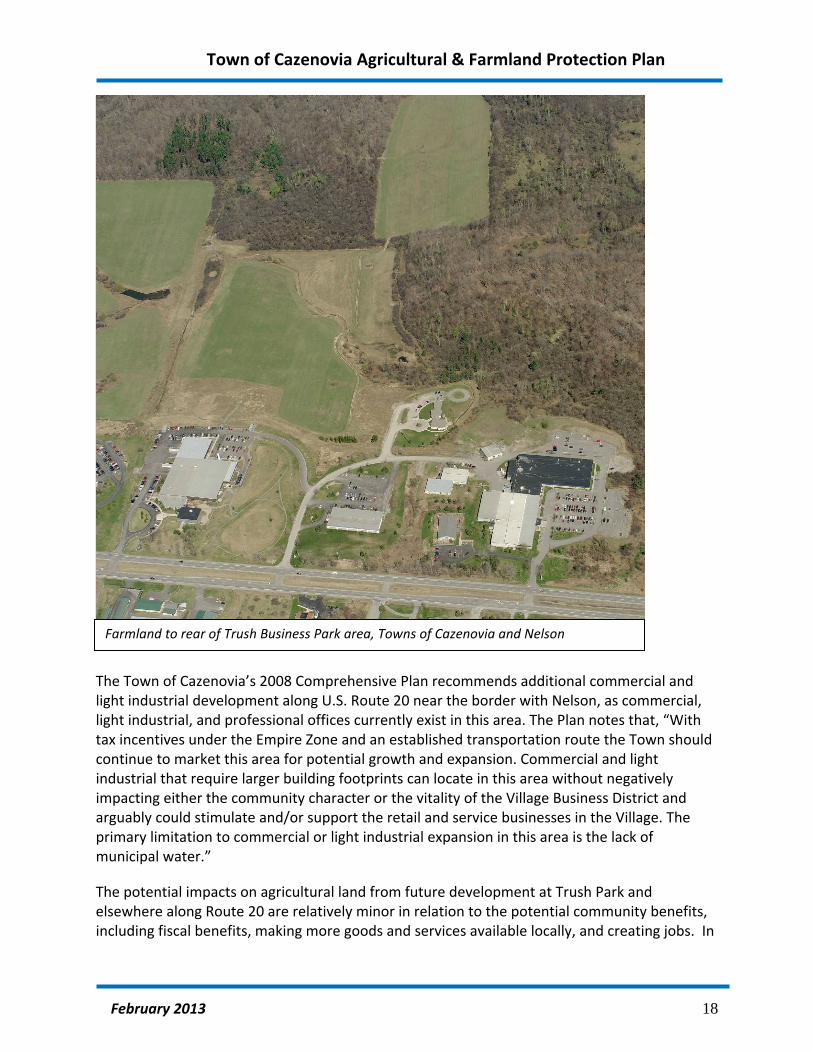
The Town of Cazenovia’s 2008 Comprehensive Plan recommends additional commercial and light industrial development along U.S. Route 20 near the border with Nelson, as commercial, light industrial, and professional offices currently exist in this area. The Plan notes that, “With tax incentives under the Empire Zone and an established transportation route the Town should continue to market this area for potential growth and expansion. Commercial and light industrial that require larger building footprints can locate in this area without negatively impacting either the community character or the vitality of the Village Business District and arguably could stimulate and/or support the retail and service businesses in the Village. The primary limitation to commercial or light industrial expansion in this area is the lack of municipal water.”
The potential impacts on agricultural land from future development at Trush Park and elsewhere along Route 20 are relatively minor in relation to the potential community benefits, including fiscal benefits, making more goods and services available locally, and creating jobs. In
Farmland to rear of Trush Business Park area, Towns of Cazenovia and Nelson

Town of Cazenovia Agricultural & Farmland Protection Plan
February 2013 19
addition, a number of farm‐related businesses are located along Route 20 that support the regional agricultural industry. However, some of the active agricultural land along Route 20 may be converted as a result of additional commercial or industrial development along Route 20 in the Town of Cazenovia (see aerial view below and Map 9: Residential, Public and Business Parcels.)
Residential development is a significant threat to farmland in the Town of Cazenovia. The Town remains attractive to new residents due to the presence of Cazenovia College, Cazenovia Lake scenic views and the Town’s proximity to Syracuse and its suburbs. Many areas in the Town are serviced by both public water and public sewer, which can accommodate relatively compact development patterns; such patterns could be combined with conservation subdivisions to protect farmland while allowing development.
U.S. Route 20 east of the Village of Cazenovia, looking north. The Village’s public water supply wellfields are located just south of the wooded area in the foreground

Town of Cazenovia Agricultural & Farmland Protection Plan
February 2013 20
E. Strengths, Weaknesses, Opportunities and Threats (SWOT)
At the public workshop held in April 2011, farmers, farmland owners and residents identified the Strengths, Weaknesses, Opportunities and Threats (SWOT). The exercise was facilitated by the Town’s planning consultant and helped to guide the planning process. “Strengths” and “weaknesses” are generally intrinsic to the community; “opportunities” and “threats” come from outside the community. The table on the following page summarizes the SWOT analysis. A more detailed analysis of issues and opportunities is provided in Section H of the Plan.

Town of Cazenovia Agricultural & Farmland Protection Plan
February 2013 21
Table 5: Table 1: Strengths, Weaknesses, Opportunities and Threats (SWOT)
Strength ‐ An asset or policy that can be leveraged to help achieve our goals
Weakness ‐ A liability, hindering us in achieving our goals, that can be corrected or mitigated
Opportunity ‐ A situation or an element that can be seized or capitalized on to support our goals
Threat ‐ An element or force that must be countered because it threatens achievement of our goals
Strengths
Soils, elevation, climate – few droughts, crop damage
Critical mass of land to support agriculture‐related businesses
Ag infrastructure and markets – supply businesses
Ag Economic Development initiatives – Ag Industrial Park, support for business development
Nearby markets – esp. for milk
Transportation infrastructure
Small‐scale processing by entrepreneurial farmers
Expertise among farmers, academia, businesses
History/Past practice/Heritage
Political support; strong support from County Board of Supervisors
Nelson Farms
Weaknesses
Relatively little land to retain Competition for land from non‐agricultural uses
Hard to farm w/neighbors
Hard to make $ in Ag
Poor condition of facilities/insufficient farm income
High property taxes, esp. on agricultural buildings Cost of doing business – taxes; state mandates; state and federal regulations
Poor return for renting land for agricultural use – doesn’t cover taxes Too expensive for young people to start farming
Poor understanding of agriculture among schools, politicians, public
Losing political support Few young people interested in farming
Labor challenges – can’t find suitable willing workers Few processing plants Limitations of climate
Equine – No “limited liability” law
Opportunities
Market for dairy products o Growing market for dairy – driven by demand from yogurt makers (although Chobani buys
exclusively through Dairy Farmers of America (DFA)) o Increased dairy processing capabilities nearby
Prospective meat processing plant and/or other processor(s) at Ag Park (former Boston Farms)
Smaller processors
Cooperative processing & marketing – See example of North East Livestock Processing Service Company (NELPSC) – based in Hudson Valley
New products – i.e. pastured, grass fed butter – processed at Queensboro
HOPS Program – Ag Econ Dev
Specialty markets o Produce/ Value added/ Organic – future business opportunities/ Crops for energy/ Apples,
cider/ Wineries/ Breweries/ Maple syrup production
Bee Keeping – small but important
Business diversification
Open farm days – promote value added operations
Small operations (50 acres or less)
Amish/ Mennonite farms – keep smaller farms in production
Increasing interest in local food o Demand from local restaurants, schools/ Central NY Bounty
State Fair, Hamilton College, Cornell Grass fed beef program
Long term protection of farmland
PDR – interest among landowners, need for State funding – Other states have had more success
Farms and open space are assets to Increasing population
Fiscal impact of housing development; Cost of community services – See Cornell study
Mortgage tax‐ to finance local land protection; other creative funding mechanisms
Work w/ local assessors
Better notification to new home buyers regarding impacts of agriculture
Funding, relief from regulations
Transportation – Highway improvements
Natural gas – income for landowners – lower cost energy
Wind energy – on site use
College student labor – would need to be organized
Tourism corridor/scenic/ Equine Alley
Ag program in high school/other grades
Threats
Poor profitability
High cost of fuel/energy; transportation costs
Property taxes; Higher assessments for farmland
Prices – especially dairy – don’t cover cost of production
Productivity – probably peaked
Poor business planning
Smaller farm operations – especially vulnerable
Cumbersome regulations – DEC, Food Safety, pesticide, fertilizer spraying
More stringent regulations – especially for milk, fresh produce
Land use regulations
Chesapeake Bay watershed – additional environmental regulations
Environmentalists/animal rights activists
Not enough land
Land development/pressure
Houses – utilize most productive land
Processing plants – need to stay profitable/ need milk available locally
Immigration service
Disease/ contamination
Queensboro Pond /dam –septic issue; Water quality concerns
Loss of agricultural education programs, e.g. Future Farmers of America (FFA) Canastota – potential loss of funding
SOURCE: Comments from attendees at first public workshops – April 2011

Town of Cazenovia Agricultural & Farmland Protection Plan
February 2013 22
F. Overview of existing plans, programs and regulations
Several existing plans, programs and regulations provide the context for this Town Agricultural & Farmland Protection Plan. In addition, many County and State agencies administer ongoing programs that address the issues identified in this Plan. This section provides an overview of existing plans and programs and how they address the issues that affect the long‐term viability of agriculture and farmland in the Town.
1. Farm NY: Growth Through Innovation – The New NY Agenda
The agricultural policy document issued by Governor Andrew Cuomo in 2010 the following key agricultural sectors, many of which are well represented or growing in the Town and Madison County:
Dairy;
Wine & grapes;
Apples;
Nursery/ Floriculture/ Landscaping;
Forestry
Horse breeding
Organic agriculture The report also identifies five key policies to support the agricultural economy in New York State:
create innovative ways to access capital for improved production technology and market development;
expand small and midsize food processing capacity in the State;
improve infrastructure that supports the sale of locally grown food, particularly in underserved and unserved communities;
capitalize on emerging technology, such as renewable energy and broadband deployment; and
keep New York agriculture competitive nationally and globally by reducing the high cost of doing business.
Since the New NY Agenda was released, New York State agencies have taken significant steps toward implementing these policies, including economic development grants for initiatives in Madison County. For example, the economic grants awarded through the Central NY Regional Economic Development Council acknowledge the importance of agriculture and food processing as vital industries in the region and the state. Awards to projects in Madison County include $994,000 to Owera Vineyards in Cazenovia for a new winery and community farm on 58 acres, including new construction, purchase of machinery and equipment, and site improvements to support wine production, tastings, farm and winery tours, and other events to

Town of Cazenovia Agricultural & Farmland Protection Plan
February 2013 23
promote regional tourism and agribusiness, and $150,000 for Johnson Brothers Lumber to partner with SUNY Morrisville to construct a demonstration scale greenhouse and aquaculture facility at the Madison County ARE Park as an add‐on to the company's lumber drying kilns using renewable resources.
2. Madison County Agricultural & Farmland Protection Plan
The Madison County Farmland Protection Plan, completed in 2005 by the Madison County Farmland Protection Board, includes descriptions of the types of agriculture in the County, history of agriculture, an overview of the issues facing the agricultural industry, a description of the economic and fiscal benefits of agriculture, and a set of recommended a series of actions to be undertaken by municipalities and other entities to address land protection, economic viability of agriculture and public education. A summary of these recommendations is included in Appendix E.
3. Madison County Agricultural Economic Development (AED) Specialist
As recommended in the 2005 Madison County Farmland Protection Plan, Madison County established a full‐time Agricultural Economic Development Specialist position that is a cooperative effort of the Madison County Planning Department and Madison County Cooperative Extension. The office is housed at the Madison County Cooperative Extension office in Morrisville. Beth McKellips currently holds the position; she succeeded Becca Jablonski in summer 2011.
The AED Specialist carries out programs that increase the economic impact of Madison County agricultural production through value‐added processing and improved marketing, distribution and public awareness. Current initiatives include:
Open Farm Day and associated events
Side Hill Beef Cooperative
Kriemhild Dairy Grass Fed Butter
A program started by AED, Central New York Bounty, is now independently operated.
In addition the AED specialist is seeking funds to support the expansion of small value‐added processors. She also plans to research potential funding for farmland protection through the global market for carbon credits.

Town of Cazenovia Agricultural & Farmland Protection Plan
February 2013 24
4. Madison County Industrial Development Agency (IDA)
The Madison County Industrial Development Agency (IDA) identifies agriculture, as well as tourism, manufacturing, distribution, and alternative energy as “targeted industries. The IDA’s website summarizes Madison County’s advantages in these industries, their significance in the regional economy and their potential for growth:
Madison County’s manufacturing industry benefits from the region’s strong work ethic, the availability of manufacturing workers, and competitive wages relative to other areas of the state. Our communities have a history in, and a knowledgeable workforce that is already trained in, advanced manufacturing.
Its central location and access to interstates, rail, air transport and barge are the driving factors behind Madison County’s attractive logistics, warehousing and distribution industry.
Agriculture has deep roots in Madison County, and it has achieved a diversification in dairy processing, meat processing, renewable energy (biomass) and many other agricultural industries.
More than any other county in New York, Madison County is at the forefront of the renewable energy industry, including wind power generation, methane (landfill gas utilization) and feedstock production.
Many people first visit Madison County as a tourist, and tourism has become a major regional driver, demonstrated by per‐capita tourism revenues that are the second highest of seven contiguous counties.
The IDA helps manufacturing and other businesses find appropriate sites, comply with local regulations and obtain financing for new development and expansion. (See http://madisoncountyida.com )
5. Soil & Water Conservation District
The mission of the Madison County Soil & Water Conservation District (SWCD) Madison County Soil & Water Conservation District is “to improve and advance the conservation, wise use and orderly development of soil, water and related natural resources of the State of New York.” The SWCD works with other organizations with the same objectives and encourages landowners to participate in conservation programs. (See http://www.madcoswcd.com .)
One of the programs administered by the SWCD is the Agricultural Environmental Management Program, which provides technical assistance and cost‐sharing to help landowners plan, design and install projects that protect water quality. Examples include barnyard runoff management, pesticide storage, and protection of waterways.

Town of Cazenovia Agricultural & Farmland Protection Plan
February 2013 25
6. Cornell Cooperative Extension of Madison County
Cornell Cooperative Extension of Madison County provides information and assistance to farmers and residents. It is part of a nationwide network and receives funding from federal, state, and county governments. Services include research‐supported technical assistance to farmers. (See http://www.madisoncountycce.org )
7. Town Comprehensive Plan
The Town of Cazenovia Comprehensive Plan, completed in 2005, recognizes that agriculture is the predominant land use and significant to the character of the community. It states that, “The working landscape has always been and continues to be an essential component of the Cazenovia character. There is a community‐wide commitment to preserving local farmlands and sustaining the local farm economy.” The Plan includes strong policy statements in support of agriculture and farmland protection and recommends specific actions relating to land use regulations, business development, and coordinating with County agencies.
8. Town Zoning Regulations
The Town of Cazenovia amended its zoning regulations following the adoption of the 2008 Comprehensive Plan that are intended to retain high quality farmland for continued agricultural use. The Agricultural Overlay District includes all parcels in the Town that meet the following three criteria:
Total area in excess of 15 contiguous acres;
Containing at least 50% of soils deemed USDA Prime Soils; AND
Located in a New York State certified Agricultural District.
Within the Agricultural Overlay, any new residences must be part of a conservation subdivision that incorporates permanent protection of the agricultural land or open space. (Conservation Subdivision provisions are summarized in Appendix D Zoning Provisions and Audit.)
The Town’s zoning regulations include some provisions that appear to restrict farm practices. For farms that meet minimum criteria in the Agricultural Districts Law and are located within certified County Agricultural Districts. The enforcement of these provisions is inconsistent with NYS Agricultural Districts Law. An evaluation of the zoning regulations is included in Appendix D: Zoning Audit.

Town of Cazenovia Agricultural & Farmland Protection Plan
February 2013 26
9. Other Programs
Numerous other programs administered by State, Federal and private entities address environmental protection, economic development, tax relief, the promotion of locally‐grown products and other issues that affect farming and agriculture in the Town. Descriptions of these programs and the agencies that work with farmers in Madison County are included in Appendix F.
10. Environmental Protection
Several County and State entities administer programs to support Madison County farmers and the agricultural industry. For example, the Agricultural Environmental Management Program administered by the Soil & Water Conservation District provides cost sharing to farmers to plan and implement practices to improve management of fertilizers and pesticides, manage stormwater runoff and reduce soil erosion. The New York Agricultural Landowner Guide: A Guide to Public Farmland Conservation Programs, prepared by the American Farmland Trust and included in Appendix F, includes an overview of these programs.
Landspreading and other solid waste disposal activities require a permit from the NYS Department of Environmental Conservation.
Town of Cazenovia Agricultural & Farmland Protection Plan
February 2013 27
G. Evaluation of agricultural preservation techniques
Several tools and techniques are available to local governments, individual landowners and private organizations to help meet the goal of retaining farmland and encouraging the continued viability of agriculture.
1. Conservation Easements/ Purchase of Development Rights
A conservation easement is a legal document that limits future development on land. As conservation easements permanently protect land from development, they are a very effective tool for the retention of farmland. Conservation easements may be acquired by a not‐for‐profit organization such as a land trust, or by a governmental entity through a “purchase of development rights” program.
a. Private, voluntary conservation easements
Landowners may place farmland under a permanent conservation easement to be held and monitored by a private land trust or other non‐profit organization. The donation of easements may be helpful to some families in estate planning as the value of the easement can be claimed as a tax deduction.
Landowners may place farmland under a permanent conservation easement to be held and monitored either by a governmental entity or by a private land trust or other non‐profit organization. The donation of easements may be helpful to some families in estate planning, as the value of the donated easement can be claimed as a tax deduction. Donation of easements provides permanent protection of farmland and open space at no cost to the town. Landowners would decide voluntarily to donate.
Land trusts often work with landowners to determine whether a conservation easement would be an appropriate way to preserve land. The Cazenovia Preservation Foundation (CPF), based in Cazenovia, is a private, non‐profit land trust that accepts donations of property or development rights, and works with individual landowners and community leaders to protect land resources. The Cazenovia Preservation Foundation operates primarily in the Town of Cazenovia area, but it has also worked with land owners in nearby municipalities.
CPF worked with landowners to secure New York State funding through Purchase of Development Rights (see below) and also holds protective easements on 6 other parcels of active farmland that total 796 acres. Map 10 depicts the location of land in the Town of Cazenovia that is permanently protected through private easements. Information about the Cazenovia Preservation Foundation is included in Appendix F.
The New York Agricultural Land Trust (NYALT), established in 2006, works with landowners throughout New York State to advise them regarding estate planning, easements, and applying for State purchase of development rights. Information about the NYALT is included in Appendix

Town of Cazenovia Agricultural & Farmland Protection Plan
February 2013 28
F. Land trust staff are often available to speak with landowners about their options regarding the preservation of their properties for continued agricultural or other conservation uses.
b. Public purchase of development rights
Purchase of Development Rights (PDR) is a program which compensates owners of farmland in exchange for an agreement to keep land from being developed. The value of the development rights is calculated as the difference between the value of the land for agricultural purposes and its value for development. A permanent conservation easement typically restricts future development on the parcel to agricultural buildings only. (Information about the easements used in New York State’s purchase of development rights program can be found at: http://www.agriculture.ny.gov/AP/agservices/farmprotect.html .) Placing an easement on a property does not affect the ownership of the parcel. The owner may continue to farm the parcel, and/or sell it. The easement holder, which is either the Town or a private land trust, is responsible for ensuring that the property is not developed.
While many landowners in Madison County are interested in selling development rights, New York State does not currently have any funding for this program.
When development of a property is limited due to a permanent conservation easement, the assessment on the property must take into consideration the impact of the easement on the value of the property. This may result in reduced property taxes for the owner. However, in practice, properties that are receiving an agricultural use value assessment would continue to be assessed based on the agricultural value rather than the market value of the property.
PDR programs are regarded as fair to landowners, who receive fair market value for the development rights. The property remains privately owned and is assessed at a value that reflects its limited use. Such programs achieve permanent protection of farmland and open space.
New York State’s PDR program has provided grants of up to 75% of the cost of purchasing development rights. The landowner or another entity such as the Town may provide the matching funds. Some landowners agree to sell their development rights for less than the appraised amount (known as a “bargain sale”), thereby donating the difference and often claiming a tax deduction for the amount donated.
The Town of Cazenovia’s Critz Farms was the first in Madison County to be awarded Purchase of Development Rights funds. The Reed farm in Cazenovia was awarded funds but has yet to close on the easement purchase. The Cazenovia Preservation Foundation (CPF) holds the easement on Critz Farms and will hold the easements on the Reed Farm once the New York State purchase of development rights is completed. CPF also holds the easements on Greyrock Farm, which is in the Town of Sullivan, but contiguous with the Town of Cazenovia.
Town of Cazenovia Agricultural & Farmland Protection Plan
February 2013 29
New York State’s program has been suspended while its administrators work with previous grantees to complete easement purchases. There is a significant backlog and no indication at this time as to when new applications may be accepted.
Federal Farm and Ranch Lands Protection Program
The Federal Farm and Ranch Lands Protection Program can provide additional matching grants for farms that have a pending offer for the purchase of development rights from a state or local government. Funding and program guidelines were established through the 2008 Farm Bill.
c. Funding options for local purchase of development rights
Some local governments in New York State have directly purchased development rights to farmland. Examples include the Towns of Webster, Perinton, Penfield, Parma and Pittsford in Monroe County. Funding for the purchase of development rights typically is raised through bonding and requires the establishment of a Capital Reserve Fund that is dedicated to the purchase of land and/or conservation easements (development rights.)
The Town may accept donations of land or easements, or money to be used to purchase land or easements. Federal, State or County grants may be used to purchase farmland or development rights.
Capital Improvement Fund
A Capital Reserve Fund is authorized by General Municipal Law Article 11, Section 6‐c and allows a municipality to accumulate funds for major purposes over a period of more than one year. If the fund specifies the parcels or interest in parcels to be acquired, a permissive referendum is required to create the fund. If the fund is created for purchase of properties or development rights in general, no permissive referendum is required to create the fund but a permissive referendum will be required before utilizing the funds for a specific purchase. The fund may be financed through annual appropriations.
The Town may issue bonds to finance the acquisition of land and/or development rights, or to finance the establishment of a fund for the purchase of land and/or development rights. If the bond will be financed over a period of more than five years, a permissive referendum is required.
Before using public funds, whether from a Reserve Fund or Bond, to purchase a particular property or development rights, the Town must publicize and hold a public hearing.
Potential Future Funding Sources
Tax incentives to raise funds for purchase of development rights would require authorization from the New York State legislature. Certain counties in New York State (Westchester and Putnam; Long Island) have been authorized to collect a tax on real estate transfers to fund

Town of Cazenovia Agricultural & Farmland Protection Plan
February 2013 30
preservation of natural and historic resources. A bill to authorize such a tax statewide was proposed in 2005 but has not been successful. A real estate transfer tax would be most effective in municipalities with very high value real estate and a large quantity of transactions each year.
Private foundations may be a source of funding for purchase of development rights. Other innovative funding sources, such as selling carbon credits, may have potential, although additional research is needed.
2. Term easement program (“Lease of Development Rights”)
Certain municipalities in New York State administer a voluntary term easement program to encourage landowners to keep farmland and other open space undeveloped for a specified period of time. The easements typically require that the land remain undeveloped or in active farm use. The Town Assessor considers the impact of the easement on the value of the land for tax purposes. As a result, property taxes may be reduced.
Some towns impose a penalty on landowners if the easement is broken or cancelled. For example, the Town of Perinton, located southwest of Rochester in Monroe County, requires that the property tax savings for the past five years must be repaid. The funds are placed into the Town’s Open Space Acquisition Reserve Fund and have been used by Perinton to purchase nearly 800 acres of land and development rights.
3. Zoning and Subdivision Techniques
a. Agricultural Protection Zoning District
Zoning regulations can be used to provide support to agricultural businesses. For example, zoning in designated agricultural areas may allow for a range of businesses to be established in conjunction with a farm operation, including farm‐related businesses and home‐based businesses.
Some agricultural zoning district regulations limit the number of residential lots that can be created from a “parent” parcel. Regulations may require density averaging or use a “sliding scale” to limit the number of dwellings permitted. The regulations may also specify maximum (as well as minimum) lot sizes for non‐farm development.
b. Incentive zoning
Land can be permanently protected by easement as part of an incentive zoning transaction.
Pursuant to NYS Town Law Section 261‐b, incentive zoning may be used to encourage the private acquisition of agricultural conservation easements or to collect money toward a public fund to purchase such easements (development rights). The Town would need to specify in its

Town of Cazenovia Agricultural & Farmland Protection Plan
February 2013 31
incentive zoning regulations that development rights for the protection of farmland would be an acceptable incentive.
Incentive zoning is fair to the owners of land to be preserved, as a developer must purchase the development rights at fair market value in order to obtain a density incentive. The technique does not diminish the development potential of land to be developed.
The technique is fairly easy for the Town to administer, as the developer and the owner of the farmland or open space arrange the transaction privately. A developer who demonstrates that land will be preserved would be entitled to the density bonus on the property to be developed.
Use of this technique can result in the permanent protection of farmland or open space through a conservation easement at virtually no cost to the Town.
c. Conservation Subdivisions (Clustering)
Land can be permanently protected by easement as part of a conservation subdivision. Conservation subdivisions, also known as clustering, allow residences to be built on smaller lot sizes than would otherwise be permitted by zoning, provided that the number of units that could be constructed on the parcel with a conventional design is not exceeded.
Typically, an applicant would design a conventional subdivision for the site, with all of the lots meeting the minimum lot size, in order to determine the number of dwelling units that could be accommodated. The conservation features to be protected are delineated next, and the house lots laid out on the remaining lands. An example of a conservation subdivision is provided on the following pages.
The house lots should be sited in locations that are least suitable for farming, and that offer the most appealing views of open space and natural resources. The subdivision design should incorporate buffers between the new residential development and the remaining farmland. A conservation easement would be placed on the farmland to prevent future development.
d. Farm‐Friendly Subdivision Design
The way new residential subdivisions are designed can minimize the potential for conflict. “Farm friendly” design is important even when only one or two new lots are created from a parent parcel. Such considerations include:
Incorporate buffers between the residences and adjoining farmland. Such buffers
should be part of the design of the residential development.
Avoid disturbing agricultural infrastructure such as access roads and drainage facilities

Town of Cazenovia Agricultural & Farmland Protection Plan
February 2013 32
Figure 1. Field Operation Efficiency
Planning Board review of subdivisions
The design of subdivisions can also minimize the conversion of high quality farmland by requiring or encouraging development on the least productive portion of the parcel.
Through the subdivision review process, Towns can authorize their Planning Boards to manage the design of new residential development to minimize the potential for conflict. For example, the layout of new house lots can be designed to avoid impacts to efficient farm operations, access roads and drainage facilities, and to maintain buffers between farms and residences.
Planning Board review of the creation of one or more new lots could reduce the potential for new lots to be designed in a manner that is not “farm friendly.” The Town Board would need to modify the Town’s subdivision review law to give the Planning Board the authority to review the creation of one or more new lots. (See Zoning Audit in Appendix D.)

Town of Cazenovia Agricultural & Farmland Protection Plan
February 2013 33

Town of Cazenovia Agricultural & Farmland Protection Plan
February 2013 34

Town of Cazenovia Agricultural & Farmland Protection Plan
February 2013 35

Town of Cazenovia Agricultural & Farmland Protection Plan
February 2013 36
“Conservation subdivisions,” also known as density averaging or clustered subdivisions, can result in the retention of farmland for agricultural use by increasing density on a portion of the parcel. This technique works best when the zoning district requires very low densities of development.
Incorporate buffers into design of non‐farm residential development
Through local zoning and subdivision review regulations, the Town Planning Board can encourage or require that new residential development is designed to minimize the potential for conflict between agricultural operations and neighboring farms. For example, new house lots should be sited to ensure that they do not impede efficient farm operations, do not disturb drainage, and maintain buffers between the farm fields and house lots.
Regulation of Impacts from Agribusinesses
Zoning regulations can help to prevent or alleviate conflicts with neighbors relating to agribusiness and entertainment uses. The Town may regulate ancillary activities, such as outdoor entertainment, provided that such activities are not determined by the NYS Department of Agriculture & Markets to be agricultural practices. Such regulations should balance the need to maintain the quality of life of residential neighborhoods with the regional economic benefit of agri‐tourism businesses. (See Appendix D: Zoning Audit for NYS Agriculture & Markets guidance to municipalities regarding local laws that may unreasonably restrict agricultural practices.)
4. Tax Relief Programs
Farming utilizes large amounts of land but does not demand proportionally large expenditures from local governments. In response to this situation, New York State has established programs to reduce property taxes on farmland that meets certain eligibility requirements.
Agricultural Use Assessments base property taxes on the value of the land as farmland, rather than its value for development. In order to be eligible, the farmland must be used by a farm operation that generates at least $10,000 a year from a farm operation as defined by New York State Agricultural Law. (See Circular 1150 in Appendix B.) Farms located within a certified Agricultural Districts, as well as farms outside a District that meet certain requirements, may be eligible to receive Agricultural Use Assessments. Agricultural Use Assessment is also available to landowners who rent the property to an eligible farmer.
Agricultural use value property tax assessment typically results in a significant reduction in the amount of taxes paid by the landowner. The use value assessment is set by a formula developed by NYS Department of Agriculture & Markets that is based on soil types. In areas where the land is valuable for development purposes, the agricultural use value will be much lower than the market value, resulting in significantly lower property taxes. However, in areas

Town of Cazenovia Agricultural & Farmland Protection Plan
February 2013 37
where farming is the “highest and best use” of the property – where a farmer is likely to pay as much for the land as anyone else ‐ the agricultural use value is the same as the market value.
While agricultural use assessments are applied automatically to property taxes levied by municipalities and school districts, fire districts must “opt in.” To do so, the governing body needs to pass a resolution agreeing to utilize agricultural use assessments.
New York State has established the Farmers School Property Tax Credit program for eligible farmers to receive refunds of up to 100% of School taxes on up to 350 acres of agricultural land, and 50% of School taxes on acreage in excess of 350 acres. To be eligible for this tax credit, farmers must earn at least 2/3 of their income in excess of $30,000 from farming. The credit may be claimed in the farmer’s annual NYS tax return.
Farm worker housing is exempt from property taxes, provided that the facility meets all safety and health standards set by the State building code and the NYS Department of Labor.
Renovation of a historic barn for continued agricultural use qualifies for a property tax exemption.
Certain property and services used in agricultural production is exempt from sales tax. Farmers need to complete Form ST‐125.
5. Business Development Programs
Business Development Financing
The Madison County Industrial Development Agency (IDA) offers financial incentives for industries – including agricultural products processing – that create or retain jobs. Low‐interest loans, sales tax exemptions, and payments‐in‐lieu‐of‐taxes are available to help finance the purchase of new equipment and/or the expansion of facilities.
Madison County has established an agricultural economic development revolving loan program to help create or expand value‐added and direct marketing opportunities. Loans of up to $25,000 may be available for farm stand infrastructure (construction, design development, market analysis, etc.), value‐added agricultural product development, training for cheese‐making, meat‐cutting or other agricultural processing initiatives, training and equipment to ensure food safety and security, and promotional materials for agri‐businesses (such as websites, pamphlets, signage, etc.). In making small low‐interest loans available for the above stated purposes, Madison County hopes to increase direct marketing opportunities for farmers, thereby helping and promoting agriculture. The loans are limited to farms and agri‐businesses with gross incomes of $1,000,000 or less. (Contact Beth McKellips, Madison County Agricultural Economic Development Specialist at 315‐684‐3001 ext 126 or [email protected] .

Town of Cazenovia Agricultural & Farmland Protection Plan
February 2013 38
The NYS Office for Community Renewal’s CDBG program can also provide grants or loans for the construction of infrastructure to support business diversification or expansion activities that would result in the creation or retention of jobs.
Grants for the installation of renewable energy or energy efficiency improvements are available through NYSERDA and the NYS Department of Agriculture and Markets. (See Appendix F for additional information.)
Promotion of Local Farm Products
Organizations such as Madison County Agricultural Economic Development Specialist, Cooperative Extension and Madison County Tourism are active in promoting farm markets, roadside stands and agri‐tourism operations. A Directory of Farm Products includes a map and contact information for farms and related businesses throughout Madison County that are open to the public. The annual Open Farm Day event introduces many residents and visitors to farm outlets.
Several State and regional programs have been established to promote local products and raise public awareness of the contributions of the agricultural industry. For example, the “Pride of New York” program, administered by the NYS Department of Agriculture and Markets, offers labeling and promotional materials to participating farmers and encourages consumers to purchase products that are produced in New York State. Nelson Farms in the hamlet of Nelson is an outlet for Pride of New York products.
Technical Assistance for the Development of New Products
Potential entrepreneurs can access the resources of the NYS Food Venture Center, which is administered by Cornell University and located in Geneva. Information about the preparation of business plans and small loans are available through Cornell Cooperative Extension. Information on these resources is included in Appendix F.
Recruit Agricultural Support Businesses
The Town’s land use regulations permit agriculture‐related businesses in the Town. (See Zoning Audit in Appendix D.)
In addition to providing for agricultural support businesses through zoning regulations, the Town, working with County and State officials, can establish a policy that welcomes such businesses to the Town in appropriate locations.

Town of Cazenovia Agricultural & Farmland Protection Plan
February 2013 39
6. Promotion and Public Information
Public education activities undertaken by farmers, municipalities or other agencies can help to raise public awareness of the importance of the agricultural industry to the region’s economy and to help residents understand farm practices.
Several State and regional programs have been established to promote local products and raise public awareness of the contributions of the agricultural industry. These programs include:
“Pride of New York”, administered by the NYS Department of Agriculture and Markets. This programs offer labeling and promotional materials to participating farmers and food producers to encourage consumers to purchase products that are grown or produced in New York State. (This was stated in an earlier paragraph – perhaps one reference should be eliminated?)
Some coordinated public outreach efforts are initiated and carried out by farmers. For example, a group of dairy farmers in LeRoy, Genesee County New York, cooperatively place an ad in the local Pennysaver each spring to notify residents about their need to spread manure, and give phone numbers to call with any questions. This outreach helps to reduce complaints. The farmers are willing, when possible, to schedule manure spreading to avoid holidays or days when neighbors have outdoor events planned.
7. Local “Right to Farm” Law
Several municipalities in New York State have passed local “Right to Farm” laws. Such laws typically establish a town policy in support of farming, define “generally accepted agricultural practices,” and affirm a farmer's right to employ such practices. The laws also include a requirement that purchasers of property within the town be notified of the policy of encouraging farming, and that farm practices may include odors, noise and other activities. Examples of laws are included in Appendix G.
Such a law often establishes a local “grievance” procedure to resolve complaints between farmers and non‐farm neighbors. A local committee consisting of local farmers as well as non‐farming residents, is typically formed to hear and resolve complaints. Municipalities may also appoint an existing committee, such as the Planning Board, to act as the Grievance Committee. A local grievance committee may be formed to hear and resolve complaints. Such a committee should include local farmers as well as non‐farm representatives. ) In some counties, the County Agricultural and Farmland Protection Board agrees to take on the responsibility of handling local grievances under a local “Right to Farm” law. A local committee created by the Town Board would need to follow the requirements of the NYS Open Meetings Law and schedule and advertise its meetings in advance.
The Town of Cazenovia’s Right to Farm Law includes a policy statement in support of agriculture but does not establish a grievance committee. A copy of this law is included in Appendix G.
Right to Farm Provisions of New York State Agricultural District Law.

Town of Cazenovia Agricultural & Farmland Protection Plan
February 2013 40
These include the requirement that developers prepare an Agricultural Data Statement when a project may impact farm properties within a County Agricultural District (see forms in Appendix E.) It also includes a requirement that buyers of property within an Agricultural District sign a form that notifies them of potential noise, odors and other impacts associated with agricultural areas. A copy of Agricultural Districts Law is included in Appendix B.
Tools available to municipalities to minimize the impacts of sewer and water line extensions on agricultural land include the “Notice of Intent” process mandated by the NYS Agricultural Districts Law and restrictions on non‐agricultural hook‐ups.
8. Programs to minimize the impact of water and sewer lines extensions into agricultural areas
Notice of Intent Process
Section 305 of the Agricultural Districts law requires local governments, before extending a water or sewer line that would serve non‐farm structures within an Agricultural District, to file a preliminary and a final Notice of Intent with the NYS Department of Agriculture and the County Agricultural & Farmland Protection Board. The law states:
Any … local government … which intends to construct, or advance a grant, loan, interest subsidy or other funds within a district to construct, … water or sewer facilities to serve non‐farm structures, shall use all practicable means in undertaking such action to realize the policy and goals set forth in this article, and shall act and choose alternatives which, consistent with social, economic and other essential considerations, to the maximum extent practicable minimize or avoid adverse impacts on agriculture in order to sustain a viable farm enterprise or enterprises within the district.
The Notice of Intent (NOI) must set forth:
A description of the proposed action and its agricultural setting
The agricultural impact of the proposed action, including short‐term and long‐term effects
Any adverse impacts on agriculture that cannot be avoided
Alternatives to the proposed action
Any irreversible and irretrievable commitments of agricultural resources which would be involved in the proposed action
Mitigation measures proposed to minimize the adverse impact of the proposed action on the continuing viability of farms within the district
Any aspects of the proposed action that would encourage non‐farm development

Town of Cazenovia Agricultural & Farmland Protection Plan
February 2013 41
A preliminary notice must be filed before the municipality issues a determination of significance pursuant to the State Environmental Quality Review Act (SEQR). The final notice must be filed at least 65 days prior to the construction or advancement of public funds. The commissioner has 45 days from receipt of the final notice to determine whether the action may have an unreasonably adverse effect on farm viability, and may take an additional 60 days to review the proposed action and issue findings.
The Commissioner of Agriculture may propose reasonable or practical alternative actions that would minimize or avoid the adverse impact of the proposed action on agriculture. The municipality or funding agency may either accept the proposed alternative or certify that other actions have been taken to minimize impacts on agricultural operations.
Lateral Restrictions
Often, as an outcome of the Notice of Intent process, a municipality will adopt a resolution that restricts hookups for non‐farm structures to anew water or sewer line that extends into an Agricultural District. The restriction on hookups would apply to non‐agricultural structures for as long as the property is located within an Agricultural District. Typical language for such a resolution is as follows:
Lateral Restriction ‐ Conditions on Future Service
The [municipality] imposes the following conditions, as warranted or recommended on the management of water/sewer lines located along [location] within an agricultural district:
(1) The only land and/or structures which will be allowed to connect to the proposed waterline or sewer within an agricultural district will be existing structures at the time of construction, further agricultural structures, and land and structures that have already been approved for development by the local governing body prior to the filing of the Final Notice of Intent by the municipality.
Land and structures that have been approved for development refer to those properties/structures that have been brought before a local governing body where approval (e.g., subdivision, site plan, and special permit) is needed to move forward with project plans and the governing body has approved the action.
(2) If a significant hardship can be shown by an existing resident, the lateral restriction to the resident’s property may be removed by the municipality upon approval by the Department. It is the responsibility of the resident landowner to demonstrate that a hardship exists relative to his or her existing water supply or septic system and clearly demonstrate the need for public water or sewer service. The municipality shall develop a hardship application to be filed with the municipality, approved by the County Department of Health, and agreed to by the Department of Agriculture and Markets.

Town of Cazenovia Agricultural & Farmland Protection Plan
February 2013 42
(3) If it can be demonstrated to the Department’s satisfaction that the landowner requested the county to remove his or her land from an agricultural district at the time of district review and the county legislative body refused to do so, lateral restrictions may be removed by the municipality if the Department determines that the removal of the restriction for the subject parcel(s) would not have an unreasonably adverse effect on the agricultural district.
(4) If land is removed from a county adopted, State certified agricultural district, and the district has been reviewed by the county legislative body and certified by the Commissioner for modification, lateral restrictions imposed by the municipality are no longer in effect for the parcels of land that have been removed from the agricultural district.
(5) Hydrants and valve boxes must not be placed directly in agricultural fields.

Town of Cazenovia Agricultural & Farmland Protection Plan
February 2013 43
H. Policies/ Issues and Opportunities Analysis
The following narrative presents the Town’s policies with regard to agricultural and farmland protection and analyzes the related issues and opportunities. The key policies are:
1. Support all types of farm operations in the Town
2. Protect the agricultural land base
3. Improve the economic viability of agriculture
4. Minimize impediments and increase support to farm operations
5. Protect environmental quality and support sustainable energy usage
6. Build community support for agriculture
1. Support the diversity of farm operations in the Town
The wide diversity of farms in the Town and surrounding areas contribute to the protection of the land base, community character, and support of the regional agricultural economy. These include large commercial dairy and crop farms, small part‐time operations, diversified farms, organic farms and equine operations. Dairy and crop farming utilize the majority of farmland in the Town, but other types of farm operations are increasing.
While the NYS Department of Agriculture and Markets defines a “farm operation” as a commercial enterprise that generates at least $10,000 annually from agricultural activities, many smaller farms in the Town contribute to the landscape and to the agricultural economy. Many of the policies and recommendations in the Plan are intended to support commercial farms as defined by NYS Agricultural Districts Law, and others support part time operations as well.
The equine industry in the region is strong and growing. The larger facilities that are involved with breeding, boarding and other services, as well as the residences with horses for their own use, support other businesses. Programs and facilities at Cazenovia College and the State University of New York at Morrisville make the area attractive for horse farms, including breeders, boarding and training facilities. For example, the Cazenovia Equine Education Center, located on Route 92, presents student equine events that are open to the public and Cazenovia College offers a specialization in Equine Business Management. Morrisville State College’s new Equine Rehabilitation and Physiology Center is located on 103 acres of land on Route 20 in Nelson, formerly Buck’s Woods camp grounds.
As small, organic and specialty crops become more established in the Town and in Madison County, agricultural support organizations need to adapt their programs to provide assistance to a greater diversity of farm operations. For example, Cornell Cooperative Extension of

Town of Cazenovia Agricultural & Farmland Protection Plan
February 2013 44
Madison County houses the regional Hops Specialist to assist farmers interested in growing hops, which was a prominent crop in the history of agriculture in Madison County. Vegetable farms and organic farms are also in need of technical support.
4. Retain sufficient high quality agricultural land to support farm operations
Agriculture is the predominant land use in the Town and a significant amount of the Town’s land base consist of soils that are highly suitable for agricultural production. Issues and opportunities relating to the protection of farmland include:
Conversion of farmland to residential and other development
Vulnerability of rented land
Potential for permanent protection of farmland through conservation easements
Encourage the permanent protection of farmland through conservation easements and purchase of development rights
Public purchase of development rights and private conservation easements protect land permanently from development and keep affordable land available for agricultural production. However, obtaining sufficient funds to purchase development rights is a significant challenge. New York State funding is currently unavailable and future funding opportunities are not known.
Target highest quality land for crop production
Significant areas in the Town consist of prime agricultural soils that are actively farmed. Areas determined to be most suitable for continued agricultural use consist of those high quality agricultural soils that are actively farmed and suitable for long‐term protection. (See Map 7: Farmland Suitable for Protection).
While agricultural soils are especially crucial to crop production, equine and livestock operations can utilize more marginal lands for pasture. Preservation efforts should be focused on the highest quality soils, although other open areas are also important to equine and livestock operations.
Dependence on rented land
Many farmers in the Town rely on rented land to support their operations. Issues relating to rented land include increasing competition from farmers for the available land, and the vulnerability of rented land to conversion.

Town of Cazenovia Agricultural & Farmland Protection Plan
February 2013 45
Farmers who lease land typically make arrangements directly with a neighboring landowner. Annual land rents can range from $15 to $50/ acre or more, depending on the location of the land in relation to the farmers home base, the quality of the soil and the configuration of the parcel. Some farmers are able to negotiate long‐term leases. With the recent increase in prices for crops, farmers have been offering higher prices for yearly leases, resulting in competition among farmers for rented land.
Although many of the landowners who lease land to farmers for agricultural production benefit from agricultural use value assessment, they typically pay more in property taxes than they receive in annual lease payments. Landowners with high value property pay significantly more in property taxes than they receive from leases, even when they receive agricultural use value assessment for the rented cropland.
Ensure landowner awareness of tax relief programs
Some landowners may not be aware of all of the tax relief programs that are available to them, such as agricultural use assessments; capital improvement exemptions, etc. Owners of land that is rented for farming, in particular, may not know that they are eligible for agricultural use assessments if their land is utilized by a qualifying farmer.
While many owners of farmland are committed to keeping the land available for agricultural use, some owners of rented land are interested in selling for development if the right opportunity arises.
Limited land available to purchase or rent
Many farmers would purchase additional land if it became available. (Source: Farmer Questionnaire).
Some land that was formerly used to produce crops is now being used for livestock pasture.
The availability of affordable land is frequently a major challenge to start‐up farms. Permanent protection of land through conservation easements can increase the availability of affordable land for new as well as experienced farmers. Additional programs that connect farmers seeking land to land for sale or rent may be helpful.
Protected land
The availability of land that is permanently protected by conservation easements would provide on‐going opportunities for continued agricultural production in the Town.
Farm succession
Although many of the farm operators in the Town have plans to pass the farm on to a younger generation in the same family, others do not. Farmland owned by families that do not include a

Town of Cazenovia Agricultural & Farmland Protection Plan
February 2013 46
younger generation in the business is more likely to be converted to residential or other development.
However, there is interest among young farmers in establishing farm operations. Land that is protected by permanent conservation would be more affordable to such new farmers.
5. Improve the economic viability of agriculture
Agriculture is a major industry in Madison County. Agriculture‐related businesses, including production agriculture, agri‐tourism, agricultural support businesses, distribution and processing are key to the Town’s long‐term economic development. Productivity has increased considerably over past few decades through mechanization and other advances in technology. As there is less potential for increased productivity, increased profitability will rely on diversification and vertical integration of the food system.
This Plan focuses on those issues that can be addressed or influenced by the Town and other local entities. It does not address commodity prices, global markets, and regulations that are outside of the control of local, County and State officials, such as. (???info missing here???)
Issues and opportunities relating to the economic viability of agriculture involve:
Enhance markets for local farm products
Increase local processing capacity
Support value‐added products and business diversification
Support agri‐tourism
Markets for agricultural products
Markets for milk and conventional cash crops are well‐established and individual farmers and local governments have little leverage to influence them. However, there are opportunities for local action to support markets for local produce and livestock, and to expand markets for value‐added products. Several initiatives of the Madison County Agricultural Economic Development Program are designed to address these opportunities, including supporting the production and marketing of value‐added products to boost profits for farmers.
Promotion of local farm products
Demand for local food products has increased significantly in recent years and presents opportunities for local farmers. Residents of Madison County as well as Syracuse and its suburbs are ready markets for locally grown food. Opportunities are especially strong for producers of vegetables, fruit and animal products, and for niche products such as pasture‐raised meat and organic products.

Town of Cazenovia Agricultural & Farmland Protection Plan
February 2013 47
Direct Sales
Farmers markets and roadside stands allow consumers to purchase agricultural products directly from the farmer. Seasonal stands include Our Farm on Peth Road and Brick Farm on Rathbun Road, and others). Direct retail sales can increase income to the farmer by eliminating costs for distribution.
Direct sales operations also contribute to agri‐tourism in the Town and Madison County. Madison County participated in the publication of a regional agri‐tourism map that depicts the location of many of the direct sales opportunities in the Town. Madison County’s Open Farm Days tour also helps to publicize these businesses.
Processing opportunities
Several dairy processors are located near the Town, including Queensboro Farm Products in Canastota, Byrne Dairy in Syracuse, and HP Hood in Oneida. The proximity of these processors is an advantage to local dairy farms.
Local meat producers have identified a need for a processing facility in Central New York. Currently, the existing local processors do not have the capacity to accommodate the increasing demand from local producers. Larger producers send livestock to Pennsylvania for processing. A cooperative of producers, known as the Side Hill Beef Cooperative, has secured Federal and State funds to construct a processing plant in Madison County. The site has not yet been established. The Madison County Industrial Development Agency is assisting the cooperative in establishing the processing plant and the Madison County AED Specialist is assisting with marketing.
Distribution
While larger farms have their own trucks for hauling milk and other products to markets, smaller producers need to contract for distribution. Small producers are challenged to find appropriately scaled distribution and marketing services.
Not‐for‐profit and for‐profit entities have attempted to meet the needs of small producers to distribute their products to retail outlets. The Central NY Bounty program, based in Syracuse, originally established in Chenango County and formerly supported by the Madison County AED Specialist, is now an independent not‐for‐profit entity that markets and distributes products to individual households, restaurants, natural food stores, and universities. However, it has had mixed success in remaining economically viable. (A case study on CNY Bounty has been published by Becca Jablonski and others in the Journal of Agriculture, Food Systems and Community Development.
A for‐profit company, Regional Access, based in Trumansburg, NY, also works with small scale producers in Madison County to store and distribute locally‐produced food products to specialty stores throughout New York State.

Town of Cazenovia Agricultural & Farmland Protection Plan
February 2013 48
Value‐added products
Sales of value‐added products can increase farmer’s profits by adding income from product sales. Local examples of these initiatives include:
Kriemhild Grass‐fed Butter is produced by a cooperative of dairy farmers in the Town of Lincoln and surrounding areas.
Meadowood Farms sheep dairy (Town of Cazenovia)
As grass‐fed butter is a specialty product, assistance is needed to bring the product to the attention of the target market. The Madison County Agricultural Economic Development Specialist has provided assistance with developing markets for this product, particularly in New York City. A grant from USDA Rural Development helped the cooperative to introduce 8‐ounce packages to enhance sales to households.
Local value‐added products are also sold at the Cazenovia Farmers Market, Syracuse market and other local outlets. The increasing public interest in locally‐produced food has helped to support the market for these products.
For small‐scale producers, it is often difficult to increase production without prohibitive investment in new equipment and employees. The AED specialist is seeking funding to develop a guide to assist businesses that have passed the start‐up phase to meet challenges such as investing in equipment, hiring employees and meeting other challenges.
Wine and beer are another example of value‐added products that are being established in Cazenovia and surrounding areas. Owera Vineyard in Cazenovia received a large ($994,000) grant from New York State to establish a tasting room and visitor's center. The 4‐acre vineyard produces grapes that are used in wine‐making. The winery and tasting room is expected to become a significant attraction for tourists. In addition, the owner of Empire Brewery in Syracuse has announced plans to construct a brewery in the Town of Cazenovia that would utilize hops grown on the premises. Critz Farms in Cazenovia has recently started to produce hard cider for sale to the public. The Madison County AED Specialist is planning to develop thematic promotional materials to promote these value‐added agri‐tourism businesses.
Business diversification
On‐farm processing can create additional markets for farm products, or enable farmers to meet the demands of large processors. Some farm operations may need financial or technical assistance to support expansion or diversification.
Value‐added businesses may be supported by regional resources, like Nelson Farms, which provides services such as packaging and labeling.

Town of Cazenovia Agricultural & Farmland Protection Plan
February 2013 49
Grant funds may be available to such expansions when they will result in the creation or retention of jobs. Some local producers have received grants from USDA Rural Development or New York State.
The Madison County Industrial Development Agency will work with businesses to secure such funding whenever the funds would result in job creation.
Agri‐Tourism Opportunities
Wine, beer, farm stands and the equine industry all contribute to the tourism economy as well as the agricultural industry. The economic impacts of tourism are generated from sales of gas, lodging, food service and other products in addition to direct sales of agricultural products.
One of the current initiatives of the Madison County AED Specialist is to develop a “beverage trail,” modeled on the wine trails in the Finger Lakes, to draw tourists to the area. A coordinated marketing initiative would help draw visitors to each of the agri‐tourism businesses that participate.
Pick‐your‐own operations with family entertainment activities include Critz Farms on Rippleton Road, and Wolf Creek Acres on Creek Road. The Farm in Caz offers a Bed and Breakfast Inn in an agricultural setting with horses and produce. Johnny Appleseed Farm sells furniture in conjunction with a working apple orchard.
Roadside stands that sell their products directly to the public contribute to agri‐tourism efforts.
Equine operations and private horse farms offer scenic views to residents and visitors.
The value of agricultural products produced on farms that offer agri‐tourism activities varies greatly. However, each of these farms contributes to the community by maintaining open land, promoting local farm products, and participating in the regional agricultural economy.
Labor
Farmers can’t find suitable willing workers
Immigration policies and enforcement affects farm operations
Potential to utilize college students with organized programs
Financial Assistance
• High start‐up costs make it difficult for young people to establish farms
Small farms find it difficult to increase production without investing in new equipment. Technical assistance may be needed to help value‐added producers increase the scale of production

Town of Cazenovia Agricultural & Farmland Protection Plan
February 2013 50
6. Provide information and technical assistance to farmers
Encourage and support beginning farmers
Although the average age of farmers is high, increasing numbers of young people have expressed interest in farming. Technical assistance for these entrepreneurs is available through programs such as the Northeast Beginning Farmer Project, which is housed at the Cornell Small Farms Program and funded by the USDA’s Beginning Farmers and Ranchers Development Program, Cornell Cooperative Extension and regional organizations. (See http://nebeginningfarmers.org/ .)
Technical assistance with business planning
Assistance with writing grants
Increase support to farm operations
This plan recommends that the Town and other local entities take measures that would support farm operations and avoid actions that would make farming more difficult. Many farm operations would benefit from continued support through technical assistance, maintenance of infrastructure, and drainage projects.
The issues relating to farm operations include:
Managing development to keep residences away from productive farmland
Avoiding or managing conflicts between farms and non‐farming neighbors
Reducing cumbersome regulations
Maintaining and improving physical infrastructure, such as roads and drainage facilities
Providing information and technical assistance to farmers
7. Manage development to keep residences away from productive farmland
Generally, it is difficult to farm in close proximity to residential neighbors. Land use regulations and other land use planning tools should seek to direct new development away from farms and high quality agricultural areas or, if such development is unavoidable, to design the development in such a way as to minimize impacts on farm operations. Local laws can help to resolve conflicts between farmers and non‐farming neighbors.
The extension of utilities tends to encourage residential development, which can make farming more difficult. In planning for the extension of water and other public infrastructure, the potential impacts on agricultural operations should be considered and mitigated as needed.

Town of Cazenovia Agricultural & Farmland Protection Plan
February 2013 51
The use of agricultural data statements and lateral restrictions can help to reduce impacts created by the extension of utilities into farming areas.
Avoid or manage conflicts between farms and non‐farming neighbors
When farm operations are in close proximity to residences, the potential for neighbor complaints can increase. Conflicts between farming and non‐farm neighbors can arise even in areas that are sparsely populated, with relatively few non‐farm residences located adjacent to farming operations. The report “Farms, Community and Collaboration: A Guide to Resolving Farm‐Neighbor Conflict,” examines the issues relating to such conflicts and how they may be resolved through mediation.
Farm neighbors may complain about mud on the road, odors, noise, slow vehicles or other farm practices. Although these practices are protected, in most cases, by “right to farm” provisions of the NYS Agricultural Districts Law, neighbor complaints can make farming more difficult. If nuisance complaints are taken to court, farmers must undertake expensive legal defense, and divert time and energy from their farm business.
Neighbors may complain about noise associated with agri‐business events, such as outdoor music performances. Whether or not public entertainment at an agribusiness is a protected practice that is protected by NYS Agricultural Districts law is subject to interpretation by the NYS Department of Agriculture & Markets. Even for agri‐businesses that are protected through the Agricultural District program, the complaint can make it hard to establish activities that may be integral to the agri‐tourism.
Non‐farming residents of the Town, particularly those new to the area or to country living, may perceive that certain farm practices threaten the environment. These residents many benefit from additional information about the extent to which farmers manage resources to protect water quality by preventing runoff of manure or chemicals, for example, or to minimize odor.
Subdivision design can affect agricultural operations
New residential lots in agricultural areas have the potential to impact agricultural drainage, access roads and other agricultural infrastructure. When new lots are created in agricultural areas, farmland may be lost and the potential for conflicts between the new residential development and the remaining farmland is increased. In addition, fields that are broken up by house lots are less efficient to farm with large equipment.
Reduce cumbersome regulations
Government regulations
The Town’s land use regulations are generally supportive of agriculture. However, there are some provisions that may be inconsistent with the NYS Agricultural District Law. The Zoning Audit in Appendix D presents an analysis of the Town’s land use regulations and recommends
Town of Cazenovia Agricultural & Farmland Protection Plan
February 2013 52
ways that the regulations can be more supportive of those agricultural operations that are defined as a “farm operation” by the NY Agricultural Districts Law.
Difficult and expensive to comply with government regulations: food safety (milk and fresh produce), labor, pesticide and fertilizer spraying, other environmental regulations. Potential for more onerous Federal regulations for farms within the Chesapeake Bay watershed.
Many of the issues identified by stakeholders, however, are outside of the control of local officials. These include concerns about federal and state food safety regulations, immigration laws and their enforcement.
Maintain and improve physical infrastructure
Maintain Transportation Infrastructure
Good access to Thruway, north‐south highways
Access to rail transportation
Local roads need to support weight of trucks hauling agricultural products
Drainage concerns
Some farmland requires drainage improvements to improve its productivity. The investment in such improvements is a barrier to farmers with limited access to capital.
Some of the agricultural land in the Town requires drainage improvements in order to maintain productivity. Often, these projects require cooperation among several landowners, as easements are needed to allow access for maintenance. Any drainage project must comply with State and Federal regulations that address wetlands, flood hazard areas, and stream corridors.
The County Soil & Water Conservation District advises landowners regarding the design and installation of drainage projects.
Access to supplies and support services
Farms in the Town benefit from the proximity of the agricultural support and supply businesses located in Cazenovia, Canastota and neighboring towns. Such businesses should be encouraged to remain and/or be located in the Town.

Town of Cazenovia Agricultural & Farmland Protection Plan
February 2013 53
8. Protect environmental quality and support sustainable energy usage
Environmental protection is important to farmers and non‐farming residents alike. Residents as well as livestock rely on groundwater for drinking water supplies. Generating energy from renewable sources can reduce dependence on fossil fuels.
Groundwater quality and the environment
Agricultural operations depend upon the availability of clean water supplies. The protection of groundwater and Cazenovia Lake is important to Town residents as well, as both public and private drinking water supplies draw from groundwater wells. Potential projects and practices that could impact groundwater and surface water quality, such as the land spreading of sanitary sewer sludge, need to be closely examined before being permitted in the Town.
Sustainable Energy opportunities
Some farm operations and related businesses may benefit from the installation of wind, solar, biomass or anaerobic digesters to replace conventional sources of energy. The use of sustainable energy sources has the potential to reduce long‐range energy costs and lower greenhouse gas emissions.
Agriculture/Renewable Energy Park in Lincoln intended to support renewable energy as well as agricultural processing projects, including the use of methane gas to generate electricity for an on‐site business. The proposed Johnson Brothers Lumber project would utilize heat generated from the methane at the landfill to dry lumber. A greenhouse is another potential use of the methane gas.
Cellulosic ethanol – demonstration farm in Nelson operated by Morrisville College
Solar panels funded by USDA Rural Energy Assistance Program grant (see article)
Wind energy for on‐site use
Anaerobic digesters can convert manure into electricity
New net‐metering legislation allows energy producers to sell excess electricity to the utility
o USDA REAP, NYSERDA grants
o Morrisville demonstration projects
o Agriculture/ Energy Park in Lincoln

Town of Cazenovia Agricultural & Farmland Protection Plan
February 2013 54
Grants and loans to install Energy Efficiency & Renewable Energy grants are available through NYSERDA, USDA Rural Development, and NYS Department of Agriculture & Markets (See Grow NY Enterprise program information in Appendix F.)
Impacts from gas drilling and mining
While leases for natural gas can generate needed income for farmers, many residents are concerned about the potential impacts of natural gas drilling and hydrofracking, in particular, on the natural environment and the character of the community.
Currently, the NYS Department of Agriculture does not consider oil/gas drilling and wind turbine development to be incompatible with agricultural operations provided that certain safeguards are put in place. The easement placed on farmland that is protected by New York State’s Purchase of Development Rights program does allow gas drilling provided that any farmland that is disturbed during drilling is properly restored. For example, topsoil must be separated from the subsoil when land is excavated, then restored properly to retain its former productivity. In addition, the construction of access roads to serve gas wells should not sever farm fields or remove viable land from agricultural production. (Copies of these guidelines are in Appendix H.)
Despite the safeguards that can retain soil productivity following gas drilling on individual parcels, intensive mining and natural gas extraction can have significant negative impacts on community character. Such impacts may detract from the rural landscape which is a significant asset to the tourism‐based economy of the region.
9. Build community support for agriculture
Community residents and political leaders clearly support the agricultural industry and local farms. Sustaining and building this support is necessary to ensure the success of the policies and recommendations in this Plan. Issues relating to community support include:
Fiscal benefits of retaining land in agricultural use compared to residential development
Availability of local food
Scenic value of farmland
In addition, institutions that support farmland and the agricultural industry require continued financial assistance from government and other entities. These range from the Madison County Agricultural Economic Development Specialist to school‐based Future Farmers of America programs.
Considerable expertise among farmers as well as institutions that support farmers – academia, businesses, government agencies

Town of Cazenovia Agricultural & Farmland Protection Plan
February 2013 55
Understanding and support of agriculture by County and local politicians is currently strong. Concerns that political support for agriculture may diminish as population changes.
Past and potential loss of funding for programs that support agriculture. For example, funding for the Future Farmers of America in the Canastota school district is threatened.
Agricultural heritage: Farming is part of the Town’s history and community character (noted in Comprehensive Plans)
Build on the local food movement to generate support for local farms
Protection of farmland can benefit communities fiscally. (See sample Cost of Community Services Studies in Appendix J.)
Environmental/ Animal rights activists can impact farm operations
Need for improved coordination
Continue to support the Open Farm Days
Coordination among agricultural support entities: Cooperative Extension, SWCD, AED
Continue and expand public education programs
Public education
While the community generally appreciates the open space and scenic views afforded by plentiful farmland, the general public has little awareness of the economic and fiscal benefits that agriculture provides to the community. These benefits include:
the economic impact of agriculture as an industry
the production of local food
lower cost of community services as compared to residential development
scenic views of open land

Town of Cazenovia Agricultural & Farmland Protection Plan
February 2013 56
I. Policies and Recommended Actions
Policy 1. Retain high quality farmland for agricultural production
Permanent protection of farmland, combined with assuring the financial viability of farming as an industry, is the most effective way that local entities and landowners can keep agriculture viable over the long term. Permanent conservation easements remove the development rights from land, removing development pressure and creating land that is more affordable for purchase by farmers.
As all of the high quality farmland cannot be permanently protected by easement, additional actions are needed to support the agricultural industry. PDR and private conservation easements are just one of many techniques recommended in this Plan.
Recommended Actions
a. Provide information to landowners who may choose to donate conservation easements to a land trust, potentially as part of estate planning.
b. Sponsor applications to NYS for Purchase of Development Rights (PDR) if funding becomes available.
c. Work with Madison County and private foundations to obtain funding to preserve farmland in the Town.
d. Encourage the Cazenovia Preservation Foundation and other land trusts to work with landowners to provide information about the potential benefits of easement donation or purchase of development rights.
Policy 2. Improve economic conditions for farming
Recommended Actions
a. Work with Madison County Industrial Development Agency and the Madison County Agricultural Economic Development Specialist to recruit food processors and other agriculture‐related industrial businesses to the region. Provide information about existing programs such as the grants and loans administered by the IDA for the creation, expansion or improvement of agriculture‐related businesses that create or retain jobs.
b. Work with County and State agencies to develop or expand markets for agricultural products, such as biofuel or aquaculture.

Town of Cazenovia Agricultural & Farmland Protection Plan
February 2013 57
c. Maintain land use regulations and development policies that support the development of farm‐related businesses in the Town.
d. Encourage residents and institutions to purchase local farm products.
e. Support the development of value‐added manufacturing of agricultural products. Provide information to entrepreneurs about sources of technical and financial assistance, such as the resources available through the Madison County Agricultural Economic Development Specialist, Nelson Farms, Morrisville College and Cornell, as well as the Madison County Agricultural Revolving Loan program.
Policy 3. Encourage Agri‐tourism
Recommended Actions
a. Work with Madison County Agricultural Economic Development Specialist, Madison County Tourism and other agencies to support and promote farm markets, and roadside stands and other agri‐tourism enterprises.
b. Encourage the establishment of additional tourist attractions, such as the proposed winery along Cazenovia Lake.
c. Encourage the expansion of existing and development of additional agri‐tourism enterprises. Ensure that land use regulations continue to support such businesses.
d. Maintain land use regulations and development policies that protect the rural character of the community and environmental quality.
Policy 4. Avoid or mitigate conflicts between farmers and neighbors
Recommended Actions
a. Adopt a local Right to Farm Law.
b. Revise subdivision regulations to require designs that avoid potential conflicts between farmers and nearby residences
c. Support programs by County and other agencies that raise public awareness of farming practices and the economic significance of agriculture.

Town of Cazenovia Agricultural & Farmland Protection Plan
February 2013 58
d. Work with agriculture‐related tourism and entertainment operations to establish voluntary guidelines that minimize impacts from ancillary operations on residential neighbors
Policy 5. Encourage the design of new residential lots in agricultural areas to avoid impacts on agricultural operations
Recommended Actions
a. Develop a subdivision design book to demonstrate how farmland can be retained as part of a conservation subdivision design. Incorporate clear guidelines into the Town’s subdivision regulations that help the Planning Board and the landowner/ developer to site new house lots in a way that minimizes the potential for conflict with farming.
Policy 6. Increase public awareness of farming practices and the significance of agriculture to the community and the regional economy.
Recommended Actions
a. Provide information to residents about farm practices.
b. Publicize environmental management activities of area farms.
c. Support educational activities for school children.
Policy 7. Protect groundwater quality and the environment
Recommended Actions
a. The Town should work closely with NYS DEC during the review of solid waste disposal and other activities that may impact groundwater quality.
b. Work with other entities to provide information to farmers about programs that encourage farmers to implement agricultural practices that minimize impacts on the environment. For example, collaborate with the Soil & Water Conservation District to publicize the Agricultural Environmental Management Program.

Town of Cazenovia Agricultural & Farmland Protection Plan
February 2013 59
Policy 8. Support agricultural drainage projects
Recommended Actions
a. Work with the Madison County Soil & Water Conservation District to identify, obtain funding for, and construct drainage projects that would benefit agricultural operations in the Town.
b. Work with landowners to encourage participation in drainage projects.
Policy 9. Minimize the impact on farmland from gas wells and other utility expansions.
Recommended Actions
a. Provide information to farmland owners and gas exploration companies to ensure that both parties are aware of the procedures that need to be followed to properly manage agricultural soils during and after gas well drilling and other land disturbance activities.
b. Enact local laws to restrict large scale mining and drilling where such activities would negatively impact the rural character and landscape of the Town.
Policy 10. Avoid or reduce impacts on agricultural operations from infrastructure extensions
Recommended Actions
a. Adopt lateral restrictions to limit residential hookups while the land is within a designated County Agricultural District.
Policy 11. Increase awareness of tax relief programs
Recommended Actions
a. Identify owners of land that is rented for agricultural production who do not receive agricultural use assessments and mail them information about the program.
b. Ensure that information about various tax relief programs is available in the Assessor’s Office and elsewhere at the Town Hall.
c. Encourage the Town Assessor to inform farmland landowners about tax relief programs that they may be eligible for, including information about deadlines for

Town of Cazenovia Agricultural & Farmland Protection Plan
February 2013 60
applying. Include information about exemptions in the Town’s annual mailing regarding agricultural assessments.
Policy 12. Encourage Renewable Energy opportunities
Recommended Actions
a. Work with Cooperative Extension, NYSERDA, USDA Rural Development and other entities to provide information to farmers regarding financial assistance programs to install renewable energy facilities.
b. Maintain communications with SUNY Morrisville regarding the successes and replicability of demonstration projects for anaerobic digestion and on‐farm wind generation.
Policy 13. Maintain partnerships with governmental and not‐for‐profit agricultural support agencies.
Madison County Agricultural Economic Development Specialist, Madison County Cooperative Extension, Madison County Agricultural and Farmland Protection Board, Madison County Soil and Water Conservation District, USDA Natural Resources Conservation Service, Madison County Industrial Development Agency and other agencies administer numerous programs to support area County farmers and the agricultural industry. Often, these programs would benefit from local promotion.
Recommended Actions
a. Make information about programs administered by Madison County agencies available at the Town Hall and on the Town’s website.
b. Maintain communications with Madison County agencies about programs to assist and support farmers and farm‐related businesses in the Town.

Town of Cazenovia Agricultural & Farmland Protection Plan
February 2013 61
Implementation Strategy – Time Frame and Responsible Entities
Policies & Recommended Actions
Short Term
Action
0‐3 years
Long Term
Action
3‐7 years
Ongoing Action
Responsible Entity
Other Involved Parties
Policy 1. Retain high quality farmland for agricultural production
Recommended Actions:
a. Provide information to landowners who may choose to donate conservation easements to a land trust, potentially as part of estate planning.
X Advisory Committee
Land Trusts
b. Sponsor applications to NYS for Purchase of Development Rights (PDR) if funding becomes available.
X Town Board Land Trusts
c. Work with Madison County and private foundations to obtain funding to preserve farmland in the Town.
X X Town Board
Advisory Committee; Land
Trusts
d. Encourage the Cazenovia Preservation Foundation and other land trusts to work with landowners to provide information about the potential benefits of easement donation or purchase of development rights.
X Planning Board Land Trusts
Policy 2. Improve economic conditions for farming
Recommended Actions:
a. Work with Madison County Industrial Development Agency and the Madison County Agricultural Economic Development Specialist to recruit food processors and other agriculture‐related industrial businesses to the region. Provide information about existing programs such as the grants and loans administered by the IDA for the creation, expansion or improvement of agriculture‐related businesses that create or retain jobs.
X X Planning Board
Madison County AED; Madison County IDA; Cornell
Cooperative Extension
b. Work with County and State agencies to develop or expand markets for agricultural products, such as biofuel or aquaculture.
X X Advisory Committee
Madison County AED; Madison County IDA; Cornell
Cooperative Extension

Town of Cazenovia Agricultural & Farmland Protection Plan
February 2013 62
Policies & Recommended Actions
Short Term
Action
0‐3 years
Long Term
Action
3‐7 years
Ongoing Action
Responsible Entity
Other Involved Parties
c. Maintain land use regulations and development policies that support the development of farm‐related businesses in the Town.
X Town Board Planning Board
d. Encourage residents and institutions to purchase local farm products.
X Advisory Committee
Madison County AED; Cornell Cooperative Extension
e. Support the development of value‐added manufacturing of agricultural products. Provide information to entrepreneurs about sources of technical and financial assistance, such as the resources available through the Madison County Agricultural Economic Development Specialist, Nelson Farms, Morrisville College and Cornell, as well as the Madison County Agricultural Revolving Loan program.
X Advisory Committee
Madison County AED; Cornell Cooperative Extension
Policy 3. Encourage Agri‐tourism
Recommended Actions:
a. Work with Madison County Agricultural Economic Development Specialist, Madison County Tourism and other agencies to support and promote farm markets, and roadside stands and other agri‐tourism enterprises
X Advisory Committee
Madison County AED; Madison County Tourism;
Cornell Cooperative Extension
b. Encourage the establishment of additional tourist attractions.
X Advisory
Committee; Town Board
Madison County AED; Madison County Tourism
c. Encourage the expansion of existing and development of additional agri‐tourism enterprises. Ensure that land use regulations continue to support such businesses
X Advisory
Committee; Town Board
Madison County AED; Madison County Tourism
d. Maintain land use regulations and development policies that protect the rural character of the community and environmental quality.
X Town Board; Planning Board
Madison County Planning

Town of Cazenovia Agricultural & Farmland Protection Plan
February 2013 63
Policies & Recommended Actions
Short Term
Action
0‐3 years
Long Term
Action
3‐7 years
Ongoing Action
Responsible Entity
Other Involved Parties
Policy 4. Avoid or mitigate conflicts between farmers and neighbors
Recommended Actions:
a. Adopt a local Right to Farm law. X Town Board
Advisory Committee
b. Revise subdivision regulations to require
designs that avoid potential conflicts
between farmers and nearby residences.
X Town Board Planning Board
c. Support programs by County and other
agencies that raise public awareness of
farming practices and the economic
significance of agriculture.
X Advisory Committee
Madison County AED; Madison County Tourism;
Cornell Cooperative Extension
d. Work with agriculture‐related tourism and entertainment operations to establish voluntary guidelines that minimize impacts from ancillary operations on residential neighbors.
X Advisory
Committee; Town Board
Madison County AED; Madison County Tourism
Policy 5. Encourage the design of new residential lots in agricultural areas to avoid impacts on agricultural operations
Recommended Actions:
a. Develop a subdivision design book to demonstrate how farmland can be retained as part of a conservation subdivision design. Incorporate clear guidelines into the Town’s subdivision regulations that help the Planning Board and the landowner/ developer to site new house lots in a way that minimizes the potential for conflict with farming.
X Planning Board
Madison County Planning
Policy 6. Increase public awareness of farming practices and the significance of agriculture to the community and the regional economy.
Recommended Actions:
a. Provide information to residents about farm practices.
X Advisory Committee
Town Board; Town Clerk
b. Publicize environmental management activities of area farms.
X Advisory Committee
Soil & Water Conservation
District

Town of Cazenovia Agricultural & Farmland Protection Plan
February 2013 64
Policies & Recommended Actions
Short Term
Action
0‐3 years
Long Term
Action
3‐7 years
Ongoing Action
Responsible Entity
Other Involved Parties
c. Support educational activities for school children. X Advisory
Committee
Madison County AED; Cornell Cooperative Extension
Policy 7. Protect groundwater quality and the environment
Recommended Actions:
a. The Town should work closely with NYS DEC during the review of solid waste disposal and other activities that may impact groundwater quality.
X Planning Board; Town Board
Soil & Water Conservation District
b. Work with other entities to provide information to farmers about programs that encourage farmers to implement agricultural practices that minimize impacts on the environment.
Advisory Committee
Madison County AED; Cornell Cooperative Extension; SWCD
Policy 8. Support agricultural drainage projects
Recommended Actions:
a. Work with the Madison County Soil & Water Conservation District to identify, obtain funding for, and construct drainage projects that would benefit agricultural operations.
X Advisory Committee
Soil & Water Conservation
District
c. Work with landowners to encourage participation in drainage projects.
X Advisory Committee
Soil & Water Conservation
District
Policy 9. Minimize the impact on farmland from gas wells and other utility expansions
Recommended Actions:
a. Provide information to farmland owners and gas exploration companies to ensure that both parties are aware of the procedures that need to be followed to properly manage agricultural soils during and after gas well drilling and other land disturbance activities.
X Advisory
Committee; Town Board
Cornell Cooperative Extension
b. Enact local laws to restrict large scale mining and drilling where such activities would negatively impact the rural character and landscape of the Town.
X Town Board Planning Board

Town of Cazenovia Agricultural & Farmland Protection Plan
February 2013 65
Policies & Recommended Actions
Short Term
Action
0‐3 years
Long Term
Action
3‐7 years
Ongoing Action
Responsible Entity
Other Involved Parties
Policy 10. Avoid or reduce impacts on agricultural operations from infrastructure extensions
Recommended Actions:
a. Adopt lateral restrictions to limit residential hookups while the land is within a designated County Agricultural District.
X Town Board Planning Board
Policy 11. Increase awareness of tax relief programs
Recommended Actions:
a. Identify owners of land that is rented for agricultural production who do not receive agricultural use assessments and mail them information about the program.
X Advisory Committee
Town Assessor
b. Ensure that information about various tax relief programs is available in the Assessor’s Office and elsewhere at the Town Hall.
X Town Assessor Town Clerk
c. Encourage the Town Assessor to inform farmland landowners about tax relief programs that they may be eligible for, including information about deadlines for applying. Include information about exemptions in the Town’s annual mailing regarding agricultural assessments.
X Advisory Committee
Town Assessor
Policy 12. Encourage Renewable energy opportunities
Recommended Actions:
a. Work with Cooperative Extension, NYSERDA, USDA Rural Development and other entities to provide information to farmers regarding financial assistance programs to install renewable energy facilities
X Advisory Committee
Cornell Cooperative
Extension; USDA RD; NYSERDA
b. Maintain communications with SUNY Morrisville regarding the successes and replicability of demonstration projects for anaerobic digestion and on‐farm wind generation.
X Advisory Committee
SUNY Morrisville; Cornell
Cooperative Extension

Town of Cazenovia Agricultural & Farmland Protection Plan
February 2013 66
Policies & Recommended Actions
Short Term
Action
0‐3 years
Long Term
Action
3‐7 years
Ongoing Action
Responsible Entity
Other Involved Parties
Policy 13. Maintain partnerships with governmental and not‐for‐profit agricultural support agencies
Recommended Actions:
a. Make information about programs administered by Madison County agencies available at the Town Hall and on the Town’s website.
X Advisory
Committee; Town Clerk
Madison County AED; Cornell Cooperative
Extension; SWCD
c. Maintain communications with Madison County agencies about programs to assist and support farmers and farm‐related businesses in the Town.
X Advisory
Committee; Town Board
Madison County AED; Cornell Cooperative
Extension; SWCD

Town of Cazenovia Agricultural & Farmland Protection Plan
February 2013 67
J. Implementation Strategy
1. Administrative Framework
The Town Board should either appoint an existing board or committee or create an Agricultural Advisory Board to monitor the implementation of this Plan. Duties would include the following:
Maintain communications with the farm operators and farmland owners.
Advise other boards regarding issues relating to agriculture and farmland protection. Refer these boards to appropriate sources for information.
Maintain information about conservation programs available to farmland owners, as well as information on estate planning and land conservation programs.
Work with local retailers, restaurants and institutions as well as farmers to help bring local crops to local markets.
Coordinate the recommended public education activities.
A sample resolution to create such a board is included in Appendix K.
2. Formal Approval Process
In accordance with the requirements of its contract with the NYS Department of Agriculture and Markets, the plan was referred to the Madison County Agricultural and Farmland Protection Board for approval. The Madison County Agricultural & Farmland Protection Board approved the Plan at its meeting on August 29, 2012. The Town Board held a public hearing on the proposed plan on February 11, 2013. The Town Board formally approved the Plan on February 11, 2013 and submitted it to the Commissioner of the NYS Department of Agriculture and Markets for final approval.

List of Maps
1. Regional Setting
2. Topography
3. Active Farmland
4. Agricultural Parcels
5. Agricultural Soils
6. Agricultural Districts
7. Farmland Suitable for Protection
8. Agricultural Rating – Farm Parcels
9. Residential, Business and Public Parcels
10. Protected Lands

(
(
Town of Cazenovia
£¤20
50-mile radius
Onondaga Natl Indian ResOnondaga Natl Indian Res
Syracuse
NewarkNewark
GenevaGeneva
AuburnAuburn
CortlandCortland
OswegoOswego
CanandaiguaCanandaigua
LyonsLyons
DrydenDryden
SodusSodus
Penn YanPenn Yan
MoraviaMoravia
SkaneatelesSkaneateles
WeedsportWeedsport
Walworth townWalworth town
Ithaca
Nelson
Lincoln
Cazenovia
Oneida
Wayne
Oswego
Delaware
Otsego
Herkimer
Cayuga
Chenango
Broome
Onondaga
Tioga
Madison
Hamilton
Lewis
Cortland
Seneca
Yates
Tompkins
Steuben
Fulton
Schuyler
Chemung
Schoharie
OntarioMontgomery
Ulster
Greene
Sullivan
Jefferson
5
5 £¤20£¤11
£¤2
£¤15£¤1
£¤20
§̈¦88
§̈¦90
§̈¦81
§̈¦481
§̈¦690§̈¦790
§̈¦88
§̈¦90
§̈¦88
§̈¦81
§̈¦88
Regional Setting
Map 1
0 10 205Miles ´
Town of Cazenovia Agricultural & Farmland Protection Plan
December 2012
Madison County within New York State

Town of Fenner Town of Smithfield
Town
of Ea
ton
Town
of Le
bano
n
Town of GeorgetownTown of DeRuyter
Town
of C
azeno
via
0 10.5Miles
´
Source: Portions of USGS Topographic Maps, Cazenovia, Erieville, Oran and DeRuyter Quadrangles
December 2012
Map 2
Topography
Agricultural & Farmland Protection PlanTown of Cazenovia

Manli
us
Sullivan
Fenn
er
DeRuyter
Fabiu
s
Nelso
n
Pomp
ey
East Rd
Ridge
Rd
E Lake Rd
Rippleton Rd
Gorge
Rd
W Lake Rd
Falls Rd
Linck
laen S
t
Delphi Rd
Damon Rd
Fenner Rd
Irish Ridge Rd
Fabius Rd
Peth Rd
Falls Blvd
Kiley Rd
Cobb Hill Rd
Syracuse Rd
Bingley Rd
Ballina Rd W
Roberts Rd
Stanley Rd
Rathb
un R
d
Tucker Rd
Burlingame Rd
Holmes Rd
Barret Rd
Corkinsv
ille Rd
Stanton Rd
Michiga
n Rd
Moseley Rd
Reservoir Rd
Pompey Hollow Rd
Perryville Rd
Emhoff RdMaple Rd
Thompson Rd Juddville Rd
Lane Rd
Kinney Rd
Hill Rd
Stone
Qua
rry R
d
Ballina Rd E
Number Nine Rd
McKinley St
Chard RdFo
rman
St
Carrys Hill Rd
Fairb
anks
Rd
School St
Coulter Rd
Hodge Rd
Cazenovia Rd
Smith Rd
N Lake Rd
Nelso
n Hts
Hardscrabble Rd
Lyon Rd
State Highway 13
Parker Rd
Dam Rd
Albany St
United States Highway Route 20 *
Main St
Sullivan St
Rippleton Cross Rd
Burto
n St
Coe RdTemp
eranc
e Hill R
d
Dugway Rd
Thurber Rd
Mill St
Bass
Rd
Wood
land R
d
Ripple
ton St
Tunnel LnChenango St
Summerfield Dr
Wood
field R
d
Gille
tt Ln
Dwye
r Rd
Fox Ln
Cardner Rd
Hoffman Rd
Corwin St
Stables Rd
Ormonde Dr
Lakewood Way
Hidden Ln
Carria
ge Ln
Wright RdGordens Rd
Hedge Ln
Black Acres Farmland Protection Plan - Towns of Nelson, Cazenovia and Lincoln
0 10.5Miles
´
SOURCE: Active farmland digitized by Stuart I. Brown Associates from 2009 aerial photos provided by NYS. Tax parcel data provided by Madison County Planning Dept.
Farm ParcelsActive Farmland/ Other Open LandOther Parcels
Map 3
Active Farmland and Other Open Land
Town of Cazenovia
Agricultural & Farmland Protection PlanTown of Cazenovia
December 2012

Manli
us
Sullivan
Fenn
er
DeRuyter
Fabiu
s
Nelso
n
Pomp
ey
State Hwy 13
East Rd
Ridge
Rd
E Lake RdCo Hwy 17
Ripple
ton Rd
Gorge Rd
W Lake Rd
US Hwy 20
Co Hwy 19
State Hwy 80
Falls Rd
Linckl
aen S
t
Delphi Rd
State Hwy 92
Co Hwy 9
Damon Rd Co Hwy 52
Co Hwy 46
Co Hwy 15
Co Hwy 28
Irish Ridge Rd
Ballina Rd
Fabius Rd
Holm
es R
d
Peth Rd
Fenner Rd
Co Rte 57
Kiley
Rd
Falls
Blvd
Cobb Hill RdSyracuse Rd
Rathb
un R
d
Ballina Rd W
Roberts Rd
Stanley Rd
Tucker Rd
Burlingame Rd
Co Hwy 24
Bingley Rd
Co Hwy 50
Corki
nsvill
e Rd
Michiga
n Rd
Stanton Rd
Barret Rd
Mosley Rd
Reservoir Rd
Pompey Hollow Rd
Co Hwy 48
Emhoff Rd
Maple Rd
Thompson Rd
Moseley Rd
Juddville Rd
Co Hwy 21
Lane
Rd
Stone
Qua
rry R
d
Co Hwy 26
Smith RdKinney Rd
Number Nine Rd
McKinley St
Chard Rd
Ballina Rd E
Carrys Hill Rd
Coulter Rd
School St
Hodge Rd
Cazenovia Rd
N Lake Rd
Fairb
anks
Rd
Thurber Rd
Nelso
n Hts
Hill Rd
Lyon Rd
Parker Rd
Co Hwy 65
Main St
Hardscrabble Rd
Dam Rd
Albany St
Burto
n St
Rippleton Cross Rd
Form
an St
Temp
eranc
e Hill R
d
Coe Rd
Dugway Rd
Tunnel Ln
Gille
tt Ln
Bass
Rd
Co Hwy 60
Fire Rd
Grassy Lane Rd
Bethe
l Rd
Hidden Ln
Co Rd 258
Hoffman Rd
Janet Ln
Owahgena Rd
Stables Rd
Clark St
Elm St
Summerfield Dr
Fire Rd W
Ormonde Dr
Carria
ge Ln
Wright Rd
Hunti
ngton
Dr
Black Acres
Fire Rd W
Co Hwy 50
Text
Active Agricultural LandAgricultural ParcelsClassification
Vacant Ag LandLivestock & ProductsDairyCattle, Calves, HogsOther LivestockHorse FarmsField CropsNursery, GreenhouseOther Classifications
0 0.5 10.25Miles ´
SOURCE: Agricultural SoilsClassification by USDA SoilSurveyActive Agricultural Land from 2008and 2009 Aerial photographs digitized by Stuart I. Brown Associates
Farmland Protection Plan Town of Cazenovia
December 2012
Agricultural Parcels
Map 4

Manli
us
Sullivan
Fenn
er
DeRuyter
Fabiu
s
Nelso
n
Pomp
ey
East Rd
Ridge
Rd
E Lake Rd
Ripple
ton R
d
Gorge
Rd
W Lake Rd
Falls Rd
Linck
laen S
t
Delphi Rd
Damon Rd
Irish Ridge Rd
Fabius Rd
Peth Rd
Fenner Rd
Kiley Rd
Falls
Blvd
Cobb Hill Rd
Syracuse Rd
Ballina Rd W
Roberts Rd
Stanley Rd
Rathb
un R
d
Tucker Rd
Burlin
game
Rd
Bingley Rd
Holmes Rd
Corkinsvil
le Rd
Stanton Rd
Michiga
n Rd
Barret Rd
Reservoir Rd
Pomp
ey H
ollow
Rd
Emhoff RdMaple Rd
Thompson Rd
Moseley Rd
Juddville Rd
Lane Rd
Stone
Qua
rry R
d
Ballina Rd E
Kinney RdNumber Nine Rd
McKinley St
Chard Rd
Form
an St
Carrys Hill Rd
School St
Coulter Rd
Hodge Rd
Cazenovia Rd
Fairb
anks
Rd
Smith Rd
N Lake Rd
Nelso
n Hts
Parker Rd
Hill Rd
Hardscrabble Rd
Dam Rd
Albany St
Main St
Sullivan St
Rippleton Cross Rd
Burto
n St
United States Highway Route 20 *
Coe RdTemp
eranc
e Hill R
d
Lyon Rd
Dugway Rd
Thurber Rd
Mill St
Bass
Rd
Ripple
ton St
Tunnel LnChenango St
Summerfield Dr
Wood
field R
d
Gille
tt Ln
Fox Ln
Cardner Rd
Hoffman Rd
Corwin St
Stables Rd
Ormonde Dr
Lakewood Way
Hidden Ln
Carria
ge Ln
Wright RdGordens Rd
Hedge Ln
Black Acres
Dugway Rd
Text
0 10.5Miles ´
SOURCE: Agricultural SoilsClassification by USDA SoilSurveyActive Agricultural Land from 2008and 2009 Aerial photographs digitized by Stuart I. Brown Associates
Farmland Protection Plan Town of Cazenovia
December 2012
Agricultural Soils
Map 5
Active Agricultural LandAgricultural Soils
Prime farmlandFarmland of statewide importancePrime farmland if drainedNot prime farmland

Manli
us
Sullivan
Fenn
er
DeRuyter
Fabiu
s
Nelso
n
Pomp
ey
State Hwy 13
East Rd
Ridge
Rd
E Lake RdCo Hwy 17
Ripple
ton Rd
Gorge Rd
W Lake Rd
US Hwy 20
Co Hwy 19
State Hwy 80
Falls Rd
Linckl
aen S
t
Delphi Rd
State Hwy 92
Co Hwy 9
Damon Rd Co Hwy 52
Co Hwy 46
Co Hwy 15
Co Hwy 28
Irish Ridge Rd
Ballina Rd
Fabius Rd
Holm
es R
d
Peth Rd
Fenner Rd
Co Rte 57
Kiley
Rd
Cobb Hill Rd
Falls
Blvd
Syracuse Rd
Rathb
un R
d
Ballina Rd W
Roberts Rd
Stanley Rd
Tucker Rd
Burlingame Rd
Co Hwy 24
Co Hwy 50
Bingley Rd
Corki
nsvill
e Rd
Michiga
n Rd
Stanton Rd
Barret Rd
Reservoir Rd
Pompey Hollow Rd
Co Hwy 48
Mosley Rd
Emhoff Rd
Maple Rd
Thompson Rd
Juddville Rd
Moseley Rd
Co Hwy 21
Lane
Rd
Stone
Qua
rry R
d
Co Hwy 26
Kinney RdSmith Rd
Number Nine Rd
McKinley St
Chard Rd
Ballina Rd E
Carrys Hill Rd
Coulter Rd
School St
Hodge Rd
Cazenovia Rd
Fairb
anks
Rd
N Lake Rd
Thurber Rd
Nelso
n Hts
Parker Rd
Co Hwy 65
Lyon Rd
Main St
Hill Rd
Hardscrabble Rd
Dam Rd
Albany St
Burto
n St
Rippleton Cross Rd
Form
an St
Temp
eranc
e Hill R
d
Coe Rd
Dugway Rd
Tunnel Ln
Gille
tt Ln
Bass
Rd
Fire Rd
Co Hwy 60
Grassy Lane Rd
Bethe
l Rd
Hidden Ln
Co Rd 258
Hoffman Rd
Janet Ln
Owahgena Rd
Stables Rd
Clark St
Elm St
Summerfield Dr
Fire Rd W
Ormonde Dr
Carria
ge Ln
Wright Rd
Hunti
ngton
Dr
Co Hwy 50
Fire Rd W
Text
Active Agricultural LandLand in Agricultural District
0 10.5Miles´
SOURCE: Agricultural DistrictBoundaries from CUGIRActive Agricultural Land from 2008and 2009 Aerial photographs digitized by Stuart I. Brown Associates
Agricultural & Farmland Protection Plan Town of Cazenovia
January 2013
Agricultural Districts
Map 6

Manli
usSullivan
Fenn
er
DeRuyter
Fabiu
s
Nelso
n
Pomp
ey
East Rd
Ridge
Rd
E Lake Rd
Ripple
ton R
d
Gorge
Rd
W Lake Rd
Falls Rd
Linck
laen S
t
Delphi Rd
Damon Rd
Fenner Rd
Irish Ridge Rd
Fabius Rd
Peth Rd
Kiley Rd
Cobb Hill Rd
Falls
Blvd
Syracuse Rd
Ballina Rd W
Roberts Rd
Stanley Rd
Bingley Rd
Rathb
un R
d
Tucker Rd
Burlin
game
Rd
Holmes Rd
Corkinsville Rd
Barret Rd
Stanton Rd
Moseley Rd
Michiga
n Rd
Reservoir Rd
Pomp
ey H
ollow
Rd
Emhoff RdMaple Rd
Thompson Rd Juddville Rd
Lane Rd
Perryville Rd
Kinney RdSto
ne Q
uarry
Rd
Hill Rd
Ballina Rd E
Number Nine Rd
McKinley St
Chard RdFo
rman
St
Carrys Hill Rd
Fairb
anks
Rd
School St
Coulter Rd
Hodge Rd
Cazenovia Rd
Smith Rd
N Lake Rd
Lyon Rd
Hardscrabble Rd
Nelso
n Hts
State Highway 13
Parker Rd
Dugway RdDam Rd
Albany St
United States Highway Route 20 *
Main St
Sullivan St
Rippleton Cross Rd
Burto
n St
Coe RdTemp
eranc
e Hill R
d
Thurber Rd
Mill St
Bass
Rd
Seibenbaum Rd
Ripple
ton St
Tunnel LnChenango St
Summerfield Dr
Wood
field R
d
Gille
tt Ln
Fox Ln
Cardner Rd
Hoffman Rd
Corwin St
Stables Rd
Ormonde Dr
Lakewood Way
Hidden Ln
Carria
ge Ln
Wright RdGordens Rd
Hedge Ln
Black Acres
Dugway Rd
Text
0 10.5Miles
´
December 2012
SOURCE: US Natural Resources Conservation Service - Soil Survey
Active FarmlandFarmland Suitable for ProtectionAgricultural Soils Classification
All areas are prime farmlandFarmland of statewide importanceNot prime farmlandPrime farmland if drained
Agricultural and Farmland Protection PlanTown of Cazenovia
Farmland Suitablefor Protection
Map 7

Manli
usSullivan
Fenn
er
DeRuyter
Fabiu
s
Nelso
n
Pomp
ey
Lyon Rd
Thomas
RdSe
ibenb
aum
Rd£¤20
£¤20 £¤20
¬«13
¬«92
¬«80
¬«80
East Rd
Ridge
Rd
E Lake RdRippleton Rd
Gorge Rd
W Lake Rd
Falls Rd
Linckl
aen S
t
Delphi Rd
Damon Rd
Irish Ridge Rd
Ballina Rd
Fabius Rd
Fenner Rd
Holm
es R
d
Peth Rd
Kiley
Rd
Cobb Hill Rd
Syracuse Rd
Rathb
un R
d
Ballina Rd W
Roberts Rd
Falls
Blvd
Stanley Rd
Tucker Rd
Bingley Rd
Burlingame Rd
Corki
nsvil
le Rd
Barret Rd
Michiga
n Rd
Stanton Rd
Mosley Rd
Reservoir Rd
Pompey Hollow Rd
Emhoff RdMaple Rd
Moseley Rd
Thompson Rd
Juddville Rd
Lane
Rd
Kinney Rd
Stone
Qua
rry R
d
Smith Rd
Number Nine Rd
McKinley St
Chard Rd
Ballina Rd E
Carrys Hill Rd
Coulter Rd
School St
Fairb
anks
Rd
Hodge Rd
Cazenovia Rd
Hill Rd
N Lake Rd
Thurber Rd
Lyon Rd
Nelso
n Hts
Parker Rd
Hardscrabble Rd
Main St
Dam Rd
Albany St
Sullivan StChenango St
Burto
n St
Rippleton Cross Rd
Form
an S
t
Temp
eranc
e Hill R
dCoe
Rd
Dugway Rd
Tunnel LnCo
nstin
e Brid
ge R
d
Wood
field
Rd
Perryville Rd
Mill StGillett Ln
Bass
Rd
Ledyard Ave
de Ruyter Reservoir Rd
Grassy Lane Rd
Seibenbaum Rd
Bethe
l Rd
Hidden Ln
Hoffman Rd
Janet Ln
Owahgena Rd
Cardner Rd
Ten Eyck Ave
Stables Rd
Clark St
Summerfield Dr
Lakewood Way
Ormonde Dr
Carria
ge LnSim
s Ln
Wright RdGordens Rd
Preston Rd
Sunset Ln
Huntington Dr
Black Acres
Mount Pleasant Dr
Owahgena Ter
Gras
sy R
d
Mids
tate L
n
Sonny Pt
Runnymede Dr
Stowe
ll Ln
Overlook Ter
Jepson Rd
Sunset Ln
Dugway Rd
¬«92¬«92
Text
0 10.5Miles
´
December 2012
SOURCES: USDA Natural Resources Conservation Service - Soil Survey for prime agricultural soils Madison County Planning Department for parcel boundaries Active farmland derived from aerial photos by Stuart I. Brown Associates Agricultural Soils Rating by Stuart I. Brown Associates
Farm Parcels by Agricultural Soils Rating
Agricultural & Farmland Protection PlanTown of Cazenovia
Agricultural Soils Rating1 - 20 (Lowest rating)21 - 5051 - 100101 - 200201 - 651 (Highest rating)
Rating by parcel is the sum of the acreage ofof soils in each agricultural suitability classificationmultiplied by a weighting factor: Prime Soils: x 3 Prime if Drained: x 2.5 Soils of Statewide Significance: x 2 Other soils: x 1
Map 8

Pomp
eyFa
bius
Manli
us
Nelso
n
Fenn
er
Sullivan
DeRuyter Georgetown
East Rd
Ridge
Rd
E Lake Rd
Ripple
ton R
d
Gorge
Rd
W Lake Rd
Falls Rd
Linck
laen S
t
Delphi Rd
Damon Rd
Irish Ridge Rd
Fabius Rd
Fenner Rd
Peth Rd
Kiley Rd
Falls
Blvd
Cobb Hill Rd
Syracuse Rd
Ballina Rd W
Roberts Rd
Stanley Rd
Rathb
un R
d
Tucker Rd
Barret Rd
Burlin
game
Rd
Bingley Rd
Holmes Rd
Corkinsvil
le Rd
Stanton Rd
Michiga
n Rd
Reservoir Rd
Pomp
ey H
ollow
Rd
Emhoff RdMaple Rd
Kinney Rd
Thompson Rd
Moseley Rd
Juddville Rd
Lane Rd
Stone
Qua
rry R
d
Ballina Rd E
Fairb
anks
Rd
Number Nine Rd
McKinley St
Chard RdFo
rman
St
Carrys Hill Rd
School St
Coulter Rd
Hodge Rd
Cazenovia Rd
State Highway 13
Smith Rd
N Lake Rd
Nelso
n Hts
Hill Rd
Parker Rd
Dugway Rd
Dam Rd
Albany St
Main St
Sullivan St
Rippleton Cross Rd
Burto
n St
United States Highway Route 20 *
Coe Rd
Lyon Rd
Temp
eranc
e Hill R
d
Thurber Rd
Mill St
Bass
Rd
Ripple
ton St
Tunnel Ln
Chenango StSummerfield Dr
Wood
field R
d
Gille
tt Ln
Fox Ln
Cardner Rd
Hoffman Rd
Corwin St
Stables Rd
Ormonde Dr
Lakewood Way
Hidden Ln
Carria
ge Ln
Wright RdGordens Rd
Hedge Ln
Black Acres
E Lake RdText
Active Farmland
0 10.5Miles
´SOURCE: Madison County Real Property Tax Service - Property Classifications of Parcels, 2010
Farmland Protection Plan Town of Cazenovia
January 2013
Residential, Businessand Public Parcels
Business, Utilities ParcelsResidential ParcelsLodgingBusinessPublic/ Community ServiceRecreation; Camp; ResortManufacturingMiningTransportation, Utilities
SOURCE: Property Classifications from Madison County assessment records.Active Agricultural Land from 2008and 2009 Aerial photographs digitized by Stuart I. Brown Associates
Public LandMadison CountyNew York StateTown of Cazenovia
Map 9

Manli
usSullivan
Fenn
er
Nelso
n
DeRuyter
Fabiu
s
Pomp
ey
State Hwy 13
East Rd
Ridge
Rd
E Lake RdCo Hwy 17
Rippleton Rd
Gorge Rd
W Lake RdUS Hwy 20
State Hwy 80
Co Hwy 19
Falls Rd
Linckl
aen S
t
Delphi Rd
State Hwy 92
Co Hwy 9
Damon Rd Co Hwy 52
Co Hwy 46
Co Hwy 15
Co Hwy 28
Irish Ridge Rd
Co Rte 57
Ballina Rd
Fabius Rd
Holm
es R
d
Peth Rd
Fenner Rd
Kiley
Rd
Falls
Blvd
Cobb Hill RdSyracuse Rd
Rathb
un R
d
Ballina Rd W
Roberts Rd
Stanley Rd
Tucker Rd
Burlingame Rd
Co Hwy 24
Barret Rd
Bingley Rd
Co Hwy 50
Corki
nsvill
e Rd
Michiga
n Rd
Stanton Rd
Reservoir Rd
Mosley Rd
Pompey Hollow Rd
Co Hwy 48
Emhoff RdMaple Rd
Thompson Rd
Kinney Rd
Moseley Rd
Juddville Rd
Co Hwy 21
Lane
Rd
Stone
Qua
rry R
d
Co Hwy 26
Smith RdNumber Nine Rd
McKinley St
Fairb
anks
RdChard Rd
Ballina Rd E
Carrys Hill Rd
Coulter Rd
School St
Hodge Rd
Cazenovia Rd
N Lake Rd
Thurber Rd
Nelso
n Hts
Hill Rd
Lyon Rd
Parker Rd
Co Hwy 65
Main St
Hardscrabble Rd
Dam Rd
Albany St
Burto
n St
Rippleton Cross RdDugway Rd
Form
an St
Temp
eranc
e Hill R
d
Coe Rd
Tunnel Ln
Gille
tt Ln
Bass
Rd
Fire Rd
Grassy Lane Rd
Bethe
l Rd
Hidden Ln
Co Rd 258
Hoffman Rd
Janet Ln
Owahgena Rd
Stables Rd
Clark St
Elm St
Summerfield Dr
Fire Rd W
Ormonde Dr
Carria
ge Ln
Wright Rd
Hunti
ngton
Dr
7th Ave
Fire Rd WCo Hwy 50
Text
0 10.5Miles ´
SOURCE: Protected land from Cazenovia Preservation Foundation and Cazenovia Comprehensive PlanPDR refers to the NYS Purchase of Development Rights program
Active Agricultural Land from 2008and 2009 Aerial photographs digitized by Stuart I. Brown Associates
Agricultural & Farmland Protection Plan Town of Cazenovia
December 2012
Protected Land
Protected LandProtected Status
Farms Under Conservation EasementPDR-Pending Final ApprovalPDR-Under EasementPrivately Protected Open Space
Publicly Owned LandNew York StateMadison CountyTownVillage of Cazenovia
Active Agricultural Land
Map 10

Town of Cazenovia Agricultural and Farmland Protection Plan
List of Appendices
A. Farmland owner survey results
B. Agricultural District information
1. Circular 1150: NYS Agriculture & Markets Law
2. Madison County Agricultural District Fact Sheet
C. Farm Parcel List with Agricultural Ratings
D. Zoning Audit, Excerpts from regulations and NYS Agriculture & Markets Guidance
E. Madison County Agricultural & Farmland Protection Plan: Summary of Recommendations
F. Existing Programs to Support Agriculture 1. Land Trust information: Cazenovia Preservation Foundation and NY
Agricultural Land Trust 2. Business Development Grant Information 3. Sustainable Energy Grants Information 4. American Farmland Trust Landowner Guide
G. Sample Right to Farm Laws
1. Town of Cazenovia, Madison County
2. Town of Fayette, Seneca County
3. Town of Gorham, Ontario County
H. Agricultural Data Statement – Model Form
I. Gas drilling guidance – NYS Department of Agriculture & Markets
J. Sample Cost of Community Services Studies
K. Model Resolution to Establish Agricultural Advisory Committee

Appendix A
Farmland owner survey results

1
Nelson Cazenovia & LincolnNelson, Cazenovia & Lincoln Farmland Protection PlanLandowner Survey - 2011
Agricultural & Farmland Protection Plan ‐ Towns of Nelson, Cazenovia and LincolnFarmer and Farmland Owner Questionnaire‐March 2011
Which of the following best describes you?

2
Agricultural & Farmland Protection Plan ‐ Towns of Nelson, Cazenovia and LincolnFarmer and Farmland Owner Questionnaire‐March 2011
What are the biggest challenges to the long‐term viability of your farm operation? (Check all that apply)
Agricultural & Farmland Protection Plan ‐ Towns of Nelson, Cazenovia and LincolnFarmer and Farmland Owner Questionnaire‐March 2011
If additional land were available at an affordable price, would you be interested in:
Buying more land

3
Agricultural & Farmland Protection Plan ‐ Towns of Nelson, Cazenovia and LincolnFarmer and Farmland Owner Questionnaire‐March 2011
If additional land were available at an affordable price, would you be interested in:Renting more land
Agricultural & Farmland Protection Plan ‐ Towns of Nelson, Cazenovia and LincolnFarmer and Farmland Owner Questionnaire‐March 2011
If your rented land were no longer available, how would that affect your farm operation?

4
Agricultural & Farmland Protection Plan ‐ Towns of Nelson, Cazenovia and LincolnFarmer and Farmland Owner Questionnaire‐March 2011
When you retire from farming, what is most likely to happen to the farmland you own?
Agricultural & Farmland Protection Plan ‐ Towns of Nelson, Cazenovia and LincolnFarmer and Farmland Owner Questionnaire‐March 2011
Please indicate whether you would support or oppose the following actions that could be undertaken by the Town, County or State government to support agriculture.
Outreach to landowners about potential tax exemptions on agricultural land and buildings

5
Agricultural & Farmland Protection Plan ‐ Towns of Nelson, Cazenovia and LincolnFarmer and Farmland Owner Questionnaire‐March 2011
Please indicate whether you would support or oppose the following actions that could be undertaken by the Town, County or State government to support agriculture:
Private conservation easements on farmland
Agricultural & Farmland Protection Plan ‐ Towns of Nelson, Cazenovia and LincolnFarmer and Farmland Owner Questionnaire‐March 2011
Please indicate whether you would support or oppose the following actions that could be undertaken by the Town, County or State government to support agriculture:
Land use regulations that limit development in areas with high quality farmland

6
Agricultural & Farmland Protection Plan ‐ Towns of Nelson, Cazenovia and LincolnFarmer and Farmland Owner Questionnaire‐March 2011
Please indicate whether you would support or oppose the following actions that could be undertaken by the Town, County or State government to support agriculture:
Regulations to require new residential development to include buffers to separate houses and existing farmland
Agricultural & Farmland Protection Plan ‐ Towns of Nelson, Cazenovia and LincolnFarmer and Farmland Owner Questionnaire‐March 2011
Please indicate whether you would support or oppose the following actions that could be undertaken by the Town, County or State government to support agriculture:
Outreach to landowners about potential tax exemptions on agricultural land and buildings

7
Agricultural & Farmland Protection Plan ‐ Towns of Nelson, Cazenovia and LincolnFarmer and Farmland Owner Questionnaire‐March 2011
Please indicate whether you would support or oppose the following actions that could be undertaken by the Town, County or State government to support agriculture:
Local "right to farm" laws
Agricultural & Farmland Protection Plan ‐ Towns of Nelson, Cazenovia and LincolnFarmer and Farmland Owner Questionnaire‐March 2011
Please indicate whether you would support or oppose the following actions that could be undertaken by the Town, County or State government to support agriculture:
Encourage agriculture‐related businesses to locate in Madison County

8
Agricultural & Farmland Protection Plan ‐ Towns of Nelson, Cazenovia and LincolnFarmer and Farmland Owner Questionnaire‐March 2011
Please indicate whether you would support or oppose the following actions that could be undertaken by the Town, County or State government to support agriculture:
Purchase of local farm products by government agencies and schools

Appendix B
Agricultural District information 1. Circular 1150: NYS Agriculture & Markets Law 2. Madison County Agricultural District Fact Sheet

~~~~~~~~~~~~~~~~~~~~~~~~~~~~~~~~ New York State Department of Agriculture and Markets 10B Airline Drive Albany, New York 12235 ~~~~~~~~~~~~~~~~~~~~~~~~~~~~~~~~
CIRCULAR 1150
ARTICLE 25AA -- AGRICULTURAL DISTRICTS
AGRICULTURE AND MARKETS LAW (AS AMENDED THROUGH January 1, 2009)
AGRICULTURAL DISTRICTS LAW

ARTICLE 25AA - AGRICULTURAL DISTRICTS Sec. 300. Declaration of legislative findings and intent. 301. Definitions. 302. County agricultural and farmland protection board. 303. Agricultural districts; creation. 303-a. Agricultural districts; review. 303-b Agricultural districts; inclusion of viable agricultural land. 304. Unique and irreplaceable agricultural land; creation of districts. 304-a. Agricultural assessment values. 304-b. Agricultural district data collection. 305. Agricultural districts; effects. 305-a. Coordination of local planning and land use decision-making with the agricultural
districts program. 305-b. Review of proposed rules and regulations of state agencies affecting the agricultural
industry. 306. Agricultural lands outside of districts; agricultural assessments. 307. Promulgation of rules and regulations. 308. Right to farm. 308-a Fees and expenses in certain private nuisance actions. 309. Advisory council on agriculture. 310. Disclosure. 300. Declaration of legislative findings and intent It is hereby found and declared that many of the agricultural lands in New York state are in jeopardy of being lost for any agricultural purposes. When nonagricultural development extends into farm areas, competition for limited land resources results. Ordinances inhibiting farming tend to follow, farm taxes rise, and hopes for speculative gains discourage investments in farm improvements, often leading to the idling or conversion of potentially productive agricultural land. The socio-economic vitality of agriculture in this state is essential to the economic stability and growth of many local communities and the state as a whole. It is, therefore, the declared policy of the state to conserve, protect and encourage the development and improvement of its agricultural land for production of food and other agricultural products. It is also the declared policy of the state to conserve and protect agricultural lands as valued natural and ecological resources which provide needed open spaces for clean air sheds, as well as for aesthetic purposes. The constitution of the state of New York directs the legislature to provide for the protection of agricultural lands. It is the purpose of this article to provide a locally-initiated mechanism for the protection and enhancement of New York state's agricultural land as a viable segment of the local and state economies and as an economic and environmental resource of major importance.
8

301. Definitions When used in this article:
1. "Agricultural assessment value" means the value per acre assigned to land for assessment purposes determined pursuant to the capitalized value of production procedure prescribed by section three hundred four-a of this article.
2. "Crops, livestock and livestock products" shall include but not be limited to the following: a. Field crops, including corn, wheat, oats, rye, barley, hay, potatoes and dry beans. b. Fruits, including apples, peaches, grapes, cherries and berries. c. Vegetables, including tomatoes, snap beans, cabbage, carrots, beets and onions. d. Horticultural specialties, including nursery stock, ornamental shrubs, ornamental
trees and flowers. e. Livestock and livestock products, including cattle, sheep, hogs, goats, horses,
poultry, ratites, such as ostriches, emus, rheas and kiwis, farmed deer, farmed buffalo, fur bearing animals, wool bearing animals, such as alpacas and llamas, milk, eggs and furs.
f. Maple sap. g. Christmas trees derived from a managed Christmas tree operation whether dug for
transplanting or cut from the stump. h. Aquaculture products, including fish, fish products, water plants and shellfish.
i. Woody biomass, which means short rotation woody crops raised for bioenergy, and shall not include farm woodland.
j. Apiary products, including honey, beeswax, royal jelly, bee pollen, propolis, package bees, nucs and queens. For the purposes of this paragraph, “nucs” shall mean small honey bee colonies created from larger colonies including the nuc box, which is a smaller version of a beehive, designed to hold up to five frames from an existing colony.
3. "Farm woodland" means land used for the production for sale of woodland products, including but not limited to logs, lumber, posts and firewood. Farm woodland shall not include land used to produce Christmas trees or land used for the processing or retail merchandising of woodland products.
4. "Land used in agricultural production" means not less than seven acres of land used as a single operation in the preceding two years for the production for sale of crops, livestock or livestock products of an average gross sales value of ten thousand dollars or more; or, not less than seven acres of land used in the preceding two years to support a commercial horse boarding operation with annual gross receipts of ten thousand dollars or more. Land used in agricultural production shall not include land or portions thereof used for processing or retail merchandising of such crops, livestock or livestock products. Land used in agricultural production shall also include: a. Rented land which otherwise satisfies the requirements for eligibility for an
agricultural assessment. b. Land of not less than seven acres used as a single operation for the production for
sale of crops, livestock or livestock products, exclusive of woodland products, which does not independently satisfy the gross sales value requirement, where such land was used in such production for the preceding two years and currently is being so used under a written rental arrangement of five or more years in conjunction with land which is eligible for an agricultural assessment.
c. Land used in support of a farm operation or land used in agricultural production, constituting a portion of a parcel, as identified on the assessment roll, which also contains land qualified for an agricultural assessment.
9

d. Farm woodland which is part of land which is qualified for an agricultural assessment, provided, however, that such farm woodland attributable to any separately described and assessed parcel shall not exceed fifty acres.
e. Land set aside through participation in a federal conservation program pursuant to title one of the federal food security act of nineteen hundred eighty-five or any subsequent federal programs established for the purposes of replenishing highly erodible land which has been depleted by continuous tilling or reducing national surpluses of agricultural commodities and such land shall qualify for agricultural assessment upon application made pursuant to paragraph a of subdivision one of section three hundred five of this article, except that no minimum gross sales value shall be required.
f. Land of not less than seven acres used as a single operation in the preceding two years for the production for sale of crops, livestock or livestock products of an average gross sales value of ten thousand dollars or more, or land of less than seven acres used as a single operation in the preceding two years for the production for sale of crops, livestock or livestock products of an average gross sales value of fifty thousand dollars or more.
g. Land under a structure within which crops, livestock or livestock products are produced, provided that the sales of such crops, livestock or livestock products meet the gross sales requirements of paragraph f of this subdivision.
h. Land that is owned or rented by a farm operation in its first or second year of agricultural production, or, in the case of a commercial horse boarding operation in its first or second year of operation, that consists of (1) not less than seven acres used as a single operation for the production for sale of crops, livestock or livestock products of an annual gross sales value of ten thousand dollars or more; or (2) less than seven acres used as a single operation for the production for sale of crops, livestock or livestock products of an annual gross sales value of fifty thousand dollars or more; or (3) land situated under a structure within which crops, livestock or livestock products are produced, provided that such crops, livestock or livestock products have an annual gross sales value of (i) ten thousand dollars or more, if the farm operation uses seven or more acres in agricultural production, or (ii) fifty thousand dollars or more, if the farm operation uses less than seven acres in agricultural production; or (4) not less than seven acres used as a single operation to support a commercial horse boarding operation with annual gross receipts of ten thousand dollars or more.
i. Land of not less than seven acres used as a single operation for the production for sale of orchard or vineyard crops when such land is used solely for the purpose of planting a new orchard or vineyard and when such land is also owned or rented by a newly established farm operation in its first, second, third or fourth year of agricultural production.
j. Land of not less than seven acres used as a single operation for the production and sale of Christmas trees when such land is used solely for the purpose of planting Christmas trees that will be made available for sale, whether dug for transplanting or cut from the stump and when such land is owned or rented by a newly established farm operation in its first, second, third, fourth or fifth year of agricultural production.
k. Land used to support an apiary products operation which is owned by the operation and consists of (i) not less than seven acres nor more than ten acres used as a single operation in the preceding two years for the production for sale of crops, livestock or livestock products of an average gross sales value of ten thousand dollars or more or (ii) less than seven acres used as a single operation in
10

the preceding two years for the production for sale of crops, livestock or livestock products of an average gross sales value of fifty thousand dollars or more. The land used to support an apiary products operation shall include, but not be limited to, the land under a structure within which apiary products are produced, harvested and stored for sale; and a buffer area maintained by the operation between the operation and adjacent landowners. Notwithstanding any other provision of this subdivision, rented land associated with an apiary products operation is not eligible for an agricultural assessment based on this paragraph.
5. "Oil , gas or wind exploration, development or extraction activities" means the installation and use of fixtures and equipment which are necessary for the exploration, development or extraction of oil, natural gas or wind energy, including access roads, drilling apparatus, pumping facilities, pipelines, and wind turbines.
6. "Unique and irreplaceable agricultural land" means land which is uniquely suited for the production of high value crops, including, but not limited to fruits, vegetables and horticultural specialties.
7. "Viable agricultural land" means land highly suitable for agricultural production and which will continue to be economically feasible for such use if real property taxes, farm use restrictions, and speculative activities are limited to levels approximating those in commercial agricultural areas not influenced by the proximity of non-agricultural development.
8. "Conversion" means an outward or affirmative act changing the use of agricultural land and shall not mean the nonuse or idling of such land.
9. "Gross sales value" means the proceeds from the sale of: a. Crops, livestock and livestock products produced on land used in agricultural
production provided, however, that whenever a crop is processed before sale, the proceeds shall be based upon the market value of such crop in its unprocessed state;
b. Woodland products from farm woodland eligible to receive an agricultural assessment, not to exceed two thousand dollars annually;
c. Honey and beeswax produced by bees in hives located on an otherwise qualified farm operation but which does not independently satisfy the gross sales requirement; and
d. Maple syrup processed from maple sap produced on land used in agricultural production in conjunction with the same or an otherwise qualified farm operation.
e. Or payments received by reason of land set aside pursuant to paragraph e of subdivision four of this section.
f. Or payments received by thoroughbred breeders pursuant to section two hundred forty-seven of the racing, pari-mutuel wagering and breeding law.
g. Compost, mulch or other organic biomass crops as defined in subdivision sixteen of this section produced on land used in agricultural production, not to exceed five thousand dollars annually.
11. "Farm operation" means the land and on-farm buildings, equipment, manure processing and handling facilities, and practices which contribute to the production, preparation and marketing of crops, livestock and livestock products as a commercial enterprise, including a “commercial horse boarding operation” as defined in subdivision thirteen of this section and “timber processing” as defined in subdivision fourteen of this section and “compost, mulch or other biomass crops” as defined in subdivision sixteen of this section. For the purposes of this section, such farm operation shall also include the production, management and harvesting of “farm woodland”, as defined in subdivision
11

three of this section. Such farm operation may consist of one or more parcels of owned or rented land, which parcels may be contiguous or noncontiguous to each other.1
12. "Agricultural data statement" means an identification of farm operations within an agricultural district located within five hundred feet of the boundary of property upon which an action requiring municipal review and approval by the planning board, zoning board of appeals, town board, or village board of trustees pursuant to article sixteen of the town law or article seven of the village law is proposed, as provided in section three hundred five-a of this article.
13. "Commercial horse boarding operation" means an agricultural enterprise, consisting of at least seven acres and boarding at least ten horses, regardless of ownership, that receives ten thousand dollars or more in gross receipts annually from fees generated either through the boarding of horses or through the production for sale of crops, livestock, and livestock products, or through both such boarding and such production. Under no circumstances shall this subdivision be construed to include operations whose primary on site function is horse racing. Notwithstanding any other provision of this subdivision, a commercial horse boarding operation that is proposed or in its first or second year of operation may qualify as a farm operation if it is an agricultural enterprise, consisting of at least seven acres, and boarding at least ten horses, regardless of ownership, by the end of the first year of operation.
14. “Timber processing” means the on-farm processing of timber grown on a farm operation into woodland products, including but not limited to logs, lumber, posts and firewood, through the use of a readily moveable, nonpermanent saw mill, provided that such farm operation consists of at least seven acres and produces for sale crops, livestock or livestock products of an annual gross sales value of ten thousand dollars or more and that the annual gross sales value of such processed woodland products does not exceed the annual gross sales value of such crops, livestock or livestock products.
15. “Agricultural tourism” means activities conducted by a farmer on-farm for the enjoyment or education of the public, which primarily promote the sale, marketing, production, harvesting or use of the products of the farm and enhance the public’s understanding and awareness of farming and farm life.
16. “Apiary products operation” means an agricultural enterprise, consisting of land owned by the operation, upon which bee hives are located and maintained for the purpose of producing, harvesting and storing apiary products for sale.
16. “Compost, mulch or other organic biomass crops” means the on-farm processing, mixing, handling or marketing of organic matter that is grown or produced by such farm operation to rid such farm operation of its excess agricultural waste; and the on-farm processing, mixing or handling of off-farm generated organic matter that is transported to such farm operation and is necessary to facilitate the composting of such farm operation’s agricultural waste. This shall also include the on-farm processing, mixing or handling of off-farm generated organic matter for use only on that farm operation. Such organic matter shall include, but not be limited to, manure, hay, leaves, yard waste, silage, organic farm waste, vegetation, wood biomass or by-products of agricultural products that have been processed on such farm operation. The resulting products shall be converted into compost, mulch or other organic biomass crops that can be used as fertilizers, soil enhancers or supplements, or bedding materials. For purposes of this section, “compost” shall be processed by the aerobic, thermophilic decomposition of solid organic constituents of solid waste to produce a stable, humus-like material.
1 The definition of "farm operation" was separately amended by Chapters 374 and 388 of the Laws of 2001 to add "manure processing and handling facilities" (Chapter 374) and "commercial horse boarding operations" (Chapter 388) and in 2005, “timber processing” (Chapter 573).
12

302. County agricultural and farmland protection board
1. (a) A county legislative body may establish a county agricultural and farmland protection board which shall consist of eleven members, at least four of whom shall be active farmers. At least one member of such board shall represent agribusiness and one member may represent an organization dedicated to agricultural land preservation. These six members of the board shall reside within the county which the respective board serves. The members of the board shall also include the chairperson of the county soil and water conservation district's board of directors, a member of the county legislative body, a county cooperative extension agent, the county planning director and the county director of real property tax services. The chairperson shall be chosen by majority vote. Such board shall be established in the event no such board exists at the time of receipt by the county legislative body of a petition for the creation or review of an agricultural district pursuant to section three hundred three of this article, or at the time of receipt by the county of a notice of intent filing pursuant to subdivision four of section three hundred five of this article. The members of such board shall be appointed by the chairperson of the county legislative body, who shall solicit nominations from farm membership organizations except for the chairperson of the county soil and water conservation district's board of directors, the county planning director and director of real property tax services, who shall serve ex officio. The members shall serve without salary, but the county legislative body may entitle each such member to reimbursement for actual and necessary expenses incurred in the performance of official duties.
(b) After the board has been established, the chairperson of the county legislative body shall appoint to it two qualified persons for terms of two years each, two qualified persons for terms of three years each and two qualified persons for a term of four years. Thereafter, the appointment of each member shall be for a term of four years. Appointment of a member of the county legislative body shall be for a term coterminous with the member's term of office. Appointment of the county planning director and county director of real property tax services shall be coterminous with their tenure in such office. The appointment of the chairperson of the county soil and water conservation district's board of directors shall be for a term coterminous with his or her designation as chairperson of the county soil and water conservation district's board of directors. Any member of the board may be reappointed for a succeeding term on such board without limitations as to the number of terms the member may serve.
(c) The county agricultural and farmland protection board shall advise the county legislative body and work with the county planning board in relation to the proposed establishment, modification, continuation or termination of any agricultural district. The board shall render expert advice relating to the desirability of such action, including advice as to the nature of farming and farm resources within any proposed or established area and the relation of farming in such area to the county as a whole. The board may review notice of intent filings pursuant to subdivision four of section three hundred five of this article and make findings and recommendations pursuant to that section as to the effect and reasonableness of proposed actions involving the advance of public funds or acquisitions of farmland in agricultural districts by governmental entities. The board shall also assess and approve county agricultural and farmland protection plans.
13

(d) A county agricultural and farmland protection board may request the commissioner of agriculture and markets to review any state agency rules and regulations which the board identifies as affecting the agricultural activities within an existing or proposed agricultural district. Upon receipt of any such request, the commissioner of agriculture and markets shall, if the necessary funds are available, submit in writing to the board (i) notice of changes in such rules and regulations which he or she deems necessary, (ii) a copy of correspondence with another agency if such rules and regulations are outside his or her jurisdiction, including such rules and regulations being reviewed, and his or her recommendations for modification, or (iii) his or her reasons for determining that existing rules and regulations be continued without modification.
(e) The county agricultural and farmland protection board shall notify the commissioner and the commissioner of the department of environmental conservation of any attempts to propose the siting of solid waste management facilities upon farmland within an agricultural district.
2. Upon the request of one or more owners of land used in agricultural production the board may review the land classification for such land established by the department of agriculture and markets, consulting with the district soil and water conservation office, and the county cooperative extension service office. After such review, the board may recommend revisions to the classification of specific land areas based on local soil, land and climatic conditions to the department of agriculture and markets.
303. Agricultural districts; creation
1. Any owner or owners of land may submit a proposal to the county legislative body for the creation of an agricultural district within such county, provided that such owner or owners own at least five hundred acres or at least ten per cent of the land proposed to be included in the district, whichever is greater. Such proposal shall be submitted in such manner and form as may be prescribed by the commissioner, shall include a description of the proposed district, including a map delineating the exterior boundaries of the district which shall conform to tax parcel boundaries, and the tax map identification numbers for every parcel in the proposed district. The proposal may recommend an appropriate review period of either eight, twelve or twenty years.
2. Upon the receipt of such a proposal, the county legislative body: a. shall thereupon provide notice of such proposal by publishing a notice in a
newspaper having general circulation within the proposed district and by posting such notice in five conspicuous places within the proposed district. The notice shall contain the following information: (1) a statement that a proposal for an agricultural district has been filed with the
county legislative body pursuant to this article; (2) a statement that the proposal will be on file open to public inspection in the
county clerk's office; (3) a statement that any municipality whose territory encompasses the proposed
district or any landowner who owns at least ten per cent of the land proposed to be included within the proposed modification of the proposed district may propose a modification of the proposed district in such form and manner as may be prescribed by the commissioner of agriculture and markets;
(4) a statement that the proposed modification must be filed with the county clerk and the clerk of the county legislature within thirty days after the publication of such notice;
14

(5) a statement that at the termination of the thirty day period, the proposal and proposed modifications will be submitted to the county planning board and county agricultural and farmland protection board and that thereafter a public hearing will be held on the proposal, proposed modifications and recommendations of the planning board and county agricultural and farmland protection board;
b. shall receive any proposals for modifications of such proposal which may be submitted by such landowners or municipalities within thirty days after the publication of such notice;
c. shall, upon the termination of such thirty day period, refer such proposal and proposed modifications to the county planning board, which shall, within forty-five days, report to the county legislative body the potential effect of such proposal and proposed modifications upon the county's planning policies and objectives;
d. shall simultaneously, upon the termination of such thirty day period, refer such proposal and proposed modifications to the county agricultural and farmland protection board, which shall, within forty-five days report to the county legislative body its recommendations concerning the proposal and proposed modifications, and;
e. shall hold a public hearing in the following manner: (1) The hearing shall be held at a place within the proposed district or otherwise
readily accessible to the proposed district; (2) The notice shall contain the following information:
(a) a statement of the time, date and place of the public hearing; (b) a description of the proposed district, any proposed additions and any
recommendations of the county planning board or county agricultural and farmland protection board;
(c) a statement that the public hearing will be held concerning: (i) the original proposal; (ii) any written amendments proposed during the thirty day review
period; (iii) any recommendations proposed by the county agricultural and
farmland protection board and/or the county planning board. (3) The notice shall be published in a newspaper having a general circulation
within the proposed district and shall be given in writing to those municipalities whose territory encompasses the proposed district and any proposed modifications, owners of real property within such a proposed district or any proposed modifications who are listed on the most recent assessment roll, the commissioner, the commissioner of environmental conservation and the advisory council on agriculture.
3. The following factors shall be considered by the county planning board, the county agricultural and farmland protection board, and at any public hearing: (i) the viability of active farming within the proposed district and in areas adjacent
thereto; (ii) the presence of any viable farm lands within the proposed district and adjacent
thereto that are not now in active farming; (iii) the nature and extent of land uses other than active farming within the proposed
district and adjacent thereto; (iv) county developmental patterns and needs; and (v) any other matters which may be relevant. In judging viability, any relevant agricultural viability maps prepared by the commissioner of agriculture and markets shall be considered, as well as soil, climate, topography,
15

other natural factors, markets for farm products, the extent and nature of farm improvements, the present status of farming, anticipated trends in agricultural economic conditions and technology, and such other factors as may be relevant.
4. The county legislative body, after receiving the reports of the county planning board and the county agricultural and farmland protection board and after such public hearing, may adopt as a plan the proposal or any modification of the proposal it deems appropriate, and shall adopt as part of the plan an appropriate review period of either eight, twelve or twenty years. The plan as adopted shall, to the extent feasible, include adjacent viable farm lands, and exclude, to the extent feasible, nonviable farm land and non-farm land. The plan shall include only whole tax parcels in the proposed district. The county legislative body shall act to adopt or reject the proposal, or any modification of it, no later than one hundred eighty days from the date the proposal was submitted to this body. Upon the adoption of a plan, the county legislative body shall submit it to the commissioner. The commissioner may, upon application by the county legislative body and for good cause shown, extend the period for adoption and submission once for an additional thirty days. Where he or she does so, the county legislative body may extend the period for the report from the county planning board and/or the period for the report from the county agricultural and farmland protection board.
5. a. The commissioner shall have sixty days after receipt of the plan within which to certify to the county legislative body whether the proposal, or a modification of the proposal, is eligible for districting, whether the area to be districted consists predominantly of viable agricultural land, and whether the plan of the proposed district is feasible, and will serve the public interest by assisting in maintaining a viable agricultural industry within the district and the state. The commissioner shall submit a copy of such plan to the commissioner of environmental conservation, who shall have thirty days within which to report his or her determination to the commissioner. A copy of such plan shall also be provided to the advisory council on agriculture. The commissioner shall not certify the plan as eligible for districting unless the commissioner of environmental conservation has determined that the area to be districted is consistent with state environmental plans, policies and objectives.
b. [repealed] 6. a. Within sixty days after the certification by the commissioner that the proposed area is
eligible for districting, and that districting would be consistent with state environmental plans, policies and objectives, the county legislative body may hold a public hearing on the plan, except that it shall hold a public hearing if the plan was modified by the commissioner or was modified by the county legislative body after they held the public hearing required by paragraph e of subdivision two of this section and such modification was not considered at the original hearing. Notice of any such hearing shall be in a newspaper having general circulation in the area of the proposed district and individual notice, in writing, to those municipalities whose territories encompass the proposed district modifications, the persons owning land directly affected by the proposed district modifications, the commissioner, the commissioner of environmental conservation and the advisory council on agriculture. The proposed district, if certified without modification by the commissioner, shall become effective thirty days after the termination of such public hearing or, if there is no public hearing, ninety days after such certification unless its creation is disapproved by the county legislative body within such period. Provided, however, that if, on a date within the thirty days after the termination of such public hearing or, if there is no public hearing, within the ninety days after such certification, the county legislative body approves creation of the district, such district shall become effective
16

on such date. Provided further, that notwithstanding any other provision of this subdivision, if the commissioner modified the proposal, the district shall not become effective unless the county legislative body approves the modified district; such approval must be given on a date within the thirty days after termination of the public hearing; and the district, if approved, shall become effective on such date. Before approving or disapproving any proposal modified by the commissioner, the county legislative body may request reports on such modified proposal, from the county planning board and the county agricultural and farmland protection board.
b. [repealed] 7. Upon the creation of an agricultural district, the description thereof, which shall include
tax map identification numbers for all parcels within the district, plus a map delineating the exterior boundaries of the district in relation to tax parcel boundaries, shall be filed by the county legislative body with the county clerk, the county director of real property tax services, and the commissioner. For all existing agricultural districts, the county clerk shall also file with the commissioner upon request the tax map identification numbers for tax parcels within those districts. The commissioner, on petition of the county legislative body, may, for good cause shown, approve the correction of any errors in materials filed pursuant to a district creation at any time subsequent to the creation of any agricultural district.
8. [repealed] 303-a. Agricultural districts; review. 1. The county legislative body shall review any district created under this section eight,
twelve or twenty years after the date of its creation, consistent with the review period set forth in the plan creating such district and at the end of every eight, twelve or twenty year period thereafter, whichever may apply. In counties with multiple districts with review dates in any twelve month period, the commissioner, on petition of the county legislative body, may, for good cause shown, approve an extension of up to four years for a district review. Thereafter, the extended review date shall be deemed the creation date for purposes of subsequent reviews by the county legislative body in accordance with this section. The review date of a district may not be extended more than four years. The petition of the county legislative body for an extension shall be submitted to the commissioner at least six months prior to the review date.
2. In conducting a district review the county legislative body shall; a. Provide notice of such district review by publishing a notice in a newspaper having
general circulation within the district and by posting such notice in at least five conspicuous places within the district. The notice shall identify the municipalities in which the district is found and the district’s total area; indicate that a map of the district will be on file and open to public inspection in the office of the county clerk and such other places as the legislative body deems appropriate; and notify municipalities and land owners within the district that they may propose a modification of the district by filing such proposal with the county clerk of the county legislature within thirty days after the publication of such notice;
b. Direct the county agricultural and farmland protection board to prepare a report concerning the following: (1) The nature and status of farming and farm resources within such district,
including the total number of acres of land and the total number of acres of land in farm operations in the district;
(2) The extent to which the district has achieved its original objectives;
17

(3) The extent to which county and local comprehensive plans, policies and objectives are consistent with and support the district;
(4) The degree of coordination between local laws, ordinances, rules and regulations that apply to farm operations in such district and their influence on farming; and;
(5) Recommendations to continue terminate or modify such district. c. Hold a public hearing at least one hundred twenty days prior to the district review
date and not more than one hundred eighty days prior to such date, in the following manner:
(1) The hearing shall be held at a place within the district or other-wise readily accessible to the proposed district;
(2) A notice of public hearing shall be published in a newspaper having a general circulation within the district and shall be given in writing to those municipalities whose territories encompass the district and any proposed modifications to the district; to persons, as listed on the most recent assessment roll, whose land is the subject of a proposed modification; and to the commissioner;
(3) The notice of hearing shall contain the following information: (a) a statement of the time, date and place of the public hearing; and (b) a description of the district, any proposed modifications and any
recommendations of the county agricultural and farmland protection board.
3. The county legislative body, after receiving the report and recommendation of the county agricultural and farmland protection board, and after public hearing, shall make a finding whether the district should be continued, terminated or modified. If the county legislative body finds that the district should be terminated, it may do so at the end of such eight, twelve or twenty year period, whichever may be applicable, by filing a notice of termination with the county clerk and the commissioner. If the county legislative body finds that the district should be continued or modified, it shall submit a district review plan to the commissioner. The district review plan shall include a description of the district, including a map delineating the exterior boundaries of the district which shall conform to tax parcel boundaries; the tax map identification numbers for every parcel in the district; a copy of the report of the county agricultural and farmland protection board required by paragraph b of subdivision two of this section; and a copy of the testimony given at the public hearing required by subdivision two of this section or a copy of the minutes of such hearing.
4. If the county legislative body does not act, or if a modification of a district is rejected by the county legislative body, the district shall continue as originally constituted, unless the commissioner, after consultation with the advisory council on agriculture, terminates such district, by filing a notice thereof with the county clerk, because: a. The area in the district is no longer predominantly viable agricultural land; or
b. The commissioner or environmental conservation has determined that the continuation of the district would not be consistent with state environmental plans, policies and objectives; provided, however, that if the commissioner certifies to the county legislative body that he or she will not approve the continuance of the district unless modified, the commissioner shall grant the county an extension as provided in subdivision one of this section to allow the county to prepare a modification of the district in the manner provided in this section.
5. Plan review, certification and filing shall be conducted in the same manner prescribed for district creation in subdivisions five, six and seven of section three hundred three of this article.
18

303-b. Agricultural districts; inclusion of viable agricultural land 1. The legislative body of any county containing a certified agricultural district shall
designate an annual thirty-day period within which a land owner may submit to such body a request for inclusion of land which is predominantly viable agricultural land within a certified agricultural district prior to the county established review period. Such request shall identify the agricultural district into which the land is proposed to be included, describe such land, and include the tax map identification number and relevant portion of the tax map for each parcel of land to be included.
2. Upon the termination of such thirty-day period, if any requests are submitted, the county legislative body shall: a. refer such request or requests to the county agricultural and farmland protection
board, which shall, within thirty days report to the county legislative body its recommendations as to whether the land to be included in the agricultural district consists predominantly of “viable agricultural land” as defined in subdivision seven of section three hundred one of this article and the inclusion of such land would serve the public interest by assisting in maintaining a viable agricultural industry within the district; and
b. publish a notice of public hearing in accordance with subdivision three of this section. 3. The county legislative body shall hold a public hearing upon giving notice in the following
manner: a. The notice of public hearing shall contain a statement that one or more requests for
inclusion of predominantly viable agricultural land within a certified agricultural district have been filed with the county legislative body pursuant to this section; identify the land, generally, proposed to be included; indicate the time, date and place of the public hearing, which shall occur after receipt of the report of the county agricultural and farmland protection board; and include a statement that the hearing shall be held to consider the request or requests and recommendations of the county agricultural and farmland protection board.
b. The notice shall be published in a newspaper having a general circulation within the county and shall be given in writing directly to those municipalities whose territory encompasses the lands which are proposed to be included in an agricultural district and to the commissioner.
4. After the public hearing, the county legislative body shall adopt or reject the inclusion of the land requested to be included within an existing certified agricultural district. Such action shall be taken no later than one hundred twenty days from the termination of the thirty day period described in subdivision one of this section. Any land to be added shall consist of whole tax parcels only. Upon the adoption of a resolution to include predominantly viable agricultural land, in whole or in part, within an existing certified agricultural district, the county legislative body shall submit the resolution, together with the report of the county agricultural and farmland protection board and the tax map identification numbers and tax maps for each parcel of land to be included in an agricultural district to the commissioner.
5. Within thirty days after receipt of a resolution to include land within a district, the commissioner shall certify to the county legislative body whether the inclusion of predominantly viable agricultural land as proposed is feasible and shall serve the public interest by assisting in maintaining a viable agricultural industry within the district or districts.
19

6. If the commissioner certifies that the proposed inclusion of predominantly viable agricultural land within a district is feasible and in the public interest, the land shall become part of the district immediately upon such certification.
304. Unique and irreplaceable agricultural lands; creation of districts
1. The commissioner, after consulting with the advisory council on agriculture, may create agricultural districts covering any land in units of two thousand or more acres not already districted under section three hundred three of this article, if (a) the land encompassed in a proposed district is predominantly unique and irreplaceable agricultural land; (b) the commissioner of environmental conservation has determined that such district would further state environmental plans, policies and objectives; and (c) the director of the division of the budget has given approval of the establishment of such area.
2. Prior to creating an agricultural district under this section, the commissioner of agriculture and markets shall work closely, consult and cooperate with local elected officials, planning bodies, agriculture and agribusiness interests, community leaders, and other interested groups. The commissioner shall give primary consideration to local needs and desires, including local zoning and planning regulations as well as regional and local comprehensive land use plans. The commissioner shall file a map of the proposed district in the office of the clerk of any municipality in which the proposed district is to be located, and shall provide a copy thereof to the chief executive officer of any such municipality and the presiding officer of the local governing body, and, upon request, to any other person. The commissioner shall publish a notice of the filing of such proposed map and the availability of copies thereof in a newspaper of general circulation within the area of the proposed district, which notice shall also state that a public hearing will be held to consider the proposed district at a specified time and at a specified place either within the proposed district or easily accessible to the proposed district on a date not less than thirty days after such publication. In addition, the commissioner shall give notice, in writing, of such public hearing to persons owning land within the proposed district. The commissioner shall conduct a public hearing pursuant to such notice, and, in addition, any person shall have the opportunity to present written comments on the proposed district within thirty days after the public hearing. After due consideration of such local needs and desires, including such testimony and comments, if any, the commissioner may affirm, modify or withdraw the proposed district. Provided, however, that if the commissioner modifies the proposal to include any land not included in the proposal as it read when the public hearing was held, the commissioner shall hold another public hearing, on the same type of published and written notice, and with the same opportunity for presentation of written comments after the hearing. Then the commissioner may affirm, modify or withdraw the proposed district, but may not modify it to include land not included in the proposal upon which the second hearing was held.
3. Upon such affirmation or modification, a map of the district shall be filed by the commissioner of agriculture and markets with the county clerk of each county in which the district or a portion thereof is located, and publication of such filing shall be made in a newspaper of general circulation within the district to be created. The creation of the district shall become effective thirty days after such filing and publication.
4. The commissioner shall review any district created under this section, in consultation with the advisory council on agriculture, the commissioner of environmental conservation and the director of the division of the budget, eight, twelve or twenty years after the date of its creation, consistent with the review period set forth in the plan creating such district or every eight years if the district was adopted prior to August first, nineteen hundred eighty-three, and every eight, twelve or twenty year period thereafter, whichever may be
20

applicable. Each such review shall include consultations with local elected officials, planning bodies, agricultural and agribusiness interests, community leaders, county agricultural and farmland protection boards, and other interested groups, and shall also include a public hearing at a specified time and at a specified place either within the district or easily accessible to the proposed district, notice of such hearing to be published in a newspaper having general circulation within the district. In addition, the commissioner shall give notice, in writing, of such public hearing to persons owning land in the district. After any such review, the commissioner may modify such district so as to exclude land which is no longer predominantly unique and irreplaceable agricultural land or to include additional such land, provided: (a) such modification would serve the public interest by assisting in maintaining a viable agricultural industry within the district and the state; (b) the commissioner of environmental conservation has determined that such modification would further state environmental plans, policies and objectives; and (c) such modification has been approved by the director of the division of the budget; provided, further that if the commissioner modifies the district to include additional land, he or she shall hold another public hearing, on the same type of published and written notice. Then the commissioner may again modify or dissolve the district, but may not modify it to include land not included in the proposed modifications upon which the second hearing was held. After any such review the commissioner, after consultation with the advisory council on agriculture, shall dissolve any such district if (a) the land within the district is no longer predominantly unique and irreplaceable agricultural land, or (b) the commissioner of environmental conservation has determined that the continuation of the district would not further state environmental plans, policies and objectives. A modification or dissolution of a district shall become effective in the same manner as is provided for in subdivision three of this section, except that in the case of dissolution, a notice of dissolution shall be filed instead of a map.
304-a. Agricultural assessment values
1. Agricultural assessment values shall be calculated and certified annually in accordance with the provisions of this section.
2. a. The commissioner of agriculture and markets shall establish and maintain an agricultural land classification system based upon soil productivity and capability. The agricultural land classification system shall distinguish between mineral and organic soils. There shall be ten primary groups of mineral soils and such other subgroups as the commissioner determines necessary to represent high-lime and low-lime content. There shall be four groups of organic soils.
b. The land classification system shall be promulgated by rule by the commissioner following a review of comments and recommendations of the advisory council on agriculture and after a public hearing. In making any revisions to the land classification system the commissioner may, in his or her discretion, conduct a public hearing. The commissioner shall foster participation by county agricultural and farmland protection boards, district soil and water conservation committees, and the cooperative extension service and consult with other state agencies, appropriate federal agencies, municipalities, the New York state college of agriculture and life sciences at Cornell university and farm organizations.
c. The commissioner shall certify to the state board of real property services the soil list developed in accordance with the land classification system and any revisions thereto.
21

d. The commissioner shall prepare such materials as may be needed for the utilization of the land classification system and provide assistance to landowners and local officials in its use.
3. a. The state board of real property services shall annually calculate a single agricultural assessment value for each of the mineral and organic soil groups which shall be applied uniformly throughout the state. A base agricultural assessment value shall be separately calculated for mineral and organic soil groups in accordance with the procedure set forth in subdivision four of this section and shall be assigned as the agricultural assessment value of the highest grade mineral and organic soil group.
b. The agricultural assessment values for the remaining mineral soil groups shall be the product of the base agricultural assessment value and a percentage, derived from the productivity measurements determined for each soil and related soil group in conjunction with the land classification system, as follows:
Percentage of Base Agricultural Mineral Soil Group Assessment Value 1A 1B 2A 89 2B 79 3A 79 3B 68 4A 68 4B 58 5A 58 5B 47 6A 47 6B 37 7 37 8 26 9 16 10 5
c. The agricultural assessment values for the remaining organic soil groups shall be the products of the base agricultural assessment value and a percentage, as follows:
Percentage of Base Agricultural Organic Soil Group Assessment Value A 100 B 65 C 55 D 35
d. The agricultural assessment value for organic soil group A shall be two times the base agricultural assessment value calculated for mineral soil group 1A.
e. The agricultural assessment value for farm woodland shall be the same as that calculated for mineral soil group seven.
22

f. Where trees or vines used for the production of fruit are located on land used in agricultural production, the value of such trees and vines, and the value of all posts, wires and trellises used for the production of fruit, shall be considered to be part of the agricultural assessment value of such land.
g. The agricultural assessment value for land and waters used in aquacultural enterprises shall be the same as that calculated for mineral soil group 1A.
4. a. The base agricultural assessment value shall be the average capitalized value of production per acre for the eight year period ending in the second year preceding the year for which the agricultural assessment values are certified. The capitalized value of production per acre shall be calculated by dividing the product of the value of production per acre and the percentage of net profit by a capitalization rate of ten percent, representing an assumed investment return rate of eight percent and an assumed real property tax rate of two percent.
b. The value of production per acre shall be the value of production divided by the number of acres harvested in New York state.
c. The percentage of net profit shall be adjusted net farm income divided by realized gross farm income. (i) Adjusted net farm income shall be the sum of net farm income, taxes on farm
real estate and the amount of mortgage interest debt attributable to farmland, less a management charge of one percent of realized gross farm income plus seven percent of adjusted production expenses.
(ii) The amount of mortgage interest debt attributable to farmland shall be the product of the interest on mortgage debt and the percentage of farm real estate value attributable to land.
(iii) The percentage of farm real estate value attributable to land shall be the difference between farm real estate value and farm structure value divided by farm real estate value.
(iv) Adjusted production expenses shall be production expenses, less the sum of the taxes on farm real estate and the interest on mortgage debt.
d. The following data, required for calculations pursuant to this subdivision, shall be as published by the United States department of agriculture for all farming in New York state: (i) Farm real estate value shall be the total value of farmland and buildings,
including improvements. (ii) Farm structure value shall be the total value of farm buildings, including
improvements. (iii) Interest on mortgage debt shall be the total interest paid on farm real estate
debt. (iv) Net farm income shall be realized gross income less production expenses, as
adjusted for change in inventory. (v) Production expenses shall be the total cost of production. (vi) Realized gross income shall be the total of cash receipts from farm
marketings, government payments, nonmoney income and other farm income.
(vii) Taxes on farm real estate shall be the total real property taxes on farmland and buildings, including improvements.
(viii) Number of acres harvested including all reported crops. (ix) Value of production shall be the total estimated value of all reported crops.
e. In the event that the data required for calculation pursuant to this subdivision is not published by the United States department of agriculture or is incomplete, such
23

required data shall be obtained from the New York state department of agriculture and markets.
f. Upon completion of the calculation of agricultural assessment values, the state board of real property services shall publish an annual report, which shall include a schedule of values, citations to data sources and presentation of all calculations. The state board of real property services shall transmit copies of the annual report to the governor and legislature, the advisory council on agriculture and other appropriate state agencies and interested parties. The state board of real property services shall thereupon certify the schedule of agricultural assessment values and the state board of real property services shall transmit a schedule of such certified values to each assessor.
g. Notwithstanding any other provision of this section to the contrary, in no event shall the change in the base agricultural assessment value for any given year exceed ten percent of the base agricultural assessment value of the preceding year.
5. a. In carrying out their responsibilities under this section, the state board of real property services and the commissioner shall keep the advisory council on agriculture fully apprised on matters relating to its duties and responsibilities.
b. In doing so, the state board of real property services and the commissioner shall provide, in a timely manner, any materials needed by the advisory council on agriculture to carry out its responsibilities under this section.
304-b. Agricultural district data reporting
1. The commissioner shall file a written report with the governor and the legislature on January first, two thousand eight and biennially thereafter, covering each prior period of two years, concerning the status of the agricultural districts program. Such report shall include, but not be limited to, the total number of agricultural districts, the total number of acres in agricultural districts, a list of the counties that have established county agricultural and farmland protection plans, and a summary of the agricultural protection planning grants program.
2. Between report due dates, the commissioner shall maintain the necessary records and data required to satisfy such report requirements and to satisfy information requests received from the governor and the legislature between such report due dates.
305. Agricultural districts; effects
1. Agricultural assessments. a. Any owner of land used in agricultural production within an agricultural district shall
be eligible for an agricultural assessment pursuant to this section. If an applicant rents land from another for use in conjunction with the applicant's land for the production for sale of crops, livestock or livestock products, the gross sales value of such products produced on such rented land shall be added to the gross sales value of such products produced on the land of the applicant for purposes of determining eligibility for an agricultural assessment on the land of the applicant. Such assessment shall be granted only upon an annual application by the owner of such land on a form prescribed by the state board of real property services. The applicant shall furnish to the assessor such information as the state board of real property services shall require, including classification information prepared for the applicant's land or water bodies used in agricultural production by the soil and water conservation district office within the county, and information demonstrating the eligibility for agricultural assessment of any land used in conjunction with
24

rented land as specified in paragraph b of subdivision four of section three hundred one of this article. Such application shall be filed with the assessor of the assessing unit on or before the appropriate taxable status date; provided, however, that (i) in the year of a revaluation or update of assessments, as those terms are defined in section one hundred two of the real property tax law, the application may be filed with the assessor no later than the thirtieth day prior to the day by which the tentative assessment roll is required to be filed by law; or (ii) an application for such an assessment may be filed with the assessor of the assessing unit after the appropriate taxable status date but not later than the last date on which a petition with respect to complaints of assessment may be filed, where failure to file a timely application resulted from: (a) a death of the applicant’s spouse, child, parent, brother or sister, (b) an illness of the applicant or of the applicant’s spouse, child, parent, brother or sister, which actually prevents the applicant from filing on a timely basis, as certified by a licensed physician, or (c) the occurrence of a natural disaster, including, but not limited to, a flood, or the destruction of such applicant’s residence, barn or other farm building by wind, fire or flood. If the assessor is satisfied that the applicant is entitled to an agricultural assessment, the assessor shall approve the application and the land shall be assessed pursuant to this section. Not less than ten days prior to the date for hearing complaints in relation to assessments, the assessor shall mail to each applicant, who has included with the application at least one self-addressed, pre-paid envelope, a notice of the approval or denial of the application. Such notice shall be on a form prescribed by the state board of real property services which shall indicate the manner in which the total assessed value is apportioned among the various portions of the property subject to agricultural assessment and those other portions of the property not eligible for agricultural assessment as determined for the tentative assessment roll and the latest final assessment roll. Failure to mail any such notice or failure of the owner to receive the same shall not prevent the levy, collection and enforcement of the payment of the taxes on such real property.
b. That portion of the value of land utilized for agricultural production within an agricultural district which represents an excess above the agricultural assessment as determined in accordance with this subdivision shall not be subject to real property taxation. Such excess amount if any shall be entered on the assessment roll in the manner prescribed by the state board of real property services.
c. (i) The assessor shall utilize the agricultural assessment values per acre certified pursuant to section three hundred four-a of this article in determining the amount of the assessment of lands eligible for agricultural assessments by multiplying those values by the number of acres of land utilized for agricultural production and adjusting such result by application of the latest state equalization rate or a special equalization rate as may be established and certified by the state board of real property services for the purpose of computing the agricultural assessment pursuant to this paragraph. This resulting amount shall be the agricultural assessment for such lands.
(ii) Where the latest state equalization rate exceeds one hundred, or where a special equalization rate which would otherwise be established for the purposes of this section would exceed one hundred, a special equalization rate of one hundred shall be established and certified by the state board for the purpose of this section.
(iii) Where a special equalization rate has been established and certified by the state board for the purposes of this paragraph, the assessor is directed and authorized to recompute the agricultural assessment on the assessment roll
25

by applying such special equalization rate instead of the latest state equalization rate, and to make the appropriate corrections on the assessment roll, subject to the provisions of title two of article twelve of the real property tax law.
d. (i) If land within an agricultural district which received an agricultural assessment is converted parcels, as described on the assessment roll which include land so converted shall be subject to payments equaling five times the taxes saved in the last year in which the land benefited from an agricultural assessment, plus interest of six percent per year compounded annually for each year in which an agricultural assessment was granted, not exceeding five years. The amount of taxes saved for the last year in which the land benefited from an agricultural assessment shall be determined by applying the applicable tax rates to the excess amount of assessed valuation of such land over its agricultural assessment as set forth on the last assessment roll which indicates such an excess. If only a portion of a parcel as described on the assessment roll is converted, the assessor shall apportion the assessment and agricultural assessment attributable to the converted portion, as determined for the last assessment roll for which the assessment of such portion exceeded its agricultural assessment. The difference between the apportioned assessment and the apportioned agricultural assessment shall be the amount upon which payments shall be determined. Payments shall be added by or on behalf of each taxing jurisdiction to the taxes levied on the assessment roll prepared on the basis of the first taxable status date on which the assessor considers the land to have been converted; provided, however, that no payments shall be imposed if the last assessment roll upon which the property benefited from an agricultural assessment, was more than five years prior to the year for which the assessment roll upon which payments would otherwise be levied is prepared.
(ii) Whenever a conversion occurs, the owner shall notify the assessor within ninety days of the date such conversion is commenced. If the landowner fails to make such notification within the ninety day period, the assessing unit, by majority vote of the governing body, may impose a penalty on behalf of the assessing unit of up to two times the total payments owed, but not to exceed a maximum total penalty of five hundred dollars in addition to any payments owed.
(iii) (a) An assessor who determines that there is liability for payments and any penalties assessed pursuant to subparagraph (ii) of this paragraph shall notify the landowner by mail of such liability at least ten days prior to the date for hearing complaints in relation to assessments. Such notice shall indicate the property to which payments apply and describe how the payments shall be determined. Failure to provide such notice shall not affect the levy, collection or enforcement or payment of payments.
(b) Liability for payments shall be subject to administrative and judicial review as provided by law for review of assessments.
(iv) If such land or any portion thereof is converted to a use other than for agricultural production by virtue of oil, gas or wind exploration, development, or extraction activity or by virtue of a taking by eminent domain or other involuntary proceeding other than a tax sale, the land or portion so converted shall not be subject to payments. If the land so converted constitutes only a portion of a parcel described on the assessment roll, the assessor shall
26

apportion the assessment, and adjust the agricultural assessment attributable to the portion of the parcel not subject to such conversion by subtracting the proportionate part of the agricultural assessment attributable to the portion so converted. Provided further that land within an agricultural district and eligible for an agricultural assessment shall not be considered to have been converted to a use other than for agricultural production solely due to the conveyance of oil, gas or wind rights associated with that land.
(v) An assessor who imposes any such payments shall annually, and within forty-five days following the date on which the final assessment roll is required to be filed, report such payments to the state board of real property services on a form prescribed by the state board.
(vi) The assessing unit, by majority vote of the governing body, may impose a minimum payment amount, not to exceed one hundred dollars.
(vii) The purchase of land in fee by the city of New York for watershed protection purposes or the conveyance of a conservation easement by the city of New York to the department of environmental conservation which prohibits future use of the land for agricultural purposes shall not be a conversion of parcels and no payment shall be due under this section.
e. In connection with any district created under section three hundred four of this article, the state shall provide assistance to each taxing jurisdiction in an amount equal to one-half of the tax loss that results from requests for agricultural assessments in the district. The amount of such tax loss shall be computed annually by applying the applicable tax rate to an amount computed by subtracting the agricultural assessment from the assessed value of the property on the assessment roll completed and filed prior to July first, nineteen hundred seventy-one, taking into consideration any change in the level of assessment. The chief fiscal officer of a taxing jurisdiction entitled to state assistance under this article shall make application for such assistance to the state board of real property services on a form approved by such board and containing such information as the board shall require. Upon approval of the application by such board, such assistance shall be apportioned and paid to such taxing jurisdiction on the audit and warrant of the state comptroller out of moneys appropriated by the legislature for the purpose of this article; provided, however, that any such assistance payment shall be reduced by one-half the amount of any payments levied under subparagraph (i) of paragraph d of this subdivision, for land in any district created under section three hundred four of this article, unless one-half the amount of such payments has already been used to reduce a previous assistance payment under this paragraph.
f. Notwithstanding any inconsistent general, special or local law to the contrary, if a natural disaster, act of God, or continued adverse weather conditions shall destroy the agricultural production and such fact is certified by the cooperative extension service and, as a result, such production does not produce an average gross sales value of ten thousand dollars or more, the owner may nevertheless qualify for an agricultural assessment provided the owner shall substantiate in such manner as prescribed by the state board of real property services that the agricultural production initiated on such land would have produced an average gross sales value of ten thousand dollars or more but for the natural disaster, act of God or continued adverse weather conditions.
2. [repealed] 3. Policy of state agencies. It shall be the policy of all state agencies to encourage the
maintenance of viable farming in agricultural districts and their administrative regulations
27

and procedures shall be modified to this end insofar as is consistent with the promotion of public health and safety and with the provisions of any federal statutes, standards, criteria, rules, regulations, or policies, and any other requirements of federal agencies, including provisions applicable only to obtaining federal grants, loans, or other funding.
4. Limitation on the exercise of eminent domain and other public acquisitions, and on the advance of public funds. a. Any agency of the state, any public benefit corporation or any local government
which intends to acquire land or any interest therein, provided that the acquisition from any one actively operated farm within the district would be in excess of one acre or that the total acquisition within the district would be in excess of ten acres, or which intends to construct, or advance a grant, loan, interest subsidy or other funds within a district to construct, dwellings, commercial or industrial facilities, water or sewer facilities to serve non-farm structures, shall use all practicable means in undertaking such action to realize the policy and goals set forth in this article, and shall act and choose alternatives which, consistent with social, economic and other essential considerations, to the maximum extent practicable, minimize or avoid adverse impacts on agriculture in order to sustain a viable farm enterprise or enterprises within the district. The adverse agricultural impacts to be minimized or avoided shall include impacts revealed in the notice of intent process described in this subdivision.
b. As early as possible in the development of a proposal of an action described in paragraph a of this subdivision, but in no event later than the date of any determination as to whether an environmental impact statement need be prepared pursuant to article eight of the environmental conservation law, the agency, corporation or government proposing an action described in paragraph a of this subdivision shall file a preliminary notice of its intent with the commissioner and the county agricultural and farmland protection board in such manner and form as the commissioner may require. Such preliminary notice shall include the following: (i) a brief description of the proposed action and its agricultural setting; (ii) a summary of any anticipated adverse impacts on farm operations and
agricultural resources within the district; and (iii) such other information as the commissioner may require.
c. The agency, corporation or government proposing the action shall also, at least sixty-five days prior to such acquisition, construction or advance of public funds, file a final notice of intent with the commissioner and the county agricultural and farmland protection board. Such final notice shall include a detailed agricultural impact statement setting forth the following: (i) a detailed description of the proposed action and its agricultural setting; (ii) the agricultural impact of the proposed action including short-term and
long-term effects; (iii) any adverse agricultural effects which cannot be avoided should the
proposed action be implemented; (iv) alternatives to the proposed action; (v) any irreversible and irretrievable commitments of agricultural resources which
would be involved in the proposed action should it be implemented; (vi) mitigation measures proposed to minimize the adverse impact of the
proposed action on the continuing viability of a farm enterprise or enterprises within the district;
(vii) any aspects of the proposed action which would encourage non-farm development, where applicable and appropriate; and
(viii) such other information as the commissioner may require.
28

The commissioner shall promptly determine whether the final notice is complete or incomplete. If the commissioner does not issue such determination within thirty days, the final notice shall be deemed complete. If the final notice is determined to be incomplete, the commissioner shall notify the party proposing the action in writing of the reasons for that determination. Any new submission shall commence a new period for department review for purposes of determining completeness.
d. The provisions of paragraphs b and c of this subdivision shall not apply and shall be deemed waived by the owner of the land to be acquired where such owner signs a document to such effect and provides a copy to the commissioner.
e. Upon notice from the commissioner that he or she has accepted a final notice as complete, the county agricultural and farmland protection board may, within thirty days, review the proposed action and its effects on farm operations and agricultural resources within the district, and report its findings and recommendations to the commissioner and to the party proposing the action in the case of actions proposed by a state agency or public benefit corporation, and additionally to the county legislature in the case of actions proposed by local government agencies.
f. Upon receipt and acceptance of a final notice, the commissioner shall thereupon forward a copy of such notice to the commissioner of environmental conservation and the advisory council on agriculture. The commissioner, in consultation with the commissioner of environmental conservation and the advisory council on agriculture, within forty-five days of the acceptance of a final notice, shall review the proposed action and make an initial determination whether such action would have an unreasonably adverse effect on the continuing viability of a farm enterprise or enterprises within the district, or state environmental plans, policies and objectives. If the commissioner so determines, he or she may (i) issue an order within the forty-five day period directing the state agency, public benefit corporation or local government not to take such action for an additional period of sixty days immediately following such forty-five day period; and (ii) review the proposed action to determine whether any reasonable and practicable alternative or alternatives exist which would minimize or avoid the adverse impact on agriculture in order to sustain a viable farm enterprise or enterprises within the district.
The commissioner may hold a public hearing concerning such proposed action at a place within the district or otherwise easily accessible to the district upon notice in a newspaper having a general circulation within the district, and individual notice, in writing, to the municipalities whose territories encompass the district, the commissioner of environmental conservation, the advisory council on agriculture and the state agency, public benefit corporation or local government proposing to take such action. On or before the conclusion of such additional sixty day period, the commissioner shall report his or her findings to the agency, corporation or government proposing to take such action, to any public agency having the power of review of or approval of such action, and, in a manner conducive to the wide dissemination of such findings, to the public. If the commissioner concludes that a reasonable and practicable alternative or alternatives exist which would minimize or avoid the adverse impact of the proposed action, he or she shall propose that such alternative or alternatives be accepted. If the agency, corporation or government proposing the action accepts the commissioner's proposal, then the requirements of the notice of intent filing shall be deemed fulfilled. If the agency,
29

corporation or government rejects the commissioner's proposal, then it shall provide the commissioner with reasons for rejecting such proposal and a detailed comparison between its proposed action and the commissioner's alternative or alternatives.
g. At least ten days before commencing an action which has been the subject of a notice of intent filing, the agency, corporation or government shall certify to the commissioner that it has made an explicit finding that the requirements of this subdivision have been met, and that consistent with social, economic and other essential considerations, to the maximum extent practicable, adverse agricultural impacts revealed in the notice of intent process will be minimized or avoided. Such certification shall set forth the reasons in support of the finding.
h. The commissioner may request the attorney general to bring an action to enjoin any such agency, corporation or government from violating any of the provisions of this subdivision.
h-1. Notwithstanding any other provision of law to the contrary, no solid waste management facility shall be sited on land in agricultural production which is located within an agricultural district, or land in agricultural production that qualifies for and is receiving an agricultural assessment pursuant to section three hundred six of this article. Nothing contained herein, however, shall be deemed to prohibit siting when: (i) The owner of such land has entered into a written agreement which shall
indicate his consent for site consideration; or (ii) The applicant for a permit has made a commitment in the permit application
to fund a farm land protection conservation easement within a reasonable proximity to the proposed project in an amount not less than the dollar value of any such farm land purchased for the project; or
(iii) The commissioner in concurrence with the commissioner of environmental conservation has determined that any such agricultural land to be taken, constitutes less than five percent of the project site.
For purposes of this paragraph, "solid waste management facility" shall have the same meaning as provided in title seven of article twenty-seven of the environmental conservation law, but shall not include solid waste transfer stations or land upon which sewage sludge is applied, and determinations regarding agricultural district boundaries and agricultural assessments will be based on those in effect as of the date an initial determination is made, pursuant to article eight of the environmental conservation law, as to whether an environmental impact statement needs to be prepared for the proposed project.
i. This subdivision shall not apply to any emergency project which is immediately necessary for the protection of life or property or to any project or proceeding to which the department is or has been a statutory party.
j. The commissioner may bring an action to enforce any mitigation measures proposed by a public benefit corporation or a local government, and accepted by the commissioner, pursuant to a notice of intent filing, to minimize or avoid adverse agricultural impacts from the proposed action.
5. Limitation on power to impose benefit assessments, special ad valorem levies or other rates or fees in certain improvement districts or benefit areas. Within improvement districts or areas deemed benefited by municipal improvements including, but not limited to, improvements for sewer, water, lighting, non-farm drainage, solid waste disposal, including those solid waste management facilities established pursuant to section two hundred twenty-six-b of the county law, or other landfill operations, no benefit assessments, special ad valorem levies or other rates of fees charged for such
30

improvements may be imposed on land used primarily for agricultural production within an agricultural district on any basis, except a lot not exceeding one-half acre surrounding any dwelling or non-farm structure located on said land nor on any farm structure located in an agricultural district unless such structure benefits directly from the service of such improvement district or benefited area; provided, however, that if such benefit assessments, ad valorem levies or other rates of fees were imposed prior to the formation of the agricultural district, then such benefit assessments, ad valorem levies or other rates or fees shall continue to be imposed on such land or farm structure.
6. Use of assessment for certain purposes. The governing body of a fire, fire protection, or ambulance district for which a benefit assessment or a special ad valorem levy is made, may adopt a resolution to provide that the assessment determined pursuant to subdivision one of this section for such property shall be used for the benefit assessment or special ad valorem levy of such fire, fire protection, or ambulance district.
7. Notwithstanding any provision of law to the contrary, that portion of the value of land which is used solely for the purpose of replanting or crop expansion as part of an orchard or vineyard shall be exempt from real property taxation for a period of six successive years following the date of such replanting or crop expansion beginning on the first eligible taxable status date following such replanting or expansion provided the following conditions are met: a. The land used for crop expansion or replanting must be a part of an existing
orchard or vineyard which is located on land used in agricultural production within an agricultural district or such land must be part of an existing orchard or vineyard which is eligible for an agricultural assessment pursuant to this section or section three hundred six of this chapter where the owner of such land has filed an annual application for an agricultural assessment;
b. The land eligible for such real property tax exemption shall not in any one year exceed twenty percent of the total acreage of such orchard or vineyard which is located on land used in agricultural production within an agricultural district or twenty percent of the total acreage of such orchard or vineyard eligible for an agricultural assessment pursuant to this section and section three hundred six of this chapter where the owner of such land has filed an annual application for an agricultural assessment;
c. The land eligible for such real property tax exemption must be maintained as land used in agricultural production as part of such orchard or vineyard for each year such exemption is granted; and
d. When the land used for the purpose of replanting or crop expansion as part of an orchard or vineyard is located within an area which has been declared by the governor to be a disaster emergency in a year in which such tax exemption is sought and in a year in which such land meets all other eligibility requirements for such tax exemption set forth in this subdivision, the maximum twenty percent total acreage restriction set forth in paragraph b of this subdivision may be exceeded for such year and for any remaining successive years, provided, however, that the land eligible for such real property tax exemption shall not exceed the total acreage damaged or destroyed by such disaster in such year or the total acreage which remains damaged or destroyed in any remaining successive year. The total acreage for which such exemption is sought pursuant to this paragraph shall be subject to verification by the commissioner or his designee.
305-a. Coordination of local planning and land use decision-making with the agricultural
districts program
31

1. Policy of local governments. a. Local governments, when exercising their powers to enact and administer
comprehensive plans and local laws, ordinances, rules or regulations, shall exercise these powers in such manner as may realize the policy and goals set forth in this article, and shall not unreasonably restrict or regulate farm operations within agricultural districts in contravention of the purposes of this article unless it can be shown that the public health or safety is threatened.
b. The commissioner, upon his or her own initiative or upon the receipt of a complaint from a person within an agricultural district, may bring an action to enforce the provisions of this subdivision.
2. Agricultural data statement; submission, evaluation. Any application for a special use permit, site plan approval, use variance, or subdivision approval requiring municipal review and approval by a planning board, zoning board of appeals, town board, or village board of trustees pursuant to article sixteen of the town law or article seven of the village law, that would occur on property within an agricultural district containing a farm operation or on property with boundaries within five hundred feet of a farm operation located in an agricultural district, shall include an agricultural data statement. The planning board, zoning board of appeals, town board, or village board of trustees shall evaluate and consider the agricultural data statement in its review of the possible impacts of the proposed project upon the functioning of farm operations within such agricultural district. The information required by an agricultural data statement may be included as part of any other application form required by local law, ordinance or regulation.
3. Agricultural data statement; notice provision. Upon the receipt of such application by the planning board, zoning board of appeals, town board or village board of trustees, the clerk of such board shall mail written notice of such application to the owners of land as identified by the applicant in the agricultural data statement. Such notice shall include a description of the proposed project and its location, and may be sent in conjunction with any other notice required by state or local law, ordinance, rule or regulation for the said project. The cost of mailing said notice shall be borne by the applicant.
4. Agricultural data statement; content. An agricultural data statement shall include the following information: the name and address of the applicant; a description of the proposed project and its location; the name and address of any owner of land within the agricultural district, which land contains farm operations and is located within five hundred feet of the boundary of the property upon which the project is proposed; and a tax map or other map showing the site of the proposed project relative to the location of farm operations identified in the agricultural data statement.
305-b. Review of proposed rules and regulations of state agencies affecting the
agricultural industry 1. Upon request of the state advisory council on agriculture, or upon his or her own
initiative, the commissioner may review and comment upon a proposed rule or regulation by another state agency which may have an adverse impact on agriculture and farm operations in this state, and file such comment with the proposing agency and the administrative regulations review commission. Each comment shall be in sufficient detail to advise the proposing agency of the adverse impact on agriculture and farm operations and the recommended modifications. The commissioner shall prepare a status report of any actions taken in accordance with this section and include it in the department’s annual report.
32

306. Agricultural lands outside of districts; agricultural assessments 1. Any owner of land used in agricultural production outside of an agricultural district shall
be eligible for an agricultural assessment as provided herein. If an applicant rents land from another for use in conjunction with the applicant's land for the production for sale of crops, livestock or livestock products, the gross sales value of such products produced on such rented land shall be added to the gross sales value of such products produced on the land of the applicant for purposes of determining eligibility for an agricultural assessment on the land of the applicant.
Such assessment shall be granted pursuant to paragraphs a, b and f of subdivision one of section three hundred five of this article as if such land were in an agricultural district, provided the landowner annually submits to the assessor an application for an agricultural assessment on or before the taxable status date. In the year of a revaluation or update of assessments, as those terms are defined in section one hundred two of the real property tax law, the application may be filed with the assessor no later than the thirtieth day prior to the day by which the tentative assessment roll is required to be filed by law. Nothing therein shall be construed to limit an applicant's discretion to withhold from such application any land, or portion thereof, contained within a single operation.
1-a [repealed] 2. a. (i) If land which received an agricultural assessment pursuant to this section is
converted at any time within eight years from the time an agricultural assessment was last received, such conversion shall subject the land so converted to payments in compensation for the prior benefits of agricultural assessments. The amount of the payments shall be equal to five times the taxes saved in the last year in which land benefited from an agricultural assessment, plus interest of six percent per year compounded annually for each year in which an agricultural assessment was granted, not exceeding five years.
(ii) The amount of taxes saved for the last year in which the land benefited from an agricultural assessment shall be determined by applying the applicable tax rates to the amount of assessed valuation of such land in excess of the agricultural assessment of such land as set forth on the last assessment roll which indicates such an excess. If only a portion of such land as described on the assessment roll is converted, the assessor shall apportion the assessment and agricultural assessment attributable to the converted portion, as determined for the last assessment roll on which the assessment of such portion exceeded its agricultural assessment. The difference between the apportioned assessment and the apportioned agricultural assessment shall be the amount upon which payments shall be determined. Payments shall be levied in the same manner as other taxes, by or on behalf of each taxing jurisdiction on the assessment roll prepared on the basis of the first taxable status date on which the assessor considers the land to have been converted; provided, however, that no payments shall be imposed if the last assessment roll upon which the property benefited from an agricultural assessment, was more than eight years prior to the year for which the assessment roll upon which payments would otherwise be levied is prepared.
(iii) Whenever a conversion occurs, the owner shall notify the assessor within ninety days of the date such conversion is commenced. If the landowner fails to make such notification within the ninety day period, the assessing unit, by majority vote of the governing body, may impose a penalty on behalf of the assessing
33

unit of up to two times the total payments owed, but not to exceed a maximum total penalty of five hundred dollars in addition to any payments owed.
b. (i) An assessor who determines that there is liability for payments and any penalties pursuant to subparagraph (ii) of this paragraph shall notify the landowner of such liability at least ten days prior to the day for hearing of complaints in relation to assessments. Such notice shall specify the area subject to payments and shall describe how such payments shall be determined. Failure to provide such notice shall not affect the levy, collection, or enforcement of payments.
(ii) Liability for payments shall be subject to administrative and judicial review as provided by law for the review of assessments.
(iii) An assessor who imposes any such payments shall annually, and within forty-five days following the date on which the final assessment roll is required to be filed, report such payments to the state board of real property services on a form prescribed by the state board.
(iv) The assessing unit, by majority vote of the government body, may impose a minimum payment amount, not to exceed one hundred dollars.
c. If such land or any portion thereof is converted by virtue of oil, gas or wind exploration, development, or extraction activity or by virtue of a taking by eminent domain or other involuntary proceeding other than a tax sale, the land or portion so converted shall not be subject to payments. If land so converted constitutes only a portion of a parcel described on the assessment roll, the assessor shall apportion the assessment, and adjust the agricultural assessment attributable to the portion of the parcel not subject to such conversion by subtracting the proportionate part of the agricultural assessment attributable to the portion so converted. Provided further that land outside an agricultural district and eligible for an agricultural assessment pursuant to this section shall not be considered to have been converted to a use other than for agricultural production solely due to the conveyance of oil, gas or wind rights associated with that land.
d. The purchase of land in fee by the city of New York for watershed protection purposes or the conveyance of a conservation easement by the city of New York to the department of environmental conservation which prohibits future use of the land for agricultural purposes shall not be a conversion of parcels and no payment for the prior benefits of agricultural assessments shall be due under this section.
3. Upon the inclusion of such agricultural lands in an agricultural district formed pursuant to section three hundred three, the provisions of section three hundred five shall be controlling.
4. A payment levied pursuant to subparagraph (i) of paragraph a of subdivision two of this section shall be a lien on the entire parcel containing the converted land, notwithstanding that less than the entire parcel was converted.
5. Use of assessment for certain purposes. The governing body of a water, lighting, sewer, sanitation, fire, fire protection, or ambulance district for whose benefit a special assessment or a special ad valorem levy is imposed, may adopt a resolution to provide that the assessments determined pursuant to subdivision one of this section for property within the district shall be used for the special assessment or special ad valorem levy of such special district.
307. Promulgation of rules and regulations
The state board of real property services and the commissioner are each empowered to promulgate such rules and regulations and to prescribe such forms as each shall deem
34

necessary to effectuate the purposes of this article, and the commissioner is further empowered to promulgate such rules and regulations as are necessary to provide for the reasonable consolidation of existing agricultural districts with new agricultural districts or with other existing districts undergoing modification pursuant to section three hundred three of this article. Where a document or any other paper or information is required, by such rules and regulations, or by any provision of this article, to be filed with, or by, a county clerk or any other local official, such clerk or other local official may file such document, paper, or information as he deems proper, but he shall also file or record it in any manner directed by the state board of real property services, by rule or regulation. In promulgating such a rule or regulation, such board shall consider, among any other relevant factors, the need for security of land titles, the requirement that purchasers of land know of all potential tax and penalty liabilities, and the desirability that the searching of titles not be further complicated by the establishment of new sets of record books.
308. Right to farm
1. a. The commissioner shall, in consultation with the state advisory council on agriculture, issue opinions upon request from any person as to whether particular agricultural practices are sound.
b. Sound agricultural practices refer to those practices necessary for the on-farm production, preparation and marketing of agricultural commodities. Examples of activities which entail practices the commissioner may consider include, but are not limited to, operation of farm equipment; proper use of agricultural chemicals and other crop protection methods; direct sale to consumers of agricultural commodities or foods containing agricultural commodities produced on-farm; agricultural tourism; production, management and harvesting of “farm woodland,” as defined in subdivision three of section three hundred one of this article and construction and use of farm structures. The commissioner shall consult appropriate state agencies and any guidelines recommended by the advisory council on agriculture. The commissioner may consult as appropriate, the New York state college of agriculture and life sciences and the U.S.D.A. natural resources conservation service. The commissioner shall also consider whether the agricultural practices are conducted by a farm owner or operator as part of his or her participation in the AEM program as set forth in article eleven-A of this chapter. Such practices shall be evaluated on a case-by-case basis.
2. Upon the issuance of an opinion pursuant to this section, the commissioner shall publish a notice in a newspaper having a general circulation in the area surrounding the practice and notice shall be given in writing to the owner of the property on which the practice is conducted and any adjoining property owners. The opinion of the commissioner shall be final, unless within thirty days after publication of the notice a person affected thereby institutes a proceeding to review the opinion in the manner provided by article seventy-eight of the civil practice law and rules.
3. Notwithstanding any other provisions of law, on any land in an agricultural district created pursuant to section three hundred three or land used in agricultural production subject to an agricultural assessment pursuant to section three hundred six of this article, an agricultural practice shall not constitute a private nuisance, when an action is brought by a person, provided such agricultural practice constitutes a sound agricultural practice pursuant to an opinion issued upon request by the commissioner. Nothing in this section shall be construed to prohibit an aggrieved party from recovering damages for personal injury or wrongful death.
35

4. The commissioner, in consultation with the state advisory council on agriculture, shall issue an opinion within thirty days upon request from any person as to whether particular land uses are agricultural in nature. Such land use decisions shall be evaluated on a case-by-case basis.
5. The commissioner shall develop and make available to prospective grantors and purchasers of real property located partially or wholly within any agricultural district in this state and to the general public, practical information related to the right to farm as set forth in this article including, but not limited to right to farm disclosure requirements established pursuant to section three hundred ten of this article and section three hundred thirty-three-c of the real property law.
308-a. Fees and expenses in certain private nuisance actions.
1. Definitions. For purposes of this section: a. "Action" means any civil action brought by a person in which a private nuisance is
alleged to be due to an agricultural practice on any land in an agricultural district or subject to agricultural assessments pursuant to section three hundred three or three hundred six of this article, respectively.
b. "Fees and other expenses" means the reasonable expenses of expert witnesses, the reasonable cost of any study, analysis, consultation with experts, and like expenses, and reasonable attorney fees, including fees for work performed by law students or paralegals under the supervision of an attorney, incurred in connection with the defense of any cause of action for private nuisance which is alleged as part of a civil action brought by a person.
c. "Final judgment" means a judgment that is final and not appealable, and settlement. d. "Prevailing party" means a defendant in a civil action brought by a person, in which a
private nuisance is alleged to be due to an agricultural practice, where the defendant prevails in whole or in substantial part on the private nuisance cause of action.
2. Fees and other expenses in certain private nuisance actions. a. When awarded. In addition to costs, disbursements and additional allowances
awarded pursuant to sections eight thousand two hundred one through eight thousand two hundred four and eight thousand three hundred one through eight thousand three hundred three-a of the civil practice law and rules, and except as otherwise specifically provided by statute, a court shall award to a prevailing party, other than the plaintiff, fees and other expenses incurred by such party in connection with the defense of any cause of action for private nuisance alleged to be due to an agricultural practice, provided such agricultural practice constitutes a sound agricultural practice pursuant to an opinion issued by the commissioner under section three hundred eight of this article, prior to the start of any trial of the action or settlement of such action, unless the court finds that the position of the plaintiff was substantially justified or that special circumstances make an award unjust. Fees shall be determined pursuant to prevailing market rates for the kind and quality of the services furnished, except that fees and expenses may not be awarded to a party for any portion of the litigation in which the party has unreasonably protracted the proceedings.
b. Application for fees. A party seeking an award of fees and other expenses shall, within thirty days of final judgment in the action, submit to the court an application which sets forth (i) the facts supporting the claim that the party is a prevailing party and is eligible to
receive an award under this section, (ii) the amount sought, and
36

(iii) an itemized statement from every attorney or expert witness for which fees or expenses are sought stating the actual time expended and the rate at which such fees and other expenses are claimed.
3. Interest. If the plaintiff appeals an award made pursuant to this section and the award is affirmed in whole or in part, interest shall be paid on the amount of the award. Such interest shall run from the date of the award through the day before the date of the affirmance.
4. Applicability. a. Nothing contained in this section shall be construed to alter or modify the provisions
of the civil practice law and rules where applicable to actions other than actions as defined by this section.
b. Nothing contained in this section shall affect or preclude the right of any party to recover fees or other expenses authorized by common law or by any other statute, law or rule.
309. Advisory council on agriculture
1. There shall be established within the department the advisory council on agriculture, to advise and make recommendations to the state agencies on state government plans, policies and programs affecting agriculture, as outlined below, and in such areas as its experience and studies may indicate to be appropriate. The department of agriculture and markets shall provide necessary secretariat and support services to the council.
2. The advisory council on agriculture shall consist of eleven members appointed by the governor with the advice and consent of the senate, selected for their experience and expertise related to areas of council responsibility. At least five members of the council shall be operators of a commercial farm enterprise and at least two members shall be representatives of local governments. The balance of the council shall be comprised of representatives of business or institutions related to agriculture. Members shall be appointed for a term of three years and may serve until their successors are chosen provided, however, that of the members first appointed, three shall serve for a term of one year, three shall serve for a term of two years, and three shall serve for a term of three years. Members shall serve without salary but shall be entitled to reimbursement of their ordinary and necessary travel expenses. The members of the council shall elect a chairman.
3. The duties and responsibilities of the advisory council on agriculture as they pertain to agricultural districts shall include, but not be limited to, providing timely advice, comments and recommendations to the commissioner in regard to: a. the establishment of agricultural districts; b. the eight year review of agricultural districts; and c. the establishment of and any revision to the land classification system used in
connection with the determination of agricultural assessment values. The commissioner may delegate to the council such additional duties and responsibilities as he deems necessary.
4. The duties and responsibilities of the advisory council on agriculture shall include, but not be limited to, providing timely advice, comments and recommendations to the state board of real property services in regard to the establishment of agricultural assessment values.
5. The advisory council on agriculture shall advise the commissioner and other state agency heads on state government plans, policies and programs affecting farming and the agricultural industry of this state. Concerned state agencies shall be encouraged to
37

establish a working relationship with the council and shall fully cooperate with the council in any requests it shall make.
6. The advisory council on agriculture may ask other individuals to attend its meetings or work with it on an occasional or regular basis provided, however, that it shall invite participation by the chairman of the state soil and water conservation committee and the dean of the New York state college of agriculture and life sciences at Cornell university. The advisory council on agriculture shall set the time and place of its meetings, and shall hold at least four meetings per year.
7. The advisory council on agriculture shall file a written report to the governor and the legislature by April first each year concerning its activities during the previous year and its program expectations for the succeeding year.
8. The advisory council on agriculture shall advise the commissioner in regards to whether particular land uses are agricultural in nature.
310. Disclosure
1. When any purchase and sale contract is presented for the sale, purchase, or exchange of real property located partially or wholly within an agricultural district established pursuant to the provisions of this article, the prospective grantor shall present to the prospective grantee a disclosure notice which states the following: "It is the policy of this state and this community to conserve, protect and encourage the development and improvement of agricultural land for the production of food, and other products, and also for its natural and ecological value. This disclosure notice is to inform prospective residents that the property they are about to acquire lies partially or wholly within an agricultural district and that farming activities occur within the district. Such farming activities may include, but not be limited to, activities that cause noise, dust and odors. Prospective residents are also informed that the location of property within an agricultural district may impact the ability to access water and/or sewer services for such property under certain circumstances. Prospective purchasers are urged to contact the New York State Department of Agriculture and Markets to obtain additional information or clarification regarding their rights and obligations under article 25-AA of the Agriculture and markets Law.”
1-a. Such disclosure notice shall be signed by the prospective grantor and grantee prior to the sale, purchase or exchange of such real property.
2. Receipt of such disclosure notice shall be recorded on a property transfer report form prescribed by the state board of real property services as provided for in section three hundred thirty-three of the real property law.
38

Agricultural District Fact Sheet Madison County Planning Department
Article 25AA—Agricultural Districts of the Agriculture and Markets Law was created to: “conserve, protect, and encourage the development and improvement of its agricultural land for production of food and other agricultural products…and to conserve and protect agricultural lands as valued natural and ecological resources which provided needed open spaces for clear air sheds, as well as for aesthetic purposes.” Several provisions of the law are outlined below: 1. State Policy of Encouraging Maintenance of Viable Farming State agencies must modify administrative regulations and procedures to encourage the
maintenance of viable commercial agriculture to the extent compatible with health, safety, and any applicable Federal regulations.
2. Limitations on Eminent Domain and Public Funds for Non-Farm Development The right of public agencies, local governments, and public benefit corporations to acquire
farmland by eminent domain or to advance a grant, loan, interest subsidy, or other public funds for non-farm development is modified and restricted, though not completely removed.
3. Limitation on Power to Impose Benefit Assessments or Special Ad Valorem Levies Benefit assessments or ad valorem levies based on parcel frontage, acreage, or value (except
a parcel up to ½ acre surrounding any non-farm structure) for such services as sewer, water, lighting, non-farm drainage, and solid waste disposal operations (except those in existence prior to agricultural district formation) may not be imposed on land used primarily for agricultural production.
4. Limitations on Local Regulations Affecting Agriculture and Agricultural Data
Statements for Certain Planning and Zoning Actions Local governments may not enact ordinances or local laws that would restrict or regulate
farm structures or farm practices beyond the requirements of health and safety. Certain planning and zoning actions impacting a farm operation or lands within 500 feet of a farm operation must have an agricultural data statement that allows the reviewing agency to evaluate possible impacts on a functioning farm operation.
5. Eligibility for Agricultural Assessments Farmers may have the value of their land in excess of its value for farming exempt from
taxation if they meet certain requirements and if they file an application with their local assessor.

Appendix C
Farm Parcel List with Agricultural Ratings

Agricultural Soils Rating ‐ Parcel ListTown and Village of Cazenovia
PRINT_KEY swis primary_ow
prop_
class
PRIME
SOILS
TOTAL
PRIME IF
DRAINED
TOTAL
STATEWIDE
IMP TOTAL
OTHER
SOILS
TOTAL
Ag
Soils
Rating
Active
Ag Total
Acres
95.3‐1‐1.111 252201 RODOR LLC 120 43.1 0.0 5.4 3.1 143.2 51.6
94.4‐1‐3 252201 Lorenzo Historic Site 680 30.3 0.0 0.0 0.7 91.6 31.0
95.3‐1‐19 252201 Gregg Development 311 26.7 1.9 2.4 0.4 90.1 31.4
94.4‐1‐8.3 252201 Moore, Augustus 321 14.6 6.2 0.0 13.4 72.8 34.2
95.1‐1‐3 252201 Sterritt, Arthur N 330 9.0 0.0 6.3 0.1 39.6 15.4
94.4‐1‐1 252201 Town Of Cazenovia 590 11.1 0.0 0.0 0.0 33.4 11.1
95.1‐1‐4 252201 Sterritt, Arthur N 330 7.1 0.0 0.0 0.0 21.3 7.1
95.1‐1‐4.1 252201 Kendrick, Mary B 311 1.6 0.0 0.0 0.0 4.9 1.6
8 V. Cazenovia Parcel Count
131.‐1‐2 252289 Holmes, James M 112 139.4 5.8 103.1 11.9 650.9 260.2
86.‐1‐29 252289 Pushlar, Paul 110 114.1 0.9 5.8 5.4 361.8 126.3
131.‐1‐1.2 252289 Holmes Lori M 112 33.1 0.0 107.6 4.6 319.2 145.3
66.‐1‐13 252289 Ketcham, Lynn A 120 78.6 16.2 19.3 1.1 316.1 115.3
119.‐1‐10.1 252289 Furnari, Salvatore A 120 90.0 0.0 11.4 3.2 296.0 104.6
86.‐1‐14 252289 Lucas, Homestead L.P. 112 71.1 0.9 37.9 0.1 291.6 110.1
130.‐1‐55 252289 Zupan, William Nick 110 67.6 0.2 29.9 20.3 283.3 118.0
107.‐1‐15.11 252289 Brownback, Russell J 120 82.0 1.0 13.9 5.9 282.1 102.8
119.‐1‐8.1 252289 Sadlon, Richard 112 82.2 0.1 14.2 0.0 275.4 96.6
130.‐1‐18 252289 Stanford, Marion 112 57.1 2.6 31.5 3.5 244.4 94.7
118.‐1‐55.1 252289 Critz, Matthew E 170 69.4 5.0 6.2 2.0 235.0 82.6
147.‐1‐25 252289 Shoemaker, Allan R 112 58.0 12.8 0.0 25.0 230.8 95.7
119.‐1‐65 252289 Wagner, Vincent A 112 59.3 0.0 21.3 2.8 223.4 83.4
146.‐1‐36.11 252289 Fraser, Howard H Jr 240 15.4 0.0 84.4 3.7 218.6 103.5
119.‐1‐64 252289 Williams, Michael 112 0.3 0.0 95.0 14.7 205.6 110.0
130.‐1‐32.1 252289 Stanford, Marion J 112 60.0 3.7 1.6 3.8 196.3 69.1
130.‐1‐30.1 252289 Stanford, Marion J 120 44.6 0.1 26.5 4.1 191.3 75.4
106.‐1‐41.1 252289 Jones, Edward W 120 54.4 0.0 6.4 9.1 185.1 69.9
130.‐1‐41 252289 Ramsden, Richard 112 52.3 0.0 0.0 24.2 181.0 76.5
107.‐1‐30.1 252289 Goodfellow, Arlene R 240 53.4 3.9 3.0 0.0 175.9 60.3
75.‐1‐1 252289 Vadeboncoeur, Joan 250 51.5 0.1 7.8 3.7 173.9 63.0
131.‐1‐9.1 252289 Sears, Richard L 117 14.8 0.0 60.3 4.3 169.3 79.4
95.‐1‐9.1 252289 The Trush Land Co 321 48.9 6.2 0.0 0.0 162.3 55.1
119.‐1‐32.1 252289 Milin, Michael M 112 7.8 2.4 55.8 15.0 156.2 81.1
67.‐1‐20.7 252289 Koennecke, Kevin J 240 20.5 9.8 31.6 4.2 153.1 66.0
95.‐1‐5 252289 Cazenovia Cent Sch Dis 557 37.1 5.3 13.5 0.8 152.2 56.6
119.‐1‐16 252289 Bushneck, Frank 240 47.0 0.0 2.0 0.0 145.1 49.0
118.‐1‐9.3 252289 Wolff, Barbara D 240 37.3 1.8 6.9 13.5 143.8 59.6
67.‐1‐12 252289 Weinheimer, Edward 240 37.7 6.5 6.0 1.1 142.5 51.3
130.‐1‐26.2 252289 Critz Matthew E 120 38.1 10.4 0.5 0.1 141.3 49.0
131.‐1‐4.1 252289 Holmes, Edmund L 120 1.5 7.9 58.0 0.5 140.8 68.0
66.‐1‐20.7 252289 Knauf, Robert A 323 40.0 7.2 0.0 0.2 138.3 47.4
67.‐1‐28 252289 AGB Properties Inc 321 45.2 0.5 0.0 0.3 137.1 46.0
95.1‐2‐7.1 252289 WNDswept Farm, LLC 240 42.1 0.0 4.1 0.9 135.5 47.1
Agricultural and Farmland Protection Plan ‐ December 2012 1

Agricultural Soils Rating ‐ Parcel ListTown and Village of Cazenovia
PRINT_KEY swis primary_ow
prop_
class
PRIME
SOILS
TOTAL
PRIME IF
DRAINED
TOTAL
STATEWIDE
IMP TOTAL
OTHER
SOILS
TOTAL
Ag
Soils
Rating
Active
Ag Total
Acres
119.‐1‐54.3 252289 P.D.J Inc DBA Johnson Bros 120 38.0 8.3 0.0 0.7 135.4 47.0
106.‐1‐11.1 252289 Nash, Andrew L 240 41.9 0.0 4.2 0.1 134.4 46.3
66.‐1‐18 252289 Coughlin, Brian T 240 43.1 0.4 1.7 0.0 133.9 45.3
95.3‐2‐26 252289 Cazenovia Resoration Corp 120 35.6 0.8 12.2 0.0 133.3 48.6
75.‐1‐44.11 252289 Lucas, Homestead LLC 120 40.0 3.4 0.4 0.0 129.4 43.9
130.‐1‐24 252289 Ridings, Peter B 120 36.6 4.1 0.0 8.7 128.7 49.4
130.‐1‐26.1 252289 Ramsden, Richard 112 36.9 0.5 7.2 0.3 126.8 45.0
107.‐1‐9.112 252289 Bauer, Tricia 120 39.5 0.0 2.5 0.0 123.6 42.0
118.‐1‐81 252289 Critz Matthew E 112 34.7 1.7 1.7 11.5 123.2 49.6
95.‐1‐9 252289 Cazenovia Restoration Cor 120 36.3 0.0 6.7 0.0 122.4 43.0
66.‐1‐24.11 252289 Gerber David R 323 29.1 12.5 0.9 0.5 120.7 42.9
67.‐1‐21.4 252289 Frisbey‐Jones Nancy 240 34.7 0.2 6.7 1.8 119.9 43.4
130.‐1‐7 252289 Ridings, Peter B 120 38.2 0.0 1.5 1.2 118.9 40.9
130.‐1‐51.111 252289 Fassett, David J 120 32.8 4.7 0.0 9.0 118.9 46.4
146.‐1‐49 252289 Rainbow, Malcom 112 36.3 1.7 2.4 0.0 118.0 40.4
106.‐1‐23.31 252289 Wilson, Jerald E 240 34.8 3.8 0.0 3.8 117.7 42.4
131.‐2‐13 252289 Trinity Glen Farm LLC 321 4.3 0.0 46.7 9.6 115.9 60.6
130.‐1‐15 252289 Steffens, John 112 36.6 0.0 0.0 5.8 115.5 42.4
66.‐1‐16 252289 One Beaver Pond LLC 240 29.3 5.5 5.9 0.2 113.6 40.9
94.‐1‐1 252289 Cazenovia College 613 34.5 0.0 3.2 2.4 112.1 40.0
86.‐1‐13 252289 Lucas, Homestead L.P. 112 25.2 2.1 12.5 3.9 109.6 43.6
146.‐1‐5.1 252289 Popek, John A 120 36.2 0.0 0.1 0.5 109.2 36.8
67.‐1‐20.1 252289 Koennecke, Kevin J 120 9.2 2.3 32.8 8.9 107.9 53.2
75.‐1‐32.1 252289 Koerner, John 117 32.4 2.9 1.3 0.4 107.5 37.0
76.‐2‐7.1 252289 Anderson, Thomas B 240 22.7 2.9 12.7 6.8 107.5 45.1
146.‐1‐25.1 252289 Reed, Gene A 120 31.0 0.0 0.9 11.6 106.4 43.5
94.‐1‐19 252289 Cazenovia Nature Conserv 250 25.8 2.9 10.3 0.0 105.3 39.0
119.‐1‐59.11 252289 Westcott, Marlene A 240 24.9 1.0 12.3 0.0 101.9 38.2
66.‐1‐1 252289 Nguyen, Quoc. 321 26.9 3.3 6.3 0.0 101.5 36.5
118.‐1‐8 252289 Perkins, Norman E 112 22.2 0.6 15.6 0.0 99.3 38.4
130.‐1‐58.2 252289 Holmes, Lori M 120 26.3 7.3 1.0 0.0 99.0 34.6
76.‐2‐5 252289 Anderson, Thomas B 312 15.0 4.5 18.3 5.8 98.9 43.7
130.‐1‐16 252289 Steffens, Howard 120 28.7 1.4 1.3 5.2 97.7 36.7
119.‐1‐61.161 252289 Moore, Gerard J 321 1.1 0.0 43.2 7.2 96.9 51.5
75.‐1‐43 252289 Robbotti, Edward 321 26.5 5.9 0.0 0.9 95.1 33.3
118.‐1‐11 252289 Perkins, Norman E 112 28.4 1.3 3.2 0.0 94.9 32.9
95.3‐2‐29.1 252289 Romagnoli, Marybeth 120 10.2 0.5 31.4 0.0 94.6 42.1
146.‐1‐9 252289 Dorward, Robert 110 22.9 0.0 6.2 13.3 94.5 42.4
119.‐1‐36 252289 Milin, Michael 112 17.5 0.1 17.4 6.6 94.0 41.5
131.‐1‐8.15 252289 Phillips, Scott 120 9.3 0.0 25.8 14.2 93.7 49.3
146.‐1‐3.1 252289 Pratt Norval L 120 25.6 0.0 7.0 1.5 92.3 34.1
118.‐1‐68 252289 Wagner, Vincent A 120 26.6 0.0 5.2 0.4 90.7 32.3
86.‐1‐29.3 252289 0 14.4 15.0 1.6 6.5 90.4 37.5
Agricultural and Farmland Protection Plan ‐ December 2012 2

Agricultural Soils Rating ‐ Parcel ListTown and Village of Cazenovia
PRINT_KEY swis primary_ow
prop_
class
PRIME
SOILS
TOTAL
PRIME IF
DRAINED
TOTAL
STATEWIDE
IMP TOTAL
OTHER
SOILS
TOTAL
Ag
Soils
Rating
Active
Ag Total
Acres
107.‐1‐50 252289 Niagara Mohawk 880 22.1 1.6 5.1 9.8 90.1 38.5
107.‐1‐33.1 252289 Johnson, Eleanor M 240 29.5 0.0 0.0 0.7 89.3 30.2
146.‐1‐8 252289 Reed, Gene A 112 3.8 5.3 24.3 14.7 88.1 48.1
147.‐1‐28 252289 Lucas, David S 120 10.6 0.1 13.2 28.3 86.6 52.1
131.‐1‐1.11 252289 Doxtator, James 321 27.4 0.4 0.8 0.4 85.0 29.0
67.‐2‐79.12 252289 Lavelle, Brian 240 3.9 0.6 31.1 9.2 84.6 44.8
106.‐1‐8.8 252289 Moore, Augustus 323 27.0 0.8 0.0 0.0 83.0 27.8
67.‐2‐20.8 252289 Nunez, Jose 120 22.6 0.0 6.5 1.5 82.3 30.6
77.‐1‐16 252289 Homestead LP, Lucas 120 19.6 0.0 10.7 1.6 81.8 31.9
147.‐1‐15.1 252289 Shoemaker, Allan R 120 17.4 5.6 0.0 14.1 80.6 37.2
67.‐2‐66 252289 Rathburn (Life Use), Lois M 105 14.3 0.0 16.8 2.7 79.3 33.8
119.‐1‐12 252289 Seymour Henry 120 15.6 0.0 1.8 28.6 79.1 46.1
146.‐1‐57.5 252289 Doan, Maria E 240 9.0 0.0 18.6 14.9 79.0 42.5
85.‐2‐1.5 252289 Homestead LP, Lucas 120 22.3 1.4 3.8 0.0 78.2 27.6
86.‐1‐1 252289 Lucas Homestead L.P. 120 14.0 0.0 13.3 9.6 78.0 36.8
86.3‐1‐71 252289 Smith, Gene F 240 25.2 0.0 0.9 0.5 77.8 26.5
76.‐2‐1 252289 WDS Holding, LLC 322 18.5 0.0 9.8 2.1 77.3 30.4
85.‐2‐5.1 252289 Schultz Adam J 240 25.3 0.0 0.3 0.0 76.6 25.6
106.‐1‐21.1 252289 Ridler, Robert W II 105 17.4 9.7 0.0 0.0 76.5 27.1
107.‐1‐16.1 252289 Brownback, Russell J III 322 20.0 0.0 6.1 3.1 75.4 29.2
147.‐1‐24.2 252289 O'Brien Martin E 322 7.4 0.0 25.5 1.4 74.7 34.4
66.‐1‐23 252289 Fraser, Bruce 105 17.8 4.2 4.8 0.5 74.1 27.3
95.‐1‐6 252289 Mahoney Properties, LLC 120 23.3 0.0 0.3 0.0 70.4 23.6
146.‐1‐20 252289 Reed, Gene A 120 21.2 0.0 0.0 5.8 69.4 27.0
146.‐1‐41 252289 Ryan, Family 312 20.8 1.8 0.2 1.8 69.2 24.7
77.‐1‐30.1 252289 Braun Claude M 117 10.9 1.3 9.5 12.7 67.6 34.4
67.‐2‐40 252289 Hard Elm Land Co. LLC 321 9.0 5.1 13.0 0.9 66.9 28.1
147.‐1‐21.1 252289 Cayanne John 320 6.2 0.0 15.9 15.6 66.0 37.7
67.3‐1‐8.1 252289 Golub, James E 240 18.4 0.5 4.3 0.0 65.1 23.2
67.‐2‐75.2 252289 Mitchell, Gail P 240 0.0 0.0 31.0 2.9 65.0 33.9
75.‐1‐29 252289 Andaloro, Joseph J 240 17.2 0.0 6.2 0.5 64.4 23.8
119.‐1‐53 252289 Johnson, Paul D 444 20.0 0.0 2.0 0.2 64.4 22.2
66.‐1‐7.12 252289 Tajo, Mohammed Jamal 240 17.7 0.0 5.2 0.0 63.5 22.9
66.‐1‐15 252289 Harris, Margaret 105 19.4 1.1 0.0 0.0 61.0 20.5
118.‐1‐12.1 252289 Peter B Ridings Marital Tru 240 15.6 0.1 6.9 0.0 60.7 22.5
107.‐1‐49 252289 Butler, Edgar 240 18.4 0.0 0.0 4.6 59.9 23.1
146.‐1‐35 252289 Eager, Charles 322 11.4 2.6 9.2 0.0 59.0 23.2
118.‐1‐83 252289 Babcock, Severance 323 8.7 0.1 8.6 15.2 58.7 32.6
130.‐1‐29 252289 Logan's Place Farm, LLC 241 15.3 0.0 6.2 0.3 58.5 21.8
106.‐1‐23 252289 Benzing, James W 240 19.3 0.0 0.0 0.1 58.1 19.4
130.‐1‐44.1 252289 Henneberg, Werner F 240 16.1 0.0 2.8 2.9 56.8 21.8
146.‐1‐40.1 252289 Beattie Eric L 240 17.2 0.0 0.6 2.8 55.7 20.6
131.‐1‐11 252289 Williams, Michael 105 0.0 0.0 27.4 0.9 55.6 28.3
Agricultural and Farmland Protection Plan ‐ December 2012 3

Agricultural Soils Rating ‐ Parcel ListTown and Village of Cazenovia
PRINT_KEY swis primary_ow
prop_
class
PRIME
SOILS
TOTAL
PRIME IF
DRAINED
TOTAL
STATEWIDE
IMP TOTAL
OTHER
SOILS
TOTAL
Ag
Soils
Rating
Active
Ag Total
Acres
119.‐1‐26.11 252289 Critz, Matthew E 170 8.9 0.4 13.1 1.4 55.3 23.8
93.‐1‐1 252289 Dennis, Robert B 110 11.1 0.1 7.1 6.2 54.0 24.5
66.‐1‐9.2 252289 Wells, Anthony E 240 9.3 2.1 10.2 0.0 53.6 21.6
130.‐1‐43.3 252289 Rockwood Ronald 240 14.7 0.0 3.8 1.5 53.2 19.9
147.‐1‐10 252289 Hirt, Thomas I 112 11.0 6.6 0.0 3.7 53.1 21.3
106.‐1‐8.7 252289 Miller‐Menacho Amie M 322 16.2 0.6 1.4 0.0 52.9 18.2
107.‐1‐28.1 252289 Tallett Christina A 321 16.3 0.0 0.9 1.7 52.6 19.0
66.‐1‐24.12 252289 Bylund, John F 323 16.4 0.9 0.3 0.2 52.0 17.7
86.‐1‐2 252289 Lucas Homestead L.P. 120 12.1 0.0 7.7 0.0 51.7 19.8
75.‐1‐6 252289 Hile, Barbara M 240 10.8 0.0 6.2 6.7 51.6 23.7
107.1‐1‐20.2 252289 Seeley, Thomas R 323 16.3 0.0 0.8 0.8 51.4 17.9
107.‐1‐24.1 252289 Johnson, Paul D 322 12.5 0.5 5.8 0.0 50.3 18.8
119.‐1‐44.13 252289 Westcott, Marlene A 120 13.9 0.0 4.3 0.0 50.2 18.2
147.‐1‐7.11 252289 Burdin, Donald L 240 6.4 8.8 0.0 8.9 50.0 24.1
107.‐1‐9.2 252289 Brownback Russell J III 120 16.2 0.0 0.0 0.0 48.7 16.2
118.‐1‐80 252289 Pollock Craig A 120 9.5 0.0 9.6 0.0 47.9 19.2
147.‐1‐24.1 252289 Hunter, Michael 241 0.0 0.0 14.0 19.7 47.6 33.6
131.‐1‐4.21 252289 Holmes Steven E 112 0.0 0.2 23.2 0.6 47.5 24.0
130.‐1‐53.111 252289 Richard, Williams Living 120 13.0 2.0 1.2 1.0 47.4 17.2
118.‐1‐69.1 252289 Jimenez Louis J 240 9.3 0.0 9.6 0.0 47.0 18.8
76.‐2‐16.7 252289 Gurney, Cameron 240 15.7 0.0 0.0 0.0 47.0 15.7
119.‐1‐17.1 252289 MacIntosh, David W 240 10.2 0.0 7.9 0.6 46.9 18.7
67.‐2‐75.3 252289 Maxwell, Cynthia E 323 0.2 1.7 19.3 3.4 46.9 24.6
107.‐1‐52 252289 Snyder, Frances 240 13.0 2.2 0.0 2.2 46.8 17.4
107.‐1‐34.11 252289 Milin, Michael 105 10.2 0.9 6.9 0.0 46.8 18.0
86.‐1‐31 252289 McCormick (Life Use) Hele 240 14.8 0.9 0.0 0.0 46.7 15.7
76.‐2‐7.2 252289 Anderson, Thomas B 120 9.8 2.3 5.0 1.5 46.6 18.6
147.‐2‐7 252289 O'Brien Martin E 323 8.4 0.0 1.0 19.2 46.5 28.7
119.‐1‐28 252289 Seidenfeld, Ella 321 3.0 3.3 7.4 13.8 45.7 27.4
146.‐1‐40.3 252289 Holmes Peter L 241 14.9 0.0 0.3 0.3 45.6 15.5
106.‐1‐8 252289 Taylor Frolic 240 11.0 4.7 0.0 0.0 44.9 15.7
75.‐1‐50.2 252289 Jones, Warren H 240 8.8 2.7 5.4 0.5 44.4 17.4
147.‐1‐25.1 252289 The Shed Corner Preserve 321 6.0 0.0 10.2 5.8 44.3 22.0
146.‐1‐51.3 252289 Libby, Irene 240 13.0 1.5 0.0 1.4 44.3 16.0
119.‐1‐7 252289 Speer, Douglas J 210 14.7 0.0 0.0 0.0 44.1 14.7
66.‐1‐7.1 252289 Tajo Mohammed Jamal 321 12.8 2.1 0.0 0.0 43.7 14.9
130.‐1‐43.1 252289 Storer, Patricia 240 13.7 0.0 0.2 2.3 43.7 16.1
118.‐1‐62.11 252289 Stowell, Gerald 105 14.5 0.0 0.0 0.0 43.5 14.5
85.‐2‐5.6 252289 East Lake Rd Investments I 312 13.5 0.0 1.1 0.6 43.4 15.2
75.‐1‐5 252289 Vadeboncoeur, Joan 120 7.1 0.0 10.9 0.0 43.3 18.1
146.‐1‐74 252289 Hirt, Thomas I 112 9.0 6.0 0.0 0.7 42.7 15.7
75.‐1‐8 252289 Hile, Dennis J 323 10.5 0.0 4.7 1.7 42.6 16.9
119.‐1‐16.1 252289 Bushneck, Barry W 240 13.8 0.0 0.0 0.1 41.5 13.9
Agricultural and Farmland Protection Plan ‐ December 2012 4

Agricultural Soils Rating ‐ Parcel ListTown and Village of Cazenovia
PRINT_KEY swis primary_ow
prop_
class
PRIME
SOILS
TOTAL
PRIME IF
DRAINED
TOTAL
STATEWIDE
IMP TOTAL
OTHER
SOILS
TOTAL
Ag
Soils
Rating
Active
Ag Total
Acres
146.‐1‐21.11 252289 Reed, Gene A 120 0.2 0.0 16.8 7.2 41.4 24.2
94.‐1‐22 252289 Bell Robb 105 10.6 0.0 4.7 0.0 41.4 15.4
106.‐1‐41.21 252289 Dally, Richard Jr 321 7.2 0.0 8.6 2.6 41.2 18.3
85.‐2‐4.2 252289 0 8.2 0.1 7.9 0.3 40.9 16.5
95.‐1‐4.1 252289 Cazenovia Resoration Corp 120 11.5 1.1 1.0 0.4 39.8 14.0
77.‐1‐15 252289 Brown, Joseph 240 8.5 1.0 3.8 3.2 38.9 16.6
147.‐1‐20.1 252289 Farenga, Michael A 240 4.5 1.2 0.0 22.0 38.7 27.8
107.‐1‐48.1 252289 Cunningham, Phillip 240 11.6 0.9 0.7 0.1 38.4 13.3
107.‐1‐1 252289 Burdin, Josie 240 8.8 4.8 0.0 0.0 38.4 13.6
107.‐1‐26 252289 LaSure, Peter P 322 9.9 0.0 3.8 0.1 37.6 13.9
107.‐1‐46.12 252289 Breault, Edward A 322 10.6 1.4 0.9 0.0 37.2 12.9
107.‐1‐34.121 252289 White, Noal 322 11.7 0.7 0.0 0.0 36.9 12.4
146.‐1‐59 252289 Hart, Phillip R 105 8.7 0.0 4.6 1.2 36.6 14.5
85.‐2‐5.2 252289 Burrell Eric 250 11.9 0.0 0.0 0.0 35.7 11.9
107.‐1‐24 252289 Basic, Joseph 312 7.5 0.0 6.3 0.1 35.3 13.9
119.‐1‐1 252289 Wagner, Vincent A 120 11.7 0.0 0.0 0.1 35.2 11.8
146.‐1‐36.14 252289 Keating Caroline F 240 11.0 0.0 0.4 1.0 35.0 12.5
118.‐1‐9.2 252289 Watson, Caroline M K 241 9.0 0.5 2.1 2.2 34.7 13.8
85.‐2‐4.1 252289 0 7.2 0.0 6.0 0.8 34.4 13.9
146.‐1‐37.19 252289 Hight, Judith 240 1.0 0.0 15.6 0.0 34.1 16.6
95.1‐2‐12 252289 Bowers, Dale A 240 10.6 0.0 1.1 0.0 34.0 11.7
118.‐1‐82 252289 Curtis, Stephen E 120 4.2 0.0 10.5 0.0 33.5 14.6
95.3‐2‐22 252289 Tallett Christina A 240 9.5 0.0 2.0 0.7 33.3 12.2
107.‐1‐4 252289 Riedl Leonard E 210 10.9 0.2 0.0 0.0 33.2 11.1
146.‐1‐34.4 252289 Hausser Peter 240 8.2 0.0 3.5 1.6 33.2 13.3
107.‐1‐21 252289 Judge, Peter A 240 9.7 0.0 2.0 0.0 33.1 11.7
106.‐1‐45.1 252289 Curtis, Charles Lester 105 10.4 0.0 0.0 0.6 31.7 10.9
85.‐2‐1 252289 Hutchison, Carol 120 6.7 0.7 4.7 0.2 31.6 12.3
118.‐1‐13.15 252289 Miller, Ardean R 240 0.1 1.7 13.5 0.0 31.4 15.2
94.‐1‐28.1 252289 Auchincloss, Howland J Jr 240 9.3 0.4 0.6 0.0 29.9 10.2
86.‐1‐4 252289 Lucas Homestead L.P. 120 2.4 0.0 11.1 0.0 29.4 13.5
106.‐1‐15 252289 Mccall, Cynthia 240 9.7 0.0 0.0 0.0 29.0 9.7
106.‐1‐8.6 252289 Stephens, James N 322 9.5 0.0 0.0 0.0 28.6 9.5
93.‐1‐20 252289 Redmond, John B Jr 321 5.7 0.2 5.3 0.0 28.3 11.2
146.‐1‐36.12 252289 Warner, Andrew N 311 3.9 0.0 8.3 0.0 28.3 12.2
146.‐1‐20.11 252289 Harris, Francis W 240 9.4 0.0 0.0 0.1 28.2 9.5
95.3‐2‐25 252289 Stowell Jeffrey N Jr 312 9.1 0.0 0.4 0.0 28.2 9.5
146.‐1‐2 252289 Hirt, Thomas I 120 8.6 0.0 1.1 0.0 27.9 9.7
146.‐1‐37.11 252289 Lawrence Dusty 311 7.0 0.0 3.4 0.0 27.9 10.4
95.1‐2‐9.1 252289 Bowers, Gordon A 110 6.8 0.0 2.7 2.2 27.9 11.7
106.‐1‐32 252289 Butler, Judith 240 7.1 0.0 3.3 0.0 27.7 10.3
130.‐1‐51.112 252289 Fasset, David J 240 8.6 0.0 0.4 1.0 27.7 10.0
146.‐1‐34.1 252289 Rainbow, Malcolm 120 5.7 0.0 2.9 4.7 27.5 13.3
Agricultural and Farmland Protection Plan ‐ December 2012 5

Agricultural Soils Rating ‐ Parcel ListTown and Village of Cazenovia
PRINT_KEY swis primary_ow
prop_
class
PRIME
SOILS
TOTAL
PRIME IF
DRAINED
TOTAL
STATEWIDE
IMP TOTAL
OTHER
SOILS
TOTAL
Ag
Soils
Rating
Active
Ag Total
Acres
75.‐1‐31 252289 Tait (Life Use) Albert E Jr 322 8.0 0.1 1.6 0.0 27.5 9.7
119.‐1‐26.12 252289 Curtis, James R 110 3.3 4.9 2.6 0.0 27.4 10.8
147.‐1‐32 252289 Mitchell, Gail P 105 2.8 0.0 5.8 7.2 27.3 15.8
118.‐1‐13.1 252289 Ridings Margaret B 321 4.3 2.8 3.8 0.0 27.2 10.8
119.‐1‐61.15 252289 Bragg, Frederick 210 3.5 0.0 8.2 0.2 27.1 11.9
147.‐1‐12 252289 Hirt, Thomas I 240 6.0 0.0 3.7 1.1 26.6 10.8
131.‐2‐5 252289 Burry, Kara J 240 0.0 0.0 8.4 9.2 26.1 17.6
118.‐1‐12.11 252289 Romig, John E Jr 322 6.0 0.0 3.9 0.0 25.9 9.9
147.‐1‐29 252289 The Sheds Corner Preserve 321 0.0 0.0 9.5 6.8 25.8 16.3
67.‐2‐79.11 252289 Polzin, Glenda 323 0.0 0.0 12.7 0.2 25.5 12.9
86.‐1‐5 252289 Lucas Homestead L.P. 120 4.6 0.0 5.8 0.0 25.4 10.4
146.‐1‐3.2 252289 Pratt Norval L 105 8.4 0.0 0.0 0.0 25.2 8.4
107.‐1‐23.12 252289 Parrella, Michael J 210 4.6 0.0 5.0 0.0 24.0 9.7
106.‐1‐8.3 252289 McGrath, Mary A 240 3.8 0.0 6.2 0.0 23.9 10.0
86.‐1‐29.2 252289 0 4.1 4.5 0.0 0.0 23.7 8.7
106.‐1‐8.5 252289 Stuart, Douglas R III 240 0.7 0.0 10.0 1.6 23.6 12.3
106.‐1‐8.1 252289 Stack, William 240 7.0 0.0 0.6 0.0 22.3 7.6
106.‐1‐45.2 252289 Morris Living Trust 210 7.4 0.0 0.0 0.0 22.1 7.4
66.‐1‐7.2 252289 Coughlin Brian T 321 4.8 0.5 3.2 0.0 22.1 8.5
146.‐1‐51.1 252289 Sullivan Diane M 240 7.1 0.1 0.0 0.3 22.0 7.6
130.‐1‐43.2 252289 Embree, Ralph G 210 7.2 0.0 0.0 0.0 21.7 7.2
119.‐1‐56.12 252289 People Of State Of New 323 7.0 0.0 0.0 0.6 21.6 7.6
119.‐1‐21 252289 Loftis, Paul 240 7.1 0.0 0.0 0.0 21.4 7.1
106.‐1‐43 252289 Schaefer, Elizabeth Hosme 311 7.1 0.0 0.0 0.0 21.4 7.2
86.‐1‐33 252289 Stearns, Charles W 105 3.9 3.0 0.5 1.1 21.4 8.5
130.‐1‐5 252289 Morford, William P Jr 240 2.4 0.0 6.3 1.6 21.4 10.3
67.‐1‐20.4 252289 Cullen William 311 0.5 2.4 6.8 0.3 21.3 9.9
84.‐1‐4.1 252289 Novak, David J 240 4.3 0.0 3.9 0.1 21.0 8.3
75.‐1‐8.1 252289 Hile, Dennis J 240 6.1 0.0 0.4 1.7 20.9 8.3
67.‐2‐58.12 252289 Hahn, John E 240 4.9 0.1 3.0 0.0 20.8 7.9
106.‐1‐8.4 252289 Doherty, Donald 240 5.5 0.0 2.1 0.0 20.5 7.6
107.‐1‐47.121 252289 Breault, Edward A 117 1.3 0.0 7.8 0.8 20.4 9.9
94.‐1‐18 252289 Cazenovia Preservation 105 4.6 0.0 3.1 0.0 20.0 7.7
107.‐1‐47.11 252289 Breault, Edward A 120 6.6 0.0 0.0 0.0 19.9 6.6
146.‐1‐45 252289 Doyle Mary E 322 6.1 0.0 0.0 1.4 19.7 7.5
106.‐1‐8.2 252289 Webster, David C 240 5.0 0.0 2.3 0.0 19.5 7.3
85.‐2‐5.4 252289 Rufo David 322 6.5 0.0 0.0 0.0 19.5 6.5
84.‐1‐3 252289 Hartt Richard B 116 5.1 0.0 2.1 0.0 19.5 7.2
146.‐1‐36.151 252289 Dickson Mary 240 2.9 0.0 5.3 0.0 19.2 8.2
67.‐2‐78 252289 Dinsmore, Charles 240 0.0 0.7 7.2 2.9 19.2 10.9
147.‐1‐24.4 252289 Hunter, Michael 322 0.0 0.0 9.2 0.7 19.2 9.9
84.‐1‐3.1 252289 Twin Farms, Inc. 321 1.0 0.0 7.5 0.9 18.9 9.4
147.‐1‐15.2 252289 Shoemaker, Allan R 105 0.5 0.0 0.0 17.3 18.9 17.8
Agricultural and Farmland Protection Plan ‐ December 2012 6

Agricultural Soils Rating ‐ Parcel ListTown and Village of Cazenovia
PRINT_KEY swis primary_ow
prop_
class
PRIME
SOILS
TOTAL
PRIME IF
DRAINED
TOTAL
STATEWIDE
IMP TOTAL
OTHER
SOILS
TOTAL
Ag
Soils
Rating
Active
Ag Total
Acres
67.‐2‐59.2 252289 Berger, Ronald C 323 5.9 0.4 0.0 0.0 18.8 6.3
66.‐1‐17.1 252289 Harris, Margaret 321 6.0 0.2 0.0 0.0 18.3 6.1
75.‐1‐24 252289 Secor, Robert W 323 3.9 0.0 1.3 3.8 18.2 9.1
77.‐1‐14 252289 Homestead LP, Lucas 120 4.8 0.0 0.0 3.7 18.2 8.5
147.‐1‐24.3 252289 Fox Donald Brian 322 0.0 0.0 8.9 0.1 17.9 9.0
119.‐1‐61.111 252289 Jones, Gavin 240 1.9 0.0 5.6 0.5 17.4 8.0
118.‐1‐50.1 252289 von Schrader, Julie 322 3.3 2.7 0.2 0.3 17.2 6.4
67.‐1‐29 252289 Runkowski, Donald 116 5.7 0.0 0.1 0.0 17.2 5.8
107.‐1‐30.2 252289 Whitaker Trevor Michael 311 5.6 0.1 0.0 0.0 17.0 5.7
85.‐2‐5.5 252289 Smith Ralph T 240 5.5 0.0 0.0 0.4 16.9 5.9
147.‐1‐21.3 252289 Cayanne, John D 314 0.0 0.0 8.2 0.0 16.4 8.2
95.‐1‐3 252289 Milmoe, Patrick 210 4.6 0.1 1.0 0.0 16.3 5.8
146.‐1‐41.1 252289 McAllister Adam 210 4.5 0.0 1.1 0.0 15.8 5.6
119.‐1‐4 252289 Sell , Beverly B 240 0.4 0.0 6.6 1.4 15.8 8.4
146.‐1‐34.7 252289 McMurtrie Paul D 322 5.2 0.0 0.0 0.0 15.7 5.3
67.3‐1‐1.1 252289 Paduano Michael 322 5.0 0.3 0.0 0.0 15.6 5.3
146.‐1‐34.5 252289 Kempf, Andrew 314 5.2 0.0 0.0 0.0 15.5 5.2
67.‐1‐20.3 252289 Grover, Richard E 210 5.1 0.0 0.0 0.1 15.5 5.3
146.‐1‐37.17 252289 Stalder Michelle M 312 5.1 0.0 0.0 0.0 15.4 5.1
146.‐1‐1 252289 Pratt Norval L 240 4.7 0.0 0.3 0.9 15.4 5.8
119.‐1‐27 252289 Carmeli, Patricia M 240 0.0 0.0 7.6 0.1 15.3 7.7
119.‐1‐55.2 252289 State Of New York 970 4.6 0.0 0.0 1.2 15.0 5.8
131.‐1‐1.19 252289 Doxtator, James 314 4.9 0.1 0.0 0.0 15.0 5.0
66.‐1‐2.2 252289 Roberts Michael W 210 3.6 0.8 1.0 0.0 15.0 5.5
84.‐1‐1.1 252289 Crockett, Fred A 116 2.1 0.5 2.4 2.2 14.7 7.3
118.‐1‐13.21 252289 Winston, Jeremy 240 0.0 0.0 7.2 0.0 14.5 7.2
118.‐1‐12.13 252289 Karker Jeffrey A 240 4.1 0.0 1.1 0.0 14.5 5.2
67.‐2‐41 252289 Stedman, Warren L 210 4.3 0.6 0.0 0.0 14.4 4.9
131.‐1‐1.17 252289 Fesenger, Gordon H 314 4.1 0.8 0.0 0.0 14.4 4.9
107.‐1‐44.12 252289 Breault, Edward A 312 2.8 2.3 0.0 0.0 14.3 5.1
118.‐1‐13.22 252289 Winston, Jeremy 323 0.0 2.0 4.6 0.0 14.1 6.6
130.‐1‐58.15 252289 Hyland Partners INC 314 4.7 0.0 0.0 0.0 14.0 4.7
106.‐1‐41.22 252289 Dally, Richard Jr 210 3.8 0.0 1.2 0.0 13.9 5.0
94.‐1‐28.2 252289 Auchincloss, Howland J Jr 311 4.6 0.0 0.0 0.0 13.9 4.6
85.‐2‐5.9 252289 East Lake Rd Investments 323 4.6 0.0 0.0 0.0 13.7 4.6
67.‐1‐21.3 252289 Denison, Charles 105 2.4 1.8 0.1 1.6 13.5 5.9
119.‐1‐49 252289 Kent, Steven J 240 3.7 0.0 0.0 2.4 13.5 6.1
119.‐1‐59.12 252289 Terry, Dorothy 314 4.2 0.3 0.0 0.0 13.4 4.5
107.‐1‐15.13 252289 Camillo Michael 210 3.8 0.0 1.0 0.0 13.4 4.8
67.‐2‐65 252289 Fitzgerald, Brian M 240 3.8 0.0 0.8 0.0 13.2 4.7
119.‐1‐6.1 252289 Babcock, Severance 323 3.1 1.5 0.0 0.0 13.0 4.6
147.‐1‐15.4 252289 Shoemaker William S 270 1.8 2.3 0.0 1.9 12.9 6.0
131.‐1‐8.14 252289 Stanton, Michael J 240 0.3 0.0 5.3 1.3 12.9 6.9
Agricultural and Farmland Protection Plan ‐ December 2012 7
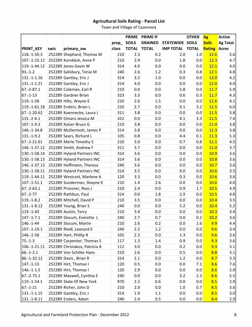
Agricultural Soils Rating ‐ Parcel ListTown and Village of Cazenovia
PRINT_KEY swis primary_ow
prop_
class
PRIME
SOILS
TOTAL
PRIME IF
DRAINED
TOTAL
STATEWIDE
IMP TOTAL
OTHER
SOILS
TOTAL
Ag
Soils
Rating
Active
Ag Total
Acres
118.‐1‐50.3 252289 Shephard, Thomas M 210 2.3 0.2 2.0 1.0 12.6 5.6
107.‐1‐15.12 252289 Kornbluh, Anne P 210 2.9 0.0 1.8 0.0 12.3 4.7
119.‐1‐44.12 252289 Jones Gavin W 314 4.0 0.0 0.0 0.0 12.1 4.0
93.‐1‐2 252289 Salisbury, Tonia M 240 2.6 1.2 0.3 0.8 12.1 4.8
131.‐1‐1.16 252289 Gantley, Eric J 314 3.2 1.0 0.0 0.0 12.0 4.2
131.‐1‐1.21 252289 Gantley, Eric J 314 4.0 0.0 0.0 0.0 12.0 4.0
67.‐2‐87.1 252289 Coleman, Earl R 210 0.0 0.0 5.8 0.0 11.7 5.9
67.‐1‐13 252289 Gardner Brian 323 3.3 0.0 0.6 0.3 11.7 4.3
119.‐1‐58 252289 Hilts, Wayne E 210 2.6 1.5 0.0 0.0 11.6 4.1
119.‐1‐61.18 252289 Enders, Brian L 210 2.7 0.0 0.1 3.2 11.5 6.0
67.‐1‐20.62 252289 Koennecke, Laura J 311 3.8 0.0 0.0 0.0 11.5 3.8
131.‐2‐6.1 252289 Omans Jessica M 322 0.0 0.0 4.1 3.3 11.5 7.4
107.‐1‐9.3 252289 Kaiser Bruce G 210 3.8 0.0 0.0 0.0 11.4 3.8
146.‐1‐34.8 252289 McDermott, James P 314 3.8 0.0 0.0 0.0 11.3 3.8
131.‐1‐9.2 252289 Sears, Richard L 105 0.8 0.0 4.4 0.1 11.3 5.3
67.‐1‐21.61 252289 Merle Timothy S 210 3.0 0.0 0.7 0.8 11.1 4.5
146.‐1‐37.12 252289 Smith, Andrew F 311 3.7 0.0 0.0 0.0 11.0 3.7
130.‐1‐58.14 252289 Hyland Partners INC 314 3.6 0.0 0.0 0.0 10.9 3.6
130.‐1‐58.13 252289 Hyland Partners INC 314 3.6 0.0 0.0 0.0 10.8 3.6
146.‐1‐37.13 252289 Hoffmann, Theresa 240 3.6 0.0 0.0 0.0 10.7 3.6
130.‐1‐58.11 252289 Hyland Partners INC 314 3.5 0.0 0.0 0.0 10.6 3.5
119.‐1‐44.11 252289 Westcott, Marlene A 120 3.3 0.0 0.3 0.0 10.6 3.6
107.‐1‐51.1 252289 Sunderman, Shayne K 210 1.4 2.6 0.0 0.0 10.6 4.0
67.‐2‐63.1 252289 Prossner, Ross J 210 2.4 0.0 0.9 1.7 10.5 4.9
67.‐2‐77 252289 Rathbun, Paul 314 0.0 1.8 2.9 0.0 10.5 4.8
119.‐1‐8.2 252289 Mitchell, David P 210 3.5 0.0 0.0 0.0 10.4 3.5
131.‐1‐8.12 252289 Young, Brian S 240 0.0 0.0 5.2 0.0 10.4 5.2
119.‐1‐43 252289 Austin, Terry 210 3.4 0.0 0.0 0.0 10.3 3.4
147.‐1‐7.1 252289 Slocum, Everette L 240 2.7 0.7 0.0 0.2 10.2 3.6
146.‐1‐44 252289 Slocum, Martin 210 2.6 0.2 0.0 1.6 9.9 4.4
107.‐1‐19.1 252289 Riedl, Leonard E 240 2.2 1.2 0.0 0.0 9.6 3.4
146.‐1‐58 252289 Hart, Phillip R 105 2.3 0.0 1.3 0.0 9.6 3.6
75.‐1‐3 252289 Carpenter, Thomas S 117 1.3 1.4 0.9 0.0 9.3 3.6
106.‐1‐21.11 252289 Christakos, Patricia A 112 3.0 0.0 0.2 0.0 9.3 3.1
66.‐1‐2.1 252289 Von Schiller Hans 210 2.6 0.0 0.5 0.0 8.8 3.1
86.‐1‐32.12 252289 Davis , Brian R 314 2.1 0.0 1.2 0.0 8.7 3.3
147.‐1‐13 252289 Hirt, Thomas I 120 0.5 0.0 0.0 7.1 8.6 7.6
146.‐1‐1.5 252289 Hirt, Thomas I 120 2.9 0.0 0.0 0.0 8.6 2.9
67.‐2‐75.1 252289 Maxwell, Cynthia E 240 0.0 0.0 3.2 2.3 8.6 5.5
119.‐1‐54.1 252289 State Of New York 970 2.3 0.6 0.0 0.0 8.5 2.9
67.‐1‐21 252289 Richer, John D 210 2.0 0.0 1.0 0.7 8.5 3.6
131.‐1‐1.15 252289 Gantley, Eric J 314 1.9 1.1 0.0 0.0 8.5 3.0
131.‐1‐8.11 252289 Enders, Adam 240 2.4 0.5 0.0 0.0 8.4 2.9
Agricultural and Farmland Protection Plan ‐ December 2012 8

Agricultural Soils Rating ‐ Parcel ListTown and Village of Cazenovia
PRINT_KEY swis primary_ow
prop_
class
PRIME
SOILS
TOTAL
PRIME IF
DRAINED
TOTAL
STATEWIDE
IMP TOTAL
OTHER
SOILS
TOTAL
Ag
Soils
Rating
Active
Ag Total
Acres
131.‐1‐1.18 252289 Fesenger, Gordon H 314 1.0 2.2 0.0 0.0 8.4 3.2
75.‐1‐32.2 252289 Koerner Roberts Lesley H 210 2.0 1.0 0.0 0.0 8.4 3.0
146.8‐1‐72 252289 Holmes, Edmund L 120 0.0 0.0 4.1 0.0 8.3 4.1
119.‐1‐56.13 252289 Henn, Michael 210 2.7 0.1 0.0 0.0 8.2 2.8
146.‐1‐51.5 252289 Libby, John 314 2.7 0.0 0.0 0.0 8.2 2.7
147.‐1‐33 252289 Travelle, Daniel Skip 260 0.0 0.0 2.7 2.6 8.1 5.4
66.‐1‐7.112 252289 Larter, Judith K 311 1.9 0.0 1.1 0.0 8.1 3.1
75.‐1‐42 252289 Ammann, Karl 210 1.5 1.3 0.0 0.0 8.0 2.9
119.‐1‐20 252289 Beacham, Terence W 210 2.6 0.0 0.0 0.0 7.8 2.6
119.‐1‐56.8 252289 Owens, Thomas J 210 2.5 0.0 0.0 0.0 7.6 2.5
131.‐2‐4 252289 Damon, Terry C 210 0.0 0.0 3.7 0.1 7.5 3.8
119.‐1‐11 252289 Jones, Margaret W 210 1.9 0.0 0.5 0.6 7.5 3.1
131.‐1‐1.14 252289 Gantley, Eric J 314 1.3 1.4 0.0 0.1 7.4 2.7
146.‐1‐37.18 252289 Stalder, Bruce 210 2.5 0.0 0.0 0.0 7.4 2.5
107.‐1‐30.3 252289 Goodfellow, William G 311 1.4 0.9 0.5 0.0 7.3 2.7
131.‐1‐1.13 252289 Gantley, Eric J 314 1.2 1.5 0.0 0.0 7.3 2.7
130.‐1‐23 252289 Jerabek, Eric 210 1.2 1.5 0.0 0.0 7.2 2.7
130.‐1‐58.12 252289 Gostin, David M 210 2.4 0.0 0.0 0.0 7.2 2.4
107.‐1‐23.6 252289 Sovik Charles F 220 0.1 0.0 3.4 0.0 7.1 3.5
66.‐1‐7.111 252289 Larter, Judith K 210 2.1 0.0 0.4 0.0 7.1 2.5
119.‐1‐56.5 252289 Forrett, Jeremy C 210 2.3 0.1 0.0 0.0 7.0 2.4
119.‐1‐28.1 252289 Anderson, Christopher F 210 0.4 0.0 1.8 2.1 7.0 4.3
131.‐1‐1.20 252289 Doxtator, James J 210 2.2 0.1 0.0 0.0 6.9 2.3
131.‐1‐12 252289 Sears, Richard L 105 0.1 0.0 3.2 0.3 6.8 3.5
107.‐1‐9.111 252289 Jones, Edward W 312 2.1 0.0 0.3 0.0 6.8 2.4
147.‐2‐9 252289 Usborne, Ann M 314 0.3 0.0 0.0 5.9 6.8 6.2
131.‐1‐4.22 252289 Merkle, David 311 0.0 0.9 2.2 0.0 6.7 3.1
131.‐2‐2 252289 Tegtmeyer, Paul 210 0.0 0.0 3.3 0.0 6.7 3.3
107.‐1‐8 252289 Webber, Mathew H 210 2.2 0.0 0.0 0.0 6.6 2.2
95.3‐2‐20 252289 New Venture Assets LLC 415 2.0 0.0 0.0 0.3 6.4 2.4
119.‐1‐8.5 252289 Sadlon, Richard 311 0.8 0.0 2.1 0.0 6.4 2.8
76.10‐1‐16 252289 Borio, Joseph C 210 1.7 0.0 0.5 0.0 6.2 2.3
106.‐1‐47 252289 Curtis, Helen B 210 2.0 0.0 0.0 0.0 6.1 2.0
107.‐1‐5 252289 Moore, Gordon D 210 2.0 0.0 0.0 0.0 6.1 2.0
67.3‐1‐3 252289 Potter Trust Albert L 210 2.0 0.0 0.0 0.0 6.1 2.0
75.‐1‐43.1 252289 Christensen, Kurt K 210 1.4 0.7 0.0 0.0 6.0 2.1
146.‐1‐51.2 252289 Slocum Dean L 210 1.5 0.0 0.0 1.6 6.0 3.1
147.‐2‐1 252289 Canal Al 210 0.0 0.0 2.9 0.0 5.8 2.9
118.‐1‐62.12 252289 Stowell Gregory N 210 1.9 0.0 0.0 0.0 5.8 1.9
147.‐1‐20.5 252289 Diehl, Joseph 240 1.8 0.1 0.0 0.0 5.6 1.9
146.‐1‐40.2 252289 Shatzkin, Charles 321 1.6 0.0 0.3 0.3 5.6 2.1
67.‐2‐66.1 252289 Rathburn (Life Use), Lois M 210 1.8 0.0 0.0 0.0 5.5 1.8
131.‐2‐6.3 252289 Damon, Terry C 323 0.0 0.0 1.9 1.7 5.4 3.5
Agricultural and Farmland Protection Plan ‐ December 2012 9

Agricultural Soils Rating ‐ Parcel ListTown and Village of Cazenovia
PRINT_KEY swis primary_ow
prop_
class
PRIME
SOILS
TOTAL
PRIME IF
DRAINED
TOTAL
STATEWIDE
IMP TOTAL
OTHER
SOILS
TOTAL
Ag
Soils
Rating
Active
Ag Total
Acres
84.‐1‐4 252289 DeFrees, Harold J 210 1.1 0.0 0.9 0.0 5.3 2.1
75.‐1‐3.1 252289 Carpenter, Thomas S 210 0.7 0.9 0.5 0.0 5.3 2.1
95.3‐2‐19 252289 New Venture Assets LLC 415 1.6 0.0 0.0 0.3 5.2 2.0
106.‐1‐24 252289 Bello, Joseph A Jr 210 1.7 0.0 0.0 0.0 5.1 1.7
146.‐1‐37.14 252289 Smith, Andrew F 210 1.7 0.0 0.0 0.0 5.1 1.7
119.‐1‐61.17 252289 Berry, Lynne J 314 0.6 0.0 0.3 2.7 5.1 3.6
131.‐1‐4.23 252289 Holmes, Steven E 311 0.0 0.0 2.5 0.0 4.9 2.5
94.‐1‐23 252289 Reynolds Joanne B 210 1.6 0.0 0.0 0.0 4.9 1.6
147.‐1‐19.1 252289 Hunt, Rachel M 210 0.8 0.8 0.0 0.6 4.9 2.2
119.‐1‐32.2 252289 Radelich Richard 240 0.4 0.0 1.8 0.0 4.7 2.2
118.‐1‐69.2 252289 Jones Marjorie Vogel 210 1.5 0.0 0.0 0.0 4.6 1.5
119.‐1‐8.3 252289 Eilers, David J 210 1.5 0.0 0.0 0.0 4.5 1.5
106.‐1‐23.32 252289 Wilson, Jacqueline 323 1.5 0.0 0.0 0.0 4.5 1.5
118.‐1‐10 252289 Castle Michael R 210 1.5 0.0 0.0 0.0 4.4 1.5
107.‐1‐34.2 252289 Brown, Eric M 240 1.4 0.0 0.1 0.0 4.3 1.5
119.‐1‐8.4 252289 Brandolini, Alan R 210 1.4 0.0 0.0 0.0 4.3 1.4
131.‐1‐8.131 252289 Phillips Scott 314 1.2 0.0 0.0 0.5 4.2 1.7
107.‐1‐47.13 252289 Breault, Edward A 120 1.4 0.0 0.0 0.0 4.2 1.4
131.‐1‐3 252289 Holmes, James M 210 1.4 0.0 0.0 0.0 4.1 1.4
106.‐1‐23.1 252289 Wilson, Gerald E 321 1.3 0.0 0.0 0.0 3.9 1.3
131.‐1‐1.12 252289 Prentiss George H 314 1.0 0.3 0.0 0.0 3.8 1.3
67.‐1‐20.61 252289 Koennecke, Sheryl M 240 1.3 0.0 0.0 0.0 3.8 1.3
131.‐1‐11.5 252289 Carole M Leska Revc Trust 210 0.1 0.0 1.7 0.0 3.6 1.8
131.‐1‐8.132 252289 Phillips R. Scott 270 0.9 0.0 0.0 0.8 3.4 1.7
106.‐1‐21.13 252289 Harken, Patrick J 210 0.3 0.0 1.1 0.0 3.2 1.4
118.‐1‐55 252289 Wolff, Barbara D 105 0.7 0.5 0.0 0.0 3.1 1.1
146.‐1‐20.12 252289 Dunbar, Paul L 270 1.0 0.0 0.0 0.0 3.1 1.1
67.‐2‐59.1 252289 Berger, Ronald C 312 1.0 0.0 0.0 0.1 3.1 1.1
95.1‐2‐11 252289 Loeper Marybeth M 210 1.0 0.0 0.1 0.0 3.1 1.0
147.‐1‐21.2 252289 Evans, James B 240 0.0 0.0 1.5 0.0 3.0 1.5
107.1‐1‐20.1 252289 Seeley, Thomas R 210 0.9 0.0 0.0 0.3 2.9 1.1
146.‐1‐34.3 252289 Smith, Andrew F 311 0.9 0.0 0.0 0.0 2.8 0.9
86.‐1‐12.1 252289 Field Ernest R 322 0.5 0.0 0.7 0.0 2.8 1.2
118.‐1‐62.13 252289 Stowell, Benjamin E 210 0.9 0.0 0.0 0.0 2.8 0.9
130.‐1‐53.113 252289 Richard, Williams Living 112 0.9 0.0 0.0 0.0 2.8 0.9
107.‐1‐34.126 252289 Formoza, Scott 311 0.9 0.0 0.0 0.0 2.7 0.9
84.‐1‐1.2 252289 Secor, Robert W 311 0.4 0.0 0.3 0.8 2.6 1.5
119.‐1‐56.11 252289 Demyttenaere, Nancy 210 0.5 0.4 0.0 0.0 2.6 0.9
67.‐2‐87.2 252289 Coleman, Janice M 210 0.0 0.0 1.2 0.0 2.5 1.2
119.‐1‐54.2 252289 P.D.J. Inc DBA Johnson Bro 210 0.8 0.0 0.0 0.1 2.5 0.9
107.‐1‐44 252289 Breault, Edward A 311 0.8 0.0 0.0 0.0 2.4 0.8
146.‐1‐38 252289 Rahi Real Estate Holdings L 210 0.8 0.0 0.0 0.0 2.4 0.8
106.‐1‐42 252289 Cazenovia Preservation 323 0.7 0.1 0.0 0.1 2.4 0.9
Agricultural and Farmland Protection Plan ‐ December 2012 10

Agricultural Soils Rating ‐ Parcel ListTown and Village of Cazenovia
PRINT_KEY swis primary_ow
prop_
class
PRIME
SOILS
TOTAL
PRIME IF
DRAINED
TOTAL
STATEWIDE
IMP TOTAL
OTHER
SOILS
TOTAL
Ag
Soils
Rating
Active
Ag Total
Acres
146.‐1‐34.9 252289 Rainbow, Malcolm 314 0.7 0.0 0.0 0.0 2.2 0.7
146.‐1‐21.12 252289 Popek, Stanley 210 0.0 0.0 1.1 0.0 2.2 1.1
146.‐1‐3.6 252289 Smith, Joshua P 210 0.7 0.0 0.0 0.0 2.1 0.7
119.‐1‐56.6 252289 Bossard, Bret 210 0.5 0.2 0.0 0.0 2.1 0.7
106.‐1‐21.12 252289 Arehart Deborah A 210 0.7 0.0 0.0 0.0 2.0 0.7
147.‐1‐11 252289 Hirt, Shirley E 323 0.5 0.0 0.0 0.3 1.9 0.9
107.‐1‐33.2 252289 Johnson, Peter 210 0.6 0.0 0.0 0.1 1.8 0.7
131.‐1‐8.1 252289 Baker, Scott C 210 0.0 0.0 0.7 0.3 1.7 1.0
85.‐2‐2 252289 Conover, Donald T 323 0.0 0.0 0.9 0.0 1.7 0.9
118.‐1‐13.14 252289 Waldron, Timothy P 240 0.0 0.0 0.8 0.0 1.6 0.8
95.3‐2‐32 252289 Romagnoli, Marybeth 311 0.0 0.0 0.6 0.0 1.3 0.6
95.3‐2‐29 252289 Romagnoli, Mary Beth 250 0.0 0.0 0.5 0.0 1.1 0.5
433 T Cazenovia Parcel Count
441 Grand Count
Agricultural and Farmland Protection Plan ‐ December 2012 11

Agricultural Soils Rating
Explanation of Column Headings
PRINT_KEY Tax parcel number ‐ from Real Property database
swis Municipal code
primary_ow Primary landowner ‐ from Real Property database
prop_class Land use classification ‐ from Real Property database (See list of codes below)
acres Total acreage of parcel ‐ from Real Property database
PRIME SOILS TOTAL
Acres of prime agricultural soils within the parcel ‐ computed from GIS by Stuart I.
Brown Associates
PRIME IF DRAINED
TOTAL
Acres of prime agricultural soils within the parcel ‐ acreage computed from GIS by
Stuart I. Brown Associates; soils mapped and classified by USDA Natural Resources
Conservation Service
STATEWIDE IMP TOTAL
Acres of prime agricultural soils within the parcel ‐ acreage computed from GIS by
Stuart I. Brown Associates; soils mapped and classified by USDA Natural Resources
Conservation
OTHER SOILS TOTAL
Acres of prime agricultural soils within the parcel ‐ acreage computed from GIS by
Stuart I. Brown Associates; soils mapped and classified by USDA Natural Resources
Conservation
Ag Soils Rating
[Prime Soils Total x 3] +[Prime If Drained Total x 2.5]+[Statewide Imp Total x
2]+[Other Soils Total] ‐ computed by Stuart I. Brown Associates
Active Ag Total Acres
Total acreage of active cropland, pasture or other open land that may be suitable
for agricultural use ‐ delineated from aerial photographs and computed from GIS
by Stuart I. Brown Associates
Property Classification Codes
100s Agricultural
200s Residential
300s Vacant
400s Commercial
500s Recreation
600s Public/ Government
700s Mining; Industrial
800s Utilities/ Transportation
900s Conservation
Agricultural and Farmland Protection Plan ‐ 2012

Appendix D
Zoning Audit, Excerpts from regulations and NYS Agriculture & Markets Guidance

1
Zoning Audit – Town of Cazenovia The audit of the Town of Cazenovia’s land use (zoning and subdivision) regulations identifies provisions that relate to agricultural uses and assesses how well the Town’s land use regulations help to support agriculture and protect farming, with particular attention to compliance with NYS Agricultural District Law.
Overview of Provisions Relating to Agricultural uses
Zoning Districts and Permitted Uses
Three base zoning districts govern the Town of Cazenovia:
• Rural A (RA) • Rural B (RB) • Lake Watershed and Riparian Corridor
“Farm and farming” is listed as a permitted use (allowed “by right”) in each of these districts.
In addition to the base zoning districts, the Town’s zoning regulations incorporate several overlay districts: the New Woodstock Hamlet Overlay (NWHO), Commercial Overlay (COMO), Industrial Overlay (IO), Village Edge Overlay (VEO) and New Woodstock Central Business Overlay (NWCBO) district. “Farm and farming” are permitted “by right” in each of these districts.
The Wellhead Protection Overlay (WPO) district allows any use permitted in the underlying district except for those uses that are specifically prohibited. Prohibited uses in the WPO district include:
• “Commercial nursery or garden center” • “Concentrated animal feeding operation in areas outside of local agricultural district(s) created
pursuant to New York State Agriculture and Markets Law”
Agricultural Overlay District
The Agricultural Overlay District (AO) consists of all parcels in the Town that meet all of the following criteria:
A. Total area in excess of 15 contiguous acres; B. Containing at least 50% of soils deemed USDA Prime Soils; AND C. Located in a New York State certified Agricultural District.
The Agricultural Overlay District is not mapped, as its boundaries are based on parcel size and Agricultural District boundaries that change over time. The determination of whether a parcel is located within the Overlay District is made on a case‐by‐case basis when new development is proposed.

2
The parcels that meet all of these criteria, based on current Agricultural District boundaries and parcel specifications, are depicted in the attached map. This map was prepared using GIS software to identify all parcels located within in an Agricultural District that contain at least 15 acres where at least 50% of the parcel consist of prime agricultural soils.
Based on this analysis, the Agricultural Overlay District currently applies to 75 parcels which range in size from 16.5 acres to 292 acres.
Farming is a permitted use in the AO district. However, certain types of farm operations and related businesses require a special use permit, including:
• Agricultural Composting • Farm Equipment Repair • Migrant labor housing for more than one family • Milk Processing for On and Off‐Farm Milk • Nurseries, lawn/landscape services, orchards, greenhouses, vineyards • Permanent or temporary produce stands for the sale of agricultural products grown principally
by the operator during the harvest season • Public Stable • Wineries
In order to be granted a special use permit, the applicant must demonstrate:
1. That the use will be of a nature, intensity, scope, size, appearance, type and quality conforming to existing residential or agricultural structures.
2. That new structures will be located in a way that minimize negative impacts on future operation and expansion of agricultural uses and does not interfere with current agricultural operations or displace farms or farming.
3. The use as proposed is related to agriculture, forestry or open spaces or will not impede such uses.
All new residential uses in the AO are subject to conservation subdivision requirements. These provisions apply to parcels that contain at least nine acres of land that is not constrained by natural limitations to development such as wetlands, watercourses, floodplains and steep slopes. The number of residential units permitted is calculated as the amount of unconstrained land divided by the minimum lot size in the applicable zoning district. A conventional layout may be required to demonstrate that the number of residences proposed on the site can be accommodated with an average of 100 feet of road frontage per lot. The lots may be of any size, provided that water and sewage disposal are accommodated. A portion of the site – not less than the amount of constrained land – must be set aside for conservation area and protected through a permanent conservation easement. The conservation areas may be owned by a private landowner, by a homeowners’ association, or by the Town or a not‐for‐profit entity. Conservation areas shall include all of the constrained land.

3
Definitions of Agricultural Uses
The Town’s zoning regulations include definitions for the following agriculture‐related uses:
Farm ‐ Any lot or parcel of land at least fifteen (15) acres in area which is used in conjunction with a farm operation.
Farm Operation ‐ As defined in New York Agriculture and Markets Law, Article 25AA, §301(11), land and on‐farm buildings, equipment, manure processing and handling facilities and practices which contribute to the production, preparation and marketing of crops, livestock and livestock products as a commercial enterprise, including a commercial horse‐boarding operation. Such farm operation may consist of one (1) or more parcels of owned or rented land, which parcels may be contiguous or noncontiguous to each other.
Farming ‐ The utilization of land and structures for the production, preservation, nonindustrial processing, storage and sale of agricultural commodities such as crops, plants, flowers, vines and grape products, trees, sod, shrubs, livestock, honey, Christmas trees, compost, poultry or dairy products, not including agricultural industry or farms primarily for the disposal of offal or garbage.
Other terms that may be include agricultural uses are not defined. These include “agricultural industry,” horticulture, landscape, garden center, florist operation, nursery and greenhouse.”
Regulations and Special Permit Criteria for Agricultural Uses
Section 165‐72 of the Town’s zoning code includes the following regulations for “Farms not located in an approved New York State Agricultural District:”
(1) No retail or commercial activity shall take place other than the storage, processing and sale of farm products grown on the premises.
(2) No odor‐or dust‐producing use, including the storage of manure, shall take place within 150 feet of the nearest lot line.
(3) No farm stock shall be kept in a structure that is closer to the nearest lot line than 150 feet.
(4) No garbage or refuse shall be used for feed other than that actually produced on the premises.
This section also states: “A farm may breed, raise and/or train animals provided the property contains a minimum of fifteen (15) acres.”

4
Stables
Private stables are permitted “by right” as an accessory use to a residence in the Commercial Overlay district and with a special use permit in the Rural A, Lake Watershed districts. The definition of “private stable” is:
An accessory building where horses are kept for private use and not for hire, remuneration or sale. Such uses shall comply with §165‐82 of this Chapter. For purposes of required pastureland, a pasture is open land which is suitable for and devoted to grazing with no buildings, wells, septic systems or improvements.
Public stables are permitted “by right” in the Commercial Overlay district and with a special use permit in the Agriculture Overlay district. “Public stable” is defined as: “A building where horses are kept for instruction, training, hire, remuneration or sale. Such uses shall comply with §165‐82 of Chapter.”
The Town’s criteria for approving special use permits for Stables (§165‐82) are:
A. Stables shall be subject to the following additional general requirements:
(1) No odor or dust producing use, including the storage of manure, shall take place within 150 feet of the nearest lot line.
(2) No horses shall be kept in a structure that is closer to the nearest lot line than 150 feet.
(3) Fencing of four (4) feet in height shall enclose a paddock and be no closer than eight (8) feet to a property line.
(4) The criteria set forth in this Section shall apply equally to horses and donkeys.
B. Additional Conditions for Private Stables:
(1) No retail or commercial activity shall take place including a riding academy.
(2) All horses boarded on the lot must be owned by the family living on the lot.
(3) Private stables shall be considered a residential accessory use.
(4) The lot must contain a minimum of three (3) acres of useable pasture land for up to two (2) horses plus one and a half (1.5) acres of usable pasture land for each additional horse up to a maximum of six (6) horses.
C. Additional conditions for Public Stables

5
(1) The lot must contain a minimum of three (3) acres of useable pasture land for up to two (2) horses plus one and a half (1.5) acre of usable pasture land for each additional horse.
Analysis
This section evaluates how well the Town’s land use regulations help to support agriculture and protect farming and identifies provisions that may be inconsistent with NYS Agricultural District Law. NYS Agriculture & Markets Law Article 25AA, which addresses the Agricultural Districts Program, includes provisions intended to protect standard farming practices from unreasonable restrictions of local laws. Section 305‐a. states:
a. Local governments, when exercising their powers to enact and administer comprehensive plans and local laws, ordinances, rules or regulations, shall exercise these powers in such manner as may realize the policy and goals set forth in this article, and shall not unreasonably restrict or regulate farm operations within agricultural districts in contravention of the purposes of this article unless it can be shown that the public health or safety is threatened.
b. The commissioner, upon his or her own initiative or upon the receipt of a complaint from a person within an agricultural district, may bring an action to enforce the provisions of this subdivision.
The limitation on local laws specifically applies to “farm operations within agricultural districts” as defined in the statute (see attached.) Generally, such operations must generate a minimum of $10,000 in sales annually and may include commercial horse boarding operations.
The NYS Department of Agriculture & Markets has published several guidance documents to assist municipalities in determining whether their local regulations “unreasonably restrict” standard farming practices in Agricultural Districts. While the Department of Agriculture & Markets does not have the authority to invalidate local laws, it can limit the ability of municipalities to enforce provisions in their local laws that are deemed to be unreasonable in specific cases.
The following findings and recommendations are intended to remove provisions that unreasonably restrict farm practices and to encourage additional provisions to make the Town’s regulations more supportive of agriculture.
1. Clarify definitions and distinguish between agricultural uses protected by Agricultural Districts Law and other farms
The definitions of “Farm,” “Farm operation,” and “Farming” are inconsistent with one another. A “farm” is defined as, “Any lot or parcel of land at least fifteen (15) acres in area which is used in conjunction with a farm operation.” However, the Town’s definition of ”Farm operation” references the definition in

6
NYS Agriculture & Markets Law, which generally uses seven acres as a threshold but may include smaller parcels.
“Farm and farming” is listed as a permitted use throughout the Town. However, “farm operation” is not specifically permitted.
It appears that the Town would like to retain regulatory authority over hobby farms and livestock maintained as an accessory use to a residence. The zoning regulations should include a clearer exemption from local regulation for those farm operations that meet the threshold for protection in Agriculture & Markets law.
Recommendation
Establish by definition two categories of farm operation that would be subject to different levels of regulation. One category would include those farms that meet the threshold established by NYS Department of Agriculture & Markets for protection in Agricultural Districts law. The second category would include small scale farms and livestock operations that do not meet those thresholds, including keeping of livestock as an accessory use to a residence.
For example, the Town of Nelson’s zoning regulations define “Agricultural Use” as: “Land uses meeting the criteria for “land used in agricultural production" as set forth in Section 301 of the New York State Agriculture and Markets Law, “and “Farm Use” as: “Land containing at least 5 acres which is used for raising or boarding livestock or agricultural products, but excluding an activity or activities that constitute an Agricultural Use as defined herein.” The regulations list “Agricultural uses” as permitted in all districts. Standards for “Farm uses” go beyond those that would be considered reasonable for agricultural operations that meet NYS Agriculture & Markets thresholds.
Regulatory statements should be avoided in the definitions
Suggested definitions that may be useful are:
Agricultural Use ‐ Land uses meeting the criteria for “land used in agricultural production" as set forth in Section 301 of the New York State Agriculture and Markets Law.
Farm Use ‐ Any parcel of land with ___ or more acres which is used in the raising of agricultural products, livestock, poultry or dairy products, including necessary farm structures and the storage of equipment customarily incidental to the primary use.
Farm Dwelling ‐ A residence located on a farm parcel.
Farm Parcel ‐ A tract or parcel of land devoted primarily to agricultural uses, and which may include a dwelling and/or other accessory uses.

7
Farm‐Related Business ‐ A business engaged principally in providing supplies, implements, livestock and/or other products or services needed for agricultural uses, including but not limited to seed, fertilizers, herbicides, pesticides, animal feeds, tools, fencing and parts for farm machinery or equipment, blacksmithing, farm implement repair, storage of agricultural products, or retail sale of agricultural products. This definition shall not include agricultural processing plants, dealerships for farm equipment or machinery or slaughterhouses.
MANURE STORAGE FACILITY ‐‐ A facility constructed as an accessory use to an animal husbandry use, riding stable, or kennel intended to collect, hold, process, store, treat, or distribute animal solid and liquid waste. Included within this definition are storage tanks, lagoons, seepage pits, drains, and collection systems intended to handle waste from 50 or more animal units as defined herein.
2. Clarify that the regulations relating to farming practices do not apply to farm operations
While the Town’s zoning regulations acknowledges the provisions of NYS Agriculture & Markets Law, there are several provisions in the Town’s zoning regulations – including minimum lot sizes, prohibition of certain agricultural uses, and the requirement for special use permits – that are inconsistent with Agriculture & Markets guidance.
The existing (Sec 165‐127.A) “disclaimer” states:
No Unreasonable Regulations. None of the regulations contained in this Article shall be construed or interpreted by the reviewing board to unreasonably restrain those farms or farming operations located in an agricultural district approved pursuant to NYS Agriculture and Markets Law Article 25AA.
However, this statement does not clearly exempt farm operations in Agricultural Districts from many of the regulations in the Town’s zoning. The wording of this paragraph requires the Town Planning Board and Zoning Board of Appeals to make determinations in each case as to whether the provisions can be applied to a specific farm. It also does not apply to the issuance of permits by the Code Enforcement Officer. The Town’s zoning regulations should state more clearly that farm operations as defined by NYS Agricultural Districts law are exempt from these restrictions.
There are two ways to exempt farm operations that meet NYS thresholds from unreasonable regulations:
1) Specifically state in each applicable section of the regulations that such farm operations are exempt from the provisions
2) Separately define farm operations that meet the NYS thresholds and other farms that do not.
Both of these approaches are used in the Town’s zoning regulations. However, more consistency and clarity is needed.

8
Recommendation
For every regulation of farming practice, include a statement such as: “This provision does not apply to farm operations within a certified Agricultural District as defined in Article 25AA of Agriculture & Markets Law, Section 301” or, if the Town zoning incorporates a separate definition for “agricultural uses” that covers such farm operations, “This provision does not apply to agricultural uses as defined herein.”
3. Agricultural Overlay District excludes several parcels with significant acreage of prime soils
The attached map shows that there are many parcels of land that are within County Agricultural Districts that do not contain prime agricultural soils. However, most of these parcels are not currently in agricultural use.
Several large farm parcels that are both located within the County Agricultural District and contain significant amounts of prime agricultural soils are not included in the Agricultural Overlay District because the number of acres of prime soils is less than 50% of the parcel total. Some of these parcels have 50 or more acres of prime agricultural soils that would be suitable for protection as part of a conservation subdivision, yet they are not covered by the provisions of the Agricultural Overlay District.
Recommendation
Expand the criteria for the Agricultural Overlay District to include parcels of any size that contain 20 or more acres of prime agricultural soils.
4. Agricultural Overlay District discourages certain agricultural uses by requiring a special use permit
In the Agricultural Overlay District, the following agricultural use require a special use permit. Such permits are not required for agricultural uses in other zoning districts:
• Agricultural composting • Migrant labor housing for more than one family • Nurseries, lawn/landscape services, orchards, greenhouses, vineyards • Permanent or temporary produce stands for the sale of agricultural products grown principally
by the operator during the harvest season • Public stable • Wineries
The requirement for special use permits for agricultural uses in the Agricultural Overlay District appears to be contradictory to the intent of the district to accommodate and support agricultural uses. Guidance from the NYS Department of Agriculture & Markets states that requiring a special permit is

9
unreasonably restrictive when applied to standard farm practices for farm operations within Agricultural Districts. Such operations should be explicitly exempt from this requirement.
Recommendation
• All agricultural uses should be permitted “by right” in the Agricultural Overlay District, including orchards, vineyards, greenhouse operations and wineries.
• Consider requiring a special use permit for new non‐farm residences in the Agricultural Overlay District.
5. Certain agricultural uses are prohibited or require a special use permit
Although “Farm and Farming” is listed as a permitted use in all zoning districts, certain types of agricultural uses are prohibited or require a special use permit. For example, public stables are only permitted “by right” in the Commercial Overlay district and require a special use permit in the Agricultural Overlay district. Private stables are only permitted “by right” in the Commercial Overlay district, require a special use permit in the Rural A, Village Edge “A” and Agricultural Overlay districts, and are not permitted in any other district. (See #
In addition, horticulture or nursery businesses may constitute farm operations as defined in NYS Agricultural District Law. These uses are permitted “by right” only in the Commercial and Industrial overlay districts and require a special use permit in the New Woodstock Central Business Overlay district. They not permitted in other districts, although “nurseries” are permitted with a special use permit in the Agricultural Overlay district.
Recommendations
• For each use listed in the district regulations as requiring a special use permit, add a qualifying statement such as: “The requirement for a special use permit shall not apply to agricultural uses within a certified County Agricultural District as defined by NYS Agriculture & Markets Law Section 301.”
• Revise the definition of “public stable” and “private stable” to state that the definition does not include horse boarding operations are included within the definition of agricultural use as defined in NYS Agricultural Districts Law Section 301. (See also #8.)
• Define “nursery.”
6. Zoning requires 15 acre minimum lot size for farms
In the Agricultural Overlay District, the minimum lot area for “Farm and Farm Related Uses” is 15 acres. In addition, the definition of “farm” states that it is a parcel of land with at least 15 acres. If strictly enforced, this provision would prohibit the use of a parcel smaller than 15 acres for agricultural production, even if such parcel were part of a larger farm operation. While this minimum may be

10
acceptable for a hobby farm or the keeping of livestock as an accessory use, it would likely be found to be unreasonable as applied to a farm operation in an Agricultural District as defined by NYS Agriculture & Markets Law Section 301.
Recommendation
• Revise definitions as recommended in #1.
• Eliminate the minimum lot size requirement for agricultural uses or include an exception for such uses located a certified County Agricultural District as defined by NYS Agriculture & Markets Law Section 301.
7. Certain agricultural uses in the Waterfront Protection Overlay District require site plan review
The Waterfront Protection Overlay District regulations state that “Site plan review by the Town of Cazenovia Planning Board shall be required for all new and amended uses in the WPO District. The requirements of this Section shall supplement and be in addition to any other applicable site plan review under this or another Chapter.”
Site plan review for agricultural uses in an Agricultural District that meet the threshold for protection under NYS Agricultural Districts Law would constitute an unreasonable restriction on farm practices unless the requirement directly relates to health and safety. Site plan review would be appropriate for specific farm practices that have a direct relationship to public health, such as pesticide and manure storage facilities. However, the application of pesticides as part of the process of raising crops is regulated by New York State and would not be within the jurisdiction of the Town to regulate.
Recommendation
• Amend the requirement for site plan review in the Waterfront Protection Overlay District to exclude agricultural uses (as defined to include farm operations that meet the threshold for protection under NYS Agricultural Districts law) except for facilities for the storage of pesticides and manure.
• Establish clear criteria and require site plan review for manure storage in the Waterfront Protection Overlay District. Sample regulations are attached.
8. Regulations for public and private stables may be unreasonable if applied to agricultural uses in certified Agricultural Districts as defined by NYS Agricultural Districts Law Section 301
The regulations for public and private stables include standards for setbacks and required acreage of “usable pasture” per horse. Private stables are permitted “by right” in the RA and RB districts and with a special use permit in the RB district.
11
For stables that constitute farm operations as defined by Agricultural District Law, the requirement for a special use permit is discouraged by NYS Agriculture & Markets guidelines. The acreage requirement for pasture may be unreasonable for certain farms.
Recommendation
• Add a statement to the regulations for public and private stables such as: “This provision does not apply to farm operations within a certified Agricultural District as defined in Article 25AA of Agriculture & Markets Law, Section 301” or, if the Town zoning incorporates a separate definition for “agricultural uses” that covers such farm operations, “This provision does not apply to agricultural uses as defined herein.”
9. Incorporate design standards for subdivisions to help protect farm infrastructure and minimize conflicts between farm operations and non‐farm neighbors
The design guidelines in the Town’s subdivision regulations do not explicitly address agricultural infrastructure, buffers between agricultural land and residences, and potential conflicts between residential and agricultural uses.
Recommendation: Revise subdivision design guidelines to require applicants to identify any agricultural infrastructure on the parcel, including access roads and drainage facilities. Add design guidelines that require the protection of existing agricultural infrastructure and buffers between agricultural land and residences, and to encourage lot layouts that minimize potential conflicts between residential and agricultural uses.
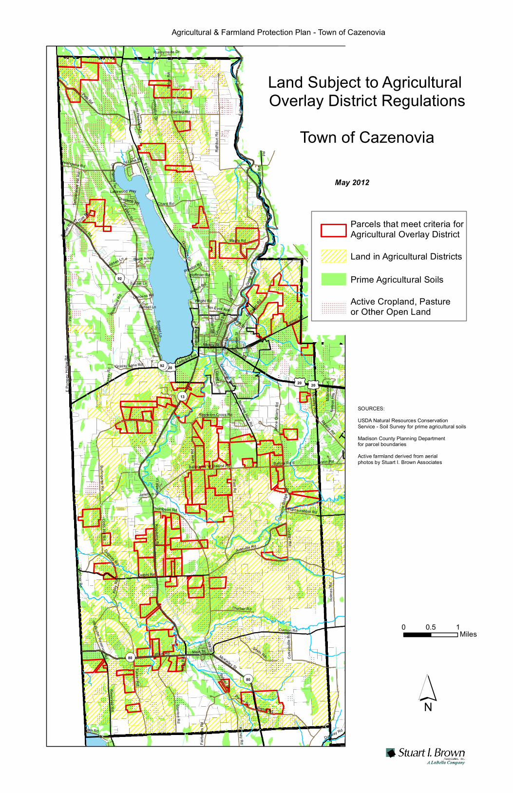
Lyon Rd
Thomas
RdSe
ibenb
aum
Rd£¤20
£¤20 £¤20
¬«13
¬«92
¬«80
¬«80
East Rd
Ridge
Rd
E Lake RdRippleton Rd
Gorge
Rd
W Lake Rd
Falls Rd
Linckl
aen S
t
Delphi Rd
Damon Rd
Irish Ridge Rd
Ballina Rd
Fenner Rd
Fabius Rd
Holm
es R
d
Peth Rd
Kiley
Rd
Cobb Hill Rd
Syracuse Rd
Rathb
un R
d
Ballina Rd W
Falls
Blvd
Roberts Rd
Stanley Rd
Bingley Rd
Tucker Rd
Burlingame Rd
Corki
nsvil
le Rd
Mosley Rd
Michiga
n Rd
Stanton Rd
Barret Rd
Reservoir Rd
Pompey Hollow Rd
Moseley Rd
Emho
ff Rd
Maple Rd
Thompson Rd
Juddville Rd
Lane
Rd
Stone
Qua
rry R
d
Smith Rd
Number Nine Rd
Kinney Rd
McKinley St
Chard Rd
Ballina Rd E
Carrys Hill Rd
Coulter Rd
School St
Hill Rd
Hodge Rd
Lyon Rd
Cazenovia Rd
N Lake Rd
Thurber Rd
Nelso
n Hts
Fairb
anks
Rd
Hardscrabble Rd
Parker Rd
Main St
Dam Rd
Albany St
Sullivan StChenango St
Burto
n St
Rippleton Cross Rd
Form
an S
t
Temp
eranc
e Hill R
d
Coe Rd
Dugway Rd
Tunnel LnCo
nstin
e Brid
ge R
d
Wood
field
Rd
Perryville Rd
Mill St
Nelson St
Gillett Ln
Bass
Rd
Ledyard Ave
de Ruyter Reservoir Rd
Seibenbaum Rd
Grassy Lane Rd
Bethe
l Rd
Hidden Ln
Hoffman Rd
Janet Ln
Owahgena Rd
Cardner Rd
Ten Eyck Ave
Stables Rd
Clark St
Summerfield Dr
Lakewood Way
Ormonde Dr
Sims L
n
Wright RdGordens Rd
Preston Rd
Sunset Ln
Huntington Dr
E Pom
pey H
ollow
Rd
Black Acres
Mount Pleasant Dr
Owahgena Ter
Gras
sy R
d
Mids
tate L
n
Runnymede Dr
Stowe
ll Ln
Overlook Ter
Jepson Rd
Sunset Ln
Dugway Rd
¬«92¬«92
Text
0 10.5Miles
´
May 2012
SOURCES: USDA Natural Resources Conservation Service - Soil Survey for prime agricultural soilsMadison County Planning Department for parcel boundariesActive farmland derived from aerial photos by Stuart I. Brown Associates
Agricultural & Farmland Protection Plan - Town of Cazenovia
Land in Agricultural Districts
Prime Agricultural Soils
Parcels that meet criteria for Agricultural Overlay District
Active Cropland, Pasture or Other Open Land
Land Subject to Agricultural Overlay District Regulations
Town of Cazenovia

Ridge
Rd
East Rd
E Lake Rd
Rippleton Rd
Gorge Rd
W Lake Rd
Falls Rd
Linckl
aen S
t
Delphi Rd
Damon Rd
Fenner Rd
Falls
Blvd Irish Ridge Rd
Fabius Rd
Peth Rd
Kiley Rd
Cobb Hill Rd
Syracuse Rd
Bingley Rd
Ballina Rd W
Roberts Rd
Stanley Rd
Rathb
un R
d
Barret Rd
Kinney Rd
Tucker Rd
Burlingame Rd
Holmes Rd
Corkinsville Rd
Stanton Rd
Perryville Rd
Michiga
n Rd
Moseley Rd
Reservoir Rd
Pompey Hollow Rd
Emhoff RdMaple Rd
Dugway Rd
Fairbanks Rd
Thompson Rd Juddville Rd
Lane RdHill Rd
Stone Quarry Rd
State Highway 13
Ballina Rd E
Number Nine Rd
McKinley St
Chard Rd
Form
an S
t
Carrys Hill Rd
School St
Coulter Rd
Hodge Rd
Cazenovia Rd
Smith Rd
N Lake Rd
Nelso
n Hts
Lyon Rd
Hardscrabble Rd
Parker Rd
United States Highway Route 20 *
Dam Rd
Albany St
Main St
Rippleton Cross Rd
Burto
n St
Coe R
dTemp
eranc
e Hill R
d
Thurber Rd
Cons
tine B
ridge
Rd
Mill StOlmstead Rd
Bass
Rd
Bear Swamp RdRip
pleton
St
Tunnel Ln
Chenango St
De Ruyter Reservoir Rd
Summerfield Dr
Wood
field R
d
Gille
tt Ln
Dwye
r Rd
Bethe
l Rd
Fox Ln
Cardner Rd
Owahgena Rd
Ten Eyck Ave
Grassy Lane Rd
Stables Rd
Ormonde DrClark St
Lakewood Way
Sims L
n
Hidden Ln
Syosset Dr
Carria
ge Ln
Wright RdGordens Rd
Hedge Ln
Sunset Ln
Black Acres
Owah
gena
Ter
Douglas
Way
Mount Pleasant Dr
Huntington Dr
Libert
y St
Runnymede Dr
Overlook Ter
Indian Lookout Rd
E Lake Rd
Holmes Rd
Dugway Rd
0 0.65 1.30.325 Miles ´
SOURCE: Zoning Districts from Madison County Planning Department Active agricultural land digitized by Stuart I. Brown Associates from 2009 aerial photos
December 2012
Active Agricultural Land
ZoningTown of Cazenovia
VE (Village Edge)LW (Lake Watershed)RB-NW ( Residential New Woodstock)RA (Residential)I (Industrial)RB (Residential)
Overlay ZonesZone
Aquifer Protection ZoneWPO - Wellhead Protection CBDO - Central Business DistrictI - IndustrialCD - Commercial
Zoning Districts andActive Farmland
Farmland Protection Plan Town of Cazenovia

12
Sample Regulations for Manure Storage
No unenclosed storage area for manure or other materials creating dust or odor shall be permitted within 100 feet of any street or residential property line nor within 100 feet of a stream or other water body or well providing a source of potable water. In no case shall a pasture be considered an unenclosed storage area for manure, nor shall a pasture be required to be set back 100 feet from any residential property line, street or water body. Any building occupied for the storage of manure or other materials creating dust or odor shall be located a minimum of 60 feet from all lot lines. Manure storage facilities shall be constructed a minimum of 500 feet from any residential property.
Site plan review by the Planning Board shall be required for manure storage facilities or for any structure that is not completely enclosed that is used primarily for the storage of liquid agricultural or food processing wastes.
Definitions
MANURE STORAGE FACILITY ‐‐ A facility constructed as an accessory use to an animal husbandry use, riding stable, or kennel intended to collect, hold, process, store, treat, or distribute animal solid and liquid waste. Included within this definition are storage tanks, lagoons, seepage pits, drains, and collection systems intended to handle waste from 50 or more animal units as defined herein
ANIMAL UNIT – The equivalent of 1000 pounds of farm animal.

Definition of Farm Operation
NYS AGRICULTURAL DISTRICTS LAW ‐ ARTICLE 25AA, Section 301
301. Definitions When used in this article: 1. "Agricultural assessment value" means the value per acre assigned to land for assessment
purposes determined pursuant to the capitalized value of production procedure prescribed by section three hundred four‐a of this article.
2. "Crops, livestock and livestock products" shall include but not be limited to the following: a. Field crops, including corn, wheat, oats, rye, barley, hay, potatoes and dry beans. b. Fruits, including apples, peaches, grapes, cherries and berries. c. Vegetables, including tomatoes, snap beans, cabbage, carrots, beets and onions. d. Horticultural specialties, including nursery stock, ornamental shrubs, ornamental trees and
flowers. e. Livestock and livestock products, including cattle, sheep, hogs, goats, horses, poultry, ratites,
such as ostriches, emus, rheas and kiwis, farmed deer, farmed buffalo, fur bearing animals, wool bearing animals, such as alpacas and llamas, milk, eggs and furs.
f. Maple sap. g. Christmas trees derived from a managed Christmas tree operation whether dug for
transplanting or cut from the stump. h. Aquaculture products, including fish, fish products, water plants and shellfish. i. Woody biomass, which means short rotation woody crops raised for bioenergy, and shall not
include farm woodland. j. Apiary products, including honey, beeswax, royal jelly, bee pollen, propolis, package bees,
nucs and queens. For the purposes of this paragraph, “nucs” shall mean small honey bee colonies created from larger colonies including the nuc box, which is a smaller version of a beehive, designed to hold up to five frames from an existing colony.
3. "Farm woodland" means land used for the production for sale of woodland products, including but not limited to logs, lumber, posts and firewood. Farm woodland shall not include land used to produce Christmas trees or land used for the processing or retail merchandising of woodland products.
4. "Land used in agricultural production" means not less than seven acres of land used as a single operation in the preceding two years for the production for sale of crops, livestock or livestock products of an average gross sales value of ten thousand dollars or more; or, not less than seven acres of land used in the preceding two years to support a commercial horse boarding operation with annual gross receipts of ten thousand dollars or more. Land used in agricultural production shall not include land or portions thereof used for processing or retail merchandising of such crops, livestock or livestock products. Land used in agricultural production shall also include: a. Rented land which otherwise satisfies the requirements for eligibility for an agricultural
assessment. b. Land of not less than seven acres used as a single operation for the production for sale of
crops, livestock or livestock products, exclusive of woodland products, which does not independently satisfy the gross sales value requirement, where such land was used in such production for the preceding two years and currently is being so used under a written rental arrangement of five or more years in conjunction with land which is eligible for an agricultural assessment.

c. Land used in support of a farm operation or land used in agricultural production, constituting a portion of a parcel, as identified on the assessment roll, which also contains land qualified for an agricultural assessment.
d. Farm woodland which is part of land which is qualified for an agricultural assessment, provided, however, that such farm woodland attributable to any separately described and assessed parcel shall not exceed fifty acres.
e. Land set aside through participation in a federal conservation program pursuant to title one of the federal food security act of nineteen hundred eighty‐five or any subsequent federal programs established for the purposes of replenishing highly erodible land which has been depleted by continuous tilling or reducing national surpluses of agricultural commodities and such land shall qualify for agricultural assessment upon application made pursuant to paragraph a of subdivision one of section three hundred five of this article, except that no minimum gross sales value shall be required.
f. Land of not less than seven acres used as a single operation in the preceding two years for the production for sale of crops, livestock or livestock products of an average gross sales value of ten thousand dollars or more, or land of less than seven acres used as a single operation in the preceding two years for the production for sale of crops, livestock or livestock products of an average gross sales value of fifty thousand dollars or more.
g. Land under a structure within which crops, livestock or livestock products are produced, provided that the sales of such crops, livestock or livestock products meet the gross sales requirements of paragraph f of this subdivision.
h. Land that is owned or rented by a farm operation in its first or second year of agricultural production, or, in the case of a commercial horse boarding operation in its first or second year of operation, that consists of (1) not less than seven acres used as a single operation for the production for sale of crops, livestock or livestock products of an annual gross sales value of ten thousand dollars or more; or (2) less than seven acres used as a single operation for the production for sale of crops, livestock or livestock products of an annual gross sales value of fifty thousand dollars or more; or (3) land situated under a structure within which crops, livestock or livestock products are produced, provided that such crops, livestock or livestock products have an annual gross sales value of (i) ten thousand dollars or more, if the farm operation uses seven or more acres in agricultural production, or (ii) fifty thousand dollars or more, if the farm operation uses less than seven acres in agricultural production; or (4) not less than seven acres used as a single operation to support a commercial horse boarding operation with annual gross receipts of ten thousand dollars or more.
i. Land of not less than seven acres used as a single operation for the production for sale of orchard or vineyard crops when such land is used solely for the purpose of planting a new orchard or vineyard and when such land is also owned or rented by a newly established farm operation in its first, second, third or fourth year of agricultural production.
j. Land of not less than seven acres used as a single operation for the production and sale of Christmas trees when such land is used solely for the purpose of planting Christmas trees that will be made available for sale, whether dug for transplanting or cut from the stump and when such land is owned or rented by a newly established farm operation in its first, second, third, fourth or fifth year of agricultural production.
k. Land used to support an apiary products operation which is owned by the operation and consists of (i) not less than seven acres nor more than ten acres used as a single operation in the preceding two years for the production for sale of crops, livestock or livestock products of an average gross sales value of ten thousand dollars or more or (ii) less than seven acres used as a single operation in the preceding two years for the production for sale of crops, livestock

or livestock products of an average gross sales value of fifty thousand dollars or more. The land used to support an apiary products operation shall include, but not be limited to, the land under a structure within which apiary products are produced, harvested and stored for sale; and a buffer area maintained by the operation between the operation and adjacent landowners. Notwithstanding any other provision of this subdivision, rented land associated with an apiary products operation is not eligible for an agricultural assessment based on this paragraph.
5. "Oil , gas or wind exploration, development or extraction activities" means the installation and use of fixtures and equipment which are necessary for the exploration, development or extraction of oil, natural gas or wind energy, including access roads, drilling apparatus, pumping facilities, pipelines, and wind turbines.
6. "Unique and irreplaceable agricultural land" means land which is uniquely suited for the production of high value crops, including, but not limited to fruits, vegetables and horticultural specialties.
7. "Viable agricultural land" means land highly suitable for agricultural production and which will continue to be economically feasible for such use if real property taxes, farm use restrictions, and speculative activities are limited to levels approximating those in commercial agricultural areas not influenced by the proximity of non‐agricultural development.
8. "Conversion" means an outward or affirmative act changing the use of agricultural land and shall not mean the nonuse or idling of such land.
9. "Gross sales value" means the proceeds from the sale of: a. Crops, livestock and livestock products produced on land used in agricultural production
provided, however, that whenever a crop is processed before sale, the proceeds shall be based upon the market value of such crop in its unprocessed state;
b. Woodland products from farm woodland eligible to receive an agricultural assessment, not to exceed two thousand dollars annually;
c. Honey and beeswax produced by bees in hives located on an otherwise qualified farm operation but which does not independently satisfy the gross sales requirement; and
d. Maple syrup processed from maple sap produced on land used in agricultural production in conjunction with the same or an otherwise qualified farm operation.
e. Or payments received by reason of land set aside pursuant to paragraph e of subdivision four of this section.
f. Or payments received by thoroughbred breeders pursuant to section two hundred forty‐seven of the racing, pari‐mutuel wagering and breeding law.
g. Compost, mulch or other organic biomass crops as defined in subdivision sixteen of this section produced on land used in agricultural production, not to exceed five thousand dollars annually.
11. "Farm operation" means the land and on‐farm buildings, equipment, manure processing and handling facilities, and practices which contribute to the production, preparation and marketing of crops, livestock and livestock products as a commercial enterprise, including a “commercial horse boarding operation” as defined in subdivision thirteen of this section and “timber processing” as defined in subdivision fourteen of this section and “compost, mulch or other biomass crops” as defined in subdivision sixteen of this section. For the purposes of this section, such farm operation shall also include the production, management and harvesting of “farm woodland”, as defined in

subdivision three of this section. Such farm operation may consist of one or more parcels of owned or rented land, which parcels may be contiguous or noncontiguous to each other.1
12. "Agricultural data statement" means an identification of farm operations within an agricultural district located within five hundred feet of the boundary of property upon which an action requiring municipal review and approval by the planning board, zoning board of appeals, town board, or village board of trustees pursuant to article sixteen of the town law or article seven of the village law is proposed, as provided in section three hundred five‐a of this article.
13. "Commercial horse boarding operation" means an agricultural enterprise, consisting of at least seven acres and boarding at least ten horses, regardless of ownership, that receives ten thousand dollars or more in gross receipts annually from fees generated either through the boarding of horses or through the production for sale of crops, livestock, and livestock products, or through both such boarding and such production. Under no circumstances shall this subdivision be construed to include operations whose primary on site function is horse racing. Notwithstanding any other provision of this subdivision, a commercial horse boarding operation that is proposed or in its first or second year of operation may qualify as a farm operation if it is an agricultural enterprise, consisting of at least seven acres, and boarding at least ten horses, regardless of ownership, by the end of the first year of operation.
14. “Timber processing” means the on‐farm processing of timber grown on a farm operation into woodland products, including but not limited to logs, lumber, posts and firewood, through the use of a readily moveable, nonpermanent saw mill, provided that such farm operation consists of at least seven acres and produces for sale crops, livestock or livestock products of an annual gross sales value of ten thousand dollars or more and that the annual gross sales value of such processed woodland products does not exceed the annual gross sales value of such crops, livestock or livestock products.
15. “Agricultural tourism” means activities conducted by a farmer on‐farm for the enjoyment or
education of the public, which primarily promote the sale, marketing, production, harvesting or use of the products of the farm and enhance the public’s understanding and awareness of farming and farm life.
16. “Apiary products operation” means an agricultural enterprise, consisting of land owned by the
operation, upon which bee hives are located and maintained for the purpose of producing, harvesting and storing apiary products for sale.
16. “Compost, mulch or other organic biomass crops” means the on‐farm processing, mixing, handling
or marketing of organic matter that is grown or produced by such farm operation to rid such farm operation of its excess agricultural waste; and the on‐farm processing, mixing or handling of off‐farm generated organic matter that is transported to such farm operation and is necessary to facilitate the composting of such farm operation’s agricultural waste. This shall also include the on‐farm processing, mixing or handling of off‐farm generated organic matter for use only on that farm operation. Such organic matter shall include, but not be limited to, manure, hay, leaves, yard waste, silage, organic farm waste, vegetation, wood biomass or by‐products of agricultural products that have been processed on such farm operation. The resulting products shall be converted into compost, mulch or other organic biomass crops that can be used as fertilizers, soil
1 The definition of "farm operation" was separately amended by Chapters 374 and 388 of the Laws of 2001 to add "manure processing and handling facilities" (Chapter 374) and "commercial horse boarding operations" (Chapter 388) and in 2005, “timber processing” (Chapter 573).

enhancers or supplements, or bedding materials. For purposes of this section, “compost” shall be processed by the aerobic, thermophilic decomposition of solid organic constituents of solid waste to produce a stable, humus‐like material.

Guidance Documents for Municipalities
Local Laws that Affect Agriculture
Prepared by the NYS Department of Agriculture & Markets
(See also: http://www.agriculture.ny.gov/AP/agservices/agdistricts.html )

Guidelines for Review of Local Laws Affecting Commercial Horse Boarding Operations
In 2001 the Agriculture and Markets Law (AML) was amended to include commercial horse boarding operations in the definition of a “farm operation” under AML §301, subdivision 11. This amendment recognized that commercial horse boarding operations are farm operations and as such should receive AML §305-a protection from unreasonably restrictive local laws. (Previously, commercial horse boarding operations were only eligible for agricultural assessments.)
Under AML §301, subd. 11, “farm operation” means “…the land and on-farm buildings,
equipment, manure processing and handling facilities, and practices which contribute to the production, preparation, and marketing of crops, livestock, and livestock products as a commercial enterprise, including a ‘commercial horse boarding operation’ as defined in subdivision thirteen of this section and ‘timber processing’ as defined in subdivision fourteen of this section. Such farm operation may consist of one or more parcels of owned or rented land, which parcels may be contiguous or noncontiguous, to each other.” AML §301, subd. 13 defines the term “commercial horse boarding operation” as "…an agricultural enterprise, consisting of at least seven acres and boarding at least ten horses, regardless of ownership, that receives ten thousand dollars or more in gross receipts annually from fees generated either through the boarding of horses or through the production for sale of crops, livestock, and livestock products, or through both such boarding and such production. Under no circumstances shall this subdivision be construed to include operations whose primary on site function is horse racing. Notwithstanding any other provision of this subdivision, a commercial horse boarding operation that is proposed or in its first or second year of operation may qualify as a farm operation if it is an agricultural enterprise, consisting of at least seven acres, and boarding at least ten horses, regardless of ownership, by the end of the first year of operation.”
The Department has consistently viewed the raising, breeding, boarding and sale of horses
as a “farm operation” under AML §301, subdivision 11. A horse boarding operation provides care, housing, health related services and training to animals kept on the premises or on other properties owned or leased by the farm operator. Riding and training activities that are directly related to and incidental to the boarding and raising of horses, including riding lessons for persons who own or have a long-term lease from the farm owner for the horse that is boarded at the farm and used for such activities, are part of the farm operation. Horse shows for horses either boarded at or owned by the farm operation, which are not open to the general public, are also part of the farm operation. The Department does not consider a riding academy to be an agricultural activity under the AML. A riding academy generally offers riding lessons to the public and to individuals that do not own or have a long-term lease for the horse that is boarded and used at the facility for such riding. Local zoning laws which include definitions and provisions for riding academies or commercial horse boarding operations should include language which distinguishes between the types of operations.
In general, the construction of on-farm buildings and the use of land for agricultural purposes should not require site plan review, special use permits or be subjected to non-conforming use requirements when located in a county adopted, State certified agricultural district. The purpose of an agricultural district is to encourage the development and improvement of agricultural land and the use of agricultural land for the production of food and other agricultural products is recognized by the New York State Constitution, Article XIV, Section 4. Therefore, generally, agricultural uses and the construction of on-farm buildings as part of a farm operation should be permitted uses when the farm operation is located within an agricultural district.
6/1/06

The application of site plan and special permit requirements to farm operations can have significant adverse impacts on such operations. Site plan and special permit review, depending upon the specific requirements in a local law, can be expensive due to the need to retain professional assistance to certify plans or simply to prepare the type of detailed plans required by the law. The lengthy approval process in some local laws can be burdensome, especially considering a farm’s need to undertake management and production practices in a timely and efficient manner. Site plan and special permit fees can be especially costly for start-up farm operations. Therefore, absent any showing of an overriding local concern, generally, an exemption from site plan and special use permit requirements should be provided to farm operations located within an agricultural district. However, as discussed in more detail in the Department’s Guidelines for Review of Local Zoning and Planning Laws, the Department recognizes the desire of some local governments to have an opportunity to review agricultural development and projects within their borders. Therefore, the Department developed a model streamlined site plan review process which attempts to respond to farmers' concerns while ensuring that local issues are examined.
Generally, farmers should exhaust their local administrative remedies and seek, for example, certain permits, exemptions available under local law or area variances before the Department reviews the administration of a local law. However, an administrative requirement/process may, itself, be unreasonably restrictive. The Department evaluates the reasonableness of the specific requirement/process, as well as the substantive requirements imposed on the farm operation. The Department has found local laws which regulate the health and safety aspects of the construction of farm buildings through provisions to meet local building codes or the State Uniform Fire Prevention and Building Code ("Uniform Code") [unless exempt from the Uniform Code under Building Code §101.2(2) and Fire Code §102.1(5)] and Health Department requirements for potable water and sewage disposal not to be unreasonably restrictive. Requirements for local building permits and certificates of occupancy to ensure that health and safety requirements are met are also generally not unreasonably restrictive.
The following are some specific matters that the Department considers when reviewing a local law that affects commercial horse boarding operations1:
A. Minimum Lot Size
The AML states that a commercial horse boarding operation must be at least seven acres in size. A Town’s limitation on the number of horses allowed per acre could be unreasonably restrictive. The Department considers, among other things, the impacts on a particular farm operation to determine if a density limitation is unreasonably restrictive. If pasture is to be used for sustenance, then one acre of pasture per horse is usually appropriate. If the area is to be used for a turn-out area, then five or more head may be carried on one acre of land. Many commercial horse boarding operations are closed systems where they are conducted on smaller acreage, feed is brought in and manure is exported off the farm. However, some horse farms may landspread and/or compost manure on the farm (See Section I of this guideline for further discussion on manure management). Horses are exercised in various arenas, indoor and outdoor, and rotated in small rectangular fenced areas (paddocks).
1 Please see Guidelines for Review of Local Zoning and Planning Laws for further general discussion of each of these issues.
1/6/06

B. Setbacks
Minimum setbacks from front, back and side yards for farm buildings have not been viewed as unreasonable unless a setback distance is unusually long. Setbacks that coincide with those required for other similar structures have, in general, been viewed as reasonable.
A farm operation’s barns, storage buildings and other facilities may already be located within
a required setback, or the farm operation may need to locate new facilities within the setback to meet the farm operation’s needs. Also, adjoining land may consist of vacant land, woodland or farmland. The establishment of unreasonable setback distances increases the cost of doing business for farmers because the infrastructure needed to support the operation (e.g., water supply, utilities and farm roads) is often already located within, and adjacent to, the farmstead area or existing farm structures. Setbacks can also increase the cost of, or make it impracticable to construct new structures for the farm operation.
Requiring setbacks from property lines for riding trails may be unreasonably restrictive. If
riding trails are located in or adjacent to fields that are used for the production of hay or other field crops, a minimum setback from a property line would take land out of production. In such instances, the trail would generally be located closer to the property line to reduce the amount of land taken out of production and reduce the amount of operating costs and time necessary to maintain a swath of unusable land established by a setback. C. Screening
Some local laws require a landowner to screen an agricultural activity from adjacent non-agricultural uses. The Department has previously determined that a requirement to screen agricultural activities from adjoining non-agricultural uses is unreasonably restrictive. While aesthetics are an appropriate and important consideration under zoning and planning laws, the purpose of the Agricultural Districts Law is to conserve and protect agricultural lands by promoting the retention of farmland in active agricultural use. Screening requirements suggest that agricultural uses are objectionable or different from other forms of land uses that do not have to be screened. Farmers should not be required to bear the extra costs to provide screening unless it is required to address a threat to the public health or safety.
D. Event Permits
Local laws that require a special permit to hold public events, shows, rodeos, competitive events, etc. are, in general, not unreasonably restrictive when the event involves the general public and not just those individuals who board their horses on the farm. If the event is limited to those individuals who board their horses on the farm, a special permit should not be required. E. Sign Limitations
The administration of local law provisions which regulate signs may unreasonably restrict a commercial horse boarding farm operation. Such farm operations may need to use signs to advertise the name of the farm and the services it offers. Paddocks and barns may not be visible from the road and therefore the farm may need to use an adequately sized on-premises sign or locate a sign(s) at off-premises locations. Whether or not a limitation on the size and/or number of signs that may be used to advertise a commercial horse boarding operation is unreasonably restrictive depends primarily on the location of the operation. An operation located on a principally traveled road probably will not need as many signs as one which is located on a less traveled road and may need directional signs to direct the public to the premises.
1/6/06

F. Farm Worker Housing
Farm worker housing, including mobile homes (also known as “manufactured homes”), is an integral part of numerous farm operations. Farmers often provide on-farm housing for their farm laborers to, among other things, accommodate the long workday, meet seasonal housing needs and address the shortage of nearby rental housing in rural areas. Generally, in evaluating the use of farm labor housing under §305-a, the Department considers whether the housing is used for seasonal and/or full-time employees and their families; is provided by the farm operator (irrespective of whether the operator owns or rents the farm for the production of agricultural products); and whether the employee to be housed is engaged in the production function(s) of the farm operation and is not a partner or owner of the farm operation. The Department does not consider the primary residence of the owner or partner of the farm operation to be protected under §305-a. For further discussion see the Department’s Guidelines for Review of Local Laws Affecting Farm Worker Housing. G. Noise
Some local laws have established maximum permitted sound pressure levels. For example, one local law prohibited noise from exceeding a maximum decibel level, which was reduced by six decibels for lots within two hundred feet of a residence district. Such noise provisions may unreasonably restrict farm operations within an agricultural district. According to an article written by David E. Baker entitled Noise: The Invisible Hazard (University Extension, University of Missouri-Columbia, published October 1993), a chain saw has a decibel level of 120 and tractors, farm equipment and power saws have a decibel level of 100. Inside an acoustically insulated tractor cab, the decibel level is 85. This type of equipment is commonly used along and/or near property boundaries and may exceed maximum decibel levels allowed by a local law. H. Smoke, Dust
Local laws may regulate smoke and other particulate matter. Such laws often prohibit measurable emission of dust or other particulate matter. These provisions may unreasonably restrict farm operations. Some measure of dust usually occurs with the tillage of land and may not subside until the area is populated with crops. Furthermore, horse operations may, from time to time, have bare spots within fields that could be a cause for airborne particulate matter and dust. Horses and other livestock may roll or dig up the turf. Dust may also occasionally come from paths used by livestock and from riding rings. Particulate matter may also become airborne from mowing and other field maintenance activities. Further, the regular operations of a farm typically involve the removal of trees and brush during field clearing and maintenance; the removal or trimming of diseased fruit canes, vines, and trees; and the removal of vegetative material from cultivated wetlands, among other things. These materials are often disposed of on the farm by open burning. On-farm open burning is considered by the Department to be a practice that is part of a “farm operation” and thus protected from unreasonable local restriction. Open burning is regulated by the Department of Environmental Conservation (DEC). Local laws should allow open burning consistent with the DEC’s regulations and/or guidance. For further discussion see the Department’s Guidelines for Review of Local Laws Affecting On-Farm Open Burning. I. Nutrient Management
Nutrient Management Practices are an essential component of any farm operation and are protected under AML §305-a from unreasonable local restrictions. Traditionally, farm operators
1/6/06

use animal waste as a main source of nutrients for crop production. Many commercial horse boarding operations may not have enough land for crop production or may have excess horse manure. Generally, manure from commercial horse boarding operations is either composted and spread on fields or stored and removed off-site. In general, the Department believes that any local waste management laws should provide exemptions to allow the land application, storage, and/or composting of animal waste, for agricultural purposes on farm operations within a county adopted, State certified agricultural district. The DEC regulates most types of solid wastes pursuant to 6 NYCRR Part 360, but exempts animal waste from this regulation. The Department considers the standards and permitting requirements under the DEC’s regulations in evaluating whether restrictions on agricultural land use and nutrient management practices are unreasonably restrictive in violation of AML §305-a. For further discussion see the Department’s Guidelines for Review of Local Laws Affecting Nutrient Management Practices.
Agricultural wastes and by-products, including manure, must be utilized or disposed of in an
environmentally safe manner. It is the Department’s view that it is not unreasonably restrictive for a local government to require that a commercial horse boarding operation submit a plan that describes how its manure will either be used or removed from the farm (e.g. by landspreading, composting, or periodic removal). Manure should not be stored and remain on the farm for a period in excess of one year. The composting of such agricultural waste is a preferred method because it is recycled and utilized as a soil amendment to enhance plant growth for both crop production and off-farm uses (e.g. landscaping, home gardens, etc.). Agriculture and Markets Law §305-a, subdivision 1 protects the on-farm composting of these materials when the composting is part of the agricultural production function of the farm, that is, the farm composts to rid the farm of its excess agricultural waste or the farm composts to create a soil amendment for crop production. For further discussion please refer to the Department’s Guidelines for Review of Local Laws Affecting On-Farm Composting Facilities.
J. Odor
Some local laws prohibit any land use which emits any discernible odor outside the building in which the use is conducted or beyond the lot line of the property. Livestock operations emit odors associated with the animals themselves, the feed, and livestock manure. The amount of odor that can be tolerated by an individual varies and quantities discernible to one person may not be to another. The actual odor regulation and its administration would have to be examined to determine whether or not a farm is unreasonably restricted.
K. Animal Control
Generally, farmers are responsible for the care, safety and confinement of livestock in their charge. Farm operations must provide adequate fencing and gates to confine livestock in a safe and reasonable manner. The public needs to be protected from livestock that may cause bodily harm and/or property damage if the animals venture off the farm. Therefore, local animal control laws that require livestock to be confined and not “run at large” without restraint, confinement or supervision, are reasonable and help to protect public health and safety. Local governments should be aware that commercial horse boarding farms may need to install fences with a height greater than may be allowed under a local law (e.g., certain horses may not be adequately confined by a maximum three or four feet fence). For further discussion please refer to the Department’s Guidelines for Review of Local Laws Affecting the Control of Farm Animals.
1/6/06

Guidelines for Review of Local Laws Affecting Direct Farm Marketing Activities Typically “direct farm marketing” encompasses roadside stands, farm markets, farmers’ markets, and “u-pick” or “pick your own operations”. Direct farm marketing is considered by the Department to be part of a “farm operation” and thus protected from unreasonable local restrictions by Agriculture and Markets Law (AML) §305-a when conducted on the farm. Direct farm marketing should be allowed in all areas within a county-adopted, State certified agricultural district. However, the degree of regulation of the various forms of direct farm marketing that is considered unreasonable depends on the nature of the proposed activities and the size and complexity of the proposed structure. A requirement to apply for a permit is generally not unreasonable. Depending upon the size and scope of the retail facility, greater regulation, such as site plan review, may be reasonable. The Department urges local governments to take into account the size and nature of the particular farm market when setting and administering such requirements. For example, to require a small farm market, which sells only a minimal amount of off-farm product, to obtain site plan approval may be unreasonably restrictive. In some cases farmers should exhaust their local administrative remedies and seek, for example, certain permits, exemptions available under a local law or area variances, before the Department reviews the administration of a local law. However, an administrative requirement/process may, itself, be unreasonably restrictive. The Department evaluates the reasonableness of the specific requirement/process, as well as the substantive requirements imposed on the farm operation. Local laws which the Department has found not to be unreasonably restrictive include those which regulate the health and safety aspects of the construction of farm buildings through provisions to meet local building codes or the State Uniform Fire Prevention and Building Code ("Uniform Code") [unless exempt from the Uniform Code under Building Code §101.2(2) and Fire Code §102.1(5)]1) and Health Department requirements. Requirements for local building permits and certificates of occupancy to ensure that health and safety requirements are met are also generally not unreasonably restrictive. The following are some of the specific matters that the Department considers when reviewing a local law that affects direct farm marketing: A. Maximum Dimensions: Generally the Department will consider whether maximum dimensions imposed by a local law are sufficient to meet existing and/or future farm needs. For example, many roadside stands are located within existing garages, barns, 1
Please see Guidelines for Review of Local Zoning and Planning Laws for discussion of State Building Code.

and outbuildings that may have dimensions greater than those set by a local ordinance. Buildings specifically designed and constructed to accommodate the sale of farm products may also not meet the local requirements. The size and scope of the farm operation is also considered. Larger farms, for example, cannot effectively market their produce through a traditional roadside stand. B. Sign Limitations: Whether or not a limitation on the size and/or number of signs that may be used to advertise a roadside stand is unreasonable depends upon the location of the stand and the type of produce sold. A farmer who is located on a principally traveled road probably will not need as many signs as one who is located on a less traveled road and may need directional signs to direct the public to their stand. The size of a sign needed may depend on whether the farmer needs to advertise the availability of several different types of produce or just one or two products. C. Product Origin: Some farmers import produce from other farms to sell at their stands to increase the diversity of products offered or to bridge periods of low supply of commodities produced on-farm. Product diversity may attract potential customers to a roadside stand or farm market. The Department believes the sale of some agricultural products grown off the farm should be allowed, but has not established a percentage of on-farm versus off-farm products for that purpose. The Department considers the facts of a particular case in making a determination whether a local law is unreasonably restrictive, but generally would view requiring a predominance of on-farm products as reasonable. The needs of “start-up” farm operations should also be considered. These farms often start out selling a large percentage of agricultural products grown off the farm in order to develop a customer base and maintain income while their farms are growing. If a percentage of on-farm products were required by a locality, allowing such farms a reasonable period of time to meet the percentage would be reasonable. The Department considers agricultural commodities produced “on-farm” to include any products that may have been produced by a farmer on their “farm operation,” which could include a number of parcels owned or leased by that farmer throughout a town, county, or the State. The Department considers all such land , when it is located in a State certified agricultural district, as part of the farm operation. D. On-farm preparation of processed foods: Some of the larger farm markets may have facilities for the on-site preparation of processed foods (e.g. a kitchen, bakeshop, etc.), as well as facilities for consumption of foods (e.g., a café). The Department considers these practices as part of the farm operation as long as the products that are prepared are composed primarily of ingredients produced on the farm. E. Ag-tourism/recreational activities:

Many farm markets offer some form of on-farm recreational activity such as hayrides, a petting zoo, or a cornfield maze. These activities are often an important component of farm markets since they are a useful tool to attract customers. If it can be shown, on a case by case basis, that an activity will “…contribute to the production, preparation and marketing of crops, livestock, or livestock products…” [AML §301(11), emphasis added] it may be considered by the Department to be part of the farm operation. However, the activity, e.g., hayrides, a petting zoo, or a cornfield maze, must be used as part of the direct marketing strategy of the farm operation. Crops, livestock or livestock products must be grown or raised and sold through direct marketing to the public at the time the activity is in use since these activities are designed to attract potential customers to the property so they may purchase crops, livestock or livestock products.
F. Farm wineries: The Department has concluded that on-farm wedding receptions, parties and special events (e.g., harvest festivals and wine tastings) held at farm wineries help market the farm operation’s wine. The Department interprets AML §301, subd. 11 to include such receptions and parties held at a farm winery as part of a farm operation under certain conditions. In cases where the farm winery is renting its facilities to private persons for such receptions and parties, the sales of the farm’s wine at such events, on an annual basis, must exceed the fees charged for the facility rental so that the primary purpose of the use of the facility is to sell the farm’s wine and not to gain rental income. In cases where the farm winery holds the special event as part of its overall marketing strategy, the event is open to the general public and no facility rental is involved, the sales of the farm’s wine at such events need not exceed the income derived from fees charged for such events (e.g., fees for a tasting, dinner or festival). The primary purpose of the events must still be to market the farm’s wines and the events must be sufficiently related to the farm operation. In addition, these activities are subject to any State or federal requirements applicable to the processing, storage and sale of alcoholic products.

Guidelines for Review of Local Laws Affecting Nutrient Management Practices (i.e. Land Application of Animal Waste, Recognizable and Non-recognizable Food Waste, Sewage Sludge and Septage; Animal Waste Storage/Management) Nutrient Management Practices are an essential component of any farm operation and are protected under AML §305-a from unreasonable local restrictions. Nutrient Management Practices generally include: (1) land application (i.e. materials are applied to the soil surface or injected into the upper layer of the soil) and/or composting of animal waste, recognizable and non-recognizable food waste, sewage sludge and septage; and (2) storage of animal waste. Animal waste, recognizable and non-recognizable food waste, sewage sludge, septage, and composted sludge have beneficial uses as fertilizer and soil amendments for crop production.
The Department recognizes a local government’s right to regulate certain aspects of the storage and disposal of solid wastes within its geographic boundaries.1 However, AML §305-a prohibits local governments from enacting and administering laws that would unreasonably restrict farm operations within a county adopted, State certified agricultural district unless the locality can show a threat to the public health or safety. Districts are established to encourage the development and improvement of agricultural land. In general, the Department believes that local waste management laws should provide exemptions to allow the land application, storage, and/or composting of animal waste, recognizable and non-recognizable food waste, septage, sludge, and composted sludge, or products derived therefrom, for agricultural purposes on farm operations within a county adopted State certified agricultural district. Certain local permit requirements are reasonable, however, including, for example, submission of copies of Department of Environmental Conservation (DEC) applications, materials and approvals to the local government; provisions for access to permitted sites and information on the activity (e.g., copies of information submitted to DEC to maintain a permit); and a reasonable permit fee.
The following is an outline of the common ways that local laws can restrict the
Nutrient Management Practices of farms, and the position of the Department with regard to these restrictions. DEC Standards • Local laws that regulate solid wastes should include an exemption for (1) the
land application of animal manure and recognizable and non-recognizable food wastes as provided in 6 NYCRR §360-4.1(c)(1); and (2) the disposal
1 Environmental Conservation Law §27-0711, for example, allows localities to adopt local laws, ordinances or regulations which comply with at least the minimum applicable requirements set forth in the DEC’s solid waste disposal regulations. See also, Monroe-Livingston Sanitary Landfill, Inc. v. Town of Caledonia, 51 N.Y.2d 679, 683-684 (1980).
12/22/05

2
and/or storage of farm generated waste as provided in 6 NYCRR §360-1.7(b)(1), (2) and (3). Local laws that only provide exemptions for solid waste disposed of or stored on the property where it is produced are generally unreasonably restrictive. Local laws should exempt the on-farm disposal or storage of solid waste for agricultural purposes, no matter where it is produced, consistent with the DEC’s regulations. Such laws should also include a separate definition for recognizable and non-recognizable food processing waste consistent with the definitions used by the DEC in 6 NYCRR Part 360, §360-1.2(b)(70).
• The DEC regulates and permits land application of solid wastes. The State
Environmental Conservation Law (ECL), solid waste management regulations (6 NYCRR Part 360) and waste transporter regulations (6 NYCRR Part 364) address disposal and land application of food processing waste, septage, sludge and composted sludge. For permitted activities, DEC requires detailed information concerning the activity. DEC review includes a technical analysis of the proposed activity; review of environmental impacts through the SEQRA process; notice and public comment for major projects; and, in some cases, a public hearing.
• The Department considers the standards and permitting requirements under
the DEC’s regulations in evaluating whether restrictions on agricultural land use and nutrient management practices are unreasonably restrictive in violation of AML §305-a. In many instances, the Department has found local laws that exceed State standards unreasonably restrictive. Each law, however, is judged on its own merits and reviews are performed on a case-by-case basis. If a local government believes that local conditions warrant standards that differ from the DEC’s, the Department considers those conditions in evaluating whether the standards are unreasonably restrictive.
Regulations Affecting Animal Waste Management Facilities • Animal waste management facilities (including manure pile areas) are a
common land use for dairy and livestock operations and farmers must handle waste management in a timely and effective manner. Absent any showing of an overriding local concern, a farmer should not be required to obtain special permits and engage in site plan review when locating these facilities in a county adopted, State certified agricultural district.
• Larger farms are required to have a plan for the proper management of liquid
and solid waste prepared according to the NRCS Conservation Practice Standard “Waste Management System No. NY-312” in order to obtain a DEC Concentrated Animal Feeding Operation (CAFO) General Permit. Such a plan includes other NRCS practice standards needed to address resource concerns, such as, “Waste Storage Facility NY313” and “Nutrient Management (Supplement) NY590.”
12/22/05

3
• The DEC’s permitting process for CAFOs addresses public health and safety
issues related to water pollution. The Department believes that the thresholds and standards established by DEC for the CAFO permit are appropriate. A requirement that a DEC regulated and permitted activity also obtain a locally administered permit would generally not be unreasonably restrictive if the local permit requirements did not exceed the State standard, applications were timely considered and without substantial fees or costs. A local law which required CAFO farms to submit copies of their permit application and permit to the locality; make the permit information available for inspection; and to keep the locality updated on changes in permit status, would be reasonable. Also, to the extent permitted by State and federal law, a local law could adopt the State standard and include an enforcement mechanism.
• Since the State does not require CAFO permits for smaller farms, requiring all
farmers to comply with the standards required for a CAFO permit might be unreasonably restrictive, unless the local government can show conditions that warrant the more stringent standards.
Restrictive Zoning of Animal Housing or Waste Management Facilities • Zoning provisions that require animal housing or waste management facilities
to be set back a great distance from roads or neighboring lot lines could be unreasonably restrictive. A farm operation’s barns and waste management facilities may already be located within the setback, or the farm operation may need to locate new facilities within the setback, both to meet the farm operation’s needs and CAFO permit requirements. The establishment of unreasonable setback distances increases the cost of doing business for farmers because the infrastructure needed to support the operation (e.g., water supply, utilities and farm roads) is often already located within, and adjacent to, the farmstead area or existing farm structures. Setbacks can also increase the cost of, or make it impracticable to construct new structures for the farm operation. In summary, setback requirements may adversely affect the farm operator’s ability to manage the farm operation effectively and efficiently.
• Many local laws prohibit the storage of manure, and other odor or dust-
producing substances within one hundred (100) feet of any lot line. Some zoning laws also prohibit buildings housing farm animals from being located within one hundred (100) feet of any lot line. There may be situations when the most favorable location for manure storage and livestock housing, both environmentally and operationally, may be less than 100 feet from a property line and a 100 feet setback may be considered unreasonable under certain circumstances. Also, adjoining land may consist of vacant land, woodland or farmland. One of the most important issues involving any type of waste is the
12/22/05
4
protection of ground water. The NYS Department of Health’s (DOH’s) standards for water well construction (private supplies) (10 NYCRR, Appendix 5-B) include a minimum distance of 100 feet between a new well and barnyards, silos, barn gutters and animal pens and 200 feet between a new well and storage areas for a manure pile. According to the standards, the separation distance between a new well and a manure pile may be reduced to 100 feet if the area is managed to prevent contamination of surface and ground water. In view of this, the Department concluded that a 100 feet setback from any existing wells and new barnyards, silos, barn gutters, livestock confinement structures, and animal pens would be reasonable. A 200 feet setback from any existing wells would also be reasonable for a manure pile, or 100 feet from a manure pile managed to prevent contamination of surface and ground water2. A 100 feet setback is also reasonable for lined manure storage ponds or fabricated units, while a 300 feet setback is reasonable for unlined self-sealing manure storage facilities (based on NRCS standards and specifications for waste storage facilities).
• The State Environmental Quality Review (SEQR) regulations at 6 NYCRR
Part 617 list “agricultural farm management practices, including construction, maintenance and repair of farm buildings and structures, and land use changes consistent with generally accepted principles of farming” as Type II actions which do not require preparation of an EAF or other compliance with SEQR. The SEQR regulations require localities to recognize the Type II actions contained in the statewide list.
2 The NYS Dept. Of Health standards also include a separation distance of 200 feet between new wells and areas used for manure application. The separation distance may be reduced to 100 feet based upon an on-site evaluation of the agricultural property by a certified nutrient management planner or soil and water conservation district official. Note that well drillers, not the owners or operators of agricultural land, are required to comply with the NYS DOH setbacks for construction of new wells. The NYS DOH confirms that the requirements are only applicable to the location of water wells at the time of construction and do not regulate existing or future agricultural activities. The setback requirement is the responsibility of the residential landowner and well driller, not the agricultural operator.
12/22/05

Appendix E
Madison County Agricultural & Farmland Protection Plan: Summary of
Recommendations

Madison County Agriculture and Farmland
Protection Plan
July 2005
Madison County Farmland Protection Board

26
GOALS
The following goals were developed as a result of 4-year process that involved over 125 people who participated in 3 public meetings. These goals are the final product of the ongoing work of Madison County Farmland Protection Board and the Madison County Planning Department. While many of the objectives and tasks reflect current agricultural and social trends as outlined on pages 6-8 others have remained virtually intact throughout the development process. .
Goal 1. Farmland Protection
Objectives: 1.1 Prevent both urban and rural sprawl
Task: Encourage non-agricultural development, including expansion the of sewer and water systems, to take place within Villages, the City of Oneida, and other settled areas already developed rather in agricultural areas Task: Develop agricultural based zoning Task: Work more closely with Realtors to more effectively promote the Disclosure Notice on the sale of land within agricultural districts
1.2 Incorporate farmland protection into local plans
Task: Encourage adoption of zoning laws with districts that provide for agriculture through compatible development Task: Increase the participation of farmers and agri-business owners on Town Planning Boards through appointment of agricultural members under section 271.11 of Town Law Task: Educate Planning and Zoning Boards of Appeal on the nature and value of agriculture Task: Promote development of town comprehensive plans and encourage the incorporation of agriculture and agri-business into those plans
1.3 Preserve most important agricultural soils
Task: Identify the most important agricultural soils and their location, and discourage non-agricultural use of and near them Task: Establish a countywide structure that accepts, administers, and possibly funds farmland preservation tools such as the purchase, transfer, or lease of development rights; the use of conservation easements; and land conservancies Task: Work closely with Soil and Water Conservation District on conservation and cropping plans, and encourage participation in USDA-sponsored programs, such as the Conservation Security Program (CSP) that help preserve agricultural soils

27
1.4 Adopt right-to-farm laws
Task: Develop model law for adaptation by local towns Task: Identify and promote New York State right-to-farm provision in Agricultural District regulations Task: Assemble, distribute, and include information about the New York right-to-farm provision in all town building ordinances in order to inform new property owners in agricultural areas and to acquaint town planning boards.
1.5 Promote and encourage farmer participation in state certified Agricultural Districts
Task: Incorporate location of districts into local comprehensive planning Task: Promote and encourage enrollment in state Certified Agricultural Districts
Goal 2. Agricultural Economic Development: support and promote agriculture within the County
Objectives: 2.1 Create new and expand existing agricultural opportunities
Task: Encourage the development of specialty farm operations such as hops, organic milk and organic food products, and products for various ethnic groups and specialty markets Task: Encourage the further development of direct marketing opportunities, including local and regional farmers’ market Task: Create new and added-value production opportunities, especially dairy products such as local cheeses, ice cream, and the like Task: Work with Morrisville State and Cazenovia Colleges to develop local interest and expertise in horse farming; work with local equestrian groups to create events, activities, horse shows, and trails.
2.2 Employ an Agricultural Economic Development Specialist to provide leadership and coordination for agricultural development and expansion.
Task: Determine how an Agricultural Economic Development Specialist can best serve Madison County agriculture; what are the needs. Task: Create AED job description; determine appropriate agencies to oversee this position; seek funding to establish the position
2.3 Ensure the continuation of businesses necessary to the success of farming
Task: Support secondary industries located in Madison and nearby Counties through Empire Zone designation, tax incentives, which are necessary to sustain agricultural

28
enterprises, such as milk processors, feed & farm supply establishments, slaughter houses, and auction barns
2.4 Integrate agriculture into Madison County’s economic development strategy
Task: Use the County’s Empire Zone designation and the Madison County Industrial Development Agency (IDA) tax abatement program to encourage the location and expansion of agri-businesses Task: Promote use of the County’s revolving loan fund for agricultural development
2.5 Expand agri-tourism efforts and activities
Task: Develop programs in collaboration Madison County Tourism, Inc. attractive to non-agriculturalists Task: Develop the county fair into a county-wide event
Goal 3. Increase public awareness of agriculture as an economic resource
Objectives: 3.1 Promote agriculture to tourists
Task: Create opportunities for bringing consumers and the farming community together by direct marketing of local products through farmers markets, community support agriculture, “u-pick” operations, and the like. Task: Develop and promote specific programs aimed at tourists. Task: Develop ties with Madison County Tourism, Inc. and other tourism groups.
3.2 Promote agriculture to County youth Task: Promote the inclusion of agriculture in schools in the curriculum and after school activities Task: Adopt “Farm-to-School,” “Seed to Table” or other similar programs that encourage the use of locally-grown farm products in local schools Task: Encourage 4-H program participation by village, city and rural youth, addressing both the high-tech and/or sustainable nature of modern agriculture
3.3 Ensure that the public understands importance of agriculture
Task: Enlist the assistance of various farm organizations to inform the public and public officials on the problems faced by the farming community as well as on the benefits of maintaining a strong agricultural economy
29
Task: Conduct public education programs on the value of Madison County’s agricultural industry
Goal 4. Prepare Madison County agriculture for the future
Objectives: 4.1 Establish stable farm ownership in near and long term
Task: Develop local programs to assist the transfer of farms to new farm owners Task: Develop a program to attract out-of-state farmers looking to relocate or to start a farming operation (e.g. “Come Farm With Us” in Oneida, Jefferson, Lewis Counties) Task: Educate Madison County farmers in the use of NY FarmLink resources Task: Create an inventory of farms for sale
4.2 Promote expansion of non-dairy agriculture
Task: Identify potentially lucrative enterprises that are adaptable to Madison County soils, climate, and markets Task: Identify and promote the processing and marketing needs and solutions for alternative enterprises
4.3 Ensure that profitability sustains Madison County agriculture. Task: Advocate for the adoption of practices and management strategies, such as alternative means of production, and consideration of other enterprises and markets, which keep dairy farming a viable enterprise. Task: Educate and train farmers in developing business and entrepreneurial skills that will improve farm profitability. Task: Create opportunities to market local products that bring consumers and the farming community together, such as farmers markets, community supported agriculture, U-Pick operations, and other local distribution systems Task: Encourage agricultural tourism as a potential means of diversification for interested farmers.
4.4 Ensure that farms have on-farm infrastructures (e.g. facilities, equipment and support) to meet future environmental regulations.
Task: Seek funding to provide resources for necessary improvements

Appendix F
Existing Programs to Support Agriculture 1. Land Trust information: Cazenovia
Preservation Foundation and NY Agricultural Land Trust
2. Business Development Grant Information 3. Sustainable Energy Grants Information 4. American Farmland Trust Landowner Guide

New York Agricultural
Landowner GuideA Guide to Public Farmland Conservation Programs
T a x R e d u c t i o n F a r m l a n d P r o t e c t i o n E n v i r o n m e n t a l M a n a g e m e n t N a t u r a l R e s o u r c e s C o n s e r v a t i o n F a r m V i a b i l i t y E n v i r o n m e n t a l M a r k e t s a n d E n e r g y
By David Haight, Diane Held and Doris Mittasch
New York Office National Office112 Spring Street, Suite 207 1200 18th Street, NW
Saratoga Springs, NY 12866 Washington, DC 20036 (518) 581-0078 (202) 331-7300 [email protected] www.farmland.org www.farmland.org/newyork
What we doFounded in 1980 by a group of farmers and conservationists concerned about the rapid loss of farmland to development, American Farmland Trust (AFT) is a nonprofit membership organization dedicated to protecting our nation’s strategic agricultural resources.
Working with farmers and ranchers, political leaders and community activists, AFT has helped to permanently protect more than two million acres of America’s best farm and ranch land.
AFT’s New York office is located in Saratoga Springs with additional staff and consultants working in central and western New York. Since 1990, AFT has been a leader on farmland protection issues in the state by developing effective public education programs and advancing agriculture and land conservation policies at all levels of government.
Our work in New York focuses on three areas:
• Protecting farmland from poorly planned development,
• Promoting environmental stewardship on farms, and
• Strengthening the economic viability of agriculture.
Through our research, educational programs and advocacy, AFT helps farmers, public officials and the public strengthen the future for farming in New York.
AcknowledgmentsThis guide was modeled after the Columbia Land Conservancy’s Farm and Forest Landowner Bulletin and the New York State Soil & Water Conservation Committee’s Guide to Conservation Funding.
Photo credits: John Archer/iStockphoto: page 4; Robert Blanchard/iStockphoto: page 13; Dietrich Gehring: Cover landscape, pages 1, 3, 7 (cow), 8, 9, 11 and backcover; Diane Held: Cover farmstand and farmers, pages 2, 6, 7 (tomatoes), 14, 16; Gene Krebs/iStockphoto: page 17; NYSERDA: page 20; Laura Ten Eyck: page 15; USDA NRCS: pages 5, 12; Jeff Vanuga/USDA NRCS: page 10
American Farmland Trust is grateful to the following people for their assistance with this project: Michael Fournier, Judy Jarnefeld, Dawn Kuras, Sean Mahar, Carol Martin, Eric Mazzone, Steve McGratten, Andrea Nelson, Paula Rosenberg, Barbara Silvestri, Robert Somers, John Stierna, John Whitney and Jessica Zweig.Designed by Innovative Resources Group • www.innovativeresourcesgroup.com
© , American Farmland Trust

Introduction
Farmers have helped shape the landscape of New York. They have cleared the countryside, plowed fields and maintained woodlands for centuries. Even today, more than seven million
acres in New York are used for farming. Nationwide, New York farmers are leading producers of more than 20 fruits, vegetables and dairy products—from apples and sweet corn to maple syrup and milk.
Agriculture is increasingly recognized as a critical element of the state’s economy as well as a key producer of fresh, healthy foods and renewable energy. Well-managed farms can act as natural filters to protect water quality, while also providing wildlife habitat and sequestering greenhouse gases.
Despite the importance of our farms, their future is threatened. Economic factors have made it difficult for many New York farms to remain viable. Disastrous weather events have destroyed entire seasons of crops. And poorly planned development has sprawled out from urban areas into the countryside, permanently destroying some of the state’s most productive farmland.
Like the first version of the New York Agricultural Landowner Guide, this edition aims to help farmers and other farmland owners navigate the sometimes-confusing array of public programs available to reduce
taxes as well as steward and protect their land. This updated version also identifies energy and environmental opportunities in a “green economy” and programs focused on enhancing farm viability. Throughout the guide, program titles are followed by the names of agencies/organizations that farmers should contact to learn more about a program. The guide consists of the following sections:
• Tax Reduction and Exemption: Strategies for reducing the tax burden on agricultural landowners (P. 2)
• Farmland Protection: Techniques for keeping land in farming (P. 5)
• Environmental Management: Programs to help farmers protect soil and water resources (P. 9)
• Natural Resource Conservation: Options for conserving wetlands, wildlife habitat and other natural resources (P. 12)
• Farm Viability: Programs helping to build long-term farm profitability (P. 14)
• Environmental Markets and Energy: Opportunities to enhance farms and the environment (P. 17)
• Resources: Contact information for agencies and organizations to help landowners achieve their agricultural and conservation goals (P. 20)
New York A gricultural L andowner Guide I

I American Farmland Trust
Tax Reduction and Exemption
Tax relief is an important issue for farmers. Farms need land to operate, and property taxes on farmland often are a considerable expense. Not only do property taxes add significantly
to business costs for farmers, farms tend to pay more in property taxes than they require in public services. As farmers often say, “Cows don’t go to school and corn doesn’t dial 911.” Increasingly, state and local governments are recognizing that keeping farmland in production may help control the cost of providing expensive community services.
The programs listed below offer property and sales tax relief for New York’s farmers. Other tax incentives can be found in the Farmland Protection and the Environmental Markets and Energy sections of the Guide.
Agricultural Farm Farmers’ Forestland Historic Orchard Sales NYS Assessment Building School Exemption Barns and Tax Conservation Exemptions Tax Credit Rehabilitation Vineyards Exemptions Easement Tax Credit Exemption Tax Credit*
Reduces taxes on ✓ ✓ ✓ ✓ ✓farm or forestland
Reduces taxes ✓ on farm buildings
Reduces sales tax ✓Reduces costs of farm ✓ building restoration
*See Farmland Protection Section, page 7
T a x R e d u c t i o n a n d E x e m p t i o n P r o g r a m s
P r o g r a m P u r p o s e s
Agricultural Assessment Contact: Town tax assessor, Soil and Water Conservation District or NYS Office of Real Property Services – Agricultural Unit
Agricultural assessment provides “use value” assessment for eligible farmland. This allows farmland to be assessed based on its agricultural value, rather than its full market (i.e., non-farm development) value. This agricultural assessment is automatically applied to county, town, city, village or school district taxes but must be adopted locally by special taxing jurisdictions such as fire or ambulance districts.
To qualify for agricultural assessment:
• Land generally must be a minimum of 7 acres and farmed by a single operation.
• Land must be used for crop production, commercial boarding of horses or livestock production.
• Farm operation must gross an average of $10,000 or more in sales per year.
• Parcels with fewer than 7 acres may qualify if the operation has an average gross sales value of $50,000 or more per year.
Support land, land set aside in federal conservation programs or farm woodland (up to 50 acres per eligible tax parcel) may qualify. Landowners who rent land to farmers are eligible to receive agricultural assessment if the property satisfies acreage requirements, the farmer renting the land meets the gross sales requirement and there is a written lease between the farmer and landowner of at least five years.

$1.50
1.25
1.00
.75
.50
.25
0Farm, Forest
and Open Land$0.29/$1
Commerical $0.26/$1
Residential$1.27/$1
New York A gricultural L andowner Guide I
Cost of Community Services StudiesCost of Community Services (COCS) studies conducted by AFT and others around the country have analyzed local revenues and expenditures by land use to determine the impacts of residential, commercial, and farm, forest and open land on local budgets. More than 15 COCS studies have been completed in New York and have consistently shown that farm, forest and open land generate more tax revenues than they receive in public services, compared with residences that typically require more in public services than they pay in taxes.
Farm Building ExemptionsContact: Local tax assessor or NYS Office of Real Property Services – Agricultural Unit
Several provisions in New York’s Real Property Tax Law provide exemptions for farm buildings from property taxes.
Section 483 exempts new or reconstructed agricultural buildings, such as barns or farm worker housing, from any increase in assessed value that results from the improvement. Application to the local assessor must be made within a year following the completion of construction work. The exemption continues automatically for 10 years, as long as the building continues to be used for farming.
Sections 483-a, 483-c, and 483-d permanently exempt from taxation certain agricultural structures, such as silos, grain storage facilities, bulk tanks, manure facilities, temporary greenhouses, and farm worker housing or commissaries/food preparation facilities. Structures must be located on parcels of at least 5 acres used for profitable agricultural production. Structures used for processing, retail merchandising, personal use or residences of applicants and their immediate families do not qualify for the exemption. The owner of the structure must file with the local assessor exemption application Form RP-483.
Section 485-b provides a 10-year exemption for farm processing and marketing buildings.
Farmers’ School Tax CreditContact: Tax preparer or NYS Department of Taxation and Finance
Qualified farmers may obtain a state income tax credit for school taxes through the Farmers’ School Tax Credit. The credit is not a real property tax exemption and does not diminish local school district revenue.
To be eligible, farmers (either individual or corporate) must receive at least two-thirds of their federal adjusted gross income from farming for the tax year or for the average of the tax year and the two consecutive years preceding the tax year. Rented land does not qualify.
The credit equals the amount of school taxes paid on the first 350 acres of qualified agricultural property. On any additional acreage, the credit equals 50 percent of school taxes paid on that land. If a farmer’s New York adjusted gross income exceeds $200,000, the credit becomes limited and phases out completely at $300,000. Use tax Form IT-217-I (for individuals, estates and trusts) or Form CT-47 (for corporations).Cost per dollar of revenue raised to provide
public services to different land uses.
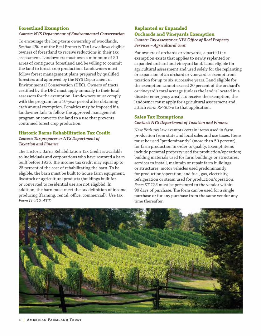
Forestland ExemptionContact: NYS Department of Environmental Conservation
To encourage the long-term ownership of woodlands, Section 480-a of the Real Property Tax Law allows eligible owners of forestland to receive reductions in their tax assessment. Landowners must own a minimum of 50 acres of contiguous forestland and be willing to commit the land to forest crop production. Landowners must follow forest management plans prepared by qualified foresters and approved by the NYS Department of Environmental Conservation (DEC). Owners of tracts certified by the DEC must apply annually to their local assessors for the exemption. Landowners must comply with the program for a 10-year period after obtaining each annual exemption. Penalties may be imposed if a landowner fails to follow the approved management program or converts the land to a use that prevents continued forest crop production.
Historic Barns Rehabilitation Tax CreditContact: Tax preparer or NYS Department of Taxation and Finance
The Historic Barns Rehabilitation Tax Credit is available to individuals and corporations who have restored a barn built before 1936. The income tax credit may equal up to 25 percent of the cost of rehabilitating the barn. To be eligible, the barn must be built to house farm equipment, livestock or agricultural products (buildings built for or converted to residential use are not eligible). In addition, the barn must meet the tax definition of income producing (farming, rental, office, commercial). Use tax Form IT-212-ATT.
Replanted or Expanded Orchards and Vineyards ExemptionContact: Tax assessor or NYS Office of Real Property Services – Agricultural Unit
For owners of orchards or vineyards, a partial tax exemption exists that applies to newly replanted or expanded orchard and vineyard land. Land eligible for agricultural assessment and used solely for the replanting or expansion of an orchard or vineyard is exempt from taxation for up to six successive years. Land eligible for the exemption cannot exceed 20 percent of the orchard’s or vineyard’s total acreage (unless the land is located in a disaster emergency area). To receive the exemption, the landowner must apply for agricultural assessment and attach Form RP-305-e to that application.
Sales Tax ExemptionsContact: NYS Department of Taxation and Finance
New York tax law exempts certain items used in farm production from state and local sales and use taxes. Items must be used “predominantly” (more than 50 percent) for farm production in order to qualify. Exempt items include personal property used for production/operation; building materials used for farm buildings or structures; services to install, maintain or repair farm buildings or structures; motor vehicles used predominantly for production/operation; and fuel, gas, electricity, refrigeration or steam used for production/operation. Form ST-125 must be presented to the vendor within 90 days of purchase. The form can be used for a single purchase or for any purchase from the same vendor any time thereafter.
I American Farmland Trust

Farmland Protection
Competition for land is a challenge for many New York farmers. As farmland is sought after for new housing and other development, land values price farmers out of the market. In addition,
poorly planned development brings new neighbors who are often unfamiliar with the sights, sounds and smells of nearby modern farms. Such situations can result in expensive conflicts that may hurt the future of farming in a community. The following programs have been established to help New York farmers and agricultural landowners protect their farm operation and productive farmland.
Agricultural NYS USDA NYS Federal New York Districts Farmland FRPP Conservation Conservation FarmLink Protection Easement Tax Easement Tax FarmNet Program Credit Incentive
Right to farm protections ✓Fund purchase of ✓ ✓development rights projects
Tax incentives for ✓ ✓conservation easements
Farm transfers & estate planning ✓
Agricultural DistrictsContact: NYS Department of Agriculture and Markets, county planning department or county Cooperative Extension office
New York’s Agricultural Districts Law was enacted in 1971 to help keep farmland in agricultural production. Interested landowners (who collectively own at least 500 acres or 10 percent of the land proposed for a district) submit a proposal to their county to create a district. A county legislative body must approve and forward the petition to the Commissioner of Agriculture for formal review and designation. As of December 2008, the state had 251 agricultural districts that represent about 8.5 million acres of land.
Farms in agricultural districts receive important “right-to-farm” protections, such as protection from nuisance lawsuits. For farmers, enrolling land in an agricultural district—and keeping the land enrolled when the district comes up for review—provides several other benefits:
F a r m l a n d P r o t e c t i o n P r o g r a m s
P r o g r a m P u r p o s e s
• The taxation of farmland within agricultural districts for certain municipal improvements (sewer, water, lighting, non-farm drainage, solid waste disposal and other landfill operations) is limited.
• When requested, the NYS Department of Agriculture and Markets can decide whether land uses are agricultural or if farm practices are “sound agricultural practices.” Such determinations can help defend farmers in zoning disputes or private nuisance lawsuits.
• The NYS Department of Agriculture and Markets has the authority to intervene when local governments enact laws that unreasonably regulate farm operations in agricultural districts.
• Additional measures—such as agricultural impact statements, notice of intent filings and real estate disclosure notices—are required for new developments and public projects in
agricultural districts.
New York A gricultural L andowner Guide I

New York State Farmland Protection ProgramContact: NYS Department of Agriculture and Markets or American Farmland Trust – New York office
Established in 1996, New York’s Farmland Protection Program provides grants to permanently protect land for agriculture in counties and towns with approved farmland protection plans. The grants are used to purchase the development rights on farmland.
The purchase of the development rights of a piece of farmland places a deed restriction, known as a conservation easement, on the property. Conservation easements are voluntary legal agreements that restrict the development and subdivision of land. When farmland owners sell or donate their development rights, they retain all other rights of ownership and continue to farm the land. The land stays private, and landowners are not required to allow public access. Protected land can be passed on to other family members or sold, but future landowners are required to follow the terms of the agreement.
Typically, the value of a conservation easement equals the property’s fair market value minus its restricted value (the value once it can no longer be developed). New York’s Farmland Protection Program pays a farmer up to 75 percent of the cost to complete the purchase of development rights transaction. The remaining 25 percent must come from a private source (such as a land trust), local government, federal agency or from a donation by the landowner (who may use the donation value as a tax deduction).
Each year, the NYS Department of Agriculture and Markets issues a request for proposals. Farms that submit applications are ranked and scored. Since its inception, the program has been very competitive. Priority is given to projects that preserve viable agricultural land in areas facing high development or conversion pressure. Priority also is given to land that buffers a significant public natural resource.
In addition, projects are evaluated by:
• Number of acres preserved
• Soil quality
• Percentage of total farm acreage available for agri-cultural production
• Proximity to other conserved farms
• Level of farm management demonstrated by cur-rent landowner
• Likelihood of the property’s continuation as a farm if ownership changes
Case Study: Greg’s U-Pick FarmIn October 2008, more than 40 people joined Greg and Sandy Spoth and their family to celebrate the protection of Greg’s U-Pick Farm. The most recent of seven properties to be protected as part of the Clarence Greenprint program, Greg’s U-Pick Farm is part of 456 acres of preserved farmland and natural lands in the town of Clarence, Erie County. For Greg and Sandy Spoth, permanently protecting their 102-acre farm means that their children, and their children’s children, will have the opportunity to continue growing and selling blueberries, strawberries, pumpkins and corn on the farm that they have worked for over 20 years. The farm was protected with help from the New York State Farmland Protection Program, United States Department of Agriculture, Town of Clarence and Western New York Land Conservancy.
I American Farmland Trust

USDA Farm and Ranch Lands Protection Program (FRPP)Contact: USDA Natural Resources Conservation Service or American Farmland Trust – New York office
The Farm and Ranch Lands Protection Program (FRPP) was created by the 1996 Farm Bill and offers matching funds to eligible entities of up to 50 percent of the funds needed to purchase development rights on farms. Matching funds have been secured from state, local or private sources to protect working farms across New York. The 2008 Farm Bill authorized greatly increased FRPP funding with an average of $150 million each year up to $200 million by 2012.
NYS Conservation Easement Tax CreditContact: NYS Department of Taxation and Finance, NYS Department of Environmental Conservation or Land Trust Alliance – Northeast office
The NYS Conservation Easement Tax Credit is available to taxpayers who own land protected by a permanent conservation easement. This refundable tax credit is for 25 percent of property taxes (school district, county, and town) paid on the conserved land, up to an annual maximum of $5,000. Both individual and corporate landowners are eligible to apply.
The conservation easement must comply with Article 49 of New York’s Environmental Conservation Law and the provisions of Internal Revenue Code (IRC) section 170(h).
To apply, individual landowners, estates and trusts, and partnerships file Form IT-242 with their income tax returns. Corporations file Form CT-242.
Federal Conservation Easement Tax Incentive Contact: Tax Preparer, Internal Revenue Service or Land Trust Alliance – Northeast office
The 2008 Farm Bill expanded federal income tax deductions for donations or partial donations of conservation easements (Form IRS 8283). These enhanced deductions were originally authorized by Congress in the Pension Protection Act of 2006 and were extended through the end of 2009. Efforts are underway to extend these incentives beyond 2009:
• All easement donors may deduct the appraised value of a conservation easement up to 50 percent of their AGI.
• Qualified farmers (individuals or corporations who earn more than 50 percent of their gross income from the business of farming in the taxable year in which the donation is made) can deduct the value of the easement donation up to 100 percent of their AGI.
• Easement donors can continue to carry over unused portions of deductions for as long as 15 years.
New York A gricultural L andowner Guide I

Partners in Farmland ConservationLand Trust Alliance, Northeast office, or American Farmland Trust, New York office
Many municipalities and landowners have partnered with nonprofit land trusts to successfully protect farmland throughout New York. Land trusts help ensure that agricultural conservation easements—the legal deed restrictions that limit future development—are followed in perpetuity. In addition to holding and monitoring easements, land trusts often play key roles in initiating farmland protection projects and writing applications to the state and federal farmland protection programs.
New York FarmLinkNew York FarmNetContact: New York FarmLink or New York FarmNet
NY FarmNet and Cornell University administer the NY FarmLink program, a farm transition network that connects farmers who are nearing retirement or planning to leave farming with new farmers who want their own businesses. The program also develops transition plans that allow retiring farmers and entering farmers to work together for a period of time before the actual farm transfer. In addition, NY FarmNet has consultants available, free of charge, to assist farmers with business planning and financial management. NY FarmLink maintains its database of new and retiring farmers at www.nyfarmlink.org.
The Challenge of Estate and Transition PlanningFor many farm families, passing the farm on to the next generation can be a major challenge. Transferring a farm involves more than just passing on the land. A will is an important part of an estate plan, but a will alone cannot guarantee a secure future for a farm family’s land and business. Estate planning is needed to address inheritance tax and settlement issues that may arise because land is not a liquid asset.
Estate planning can accommodate the needs of all family members, even those who leave the farm operation. A good estate plan will accomplish at least four goals:
• Transfer ownership and management of the agricultural operation, land and other assets,
I American Farmland Trust
• Avoid unnecessary income, gift and estate taxes,
• Ensure financial security and peace of mind for all generations, and
• Develop the next generation’s management capacity.
Frequent changes in the tax laws highlight the need for sound estate planning that is tailored to individual circumstances and addresses the uncertainty about future tax legislation. There are many sources of information about estate and transition planning, including attorneys, accountants and other financial advisors. NY FarmNet is a commonly used resource. American Farmland Trust has published Your Land is Your Legacy: A Guide to Planning for the Future of Your Farm; order by calling (800) 370-4879.

AEM & AMA CLLG CStP ECP EFARM EQIP CPGL GLCI ANSACP
Conservation planning ✓ ✓ ✓ ✓ ✓ ✓Water quality & nutrient management ✓ ✓ ✓ ✓ ✓ ✓ ✓Irrigation ✓ ✓ ✓ ✓ ✓ ✓Soil management & erosion control ✓ ✓ ✓ ✓ ✓ ✓Integrated pest & pesticide management ✓ ✓ ✓ ✓ ✓Pasture management ✓ ✓ ✓ ✓ ✓ ✓ ✓ ✓ Air quality management ✓ ✓ ✓Transition to organic farming ✓ ✓ ✓
E n v i r o n m e n t a l M a n a g e m e n t P r o g r a m s
P r o g r a m P u r p o s e s
Environmental Management
Farmers have played an important role in the stewardship of New York’s natural resources for generations. The following voluntary programs offer assistance to farmers in keeping land in
active agricultural or forestry production while protecting water, soil and air quality, and achieving other natural resource goals on farm and forest lands.
Agricultural Environmental Management (AEM)Agricultural Nonpoint Source Abatement and Control Program (ANSACP)Contact: Soil and Water Conservation District office
New York’s Agricultural Environmental Management (AEM) program is an incentive-based program that helps farmers make common-sense, cost-effective and science-based decisions to achieve business objectives while protecting and conserving the state’s natural resources. Farmers work with local AEM resource professionals to develop comprehensive farm plans using a tiered process.
Tier 1 – Inventory current activities, future plans and potential environmental concerns
Tier 2 – Document current land stewardship; assess and prioritize areas of concern
Tier 3 – Develop conservation plans addressing concerns and opportunities tailored to farm goals
Tier 4 – Implement plans utilizing available financial, educational and technical assistance
Tier 5 – Evaluate to ensure the protection of the environment and farm viability
New York A gricultural L andowner Guide I
The AEM program is implemented through the cooperation of several agencies, including Cornell Cooperative Extension, Soil and Water Conservation Districts and the USDA Natural Resources Conservation Service. The AEM process is often facilitated with funding from New York’s Agricultural Nonpoint Source Abatement and Control Program (ANSACP) and the federal Environmental Quality Incentive Program (EQIP). The ANSACP may provide up to 87.5 percent of the funding needed for farmers to plan and implement best management practices.
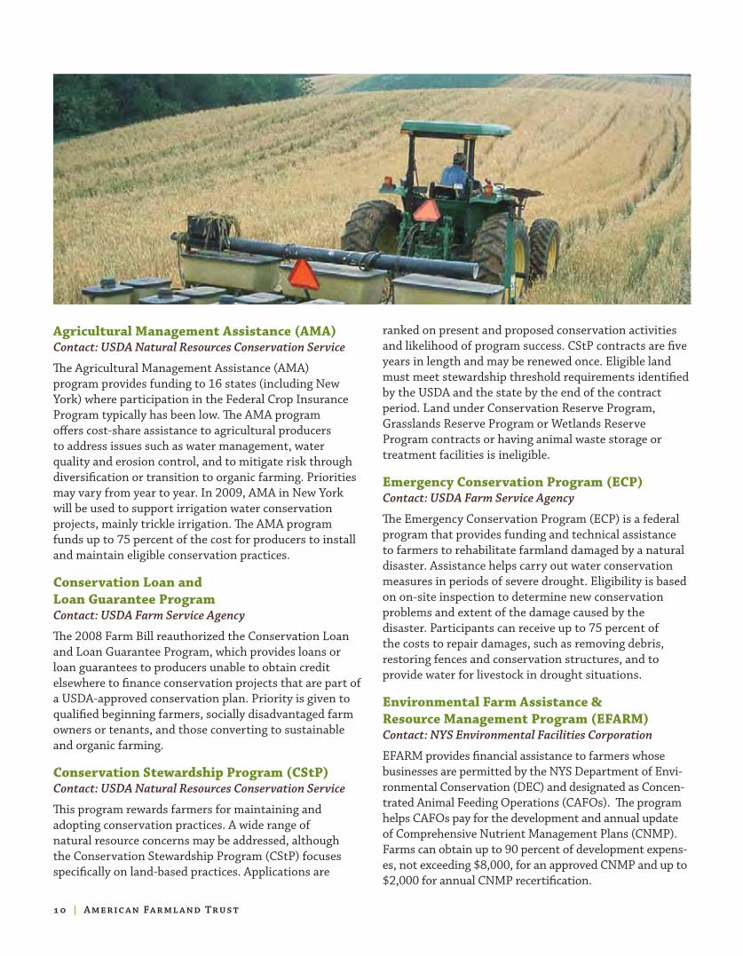
Agricultural Management Assistance (AMA)Contact: USDA Natural Resources Conservation Service
The Agricultural Management Assistance (AMA) program provides funding to 16 states (including New York) where participation in the Federal Crop Insurance Program typically has been low. The AMA program offers cost-share assistance to agricultural producers to address issues such as water management, water quality and erosion control, and to mitigate risk through diversification or transition to organic farming. Priorities may vary from year to year. In 2009, AMA in New York will be used to support irrigation water conservation projects, mainly trickle irrigation. The AMA program funds up to 75 percent of the cost for producers to install and maintain eligible conservation practices.
Conservation Loan and Loan Guarantee ProgramContact: USDA Farm Service Agency
The 2008 Farm Bill reauthorized the Conservation Loan and Loan Guarantee Program, which provides loans or loan guarantees to producers unable to obtain credit elsewhere to finance conservation projects that are part of a USDA-approved conservation plan. Priority is given to qualified beginning farmers, socially disadvantaged farm owners or tenants, and those converting to sustainable and organic farming.
Conservation Stewardship Program (CStP)Contact: USDA Natural Resources Conservation Service
This program rewards farmers for maintaining and adopting conservation practices. A wide range of natural resource concerns may be addressed, although the Conservation Stewardship Program (CStP) focuses specifically on land-based practices. Applications are
ranked on present and proposed conservation activities and likelihood of program success. CStP contracts are five years in length and may be renewed once. Eligible land must meet stewardship threshold requirements identified by the USDA and the state by the end of the contract period. Land under Conservation Reserve Program, Grasslands Reserve Program or Wetlands Reserve Program contracts or having animal waste storage or treatment facilities is ineligible.
Emergency Conservation Program (ECP)Contact: USDA Farm Service Agency
The Emergency Conservation Program (ECP) is a federal program that provides funding and technical assistance to farmers to rehabilitate farmland damaged by a natural disaster. Assistance helps carry out water conservation measures in periods of severe drought. Eligibility is based on on-site inspection to determine new conservation problems and extent of the damage caused by the disaster. Participants can receive up to 75 percent of the costs to repair damages, such as removing debris, restoring fences and conservation structures, and to provide water for livestock in drought situations.
Environmental Farm Assistance & Resource Management Program (EFARM)Contact: NYS Environmental Facilities Corporation
EFARM provides financial assistance to farmers whose businesses are permitted by the NYS Department of Envi-ronmental Conservation (DEC) and designated as Concen-trated Animal Feeding Operations (CAFOs). The program helps CAFOs pay for the development and annual update of Comprehensive Nutrient Management Plans (CNMP). Farms can obtain up to 90 percent of development expens-es, not exceeding $8,000, for an approved CNMP and up to $2,000 for annual CNMP recertification.
I American Farmland Trust

Environmental Quality Incentive Program (EQIP)Contact: USDA Natural Resources Conservation Service
The federal Environmental Quality Incentive Program (EQIP) provides technical assistance, cost-share payments and incentive payments to assist with environmental and conservation improvements on land used for agricultural production. The EQIP pays up to 75 percent of the cost to implement structural and management practices on eligible agricultural land. Up to 90 percent cost-share assistance is available to limited resource, socially disadvantaged or beginning farmers and ranchers. Cost-share payments may be made to help farmers install erosion control measures, agricultural waste management facilities, or renewable energy resources. EQIP funding may also establish conservation practices such as nutrient management, forest management, integrated pest management, manure management and wildlife habitat management. The 2008 Farm Bill increased the funding
available for EQIP cost-share and incentive payments and extended eligibility to conservation practices directly related to organic production and transition.
GrazingContact: USDA Natural Resources Conservation Service or Soil and Water Conservation District
The federal Conservation of Private Grazing Land (CPGL) program provides technical and educational assistance for conservation and enhancement of private grazing lands, including sustainable grazing practices such as rotational grazing.
The Grazing Lands Conservation Initiative (GLCI), a nationwide collaboration, provides technical assistance to owners and managers of private grazing land to enhance its long-term productivity and ecological health. The USDA Natural Resources Conservation Service (NRCS) funds technical assistance and assists with public awareness activities about the benefits of private grazing land.
Organic FarmingContact: USDA Natural Resources Conservation Service or NYS Department of Agriculture and Markets
The 2008 Farm Bill establishes new opportunities for organic agricultural operations. The EQIP Organic Initiative allows eligible producers to apply for $20,000 annually, up to $80,000 over a maximum of six years. Certified organic producers or those transitioning to organic production must carry out conservation practices consistent with an Organic System Plan.
The Agricultural Management Assistance Program (AMA) allocates funds for cost-share assistance to producers, handlers and processors who are applying for National Organic Certification for eligible agricultural products. Producers may be reimbursed for up to 75 percent of their organic certification costs, not to exceed $750.
New York A gricultural L andowner Guide I

CRP and FWP CREP DFN GRP LIP WRP and WREP WHIP
Stream corridor management ✓ ✓ ✓& protection
Pasture management ✓& protection
Wildlife habitat management ✓ ✓ ✓ ✓ ✓& protection
Wetland creation, management ✓ ✓& protection
N a t u r a l R e s o u r c e C o n s e r va t i o n P r o g r a m s
P r o g r a m P u r p o s e s
Natural Resource Conservation
Agricultural landowners play an important role in the stewardship of New York’s natural resources. The following voluntary programs compensate farmers for reducing or eliminating farm practices on portions of their property, with the aim of establishing riparian buffers or protecting wetlands and other natural settings.
Conservation Reserve Program (CRP)Farmable Wetlands Program (FWP)Contact: USDA Farm Service Agency
The Conservation Reserve Program (CRP) encourages farmers to convert highly erodible cropland and other environmentally sensitive land to vegetative cover, such as tame or native grasses, wildlife plantings, trees, filter strips or riparian buffers. Participating farmers receive annual rental payments for the term of their multi-year contracts (between 10 to 15 years). Cost-share funding of up to 50 percent is provided for the establishment of vegetative cover practices. Landowners also may receive funding to fence streams that exclude livestock, build grass waterways or develop shallow water areas for livestock.
Administered through the CRP, the Farmable Wetlands Program (FWP) seeks to improve the hydrology and vegetation on farmable wetlands. FWP contracts are from 10 to 15 years long. Participating producers receive incentive payments, annual rental payments and
cost-share assistance for implementing necessary conservation practices.
Conservation Reserve Enhancement Program (CREP)Contact: USDA Farm Service Agency or Soil and Water Conservation District office
The NYS Conservation Reserve Enhancement Program (NYS CREP) aims to protect water quality in streams by helping agricultural landowners to trap sediment, pesticides and fertilizers in runoff by planting trees, shrubs, and grasses on stream banks. Contracts require a 10- to 15-year commitment, during which the vegetative buffers must be maintained by the contracted individual. Landowners are compensated through annual rental payments. Cost-share funding up to 50 percent with an additional 40 percent in incentive payments is available for planting materials, fencing, watering facilities and stream crossings. Enrollment is limited to specific geographic areas and practices.
I American Farmland Trust

Debt for Nature (DFN)Contact: USDA Farm Service Agency
The Debt for Nature (DFN) Program is available to landowners with USDA Farm Service Agency loans that were secured by real estate. The program reduces a borrower’s debt in exchange for a conservation contract with a term of 10, 30 or 50 years. The conservation contract is a voluntary legal agreement that restricts development on marginal cropland or other environmentally sensitive land for conservation, recreation or wildlife purposes.
Grassland Reserve Program (GRP)Contact: USDA Farm Service Agency or USDA Natural Resources Conservation Service
The Grassland Reserve Program (GRP) helps landowners restore and protect grassland, including pastureland, while maintaining the areas as grazing lands. Participants limit future development and cropping uses of the land through either a term contract or permanent conservation easement while retaining the right to conduct common grazing practices, produce hay, mow or harvest for seed production. Cost-share assistance for up to 50 percent of approved restoration practices may also be available. GRP contracts and easements prohibit the production of crops (other than hay), fruit trees, and vineyards that require breaking the soil surface and any other activity that would permanently disturb the surface of the land, except for appropriate land management activities included in a grassland conservation plan.
Landowner Incentive Program (LIP)Contact: NYS Department of Environmental Conservation
The Landowner Incentive Program (LIP) is a federal program that provides grants to state agencies to work with private landowners on conservation and habitat protection projects. To be eligible, state fish and wildlife agencies, landowners or non-profit groups must
contribute at least 25 percent of the cost of projects, which are designed to protect endangered species and other at-risk plants and animals.
The NYS Department of Environmental Conservation (DEC) has prioritized two areas of concentration for the LIP in New York: the conservation and management of grasslands to protect endangered bird species that nest in open grassland habitats and the protection of at-risk bat species.
Wetlands Reserve Program (WRP)Wetlands Reserve Enhancement Program (WREP)Contact: USDA Natural Resources Conservation Service
The federal Wetlands Reserve Program (WRP) restores and protects wetlands on private property. Participating landowners are paid for permanent or temporary conservation easements that establish wetland protection and restoration as the primary land use for the duration of the agreement. For land to be eligible for the WRP it must have remained under the same ownership during the preceding seven years. Landowners can receive as much as 100 percent of the appraised agricultural market value of the property for permanent conservation easements or 75 percent for 30-year easements. A third option, 10-year restoration agreements, provides 75 percent of the restoration costs without the requirement of a conservation easement. In all program options, landowners continue to control access to their land.
The 2008 Farm Bill authorized the Wetlands Reserve Enhancement Program (WREP) allowing landowners to reserve grazing rights within a warranty easement deed where compatible and consistent with a conservation plan and program purpose.
Wildlife Habitat Incentives Program (WHIP)Contact: USDA Natural Resources Conservation Service
The Wildlife Habitat Incentives Program (WHIP) offers financial incentives to agricultural landowners who maintain habitat for fish and wildlife. Participating landowners work with the USDA Natural Resources Conservation Service (NRCS) to create wildlife habitat development plans that list the goals and practices needed to improve wildlife habitat. The NRCS provides up to 75 percent in cost-share assistance to implement the plans and limits payments to $50,000 a year. WHIP agreements generally last from five to 10 years. In New York, the priority of the WHIP primarily has been habitat for grassland birds.
New York A gricultural L andowner Guide I

Beginning Farmland, Farm Accessing Marketing Research Value- Farmers buildings operating new and and added and equipment loans markets promotion development products loans
BFRIDA ✓ ✓DFOWL ✓ ✓BFLP ✓ ✓Emergency Farm Loans ✓ ✓Farm Operating Loans ✓Farm Ownership Loans ✓Farm to School ✓ GAP & GHP ✓ ARDG ✓ ✓Farmland Viability Grants ✓ ✓ ✓ ✓PONY ✓NYFVI ✓ ✓ ✓ ✓FLHLG ✓ VAPG ✓Small Business Micro Loans ✓ ✓ ✓ ✓Northeast SARE ✓ ✓ ✓ ✓
Farm Viability
Farms need to be economically viable to sustain families and communities over the long term. There are a growing number of programs to assist farmers in adding value to agricultural
products, diversifying income streams, developing new farm products, marketing products to local consumers and researching alternative production strategies. Farm viability programs available to farmers or people that would like to begin farming include:
Beginning Farmers and RanchersContact: USDA Farm Service Agency
The USDA Farm Service Agency (FSA) provides direct and guaranteed loans to beginning farmers and ranchers who are unable to obtain financing from commercial credit sources. The FSA administers two programs aimed at helping foster new farming opportunities.
I American Farmland Trust
Farm Vi abilit y Progr ams
P r o g r a m P u r p o s e s

New York A gricultural L andowner Guide I
• The Beginning Farmer and Rancher Individual Development Account Pilot Program (BFRIDA) provides business and financial education and matched savings accounts that can be used as part of a downpayment on farmland or to purchase breeding stock, farm equipment or other productive farm assets.
• The Downpayment Farm Ownership Loan Program (DFOWL) provides a means for retiring farmers to transfer their land to beginning farmers and assists beginning farmers with downpayments for purchasing farmland.
New York Beginning Farmer Loan Program (BFLP) Contact: NYS Environmental Facilities Corporation
The New York Beginning Farmer Loan Program (BFLP) pro-vides low-cost financial assistance to beginning farmers in New York for the purchase of agricultural property and equipment to help start a farming business or to facilitate inter-generational transfer of a farm business. To partici-pate, a beginning farmer works with a lender to arrange the terms of a loan. The BFLP does not directly provide funds to finance the loan but instead acts as a conduit by issuing and selling a tax-exempt bond (“aggie bond”) to the lender. The tax-exempt status enables the lender to give a better interest rate to the borrower, usually around one to two per-centage points less than the usual taxable interest loan.
Emergency Farm LoansContact: USDA Farm Service Agency
The Farm Service Agency (FSA) provides Emergency Farm Loans to help producers recover from production and other farm operation losses due to drought, flooding, other natural disasters, or quarantine. Farm operations must be located in a county declared as a disaster or quarantine area. Producers can borrow up to 100 percent of actual production or physical losses, to a maximum of $500,000.
Farm Enterprise Loans and CreditContact: USDA Farm Service Agency
The Farm Service Agency (FSA) offers two types of loans to family farmers and ranchers who cannot obtain commercial credit:
• Direct/Guaranteed Farm Operating Loans enable purchase, operation and finance options for existing farms.
• Direct/Guaranteed Farm Ownership Loans assist eligible small-farm operators to purchase farmland, construct or repair buildings, and promote soil and water conservation.
Farm to SchoolContact: http://farmtoschool.cce.cornell.edu/
The Cornell Farm to School Program was established in 2002 with funding from the USDA Initiative for Future Agriculture and Food Systems. The program, supported by Cornell Cooperative Extension, facilitates connections between New York farms and food service managers in educational facilities across the state.
Good Agricultural Practices (GAP) and Good Handling Practices (GHP) Certification ProgramContact: NYS Department of Agriculture and Markets – Division of Food Safety and Inspection
Many retailers, wholesale buyers, restaurants and schools now require produce suppliers to provide third-party certification of adherence to Good Agricultural Practices (GAP) and Good Handling Practices (GHP). To assist farmers in certifying that their operations meet the voluntary GAP and GHP standards, the NYS Department of Agriculture and Markets will reimburse growers and handlers the cost, up to $750, of required audits and water testing. Funding is on a first-come, first-served basis and is provided by the USDA Specialty Crop Block Grant Program.

GROW New YorkContact: NYS Department of Agriculture and Markets
GROW New York programs seek to promote agricultural development, expand employment and generate increased economic activity across the state. Opportunities specifically for agricultural producers include:
Agricultural Research and Development Grants (ARDG)Administered by the NYS Department of Agriculture and Markets, these grants fund projects involving new prod-uct development, alternative production, processing, dis-tribution and marketing technologies; the introduction of new technologies; and organizational approaches to further develop New York’s agricultural industry.
Farmland Viability Grants Designed to help maintain farmland as a working landscape, this program funds the development of farm viability plans and the implementation of projects that contribute to farm profitability. Grant funds may be used by an individual farm to develop or implement a business management plan.
Pride of New York (PONY)This promotional program assists producers by building awareness, preference and sales for Pride of New York (PONY) products. The program provides assistance through marketing materials and cooperative funding for television and radio advertising as well as print, point of purchase and promotional items.
New York Farm Viability Institute Grants (NYFVI)Contact: New York Farm Viability Institute
A farmer-led nonprofit organization, the New York Farm Viability Institute (NYFVI) provides grant funding for
applied research and education projects that help farms increase profits and provide models for other farms. The Institute offers several grant programs with opportunities for farm-based projects.
Rural Development Grants and LoansContact: USDA Rural Development
The USDA also administers grants and loans through the Rural Development agency. The Rural Housing Service, Multi-Family Housing Processing Division, offers Farm Labor Housing Loans and Grants (FLHLG) to finance construction, repair or purchase of housing and related facilities for domestic farm laborers. Value-Added Producer Grants (VAPG) provide matching funds to agricultural producers for marketing value-added products and for farm-based renewable energy. Grants may be used for planning activities ($100,000 maximum) or for working capital expenses (maximum $300,000), but not both.
Small Business MicroLoansContact: Small Business Administration
The Small Business Administration (SBA) provides a number of financial assistance programs for small businesses. While the SBA does not make direct loans, it works with thousands of lenders and other intermediaries to facilitate the loan process. SBA’s MicroLoan Program provides short-term loans up to $25,000 for small-scale agricultural operations and other small businesses.
Northeast Sustainable AgricultureResearch and Education (SARE)Contact: USDA Northeast SARE
The USDA Northeast Region Sustainable Agriculture Research and Education (SARE) program offers grants to eligible farmers, researchers, educators and others who are working on innovative approaches to sustainable agriculture. Proposed projects should advance good stewardship, improve farm profitability and strengthen rural communities.
Farmer Grants encourage commercial producers to conduct and manage farm-based demonstration projects related to production or marketing techniques. A technical advisor, often an extension agent, crop consultant or other service professional, is required as a project consultant.
Partnership Grants provide the opportunity for farmers to participate in on-farm demonstrations, research, marketing and other projects that NE SARE has funded as partners of agricultural service providers who have designed projects.
I American Farmland Trust

Environmental Markets and Energy
A n increasing number of farmers and agricultural landowners are interested in opportunities to generate renewable energy as a means of reducing business costs, diversifying their income sources and enhancing the environmental sustainability of their businesses. Other farmers are interested in reducing energy consumption or participating in emerging environmental markets, such as carbon trading. The following
section describes financial incentives and programs available to help farmers tap into new environmental market and energy opportunities.
Bioenergy Income for Renewable Income for Energy crop providing energy facility renewable efficiency production environmental development energy improvements benefits generation
BCAP ✓ ✓Environmental Services Markets ✓REAP ✓Anaerobic Digester Program ✓Energy Smart Loan Fund ✓ ✓Existing Facilities Program ✓New Construction Program ✓On-site Wind System Incentive Program ✓Solar-Electric System Incentive Program ✓REPI ✓
Solar, Wind and Farm Waste ✓Facility Tax Exemptions
Federal Energy & Energy Efficiency Incentives ✓ ✓VAPG* ✓*See Farm Viability Section, page 16
P r o g r a m P u r p o s e s
E n v i r o n m e n t a l M a r k e t s a n d E n e r g y P r o g r a m s
New York A gricultural L andowner Guide I

Biomass Crop Assistance Program (BCAP)Contact: USDA Farm Service Agency
The 2008 Farm Bill authorized this new program to promote the cultivation of bioenergy crops in specified project areas. One farmer or a group of farmers may propose a Biomass Crop Assistance Program (BCAP) project area by providing evidence of eligible land, crops and a commitment from a biomass conversion facility. There is no minimum acreage requirement. Landowners enter into five-year contracts for annual and perennial crops, and 15-year contracts for woody biomass. Participating agricultural and forest landowners receive cost-share payments of up to 75 percent to establish an eligible crop, annual payments to support production, and funding to assist with the collection, harvest, storage and transportation of materials for use in a biomass conversion facility.
Environmental Services MarketsContact: Chicago Climate Exchange or NYS Department of Environmental Conservation
Environmental services markets place an economic value on environmental benefits such as clean water, sequestering carbon to control climate change and protecting biodiversity. Through these markets, landowners can sell “credits” accumulated by adopting practices or technologies that generate desired environmental outcomes, such as no-till farming, more efficient use of nitrogen fertilizer and anaerobic digesters to offset greenhouse gas emissions.
Farms producing credits are known as “offset providers.” “Offset aggregators” buy credits from offset providers to sell to an environmental services market, such as the Chicago Climate Exchange (CCX). Certain aggregators will combine credits from a number of small farms to trade on the energy market. A list of approved aggregators who sell to the CCX can be found on its Web site.
New York is one of 10 states implementing the Regional Greenhouse Gas Initiative (RGGI), the first mandatory cap and trade program in the United States to reduce greenhouse gas emissions. The CO2 Budget Trading Program may provide opportunities for New York farmers to sell carbon credits to the New York Climate Exchange (NYCX) and the Northeast Climate Exchange (NECX).
Case Study: Patterson Dairy Farm, Auburn, N.Y. A Carbon Trading Success Story
In 2005, farm owner Connie Patterson began using an anaerobic digester to convert dairy manure and food waste to electricity. The digester also provides an important environmental service by capturing methane, a contributor to global warming. Patterson works with the Environmental Credit Corporation to sell credits for this captured methane on the Chicago Climate Exchange. Patterson received $1.2 million in grants from the NYS Energy Research and Development Authority, USDA Rural Development and the Agriculture Environmental Management program to install the $1.5 million digester.
The electricity generated by the methane digester enabled Patterson to save $80,000 in 2008 alone. Patterson Farms also noticed significantly less odor from manure storage and displacement of bedding costs by using digested manure solids.
Source: Curt Gooch, Scott Inglis, Jennifer Pronto, “Anaerobic Digestion at Patterson Farms, Inc.: Case Study,” Cornell University, Manure Management Program (www.manuremanagement.cornell.edu)
Financial Incentives for EnergyContact: USDA Rural Development or NYS Energy Research and Development Authority
Grants, loans and rebates from a variety of sources and local, state and federal tax incentives are available for on-farm renewable energy production. Landowners are encouraged to apply for federal and state incentives to pro-vide additional funding for the design, purchase and instal-lation of energy efficient and renewable energy systems.
Rural Energy for America Program (REAP)Formerly known as the USDA’s Renewable Energy and Energy Efficiency Program, the Rural Energy for America Program (REAP) provides grants of up to 25 percent of the cost of renewable energy systems and energy efficiency improvements for agricultural producers. The REAP also authorizes guarantees for loans as large as $25 million.
New York State Energy Research and Development Authority (NYSERDA) ProgramsThe NYS Energy Research and Development Authority (NYSERDA) offers financial and technical assistance to businesses, industries, municipalities and residents
I American Farmland Trust

who pay the New York System Benefits Charge (SBC). Energy audits that identify cost-effective energy efficiency improvements to lower energy bills, increase productivity and reduce environmental impacts are provided at little or no cost to the farmer. Cost-share energy feasibility studies provide a detailed analysis to determine potential energy reductions and improved efficiencies on more complex systems. Incentives and loan rate reductions are available for eligible energy-efficient equipment and renewable energy projects.
Additional incentive programs available through NYSERDA to agricultural landowners include:
• Anaerobic Digester Gas-to-Electricity Program: Financial incentives support the purchase, installation and operation of anaerobic digester gas-to-electricity systems.
• Energy $mart LoanSM Fund Program: NYSERDA will buy down the interest rate of a loan for eligible energy-efficiency improvements or renewable technologies. The reduced interest rate is available for up to 10 years.
• Existing Facilities Program: Cost-share incentives are available for eligible energy efficient improvements to farm operations.
• New Construction Program (NCP): Technical assistance and financial incentives based on improved building energy efficiency are provided to design teams and building owners.
• On-site (Small) Wind System Incentive Program: Cash incentives are available for the installation of new wind generation systems by eligible installers.
• Solar-Electric (PV) System Incentive Program: Cash incentives are available for the installation of new solar electric or photovoltaic (PV) systems by eligible installers.
Renewable Energy Production IncentivesContact: NYS Energy Research and Development Authority
Agricultural landowners can receive financial incentives—in the form of a tax credit or deduction or a direct cash payment—for renewable energy generation on their property. Production incentives are based on the amount of electricity produced ($/kWh generated) or, for renewable fuels, on the number of gallons produced ($/gallon).
Tax Incentives for EnergyContact: NYS Office of Real Property Service, NYS Department of Taxation and Finance or Internal Revenue Service
New York offers personal and corporate tax incentives to encourage the investment in energy efficient products and renewable energy. Section 487 of Real Property Tax Law provides a 15-year real property tax exemption for solar, wind and farm-waste energy systems. This is a local option exemption, meaning that local governments are permitted to decide whether or not to allow it. The exemption applies only to general municipal and school district taxes; it cannot be applied to special assessments or special ad valorem levies.
The retail sale and installation of residential solar energy equipment are exempt from the state sales and use tax. The state law also permits local governments to grant an exemption from local sales tax. Publication 718-Sof the NYS Department of Taxation and Finance is available online and details local solar sales tax rates and exemptions.
The federal Energy Policy Act of 2005 established a wide variety of tax credits for businesses and homeowners who buy fuel-efficient vehicles, install energy-efficient appliances and products, produce their own biodiesel or ethanol, or install renewable energy systems. The American Recovery and Reinvestment Act of 2009 extended many of these tax incentives.
Web ResourcesFederal, state and nonprofit Web sites that offer additional information about environmental markets and energy include:
U.S. Department of Energy – www.eere.energy.gov
NYSERDA’s Power Naturally – www.powernaturally.org
Database of State Incentives for Renewable Energy (DSIRE) – www.dsireusa.org
Tax Incentives Assistance Project (TIAP) – www.energytaxincentives.org
New York A gricultural L andowner Guide I

ResourcesAmerican Farmland Trustwww.farmland.org/newyork
New York State Office (518) 581-0078
Western New York Office (716) 652-0100
Farmland Information Center (800) 370-4879 www.farmlandinfo.org
Chicago Climate Exchange(312) 554-3350chicagoclimatex.com
Cornell Cooperative Extension(607) 255-2237www.cce.cornell.eduA directory of local offices is available online; local offices are also listed in the phone book under “[County name] County Cooperative Extension.”
Farm to School(607) 255-2730http://farmtoschool.cce.cornell.edu/
Grazing Lands Conservation Initiative(607) 334-4632, ext. 116 (NY coordinator)www.glci.org
Internal Revenue Service(800) 829-4933www.irs.gov
Land Trust Alliance, Northeast Office(518) 587-0774www.lta.org
New York Farm Bureau(518) 436-8495www.nyfb.org
NY FarmLinkNY FarmNet(800) 547-FARMwww.nyfarmlink.orgwww.nyfarmnet.org
New York Farm Viability Institute(315) 453-3823www.farmviability.org
NYS Department of Agriculture and Markets(518) 457-3880(800) 554-4501www.agmkt.state.ny.us
NYS Department of Environmental Conservation
Division of Lands and ForestsBureau of Private Land Services(518) 402-9425www.dec.state.ny.usA directory of regional offices is available online; regional offices are listed in the phone book under “New York State Environmental Conservation.”
Regional Greenhouse Gas Initiative(518) 402-8448
NYS Department of Taxation and FinanceTaxpayer Assistance Bureau(800) 225-5829www.tax.state.ny.us
NYS Energy Research and Development Authority
(866) NYSERDA(518) 862-1090www.nyserda.org
NYS Environmental Facilities Corporation(800) 200-2200 www.nysefc.org
NYS Office of Real Property Services, Agricultural Unit
(518) 486-5446/(518) 474-2982www.orps.state.ny.us
NYS Soil and Water Conservation CommitteeNYS Soil and Water Conservation Districts(518) 457-3738www.nys-soilandwater.orgA directory of county offices is available online; County offices are also listed in the phone book under “[County name] Soil and Water Conservation District.”
Northeast Sustainable Agriculture Research and Education Program (SARE)
www.nesare.org(802) 656-0471
Small Business Administration(800) 827-5722www.sba.govA directory of NY district offices is available online.
NYS Farm Service AgencyNew York State Farm Service Agency(315) 477-6300www.fsa.usda.gov/nyA directory of USDA Service Centers is available online; local offices are listed in the phone book under “United States Agriculture Department Farm Service Agency.”
USDA Natural Resources Conservation Service
(315) 477-6504www.ny.nrcs.usda.gov (New York NRCS)A directory of USDA Service Centers is available online; local offices are listed in the phone book under “United States Agriculture Department Natural Resources Conservation Service.”
USDA Rural DevelopmentUSDA Rural Business Cooperative Service(315) 477-6400www.rurdev.usda.gov/ny
I American Farmland Trust

All of the options listed in this guide are valuable tools to help landowners protect their land. But these options exist within the context of federal, state and local policies. If landowners feel those policies need improvement, they can have a voice in those changes.
What you can do• Take the next step — learn more about the opportunities described in this landowner
guide. Contact American Farmland Trust and other resources that can help you and your community protect farmland and strengthen the future for agriculture.
• Help your community take control of its future — talk to your elected leaders about the benefits working lands provide.
• Speak up in support of public programs and incentives that keep farmland in production, promote environmental stewardship and strengthen farm viability.
• Be a steward of the land; encourage sustainable management practices that keep the land healthy.
• Prepare now for the future of your land, your business and your family. Consult with your legal, financial and tax advisors to develop your estate plan.
No FarmsNo FoodNo…
77% of America’s fruits, vegetables and dairy products are grown near metro regions, on farmland that is in the path of development.
In New York, a farm is lost to development every three days.
Losing this land threatens our ability to grow local food, protect our drinking water and keep local economies strong.
America’s farms produce so much more than food.
Join American Farmland Trust in supporting New York’s farms.Visit www.farmland.org/newyork or contact (518) 581-0078; [email protected]

American Farmland Trust greatly appreciates the generous financial support of the following individuals and organizations that made possible the production of this publication:
Sarah K. deCoizart ArticleTENTH Perpetual Charitable Trust
Matthew Bender, IV
Blueberry Ridge Stewardship Services, LLC
Dairylea Cooperative Inc.
Dairy Farmers of America’s Northeast Area Council
Dairy Marketing Services
Western New York Foundation
Hancock & Estabrook, LLP
National Grape Cooperative
Shulman, Howard and McPherson, LLP
and the members of American Farmland Trust

Site developed by FreeLance. Copyright 2009-2010 ©
Farmland Agricultural landscapes are an important component in
the ‘sense of place’ of the Town of Cazenovia.
However, the agricultural economy and increasing
demand for residential land has led to pressure for
farms to close or sell off lots. In 2007, CPF actively
became involved in farmland protection through its work
on the purchase of development rights (PDR) of the
Critz Farm (241 acres) by the State. Through this state
program, CPF holds an agricultural easement on the
farm and farmstead in perpetuity. CPF has also
protected Greyrock Farm (272 acres) through this
program and is working to protect another 422 acres on
the Reed Farm in New Woodstock.
In addition, CPF holds protective easements on 6 other parcels of active farmland that total 796 acres. Some of the
easements also protect scenic and open space values.
Petreikis Farm
Home Conserve/Preserve News Trails Walks 'N Talks Gifts & Support About search...
Page 1 of 1Cazenovia Preservation Foundation - Farmland
6/1/2012http://cazpreservation.org/index.php?option=com_content&view=article&id=64&Itemid=87

Site developed by FreeLance. Copyright 2009-2010 ©
History A History of Community StewardshipThe mission of the Cazenovia Preservation Foundation is to “protect historic, agricultural and natural resources in and around Cazenovia for the benefit of
the community.” A review of the 43 years of CPF history reveals a rich and interesting history of an organization that has evolved in its fulfillment of this
mission as our community has changed.
On January 5, 1967, Cazenovia Preservation Foundation, Inc. was incorporated as a not-for-profit for the express purpose of preserving historic buildings
in the Village. For the next 18 years, the organization’s board and volunteers provided education, historic registration, and financial support to enhance
the architectural history of the village. CPF published books and pamphlets on the history of Cazenovia and it s architecture; took a lead role in working
with the Trust for Historic Preservation to catalog, register and protect the architecture of the community; and provided funds for the restoration of highly
visible buildings such as the Gothic Cottage, Cazenovia College Theater and the New Woodstock Historical Society. In addition, CPF established a
revolving low-interest loan fund to assist homeowners in the restoration of their historic residences.
In 1985, CPF members expanded their view of preservation to include the countryside and farms surrounding our historic Village with its purchase of 25
acres known as Fairchild Hill at the south end of Cazenovia Lake and the 2.5 mile former railroad corridor known as the Gorge Trail. With these
purchases, CPF’s land conservation efforts were born.
In this next phase of community stewardship, CPF employed a selection of land conservation methods while continuing its Village preservation through
the placement of façade easements and architectural consultations and review on historic Village buildings such as the Lincklaen House, Methodist
Church and Cazenovia Public Library. CPF was ‘gifted’ or acquired open space and trail acreage throughout the Town in a vision of a ‘greenbelt’ and trail
system. During this time, Carpenter’s Pond and the Willow Patch also became CP-protected properties. Additions were also made to the public trail
system with the purchase of a portion of the abandoned railroad bed between Cazenovia and New Woodstock.
Conservation easements also became a tool to preserve the scenic open space and agricultural character of the community. In some cases, like New
Woodstock’s Rose Farm and the Meadows Farm on Route 13 at the south edge of the Village, protective easements and conservation planning were
combined to protect a large sensitive area as it changed ownership. Other easement properties, such as Stone Quarry Hill Art Park, protected existing
community recreation resources. Easement and CPR-owned lands added acreage adjacent to already protected lands in the viewshed of Cazenovia
Lake and along well-traveled roads.
CPF’s involvement in Village and Town issues that affect community architectural and land stewardship is not new. Active involvement in planning
projects began with the 1981 Cazenovia community Resources Project and continues with co-sponsorship of the Cazenovia Area Planning Project in
1999. The CPF board provides comments or is represented on advisory or working committees on many local issues, including historic preservation,
conservation, community develo9p and sensitive land use.
A new, exciting phase of agricultural protection was ushered into Cazenovia in 2007 when Critz Farm was the first successful applicant in Madison County
for New York State’s Purchase of Development Rights (PDR) program. CPF now holds the easement on this farm and is actively involved in preparing the
files for completion of the PDR process on two other area farms.
CPF is currently working to increase its professionalism as a local, community land trust. It has recently been involved in organizational assessment and
strategic planning as well as a rigorous update of its easement and stewardship programs. Guided by its mission of protection, the Cazenovia
Preservation Foundation anticipates continuing and expanding its programs for the benefit of the Cazenovia community.
Home Conserve/Preserve News Trails Walks 'N Talks Gifts & Support About search...
Page 1 of 1Cazenovia Preservation Foundation - History
6/1/2012http://cazpreservation.org/index.php?option=com_content&view=article&id=53&Itemid=76

Site developed by FreeLance. Copyright 2009-2010 ©
CazPreservation.org
PO Box 627
Cazenovia
NY
13035
Enter your Name:
E-mail address:
Message Subject:
Enter your Message:
E-mail a copy of this message to your own address.
��
��
�����
Send
Home Conserve/Preserve News Trails Walks 'N Talks Gifts & Support About search...
Page 1 of 1Cazenovia Preservation Foundation - CazPreservation.org
6/1/2012http://cazpreservation.org/index.php?option=com_contact&view=contact&id=1&Itemid=85

12-09
Conserving Your Farm for Future Generations
in partnership with the
New York Agricultural Farmland Trust
Who is the New York Agricultural Land Trust?
The New York Agricultural Land Trust (NYALT) was created by farmers, for farmers, municipalities and
community members to conserve farmland, in 2006 with the assistance of American Farmland Trust. In
2007 we received our nonprofit status allowing us to work directly with farmers and interested
landowners to conserve their farmland.
As the first state-wide agricultural land trust in New York State, we receive inquiries from farmers about
conserving their land on an average of once a week. Our primary focus is to support farm families and
communities in their efforts to conserve those lands important to each community’s agricultural industry,
rural character and farming legacy.
Why do people want to conserve their land?
Each farm family has a variety of reasons they wish to conserve their land—but all of them believe that it
is important to conserve high-quality farmland for the future.
Many of the farm families we work with believe that our food security is based on quality land, and the
need for good land to be available for future generations. Others want to pass their land on to the next
generation of farmers in their family or purchase additional farmland. Some farmers are planning on
utilizing the farmland protection funding (see below) to diversify their farming operation while others are
interested in using farmland protection as part of their estate planning or the transfer of the land to other
family members.
� The farmland protection program does not require the land to be farmed—rather, it ensures that
good land will be available for future generations. The farmer continues to own his/her land and it
stays on the tax roles.
� The farmland protection program does not tell farmers how or what to farm. This allows agriculture
to change over time and enables farmers to make timely decisions to adapt to changing markets
and demands.
How does New York Agricultural Land Trust help conserve farmland?
We currently partner with local municipalities and landowners who apply for farmland protection grant
funding for the New York State Department of Agriculture. This is program is called the Purchase of
Development Rights (PDR). If a farm is selected for protection with the NYS farmland protection program
it will pay for up to 75% of the non-agricultural development rights value. The municipality, as is the case
with Montgomery and Rensselaer Counties, may contribute funding towards the transaction costs. Other
counties provide in-kind services, such as computerized mapping.
New York Agricultural Land Trust
P.O. Box 121
Preble, NY 13141
www.NYALT.org

12-09
NYALT works with the sponsoring municipality and landowners and who have been selected for a NYS
farmland protection grant (PDR) to help them with the conservation land planning, related documents,
and materials necessary to meet state and federal guidelines for farmland conservation projects. As part
of this process, NYALT agrees to uphold the conservation agreement (called a conservation easement)
into the future.
In the future, once we have added a dedicated land protection staff person, we expect to be able to
conserve farmland and related woodlands by landowners donating the development rights to their
property and therefore taking advantage of federal and state income tax deductions.
How does the NYS Farmland Protection Program Work with NYALT?
In New York State, a municipality (county or town) is able to endorse and submit up to three farmland
protection grant applications to the State. The State receives dedicated funding each year to conserve
farmland which is then divided equally between five regions of the state (Long Island, Hudson Valley,
Eastern New York, Central New York, and Western New York).
Please see the NYALT website for greater detail.
� Each county and/or municipality in New York State may have slightly different project criteria from
which they “rank” applications from farmers as well as somewhat different farmland protection
grant application process. Please contact your County Farmland Protection Committee, or your local
municipality for information on their process and ranking criteria.
� In the past, the NYS farmland grant application is released in the summer and is due back three-four
months later. Counties tend to select their top applicants prior to June.
� Before you decide to apply for New York State farmland protection funds in partnership with NYALT,
we recommend that you contact us to go over the process, costs, timeline and the example
documents used to conserve their farm.
� NYALT has established a simple application process for farmers interested in working with us to
conserve their land. It is important to go over this application process as part each landowner’s
decision to apply for farmland protection funding. NYALT will need you to fill out our application
form at least one month prior to the NYS grant application deadline to allow us time to review the
application and answer any questions.
Determining the value of your non-agricultural development rights.
Each farm is unique, and will have different non-farm development right values. It is advisable if you, as a
farmland protection applicant to NYS, obtain a realistic figure for your development rights prior to
applying. We suggest you talk to an appraiser familiar with farmland protection programs to get an
estimate of your development rights.
� It will also be important to talk to NYALT about how the land planning and the conservation
agreement (conservation easement) will affect your development rights value. New York State will
pay for up to 75% of the development rights value as determined by a NYS certified appraiser. This
appraisal is undertaken once the final land planning and farmland protection agreement
(conservation easement) is completed. See the NYALT handout on the website.
Questions? Call Maureen Knapp [607-591-9607] or Nancy Hourigan, NYALT Board Member, Hourigan
Farm of Elbridge [315-689-6844] or email [email protected].

In accordance with Federal law and U.S. Department of Agriculture policy, Madison County is prohibited from discriminating on the basis or race, color, national origin,
sex, age, or disability.
Madison County, New York Agricultural Revolving Loan Fund
PART 1. APPLICANT INFORMATION Name of Applicant: ________________________ � Corporation Year ___ State___ Address: ____________________________ � Partnership Year ___ State___ ____________________________ � Sole Proprietorship Year___ Contact Person: ___________________________ Federal ID # ___________________ Telephone: ( ) ________________ Fax: ( ) ________________ Nature of Business: ______________________________________________________ ______________________________________________________ Company Attorney ______________________ Accountant __________________ Firm Name ______________________ Firm Name __________________ Address ______________________ Address __________________ ______________________ __________________ Telephone ______________________ Telephone __________________
Company Officers Name Position _____________________ _________ _____________________ _________ _____________________ _________ _____________________ _________
Company Principals (Shareholders/ Partners)
Name % Interest _____________________ _________ _____________________ _________ _____________________ _________ _____________________ _________
(attach additional listing as necessary)

In accordance with Federal law and U.S. Department of Agriculture policy, Madison County is prohibited from discriminating on the basis or race, color, national origin,
sex, age, or disability.
Is the company current in all of its tax obligations? Yes__ No__ Explain:________________________________________ Is the company delinquent in the payment of any loans? Yes__ No__ Explain:________________________________________ Has the company been declared in default on any of its loans? Yes__ No__ Explain:________________________________________ Has the company ever filed for bankruptcy? Yes__ No__ Explain:________________________________________ Have any of the company’s principals ever personally filed for bankruptcy or in any way sought protection from creditors? Yes__ No__ Explain:________________________________________ Are there currently any unsatisfied judgments against the company? Yes__ No__ Explain:________________________________________ Are there currently any unsatisfied judgments against any of the company’s principals? Yes__ No__ Explain:________________________________________

In accordance with Federal law and U.S. Department of Agriculture policy, Madison County is prohibited from discriminating on the basis or race, color, national origin,
sex, age, or disability.
PART 2. PROJECT INFORMATION Summary Project Description:_______________________________________________ ________________________________________________________________________________________________________________________________________________________________________________________________________________________ ________________________________________________________________________________________________________________________________________________________________________________________________________________________________________________________________________________________________________________________________________________________________________________________________________________________________________________________________________________________________________________________________________________________________________________________________________________________________________________________________________________________________________________________________________________________________________________________________________________________________________________________________________________________________________________________________________________________________________ Project Costs _______________________________________________________________________________________________________________________________________________________________________________________________________________________________________ Total: _______________
Sources of Funds Bank _______________ ARLF _______________ Equity/Cash _______________ _____________ _______________ _____________ _______________ _____________ _______________ _____________ _______________ Total: _______________
Please provide a brief description of the company’s history: _______________________ ________________________________________________________________________________________________________________________________________________________________________________________________________________________ Please provide a brief description of the company’s current operations including products, markets, etc: _____________________________________________________ ________________________________________________________________________________________________________________________________________________________________________________________________________________________

In accordance with Federal law and U.S. Department of Agriculture policy, Madison County is prohibited from discriminating on the basis or race, color, national origin,
sex, age, or disability.
Please provide trade references, primary customer listing and banking relationships: ____ ________________________________________________________________________________________________________________________________________________________________________________________________________________________________________________________________________________________________ Please provide a summary of the company’s current full and part-time employment: ____ ________________________________________________________________________________________________________________________________________________________________________________________________________________________ Please provide projections for new employment for each of the five years following project completion: Year 1: _________________________________________________________________ Year 2: _________________________________________________________________ Year 3: _________________________________________________________________ Year 4: _________________________________________________________________ Year 5: _________________________________________________________________ Please provide source for all project costs (vendor quotes, catalog prices, contractor’s estimates, consultant estimates, etc.): _________________________________________ ________________________________________________________________________________________________________________________________________________________________________________________________________________________ ________________________________________________________________________________________________________________________________________________________________________________________________________________________________________________________________________________________________

In accordance with Federal law and U.S. Department of Agriculture policy, Madison County is prohibited from discriminating on the basis or race, color, national origin,
sex, age, or disability.
PART 3. REQUIRED EXHIBITS Exhibit A – Financial Information
Note – Financial statements must be in form acceptable to the lender. The applicant may wish to verify the acceptability of its statements prior to preparation.
• Financial statements/tax returns of the company for the last three completed fiscal years.
• Projected balance sheet and income statement for three years following completion of the project, and projected monthly cash flows for at least the first year following completion of the project.
• Personal financial statements (either on a standard bank form or in a comparable format) for each principal owning at least 20% of the company.
Exhibit B – Additional Information (as applicable)
• Any other information which may serve to document the information provided with this application or which may affect a credit decision by the lender.

In accordance with Federal law and U.S. Department of Agriculture policy, Madison County is prohibited from discriminating on the basis or race, color, national origin,
sex, age, or disability.
PART 4. AGREEMENTS
a) I/We agree that if MCARLF approves this loan application, I/We will not, for at least two years, hire as an employee or consultant anyone that was employed by the MCARLF during the one year period prior to the disbursement of the loan.
b) I/We agree that the project will adhere to local, state and federal air and water
pollution standards/
c) I/We agree that I/We will obtain appropriate liability and hazard insurance coverage on equipment financed through the ARLF with Madison County listed as lender’s loss payee. Evidence of insurance is required prior to the dispursal of funds.
d) I/We agree that if construction in financed by this MCARLF loan, accessibility to
the handicapped is assured by compliance with the standards of 4ICFR, Subpart 101-19.6
e) I/We agree that if construction is financed by the MCARLF loan, the project will
comply with the National Historic Preservation Act, 1966, as amended.
f) I/We agree that if construction or reconstruction is financed by the MCARLF, the project will comply with the regulations of the Davis-Bacon Act requiring that employees be paid in accordance with the prevailing wage rates.
g) I/We agree to submit annual financial reports to MCARLF.
h) I/We agree that verification of any information contained herein, or to be
provided in support of this loan request, may be obtained, and a formal credit check may be undertaken by any sources deemed appropriate by the Madison County Agricultural Revolving Loan Fund Committee.
i) I/We agree to enter into a First Sources Hiring Agreement with the Madison
County Employment and Training Office (MCETO) for the recruitment, referral and placement of new covered employees.
j) I/We agree to abide by all State and Federal regulations regarding employment.

In accordance with Federal law and U.S. Department of Agriculture policy, Madison County is prohibited from discriminating on the basis or race, color, national origin,
sex, age, or disability.
PART 5. CERTIFICATIONS
a) I/We certify that all information in this application and Exhibits is true and complete to the best of my/our knowledge and is submitted to MCARLF so MCARLF can decide whether to grant a loan to me/us.
b) I/We give the assurance that I/We will comply with Section 112 and 113 of
Volume 13 of the Code of Federal Regulations. These Code Sections prohibit discrimination on the grounds of race, color, sex, religion, marital status, handicap, age, or national origin by recipients of Federal financial assistance and require appropriate reports and access to books and records. These requirements are applicable to anyone who buys and takes control of the business. I/We realize that if I/We do not comply with these non-discrimination requirements, MCARLF can call, terminate or accelerate repayment on My/Our land.
c) I/We certify that facilities under its ownership, lease or supervision, which will be
utilized in the accomplishment of the project or services financed by MCARLF monies, are not listed on the Environmental Protection Agency’s (EPA) list of violating facilities pursuant to Section 15.20 of 4OCFR, Part 15.
In accordance with Federal law and U.S. Department of Agriculture policy, Madison County is prohibited from discriminating on the basis or race, color, national origin,
sex, age, or disability.
PART 6. DECLARATIONS I (we) authorize Madison County, New York to order credit reports and/or financial background information on my (our) personal and business financial background. I (we) authorize disclosure of all information submitted in connection with this application to any financial institution in consideration of any assistance that may be provided. As consideration for any Management and Technical Assistance that may be provided, I (we) waive all claims against Madison County and its consultants. I (we) attest that to the best of my (our) knowledge, information and belief, the information contained in the foregoing application is correct and true. I (we) am (are) aware that the filing of a false instrument in connection with this application may constitute an attempt to defraud Madison County and may be a felony under the laws of the State of New York. If applicant is a sole proprietorship or partnership, sign below: ___________________ _________ Signature Date ___________________ _________ Printed Name and Title Date ___________________ _________ Signature Date
If applicant is a corporation, sign below: ______________________________ Name of Corporation ___________________ _________ Authorized Signature Date ______________________________ Printed Name and Title
State of New York ) ) ss.: County of Madison ) On this day of , 20 , before me personally came , to me known, who, being by me duly sworn, did depose and say that deponent resides at , that the deponent is the of , the company described in and which executed the foregoing instrument; that deponent had the authority to execute same by order of the Board of Directors or other authority of said company; and that deponent signed deponent’s name thereto by like order. __________________________________________ Notary Public State of New York ) ) ss.: County of Madison ) On this day of , 20 , before me personally came , to me known, who, being by me duly sworn, did depose and say that deponent resides at , that the deponent is the of , the company described in and which executed the foregoing instrument; that deponent had the authority to execute same by order of the Board of Directors or other authority of said company; and that deponent signed deponent’s name thereto by like order. __________________________________________ Notary Public

In accordance with Federal law and U.S. Department of Agriculture policy, Madison County is prohibited from discriminating on the basis or race, color, national origin,
sex, age, or disability.
PART 7. NONDISCRIMINATION STATEMENT In accordance with Federal law and U.S. Department of Agriculture policy, Madison County is prohibited from discriminating on the basis or race, color, national origin, sex, age, or disability. To file a complaint of discrimination, write USDA, Director, Office of Civil Rights, 1400 Independence Avenue, S.W., Washington, D.C. 20250-9410, or call (800) 795-3272 (voice) or (202) 720-6382 (TDD). The following information is requested by the Federal Government in order to monitor compliance with Federal Laws prohibiting discrimination against applicants seeking to participate in this program. You are not required to furnish this information, but are encouraged to do so. This information will not be used in evaluating your application or to discriminate against you in any way. However, if you choose not to furnish it, we are required to note the race/national origin of individual applicants on the basis of visual observation or surname. Ethnicity: Hispanic or Latino_______ Not Hispanic or Latino_______ Race: (Mark one or more) White_______ Black or African American_______ American Indian/Alaskan Native_______ Asian_______ Native Hawaiian or Other Pacific Islander_______ Gender: Male_______ Female_______

Andrew M. Cuomo, Governor Francis J. Murray, Jr., NYSERDA President and CEO
Agriculture Overview
FlexTech Farm Form
Energy Efficiency and Renewable Programs > Commercial / Industrial > Sectors > Agriculture
Agriculture
Energy Efficiency Improvements for New York Farms
Agriculture Energy Efficiency Opportunities
The Agriculture Energy Efficiency Program closed on March 25, 2011. If you have an
application in to this Program and have questions, please call 1-800-732-1399 or e-mail
NYSERDA opportunities currently available for the agriculture sector include:
FlexTech Farm Energy Audits help farms better understand energy needs and identify
and prioritize energy efficiency opportunities
NYSERDA will:
Fund the full cost of an energy audit, up to $1,500 •
Assign a FlexTech Consultant to perform the energy audit •
Offer 50-50 cost-sharing option to help you defray some of the expense for
complex audits exceeding $1,500
•
Assign the NYSERDA FlexTech Consultant to work with the farm to determine
the audit's scope of work and budget
•
Oversee the FlexTech Consultant’s progress and be available to address
questions during the audit
•
Apply now for NYSERDA's FlexTech Farm Energy Audits.
Implementation Incentives:
Through the Existing Facilities Program, NYSERDA offers incentives for a variety of energy
projects. Pre-Qualified incentives are available for lighting, motors, variable speed drives
and more. Larger, more complex projects that meet a project minimum size are able to
access incentives through Performance Based incentives and are determined on a per
kWh or per mmBTU savings basis.
Other Agriculture Funding Opportunities
PON 2276 Renewable Portfolio Standard Customer Sited Tier Anaerobic
Digester Gas-To-Electricity Program
•
PON 2422 Agriculture Disaster Program •
Existing Facilities Program •
Solar-Electric (PV) System Incentive Program •
On-Site (Small) Wind System Incentive Program •
05/24/2012 - 3 New York Residents Recognized for Outstanding Service on Behalf of Low-Income Energy Customers
05/18/2012 - Governor Cuomo Announces $15 Million for Three "Proof of Concept" Centers to Connect Energy Innovators with Business Investors
05/17/2012 - Keep Cool and Save Energy In and Out of the Pool
05/16/2012 - Upcoming Low-Income Energy Forum May 22-23
05/07/2012 - NYSERDA-Sponsored Workshops to Help Buffalo-Area Residential Contractors Grow Business in a Difficult Economy
Assisted Home Performance Program with ENERGY STAR
PON 1913 - Electric Power Transmission and Distribution (EPTD) Smart Grid Program
PON 1927 - NYSERDA Growth Capital Business Partners
PON 2149 - Solar Thermal Incentive Program
Announcements
Funding Opportunities
Contacts1-866-NYSERDA
Agriculture
K-12 Schools
Municipal Water &
Waste Water Facilities
Colleges and
Universities
Small Business
Commercial Real Estate
(CRE)
Healthcare
Commercial Kitchens
State Facilities and
Vehicles
National Fuel's Incentive
Program
Home About Events Funding Opportunities Publications Contractors All Programs Contacts Newsroom
Energy Efficiency and Renewable Programs
Energy Innovation and Business Development
Energy Education and Workforce Development
Energy and the Environment
Energy Data, Planning and Policy
http://www.nyserda.ny.gov/Page-... http://www.nyserda.ny.gov/Page-... Page 1 of 2
6/1/2012http://www.nyserda.ny.gov/Page-Sections/Commercial-and-Industrial/Sectors/Agriculture.aspx

Appendix G
Sample Right to Farm Laws 1. Town of Cazenovia, Madison County 2. Town of Fayette, Seneca County 3. Town of Gorham, Ontario County

��
Town of Cazenovia’s Right-to-Farm LawLocal Law No. 7 2007
Section 1. Legislative Intent and Purpose The Town Board recognizes that farming is an essential enterprise and an important industry that enhances the economic base, natural environment and quality of life in the Town of Cazenovia. The Town Board further declares that it shall be the policy of the Town to encourage agriculture and foster understanding by all residents of the necessary day-to-day operations involved in farming so as to encourage cooperation with those practices.
It is the general purpose and intent of this law to maintain and preserve the rural traditions and character of the Town, to permit the continuation of agricultural practices, to protect the existence and operation of farms, to encourage the initiation and expansion of farms and agri-businesses, and to promote new ways to resolve disputes concerning agricultural practices and farm operations. In order to maintain a viable farming economy in the Town of Cazenovia, it is necessary to limit the circumstances under which farming might be deemed to be a nuisance and to allow agricultural practices inherent to, and necessary for, the business of farming to be able to proceed, and to be undertaken free of unreasonable and unwarranted interference or restriction.
Section 2. Definitions 1. “Farmland” shall mean land used in agricultural production, as defined in section 301 (4) of Article 25AA of New York State Agriculture and
Markets Law.
2. “Farmer” shall mean any person, organization, entity, association, partnership, limited liability company, or corporation engaged in the business of
agriculture, whether for profit or otherwise, including the cultivation of land, raising of crops or raising of livestock.
3. “Agricultural products” shall mean those products as defined in section 301 (2) of Article 25AA of New York State Agriculture and Markets Law
including, but not limited to:
a. Field crops, including corn, wheat, rye, barley, hay, potatoes and dry beans
b. Fruits, including apples, peaches, grapes, cherries and berries
c. Vegetables, including tomatoes, snap beans or peas, cabbage, carrots, beets and onions
d. Horticultural specialties, including nursery stock, ornamental shrubs, ornamental trees and flowers

36
e. Livestock and livestock products, including cattle, sheep, hogs, goats, horses, poultry, llamas, ratites such as ostriches, emus, rheas and kiwis, farmed deer and buffalo, fur-bearing animals, milk and milk products, eggs, furs. and poultry products
f. Maple sap and sugar products
g. Christmas trees derived from a managed Christmas tree operation whether dug for transplanting or cut from the stump
h. Aquaculture products, including fish, fish products, water plants and shellfish
i. Short rotation woody crops raised for bio-energy, and
j. Production and sale of woodland products including, but not limited to, logs, lumber, posts and firewood.
4. “Agricultural practices” shall mean those practices necessary for the on-farm production, preparation and marketing of agricultural commodities. Examples of such practices include, but are not limited to, operation of farm equipment, proper use of agricultural chemicals and other crop production methods, and construction and use of farm structures.
5. “Farm operation” shall be as defined in section 301 (11) in the New York State Agriculture and Markets Law.
Section 3. Right-to-Farm Declaration Farmers, as well as those employed, retained or otherwise authorized to act on behalf of farmers, may lawfully engage in agricultural practices within this Town at all times and all such locations as are reasonably necessary to conduct the business of agriculture. For any agricultural practice, in determining the reasonableness of the time, place and methodology of such practice, due weight and consideration shall be given to both traditional customs and procedures in the farming industry as well as to advances resulting from increased knowledge, research, and improved technologies.
Agricultural practices conducted on farmland shall not be found to be a public or private nuisance if such agricultural practices are:
1. Reasonable and necessary to the particular farm or farm operation
2. Conducted in a manner that is not negligent or reckless
3. Conducted in conformity with generally accepted and sound agricultural practices
4. Conducted in conformity with all local, state, and federal laws and regulations
5. Conducted in a manner that does not constitute a threat to public health and safety or cause injury to the health or safety of any person, and

��
6. Conducted in a manner that does not reasonably obstruct the free passage or use of navigable waters or public roadways.
Nothing in this local law shall be construed to prohibit an aggrieved party from recovering damages for bodily injury or wrongful death due to a failure to follow sound agricultural practice, as outlined in this section.
Section 4. Notification to Real Estate Buyers In order to promote harmony between farmers and their neighbors, the Town requires land holders and/or their agents and assigns to comply with section 310 of Article 25AA of New York State Agriculture and Markets Law, and provide notice to prospective purchasers and occupants as follows: “It is the policy of this state and this community to conserve, protect, and encourage the development and improvement of agricultural land for the production of food and other products, and also for its natural and ecological value. This notice is to inform prospective residents that the property they are about to acquire lies partially or wholly within an agricultural district, or partially or wholly adjacent to areas where farm operations take place, and that farming activities occur within the district and within these other areas. Such farming activities might include, but not be limited to, activities that cause noise, dust and odors.” This notice shall be provided to prospective purchasers of property within an agricultural district or on property with boundaries within 500 feet of an agricultural district or a farm operation that might be located outside a designated agricultural district.
A copy of this notice shall be included by the seller or seller’s agent as an addendum to the purchase and sale contract at the time an offer to purchase is made.
Section 5. Severability Clause If any or part of this local law is for any reason held to be unconstitutional or invalid, such decision shall not affect the remainder of this Local Law. The Town hereby declares that it would have passed this local law and each section and subsection thereof, irrespective of the fact they any one or more of these sections, subsections, sentences, clauses or phrases may be declared unconstitutional or invalid.
Section 6. Precedence This Local Law and its provisions are in addition to all other applicable laws, rules and regulations.


RIGHT TO FARM LAW
CHAPTER 39
TOWN OF GORHAM
39.001 Legislative Intent and Purpose 39.002 Definitions 39.003 Right to Undertake Agricultural Practices 39.004 Notice to Prospective Neighbors 39.005 Resolution of Disputes 39.006 Severability 39.007 Effective Date [History: Adopted by the Town Board of the Town of Gorham, LL#4/99) 39.001 LEGISLATIVE INTENT AND PURPOSE Farming is important to the Town of Gorham as it reinforces the quality of life enjoyed by its citizens, provides employment for agriservices, provides locally produced fresh commodities, promotes economic stability, maintains open space, promotes environmental quality, and does not increase the demand for services provided by local government. In order to maintain a viable farming economy in the Town of Gorham, farmers must be afforded protection allowing them the right to farm. Therefore, the Town of Gorham emphasizes to newcomers that this town encourages its agriculture and requests newcomers to be understanding of the necessary day-to-day operations involving agribusinesses. In order to address the unique circumstances facing agriculture in the Town of Gorham, it is necessary to provide for more comprehensive local right to farm protection as provided in this local law. It is the general purpose and intent of this Local Law to maintain and preserve the rural tradition and character of the Town of Gorham, to permit the continuation of agricultural practices, to protect the existence and operation of farms, and to encourage the initiation and expansion of farms and agricultural businesses. For the purpose of reducing future conflicts between farmers and non-farmers, it is necessary for notice to be given to its neighbors about the nature of agricultural practices.
39.002 DEFINITIONS “Farm” – includes, but is not limited to, livestock, dairy, poultry, furbearing animals, acquaculture, fruit, vegetable and field crop farms, plantations, orchards, nurseries, greenhouses, or other similar operations used primarily for raising of agricultural or horticultural commodities. “Agricultural Practices” – includes all farming activities conducted, necessary to the operation of the agricultural operation. 39.003 RIGHT TO UNDERTAKE AGRICULTURE PRACTICES 1. On any land which may be lawfully used for agricultural purposes in the Town of Gorham, whether or not it is located in an agricultural district, an agricultural practice shall not constitute a public or private nuisance, provided such agricultural practice constitutes a sound agricultural practice pursuant to an opinion issued upon request by the New York State Agriculture and markets Law. 2. Farmers, as well as those employed, retained, or otherwise authorized to act on behalf of farmers, may lawfully engage in farming practices within the Town of Gorham at any and all such times and all such locations as are reasonably necessary to conduct the business of farming. For any activity or operation, in determining the reasonableness of the time, place and methodology of such operation, due weight and consideration shall be given to both traditional customs and procedures in the farming industry as well as to advances resulting from increased knowledge and improved technologies. 3. Nothing in this local law shall be construed to prohibit an aggrieved party from recovering damages for bodily injury or wrongful death. 39.004 RESOLUTION OF DISPUTES 1. Should a controversy arise regarding an inconvenience or discomfort occasioned by agricultural operations, including but not limited to noises, odors, fumes, dust, the operation of machinery of any kind during any hour of the day or night, the storage and disposal of manure, and the application by spraying or otherwise of chemical fertilizers, soil amendments, herbicides and/or pesticides, the parties will submit the controversy to the Town of Gorham Code Enforcement Officer as set forth below in an attempt to resolve the matter prior to filing if any court action. 2. Controversy between the parties may be submitted to the Code Enforcement Officer whose decision shall be advisory only, within fifteen (15) days of the date of the occurrence of the particular activity giving rise to the controversy or of the date a party became aware of the occurrence.

3. The controversy shall be presented to the Code Enforcement Officer by written consent of one of the parties within the time specified herein. Thereafter, the Code Enforcement Officer will investigate the facts of the controversy, but must, within fifteen (15) days, hold a meeting with both parties to consider the merits of the matter, and within ten (10) days after meeting with both parties, the Code Enforcement Officer will render a written decision to the parties. At the time of the initial meeting, both parties shall have an opportunity to present what each considers to be pertinent facts. 4. The decision of the Code Enforcement Officer shall not be binding. If one of the parties is not satisfied with the Code Enforcement Officer’s decision, the matter shall be submitted to the Town Board according to the procedures set forth as follows: (a) The controversy between the parties shall be submitted to the Town Board upon consent of one of the parties. (b) The Town Board shall review the controversy with a report from the Code Enforcement Officer. Within thirty (30) days of the written request, the Town Board shall render a written decision to the parties. 39.006 SEVERABILITY If any provision of this Local Law shall be adjudged by any Court of competent jurisdiction to be invalid, such adjudication shall not effect, impair or invalidate the remainder thereof, but shall be confined in its operation to the particular provision directly involved in the controversy in which such judgment shall have been rendered. 39.007 EFFECTIVE DATE This local law shall take effect immediately upon filing with the Secretary of State (9/3/99)

Appendix H
Agricultural Data Statement – Model Form

AGRICULTURAL DATA STATEMENT
Per § 305-a of the New York State Agriculture and Markets Law, any application for a special use permit, site plan approval, use variance, or subdivision approval requiring municipal review and approval that would occur on property within a New York State Certified Agricultural District containing a farm operation or property with boundaries within 500 feet of a farm operation located in an Agricultural District shall include an Agricultural Data Statement.
A. Name of applicant:
Mailing address:
B. Description of the proposed project:
C. Project site address: Town:
D. Project site tax map number:
E: The project is located on property: � within an Agricultural District containing a farm operation, or � with boundaries within 500 feet of a farm operation located in an Agricultural District.
F. Number of acres affected by project:
G. Is any portion of the project site currently being farmed? � Yes. If yes, how many acres or square feet ? � No.
H. Name and address of any owner of land containing farm operations within the Agricultural District and is located within 500 feet of the boundary of the property upon which the project is proposed.
I. Attach a copy of the current tax map showing the site of the proposed project relative to the location of farm operations identified in Item H above. ~ ~ ~ ~ ~ ~ ~ ~ ~ ~ ~ ~ ~ ~ ~ ~ ~ ~ ~ ~ ~ ~ ~ ~ ~ ~ ~ ~ ~ ~ ~ ~ ~ ~ ~ ~ ~ ~ ~ ~ ~ ~ ~ ~ ~ ~ ~ ~ ~ ~ ~ ~ ~ ~ ~ ~ ~ ~ ~
FARM NOTE
Prospective residents should be aware that farm operations may generate dust, odor, smoke, noise, vibration and other conditions that may be objectionable to nearby properties. Local governments shall not unreasonably restrict or regulate farm operations within State Certified Agricultural Districts unless it can be shown that the public health or safety is threatened. ~ ~ ~ ~ ~ ~ ~ ~ ~ ~ ~ ~ ~ ~ ~ ~ ~ ~ ~ ~ ~ ~ ~ ~ ~ ~ ~ ~ ~ ~ ~ ~ ~ ~ ~ ~ ~ ~ ~ ~ ~ ~ ~ ~ ~ ~ ~ ~ ~ ~ ~ ~ ~ ~ ~ ~ ~ ~ ~
Name and Title of Person Completing Form Date

State CertifiedAgricultural District
Farm Operation
# Property Containing Proposed Project with 500’ Radius
#1 Requires an Agricultural Data Statement because it lies within an Agricultural District containing a farm operation.
#2 Requires an Agricultural Data Statement because
the property boundaries are within 500 feet of a farm operation located in an Agricultural District.
#3 Does not require an Agricultural Data Statement because it lies outside an Agricultural District and the
property boundaries are more than 500 feet from a farm operation located in an Agricultural District.
# 4 Does not require an Agricultural Data Statement for the same reasons as #3 and because farm operations
outside of an Agricultural District do not require an Agricultural Data Statement.
#5 Requires an Agricultural Data Statement for the
same reason as #1.
When to Submit an Agricultural Data Statement
There are two criteria pursuant to Agriculture and Markets Law § 305-a to determine if a proposed project requires an Agricultural Data Statement:1- the project is located on property within an Agricultural District containing a farm operation, or
2- the project is located on property with boundaries within 500 feet of a farm operation located in an Agricultural District.
#1
#5
#4
#3
#2
YesYes
Yes
No
No

Appendix I
Gas drilling, easement and wind energy guidance – NYS Department of
Agriculture & Markets

2/11
NEW YORK STATE DEPARTMENT OF AGRICULTURE AND MARKETS
Guidelines for Construction and Restoration
at Natural Gas Well Drilling Sites in Agricultural Areas The following guidelines shall apply to the construction and restoration of natural gas well drilling pads and access roads constructed on agricultural land. The project sponsor should coordinate with the New York State Department of Agriculture and Markets (Ag. and Markets) to develop an appropriate schedule for inspections to assure that the goals of these guidelines are being met. The project sponsor should also hire an Agricultural Monitor to oversee the construction and restoration of well drilling sites in agricultural lands. Siting Goals Minimize impacts to normal farming operations by locating well pads along field edges and in nonagricultural areas where possible. Avoid dividing larger fields into smaller fields, which are more difficult to farm, by locating access roads along the edge of agricultural fields (hedgerows and field boundaries) and in nonagricultural areas where possible. Locate access roads, which cross agricultural fields, along ridge tops and following field contours, where possible, to eliminate the need for cut and fill and reduce the risk of creating drainage impacts. The permanent width of access roads in agricultural fields should be no more than 16 feet to minimize the loss of agricultural land. All existing drainage and erosion control structures such as diversions, ditches, and subsurface drain tile lines shall be avoided or appropriate measures taken to maintain the design and effectiveness of the existing structures. Any structures disturbed during well pad construction shall be repaired to as close to original condition as possible, as soon as possible, unless such structures are to be eliminated based on a new design. Construction Requirements The surface of access roads constructed through agricultural fields shall be level with the adjacent field surface. Culverts and waterbars shall be installed along access roads to maintain natural drainage patterns.

2/11
All topsoil must be stripped from agricultural areas used for vehicle and equipment traffic and parking. All vehicle and equipment traffic and parking shall be limited to the access road and/or designated work areas such as well pads. No vehicles or equipment will be allowed outside the work area without prior approval from the landowner and, when applicable, the Environmental Monitor. Topsoil stockpile areas shall be clearly designated in the field and on the on-site “working set” of construction drawings. A level and stable surface is required for the drilling rig at the well site. Construction of the well pad can require significant grading of the existing surface. Topsoil should be removed from the drilling site and stockpiled separate from subsoil and other material. Topsoil and subsoil graded from the drilling site should not block natural drainage. Subsurface drainage can be damaged during the grading of the well site. Provisions for drain tile repair should be included in the easement agreement. During the drilling operation, water with a high salt content may be removed from the hole and pumped into a brine pit. Brine pits should be covered with several feet of subsoil to prevent salt damage to vegetation after reclamation. Original topsoil must be placed over the surface of the brine pit during reclamation. During the drilling, a slurry of pulverized rock and clay like material is generally removed from the hole and pumped into a pit on site. The landowner should be aware of how this mud or drill cuttings will be disposed of after drilling. Drilling mud should be removed from active agricultural fields. Drilling mud or cuttings cannot be mixed with topsoil. Farmland soils with an extended seasonal-perched high water table will sustain a chronic state of wetness throughout the mass of buried drill cuttings. The same condition may also lead to the potential leaching of residual salts within the agricultural soil profile resulting in the loss or reduction in soil fertility, and long-term crop loss. When a well pad and associated drilling operations occur on a site that has a shallow depth to the water table, alternative on-site burial techniques shall be employed. These techniques include temporary, raised earthen berm pits with plastic liner to accommodate the removal of both the drilling fluids and the wet drill cuttings from the site before restoration. In pasture areas, work areas will be fenced to prevent livestock access, consistent with landowner agreements. Restoration Requirements Following construction, all agricultural areas temporarily used for the well pad must be regraded to restore the original contours to the extent possible. After the well pad is regraded, all disturbed agricultural areas will be decompacted to a depth of 18 inches with a deep ripper (subsoiler) or heavy-duty chisel plow. In areas where the topsoil was stripped, soil decompaction shall be conducted prior to topsoil

2/11
replacement. Following decompaction, all rocks 4 inches and larger in size will be removed from the surface of the subsoil prior to replacement of the topsoil. The topsoil will be replaced to original depth and the original contours will be reestablished where possible. All rocks 4 inches and larger shall be removed from the surface of the topsoil. Subsoil decompaction and topsoil replacement should be avoided after October 1, unless approved on a site-specific basis by the landowner in consultation with Ag. and Markets. All parties involved should be cognizant that areas restored after October 1st may not obtain sufficient growth to prevent erosion over the winter months. If areas are to be restored after October 1st, necessary provision should be made to restore any eroded areas in the springtime, to establish proper growth. Where farmland on a soil with a high water table has been inadvertently used as a disposal pit for the wet drill cuttings and potential residual salts, the site can be rehabilitated for farming by the re-excavation of the pit, removal of the materials, and subsequent backfilling with soil materials that is consistent with the native soil profile. All access roads will be regraded to allow for farm equipment crossing and to restore original surface drainage patterns, or other drainage pattern incorporated into the design. Lime and fertilizer shall be applied to restored agricultural areas where necessary and such areas shall be seeded with the seed mix specified by the landowner, in order to maintain consistency with the surrounding areas. All surface or subsurface drainage structures damaged during construction shall be repaired to as close to preconstruction conditions as possible, unless said structures are to be removed as part of the project design. Any surface or subsurface drainage problems resulting from construction of the well pad will be corrected with the appropriate mitigation as determined by the Agricultural Monitor, The Department and the Landowner. Following restoration, all construction debris will be removed from the site. Two Year Monitoring and Remediation The Project Sponsor will provide a monitoring and remediation period of no less than two years immediately following the completion of initial restoration. The two year period allows for the effects of climatic cycles such as frost action, precipitation and growing seasons to occur, from which various monitoring determinations can be made. The monitoring and remediation phase will be used to identify any remaining agricultural impacts associated with construction that are in need of mitigation and to implement the follow-up restoration. General conditions to be monitored include topsoil thickness, relative content of rock and large stones, trench settling, crop production, drainage and repair of severed fences, etc.

2/11
Impacts will be identified by the Environmental Monitor through on site monitoring of all agricultural areas impacted by construction and through contact with respective farmland operators and the Department of Agriculture and Markets. Monitoring and follow-up should include any necessary mitigation of residual drainage problems with effective installation of AASHTO M252 subsurface drain line systems along the perimeter of the overall site and “horseshoed” around and slightly upslope from the burial pit. Topsoil deficiency and settling shall be mitigated with imported topsoil that is consistent with the quality of topsoil on the affected site. Excessive amounts of rock and oversized stone material will be determined by a visual inspection of disturbed areas as compared to portions of the same field located outside the construction area. All excess rocks and large stones will be removed and disposed of by the Project Sponsor. When the subsequent crop productivity within affected areas is less than that of the adjacent unaffected agricultural land, the Project Sponsor as well as other appropriate parties, will help to determine the appropriate rehabilitation measures to be implemented. Because conditions which require remediation may not be noticeable at or shortly after the completion of construction, the signing of a release form prior to the end of the remediation period will not obviate the Project Sponsor’s responsibility to fully redress all project impacts. Subsoil compaction shall be tested using an appropriate soil penetrometer or other soil compaction measuring device. Compaction tests will be made for each soil type identified on the affected agricultural fields. The subsoil compaction test results within the affected area will be compared with those of the adjacent unaffected portion of the farm field/soil unit. Where representative subsoil density of the affected area exceeds the representative subsoil density of the unaffected areas, additional shattering of the soil profile will be performed using the appropriate equipment. Deep shattering will be applied during periods of relatively low soil moisture to ensure the desired mitigation and to prevent additional subsoil compaction. Oversized stone/rock material which is uplifted to the surface as a result of the deep shattering will be removed.

1
NEW YORK STATE DEPARTMENT OF AGRICULTURE AND MARKETS
Guidelines for
Agricultural Mitigation for Wind Power Projects The following guidelines shall apply to construction areas for wind power construction projects impacting agricultural land. The project sponsor shall coordinate with the New York State Department of Agriculture and Markets (Ag. and Markets) to develop an appropriate schedule for inspections to assure that the goals of these guidelines are being met. The project sponsor shall hire an Environmental Monitor to oversee the construction and restoration in agricultural fields. The Environmental Monitor shall be on site whenever construction or restoration work is occurring on agricultural land. Siting Goals Minimize impacts to normal farming operations by locating structures along field edges and in nonagricultural areas where possible. Avoid dividing larger fields into smaller fields, which are more difficult to farm, by locating access roads along the edge of agricultural fields (hedgerows and field boundaries) and in nonagricultural areas where possible. Locate access roads, which cross agricultural fields, along ridge tops and following field contours, where possible, to eliminate the need for cut and fill and reduce the risk of creating drainage problems. The permanent width of access roads in agricultural fields should be no more than 16 feet to minimize the loss of agricultural land. All existing drainage and erosion control structures such as diversions, ditches, and tile lines shall be avoided or appropriate measures taken to maintain the design and effectiveness of the existing structures. Any structures disturbed during construction shall be repaired to as close to original condition as possible, as soon as possible, unless such structures are to be eliminated based on a new design. Construction Requirements The surface of access roads constructed through agricultural fields shall be level with the adjacent field surface. Culverts and waterbars shall be installed to maintain natural drainage patterns. All topsoil must be stripped from agricultural areas used for vehicle and equipment traffic and parking. All vehicle and equipment traffic and parking shall be limited to the access

2
road and/or designated work areas such as tower sites and laydown areas. No vehicles or equipment will be allowed outside the work area without prior approval from the landowner and, when applicable, the Environmental Monitor. The area of impact from the installation of electric cables can vary depending on the installation method and number of cables. When 3 or more cables are installed in the same area or if an open trench is required for installation, topsoil stripping from the entire work area will be necessary. As a result, additional work space may be required. Topsoil stripped from work areas (tower sites, parking areas, electric cable trenches, along access roads) shall be stockpiled separate from other excavated material (rock and/or subsoil). At least 50 feet of temporary workspace is needed along "open-cut" electric cable trenches for proper topsoil segregation. All topsoil will be stockpiled immediately adjacent to the area where stripped/removed and shall be used for restoration on that particular site. Topsoil stockpile areas shall be clearly designated in the field and on the on-site “working set” of construction drawings. Electric interconnect cables and transmission lines installed above ground can create long term interference with agricultural land use. As a result, interconnect cables shall be buried in agricultural fields wherever practicable. Interconnect cables and transmission lines installed above ground should be located outside field boundaries wherever possible. When above ground cables and transmission lines must cross farmland, the project sponsor shall minimize agricultural impacts by using taller structures that provide longer spanning distances and shall locate poles on field edges to the greatest extent practicable. The line location and pole placements shall be reviewed with the Department and the Environmental Monitor prior to final design. In cropland, hayland and improved pasture a minimum depth of forty-eight inches of cover will be required for all buried electric cables. In unimproved grazing areas and land permanently devoted to pasture, a minimum depth of thirty-six inches of cover will be required. In areas where the depth of soil over bedrock ranges from zero to forty-eight inches, the electric cables shall be buried entirely below the top of the bedrock or at the depth specified for the particular land use whichever is less. At no time will the depth of cover be less than twenty-four inches below the soil surface. For lands disturbed within or adjoined to agricultural areas where the installation of the buried electric cables alters the natural stratification of soil horizons and natural soil drainage patterns, the Project Sponsor shall rectify the effects with measures such as subsurface intercept drain lines. The Environmental Monitor, in consultation with Ag. and Markets staff, shall select the type of intercept drain lines to install to prevent surface seeps and the seasonally prolonged saturation of the cable installation zone and adjacent areas. Drawings of such drain locations shall be provided by the Project Sponsor during monitoring and follow-up remediation. All drain lines shall be installed according to Natural Resource Conservation Service standards and specifications and shall meet or exceed the AASHTO M252 specifications.

3
All excess subsoil and rock shall be removed from the site. On site disposal of such material may be allowed if approved by the landowner and the Environmental Monitor, with appropriate consideration given to any possible agricultural or environmental impacts.* In pasture areas, work areas will be fenced to prevent livestock access, consistent with landowner agreements. All pieces of wire, bolts, and other unused metal objects will be picked up and properly disposed of as soon as practical after the unloading and packing of turbine components so that these objects will not be mixed with any topsoil.* Excess concrete will not be buried or left on the surface in active agricultural areas. Concrete trucks will be washed outside of active agricultural areas.* (*Any permits necessary for disposal under local, State and/or federal laws and regulations must be obtained by the contractor, with the cooperation of the landowner when required.) Restoration Requirements Following construction, all disturbed agricultural areas will be decompacted to a depth of 18 inches with a deep ripper or heavy-duty chisel plow. Soil compaction results shall be no more than 250 pounds per square inch (PSI) as measured with a soil penetrometer. In areas where the topsoil was stripped, soil decompaction shall be conducted prior to topsoil replacement. Following decompaction, all rocks 4 inches and larger in size will be removed from the surface of the subsoil prior to replacement of the topsoil. The topsoil will be replaced to original depth and the original contours will be reestablished where possible. All rocks 4 inches and larger shall be removed from the surface of the topsoil. Subsoil decompaction and topsoil replacement should be avoided after October 1, unless approved on a site-specific basis by the landowner in consultation with Ag. and Markets. All parties involved should be cognizant that areas restored after October 1st may not obtain sufficient growth to prevent erosion over the winter months. If areas are to be restored after October 1st, necessary provision should be made to restore any eroded areas in the springtime, to establish proper growth. All access roads will be regraded to allow for farm equipment crossing and to restore original surface drainage patterns, or other drainage pattern incorporated into the design. All restored agricultural areas shall be seeded with the seed mix specified by the landowner, in order to maintain consistency with the surrounding areas. All surface or subsurface drainage structures damaged during construction shall be repaired to as close to preconstruction conditions as possible, unless said structures are to be removed as part of the project design. Any surface or subsurface drainage problems resulting from construction of the wind energy project will be corrected with the

4
appropriate mitigation as determined by the Environmental Monitor, The Department and the Landowner. On affected farmland, any restoration practices shall be postponed until favorable (workable, relatively dry) topsoil/subsoil conditions exist. Restoration shall not be conducted while soils are in a wet or plastic state. Stockpiled topsoil shall not be regraded and subsoil shall not be decompacted until plasticity, as determined by the Atterberg field test is significantly reduced. No Project restoration activities shall occur in agricultural fields between the months of October through May unless favorable soil moisture conditions exist. The Environmental Monitor shall advise Ag & Markets regarding tentative restoration planning. Potential schedules will be determined by conducting the Atterberg field test at appropriate depths into topsoil stockpiles, and below the subsoil surface for a mutual determination of adequate field conditions for the restoration phase of the Project.
Following restoration, all construction debris will be removed from the site. Two Year Monitoring and Remediation The Project Sponsor will provide a monitoring and remediation period of no less than two years immediately following the completion of initial restoration. The two year period allows for the effects of climatic cycles such as frost action, precipitation and growing seasons to occur, from which various monitoring determinations can be made. The monitoring and remediation phase will be used to identify any remaining agricultural impacts associated with construction that are in need of mitigation and to implement the follow-up restoration. General conditions to be monitored include topsoil thickness, relative content of rock and large stones, trench settling, crop production, drainage and repair of severed fences, etc. Impacts will be identified by the Environmental Monitor through on site monitoring of all agricultural areas impacted by construction and through contact with respective farmland operators and the Department of Agriculture and Markets. Topsoil deficiency and trench settling shall be mitigated with imported topsoil that is consistent with the quality of topsoil on the affected site. Excessive amounts of rock and oversized stone material will be determined by a visual inspection of disturbed areas as compared to portions of the same field located outside the construction area. All excess rocks and large stones will be removed and disposed of by the Project Sponsor. When the subsequent crop productivity within affected areas is less than that of the adjacent unaffected agricultural land, the Project Sponsor as well as other appropriate parties, will help to determine the appropriate rehabilitation measures to be implemented. Because conditions which require remediation may not be noticeable at or shortly after the completion of construction, the signing of a release form prior to the end of the remediation period will not obviate the Project Sponsor’s responsibility to fully redress all project impacts.

5
Subsoil compaction shall be tested using an appropriate soil penetrometer or other soil compaction measuring device. Compaction tests will be made for each soil type identified on the affected agricultural fields. The subsoil compaction test results within the affected area will be compared with those of the adjacent unaffected portion of the farm field/soil unit. Where representative subsoil density of the affected area exceeds the representative subsoil density of the unaffected areas, additional shattering of the soil profile will be performed using the appropriate equipment. Deep shattering will be applied during periods of relatively low soil moisture to ensure the desired mitigation and to prevent additional subsoil compaction. Oversized stone/rock material which is uplifted to the surface as a result of the deep shattering will be removed. Revised 6-22-11

1/7/09 Final
New York State Department of Agriculture and Markets
GUIDANCE DOCUMENT SERIES FARMLAND PROTECTION IMPLEMENTATION GRANT PROGRAM
Title Commitment and Curatives for Conservation Easements GD # 5 Overview A commitment for title insurance is one of the documents that NYSDAM requires in order to review Conservation Easement projects prior to disbursement of funds. The commitment for title insurance is the first step in securing a title insurance policy. It includes how much coverage is being requested, a description of the Property being insured, and a list of those title encumbrances that are being excluded from coverage. Easement holders should carefully review the title commitment to make sure that there are no prior encumbrances on the title that could significantly diminish or impair the conservation values of the Property that the Conservation Easement is designed to protect. Given the purpose of the State’s Agricultural and Farmland Protection Program, particular attention will focus on any encumbrances that may unreasonably restrict or diminish the agricultural viability of a Farm Operation. NYSDAM’s Counsel’s Office will also review the policy to ensure that the state’s funding will not be jeopardized by title matters. Elements of a Title Commitment The title insurance commitment should be an ALTA (American Land Title Association) Owners Policy provided by a title insurance company. The commitment should insure the easement holder and should reference that the proposed policy is to insure an “easement interest in real property as defined by Article 49, Title 3 of the Environmental Conservation Law.” The owner of the Property as revealed by the title search must be the proposed grantor of the Conservation Easement and must have proper authority to convey the easement. Corporate owners must have resolutions authorizing the conveyance and minors or individual owners deemed incompetent must have duly appointed guardians. The amount of the title policy shall be no less than the amount being provided by NYSDAM, but preferably equivalent to the fair market value of the Conservation Easement as determined by an appraiser. The premium for the insurance policy is based on the policy amount and is determined by the Title Insurance Rate Service Association (TIRSA) Rate Manual. The premium can be determined by using several different rate calculators available on the internet provided by a number of different title insurance companies. Schedule A of the title commitment should be the exact legal description of the Property to be covered by the Conservation Easement. Beginning with Conservation Easements funded in May 2006, this description must be the legal description of the Property prepared by a New York State Licensed surveyor and should not simply be a description prepared by the title insurance company based on the deed records. For projects funded prior to May 2006, the Property should be described based on a survey if one exists, or in a clear legal description of all of the land to be
- 1 -

1/7/09 Final
covered by the Conservation Easement. In all cases, the legal description used in the title should be the same as that used in the Conservation Easement and the purchase and sales contract. The title company will read the survey and examine the map and legal descriptions and will except any problem areas identified by the survey from coverage. Any encroachments, rights of way or other issues identified on the survey should be carefully reviewed by the holder of the Conservation Easement and remedied before closing. Schedule B of the title commitment lists the matters that need to be addressed prior to closing and those matters that will be excepted from coverage. Legible copies of all of the documents listed in schedule B must be provided to NYSDAM. Title Review Process Title insurance provides coverage for future claims or future losses due to title defects which are created prior to the acquisition of the Conservation Easement. The first step in the process is the “title search” in which a title abstractor conducts a thorough search of the public records for those documents associated with the Property.
The title insurance company examines those recorded documents to determine if there are any rights or claims that may have an impact upon the title to the Property. The title search may reveal the existence of recorded defects, liens or encumbrances upon the title such as unpaid taxes, unsatisfied mortgages, judgments and tax liens against the current or past owners, easements, restrictions and court actions. These recorded defects, liens and encumbrances are reported as exceptions to coverage listed in the Schedule B of the Commitment for Title Insurance. Once listed, these matters can be:
• accepted (such as simple utility easements), • resolved (such as obtaining a mortgage subordination from a bank), or • omitted prior to the closing of the transaction (such as obtaining a release of and oil and
gas lease from a petroleum company).
Prior encumbrances on the title can affect both the legality of the proposed Conservation Easement as well as the use of the land. The easement holder should carefully review both the legal and the land use impacts of the issues found in the title search.
Land Use Issues The easement holder should carefully review the Schedule B with their attorney to decide how they will handle all exceptions listed. Some listed exceptions may have a significant negative impact on the agricultural viability of the Property and should be resolved prior to closing. Prior conveyances including the right to extract sand and gravel, oil and gas leases, and other conveyances affecting the surface and use of the land may have a significant negative impact on the agricultural viability of the Farm Operation and may directly conflict with the purpose of the Conservation Easement. For example, a prior conveyance that allows an individual to remove and sell topsoil would be unacceptable to NYSDAM and would need to be resolved prior to closing. However, many title exceptions such as simple utility easements that allow utility
- 2 -

1/7/09 Final
companies to place poles and electric wires along a public road would likely have no impact on the agricultural use of the Property and could simply be accepted as an exception.
It is in the best interest of the easement holder to do this review of listed exceptions as some may also pose stewardship challenges in the future. For example, rights of way across farmland are often poorly defined and may allow for a paved driveway across farm fields. This could be in violation of the Conservation Easement depending upon where the right of way falls.
Legal Issues Issues such as mortgages, rights of first refusal and unpaid taxes are legal matters that need to be addressed prior to acquiring the Conservation Easement. NYSDAM’s Counsel’s Office will also review the title and will need a copy of the title commitment along with a legible copy of all the documents listed as exceptions in Schedule B. In addition, a title curative letter that addresses objectionable title matters that must be resolved prior to closing must be submitted with the title. All communication regarding the title must come from a municipal attorney or the project manager if that responsibility has been delegated through a written agreement between the project manager and municipal contractor. The title curative letter should explain how title matters will be cured prior to closing and should include a copy of proposed documents required to cure the defects. For example, if there is a mortgage that will be paid off at closing using a portion of the Conservation Easement proceeds, this should be set forth in the letter. If the mortgage is to be subordinated, a copy of the proposed subordination agreement should be included with the title information submitted to NYSDAM. In some cases, NYSDAM may request additional information from the project manager to determine if exceptions will have a negative impact on farm viability. Exceptions in Need of Review While it is impossible to anticipate what will be identified during the title search, the following is a list of routine exceptions to title coverage. Easement holders should carefully review all exceptions with their attorney to determine whether or not the prior encumbrances on the Property will interfere with the agricultural use or viability of the farm. NYSDAM Counsel’s Office will review the specifics of the title to determine potential impact on farm viability and the legality of the Conservation Easement, but in general, will evaluate the following encumbrances as set forth below. Electric and Telephone Easements These pre-existing rights generally do not interfere with the agricultural viability of the Farm Operation. However, these easements should be carefully read to ensure that each does not grant future rights that could limit agricultural practices allowed by the landowner or have a negative impact on agricultural viability, such as the right to build a five-acre substation. In such a case, the most appropriate curative for this exception may be to exclude the five acres from the easement. Water and Sewer Easements It is essential that an onsite visit be conducted to investigate as to whether rights granted under water and sewer easements have already been exercised or if reserved rights remain to install
- 3 -

1/7/09 Final
pipelines and roadways for access to such infrastructure. If they allow for future disturbance of the soil, the extent of potential disturbance and implications for farm management should be investigated to determine the impact on farm viability. Water Rights Limited rights of use or access to water are generally compatible with farmland conservation. However, a conveyance of all water rights on the Property to an adjoining landowner may diminish the agricultural value of the Property so much that NYSDAM may decide not to fund the Conservation Easement on the farm. Oil and Gas Leases and Pipelines In some areas of the state, it is common to find an old oil and gas lease that has expired by its own terms where it can be documented that no oil or gas was ever produced on the Property. In those cases, such a lease can be addressed by obtaining a release from the company holding the lease or by having the landowner sign an affidavit stating that no oil and gas related activity took place during the terms of the lease. In all cases, as per the NYSDAM model Conservation Easement, oil and gas rights must be limited and localized in impact, affecting no more than two acres of the Property at one time. Existing oil and gas leases that are still active can be addressed as listed below in descending order of preference. Any of these options would be satisfactory to NYSDAM provided the specific language/provision of the selected option as it appears in the Conservation Easement or title curative is also acceptable to NYSDAM:
1. Release the oil/gas lease from the Property that is to be encumbered with the proposed Conservation Easement or release the surface rights related to the oil/gas lease on the Property that is to be encumbered with the proposed Conservation Easement;
2. Subordinate the oil/gas lease to the proposed Conservation Easement;
3. Amend the oil/gas lease to designate the allowable specific site(s) for any well and all associated appliances and then exclude that portion (or whole tax parcel) from the proposed Conservation Easement;
4. Amended the oil/gas lease to incorporate stipulations to address these specific issues (and then retain the entire farm within the proposed Conservation Easement) and perhaps address other issues depending upon the specific provisions or language of the oil and gas lease: • maximum extent of area that will be associated with each well site and associated
appliances, • whether or not the access road may be paved (i.e., will the access road become an
impervious surface?), and • site remediation must address topsoil quality as well as ground surface contours;
5. Incorporate the following stipulations into the proposed Conservation Easement: • require the landowner to notify NYSDAM when the location of each well site is to be determined (and give NYSDAM an opportunity to participate in an onsite meeting to determine said location),
- 4 -

1/7/09 Final
• require the landowner to notify the local Soil & Water Conservation District (SWCD) and NYSDAM prior to when a well site is to be reclaimed and restored to agricultural land (and give NYSDAM an opportunity to participate in an onsite meeting to review the proposed reclamation), and • require that the completed reclamation must be acceptable to the local SWCD and/or NYSDAM – if not acceptable, the landowner shall be responsible to restore the site to a condition acceptable to the local SWCD and/or NYSDAM.
Energy and Communications Leases It is becoming more common to see long-term leases or easements granted to companies to operate wind turbines or place cellular towers on farms across the state. These leases will be treated in much the same way as oil and gas leases. The use of farms for wind energy or communication installations will be found acceptable if they are compatible with the Purpose of the Conservation Easement, subordinate to the agricultural use of the Property and located in a manner that minimizes the impact to prime or statewide important soils. Mineral Rights Surface minerals such as sand and gravel are often leased to construction companies to extract material for commercial use. These surface mines can make the Property unfit for agriculture and must be excluded, released or otherwise accounted for in the Conservation Easement prior to closing on the Conservation Easement. With approval of NYSDAM, the area subject to the lease may be permitted to be excluded from the conservation project. Mineral rights can be found compatible with the Conservation Easement if they are (a) limited and localized in impact, affecting no more than two acres of the Property at one time; (b) compatible with the Purpose of this Easement; (c) reasonably necessary and exclusively for the Farm Operation; and (d) the impact to the prime and statewide important soils is minimized. Right of First Refusals These rights must be released or made subordinate to the Conservation Easement. Life Estates These rights must be released or made subordinate to the Conservation Easement. Mortgages and Uniform Commercial Code filings (UCCs) Indexed against real property These rights must be discharged or made subordinate to the Conservation Easement. Other Exceptions Other prior encumbrances such as private covenants that prohibit construction of all buildings, including agricultural structures, will be reviewed on a case-by-case basis, but will need to be terminated or subordinated if they will unreasonably restrict or diminish the agricultural viability of the Farm Operation.
Conclusion The careful review of the title to Property will avoid potential conflicts in the future and will ensure that the agricultural viability of the Property is not diminished by title defects.
- 5 -

1/7/09 Final
Title Checklist
□ Does the title curative letter from the local municipal contractor or project manager address all exceptions of concern listed in Schedule B?
□ Does the title curative letter include proposed curatives such as subordination agreements and releases?
□ Does the packet include legible copies of all documents listed in Schedule B? □ Is Schedule A the legal description completed by the surveyor? (for awards made in May
2006 and thereafter) □ Is the legal description used for the title identical to that used for the Conservation
Easement and purchase and sales contract? □ Is the title commitment for an Owners Policy in an amount not less than NYSDAM’s
contribution toward the project? □ Is title vested in the proposed Grantor of the easement (i.e., landowner)? □ Does the title commitment reference that the proposed policy is to insure a “Conservation
Easement interest in real property as defined by Article 49, Title 3 of the Environmental Conservation Law”?
Samples online: Title Curative Letter Subordination Agreement Boundary Line Agreement
For more information contact: Dave Behm, Farmland Protection Program Manager
518-457-2713 [email protected]
- 6 -

Appendix J
Sample Cost of Community Services Studies

The FARMLAND INFORMATION CENTER (FIC) is a clearinghouse for information about farmland protection and stewardship.The FIC is a public/private partnership between the USDA Natural Resources Conservation Service and American Farmland Trust.
A m e r i c a n f a r m l a n d t r u s t · F a r m l a n d i n f o r m a t i o n c e n t e r
FACTSHEET
COST OF
COMMUNITY
SERVICES
STUDIES
DESCRIPTION
Cost of Community Services (COCS) studies area case study approach used to determine the fiscal contribution of existing local land uses. A subset of the much larger field of fiscal analysis,COCS studies have emerged as an inexpensiveand reliable tool to measure direct fiscal relation-ships. Their particular niche is to evaluate workingand open lands on equal ground with residential,commercial and industrial land uses.
COCS studies are a snapshot in time of costsversus revenues for each type of land use. Theydo not predict future costs or revenues or theimpact of future growth. They do provide abaseline of current information to help local officials and citizens make informed land use and policy decisions.
METHODOLOGY
In a COCS study, researchers organize financialrecords to assign the cost of municipal servicesto working and open lands, as well as to resi-dential, commercial and industrial development.Researchers meet with local sponsors to definethe scope of the project and identify land usecategories to study. For example, working landsmay include farm, forest and/or ranch lands.Residential development includes all housing,including rentals, but if there is a migrant agri-cultural work force, temporary housing for theseworkers would be considered part of agriculturalland use. Often in rural communities, commercialand industrial land uses are combined. COCSstudies findings are displayed as a set of ratiosthat compare annual revenues to annual expendi-tures for a community’s unique mix of land uses.
COCS studies involve three basic steps:
1. Collect data on local revenues and expenditures.
2. Group revenues and expenditures and allocatethem to the community’s major land usecategories.
3. Analyze the data and calculate revenue-to-expenditure ratios for each land use category.
The process is straightforward, but ensuring reliable figures requires local oversight. The most complicated task is interpreting existingrecords to reflect COCS land use categories.Allocating revenues and expenses requires a significant amount of research, including exten-sive interviews with financial officers and public administrators.
HISTORY
Communities often evaluate the impact of growthon local budgets by conducting or commissioningfiscal impact analyses. Fiscal impact studies proj-ect public costs and revenues from different landdevelopment patterns. They generally show thatresidential development is a net fiscal loss forcommunities and recommend commercial andindustrial development as a strategy to balancelocal budgets.
Rural towns and counties that would benefitfrom fiscal impact analysis may not have theexpertise or resources to conduct a study. Also,fiscal impact analyses rarely consider the contri-bution of working and other open lands, whichis very important to rural economies.
American Farmland Trust (AFT) developedCOCS studies in the mid-1980s to providecommunities with a straightforward and in-expensive way to measure the contribution ofagricultural lands to the local tax base. Sincethen, COCS studies have been conducted in at least 151 communities in the United States.
FUNCTIONS & PURPOSES
Communities pay a high price for unplannedgrowth. Scattered development frequently causestraffic congestion, air and water pollution, lossof open space and increased demand for costlypublic services. This is why it is important forcitizens and local leaders to understand the rela-tionships between residential and commercialgrowth, agricultural land use, conservation andtheir community’s bottom line.
COCS studies help address three misperceptionsthat are commonly made in rural or suburbancommunities facing growth pressures:
1. Open lands—including productive farms andforests—are an interim land use that shouldbe developed to their “highest and best use.”
2. Agricultural land gets an unfair tax breakwhen it is assessed at its current use value for farming or ranching instead of at its potential use value for residential or com-mercial development.
3. Residential development will lower propertytaxes by increasing the tax base.
While it is true that an acre of land with a newhouse generates more total revenue than an acre of hay or corn, this tells us little about
FARMLANDINFORMATION
CENTER
© August 2010
FARMLAND INFORMATION CENTER
(800) 370-4879www.farmlandinfo.org
A M E R I C A N F A R M L A N D T R U S T F A R M L A N D I N F O R M A T I O N C E N T E R
SUMMARY OF COST OF COMMUNITY SERVICES STUDIES, REVENUE-TO-EXPENDITURE RATIOS IN DOLLARS
Community
Residential including
farm houses Commercial & Industrial
Working &Open Land Source
Colorado
Custer County 1 : 1.16 1 : 0.71 1 : 0.54 Haggerty, 2000
Sagauche County 1 : 1.17 1 : 0.53 1 : 0.35 Dirt, Inc., 2001
Connecticut
Bolton 1 : 1.05 1 : 0.23 1 : 0.50 Geisler, 1998
Brooklyn 1 : 1.09 1 : 0.17 1 : 0.30 Green Valley Institute, 2002
Durham 1 : 1.07 1 : 0.27 1 : 0.23 Southern New England Forest Consortium, 1995
Farmington 1 : 1.33 1 : 0.32 1 : 0.31 Southern New England Forest Consortium, 1995
Hebron 1 : 1.06 1 : 0.47 1 : 0.43 American Farmland Trust, 1986
Lebanon 1 : 1.12 1 : 0.16 1 : 0.17 Green Valley Institute, 2007
Litchfield 1 : 1.11 1 : 0.34 1 : 0.34 Southern New England Forest Consortium, 1995
Pomfret 1 : 1.06 1 : 0.27 1 : 0.86 Southern New England Forest Consortium, 1995
Windham 1 : 1.15 1 : 0.24 1 : 0.19 Green Valley Institute, 2002
Florida
Leon County 1 : 1.39 1 : 0.36 1 : 0.42 Dorfman, 2004
Georgia
Appling County 1 : 2.27 1 : 0.17 1 : 0.35 Dorfman, 2004
Athens-Clarke County 1 : 1.39 1 : 0.41 1 : 2.04 Dorfman, 2004
Brooks County 1 : 1.56 1 : 0.42 1 : 0.39 Dorfman, 2004
Carroll County 1 : 1.29 1 : 0.37 1 : 0.55 Dorfman and Black, 2002
Cherokee County 1 : 1.59 1 : 0.12 1 : 0.20 Dorfman, 2004
Colquitt County 1 : 1.28 1 : 0.45 1 : 0.80 Dorfman, 2004
Columbia County 1 : 1.16 1 : 0.48 1 : 0.52 Dorfman, 2006
Dooly County 1 : 2.04 1 : 0.50 1 : 0.27 Dorfman, 2004
Grady County 1 : 1.72 1 : 0.10 1 : 0.38 Dorfman, 2003
Hall County 1 : 1.25 1 : 0.66 1 : 0.22 Dorfman, 2004
Jackson County 1 : 1.28 1 : 0.58 1 : 0.15 Dorfman, 2008
Jones County 1 : 1.23 1 : 0.65 1 : 0.35 Dorfman, 2004
Miller County 1 : 1.54 1 : 0.52 1 : 0.53 Dorfman, 2004
Mitchell County 1 : 1.39 1 : 0.46 1 : 0.60 Dorfman, 2004
Morgan County 1 : 1.42 1 : 0.25 1 : 0.38 Dorfman, 2008
Thomas County 1 : 1.64 1 : 0.38 1 : 0.67 Dorfman, 2003
Union County 1 : 1.13 1 : 0.43 1 : 0.72 Dorfman and Lavigno, 2006
Idaho
Booneville County 1 : 1.06 1 : 0.84 1 : 0.23 Hartmans and Meyer, 1997
Canyon County 1 : 1.08 1 : 0.79 1 : 0.54 Hartmans and Meyer, 1997
Cassia County 1 : 1.19 1 : 0.87 1 : 0.41 Hartmans and Meyer, 1997
Kootenai County 1 : 1.09 1 : 0.86 1 : 0.28 Hartmans and Meyer, 1997
Kentucky
Campbell County 1 : 1.21 1 : 0.30 1 : 0.38 American Farmland Trust, 2005
Kenton County 1 : 1.19 1 : 0.19 1 : 0.51 American Farmland Trust, 2005
Lexington-Fayette County 1 : 1.64 1 : 0.22 1 : 0.93 American Farmland Trust, 1999
Oldham County 1 : 1.05 1 : 0.29 1 : 0.44 American Farmland Trust, 2003
Shelby County 1 : 1.21 1 : 0.24 1 : 0.41 American Farmland Trust, 2005
2

A M E R I C A N F A R M L A N D T R U S T F A R M L A N D I N F O R M A T I O N C E N T E R
SUMMARY OF COST OF COMMUNITY SERVICES STUDIES, REVENUE-TO-EXPENDITURE RATIOS IN DOLLARS
Community
Residential including
farm houses Commercial & Industrial
Working &Open Land Source
Maine
Bethel 1: 1.29 1 : 0.59 1 : 0.06 Good, 1994
Maryland
Carroll County 1 : 1.15 1 : 0.48 1 : 0.45 Carroll County Dept. of Management & Budget, 1994
Cecil County 1 : 1.17 1 : 0.34 1 : 0.66 American Farmland Trust, 2001
Cecil County 1 : 1.12 1 : 0.28 1 : 0.37 Cecil County Office of Economic Development, 1994
Frederick County 1 : 1.14 1 : 0.50 1 : 0.53 American Farmland Trust, 1997
Harford County 1 : 1.11 1 : 0.40 1 : 0.91 American Farmland Trust, 2003
Kent County 1 : 1.05 1 : 0.64 1 : 0.42 American Farmland Trust, 2002
Wicomico County 1 : 1.21 1 : 0.33 1 : 0.96 American Farmland Trust, 2001
Massachusetts
Agawam 1 : 1.05 1 : 0.44 1 : 0.31 American Farmland Trust, 1992
Becket 1 : 1.02 1 : 0.83 1 : 0.72 Southern New England Forest Consortium, 1995
Dartmouth 1 : 1.14 1 : 0.51 1 : 0.26 American Farmland Trust, 2009
Deerfield 1 : 1.16 1 : 0.38 1 : 0.29 American Farmland Trust, 1992
Deerfield 1 : 1.14 1 : 0.51 1 : 0.33 American Farmland Trust, 2009
Franklin 1 : 1.02 1 : 0.58 1 : 0.40 Southern New England Forest Consortium, 1995
Gill 1 : 1.15 1 : 0.43 1 : 0.38 American Farmland Trust, 1992
Leverett 1 : 1.15 1 : 0.29 1 : 0.25 Southern New England Forest Consortium, 1995
Middleboro 1 : 1.08 1 : 0.47 1 : 0.70 American Farmland Trust, 2001
Southborough 1 : 1.03 1 : 0.26 1 : 0.45 Adams and Hines, 1997
Sterling 1 : 1.09 1 : 0.26 1 : 0.34 American Farmland Trust, 2009
Westford 1 : 1.15 1 : 0.53 1 : 0.39 Southern New England Forest Consortium, 1995
Williamstown 1 : 1.11 1 : 0.34 1 : 0.40 Hazler et al., 1992
Michigan
Marshall Twp., Calhoun County 1 : 1.47 1 : 0.20 1 : 0.27 American Farmland Trust, 2001
Newton Twp., Calhoun County 1 : 1.20 1 : 0.25 1 : 0.24 American Farmland Trust, 2001
Scio Twp., Washtenaw County 1 : 1.40 1 : 0.28 1 : 0.62 University of Michigan, 1994
Minnesota
Farmington 1 : 1.02 1 : 0.79 1 : 0.77 American Farmland Trust, 1994
Independence 1 : 1.03 1 : 0.19 1 : 0.47 American Farmland Trust, 1994
Lake Elmo 1 : 1.07 1 : 0.20 1 : 0.27 American Farmland Trust, 1994
Montana
Carbon County 1 : 1.60 1 : 0.21 1 : 0.34 Prinzing, 1997
Flathead County 1 : 1.23 1 : 0.26 1 : 0.34 Citizens for a Better Flathead, 1999
Gallatin County 1 : 1.45 1 : 0.16 1 : 0.25 Haggerty, 1996
New Hampshire
Brentwood 1 : 1:17 1 : 0.24 1 : 0.83 Brentwood Open Space Task Force, 2002
Deerfield 1 : 1.15 1 : 0.22 1 : 0.35 Auger, 1994
Dover 1 : 1.15 1 : 0.63 1 : 0.94 Kingsley, et al., 1993
Exeter 1 : 1.07 1 : 0.40 1 : 0.82 Niebling, 1997
Fremont 1 : 1.04 1 : 0.94 1 : 0.36 Auger, 1994
Groton 1 : 1.01 1 : 0.12 1 : 0.88 New Hampshire Wildlife Federation, 2001
Hookset 1 : 1.16 1 : 0.43 1 : 0.55 Innovative Natural Resource Solutions, 2008
Lyme 1 : 1.05 1 : 0.28 1 : 0.23 Pickard, 2000
Milton 1 : 1:30 1 : 0.35 1 : 0.72 Innovative Natural Resource Solutions, 2005
3

A M E R I C A N F A R M L A N D T R U S T F A R M L A N D I N F O R M A T I O N C E N T E R
SUMMARY OF COST OF COMMUNITY SERVICES STUDIES, REVENUE-TO-EXPENDITURE RATIOS IN DOLLARS
Community
Residential including
farm houses Commercial &
Industrial Working & Open Land Source
New Hampshire (continued)
Mont Vernon 1 : 1.03 1 : 0.04 1 : 0.08 Innovative Natural Resource Solutions, 2002
Stratham 1 : 1.15 1 : 0.19 1 : 0.40 Auger, 1994
New Jersey
Freehold Township 1 : 1.51 1 : 0.17 1 : 0.33 American Farmland Trust, 1998
Holmdel Township 1 : 1.38 1 : 0.21 1 : 0.66 American Farmland Trust, 1998
Middletown Township 1 : 1.14 1 : 0.34 1 : 0.36 American Farmland Trust, 1998
Upper Freehold Township 1 : 1.18 1 : 0.20 1 : 0.35 American Farmland Trust, 1998
Wall Township 1 : 1.28 1 : 0.30 1 : 0.54 American Farmland Trust, 1998
New York
Amenia 1 : 1.23 1 : 0.25 1 : 0.17 Bucknall, 1989
Beekman 1 : 1.12 1 : 0.18 1 : 0.48 American Farmland Trust, 1989
Dix 1 : 1.51 1 : 0.27 1 : 0.31 Schuyler County League of Women Voters, 1993
Farmington 1 : 1.22 1 : 0.27 1 : 0.72 Kinsman et al., 1991
Fishkill 1 : 1.23 1 : 0.31 1 : 0.74 Bucknall, 1989
Hector 1 : 1.30 1 : 0.15 1 : 0.28 Schuyler County League of Women Voters, 1993
Kinderhook 1 : 1.05 1 : 0.21 1 : 0.17 Concerned Citizens of Kinderhook, 1996
Montour 1 : 1.50 1 : 0.28 1 : 0.29 Schuyler County League of Women Voters, 1992
North East 1 : 1.36 1 : 0.29 1 : 0.21 American Farmland Trust, 1989
Reading 1 : 1.88 1 : 0.26 1 : 0.32 Schuyler County League of Women Voters, 1992
Red Hook 1 : 1.11 1 : 0.20 1 : 0.22 Bucknall, 1989
Rochester 1 : 1.27 1 : 0.18 1 : 0.18 Bonner and Gray, 2005
North Carolina
Alamance County 1 : 1.46 1 : 0.23 1 : 0.59 Renkow, 2006
Chatham County 1 : 1.14 1 : 0.33 1 : 0.58 Renkow, 2007
Henderson County 1 : 1.16 1 : 0.40 1 : 0.97 Renkow, 2008
Orange County 1 : 1.31 1 : 0.24 1 : 0.72 Renkow, 2006
Union County 1 : 1.30 1 : 0.41 1 : 0.24 Dorfman, 2004
Wake County 1 : 1.54 1 : 0.18 1 : 0.49 Renkow, 2001
Ohio
Butler County 1 : 1.12 1 : 0.45 1 : 0.49 American Farmland Trust, 2003
Clark County 1 : 1.11 1 : 0.38 1 : 0.30 American Farmland Trust, 2003
Hocking Township 1 : 1.10 1 : 0.27 1 : 0.17 Prindle, 2002
Knox County 1 : 1.05 1 : 0.38 1 : 0.29 American Farmland Trust, 2003
Liberty Township 1 : 1.15 1 : 0.51 1 : 0.05 Prindle, 2002
Madison Village, Lake County 1 : 1.67 1 : 0.20 1 : 0.38 American Farmland Trust, 1993
Madison Twp., Lake County 1 : 1.40 1 : 0.25 1 : 0.30 American Farmland Trust, 1993
Madison Village, Lake County 1 : 1.16 1 : 0.32 1 : 0.37 American Farmland Trust, 2008
Madison Twp., Lake County 1 : 1.24 1 : 0.33 1 : .030 American Farmland Trust, 2008
Shalersville Township 1 : 1.58 1 : 0.17 1 : 0.31 Portage County Regional Planning Commission, 1997
Pennsylvania
Allegheny Twp., Westmoreland County 1 : 1.06 1 : 0.14 1 : 0.13 Kelsey, 1997
Bedminster Twp., Bucks County 1 : 1.12 1 : 0.05 1 : 0.04 Kelsey, 1997
Bethel Twp., Lebanon County 1 : 1.08 1 : 0.17 1 : 0.06 Kelsey, 1992
Bingham Twp., Potter County 1 : 1.56 1 : 0.16 1 : 0.15 Kelsey, 1994
Buckingham Twp., Bucks County 1 : 1.04 1 : 0.15 1 : 0.08 Kelsey, 1996
4

A M E R I C A N F A R M L A N D T R U S T F A R M L A N D I N F O R M A T I O N C E N T E R
SUMMARY OF COST OF COMMUNITY SERVICES STUDIES, REVENUE-TO-EXPENDITURE RATIOS IN DOLLARS
Community
Residential including
farm houses Commercial &
Industrial Working & Open Land Source
Pennsylvania (continued)
Carroll Twp., Perry County 1 : 1.03 1 : 0.06 1 : 0.02 Kelsey, 1992
Hopewell Twp., York County 1 : 1.27 1 : 0.32 1 : 0.59 The South Central Assembly for Effective Governance, 2002
Kelly Twp., Union County 1 : 1.48 1 : 0.07 1 : 0.07 Kelsey, 2006
Lehman Twp., Pike County 1 : 0.94 1 : 0.20 1 : 0.27 Kelsey, 2006
Maiden Creek Twp., Berks County 1 : 1.28 1 : 0.11 1 : 0.06 Kelsey, 1998
Richmond Twp., Berks County 1 : 1.24 1 : 0.09 1 : 0.04 Kelsey, 1998
Shrewsbury Twp., York County 1 : 1.22 1 : 0.15 1 : 0.17 The South Central Assembly for Effective Governance, 2002
Stewardson Twp., Potter County 1 : 2.11 1 : 0.23 1 : 0.31 Kelsey, 1994
Straban Twp., Adams County 1 : 1.10 1 : 0.16 1 : 0.06 Kelsey, 1992
Sweden Twp., Potter County 1 : 1.38 1 : 0.07 1 : 0.08 Kelsey, 1994
Rhode Island
Hopkinton 1 : 1.08 1 : 0.31 1 : 0.31 Southern New England Forest Consortium, 1995
Little Compton 1 : 1.05 1 : 0.56 1 : 0.37 Southern New England Forest Consortium, 1995
West Greenwich 1 : 1.46 1 : 0.40 1 : 0.46 Southern New England Forest Consortium, 1995
Tennessee
Blount County 1 : 1.23 1 : 0.25 1 : 0.41 American Farmland Trust, 2006
Robertson County 1 : 1.13 1 : 0.22 1 : 0.26 American Farmland Trust, 2006
Tipton County 1 : 1.07 1 : 0.32 1 : 0.57 American Farmland Trust, 2006
Texas
Bandera County 1 : 1.10 1 : 0.26 1 : 0.26 American Farmland Trust, 2002
Bexar County 1 : 1.15 1 : 0.20 1 : 0.18 American Farmland Trust, 2004
Hays County 1 : 1.26 1 : 0.30 1 : 0.33 American Farmland Trust, 2000
Utah
Cache County 1 : 1.27 1 : 0.25 1 : 0.57 Snyder and Ferguson, 1994
Sevier County 1 : 1.11 1 : 0.31 1 : 0.99 Snyder and Ferguson, 1994
Utah County 1 : 1.23 1 : 0.26 1 : 0.82 Snyder and Ferguson, 1994
Virginia
Augusta County 1 : 1.22 1 : 0.20 1 : 0.80 Valley Conservation Council, 1997
Bedford County 1 : 1.07 1 : 0.40 1 : 0.25 American Farmland Trust, 2005
Clarke County 1 : 1.26 1 : 0.21 1 : 0.15 Piedmont Environmental Council, 1994
Culpepper County 1 : 1.22 1 : 0.41 1 : 0.32 American Farmland Trust, 2003
Frederick County 1 : 1.19 1 : 0.23 1 : 0.33 American Farmland Trust, 2003
Northampton County 1 : 1.13 1 : 0.97 1 : 0.23 American Farmland Trust, 1999
Washington
Okanogan County 1 : 1.06 1 : 0.59 1 : 0.56 American Farmland Trust, 2007
Skagit County 1 : 1.25 1 : 0.30 1 : 0.51 American Farmland Trust, 1999
Wisconsin
Dunn 1 : 1.06 1 : 0.29 1 : 0.18 Town of Dunn, 1994
Dunn 1 : 1.02 1 : 0.55 1 : 0.15 Wisconsin Land Use Research Program, 1999
Perry 1 : 1.20 1 : 1.04 1 : 0.41 Wisconsin Land Use Research Program, 1999
Westport 1 : 1.11 1 : 0.31 1 : 0.13 Wisconsin Land Use Research Program, 1999
Note: Some studies break out land uses into more than three distinct categories. For these studies, AFT requested data from the researcher and recalculated the final ratios for the land use categories listed in this table. The Okanogan County, Wash., study is unique in that it analyzed the fiscal contribution of tax-exempt state, federal and tribal lands.
American Farmland Trust’s Farmland Information Center acts as a clearinghouse for information about Cost of Community Services studies. Inclusion in this table does not necessarily signify review or endorsement by American Farmland Trust.
5

A m e r i c a n f a r m l a n d t r u s t · F a r m l a n d i n f o r m a t i o n c e n t e r
COST OF
COMMUNITY
SERVICES
STUDIES
For additional information on farmland protection and
stewardship contact the Farmland Information Center. The FIC offers a staffed answer service and online library with
fact sheets, laws, sample documentsand other educational materials.
a community’s bottom line. In areas where agriculture or forestry are major industries, it is especially important to consider the real prop-erty tax contribution of privately owned work-ing lands. Working and other open lands maygenerate less revenue than residential, commer-cial or industrial properties, but they require little public infrastructure and few services.
COCS studies conducted over the last 20 yearsshow working lands generate more public rev-enues than they receive back in public services.Their impact on community coffers is similar tothat of other commercial and industrial landuses. On average, because residential land usesdo not cover their costs, they must be subsidizedby other community land uses. Converting agri-cultural land to residential land use should notbe seen as a way to balance local budgets.
The findings of COCS studies are consistent withthose of conventional fiscal impact analyses,which document the high cost of residentialdevelopment and recommend commercial andindustrial development to help balance localbudgets. What is unique about COCS studies isthat they show that agricultural land is similar to other commercial and industrial uses. In nearly every community studied, farmland hasgenerated a fiscal surplus to help offset theshortfall created by residential demand for
public services. This is true even when the landis assessed at its current, agricultural use.However as more communities invest in agri-culture this tendency may change. For example,if a community establishes a purchase of agricul-tural conservation easement program, workingand open lands may generate a net negative.
Communities need reliable information to helpthem see the full picture of their land uses.COCS studies are an inexpensive way to evalu-ate the net contribution of working and openlands. They can help local leaders discard thenotion that natural resources must be convertedto other uses to ensure fiscal stability. They alsodispel the myths that residential developmentleads to lower taxes, that differential assessmentprograms give landowners an “unfair” tax breakand that farmland is an interim land use justwaiting around for development.
One type of land use is not intrinsically betterthan another, and COCS studies are not meantto judge the overall public good or long-termmerits of any land use or taxing structure. It isup to communities to balance goals such asmaintaining affordable housing, creating jobs and conserving land. With good planning, these goalscan complement rather than compete with eachother. COCS studies give communities anothertool to make decisions about their futures.
$0.29$0.35
$1.16
www.farmlandinfo.org
(800) 370-4879
Median cost per dollar of revenue raised toprovide public services to different land uses.
Commercial& Industrial
Working &Open Land
Residential
Median COCS Results
AFT NATIONAL OFFICE
1200 18th Street, NW, Suite 800Washington, DC 20036
(202) 331-7300www.farmland.org
The FARMLAND INFORMATION CENTER (FIC) is a clearinghouse for information about farmland protection and stewardship.The FIC is a public/private partnership between the USDA Natural Resources Conservation Service and American Farmland Trust.6

Fiscal Impact of Land Development
Alternatives Town of Aurora
July, 2008
Prepared for: Town of Aurora, NY Kent Gardner, PhD.
Project Director
1 South Washington Street Suite 400
Rochester, NY 14614 585.325.6360
100 State Street Suite 330
Albany, NY 12207 518.432.9428
www.cgr.org
©Copyright CGR Inc. 2008 – All rights Reserved

i
Fiscal Impact of Land Development Alternatives Town of Aurora July, 2008
SUMMARY Erie County’s Town of Aurora remains a relatively undeveloped area within reach of the City of Buffalo. The town contains the Village of East Aurora, which contains many historically significant tourist attractions and a small, close knit population. The historic nature of the village and its scenic views, natural resources, thriving tourism industry and strong property values stimulated discussion among Town leaders about how to preserve the character, charm and economic viability of the community. The Aurora Town Board created the Aurora Open Space Committee in January 2007 to address one issue along these lines: open space protection. A community survey confirmed support for this process, and subsequent work by the committee yielded a list of 4,000 acres of parcels with potential for conservation. The Town Board engaged the Center for Governmental Research (CGR) to conduct a fiscal impact analysis of development alternatives for the land that has been targeted for conservation.
The key question put before CGR was this:
If the Town of Aurora took action to prevent an increase in residential development, how would property tax rates be affected?
CGR Fiscal Impact Analysis Using reasonable assumptions, CGR modeled the impact of incremental changes in land use on population, housing units, town costs, school costs and town and school property tax rates.
Modeling is not an attempt to forecast future tax rates. Tax rates–particularly for public education—are determined by a wide range of factors. For this purpose, CGR explores the impact of alternative land use on tax rates, holding all other factors constant. The only changes modeled here are the impacts on costs that are directly influenced by increased development . Other factors, such as increasing community demand for public services, growing cost of state-generated mandates on public schools and the town, rising public sector expenditures like energy,

ii
changes in school or municipal state aid, and evolving costs of labor are all beyond the scope of this study.
CGR modeled several different development scenarios. The various models incorporate different assumptions about the pace of development, the character of new dwellings, the relative impact of the new dwellings on the town’s primary school district and other issues. The results presented in this fiscal impact report assume that the underlying cost structure facing the school districts and the town is held constant. The model does not make any forecasts of changes in per-unit costs of public services, nor about the relationship between inflation in service costs and real estate prices. The prices and cost conditions of the year 2007-08 are also assumed to be constant so that the effect of increasing development can be studied separately from other factors affecting the cost of local government.
Findings Additional residential development in the Town of Aurora appears fiscally neutral for the school district, neither increasing nor decreasing expected property tax rates. Additional development may reduce town tax rates slightly.* This finding depends on a number of assumptions that will be explored in the body of the report.
We acknowledge that it is well beyond the scope of our report to speculate on the merits of protecting open space for other reasons. Development pressures have not yet reached the Town of Aurora, and though actions to protect open space against the problems of future development may be good planning, this particular line of reasoning does not factor into our analysis
Again, tax levies and rates could change for other reasons unrelated to those captured in our model. State and federal policies can impact local municipalities and can strain school districts in the process. State aid ratios may fluctuate and the price of home sales could vary significantly in this uncertain housing market.
Significant factors influencing our conclusions are:
* The property tax rate on services provided to Town of Aurora residents may decline slightly. Increasing development may allow the Town of Aurora to spread the “fixed cost” of public services over a larger number of housing units, slightly reducing the cost of these services. The total impact on the combined tax rate is about 2%. However, this is not a finding based on an analysis of the means of service delivery within the Town and is not a major conclusion of CGR’s study.

iii
Both information from the Census and the school district indicate a relatively low density of school children in the Town of Aurora—about one school-aged child per two dwelling units. The development that is occurring in the town is consistent with this demographic profile.
State school aid to the East Aurora Union Free School District slightly buffers the community from the cost of development.
New homes are selling for substantially higher prices than existing homes. The median value of existing single family homes sold in 2006 and 2007 was about $190,000. Newly constructed homes are priced at $300,000 or more.
Growth brings many challenges. However, as the community weighs the impact of possible development versus land conservation, it can do so with the knowledge that the impact on tax rates from reducing residential development should not be a significant factor in the decision process.

iv
Acknowledgements CGR would like to thank the Town of Aurora and the East Aurora Union Free School District for their immense help in collecting and disseminating data to help us accomplish this study.
Staff Team Staff support was offered during the course of data collection and analysis by Senior Research Associates Jaime Saunders and Scott Sittig and Research Assistant Katherine Corley.

v
TABLE OF CONTENTS Summary ............................................................................................................... i
CGR Fiscal Impact Analysis .......................................................................................... i
Findings ........................................................................................................................ ii
Table of Contents ................................................................................................v
Introduction .........................................................................................................1
CGR’s Approach to Estimating Fiscal Impact ..................................................1
Assumptions in the Model ............................................................................................2
The Pace & Character of Development .................................................................2
Expansion in the EAUF School District..................................................................2
Impact of Development on Town Costs.................................................................3
Findings of Fiscal Impact Analysis....................................................................4
Modeling Different Assumptions ............................................................................4
Conclusion...........................................................................................................5

1
INTRODUCTION Local governments have been granted sweeping powers over land use within their boundaries. When accompanied by a Comprehensive Plan, the municipality can establish a zoning ordinance that dictates permissible uses for certain portions of a community’s land. Zoning and subdivision requirements can indicate where commercial and industrial uses are allowed, and can control population density and other residential use characteristics in specific neighborhoods.
However, zoning powers are limited. In some communities, the power to regulate development has not been sufficient to maintain community character. Another tool of land use planning is the “purchase of development rights” or PDR. PDR separates the development rights of a parcel from the other components of land ownership. This “right to develop” can be purchased just like any other piece of property and held by a municipality or a private entity like a land trust. The owner of the property retains other rights of ownership, such as the right to cultivate the land or use it for recreational purposes, but not the right to build structures on the parcel. As the owner no longer has the power to develop the property, the property may have a lower market value, as these limited rights are factored into the property assessment.
It is important to strike a balance between land preservation and promotion of economic and community development goals. A vibrant and healthy community includes both open space and developable parcels, the latter of which contributes cost and revenue to the local tax burden, while the former maintains community history and character. By engaging CGR, the Town of Aurora acknowledges this delicate balance and seeks to identify the fiscal impacts of various land use combinations.
CGR’S APPROACH TO ESTIMATING FISCAL IMPACT
This study addresses only impacts on the town and the school district. The goal of the study is to develop reasonable estimates of the impact of land use change on the tax levies and tax rates of the Town of Aurora and the East Aurora Union Free (EAUF) School District. For the purposes of this study, CGR focused exclusively on the EAUF and did not consider the portions of other schools’ districts that crossover into the Town. The size and scale of the portion of these districts was too small to significantly influence the final results.

2
Assumptions in the Model This fiscal impact model is designed to estimate how service costs and town revenues may change as the community adds residential development. This is different from forecasting the future. The model is a tool that asks the question, “If all else remained the same, what is the impact on tax rates from exchanging X acres of undeveloped land for Y homes.”
The model does not, for example, predict how the average costs of public education may change in the future. In recent decades the costs per child (independent of changes in total enrollment) have been rising steadily, outstripping the general increase in prices. Reasons for this trend are numerous – changes in state and federal regulations for children with special needs, declining class sizes, and increasing teacher salaries are often cited. Whether or not this trend continues into the future is not the concern of this study. The fiscal impact model does not attempt to forecast changes in the real cost of education per child; the only question the model addresses is the tax impact from a change in the number of school children, and how land use decisions might drive this change. The cost of education per child is held constant.
The Pace & Character of Development At the present time, the Town of Aurora faces very little development pressure, although this may change. CGR obtained all residential home sales for the Town of Aurora from the present through 2005 from the NYS Office of Real Property Services. An analysis of these data revealed that the rate of new development is very low.
New homes are selling for substantially higher prices than existing homes. The median value of existing single family homes sold in 2006 and 2007 was about $190,000. Newly constructed homes are selling for $300,000 or more.
Our study assumes a very modest rate of growth, one calculated to consume the Open Space Committee’s 1,500 acre target within the twenty-year timeframe of the model. This rate of growth is 24 units per year, most on relatively large lots, which is a much more rapid rate of development than has occurred in the recent past. However, this is not beyond the range of possibility, and would be a reasonable expectation for certain other communities in Erie County. We assume that new construction will continue to be valued at the higher rates of recent years.
Expansion in the EAUF School District It is difficult to predict the number of new students added to a district as a result of new construction, the distribution of these new students across

3
grade levels, or the attendance area in which the students will live. Each of these elements can alter the impact of new construction on school finances, and subsequently on tax rates. This study functions like a Generic Environmental Impact Study, as it considers general impacts in the absence of a specific development proposal on a particular parcel.
The EAUF reported that there is currently no excess capacity in the district. However, CGR noted that enrollment has been declining and that the district has a physical expansion/renovation in process. As a consequence, we built into our assumptions a capacity for fifty additional school children. However, even if we assume zero capacity, expansion of existing school facilities within our model would not be necessary for about five years, and even then, the only expansion necessary would be a few classrooms. The current state building aid ratio applied to the EAUF is 58.5%. We used this figure as the basis for possible future construction costs. We also employed New York State Education Department’s (NYSED) cost estimates and effective capacity values for new construction. To the extent that the community chooses to build schools whose construction standards exceed NYSED’s aidable values, or chooses to reduce class size considerably, the cost of accommodating growth would increase.
According to the US Bureau of the Census for 2000, the average number of school-aged students per occupied housing unit in the Town of Aurora, was 0.5. This is consistent with figures provided to CGR by the school district. There is no indication that this is will change in the near future. New construction underway consists either of patio homes that cater to “empty nesters” or of large lot developments that, while family friendly, will sell for much more than the average home price in the Town.
Impact of Development on Town Costs CGR develops assumptions about the fiscal impact of growth in two stages. While it might seem logical to simply divide the total cost of maintaining the town’s physical assets and programs by the number of residents, this would not capture the budgetary impact of small expansions of existing programs. The Town of Aurora will probably experience little additional cost in maintaining the Office of the Supervisor or the Town Board if the population were to increase a small amount, like 10%. However, the Office of the Assessor would expect an increase in workload as a consequence of growth. CGR’s model applies a set of assumptions to each one of the town budget line items and factors them into a total cost impact of new development within the town.
Given the slow pace of development in the Town, CGR assumes that the modest increase in demand for services envisioned in this study will not force a major expansion of current Town facilities.

4
FINDINGS OF FISCAL IMPACT ANALYSIS
CGR’s analysis suggests that a plausible rate of residential expansion (remembering that the rate assumed in the model exceeds recent experience) will be fiscally neutral for the community. New residential construction can be expected to “pay its own way,” generating new tax revenue roughly equal to the cost of new services required to service it.
Factors that drive this conclusion are as follows.
On average, the Town of Aurora has a relatively low density of school children per dwelling unit. Much of the housing currently being developed is targeting “empty nesters” and thus reinforces this demographic characteristic.
The market value of new homes is higher than the average for current construction. These new homes will contribute more to the potential revenue of the community than the average home in the Town.
Using our absorption rate of 24 units per year, residential development will consume 1,500 acres in the 20 year period studied in our model. We estimate that there will be no change in the EAUF tax rate over the 20 year period. Town tax rates show a slight decline over 20 years, perhaps 5-8%, but reflecting the fact that the Town’s fixed costs have a broader base for sharing as the town develops. On balance, CGR estimates the decline in the combined school and town tax rate would be about 2%. However, the result for the town is not based on a rigorous analysis of town services. This is only a general estimate.
Modeling Different Assumptions Any number of assumptions can change the outcome that we have identified. The most dramatic of these is the school-aged child/housing unit ratio. The Town of Aurora has a much lower than average ratio compared with many other communities that we have studied.
As noted above, the number of school children per dwelling unit is relatively low.
If the number of school children per new housing unit increased from 0.5 to 1.0, the total tax rate would increase about 9% by the end of the 20 year period, relative to the baseline assumptions.

5
If the number of school children per new housing unit increased from 0.5 to 1.5, the total tax rate would increase about 20% by the end of the 20 year period, relative to the baseline assumptions.
State aid is a significant factor affecting the local cost of public education. About ¼ of the operating cost per child is paid by state aid. For purposes of illustration, were no additional state aid provided as new students are added to the district, the school tax rate would increase about 3% by the end of the period.
The cost of a new home is also a significant factor. CGR assumes that new homes will have an equalized value of $300,000.
If new homes were to be equal in value to the average of existing homes ($190,000), the average tax rate would rise about 5% by the end of the period, relative to the baseline assumptions.
If the cost of new homes were to rise to $500,000, the total tax rate would decline about 7%, relative to the baseline.
While the slow pace of development in Aurora does not suggest the need for any significant growth in student population, and thus little need for facilities expansion, the costs of the limited facility expansion we have modeled would be substantially higher without the building aid offered by the state.
CONCLUSION The preservation of current open space by the Town of Aurora would not have a significant impact on the property tax burden anticipated for Town residents. While the fiscal impacts are minimal, we acknowledge that there are other reasons that motivate a community to protect its land from development. In addition, there are other factors that drive tax levies and tax rates that are beyond the scope of our model. Every community is faced with the challenges of finding the right balance between development and open space and the Town of Aurora is wisely conducting a community dialogue about these important issues.


Appendix K
Model Resolution to Establish Agricultural Advisory Committee

RESOLUTION Establishing an Agricultural Advisory Committee
Adopted August 16, 2010 WHEREAS, on January 11/ 2010 the Town of Brutus adopted an Agriculture and Farmland Protection Plan; and WHEREAS, the Brutus Agriculture and Farmland Protection Plan was subsequently reviewed and approved by the Cayuga County Agricultural and Farmland Protection Board and the New York State Department of Agriculture and Markets; and WHEREAS, the resolution of Adoption approved by the Town Board also established “ an Agricultural Advisory Committee to assist the Town Board and other local agencies implement the recommendations of the Plan and generally advise the Town Board and other local agencies on matters impacting local agriculture; and …to adopt at subsequent meetings such resolutions as may be necessary to establish the membership of the Agricultural Advisory Committee and facilitate its operations “1 Now therefore be it RESOLVED, that the Town Board of the Town of Brutus hereby establishes the
Purpose, Structure, Operational Parameters, and Membership of the Town of Brutus Agricultural Advisory Committee
Section 1 – The purpose of the Agricultural Advisory Committee is to advise the Town Board and other Town agencies on matters pertaining to the preservation, promotion, and ongoing operation of agricultural activity in the Town of Brutus. Section 2 – A. Committee; Personnel; Appointment; Organization. There is hereby established in the Town of
Brutus a permanent committee to be known and designated as the "Town of Brutus Agricultural Advisory Committee" which shall consist of five (5) residents of the Town of Brutus who are engaged in farming, agri‐business, or a vocation related to agriculture; and two (2) residents of the Town of Brutus who shall serve as ex‐officio members, one of whom shall be a Town Board member and one who shall be a Planning Board member or alternate member. Ex‐officio members shall only be eligible to serve on the committee while they hold the other cited Town office. The members of the said committee first appointed, shall serve for terms as follows: two (2) appointees for one (1) year terms; two (2) appointees for two (2) year terms and one (1) appointee for a three (3) year term. Thereafter, all appointments shall be for terms of three (3) years and vacancies shall be filled for the
1 RESOLUTION – JANUARY 11, 2010, Approving the Town of Brutus Agriculture and Farmland Protection Plan

unexpired term only. The members shall serve until their respective successors are appointed. The members of the committee shall receive no compensation for their services. The committee shall organize within thirty (30) days after the appointment of its total membership for the remainder of the then calendar year and thereafter annually and select from among its members a chairperson and such other officers as it may deem necessary. Said committee may establish rules of order and meet at once annually and from time to time as its rules of order might provide. The Agricultural Advisory Committee shall report to the Town Board and to such other Town agencies as may request its assistance.
B. Assistance. The Agricultural Advisory Committee may request technical assistance and/or specialized advise from any resource it may deem appropriate, including but not limited to other local residents; other Town of Brutus officials; Cayuga County Planning,; Cayuga County Cooperative Extension; Cayuga County Soil and Water Conservation; Cayuga County Agriculture and Farmland Protection Board; American Farmland Trust; New York Agricultural Land Trust and NYS Agriculture and Markets. However, no contracts for payment for services or other expenditure of Town funds may be entered into by the Committee.
C. Funds for Committee Operations As a citizen advisory committee, the Agricultural Advisory Committee may not authorize any expenditure of Town funds. Funds necessary for proper committee operation may be requested by the committee from the Town Board and, in accordance with customary procedures, the Town Board may authorize such funds and approve the expenditure thereof.
Section 3 ‐ Responsibilities of Committee. The responsibilities of the committee shall be as follows:
1. To recommend methods, review proposals, and develop proposals for the implementation of the goals of the Town of Brutus Agriculture and Farmland Protection Plan and, report their findings to the Town Board.
2. To, from time to time, amend and update the Plan as needed and refer such updates and amendments to the Town Board.
3. To monitor local farming activity and determine existing issues facing farmers and those in
related endeavors and to recommend reasonable and desirable solutions to the Town Board.
4. To monitor trends in agriculture, and local development so as to identify future issues, which will face farmers and those in related endeavors and to recommend reasonable and desirable solutions to the Town Board.
5. To identify methods whereby the Town Board, County or State governments can encourage existing farmers to continue in active agricultural operation.

6. To, when requested by the Town Board or other agencies engaged in and environmental review of proposed private or public development projects and/or infrastructure projects, provide input regarding the impacts on agriculture of such projects.
7. To recommend to the Town Board, Town Planning Board and/or other agencies techniques that will help preserve large, contiguous and economically viable tracts of agricultural land.
8. To communicate with local farmers that the Agricultural Advisory Committee exists and can
offer direction and assistance in many cases, invite their participation in Committee activities, and either directly or through interaction with other government agencies advise them of benefits and protections to which they are entitled.
9. To facilitate the local presentation of educational programs by Cooperative Extension and other
experts for farmers for the purposes of improving local farming practices and meeting the challenges the industry faces.
10. To assist in minimizing conflicts between agricultural uses and adjacent and nearby rural
residential and commercial activities. 11. To encourage and assist applications to farmland preservation programs including but not
limited to the New York State Purchase of Development Rights program, and, when such applications are submitted provide input into the review thereof.
12. To encourage appropriate conservation strategies and agricultural activities. 13. To study and comment on proposals by local, county, state or federal governments that may
impact on local farms and farmlands. 14. To recommend to the Town Board reasonable and desirable changes to this listing of
responsibilities. 15. To make an annual report to the Town Board setting forth and detailing the activities and
operations of the committee during the preceding year. 16. To accomplish any other tasks referred to it by the Town Board or other local agencies having to
do with agricultural related activities.
xxx