town wide regulations - redtreellp.com code/sherford town code part 1… · town wide regulations...
TRANSCRIPT
�
part i
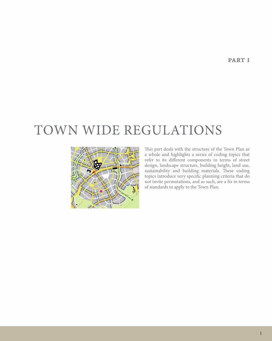
Town wide ReGULATionSThis part deals with the structure of the Town Plan as a whole and highlights a series of coding topics that refer to its different components in terms of street design, landscape structure, building height, land use, sustainability and building materials. These coding topics introduce very specific planning criteria that do not invite permutations, and as such, are a fix in terms of standards to apply to the Town Plan.
� SHeRFoRd | Town Code
21
45
68
59
31
3
2
26
8
12
13
9
9
11
12
9
9
9
9
9
12
8
9
1
14
12
14
12
N
1 - Secondary School
2 - Primary School
3 - Health Centre & Children's Centre
4 - Sports Centre
5 - Youth Centre
6 - High Street
7 - Community Park
8 - Outdoor Sports Facilities
9 - Wildlife and Green corridors
10 - Sherford quarry (disused)
11 - Existing woodlands
12 - Existing farm houses and buildings
13 - Park and Ride interchange
14 - Key Feature Building
15 - King George V playing fields
16 - Community Wind Turbines
Key
Reproduced from the Ordinance Survey
map with the permission of the Controller
of Her Magestys' Stationery Office.
Licence Number 0100031673
Crown Copyright Reserved
0 25 50 100 m0 25 50 100 m0 25 50 100 m
STANDARHAY CLOSE
HA
ZE
L D
RIV
E
HA
RT
WE
LL
AV
EN
UE
LB
2
4
5
7
10
12
9
9
8
1
1516
16
Project
SHERFORD
Drawing title
ILLUSTRATIVE
TOWN PLAN
Scale size
1:5000 @ A1Drawn
DP/IM/TYClient
REDTREE
Checked
SGDate
09.11.2006THIS DRAWING MAY BE USED ONLY FOR
THE PURPOSE INTENDED AND ONLY
WRITTEN DIMENSIONS SHALL BE USED
Drawing number
038-III/11.1001
The Prince's Foundation
19-22 Charlotte Road
London, EC2A 3SG
Tel: 0207 613 8500
Fax: 0207 613 8599
www.princes-foundation.org
Rev
OPA
21
45
68
59
31
N
3
2
26
8
12
13
9
9
11
12
9
9
9
9
9
12
8
9
1
14
12
14
12
Key 1 - Secondary School
2 - Primary School
3 - South Hams Area Local Care
Centre and Children's Centre
4 - Sports Centre
5 - Youth Centre
6 - High Street
7 - Community Park
8 - Outdoor Sports Facilities
9 - Wildlife and Green corridors
10 - Sherford quarry (disused)
11 - Existing woodlands
12 - Existing farm houses and buildings
13 - Park and Ride interchange
14 - Key Feature Building
Reproduced from the Ordinance Survey
map with the permission of the Controller
of Her Magestys' Stationery Office.
Licence Number 0100031673
Crown Copyright Reserved
0 25 50 100 m0 25 50 100 m0 25 50 100 m
STANDARHAY CLOSE
HA
ZE
L D
RIV
E
HA
RT
WE
LL
AV
EN
UE
LB
Project
SHERFORD
Drawing title
ILLUSTRATIVE
TOWN PLAN
Scale size
1:5000 @ A1Drawn
DP/IM/TYClient
REDTREE
Checked
SGDate
10.10.2006THIS DRAWING MAY BE USED ONLY FOR
THE PURPOSE INTENDED AND ONLY
WRITTEN DIMENSIONS SHALL BE USED
Drawing number
038-III/11.1001
The Prince's Foundation
19-22 Charlotte Road
London, EC2A 3SG
Tel: 0207 613 8500
Fax: 0207 613 8599
www.princes-foundation.org
Rev
A
24
5
7
10
12
8
9
9
8
1

�PART i
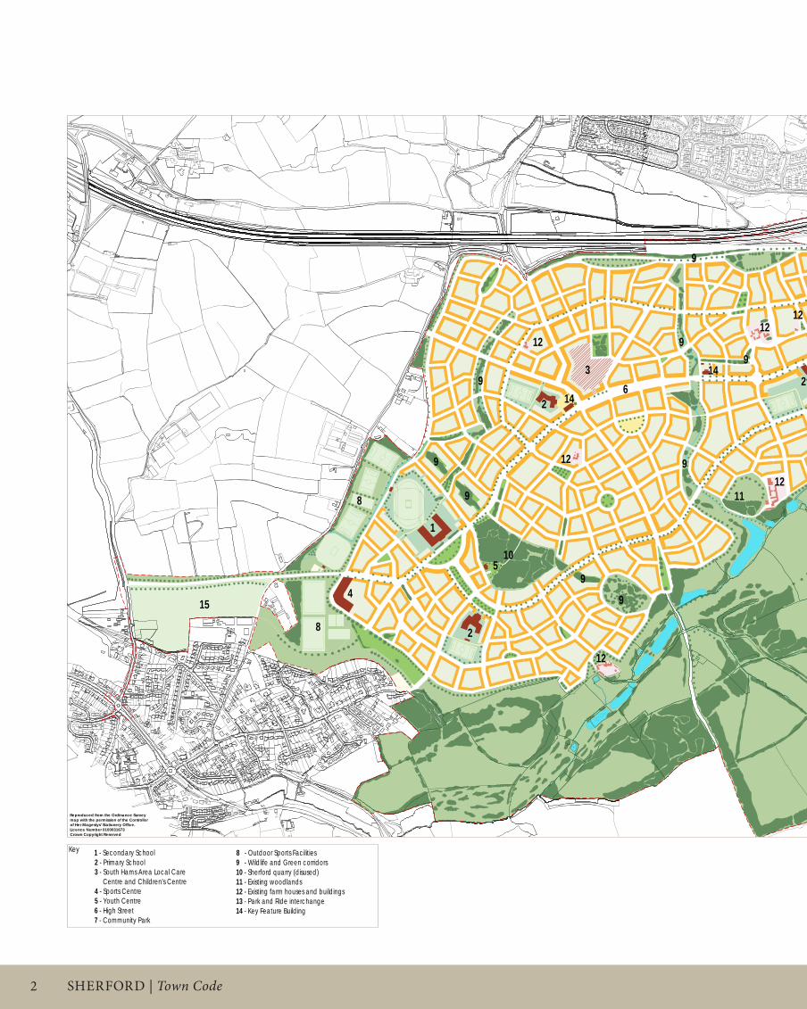
Sherford is designed in the way settlements have been designed for centuries, with the exception of most in the twentieth. in that sense it is traditional. it is designed to facilitate exchange between its citizens and to empower them regardless of their health, age or wealth. it will achieve the highest and best stewardship of precious resources of energy and water. it will contribute to the local identity of the region.
it does this by providing: An interconnected and fine-grained system of streets encouraging cycle and pedestrian movement, whilst accommodating vehicles. A fine-grained mixing of uses to increase opportunity and amenity for pedestrians.A range of accessible green spaces to do the same. A main street at the heart of the town to attract visitors and provide facilities for residents. A bus service running along the main street and through the heart of other local neighbourhoods, providing quick access to play areas. Adequate densities to support local needs nearby, that also affords space for a large community park.A broad range of tenures and dwelling types. A legible structure of varying streets and public spaces articulated by architecture and buildings that reflect the best traditions of the region. efficient methods of energy conservation and renewable energy regeneration.waste management and minimisation.efficient design and management of water use.
And, by: enhancing and creating natural habitats for wildlife, far beyond those that are currently there.
This Town Code gives instruction as to how all these will be achieved.
•
•
••
•
•
••
•
••
•
Town PLAn PRinCiPLeS21
45
68
59
31
3
2
26
8
12
13
9
9
11
12
9
9
9
9
9
12
8
9
1
14
12
14
12
N
1 - Secondary School
2 - Primary School
3 - Health Centre & Children's Centre
4 - Sports Centre
5 - Youth Centre
6 - High Street
7 - Community Park
8 - Outdoor Sports Facilities
9 - Wildlife and Green corridors
10 - Sherford quarry (disused)
11 - Existing woodlands
12 - Existing farm houses and buildings
13 - Park and Ride interchange
14 - Key Feature Building
15 - King George V playing fields
16 - Community Wind Turbines
Key
Reproduced from the Ordinance Survey
map with the permission of the Controller
of Her Magestys' Stationery Office.
Licence Number 0100031673
Crown Copyright Reserved
0 25 50 100 m0 25 50 100 m0 25 50 100 m
STANDARHAY CLOSE
HA
ZE
L D
RIV
E
HA
RT
WE
LL
AV
EN
UE
LB
2
4
5
7
10
12
9
9
8
1
1516
16
Project
SHERFORD
Drawing title
ILLUSTRATIVE
TOWN PLAN
Scale size
1:5000 @ A1Drawn
DP/IM/TYClient
REDTREE
Checked
SGDate
09.11.2006THIS DRAWING MAY BE USED ONLY FOR
THE PURPOSE INTENDED AND ONLY
WRITTEN DIMENSIONS SHALL BE USED
Drawing number
038-III/11.1001
The Prince's Foundation
19-22 Charlotte Road
London, EC2A 3SG
Tel: 0207 613 8500
Fax: 0207 613 8599
www.princes-foundation.org
Rev
OPA
� SHeRFoRd | Town Code
21
45
68
59
31
N
- Major Streets & Public Spaces - Key buildings
- Community Park & Strategic Landscape
- Major Green Corridors
- Key Views
- Ridge Line
- High Point
- Potential Major Visial Link
Key
Reproduced from the Ordinance Survey
map with the permission of the Controller
of Her Magestys' Stationery Office.
Licence Number 0100031673
Crown Copyright Reserved
0 25 50 100 m0 25 50 100 m0 25 50 100 m
STANDARHAY CLOSE
HA
ZE
L D
RIV
E
HA
RT
WE
LL
AV
EN
UE
LB
Project
SHERFORD
Drawing title
LEGIBILITY
Scale size
1:5000 @ A1Drawn
DP/IM/TYClient
REDTREE
Checked
SGDate
09.11.2006THIS DRAWING MAY BE USED ONLY FOR
THE PURPOSE INTENDED AND ONLY
WRITTEN DIMENSIONS SHALL BE USED
Drawing number
038-III/11.2011
The Prince's Foundation
19-22 Charlotte Road
London, EC2A 3SG
Tel: 0207 613 8500
Fax: 0207 613 8599
www.princes-foundation.org
Rev
OPA
21
45
68
59
31
N
- Major Streets & Public Spaces
- Quarters
- Key Buildings- Community Park & Strategic Landscape- Major Green Corridors- Key Views- Ridge Line
- High Point
- Potential Major Visial Link
Key
Reproduced from the Ordinance Surveymap with the permission of the Controllerof Her Magestys' Stationery Office.Licence Number 0100031673Crown Copyright Reserved
0 25 50 100 m0 25 50 100 m0 25 50 100 m
STANDARHAY CLOSE
HAZ
EL D
RIV
E
HAR
TWELL AVEN
UE
LB
Project
SHERFORD
Drawing title
LEGIBILITY
Scale size
1:5000 @ A1Drawn
DP/IMClient
REDTREE
Checked
SGDate
12.10.2006THIS DRAWING MAY BE USED ONLY FOR
THE PURPOSE INTENDED AND ONLYWRITTEN DIMENSIONS SHALL BE USED
Drawing number
038-III/11.2010
The Prince's Foundation
19-22 Charlotte RoadLondon, EC2A 3SGTel: 0207 613 8500Fax: 0207 613 [email protected]
Rev
-

�PART i
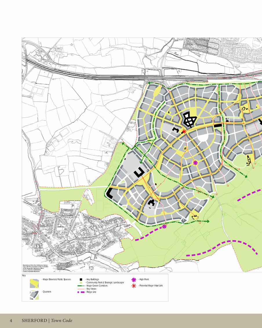
The opposite figure examines the legibility strategy for Sherford. This will include:
Structuring the town into distinct quarters bounded by principal streets, where most mixed-use and community facilities will be located. The significance of these streets will be emphasised by their spatial characteristics and architecture and will be established by the Regulating Plan. Key landscape features such as major green corridors will also distinguish quarters, which will enable residents and visitors to easily ‘read’ the town.
Clearly distinguishing between town and surrounding natural spaces, by creating a strong urban edge, and preserving views outwards, typical of South Hams towns and villages; the southeast part of the site slopes more steeply from the High Street down into the valley and enjoys special views of the gentle valley which rises on the other side.
Responding to the topographic character of the site by enhancing the spatial and architectural attributes of the urban form of prominent areas. The highest point in the development will be celebrated with a proposed circus where the streets radiate into the surrounding structure. The landscaping of the Park should equally enhance the attributes of the site and preserve key ridges and high points.
Locating civic or distinctive buildings in a position which will aid the legibility of the streets and spaces, such as squares, at the termination of street vistas and as corner buildings at key crossroads, which will serve as landmarks.
incorporating existing farms and farm houses within the urban form to create the type of contrast and diversity found in historical places. detailed Regulating Plans will establish how these houses terminate vistas or frame public spaces.
•
•
•
•
•
LeGibiLiTy PLAn21
45
68
59
31
N
- Major Streets & Public Spaces - Key buildings
- Community Park & Strategic Landscape
- Major Green Corridors
- Key Views
- Ridge Line
- High Point
- Potential Major Visial Link
Key
Reproduced from the Ordinance Survey
map with the permission of the Controller
of Her Magestys' Stationery Office.
Licence Number 0100031673
Crown Copyright Reserved
0 25 50 100 m0 25 50 100 m0 25 50 100 m
STANDARHAY CLOSE
HA
ZE
L D
RIV
E
HA
RT
WE
LL
AV
EN
UE
LB
Project
SHERFORD
Drawing title
LEGIBILITY
Scale size
1:5000 @ A1Drawn
DP/IM/TYClient
REDTREE
Checked
SGDate
09.11.2006THIS DRAWING MAY BE USED ONLY FOR
THE PURPOSE INTENDED AND ONLY
WRITTEN DIMENSIONS SHALL BE USED
Drawing number
038-III/11.2011
The Prince's Foundation
19-22 Charlotte Road
London, EC2A 3SG
Tel: 0207 613 8500
Fax: 0207 613 8599
www.princes-foundation.org
Rev
OPA

� SHeRFoRd | Town Code