transitioning mature satellite products into cdrs and cirs: noaa’s cdr project jeffrey l....
TRANSCRIPT

Transitioning Mature Satellite Products into CDRs and CIRs:
NOAA’s CDR Project
Jeffrey L. Privette, NOAA
Acknowledgments:John Bates, Tom Karl, Ed Kearns and The Joint Agency Study Team on the Climate Impacts of the Nunn-McCurdy NPOESS
Certification (incl. NASA, USGS)

22NOAA’s SDS Project
NPOESS Science Advisory Team Meeting, Asheville, NC
Outline
Motivation for Climate Data Records (CDRs) NOAA’s New Start Stakeholder-driven Development & Production

Long Term Records are Needed to
Determine True IPCC Projection
IPCC model projections for temperature, precipitation, and sea ice vary greatly
Mitigation and adaptation strategies depend critically on identifying which models are best
Only high quality, sustained CDRs can validate climate model projections into the decades ahead
*Resolution scale in Panel 1 is notional only.
*

44NOAA’s SDS Project
NPOESS Science Advisory Team Meeting, Asheville, NC
1181 82 83 84 85 87 88 89 90 9186 92 93 94 95 96 98 99 00 01 0297 04 0503 07 09 100806
Aqua
AVHRR
MODIS
VIIRS
N07 N09 N11 N14 N16 N17N09
Polar-orbiting Satellite Record Can Reveal Climate Change Information
12 13 14 15
NPP
NPOESS
20th Century 21st Century
~2026
45-year Record From 2-3 Sensor Types
1:30 PM orbit
55NOAA’s SDS Project
NPOESS Science Advisory Team Meeting, Asheville, NC
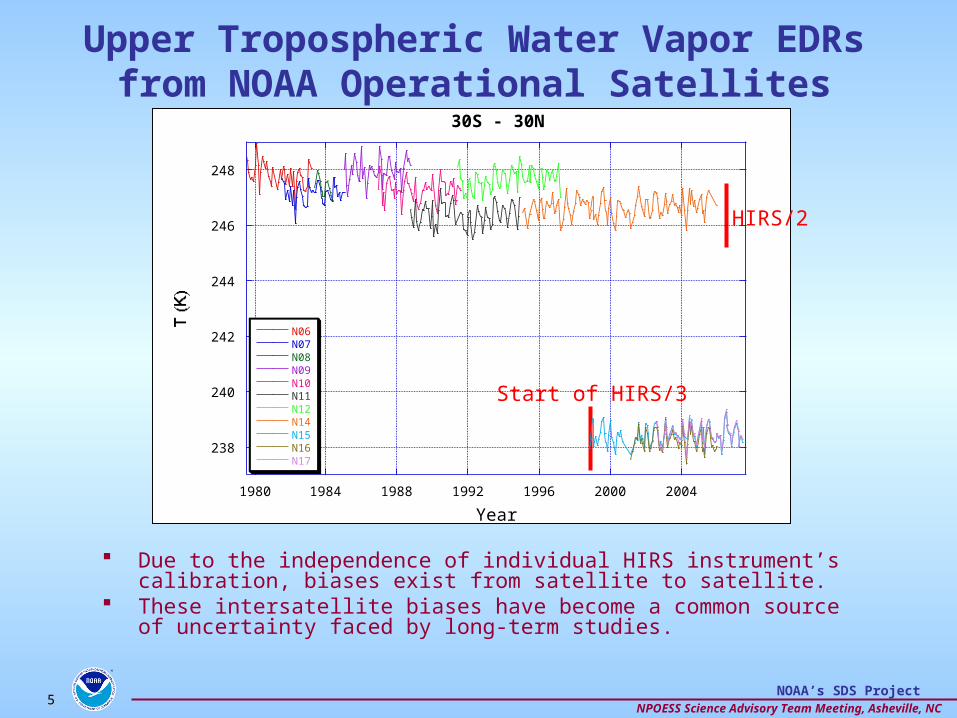
Upper Tropospheric Water Vapor EDRs from NOAA Operational Satellites
Due to the independence of individual HIRS instrument’s calibration, biases exist from satellite to satellite.
These intersatellite biases have become a common source of uncertainty faced by long-term studies.
Start of HIRS/3
HIRS/2
238
240
242
244
246
248
1980 1984 1988 1992 1996 2000 2004
30S - 30N
N06N07N08N09N10N11N12N14N15N16N17
Year

66NOAA’s SDS Project
NPOESS Science Advisory Team Meeting, Asheville, NC
Intersatellite Calibration and Correction Provides FCDR
Biases minimized.
Temperature dependent biases accounted for.
Similar overall variances between HIRS/2 and HIRS/3.
Time series can be extended as variance preserved.
246
246.5
247
247.5
248
248.5
249
1980 1984 1988 1992 1996 2000 2004
30S - 30N
N06N07
N08N09
N10N11
N12N14
N15N16
N17
Year
-0.4
-0.2
0
0.2
0.4
1980 1984 1988 1992 1996 2000 2004Year
Pairs N06-N07 N07-N08 N09-N10 N10-N11 N11-N12 N12-N14 N14-N15 N15-N16 N16-N17
Ave Diff -0.065 0.073 0.008 0.059 0.006 0.048 -0.042 -0.035 0.048

77NOAA’s SDS Project
NPOESS Science Advisory Team Meeting, Asheville, NC
Solar Insolation From Research Satellites
Original data (EDRs) cover several decades
Multiple data sources Work Needed for CDR:
– Sensor models to explain differences
– Development of homogeneous data set versions
– Estimation of detectable variability and trends

88NOAA’s SDS Project
NPOESS Science Advisory Team Meeting, Asheville, NC
Climate Data Records (CDRs) ProvideLong-term, Defensible Climate Benchmarks
Climate signatures tend to be small, but persistent, relative to normal environmental variability. Detection/analysis often requires long-term analysis
CDR is “… a time series of measurements of sufficient length, consistency, and continuity to determine climate variability and change” (NRC, 2004)
NAS, 2004
• Characteristics:o Long-term (multi-decadal)o Multi-satellite/multi-sensor (possibly ‘fused’ data sources)o Seamless, unified and coherent
Normalized (minimal observatory and sampling artifacts)o Peer-reviewed, “best practice” or “community” algorithmso Validated (uncertainty well-characterized)o Well documented (incl. peer-reviewed literature)o Comprehensive metadata and QA informationo Active data stewardship (reprocessings, refreshed storage media)

99NOAA’s SDS Project
NPOESS Science Advisory Team Meeting, Asheville, NC
National ClimaticData Center (NCDC)Asheville, North Carolina NCDC is the steward of the Nation’s in-situ
and satellite data and information.
Mission
To provide access and
stewardship to the Nation’s
resource of global climate
and weather related data and
information, and assess
and monitor climate
variation and change.

1010NOAA’s SDS Project
NPOESS Science Advisory Team Meeting, Asheville, NC
A Mandated Responsibility
Monitor and Describe the Climate
2007 Anomalies over Land and Sea NOAA/NCDC
7

1111NOAA’s SDS Project
NPOESS Science Advisory Team Meeting, Asheville, NC
Example CDR Prioritization(Sort By IPCC, Algorithm Investment,
Launch)
CDR Bundle Candidate Climate Data RecordsTEMPERTURE
PROFILESLower Stratospheric Temperature Profile, Lower Tropospheric Temperature Profile, Upper
Tropospheric Temperature Profile, Surface Air TemperatureREFLECTANCE
PRODUCTSSurface Reflectance (BRF; NBAR), Blue Sky Albedo (instantaneous), Black/White Sky
Albedo,Vegetation IndexWATER VAPOR
PROFILESLower Stratospheric Water Vapor Profile, Lower Tropospheric Water Vapor Profile, Upper
Tropospheric Water Vapor Profile, Total Column Water Vapor, Surface Water VaporLAND/LAKE SURFACE
TEMPERATURE Land Surface Temperature, Land Surface Emissivity (TIR), Lake Surface Temperature
RADIATION BUDGETTop-of-Atmosphere Outgoing Long Wave & Short Wave Radiation, Surface Up/Down Long
Wave & Short Wave RadiationGLACIERS/ICE CAPS Glacier Extent, Ice Sheet Extent
OZONEOzone Stratospheric Profile , Tropospheric Ozone , Total Column Ozone , Coarse Ozone
Profile SEA PROPERTIES Sea Surface Temperature
CLOUD PROPERTIESCloud Column Water, Cloud Optical Thickness,Particle Phase, Particle Size, Cloud Top
Pressure, Cloud Top Temperature, Cloud Top Emissivity, Cloud Column Water VaporSNOW Snow Areal Extent
AEROSOLS Aerosol Particle Size, Aerosol Optical Thickness , Aerosol Refractive IndexSEA ICE
(TEMPERATURE) Ice Surface TemperatureCLOUD PROPERTIES Cloud Cover, Cloud Type
FIRES (ENERGY)Active Fire Area, Active Fire Occurrence, Active Fire Temperature, Fire Radiative Power
(FRP)
TRACE GASESTropospheric Column of CO, Tropospheric Column of CH4, Stratospheric CH4, Stratospheric
CO2, Tropospheric Column of CO2, Lower Tropospheric CO2, Tropospheric N2OLAND COVER
(THEMATIC) Land Cover Map (Thematic)
IRRADIANCEDownwelling Total Solar Radiation at Top-of-Atmosphere, Downwelling Spectral Solar
Radiation at Top-of-AtmosphereFIRES (BURNED AREA) Burned Area
PRECIPITATION Rain RateBIOPHYSICAL
PRODUCTS Fraction of Absorbed Photosynthetically Active Radiation (fAPAR), Leaf Area IndexOCEAN WINDS Global Ocean Surface Vector Winds (OSVW), Coastal Ocean Surface Vector Winds (OSVW)OCEAN COLOR
PRODUCTS Calcite Concentration, Fluorescence, Chlorophyll A Concentration, Total Suspended MatterLAKES Lake Area Extent
LAND COVER (Cont. Fields) Fractional Tree/Grass Cover
SEA LEVEL Basic Sea Level Geophysical Data Record (GDR), Significant Wave HeightSNOW DEPTH Snow Water Equivalent, Snow Depth

1212NOAA’s SDS Project
NPOESS Science Advisory Team Meeting, Asheville, NC
Much Work Remains
1212

1313NOAA’s SDS Project
NPOESS Science Advisory Team Meeting, Asheville, NC
Atmosphere TEMPERTURE PROFILES CrIMMS H X F 2009 1
Terrestrial REFLECTANCE PRODUCTS VIIRS H X S 2009 1
Atmosphere WATER VAPOR PROFILES CrIMMS H X F 2009 2
Terrestrial LAND/LAKE SURFACE TEMPERATURE VIIRS H X S 2009 2
Atmosphere RADIATION BUDGET ERBS H X F 2009 3
Terrestrial GLACIERS/ICE CAPS VIIRS H S 2009 3
Atmosphere OZONE OMPS H X F 2009 4
Ocean SEA PROPERTIES VIIRS M X S 2009 4
Significance: Global Change
In Develop-
ment
Rank (S)tate or (F)orcing
First Launch
Primary SensorDiscipline Area CDR Bundle
CDR Prioritization Example
etc. (28 CDR bundles in total)
CDR bundle is costing convenience to group CDRs typically produced from the same or similar algorithm(s).
Primary sensor is a costing convenience to associate each CDR with one and only one NPOESS era sensor. It is recognized that data from multiple satellite sensors, and in situ data, are often used to determine a CDR.
Significance to Global Change follows from a review of IPCC Fourth Assessment Report (2007).
In development: Based on NASA ROSES ’06 A.15 and NOAA SDS 2007 selections.
First launch considers only NPP/NPOESS era launches per the mandate of the NPOESS Climate Recovery activity.
State and Forcing variable bundles, as defined by CCSP Strategic Plan Chapter 12, are prioritized at a 1:1 ratio.

1414NOAA’s SDS Project
NPOESS Science Advisory Team Meeting, Asheville, NC
CDR Production Occurs Within An End-to-End Program

1515NOAA’s SDS Project
NPOESS Science Advisory Team Meeting, Asheville, NC
CDRs provide high quality, consistent long term satellite records appropriate for climate change detection and characterization
climate modeling environments, assimilation, model validation
Currently any satellite-derived CDRs are ad hoc research efforts
NOAA-NASA developed blueprint for migration of successful research satellite products into operational CDRs
President’s FY09 budget includes new NOAA funding for CDR program
AO for grant proposals on streets
NOAA Project will require understanding stakeholder priorities and extensive stakeholder shake-out/feedback on CDRs
Summary