understanding the relationships among city...
TRANSCRIPT

Understanding the
Relationships among
City Microclimate,
Morphology and
Energy Use
Melissa R. Allen, Oak Ridge National Laboratory
Amy Rose, Oak Ridge National Laboratory
Joshua New, Oak Ridge National Laboratory
Olufemi Omitaomu, Oak Ridge National Laboratory
Jiangye Yuan, Oak Ridge National Laboratory
Marcia Branstetter, Oak Ridge National Laboratory
April 7, 2017

2 Presentation name
Urban-MET
• Integrate approaches across three research areas: earth system and climate modeling; energy modeling; and population/urban planning; to:
– Model urban micrometeorological processes and effects on and from regional climate and building energy use at neighborhood resolution
– Integrate climate, population, and land use projections in order to determine the most energy-efficient urban configurations for the mid-21st century
– Provide analysis and visualization tools to help planners optimally use these results
Integrated Urban Microclimate and Energy Planning Tool
Energy Modeling
Population Interactions
Microclimate

3 Presentation name
Microclimate Modeling
(Domains: 6km, 1km, 270m, 90m)
d01 d01

4 Presentation name
Data Collection/Parameters for ORNL
Campus Benchmark Study
• Hourly building energy use data for 2013-2015 for over 40 ORNL campus buildings
• Metasys hourly indoor/outdoor temperature/humidity/wind data for years 2014, 2015 for ORNL building 4500N
• Hourly meteorological station data for 2009-2015 from Towers A, B, D, K, L, M, Y, S, West
• Building shape files (Building height, height to width ratio, the building fraction, and the road fraction parameters at the individual building level computed)

5 Presentation name
ORNL Campus Morphology

6 Presentation name
Morphology Creation Tool
Key Parameters:
• Plan Area Density – Ratio of the plan area to the dilated
area
• Plan area - sum of the building surface areas
within the dilated area
• Frontal Area Index – Ratio of the wall area to the
average distance between the building centroids from
North to South multiplied by the average from East to
West
• Height to Width Ratio – ratio of the building height to the
average distance between each building
Current
Building
Dilated area
Plan area is highlighted in yellow
Current
Building
Dilated area
Plan area is highlighted in yellow
Current
Building
Dilated area
Plan area is highlighted in yellow
Current
Building
Dilated area
Plan area is highlighted in yellow
7 Presentation name
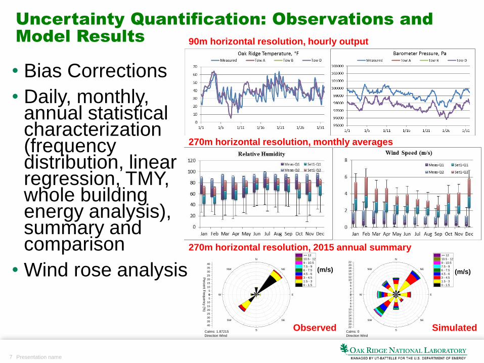
Uncertainty Quantification: Observations and
Model Results
• Bias Corrections
• Daily, monthly, annual statistical characterization (frequency distribution, linear regression, TMY, whole building energy analysis), summary and comparison
• Wind rose analysis
Tower
A
Tower
B
Tower
D
Tower
K
Tower
L
Tower
M
Tower
A
Tower
B
Tower
D
Tower
K
Tower
L
Tower
M
N
NE
E
SE
S
SW
W
NW
0
5
10
15
20
25
30
35
40
0
5
10
15
20
25
30
35
40
Pe
rcen
t Fre
qu
en
cy (%
)
Calms: 1.87215
Direction Wind
>= 12
10.5 - 12
9 - 10.5
7.5 - 9
6 - 7.5
4.5 - 6
3 - 4.5
1.5 - 3
0 - 1.5
N
NE
E
SE
S
SW
W
NW
02468
10121416182022
02468
10121416182022
Calms: 0
Direction Wind
>= 12
10.5 - 12
9 - 10.5
7.5 - 9
6 - 7.5
4.5 - 6
3 - 4.5
1.5 - 3
0 - 1.5
90m horizontal resolution, hourly output
270m horizontal resolution, monthly averages
270m horizontal resolution, 2015 annual summary
(m/s) (m/s)
Observed Simulated

8 Presentation name
Communication between models
• Conversion of potential temperature at each vertical level to actual temperature
• Conversion of U,V,W at each vertical level to wind speed and direction at each level
• Conversion of Water Vapor to Relative Humidity and to Dew Point temperature at each vertical level
• Placing above variables plus relevant native output onto 2d grids for each vertical level and then converting each variable set at each vertical level to per-building values and translating to epw-type csv files for reading into E+.

9 Presentation name
Whole Building Energy Analysis
EnergyPlus models of three buildings used to compare energy
consumption differences based on measured versus simulated weather
data

10 Presentation name
Proposed Morphologies for New
Development in Chicago Loop

11 Presentation name
Proposed Morphologies for New
Development in Chicago Loop

12 Presentation name
Morph 1: Supposed Development Plans
Related Midwest Building (OneEleven luxury apts, Hotel
Chicago)
Columbia College, Sage Medical Group, Car share, Parking garage, Dry Cleaner, Small Businesses, lofts
Commercial Real Estate
Office Building
Condos, businesses
Low-rise residential
13 Presentation name
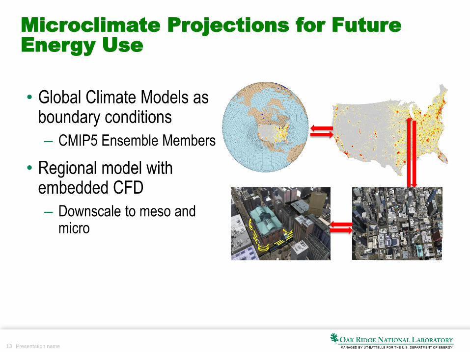
Microclimate Projections for Future
Energy Use
• Global Climate Models as boundary conditions
– CMIP5 Ensemble Members
• Regional model with embedded CFD
– Downscale to meso and micro

14 Presentation name
Urbanization projections: evaluating
future per capita energy use
• LandCast – Locally adaptive, spatially explicit
population predictions
– Business as usual growth rate, land use, land cover change
– Shows changes from 2010 to predicted urbanization for 2050
– Dense settlement can afford energy efficiencies by encouraging multi-dwelling living
– Average carbon footprint per capita is smaller for cities in which individuals live in multi-dwelling buildings
Change in population per 1km cell
from 2010 to 2050

15 Presentation name
Fractional Factorial Design: Sensitivity
Analysis for Test Morphologies
• Developed the world’s fastest building energy model creator
– Capable of creating 155,793 unique buildings (35.58GB of storage) on a laptop in 2.6 minutes
• Advanced fractional-factorial designs were extended to allow sensitivity analysis in a way that maximizes the statistical resolution for a given number of simulations
– ~150k buildings were simulated and verified for this project
– Covers all 16x DOE reference buildings (representing over 70% of the U.S. commercial building stock)
– 16x climate zones
– 3x vintages (based on building codes active at the time: pre-1980, 1980-1990, post-1990)
16 Presentation name
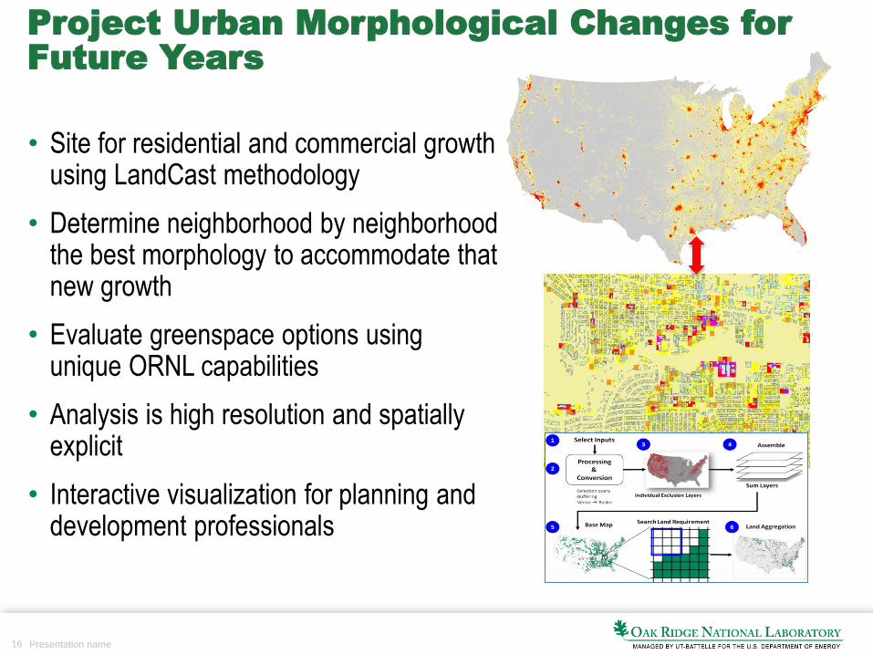
Project Urban Morphological Changes for
Future Years
• Site for residential and commercial growth using LandCast methodology
• Determine neighborhood by neighborhood the best morphology to accommodate that new growth
• Evaluate greenspace options using unique ORNL capabilities
• Analysis is high resolution and spatially explicit
• Interactive visualization for planning and development professionals

17 Presentation name
Acknowledgements
• Matthew Seals, Oak Ridge National Laboratory
• Thomaz Carvalhaes, Oak Ridge National Laboratory
• Linda Sylvester, Oak Ridge National Laboratory
• Mark Adams, Oak Ridge National Laboratory
• Mahabir Bhandari, Oak Ridge National Laboratory
• Som Shrestha, Oak Ridge National Laboratory