urban challenge (2007)
TRANSCRIPT

1
Developing aDeveloping aSelfSelf--Driving CarDriving Car
for the 2007 DARPA for the 2007 DARPA Urban ChallengeUrban Challenge
Seth TellerCS and AI Laboratory
EECS DepartmentMIT
Joint work with: Matt Antone, David Barrett, Mitch Berger, Bryt Bradley, Ryan Buckley, Stefan Campbell, Alexander Epstein, Gaston Fiore, Luke Fletcher, Emilio Frazzoli, Jonathan How, Albert Huang, Troy Jones, Sertac Karaman, Olivier Koch, Yoshi Kuwata, Victoria Landgraf, John Leonard, Keoni Maheloni, David Moore, Katy Moyer, Edwin Olson, Andrew Patrikalakis, Steve Peters, Stephen Proulx, Nicholas Roy, Chris Sanders, Justin Teo, Robert Truax, Matthew Walter, Jonathan Williams
23 Apr 2008
Urban Challenge (2007)Urban Challenge (2007)• Novel elements:
– Urban road network– Moving traffic
• Human and robotic!– No course inspection– 60 miles in 6 hours
• Scored by speed, safety• $3.5M prize pool
– 89 entering teams• Program goals
– Safe (collision-free, polite) driving at up to 30mph– Capable (turns, stops, intersections, merging, parking, …)– Robust (blocked roads, erratic drivers,
sparse waypoints, GPS degradation and outages, …)
Source: DARPA Urban Challenge Participants Briefing, May 2006

2
23 Apr 2008
Program ScopeProgram Scope• In scope:
– Following -- Emergency stops– Intersections -- Timely left turns across traffic– Passing, Merging -- Potholes, construction sites– Parking, U-turns -- Blockages, replanning
• Out of scope:– Pedestrians– High speed (> 30 mph)– Traffic signals, signage– Difficult off-road terrain– Highly inclement weather
23 Apr 2008
DARPADARPA--Provided InputsProvided Inputs
• USB stick w/ two files:
• RNDF = Road Network Description File– Topology of road network– “Sparse” GPS waypoints– Parking zones– Provided 48 hours ahead
• MDF = Mission Description– List of RNDF way-points to
be visited by autonomous car– Provided 5 minutes ahead
Source: DARPA Participants Briefing, May 2006
Vehicle navigatesroads with sparse waypoints
Intersection notcalled out in RNDF
Sparse waypointson curved road
3
23 Apr 2008
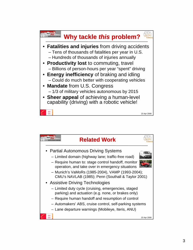
Why tackle Why tackle thisthis problem?problem?• Fatalities and injuries from driving accidents
– Tens of thousands of fatalities per year in U.S.– Hundreds of thousands of injuries annually
• Productivity lost to commuting, travel– Billions of person-hours per year “spent” driving
• Energy inefficiency of braking and idling– Could do much better with cooperating vehicles
• Mandate from U.S. Congress– 1/3 of military vehicles autonomous by 2015
• Sheer appeal of achieving a human-levelcapability (driving) with a robotic vehicle!
23 Apr 2008
Related WorkRelated Work
• Partial Autonomous Driving Systems– Limited domain (highway lane; traffic-free road)– Require human to: stage control handoff, monitor
operation, and take over in emergency situations– Munich’s VaMoRs (1985-2004), VAMP (1993-2004);
CMU’s NAVLAB (1985); Penn (Southall & Taylor 2001)• Assistive Driving Technologies
– Limited duty cycle (cruising, emergencies, staged parking) and actuation (e.g. none, or brakes only)
– Require human handoff and resumption of control– Automakers’ ABS, cruise control, self-parking systems– Lane departure warnings (Mobileye, Iteris, ANU)

4
23 Apr 2008
Assessment and StrategyAssessment and Strategy
• Human-level urban driving not achievablewith existing algorithms / systems in 2006– Key issues: uncertainty; sensing/CPU resources; safety– Example: if vehicle is unsure where the road is, and/or
where it is with respect to the road, identifying a safe, appropriate traffic behavior (at speed!) is very difficult
• Strategy– Technical footprint for success covers many disciplines
interdisciplinary approach integrating EECS/AA/ME– Spiral design approach figure out how to solve the
problem while designing the system at the same time
23 Apr 2008
Team FormationTeam Formation
8

5
23 Apr 2008
Team Members & RolesTeam Members & Roles• Faculty, postdocs, students, staff
– Operating software, sensor & computer selection and configuration (~8 full-time graduate student programmers)
– Project Management• Draper Laboratory
– System Engineering, Vehicle Integration & Test Support, Logistics Support
• Olin College of Engineering– Vehicle Engineering (Mech. & Elec.)– System Testing support
• Other Team Partners and Sponsors– Quanta Computer, BAE Systems, Ford,
Land Rover, MIT SOE, CSAIL, EECS, A/A, MIT IS&T, MIT Lincoln Laboratory,…
9
23 Apr 2008
Compressed TimelineCompressed Timeline• Bring up rapid prototype vehicle
(Ford Escape) summer/fall ‘06– Gain experience with sensors,
dynamics, coding, configuration• Bring up competition vehicle
(LandRover LR3) spring ‘07– Develop mature algorithms, tune
for qualifying rounds and final event
Site Visit(6/20/07)
Semi-final(10/26-31)
Final Event(11/3)
Participants Conference (5/20)
Program Announced (5/1)
Site Visit(10/27)
Track A Announced (10/2)
2006 2007
Ford Escape LR3

6
23 Apr 2008
Design StrategyDesign Strategy
• Sensor-rich, CPU- and I/O-intensive architecture– Many sensors to interpret surroundings “live”– Intensive use of live and logged visualization– Many resources, to avoid premature optimization
• Redundancies:– Sensor type and spatial coverage– Closed-loop multi-level planning and control– Computation failover at process level– Firmware-mediated actuator control
• Failsafe behaviors– If no progress, relax perceived constraints
23 Apr 2008
Our ApproachOur Approach
Velodyne HDL (1)
PushbroomSick LIDARs (5)
ACC RADARs (15)
SkirtSick LIDARs (7)
Cameras (6)
12
ApplanixGPS / IMU

7
23 Apr 2008
Planar Laser Range ScannersPlanar Laser Range ScannersFalse colored by height
23 Apr 2008
VelodyneVelodyne LidarLidar• 64 lasers, 360° HFOV• Spins at 15 Hz• Vertical FOV
-24° +2°• Redundant (albeit
relatively noisy) lidar

8
23 Apr 2008
Sample Sample VelodyneVelodyne DataDataFalse colored by height
23 Apr 2008
Detection of Static ObstaclesDetection of Static Obstacles

9
23 Apr 2008
Automotive RadarsAutomotive Radars
• 15 Delphi automotive radars• Doppler range, bearing, closing
speed of 20 objects @ 10Hz• Narrow beam width• Good far-field car detectors
23 Apr 2008
Sample Radar DataSample Radar DataRaw range, bearing, range rate data, false-colored by radar ID

10
23 Apr 2008
Vehicle Detection and TrackingVehicle Detection and Tracking
23 Apr 2008
Tracking in CambridgeTracking in Cambridge

11
23 Apr 2008
Video CamerasVideo Cameras• 5 Firewire Cameras
– Point Grey Firefly MV• 720x480 8bpp Bayer
pattern @ 22.8 fps• ~40 MB/s (2.5 GB/min)
Lots of data!• Purpose: Detection of
painted lane markings
Rear view Narrow forward view
Forward left Forward center Forward right
23 Apr 2008
Lane EstimationLane Estimation
Road paintdetectors
CurbDetectors
Lane centerline estimator
Lane tracker
RNDF

12
23 Apr 2008
ClosedClosed--Loop Lane TrackingLoop Lane TrackingPlayback speed: 2x
One-way two-lane roadRNDF-interpolated estimate goes through trees and bushes!
23 Apr 2008
System ArchitectureSystem Architecture
• Perception– Vehicle surroundings– Vehicle location w.r.t.
surroundings and RNDF
• Planning & Control– Codified driving rules– How to reach the goal
• AEVIT Vehicle Conversion (EMC) control unit– Continuous signal (steering, gas/brake)– Discrete signal (turn signals, gear shift)
Perception
NavigatorMDF
Goal
Trajectory
Steer, gas/brake
Vehicle states
Drivable surface, lane markings, Obstacles;
Traffic vehicle
Local mapDrivableSurface, Hazards
SituationalPlanner
Vehicle Controller
Vehicle
Vehicle State Estimator
SensorsSensorsSensorsSensorsSensorsSensorsSensorsRNDF
13
23 Apr 2008
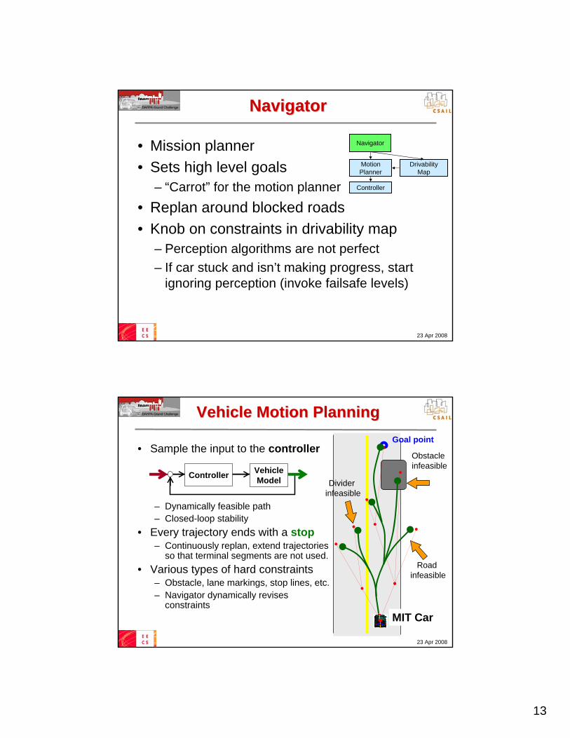
NavigatorNavigator
• Mission planner• Sets high level goals
– “Carrot” for the motion planner• Replan around blocked roads• Knob on constraints in drivability map
– Perception algorithms are not perfect– If car stuck and isn’t making progress, start
ignoring perception (invoke failsafe levels)
Navigator
Drivability Map
MotionPlanner
Controller
23 Apr 2008
Vehicle Motion PlanningVehicle Motion Planning
• Sample the input to the controller
– Dynamically feasible path– Closed-loop stability
• Every trajectory ends with a stop– Continuously replan, extend trajectories
so that terminal segments are not used.• Various types of hard constraints
– Obstacle, lane markings, stop lines, etc.– Navigator dynamically revises
constraints
Controller VehicleModel
Obstacleinfeasible
Road infeasible
Goal point
Divider infeasible
MIT Car

14
23 Apr 2008
Competition Vehicle: LR3Competition Vehicle: LR3
• Linux blade cluster with two fast interconnection networks– 10 blades each with 2.33GHz quad-core processor 40 cores– Approximately 80 driving-related processes steady-state
• Many sensors– Applanix IMU/GPS– Hi-res odometry– 12 SICK Lidars– Velodyne (~64 Lidars)– 15 automotive radars– 5 video cameras
• Roof-mounted AC• Power consumption
~5500W total• Internal gas generator
23 Apr 2008
LR3 Mobile Machine RoomLR3 Mobile Machine Room

15
23 Apr 2008
Autonomous Driving Test SiteAutonomous Driving Test Site
• South Weymouth Naval Air Station– About 40 min. from MIT off 3S– Usually $10K/day; free to our
team when no paying customer • Large tarmac area
– Can create arbitrary (flat) road networks– Environmentally sensitive:
• Obstacles: traffic cones • Lane markings: only flour• Traffic: team members’ cars
23 Apr 2008
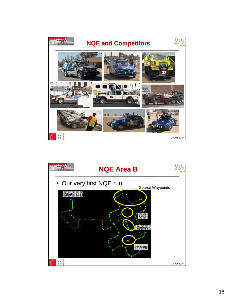
NQE and CompetitorsNQE and Competitors

16
23 Apr 2008
FineFine--Grained Prior Map DataGrained Prior Map Data• Every other team we spoke to manually
“densified” the provided RNDF (map) dataduring the 48-hour pre-competition period– Used high-resolution geo-referenced aerial imagery– Added precise position and / or curvature samples
at dense intervals (every few meters) along roads• Rationales we heard for this approach:
– “All the other teams are densifying” (not true)– Such “data infrastructure” will be widely available
soon via commercial efforts (NavTeq, Google)• DARPA implicitly blessed this strategy
– 48-hour RNDF distribution; no surprise road segments
23 Apr 2008
Why This is a Bad IdeaWhy This is a Bad Idea• Prior info could be incorrect, since map data:
– … can be incomplete or erroneous at source– … can become stale due to a dynamic world– … can be corrupted in transmission or by bad guys
• “Locks in” reliance on precision GPS navigation– No matter how good, position sometimes “jumps” a few meters– This is an inherent limitation of GPS in urban environments– Hinders research on core problem aspect (perception)
• Brittle whole-system aspects / points of failure– Challenge of highly-available map data service at scale– Degraded or denied GPS reception
• One team froze for 40+ minutes at starting line due to poor GPS !
• Causes human observers to misjudge cars’ abilities– Example DARPA webcast commentators attributed human-like
driving skills to cars pulling into parking spots marked with lines

17
23 Apr 2008
An Alternative DirectionAn Alternative Direction
• Drive with just-in-time sensing, andpoor-quality (or no) GPS reception
• Why?– Humans drove just fine before advent
of precision roadmaps and GPS– Avoids brittle aspects of GPS-based approach– Technology trends (sensing, CPU, I/O, faster
actuators) hold promise of achieving driving performance superior to that of humans
– Social aspect: trust in sensors vs. trust in maps
23 Apr 2008
A Concrete ProposalA Concrete Proposal
• Run the next Challenge without GPS !without GPS !• At least four good reasons to do this:
– Bring into sharp relief which aspects of the autonomous driving problem have been solved
– Show the military what level of capability toexpect when bad guys jam their GPS reception
– Dramatically lower the cost barrier for “garage teams” (omit ~$75K high-end GPS/IMU systems)
– Channel research into perception tasks rather than precision mapping and data integration
18
23 Apr 2008
NQE and CompetitorsNQE and Competitors
23 Apr 2008
NQE Area BNQE Area B
• Our very first NQE run.Sparse Waypoints
Parking
Gate
Gauntlet
Start chute

19
23 Apr 2008
NQE Area BNQE Area BPlayback speed: 3.3x
One of only 2 teams to complete Area B on the first attempt.
23 Apr 2008
Area B Parking TestArea B Parking Test
• Parking: RNDF target position was blocked

20
23 Apr 2008
NQE Area ANQE Area A• Advanced traffic capabilities
– Merging into traffic– Left turn across oncoming traffic– Excessive delay (> 10 sec.) prohibited
• ~10 traffic vehicles moving at 10mph.
• 1st trial – 7 laps in 24 min• 2nd trial – 10 laps in 12 min
23 Apr 2008
NQE Area CNQE Area C
• Objectives– Intersection precedence (turn-taking)– Blocked check points (replanning, 3-point turns)
Route blockage

21
23 Apr 2008
Urban Challenge Event Urban Challenge Event (11/03/07)(11/03/07)
• Only 11 of 35 teams selected, due to DARPA’s safety concerns
• 50 human-driven traffic vehicles• 3 MDF missions totaling ~60 miles
1 mile
23 Apr 2008
Change in DARPAChange in DARPA’’s Emphasiss Emphasis
• Focus very different from specification, NQE– Allowed human pre-inspection of road network
• Opportunity to validate manually densified RNDFs– Simplified competition setup
• No DARPA-generated road blockages• No passing or merging at speed• No dense human traffic or planned human challenges• No other vehicles (parked or moving) in parking lots
– No GPS degradation or outages• RF sources turned off (plasma display, chase video)
• Other robot cars– Highly unpredictable

22
23 Apr 2008
23 Apr 2008
Degraded PerformanceDegraded Performance• Phantom curbs on the dirt segment
– Had never tested on steeply-sloped dirt roads– Failsafe timer kicked in disregard curbs

23
23 Apr 2008
Accident with Accident with CarOLOCarOLO• Accident had several contributory causes:
– CarOLO drove into us damaged, removed from competition– Hard to detect slowly moving objects, without false positives– Could have embedded a better evasive maneuver
The first bot-on-bot caraccident in
history!
23 Apr 2008
Accident with CornellAccident with Cornell• Cornell
– Stopped, then reversedtoward the intersection
– Started moving as we passed
DARPA: “no fault” incident;both teams continued
The second bot-on-botcar accident in history!
• MIT– Tried passing to Cornell’s left
– Returned to right lane too quickly

24
23 Apr 2008
Traffic JamTraffic Jam• Each car waiting for another car to move• Excess delay = 10sec traffic jam
23 Apr 2008
HighHigh--Speed SectionSpeed Section• MDF speed limit: 30mph
– Braking distance = 36m (with 2.5m/s2 deceleration)– Standoff distance = 10m– Requires reliable detection range: 50m
Capped @25mphby our software

25
23 Apr 2008
ResultsResults• 6 teams finished; 5 others
removed from competitionby DARPA officials– At-fault collisions – Near misses– Excess delay
• Many race-day firsts for us:– More than 20 miles in one day– Steep dirt (unpaved) segment– Mile-long, wide lanes @25mph– Interaction with other robots
• We drove safely– No processes died– Our chase driver: “your vehicle
was always safe, in my opinion”
CMU Stanford Virginia Tech
23 Apr 2008
Failure ModesFailure Modes
• Perception limitations– Hallucinated curbs (at detection size threshold)– Vulnerability to shadows, sun blinding– Sensitivity to vehicle pitch– Inability to track slow-moving vehicles (< 3mph)
• Control / Planning limitations– Occasionally failed to achieve target orientation– Caused over-correction, unsafe maneuvers
• Failsafe strategy– Unclear when to relax or observe constraints– Example: U-turn at roadblock, or drive around?

26
23 Apr 2008
Teamwork!Teamwork!
23 Apr 2008
AchievementsAchievements
• Respectable rookie showing– First time in DGC for
everyone on MIT team• Fourth place overall
– One of only 6 teams (of 89 initially entering) to complete UCE course
• Completed all NQE missions without manual annotation of RNDF

27
23 Apr 2008
Lessons LearnedLessons Learned
• About competing effectively
• About DARPA’s expectations
• About the autonomous driving task
• About differing long-term approaches
More info: http://dgc.mit.edu
23 Apr 2008
Questions and DiscussionQuestions and Discussion