vol. 6 no. 4, december 2015 ra ii wigos project newsletter · ra ii wigos project newsletter ... ²...
TRANSCRIPT

- 1 -
Vol. 6 No. 4, December 2015
RA II WIGOS Project Newsletter DEVELOPING SUPPORT FOR NATIONAL METEOROLOGICAL AND HYDROLOGICAL SERVICES IN SATELLITE DATA, PRODUCTS AND TRAINING
Contents of this issue Page
² FY-2G in On-orbit Operation 1
² The 1st KMA International Meteorological Satellite Conference 4 ² The Sixth Asia/Oceania Meteorological Satellite Users’ Conference 6 ² The Third Meeting of the Coordinating Group of the WMO
Regional Association II (Asia) WIGOS Project to Develop Support
for National Meteorological and Hydrological Services (NMHSs)
in Satellite Data, Products and Training 7
² Members of the Coordinating Group 10 ² From the Co-editors 11
FY-2G in On-orbit Operation As the latest operational geostationary meteorological satellite of CMA, FY-2G has been operating located in 104.5°E since 3 June, 2015 replacing its predecessor (FY-2E) after about 5-month on-orbit testing from the beginning of 2015. Benefit from the better
calibration accuracy for the main infrared bands (<0.7K@290K) as well as stray light restraints for all bands, the image quality and radiometric performance of FY-2G has been significantly improved, which promotes CMA to generate more products to meet users’ requirement as extremely as possible.
- 2 -
Raw 5-band imagery
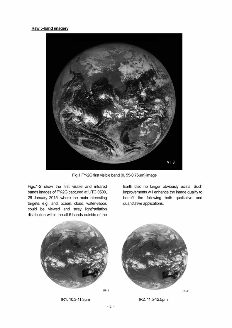
Fig.1 FY-2G first visible band (0. 55-0.75μm) image
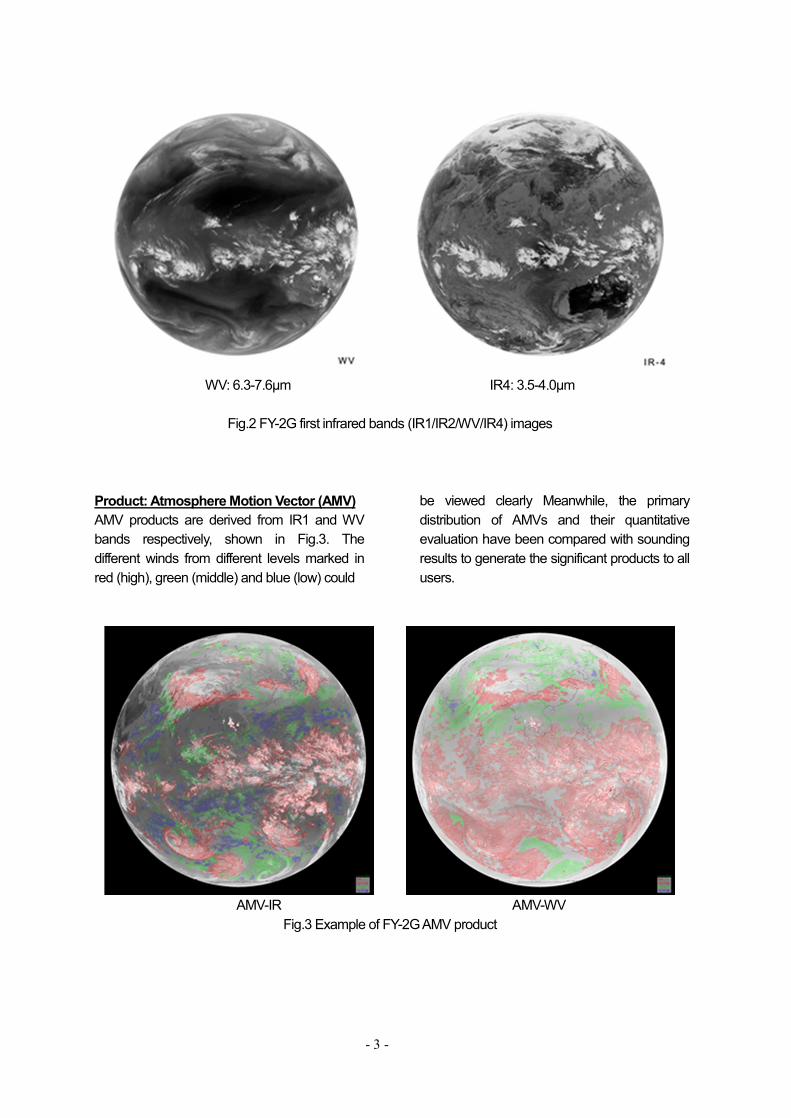
Figs.1-2 show the first visible and infrared bands images of FY-2G captured at UTC 0500, 26 January 2015, where the main interesting targets, e.g. land, ocean, cloud, water-vapor, could be viewed and stray light/radiation distribution within the all 5 bands outside of the
Earth disc no longer obviously exists. Such improvements will enhance the image quality to benefit the following both qualitative and quantitative applications.
IR1: 10.3-11.3μm IR2: 11.5-12.5μm
- 3 -
WV: 6.3-7.6μm IR4: 3.5-4.0μm
Fig.2 FY-2G first infrared bands (IR1/IR2/WV/IR4) images
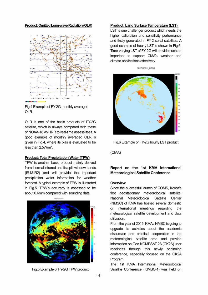
Product: Atmosphere Motion Vector (AMV) AMV products are derived from IR1 and WV bands respectively, shown in Fig.3. The different winds from different levels marked in red (high), green (middle) and blue (low) could
be viewed clearly Meanwhile, the primary distribution of AMVs and their quantitative evaluation have been compared with sounding results to generate the significant products to all users.
AMV-IR AMV-WV
Fig.3 Example of FY-2G AMV product
- 4 -
Product: Omitted Long-wave Radiation (OLR)
Fig.4 Example of FY-2G monthly averaged OLR OLR is one of the basic products of FY-2G satellite, which is always compared with these of NOAA-18 AVHRR to real-time assess itself. A good example of monthly averaged OLR is given in Fig.4, where its bias is evaluated to be less than 2.5W/m2. Product: Total Precipitation Water (TPW): TPW is another basic product mainly derived from thermal infrared and its split-window bands (IR1&IR2) and will provide the important precipitation water information for weather forecast. A typical example of TPW is illustrated in Fig.5. TPW’s accuracy is assessed to be about 0.6mm compared with sounding data.
Fig.5 Example of FY-2G TPW product
Product: Land Surface Temperature (LST): LST is one challenger product which needs the higher calibration and sensitivity performance and firstly generated in FY-2 serial satellites. A good example of hourly LST is shown in Fig.6. Time-varying LST of FY-2G will provide such an important to support CMA’s weather and climate applications effectively.
Fig.6 Example of FY-2G hourly LST product
(CMA) Report on the 1st KMA International Meteorological Satellite Conference Overview Since the successful launch of COMS, Korea's first geostationary meteorological satellite, National Meteorological Satellite Center (NMSC) of KMA has hosted several domestic or international meetings regarding the meteorological satellite development and data utilization. From the year of 2015, KMA / NMSC is going to upgrade its activities about the academic discussion and practical cooperation in the meteorological satellite area and provide information on Geo-KOMPSAT-2A (GK2A) user readiness through this newly beginning conference, especially focused on the GK2A Program. The 1st KMA International Meteorological Satellite Conference (KIMSC-1) was held on
- 5 -
November 16~18, 2015 in Seoul, Korea, in collaboration with Electronics and Telecommunications Research Institute (ETRI). About 200 satellite operators, users, researchers, Industry–University-Institute -Collaboration and developer for meteorological satellites, and participation agency for WMO and CGMS participated in this conference and it had been successfully progressed. Sections The conference consisted of forty presentations for four sections. • Section 0 : Introduction of Nation’s
Satellite Activities • Section 1 : Current Status and Future
Plan of GK2A • Section 2 : Space Weather Activities • Section 3 : Preparation of KMA's LEO
satellite • Section 4 : Geophysical Products from
GK2A Algorithm Development - Cloud/Rainfall, Scene Analysis
During those sections, a lot of information was presented about plans and introduction of the operational satellite agencies (NSMC/CMA, EUMETSAT, MSC/JMA, KMA, NESDIS/NOAA and AuBOM), COMS’s use and operational status, LEO satellite’s operation and
development plan, advanced meteorological satellite’s application technology development and international cooperation plan and GK2A satellite’s development.. Above this conference were the additional meetings whose topics were advanced meteorological satellite’s development (Harris Cop.), LEO satellite’s economic analysis(NCAR), space weather’s international cooperation(NOAA/SWPC) and GK2A’s magnetometer development and cooperation plan of sharing for observation data(ESA). Conclusion The conference was very successful meeting to interact directly with each satellite operators and users. Also it was of help to improve status of meteorological satellite field, to acquire development technic of satellite products, to share development plan of satellite advanced country’s GEO/LEO satellite instrument and application technic and to expand cooperation system of practical application and calibration technic. (Dohyeong Kim, NMSC/KMA)
- 6 -
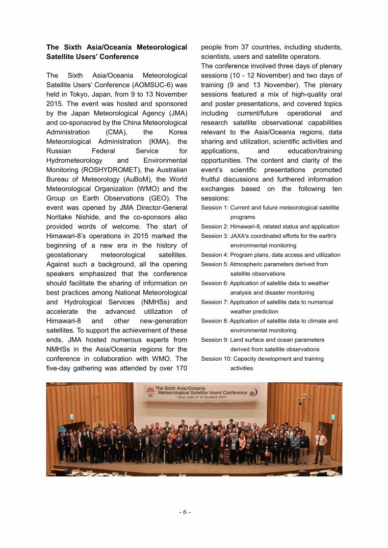
The Sixth Asia/Oceania Meteorological Satellite Users’ Conference The Sixth Asia/Oceania Meteorological Satellite Users’ Conference (AOMSUC-6) was held in Tokyo, Japan, from 9 to 13 November 2015. The event was hosted and sponsored by the Japan Meteorological Agency (JMA) and co-sponsored by the China Meteorological Administration (CMA), the Korea Meteorological Administration (KMA), the Russian Federal Service for Hydrometeorology and Environmental Monitoring (ROSHYDROMET), the Australian Bureau of Meteorology (AuBoM), the World Meteorological Organization (WMO) and the Group on Earth Observations (GEO). The event was opened by JMA Director-General Noritake Nishide, and the co-sponsors also provided words of welcome. The start of Himawari-8’s operations in 2015 marked the beginning of a new era in the history of geostationary meteorological satellites. Against such a background, all the opening speakers emphasized that the conference should facilitate the sharing of information on best practices among National Meteorological and Hydrological Services (NMHSs) and accelerate the advanced utilization of Himawari-8 and other new-generation satellites. To support the achievement of these ends, JMA hosted numerous experts from NMHSs in the Asia/Oceania regions for the conference in collaboration with WMO. The five-day gathering was attended by over 170
people from 37 countries, including students, scientists, users and satellite operators. The conference involved three days of plenary sessions (10 - 12 November) and two days of training (9 and 13 November). The plenary sessions featured a mix of high-quality oral and poster presentations, and covered topics including current/future operational and research satellite observational capabilities relevant to the Asia/Oceania regions, data sharing and utilization, scientific activities and applications, and education/training opportunities. The content and clarity of the event’s scientific presentations promoted fruitful discussions and furthered information exchanges based on the following ten sessions: Session 1: Current and future meteorological satellite
programs Session 2: Himawari-8, related status and application Session 3: JAXA's coordinated efforts for the earth's
environmental monitoring Session 4: Program plans, data access and utilization Session 5: Atmospheric parameters derived from
satellite observations Session 6: Application of satellite data to weather
analysis and disaster monitoring Session 7: Application of satellite data to numerical
weather prediction Session 8: Application of satellite data to climate and
environmental monitoring Session 9: Land surface and ocean parameters
derived from satellite observations Session 10: Capacity development and training
activities
- 7 -
The plenary sessions featured 26 country reports from NMHSs using meteorological satellite data for operations such as weather analysis, forecasting and issuance of warnings. This was the first opportunity for Asia/Oceania-region users to provide feedback. The reports detailed the current status of satellite data utilization in NMHSs, their expectations for new-series satellites in hazard monitoring, and needs for their derivation of desired benefits. The satellite operators, researchers and others present recognized the importance of satellite data utilization for mitigating the effects of disasters in developing/least-developed countries and elsewhere, and welcomed the willingness of Asia/Oceania-region users to develop their own products based on such data. The training sessions were intended to enhance capacity for satellite data usage. Presentations given on the first day highlighted the new generation of geostationary meteorological satellites such as Himawari-8 and applications for RGB satellite imagery. RGB products are easy to composite, and their further use in weather analysis is expected. Hands-on training provided on the second day focused on visualization/analysis software such as JMA’s SATAID product. Trainees installed SATAID on PCs and interpreted actual Himawari-8 observation data using the software with the assistance of presenters and JMA staff. At the end of the plenary session, KMA announced a plan to host the Seventh Asia/Oceania Meteorological Satellite Users’ Conference in the fall of 2016 in conjunction with the 22nd AMS Satellite Conference and the 2nd KMA International Meteorological Satellite Conference. All presentation materials are available at: http://www.jma-net.go.jp/msc/en/aomsuc6/index.html (Kotaro Bessho, JMA)
The Third Meeting of the Coordinating Group of the WMO Regional Association II (Asia) WIGOS Project to Develop Support for National Meteorological and Hydrological Services (NMHSs) in Satellite Data, Products and Training The Third Meeting of the Coordinating Group of the WMO Regional Association II (Asia) WIGOS Project to Develop Support for National Meteorological and Hydrological Services (NMHSs) in Satellite Data, Products and Training was held at the headquarters of the Japan Meteorological Agency (JMA) in Tokyo, Japan, on 14 November 2015 in conjunction with the 6th Asia/Oceania Meteorological Satellite Users’ Conference. The event was attended by RA II Member representatives and a number of RA V Member observers. The meeting opened with addresses from Kenji Akaeda (the Director-General of JMA’s Observation Department) and Anthony Rea (on behalf of WMO), who both welcomed the attendees and thanked them for coming. Status review Co-chair Toshiyuki Kurino (JMA) highlighted achievements of the project, including relevant meetings such as AOMSUCs. Dohyeong Kim from the Korea Meteorological Administration (KMA; one of the project’s co-coordinators) highlighted the importance and value of newsletter contributions from RA II Members for the project. Agnes Lane from the Australian Bureau of Meteorology (AuBoM) detailed the activities of the RA V Task Team on Satellite Utilization, including a plan for the distribution of a questionnaire to identify user requirements in relation to satellite data. Anthony Rea delivered a presentation on the continued activities of WMO Members within the WMO Space Programme, including work performed under the RA II WIGOS Project, as major current challenges and highlights. User requirements for satellite data utilization Toshiyuki Kurino presented the results of a questionnaire survey on the utilization of data
- 8 -
from the new generation of geostationary meteorological satellites. The questionnaire was designed to poll WMO RA II/V Members on requirements, expectations and challenges with regard to Himawari-8 and other such satellites. Based on the results presented, the attendees agreed that a more comprehensive questionnaire should be developed under the project to more accurately assess user needs. Requirements for SCOPE-Nowcasting and Severe Weather Forecasting (SWFDP) Anthony Rea delivered a presentation on SCOPE-Nowcasting covering its background, rationale and requirements, and also outlined a project plan. The SCOPE-Nowcasting effort was sparked by the success of the SCOPE for Climate Monitoring (SCOPE-CM) initiative, which has demonstrated the value of various cooperation models among satellite operators in the generation of satellite climate datasets through theme-driven pilot projects. Attendees at the first meeting of the SCOPE-Nowcasting Team in November 2013 established four pilot projects covering the areas of: 1) RGB composites for basic nowcasting; 2) volcanic ash products; 3) a combination of satellite global precipitation products (GEO + LEO) for advanced nowcasting; and 4) products for sand and dust forecasting. He also highlighted the following future steps in SCOPE-Nowcasting: - Continuation of current pilot projects into
2016 - Ongoing team meetings via three-monthly
teleconferences - Project review at IPET-SUP in February
2016 (consideration of additional pilot projects)
Nguyen Manh Linh from Vietnam’s National Hydro-Meteorological Service (NHMS) delivered a presentation on the activities of the Regional Forecasting Support Center (RFSC) at Hanoi, including efforts to provide NMHSs in Southeast Asia with global and regional forecast products derived from numerical weather products and satellite products. Wim van Dijk from New Zealand’s MetService gave an overview of the Severe Weather Forecasting and Disaster Risk Reduction Demonstration
Project (SWFDDP; a regional subproject of SWFDP in RA V), highlighting regular in-country training for forecasters and experts. Collaboration with the Joint RA II/RA V WIGOS Satellite Data Project Dohyeong Kim gave an outline of the Joint RA II/V Workshop on WIGOS for Disaster Risk Reduction (Jakarta, Indonesia, 12 – 14 October 2015). Attendees at the workshop approved the establishment of the Joint RA II/RA V WIGOS Satellite data project in collaboration with this WMO RA II WIGOS Project and the RA V Task Team on Satellite Utilization. The overall goals of the joint project are: - All Members should receive and be able to
interpret/use geostationary satellite data as full spatial, spectral and temporal resolution subsets.
- Satellite operators should develop a protocol for the request, receipt and processing of event-driven rapid-scan geostationary satellite data for disaster risk reduction.
Himawari-8 rapid-scan Toshiyuki Kurino presented a draft plan for collaborative development to improve access to Rapid Scan observation data from Himawari-8 in RA-II/RA-V in order to support response to the second goal of the joint RA II/RA V WIGOS Satellite data project. He outlined how the Himawari-8 rapid scan observation target area is essentially focused on tropical cyclones in the RSMC Tokyo - Typhoon Center’s area of responsibility and on volcanic eruptions for the Tokyo Volcanic Ash Advisory Center (VAAC Tokyo). However, JMA remains committed to supporting NMHSs in the region to the maximum extent possible by providing rapid-scan observation data at the request of NMHSs. As an initial step, JMA and AuBoM will embark on a joint feasibility study toward the development of a protocol for the request of Himawari-8 Rapid Scan observation data. Work plan for 2015 – 2016 On the basis of discussions conducted at the meeting, the following work plan for 2015 –

- 9 -
2016 was proposed and agreed upon: - Support for the preparation of satellite data
users in relation to the new generation of geostationary meteorological satellites
- Establishment of close coordination between the ongoing RA II WIGOS Project to Develop Support for NMHSs in Satellite Data, Products and Training and the RA-V Task Team on Satellite Utilization
- Successful hosting of the 7th Asia/Oceania Meteorological Satellite Users’ Conference by KMA and co-hosting by the American Meteorological Society
- Ongoing issuance of quarterly newsletters
After summarizing the content of the meeting and related future issues, Anthony Rea thanked the co-coordinators, Takeshi Otomo and Dohyeong Kim, and also expressed his appreciation to related JMA staff for their hard work on organizing the meeting and the 6th Asia/Oceania Meteorological Satellite Users’ Conference. He also thanked Toshiyuki Kurino in particular for his work as co-chair with co-coordinators of the RA II WIGOS Project on guiding the work of the meeting. (Takeshi OTOMO, JMA)

- 10 -
Members of the Coordinating Group JAPAN (Co-coordinator) Mr Takeshi OTOMO Senior Coordinator for Satellite Systems Satellite Program Division Japan Meteorological Agency REPUBLIC OF KOREA (Co-coordinator) Dr Dohyeong KIM Senior Researcher Satellite Planning Division, National Meteorological Satellite Center Korea Meteorological Administration BAHRAIN Mr Adel Tarrar Mohammed DAHAM Acting Director Ministry of Transportation CHINA Mr Xiang FANG Director, Remote Sensing Data Application National Satellite Meteorological Center China Meteorological Administration HONG KONG, CHINA Mr Lap-shun LEE Senior Scientific Officer Hong Kong Observatory INDIA Mr A. K. SHARMA Deputy Director General of Meteorology India Meteorological Department KYRGYZSTAN Ms Mahkbuba KASYMOVA Head, Department of Weather Forecasting Kyrgyzhydromet MALDIVES Mr Ali SHAREEF Deputy Director General Maldives Meteorological Service OMAN Mr Humaid AL-BADI
Chief, Remote Sensing and Studies Section Oman Department of Meteorology PAKISTAN Mr Muhammad ASLAM Senior Meteorologist Allama Iqbal International Airport Pakistan Meteorological Department Mr Zubair Ahmad SIDDIQUI Deputy Director/Senior Meteorologist Institute of Meteorology & Geophysics Pakistan Meteorological Department RUSSIAN FEDERATION Ms Tatiana BOURTSEVA Chief, Information Department ROSHYDROMET Dr Oleg POKROVSKIY Principal Scientist, Main Geophysical Observatory ROSHYDROMET UZBEKISTAN Mr Sergey Klimov Acting Chief, Hydrometeorological Service UZHYDROMET VIET NAM Ms Thi Phuong Thao NGUYEN Researcher, Research & Development Division National Center for Hydrometeorological Forecasting Ministry of Natural Resources and Environment of Viet Nam EUMETSAT (OBSERVER) Dr Volker GAERTNER Head of User Services Division EUMETSAT Dr Kenneth HOLMLUND Head of Remote Sensing and Products Division EUMETSAT

- 11 -
From the Co-editors The co-editors invite contributions to the newsletter. Although it is assumed that the major contributors for the time being will be satellite operators, we also welcome articles (short contributions of less than a page are fine) from all RA II Members, regardless of whether they are registered with the WMO Secretariat as members of the WIGOS Project Coordinating Group. We look forward to receiving your contributions to the newsletter. (Dohyeong KIM, KMA, and Takeshi OTOMO, JMA)
RA II WIGOS Project Home Page http://www.jma.go.jp/jma/jma-eng/satellite/ra 2wigosproject/ra2wigosproject-intro_en_jma. html
Editorials and Inquiries
Takeshi OTOMO (Mr.) Senior Coordinator for Satellite Systems Satellite Program Division Observation Department Japan Meteorological Agency 1-3-4 Otemachi, Chiyoda-ku Tokyo 100-8122, Japan Tel: +81-3-3201-8677 Fax: +81-3-3217-1036 Email: [email protected] Dohyeong KIM (Dr.) Senior Researcher Satellite Planning Division, National Meteorological Satellite Center Korea Meteorological Administration 64-18 Guam-gil, Gwanghyewon, Jincheon, Chungbuk, 365-830, Republic of Korea Tel: +82-70-7850-5705 Fax: +82-43-717-0210 Email: [email protected] (Editor-in-chief of this issue: Dohyeong Kim)