walk 25 a tour of the valle del gizio - casa la rocca walk 25 a tour of the valle del gizio the...
TRANSCRIPT

141
Walk 25
A Tour of the Valle del Gizio
The Valle del gizio runs south-east for about 8km from Sulmona until closed in by mountains and the pass onto the high Cinquemiglia plain. It’s a place
Walking time 5hrs 30mins (4hrs if Colle Mitra is omitted)difficulty 2 (likely to be snowbound in winter months); 1 (if Colle
Mitra is omitted)ascent/descent 570m/570m (200m/200m if Colle Mitra is omitted)distance 19km (15km if Colle Mitra is omitted)Map Monte Genzana, Monte Rotella (1:25,000)Start Tamoil garage on SS17, about 2km south of Sulmonaaccess The Valle del Gizio is a few kilometres south-east of
Sulmona. The SS17 runs right through it. From the centre of Sulmona, head south-east following signs for Roccaraso and Napoli, and reach the SS17 main road (that bypasses Sulmona). Turn south-east (right) onto the SS17 and follow it until you reach the Tamoil petrol station and café on the left. From the south-east (roccaraso) take the SS17 and Tamoil is on the right about 6km beyond the turning for Pettorano.
Parking Far side of the café next to the petrol station
An excursion around the wide Valle del Gizio at the far south-eastern end of the broad, long and fertile Sulmona basin, which marks the confluence of three rivers – the Sagittario, the Aterno and the Gizio. This easily accessed route follows lanes through fields and vineyards on the flat valley floor and then olive groves on the slopes to reach the beautiful old village of Pettorano. Return from the village is best accomplished via a steep climb up to Colle Mitra that overlooks the whole of the Sulmona basin. (This climb and the final descent are steep, across pathless mountainside. You will need good footwear and should take water.) The view is very much worth it, but a return along the valley floor is an option for a far less taxing day.
576Abruzzo.indd 141 19/04/2011 13:01
142
Walkinginabruzzo
of old farming hamlets, scattered vineyards, cereal fields and orchards, hemmed with olive groves, into which Sulmona’s villa belt is only slowly beginning to encroach.
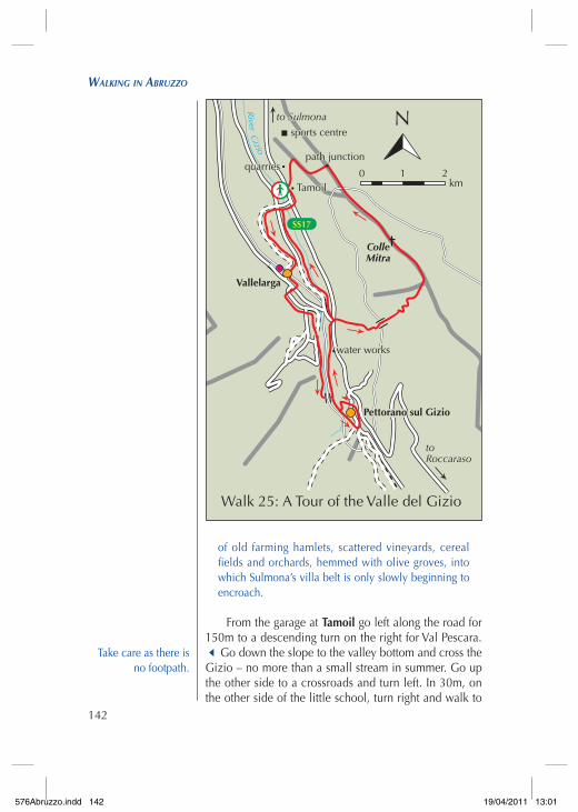
From the garage at tamoil go left along the road for 150m to a descending turn on the right for Val Pescara. 3Go down the slope to the valley bottom and cross the Gizio – no more than a small stream in summer. Go up the other side to a crossroads and turn left. In 30m, on the other side of the little school, turn right and walk to
Take care as there is no footpath.
Walk 25: A Tour of the Valle del Gizio
quarriespath junction
water works
sports centre
Vallelarga
Pettorano sul Gizio
Tamoil
SS17
River
Gizio
quarriespath junction
Tamoil
sports centre
to Sulmona
toRoccaraso
ColleMitra
Walk 25: A Tour of the Valle del Gizio
Pettorano sul Gizio
to Sulmona
water works
km
N
1 20 1 20km
N
576Abruzzo.indd 142 19/04/2011 13:01
143
Walk25–atouroftHevalledelgizio
the old farming hamlet ahead.4Pass through the houses and turn left to join Contrada Casa La Rocca – one of the main lanes through the valley – which arrives on your right.
Walk south-east for about 1.5km, continuing past a right turn where dog kennels may provide a brief noisy interlude. Take the next turn right onto an unsealed lane that leads, in a large ‘S’, to the abandoned Vallelarga train station. Cross the line and turn left. In 100m go left again, then in another 250m turn right to rise to the main road. Turn right, then quickly take the first left. Climb the slope to a fig tree at a junction. Turn left to face south-east and continue the journey up the valley. Walk for 500m to a T-junction with a new house on the corner.
Turn left and go downhill for 50m to a lane on the right. Go down the lane across a field. Keep right at the metal pylon and then go up right to a smaller concrete pylon. Follow the track through olive trees until it joins
The alternative return route, avoiding Colle Mitra, rejoins the main route at this point.
Pettorano sul Gizio
576Abruzzo.indd 143 19/04/2011 13:01

144
Walkinginabruzzo
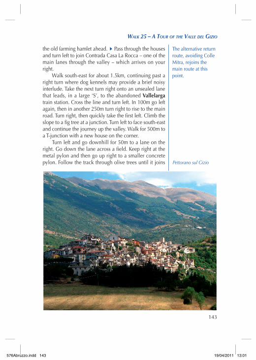
a 4x4 road on the right. Go left along the road for about 500m to a junction.3Turn left, downhill, to cross the swiftly flowing canal that feeds the waters of the Gizio into the valley’s irrigation network. Follow the path to find yourself above the railway line as Pettorano comes finally into view.
The valley is a major communication route through central Italy. The picturesque mountain railway linking Sulmona with Naples runs to the far end before turning back to climb the steep north-eastern flank below the strategic hill of Colle Mitra. The SS17 ‘Abruzzo high-way’ also runs through and climbs stilted hairpins to gain the plain.
The path runs alongside the line then descends beneath an arch to a junction. Turn right and walk to the road below Pettorano. Opposite is the entrance to the archaeological park. If it is open go in to see the fine restored water mills and then find a way onto the lane on
You can reach this same point by turning
right at the junction with the new house and then left down
a lane.
Summer in the Valle del Gizio
576Abruzzo.indd 144 19/04/2011 13:01
145
Walk25–atouroftHevalledelgizio
the left that climbs to the village. You can also join this lane just past the park entrance. Find your way up steps and alleys to the cas-tle at the top of the village.
Turn back to wander down the main street along the spine of Pettorano sul gizio. Pass through narrow alleys to the lower end of the village and a piazza with a bar next to the road. Walk round the hairpin and down the road for 50m. Go down steps on the left and follow the path back left past houses to the church on another hairpin. Go left down a side-road signposted for the nature reserve and pass the Carabinieri. Arrive back at the River Gizio and turn right to retrace your steps to the railway-arch junction. Don’t go up to it, but continue alongside the river to a water works. Go on past a reservoir (empty) on the right to reach the road. Turn right to the SS17 and then turn left to a lay-by on the left. A snack van is often in residence.
If you don’t want to climb Colle Mitra, go left from the lay-by on an unsealed road past the trattoria. Take the first unsealed lane on the right and walk down the lane, keeping right at a fork, all the way back to the school building. From here, retrace your steps to the start point.
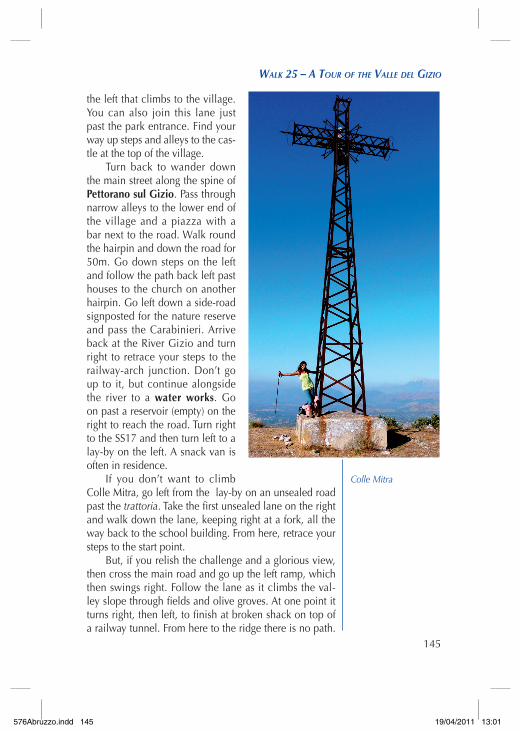
But, if you relish the challenge and a glorious view, then cross the main road and go up the left ramp, which then swings right. Follow the lane as it climbs the val-ley slope through fields and olive groves. At one point it turns right, then left, to finish at broken shack on top of a railway tunnel. From here to the ridge there is no path.
Colle Mitra
576Abruzzo.indd 145 19/04/2011 13:01

146
Walkinginabruzzo
Climb the dry valley ahead, north-eastwards. It soon steepens, requiring a relentless slog to the top. Aim for the left-hand side of the valley headwall. Finally the top and the views arrive. Turn north-west (left) and follow the ridge across the shallow saddle and then up to the giant iron cross on Colle Mitra. The view down to Sulmona and across the basin is tremendous – worth every drop of sweat to see it!
Descend the ridge north-west from the cross, enjoy-ing the wonderful prospect. After passing trees on the right the path bears left to join a larger path ascending from Sulmona. Turn right onto it and pass over the rail-way line (which runs through a tunnel beneath your feet). Descend towards Sulmona sports centre.
At a signed junction, turn left onto a side-path and descend to cross the small valley. The path climbs and leads on, beneath power lines, towards old quarries. At a junction above the quarry, turn left. The path then swings back left and descends obliquely out onto the hillside. At a hairpin back right, leave the path and take a direct line to the Tamoil garage plainly visible below. Go easy on the steep scree. There is no path.
Cross the irrigation canal by a green bridge behind the garage and head into the car park. With luck, the café will still be open!
576Abruzzo.indd 146 19/04/2011 13:01