wellington central city green network plan
TRANSCRIPT

1
Wellington Central City
Ko te hiahia kia piripono kia PapatūānukuWe want nature to be a part of our lives.
Green NetworkPlan
Draft 27.10.2021
2
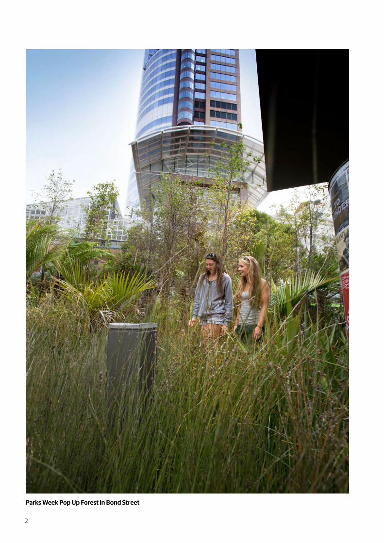
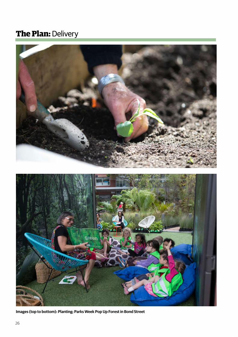
Parks Week Pop Up Forest in Bond Street

ContentsIntroduction 4-5
Central City Layers 6-7
Vision / Objectives / Targets 8-9
The Benefits 10-11
Opportunities 15
Challenges 17
Green Cover 19
The Current Status of Greening 14-19
The Objectives 20-21
A Continuum of Diverse Green Spaces 22-23
Enhancing and Greening Existing Public Spaces 24-25
Delivery 26-27
The Plan 20-27
Appendix 1 - History of Greening in the Central City 30-31
Appendix 2 - Our City Tomorrow Alignment 34-35
The Context 12-13
Appendix 3 - Green Space Types & Case Studies 38-59
Work Cited 62-63
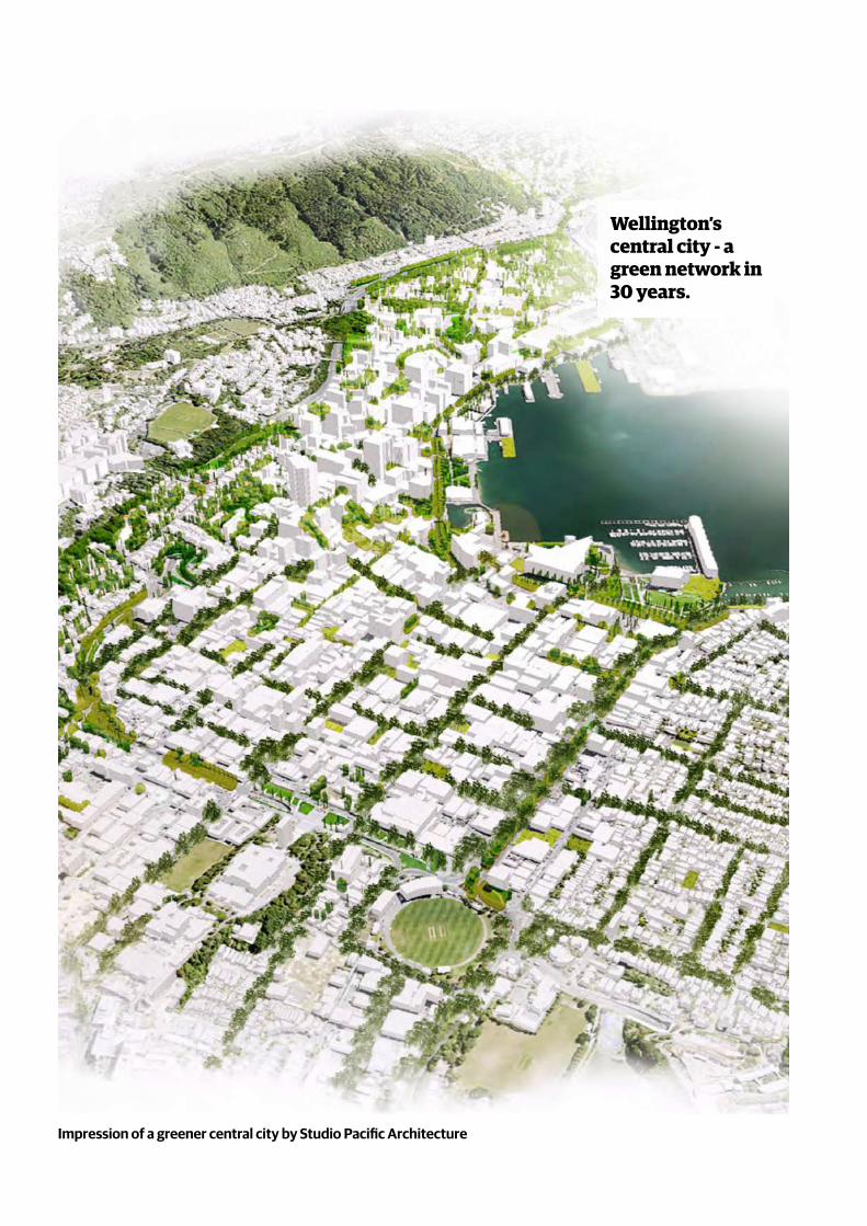
Impression of a greener central city by Studio Pacific Architecture
Wellington’s central city - a green network in 30 years.

5
The central city is dominated by buildings, large areas of asphalt and paving. Streets are vehicle dominated, with large areas of car parking. The original vegetation has gone, the streams only exist in pipes. This has resulted in a deficit of green space in the central city for current users and residents. There is a need to further green the central city.
As Wellington changes and grows, with greater numbers of people visiting and living in the central city, there is a need to further treasure, celebrate, grow and manage the green network, with support from the blue network.
A diversity of green spaces, trees and plants that can be accessed and viewed is critical to people’s wellbeing. Plants play a crucial role in sustaining a healthy environment and mitigating climate change.
Green and blue elements should be part of all development whether it is new infrastructure, transport and/or a building project. There is need to ensure the city continues to build on its liveability and ‘eco-credentials’.
A network of green spaces, trees and planting in the central city will contribute to Wellington’s aspirations for social, economic, cultural and environmental wellbeing and have benefits at different scales.
The Green Network Plan sets the direction and targets for how we green Wellington’s central city in the next 30 years to address the current deficit, provide for growth and to address the climate and ecological emergency declared in 2019.
Global:
Climate change mitigation and adaptation.
City:
A beautiful and connected central city.
People:
Individual health and wellbeing.

6
The Green NetworkParks, trees & planting
connecting the city
The Blue NetworkThe streams & harbour
The Built EnvironmentThe buildings, structures & hard surfaces
Central City Layers

7
The green network is the plants – the trees, shrubs, gardens and grass that ‘green’ and connect the city. These green elements can occur in all sorts of places, in both public and private ownership. These places include streets, parks, plazas, laneways, carparks, community gardens, roofs and even walls of buildings.What is the Blue Network? The blue network supports the green network and is the system that captures water, it consists of ground water, streams, waterways, wetlands and pipes. It is symbiotic with the green network as plants need water to survive and thrive. The management of stormwater and the quality of water is critical. Permeable surfaces (unpaved) allow rain to drain naturally into the ground. In conjunction with water sensitive urban design (WSUD) alternatives, these are alternatives to piping water.
What is the Green Network Plan? This Plan proposes a well-developed continuum of green spaces to deliver the many ecological, social, economic, cultural and public health benefits to the central city, enhancing its liveability for existing residents, workers and visitors and also the growing numbers of new residents.
To optimise the benefits, the green network needs to be:
well distributed and highly inter-connected across the central city (spatial)
of adequate area (quantitative) of suitable quality (qualitative) in public
and private ownership.
This Plan builds on the current status of ‘green’ in the central city, and proposes that investment and change is required to meet future demand. The distribution, quantity and quality of what exists, what is needed and where the opportunities are for improvement are all considered.
Delivering the green network will require:
increased and ongoing investment to treasure, celebrate, grow and manage the city’s plant life
adequate protection and provision of public open space where significant parts of the green network should be located
collaborating with other landowners to allow the green network to spread and flourish right across the city.
This document is non-statutory. It is intended to be used to direct green network investment and prioritisation, which will be done through the Green Network Plan Implementation Framework.

8
Thinking and living green in Wellington’s central city, is the future for the planet and all of us.
Vision
“Urbanisation and climate change call for new solutions to maintain and improve the quality of life in our cities. Public green space has a positive effect on biodiversity, climate, wellness and air quality (Green Cities).”
Why
A multi-pronged approach that works at different levels is mandated to be delivered through the following objectives.
Objectives
TREASURE and protect
what is important
CELEBRATEthe value of green with
partners
GROWthe number
trees and public green
MANAGEwhat we create and
what we already have really well
This will be done through a continuum of green spaces including:
Parklets
UrbanParks
DestinationParks
Laneways
Streets
Public /Private SpacesPrivateSpaces
Community gardensGreen roofs
Green walls
Which contain green elements:
Trees Shrubs Gardens GrassAll supported by blue network elements which are often delivered through water sensitive urban design (WSUD).
This will lead to a thriving green capital city framed by the harbour and hills, composed of interconnected and cohesive neighbourhoods that support people to lead healthy
9
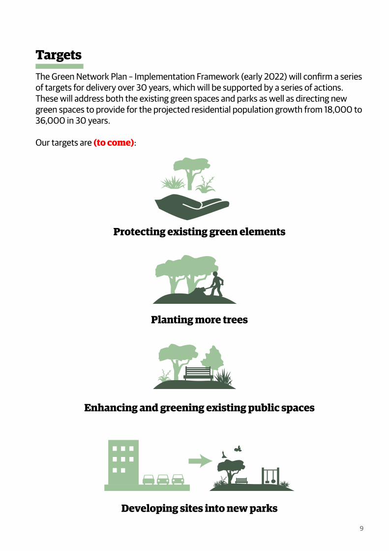
The Green Network Plan – Implementation Framework (early 2022) will confirm a series of targets for delivery over 30 years, which will be supported by a series of actions. These will address both the existing green spaces and parks as well as directing new green spaces to provide for the projected residential population growth from 18,000 to 36,000 in 30 years.
Our targets are (to come):
Protecting existing green elements
Planting more trees
Enhancing and greening existing public spaces
Developing sites into new parks
Targets
Store and �lter rainwater to reduce pressure on stormwater infrastructure.
Increased property values.
Improved public health & reduction in health care costs.
Sequestercarbonemissions.
Improve and create habitat for biodiversity.
Promote healthy active lifestyles.
Nature’s beauty and inspiration close by.
Places to relax,play and have fun.
Places for community buildingthrough social interactions.
Places of refuge thatenhance communityresilience.
Connect people to nature.
Economic bene�t ofbeing able to live, workand visit a green city.
Water sensitive urban design for climate adaption & to improve water quality.
10
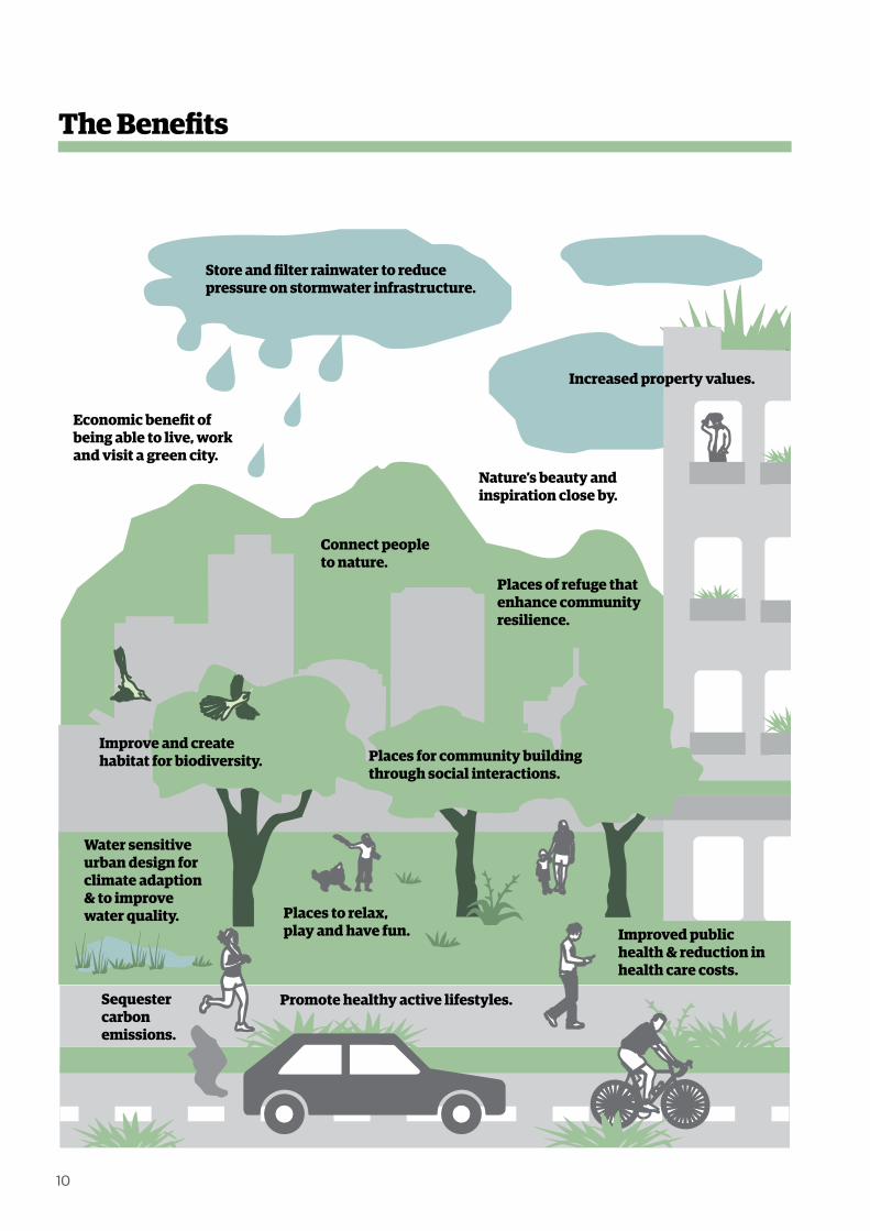
The Benefits

11
“Urban green space is a necessary component for delivering healthy, sustainable and liveable cities (The World Health Organisation 2017).”
Benefits of a green network
It is recognised that daily contact with nature is fundamental to good urban living. There is an ethical responsibility to conserve nature in the city as part of the shared global habitat for all life. Nature can be woven through cities in many ways – from wild biodiversity in large open spaces to gardens and individual trees in largely built areas, such as the central city. Research shows that plentiful green elements in urban environments bring many benefits to a good quality of life for residents and a healthy environment. Wellington is one of the founding cities in the Biophilic Cities Network.
Nature’s services Nature provides ‘ecosystem services’ that are fundamental to health, wellbeing and survival. Ecosystem services include the provision of air, water, fertile soils, nutrient recycling and energy all to support plants. Ecosystem services can also help mitigate against climate change. Trees, for instance, help offset emissions by storing carbon, regulate runoff during heavy rain and reduce the summer ‘heat sink’ effect by shading heat-absorbing built surfaces. They help reduce the impact of some of the unwanted outcomes of urban development. For example, air pollution.
Green and built elements need to be interwoven to ensure the benefits of both are realised.
People’s health and wellbeing Many of the mental and physical health and wellbeing benefits we derive from urban open spaces are provided by nature, either directly or indirectly.
People tend to be more active in green spaces and this is linked to improved physical health, such as reduced diabetes, cardiovascular disease and mortality. Experience of nature in open spaces also correlates with improved mental health and creative thinking, and reduced anxiety and stress. Time in a green place provides an opportunity to have a break from intense periods of focused attention in indoor environments and recharge. Nature is often a source of new ideas.
The social interactions that occur in public green spaces can also help people connect socially, with improved sense of belonging and well-being. Collectively, these individual benefits bring wider public health and social benefits, such as reducing costs on our health systems and helping bring communities together.

12
Key:
Te Atakura
Wellington City Council
Vibrant &Prosperous
Compact ResilientInclusive &Connected
GreenerMana WheunaPartnerships
Community Outcomes
Planning for Growth
Public SpaceDesign Policy 2010
Planning for Growth
Economic DevelopmentStrategy
Aho TiniStrategy
Wellington DesignManual
Green Network Plan
Community FacilitiesPolicy 2010
Accessible WellingtonAction Plan 2019
Sustainable FoodPlan
Wellington ResilienceStrategy
Our Natural CapitalBiodiversity Strategy
Our Capital SpacesOpen Space Strategy
Heritage Strategy
Play SpacesPolicy 2010
Te Tauihu MāoriAction Plan
Social Wellbeing Economic Wellbeing Cultural Wellbeing Environmental Wellbeing
District Plan
Asset ManagementPlans
PōnekePromise
CyclewaysProgramme
LanewaysProgramme
Central CityGreening
Our Place Project
HousingStrategies
Build BackBetter
TransportProjects
Let’s GetWellington Moving
Strategic Programme
Liveability
Access
Carbon emissions andmode shift
Safety
Resilience
Gehl Public Space& Public Life Study
2021
Te Tiriti o WaitangiEnabling legislations – Local Government Act 2020, Resource Management Act 1991
Mem
oran
da o
f Und
erst
andi
ng w
ith m
ana
whe
nua
Publ
icD
eliv
ery
Stra
tegi
es/P
lans
/Pol
icie
s G
oals
Let’s Get WellingtonMoving (LGWM)
CityStreets
Mass RapidTransport
GoldenMile
Hutt Road /Thorndon Quay
Stategic
Highways
SaferSpeeds
Under development/being reviewed
GNP will support this strategy/policy/delivery outcome.
GNP will in�uence this strategy/policy/delivery outcome.
Public Space Delivery
Priv
ate
Reg
ulat
ion
Central CityFramework
Wellington WaterfrontFramework
Water SensitiveUrban Design guide
TeNgakau
Design Guides
This Plan is part of a suite of Council strategies and polices which are inter-related.
The Context
The hierarchy of overarching city goals and major strategies, policies and bylaws that the Green Network Plan will support or influence.

13
The Central City Framework 2010“Make our streets green – Wellington’s streets will become greener and more attractive through a combination of planting, new and upgraded inner-city parks and intiatives such as ‘stream streets’ and wetlands in our city open spaces.” “The development of a legible green network of spaces and links. This will include vegetation and systems both within public spaces such as streets and parks and also look at how private development can play a role.”
The Wellington Waterfront Framework 2001The Framework directs the management of the Waterfront. It proposes two large green parks – Waitangi Park and Frank Kitts Park. Key principles include:
“Ecological values of the waterfront will be maintained, bearing in mind that this is a highly modified environment.
There will be a variety of open spaces – some green, some sheltered and some paved.”
Our City Tomorrow: Spatial Plan for Wellington City 2021“Action 3.33 - Develop a Green Network Plan for the Central City and investigate opportunities to expand the green network beyond the central city to establish forests to sequester carbon”
Te Atakura - First to ZeroMove 1: Support the transition towards higher-density development by ensuring residents will still derive the benefits of being close to nature within a compact city.
Move 7: Protect and enhance the domain of Tāne by integrating an increased green network across the central city, with its biodiversity and ecosystem services (including carbon sequestration and investing in green infrastructure to help.
Wellington 2021 Public Space Public Life Study – Gehl Architects The first of 4 key moves promotes “green and blue -working with the unique natural assets
and amenities -can make Wellington an even greener, resilient and more sustainable city.”
Our Capital Spaces, open space and recreation strategy for WellingtonThe four outcomes of the strategy are: (i) getting everyone active and healthy; (ii) protecting our birds, nature, streams and landscapes; (iii) contributing to Wellington’s outstanding quality of life; and (iv) doing it together.
Our Natural Capital 2015 Wellington’s indigenous biodiversity strategy and action plan aims to protect and restore indigenous biodiversity, connect people to nature and foster their sense of kaitiakitanga – weaving nature through the city.
Contribute to Objective 3.1.1 to ensure all Wellingtonians encounter nature on a daily basis; specifically through actions (a), (c) and (g) to increase native planting, increase the number of large trees and install green roofs and walls in the central city.
Green Space in Wellington’s Central City – Blaschke et al 2019 The report analysed the provision of public green space in central Wellington City in relation to current and projected future population levels. Key conclusions that came out of this were:
“Green space amount per capita in central Wellington City declines substantially - by half on average - when projected population growth to 2043 …. is considered.”
Increasing the total amount, accessibility and quality of green space in the central city will need to be achieved in order to accommodate future population growth and fulfil a vision of “central city green spaces that enhance community and ecosystem health.”
The following strategies, plans and studies all direct the development of the Plan:

Legend
Central city green network area
Pukeahu
Waitangi Park
Basin Reserve
Te Aro Park
Glover Park
Cobblestone Park
Midland Park
Frank Kitts Park
Katherine Mans�eld Park
Parliament Grounds
Railway Station Forecourt
Ahumairangi (Tinakori Hill)
Mount Victoria Town Belt
Te Ngākau Civic Square
Mount Cook
Central Park
Wellington Botanic Garden
Raurimu KaingaTiakiwai Stream locality
Tiakiwai Kainga
Te rae Kaihau
Pipitea Pa
Pipitea Marae
Kumutoto Kainga
Te Aro Kainga
Waitangi Lagoon
0 500m
Legend
Central city green network area
Parks
Maori Sites of Signi�cance
Historic Streams
1840 shoreline
14
Thorndon/Pipitea This is an area of two halves- the area to the west is a mixed use area that includes the main capital city functions such as Parliament. There are private gardens, semi-public green spaces around schools and churches and public green spaces such as the Parliamentary grounds. Together with the proximity of Te Ahumairangi, there is a significant feeling of green. This contrasts with the industrial activities within the rail yards and CentrePort which is disconnected from the rest of the city. It contains little or no green.
Wellington CentralThe commercial and business heart of the city, which is characterised by denser development with a pronounced concentration of multi-storey high-rise buildings in the area between Parliament and Te Ngakau – Civic Square.
The quantity and quality of trees and planting is relatively low with green public spaces focused on the Waterfront, the Quays and along Lambton Quay.
Te AroA mix of uses - from bars and restaurants through to small professional businesses, larger format retail operations and residential apartments. The city’s main entertainment district is around Courtney Place. It is also an area of change with a large number of residential developments being undertaken.
While there are the destination parks – Waitangi to the north and Pukeahu to the south, there is a lack of green especially within the eastern part. Te Aro however, has the greatest potential for greening due to amount of under-developed land.
The Current Status of Greening
15
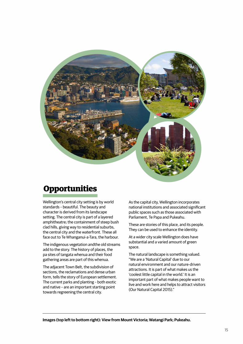
Wellington’s central city setting is by world standards – beautiful. The beauty and character is derived from its landscape setting. The central city is part of a layered amphitheatre; the containment of steep bush clad hills, giving way to residential suburbs, the central city and the waterfront. These all face out to Te Whanganui-a-Tara, the harbour.
The indigenous vegetation andthe old streams add to the story. The history of places, the pa sites of tangata whenua and their food gathering areas are part of this whenua.
The adjacent Town Belt, the subdivision of sections, the reclamations and dense urban form, tells the story of European settlement. The current parks and planting – both exotic and native – are an important starting point towards regreening the central city.
As the capital city, Wellington incorporates national institutions and associated significant public spaces such as those associated with Parliament, Te Papa and Pukeahu.
These are stories of this place, and its people. They can be used to enhance the identity.
At a wider city scale Wellington does have substantial and a varied amount of green space.
The natural landscape is something valued. “We are a ‘Natural Capital’ due to our natural environment and our nature-driven attractions. It is part of what makes us the ‘coolest little capital in the world.’ It is an important part of what makes people want to live and work here and helps to attract visitors (Our Natural Capital 2015).”
Opportunities
Images (top left to bottom right): View from Mount Victoria; Watangi Park; Pukeahu.
16
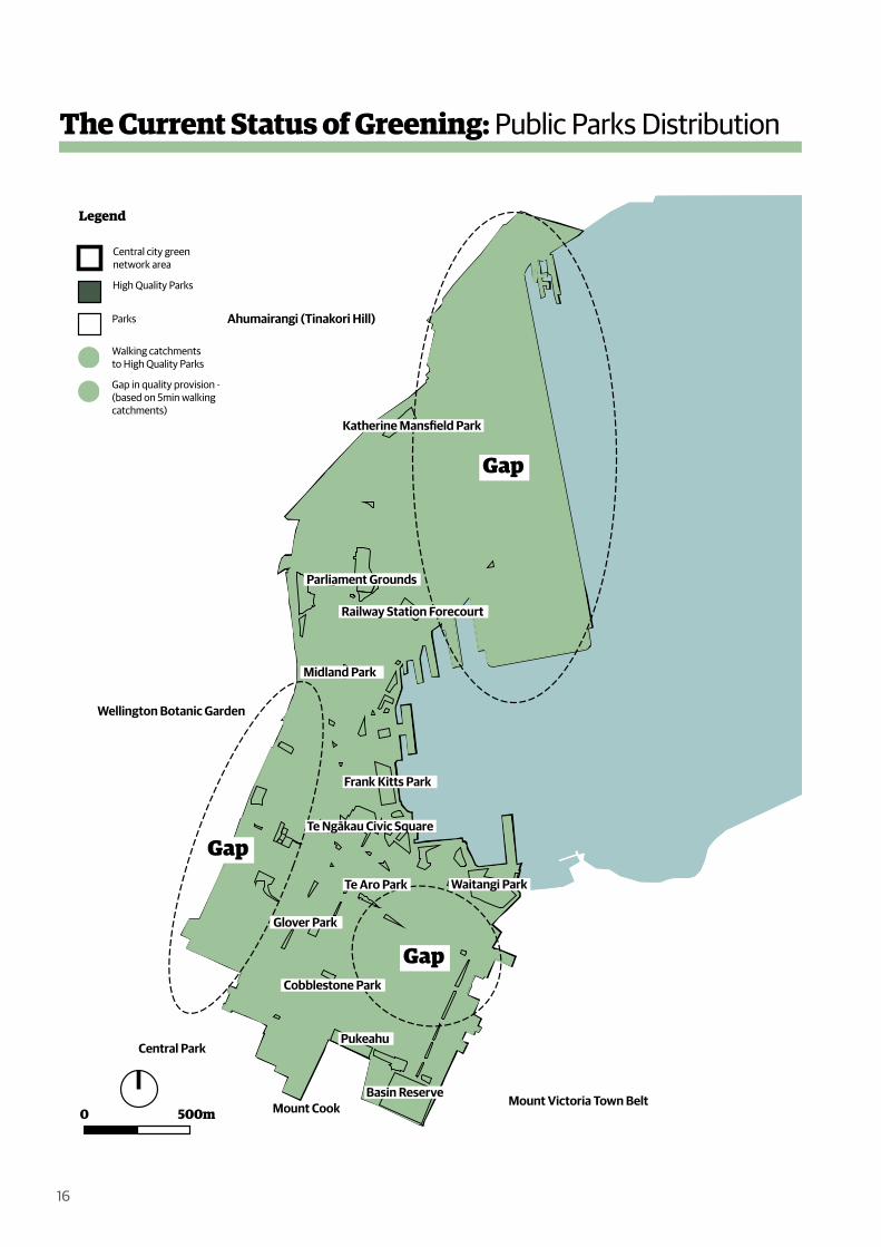
The Current Status of Greening: Public Parks Distribution
0 500m
Legend
Central city green network area
High Quality Parks
Parks
Walking catchments to High Quality Parks
Gap in quality provision - (based on 5min walking catchments)
Pukeahu
Waitangi Park
Basin Reserve
Te Aro Park
Glover Park
Cobblestone Park
Midland Park
Frank Kitts Park
Katherine Mans�eld Park
Parliament Grounds
Railway Station Forecourt
Ahumairangi (Tinakori Hill)
Mount Victoria Town Belt
Te Ngākau Civic Square
Mount Cook
Central Park
Wellington Botanic Garden
0 500m
.
Gap
Gap
Gap

17
The total central city is 444.5ha. Just over 9% or 41.25ha can be considered as green spaces.
These green spaces are made up of:
43% public parks 24% road reserves 33% privately owned
The central city is car focused, with approximately 11% of the central city dedicated to car parking/parking lots (note this does not include on-street parking or roads/streets).
The central city has a deficit of green space for the current residents, workers and visitors. This will be further exacerbated by the population growth which is projected to double from 18,000 to 36,000 over 30 years.
Central city living means more public green spaces are needed for people to use in a wide variety of ways – in addition to the ‘wilder’ hilltop parks of the nearby Wellington Town Belt. People thrive in cities where greening (in all it’s forms) is part of the urban fabric. Space needs to be deliberately allocated for this purpose.
Climate change and natural disasters bring a vulnerability; storms, flooding, earthquake induced liquefaction, tsunami and plant disease all need to be considered.
The central city has a fragmented green space network with minimal cohesion and limited areas of ecological focus. There are significant gaps within the open space catchment, especially through Pipitea and Te Aro. There is also a significant lack of street tree planting which hinders greater connectivity between green parks, the Town Belt, Wellington Botanic Garden ki Paekākā and the Waterfront.
Current green spaces are of mixed quality and need to support a more diverse range of uses and ecological needs. Currently there is minimal tree protection for central city trees.
There are few incentives or requirements for private development contributions to the city’s green network.
Due to the topography and the prominence of the Town Belt, there can be a skewed perception of how green the central city is.
Challenges
Images (top left to bottom right): Wellington Motorway, Wellington Central City Apartment Dwellers; Wellington Central City Population.

0 500m
Thorndon/Pipitea
WellingtonCentral
Te Aro
Legend
Central city green network area
Tree Canopy
Garden Bed
Grass
0 500m
18
The Current Status of Greening: Green Cover
Thorndon / Pipitea
Wellington Central
Te Aro
1% 1%
GrassGarden bed
4.42%
Tree canopy
2% 4%
GrassGarden bed
7.09%
Tree canopy
2% 2%
GrassGarden bed
5.05%
Tree canopy
Central City Overall
2% 2%
GrassGarden bed
5.12%
Tree canopy
12% Permeability of public realm
19
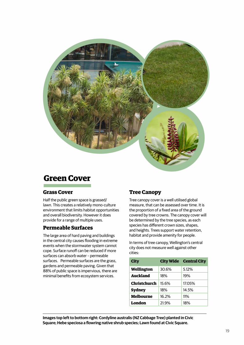
Grass CoverHalf the public green space is grassed/lawn. This creates a relatively mono-culture environment that limits habitat opportunities and overall biodiversity. However it does provide for a range of multiple uses.
Permeable SurfacesThe large area of hard paving and buildings in the central city causes flooding in extreme events when the stormwater system cannot cope. Surface runoff can be reduced if more surfaces can absorb water – permeable surfaces. Permeable surfaces are the grass, gardens and permeable paving. Given that 88% of public space is impervious, there are minimal benefits from ecosystem services.
Tree CanopyTree canopy cover is a well utilised global measure, that can be assessed over time. It is the proportion of a fixed area of the ground covered by tree crowns. The canopy cover will be determined by the tree species, as each species has different crown sizes, shapes, and heights. Trees support water retention, habitat and provide amenity for people.
In terms of tree canopy, Wellington’s central city does not measure well against other cities:
Green Cover
City City Wide Central City
Wellington 30.6% 5.12%Auckland 18% 19%
Christchurch 15.6% 17.05%Sydney 18% 14.5%Melbourne 16.2% 11%London 21.9% 18%
Images top left to bottom right: Cordyline australis (NZ Cabbage Tree) planted in Civic Square; Hebe speciosa a flowring native shrub species; Lawn found at Civic Square.
20
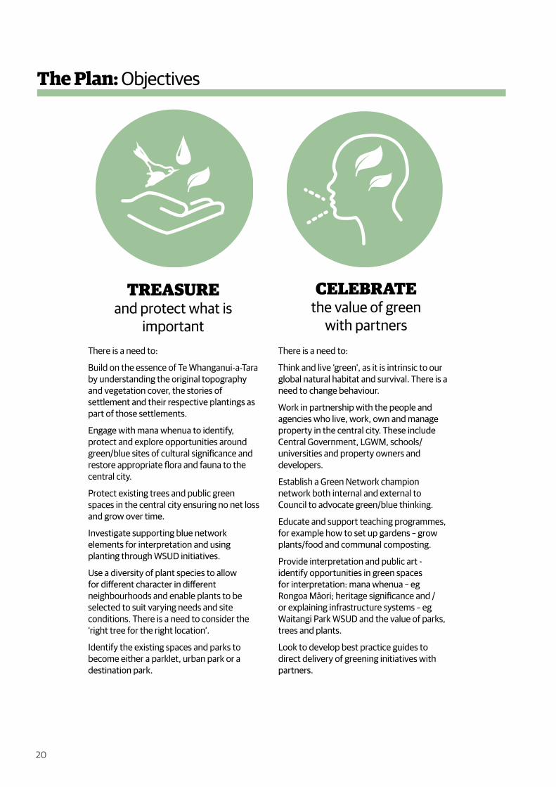
The Plan: Objectives
TREASUREand protect what is
important
CELEBRATEthe value of green
with partnersThere is a need to:
Build on the essence of Te Whanganui-a-Tara by understanding the original topography and vegetation cover, the stories of settlement and their respective plantings as part of those settlements.
Engage with mana whenua to identify, protect and explore opportunities around green/blue sites of cultural significance and restore appropriate flora and fauna to the central city.
Protect existing trees and public green spaces in the central city ensuring no net loss and grow over time.
Investigate supporting blue network elements for interpretation and using planting through WSUD initiatives.
Use a diversity of plant species to allow for different character in different neighbourhoods and enable plants to be selected to suit varying needs and site conditions. There is a need to consider the ‘right tree for the right location’.
Identify the existing spaces and parks to become either a parklet, urban park or a destination park.
There is a need to:
Think and live ‘green’, as it is intrinsic to our global natural habitat and survival. There is a need to change behaviour.
Work in partnership with the people and agencies who live, work, own and manage property in the central city. These include Central Government, LGWM, schools/universities and property owners and developers.
Establish a Green Network champion network both internal and external to Council to advocate green/blue thinking.
Educate and support teaching programmes, for example how to set up gardens – grow plants/food and communal composting.
Provide interpretation and public art - identify opportunities in green spaces for interpretation: mana whenua – eg Rongoa Māori; heritage significance and /or explaining infrastructure systems – eg Waitangi Park WSUD and the value of parks, trees and plants.
Look to develop best practice guides to direct delivery of greening initiatives with partners.
21
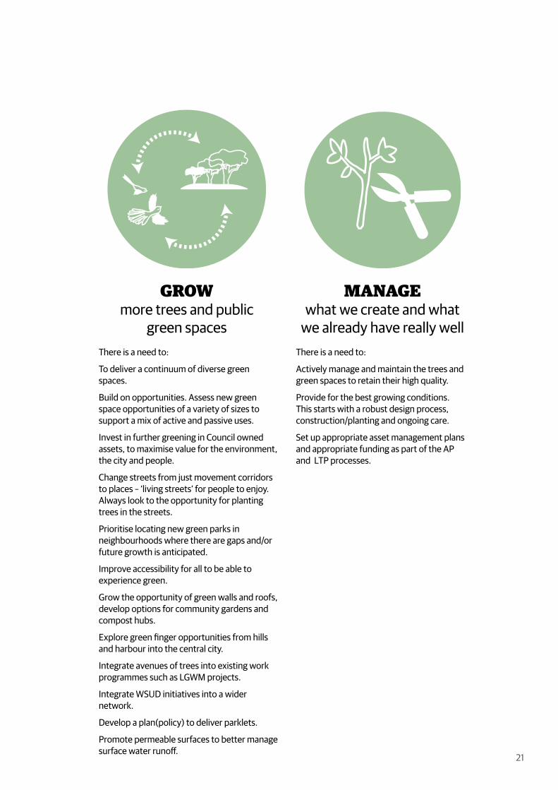
GROWmore trees and public
green spaces
MANAGEwhat we create and what
we already have really wellThere is a need to:
To deliver a continuum of diverse green spaces.
Build on opportunities. Assess new green space opportunities of a variety of sizes to support a mix of active and passive uses.
Invest in further greening in Council owned assets, to maximise value for the environment, the city and people.
Change streets from just movement corridors to places – ‘living streets’ for people to enjoy. Always look to the opportunity for planting trees in the streets.
Prioritise locating new green parks in neighbourhoods where there are gaps and/or future growth is anticipated.
Improve accessibility for all to be able to experience green.
Grow the opportunity of green walls and roofs, develop options for community gardens and compost hubs.
Explore green finger opportunities from hills and harbour into the central city.
Integrate avenues of trees into existing work programmes such as LGWM projects.
Integrate WSUD initiatives into a wider network.
Develop a plan(policy) to deliver parklets.
Promote permeable surfaces to better manage surface water runoff.
There is a need to:
Actively manage and maintain the trees and green spaces to retain their high quality.
Provide for the best growing conditions. This starts with a robust design process, construction/planting and ongoing care.
Set up appropriate asset management plans and appropriate funding as part of the AP and LTP processes.
GreenCorridor
Harbour
StreetTree
GreenRoof
WaterfrontBalcony
GreenWall
PrivateGarden
Balcony
Entry Garden
Wellington Town Belt
Urban Park
Parklet
22
The Plan: Continuum of diverse green spaces
In 30 years the population will double with more people in higher density living. This density needs to be done well which includes accessing and being able to view greenery.
This plan directs a continuum of public and private green and open spaces to provide for a diversity of uses. Public parks are important as they are accessible to all and can be of sufficient area to provide multiple community and environmental benefits, and provide a green character in a neighbourhood. The open spaces where green and blue elements can flourish, are not just confined to public parks. The street network and private land also hold potential for more green elements.
The quality and diversity of greening is critical to allow people to enjoy green spaces that are safe and attractive while providing for good access and amenities. Enabling the right balance of green and open spaces is vital to support a variety of housing typologies and neighbourhoods to cater for a broad range of people throughout all stages of their lives.
Destination ParkA large park that given its
size can be multi-functional but may have a primary function that delivers a
particular social, cultural or recreational use.
Medium sized green spaces offering a variety of amenities for an associated neighbourhood. An
‘urban backyard’ for residents. Critical in areas of change.
Small urban spaces. Location is opportunistic -temporary or
permanent. Relates to immediate surroundings and uses. Likely to be
part of road reserve.
GreenCorridor
Harbour
StreetTree
GreenRoof
WaterfrontBalcony
GreenWall
PrivateGarden
Balcony
Entry Garden
Wellington Town Belt
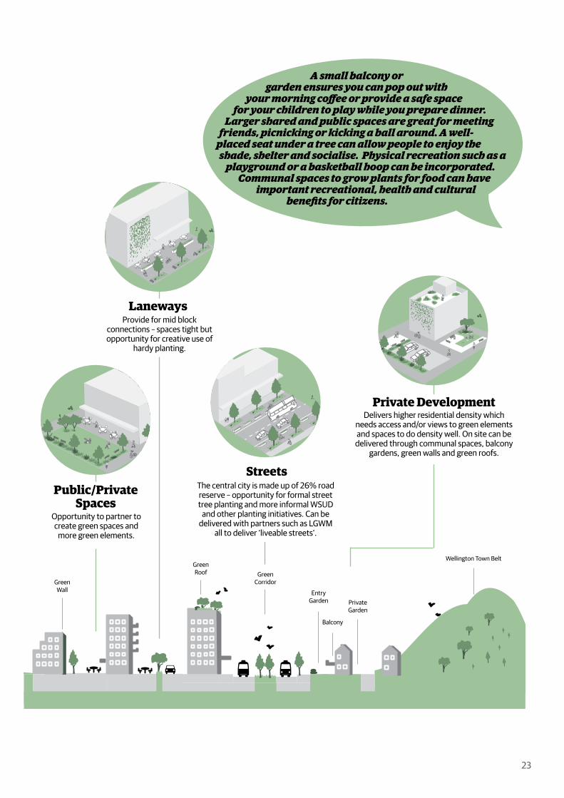
Public/Private Spaces
Laneways
23
A small balcony or garden ensures you can pop out with
your morning coffee or provide a safe space for your children to play while you prepare dinner.
Larger shared and public spaces are great for meeting friends, picnicking or kicking a ball around. A well-
placed seat under a tree can allow people to enjoy the shade, shelter and socialise. Physical recreation such as a
playground or a basketball hoop can be incorporated. Communal spaces to grow plants for food can have
important recreational, health and cultural benefits for citizens.
Streets
Private DevelopmentDelivers higher residential density which
needs access and/or views to green elements and spaces to do density well. On site can be
delivered through communal spaces, balcony gardens, green walls and green roofs.
The central city is made up of 26% road reserve – opportunity for formal street tree planting and more informal WSUD
and other planting initiatives. Can be delivered with partners such as LGWM
all to deliver ‘liveable streets’.
Provide for mid block connections – spaces tight but opportunity for creative use of
hardy planting.
Opportunity to partner to create green spaces and
more green elements.

0 500m
Legend
Central city green network area
Proposed Destination Parks
Proposed Urban Parks
Proposed Parklets
1
43
36
4
20
23
27
33
41
3032
37
44
39
34
40
26
38
3
2
7
10
6
14
15
35
12
1817
13
29
21
31
8
24
5
45
42
25
11
19
16
9
28
22
24
The Plan: Enhancing and greening existing public spaces
Existing spaces / parks identified to evaluate further the opportunity to become either a parklet, urban park or a destination park.

25
Spaces ProposedType
1 Katherine Mansfield Memorial Park
Urban Park
2 Magyar Millennium Park Urban Park3 CentrePort Park Urban Park4 NZ Parliament Grounds Destination Park5 Bolton Street Cemetery Urban Park6 Bolger Park Urban Park7 Waititi Landing (ANZAC Corner) Urban Park8 Railway Station Forecourt Urban Park9 Alexander Turnbull House Lawn Parklet10 The Cenotaph - War Memorial
ReserveUrban Park
11 Whitmore Plaza Parklet12 Midland Park Urban Park13 Kumutoto Park Urban Park14 Grey Street Pocket Square Urban Park15 Everton Terrace Park Urban Park16 Lambton/Featherston/Hunter
Plaza SpacesParklet
17 Post Office Square Urban Park18 Queens Wharf Open Spaces Urban Park19 Old Bank Plaza Parklet20 Frank Kitts Park Destination Park21 Terrace Tunnel Park - North Urban Park22 Bond Street Parklet23 Civic Square Destination Park
24 Taranaki St Wharf/Lagoon Area Urban Park25 Mount Street Parklet26 Flagstaff Hill / Terrace Gardens Urban Park27 Denton Park Urban Park28 Michael Fowler Centre Carpark Parklet29 Te Papa Perimetre Open Spaces Urban Park30 Clyde Quay Park Urban Park31 Terrace Tunnel Park - South Urban Park32 Volunteer Corner Urban Park33 Cuba Mall Urban Park34 Te Aro Park Urban Park35 Wakefield Street Park Urban Park36 Waitangi Park Destination Park37 Te Niho Park Urban Park38 Glover Park Urban Park39 Courtney Place Streetscape
Openspaces / West CourtenayUrban Park
40 Cobblestone Park Urban Park
41 Cambridge / Kent Terrace Median
Urban Park
42 Karo Drive Sculpture Park Parklet43 Pukeahu National War Memorial
ParkDestination Park
44 87 Kent Terrace Urban Park45 Basin Reserve Urban Park
Urban Park
Parklet
Destination Park
Size: <200m2Catchment: as opportunities arise
New parklets delivered through re-allocationof street or other smaller spaces.
Size: 200m2 – 3,000m2Catchment: about a 5min walk
New urban parks delivered throughstrategic land aquisition.
Size: Large, multi-functional park spaceCatchment: about a 15min walk
26
The Plan: Delivery
Images (top to bottom): Planting; Parks Week Pop Up Forest in Bond Street

27
“The overarching recommendation is to plan for, and adequately resource an increased amount, accessibility, and quality of green space in the central city, in order to provide for the health, wellbeing, amenity, and ecosystem benefits required by the likely significantly larger future population of the central city (Blaschke et al 2019)”.
The delivery occurs through the Green Network Plan- Implementation Framework.
The Green Network Plan and the Impementation Framework will
direct strategic and policy initiatives required to protect and embed green thinking into projects.
engage with operational projects and activites required to treasure, celebrate, grow and manage green initiatives.
co-ordinate relationship management to foster greening partnerships, collaboration and efficiencies within Council and with external stakeholders.
direct advocacy to promote greening, its benefits and related behaviour change.
It will be done by setting targets, actions and measurables. The actions are central to achieving the vision and objectives.
The Framework is a living document, which will be regularly reviewed and updated in the light of the changing context and:
will provide clarity around ownership of the Plan and resourcing to monitor and deliver outcomes
indicate broad estimates of investment - making explicit the actions that are fully or partly funded, those that will require new funding and referenced as part of the Annual Plan and Long Term Plan rounds.
will better connect greening outcomes to funding cycles including Development Contribution Policy. The Council will manage the green network as a key part of the central city’s infrastructure.

28

29
Appendix 1Green History of Wellington Central City
30
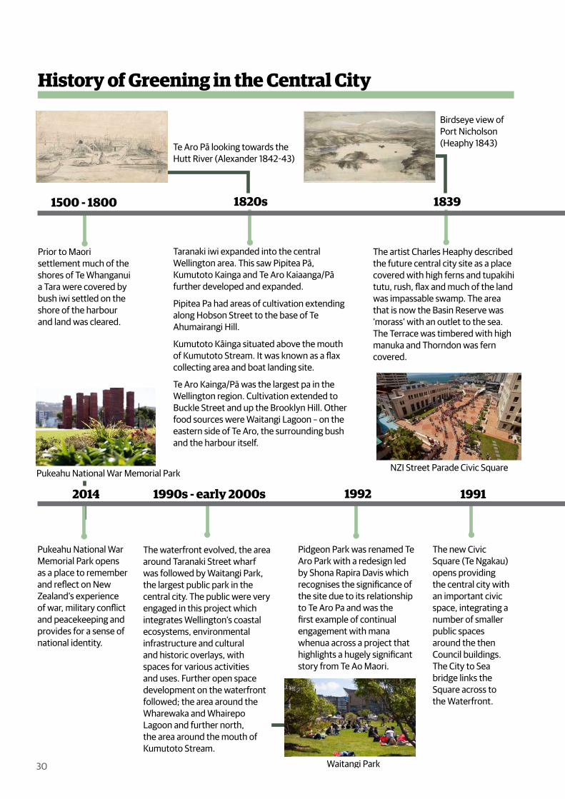
History of Greening in the Central City
Prior to Maori settlement much of the shores of Te Whanganui a Tara were covered by bush iwi settled on the shore of the harbour and land was cleared.
Taranaki iwi expanded into the central Wellington area. This saw Pipitea Pā, Kumutoto Kainga and Te Aro Kaiaanga/Pā further developed and expanded.
Pipitea Pa had areas of cultivation extending along Hobson Street to the base of Te Ahumairangi Hill.
Kumutoto Kāinga situated above the mouth of Kumutoto Stream. It was known as a flax collecting area and boat landing site.
Te Aro Kainga/Pā was the largest pa in the Wellington region. Cultivation extended to Buckle Street and up the Brooklyn Hill. Other food sources were Waitangi Lagoon – on the eastern side of Te Aro, the surrounding bush and the harbour itself.
1820s
The artist Charles Heaphy described the future central city site as a place covered with high ferns and tupakihi tutu, rush, flax and much of the land was impassable swamp. The area that is now the Basin Reserve was ‘morass’ with an outlet to the sea. The Terrace was timbered with high manuka and Thorndon was fern covered.
1839
The new Civic Square (Te Ngakau) opens providing the central city with an important civic space, integrating a number of smaller public spaces around the then Council buildings. The City to Sea bridge links the Square across to the Waterfront.
1991
The waterfront evolved, the area around Taranaki Street wharf was followed by Waitangi Park, the largest public park in the central city. The public were very engaged in this project which integrates Wellington’s coastal ecosystems, environmental infrastructure and cultural and historic overlays, with spaces for various activities and uses. Further open space development on the waterfront followed; the area around the Wharewaka and Whairepo Lagoon and further north, the area around the mouth of Kumutoto Stream.
1990s - early 2000s
Pukeahu National War Memorial Park opens as a place to remember and reflect on New Zealand’s experience of war, military conflict and peacekeeping and provides for a sense of national identity.
2014
Pidgeon Park was renamed Te Aro Park with a redesign led by Shona Rapira Davis which recognises the significance of the site due to its relationship to Te Aro Pa and was the first example of continual engagement with mana whenua across a project that highlights a hugely significant story from Te Ao Maori.
1992
1500 - 1800
Te Aro Pā looking towards the Hutt River (Alexander 1842-43)
Birdseye view of Port Nicholson (Heaphy 1843)
NZI Street Parade Civic Square
Waitangi Park
Pukeahu National War Memorial Park

31
Frank Kitts Park opened on the waterfront in 1976 on redundant Harbour Board land. Initially half the current size, it was expanded in the late 1980s in line with plans to open up the waterfront for the public. This started with a Civic Trust run public competition in 1982 for the future of the waterfront.
1970s
Midland Park was opened. The Council bought the Midland Hotel and had it
demolished. It was to be start of developing a series of public parks in the central city, which never transpired. Both Glover and Cobblestone Parks in Te Aro have further evolved.
1983
Given Wellington’s steep topography the Mein Smith survey laid out 1100 town acres covering Te Aro, Thorndon and The Terrace. The steep slopes adjacent to the flat areas became the open spaces – now the Town Belt, with limited public open spaces within what is now the central city. Two cemeteries adjacent to the central city were created, the larger Bolton Street Cemetery and the smaller Mount Street Cemetery for those of the Catholic faith.
1840
The bush on the surrounding hills was cleared and burnt, leaving a barren aspect from the harbour. Native bird life was drastically reduced. Reclamation was underway to support the mercantile businesses and port development with minimal thought of parks or public spaces.
1860s
The start of the urban motorway construction led to hundreds of houses demolished and the bisection of the Bolton Street cemetery with 3693 human remains needing to be reinterned. Katherine Mansfield Park was developed adjacent to the motorway.
1964
Pidgeon Park opened.
1900s
The Wellington Botanic Gardens were established, on the forested site that Te Atiawa from Pipitea Pa had used for food cultivation and native plant gathering.
1869
Relatively large scale commercial development occurred in the central city with very little green in Victorian Wellington. Private gardens were described as bare of trees with some kitchen gardens on larger sites.
Late 1800s
Plan of the town of Wellington (New Zealand Company 1840) Scene in the Botanical Gardens
(Unknown ca 1840)
Urban Motorway (Whites Aviation 1969)
Development along Lambton Quay (Hinge 1920)
MidlandPark
(Selkirk1983)

32
33
Appendix 2Strategic Context

34
Compact
Wellington builds on its urban form with quality development in the right locations.
The inner-city population will increase with higher density residential accommodation developed in the central city. Research shows people need ready access to green space for their health and wellbeing, so high quality, well-designed green spaces will be a critical factor in supporting the intensification. The green spaces will need to be of various types and be multi-functional to meet the needs of residents, workers and visitors and increase the amount of nature and its useful services in the central city.
Greener
Wellington is sustainable and its natural environment is protected, enhanced and integrated into the urban environment.
Greening the central city will reintroduce natural processes and connections that help keep our urban environment healthy and liveable.
• Healthier environment: Trees and plants improve air quality by capturing airborne particles and water quality by filtering out pollutants.
• More sustainable: Planting, raingardens and wetlands filter pollutants and also store and slowly release stormwater, reducing flood risk. Trees and plants can store carbon and provide food.
• More biodiversity: More green spaces can provide habitat for numerous plant and animal species.
• More liveable: Trees and plants provide shade, shelter and sensory stimulation that helps to make the city pleasant to be in.
Vibrant +Prosperous
Wellington builds on its reputation as an economic hub and creative centre of excellence by welcoming and supporting innovation and investing strategically to maintain our thriving economy.
Central city green spaces can support Wellington’s economy by enhancing our reputation as a city that is close to nature and stimulating to be in.
• Showcasing sustainable urban design: The green network can visibly show how nature and high-density living can be creatively integrated and reflect Wellington’s unique environment.
• Visitor attractions: Green spaces can be attractions in themselves (e.g. Pukeahu National War Memorial Park) and accommodate events and exhibitions based on Wellington’s unique history, arts and leisure scene.
• Property value: Studies indicate that properties close to green open space in high density housing areas tend to have higher real estate value.
• Supporting creativity: Green spaces close to where people work provide opportunities for people to take time out during the working day, mentally recharge and derive inspiration from being in the open air and close to natural elements.
Our City Tomorrow Alignment

35
Inclusive +Connected
Wellington recognises and fosters its identity by supporting social cohesion and cultural diversity, and has world-class movement systems with attractive and accessible public spaces and streets.
Well-designed central city green spaces can provide important places of connection for all.
• Social gathering: Provided they are designed to feel safe, accessible and shared, green spaces are places where people can freely mix, relax, have fun and build a sense of community. The green elements help to make these spaces pleasant and calming – places of respite from the demands of everyday life that supports positive social activity.
• Sense of belonging: The green spaces can be designed to reflect Wellington’s unique natural, social and cultural history, which helps build a sense of identity and belonging.
Resilient
Wellington’s natural and built environments are healthy and robust, and we build physical and social resilience through good design.
Central city green spaces can help build resilience through:
• Climate change mitigation and adaptation: Trees absorb C02 . Trees, rain gardens and wetlands absorb/filter rainfall and slow stormwater flow. Trees and other vegetation moderate summer temperatures.
• Community building: Residents know each other through encounters, activities and events in the green spaces – building a sense of belonging and community support.
• Places of refuge: In natural disasters, people seek out green spaces as safe, communal gathering places. In pandemics, people seek out green spaces as safe places for exercise, fresh air and stress relief.
• Improved citizen health: The demand on health services, and costs, are reduced because people’s physical and mental health improves through their contact with nature.
Mana Whenua Partnerships
Mana whenua development and landowner interests are recognised in planning and developing our city. Design of our public space is undertaken in collaboration with mana whenua.
The central city green spaces will be co-designed with mana whenua.
• Tirohanga o te ao (Māori world view), traditional knowledge of taiao (natural environment) and kaitiakitanga (guardianship) can be embedded and help shape the green network. For example, the alignment and character of green spaces could reflect the original streams
• The cultural landscape of Te Whanganui-a-Tara, including sites of significance, can be recognised and expressed through design and story-telling interpretation.
Our City Tomorrow: Spatial Plan for Wellington City 2021 includes six goals to guide how Wellington city will grow in the future, develop and address key challenges such as population growth, earthquake risk and climate change – while continuing to be a highly liveable city. Implementing the central city green network plan can help achieve the goals.

36
37
Appendix 3Green Space Types & Case Studies
38
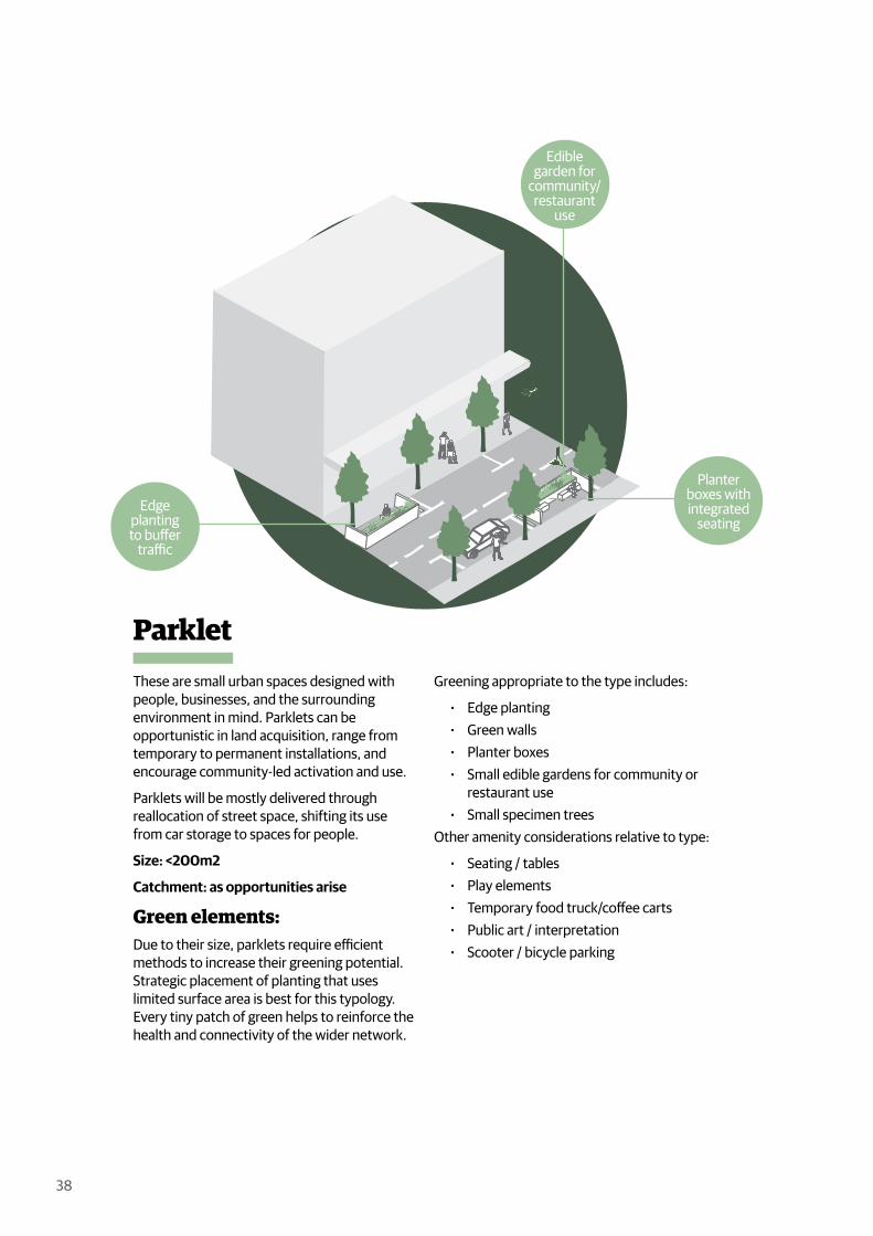
ParkletThese are small urban spaces designed with people, businesses, and the surrounding environment in mind. Parklets can be opportunistic in land acquisition, range from temporary to permanent installations, and encourage community-led activation and use.
Parklets will be mostly delivered through reallocation of street space, shifting its use from car storage to spaces for people.
Size: <200m2
Catchment: as opportunities arise
Green elements:Due to their size, parklets require efficient methods to increase their greening potential. Strategic placement of planting that uses limited surface area is best for this typology. Every tiny patch of green helps to reinforce the health and connectivity of the wider network.
Greening appropriate to the type includes:
Edge planting Green walls Planter boxes Small edible gardens for community or
restaurant use Small specimen trees
Other amenity considerations relative to type:
Seating / tables Play elements Temporary food truck/coffee carts Public art / interpretation Scooter / bicycle parking
Edge plantingto buffer
traffic
Planter boxes withintegrated
seating
Ediblegarden for
community/restaurant
use

39
Case Study
Fresh Air Square, London (WMB studio)Fresh Air Square is one of a series of parklets that have been installed in London as part of Team London Bridge’s fresh Air Squares initiative. The initiative aims to improve local environments, raise awareness of London’s pollution, and monitor air quality. The Tooley Street parklet (shown above) was the first one to be installed in November 2015. It was designed to replace two standard car park spaces.
The Fresh Air Square is a colourful modular parklet that can be scaled up or down depending on available space. The installations are temporary but built to promote the need for more permanent green spaces in the city. The parklet features a zigzag bench built using scaffolding boards painted bright red for traffic visibility.
Pockets of greening have been weaved along the roadside edge, creating a buffer from wind exposure and passing traffic. Fresh Air Square is useful as a case study a the design’s modularity could be replicated in different locations and configurations throughout the city.
Parklets like these can create small chances for respite, interaction, allow for business activation and alleviate footpath congestion. They can be both temporary and permanent and be peppered throughout a city as opportunities arise.

40
Urban ParkAn urban park prioritised in areas of change with significant existing or anticipated urban growth. These spaces will provide residents, workers, and visitors to the central city respite from the built environment and the opportunity to connect with nature.
Where residential development is dense, they will offer a social and recreational hub for inner-city communities. For individuals or families living in a relatively small central city apartment without a typical suburban backyard, urban parks provide everyday access to a shared “urban backyard.” These spaces will be high-performing for their size, offering a variety of amenities that respond and cater to the needs of the associated neighbourhood.
Size: 200m2 – 3,000m2
Catchment: about a 5min walk
Green elements:Urban parks like Cobblestone Park are a good example of maximising green space, planting, and canopy cover with a balance of recreation uses while limiting the amount of paved surface area.
Greening appropriate to the type & site context includes:
Patches of planting / canopy cover Lawn area Planting beds with a diversity of species Nature play elements WSUD elements Edible/fruiting trees Small community garden & composting
Other amenity considerations relative to type:
Multiple seating / picnic areas Shade structures Small playground / nature play Could include sports facilities eg. 3 on 3
court/ hoops/ skate surface etc Artwork / interpretation that engage with
mana whenua/cultural values Includes spaces for temporary kiosks and
food trucks/coffee carts Integrated with existing pedestrian and
cycle connections Scooter / cycle parking facilities
Smalllawnarea Planting
bed with diversity of
species
Smallplayground
/ nature playarea
Opportunity for edible /
fruitingtrees
41
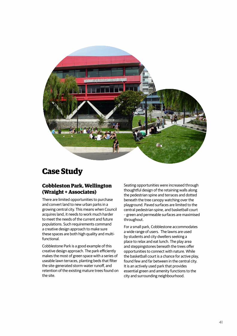
Case Study
Cobbleston Park, Wellington (Wraight + Associates)There are limited opportunities to purchase and convert land to new urban parks in a growing central city. This means when Council acquires land, it needs to work much harder to meet the needs of the current and future populations. Such requirements command a creative design approach to make sure these spaces are both high quality and multi-functional.
Cobblestone Park is a good example of this creative design approach. The park efficiently makes the most of green space with a series of useable lawn terraces, planting beds that filter the site-generated storm-water runoff, and retention of the existing mature trees found on the site.
Seating opportunities were increased through thoughtful design of the retaining walls along the pedestrian spine and terraces and dotted beneath the tree canopy watching over the playground. Paved surfaces are limited to the central pedestrian spine, and basketball court – green and permeable surfaces are maximised throughout.
For a small park, Cobblestone accommodates a wide range of users. The lawns are used by students and city dwellers seeking a place to relax and eat lunch. The play area and steppingstones beneath the trees offer opportunities to connect with nature. While the basketball court is a chance for active play, found few and far between in the central city. It is an actively used park that provides essential green and amenity functions to the city and surrounding neighbourhood.
42
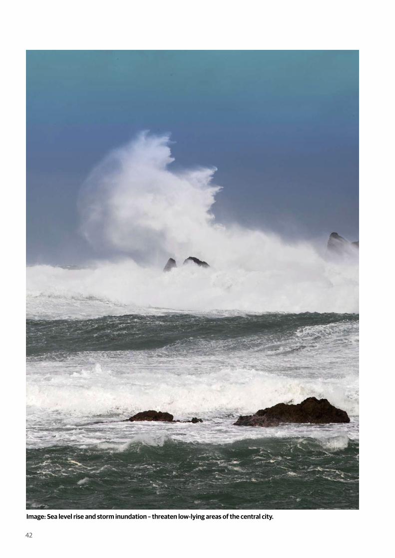
Image: Sea level rise and storm inundation – threaten low-lying areas of the central city.

43
Taasinge Square, Copenhagen (GHB Landscape Architects)Taasinge Square is an exceptional example of an urban park space that integrates greening approaches with climate adaption. Climate adaption is a pressing issue in Wellington’s central city – with most of the development on low-lying reclaimed land – flooding, sea-level rise, and liquefaction are significant concerns. Looking to cities the are setting a precedent for creative adaption is critical.
Taasinge Square is part of Copenhagen’s broader Cloudburst Plan, the city’s climate mitigation plan following the 2011 flood, which caused roughly NZD 1.5 billion in damages. The 20-year plan includes over 300 blue/green infrastructure projects for water rendition and drainage integrated into Copenhagen’s streets and public space network and the private realm through public-private partnerships. It is an integrated planning approach that focuses on the liveability benefits such investment can provide the city.
Once underutilised paved surface, the square itself has been converted to a valuable public green space. This natural refuge supports biodiversity while detaining and collecting rainwater from the surrounding streets and rooftops. The square shows how stormwater detention (both above and below ground) can produce playful urban spaces that support community interaction and delight – adding value to our urban neighbourhoods.
Before
Case Study: Climate Adaptive Urban Park
44
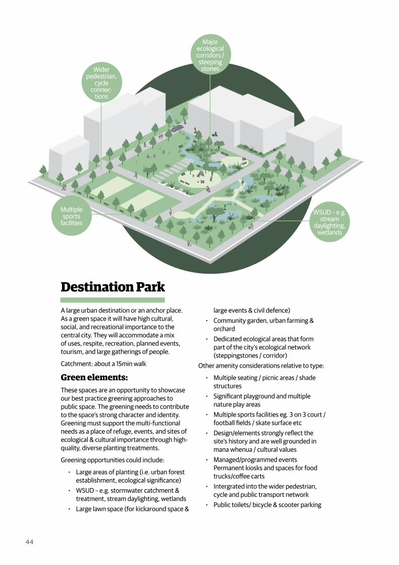
Destination ParkA large urban destination or an anchor place. As a green space it will have high cultural, social, and recreational importance to the central city. They will accommodate a mix of uses, respite, recreation, planned events, tourism, and large gatherings of people.
Catchment: about a 15min walk
Green elements:These spaces are an opportunity to showcase our best practice greening approaches to public space. The greening needs to contribute to the space’s strong character and identity. Greening must support the multi-functional needs as a place of refuge, events, and sites of ecological & cultural importance through high-quality, diverse planting treatments.
Greening opportunities could include:
Large areas of planting (i.e. urban forest establishment, ecological significance)
WSUD – e.g. stormwater catchment & treatment, stream daylighting, wetlands
Large lawn space (for kickaround space &
large events & civil defence) Community garden, urban farming &
orchard Dedicated ecological areas that form
part of the city’s ecological network (steppingstones / corridor)
Other amenity considerations relative to type:
Multiple seating / picnic areas / shade structures
Significant playground and multiple nature play areas
Multiple sports facilities eg. 3 on 3 court / football fields / skate surface etc
Design/elements strongly reflect the site’s history and are well grounded in mana whenua / cultural values
Managed/programmed events Permanent kiosks and spaces for food trucks/coffee carts
Intergrated into the wider pedestrian, cycle and public transport network
Public toilets/ bicycle & scooter parking
Multiple sports
facilitiesWSUD – e.g.
stream daylighting,
wetlands
Wider pedestrian,
cycle connec-
tions
Major ecological corridors / steeping
stones

45
Case Study
Waitangi Park, Wellington (Wraight + Associates)Waitangi Park is a successful study of how our green spaces can not only meet our city’s environmental and amenity needs but also express our cultural narratives and relationship with nature.
At 5.8ha Waitangi Park is the largest park in the central city. The park provides many recreational amenities such as the large lawn area, skate park, children’s playground, and basketball courts and often hosts various public events.
The central design element of the park has been the integration of the Waitangi Stream. Before the development of the central city, the Waitangi Stream and lagoon were critical sources of food gathering, freshwater, and materials for local iwi. The story is that the stream and lagoon was once the home of a taniwha that disappeared upon European arrival. This narrative aligns with the eventual
fate of the stream. It was piped for urban development.
The daylighting of the Waitangi stream and interpretation of the lagoon through a planted narrative reveals the potential of what our natural heritage can bring to the city. “The park’s environmentally sustainable design and the water sensitive urban design strategy not only contributes to improved water quality but also contributes to the visual appeal of the park generating a unique character for the place (Wraight + Associates).”
46
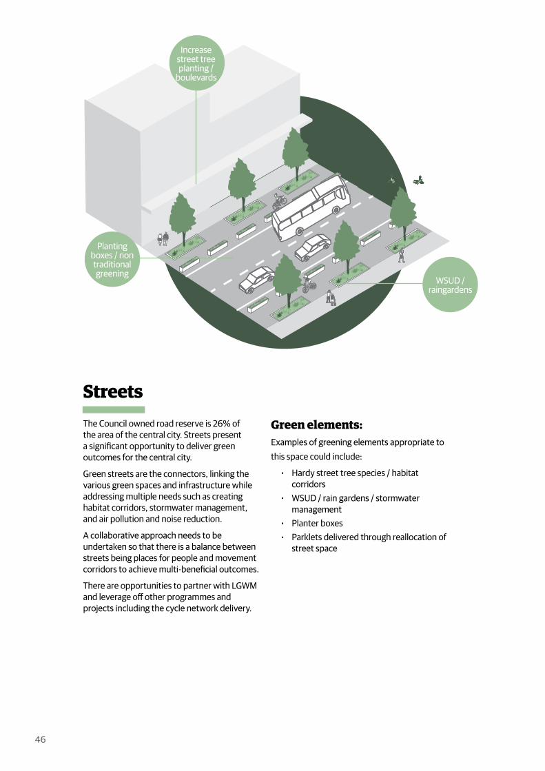
StreetsThe Council owned road reserve is 26% of the area of the central city. Streets present a significant opportunity to deliver green outcomes for the central city.
Green streets are the connectors, linking the various green spaces and infrastructure while addressing multiple needs such as creating habitat corridors, stormwater management, and air pollution and noise reduction.
A collaborative approach needs to be undertaken so that there is a balance between streets being places for people and movement corridors to achieve multi-beneficial outcomes.
There are opportunities to partner with LGWM and leverage off other programmes and projects including the cycle network delivery.
Green elements:Examples of greening elements appropriate to this space could include:
Hardy street tree species / habitat corridors
WSUD / rain gardens / stormwater management
Planter boxes Parklets delivered through reallocation of
street space
[Insert diagram showing greeningopportunities in the street network]
Planting boxes / non traditional greening
WSUD /raingardens
Increase street tree planting /
boulevards

47
Case Study
Lower Cuba Street, Wellington (WCC)Lower Cuba street is an excellent example of streetscape greening in a Wellington central city context.
Lower Cuba Street was redesigned as a shared space in 2011 to provide some additional public space when Manners Mall was removed. The street provides a clear pedestrian link from Cuba Mall to Civic Square and the waterfront. Conversion from a car dominated space to shared space gives pedestrians priority by limiting vehicle speeds to walking pace.
The greening in this example reinforces the pedestrianisation of this street by providing amenity and helps to outline the shared and pedestrian zones. Street trees provide a visual corridor making the street width look narrow, encouraging vehicles to slow down.
Rain gardens offer visual interest and contact with nature while helping the city manage stormwater sustainably. Water that runs into the rain gardens filters down to the sub-soil drainage instead of straight into the drain and harbour. The trees and plants will, in the process, filter out any pollutants.
In the Wellington Public Space Public Life Study 2021, Gehl has highlighted Lower Cuba Street as exemplar street greening. Gehl states, Lower Cuba Street “has a great presence of greenery adding a positive sensory environment to the city (Gehl 27).”

48
LanewaysLaneways play a vital role in the public realm and finer grain network of the central city. They can improve midblock connectivity for people on foot when adequate investment is made to ensure they are attractive, safe, and activated.
Regarding greening, laneways present a massive opportunity to the city as public space can be prioritised over transport movement. Space in a laneway is tight, but creative use of hardy planting can contribute to the overall connectivity of the green network and add to the mix of urban backyards in the central city.
Green elements:Examples of greening elements appropriate to this space could include:
Edge planting Green walls Planter boxes Small edible gardens for community or
restaurant use Small / narrow specimen trees WSUD / rain gardens
Planter boxes to delineate
space
Rain gardens to treat storm
water
Green wall / verticle garden Narrow
treespecies

49
Case Study
Lombard Lane, Wellington (Cook Strait Properties + BECA + E3BW + LandLAB + WCC)This project was a public/private sector partnership between Wellington City Council and Cook Strait Properties to regenerate Denton Park and surrounding streetscapes in and around Lombard Lane, Bond Street, and the Victoria Street interface. The central city block before the project had become rundown, underutilised, and vehicle-dominated, with safety issues affecting tenants and property owners. Investment in the public realm was needed to assure businesses of the lane’s future occupation and bring public life back. A significant part of the public realm investment was the delivery of quality open space and streetscape greening.
Denton Park was an integral part. The project has been re-designed into an elevated lawn space that allows informal occupation by the public and a green outlook to the adjacent restaurant. The shared spaces of Lombard Lane and Bond Street have been reinvigorated with a greener outlook and now include street tree planting, garden beds, rain gardens, and informal planter pots that line the space.
Through this revitalisation Lombard Lane has become a busy pedestrian route and inspired a diverse mix of retail and hospitality businesses to open in the area, further activating the central city space.
50
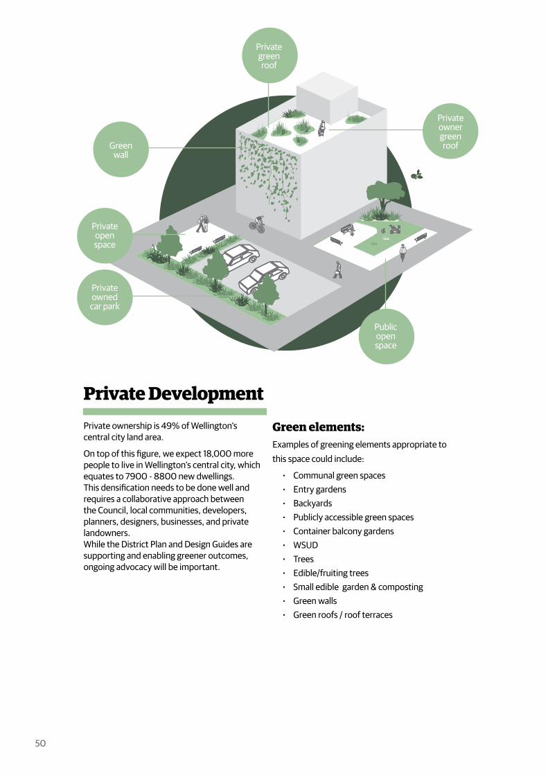
Private DevelopmentPrivate ownership is 49% of Wellington’s central city land area.
On top of this figure, we expect 18,000 more people to live in Wellington’s central city, which equates to 7900 - 8800 new dwellings. This densification needs to be done well and requires a collaborative approach between the Council, local communities, developers, planners, designers, businesses, and private landowners. While the District Plan and Design Guides are supporting and enabling greener outcomes, ongoing advocacy will be important.
Green elements:Examples of greening elements appropriate to this space could include:
Communal green spaces Entry gardens Backyards Publicly accessible green spaces Container balcony gardens WSUD Trees Edible/fruiting trees Small edible garden & composting Green walls Green roofs / roof terraces
Privateowned
car park
Publicopenspace
Privateownergreenroof
Privateopenspace
Greenwall
Privategreenroof

51
Case Study
Urban Habitat Collective, Newtown, Wellington (Spacecraft Architects)Spacecraft Architects are in the process of designing a co-housing apartment building for a group of Wellington families.
The concept of this apartment complex is about balancing private space with the ability to interact with and share amenities with neighbours. The shared spaces “…will include a shared dining & living area, and such other common areas as we agree in the design process. They will be integrated into the building to save costs and encourage community interaction. They are designed for daily use, are an integral part of the community, and are always supplemental to the private residences (Urban Habitat Collective)”.
While the notion of co-housing is not for all, Spacecraft Architects have found a balance between private and shared outdoor space within this high-density development. The shared space between the apartment buildings is an excellent opportunity for greening and provides a sense of community. The balconies overlooking the shared green space provide the transition from private to shared and would allow families to be able to greet neighbours or check up on children playing below.

52
Public / Private PartnershipsAnother enabler for greener outcomes is a partnership approach between public and private agencies.
This is a method of cooperation aimed to deliver projects that have been identified to impact the public realm. This type of cooperation aims to achieve mutual public and commercial benefits to both public and private partners.
In an economic climate where public funding is limited, engagement of a private partner can ensure partial financing of the project and therefore lift the burden off public funds. This can lead to better quality outcomes for a project. Public agencies such as the Council can then deliver on strategic goals they may not have achieved due to limited public funding.
Green elements:Examples of greening elements appropriate to this space could include:
Publicly accessible green spaces WSUD Trees & Edible/fruiting trees Small edible garden & composting Green walls Green roofs / roof terraces
Publiclyaccessible
park on private
land
Publicaccessroutes
Private building
Businessesactivating the space
53
Case Study
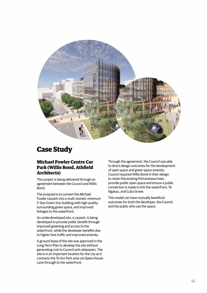
Michael Fowler Centre Car Park (Willis Bond, Athfield Architects)This project is being delivered through an agreement between the Council and Willis Bond.
The proposal is to convert the Michael Fowler carpark into a multi-storied, minimum 5-Star Green Star building with high quality, surrounding green space, and improved linkages to the waterfront.
An underdeveloped site, a carpark, is being developed to provide public benefit through improved greening and access to the waterfront, while the developer benefits due to higher foot traffic and improved amenity.
A ground lease of the site was approved in the Long-Term Plan to develop the site without generating cost to Council and ratepayers. The site is in an important location for the city as it connects the Te Aro Park area via Opera House Lane through to the waterfront.
Through the agreement, the Council was able to direct design outcomes for the development of open space and green space amenity. Council required Willis Bond in their design to retain the existing Pohutukawa trees, provide public open space and ensure a public connection is made to link the waterfront, Te Ngakau, and Cuba Street.
This model can have mutually beneficial outcomes for both the developer, the Council, and the public who use the space.

54
Green Walls(Also known as living walls or vertical gardens).
Green walls come in two main types:
A vertical structure is fixed to the wall of a building with climbing plants rooted in soil at ground level. The plants use the structure to climb up the wall from the soil containers below.
The soil is fixed to the wall itself (often in modular units). The plants are rooted in the modular units, which are fastened to the façade using a structural system.
Green walls have many benefits for the central city as they
Are fixed vertically and can be used in areas where space is limited (for example, in laneways or along narrow streets).
Can improve the appearance of a building or structure (as well as prevent graffiti that can occur on bare walls).
Diversify the suite of planted habitats and can act as stepping stones for species.
Increase the amount of visible green in the city environment & improve the psychological health of residents.
Improve air quality and reduce noise Help collect and filter stormwater from
buildings and can be used for water sensitive urban design.
Can be used for edible gardens.
Green elements: Plants should be chosen to suit the
location and climate of the green wall Hardy climbing or cliff species (NZ has
many native species that thrive on cliff faces and which have been trialed successfully in green walls)
Hanging plants can also work - beans and tomatoes have been used in edible green walls (in sheltered, sunny sites)
Type 1 /Climbing
Green Wall
Type 2 /Modular
Green Wall

55
Case Study
Civic Square Green Wall (Natural Habitats)Designed by Natural Habitats, the 24sqm green wall was installed in the prominent site of Civic Square as an exemplar project and a way to motivate developers to install more around the central city. The harsh coastal environment of the green wall’s location demonstrates how green walls can thrive in Wellington – and gives confidence for future installations. Careful plant selection is critical to achieving a thriving green wall. Species used in this example include the following hardy native species:
Arthropodium “Te Puna” (rengarenga lily) Acaena novae “Zelandiae” (piripiri Chionochloa conspicua “Hunangamoho”
(snow grass) Disphyma crassifolium (New Zealand ice
plant) Fuschia procumbens (creeping fuschia)
The structure itself is a modular system and built to be self-watering and self-fertilising. The wall is moveable if required. Further examples of green walls have also been rolled out throughout the central city by Wellington City Council through the laneways programme to green the street network when street trees are not achievable.
The design and ongoing management needs careful consideration for green walls to be successful.

56
Green Roofs(Also known as living roofs or roof gardens).
Green roofs are a roof of a building or built structure that has been planted over a layered system of waterproof membrane, insulation, drainage, root barrier, and growing medium. A similar type (although not a genuine green roof) is a rooftop container garden. Rooftop container gardens are when plants are sown in containers or pots and placed or fixed on a roof/roof terrace. These are a more accessible and cheaper alternative to green roofs as they may not need the structural engineering and waterproofing required by genuine green roofs. Green roofs have many benefits for the central city:
They can be used in dense city environments where at-grade space is limited as they utilise the buildings.
They slow and reduce stormwater run-off, which places less stress on the central city’s stormwater infrastructure and an individual site and building’s drainage system.
Provide amenity and a green outlook for the building users and for other who are overlooking.
Green elements: Plants should be chosen to suit the
location and climate of the green roof. Many hardy native plant species thrive in
green roof conditions, including native ground covers, grasses, succulents, climbers, and creepers.
Native species specifically are suitable as they promote native biodiversity and can be stepping stones for migrating fauna.
Roof topContainer
Garden
GreenRoof
57
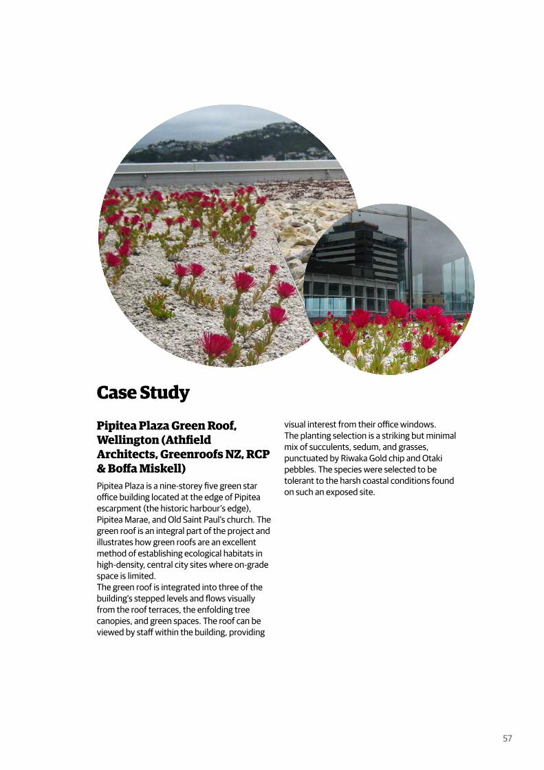
Case Study
Pipitea Plaza Green Roof, Wellington (Athfield Architects, Greenroofs NZ, RCP & Boffa Miskell)Pipitea Plaza is a nine-storey five green star office building located at the edge of Pipitea escarpment (the historic harbour’s edge), Pipitea Marae, and Old Saint Paul’s church. The green roof is an integral part of the project and illustrates how green roofs are an excellent method of establishing ecological habitats in high-density, central city sites where on-grade space is limited. The green roof is integrated into three of the building’s stepped levels and flows visually from the roof terraces, the enfolding tree canopies, and green spaces. The roof can be viewed by staff within the building, providing
visual interest from their office windows. The planting selection is a striking but minimal mix of succulents, sedum, and grasses, punctuated by Riwaka Gold chip and Otaki pebbles. The species were selected to be tolerant to the harsh coastal conditions found on such an exposed site.

58
Good Food Green SpacesPart of the Green Network Plan will be connecting with the broader sustainable food network for Wellington city by supporting initiatives to increase the amount and quality of green space used for food production in the central city. Examples of food production spaces include community gardens, urban farms, inner-city exemplar gardens, community composting hubs, vertical gardens, fruiting trees, and edible rooftop gardens.
Community food production spaces allow central city residents to participate in gardening where personal backyard space is unavailable.
These spaces are a way to diversify the green network and offer space for central city residents to connect and educate themselves / or increase capacity (either one works - your choice) in food growing and production. They also provide capacity to wrap food waste back into production at a local level. These spaces are part of the continuum of green spaces and foster a sense of community, improving the central city’s mental and physical wellbeing, livability, and resilience.
While the central is constrained for space there are industrial & under developed sites that could contribute to local food production. These sites could be either temporary or permanent, and no longer fit for purpose. They include sites in Pipitea, car parking lots, road reserve and even rooftops.
Green elements:Examples of greening elements appropriate to these spaces include:
Edible / fruiting trees Community gardens Edible green walls Edible roof gardens Edible container gardens Rongoā rākau (medical plant / tree
species) Berm gardens Urban farms
Communitygarden
Edible container
garden
Roof topgarden
Edible /fruiting
trees
Restaurantspace

59
Case Study
Sole Food Street Farms, VancouverSole Food Street Farms is a Vancouver-based organisation that has converted underutilised, contaminated land into productive urban farms. Their Main Street location, found on a previous petrol station site, was leased to the organisation by the City of Vancouver for one Canadian dollar per year is today one of the largest urban farming sites in North America. The site, before the project, had been vacant for over a decade due to soil contamination. Sole Foods Farms worked around the contamination issue by setting up a system of planter boxers to grow their extensive orchard, herb, and vegetable garden.
Soles Food Farming project provides numerous benefits to Vancouver’s city, including offering jobs and training to members of the community with mental health and addiction issues. The city of Vancouver has strongly
supported the project as it aligns with Vancouver’s Greenest City Action plan. The plan stipulates a “Local Food” action where the goal is “Vancouver will become a global leader in urban food system (City of Vancouver)” with the associated target to: “Increase city-wide and neighbourhood food assets by a minimum of 50% over 2010 levels (City of Vancouver)”.

60
61
Work Cited

62
Auckland Council. "Auckland’s Urban Ngahere (Forest) Strategy. te Rautaki Ngahere Ā-Tāone O Tāmaki Makaurau."
Blaschke, Paul et al. "Green Space in Wellington’s Central City: Current Provision, and Design for Future Wellbeing." New Zealand Centre for Sustainable Cities, 2019.
Boffa Miskell. "Pipitea Plaza." https://www.boffamiskell.co.nz/project.php?v=pipitea-plaza.
City of Melbourne. "Green Our City Strategic Action Plan " 2017. https://www.melbourne.vic.gov.au/sitecollectiondocuments/green-our-city-action-plan-2018.pdf
City of Melbourne. "Urban Forest Strategy " 2014. https://www.melbourne.vic.gov.au/sitecollectiondocuments/urban-forest-strategy.pdf
City of Sydney. "Greening Sydney Strategy " 2021. https://www.cityofsydney.nsw.gov.au/strategies-action-plans/greening-sydney-strategy
City of Sydney. "Urban Forest Strategy " 2013. https://www.cityofsydney.nsw.gov.au/strategies-action-plans/urban-forest-strategy
Gehl Architects. "Wellington 2021 Public Space Public Life Study " 2021.
GHB Landscape Architects. "Taasinge Square." https://www.ghb-landskab.dk/en/projects/taasinge-square.
Green Cities. https://thegreencities.eu/.
Heaphy, Charles. "Birdseye View of Port Nicholson." 1843. https://natlib.govt.nz/records/22875686
Hinge, Leslie. "Development Along Lambton Quay." 1920s. https://natlib.govt.nz/records/22719036
LandLAB. "Lombard Lane." http://landlab.co.nz/lombard-lane-denton-park.
London, Treeconomics. "Valuing London’s Urban Forest: Results of the London I -Tree Eco Project." 2015.
Morgenroth, Justin. "Tree Canopy Cover in Christchurch, New Zealand. Report Prepared for the Christchurch City Council." University of Canterbury, 2017.
Morgenroth, Justin. "Tree Canopy Cover in the Green Network Plan Study Area, Wellington, New Zealand. Technical Report Prepared for Wellington City Council." University of Canterbury, 2020.
Morgenroth, Justin. "Tree Canopy Cover In Wellington City and Suburbs, New Zealand. report Prepared for the Wellington City Council." University of Canterbury, 2021.
Natural Habitats. "Civic Square Green Wall." https://www.naturalhabitats.co.nz/.
New Zealand Company. "Plan of the Town of Wellington." 1840. New Zealand Company. archway.archives.govt.nz/ViewFullItem.do?code=2431150
Norman, Edmund. "Te Aro Pā Looking Towards the Hutt River." 1842 - 1843. https://natlib.govt.nz/records/23026225
Selkirk, Gail. "Midland Park." 1983, p. Reference: EP/1983/3745.
Sole Food Street Farms. "Sole Food Street Farms." https://solefoodfarms.com/.
Spacecraft Architect. "Urban Habitat Collective." Wellington, New Zealand https://www.spacecraftarchitects.co.nz/Urban-Habitat-Collective.
Unknown. "Scene in the Botanical Gardens." ca 1900. https://natlib.govt.nz/records/22751152?search%5Bpath%5D=photos&search%5Btext%5D=wellington+botanic+gardens
Vancouver, City of. "Greenest City Goal: Local Food." https://vancouver.ca/green-vancouver/local-food.aspx.
Wellington City Council. "Central City Framework." 2010. https://wellington.govt.nz/your-council/plans-policies-and-bylaws/policies/central-city-framework
Wellington City Council. "Lower Cuba Street Shared Space." https://wellington.govt.nz/~/media/your-council/projects/files/goldenmile-lowercuba-info.pdf.

63
Wellington City Council. "Michael Fowler Centre Carpark Development." On 30 September 2021, the Council agreed to the key commercial terms on a 175-year ground lease for the Michael Fowler Centre carpark with Willis Bond., 2021.
Wellington City Council. "Our Capital Spaces: An Open Space and Recreation Strategy for Wellington " 2013. https://wellington.govt.nz/your-council/plans-policies-and-bylaws/policies/our-capital-spaces
-Wellington City Council. "Our City Tomorrow: Spatial Plan for Wellington City." https://planningforgrowth.wellington.govt.nz/draft-spatial-plan.
Wellington City Council. "Our Natural Capital: wellington’s Biodiversity Strategy and Action Plan." 2015. https://wellington.govt.nz/your-council/plans-policies-and-bylaws/policies/biodiversity-strategy-and-action-plan
Wellington City Council. "Te Atakura - First to Zero: Wellington's Blueprint for a Zero Carbon Capital." 2019. https://wellington.govt.nz/environment-and-sustainability/climate-change/zero-carbon-capital
Wellington City Council. "Te Atakura - First to Zero: wellington City’s Zero Carbon
Implementation Plan." 2020. https://wellington.govt.nz/environment-and-sustainability/climate-change/zero-carbon-capital
Wellington City Council. "Water Sensitive Urban Design: A Guide for Wsud Stormwater Management in Wellington ". https://wellington.govt.nz/environment-and-sustainability/water/stormwater/water-sensitive-urban-design-guide
Whites Aviation. "Urban Motorway." 1969. https://tiaki.natlib.govt.nz/#details=ecatalogue.630686
WMB Studio. "Parked Bench." https://wmbstudio.co.uk/parked-bench.
World Health Organisation. "Urban Green Space and Health: Intervention Impacts and Effectiveness." 2017.
Wraight + Associates. "Cobbleston Park." https://waal.co.nz/our-projects/urban/cobblestone-park/.
Wraight + Associates. "Waitangi Park." https://waal.co.nz/our-projects/urban/waitangi-park/.
(References to be further proofed)

64