what's new in arcview 3.1, 3.2, and 3.3
TRANSCRIPT

ESRI 380 New York St., Redlands, CA 92373-8100, USA • TEL 909-793-2853 • FAX 909-793-5953 • E-MAIL [email protected] • WEB www.esri.com
What's New in ArcView 3.1, 3.2, and 3.3
An ESRI ® White Paper • June 2002

Copyright © 2002 ESRI All rights reserved. Printed in the United States of America. The information contained in this document is the exclusive property of ESRI. This work is protected under United States copyright law and other international copyright treaties and conventions. No part of this work may be reproduced or transmitted in any form or by any means, electronic or mechanical, including photocopying and recording, or by any information storage or retrieval system, except as expressly permitted in writing by ESRI. All requests should be sent to Attention: Contracts Manager, ESRI, 380 New York Street, Redlands, CA 92373-8100, USA. The information contained in this document is subject to change without notice.
U.S. GOVERNMENT RESTRICTED/LIMITED RIGHTS Any software, documentation, and/or data delivered hereunder is subject to the terms of the License Agreement. In no event shall the U.S. Government acquire greater than RESTRICTED/LIMITED RIGHTS. At a minimum, use, duplication, or disclosure by the U.S. Government is subject to restrictions as set forth in FAR §52.227-14 Alternates I, II, and III (JUN 1987); FAR §52.227-19 (JUN 1987) and/or FAR §12.211/12.212 (Commercial Technical Data/Computer Software); and DFARS §252.227-7015 (NOV 1995) (Technical Data) and/or DFARS §227.7202 (Computer Software), as applicable. Contractor/Manufacturer is ESRI, 380 New York Street, Redlands, CA 92373-8100, USA. @esri.com, 3D Analyst, ADF, AML, ARC/INFO, ArcAtlas, ArcCAD, ArcCatalog, ArcCOGO, ArcData, ArcDoc, ArcEdit, ArcEditor, ArcEurope, ArcExplorer, ArcExpress, ArcFM, ArcGIS, ArcGrid, ArcIMS, ArcInfo Librarian, ArcInfo, ArcInfo—Professional GIS, ArcInfo—The World's GIS, ArcLogistics, ArcMap, ArcNetwork, ArcNews, ArcObjects, ArcOpen, ArcPad, ArcPlot, ArcPress, ArcQuest, ArcReader, ArcScan, ArcScene, ArcSchool, ArcSDE, ArcSdl, ArcStorm, ArcSurvey, ArcTIN, ArcToolbox, ArcTools, ArcUSA, ArcUser, ArcView, ArcVoyager, ArcWatch, ArcWeb, ArcWorld, Atlas GIS, AtlasWare, Avenue, BusinessMAP, Database Integrator, DBI Kit, ESRI, ESRI—Team GIS, ESRI—The GIS People, FormEdit, Geographic Design System, Geography Matters, Geography Network, GIS by ESRI, GIS Day, GIS for Everyone, GISData Server, InsiteMAP, MapBeans, MapCafé, MapObjects, ModelBuilder, MOLE, NetEngine, PC ARC/INFO, PC ARCPLOT, PC ARCSHELL, PC DATA CONVERSION, PC STARTER KIT, PC TABLES, PC ARCEDIT, PC NETWORK, PC OVERLAY, Rent-a-Tech, RouteMAP, SDE, SML, Spatial Database Engine, StreetEditor, StreetMap, TABLES, the ARC/INFO logo, the ArcAtlas logo, the ArcCAD logo, the ArcCAD WorkBench logo, the ArcCOGO logo, the ArcData logo, the ArcData Online logo, the ArcEdit logo, the ArcEurope logo, the ArcExplorer logo, the ArcExpress logo, the ArcFM logo, the ArcFM Viewer logo, the ArcGIS logo, the ArcGrid logo, the ArcIMS logo, the ArcInfo logo, the ArcLogistics Route logo, the ArcNetwork logo, the ArcPad logo, the ArcPlot logo, the ArcPress for ArcView logo, the ArcPress logo, the ArcScan logo, the ArcScene logo, the ArcSDE CAD Client logo, the ArcSDE logo, the ArcStorm logo, the ArcTIN logo, the ArcTools logo, the ArcUSA logo, the ArcView 3D Analyst logo, the ArcView Business Analyst logo, the ArcView Data Publisher logo, the ArcView GIS logo, the ArcView Image Analysis logo, the ArcView Internet Map Server logo, the ArcView logo, the ArcView Network Analyst logo, the ArcView Spatial Analyst logo, the ArcView StreetMap 2000 logo, the ArcView StreetMap logo, the ArcView Tracking Analyst logo, the ArcWorld logo, the Atlas GIS logo, the Avenue logo, the BusinessMAP logo, the Data Automation Kit logo, the Digital Chart of the World logo, the ESRI Data logo, the ESRI globe logo, the ESRI Press logo, the Geography Network logo, the MapCafé logo, the MapObjects Internet Map Server logo, the MapObjects logo, the MOLE logo, the NetEngine logo, the PC ARC/INFO logo, the Production Line Tool Set logo, the RouteMAP IMS logo, the RouteMAP logo, the SDE logo, The World's Leading Desktop GIS, Water Writes, www.esri.com, www.geographynetwork.com, www.gisday.com, and Your Personal Geographic Information System are trademarks, registered trademarks, or service marks of ESRI in the United States, the European Community, or certain other jurisdictions. Other companies and products mentioned herein are trademarks or registered trademarks of their respective trademark owners.

J-8281
ESRI White Paper i
What's New in ArcView 3.1, 3.2, and 3.3
An ESRI White Paper Contents Page Application Level................................................................................... 2
Start-Up Screen Dialog .................................................................... 2 Project Update for Existing Projects................................................ 2 Expanded Date Support ................................................................... 2 Support for PC ARC/INFO Double-Precision Coverages............... 3 Improved Support for ArcInfo Line Symbols.................................. 3
New TrueType Fonts and Symbols............................................ 3 Import Multilayer ArcInfo Line Symbols.................................. 3 Import ArcInfo LineType Marker Symbols............................... 3
Customize ArcView......................................................................... 3 Extension .apr Files Available ................................................... 3
ArcView Projection Utility .............................................................. 4
Views and Themes................................................................................. 4 View Properties................................................................................ 4
Background Color...................................................................... 4 Setting Projection for Already-Projected Data .......................... 5
TOC Style ........................................................................................ 5 Label and Text Tools ....................................................................... 5
Default Settings for Text and Label Tools Dialog..................... 5 Spline Text Tool ........................................................................ 6
Convert Shapefiles to Projected Units ............................................. 6 Adding Themes................................................................................ 6
Adding Already-Projected Data to a Projected View................ 6 ESC Cancels Directory Scan for Add Theme............................ 6 Map and Distance Units Automatically Set............................... 6
New View Menu Options ................................................................ 6 Manage Data Sources Under View Menu ................................. 6 Save Project As and Extensions Under File Menu .................... 7
Create Buffers Wizard ..................................................................... 7

What's New in ArcView 3.1, 3.2, and 3.3
J-8281
June 2002 ii
Contents Page Views Can Be Exported into JPEG Format..................................... 7 ESC Stops Drawing of Themes ....................................................... 7
Data Integration Utilities........................................................................ 7
SDTS Data Import ........................................................................... 7 DXF Export...................................................................................... 7
Creating and Editing Spatial Data.......................................................... 7 Shape Properties Dialog................................................................... 7 Snap Tolerance Cursor..................................................................... 8 Introducing Measured and Three-Dimensional Shapes................... 8
What Are Measured and Three-Dimensional Shapes? .............. 8 Improved Support for Dynamic Segmentation ................................ 9
Tables..................................................................................................... 9 What's New for SQL Connect ......................................................... 9
Printing and Layouts .............................................................................. 10 Neatline Button ................................................................................ 10 Layouts Can Be Exported into JPEG Format .................................. 10
Extensions .............................................................................................. 10
CAD Reader Extension.................................................................... 11 Database Access Extension.............................................................. 11 Dialog Designer Extension .............................................................. 11 Digitizer Extension .......................................................................... 12
Stream Tolerance ....................................................................... 12 Enable/Disable Stream Mode .................................................... 12
GeoProcessing Extension................................................................. 12 Dissolve Features Based on an Attribute ................................... 13 Merge Themes Together ............................................................ 13 Clip One Theme Based on Another ........................................... 13 Intersect Two Themes................................................................ 13 Union Two Themes.................................................................... 13 Assign Data by Location............................................................ 14
Graticules and Measured Grids Extension....................................... 14 ERDAS IMAGINE Image Extension .............................................. 15 JPEG (JFIF) Image Support Extension............................................ 15 Legend Tool Extension .................................................................... 15 Military Data Reader Extensions ..................................................... 15 MrSID Image Support Extension..................................................... 16

What's New in ArcView 3.1, 3.2, and 3.3
J-8281
ESRI White Paper iii
Contents Page Report Writer Extension .................................................................. 16 TIFF 6.0 Image Support Extension.................................................. 17 VPF Viewer Extension .................................................................... 17
Optional Extensions to ArcView ........................................................... 18
ArcView 3D Analyst Extension....................................................... 18 ArcPress for ArcView Extension..................................................... 18 ArcView Business Analyst Extension ............................................. 18 ArcView Image Analysis Extension................................................ 20 ArcView Network Analyst Extension ............................................. 21 ArcView Spatial Analyst Extension ................................................ 22 ArcView StreetMap Extension ........................................................ 23 ArcView StreetMap 2000 Extension ............................................... 23 ArcView Tracking Analyst Extension ............................................. 24
ESRI Data & Maps ................................................................................ 24
Samples .................................................................................................. 25 ArcView Connect for R/3 Extension ............................................... 25 ArcView R/3 Interface Project......................................................... 25 Map Labeling Extension .................................................................. 25 MGE Reader Extension ................................................................... 26 DIGEST (ASRP/USRP)................................................................... 26 MGRS Coordinate Display .............................................................. 26 S-57 Data Converter ........................................................................ 26 RPF Indexer ..................................................................................... 27


J-8281
ESRI White Paper
What's New in ArcView 3.1, 3.2, and 3.3 Welcome to ArcView® 3.x. Whether you are an experienced user or getting started with ArcView 3.x, this white paper will introduce you to all of the new features and capabilities of ArcView 3.x. Each new release exemplifies ESRI's commitment to enhancing the user experience with ArcView. ArcView 3.1 introduced a wizard-based approach to accomplish a variety of more sophisticated tasks such as advanced map production and advanced geoprocessing. Task wizards, along with other updates focusing on enhancing usability, leverage the power of ArcView to help you more quickly and easily accomplish your geographic information system (GIS) objectives. ArcView 3.1 also introduced several new included extensions, specifically designed to supplement your GIS requirements. In particular, ArcView features a report writer extension that enables you to easily generate professional reports, including embedded maps and charts, that help you more successfully communicate the results of your GIS analysis. ArcView 3.2 provided both strategic updates to existing capabilities as well as new tools to facilitate your GIS operations. Specifically, ArcView 3.2 included an updated report writer and significant database access improvements. ArcView 3.2 also introduced a new shapefile projection utility, providing support for an extensive range of data projections and datum transformations, as well as support for several new data formats. ArcView 3.3 provides key updates to many of the tools that are part of ArcView. ArcView 3.3 includes updates to many extensions including CAD Reader, ERDAS IMAGINE® Image Reader, and the National Imagery Transmission Format (NITF) Data Reader. Also, the Projection Utility has been enhanced for greater performance. The Report Writer has been updated to include Crystal Reports™ 8.5 by Crystal Decisions. Database Access 2.1c is also included to support the latest ArcSDE™ database and provide direct connections to ArcSDE data. ESRI Data & Maps has also expanded to eight CDs full of new and updated data.

What's New in ArcView 3.1, 3.2, and 3.3
J-8281
June 2002 2
Application Level
Start-Up Screen Dialog
Created with new users in mind, this dialog gives quick and easy access to some of the most common tasks performed when starting ArcView. You can choose to create a new project (either blank or with a view) or open an existing one. Clear the check box to stop the dialog from displaying when ArcView opens.
If you do not want the dialog displayed again, delete the avstart.txt file in your TEMP directory (PC) or $HOME directory (UNIX).
Project Update for Existing Projects
When opening a project that has a customized interface (i.e., the project uses one of ESRI's optional extensions or contains changes to buttons, tools, or menus through the use of the Customize dialog box) and was created using ArcView 3.0 or 3.0a, ArcView will show the following message box:
To update your project, click Yes. The new version 3.1 tools will be added to your interface. To leave your project as is, click No. Your project will not be updated.
Expanded Date Support
The supported range of the value of the Date class in ArcView is no longer limited to 1970 to 2038. ArcView now supports a date range from 4715 B.C. to 9999 A.D. While dates beyond this range may work, they may not produce consistent results for all Avenue™ requests. ArcView will recognize dates from January 1, 0000, to December 31, 9999, in dBASE® files and from January 1, 1000, to December 31, 9999, in INFO™ files. Dates outside this range are given a value of null when retrieved from a table. Delimited text files store dates as strings that can be converted to dates with Avenue software. This means the delimited text file date range is the same as the Avenue Date class range.
What's New in ArcView 3.1, 3.2, and 3.3
J-8281
ESRI White Paper 3
Support for PC ARC/INFO Double-Precision Coverages
One of the new features in PC ARC/INFO® 4.0 is the ability to create double-precision coverages. Support for direct read of these coverages has been added in ArcView 3.3. Note: ArcView 3.3 cannot access PC ARC/INFO single- and double-precision coverage types when mixed in a single workspace. Whichever type ArcView first encounters is the type that will be used for the entire workspace.
Improved Support for ArcInfo Line Symbols
Prior to version 3.1, ArcView could not display some types of ArcInfo™ line symbols—particularly custom symbols such as multilayer or LineType Marker. Now most ArcInfo line symbols can be used in ArcView.
New TrueType Fonts and Symbols
New and enhanced symbol palettes include
Geology.avp: nearly 300 line and marker symbols for making U.S. Geological Survey (USGS)-compliant geologic maps
Weather.avp: additional weather frontline symbols
Transp.avp: additional railroad line symbols
Forestry.avp: line and marker symbols for creating forest firefighting maps
Import Multilayer
ArcInfo Line Symbols You can now import multilayer ArcInfo line symbols into ArcView. Even if you do not have access to ArcInfo, you can create your own symbols using new Avenue classes added to support these new capabilities. For more information, refer to the "symbols, how to create complex line symbols using Avenue" topic in the ArcView online help index.
Import ArcInfo LineType Marker
Symbols
You can also import LineType Marker and LineType VertexMarker from ArcInfo symbolsets. The ArcInfo marker symbols you import must already be defined using TrueType® fonts. (This capability became available in ArcInfo 7.1.) You will need to create a new version of the TrueType font and name it appropriately so that ArcView can match the information in the LineSet file and use the correct font and character for your font. If the ArcInfo symbol was created using the older IGL font technology, ArcView will still import the symbol, including all of its properties, except the marker symbol. The current default marker symbol in ArcView will be used, but you can use Avenue to substitute one that is more appropriate. For script examples, refer to the "symbols, Avenue examples" topic in the ArcView online help index.
Customize ArcView
Extension .apr Files Available
The $AVHOME\samples\ext directory contains the project files used to create the extensions listed above. You can customize the extensions by editing the project files and creating new versions of the extensions.
What's New in ArcView 3.1, 3.2, and 3.3
J-8281
June 2002 4
ArcView Projection Utility
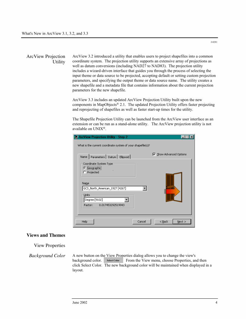
ArcView 3.2 introduced a utility that enables users to project shapefiles into a common coordinate system. The projection utility supports an extensive array of projections as well as datum conversions (including NAD27 to NAD83). The projection utility includes a wizard-driven interface that guides you through the process of selecting the input theme or data source to be projected, accepting default or setting custom projection parameters, and specifying the output theme or data source name. The utility creates a new shapefile and a metadata file that contains information about the current projection parameters for the new shapefile. ArcView 3.3 includes an updated ArcView Projection Utility built upon the new components in MapObjects® 2.1. The updated Projection Utility offers faster projecting and reprojecting of shapefiles as well as faster start-up times for the utility. The Shapefile Projection Utility can be launched from the ArcView user interface as an extension or can be run as a stand-alone utility. The ArcView projection utility is not available on UNIX®.
Views and Themes
View Properties
Background Color A new button on the View Properties dialog allows you to change the view's
background color. From the View menu, choose Properties, and then click Select Color. The new background color will be maintained when displayed in a layout.
Select Color
What's New in ArcView 3.1, 3.2, and 3.3
J-8281
ESRI White Paper 5
Setting Projection for Already-Projected
Data
When you are adding projected data as a theme, ArcView will detect whether it is projected and prompt you to set your view's projection. You are not prompted if the extent of themes is beyond the standard geographic coordinates.
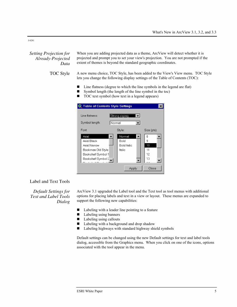
TOC Style A new menu choice, TOC Style, has been added to the View's View menu. TOC Style lets you change the following display settings of the Table of Contents (TOC): Line flatness (degree to which the line symbols in the legend are flat) Symbol length (the length of the line symbol in the toc) TOC text symbol (how text in a legend appears)
Label and Text Tools
Default Settings for Text and Label Tools
Dialog
ArcView 3.1 upgraded the Label tool and the Text tool as tool menus with additional options for placing labels and text in a view or layout. These menus are expanded to support the following new capabilities:
Labeling with a leader line pointing to a feature Labeling using banners Labeling using callouts Labeling with a background and drop shadow Labeling highways with standard highway shield symbols
Default settings can be changed using the new Default settings for text and label tools dialog, accessible from the Graphics menu. When you click on one of the icons, options associated with the tool appear in the menu.

What's New in ArcView 3.1, 3.2, and 3.3
J-8281
June 2002 6
A sample extension for autolabeling more than one theme is also included.
Spline Text Tool A new Spline text tool with the ability to align text or position it along curved lines has been added in this release. The tool is presented as an option on the Text tool menu. After indicating where you want text drawn (by clicking in your view or layout), use the Spline Text Properties dialog to enter, align, and draw your text.
Convert Shapefiles to Projected Units
For projected views, Convert to Shapefile will now ask you if you want the new shapefile to be created in projected units. Previously, Convert to Shapefile only output the new shapefile in decimal degrees for projected views. (For nonprojected views, the new shapefile was and still will be created in the units of the base data.)
Adding Themes
Adding Already-Projected Data to a
Projected View
Add Theme will now warn you if you try to add already-projected data to a projected view (unless you are adding images). The data will be added to the view anyway, but it may not display properly because you cannot view already-projected data in a projected view.
ESC Cancels Directory Scan for
Add Theme
ESC cancels the directory scan for Add Theme. This allows you to immediately stop ArcView from reading all the directories. For example, if you have a folder with 40 folders in it and you want to go to the third in the list, wait for ArcView to display the first three folders, then press ESC. Now double-click on the third folder in the list.
Map and Distance Units Automatically
Set
When adding a theme, if ArcView detects that your data is in decimal degrees, the map and distance units will automatically be set.
New View Menu
Options
Manage Data Sources
Under View Menu A new menu choice, Manage Data Sources, has been added to the View's File menu. Manage Data Sources lets you copy, rename, and delete shapefiles.

What's New in ArcView 3.1, 3.2, and 3.3
J-8281
ESRI White Paper 7
Save Project As and Extensions Under File
Menu
Save Project As and Extensions have been added to the View's File menu to make these options more accessible. (They have also been added to the interfaces of the other document types such as the Layout's File menu, the Project's File menu, and the Table's File menu.)
Create Buffers Wizard
Accessed from the View's Theme menu, this wizard provides an easy-to-use set of panels for creating buffers. Using the panels, you will be able to select what and how to buffer, set buffer options, and specify where output should be saved.
Views Can Be Exported into JPEG
Format
Views can now be exported into JPEG format.
ESC Stops Drawing
of Themes Pressing ESC will immediately stop the drawing of themes without clearing the view's display. (To support this functionality, the ESC accelerator to turn off all themes has been removed.)
Data Integration Utilities
SDTS Data Import ArcView 3.2 included a data import utility that imports Spatial Data Transfer Standard
(SDTS) raster and point data and creates ESRI® GRID files and ArcView point shapefiles, respectively. At ArcView 3.3, the SDTS raster import utility has been updated to support the latest raster profile types released by the USGS.
DXF Export ArcView 3.2 included a data conversion utility providing shape to DXF output.
Creating and Editing Spatial Data
Shape Properties
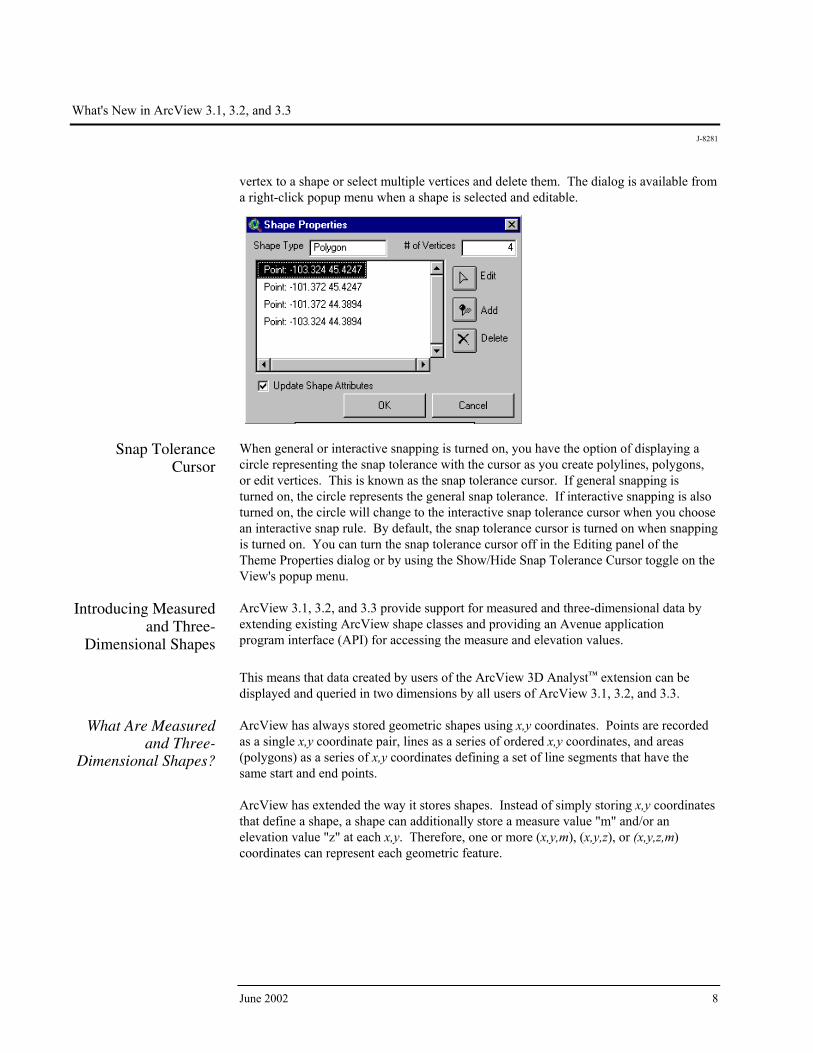
Dialog This dialog was added to ArcView to support interactive addition, deletion, and editing of shape vertices. The main dialog identifies the type of shape and the number of vertices and presents a list of vertices within the shape. You can choose to add a
3.2
What's New in ArcView 3.1, 3.2, and 3.3
J-8281
June 2002 8
vertex to a shape or select multiple vertices and delete them. The dialog is available from a right-click popup menu when a shape is selected and editable.
Snap Tolerance
Cursor When general or interactive snapping is turned on, you have the option of displaying a circle representing the snap tolerance with the cursor as you create polylines, polygons, or edit vertices. This is known as the snap tolerance cursor. If general snapping is turned on, the circle represents the general snap tolerance. If interactive snapping is also turned on, the circle will change to the interactive snap tolerance cursor when you choose an interactive snap rule. By default, the snap tolerance cursor is turned on when snapping is turned on. You can turn the snap tolerance cursor off in the Editing panel of the Theme Properties dialog or by using the Show/Hide Snap Tolerance Cursor toggle on the View's popup menu.
Introducing Measured and Three-
Dimensional Shapes
ArcView 3.1, 3.2, and 3.3 provide support for measured and three-dimensional data by extending existing ArcView shape classes and providing an Avenue application program interface (API) for accessing the measure and elevation values. This means that data created by users of the ArcView 3D Analyst™ extension can be displayed and queried in two dimensions by all users of ArcView 3.1, 3.2, and 3.3.
What Are Measured and Three-
Dimensional Shapes?
ArcView has always stored geometric shapes using x,y coordinates. Points are recorded as a single x,y coordinate pair, lines as a series of ordered x,y coordinates, and areas (polygons) as a series of x,y coordinates defining a set of line segments that have the same start and end points. ArcView has extended the way it stores shapes. Instead of simply storing x,y coordinates that define a shape, a shape can additionally store a measure value "m" and/or an elevation value "z" at each x,y. Therefore, one or more (x,y,m), (x,y,z), or (x,y,z,m) coordinates can represent each geometric feature.

What's New in ArcView 3.1, 3.2, and 3.3
J-8281
ESRI White Paper 9
Improved Support for Dynamic
Segmentation
All dynamic segmentation functionality available for coverage route systems in previous versions of ArcView is now available on measured PolyLine shapefiles (i.e., a PolyLineM or a PolyLineZ with the optional measure values attached). The extended dynamic segmentation functionality includes the following: The DynName class now accepts a measured PolyLine shapefile FTab on the Make
request.
The Add Event Theme dialog now recognizes measured PolyLine shapefiles—that is, event themes can be defined on measured shapes.
The FTab requests ReturnLocation and ReturnRouteMeasure now work on measured
PolyLine shapefiles.
The Export request on the FTab class can now convert an ArcInfo coverage route system into a measured (PolyLineM) shapefile.
Tables
What's New for SQL
Connect With PC versions of ArcView, error messages returned from an ODBC driver are now appended to a file called ODBC.errlog located in the ArcView home directory. Error messages associated with incorrect login information, select statement syntax errors, or attempting to perform an invalid database operation are normally returned from a driver. If the ODBC.errlog file does not exist, you will get a message stating that the file has been created the first time a driver returns an error message. Below is an example of an error message that may appear in this file. Call to SQLPrepare received error ODBC API function called Received: SQL_ERROR Return code from the ODBC function Return code: -1 State: S0022 ODBC error code—If you have ODBC API documentation, you can retrieve more information about the problem by looking up this SQL State. Error: [INTERSOLV][ODBC Oracle driver][Oracle]ORA-00904: invalid column name Error code and error message from the database
5,5z = 2m = 2
15,5z = 3m = 6
25,5 z = 3 m = 9
0,0 z = 3 m = 0
10,0z = 3m = 5
20,0z = 2 m = 7

What's New in ArcView 3.1, 3.2, and 3.3
J-8281
June 2002 10
File: ..\sql\ntcur.c ArcView source code reference Line: 313 Please also see "Database Access" in the Extension section of this white paper.
Printing and Layouts
Neatline Button A neatline defines the map's frame. A border is composed of an additional line or lines
that are parallel to the neatline. They are often used to provide the outer limit of the map or just to provide a decorative element. ArcView 3.1, 3.2, and 3.3 include a Neatline button on the layout interface that provides several options for adding a neatline to your map. You can control the placement of a neatline by specifying whether it should be drawn around all graphics, selected graphics, or inset from the margins of a page. You can also vary the appearance of a neatline by changing its line style, width, and corner shape. Additionally, you can add background color and drop shadows.
To create neatness and borders on your layout, use the Neatline button available in the button bar. Once selected, the Neatline dialog will appear.
Layouts Can Be Exported into JPEG
Format
Layouts can now be exported into JPEG format.
Extensions ArcView extensions are add-on programs that provide specialized GIS functionality.
When you load an extension, the ArcView user interface changes to reflect the functionality available in the extension. New menus, buttons, tools, and dialog options will be available. Extensions are loaded and unloaded using the Extensions dialog box. To access the Extensions dialog, choose Extensions from the File menu.

What's New in ArcView 3.1, 3.2, and 3.3
J-8281
ESRI White Paper 11
The following extensions are included with ArcView.
CAD Reader Extension
CAD Reader extension has been updated to support AutoCAD® 2000 (Release 15) drawing and AutoCAD 2002 drawing and DXF™ files in ArcView 3.3. The extension also supports three-dimensional computer-aided design (CAD) drawings, which can be used with the ArcView 3D Analyst extension, allowing you to add three-dimensional CAD drawings directly into ArcView 3D Analyst (similar to any other three-dimensional theme) for analysis and interactive perspective viewing. The CAD Reader extension is not available on UNIX.
Database Access Extension
The Database Access extension provides multiuser, client/server access to spatial and nonspatial data stored in relational databases. You can create database themes to see spatial data and database tables to see nonspatial or tabular data in ArcView. Database Access 2.0 added substantially enhanced access to ODBC-compliant databases as well as significantly improved access to Spatial Database Engine™ (SDE®) data. In addition to selection support, selection-enabled database tables now always display all of the records returned from a query instead of just an initial subset to which additional records can be added. The database table also exists entirely in memory and is no longer cached to disk. This is accomplished by maintaining a subset of records in memory and adjusting the subset as the table is scrolled. Database Access 2.1c is the latest version of the ArcView Database Access extension. Database Access 2.1c expands the data reading capabilities of ArcView 3.3, allowing it to connect to an ArcSDE 8.1 spatial data server. The biggest change with Database Access 2.1c is the new Direct Connect feature. Using the ArcSDE Direct Connect configuration option, ArcView 3.3 can connect to spatial data on Oracle or SQL Server without an ArcSDE application server being present. Direct Connect with Database Access 2.1c requires an ArcSDE server connection license. Database Access continues to support SDE 3.0.x and ArcSDE 8.1.x.
Dialog Designer Extension
The Dialog Designer extension provides Avenue developers with tools for customizing the ArcView interface. With this extension, you can create specialized input forms, organize related tools in separate dialogs, add buttons directly to your view or layout, and link what is displayed to your data. The extension supports the display of symbols in list and combo boxes. Multiple rows and columns in a list box are also supported.

What's New in ArcView 3.1, 3.2, and 3.3
J-8281
June 2002 12
Digitizer Extension The Digitizer extension has been enhanced to support stream mode digitizing. Using
this method, you click only the first vertex and simply trace over the feature on a paper map. When you complete tracing the feature, you click another button to end the line. ArcView automatically adds vertices based on a stream tolerance distance that you specify in the current map units. Stream mode digitizing makes it quick and easy to capture complex features, such as streams, rivers, and contours, from the paper map. When you load the Digitizer extension, ArcView adds two new choices to the View menu: Stream Tolerance and Enable/Disable Stream Mode.
Stream Tolerance When you trace features over the paper map in stream mode, ArcView automatically adds vertices at a specified interval. You can set this interval in current map units and change the distance at any time, even while tracing an existing line. You can also specify the stream tolerance distance interactively using the Stream Tolerance tool in the toolbar. (The Stream Tolerance tool allows you to interactively perform the same functions as the Stream Tolerance menu choice.)
Enable/Disable Stream Mode
This menu item allows you to switch between digitizing in point mode and the new enhanced method of digitizing in stream mode. The default option is point mode digitizing. You may also use the F3 function key to switch between the two modes. The Digitizer extension is not available on UNIX.
GeoProcessing Extension
The wizard-based interface in this extension lets you perform some new spatial analysis functions in ArcView. To access the GeoProcessing extension, load the extension using the Extensions dialog. Make sure a View is open and active. Then, from the View menu, choose GeoProcessing.

What's New in ArcView 3.1, 3.2, and 3.3
J-8281
ESRI White Paper 13
The following functions are provided for each GeoProcessing function.
Dissolve Features Based on an Attribute
This process will aggregate features in a theme based on an attribute of that theme. For example, Dissolve could be used to create a theme showing sales regions by salesperson, where each salesperson is responsible for several counties. Sales territories could be established by removing shared county boundaries from those counties represented by the same salesperson.
Merge Themes Together
This process will append two or more themes into one theme. The merge process creates a new theme using the fields from the theme you select. If the other themes to be merged have more fields than the theme you have specified, those fields will not be in the new theme's table. If the other themes do not have the same fields as the specified theme, empty cells will be added to the new theme's table. For example, you could merge several tiled county themes with census data to make a single metropolitan area.
Clip One Theme Based on Another
This process creates a new shapefile by using one theme (the clip theme) like a cookie cutter on another theme (the input theme). For instance, you might use a county boundary from a counties theme to clip a roads theme. This would create a new theme containing only the roads that fall inside the county boundary.
Intersect Two Themes This process computes the geometric intersection of two themes and adds it to your view as a new theme. The two spatial data sets are integrated, but only the features that fall within the spatial extent common to both themes are preserved. For example, suppose you are a real estate developer and want to build a retirement center within the city boundaries. You can create a theme that assigns land use information (i.e., building codes) to your parcel data so you can look for areas meeting the requirements for multifamily dwellings.
Union Two Themes The Union process creates a new theme by overlaying two polygon themes. The output theme contains the combined polygons and attributes of both themes. Suppose you want to analyze the erosion potential of soils in a given area. Some combinations of slope and soil type represent high risk for erosion, and knowing where these conditions

What's New in ArcView 3.1, 3.2, and 3.3
J-8281
June 2002 14
exist enables risk assessment of crops. You have one theme with boundaries of slope and another with soil type data. You use Union to create a new theme that contains the spatial combination of information with attribute data, permitting evaluation of erosion potential.
Assign Data by Location
The assign data by location operation performs a spatial join between two selected themes. A spatial join is similar to an attribute join; however, it is based on the spatial relationship between the features in the two themes. For example, a travel agency concerned about client safety might assign data from a theme of hotels in a major city to a theme of crime events. The hotel data would be added to the crime event data, along with the distance to the hotel nearest the crime event. As a result, the hotels nearest the most crimes may not be recommended to the travel agency's safety-conscious clientele.
Graticules and Measured Grids
Extension
Graticules and grids are used to show latitude and longitude on a reference map such as a navigational chart, regional map, or topographic map. Using a set of easy-to-use wizard panels, you can create a grid, graticule, or both. If you are not satisfied with the best-guess evaluation of ArcView for settings, you can customize them yourself. Customization options include the ability to show only graticule lines and labels or create a full or partial grid. There are also options for choosing the font style and label size. The interval between graticule lines can be adjusted by changing the settings for degrees, minutes, and seconds. If you are showing graticule lines, you can set the line width and color. Like graticules, you can also adjust display settings for a measured grid. The grid interval, again, is initially estimated by ArcView, and you can choose to display your grid as tics or as a set of intersecting lines. Line width, color of grid tics and lines, as well as font, font size, and style for labels can be adjusted as desired. Border options, including line color and style, are also available. To access the Graticules and Measured Grids extension, load the extension using the Extensions dialog under the File pulldown menu. You must have at least one view frame
What's New in ArcView 3.1, 3.2, and 3.3
J-8281
ESRI White Paper 15
in your layout before the Graticules and Measured Grids extension is enabled. Click the Graticule and Measured Grids button on the ArcView toolbar to display the first wizard panel.
ERDAS IMAGINE Image Extension
This extension provides support for ERDAS IMAGINE images. ArcView 3.3 supports ERDAS IMAGINE 8.5 for Windows and UNIX. Support for the ERDAS IMAGINE image format has been enhanced to support reading of pyramid layers. Pyramid layers allow for quick display of large images. The extension can only read pyramid layers already created for an IMAGINE image. Pyramid layers can be created using ERDAS IMAGINE or ESRI ArcGIS™ products.
JPEG (JFIF) Image Support Extension
This extension provides support for JFIF images, the public domain image file format for JPEG-compressed images.
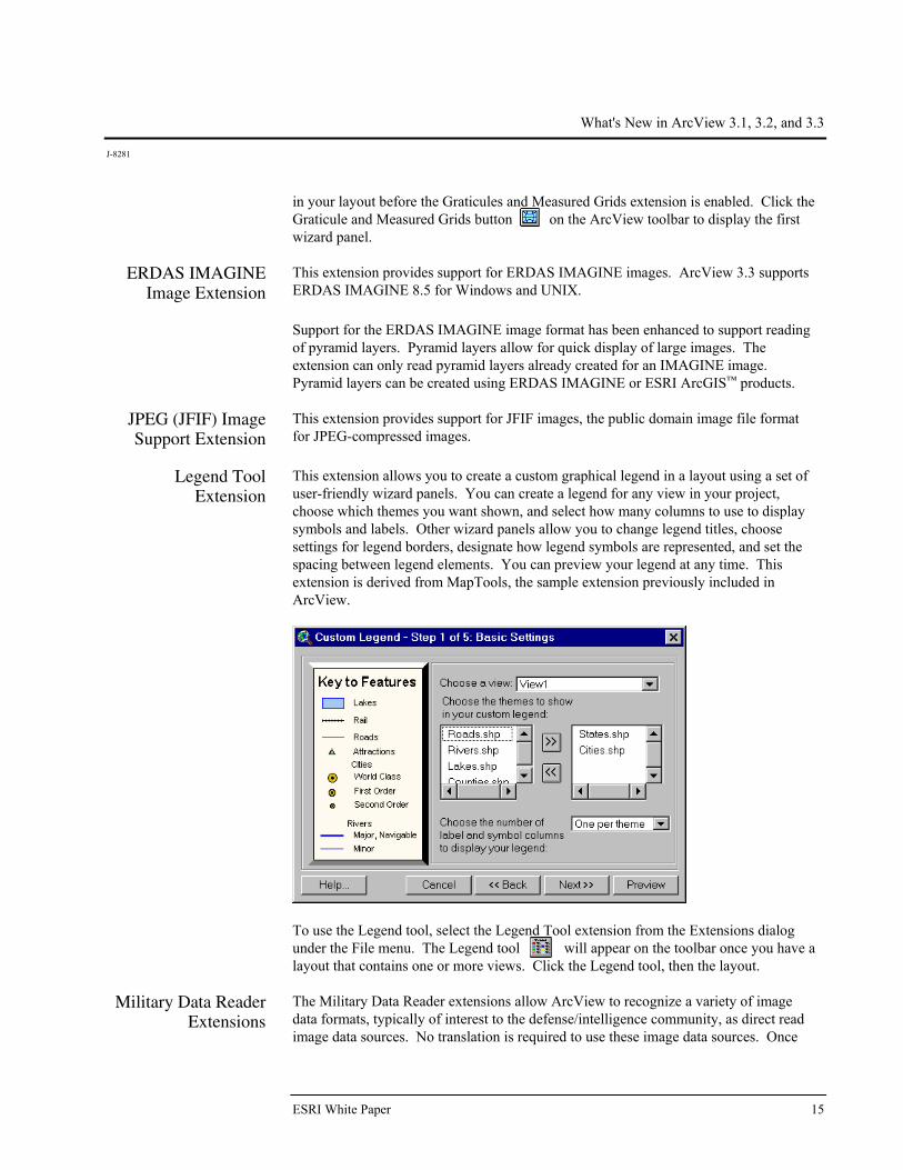
Legend Tool Extension
This extension allows you to create a custom graphical legend in a layout using a set of user-friendly wizard panels. You can create a legend for any view in your project, choose which themes you want shown, and select how many columns to use to display symbols and labels. Other wizard panels allow you to change legend titles, choose settings for legend borders, designate how legend symbols are represented, and set the spacing between legend elements. You can preview your legend at any time. This extension is derived from MapTools, the sample extension previously included in ArcView.
To use the Legend tool, select the Legend Tool extension from the Extensions dialog under the File menu. The Legend tool will appear on the toolbar once you have a layout that contains one or more views. Click the Legend tool, then the layout.
Military Data Reader Extensions
The Military Data Reader extensions allow ArcView to recognize a variety of image data formats, typically of interest to the defense/intelligence community, as direct read image data sources. No translation is required to use these image data sources. Once

What's New in ArcView 3.1, 3.2, and 3.3
J-8281
June 2002 16
the proper extension for each image format is loaded, you can use these image data sources with ArcView like any other supported image data source. The Military Data Reader consists of multiple extensions that you can use in any combination. These extensions include support for the following formats: ARC Digitized Raster Graphics (ADRG Image Support extension)
Compressed ARC Digitized Raster Graphics (CADRG Image Support extension)
Controlled Image Base (CIB Image Support extension)
National Image Transfer Format (NITF Image Support extension)—NITF image
support at ArcView 3.3 has been enhanced to read all images in .ntf format as well as rotated NITF images. A sample script to read annotation is also included.
MrSID Image Support
Extension MrSID™ is a multiresolution wavelet-based image format that allows a high compression ratio and fast access of large amounts of image data at any scale. Support for the MrSID image format was added as an example of using the ImgDLL class that allows image formats to be added to ArcView. When you load the MrSID Image Support extension, you can add .sid files to views as image themes.
Report Writer Extension
The Report Writer extension integrates the industry-leading Crystal Decisions' Crystal Reports report generating and editing application with the existing ArcView Table, View, and Project user interfaces. The goal of the ArcView Report Writer interface is to streamline the process of data selection and preparation for the reporting process. ArcView provides a report wizard that lets you choose the type of report you want, choose whether you want to use all the records in the table or only the selected records, and specify the output report name. Then the report wizard starts the Crystal Reports application with your data already loaded so you can easily continue designing your report. ArcView 3.3 includes Crystal Decisions' Crystal Reports 8.5. With the ArcView report wizard, you can choose one of the following report types: Quick Report Standard Report Form Letters Mailing Labels Top Number (N) Report Cross-Tab Report Drill-Down Report A report based on another template
Note: If you do not have Crystal Decisions' Software's Crystal Reports installed on your system, you can still create a simple report with ArcView using Quick Reports. The Quick Reports option does not use Crystal Decisions' Software's Crystal Reports and is available after any installation of ArcView. The Quick Reports interface provides basic tools for selection and organization of fields; setting fonts, column width, and row heights to be used in the report; and previewing and printing the report.

What's New in ArcView 3.1, 3.2, and 3.3
J-8281
ESRI White Paper 17
The Report Writer extension is not available on UNIX.
TIFF 6.0 Image
Support Extension The TIFF 6.0 Image Support extension allows you to add version 6.0 TIFF files to Views as image themes and place them on Layouts in picture frames. TIFF 6.0 image support includes the use of GeoTIFF 1.0 tags to properly place the image in the proper geographic space, if present.
VPF Viewer Extension
VPF Viewer extension allows you to work with vector product format (VPF) data in ArcView. Using this extension, you can integrate VPF databases into your work seamlessly without having to convert these files into ArcView shapefile format. The VPF Direct Read function has the ability to add valid three-dimensional VPF themes as three-dimensional type files. A valid three-dimensional VPF theme is one where there are no null Z values present in the coordinate geometry. If any null values are found in the geometry, the theme will be added to the view as a two-dimensional type file. The VPF Direct Reader will automatically detect whether a VPF theme is three dimensional and add it accordingly. To view the shapefiles in three dimensions, you must have the ArcView 3D Analyst extension loaded.
What's New in ArcView 3.1, 3.2, and 3.3
J-8281
June 2002 18
Optional Extensions to ArcView
The optional extensions bring advanced, specialized GIS analysis to the desktop. They are available as separate software.
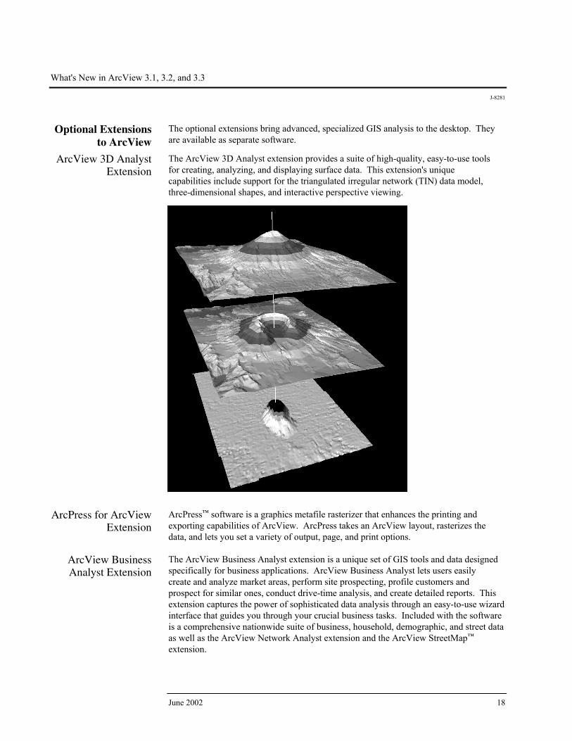
ArcView 3D Analyst Extension
The ArcView 3D Analyst extension provides a suite of high-quality, easy-to-use tools for creating, analyzing, and displaying surface data. This extension's unique capabilities include support for the triangulated irregular network (TIN) data model, three-dimensional shapes, and interactive perspective viewing.
ArcPress for ArcView
Extension ArcPress™ software is a graphics metafile rasterizer that enhances the printing and exporting capabilities of ArcView. ArcPress takes an ArcView layout, rasterizes the data, and lets you set a variety of output, page, and print options.
ArcView Business Analyst Extension
The ArcView Business Analyst extension is a unique set of GIS tools and data designed specifically for business applications. ArcView Business Analyst lets users easily create and analyze market areas, perform site prospecting, profile customers and prospect for similar ones, conduct drive-time analysis, and create detailed reports. This extension captures the power of sophisticated data analysis through an easy-to-use wizard interface that guides you through your crucial business tasks. Included with the software is a comprehensive nationwide suite of business, household, demographic, and street data as well as the ArcView Network Analyst extension and the ArcView StreetMap™ extension.

What's New in ArcView 3.1, 3.2, and 3.3
J-8281
ESRI White Paper 19
The ArcView Business Analyst extension is not available on UNIX.
What's New in ArcView 3.1, 3.2, and 3.3
J-8281
June 2002 20
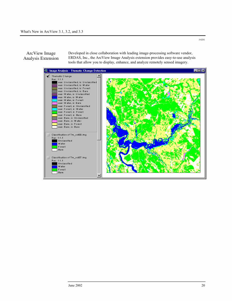
ArcView Image Analysis Extension
Developed in close collaboration with leading image-processing software vendor, ERDAS, Inc., the ArcView Image Analysis extension provides easy-to-use analysis tools that allow you to display, enhance, and analyze remotely sensed imagery.
What's New in ArcView 3.1, 3.2, and 3.3
J-8281
ESRI White Paper 21
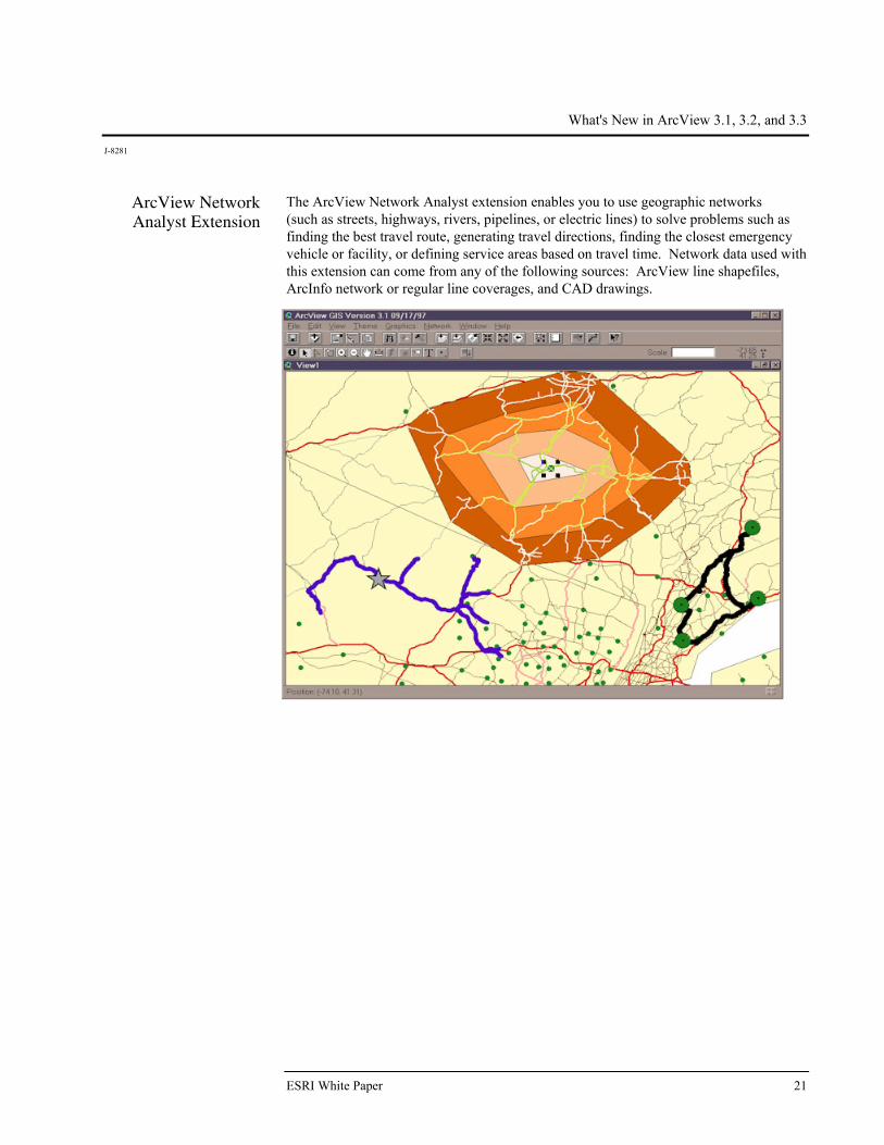
ArcView Network Analyst Extension
The ArcView Network Analyst extension enables you to use geographic networks (such as streets, highways, rivers, pipelines, or electric lines) to solve problems such as finding the best travel route, generating travel directions, finding the closest emergency vehicle or facility, or defining service areas based on travel time. Network data used with this extension can come from any of the following sources: ArcView line shapefiles, ArcInfo network or regular line coverages, and CAD drawings.

What's New in ArcView 3.1, 3.2, and 3.3
J-8281
June 2002 22
ArcView Spatial Analyst Extension
The ArcView Spatial Analyst extension provides tools to create, view, query, and analyze map cell-based raster data and to perform integrated vector–raster analysis using feature-based and grid-based themes. Capabilities include conversion of feature themes to grid themes, creation of buffer distance and proximity surfaces from feature or grid themes, contouring and density mapping from themes containing point features, slope and aspect mapping, cell-based map analysis, Boolean query on multiple grid themes, neighborhood and zone analysis, and grid classification and display. The extension includes an extensive Avenue programming interface for developing spatial analysis applications.

What's New in ArcView 3.1, 3.2, and 3.3
J-8281
ESRI White Paper 23
ArcView StreetMap Extension
The ArcView StreetMap extension adds nationwide address geocoding and street map display to ArcView and includes a compressed street and landmark database for the entire United States on a single CD. The StreetMap extension uses data sources from Wessex Streets 6.0. Wessex, a division of Geographic Data Technology, Inc. (GDT), enhances TIGER 97 by removing the telltale TIGER "wiggle" that results in streets that are not straight. StreetMap data is in NAD83 coordinates. The ArcView StreetMap extension is not available on UNIX.
ArcView StreetMap 2000 Extension
The ArcView StreetMap 2000 extension is enhanced StreetMap software developed jointly by ESRI and GDT. ArcView StreetMap 2000 supports nationwide address geocoding and street map display. This extension uses GDT's Dynamap/2000® database, released in January of 1999, and GDT's Matchmaker® geocoding engine. GDT's Matchmaker geocoder offers traditional geocoding capabilities and allows the matching of intersections and addresses composed of alphanumeric notations. An Interactive Matcher dialog box displays addresses that failed to match, explains the problem, and suggests possible alternatives. Additionally, state boundaries, cities, airports, hospitals, parks, lakes, and river data are integrated into the display of the data found on the CD. ArcView StreetMap 2000 data is in NAD83 coordinates. The ArcView StreetMap 2000 extension is not available on UNIX.

What's New in ArcView 3.1, 3.2, and 3.3
J-8281
June 2002 24
ArcView Tracking Analyst Extension
The ArcView Tracking Analyst extension can be used by anyone who needs to view and analyze the movement and status of objects through time. Developed in close collaboration with TASC Inc., a major provider of advanced information technology solutions for governments and businesses worldwide, ArcView Tracking Analyst supports real-time global positioning system and network connections, allowing you to map events in real time. For example, you could follow your delivery vehicles on their daily routes, track weather conditions such as hurricanes or lightning, or study the migration routes of animals. The ArcView Tracking Analyst extension requires ArcView 3.1 or higher and is available on Windows 95/98®, Windows NT® 4.0, 2000, and XP; and Solaris™.
ESRI Data & Maps ArcView 3.3 includes the ESRI Data & Maps 2002 CDs with eight CDs of data.
There are two major areas of change in the 2002 version of the Data & Maps CDs. The first involves updating more than 450 metadata files to provide full compatibility with the new ArcIMS® 4 Metadata Server. The second major change is that all layers of census geography were updated to be current with Census 2000. All the county, city, place, tract, block group, and block locations have been updated with the most current TIGER or GDT boundary files. All census-derived attributes have been updated with the current Census 2000 Summary File 1 (SF1) and/or Public Law 94 (PL94) attribute values. New year 2001 population estimates are provided from ESRI Business Information Solutions (ESRI BIS, formerly CACI Marketing Services Group) for most of the census geographies, and the Census of Agriculture attributes for states and counties were updated to 1997.

What's New in ArcView 3.1, 3.2, and 3.3
J-8281
ESRI White Paper 25
Other U.S. updates include the 107th Congressional District boundaries as well as new five- and three-digit ZIP Code boundaries current to January 2002. For the world data, international boundaries and time zones have been updated to reflect recent changes. For more details regarding the data, refer to the ESRI Data & Maps 2002 white paper.
Samples The samples directory contains a rich resource of sample programs you can use directly in your work or study to learn more about customizing ArcView. There are three kinds of samples in the samples library: Avenue scripts, extensions, and other sample programs. For a listing and description of samples in this directory, refer to "Sample scripts and extensions" under the Contents tab in the help topics. The extensions are located in the $AVHOME\samples\ext directory in your ArcView installation.
ArcView Connect for R/3 Extension
The ArcView Connect for R/3® sample extension allows you to initiate SAP™ R/3 function modules from ArcView. Using this extension, you can download R/3 data into ArcView for visualization and spatial analysis as well as interact with SAP R/3 on a transactional basis. This extension allows you to immediately utilize R/3 standard functions and provides a flexible tool to build custom applications that require ArcView and SAP R/3 connectivity. ArcView Connect for R/3 will quickly allow, for example, a download of customer information from R/3. If the customer data has address information, it can be geocoded, displayed, and analyzed with any other spatial data using ArcView. ArcView Connect for R/3 can also be used to access data stored in several other SAP modules such as Materials Management (MM), Plant Maintenance (PM), Sales and Distribution (SD), Asset Management (AM), Service Management (SM), and others. This extension uses a generic Dynamic Link Library (DLL) that was built using the SAP C++ Developer Kit. The DLL is wrapped in a Visual Basic® (VB) GUI and allows communication to SAP R/3 via the SAP Remote Function Call (RFC) libraries. All source code for the VB example interface application is provided as part of the extension. The extension requires a standard installation of Samples. Its file name is esrir3.avx and is located in the $AVHOME\samples\ext\esrir3 folder.
ArcView R/3 Interface Project
The ArcView R/3 Interface is a sample project that enables ArcView to communicate with the MM and modules of SAP R/3. The ArcView R/3 Interface can also be customized and extended to work with other R/3 modules and to present more options to the user within ArcView.
Map Labeling Extension
This sample extension adds a choice to the Theme menu that gives you an interface for labeling one or more themes so placement conflicts between labels will be resolved for all labels, regardless of what theme the label belongs to. The interface allows you to set priorities and rules for each theme that goes into the labeling process. For example, you can assign a different font to each theme.

What's New in ArcView 3.1, 3.2, and 3.3
J-8281
June 2002 26
The extension requires a standard installation of the Samples. Its file name is multmlab.avx and is located in the $AVHOME\samples\ext folder.
MGE Reader Extension
This sample extension allows you to integrate data created in Intergraph's MGE software or Bentley's MicroStation® GeoGraphics software. You can also use data in MicroStation design files linked directly to external tables, and ArcView will manage the linkages for you. ArcView presents this data in a manner familiar to ArcView users while maintaining many tools and features of the native software. You can symbolize, query, and analyze the data just like any other spatial data without converting the data to shapefile format. This allows you to view the most up-to-date data in ArcView, while the underlying data is updated in the native software. This extension requires a standard installation of the Samples and is dependent on the CAD Reader extension. The file name is MGEView.avx, and it is located in the $AVHOME\samples\ext folder.
DIGEST (ASRP/USRP)
This sample extension provides direct read support for raster data compliant with DIGEST Annex A, a format primarily used by international defense and military agencies. The reader georeferences DIGEST images. There are two profiles: Arc Standard Raster Product (ASRP), produced by the UK Mil Survey, and UTM/Universe Polar Stereographic (UPS) (USRP), produced by the French Defense Mapping Agency. The sample extension supports ASRP 1.1 and 1.2 and USRP 1.2 and 1.3.
MGRS Coordinate Display
This sample extension provides interactive display of coordinates on-screen in the Military Grid Reference System (MGRS). MGRS is a coordinate system widely used in defense for designating the location of points of interest. Its use is especially prevalent in the army. The extension supports the coordinates as defined in the Army Handbook for the Transformation of Datums, Projections, Grids, and Common Coordinate Systems by the U.S. Army Corps of Engineers Topographic Engineering Center, January 1996. The extension reads source data in decimal degrees, converts the coordinates to MGRS, and displays the MGRS coordinates in a dialog box in real time. The extension converts and displays the MGRS coordinates to UTM/UPS and latitude/longitude. As an option, you can save the UTM/UPS and latitude/longitude coordinates in a separate file. The utility also generates graticules within an MGRS zone for WGS84.
S-57 Data Converter The S-57 data format is defined in the International Hydrographic Organization's Special Publication S-57. This format was formerly referred to as DX-90. S-57 is object-oriented vector data stored in binary format. This sample extension converts the converted binary S-57 (ENC) data to ArcView shapefiles. The extension supports all data types from S-57: spatial objects (connected nodes, isolated nodes, edges, and faces) and feature objects (points, nodes, lines, areas, and composites). The UNIX version of the S-57 converter is only available on Solaris.
3.2
What's New in ArcView 3.1, 3.2, and 3.3
J-8281
ESRI White Paper 27
RPF Indexer Raster Product Format (RPF) is one of the NITF's formats. CIB and CADRG are RPF products. This sample extension uses the geographics extent of each RPF data set and generates a shapefile that can be used as an index theme for RPF image formats. The index theme helps the user choose the images of interest for easier display. The user selects a block or draws a box on the index theme in the View document to display the corresponding images. The user can click on the block (or user-drawn box) again and the images will undraw.

No. GS-35F-5086H
Printed in USA
Place ESRI business partner or distributor address here.
For more than 30 years ESRI has been helping people manage and analyze geographic information. ESRI offers a framework for implementing GIS technology in any organization with a seamless link from personal GIS on the desktop
to enterprisewide GIS client/server and data management systems. ESRI GIS solutions are flexible and can be customized to meet the needs of our users. ESRI is a full-service GIS company, ready to help you begin, grow, and build success with GIS.
International Offices
Regional Offices
ESRI
380 New York Street
Redlands, California
92373-8100, USA
Telephone: 909-793-2853
Fax: 909-793-5953
For more information
on ESRI, call
1-800-447-9778(1-800-GIS-XPRT)
or contact an ESRI reseller near you.
Send e-mail inquiries to
Visit ESRI’s Web page at
www.esri.com
Corporate
Outside the United States,
contact your local ESRI distributor.
For the number of your distributor,
call ESRI at 909-793-2853,
ext. 1235,
or visit our Web site at
www.esri.com/international
ESRI–Minneapolis 651-454-0600ESRI–Olympia
360-754-4727
ESRI–Boston 978-777-4543
ESRI–California909-793-2853 ext. 1-1906
ESRI–Denver 303-449-7779
ESRI–San Antonio 210-499-1044
ESRI–Charlotte704-541-9810
ESRI–Washington, D.C.703-506-9515
ESRI–St. Louis 636-949-6620
ESRI–Philadelphia 610-337-8380
Australia613-9867-0447
Belgium/Luxembourg32-2-460-7480
Bulgaria359-2-964-0850
Canada416-441-6035
France33-1-46-23-6060
Germany/Switzerland49-8166-677-041-1-360-2460
Hong Kong852-2730-6883
Hungary361-428-8040
India91-11-620-3802
Indonesia/Malaysia62-21-570-7685603-7874-9930
Italy39-06-406-96-1
Japan81-3-3794-6681
Korea82-2-571-3161
Netherlands31-10-217-0700
Poland 48-22-825-9836
Portugal351-2-1-781-6640
Romania40-1-231-13-81
Singapore65-742-8622
Spain34-91-559-4375
Sweden46-23-755-400
Thailand66-2-678-0707
United Kingdom44-1296-745-500
Venezuela58-212-285-9394