when colonization goes south: understanding the reasons
TRANSCRIPT

1
When Colonization Goes South: Understanding the Reasons Behind the Failure of Wakefield’s Systematic Colonization in South Australia Edwyna Harris
Monash University
Sumner La Croix*
University of Hawai‘i
3 December 2018
Abstract Britain after the Napoleonic wars saw the rise of colonial reformers, such as Edward Wakefield,
who had extensive influence on British colonial policy. A version of Wakefield’s “System of
Colonization” became the basis for an 1834 Act of Parliament establishing the South Australia
colony. We use extended versions of Robert Lucas’s 1990 model of a colonial economy to
illustrate how Wakefield’s institutions were designed to work. Actual practice followed some of
Wakefield’s principles to the letter, with revenues from SA land sales used to subsidize passage
for more than 15,000 emigrants over the 1836-1840 period. Other principles, such as surveying
land in advance of settlement and maintaining a sufficient price of land, were ignored. Initial
problems stemming from delays in surveying and a dysfunctional division of executive authority
slowed the economy’s development over its first three years and led to a financial crisis. These
difficulties aside, we show that actual SA land institutions were more aligned with geographic
and political conditions in SA than the ideal Wakefield institutions and that the SA colony
thrived after it took measures to speed surveying and reform its system of divided executive
authority.
Please do not quote or cite or distribute without permission ©
For Presentation at the ASSA Meetings, Atlanta, Georgia January 4, 8-10 am, Atlanta Marriott Marquis, L505
Key words: Adelaide; colonization; priority land order; South Australia; auction; Wakefield;
special surveys; land concentration; emigration
JEL codes: N47, N57, N97, R30, D44
*Edwyna Harris, Dept. of Economics, Monash University, PO Box 8E, Victoria 3800, Australia;
[email protected]; Sumner La Croix, Dept. of Economics, University of Hawaii, 2424
Maile Way, Honolulu, HI 96822, USA; [email protected]. We thank staff at the University of
Hawaii, State Library of Victoria, State Library of New South Wales, State Library of South
Australia, the National Archives of Australia, and State Records of South Australia for their help
in locating sources.

2
I. Introduction
After the Napoleonic wars social and political problems plagued Britain, particularly in
relation to low wages, depressed returns to capital, and the rise of pauperism that imposed
high costs on the state. These circumstances resulted in a slew of political economy theories
from social and political reformers aimed at relieving these ills, particularly the burden of the
working poor. A major theme of such theories was how colonization may provide some outlet
for the impoverished working class thereby improving living standards both at home and
abroad. In the 1820s and 1830s, colonial reformers, such as Edward Gibbon Wakefield, Charles
Buller, Sir William Molesworth, and Lord Durham were able to attract attention and followers
who had extensive influence on British policy, both towards its existing colonies and the
establishment of new colonies, such as South Australia and New Zealand. Wakefield’s short
pamphlet, A Letter from Sydney (1829b), was particularly influential in the 1830s, as it proposed
a new ‘theory’ of colonization—known as systematic colonization—designed to avoid many of
the economic and social problems found in existing colonies. Wakefield argued that its
emphasis on concentrating settlement by setting a sufficiently high price of land and on
subsidizing immigration would guarantee returns to capital and yet provide upward mobility to
migrant laborers after working for several years. The pamphlet takes the perspective of a
convict just returned to England from New South Wales, Australia, who details the evils of the
convict labor system and then outlines how a new colony might successfully rely on free labor.
Wakefield’s scheme became the focal point for policies propounded by the National
Colonization Society, a group that Wakefield helped establish. In the early 1830s, the Society
began to advocate for the establishment of a new British colony located between the New
South Wales and Swan River (Western Australia) penal colonies. After much debate and several
draft plans being refused, a somewhat watered-down version of Wakefield’s “System of
Colonization” became the basis for an August 1834 Act of Parliament that established the South
Australia (SA) colony. The experiment commences in 1834/1835 with the establishment of a
Colonization Commission tasked with organizing colonization, recruiting migrants, selling rights
to lands in yet-to-be-explored SA, and funding ships to bring surveyors and, later, migrants to
the colony. From April 1836 ships sailed to the other side of the globe to implement the
colonization plan, with land buyers convinced their investments would pay off and migrants
anticipating a better future than in Great Britain.
We start by documenting how Wakefield expected his design of colonial institutions
would work and what their implications would be for landowners, laborers, and the British
public. We then use extended versions of Robert Lucas’s 1990 model of a colonial economy to
explicitly model Wakefield’s institutions and investigate whether they were potentially capable
of performing as expected. A simple static model focuses on how a colonial authority that acts
to maximize profits of landowners chooses both the amount of land to make available for
purchase and the number of subsidized laborers brought to the colony. The two choices are
closely connected because in the Wakefield system the sole source of immigration subsidies is
the revenue derived from land sales.

3
Next we examine whether the actual institutions set forth in the SA Act and the
Colonization Commission’s instructions were capable of implementing Wakefield’s system of
colonization. Some institutions followed Wakefield’s principles to the letter: Land was sold
rather than distributed via land grants or settler claims; land sales revenues were used to
subsidize passage for more than 15,000 emigrants; and land was sold at a fixed price. Two SA
land institutions did not follow Wakefield’s plan: Special surveys and sales of land at a relatively
low price. Wakefield severely criticized the low price (£1/acre) set for all SA country lands by
the Commission in 1835 as inconsistent with his principles of systematic colonization, and
disavowed the experiment months before any ships ever sailed from England (Wakefield, 1849:
20).1 Land regulations adopted in October 1835 allowed for anyone who paid £4,000 upfront to
call for a “special survey” of 15,000 acres anywhere in the colony from which the investor could
select 4,000 acres. Special surveys allowed settlers to disperse far from Adelaide, thereby
dispensing with Wakefield’s principle of concentrated settlement. Other principles, such as
surveying land in advance of settlement and maintaining a sufficient price of land, were
ignored.
Despite initial problems stemming from delays in surveying and a dysfunctional division
of executive authority, we show that the land institutions implemented in SA were more
aligned with geographic and political conditions there than the idealized Wakefield institutions.
We then provide evidence supporting the Colonization Commissioners’ decision to allow
investors to select and purchase large tracts of surveyed lands, at a constant, relatively low
price. We conclude by briefly examining SA’s booming economy after 1844 and consider
whether elements of the Wakefieldian institutional experiment contributed to the colony’s
post-1844 success.
II. A System of Colonization: Wakefield’s elaborate plans for new colonies
Economic conditions in Britain in the 1820s were depressed with large population
growth in urban centres, low wages, and poor living standards. This led philosophers, radicals,
and liberal reformers to focus their attentions on how to improve social conditions via
colonization. Colonization was not particularly popular at the time due to changes in public
attitudes towards the use of slave and convict labor. Hence, reformers looked to develop
alternative methods of colonization that would avoid the moral stain of forced labor in all its
guises. This set the stage for the rise in popularity of systematic colonisation, which is most
commonly associated with Edward Gibbon Wakefield.
1 In a May 1835 letter to Robert Gouger, Secretary of the SA Colonization Commission, Wakefield stated:
“I have always thought £2 the very lowest price that ought to be required for the object in view … If they
[the commissioners] start with 12s., the colony will be a second Swan River, and if you support that
price, many people will naturally suppose that I do. It is for the sake of a year or two hence that I wish to
guard myself from only a seeming participation, through you, in an experiment which, in my opinion,
must [original emphasis] fail” (Quoted in Hodder (2013) and Mills, 1915: 237).

4
Prior to his three-year term in Newgate prison for fraud and abduction of an heiress,
Wakefield was unknown in intellectual and political circles. Wakefield ideas gained public
attention via the publication of his book, The Punishment of Death, an exposé of the brutal
treatment of prisoners in Newgate Prison, and the pamphlet, A letter from Sydney (1829b)
mentioned above. Jeremy Bentham, the founder of modern utilitarianism, became an avid
supporter of Wakefield’s colonization theory, and it had a significant impact on many radical
reformers of the day including Sir William Molesworth, radical politician and historian George
Grote, MP Charles Buller, and politician and colonial administrator Lord Durham (Bloomfield,
1961). Due to the social stain associated with his criminal conviction, Wakefield rarely took
center stage in the reform groups efforts to change British policy to favor systematic
colonization but his extensive writings on the topic were widely circulated and he was a pivotal
part of efforts to establish British colonies in SA and New Zealand and to reform the colonial
government in Canada (Temple, 2002).
Wakefield’s colonization scheme drew its motivation from several factors, including to
improve the socio-economic conditions of the English and Irish poor by facilitating colonial
emigration; to provide land owners in Britain’s colonies with an increased supply of labor; and
to create an outlet for a glut of capital in the United Kingdom (Wakefield 1829b: 186-188). His
outline of a system of colonization contains nine articles. Briefly, the key features of his
proposal were aimed at balancing three factors of production that is, land, labor, and capital. In
the first instance, the model required land to be sold at a ‘sufficient’ price.2 This would
generate a stream of revenue to pay for assisted immigration leading to the establishment of
an agricultural workforce.3 In turn, this would create positive returns to capital for those who
2 Wakefield (1829b) was not the first person to suggest colonial land should be sold rather than given
away. For instance, Robert Gourlay (1822), writing on Upper Canada, argued that colonial land should
be sold rather than given away, with the proceeds used to assist migration. Robert Torrens had also
advocated land sales rather than land grants prior to Wakefield’s advocacy (Kittrell, 1973). In an 1827
speech to reinstate the Select Committee into Emigration to the House of Commons, Torrens stated
that:
a well regulated system of colonisation would … apply the redundant labor and capital of the
United Kingdom to the redundant land of the colonies; it would restore the properties on which
prosperity and happiness depend … the productivity of labor in the new colonies would be able
in a very short period to replace, with surplus, the capital advanced for transportation (Torrens,
quoted in Booth (2004:78)).
Hutchinson (1958) argued that, in the 1830s and 1840s, Torrens was only second to Wakefield in
advancing both political motives and theoretical justifications for colonization. The major difference
between Torrens’ and Wakefield’s ideas on colonization was that Torren’s plan had the British
government paying for passage and supporting emigrants upon their arrival with a grant of land and
other necessities before they became independent.
3 Wakefield was neither the first writer to discuss methods of alleviating the poor socio-economic
conditions of British workers nor the first to propose a system of colonization. For instance, Under-
Secretary of State for the Colonies between 1822 and 1828, Robert Wilmot-Horton, employed a wages-

5
purchased land. Positive returns were generated by a guaranteed labor supply employed in
agriculture to create output that, over time, would be in excess of colonial needs thereby
establishing an export sector.
The requirement to sell colonial land at a ‘sufficient price’ became the centrepiece for
Wakefield’s theory and he used the failure of the Swan River colony in Western Australia as an
example of why setting land prices sufficiently high was critical. At Swan River, economic
progress had been stifled because low land prices (at 1s 6d/acre) induced laborers to become
land owners, leaving the colony with too few laborers to exploit opportunities on settled lands
(Hodder, 2013). In other words, there was an abundance of land but too little capital and labor.
Further, the ease at which land was available led to the disastrous dispersal of a few settlers
across a large geographical area. Hence, the appeal of Wakefield’s notions of systematic
colonisation lay in the fact that it would not cost the British Treasury a cent because returns
from land sales would provide the funds to pay for the passage of a continuous stream of
emigrants. In other words,
The foundation and cardinal principle of the self-established and self-supporting colony
of South Australia is, that the waste and unoccupied land shall be sold at a price
sufficient to carry out the requisite supply of labor for its cultivation (British
Parliamentary Papers, 1836: 465).
Moreover, when all of the revenue from selling land was committed to subsidizing migrant
labor, “the capitalist obtains a more ample and constant supply of that indispensable
instrument of production, than that which it would be possible, under any other arrangement
to obtain at so cheap a rate” (British Parliamentary Papers, 1839: 10). The land price therefore,
acts as a bounty on the introduction of capital by giving land a greater value than the price at
which it is sold.
The price of land sold in the colony had to be ‘sufficient’ to achieve two goals: (1)
generate enough revenue to bring the desired quantity of labor to the colony and (2) prevent
laborers, once they arrived in the colony, from becoming landowners too quickly. The logic is
that if the land price is set too low, assisted migrants could buy land on arrival and this would
reduce the ratio of labor to land below that which would maximize returns to landowners. In
other words, the reduction in the labor supply available to land owners and an expansion in the
number of land owners would together result in higher wages and depress returns to
fund approach arguing that wages in Britain were low because labor supply was greater than demand
(Kittrell, 1965). To improve wage rates required a reduction in population via colonization while
simultaneously creating alternative markets for British output. Reducing population would require
pauper emigration to the colonies to be funded by parishes; individuals would forgo parish maintenance
in exchange for assisted passage. The sticking point of Wilmot-Horton’s ideas was the objection to
parishes financing migration. Therein lay the appeal of Wakefield’s theory whereby migration would be
funded by revenue from colonial land sales.

6
landowners. But, if the land price was ‘sufficient’, labor would be compelled to work for three
to four years before entering the land market. This would create satisfactory returns to capital
while keeping wages low albeit, higher than in Britain. In addition, once laborers had saved
enough money to purchase land, the new flow of migrants subsidized by these land revenues
would be sufficient to keep wages from rising. The process would continue indefinitely until all
land was occupied. However, the question remains, what is the sufficient price of land?
In the article, ‘Sketch of a proposal for the colonization of Australasia’, Wakefield
(1829a) stated the sufficient price was £2/acre. However, in A letter from Sydney (1829b: 178)
he retracted this quantification and argued that the sufficient price was dependent on context.
This context required a consideration of two elements before the sufficient price could be
established: first, the length of service that labor should provide before becoming land owners;
and second, the general conditions of the colony, such as climate, wage rates, and living costs.
Once these were determined, it was possible to establish how much labor could save and set
land prices at a rate that would ensure labor provided a period of service before they could buy
land and become cultivators in their own right.4 In other words, no one price would fit all
colonies in every circumstance.
Torrens (1835) was the first to set forth the idea that the sufficient price required a
reference to wages. Torrens (1835: 70) illustrated the idea as follows: assume wages were
40s/year with a frugal laborer able to save 50 per cent/year. In order to prevent them from
purchasing land for three to four years then, the sufficient price would be £3 12s/acre.
Nevertheless, because wage rates were likely to change, in practice, the ‘sufficient’ price would
require adjustments over time in order to provide the correct balance of land, labor, and
capital. Lloyd Prichard (1968: 255) argued that:
the price would depend on the rate of increase of population and therefore on
migration which, in turn, would depend on many factors. It would also depend on the
rate of accumulation which would depend on wages, the cost of living, and the number
of acres required to provide the laborer with a living.
Wakefield himself acknowledged that economic dynamics in a given colony mattered for the
calculation of a sufficient price, but he ignored two critical factors. First, he paid no attention to
the extent of information and forecasting required on the part of officials to continuously adjust
the price to achieve his twin goals of sufficient subsidized immigration and deterrence of land
purchases by new migrants. Second, he paid little attention to the costs of adjusting colonial
labor supplies. Adjustment costs would be imposed by the lags between identifying the need
for more labor in a colony and actually receiving the shiploads of migrants to satisfy this
demand. If land was released without enough available labor, then returns to capital would be
4 Mills (1974) notes the flaws in this system in that, over time, the theory becomes more complex in that
it was difficult to determine the land price that would achieve the dual objectives of restricting
ownership and providing the exact labor supply required by land owners.

7
stifled, wages would increase, and the whole plan would become essentially inoperable.
Alternatively, if land were not released quickly enough, assisted migrants would face
unemployment imposing additional costs on already constrained government finances.
Mills (1915:214-215) observes that the Wakefield model does not incorporate any
notion of a “limits of location”, a boundary beyond which settlement would not be allowed. His
principle of a “sufficient price of land” would, however, tend to concentrate settlement on
good lands not too distant from the capital city. As distance from the central city and port
increased, the cost of transporting goods to market increases and beyond a certain distance,
returns to lands purchased at the sufficient price would be negative. Colonies often imposed
limits to location because they needed to account for the presence or opposition of local
indigenous populations. Wakefield never considers indigenous people in his theory of
systematic colonization and thus implicitly adopts the doctrine of terra nullis, that the land is
not used or occupied. The degree of opposition from indigenous populations could, however,
affect the viability of the property rights regimes envisioned for colonies founded under
Wakefield’s principles (Dye and La Croix, 2013 and 2018). Higher levels of indigenous
opposition require more effective third-party garrison protection rather than less effective first-
and second-party protection to guard settlers’ life and property. Garrison protection allows the
government to survey and carefully delineate property rights to lands and then sell surveyed
properties to settlers and investors. Lower levels of opposition provide incentives for settlers
to squat on lands beyond the boundary of surveyed lands, using first- and second-party
enforcement to protect their claims against other settlers and indigenous peoples.
III. Modeling Wakefield with an Expanded Lucas Model
In his 1990 article on colonial investment, Robert Lucas, Jr. poses a question that applies
directly to the settlement of British colonies: Why doesn’t more capital flow from the home
country to its colonies when colonial investment is protected by well specified and enforced
property rights and there are high returns to colonial investment? Lucas uses a simple one-
period, two-factor production model to provide one answer to his question. He assumes that
the colony’s production function is y=f(x), where x is capital per worker, the number of workers
is fixed, and the colony’s government has the ability to choose the amount of home investment
in the colony. In Lucas’s simple one-period model, the government acts as the agent of
investors by choosing x so as to maximize:
f(x)-{f(x)-xf’(x)}-rx (1)
where r is the opportunity cost of capital and {f(x)-xf’(x)} is the wage bill. Following Lucas
(1990:95), the first-order condition is:
f’(x)=r-xf’’(x). (2)
In other words, the marginal product of capital equals the opportunity cost of capital minus the
“derivative of the colony’s real wage rate with respect to capital per worker” i.e., the

8
opportunity cost of capital plus a “monopsony” wage discount. This implies that the return to
capital in the colony is greater than the return to capital in the home country. Lucas’s new
insight from this simple modeling is that higher measured returns to British colonial investment
could be the result of restrictions on capital flows from the home country to the colony.
In the Lucas model, there is a large, fixed supply of indigenous labor and the critical
problem for the colony is to provide incentives for investors to bring relatively scarce capital to
the colony while controlling overall levels of investment. In some British colonies – think SA –
labor was the relatively scarce factor. In SA supplies of Aboriginal labor were relatively small at
initial settlement in 1836 due to declines in population from exposure to new diseases and
Aboriginal resistance to, rather than cooperation with, invading colonists. From the perspective
of SA investors who had purchased SA land, Aboriginals were not a source of labor for colonial
enterprises, and thus the central problem for land owners was to induce sufficient supplies of
labor to migrate to the colony and work on the lands they had purchased. Obstacles to SA
emigration included the high cost of passage to Australia relative to the cost of passage to
Canada or the United States and objections by the colony’s founders to the use of servitude to
facilitate repayment of debts incurred for passage costs.
To account for these initial conditions, consider a second model that is a simple variant
of the Lucas model in which we replace capital with surveyed land in the production function
and allow labor to be brought to SA at zero cost and property rights in land to be established
also at zero cost. In this case, the organizers of the colony would adjust land and labor supplies
to generate x*, the land/labor ratio that maximizes profits to the colony’s land owners. All SA
arable land would be brought into production and sufficient labor brought to the colony to
reach x*.5
Now consider a third model that is a variant of the second model in which it is costly for
labor to migrate from Britain to SA and British residents would not choose to travel to SA if they
had to pay the full cost of passage. Wakefield’s model of systematic colonization was designed
to relieve colonial labor scarcity by using revenue from the sale of SA land to fully or partly
subsidize passage of selected British migrants to SA. The number of migrants who could be
subsidized was determined by the price of land set by the Colonization Commission, the
demand for land at the fixed price, and the cost of passage from Britain to SA. We assume that
workers were willing to migrate to the colony when net wages in SA exceeded wages in Britain
and other colonies; that a worker can be transported to SA at constant cost c; that SA land is
sold at a constant price p; and that an acre of newly purchased land is identical to an acre of
land already in production. In this case, the colonial government, the agent of the land owners,
maximizes:
max {f(x(p)) –[f(x(p)) -x(p)f’(x(p))] – px(p))} Þ xf’ – px (3)
w.r. p
5 The x* in model one and model two would be identical if the transport cost of bringing the same values
of human capital and physical capital to SA are identical.

9
s.t. c/p £ x(p)
where x(p) is the ratio of land to labor at price of land = p, x’(p)<0, and f(x(p)) -x(p)f’(x(p)) is the
land owners’ wage bill. Substituting and solving for the Kuhn-Tucker conditions:
c/p £ x(p) (5)
x’(p) f’(x(p)) + x(p) f’’(x(p)) - px’(p) - x(p) = 0 Þ x’f’ + xf” – px’ – x = 0 (6)
Substitute for x(p), divide by x’ and rearrange:
f’ = p – p exp(1-f’’) (7)
This result says that the marginal product of land equals the price of land—the standard
condition in a one-period competitive land market—plus the monopsony discount to wages
attained by providing less land per worker. In this model, the optimal land-labor ratio x*³ c/p.
If all revenues from land sales are spent on subsidizing labor emigration, then x=c/p. If the
unconstrained profit-maximizing x* > c/p, then land owners will choose this option and devote
only a portion of the revenue from land sales to subsidizing migration. If x* < c/p, then owners
spend all revenue from land sales on subsidizing migration but are unable to reach the profit-
maximizing x*.6 By the envelope theorem, we find that ¶X*(p)/¶c = 1/p > 0. Thus, as the cost
of transporting new migrant workers to SA falls, investors purchase more land, provide the land
fund with more resources, and thereby allow more assisted emigrants to travel to SA.
IV. Experimentation: What Went Right and What Went Wrong
Led by two close associates of Wakefield, Robert Gouger and Major Anthony Bacon, the
National Colonization Society’s initial (1832) plan for colonizing SA revolved around a powerful
company with £500,000 in capital selling SA land and controlling the colonial government. The
Colonial Office rebuffed this proposal and the Society responded with a revised plan that
retained a profit-making corporation, the SA Land Company, as the organization that would
make and enforce rules for colonization. James Stephen, permanent counsel to and later
Under-Secretary of the Colonial Office, derided the new plan as “wild and impractical”. Hopes
for approval increased with the change of government in 1833 and the appointment of Lord
Stanley, a politician more sympathetic to rational colonization ideas, as Secretary of War and
the Colonies. However, a revised plan failed in March/April 1833 after renewed objections
from the Colonial Office (Pike, 1967:64-65). Later that year promoters of SA colonization
6 Sales of additional lands do not change this result. It is important to stress that model 3 indirectly
incorporates Wakefield’s condition that migrant labor find it unprofitable to quickly purchase new
colonial land. This is because the model’s results require the colonial government to distribute less land
than demanded by all individual investors.

10
offered a new plan based on a non-profit SA Association. In March 1834, the Association’s
governing committee devised a new bill that established a hybrid colony, “something between
a Crown and a charted colony.” It stipulated that the Association’s governing committee
administer the Crown colony and have a role in nominating and replacing the colony’s governor
(Pike, 1967:68). Lord Stanley insisted that the bill provide for immigration to the colony only
after a loan of £50,000 was raised, £35,000 of land sold, and the Association replaced by a
government-appointed South Australia Colonization Commission. A much-amended version
incorporating Lord Stanley’s requirements passed through the Houses of Commons and Lords in
August 1834 and was ratified by the King.
A. What Went Right: Preliminary Land Sales and Subsidized Migration
The eight SA Colonization Commissioners—four Tories and four Liberals--were charged
with selling £35,000 of land and setting a single price of land that was sufficiently high so as to
prevent emigrating laborers from immediately buying land. This issue became a source of some
contention between the Commissioners and Wakefield because, as mentioned, Wakefield had
quantified the ‘sufficient’ land price at £2/acre. Wakefiled lobbied for his preferred price but in
June 1835 the Commissioners set the price of a “Priority Land Order” (PLO), consisting of 80
country acres and 1 city acre at £81, i.e., an average price of £1/acre.7 Wakefield criticized this
price as far too low and distanced himself from the SA colonial experiment. Despite the lower
price, by August 1835 land sales had stalled, with just over half of the required sales achieved.
Rowland Hill, Secretary to the Colonization Commission summed up the problem: “there is
quite an essential difficulty, namely the necessity for selling land … which no one knows
anything about” (cited in Sutherland, 1898:40; see also British Parliamentary Papers, 1836:4).
To prevent the collapse of the scheme before settlement had even commenced, three
investors closely connected with the venture – George Fife Angas (a Commission member),
Thomas Smith, and Henry Kingscote – formed the South Australian (SA) Company offering to
buy the remaining packages at a reduced price of 12s/acre. Their offer prompted a surge of
buying activity at the 20s/acre price by other parties, bringing the number of 81-acre PLOs sold
to 334, still far short of the required sales (Price, 1924:33-34). The Commission responded by
temporarily reducing the price of land to the legal minimum, 12 shillings, and allowed the three
main SA Company investors to purchase 103 PLOs and transfer them to the Company.
Investors who had already purchased PLOs (or put down deposits) were compensated for the
reduced price paid by the SA Company by being awarded rights to an additional 54 acres of
country land, thereby providing them with one city acre and 134 country acres. By the end of
December 1835, the Commission had secured land sales of £35,000 as well as the stipulated
£50,000 loan. The government then allowed the Commission to begin the process of recruiting
migrants and setting up the machinery of colonial administration.
7 There appears to have been little attention paid to the fact that upset prices for land in neighboring
New South Wales (including Victoria) was 5 shillings/acre from 1831 to 1838 when it was increased to
12s/acre. By 1842, under the Imperial Wastelands Act, the upset price was further increased to £1/acre.

11
The Colonization Commission moved quickly to recruit emigrants eligible for assisted
passage. Settlers applying for assisted passage were required to complete a form detailing their
occupation, age, married status, and number of children. The form included the name of a
recent employer who would vouch for the applicant as well as the minister of the local parish in
which they resided. Preference was given to married couples and those with trades that would
be required in the colony, including, for example, agricultural laborers, coopers, smiths, boat-
builders, tanners, and brickmakers (British Parliamentary Papers, 1836:27-28). Of the 9,422
applications (submitted by family) for assisted passage between 1836 and 1840,, embarkation
orders were issued to 5,070, comprising 3,942 adult males, 3,548 adult females, and 4,718
children (Pike, 1967:180). On arrival, adult emigrants were expected to enter the labor market
and work until they could buy their own land.8
In spring 1836 hundreds of eager migrants had wound up personal business, quit their
jobs, and sold most of their belongings. Impatient to start their colonial adventures, they
chartered their own ships and left earlier than planned for SA, arriving well before colonial
officials were ready for them. Adult emigrants totaled 753 people in 1836 and 858 in 1837, and
they brought 609 children with them (Table 1). Much larger flows of emigrants were triggered
in 1838 and 1839 with the influx of revenues from special surveys and the 1837-38 rebellions in
Canada, an alternative destination for British migrants. During 1838 and 1839, 5,445 adults and
3,029 children emigrated to SA. Migration continued at high levels through August 1840 when
it abruptly ended. Reasons include the Colonization Commissioners suspending assisted
migration, perceptions by migrants of brighter prospects in the newly opened Wakefieldian
colony of New Zealand, and reports that lands outside of the immediate area around Adelaide
were unsuited for arable agriculture.
In sum, Wakefield’s plan for using proceeds from land sales to subsidize emigration to
SA was broadly carried out as designed, with more than 50 percent of proceeds from land sales
devoted to subsidizing passage for emigrants. The time lag between sale of SA lands and arrival
of subsidized emigrants in SA was variable. For example, revenue from the special surveys
requested during the first eight months of 1838 subsidized the large emigrant flows arriving in
the colony in 1839 and the first eight months of 1840.
B. What went Wrong: Survey Delays and the Split Executive
Delays in Surveying. The first and most deleterious effect on the SA colonial experiment
came from survey delays, which had their roots in a number of factors. First, even before there
had been any systematic exploration of SA, the Colonization Commission sold claims to
unidentified lands at unknown locations in the colony. Once land claims had been sold but
before the first ships of emigrants arrived, the survey team was supposed to travel to SA,
8 Those who purchased land could also secure free passage for one servant to accompany them for
every £20 subscribed (Bloomfield, 1961:138). During the first five years of settlement, servants
travelling with employers represented less than one in ten migrants (Pike, 1967:150). The SA Company
used this provision to bring more than 300 employees to SA free of charge.

12
identify a port and capital city, survey lots in the capital, and then identify and survey country
lands suitable for cultivation. After these surveys were completed, the resident commissioner
was to conduct a lottery to determine the order of selection by PLO holders; they would then
choose their land parcel and have the right to use it immediately. This process went awry right
from the start. Ships with surveyors left England on March 20 and May 1, 1836 but were
preceded by two ships from the SA Company carrying officers and settlers. Once the Surveyor-
General, Colonel William Light, and his small team of surveyors arrived in the colony in July
1836, exploration of the coastline ensued to identify a suitable location for a port and a capital
city. This took several months and was delayed by Light’s decision to explore numerous port
locations as well as a disagreement with Governor Hindmarsh as to the most appropriate sites
for the capital city and port. The sites were finalized in January 1837 but this decision was
preceded by the arrival of four commission-sponsored ships with emigrants. Emigrating PLO
investors and agents of absentee PLO investors were shocked to find surveys had not been
made in advance and that the city and port location had not yet been selected.
In February 1837, Light completed staking out 1,042 one-acre rectangular lots that fully
encompassed the new city of Adelaide, with 42 lots reserved for various public purposes. PLO
rights holders who had migrated to the colony, family members acting as their agents,
professional agents, and the other recently arrived migrants were able to see staked-out lands
to gather information before PLO lots were selected and remaining lands purchased in the
subsequent auction. On the morning of March 23 the colony’s resident commissioner held a
lottery to determine the order in which the owner of each PLO would choose a town lot. In the
afternoon PLO rights holders or their agents selected 402 lots within the city boundaries.
Sequential English auctions with an upset price of £1 per acre were then held for each of the
remaining 593 lots on March 30. (See Harris and La Croix (2018a) for a complete discussion of
the allocation of Adelaide lots.)
Survey of country districts to the north and south of Adelaide—promised to be available
to PLO holders on arrival – would take more than five years to complete due to the rugged
terrain in those regions, lack of equipment, the absence of roads, and interruptions forced by
diversion of surveying staff to conduct special surveys.9 No lands outside of Adelaide would
9 Contemporary observers characterized SA surveying operations through August 1838 as far too small
and underequipped. The small size of the SA surveying staff was in part due to a mistake made by
Surveyor-General Light in ascertaining the breadth and depth of his tasks while he was still in England.
Light did not complain about the size of his staff or the resources afforded to them when he left
England, and his opinion was obtained by the Commission. However, letters from the surveyors suggest
the delay in surveying was the result of “the difficult circumstances of survey in a new country without
resources at the command of surveyors at home…instead of that reasonable allowance and that credit
for work done which they feel conscious of deserving, they have been taunted with incapacity and
neglect of duty” (British Parliamentary Papers, 1838:35). In April 1837, one month after city lots had
been surveyed and selected Light informed the commissioners that it would take three years to
complete the preliminary surveys of country lands that were supposed to have been available to land
owners on arrival. Boyle Travis Finniss, a deputy surveyor, notes that surveys were delayed for a myriad

13
become available for selection until May 1838, and then only in Districts A and B in the
immediate vicinity of Adelaide (Figure 1). Twenty-seven of the 437 PLO holders cashed in their
rights to select a 134-acre parcel of country land for the right to select a special survey
(described below) outside of the A-G surveyed districts available for selection. Only 216 PLO
holders would choose parcels in Districts A and B in May 1838 (Figure 2); ten were absent or
“passed” on their selection and the remaining 211 reserved a selection in the C-H districts still
to be surveyed. PLO holders who made selections in the A-B districts did not receive access to
them for several months after their selection, because despite being surveyed and mapped, the
parcels had not been staked out. Price (1924:149) states that “[s]ections gradually became
available in Districts A and B … from July, 1838, onwards, and in Districts C and E from June,
1839” and “[s]ections at Rapid Valley and Encounter Bay were finished from July and August,”
1839. Oldham (1917:53) observes that the majority of claims in District D were not issued until
June 1841, only a few grants in District E had been issued by 1840, and no surveying had been
done in Districts G and H (Kangaroo Island) at the start of 1841. Table 2 illustrates the slow
progress of agricultural production between 1837 and 1842.
Slow surveying would delay the development of farms and this was particularly
important in the SA context because some purchasers of priority land orders and laborers had
migrated to Australia in advance of the surveys, making them particularly reliant on surveys
being completed expeditiously. Slow surveying would force consumption of capital needed to
start new farms or reliance on the government to provide relief and rations.10
We note that
slow surveying might not have been as harmful to non-resident speculators who intended to
hold their selected lands for development at a future date. As their place in a priority queue
was still ensured, they had little to lose.
The Split Executive. Further adding to the problems that confounded the experiment
was the lack of concise detail regarding colonial administration in the Foundation Act of 1834.
The Commission filled this gap by providing letters of instruction to various people appointed in
government positions including, the resident commissioner, treasurer, and colonial
of other reasons including lack of transport to survey locations and irregular provision of rations in the
field to survey workers (Finniss, 1886).
Deputy-Surveyor Kingston was sent to London in June 1837 to request additional help. Upon Kingston’s
return in June 1838, Light was informed that the Colonial Commissioners had rejected his requests for
additional help with surveys, and instructed him to conduct a running survey of a 150-square-mile area.
Light refused and was replaced by Kingston. He fought with PLO holders and the resident commissioner
over the running survey order which was never implemented. Surveyors continued using a
trigonometric survey.
10 Finnis (1886:9) identified the delays in obtaining possession of land purchased in England as producing
a ‘fatal effect’ on bona fide settlers as their small capital was absorbed by the high costs of living and
housing. He argues that this dissipation of capital would have been prevented if only large capitalists
had been given access to land.

14
storekeeper. Instructions to the resident commissioner, James Hurtle Fisher, were relatively
broad guidelines designed to allow him flexibility based on particular colonial circumstances.
He could alter land prices as he saw fit to balance the supply of labor and capital but was
required to keep the Commissioners “constantly informed of the extent of the demand for
labor within the colony”. Fisher was to set relief at a level ensuring no settler fell into a state of
destitution, while not creating disincentives to finding private employment (British
Parliamentary Papers, 1837: 14).
In addition to the resident commissioner appointed by the Colonization Commission,
the Colonial Secretary appointed a governor. The particular and distinct function of the
governor’s office was never outlined in the Foundation Act. When Torrens was asked about the
division of powers between these two offices he noted, “the Act of Parliament was not
sufficiently distinct to enable us to draw any precise line” (British Parliamentary Papers, 1841b:
3). He further adds that while it was generally understood all matters of finance and land
would be within the purview of the resident commissioner, “finance and government are so
blended, that it was difficult to separate the two” (British Parliamentary Papers, 1841b: 3). It
was obvious to officials that the governor had to be able to spend money to provide basic
services but his ability to do so was constrained under the 1834 Foundation Act which
restricted borrowing to £20,000. By the end of 1837, the governor had spent £17,200 almost
the entire amount for which he was authorized to borrow (British Parliamentary Papers,
1837:12/13).
This vague division of authority not only led to financial difficulties in the colony, but
very public disputes between Governor Hindmarsh and Resident Commissioner Fisher.
Hindmarsh also clashed with the Surveyor-General, Colonel William Light, regarding the site for
the city of Adelaide, a dispute that lingered long after the city had been surveyed and owners
were developing their lots. The bitter feud between several public officials led Fisher, Light and
Hindmarsh to write to London asking for the recall of their opponents. By the end of 1837 it
was obvious the divided authority was leading to dysfunction in colonial administration because
of the, “want of that unity of purpose and effectual cooperation which ought to have existed”
(British Parliamentary Papers, 1837:4). In 1838 Parliament legislated to combine the two
positions. Governor Hindmarsh was recalled and his replacement, George Gawler, became
both governor and resident commissioner.
C. The Enigma of Special Surveys
Douglas Pike (1961) claims that the colony of South Australia was established to allow rich
investors to claim valuable lands in the new colony at below-market prices. Pike cites the
reduction in the price per acre in the 81-acre PLO packages from 20s to 12s in October 1835 as
evidence of a “land job”. He notes that three wealthy investors led by George F. Angas forced
the Commissioners to temporarily lower the price and almost immediately thereafter—on
March 15, 1836—the price for new land orders was returned to the previous price of 20s after
the Colonization Commission’s land sales floor had been met. In his critique, Pike (1961) ignores
the consideration by commissioners that in the absence of the price reduction, the colony

15
would probably have been unable to generate £35,000 in land sales, thus delaying or foregoing
its establishment.
Better evidence for a “land job” might lie in Angas’s insistence that the Commissioners
also amend the land regulations to allow for special surveys. The amended regulations
(October 1835) state that “anyone who shall pay in advance to the proper officer, either in
England or in the colony, the price of 4,000 acres of land or upwards shall have a right, for every
4,000 acres thus paid for, to call on the Colonialization Commission to survey any compact
district within the colony, of an extent not exceeding 15,000 acres, and within a reasonable time
after such survey to select his land from any part of such district before any other applicant”
(British Parliamentary Papers, 1836: 22). The first 28 special surveys were requested between
January 1, 1839, and August 31, 1839, and became available to their owners in 1839 and 1840
as government-paid surveys were completed. Table 4 provides a list of who purchased each
survey and the dates when they became available to their owners, while Figure 2 shows that
the locations of each survey were concentrated along the Murray River, on the eastern side of
the Lofty Mountain Range, and at several locations off the map, including two ports.
The surveys enabled investors commanding sufficient wealth, such as the SA Company or
the agent John Morphett or the South Australian Town Association or G.F. Angas, to claim large
tracts of the best lands in the colony outside of the areas set aside for PLO investors. As Figure
2 shows, special surveys allowed investors to select valuable tracts of land anywhere within the
boundaries of South Australia; the special surveys were colloquially known as “picking the eyes
out of the country.” Special surveys implemented at the price of £1/acre essentially made a
mockery of the Wakefieldian principle of concentrated settlement, as they allowed speculators
to make claims of potentially valuable lands no matter how geographically scattered they were.
The underlying rationale for a special survey is to establish property rights on all potentially
valuable lands and then to let the market determine when the lands will be brought into
production. Because the price of land was set at relatively low levels, the patterns of land
ownership and settlement became, in many ways, the antithesis to the Wakefieldian doctrine
of planned concentrated settlement.
V. New Explanations for SA Land Institutions
Is it possible that the land institutions adopted in SA were actually more suited to the
conditions in the colony than the institutions Wakefield designed? To examine this idea, we
consider how the presence of Aboriginal resistance to British settlers and the existence of
valuable lands far from Adelaide would have affected the design and evolution of SA land
institutions.
A. Aboriginal Resistance to British Settlers.
Resistance from SA Aboriginal tribes was muted in the first 20 months of settlement,
and expanded in the second half of 1838 beyond the immediate area around Adelaide and the

16
country districts. This conflict did not come as a surprise to colonial authorities, as it mirrored
experiences in other Australian colonies as settlement expanded beyond coastal enclaves. The
possibility of confrontation in SA would have been apparent from as early as 1831 after Captain
Collet Barker was killed during his exploratory mission to the area. As a result, sales of property
in such a potentially dangerous environment would require third-party protection from the
government. The Colonization Commission was, however, not prepared to incur substantial
police expenditures to protect settlers and their new properties against Aboriginal resistance.
Governor Hindmarsh’s hands were tied. His official instructions said Aboriginals had equal
protection under the law as did any British subject. But in the absence of a military or police
presence, there were little means available by which to provide this protection either to settlers
or natives.11
However, in early 1838 Hindmarsh, with unanimous consent of the Legislative
Council, retained the 16 marines that accompanied settlers a year earlier as the colony’s police
force (Pike, 1967:285/86).
Early settlers at Adelaide record the local Kaurna people who occupied the Adelaide
plain as being relatively harmless and rather irritating (Barrit Diaries, 20/5/1840: 5; Castles and
Harris, 1987).12
In areas outside the immediate vicinity of Adelaide, there were reports of
conflict between Europeans and local tribes in 1839 (Foster and Nettelback, 2012:26). These
concerns were magnified in July 1840 when 26 settlers were ship wrecked off Coorong, about
180 kilometres south of Adelaide. An Aboriginal tribe killed all survivors, making it the largest
massacre of Europeans by Aboriginals in Australia’s history, an affair which caused
“consternation, fear, and outrage” when it was reported in Adelaide (Foster and Nettelbeck,
2012:26; see also Foster and Nettelbeck, 2009; Foster, Hosking, and Nettelbeck, 2000; Booth,
2004; Lendrum, 1977).
Further conflicts occurred on the overland trails, increasing in frequency, as use of those
routes became the preferred method to supply stock to SA from late 1839.13
Conflict was
centered around the Murray and Rufus Rivers where tribes proved more hostile than those
encountered earlier on the Adelaide Plains. As profit maximizers, overland parties were lured
11
This section refers to the attitudes toward settler protection by the first three governors; the dates of
their appointment and recall were: Hindmarsh, 28/12/1836 to 16/7/1838; Gawler, 17/10/1838 to
15/5/1841; and Grey, 15/5/1841 to 25/10/1845.
12 Barrit notes this but so too do a number of other settlers. See accounts in Booth (2004: 224, 237, 261;)
and Clarke (2005:62, 64, 69). It was one reason a Native Location (referred to as “Piltawodli” by the
Aboriginals) was established on the north side of the Torrens between North and South Adelaide in
1838, to discourage Aboriginals from wandering the streets begging for food and being a nuisance.
13 Edward Eyre travelled 955 miles overland in 21 weeks during 1839 recording a 1 percent loss of stock
while Robert Leake, a pastoralist from Tasmania, shipped stock to Adelaide in 1838, losing about 10
percent of his sheep in the five and a half day crossing (MacGillvray, 1982:14).

17
by large gains from selling stock to settlers in Adelaide (Foster and Nettelbeck, 2012).14
They
encountered Aboriginal groups living along these routes whose native food sources and access
to hunting grounds had been substantially reduced or destroyed as settlement expanded.
Aboriginals viewed European stock as substitutes for their traditional sources of meat such as,
kangaroo, and a natural response to that circumstance would have led natives to steal stock
(Booth, 2004). These losses further incited flock owners and shepherds to cooperate and
undertake violent means of first- and second-party protection and intimidation. Third-party protection was difficult to provide because the Colonization Commission did
not consider resistance from Aboriginal inhabitants inside the colony’s boundaries when it
planned the colony. Thus, it could only make ex post adjustments in protection and property
rights specification.15
How much third-party protection was to be provided to overlanders was a
more difficult issue. Dye and La Croix (2013; 2018) argue a colonial government that sells land
to settlers has incentives to incur sufficient expenditures to provide protection to land owners
or else new investors would not pay for property from which they rationally expect to be
quickly dispossessed. Under these conditions squatting is a better choice. However,
overlanders were not squatters. They may have camped at some locations for a period of time
to rest stock and men but overlanders were merely transitory trading groups crossing
Aboriginal territory to deliver their product. The government’s dilemma was whether to
provide them with third-party protection.
In August 1841, Governor Grey made it abundantly clear to settlers and Lord Russell in
London that individuals “[v]oluntarily withdrawing themselves from the protection of the
British Government” (British Parliamentary Papers, 1843:284) would not be afforded
government defense. However, those “who enter districts only after the government have
declared them open for location…consequently have a right to expect that protection will be
afforded to them” (British Parliamentary Papers, 1843:284). As such, if land was purchased,
surveyed, and then settled, third-party enforcement would be provided (Dye and La Croix,
2013). In all other circumstances, first- or second-party enforcement had to be relied upon.
Governor Grey’s reasoning for not providing third-party protection to overlanders was
that their expeditions, which walked sheep from Victoria and New South Wales sheep stations
to newly established SA sheep stations, were a “matter of private adventure, and not of public
14
For example, in 1838, James Crawford made a profit of £3,000 selling 700 cattle (Foster and
Nettelbeck, 2012:33).
15 The colony’s boundary was fixed in a way as to prevent conflict with inland Aboriginals who may have
had more clear property rights (in the eyes of the British) compared to those in other Australian
colonies. Further, the Colonial Office believed the colony must be responsible for its own safety and the
lack of provision for military or police was one of the reasons Colonel James Napier turned down the
offer to be first governor of the new colony (British Parliamentary Papers 1841c: 53). Contrary to the
Colonial Office view however, Gawler believed the desire to promote settlement and special surveys
carried with them an implicit guarantee of protection (Price, 1924).

18
utility” (British Parliamentary Papers, 1843: 286). Grey’s argument is strained, as government
protection of important trading routes has long been acknowledged as generating public
benefits, in this case allowing faster establishment of the colony’s wool industry and relieving
unemployed emigrants. Another point made by Grey may be more pertinent:
The tracts of country inhabited by these [Aboriginals] being many hundred miles in
length, it appears impossible for the government to occupy its whole extent either with
troops or police stations [so that] no effective protection can therefore be afforded by
these means to particular travellers overland (British Parliamentary Papers, 1843:284)
Add to that the fact Grey had adopted substantial austerity to reduce public spending after the
earlier financial crisis and it appears third-party protection for those crossing the interior would
not be forthcoming.
However, during the last few months of 1841 the severity of conflicts accelerated.
There with reports of warlike attacks by Aboriginals on overlanders.16
In response, Grey
capitulated, sending a dispatch of 25 police (third-party enforcement) and volunteers (second-
party enforcement) from Adelaide to quell further violence. Once the initial skirmishes were
over, in October 1841 a permanent Resident Magistrate and Protector of Aboriginals, Edward
Eyre, was established at the Murray River. This created permanent third-party protection on
the overland trail.17
By 1842, the Imperial Wasteland Act (5 and 6 Vic c.36.) had legalized
squatting to settlers who paid a lease fee to graze cattle and sheep on specific waste lands. In
response to increased squatter presence in the interior, mounted police as well as police
stations were slowly established in the SA interior to provide third-party protection to
legitimate lease holders (MacGillivray, 1982).
B. Valuable Lands Far from Adelaide
South Australia established its land institutions in three distinct phases. In the first
phase (1836-1838), the government surveyed land in Adelaide and surrounding districts A-B
that were specified by Colonial Surveyor Light. From surveyed 1-acre lots in Adelaide and 134-
acre country sections, owners of priority land orders made selections. Remaining lands in
Adelaide were sold at auction and remaining lands in Districts A-B were offered via tender at a
minimum price of £1 per acre. In this first phase, the government specified the form of
property right – fee simple rights including all rights to minerals, payment of property tax, third-
16
For details on the conflict, including eyewitness accounts of the apparent ferocity of Aboriginal tribes
around the Murray and Rufus Rivers in 1841, see British Parliamentary Papers (1843:267-309).
17 Colonists had earlier appealed to the governor to do more to quell the violence on the overland trail
not only to protect capital (stock) but also to ensure the lines of communication between colonies was
maintained (British Parliamentary Papers, 1843:270-271. We note that shipment of sheep from
Tasmania to SA virtually ceased once the overland routes from neighboring colonies became
established.

19
party protection—and delineated the areas which would be surveyed and made available for
sale. Phase two (1839-1841) began in January 1839 when the government began to accept
requests to conduct special surveys of colony lands. Upon payment of £4,000 any investor,
settler, or group could order a government-paid survey of 15,000 acres anywhere in the colony
outside of the original A-H settlement districts. From the special survey area, the buyer could
pick 4,000 acres to which fee-simple rights were assigned.18
Within the colony’s vast
boundaries, there were no limits on the extent of settlement, no boundaries beyond which the
government would refuse to sell land and provide third-party protection. In phase two, the type
of property rights in land was specified by the government, while private parties determined
the particular lands in which property rights were to be delineated. Phase three (1842-1851)
was triggered by passage of the Act for Regulating Sales of Land (1842), which both expanded
and restricted special surveys and repealed previous regulations governing them contained in
the 1835 ‘Modified Regulations for the Disposal of Land’ (British Parliamentary Papers,
1836:22). For a minimum payment of £20,000, an investor could request a perimeter survey of
a compact tract of 20,000 acres and be awarded for fee-simple rights to the entire tract.
Further surveys within the tract were not initially conducted. These larger special surveys were
utilized by buyers in the mid-1840s to establish rights to lands showing signs of rich copper
deposits (Blainey, 1969).
Why did the SA government both specify and delineate property rights in land during
the first phase of settlement (1836-1838), while during the second phase (1839-1841), the
government only specified the form of property right, leaving investors with the choice of lands
to which property rights would be delineated. Yoram Barzel (1997) has argued that the value of
a resource will be maximized when the decision to delineate property rights in the resource is
reserved to the party who has the least cost of measuring its likely value.19
Measuring land
quality is, of course, only important when the value of unclaimed land varies considerably.
Land heterogeneity poses a problem for any von Thünen-based model of frontier settlement
and property rights, as it eliminates the simple relationship between distance from the land to
the market city and port.20
If a government were to set compact boundaries of settlement
based on distance from the central city and port, valuable properties would be excluded from
survey and sale. Settlers would have an incentive to forego payment for surveyed properties
within the boundaries and squat on valuable properties outside the boundaries (Dye and La
Croix, 2013). One way for a colonial government to proceed in the presence of land
18
Unselected survey acres within the special survey were available for sale at a minimum price of
£1/acre.
19 Measurement costs are composed of the costs incurred to find particularly valuable tracts of land and
the cost incurred when low-value lands are identified as high-value lands and erroneously purchased
and surveyed. Minimizing measurement costs is a necessary condition for maximizing gains to society
from the land resource. Barzel (1997:90) observed that “individuals have a comparative advantage over
the government in various delineation activities and actually undertake many of them.”
20 For examples, see Alston, Harris and Mueller (2012) and Dye and La Croix (2013, 2018).

20
heterogeneity is to survey and sell particularly valuable tracts unconnected to other surveyed
areas. But this raises another question: How would the government decide which tracts of land
are valuable enough to warrant survey, sale, and protection? If determination of the value of
far-flung lands requires exploration of particular lands (rather than a larger region) and
evaluation of their commercial potential, then in some cases the value of the resource would be
maximized if government stepped aside and allowed private parties to determine whether a
tract of land is valuable enough for property rights to be established.
Economic historians, in particular Gary Libecap (2007) and Terry Anderson and P.J. Hill
(2005), have carefully documented numerous examples from the American frontier in the
nineteenth-century in which private parties selected tracts of land and natural resources and
effectively specified and enforced property rights to them. Examples include gold mining in
California, silver mining in Nevada, ranching lands on the Great Plains, and water throughout
the West. Examples are not confined to the United States: Lee Alston, Gary Libecap, and
Bernardo Mueller (1998; 1999) have analyzed the complex interaction between private parties,
indigenous groups and the state in Brazil’s Amazon region in specifying, delineating, and
enforcing rights. In many of these cases, authors have emphasized that individuals establishing
land rights had an informational advantage over the state in identifying which resources were
the most valuable, thereby reducing transaction costs associated with rights delineation.
SA land settlement provides some interesting insights into Barzel’s argument regarding
who should delineate rights. This is because property rights were delineated by the
government in phase one and by investors in phase two.21
In 1837 and much of 1838, the
government focused on surveying lands in Districts A and B and then staking out 134-acre and
80-acre plots so that PLO selectors and buyers could take possession of them (Figure 2).22
From
the middle of 1838 through 1842, the government also surveyed lands in Districts C-F and made
them available for selection by PLO holders and purchasers. Surveyors noted that lands in
Sections C-F were extremely rugged and “very intricate” (Price, 1924:132). Resident
21
Private investors clearly have more incentives than government officials to keep investigative costs
low, as they, unlike government officials, are able to keep residual returns from finding valuable
properties. Private investors do not, however, have incentives to account for the government’s
surveying or third-party enforcement costs. One way to partly account for this would be for the investor
to pay for the survey. This would, however, reduce incentives for government officials to conduct least-
cost surveys. Another way to correct misalignment of incentives would be for the investor to pre-pay
for the land prior to the survey and to set a floor on the size of the survey.
22 Government delineation of property rights in phase one has roots in several factors. First, government
surveyors were expected to arrive prior to the initial wave of settlers and conduct surveys of city lots
and country acres. No private parties were expected to be present. (As discussed above, this plan was
not executed properly.) Second, exploratory expeditions of virtually unseen SA surely had some aspects
of a public good and might then be best financed by the government. Third, the absence of an existing
land or inland water transportation network increased the likelihood of the first few hundred farms
being developed near Adelaide and its port.

21
Commissioner Fisher initially restricted surveys to districts A and B surrounding Adelaide, but
PLO holders complained that they had a right to select their lands from any of the A-F districts
and, on the basis of information from exploratory expeditions, wanted to select lands in coastal
areas to the west of Lake Alexandrina.23
Fisher responded in July 1838 by opening the southern
districts for survey and, later the same year, the Colonization Commissioners repealed their
land regulations and “issued new rules which encouraged an even wider dispersion” of
settlement (Pike, 1967:175).
How valuable were the lands in Districts C-F to which the government delineated
property rights? One indicator of value is whether surveyed lands in these districts were
selected or purchased when they became available. Table 3 displays the amount of land
surveyed in district A-F and the amount of land selected by investors as of November 30,
1840.24
PLO holders and buyers had selected or purchased 87.97 percent of surveyed lands in
District A but just 41.9 percent of surveyed lands in District B. In Districts C-F, only 28.52
percent of surveyed lands were selected or sold.
In January 1839 the SA government began to accept applications for special surveys,
which essentially allowed private parties willing to purchase large tracts of land to delineate
private rights in land anywhere in the colony outside of Adelaide and Districts A-H. Because the
price of an acre of special survey land was set relatively low at £1, the system ensured investors
would rush to establish claims to valuable lands widely dispersed throughout SA. In the first
eight months of 1839, 28 special surveys were applied for, another nine through 1840, with a
total of 39 being requested before their suspension on May 6, 1841 (refer to Table 4 for a list of
purchasers of special surveys and the dates they were applied for).25
By November 30, 1840,
government survey teams had completed special surveys of 185,877 acres from which buyers
selected 52,440 acres. The 28.21 percent of surveyed lands selected corresponded closely to
the 26.67 percent dictated by the minimum selection of 4,000 acres from each 15,000-acre
survey. In October 1839 Governor Gawler cut the size of the area to be surveyed from 15,000
acres to just over 4,000 acres in a bid to reduce ballooning survey costs. (See Section 5C
below.). At least 12 special surveys of 15,000 had already been completed, but Gawler’s
restrictions applied at least partly to the next 27 special surveys.26
23
See Pike (1967:174-175).
24 Kangaroo Island, encompassing Districts G and H, provides the exception to the rule. Water sources
on the island were scarce and the government, at the request of PLO holders who had reserved
selection rights on the island, decided to delay surveys on the island given the land’s unsuitability for
pastoral or arable use.
25 In 1846, the Colonial Secretary, Earl Grey, instructed Governor Robe to reject any further requests for
special surveys (Pike, 1967:306).
26 Other restrictions included provisions in the surveys claimed along the Murray River to allow the
government to reclaim waterfront land.

22
The vast majority of the special surveys were located more 100 miles from Adelaide,
ensuring the Wakefieldian ideal of geographical concentration of settlement radiating from a
central city and port would never be achieved. Historians have often viewed the institutions
realized in SA as a paradigmatic example of how institutional designs are rarely implemented as
envisioned and often generate unintended consequences. It is, however, worth asking whether
or not the institutions implemented were flawed due to compromises made in the Foundation
Act or whether the compromise institutions better fit conditions in SA? Is it possible that absent
the delays in surveying and problems with the split executive, these institutions actually worked
pretty well in guiding the extent of settlement and formation of property rights in land?
Consider the establishment of the SA colony within the context of the Dye-La Croix
(2013) model of frontier property rights. One of the model’s main results is that when a
government faces indigenous resistance to settlers occupying land at the frontier, the
government will choose to survey and sell (rather than grant) land within official boundaries of
settlement and provide third-party enforcement of rights to land owners. Another prediction is
that the government will decline to provide third-party protection to settlers who squat outside
the boundaries. In SA, three of the four predictions of the model held—surveyed lands were
sold (rather than granted), third-party protection was provided to land owners, their workers,
and their properties, while third-party protection was denied to squatters who grazed their
flocks on “waste” land, i.e., frontier land claimed by the government but not surveyed or
available for sale.
One prediction of the Dye-La Croix model fails: That the sale of surveyed lands will take
place within limited boundaries of settlement.27
That prediction is, however, dependent on the
model’s assumptions that land quality is homogenous and its value falls as its distance from the
colony’s city and port increases. If, however, there are distant pockets of valuable land, then
there could be gains to private parties from delineating land rights in compact areas far from
the central city. The dilemma inherent in the SA system is that the type of property rights
delineated—fee simple with third-party enforcement—necessarily triggers one-time-only
surveying expenditures and ongoing police expenditures by the colonial government. This
raises a critical question: Does this decentralized mechanism of property rights delineation
generate any incentives for private parties to account for the cost to the government of
providing third-party enforcement and initial surveying?28
Several solutions are possible. First,
the government could have calculated ex ante that a few distant settlements might not be
27
Given the enormous size of the colony within its official boundaries—984,377 square miles overall and
18,147 square miles in the south east, it makes little sense to say that the colony boundaries constituted
the limits of settlement.
28 Systems of copyrights, trademarks, and patents have a structure similar to the SA special surveys: The
government specifies the type of property right and individuals choose whether to delineate intellectual
property rights in their inventions, marks, and creative works.

23
worth the cost of protection but net gains from a decentralized system would be bigger than
net gains from a centralized system. In this case, third-party protection will be provided to
distant settlements even when such protection clearly fails a stand-alone cost-benefit test.
Second, private parties may rationally expect less third-party enforcement than is officially
promised the further away from Adelaide they are. In this case, a selection mechanism
operates, with private parties who select distant lands having the capabilities of providing
effective first- and second-party enforcement to complement the weaker third-party
enforcement provided by the state.29
Finally, special surveys might have been just another
institutional experiment gone awry. Revenues from the sale of special survey tracts allowed
thousands of assisted emigrants to travel to SA in 1839 and 1840. Providing relief to emigrants
unable to find employment overburdened the government in 1840-1841 and was one of several
factors triggering the colony’s financial crisis. The Colonization Commission’s decision in
November 1840 to suspend the surveys might just be characterized as the timely end to an
institution with costly unintended consequences.30
C. Costly Consequences of SA Special Surveys
Governor Gawler took office on October 17, 1838 and signalled that the Land Office
would accept applications for special surveys. The twenty-eight special surveys authorized
between January 15 and August 30, 1839 directly triggered additional government
expenditures for land surveying and police. Table 5 presents quarterly data from official
reports of government expenditures from October 1839 to 1842 as well as extrapolated annual
estimates for 1839, 1840, and 1841. Our estimated expenditures on surveying for 1839, 1840
and the first half of 1841 amount to £89,362.31
This includes surveying expenditures for special
survey areas as well as six of the PLO (A-F) districts. (See Figure 3.) Estimated expenditures on
police, who primarily served in a military capacity in outlying areas, amounted to £39,972 for
1839, 1840 and the first half of 1841.
Expenditures on supporting newly arrived emigrants were indirectly triggered by the
special surveys, as revenue from their sales refreshed the emigration fund and allowed 4,000-
29
Anderson and Hill’s (1990) classic article on frontier property rights argues that open-access
homesteading dissipates rents via a race to claim high-quality lands. Hansen and Libecap (2002) present
(limited) evidence that when Montana lands were opened for homesteading, dissipation of rents was
limited due to self-selection of settlers on the basis of previous farming experience. We note that while
there was a race in SA to claim special survey tracts, dissipation was limited by the use of land sales to
make claims, the absence of a beneficial use provision in the delineation of property rights, and by self-
selection of applicants capable of providing sufficient first- and second-party protection.
30 Three special surveys were conducted between 1843 and 1846 to claim rights to land showing signs of
copper deposits.
31 Accounts from 1837, 1838, and the first three quarters of 1839 were never produced. This is usually
blamed on the incompetence and disorganization of the Colonial Treasurer, Osmond Gilles.

24
5,000 thousand additional emgrants to receive assisted passage to SA in 1839 and 1840.
Estimates of relief expenditures were only separately broken out by the colonial government in
its official accounts from the second quarter of 1841. If we add, say, half of the expenditures
on public works (which employed newly arrived emigrants as a form of relief) to explicitly-
designated expenditures on emigration relief, then relief expenditures amount to £61,387 over
the 1839-1841 period. Our rough estimates of total expenditure on police, surveying, and
emigrant relief amount to £190,721.
Table 5 shows that total revenues from taxes and fees for 1839-1841 amounted to just
£91,263. The choices facing Governor Gawler in late 1838 were stark: the colony’s planners
had not thought a police force would be necessary and had never considered the possibility of
surveying hundreds of thousands of acres of land during the colony’s first five years. The
government’s revenues from taxes and fees were very small, and there were few revenue
sources to draw on to finance additional expenditures. Gawler addressed this issue by using his
emergency powers to issue bills against the British Treasury and Colonial Commission to pay for
more police, surveyors, and relief measures.
Price (1927:195) estimated that overall colonial expenditures from January 1839 to
June 1841 “amounted to £335,505, an excess of £269,537 over the Colonial revenue.” Both
Pike and Price provide evidence that Governor Gawler made a calculated decision to exceed
vastly his borrowing authority to make up for delayed surveying and provide promised police,
surveying, and relief services to settlers. In June 1840 Gawler wrote to the colonial secretary
that:
I considered it emergency when the survey department could not keep pace with the
demand; when the police force was not sufficient to suppress bushrangers and other
lawless characters, to control the natives, and to check contraband trade; emergency,
when public officers of value were leaving their situations on account of the
insufficiency of their salaries, or were trading and really plundering the Government on
what they called authorized principle; emergency, when the survey and land offices
being burnt down, there was not a public office belonging to the Government in
Adelaide, and none of reasonable permanent suitableness to be hired; . . . These, in
addition to immigrant sickness and destitution, are the great and leading objects which
have been to my fullest conviction emergencies, and which have absorbed the greater
part of the extraordinary expenditure (quoted in Hodder, 2013).
The financial difficulties of the colony were partly due to the ideology surrounding its
foundation that it would be self-supporting, a notion that Governor Gawler heartily supported
as he embarked for the colony (Pike, 1967:176). The other Australian colonies had required
large subsidies after their founding (in part in New South Wales to support its gaols) and
Colonial Office opposition in the early 1830s to the creation of the SA colony had multiple roots,

25
including worries about the colony potentially requiring large subsidies from Britain.32
By 1841,
the colonial finances were in such a pitiable state the British parliament formed a Select
Committee to inquire into the extent of the financial crisis. Part of the investigation was
devoted to understanding how and why the so-called ‘self-supporting’ system had failed.
During questioning by the Committee, the chair of the Colonial Land and Emigration
Commission, Robert Torrens, doggedly maintained that up until January 1, 1841, the colony had
been self-supporting (British Parliamentary Papers, 1841b:16). Rowland Hill’s evidence
employed a similar argument. Perhaps their reasoning was that, prior to the crisis, the
Colonization Commissioners did not have to call on the British Treasury for funds. But, when
considered alongside the fact that by 1841 public debt was £305,328, any claim SA was self-
supporting was tenuous at best and a delusion at worst. The outcome of Select Committee in
1842 was the advancement of £155,000 to save the colony from certain bankruptcy.
In retrospect the subsidies involved were quite large given initial expectations about
the colony’s finances but relatively small from the perspective of overall expenditures by the
British government. Just before his departure from SA, Governor Gawler estimated the British
government had spent £200,000 on Swan River since its foundation in 1827 (Gawler on 22 April
1841 as quoted in Booth, 2004:102). Swan River had just 5,586 people in 1850, whereas SA had
15,486 people in 1841 and 63,700 in 1850. Thus, per capita public debt in the Swan River
colony (using the 1850 population and 1840 debt) was £35.8, whereas per capita debt in the SA
colony amounted to just £19.7 in 1841. Moreover, the debt incurred during the SA founding
was not large relative to Britain’s national debt, adding just .04 percent to the 1840 debt of
£788 million.
VI. Conclusion: A barrage of positive shocks Less than six years after the SA colony was established in December 1836, a series of
positive shocks floated the colony towards a robust prosperity. First, the early 1840s global
depression that had reduced the price of wool by more than 50 percent and trimmed capital
flows to SA came to an end in Australia from 1845. As the price of wool rose, capital flows to
SA increased and more land was opened for grazing by cattle and sheep. Second, increases in
land employed for pastoral and arable uses in SA induced an increase in land sales and demand
for labor. Revenue from land sales refreshed the Emigration Fund and allowed large-scale
assisted migration from Britain to resume in 1846. Third, British tariff laws applicable to SA
corn exports were phased out over the 1846-1849 period. But, from June 1851 SA corn exports
to Britain were quickly diverted to Victoria due to the soaring demand from gold miners
flooding into that colony.
These developments were overshadowed by the discovery of copper in 1841, the
opening of two large copper mines in Kapunda (1844) and Burra (1845), and the swift
expansion of the industry through 1850. Speculators used four special surveys, each consisting
32
James Stephen, Memorandum on the Draft Charter of the South Australian Land Company, 14 July
1832, Colonial Office Papers 13/1. See also Pike (1967:61-63).

26
of 20,000 acres, to purchase lands suspected of holding copper deposits outside of the
proclaimed copper districts and tenders to purchase 80-acre tracts of land inside the settlement
districts. The system already in place in Britain to encourage migration to SA facilitated the
migration of entire towns of skilled miners from Cornwall to SA. Experienced miners quickly
exploited the rich copper deposits and by 1850, SA was producing and exporting roughly 10
percent of the world’s supply of copper.
A snapshot of SA at the end of 1850, just a few months before the discovery of gold in
next-door Victoria, reveals a colony fully recovered from the array of problems produced by the
initial experiment (1836-1838) with a split executive and slow land surveys (1836-1840). Many
aspects of the colony’s land policies had proven beneficial for its residents. Special surveys had
allowed property rights in valuable pastoral lands to be established, sped the development of
the copper industry, and subsidized travel to SA for more than 10,000 emigrants. Grazing
licenses on crown waste lands had both quickened the development of SA’s pastoral industry
and effectively dealt with competition for distant lands by squatters.
Despite the good outcomes from SA land institutions, it is notable that they were
neither the product of explicit design nor the result of Hayekian experimentation. Rather, they
were the result of a deal struck with the SA Company when the Colonization Commissioners
could not generate the requisite £35,000 in land sales to start the colony. There was no reason
why a deal struck to satisfy a large corporate investor would necessarily increase the colony’s
overall welfare. In fact, Douglass Pike (1967) called the deal “a land job”, a devise to feed land
cheaply to rich investors to the detriment of the colony. Edward Gibbon Wakefield labeled the
SA land institutions that emerged in 1835 as an experiment that “must … fail.” Why then did
the experiment succeed so well? One reason is that the central Wakefieldian element in the
institutions, using the revenues from land sales to subsidize emigration, worked splendidly and
helped to remedy traditional colonial imbalances in land-labor ratios. Another reason is that
the Wakefieldian virtue of population concentration may have been oversold. The fifty percent
reduction in the price of land from the Wakefieldian ideal of £2 surely allowed more of the
colony’s valuable lands to be quickly brought into production. All things considered, the good
institutions that evolved in South Australia may have been as much the result of luck than the
hubristic design of a nineteenth-century visionary intent on implementing institutions unsuited
for the colony.

27
References Anderson, Terry L., and Peter J. Hill (1990). "The Race for Property Rights," Journal of Law and
Economics 33(1):177-197.
Anderson, Terry L., and Peter J. Hill (2005). The Not So Wild, Wild West: Property Rights on the Frontier. Palo Alto: Stanford University Press.
Alston, Lee, Edwyna Harris, and Bernardo Mueller (2012). “The Development of Property Rights
on Frontiers: Endowments, Norms, and Politics,” Journal of Economic History 72:741-
770.
Alston, L. J., Libecap, G. D., and Mueller, B. (1998). ‘Property rights and land conflict: a
comparison of settlement of the US western and Brazilian Amazon frontiers’, in J. H.
Coatsworth and A.M. Taylor, eds., Latin America and the world economy since 1800.
Cambridge, Mass. and London: Harvard University Press, pp. 55–84.
Alston, L. J., Libecap, G. D., and Mueller, B. (1999). Titles, conflict, and land use: the development of property rights and land reform on the Brazilian Amazon frontier. Ann
Arbor, Michigan: University of Michigan Press.
Arrowsmith, John (1839). The district of Adelaide, South Australia : as divided into country sections / from the trigonometrical surveys of Colonel Light, late Survr. Genl. Soho
Square. London.
Arrowsmith, John (1841). Map shewing the special surveys in South Australia, to the eastward of the Gulf of St. Vincent: from lat. 033⁰ to 035⁰40'S. London.
Barrit, Joseph (1840-1841). Letters to family members, State Library of South Australia, D7704
(L).
Barzel, Yoram (1997). Economic analysis of property rights. 2nd
ed. Cambridge: Cambridge
University Press.
Blainey, Geoffrey (1969). The rush that never ended: A History of Australian Mining. 2nd ed.
Carleton, Victoria: Melbourne University Press.
Bloomfield, Paul (1961). Edward Gibbon Wakefield: builder of the British Commonwealth. London: Longmans.
Booth, Jean (2004). Rethinking South Australia 1829-1841: Aspects of government and Empire. Ph.D. Thesis Social Sciences (Communication and Information Studies). University of
South Australia.
28
British Parliamentary Papers (1837). First annual report of the Colonisation Commissioners for South Australia. London.
British Parliamentary Papers (1838). Second annual report of the Colonisation Commissioners for South Australia. London.
British Parliamentary Papers (1839). Third annual report of the Colonisation Commissioners for South Australia. London.
British Parliamentary Papers (1840). Fourth Report of the Commissioners on the Colonisation of South Australia. London.
British Parliamentary Papers (1841a). First Report from the Select Committee on South Australia. House of Commons, Session 1, Paper 119.
British Parliamentary Papers (1841b). Second Report from the Select Committee on South Australia. Minutes of Evidence and Appendix of Documents. Paper 394.
British Parliamentary Papers (1841c). South Australia. Returns of copies of any correspondence in the Colonial Department relative to the establishment of the settlement of South Australia since the year 1834, and its present financial difficulties.
British Parliamentary Papers (1843). Papers relative to South Australia. London: Cowes and Son.
British Parliamentary Papers (1844). Copies of correspondence and memorials on the subject of the Colonial Land Fund of South Australia, and on the expediency of renewing emigration to that colony. London.
Castles, Alex C. and Harris, Michael C. (1987). Lawmakers and Wayward Whigs: Government and Law in South Australia, 1836–1986. Adelaide: Wakefield Press, pp. 1-28.
Clarke, Sharyn (2005). The creation of the Torrens: A history of Adelaide’s river to 1881. Thesis
submitted for Master of Arts (History), School of Social Sciences, University of Adelaide.
Dye, Alan and Sumner La Croix (2013). “The Political Economy of Land Privatization in Argentina
and Australia, 1810-1850: A Puzzle.” Journal of Economic History 73(4):901-936.
Dye, Alan and Sumner La Croix (2018). “Institutions for the Taking: Property Rights and the
Settlement of the Cape Colony, 1652-1750,” Economic History Review, in press.
Finniss, Boyle Travers (1886). The Constitutional History of South Australia during twenty-one years, from the foundation of the settlement in 1836 to the inauguration of responsible government in 1857. Adelaide: W.C. Rigby.

29
Foster, Robert, Hosking, Rick, and Nettlebeck, Amanda (2000). Fatal Collisions: the South Australian frontier and the violence of memory. Kent Town: Wakefield Press.
Foster, Robert and Nettelbeck, Amanda (2009). ‘Rule of law on the South Australian frontier’.
Legal History, 13: 209-261.
Foster, Robert and Nettelbeck, Amanda (2012). Out of the Silence: the history of memory of South Australia’s frontier wars. Kent Town: Wakefield Press.
Gourlay, Robert (1822). Statistical account of Upper Canada compiled with a view to a grand system of emigration. 1966 Reprint. Yorkshire: S.R. Publishers Ltd.
Hansen, Zeynep K., and Gary D. Libecap (2004). “The Allocation of Property Rights to Land: U.S.
Land Policy and Farm Failure in the Northern Great Plains.” Explorations in Economic History 41: 103–29.
Harris, Edwyna, and Sumner La Croix (2018a). Did Speculation in Land Pay Off for British
Investors? Buying and Selecting Land in South Australia, 1835-1850. Dept. of Economics,
University of Hawai‘i Working Paper No. 18-9.
Harris, Edwyna, and Sumner La Croix (2018b). Prices, Wages, and Welfare in Early Colonial
South Australia: New Data to Test Old Explanations. Unpublished manuscript.
Hodder, Edwin (2013). The History of South Australia, Volume I. A Project Gutenberg Australia
eBook *eBook No.: 1302721h.
Hutchinson, T.W. (1958). “Robert Torrens and Classical Economics.” The Economic History Review 11 (2): 316-321.�
Kittrell, Edward R. (1965). “The development of the theory of colonization in English classical
political economy.” The Southern Economic Journal 31 (3): 189-206.
Kittrell, Edward R. (1973). “Wakefield’s scheme of systematic colonization and classical
economics.” American Journal of Economics and Sociology 32: 87-111.
Lendrum, S. D. (1977). “The ‘Coorong Massacre’: Martial law and the Aborigines at first
settlement.” Adelaide Law Review 6: 26-43.
Libecap, Gary D. (2007). “The Assignment of Property Rights on the Western Frontier: Lessons
for Contemporary Environmental and Resource Policy,” Journal of Economic History
67(2):257-291.
Lloyd-Prichard, M. F. (1968). The collected works of Edward Gibbon Wakefield. Glasgow: Collins.
30
Lucas, Robert E., Jr (1990). “Why Doesn’t Capital Flow from Rich to Poor Countries?” American Economic Review, 80(2):92-96.
MacGillivray, Leith G. (1982). Land and People: European Land Settlement in the South East of
South Australia, 1840-1940. Unpublished Doctoral Thesis. Dept. of History, University of
Adelaide.
Mills, Richard Charles (1974). The Colonization of Australia, 1829-1842: The Wakefield
Experiment in Empire Building. Sydney: Sydney University Press.
Oldham, Wilfrid (1917). The Land Policy of South Australia: from 1830-1842. Adelaide: G.
Hassell & Son.
Pike, Douglas (1961). “Introduction of the Real Property Act in South Australia,” Adelaide Law
Review 1(2):169-189.
Pike, Douglas (1967). Paradise of Dissent: South Australia 1829-1857. 2nd ed. Kingsgrove, New
South Wales: Melbourne University Press.
Price, A. Grenfell (1924). The Foundation and Settlement of South Australia 1829-1845. Adelaide: F.W. Preece.
South Australia. Returns of the quantity of land in South Australia sold by the Colonization
Commissioners since 5th May 1835; amount paid for the same; names of the
purchasers, &c.
Sutherland, George (1898). The South Australian Company: A study in colonization. London:
Longman, Greens, and Co.
Temple, Philip (2002). A Sort of Conscience: The Wakefields. Auckland: Univ. of Auckland Press.
Torrens, Robert (1835). Colonization of South Australia. London: Longman, Rees, Orme, Brown,
Green and Longman.
Wakefield, Edward Gibbon (1829a). “Sketch of a proposal for colonization of Australasia.” The Morning Chronicle, August 27, 1829 (Issue 18705).
Wakefield, Edward Gibbon [2013 (1829b)]. A Letter From Sydney, The Principal Town Of Australasia. Edited by Robert Gouger. A Project Gutenberg of Australia eBook. eBook
No.: 1306631h.html.
Wakefield, Edward Gibbon (1834). New British Province of South Australia. London: C. Knight.

31
Wakefield, Edward Gibbon [2001 (1849)]. A view of the art of colonization: With Present Reference to the British Empire; In Letters Between a Statesman and a Colonist. Edited
by Edward Gibbon Wakefield. Reprint Kitchener: Batoche Books.

32
Figure 1: Southeastern Region of SA Colony
Source: Google Earth, sourced on December 2, 2018.

33
Figure 2: Country lands in Districts A and B: Selections as of June 1838.
Note: The darker orange colored squares are country sections chosen by PLO holders Source: Arrowsmith (1839); digitized version taken from National Library of Australia at http://nla.gov.au/nla.obj-231421265/.

34
Figure 3: Special Survey and Preliminary District Locations
Note: Special survey areas demarcated with red outline and preliminary order districts demarcated with green outline. Source: Arrowsmith (1841). Digitized version taken from National Library of Australia at http://nla.gov.au/nla.obj-231888370.

35
Table 1: Emigrants to South Australia, 1836 - August 1840 Emigrants of the Laboring Class Emigrants of a Superior Class No. of Adults Children Adults All Total Year Ships Males Females Males Females Males Females Children Emigrants 1836 14 433 201 90 89 78 41 9 941 1837 10 383 349 216 150 88 38 55 1,279 1838 30 900 837 488 472 258 98 101 3,154 1839 37 1,440 1,378 947 825 373 161 196 5,320 1840 to August 19 786 783 739 702 98 25 15 3,148 Total 110 3,942 3,548 2,480 2,238 895 363 376 13,842 Source: British Parliamentary Papers (1843:312).

36
Table 2: SA acres by crop, 1837-1842 1837 1838 1839 1840 1841 1842
Wheat 0 20 120 1,059 4,154 14,009 Barley 0 1 28 388 897 2,691 Oats 0 5 30 424 501 700 Maize 0.25 10 60 192 714 850 Potatoes 1.5 20 75 440 456 690 Crops Not Specified 0 0 70 na na na Gardens 6 25 60 na na na Total 7.75 86 443 2,693 6,722 18,940 Source: Data for 1837-1839 are from British Parliamentary Papers (1843:320). Data for 1837 and 1838 are not official returns. Data for 1840-1842 are from British Parliamentary Papers (1844:21).

37
Table 3: Survey and Selection of District and Special Survey Lands as of November 30, 1840 A. District Survey and Selection
District Acres Surveyed Acres Selected A 55,248 48,048 B 56,898 23,840 C 48,400 16,400 D 44,880 2,720 E 31,680 8,000 F 6,080 2,640 Total 243,186 101,648 Total without Districts A 187,938 53,600 Total without Districts A and B 131,040 29,760 B. Special Surveys and Selection Special Surveys Acres Surveyed Acres Selected
185,887 52,440 Source: British Parliamentary Papers (1841c:321), Enclosure 4.

38
Table 4: Special Survey, 1838-1840 No. Day Month Year Acres Name of Purchaser
1 11 1 1839 4000 William Hampden Dutton of Adelaide, Esq 2 14 1 1839 4000 South Australian Company 3 14 1 1839 4000 South Australian Company 4 16 1 1839 4000 John Barton Hack, Esq. 5 23 1 1839 4000 John Barton Hack, Esq. 6 24 1 1839 4000 Matthew Smillie, Esq. 7 31 1 1839 4000 Charles Flaxman 8 31 1 1839 4000 Henry Dundas Murray and John Reid, Esqs. 9 20 2 1839 4000 Hon. G.M. Stephen
10 27 2 1839 4000 Charles Smith and Henry Hawson, Esqs. 11 2 3 1839 4000 South Australian Company 12 26 4 1839 8000 Charles Flaxman, Esq. 13 4 5 1839 8000 Charles Flaxman, Esq. 14 3 5 1839 12000 David McLaren, Esq. for SA Company 15 10 5 1839 4000 John Barton Hack, Esq. and John Russell, Esq. 16 13 5 1839 4000 John Morphett, Esq. 17 13 5 1839 4000 John Morphett, Esq. 18 15 5 1839 4000 George Hall and William Mein, Esqs. 19 20 5 1839 4000 Charles Flaxman, Esq. 20 20 5 1839 4000 Charles Flaxman, Esq. 21 23 5 1839 4000 George Hall, Esq 22 7 6 1839 4000 John Barton Hack, Esq. and John Russell, Esq. 23 8 7 1839 4000 John Morphett, Esq. 24 10 7 1839 4000 Edward John Eyre and Osmond Gilles, Esqs. 25 17 7 1839 4000 Edward Roland and Joseph Gilbert, Esqs. 26 20 7 1839 4000 South Australian Company 27 22 8 1839 4000 Mr. Robert Cock 28 30 8 1839 4000 Neil Malcolm, Esq.
Three other purchases of extra quantities of land, in certain special surveys, already purchased
1 19 7 1839 1000 David McLaren Esq for S. Aus. Co. 2 19 7 1839 1000 David McLaren Esq for S. Aus. Co. 3 20 7 1839 500 John Morphett, Esq.
Source: British Parliamentary Papers (1840:32-33).
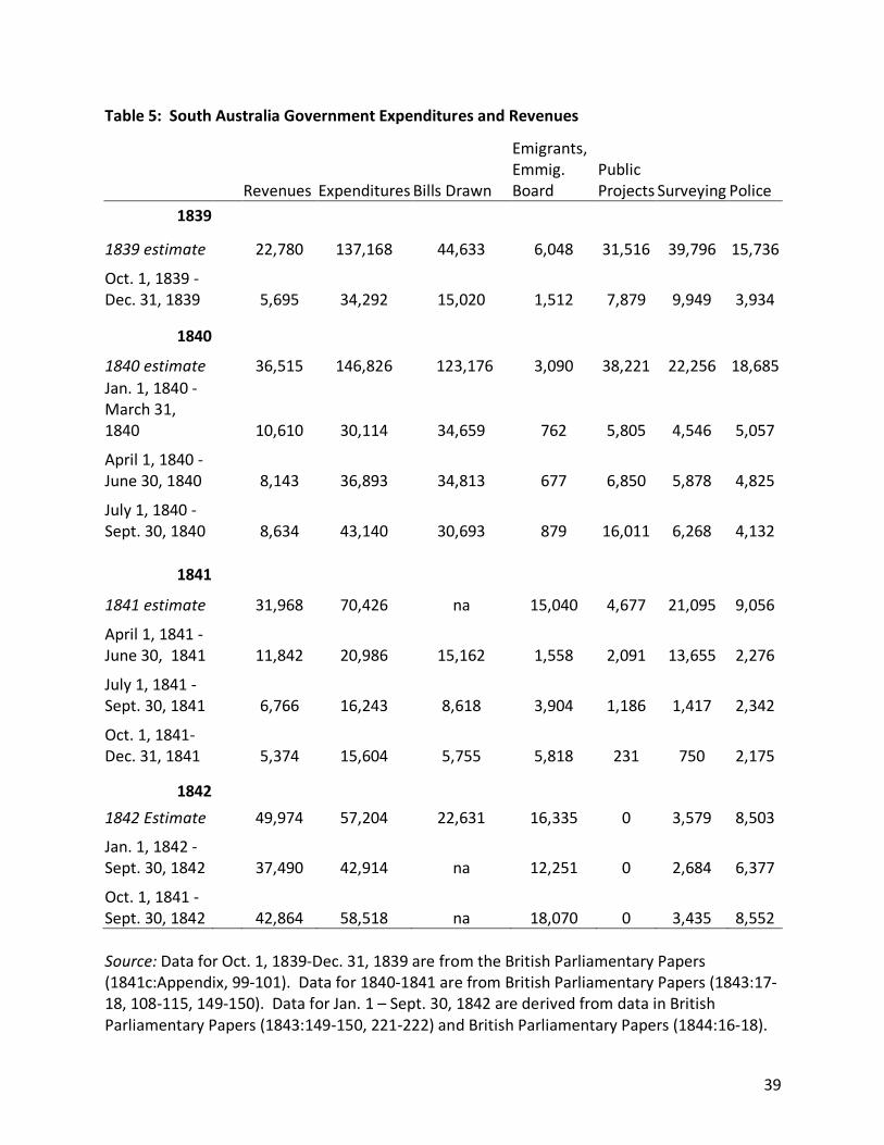
39
Table 5: South Australia Government Expenditures and Revenues
Revenues Expenditures Bills Drawn
Emigrants, Emmig. Board
Public Projects Surveying Police
1839
1839 estimate 22,780 137,168 44,633 6,048 31,516 39,796 15,736
Oct. 1, 1839 -Dec. 31, 1839 5,695 34,292 15,020 1,512 7,879 9,949 3,934
1840 1840 estimate 36,515 146,826 123,176 3,090 38,221 22,256 18,685 Jan. 1, 1840 - March 31, 1840 10,610 30,114 34,659 762 5,805 4,546 5,057
April 1, 1840 - June 30, 1840 8,143 36,893 34,813 677 6,850 5,878 4,825
July 1, 1840 - Sept. 30, 1840 8,634 43,140 30,693 879 16,011 6,268 4,132
1841
1841 estimate 31,968 70,426 na 15,040 4,677 21,095 9,056
April 1, 1841 - June 30, 1841 11,842 20,986 15,162 1,558 2,091 13,655 2,276
July 1, 1841 - Sept. 30, 1841 6,766 16,243 8,618 3,904 1,186 1,417 2,342
Oct. 1, 1841-Dec. 31, 1841 5,374 15,604 5,755 5,818 231 750 2,175
1842 1842 Estimate 49,974 57,204 22,631 16,335 0 3,579 8,503 Jan. 1, 1842 - Sept. 30, 1842 37,490 42,914 na 12,251 0 2,684 6,377
Oct. 1, 1841 - Sept. 30, 1842 42,864 58,518 na 18,070 0 3,435 8,552 Source: Data for Oct. 1, 1839-Dec. 31, 1839 are from the British Parliamentary Papers (1841c:Appendix, 99-101). Data for 1840-1841 are from British Parliamentary Papers (1843:17-18, 108-115, 149-150). Data for Jan. 1 – Sept. 30, 1842 are derived from data in British Parliamentary Papers (1843:149-150, 221-222) and British Parliamentary Papers (1844:16-18).