aylsham€¦ · while the aylsham neighbourhood plan gives an indication of how aylsham hopes to...
TRANSCRIPT

shaping the future
AYLSHAM

STATISTICAL INFORMATION
Unless the source is specifically referenced within the text of this document statistical information is taken from the application made by Broadland District Council on behalf of Aylsham to the Government’s Future High Street Fund in July 2019.

Aylsham ~ shaping the future
FOREWORD Imagine how a single tree could transform the Market Place in Aylsham. Then think where you would put it, what would have to go to make way for it, how would that affect the dynamic of the area? Suddenly, that tree – a simple green splash of nature in a concrete oasis – changes more than just the look of the square but has led to a chain of events which could alter the whole character and feel of the town. This is the starting point for this report which was drawn up by the Cittaslow Aylsham committee to seek ways to improve our quality of life in the face of large-scale development, transport network constraints, future changes to the economy, and the associated pressures on services and infrastructure. Over the years, plans to improve our High Streets have flourished in a bid to accommodate the growth of online shopping, out-of-town retail centres and housing sprawl. Yet all have either failed, by-passed Aylsham or focused solely on technicalities without a long-term vision to provide a safe and healthy environment for locals and visitors to the town. And the pressure to build homes has spawned numerous government and local authority proposals, the latest being the Greater Norwich Local Plan to cover the period from 2018 to 2038. So the need to be prepared has never been clearer. Builders should be made aware of what is wanted and not wanted in Aylsham before the bulldozers move in. While the Aylsham Neighbourhood Plan gives an indication of how Aylsham hopes to manage development, this Cittaslow plan is aimed at promoting beauty and greater well-being by making Aylsham’s historical centre more attractive, more people friendly, while retaining its traditional function as a vibrant market place. And by taking advantage of new technologies, we can create a cleaner, greener town and reap the economic rewards. Implementing these measures would set an example of how the community, local businesses and local authorities can have a shared vision for a better future. So, the next question is what sort of tree do we want?
Patrick Prekopp Chair Cittaslow Aylsham
(i)

Aylsham ~ shaping the future
EXECUTIVE SUMMARY
1 Aylsham is an historic town which has grown from a population of 5,500 in 2001 (2001 Census) to 8,200 today. For many years the town was sustained by the surrounding local agricultural activity, but by 2004 the loss of the town’s livestock market, the opening of an out-of-centre supermarket and the planned residential growth were all causes of concern for the town’s residents and businesses.
2. The community embraced the need for change and with the support of the Town
Council and other local organisations, Aylsham became the UK’s second Cittaslow town in 2005. This attracted much local and national media attention and helped to foster a more positive outlook within the local community.
3. In the ensuing years, the focus has been very much on building a sense of
community now evidenced by an annual programme of extremely well-supported community events including the Food Festival, Summer Street Party and Christmas Lights Switch On. In 2020 Aylsham will be celebrating the 15th anniversary of securing Cittaslow status, hosting the movement’s International President, Stefano Pisani, and representatives from other UK and overseas Cittaslow towns.
4. The anniversary comes at a time when the town is again facing many challenges and
it is a good time to look at the wider goals of the Cittaslow movement. These include environmental, infrastructure and built environment objectives and the hope is to bring together the community, local businesses and local authorities to again focus on the future of the town and, hopefully, develop a shared vision.
5. Many Cittaslow goals sit very comfortably with the policy objectives of the Aylsham
Neighbourhood Plan 2018-2038. This was endorsed by a local referendum and formally adopted in 2019. However, delivery of the Neighbourhood Plan policy objectives is not funded and many are subject to the vagaries of the Town Planning process. So, if the community can come together to create a clear vision for the future of the town, the potential for its voice to be heard will be much enhanced.
6. This paper considers some of the key challenges facing Aylsham and looks at them
from a Cittaslow perspective. The challenges include:
• Public car parking
• Provision for pedestrians and accessibility
• Public transport
• Traffic management
• Sustainability of the town centre 7. Within each challenge the paper outlines a number of options which it is hoped will
help to start a conversation within the community leading to a shared vision for the town. The risk is that without a long-term vision, opportunities that arise in the coming years will be evaluated wholly on the pressures prevailing at the time, rather than for the contribution they can make to a strategic programme.
(ii)

Aylsham ~ shaping the future
8. The desired outcome is that Aylsham’s future is forged by engaging all stakeholders with an interest in the town. Those stakeholders will include residents, community groups, businesses, employers, service providers and all tiers of local authorities. The ultimate goal is to remain true to the values of Cittaslow.
(iii)

Aylsham ~ shaping the future
(iv)

Aylsham ~ shaping the future
CONTENTS Section page
1. Introduction 1 2. Public car parks 3 3. Getting around the town centre 5 4. Traffic management in the town centre 7 5. Rethinking the town centre 10 6. Agreeing a vision 12 Appendix A: Cittaslow requirements 14 Appendix B: Possible sites for a public long-stay car park 16 Appendix C: Aylsham’s historic centre 17 Appendix D: Traffic management 19 Appendix E: Aylsham Neighbourhood Plan requirements 22 Appendix F: Thoughts on Red Lion Street 25
(v)

blank page

Aylsham ~ shaping the future
1
1 INTRODUCTION Cittaslow Requirement C8:
Plans to promote appreciation of historic centres and to make them user-friendly through the production of a Town Plan, Conservation Area Appraisal, Town Design Statement or similar.
1.1 Considered to be of Saxon origin, Aylsham is listed in the Domesday Book
(1086). It prospered through the wool and weaving industry until this declined and corn, timber and agriculture became important commodities. A predominance of 18th and 19th century Georgian facades shape the centre of the town where the road network remains substantially as it has done for centuries.
1.2 The town currently has a resident population of 8,200 population. In addition,
it serves a sizeable rural hinterland providing access to a range of facilities, helping to ensure that the rural communities’ needs are met at the local level. This connection with the rural communities still makes an important contribution to the town’s economy.
1.3 Aylsham has a unique historic core with the National Trust, in its capacity as
Lord of the Manor, owning the town’s Market Place. The National Trust has extensive local land holdings including its estates associated with Blickling Hall and Felbrigg Hall, both of which attract many visitors annually. The proximity of these historic attractions, which are part of a wider Norfolk tourism offering, to Aylsham means that the town is well placed to contribute to, and benefit from, the burgeoning tourism economy.
1.4 The potential has always existed to create a town with a sustainable local
economy and, as the population grew, to build a greater sense of place and community. But back in the late 1990, early 2000s, local opinion was that the town was heading into decline. The livestock market had closed following foot-and-mouth and swine fever outbreaks and by 2004 the imminent arrival of a Tesco supermarket outside of the town centre, was causing concern. The population in 2001 was 5,500 but with substantial growth looming.
1.5 The local community came together and, supported by Aylsham Town
Council, Rural Action East and the Aylsham Partnership, in 2005 it became only the second UK town to become a Cittaslow town. The arrival of Cittaslow came as a breath of fresh air, generating a lot of publicity, local and national, which gave residents a reason to be proud of where they lived. A Cittaslow Committee was established, then as today, a committee of the Town Council.
1.6 Founded in Italy in 1999, Cittaslow is part of a cultural trend known as
the “slow movement”. Its goals include improving the quality of life in towns by slowing down its overall pace, especially in its use of spaces and the flow of life and traffic through them. More specifically, Cittaslow towns seek to address key requirements in the following areas:

Aylsham ~ shaping the future
2
(a) Environment (b) Infrastructure (c) Quality of urban fabric (d) Encouragement of local produce and products (e) Hospitality and community (f) Cittaslow awareness creation
1.7 To date the town’s focus has been on advancing the “Hospitality and
Community” aspects of its Cittaslow status with the town centre providing a range of social and community activities at the library, Town Hall and parish church, including a monthly cinema and children’s activities. The town has an annual Food Festival, Summer Picnic in the Market Place and traditional Christmas Lights Switch On. There are about 50 community groups mostly made up of retired or elderly people who meet for cultural and social activities. These events are generally well attended and organised by a small, dedicated band of volunteers.
1.8 The full Cittaslow requirements are detailed in Appendix A. At a town level
within the UK many of these requirements are outside the direct control of the Town Council with the District and County Councils having the powers required to implement any necessary changes. However, in Aylsham all three tiers of local government are bound by one statutory document, the Aylsham Neighbourhood Plan 2018-2038 (referred to subsequently as “the Neighbourhood Plan”). Formally adopted, following a local referendum, in 2019 the Neighbourhood Plan has the potential to deliver against many of the Cittaslow requirements. Relevant extracts from this plan are included at Appendix E.
1.9 Funding pressures on local authorities, together with the power that large
developers wield through the Town Planning process, make delivery of the objectives in the Neighbourhood Plan far from certain. However, if the community can come together to create a clear vision for the future of the town, the potential for its voice to be heard will be greatly enhanced.
1.10 As the town approaches the fifteenth anniversary of its Cittaslow status in
2020 this paper looks at some of the challenges it faces and considers the relevance of the Cittaslow requirements, how they connect with the Neighbourhood Plan, and how they might shape a vision for the town.
1,11 What follows are some thoughts on issues that seem to be of greatest
concern to the community and local business interests at the present time. The intention is to start a conversation which will lead to a shared view of Aylsham which strengthens its status as a Cittaslow town - a view that can be published as a plan fulfilling Cittaslow Requirement C8.

Aylsham ~ shaping the future
3
2 PUBLIC CAR PARKS Cittaslow Requirement E7: Managed car parks in areas with access to town centres 2.1 While the Neighbourhood Plan makes generalised statements about traffic
management, highways and public transport, it is silent on the subject of public car parking. However, adequate provision of public car parking is a matter of key concern to residents, businesses and visitors. Any vision for the town must address this issue and this would accord with Cittaslow requirements.
2.2 Town centre public off-street public car parking is available at the Butts Land
(58 spaces) and Burgh Road (57 spaces) car parks. Both these car parks are the responsibility of Broadland District Council and are not subject to charges or restrictions on parking duration. On-street car parking is available in the Market Place (29 spaces – max stay 2 hours) and on Norwich Road (9 spaces – max stay 30 minutes). Within this overall provision are five designated disabled parking spaces.
2.3 Many of the town’s retail and service sector businesses rely on the ability of
their clients to park in close proximity to the town centre. Reasons for this include:
• accessibility issues arising from a client-base predominantly from an older demographic, many with mobility problems
• clients, often from the rural hinterland, who have a very focused need and will not linger in the town e.g. a visit to a butcher, bank or optician
• younger clients who, because of time pressures, will fit their visit in with the school run or their trip to/from work
2.4 As the population in the town has grown in number and age – at 31% the
percentage of those aged 65+ years is higher than the national average – the demand for short-stay car parking in the town centre has increased significantly. While the town centre’s on-street parking restrictions are enforced, there is no management of the public off-street car parks.
2.5 Not unreasonably, people working in the town centre make use of the public
off-street car parks, occupying spaces for the duration of the working day. There is also evidence that people, both residents of the town and those from the surrounding rural communities, who work in Norwich drive into the town centre and use the public off-street car parks in order to access bus stops for their commute to the city.
2.6 As a consequence, the public off-street car parks are almost at capacity by
the time people come into the town centre to shop or access services. They are unable, therefore, to make any significant contribution to meeting the growing demand for short-stay parking.

Aylsham ~ shaping the future
4
2.7 Both the Butts Land and Burgh Road car parks are conveniently placed with
reasonable pedestrian access to the town centre. A simple solution to creating more short-stay provision would be to manage these car parks to restrict the duration of stay, e.g. a maximum stay of two hours, or to introduce charges which make stays over two hours increasingly unattractive.
2.8 Any approach to managing the town centre’s public off-street car parks to
prohibit or discourage, long-stay parking will severely disadvantage the people who work in the town centre and those using it as a means of connecting with public transport. It is imperative, therefore, that any management measures are only implemented in association with the provision of a public off-street long-stay car park.
2.9 Currently there is no local authority funding committed to the delivery of any
additional car parking in Aylsham. Future large-scale housing developments might deliver funding, or potentially a car park. However, unless the local community and business come together to champion both the need for, and possible delivery options, for a public off-street long-stay car park it is unlikely to gain any traction and the town’s car parking problems will only continue to worsen.
2.10 Putting aside the question of how they could be delivered, the first
consideration is where could a long-stay car park be located? The three locations listed below, and outlined briefly in the following paragraphs, are shown in the plans at Appendix B.
• Key’s Sale Yard Car parking associated with existing business use accessed off Palmers Lane
• Norwich Road Agricultural land in the vicinity of the former Aylsham Motel
• Burgh Road Agricultural land between site of Aegel House and “car boot sale” field.
2.11 Located off Palmers Lane, the Key’s Sale Yard has a significant area of
existing car parking associated with the current business use. It is within a five-minute walk of the Market Place so is conveniently located for people working in the town centre and wishing to use busses passing through the centre of the town.
2.12 Both the Norwich Road and Burgh Road sites are located further from the
town centre but offer the advantage of being easily accessible from the A140, potentially reducing the volume of traffic passing through the town centre. The Norwich Road site is passed by all existing bus routes and would immediately meet the needs of commuters continuing their travel into Norwich by bus.

Aylsham ~ shaping the future
5
2.13 Car parking generated by the “car-boot sale” field on Burgh Road has been a growing cause for concern. A public car park adjacent to, or even incorporating part of the field’s existing land allocated for parking, could address those concerns. The site also is within easy walking distance of Aylsham High School and couldbe used as a drop off/pick up location for pupils.
2.14 Walking distance to the Market Place from both the Norwich Road and
Burgh Road sites is a little over half-a-mile. 2.15 As part of its consideration of “Sustainable Growth and Development” the
Neighbourhood Plan makes a reference at Objective 7 to “Improvements to footpaths, cycle networks, public transport and out-of-town parking . . .” The wider implications of providing long-stay car parking in Aylsham are explored further in Section 4.
3 GETTING AROUND THE TOWN CENTRE Cittaslow Requirement B2: Existence of disability-friendly pavements and walkways Cittaslow Requirement B4: Infrastructure which facilitates alternative mobility 3.1 Unlike many historic market towns, Aylsham’s centre never experienced a
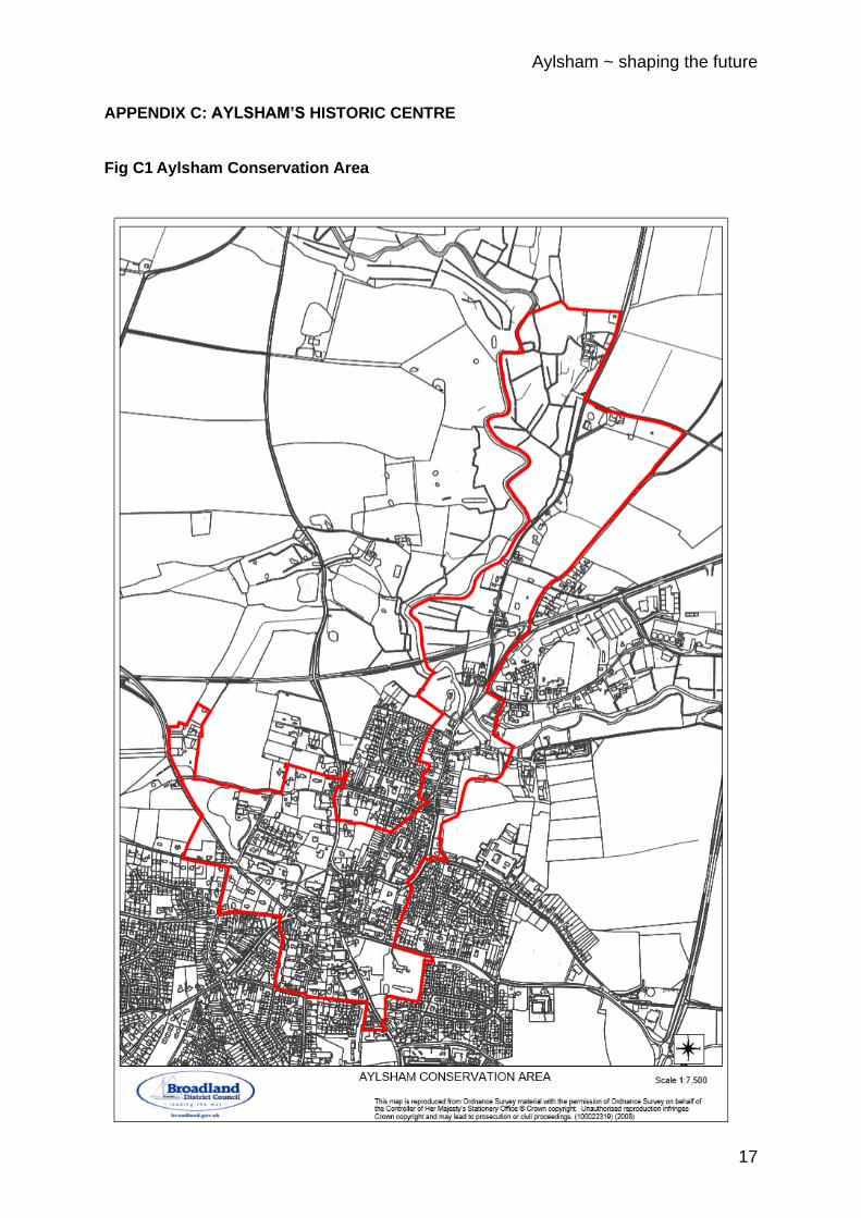
devasting fire that resulted in the historic layout being changed. This is a major benefit in that the town centre still has many splendid buildings of historical interest which are greatly admired by the local community and visitors. The value of this architectural heritage is exemplified by the number of Listed Buildings within the town’s Conservation Area. The extent of this is shown on the plans at Appendix C.
3.2 In the post-war years right through to the present-day, traffic volumes have
continually increased and are set to continue growing as the town’s population expands. As a consequence of this, the priority of the local highway authority, Norfolk County Council, has been to maximise the capacity of the historic streets to accommodate the increasing volume of traffic. Often this has been achieved at the expense of the provision for pedestrians in the town centre.
3.3 The need to change this approach is a key theme within the Neighbourhood
Plan. The plan’s Vision Aims and Objectives include
Vision 4 To ensure growth of the town is facilitated by improvements to infrastructure.
Associated with this is:

Aylsham ~ shaping the future
6
Objective (xi) To enhance the road network to improve traffic management and road safety with priority given to the provision of pedestrian walkways, and cycle routes.
3.4 Throughout the Neighbourhood Plan there are repeated references to
“Sustainable Transport” and this is stated to include improvements to footpaths. The focus of the authors of the Plan, insofar as it relates to pedestrian walkways and footpaths, would most likely have been on developing links to the town centre, to schools and employment areas, etc, which could be delivered predominantly by new residential developments.
3.5 If pedestrian access to the town centre from residential areas is to be
improved, however, it is imperative that the provision for pedestrians within the town centre is adequate and safe for all users. The footpath/footway provision must be adequate for users with impaired mobility, including those who are dependent on wheelchairs and mobility scooters. And, if the town centre is to attract younger residents, the pedestrian provision must also be suitable for people with very young children including toddlers and those in buggies and prams.
3.6 The pavements in Red Lion Street are a particular cause for concern. They
are extremely narrow, certainly not wide enough for a wheelchair, and when walking, passing another person coming in the other direction requires one person to step into the carriageway. The problem is exacerbated by the width of the carriageway making it difficult for vehicles to pass one another.
As a consequence, the protruding mirrors of larger vehicles often extend over the pavements. The following images illustrate some of the challenges for pedestrians in Red Lion Street.
3.7 The most direct route for pedestrians approaching the town centre from the
west requires them to pass along Penfold Street. From the historic Soame Pump towards the Market Place there are no pavements with the carriageway abutting directly onto the front of properties as shown in the images below.

Aylsham ~ shaping the future
7
3.8 In both Red Lion Street and Penfold Street, the challenge is to create more space for pedestrians. To facilitate this it will be necessary to reduce the width of the carriageway by one or more of the following traffic management measures:
• Maintaining two-way traffic but reducing the carriageway width and giving priority to traffic in one direction
• Making the street(s) one-way
• Introducing weight restrictions 24/7, except for vehicles delivering to town centre premises, or for restricted periods e.g. 10am to 4pm.
• Revising bus routes to avoid them passing through the street(s)
3.9 The wider implications of the traffic management measures required to facilitate improved pedestrian provision are explored further in Section 4.
4. TRAFFIC MANAGEMENT IN THE TOWN CENTRE Cittaslow Requirement A1: Apparatus to test air quality and report conditions Cittaslow Requirement A7: Apparatus to measure noise pollution and plans to reduce it 4.1 It has to be acknowledged that traffic management is not expressly identified
as a Cittaslow Requirement. It also has to be accepted that the statutory duties relating to the monitoring and management of air quality and noise pollution reside with the principal local authorities, not Aylsham Town Council. However, in an historic market town such as Aylsham, which has no significant local industrial activity, the key influence on both air quality and noise pollution is traffic passing through the centre of the town. And, for a town that has seen its population grow by over 50% in the last two decades the associated growth in vehicle movements through the town centre cannot be ignored if the environmental principles that underpin Cittaslow Requirements A1 and C1 are to be adhered to.
4.2 The need to both mitigate the impact of the increasing volume of traffic in the
town centre and the environmental and safety impacts of that traffic, however, is highlighted in the Neighbourhood Plan which expressly states:
Objective 7 To enhance transport provision to meet the needs of
existing and future populations while reducing travel need and impact.
Associated with Objective 7 are the more detailed statements: The existing road network in the town centre struggles
to cope with the volume and size of traffic. As the population grows, this problem will intensify.

Aylsham ~ shaping the future
8
It is important to develop a more effective method of directing through traffic away from the centre of town.
4.3 Looking first at the issue of through traffic which is not generated from within
the town, the focus must be to ensure that existing highway infrastructure that is peripheral to the town is used to its maximum potential. The A140 to the east of the town provides a bypass for the majority of traffic heading north/south past the town. Traffic approaching from the west on the B1145 (Cawston Road) can connect with the A140 bypassing the town on Henry Page Road. The highway layout is shown on Fig D1 at Appendix D.
4.4 A key challenge is the management of through traffic which originates to the
north of the town and to the west of the A140 and east of the B1149 (Holt Road). This includes private and commercial vehicles which approach the town on the Cromer Road and the Blickling Road; the former passing through Red Lion Street and the latter Penfold Street.
4.5 Anecdotally, the Cromer Road traffic arises because it is perceived by
drivers as easier to pass southward through Aylsham at peak times. This allows them to join the A140 at the roundabout to the south of the town, rather than turn right onto the A140 from a minor road serving the settlements immediately to the west of the A140.
4.6 It appears that traffic from the northwest of Aylsham, intending to join the
A140, and which could otherwise stay on/join the B1149 (Holt Road) and then travel eastward along the B1145, often opt to use the Blickling Road and pass though the town. Many HGVs transporting produce from local agricultural businesses to commercial processing plants appear to make this choice.
4.7 While public transport, which in the case of Aylsham is comprised
exclusively of bus services, is perceived as a key contributor to reducing traffic volumes and is frequently referenced within the Neighbourhood Plan, the existing services are not without their problems, namely:
1. The size of buses has grown significantly in recent years to the
extent that they have difficulty in negotiating the centre of the town, particularly Red Lion Street, Market Place and Penfold Street; and

Aylsham ~ shaping the future
9
2. The current bus services do not enter any of the significant areas of residential development added to the town since the mid-1970s, making access to them particularly difficult for residents with any mobility impairments.
4.8 The case for reclaiming more of the streetscape for pedestrians is made in
Section 3 above and at paragraph 3.8 a number of suggestions are made for changes to traffic management arrangements in the town centre to facilitate this. In Section 2 the case is made for the provision of a long-stay car park outside the town centre.
4.9 The potential will be created if either the Burgh Road or Norwich Road long-
stay car parks were to be delivered for these to be used as park-and-ride sites. Both are conveniently located adjacent to roundabouts on the A140, giving easy access to busses, and also to bus passengers who currently drive into the town centre and park in the existing car parks to access town centre bus stops. Additionally, a park-and-ride facility at either site could be connected with the town centre by a hopper-bus service whose routing took in areas of residential development. An illustrative hopper-bus route, based on a park-and-ride site on Burgh Road, is shown in Fig D2 in Appendix D.
4.10 It, therefore, becomes conceivable that any revision to traffic arrangements
within the town centre would not need to accommodate large public service busses passing through Red Lion Street and Penfold Street. If HGVs also were to be restricted in their access to the town centre the opportunity to improve the experience of pedestrians in the town centre would be further enhanced.
4.11 Weight restrictions are employed in a number of Norfolk towns to restrict
access of HGVs to town centres e.g. Downham Market. Agricultural vehicles are generally exempted from weight restrictions where they are moving between areas of land in the ownership of a single farm business. Transporting produce from the farm to a commercial processing plant is not part of that exemption. The imposition of weight restrictions on the Blickling Road and Cromer Road could, therefore, be considered. This would require larger vehicles approaching the town from the north-west to use the B1149 and B1145 to gain access to the A140.
4.15 Reducing other vehicle movements in the town centre would require a more
radical traffic management strategy. The key element of this would be the approach taken to Red Lion Street. As previously highlighted, Henry Page Road and the A140 effectively provide a peripheral route around much of the town and provide an alternative route for vehicles which might otherwise pass through the town using Red Lion Street. The perceived difficulty experienced by drivers wanting to join the A140 to travel southwards (toward Norwich) from north of Aylsham has already been mentioned. If Red Lion Street were to be made one-way it would, therefore, appear logical to allow traffic to pass along it from north to south.

Aylsham ~ shaping the future
10
4.16 Other measures would almost certainly be required to avoid other roads around the town centre becoming rat-runs. The most obvious being Oakfield Road where a short length of the northern end may need to be made one-way south bound. The Red Lion Street and Oakfield road suggested traffic flows are illustrated in Fig D3.
4.17 Two-way traffic flows in Penfold Street are unavoidable. To reduce that
traffic’s impact on pedestrians, and make space available for the creation of pavements, it is suggested that the carriage way be significantly reduced in width. Priority could be given to vehicles travelling away from the town centre (west bound) thus minimising traffic queuing on Penfold Street where it abuts the Market Place. In association with any such measure thought could also be given to improving pedestrian safety in the vicinity of the Soame Pump.
5. RETHINKING THE TOWN CENTRE Cittaslow Requirement A8:
Plans for the elimination of aesthetically displeasing advertisements
Cittaslow Requirement B3: Disability-friendly access to public places and offices Cittaslow Requirement B5: Free and easily accessible public conveniences Cittaslow Requirement B6: Plan for all business hours to coincide with townspeople’s needs Cittaslow Requirement C1:
Plans to promote the maintenance, conservation and enhancement of historic areas, buildings and artefacts of cultural and local significance and their sympathetic re-use.
Cittaslow Requirement C5: Use of slightly litter bins and fixed times for emptying them Cittaslow Requirement D3:
Plans to encourage and provide space for farmers and organic markets
Cittaslow Requirement E4: Existence of well-marked tourist routes with proper directions and
descriptions Cittaslow Requirement E8:
Promote special events to encourage development and support facilities for people to come and enjoy them
5.1 The above could be considered an eclectic mix, particularly as they are
presented in the order they appear in the Cittaslow accreditation documentation, rather than in what might be considered their relevance to Aylsham. But it is difficult to disagree that each of them, if implemented, has the potential to make a town centre a better place. It has also to be acknowledged that Aylsham is already going in the right direction on a lot of the requirements.

Aylsham ~ shaping the future
11
5.2 Sadly, the excellent Future High Street Fund bid made by Broadland
District Council on behalf of Aylsham was unsuccessful, but it is interesting now to see the plans that are emerging from those towns that were successful and the thinking behind those plans. Put simply, for the retail offering to survive the decline in footfall needs to be reversed and the time that people spend in the vicinity of the shops needs to be increased. This requires the town centre to become a place that people want to visit. In addition to retail it has to have hospitality and entertainment offerings that appeal to the entire community, including young families, and to visitors.
5.3 Previous Section 2, 3 and 4 have highlighted the issues that need to be
addressed if the right balance is to be struck between managing traffic flows through the town, access to car parking, availability of public transport and creating a space that people are keen to visit and spend time in.
5.4 The Market Place is the location for the twice weekly markets, the
monthly farmers Market and a number of well-supported community social events during the year including a summer street party, Slow Food Festival and the Christmas lights switch on. When not being used for these purposes it is primarily a short-stay car park.
5.5 If the Butts Land and Burgh Road car parks were to be managed for
short-stay parking this could reduce the need for parking in the Market Place. Could the Market Place then be reconfigured so that it is available throughout the week as an area for people to spend leisure time, to have the space to linger and appreciate the wealth of historic buildings? If Red Lion Street had wider pavements, and felt a comfortable place to be as a pedestrian, would they be drawn into it and window-shop? Would this be helped if the random collection of unsightly A-boards outside the Town Hall advertising traders in Red Lion Street Street were replaced with signage more appropriate to the heritage of the location?
5.6 If Red Lion Street was one-way would vehicles routinely need to use
the Market Place as a through route? Could the Market Place be configured as an area of pedestrian priority with a small amount of disabled parking and a pick-up point for the hopper-bus as illustrated overleaf?

Aylsham ~ shaping the future
12
5.7 Only when there is agreement on the vision for the town can attention
really turn to litter bins, signposting tourist routes etc.
6. AGREEING A VISION 6.1 Thank you for taking the time read this paper. You may already have a
clear vision that you think is right for the town, or it may be that you think the town is fine as it is.
6.2 Many people have reflected on the individual challenges that the town
faces over the years. For example, at Appendix F we have reproduced some thoughts from County Councillor David Harrison which particularly focus on Red Lion Street. It is important for the future of the town that the community can take a view, not just on individual challenges, but the totality of the challenges facing the town.
6.3 In November 2020 the town will be celebrating 15 years as a Cittaslow
Town. The town will be hosting a gathering of representatives from Cittaslow towns from across the globe. This comes at a time when there is little doubt that the population of the town will continue to expand and at a time when retailers in traditional settings are finding it increasingly hard to sustain their businesses.

Aylsham ~ shaping the future
13
6.3 As the town celebrates its Cittaslow status it seems an appropriate time to ask the question:
Can we grow as a Cittaslow Town . . . and will it help shape the future of Aylsham?
6.4 Your views are important. We are seeking feedback from anyone who
has an interest in the town including:
• Residents of the town
• People who work in the town
• Owners of businesses in the town
• People who are not residents of the town but who use shops, services etc. in the town
• Community groups active in the town
• Owners of land within or adjacent to the town
• Politicians whose constituents are Aylsham residents 6.5 You can send written responses to:-
Aylsham Town Clerk Aylsham Town Council Town Hall Market Place Aylsham Norwich NR11 6EL
You can email responses:-

Aylsham ~ shaping the future
14
APPENDIX A: CITTASLOW REQUIREMENTS
A: ENVIRONMENTAL POLICY
B: INFRASTRUCTURE POLICIES
C: QUALITY OF URBAN FABRIC
Ref Requirement Ref Requirement Ref Requirement
A1 Apparatus to test air quality and report conditions
B1 Existence of well-kept green spaces
C1 Plans to promote the maintenance, conservation and enhancement of historic areas, buildings and artefacts of cultural and local significance and their sympathetic re-use.
A2 Rules for the use and distribution of water supplies and pollution free water in rivers and waterways
B2 Existence of disability-friendly pavements and walkways
C2 Plans to abolish faulty theft alarms, combined with suitable measures for the protection of private property.
A3 Plans for the implementation of new composting technology and the promotion of composting in people’s homes
B3 Disability-friendly access to public places and offices
C3 Encouragement of use of reusable crockery and cutlery in public establishments
A4 Ability to measure light pollution and a plan of action to prevent it
B4 Infrastructure which facilitates alternative mobility
C4 Use of sightly litter bins and fixed times for emptying them
A5 Incentives to encourage the use of alternative sources of energy
B5 Free and easily accessible public conveniences
C5 Plans to plant sweet smelling or environment-enhancing plants in public and private gardens.
A6 Mechanisms to measure electromagnetic emissions and a plan of action for their reduction
B6 Places for people to sit down and rest, not just in town centres
C6 Encouragement of the use of interactive websites where the public can communicate with the administrators of the town.
A7 Apparatus to measure noise pollution and plans to reduce it
B7 Uniform opening hours for the different departments of council offices
C7 Plans to promote eco-friendly architecture.
A8 Plans for the elimination of aesthetically displeasing advertisements
B8 Provision of Public Relations office
C8 Plans to promote appreciation of historic centres and to make them user-friendly through the production of a Town Plan, Conservation Area Appraisal, Town design Statement or similar.
A9 Application of EMAS regulations
B9 Slow City Call Centre for people to contact
A9b Application of ISO 9000 B10 Plan for all business hours to coincide with townspeople’s needs
A9c Application of SA 8000
A9d Application of EMAS regulations
A10 Participation in ‘Local Agenda 21’ projects

Aylsham ~ shaping the future
15
D: ENCOURAGEMENT OF LOCAL PRODUCE AND PRODUCTS
E: HOSPITALITY & COMMUNITY
F: CITTASLOW AWARENESS CREATION
Ref Requirement Ref Requirement Ref Requirement
D1 Up to date Cittaslow register of locally produced goods and producers within the natural hinterland of the town
E1 Regular checking that restaurants etc deliver what they advertise.
F1 Directory of organisations contributing to the aims and objectives of Cittaslow
D2 Events and training to help people appreciate and preserve local cultural and artistic traditions.
E2 Multilingual signposting, directions and instructions
F2 Cittaslow logo on council/partnership documents (letterhead etc)
D3 Plans to encourage and provide space for farmers and organic markets
E3 Training for those providing services to tourists, adoption of initiatives such as ‘Welcome Host’.
F3 Promotion of the movement’s aims and practices
D4 Plans to increase awareness of good food and nutrition
E4 Existence of well-marked tourist routes with proper directions and descriptions.
F4 Website showing how Cittaslow themes are applied
D5 Educational programmes about organic food production
E5 Printed ‘Cittaslow’ guides
F5 Initiatives to promote family life, with provision of leisure activities, home help for old people and the chronically sick
D6 Implementation of measures for the preservation of unique local foodstuffs
E6 Implementation of rules regarding ‘prices as shown’
F5 To promote family life and healthy living for all age groups
D7 Plans to encourage organic farming and quality certification
E6 Promote a wide cross section of social events, sports clubs and volunteering opportunities for the whole community
F6 Provision in budget for the application of these requirements and measures to improve scores
D8 Creation of awareness of traditional foodstuffs
E7 Managed carparks in areas with access to town centres
F7 Press cuttings referring to Cittaslow to be shown on Council noticeboards and establishment of lines of communication to local and national press and media.
D9 Plans for the protection of goods and produce representing local tradition
E8 Promote special events to encourage development and support facilities to make it easy for people to come and enjoy them
F8 Initiatives to involve opinion leaders and local firms in helping to achieve compliance with Cittaslow requirements
E9 Promotion of any initiatives of a Cittaslow nature
F9 Encouragement of schools, hospitals, councils, community centres and tourism operators to use local produce

Aylsham ~ shaping the future
16
APPENDIX B: POSSIBLE SITES FOR A PUBLIC LONG-STAY CAR PARK
KEY’S SALE YARD
NORWICH ROAD
BURGH ROAD
Aylsham ~ shaping the future
17
APPENDIX C: AYLSHAM’S HISTORIC CENTRE Fig C1 Aylsham Conservation Area

Aylsham ~ shaping the future
18
Fig C2 Listed Buildings in Town Centre

Aylsham ~ shaping the future
19
APPENDIX D: TRAFFIC MANAGEMENT Fig D1: Highway Network Overview

Aylsham ~ shaping the future
20
Fig D2: Hopper-Bus Route Provisional route only – route within Norfolk Homes, Willow Park and Bure Meadows developments still to be determined

Aylsham ~ shaping the future
21
Fig D3: Town Centre Traffic Flows
Aylsham ~ shaping the future
22
APPENDIX E: AYLSHAM NEIGHBOURHOOD PLAN REQUIREMENTS Aims, objectives and policies that match Cittaslow requirements
Sustainable growth and development
Objective 7: To enhance transport provision to meet the needs of existing and future populations while reducing travel need and impact
The existing road network in the town centre struggles to cope with the volume and size of traffic. As the population grows, this problem will intensify. It is important to develop a more effective method of directing through traffic away from the centre of the town (such as more effective signposting). Improvements to footpaths, cycle networks, public transport and out-of-town parking/park & ride will encourage greater use of sustainable transport modes.
1: Housing
Ref Requirement
Policy 1 Improving housing design
III. Providing off-road car parking adjacent to or in front of new dwellings that would be accessible to the occupiers of those homes and would be consistent with good standards of urban design.
Policy 2 Improving the design of development
VII. Designing roads and parking areas within any site should minimise the effects on pedestrians, in particular safeguarding children where they walk or play, enable safe access to public transport and, where appropriate, make provision for bus stops, avoid the opportunity for indiscriminate parking by residents and visitors and design in measures to avoid it.
2: Environment
Ref Requirement
Policy 6 Accessibility and biodiversity
All new development should maximise opportunities to enhance ecological connectivity and, through the connection to existing footpaths and cycleways, encourage links to the wider parish and countryside. Green infrastructure provided as part of new development should improve biodiversity and connections with existing open spaces in and around Aylsham.
3: Local Economy
Ref Requirement
Policy 7 Employment and tourism opportunities
Development proposals that create new employment and/or increased local tourism will be supported subject to the following criteria: Their size and design respect the immediate
Aylsham ~ shaping the future
23
surroundings in which they are located; They are appropriate to a market town or support rural farming and agriculture; They do not have a significant impact on the local environment and the amenities of adjacent residential properties or other land uses; They do not have a negative effect on the viability of the town centre.
4: Recreation
Ref Requirement
Policy 9 Additional community facilities
Development proposals relating to the provision of additional community facilities, recreational space, play space, sports facilities and parking near the town centre will be supported where they comply with the requirements of other policies in the ANP.
Policy 10 Planning gain
Aylsham Town Council will be a signatory to all s106 agreements (relating to the delivery of open and recreational space and any additional community-requested benefits).
5: Infrastructure
Ref Requirement
Vision, aims and objective
To ensure growth of the town is facilitated by improvements to infrastructure. (x) To deliver a better-integrated public transport system serving the growing Aylsham community (xi) To enhance the road network to improve traffic management and road safety with priority given to the provision of pedestrian walkways, and cycle routes.
Policy 11 Sustainable transport
Development should be where appropriate and practicable: a) create opportunities to enhance and encourage the use of sustainable transport modes through the provision of footpaths, cycleways and public transport improvements; b) provide access, connectivity and linkages to the existing network of footpaths and cycleways and, in particular, to the town centre, schools, community facilities and recreational spaces.
Policy 12 Traffic impact
New development (of 10 or more residential dwellings and all commercial) proposals will be expected to quantify the level of traffic movements they are likely to generate. The scope of the assessment will be proportionate to the scale of development and for residential developments of more than 50 dwellings and commercial developments of more than 250sq m should be agreed with the highways authority. Assessing the potential impact of this traffic must

Aylsham ~ shaping the future
24
include appropriate and proportionate measures to mitigate any negative impacts on road safety, pedestrians, safe road crossings, cyclists, parking, congestion, noise and air quality within Aylsham.
Project 1 Cycleway
Cycleway linking Aylsham to the wider area and possibly, over time, to connections to Norwich.
Project 2 Traffic Plan
Undertake Aylsham Town Traffic Plan (ATTP) as identified by Burgh Road and Oakfield Road Residents Associations (BORRA) to identify strategy options and proposals such as a “one-way” system, including an evidence-based review of the Aylsham road network to ensure all impacts and possible solutions are considered.
Project 3 A140 Crossing
Seek a pedestrian crossing on the A140 at the Bure Valley Railway to enable the safe crossing of the A140 and the continuation of the footpath and cycleway into Aylsham town centre from Hoveton.

Aylsham ~ shaping the future
25
APPENDIX F: THOUGHTS ON RED LION STREET
A contribution by County Councillor David Harrison
Getting the Traffic out of Red Lion Street During my time as a county councillor for Aylsham I have thought long and hard about how to get Red Lion Street pedestrianised and free of traffic, and I think this scheme offers a way forward. Removing the traffic from Red Lion Street would improve the look and feel of Aylsham, enhance its commercial sector, and integrate the Town Centre. 1a Traffic coming into Aylsham on the Cromer Road would continue along White Hart Street into Gas House Hill and then turn right into Sir Williams Lane, which would be made one way going down. At the bottom of Sir Williams Lane traffic would turn right into Burgh Road. At present traffic going down Sir Williams Lane which intends to go into the centre of Aylsham is forced to turn right at the bottom into Buckenham Road and then turn almost immediately right into Burgh Road. This double turning could be removed by merging the first few yards of Buckenham Road into Sir Williams Lane and changing the priorities.
1b Making Sir Williams Lane one way should not affect the access to the High School. Traffic arriving for the school at the roundabout at the bottom of Burgh Road would reach the school via Buckenham Road and Palmerston Road which is the way the coaches go. 2 Burgh Road would become the main entry into Aylsham. It is narrow, but certainly not as narrow as Millgate, and in parts it could be widened. Buses already use it. Under the new scheme buses would go up Burgh Road into the Market Square, circle round, pick up passengers outside the Town Hall and then leave Aylsham by the Norwich Road. Buses from Norwich would do the reverse. 3 Oakfield Road would have to be made one-way going from Burgh Road to Gas House Hill. 4 Light traffic in the Market Square would be able to go to the Cromer Road by going down Blickling Road and then turning into Rawlinson’s Lane which would also have to be made one-way. So would Peterson’s Lane, with a stop junction where it joins Rawlinson’s Lane. 5 Light traffic in the Market Square area would be able to travel north to Gas House Hill and Millgate via Oakfield Road. 6 The only vehicles in Red Lion Street would be cars belonging to the houses and commercial vehicles accessing the shops. 7 DISADVANTAGES
A There would be some cost, but most of the changes would be making the roads one-way. I am really hopeful money would be available – North Walsham has just received a grant of almost £2 million for its regeneration.
B Th bus route up Millgate would be lost. C Vehicles travelling from Cromer Road and Millgate would have to travel a
greater distance to get to the centre.