whitecleaves quarry, buckfastleigh - devon · quarry and its surrounding environment, located in...
TRANSCRIPT
Devon Wildlife Consultants, 26 Commercial Road, Exeter, EX2 4AE
Tel: 01392 455930
email: [email protected]
Devon Wildlife Consultants is a trading style of Devon Wildlife Enterprises Limited
Whitecleaves Quarry, Buckfastleigh
Bat Activity Survey
Report No: 08/003e
Date: October 2008
Client: Sam Gilpin Demolition Ltd
Andrew Charles MSc. MIEEM, Michael Symes BSc (Hons) AIEEM
& Katie Jones BSc (Hons) MIEEM

Report 08/003: Bat Activity Survey – Whitecleaves Quarry, Buckfastleigh
WHITECLEAVES QUARRY, BUCKFASTLEIGH
BAT ACTIVITY SURVEY
This report was prepared on behalf of
SAM GILPIN DEMOLITION LTD
October 2008
Devon Wildlife Consultants
Checked by Signed Dated
Carly Bawdon MSc MIEEM

Report 08/003e: Bat Activity Survey – Whitecleaves Quarry, Buckfastleigh
Contents 1 Introduction ..................................................................................................................1
2 Survey Methodology .....................................................................................................2
3 Results ...........................................................................................................................4
3.1 12th
May 2008 Survey Visit ...................................................................................4
3.2 31st May 2008 Survey Visit ...................................................................................5
3.3 9th
June 2008 Survey Visit.....................................................................................6
3.4 23rd
June 2008 Survey Visit ..................................................................................7
3.5 14th
July 2008 Survey Visit ...................................................................................8
3.6 21st July 2008 Survey Visit....................................................................................9
3.7 4th
August 2008 Survey Visit...............................................................................11
3.8 27th
August 2008 Survey Visit.............................................................................12
3.9 15th
September 2008 Survey Visit.......................................................................13
3.10 21st September 2008 Survey Visit .......................................................................15
4 Discussion....................................................................................................................17
5 Implications of the Development................................................................................19
5.1 Introduction ........................................................................................................19
5.2 Greater Horseshoe Bat Flight Lines...................................................................19
5.3 Potters Wood SSSI & Buckfastleigh Caves SSSI...............................................21
6 Mitigation....................................................................................................................23
6.1 Introduction ........................................................................................................23
6.2 Greater Horseshoe Bat Flight Lines...................................................................23
6.3 Potters Wood SSSI & Buckfastleigh Caves SSSI...............................................24
7 Recommendations.......................................................................................................25
7.1 Greater Horseshoe Bat Flight Lines...................................................................25
7.2 Potters Wood SSSI & Buckfastleigh Caves SSSI...............................................25
References...........................................................................................................................26
Appendices..........................................................................................................................27
Appendix 1 – Bat Activity Survey Transect Map..............................................................28
Appendix 2 – Bat Activity Survey Maps............................................................................29
Appendix 3 – Greater Horseshoe Bat Activity Overview Map.........................................30
Appendix 4 – Proposed Vegetation Removal & Re-profiling Works ...............................31
Appendix 5 – Greater Horseshoe Bat Mitigation Plan .....................................................32
Appendix 6 – SSSI & SAC Citations .................................................................................33
Report 08/003e: Bat Activity Survey – Whitecleaves Quarry, Buckfastleigh 1
1 Introduction
1.1 This report contains the results of a Bat Activity Survey undertaken at Whitecleaves
Quarry and its surrounding environment, located in Buckfastleigh, Devon. The site is
located at National Grid Reference SX 737 656. This survey was carried out on behalf
of Sam Gilpin Demolition Ltd.
1.2 The Bat Activity Survey was undertaken from May to September, inclusive,
comprised of two survey visits undertaken each month.
1.3 Whitecleaves Quarry is located to the southeast of Buckfastleigh and is separated from
the town by the A38 which forms the northern and western boundary to the site.
Agricultural pasture border the site to the northeast and east, with Potters Wood
located to the south. Whitecleaves Quarry comprises of the large void of the quarry
which is predominantly inundated with water. The quarry walls are formed by high,
steep rock faces, which are further surrounded by patches of woodland and the Dean
Burn watercourse which flows adjacent to the south-western boundary to the site.
1.4 It is understood that it is proposed to develop the site to create a recycling centre and
associated offices. To facilitate this proposal, the central area of the quarry will be
extended and raised through mining and re-profiling, with additional re-profiling
around the quarry entrance and the proposed office location.

Report 08/003e: Bat Activity Survey – Whitecleaves Quarry, Buckfastleigh 2
2 Survey Methodology
Due to the rarity of greater horseshoe bats and their legal protection as listed on Annex II of
the Habitat Directive, Natural England states that development proposals of an area of 1Ha or
larger which are within 4km of a known greater horseshoe roost should be subject to a
programme of bat activity surveys. This should include two activity surveys to be undertaken
each month from May to September (Mitchell-Jones, 2004) to identify any feeding habitats or
flight lines used by this species throughout the summer period.
Whitecleaves Quarry partially includes the northern extent of Potters Wood Site of Special
Scientific Interest (SSSI); in addition Whitecleaves Quarry is located approximately 800m to
the south of Buckfastleigh Caves SSSI. Both of these SSSI’s include large roosts for greater
horseshoe bats which are recognised within the SSSI designations for these areas.
Buckfastleigh Caves SSSI also forms part of the South Hams Special Area of Conservation
(SAC) which refers to the presence of greater horseshoe bat roosts within its designation.
Through the sites proximity to these greater horseshoe roosts and in consideration that the site
is in excess of 1Ha, the Bat Activity Survey was deemed necessary prior to the proposed
development works.
The Bat Activity Survey comprised of a transect survey which was undertaken twice monthly
from May 2008 to September 2008, inclusive. The actual route was identified during daylight
hours in order to locate any potential risks associated with the route and to identify points
within the site which may be utilised by foraging/commuting bats. The water level within the
quarry void prevented access beyond the western track way which leads into the quarry and
subsequently into the pool of water. It is noted that bat activity recorded from the quarry void
will only represents those bats which frequented the western track way and the entrance/exit
point of the quarry void while the surveyor was present within these positions.
The path of the transect route and location of the listening points utilised for the survey are
detailed on the Bat Activity Survey Transect Map – DWC Drawing Number: 08/003-01, in
Appendix 1.
The transect route, with listening points, was continually walked throughout the survey visits.
It was walked in an anti-clockwise direction during the first survey visit undertaken each
month, and in a clockwise direction for the second survey visit of each month.
Transects were walked from 15 minutes before sunset until 3 hours after sunset. Stops were
made at the identified listening points. These listening points were held for approximately 5
minutes. All bat activity was recorded using a Batbox Duet bat detector, recording to
minidisk. To aid species identification all recordings were analysed using BatSound (3.3)
computer software.
All identified bat activity recorded during the survey visits is illustrated upon Bat Activity
Survey Maps - DWC Drawing Numbers 08/003-02 to 08/003-11 in Appendix 2.
The Bat Activity Survey Maps illustrate the location of all recorded bat activity. Observed bat
flight is illustrated as an arrow indicating the position and direction of the observed flight, with

Report 08/003e: Bat Activity Survey – Whitecleaves Quarry, Buckfastleigh 3
the colour of the arrow utilised to indicate the species of the observed bat. Where bat echo-
locations calls were detected without observation of the bats flight, ‘H’ symbol is used to
illustrate the position of the surveyor when this echo-location call was recorded. In this
incidence a alphanumeric code is utilised to indicate the identified species. All illustrated bat
activity upon the Bat Activity Survey Map is accompanied by the time that the activity was
recorded. Where multiple bats of the same species were identified at the same time a
multiplication symbol and the actual number of identified bats is provided adjacent to the time
of the identified bat activity.
Report 08/003e: Bat Activity Survey – Whitecleaves Quarry, Buckfastleigh 4
3 Results
Two survey visits were undertaken between May to September 2008 inclusive. The weather
conditions and bat activity recorded during the survey visits, undertaken at the time of
writing, are presented in Sections 3.1 to 3.10, and illustrated upon Bat Activity Survey Maps -
DWC Drawing Numbers 08/003-02 to 08/003-11 in Appendix 2.
3.1 12th
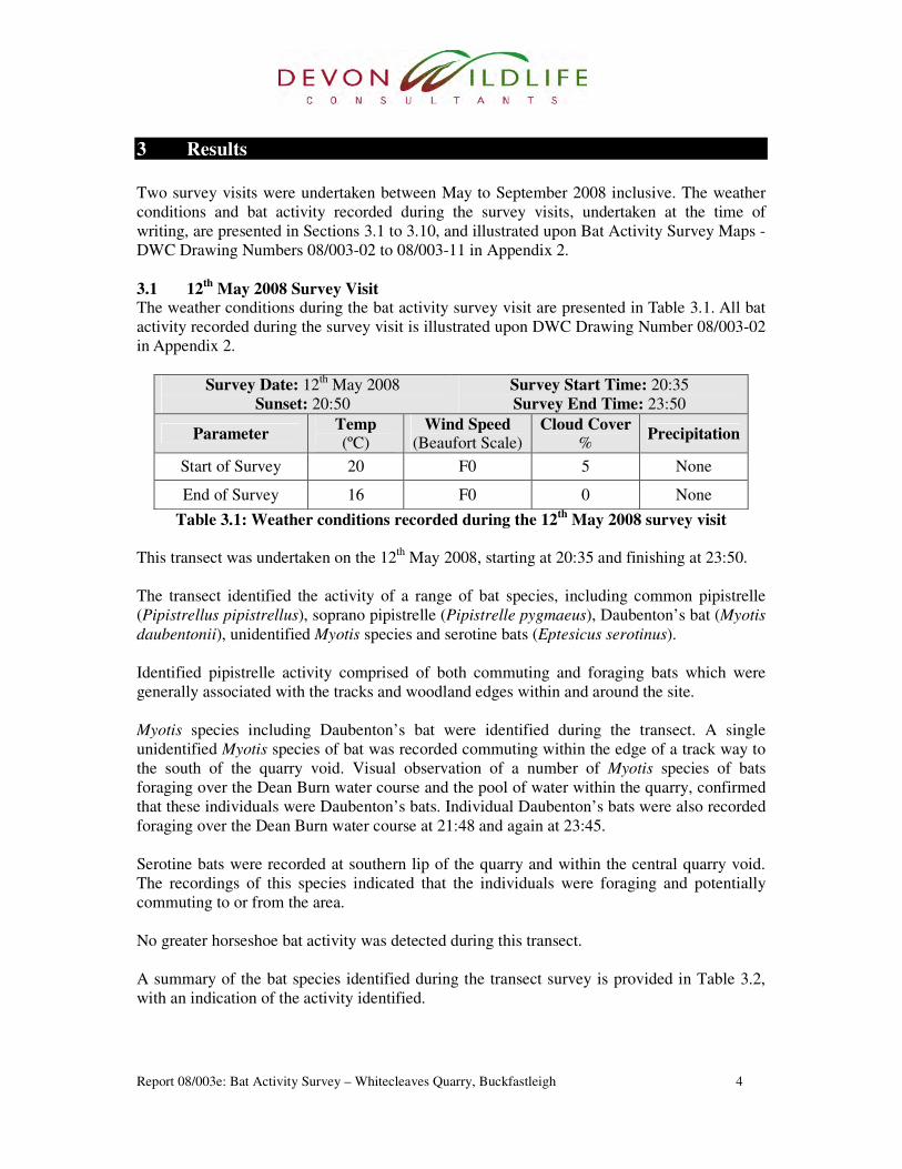
May 2008 Survey Visit The weather conditions during the bat activity survey visit are presented in Table 3.1. All bat
activity recorded during the survey visit is illustrated upon DWC Drawing Number 08/003-02
in Appendix 2.
Survey Date: 12th
May 2008
Sunset: 20:50
Survey Start Time: 20:35
Survey End Time: 23:50
Parameter Temp (ºC)
Wind Speed (Beaufort Scale)
Cloud Cover %
Precipitation
Start of Survey 20 F0 5 None
End of Survey 16 F0 0 None
Table 3.1: Weather conditions recorded during the 12th
May 2008 survey visit
This transect was undertaken on the 12th
May 2008, starting at 20:35 and finishing at 23:50.
The transect identified the activity of a range of bat species, including common pipistrelle
(Pipistrellus pipistrellus), soprano pipistrelle (Pipistrelle pygmaeus), Daubenton’s bat (Myotis
daubentonii), unidentified Myotis species and serotine bats (Eptesicus serotinus).
Identified pipistrelle activity comprised of both commuting and foraging bats which were
generally associated with the tracks and woodland edges within and around the site.
Myotis species including Daubenton’s bat were identified during the transect. A single
unidentified Myotis species of bat was recorded commuting within the edge of a track way to
the south of the quarry void. Visual observation of a number of Myotis species of bats
foraging over the Dean Burn water course and the pool of water within the quarry, confirmed
that these individuals were Daubenton’s bats. Individual Daubenton’s bats were also recorded
foraging over the Dean Burn water course at 21:48 and again at 23:45.
Serotine bats were recorded at southern lip of the quarry and within the central quarry void.
The recordings of this species indicated that the individuals were foraging and potentially
commuting to or from the area.
No greater horseshoe bat activity was detected during this transect.
A summary of the bat species identified during the transect survey is provided in Table 3.2,
with an indication of the activity identified.
Report 08/003e: Bat Activity Survey – Whitecleaves Quarry, Buckfastleigh 5
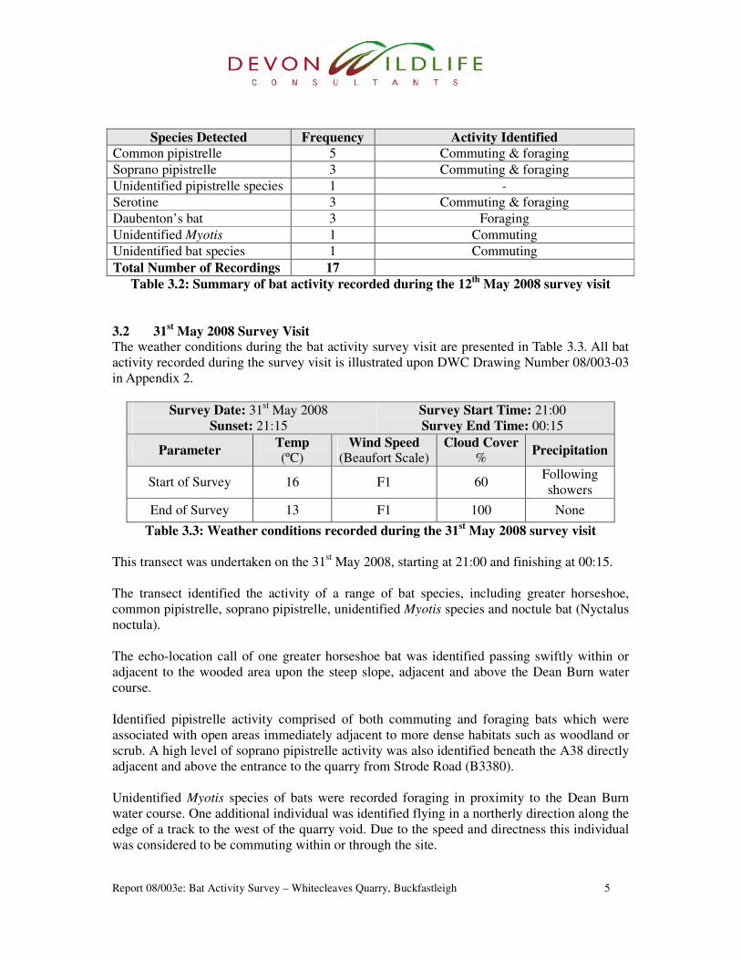
Species Detected Frequency Activity Identified
Common pipistrelle 5 Commuting & foraging
Soprano pipistrelle 3 Commuting & foraging
Unidentified pipistrelle species 1 -
Serotine 3 Commuting & foraging
Daubenton’s bat 3 Foraging
Unidentified Myotis 1 Commuting
Unidentified bat species 1 Commuting
Total Number of Recordings 17
Table 3.2: Summary of bat activity recorded during the 12th
May 2008 survey visit
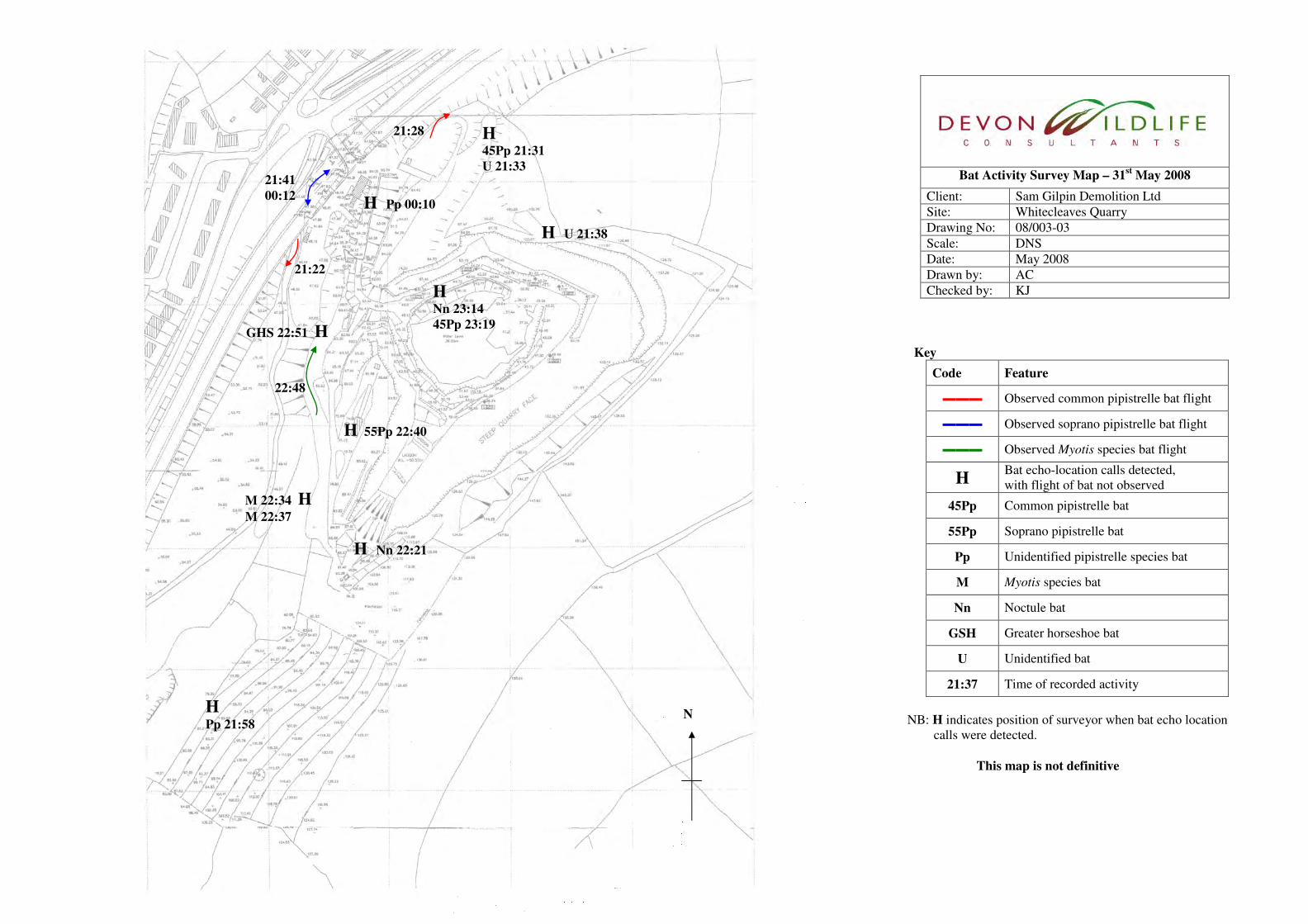
3.2 31st May 2008 Survey Visit
The weather conditions during the bat activity survey visit are presented in Table 3.3. All bat
activity recorded during the survey visit is illustrated upon DWC Drawing Number 08/003-03
in Appendix 2.
Survey Date: 31st May 2008
Sunset: 21:15
Survey Start Time: 21:00
Survey End Time: 00:15
Parameter Temp (ºC)
Wind Speed (Beaufort Scale)
Cloud Cover %
Precipitation
Start of Survey 16 F1 60 Following
showers
End of Survey 13 F1 100 None
Table 3.3: Weather conditions recorded during the 31st May 2008 survey visit
This transect was undertaken on the 31st May 2008, starting at 21:00 and finishing at 00:15.
The transect identified the activity of a range of bat species, including greater horseshoe,
common pipistrelle, soprano pipistrelle, unidentified Myotis species and noctule bat (Nyctalus
noctula).
The echo-location call of one greater horseshoe bat was identified passing swiftly within or
adjacent to the wooded area upon the steep slope, adjacent and above the Dean Burn water
course.
Identified pipistrelle activity comprised of both commuting and foraging bats which were
associated with open areas immediately adjacent to more dense habitats such as woodland or
scrub. A high level of soprano pipistrelle activity was also identified beneath the A38 directly
adjacent and above the entrance to the quarry from Strode Road (B3380).
Unidentified Myotis species of bats were recorded foraging in proximity to the Dean Burn
water course. One additional individual was identified flying in a northerly direction along the
edge of a track to the west of the quarry void. Due to the speed and directness this individual
was considered to be commuting within or through the site.
Report 08/003e: Bat Activity Survey – Whitecleaves Quarry, Buckfastleigh 6
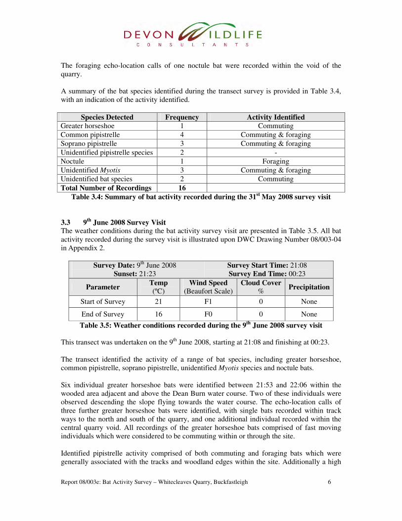
The foraging echo-location calls of one noctule bat were recorded within the void of the
quarry.
A summary of the bat species identified during the transect survey is provided in Table 3.4,
with an indication of the activity identified.
Species Detected Frequency Activity Identified
Greater horseshoe 1 Commuting
Common pipistrelle 4 Commuting & foraging
Soprano pipistrelle 3 Commuting & foraging
Unidentified pipistrelle species 2 -
Noctule 1 Foraging
Unidentified Myotis 3 Commuting & foraging
Unidentified bat species 2 Commuting
Total Number of Recordings 16
Table 3.4: Summary of bat activity recorded during the 31st May 2008 survey visit
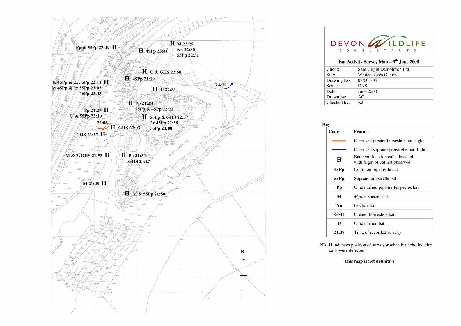
3.3 9th
June 2008 Survey Visit The weather conditions during the bat activity survey visit are presented in Table 3.5. All bat
activity recorded during the survey visit is illustrated upon DWC Drawing Number 08/003-04
in Appendix 2.
Survey Date: 9th
June 2008
Sunset: 21:23
Survey Start Time: 21:08
Survey End Time: 00:23
Parameter Temp (ºC)
Wind Speed
(Beaufort Scale) Cloud Cover
% Precipitation
Start of Survey 21 F1 0 None
End of Survey 16 F0 0 None
Table 3.5: Weather conditions recorded during the 9th
June 2008 survey visit
This transect was undertaken on the 9th
June 2008, starting at 21:08 and finishing at 00:23.
The transect identified the activity of a range of bat species, including greater horseshoe,
common pipistrelle, soprano pipistrelle, unidentified Myotis species and noctule bats.
Six individual greater horseshoe bats were identified between 21:53 and 22:06 within the
wooded area adjacent and above the Dean Burn water course. Two of these individuals were
observed descending the slope flying towards the water course. The echo-location calls of
three further greater horseshoe bats were identified, with single bats recorded within track
ways to the north and south of the quarry, and one additional individual recorded within the
central quarry void. All recordings of the greater horseshoe bats comprised of fast moving
individuals which were considered to be commuting within or through the site.
Identified pipistrelle activity comprised of both commuting and foraging bats which were
generally associated with the tracks and woodland edges within the site. Additionally a high

Report 08/003e: Bat Activity Survey – Whitecleaves Quarry, Buckfastleigh 7
level of common and soprano pipistrelle activity was identified beneath the A38 directly
adjacent and above the entrance to the quarry. Activity at this location included a number of
individuals of both species, with social calls recorded between individual common pipistrelle
bats.
Echo-location calls of unidentified Myotis species of bats were recorded in proximity to the
Dean Burn water course. The echo-location calls included feeding ‘buzzes’ indicating
foraging.
A single noctule bat was briefly detected to the north of the quarry void.
A summary of the bat species identified during the transect survey is provided in Table 3.6,
with an indication of the activity identified.
Species Detected Frequency Activity Identified
Greater horseshoe 9 Commuting
Common pipistrelle 12 Commuting, foraging & social interaction
Soprano pipistrelle 12 Commuting & foraging
Unidentified pipistrelle species 3 -
Noctule 1 -
Unidentified Myotis 3 Foraging
Unidentified bat species 4 Commuting
Total Number of Recordings 44
Table 3.6: Summary of bat activity recorded during the 11th
June 2008 survey visit
3.4 23rd
June 2008 Survey Visit The weather conditions during the bat activity survey visit are presented in Table 3.7. All bat
activity recorded during the survey visit is illustrated upon DWC Drawing Number 08/003-05
in Appendix 2.
Survey Date: 23rd
June 2008
Sunset: 21:30
Survey Start Time: 21:15
Survey End Time: 00:30
Parameter Temp (ºC)
Wind Speed (Beaufort Scale)
Cloud Cover %
Precipitation
Start of Survey 18 F0 10 None
End of Survey 11 F0 5 None
Table 3.7: Weather conditions recorded during the 23rd
June 2008 survey visit
This transect was undertaken on the 23rd
June 2008, starting at 21:15 and finishing at 00:30.
The transect identified the activity of a range of bat species, including greater horseshoe,
common pipistrelle, soprano pipistrelle and unidentified Myotis species of bats.
Two individual greater horseshoe bats were identified at 22:10 and 22:11 moving south and
briefly foraging above a track way. The echo-location calls of two further greater horseshoe

Report 08/003e: Bat Activity Survey – Whitecleaves Quarry, Buckfastleigh 8
bats were identified, with single bats recorded within track ways to the north and west of the
quarry. The recordings of these two individual greater horseshoe bats comprised of fast
moving individuals which were considered to be commuting within or through the site.
Identified pipistrelle bat species activity comprised of both commuting and foraging bats
which were generally associated with the tracks and woodland edges within the site. A high
level of common pipistrelle activity was also identified beneath the A38 directly adjacent and
above the entrance to the quarry, including a number of social calls recorded between
individual common pipistrelle bats.
Echo-location calls of unidentified Myotis species of bats were recorded in proximity to the
Dean Burn water course and above track ways surrounding the quarry void.
An unidentified bat was observed briefly within the quarry void, although due to the distance
between this bat and the surveyor no echo-location recording was possible. Four further
unidentified bats were recorded at the western extent of the site, where echo-location calls
were either too brief or faint to allow identification.
A summary of the bat species identified during the transect survey is provided in Table 3.8,
with an indication of the activity identified.
Species Detected Frequency Activity Identified
Greater horseshoe 4 Commuting & foraging
Common pipistrelle 16 Commuting, foraging & social interaction
Soprano pipistrelle 7 Commuting & foraging
Unidentified pipistrelle species 8 -
Unidentified Myotis 4 Commuting & foraging
Unidentified bat species 5 Commuting
Total Number of Recordings 44
Table 3.8: Summary of bat activity recorded during the 23rd
June 2008 survey visit
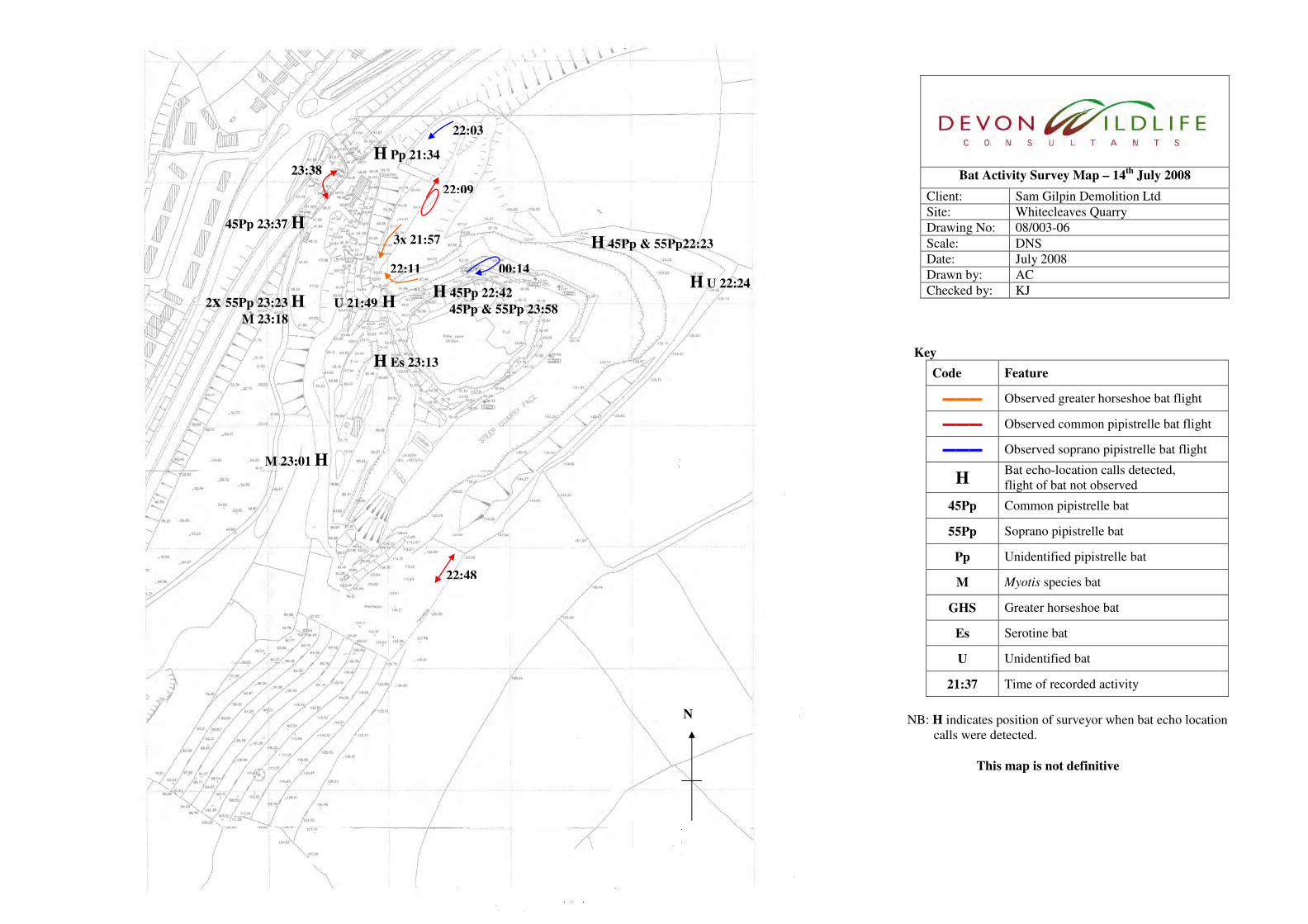
3.5 14th
July 2008 Survey Visit The weather conditions during the bat activity survey visit are presented in Table 3.9. All bat
activity recorded during the survey visit is illustrated upon DWC Drawing Number 08/003-06
in Appendix 2.
Survey Date: 14th
July 2008
Sunset: 21:21
Survey Start Time: 21:06
Survey End Time: 00:21
Parameter Temp (ºC)
Wind Speed (Beaufort Scale)
Cloud Cover %
Precipitation
Start of Survey 17 F0 30 None
End of Survey 13 F0 80 None
Table 3.9: Weather conditions recorded during the 14th
July 2008 survey visit
This transect was undertaken on the 14th
July 2008, starting at 21:06 and finishing at 00:21.
Report 08/003e: Bat Activity Survey – Whitecleaves Quarry, Buckfastleigh 9
The transect identified the activity of a range of bat species, including greater horseshoe,
common pipistrelle, soprano pipistrelle, serotine and unidentified Myotis species of bat.
Three greater horseshoe bats were identified commuting along a track way flying in a
southern direction at 21:57 in close succession. One further individual greater horseshoe bat
was also identified commuting along a track at 22:11.
Identified pipistrelle bat species activity comprised of both commuting and foraging bats
which was widely dispersed throughout the site. Activity was generally associated with the
woodland edges, track ways, the central void of the quarry and the Dean Burn Water Course.
Recordings of two unidentified Myotis species of bats were noted along the western edge of
the site, above a track way at 23:01 and within the open coach park area at 23:18.
A serotine bat was identified foraging high along the woodland edge and southern lip of the
central quarry void at 23:13.
Faint bat echo-location calls were recorded at 21:49 at the entrance to the quarry void, and at
22:24 at the north-eastern tip of the site area. No observation of these bats was made and the
recorded bat calls were to faint and brief to allow any further identification.
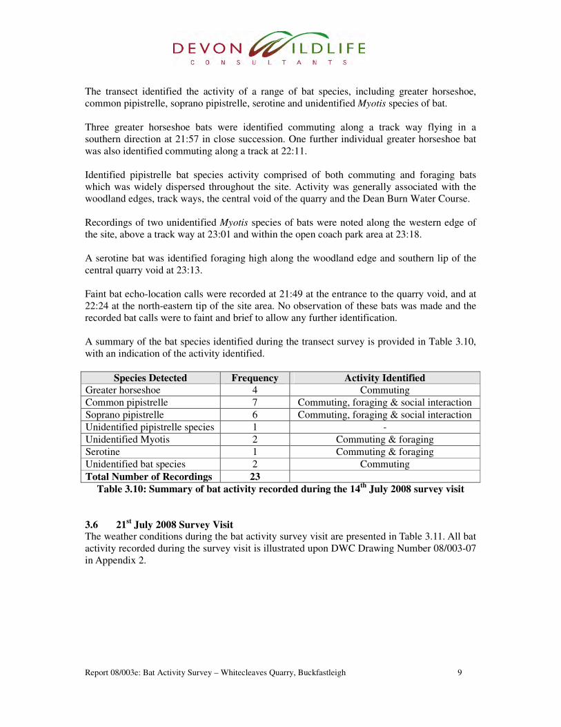
A summary of the bat species identified during the transect survey is provided in Table 3.10,
with an indication of the activity identified.
Species Detected Frequency Activity Identified
Greater horseshoe 4 Commuting
Common pipistrelle 7 Commuting, foraging & social interaction
Soprano pipistrelle 6 Commuting, foraging & social interaction
Unidentified pipistrelle species 1 -
Unidentified Myotis 2 Commuting & foraging
Serotine 1 Commuting & foraging
Unidentified bat species 2 Commuting
Total Number of Recordings 23
Table 3.10: Summary of bat activity recorded during the 14th
July 2008 survey visit
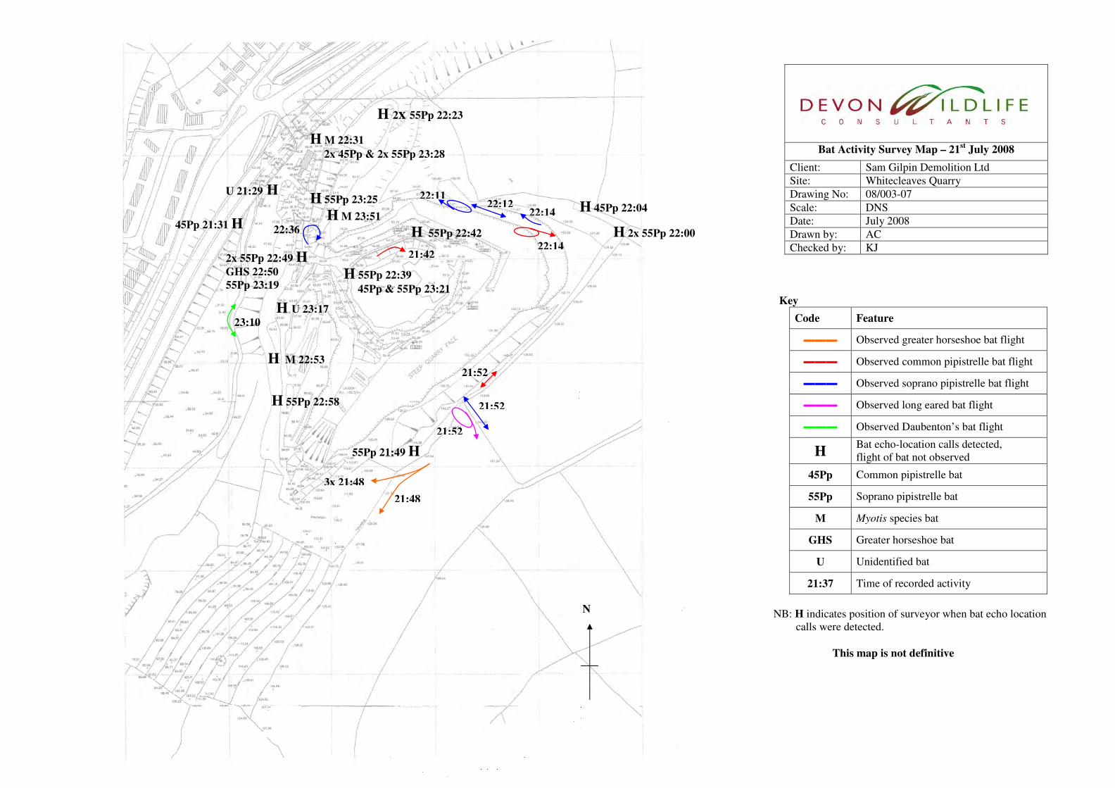
3.6 21st July 2008 Survey Visit
The weather conditions during the bat activity survey visit are presented in Table 3.11. All bat
activity recorded during the survey visit is illustrated upon DWC Drawing Number 08/003-07
in Appendix 2.

Report 08/003e: Bat Activity Survey – Whitecleaves Quarry, Buckfastleigh 10
Survey Date: 21st July 2008
Sunset: 21:15
Survey Start Time: 21:00
Survey End Time: 00:15
Parameter Temp (ºC)
Wind Speed (Beaufort Scale)
Cloud Cover %
Precipitation
Start of Survey 16 F0 20 None
End of Survey 14 F2 0 None
Table 3.11: Weather conditions recorded during the 21st July 2008 survey visit
This transect was undertaken on the 21st July 2008, starting at 21:00 and finishing at 00:15.
The transect identified the activity of a range of bat species, including greater horseshoe,
common pipistrelle, soprano pipistrelle, long-eared species of bat (Plecotus sp.), Daubenton’s
and unidentified Myotis species of bats.
Four greater horseshoe bats were observed at 21:48 moving in close succession along the
vegetated south-western edge of the site. The echo-location calls of one further greater
horseshoe bat were identified at the entrance to the quarry void at 22:50. These recordings
comprised of fast moving individuals which was considered to be commuting within or
through the site.
A high level of pipistrelle bat species activity was identified within and surrounding the site.
This included commuting and foraging bats noted above track ways, along vegetation lines
and within the central void of the quarry. Social calls of both common and soprano pipistrelle
bats were recorded at the western edge of the site and from the central quarry void.
Faint echo-location calls of unidentified Myotis species of bats were recorded in proximity to
the Dean Burn Water Course and above track ways surrounding the quarry void. One Myotis
bat was observed flying close above the waters surface of the Dean Burn Water Course,
which is typical behaviour of Daubenton’s bat, allowing further identification of this
individual.
One long-eared bat, a common pipistrelle and a soprano pipistrelle were observed foraging
within close proximity at the western boundary of the site. During this observation the long-
eared bat was observed feeding upon moths on the wing.
Two unidentified bats were observed briefly within close proximity of the quarry entrance,
although due to the distance between this bat and the surveyor no echo-location recording was
possible.
A summary of the bat species identified during the transect survey is provided in Table 3.12,
with an indication of the activity identified.

Report 08/003e: Bat Activity Survey – Whitecleaves Quarry, Buckfastleigh 11
Species Detected Frequency Activity Identified
Greater horseshoe 5 Commuting & foraging
Common pipistrelle 8 Commuting, foraging & social interaction
Soprano pipistrelle 20 Commuting & foraging
Long eared bat species 1 Foraging
Daubenton’s bat 1 Foraging
Unidentified Myotis 3 Commuting & foraging
Unidentified bat species 2 Commuting
Total Number of Recordings 40
Table 3.12: Summary of bat activity recorded during the 21st July 2008 survey visit
3.7 4th
August 2008 Survey Visit The weather conditions during the bat activity survey visit are presented in Table 3.13. All bat
activity recorded during the survey visit is illustrated upon DWC Drawing Number 08/003-08
in Appendix 2.
Survey Date: 4th
August 2008
Sunset: 20:55
Survey Start Time: 20:40
Survey End Time: 23:55
Parameter Temp (ºC)
Wind Speed (Beaufort Scale)
Cloud Cover %
Precipitation
Start of Survey 17 F0 100 None
End of Survey 15 F0 100 None
Table 3.13: Weather conditions recorded during the 4th
August 2008 survey visit
This transect was undertaken on the 4th
August 2008, starting at 20:40 and finishing at 23:55.
The transect identified the activity of a range of bat species, including greater horseshoe,
common pipistrelle, soprano pipistrelle, long-eared bat, serotine and noctule bat.
Twenty-one greater horseshoe bats were observed in close succession between 21:17 and
21:25. All these bats were recorded making fast passes, in a south-west direction along a track
way to the north-west of the quarry void. Further echo-location calls of greater horseshoe bats
were also detected at the north and southern extent of the quarry and within a track way to the
south-west of the quarry, at 22:28, 23:19 and 23:25. These bats comprised of fast moving
individuals, which were considered to be commuting within or through the site.
A high level of common and soprano pipistrelle bat activity was recorded throughout the
transect survey from all areas of the site. This included commuting and foraging bats noted
above track ways, along vegetation lines and within the central void of the quarry.
A long-eared bat was observed foraging at the eastern extent of the quarry site at 21:49. This
individual was observed flying between an adjacent hedgerow and the wooded site boundary.
An additional long-eared bat was also detected within the quarry void at 22:38.
Report 08/003e: Bat Activity Survey – Whitecleaves Quarry, Buckfastleigh 12
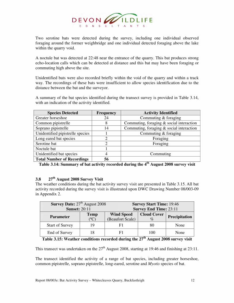
Two serotine bats were detected during the survey, including one individual observed
foraging around the former weighbridge and one individual detected foraging above the lake
within the quarry void.
A noctule bat was detected at 22:48 near the entrance of the quarry. This bat produces strong
echo-location calls which can be detected at distance and this bat may have been foraging or
commuting high above the site.
Unidentified bats were also recorded briefly within the void of the quarry and within a track
way. The recordings of these bats were insufficient to allow species identification due to the
distance between the bat and the surveyor.
A summary of the bat species identified during the transect survey is provided in Table 3.14,
with an indication of the activity identified.
Species Detected Frequency Activity Identified
Greater horseshoe 24 Commuting & foraging
Common pipistrelle 8 Commuting, foraging & social interaction
Soprano pipistrelle 14 Commuting, foraging & social interaction
Unidentified pipistrelle species 1 Commuting & foraging
Long eared bat species 2 Foraging
Serotine bat 2 Foraging
Noctule bat 1
Unidentified bat species 4 Commuting
Total Number of Recordings 56
Table 3.14: Summary of bat activity recorded during the 4th
August 2008 survey visit
3.8 27th
August 2008 Survey Visit The weather conditions during the bat activity survey visit are presented in Table 3.15. All bat
activity recorded during the survey visit is illustrated upon DWC Drawing Number 08/003-09
in Appendix 2.
Survey Date: 27th
August 2008
Sunset: 20:11
Survey Start Time: 19:46
Survey End Time: 23:11
Parameter Temp (ºC)
Wind Speed (Beaufort Scale)
Cloud Cover %
Precipitation
Start of Survey 19 F1 80 None
End of Survey 18 F1 100 None
Table 3.15: Weather conditions recorded during the 27th
August 2008 survey visit
This transect was undertaken on the 27th
August 2008, starting at 19:46 and finishing at 23:11.
The transect identified the activity of a range of bat species, including greater horseshoe,
common pipistrelle, soprano pipistrelle, long-eared, serotine and Myotis species of bat.

Report 08/003e: Bat Activity Survey – Whitecleaves Quarry, Buckfastleigh 13
Three greater horseshoe bats were detected at the entrance to, and just within the quarry void
at 21:30, 21:57 and 22:45. The first two individuals were recorded making fast passes and the
third bat was recorded briefly foraging. Three further greater horseshoe bats were recorded at
the northern extent of the site within a track way. These bats foraged over a length of the track
way for a short period of time before exiting the site.
Further bat activity included a relatively high level of detected and/or observed common
pipistrelle, soprano pipistrelle, long-eared and Myotis species of bats. This activity was
recorded throughout the northern and western extent of the survey, in addition to the central
quarry void. Activity was recorded largely in association with track ways and wooded edges
within the site, and at the western boundary of the site, beneath the elevated A38 road way.
One serotine bat was also recorded during the survey, foraging within the quarry void at
22:03.
A high level of social calls and interaction was recorded between the pipistrelle bats species,
with a single social interaction also recorded between two Myotis species bats. UK bat species
enter their mating period during late August and it is considered that the increase in the level
of social interaction could be attributed to this.
A summary of the bat species identified during the transect survey is provided in Table 3.16,
with an indication of the activity identified.
Species Detected Frequency Activity Identified
Greater horseshoe 6 Commuting & foraging
Common pipistrelle 19 Commuting, foraging & social interaction
Soprano pipistrelle 9 Commuting, foraging & social interaction
Long eared bat species 8 Foraging
Serotine bat 1 Foraging
Unidentified Myotis 9 Commuting, foraging & social interaction
Total Number of Recordings 53
Table 3.16: Summary of bat activity recorded during the 27th
August 2008 survey visit
3.9 15th
September 2008 Survey Visit The weather conditions during the bat activity survey visit are presented in Table 3.17. All bat
activity recorded during the survey visit is illustrated upon DWC Drawing Number 08/003-10
in Appendix 2.
Survey Date: 15th
September 2008
Sunset: 19:29
Survey Start Time: 19:14
Survey End Time: 22:29
Parameter Temp (ºC)
Wind Speed (Beaufort Scale)
Cloud Cover %
Precipitation
Start of Survey 17 F0 90 None
End of Survey 15 F0 100 None
Table 3.17: Weather conditions recorded during the 15th
September 2008 survey visit

Report 08/003e: Bat Activity Survey – Whitecleaves Quarry, Buckfastleigh 14
This transect was undertaken on the 15th
September 2008, starting at 19:14 and finishing at
22:29.
The transect identified the activity of a range of bat species, including greater horseshoe,
lesser horseshoe (Rhinolophus hipposideros), common pipistrelle, soprano pipistrelle,
Nathusius’ pipistrelle (Pipistrellus nathusii), long-eared bats, Daubenton’s and unidentified
Myotis species of bat.
One greater horseshoe bat was detected briefly within a track way to the north of the quarry
void at 21:56.
Further bat activity included a relatively high level of detected and/or observed common
pipistrelle, soprano pipistrelle, long-eared and Myotis species of bats. Activity included
commuting and foraging individuals, accompanied by several social calls. Activity was
predominantly detected or observed along woodland edges and track ways surrounding the
quarry, within the quarry void and beneath the elevated A30 road.
It is considered that this high level of social calls and interaction recorded between these
species relates to the late summer/autumn mating period for all UK species of bat.
A single Nathusius’ pipistrelle was detected in close proximity to two soprano pipistrelle bats,
along the wooded edge at the eastern extent of the quarry. Two Daubenton’s bats were
observed foraging over the central water body of the quarry at 21:04; and a single lesser
horseshoe bat was detected foraging within Potters Wood at the southern extent of the quarry.
Unidentified bats were also recorded briefly at 19:43 and 19:45 within the western extent of
the quarry. The recordings of these bats were insufficient to allow species identification, this
may have been due to the distance between the bat and the surveyor.
A summary of the bat species identified during the transect survey is provided in Table 3.18,
with an indication of the activity identified.
Species Detected Frequency Activity Identified
Greater horseshoe 1 Commuting
Lesser horseshoe 1 Foraging
Common pipistrelle 9 Commuting, foraging & social interaction
Soprano pipistrelle 8 Commuting, foraging & social interaction
Nathusius’ pipistrelle 1 Foraging
Unidentified pipistrelle 2 Commuting & foraging
Long eared bat species 7 Foraging& social interaction
Daubenton’s bat 2 Foraging
Unidentified Myotis sp. 6 Commuting, foraging & social interaction
Unidentified bat 2 -
Total Number of Recordings 39
Table 3.18: Summary of bat activity recorded during the 15th
September 2008 survey visit
Report 08/003e: Bat Activity Survey – Whitecleaves Quarry, Buckfastleigh 15
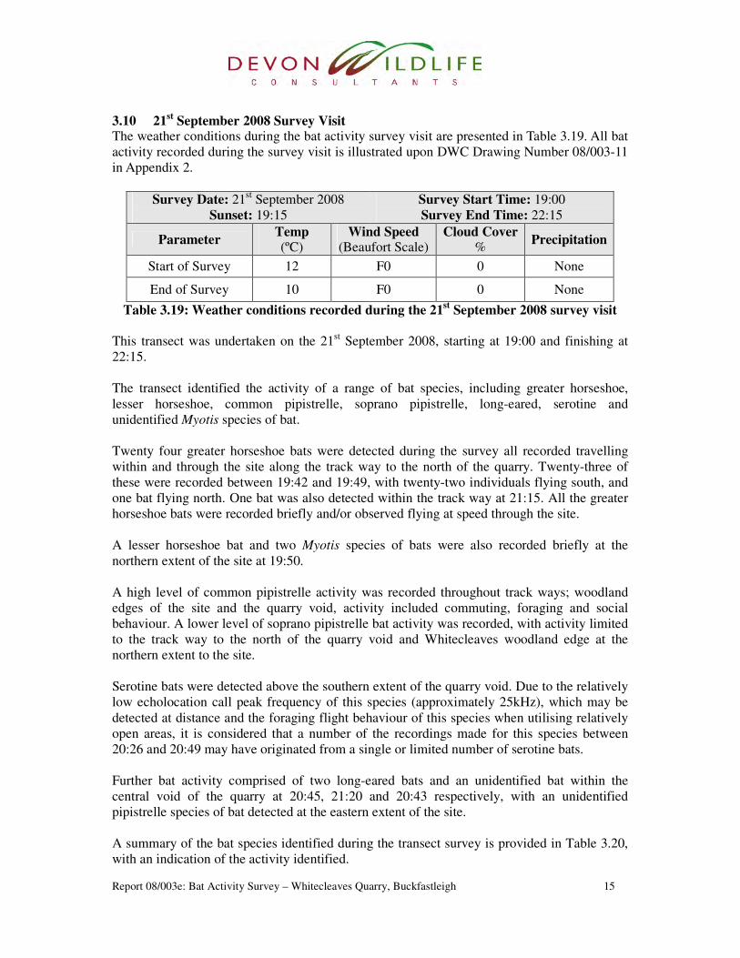
3.10 21st September 2008 Survey Visit
The weather conditions during the bat activity survey visit are presented in Table 3.19. All bat
activity recorded during the survey visit is illustrated upon DWC Drawing Number 08/003-11
in Appendix 2.
Survey Date: 21st September 2008
Sunset: 19:15
Survey Start Time: 19:00
Survey End Time: 22:15
Parameter Temp (ºC)
Wind Speed (Beaufort Scale)
Cloud Cover %
Precipitation
Start of Survey 12 F0 0 None
End of Survey 10 F0 0 None
Table 3.19: Weather conditions recorded during the 21st September 2008 survey visit
This transect was undertaken on the 21st September 2008, starting at 19:00 and finishing at
22:15.
The transect identified the activity of a range of bat species, including greater horseshoe,
lesser horseshoe, common pipistrelle, soprano pipistrelle, long-eared, serotine and
unidentified Myotis species of bat.
Twenty four greater horseshoe bats were detected during the survey all recorded travelling
within and through the site along the track way to the north of the quarry. Twenty-three of
these were recorded between 19:42 and 19:49, with twenty-two individuals flying south, and
one bat flying north. One bat was also detected within the track way at 21:15. All the greater
horseshoe bats were recorded briefly and/or observed flying at speed through the site.
A lesser horseshoe bat and two Myotis species of bats were also recorded briefly at the
northern extent of the site at 19:50.
A high level of common pipistrelle activity was recorded throughout track ways; woodland
edges of the site and the quarry void, activity included commuting, foraging and social
behaviour. A lower level of soprano pipistrelle bat activity was recorded, with activity limited
to the track way to the north of the quarry void and Whitecleaves woodland edge at the
northern extent to the site.
Serotine bats were detected above the southern extent of the quarry void. Due to the relatively
low echolocation call peak frequency of this species (approximately 25kHz), which may be
detected at distance and the foraging flight behaviour of this species when utilising relatively
open areas, it is considered that a number of the recordings made for this species between
20:26 and 20:49 may have originated from a single or limited number of serotine bats.
Further bat activity comprised of two long-eared bats and an unidentified bat within the
central void of the quarry at 20:45, 21:20 and 20:43 respectively, with an unidentified
pipistrelle species of bat detected at the eastern extent of the site.
A summary of the bat species identified during the transect survey is provided in Table 3.20,
with an indication of the activity identified.
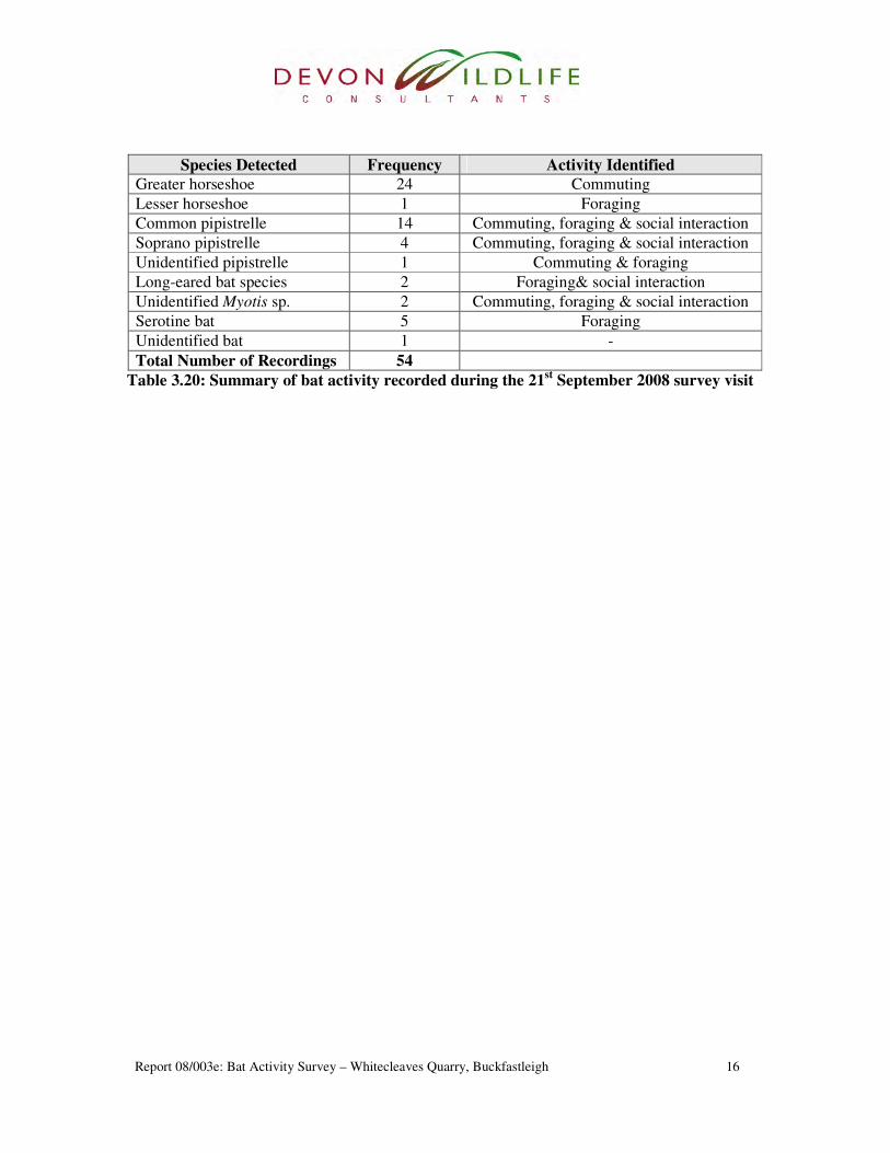
Report 08/003e: Bat Activity Survey – Whitecleaves Quarry, Buckfastleigh 16
Species Detected Frequency Activity Identified
Greater horseshoe 24 Commuting
Lesser horseshoe 1 Foraging
Common pipistrelle 14 Commuting, foraging & social interaction
Soprano pipistrelle 4 Commuting, foraging & social interaction
Unidentified pipistrelle 1 Commuting & foraging
Long-eared bat species 2 Foraging& social interaction
Unidentified Myotis sp. 2 Commuting, foraging & social interaction
Serotine bat 5 Foraging
Unidentified bat 1 -
Total Number of Recordings 54
Table 3.20: Summary of bat activity recorded during the 21st September 2008 survey visit
Report 08/003e: Bat Activity Survey – Whitecleaves Quarry, Buckfastleigh 17
4 Discussion
The Bat Activity Survey at Whitecleaves Quarry, undertaken during May, June, July, August
and September 2008, identified a relatively high level of bat activity with a range of bat
species. This activity has largely been identified in association with the track ways and
woodland edges within the site, and in association with the Dean Burn water course and
beneath the elevated A38 road way at the western extent to the site. The eastern extent of the
site had relatively lower levels of bat activity which may be due to the high elevation and
more exposed nature of this site boundary.
Nine bat species were identified during the survey visits, including greater horseshoe, lesser
horseshoe, common pipistrelle, soprano pipistrelle, Nathusius’ pipistrelle, noctule, serotine,
long-eared bat species and Myotis species of bat, including Daubenton’s bat.
It is considered that additional species of Myotis bat, such as Natterer’s bat (Myotis nattereri),
whiskered bat (Myotis mystacinus) and Brandt’s bat (Myotis brandtii) may have been
represented during the survey. Due to the similar attributes of the flight patterns and echo-
location calls of these closely related species no further identification was undertaken, with
the exception of Daubenton’s bat which was identified by their distinctive foraging flight
pattern, foraging close over the surface of water bodies, such as the Dean Burn water course
or the pool within the quarry void.
The Bat Activity Survey identified a high level of greater horseshoe bat activity, recorded
within track ways, woodland edges and within the central void to the quarry. The flight lines
and positions of recorded greater horseshoe bat activity is illustrated upon the Greater
Horseshoe Bat Activity Overview Map, DWC Drawing Number 08/059a-12, in Appendix 3.
Greater horseshoe bats were predominantly considered as commuting individuals, moving
fast, within and through the site, and recorded approximately between 30 minutes and 1 hour
after sunset. Bats were recorded circumnavigating the central quarry void, predominantly
flying along track ways to the west of the quarry void and in association with the Dean Burn
Water Course and the adjacent area of woodland. Four greater horseshoe bats were also
recorded moving south along the eastern boundary of the site during the 21st July 2008
transect survey.
Low levels of foraging greater horseshoe bat activity was also recorded during the surveys
undertaken on the 23rd
June, 21st July, 4
th August and 27
th August 2008. This included brief
periods of single or low numbers of greater horseshoe bats within the quarry void and above
the track ways to the west of the quarry void.
Greater horseshoe bats commonly use dark sheltered linear features, such as woodland rides,
hedgerows and water courses as commuting routes between roosts and feeding areas. It is
considered that the track ways immediately to the west of the quarry void, the Dean Burn
water course and associated woodland, and the wooded eastern boundary to the quarry, are
utilised as commuting routes. It is also considered that the adjacent woodland and track way
at the western extent of the quarry is used in conjunction with the water course, as the

Report 08/003e: Bat Activity Survey – Whitecleaves Quarry, Buckfastleigh 18
descending topography and wooded vegetation creates a sheltered, dark environment with a
potential abundance of invertebrate prey species.
Report 08/003e: Bat Activity Survey – Whitecleaves Quarry, Buckfastleigh 19
5 Implications of the Development
5.1 Introduction
It is understood that it is proposed to develop the site to create a recycling centre and
associated offices. It is understood that to facilitate this proposal, the central area of the quarry
will need to be raised and levelled, thus removing the current water bodies, with areas of re-
profiling required around the quarry entrance and the proposed office location, to create larger
open areas than currently are present.
The re-profiling works would see an expansion of the quarry void with a level area created
and extended to include the current western extent of the quarry void. It is understood that the
current western extent of the quarry will be mined over a period of 5 years, involving two
blasts per year. The subsequent mineral stone will be removed from the quarry with waste
material utilised to level the quarry base. In addition a track way and open area, to the north of
the quarry void, will be amalgamated and levelled, creating an area for the proposed offices.
The areas of wooded vegetation to be removed and areas of land to be mined and/or re-
profiled are illustrated upon DWC Drawing Number 08/003-14, in Appendix 4.
5.2 Greater Horseshoe Bat Flight Lines
The current study has identified a variety of greater horseshoe bats commuting within or
through the quarry site. From this identified activity it is considered that greater horseshoe
bats utilise commuting routes which circumnavigate the quarry void to the east and the west.
Predominantly greater horseshoe bats utilised the track ways immediately to the northwest of
the quarry void and the Dean Burn water course and associated woodland, as well as utilising
the eastern wooded boundary of the site. Low levels of single or low numbers of greater
horseshoe bats was also recorded foraging within the quarry void and above the track ways to
the southwest of the quarry void. The flight lines and positions of recorded greater horseshoe
bat activity is illustrated upon the Greater Horseshoe Bat Activity Overview Map, DWC
Drawing Number 08/059a-12, in Appendix 4.
Due to the rarity of greater horseshoe bats and its protection as listed on Annex II of the
Habitat Directive, development proposals are required to account and protect identified
feeding habitats or flight lines used by this species (Mitchell-Jones, 2004).
The identified greater horseshoe commuting routes, particularly through the western extent of
the survey area, are important to the permeability of the landscape for greater horseshoe bats
by connecting foraging habitats and roost sites, including the designated sites of Potters Wood
SSSI and Buckfastleigh Caves SSSI.
5.2.1 Eastern Boundary
It is understood that the eastern boundary of the quarry will not be directly affected by the
proposed development with activity limited to the installation of a safety fence lining the
quarry void. Previously a bund has been created and planted with wooded species running the
length of the eastern site boundary, connecting Whitecleaves Wood, at the northern extent of
Report 08/003e: Bat Activity Survey – Whitecleaves Quarry, Buckfastleigh 20
the quarry site, to a plantation woodland adjacent to Potters Wood, at the southern extent of
the site.
During the survey relatively low levels of commuting greater horseshoe bats were recorded
utilising the eastern boundary, which may be due to elevated position of this boundary. It is
considered that as the growth of the wooded vegetation along this boundary develops the level
of shelter will also increase, in turn increasing the permeability for greater horseshoe bats
along this commuting route.
5.2.2 Western Extent of the Site The western extent of the site will be subject to a high level of disturbance including mining
and re-profiling of areas to the northwest and southwest of the current quarry void.
It is proposed that the current wooded areas immediately to the southwest of the quarry void
will be mined with the area subsequently re-profiled to grade into the adjacent track way
located to the southwest of the quarry void, creating an expanded central quarry void. During
the survey a number of greater horseshoe bats were identified utilising this track way,
commuting within and through the site, including a number of individuals partially using the
track way before descending the adjacent woodland and proceeding into the corridor of the
Dean Burn Water Course.
Currently this track way ranges in width from approximately between 6 to 20 metres and is
sheltered from the surrounding areas of woodland and ground/rock topography. The
expansion and connection of the track way within the central quarry void will increase the
level of potential exposure to this commuting route, potentially decreasing the permeability of
this feature to greater horseshoe bats. A level of shelter will be maintained by the position of
this track way, set within the hillside, combined with the shading from the adjacent woodland
to the west. Mitigation should be instated to protect this flight line including measures to
maintain use of the track way by greater horseshoe bats.
It is also proposed to amalgamate the track way to the northwest of the quarry void to a small
clearing creating an initial recycling sorting area and offices. This area will require the
removal of vegetation and a tree line which currently separates the two areas, with the ground
level graded, creating a larger area of open space. During the survey a high level of greater
horseshoe bats were identified utilising this track way, including individuals commuting from
Whitecleaves Wood at the northern extent of the site, which flew along the full length of the
track way.
Currently this track way ranges in width approximately from 6 to 15 metres and is sheltered
by the adjacent areas of woodland and trees. The amalgamation of these areas will create a
larger area of open space with a greater level of potential exposure. This increased level of
potential exposure will influence and potentially reduce the permeability of this feature to
greater horseshoe bats. A level of shading will be maintained by the adjacent woodland to the
east and woodland strip to the west although further mitigation will be required to elevate this
and reduce the impact of the works.
Report 08/003e: Bat Activity Survey – Whitecleaves Quarry, Buckfastleigh 21
5.3 Potters Wood SSSI & Buckfastleigh Caves SSSI
Whitecleaves Quarry partially includes the northern extent of Potters Wood SSSI which is
designated for its geological interest, and partially as an important site for roosting bats
including greater horseshoe bats. Buckfastleigh Caves SSSI is located approximately 600m to
the north of Whitecleaves Quarry at it closest point.
Planning policy states that local planning authorities have a statutory duty under the Wildlife
& Countryside Act 1981 to ensure that proposed developments avoid damage to SSSI’s and
SAC’s, and that the objectives of such sites are considered. Where direct impacts to statutory
designated sites, such as SSSI and SAC sites are antisipated permission from Natural England
will be required to allow such works.
Although the southern extent of Whitecleaves Quarry forms the northern extent of Potters
Wood SSSI, it is noted that entrances into the cave system are located between 200 to 400
metres from the quarry. It is understood from Natural England that Potters Wood SSSI was
last assessed in 2004/2005 and was considered as in a maintained and favourable condition,
with lesser horseshoe bats recorded hibernating in Shaky Cave and lesser and greater
horseshoe bats hibernating in Bunkers Cave, with associated evidence of invertebrate prey
remains indicating use of the caves as summer bat roosts.
Geological interest pertaining to the cave system of Potters Wood SSSI includes important
mineral deposits forming aragonite crystals and calcite helictites. The network of caves was
formed 150,000 years ago, providing an important study site for late Pleistocene cave
formation.
Buckfastleigh Caves SSSI are also designated largely due to geological interest, and partially
through the inclusion of the endemic cave shrimp (Niphargellus glenniei) and as an important
site for roosting bats. Buckfastleigh Caves SSSI supports the largest colony of greater
horseshoe bats in the country, with the cave system containing more than 1,000 bats, which
estimated at approximately one quarter of the UK’s total population.
Buckfastleigh Caves SSSI also forms an isolated patch of the South Hams Special Area of
Conservation (SAC). The South Hams SAC includes a number of areas within south Devon,
including coastal calcareous grassland, scrub and cliffs, woodlands and cave systems such as
Buckfastleigh Caves.
Potential impacts to these designated sites include a range of factors, including factors which
may influence greater horseshoe bats.
Impacts to the designated sites may potentially include isolation or interruption of greater
horseshoe bat flight lines leading to and from the cave roosts, and foraging habitats. As such it
will be important to maintain the connectivity of the landscape for greater horseshoe bats with
the identified flight lines adequately protected.
Mitigation measures will be required to ensure flight lines for greater horseshoe bat within
and through the site are not impeded, and measures will be required to ensure that blasting

Report 08/003e: Bat Activity Survey – Whitecleaves Quarry, Buckfastleigh 22
operations do not influence the cave systems of Potters Wood SSSI or Buckfastleigh Caves
SSSI.
Additional potential impacts consist of disturbance to roosting bats within both Potters Wood
SSSI and Buckfast Cave SSSI, through potential vibration and air pressure changes resulting
from the blasting associated within the proposed mining operations of the quarry. Further
impacts may also be experienced through influences to the integrity of the cave systems,
causing rock movements or alterations to hydrological flows.
Further determination of these impacts is difficult to quantify and may remain undetermined
without further study or ecological and geological monitoring. Previously Whitecleaves
Quarry was commercially mined, including blasting, during which time hibernating greater
horseshoe bats were present with numbers monitored at Buckfastleigh Caves SSSI from 1966
to present. Potters Wood SSSI was designated in 1986 coinciding with termination of the
commercial quarrying at Whitecleaves Quarry.
As statutory designated sites, any proposed works which may cause an impact to the Potters
Wood SSSI and Buckfastleigh Caves SSSI will require prior permission from Natural
England.
Report 08/003e: Bat Activity Survey – Whitecleaves Quarry, Buckfastleigh 23
6 Mitigation
6.1 Introduction
Appropriate protection and mitigation should be utilised to alleviate the proposed impacts to
the identified greater horseshoe bat flight lines, also indecently reducing the potential impact
to flight lines leading and connecting to Potters Wood SSSI and Buckfastleigh Caves SSSI.
Further mitigation measures are also required to avoid any further impacts to Potters Wood
SSSI and Buckfastleigh Caves SSSI.
These aspects are considered in more detail in Section 6.2 and 6.3 below. An accompanying
Greater Horseshoe Bat Mitigation Map, DWC Drawing Number 08/003-14, is presented in
Appendix 5.
6.2 Greater Horseshoe Bat Flight Lines
Greater horseshoe bat commuting flight lines were identified circumnavigating Whitecleaves
Quarry, including the woody eastern boundary and the tracks ways, woodland and the Dean
Burn Water Course through and at the western extent of the site.
It is understood that the eastern boundary flight line will remain unaffected by the proposed
development. This boundary has previously been planted with trees and it is considered as
these trees develop this flight line will become more sheltered, in turn increasing the
permeability for greater horseshoe bats along this commuting route. Therefore no mitigation
is considered for this identified flight line.
The track way flight lines located within the western extent of the survey area will be opened
up, connecting to the adjacent quarry void and woodland clearing. This will increase the level
of exposure within these track ways, influencing the identified flight lines, potentially
reducing the suitability for greater horseshoe bats. It is considered that the situation of the
track ways, in combination with remaining surrounding vegetation will provide some shelter
although it is recommended that additional vegetation be planted to increase the level of
shelter, creating dense woodland edge habitats. It is considered that this vegetation planting
may alleviate the disturbance to this track way, allowing greater horseshoe bats to continue
the commute through the quarry, utilising the wooded edge of the former track ways and
clearing.
As these identified flight lines will be impacted upon, by an increase in their current exposure,
further bat activity monitoring may be considered to ensure that this level of mitigation is
adequate.
To avoid any further impact to these identified flight lines it is recommended that no external
lighting should illuminate any part of the identified commuting flight lines. This should be
maintained during all times of darkness throughout the year. Although bat species generally
hibernate from October to May individual bats may rouse from torpor during periods of mild
weather, moving between hibernation roosts and occasional foraging.

Report 08/003e: Bat Activity Survey – Whitecleaves Quarry, Buckfastleigh 24
It is understood that re-establishment of the eastern track way boundary, to the southwest of
the central quarry void, will be undertaken following the mining/re-profiling works with
vegetation planting. This vegetation planting should consist of a hedgerow/hedgebank.
Planting should be utilised to create a broad feature, approximately 3-6m in width should be
allowed to reach an average height of around 3m. It should comprise of native, wildlife
attracting species. It is noted that the re-established track way boundary may only be
reinstated following mining works, which is estimated to take 5 years to complete. During this
period the track way flight line will incur a higher level of exposure than present.
A wetland strip is proposed to run below the steep eastern cliff face to the quarry void. It is
also proposed to incorporate a vegetation strip parallel to this wetland. It is considered that
this wetland and vegetated strip may include wildlife interest and serve as a future bat flight
corridor linking the wooded vegetation to the north and south of the quarry void, and
potentially providing additional bat foraging habitat. The wetland should incorporate a graded
edge encouraging the establishment of emergent and marginal plant species thus increasing
the potential wildlife value. Planting of the accompanying vegetation strip should incorporate
native, wildlife attracting tree and shrub species allowed to reach an average height of around
3m. It is noted that this wetland and associated planting will only be reinstated following
mining works, which is estimated to take 5 years to complete.
6.3 Potters Wood SSSI & Buckfastleigh Caves SSSI
It will be important to maintain the connectivity of the landscape for greater horseshoe bats,
allowing their dispersal and movement between foraging habitats and roost sites such as
Potters Wood SSSI and Buckfastleigh Caves SSSI. To achieve this greater horseshoe bat
flight lines should be adequately protected or mitigated for to alleviate any impact to these
statutory designated sites. Flight lines within Whitecleaves Quarry are considered within
Section 6.2 above.
Indirect impacts to Potters Wood SSSI and Buckfastleigh Caves SSSI may result from the
blasting undertaken as part of mining operations. This potential impact would be considered
at a lesser extent with regard to Buckfastleigh Caves SSSI due to the greater distance from
Whitecleaves Quarry. It is understood that blasting operations were previously undertaken at
Whitecleaves Quarry during former commercial mining works.
Blasting operations may cause potential disturbance to roosting or hibernating bats within the
cave systems through damage to the integrity of the cave system and/or from air pressure
changes and/or vibration.
The type and level of blasting should be selected to avoid any such impact. If an impact can
not be avoided prior permission will be required from Natural England. As a precautionary
measure it may be considered suitable to avoid blasting operations during the most sensitive
periods for bats, such as maternity or deep hibernation periods, which would be May to
August and November to February respectively.

Report 08/003e: Bat Activity Survey – Whitecleaves Quarry, Buckfastleigh 25
7 Recommendations
7.1 Greater Horseshoe Bat Flight Lines
Vegetation planting should be undertaken along the perimeter of all the remaining vegetation
adjacent to the identified greater horseshoe track way flight lines, immediately following any
vegetation removal/clearance works. This planting should comprise of native shrub species,
such as hawthorn (Crataegus monogyna), blackthorn (Prunus spinosa), field maple (Acer
campestre) and hazel (Corylus avellana), sourced from local providence. These woodland
shrub species are shade tolerant and should be utilised to create dense sheltered, woodland
edge habitats.
Further bat activity monitoring should be considered to ensure that this level of mitigation is
adequate to the identified greater horseshoe bat flight lines.
New hedge planting should be utilised to re-establish the eastern boundary of the track way to
the southwest of the quarry void. This planting should create a broad feature, approximately
3-6m across and allowed to reach an average height of around 3m. It should comprise of
native, wildlife attracting species. Hedgerow trees should be planted or allowed to develop at
approximately 20m intervals along the hedgerow, which will provide further shelter in
addition to bat feeding perches. It is noted that this re-established track way boundary may
only be reinstated following mining works, which are estimated to take 5 years to complete.
The wetland strip proposed to run below the steep eastern cliff face to the quarry void should
incorporate a graded edge encouraging the establishment of emergent and marginal plant
species, and be accompanied by a 6 metre wide vegetation strip comprising of native, wildlife
attracting shrub species, allowed to reach an average height of around 3m. It is noted that this
wetland and associated planting will only be reinstated following the proposed mining works,
which are estimated to take 5 years to complete.
7.2 Potters Wood SSSI & Buckfastleigh Caves SSSI
The type and level of blasting should be selected to avoid any impact to Potters Wood SSSI
and Buckfastleigh Caves SSSI. If an impact can not be avoided prior permission will be
required from Natural England.
As a precautionary measure, to minimise any potential impact through vibration, air pressure
changes, damage to the integrity of the cave systems, blasting operations should be avoided
during the most sensitive periods for bats, such as maternity or deep hibernation periods,
which would run from May to August and November to February respectively.
Report 08/003e: Bat Activity Survey – Whitecleaves Quarry, Buckfastleigh 26
References
Bat Conservation Trust. (2007). Bat Surveys – Good Practice Guidelines. Bat Conservation
Trust, London.
Countryside & Rights of Way Act 2000. HMSO
Devon Biodiversity Action Plan. http://www.devon.gov.uk/devon_biodiversity_action_plan
English Nature. (2003). Managing Landscapes for the Greater Horseshoe Bat. English
Nature, Peterborough
English Nature. (2004). The Bat Mitigation Guidelines. English Nature, Peterborough
JNCC. (2001). Habitat Management for Bats. Joint Nature Conservation Committee,
Peterborough
Mitchell-Jones A.J. & Mcleish A.P. (2004). The Bat Workers Manual, 3rd
Edition. Joint
Nature Conservation Committee, Peterborough
UK Biodiversity Action Plan. www.ukbap.org/uk
Wildlife & Countryside Act 1981, as amended HMSO

Report 08/003e: Bat Activity Survey – Whitecleaves Quarry, Buckfastleigh 27
Appendices
Appendix 1: Transect Survey Map
DWC Drawing Number 08/003-01
Appendix 2: Bat Activity Survey Maps
DWC Drawing Numbers 08/003-02 - 08/003-11
Appendix 3: Greater Horseshoe Bat Activity Overview Map
DWC Drawing Numbers 08/003-12
Appendix 4: Proposed Vegetation Removal & Re-profiling Works
DWC Drawing Numbers 08/003-13
Appendix 5: Greater Horseshoe Bat Mitigation Plan
DWC Drawing Numbers 08/003-14
Appendix 6: SSSI & SAC Citations

Report 08/059a: Bat Activity Survey – Buckfast Winery, Devon 28
Appendix 1 – Bat Activity Survey Transect Map

3.
Bat Activity Survey Transect Map
Client: Sam Gilpin Demolition Ltd
Site: Whitecleaves Quarry
Drawing No: 08/003-01
Scale: DNS
Date: May 2008
Drawn by: AC
Checked by: KJ
Key
Code Feature
▬▬ Transect route
■ Listening points
This map is not definitive
N

Report 08/059a: Bat Activity Survey – Buckfast Winery, Devon 29
Appendix 2 – Bat Activity Survey Maps

3.
Bat Activity Survey Map – 12th
May 2008
Client: Sam Gilpin Demolition Ltd
Site: Whitecleaves Quarry
Drawing No: 08/003-02
Scale: DNS
Date: May 2008
Drawn by: AC
Checked by: KJ
Key
Code Feature
▬▬▬ Observed common pipistrelle bat flight
▬▬▬ Observed soprano pipistrelle bat flight
▬▬▬ Observed Daubenton’s bat flight
H Bat echo-location calls detected,
with flight of bat not observed
45Pp Common pipistrelle bat
55Pp Soprano pipistrelle bat
Pp Unidentified pipistrelle species bat
M Myotis species bat
Es Serotine bat
U Unidentified bat
21:37 Time of recorded activity
NB: H indicates position of surveyor when bat echo location
calls were detected.
This map is not definitive
N
45Pp 23:38 H
21:22
21:27
21:41
21:48
23:45
H 55Pp 21:34
H Es 23:50
H 45Pp 22:09
H 45Pp 23:01
H 55Pp22:27
H Pp 23:29
H U 23:22
H Es 23:32
H Es 23:37
21:27
H M 21:38
3.
Bat Activity Survey Map – 31st May 2008
Client: Sam Gilpin Demolition Ltd
Site: Whitecleaves Quarry
Drawing No: 08/003-03
Scale: DNS
Date: May 2008
Drawn by: AC
Checked by: KJ
Key
Code Feature
▬▬▬ Observed common pipistrelle bat flight
▬▬▬ Observed soprano pipistrelle bat flight
▬▬▬ Observed Myotis species bat flight
H Bat echo-location calls detected,
with flight of bat not observed
45Pp Common pipistrelle bat
55Pp Soprano pipistrelle bat
Pp Unidentified pipistrelle species bat
M Myotis species bat
Nn Noctule bat
GSH Greater horseshoe bat
U Unidentified bat
21:37 Time of recorded activity
NB: H indicates position of surveyor when bat echo location
calls were detected.
This map is not definitive
N
GHS 22:51 H
21:22
22:48
21:41
00:12
H 55Pp 22:40
H Nn 22:21
H Pp 21:58
H 45Pp 21:31
U 21:33
H U 21:38
H Pp 00:10
H Nn 23:14
45Pp 23:19
21:28
M 22:34 H M 22:37
3.
Bat Activity Survey Map – 9th
June 2008
Client: Sam Gilpin Demolition Ltd
Site: Whitecleaves Quarry
Drawing No: 08/003-04
Scale: DNS
Date: June 2008
Drawn by: AC
Checked by: KJ
Key
Code Feature
▬▬▬ Observed greater horseshoe bat flight
▬▬▬ Observed soprano pipistrelle bat flight
H Bat echo-location calls detected,
with flight of bat not observed
45Pp Common pipistrelle bat
55Pp Soprano pipistrelle bat
Pp Unidentified pipistrelle species bat
M Myotis species bat
Nn Noctule bat
GSH Greater horseshoe bat
U Unidentified bat
21:37 Time of recorded activity
NB: H indicates position of surveyor when bat echo location
calls were detected.
This map is not definitive
N
GHS 21:57 H
H GHS 22:03
M & 2xGHS 21:53 H
H 45Pp 23:41
H Pp 21:34
GHS 23:27
H M & 55Pp 21:50
H U 22:35
H 45Pp 21:19 3x 45Pp & 2x 55Pp 22:11 H 3x 45Pp & 2x 55Pp 23:03
45Pp 23:43
Pp 21:28 H U & 55Pp 23:10
22:41
M 21:48 H
H Pp 21:28
55Pp & 45Pp 22:22
H M 22:29
Nn 22:30
55Pp 22:31
H U & GHS 22:50
H 55Pp & GHS 22:57
2x 45Pp 22:58
55Pp 23:00
Pp & 55Pp 23:49 H
22:06

3.
Bat Activity Survey Map – 23rd
June 2008
Client: Sam Gilpin Demolition Ltd
Site: Whitecleaves Quarry
Drawing No: 08/003-05
Scale: DNS
Date: June 2008
Drawn by: AC
Checked by: KJ
Key
Code Feature
▬▬▬ Observed greater horseshoe bat flight
▬▬▬ Observed common pipistrelle bat flight
▬▬▬ Observed soprano pipistrelle bat flight
▬▬▬ Observed unidentified bat flight
H Bat echo-location calls detected,
with flight of bat not observed
45Pp Common pipistrelle bat
55Pp Soprano pipistrelle bat
Pp Unidentified pipistrelle species bat
M Myotis species bat
GSH Greater horseshoe bat
U Unidentified bat
21:37 Time of recorded activity
NB: H indicates position of surveyor when bat echo location
calls were detected.
This map is not definitive
N
H Pp 23:08
H 55Pp 23:50
H GHS 22:59
H 55Pp & Pp
22:36
H 55Pp 22:45
45Pp 22:43 U 23:20 H
M 22:19 H Pp 21:42
23:02 4x45Pp 23:23 H
H Pp 21:31
2xPp 23:41
45Pp 22:49
H 45Pp & 55Pp 22:52
M 22:55 H M & Pp 23:11
45Pp & GHS 23:38
Pp & 45Pp 23:31 H 55Pp 00:13……
21:54 & 21:55
22:01
22:10
& 22:11
45Pp 22:21 H
H 45Pp & M 22:25
H 45Pp 23:04 U 23:35 H
55Pp 00:11
45Pp 23:56 H
U 22:13
U 23:54
45Pp 23:58 H
3.
Bat Activity Survey Map – 14th
July 2008
Client: Sam Gilpin Demolition Ltd
Site: Whitecleaves Quarry
Drawing No: 08/003-06
Scale: DNS
Date: July 2008
Drawn by: AC
Checked by: KJ
Key
Code Feature
▬▬▬ Observed greater horseshoe bat flight
▬▬▬ Observed common pipistrelle bat flight
▬▬▬ Observed soprano pipistrelle bat flight
H Bat echo-location calls detected,
flight of bat not observed
45Pp Common pipistrelle bat
55Pp Soprano pipistrelle bat
Pp Unidentified pipistrelle bat
M Myotis species bat
GHS Greater horseshoe bat
Es Serotine bat
U Unidentified bat
21:37 Time of recorded activity
NB: H indicates position of surveyor when bat echo location
calls were detected.
This map is not definitive
N
H 45Pp & 55Pp22:23
2x 55Pp 23:23 H M 23:18
H Pp 21:34
H 45Pp 22:42
45Pp & 55Pp 23:58
3x 21:57
H Es 23:13
45Pp 23:37 H
U 21:49 H
M 23:01 H
22:03
22:09
22:48
00:14
23:38
22:11 H U 22:24
3.
Bat Activity Survey Map – 21st July 2008
Client: Sam Gilpin Demolition Ltd
Site: Whitecleaves Quarry
Drawing No: 08/003-07
Scale: DNS
Date: July 2008
Drawn by: AC
Checked by: KJ
Key
Code Feature
▬▬▬ Observed greater horseshoe bat flight
▬▬▬ Observed common pipistrelle bat flight
▬▬▬ Observed soprano pipistrelle bat flight
▬▬▬ Observed long eared bat flight
▬▬▬ Observed Daubenton’s bat flight
H Bat echo-location calls detected,
flight of bat not observed
45Pp Common pipistrelle bat
55Pp Soprano pipistrelle bat
M Myotis species bat
GHS Greater horseshoe bat
U Unidentified bat
21:37 Time of recorded activity
NB: H indicates position of surveyor when bat echo location
calls were detected.
This map is not definitive
N
H 45Pp 22:04
H 2x 55Pp 22:23
H 55Pp 23:25
H M 23:51
2x 55Pp 22:49 H
GHS 22:50
55Pp 23:19 H 55Pp 22:39
45Pp & 55Pp 23:21
H U 23:17
H 2x 55Pp 22:00
23:10
H M 22:53
H 55Pp 22:58
H M 22:31
2x 45Pp & 2x 55Pp 23:28
H 55Pp 22:42 45Pp 21:31 H
U 21:29 H
55Pp 21:49 H
22:12 22:11
22:14
21:52
21:48
3x 21:48
22:14
21:52
21:52
22:36
21:42

3.
Bat Activity Survey Map – 4th
August 2008
Client: Sam Gilpin Demolition Ltd
Site: Whitecleaves Quarry
Drawing No: 08/003-08
Scale: DNS
Date: August 2008
Drawn by: AC
Checked by: KJ
Key
Code Feature
▬▬▬ Observed greater horseshoe bat flight
▬▬▬ Observed common pipistrelle bat flight
▬▬▬ Observed soprano pipistrelle bat flight
▬▬▬ Observed long eared bat flight
▬▬▬ Observed serotine bat flight
H Bat echo-location calls detected,
flight of bat not observed
45Pp Common pipistrelle bat
55Pp Soprano pipistrelle bat
LE Long-eared bat species
Es Serotine bat
GHS Greater horseshoe bat
Nn Noctule bat
U Unidentified bat
21:37 Time of recorded activity
NB: H indicates position of surveyor when bat echo location
calls were detected.
This map is not definitive
N
H 45Pp 21:46
H 2x 55Pp 21:32
45Pp 21:32
H Es 23:25
H U 20:59
U 21:04
2x 55Pp & LE 22:38
55Pp 23:10
H Nn 22:48
H 55Pp 21:17
45Pp 22:21 H
U 23:05 H
55Pp 22:02 H
9x 21:17 21:17
2x 21:28
21:49
21:44
22:28
23:25
21:55
21:15
22:43 3x 21:21
8x 21:22
21:25
55Pp 22:24 H
55Pp 22:21 H
55Pp 23:04 H
Pp 22:59 H
45Pp 22:49 H
H 45Pp 23:14
GHS & U 23:19
GHS 23:25 H

3.
Bat Activity Survey Map – 27th
August 2008
Client: Sam Gilpin Demolition Ltd
Site: Whitecleaves Quarry
Drawing No: 08/003-09
Scale: DNS
Date: August 2008
Drawn by: AC
Checked by: KJ
Key
Code Feature
▬▬▬ Observed greater horseshoe bat flight
▬▬▬ Observed common pipistrelle bat flight
▬▬▬ Observed soprano pipistrelle bat flight
▬▬▬ Observed Myotis species bat flight
▬▬▬ Observed long eared bat flight
H Bat echo-location calls detected,
flight of bat not observed
45Pp Common pipistrelle bat
55Pp Soprano pipistrelle bat
LE Long-eared bat species
Es Serotine bat
GHS Greater horseshoe bat
M Myotis species bat
21:37 Time of recorded activity
NB: H indicates position of surveyor when bat echo location
calls were detected.
This map is not definitive
N
H LE 21:52
H GHS, 55Pp & LE 22:08
H M 22:06
H 45Pp & M 21:20
45Pp & GHS 21:30
GHS & LE 21:57
Pp45 & Es 22:03
GHS, M & 3x LE 22:45
H 55Pp 21:26
45Pp 21:08 H
45Pp & 55Pp 21:43 H
21:24
21:37
3x 22:18
7x 20:00
20:54 20:40
20:46
21:15
21:05
22:25
20:43
55Pp & M 20:48 H M 22:16
45Pp 21:36 H
H 55Pp 20:42
2x M 20:51 H
45Pp & 55Pp21:09 H
45Pp 21:12 H
20:54
21:31
H 45Pp 22:21
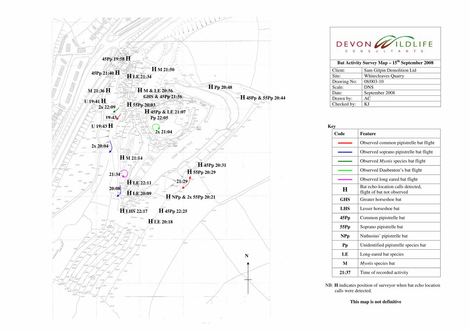
3.
Bat Activity Survey Map – 15th
September 2008
Client: Sam Gilpin Demolition Ltd
Site: Whitecleaves Quarry
Drawing No: 08/003-10
Scale: DNS
Date: September 2008
Drawn by: AC
Checked by: KJ
Key
Code Feature
▬▬▬ Observed common pipistrelle bat flight
▬▬▬ Observed soprano pipistrelle bat flight
▬▬▬ Observed Myotis species bat flight
▬▬▬ Observed Daubenton’s bat flight
▬▬▬ Observed long eared bat flight
H Bat echo-location calls detected,
flight of bat not observed
GHS Greater horseshoe bat
LHS Lesser horseshoe bat
45Pp Common pipistrelle bat
55Pp Soprano pipistrelle bat
NPp Nathusius’ pipistrelle bat
Pp Unidentified pipistrelle species bat
LE Long-eared bat species
M Myotis species bat
21:37 Time of recorded activity
NB: H indicates position of surveyor when bat echo location
calls were detected.
This map is not definitive
N
H NPp & 2x 55Pp 20:21
H LE 22:11
H 55Pp 20:03
45Pp 19:58 H
21:34
21:29
2x 20:04
2x 21:04
2x 22:09
19:43
20:08
U 19:43 H
H LE 20:09
H LE 21:34 45Pp 21:40 H
M 21:36 H
H LHS 22:17
H 55Pp 20:29
H 45Pp 20:31
H 45Pp & 55Pp 20:44
H Pp 20:48 H M & LE 20:56
GHS & 45Pp 21:56
H 45Pp & LE 21:07
Pp 22:05
H M 21:14
H M 21:50
H 45Pp 22:25
H LE 20:18
U 19:41 H
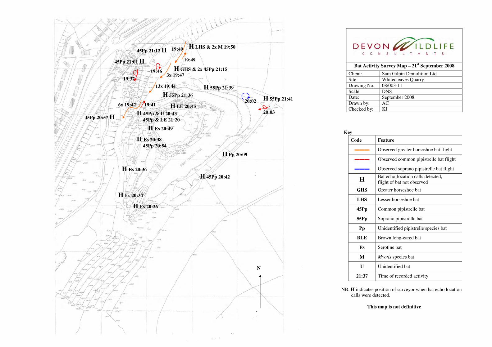
3.
Bat Activity Survey Map – 21st September 2008
Client: Sam Gilpin Demolition Ltd
Site: Whitecleaves Quarry
Drawing No: 08/003-11
Scale: DNS
Date: September 2008
Drawn by: AC
Checked by: KJ
Key
Code Feature
▬▬▬ Observed greater horseshoe bat flight
▬▬▬ Observed common pipistrelle bat flight
▬▬▬ Observed soprano pipistrelle bat flight
H Bat echo-location calls detected,
flight of bat not observed
GHS Greater horseshoe bat
LHS Lesser horseshoe bat
45Pp Common pipistrelle bat
55Pp Soprano pipistrelle bat
Pp Unidentified pipistrelle species bat
BLE Brown long-eared bat
Es Serotine bat
M Myotis species bat
U Unidentified bat
21:37 Time of recorded activity
NB: H indicates position of surveyor when bat echo location
calls were detected.
This map is not definitive
N
H 45Pp & U 20:43
45Pp & LE 21:20
H Es 20:26
H Pp 20:09
20:02
19:49
6x 19:42
3x 19:47
19:49
19:46
19:37
45Pp 20:57 H
H 45Pp 20:42
45Pp 21:01 H
H LHS & 2x M 19:50
19:41
13x 19:44
20:03
H Es 20:36
H Es 20:38
45Pp 20:54
H Es 20:34
H LE 20:45
H Es 20:49
45Pp 21:12 H
H GHS & 2x 45Pp 21:15
H 55Pp 21:36
H 55Pp 21:39
H 55Pp 21:41

Report 08/059a: Bat Activity Survey – Buckfast Winery, Devon 30
Appendix 3 – Greater Horseshoe Bat Activity Overview Map
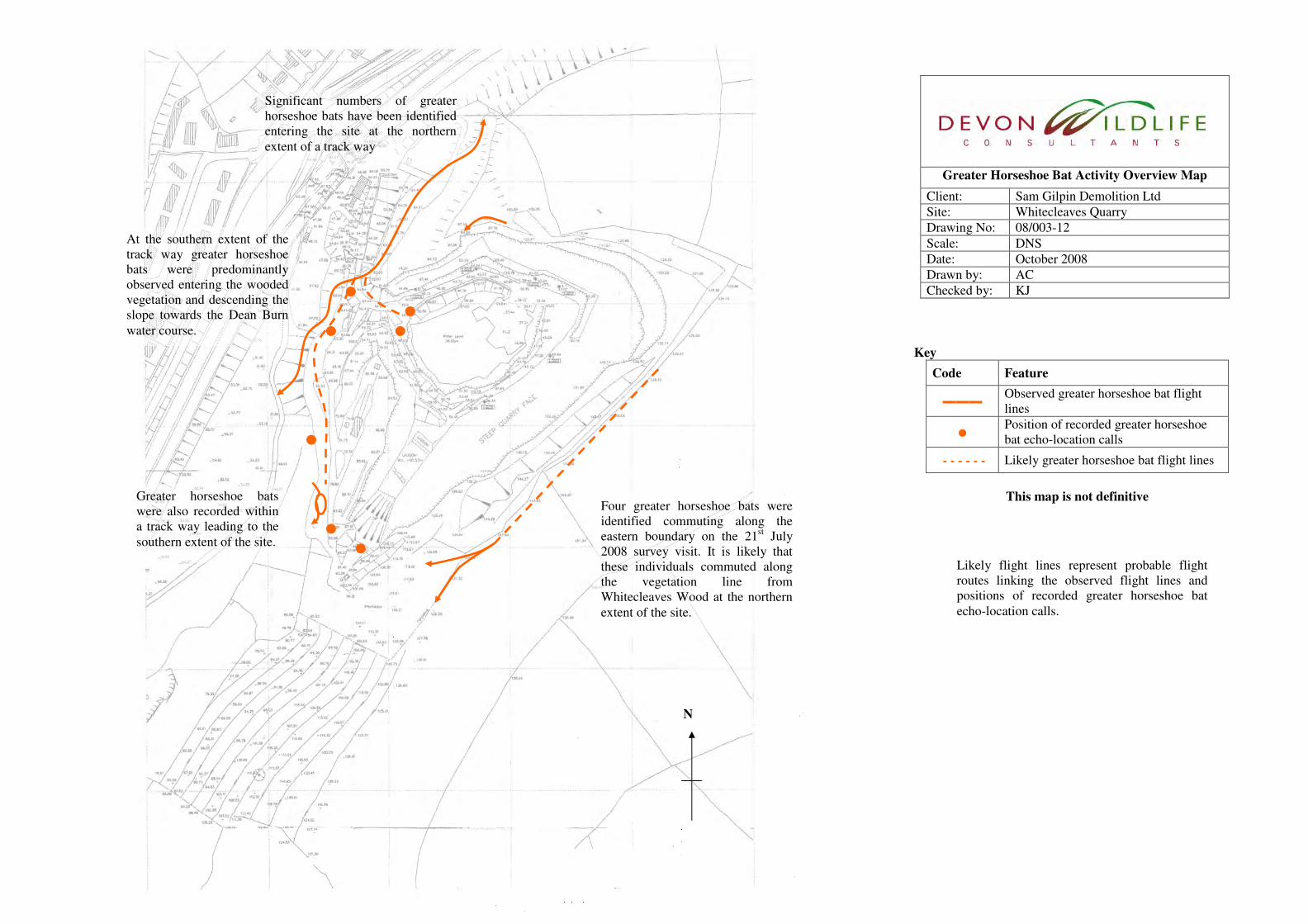
3.
Greater Horseshoe Bat Activity Overview Map
Client: Sam Gilpin Demolition Ltd
Site: Whitecleaves Quarry
Drawing No: 08/003-12
Scale: DNS
Date: October 2008
Drawn by: AC
Checked by: KJ
Key
Code Feature
▬▬▬ Observed greater horseshoe bat flight
lines
● Position of recorded greater horseshoe
bat echo-location calls
- - - - - - Likely greater horseshoe bat flight lines
This map is not definitive
N
At the southern extent of the
track way greater horseshoe
bats were predominantly
observed entering the wooded
vegetation and descending the
slope towards the Dean Burn
water course.
Greater horseshoe bats
were also recorded within
a track way leading to the
southern extent of the site.
Significant numbers of greater
horseshoe bats have been identified
entering the site at the northern
extent of a track way
Likely flight lines represent probable flight
routes linking the observed flight lines and
positions of recorded greater horseshoe bat
echo-location calls.
Four greater horseshoe bats were
identified commuting along the
eastern boundary on the 21st July
2008 survey visit. It is likely that
these individuals commuted along
the vegetation line from
Whitecleaves Wood at the northern
extent of the site.

Report 08/059a: Bat Activity Survey – Buckfast Winery, Devon 31
Appendix 4 – Proposed Vegetation Removal & Re-profiling Works
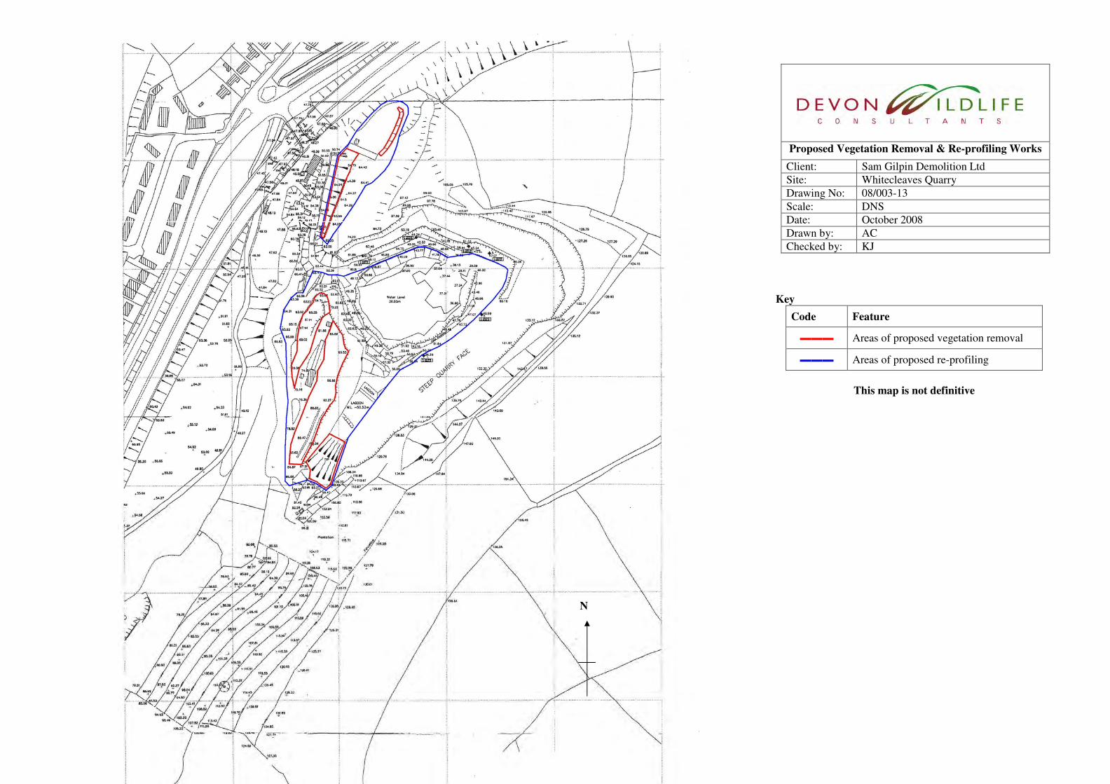
3.
Proposed Vegetation Removal & Re-profiling Works
Client: Sam Gilpin Demolition Ltd
Site: Whitecleaves Quarry
Drawing No: 08/003-13
Scale: DNS
Date: October 2008
Drawn by: AC
Checked by: KJ
Key
Code Feature
▬▬▬ Areas of proposed vegetation removal
▬▬▬ Areas of proposed re-profiling
This map is not definitive
N

Report 08/059a: Bat Activity Survey – Buckfast Winery, Devon 32
Appendix 5 – Greater Horseshoe Bat Mitigation Plan

3.
Greater Horseshoe Mitigation Plan
Client: Sam Gilpin Demolition Ltd
Site: Whitecleaves Quarry
Drawing No: 08/003-14
Scale: DNS
Date: October 2008
Drawn by: AC
Checked by: KJ
Key
Code Feature
▬▬▬ Recommended vegetation planting
▬▬▬ Proposed wetland
This map is not definitive
The wetland strip proposed to run below the steep
eastern cliff face to the quarry void should
incorporate a graded edge encouraging the
establishment of emergent and marginal plant
species, and be accompanied by a 6 metre wide
vegetation strip comprising of native, wildlife
attracting tree and shrub species, allowed to reach
an average height of around 3m. It is noted that
this wetland and associated planting may only be
reinstated following mining works, which is
estimated to take 5 years to complete. Vegetation planting to be undertaken
along the perimeter of all the
remaining vegetation adjacent to the
identified greater horseshoe track way
flight lines, immediately following
any vegetation removal/clearance
works. This planting should comprise
of native shrub species creating dense
sheltered, woodland edge habitats.
Further bat activity monitoring should
be considered to ensure that this level
of mitigation is adequate to the
identified greater horseshoe bat flight
lines.
6 metre vegetation planting
strip should continue linking
to Potters Wood SSSI at the
southern extent of the site.
New hedge planting should be utilised to re-establish the eastern boundary of the
track way to the southwest of the quarry void. This planting should create a broad
feature, approximately 3-6m across allowed to reach an average height of around
3m. It should comprise of native, wildlife attracting species. Hedgerow trees should
be planted or allowed to develop at approximately 20m intervals along the
hedgerow, which will provide further shelter in addition to bat feeding perches. It is
noted that this re-established track way boundary may only be reinstated following
mining works, which is estimated to take 5 years to complete.
The type and level of blasting should be selected to
minimise any impact to Potters Wood SSSI and Buckfast
Caves SSSI. As a precautionary measure, to minimise any
potential impact through vibration, air pressure changes,
damage to the integrity of the cave systems, blasting
operations should be avoided during the most sensitive
periods for bats, such as maternity or deep hibernation
periods, which would be May to August and November to
February respectively.

Report 08/059a: Bat Activity Survey – Buckfast Winery, Devon 33
Appendix 6 – SSSI & SAC Citations