willingham mere, ‘digging environment’ project (31st may ... willingham mere.pdf · willingham...
TRANSCRIPT

Christopher Evans, Steve Boreham, Hayley Roberts, Robin Standring and Jonathan Tabor
Willingham Mere, ‘Digging Environment’ Project (31st May-10th June)

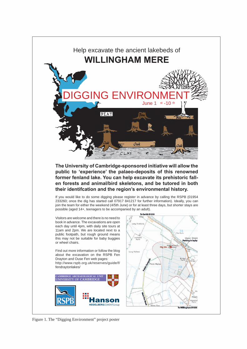
Willingham Mere, ‘Digging Environment’ Project (31st May-10th June) Christopher Evans, Steve Boreham, Hayley Roberts, Robin Standring and Jonathan Tabor Funded by a University of Cambridge Knowledge Transfer Project-grant, the aim of this joint Cambridge Archaeology Unit (CAU), Royal Society for the Protection of Birds (RSPB) and Hanson Aggregates initiative was to encourage members of the public to experience palaeo-environmentalism (Figure 1). Specifically, they were able to excavate this renowned former fenland lake’s fallen prehistoric forests and animal/bird skeletons, and receive expert tuition in both their identification and the region’s environmental history. For those wishing less hands-on exposure, there were daily tours and an accompanying public lecture in Willingham’s Baptist Church, ‘Digging Environment: Willingham Mere and Prehistoric Wetland Resource-use’ (by Christopher Evans, CAU, Director). The fieldwork was also filmed, with a number of participants interviewed, for the forthcoming series of BBC 4’s Digging for Britain. Investigation Results Jonathan Tabor Following on from Boreham’s borehole survey (see below), the archaeological investigations comprised the excavation of a 9x10m area on the north-eastern edge of Willingham Mere (Figure 2). In order to most effectively tackle the key objectives of the project, two organic deposits identified by Boreham were targeted for more intensive sampling and hand excavation. The area was stripped of topsoil before being machine excavated in a series of ‘steps’, in order to expose the surface of the ‘upper’ and ‘lower’ organic silts. The stepped excavation area not only ensured a stable trench edge, but also allowed the simultaneous hand-excavation of areas of both of the targeted organic deposits (Figures 3 and 4). Context
No. Description Depth from
surface (m) Finds / organic remains
01 Modern plough soil 0 – 0.3
02 Marl 0.3 – 0.65 Freshwater mussel shells
03 Upper organic silt 0.65 - 0.75 Reed cases, bird bone, fish bone, mollusc shells, poorly preserved wood frags
04 Silt 0.75 – 1 Reed cases, mollusc shells
05 Lower organic silt 1-1.3 Preserved round wood fragments/twigs, reed cases/fragmites, bird bone, fish bone,
mollusc shells. 06 Silt with sand and
pebbles 1.3 -
Table 1: The sedimentary sequence exposed during the excavation
1
DIGGING ENVIRONMENTJune 1 st -10 th
Help excavate the ancient lakebeds of
WILLINGHAM MERE
The University of Cambridge-sponsored initiative will allow the public to ‘experience’ the palaeo-deposits of this renowned former fenland lake. You can help excavate its prehistoric fall-en forests and animal/bird skeletons, and be tutored in both their identifcation and the region’s environmental history.
If you would like to do some digging please register in advance by calling the RSPB (01954 233260; once the dig has started call 07917 841217 for further information). Ideally, you can join the team for either the weekend (4/5th June) or for at least three days, but shorter stays are possible (aged 14+, teenagers to be accompanied by an adult).
Visitors are welcome and there is no need to book in advance. The excavations are open each day until 4pm, with daily site tours at 11am and 2pm. We are located next to a public footpath, but rough ground means this may not be suitable for baby buggies or wheel chairs.
Find out more information or follow the blog about the excavation on the RSPB Fen Drayton and Ouse Fen web pages:http://www.rspb.org.uk/reserves/guide/f/fendraytonlakes/
Figure 1. The “Digging Environment” project poster

MERE
MERE
Cropmarks
Willingham Mere
Dig site
0
0
kilometres
kilometre
1
1
Figure 2. Site location and aerial photograph of mere deposits
271000
272000
273000
274000
539000
540000
541000
542000
271000
272000
273000
274000
539000
540000
541000
542000

Figure 3. Open day and excavation in progress

Figure 4. Excavation in progress and trench at completion of excavation

The deposits encountered closely correlated with those identified during the borehole survey and the basic sequence is shown in Table 1. The two organic deposits, [03] and [05], which were targeted during the excavation represent two distinct phases of fen development separated by a period of wetter reed swamp conditions ([04]). The lower organic silt ([05]) represents an alder carr fen environment, while the upper organic silt ([03]) reflects a more open fen environment (see Boreham, below). Of the two deposits, the lower organic silt ([05]) was the better preserved and richest in terms of organic remains. Large amounts of preserved round wood and twig fragments – the detritus of the alder carr woodland - were recorded and sampled. In addition at least two possibly worked wood fragments – one potentially a wooden peg – await specialist analysis. A number of disarticulated bird bones - preliminarily identified as coot - and fish bone were also recovered. The upper organic silt ([03]) was less well preserved, waterlogged conditions no longer being present at this level, however, it was more fruitful in terms of bird and fish bone recovery. Species identified include Mallard duck and pike. Outreach Hayley Roberts Some 38 volunteers participated in the project. On average volunteers came for two days each, although this did vary with some coming for four or five days. The types of people and their reasons for coming varied; all age bands and both sexes were represented. Those under 18 were accompanied by an adult and at least one was using the experience for his Duke of Edinburgh Award. One individual in the 20-30 age bracket was an archaeology student (undertaking a distance learning course in Australia) and found the experience very valuable as her first taste of archaeology since moving to the UK. Seven volunteers had some experience of archaeology before digging at Willingham Mere. Some of these, but not all, were members of the Fen Edge Archaeology Group (FEAG). The group also acquired at least three new members during the course of the dig and all were keen to learn new skills ready for their own project later in the year. Four volunteers work for the Environment Agency in the area (including on the Over-Needingworth Quarry) and chose this project as their ‘green day’ (one day a year when employees volunteer on a project of their choice). The interaction between CAU and RSPB staff working on the project was enormously beneficial for both parties. Knowledge was exchanged both ways and it made for a rounded experience for the volunteers. Each volunteer was asked to fill in an evaluation form for the event and 30 completed, or partially completed forms were returned. The completed forms indicated that a significant number of the volunteers have gone from little or no excavation experience to feeling comfortable using archaeological terms such as ‘context’ and understanding the excavation and recording process. Generally, volunteers also felt that they understood the palaeo-environmental changes that had happened at Willingham Mere.
6

Although not all of the volunteers were asked whether they would like to take part in another university funded project, over half expressed an interest and many left contact details (even though they were not asked to and warned about data security). The site also received 150 visitors. All of visitors were given a presentation that lasted approximately 30 minutes although many spent up to and over an hour looking at the finds and asking questions. The majority that were asked were local (from the surrounding villages of Willingham, Over and Longstanton) although some had come from further afield (eg. Cambridge, Huntingdon and March). Visitors had heard about the project from a variety of sources; the press, university newsletters, Huntingdon Council newsletter and local societies such as Cambridge Antiquarian Society and University of the Third Age. Several RSPB employees also visited the site. Children appeared to enjoy the site as much as the adults, with one child memorably saying that ‘I thought this was going to be dull but I’ve really enjoyed it’. Although the visitor book was not compulsory some of the comments made were very illuminating as to how well the event was received; for example, ‘What a wonderful group of friendly, knowledgeable people’ and ‘a really interesting and lucid explanation of the site. So glad we came’. Pollen Analysis and Radiocarbon Dating of Sediments Steve Boreham In this study, two transects (T1 & T2), each of nine boreholes, were investigated in the north-east corner of the former site of Willingham Mere (Figure 5). Survey boring was principally undertaken with a narrow gouge auger, although a Dutch auger and a Hiller corer were also used depending on the ground conditions encountered. Coring of an archive sequence from T1 BH1 was undertaken with a Russian corer, which enabled uncontaminated core samples for subsequent analysis to be obtained. All boreholes were stopped on gravel and sand. In general, the sediment sequence from the two transects comprised basal sand and gravel overlain by sandy silt with pebbles (see Figures 6 & 7). In places, this unit contained thin lenses of peat and organic material. Above this, almost everywhere was a thin lower organic silt, with peaty inclusions and wood. In most places this was overlain by a grey slightly marly and organic silt, which in turn was overlain by a thin upper organic silt with peaty inclusions. Overlying this was a unit of silty lake marl, which sometimes had an erosional base. Above this, and sometimes occupying channel forms cut through the lake marl was a unit of alluvial silty clay. At all locations there was an upper 20-30cm of ploughsoil.
7

Figure 5 – Map and aerial photograph of the former site of Willingham Mere showing transects T1 & T2, and the location of the borehole (BH1) investigated for pollen in this study. The location of other transects (MW1 & MW2) and a borehole previously investigated for pollen (MWP) (Waller 1994) is also shown.
8

Pollen and Radiocarbon Dating from T1 BH1 It is generally considered that for dating and palaeoenvironmental reconstruction a long sediment sequence is preferred. The sequence from T1 BH1 was chosen for investigation since it was one of the longest encountered, and apparently well-preserved. This study focuses on a 130 cm long sequence of lake marl, silt and organic mud, which was sampled for radiocarbon dating and pollen analysis.
Figure 6 – Transect T1 showing the stratigraphy and lithology of sediments encountered, and the location of BH1 investigated for pollen.
Figure 7 – Transect T2 showing the stratigraphy and lithology of sediment encountered.
In this study, a pollen assessment of fourteen samples from the sequence at BH1 has allowed the changing vegetation and landscape around Willingham Mere to be investigated. In addition, four bulk radiocarbon dates (by The University of Waikato) have been obtained from the sequence with the aim of understanding the age and deposition history of these sediments.
9

Radiocarbon Dating The radiocarbon results and OxCal calibrations for the four bulk radiocarbon dates appear in Appendix 1. An age-elevation model for the Willingham Mere sequence appears in Figure 8. The basal bulk date (160-170cm) is 3220±44 BP (Wk- 31080), which calibrates at 85.3% probability to 3512 - 3365 Cal BP. This mid-Bronze Age date is from the basal part of the lower organic silt unit, which records the onset of peat accumulation and fen conditions at the site, and coincides with a peak in alder (Alnus) pollen. The date (140-150cm) is 2672±43 BP (Wk- 31079), which calibrates at 95.4% probability to 2860 - 2740 Cal BP. This late Bronze Age/early Iron Age date is from the upper part of the lower organic silt unit, which records the transition to wetter conditions at the site, and coincides with peaks in hazel (Corylus) and willow (Salix) pollen. The date (110-120cm) is 2386±41 BP (Wk- 31078), which calibrates at 81.4% probability to 2503 - 2337 Cal BP. This mid-Iron Age date is from the lower silt unit, which records the onset of deeper water, and coincides with a decline on trees and a peak in cereal pollen. The upper bulk date (80-90cm) is 1763±54 BP (Wk- 31077), which calibrates at 95.4% probability to 1820 - 1553 Cal BP. This Roman date is from the upper part of the upper organic silt unit, which records a brief return to fen conditions before the onset of the lake marl deposition in the final incarnation of the mere. The age-elevation curve (Figure 8) created from the four radiocarbon dates clearly shows that the Willingham Mere sequence spans the mid-Bronze Age Age to Roman period. The rate of sediment accumulation was approximately 0.42mm per year.
0.0
0.2
0.4
0.6
0.8
1.0
1.2
1.4
1.6
0 1000 2000 3000 4000
C14 years BP
Figure 8 – Age-elevation model for Willingham Mere sequence. The fitted log curve has an r2 value of 0.97 The elevation of the ground surface at T1 BH1 was 1.8773m OD.
10

Pollen Analyses The 14 samples of sediment from the sequence at T1 BH1 were prepared using the standard hydrofluoric acid technique, and counted for pollen using a high-power stereo microscope at x400 magnification. The percentage pollen data from these samples is presented in Appendix 2, and is shown as percentage pollen diagrams in Figure 9. Unfortunately, one pollen sample from the upper part of the sequence (45cm) proved to be barren. The pollen concentrations of the remaining samples ranged between 89,395 and 29,360 grains per ml. Pollen counting was somewhat hampered by the presence of finely divided organic debris, and preservation of the fossil pollen grains (palynomorphs) was quite variable, especially in the upper part of the sequence. Assessment pollen counts were made from a single slide for these samples. The pollen sums achieved ranged between 64 and 163. None of these counts exceed the statistically desirable total of 300 pollen grains main sum. As a consequence caution must be employed during the interpretation of these results. This sequence shows a number of marked changes in the pollen assemblage that can be used to reconstruct the palaeoenvironments at the site. The basal sample (175cm) from the sandy silt unit appears to represent a reed swamp environment surrounded by alder carr with deeper water indicated by the presence of yellow water-lily (Nuphar) pollen, and mixed-oak woodland at a distance. In contrast, the lower organic silt (171-140cm) appears to have been deposited at a time of drier conditions at the site, with the expansion of alder (Alnus) and willow (Salix) carr, with hazel (Corylus). The lower slightly marly and organic silt (140-100cm) appears to indicate a return to wetter reedswamp conditions, with a gradual decline in alder and willow. Towards the top of this unit (120-100cm) emergent vegetation such as sedges (Cyperaceae), bur-reed (Sparganium) and reedmace (Typha latifolia) become more abundant, and deeper open water is again indicated by the presence of yellow water-lily (Nuphar) pollen. The pollen of cereals also appear strongly in the record at 115cm. The upper organic silt (100-80cm) seems to represent a period of lower water levels with declining emergent vegetation and indicators of open water. However, alder and willow carr also continue to decline in importance, indicating that this was an environment dominated by reed swamp and fen vegetation. The lake marl has a pollen assemblage which includes a large number of meadow and riparian herbs, as well as the ubiquitous grass pollen signal from reed swamp. Open water is indicated by the pollen of water-milfoil (Myriophyllum). Cereal pollen and the disturbed ground indicator ribwort plantain (Plantago lanceolata) are present to the top of the sequence. Taken together, this pollen sequence presents evidence for repeated fluctuations in local water level. It seems that the basal sandy silt may represent early Bronze Age fluvial deposits, and that the lower organic silt unit accumulated at a time of lower water levels within an alder and willow carr environment which persisted until the early Iron Age. The lower marly silt appears to represent deposition within a large reed-fringed water body, that became reed swamp and fen due to lower local water levels in the late Iron Age/early Roman period. This drier interval was short-lived, and Willingham Mere became established at the site from the Roman period onwards.
Historical Context In the early Bronze Age, it seems that the valley of a small northward- flowing tributary of the River Ouse occupied the location of Willingham Mere (Waller 1994). Presumably, the basal sandy silt with pebbles, represents the deposits of this tributary stream. Alder and willow carr must have occupied the floor of this small valley from the mid-Bronze Age until the early Iron Age, leading to the deposition of the lower organic silt unit. Waller (1994) suggests that this small valley was dammed to the north by alluvial deposits (levees) of River Ouse, causing the formation of an extensive reed swamp and lake. It could be that the drainage was first impeded by the rising sea-level in the early Bronze Age. This first ‘incarnation’ of Willingham Mere must have been quite extensive, but it was not a marl-lake in quite the same way as the second ‘incarnation’ of the mere, perhaps suggesting a periodic inflow of silt-laden water from a local stream, or from the River Ouse. It seems that reed swamp and fen vegetation in-filled the earliest lake, but that suddenly, and perhaps in response to the construction of the Old West River, lacustrine conditions returned to the area in the Roman period.
11

Figure 9. Pollen Diagram

In the Middle Ages, it seems that that there were two adjacent meres; Willingham Mere to the west and Alkes or Aux Mere to the east (Wright and Lewis 1989). In the winter months, the conjoined area flooded by both meres was as much as 153Ha, but the summer area of Willingham Mere was closer to 35Ha. Willingham Mere appears to have been 5-6m deep (Hinde 1986, Astbury 1957, Fowler 1933) at its height, and to have provided the clear alkaline water required by the Characeae (stoneworts) to form the white to buff Chara lake marl that typifies the extent of the mere visible on the ground and from aerial photographs (Figures 1 and 5). In the 17th Century, drainage of surrounding peat fen was at first directed in to the mere, but subsequently the mere itself was drained, so that by the mid-18th Century the former lake bed was exposed for agriculture (Wright and Lewis 1989). As part of the Fenland Project, Martin Waller and others investigated Willingham Mere with two transects of boreholes (MW1 & MW2) and pollen analysis of a key sequence (MWP) (Waller 1994). The location of these two borehole transects is shown in Figure 5, and the cross-sections from the transects have been re-drawn by the author and appear in Figures 10 & 11.
Figure 10 – Transect MW1 showing the stratigraphy and lithology of sediments encountered – redrawn from Waller (1994).
Figure 11 – Transect MW2 showing the stratigraphy and lithology of sediments encountered, and the location of MWP investigated for pollen – redrawn from Waller (1994).
13

By comparing Figures 6 & 7 and Figures 10 & 11 it can be seen that in general, the stratigraphy of the sediment sequences across the mere is rather consistent. None of the Waller boreholes penetrated the basal sandy silt with pebbles, and thus did not contact the underlying gravel and sand unit. It is also worth noting that although the stratigraphy is identical between the sections, the lithology described by Waller differs slightly from that described in this report. Thus, the lower organic silt unit is described by Waller as a lower ‘peat’, and the lower slightly marly and organic silt unit is described by Waller as a ‘silty organic marl’. Since each borehole presents slightly different lithologies, these aggregate descriptive terms are simply convenient categories into which similar sediments can be grouped. Pollen analysis by Waller focused on a particular borehole (MWP) located close to the beginning of transect T2 (Figure 7). Waller carried out a complete pollen analysis of 35 pollen samples from a 140cm long sequence spanning the lower organic silt through to the top of the lake marl. The original pollen diagram is difficult to interpret, but the author has re-drawn a pollen diagram using selected taxa from Waller’s original (Figure 12). Two radiocarbon determinations were also obtained from this sequence, allowing the changes in lithology and pollen assemblages to be dated. Waller describes five local pollen assemblage biozones (WM1-5) from the sequence which relate to changes in palaeoenvironments at the site. In broad terms, the sequence of events described from the site is identical to that determined by the author from the assessment pollen analysis of the sequence at T1 BH1 (Figure 9). The MWP sequence starts with a period of sedge and grass dominated peat formation and fen pools, in the early Iron Age (MW1), followed by an episode of rising water levels and the development of alder and willow carr (WM2). Further rises in water level resulted in the spread of reed swamp and open water, and the formation of a lake with abundant aquatics, sedge and grass (WM3), followed by the development of more terrestrial conditions (WM4). Finally, in the early Roman period, an open alkaline mere formed, dominated by water-milfoil (Myriophyllum) and sedges, and surrounded by tall-herb meadow communities (WM5). The original Waller diagram included a large number of pollen taxa as an inevitable consequence of full pollen counts, rather than assessment counts being made. However, the poor preservation of palynomorphs in the upper part of the T1 BH1 sequence may explain the apparent absence of some fragile types, such as ash (Fraxinus), nettle (Urtica) and broad-leaved pondweed (Potamogeton) in the assessment pollen diagram. In general, the two pollen diagrams agree with each other very well, and provide a robust narrative of landscape change around Willingham Mere. The radiocarbon dating and pollen analyses from the Willingham Mere sequences have shown that there has been rapid environmental and ecological change at the site over the past c.3000 years. The dry-ground pollen signal from the rising land to the south is largely ‘swamped’ by the large amount of locally produced pollen from the wetland environments that have persisted at the site. However, it is possible to detect both mixed-oak woodland, and arable activity in the surrounding landscape. The repeated waxing and waning of local water tables in this fen-edge location appear to have been entirely responsible for the formation of two incarnations of Willingham Mere at the this site. The first ‘Iron Age’ mere was surrounded by extensive reed beds, and must have received an influx of silt from local streams or the River Ouse. The second ‘Roman’ mere was probably smaller and completely cut off from direct fluvial inputs. Historical records of the depth of this mere (5-6m) suggests that the surrounding peat and retaining alluvial banks (levees) must have risen to c.7m OD, given that the modern surface of the lake marl is between 1.5 and 2m OD. This is an astonishing conclusion in the context of a flat landscape where modern elevations rarely rise above 2-3m. The rapid changes in environment at this site should serve as a reminder that at the fen-edge, the modern flat and ‘boring’ fields conceal a wealth of information about a surprising range of past landscape histories; in a sense the ‘lost ecology’ of fenland. Apart from the ‘nothing is as it seems’ message that this site underlines, there is a thread of hope for the future contained in this detailed landscape history. In the past, subtle natural and anthropogenic changes in drainage have brought about huge alterations to these wetland ecosystems. Provided that there is a
14

Figure 12.
detailed understanding of geology, soils, drainage and topography, the possibility of successfully engineering and maintaining new wetland habitats in Fenland is a tangible future objective. References
Astbury, A. K. (1957) The Black Fens. The Golden Head Press, Cambridge. Fowler, G. E. (1933) Fenland waterways, past and present. South Level District. Part I. Proceedings of the Cambridge Antiquarian Society 33, 108–128. Hinde, K. S. G (1986) Willingham West Fen Pumping Station. Cambridge Society for Industrial Archaeology. Waller, M. (1994) The Fenland Project, No. 9: Flandrian Environmental Change in Fenland. East Anglian Archaeology Report No.70. Wright, A. P. M. & Lewis, C. P. (1989) A History of the County of Cambridge and the Isle of Ely: Volume 9: Chesterton, Northstowe, and Papworth Hundreds. Victoria County History.
16

APPENDIX 1. Radiocarbon dating results and calibrations

Result is following Stuiver and Polach, 1977, Radiocarbon 19, 355-363. This is based on the Libby half-life of 5568 yr with correction for isotopic fractionation applied. This age is normally quoted in publications and must include the appropriate error term and Wk number. Quoted errors are 1 standard deviation due to counting statistics multiplied by an experimentally determined Laboratory Error Multiplier. The isotopic fractionation, , is expressed as ‰ wrt PDB. F C% is also known as pMC (percent modern carbon).
31077
WM80-90
Lake muds, Gyttja, ClaysVisible contaminants removed.
Washed in hot 10% HCl, rinsed and treated with hot 1% NaOH. The NaOH insoluble fraction was treated with hot 10% HCl, filtered, rinsed and dried.
-30.3 0.2
-197.1 5.4
80.3 0.5
1763 ± 54 BP
Conventional Age or Percent Modern Carbon (pMC) • • • • Percent Modern Carbon (pMC)
δ13C
Willingham, Cambs., United Kingdom
S Boreham
The University of WaikatoRadiocarbon Dating Laboratory
Private Bag 3105 Hamilton, New Zealand. Fax +64 7 838 4192 Ph +64 7 838 4278 email [email protected] Head: Dr Alan Hogg
Report on Radiocarbon Age Determination for Wk-SubmitterSubmitter's CodeSite & Location
Sample MaterialPhysical Pretreatment
Chemical Pretreatment
Result
‰‰
±
±
Comments
%±
δ13C
D14C
7/06/11
14
F C%14

Result is following Stuiver and Polach, 1977, Radiocarbon 19, 355-363. This is based on the Libby half-life of 5568 yr with correction for isotopic fractionation applied. This age is normally quoted in publications and must include the appropriate error term and Wk number. Quoted errors are 1 standard deviation due to counting statistics multiplied by an experimentally determined Laboratory Error Multiplier. The isotopic fractionation, , is expressed as ‰ wrt PDB. F C% is also known as pMC (percent modern carbon).
31078
WM110-120
Lake muds, Gyttja, ClaysVisible contaminants removed.
Washed in hot 10% HCl, rinsed and treated with hot 1% NaOH. The NaOH insoluble fraction was treated with hot 10% HCl, filtered, rinsed and dried.
-29.4 0.2
-257.0 3.8
74.3 0.4
2386 ± 41 BP
Conventional Age or Percent Modern Carbon (pMC) • • • • Percent Modern Carbon (pMC)
δ13C
Willingham, Cambs., United Kingdom
S Boreham
The University of WaikatoRadiocarbon Dating Laboratory
Private Bag 3105 Hamilton, New Zealand. Fax +64 7 838 4192 Ph +64 7 838 4278 email [email protected] Head: Dr Alan Hogg
Report on Radiocarbon Age Determination for Wk-SubmitterSubmitter's CodeSite & Location
Sample MaterialPhysical Pretreatment
Chemical Pretreatment
Result
‰‰
±
±
Comments
%±
δ13C
D14C
7/06/11
14
F C%14

Result is following Stuiver and Polach, 1977, Radiocarbon 19, 355-363. This is based on the Libby half-life of 5568 yr with correction for isotopic fractionation applied. This age is normally quoted in publications and must include the appropriate error term and Wk number. Quoted errors are 1 standard deviation due to counting statistics multiplied by an experimentally determined Laboratory Error Multiplier. The isotopic fractionation, , is expressed as ‰ wrt PDB. F C% is also known as pMC (percent modern carbon).
31079
WM140-150
Lake muds, Gyttja, ClaysVisible contaminants removed.
Washed in hot 10% HCl, rinsed and treated with hot 1% NaOH. The NaOH insoluble fraction was treated with hot 10% HCl, filtered, rinsed and dried.
-30.2 0.2
-282.9 3.8
71.7 0.4
2672 ± 43 BP
Conventional Age or Percent Modern Carbon (pMC) • • • • Percent Modern Carbon (pMC)
δ13C
Willingham, Cambs., United Kingdom
S Boreham
The University of WaikatoRadiocarbon Dating Laboratory
Private Bag 3105 Hamilton, New Zealand. Fax +64 7 838 4192 Ph +64 7 838 4278 email [email protected] Head: Dr Alan Hogg
Report on Radiocarbon Age Determination for Wk-SubmitterSubmitter's CodeSite & Location
Sample MaterialPhysical Pretreatment
Chemical Pretreatment
Result
‰‰
±
±
Comments
%±
δ13C
D14C
7/06/11
14
F C%14

Result is following Stuiver and Polach, 1977, Radiocarbon 19, 355-363. This is based on the Libby half-life of 5568 yr with correction for isotopic fractionation applied. This age is normally quoted in publications and must include the appropriate error term and Wk number. Quoted errors are 1 standard deviation due to counting statistics multiplied by an experimentally determined Laboratory Error Multiplier. The isotopic fractionation, , is expressed as ‰ wrt PDB. F C% is also known as pMC (percent modern carbon).
31080
WM160-170
Lake muds, Gyttja, ClaysVisible contaminants removed.
Washed in hot 10% HCl, rinsed and treated with hot 1% NaOH. The NaOH insoluble fraction was treated with hot 10% HCl, filtered, rinsed and dried.
-29.3 0.2
-330.3 3.7
67.0 0.4
3220 ± 44 BP
Conventional Age or Percent Modern Carbon (pMC) • • • • Percent Modern Carbon (pMC)
δ13C
Willingham, Cambs., United Kingdom
S Boreham
The University of WaikatoRadiocarbon Dating Laboratory
Private Bag 3105 Hamilton, New Zealand. Fax +64 7 838 4192 Ph +64 7 838 4278 email [email protected] Head: Dr Alan Hogg
Report on Radiocarbon Age Determination for Wk-SubmitterSubmitter's CodeSite & Location
Sample MaterialPhysical Pretreatment
Chemical Pretreatment
Result
‰‰
±
±
Comments
%±
δ13C
D14C
7/06/11
14
F C%14

APPENDIX 2 Willingham Mere 2011 - Percentage Pollen Data
Depth (cm) 175 165 155 145 135 125 115 105 95 85 75 65 55 45Trees & ShrubsBetula 0.0 0.0 0.0 0.7 0.0 0.0 1.3 1.4 0.0 0.0 0.0 0.0 1.6Pinus 3.0 1.2 0.8 0.7 2.4 1.4 0.0 0.0 0.0 0.0 0.0 1.0 1.6Ulmus 1.5 0.0 0.0 0.0 0.0 1.4 0.0 0.0 0.0 0.0 0.0 0.0 0.0Quercus 4.5 4.9 3.8 5.2 3.6 2.8 1.3 4.1 3.4 2.4 2.6 2.0 3.1Tilia 1.5 0.0 0.0 0.0 0.0 0.0 0.0 0.0 0.0 0.0 0.0 0.0 0.0Alnus 7.5 20.7 18.8 17.0 11.9 11.1 7.7 4.1 4.6 4.8 2.6 2.0 1.6Corylus 4.5 6.1 8.3 11.1 6.0 4.2 3.8 5.4 5.7 6.0 5.1 5.0 4.7Salix 0.0 0.0 1.5 5.2 2.4 2.8 1.3 1.4 1.1 2.4 2.6 0.0 0.0Juniperus 4.5 1.2 0.8 0.7 0.0 0.0 1.3 1.4 1.1 1.2 1.3 0.0 0.0Ligustrum 0.0 0.0 0.8 0.0 0.0 1.4 0.0 0.0 0.0 0.0 0.0 0.0 0.0
HerbsPoaceae 41.8 31.7 31.6 34.6 41.7 50.0 48.7 51.4 47.1 50.6 51.3 51.5 40.6Cereals 0.0 0.0 0.0 0.0 0.0 0.0 3.8 1.4 2.3 1.2 1.3 2.0 1.6Cyperaceae 4.5 4.9 2.3 1.3 2.4 6.9 11.5 6.8 10.3 8.4 6.4 5.9 4.7Ericaceae undiff. 0.0 0.0 1.5 0.7 0.0 0.0 0.0 0.0 0.0 0.0 0.0 0.0 0.0Asteraceae (Asteroidea/Cardueae) undif. 0.0 0.0 0.0 0.0 0.0 0.0 0.0 0.0 0.0 0.0 1.3 1.0 3.1Asteraceae (Lactuceae) undif. 0.0 0.0 0.0 0.0 0.0 0.0 0.0 0.0 0.0 0.0 1.3 1.0 1.6Artemisia type 0.0 0.0 0.8 0.7 1.2 0.0 0.0 0.0 0.0 0.0 0.0 0.0 0.0Cirsium type 0.0 0.0 0.0 0.0 0.0 0.0 0.0 0.0 0.0 0.0 1.3 2.0 1.6Centaurea nigra type 0.0 0.0 0.0 0.0 0.0 0.0 0.0 0.0 0.0 0.0 0.0 0.0 3.1Caryophyllaceae 0.0 1.2 0.0 0.0 0.0 0.0 0.0 0.0 0.0 0.0 0.0 0.0 0.0Chenopodiaceae 0.0 1.2 0.8 0.7 0.0 1.4 0.0 0.0 0.0 0.0 0.0 1.0 0.0Brassicaceae 3.0 3.7 3.8 3.9 4.8 2.8 2.6 1.4 3.4 2.4 1.3 1.0 1.6Fabaceae 0.0 0.0 0.8 2.0 1.2 0.0 0.0 1.4 1.1 0.0 1.3 0.0 1.6Filipendula 0.0 0.0 0.0 0.7 1.2 1.4 1.3 0.0 0.0 0.0 0.0 0.0 0.0Lamiaceae 0.0 0.0 0.8 0.0 0.0 0.0 0.0 0.0 0.0 1.2 1.3 0.0 0.0Plantago laneolata 0.0 1.2 0.8 0.7 1.2 0.0 1.3 2.7 2.3 1.2 0.0 1.0 1.6 barrenRanunculus type 3.0 2.4 1.5 2.0 1.2 2.8 2.6 2.7 2.3 2.4 3.8 1.0 1.6Rumex 3.0 1.2 0.8 1.3 2.4 1.4 0.0 1.4 1.1 2.4 1.3 0.0 0.0Apiaceae 1.5 3.7 3.8 2.6 2.4 1.4 1.3 1.4 1.1 1.2 1.3 2.0 3.1Liliaceae 0.0 0.0 0.0 0.0 0.0 0.0 1.3 1.4 1.1 0.0 1.3 1.0 0.0

APPENDIX 2 Willingham Mere 2011 - Percentage Pollen Data
Lower plantsEquisetum 0.0 0.0 0.0 0.0 0.0 0.0 0.0 0.0 0.0 0.0 0.0 0.0 0.0Selaginella 0.0 0.0 0.0 0.0 0.0 0.0 0.0 0.0 0.0 0.0 0.0 0.0 0.0Polypodium 1.5 1.2 3.8 1.3 1.2 0.0 1.3 1.4 1.1 1.2 1.3 0.0 0.0Pteropsida (monolete) undif. 11.9 11.0 12.0 6.5 10.7 5.6 6.4 6.8 9.2 8.4 7.7 15.8 15.6Pteropsida (trilete) undif. 3.0 2.4 0.8 0.7 2.4 1.4 1.3 2.7 1.1 2.4 2.6 4.0 6.3SphagnumAquatics Myriophyllym alt. 0.0 0.0 0.0 0.0 0.0 0.0 0.0 0.0 0.0 0.0 2.6 4.0 7.8Nuphar type 3.0 1.2 0.0 0.0 0.0 0.0 1.3 5.4 3.4 1.2 0.0 0.0 0.0Sparganium type 13.4 12.2 11.3 5.2 7.1 11.1 12.8 23.0 18.4 12.0 7.7 5.9 6.3Typha latifolia 0.0 0.0 0.8 0.0 0.0 0.0 1.3 2.7 1.1 1.2 0.0 0.0 0.0Sum trees 17.9 26.8 23.3 23.5 17.9 16.7 10.3 9.5 8.0 7.2 5.1 5.0 7.8Sum shrubs 9.0 7.3 11.3 17.0 8.3 8.3 6.4 8.1 8.0 9.6 9.0 5.0 4.7Sum herbs 56.7 51.2 48.9 51.0 59.5 68.1 74.4 71.6 72.4 71.1 74.4 70.3 65.6Sum spores 16.4 14.6 16.5 8.5 14.3 6.9 9.0 10.8 11.5 12.0 11.5 19.8 21.9
Main Sum 67 82 133 153 84 72 78 74 87 83 78 101 64
Concentration (grains per ml) 29360 57493 69938 89395 73619 68839 68361 51884 57186 58194 51270 37936 44873