wind farm zone hollandse kust (noord) certification …
TRANSCRIPT

WIND FARM ZONE HOLLANDSE KUST (NOORD)
Certification Report Site Conditions Assessment Netherlands Enterprise Agency
Report No.: CR-SC-DNVGL-SE-0190-04805-1 Date: 2019-10-07

DNV GL – Report No. CR-SC-DNVGL-SE-0190-04805-1 – www.dnvgl.com
Page i
Project name: Wind Farm Zone Hollandse Kust (noord) DNV GL
Renewables Certification Tuborg Parkvej 8 2900 Hellerup Denmark
Report title: Certification Report Site Conditions Assessment
Customer: Netherlands Enterprise Agency, Croeselaan 15 3521 BJ Utrecht The Netherlands
Contact person: F.C.W. (Frank) van Erp Date of issue: 2019-10-07 Project No.: 10016925 Report No.: CR-SC-DNVGL-SE-0190-04805-1
Applicable contract(s) governing the provision of this Report: WOZ1600001 Objective: To confirm that the result of A) MetOcean Investigations, B) Geotechnical Investigations and Geological Ground Model, C) Morphological and Scour Investigations, D) Wind Investigations and E) Geophysical Investigations, carried out for Wind Farm Zone Hollandse Kust (noord) can be used for design of future offshore wind farms. Prepared by: Verified by: Approved by:
Erik Asp Project Manager, Senior Principal Specialist
Erik Jørgensen Senior Principal Specialist
Pia Redanz Head of Section, Loads Copenhagen
Copyright © DNV GL 2019. All rights reserved. This publication or parts thereof may not be copied, reproduced or transmitted in any form, or by any means, whether digitally or otherwise without the prior written consent of DNV GL. DNV GL and the Horizon Graphic are trademarks of DNV GL AS. The content of this publication shall be kept confidential by the customer, unless otherwise agreed in writing. Reference to part of this publication which may lead to misinterpretation is prohibited. DNV GL Distribution: Keywords: ☐ Unrestricted distribution (internal and external) Offshore wind, Wind Farm Zone Hollandse Kust
(noord), Site Conditions Assessment ☐ Unrestricted distribution within DNV GL ☐ Limited distribution within DNV GL after 3 years ☒ No distribution (confidential) ☐ Secret
Rev. No. Date Reason for Issue Prepared by Verified by Approved by
Draft 2019-07-04 Incomplete Draft for RVO comments Erik Asp
0 2019-07-15 Final Erik Asp Michael Wagner Pia Redanz
1 2019-10-07 Additional Wind Measurements Included Erik Asp Erik Jørgensen Pia Redanz

DNV GL – Report No. CR-SC-DNVGL-SE-0190-04805-1 – www.dnvgl.com
Page ii
Table of contents
1 EXECUTIVE SUMMARY ..................................................................................................... 1
2 CERTIFICATION SCHEME ................................................................................................. 1
3 LIST OF REPORTS ........................................................................................................... 1
4 CONDITIONS ................................................................................................................. 3
5 OUTSTANDING ISSUES ................................................................................................... 3
6 CONCLUSION ................................................................................................................. 3 6.1 Studies Reviewed by DNV GL 3 6.2 Other Site Conditions Studies not Reviewed by DNV GL 6 6.3 Over-All Conclusion 6 Appendix A Wind Investigations Appendix B MetOcean Investigations Appendix C Geophysical Investigations Appendix D Geotechnical Investigations and Geological Ground Model Appendix E Geotechnical Parameters Appendix F Morphological and Scour Investigations Appendix G List of Documents/References

DNV GL – Report No. CR-SC-DNVGL-SE-0190-04805-1 – www.dnvgl.com
1
1 EXECUTIVE SUMMARY
The Hollandse Kust (noord) Wind Farm Zone (HKNWFZ) is located in the Dutch Sector of the North Sea, approximately 22 km from the coastline. As part of the tender preparations, the Netherlands Enterprise Agency (Rijksdienst voor Ondernemend Nederland, RVO.nl) requested the following investigations of the wind farm site:
• Wind • MetOcean- (including a MetOcean database) • Geophysical • Geotechnical • Morphological and scour mitigation
DNV GL was assigned to validate those studies. DNV GL has further been assigned to:
• verify if the quality management system of the measuring campaign carried out as part of the study is in place
• refer to the Archaeological assessment and to the methodology used (Dutch Quality Standard for Archaeology (KNA Waterbodems 4.0) and to the approval of the RCE
• refer to the UXO Desk Study carried out as part of the site package • Refer to the validation of the buoys (Trial Campaign validation, followed by a Pre-Deployment
validation)
Finally, DNV GL was assigned to ensure the overall quality, completeness and the consistency between parameters found & used in the different studies.
2 CERTIFICATION SCHEME The following scheme was applied:
Document No. Title DNVGL-SE-0190:2015-12 Project certification of wind power plants
The MetOcean Investigations, Geotechnical Investigations and Geological Ground Model, Morphological and Scour Investigations and Wind Investigation have been evaluated based on section 2.3.2 Site Assessment of DNVGL-SE-0190.
By fulfilling the requirements in DNVGL-SE-0190, the Site Assessment Requirements listed in
IEC 61400-22:2010-05 Wind turbines – Part 22: Conformity Testing and Certification
are also fulfilled.
3 LIST OF REPORTS The appendices A to G to this report comprise the detailed DNV GL certification reports which include reference standards/documents, list of reviewed design documentation as well as summary and conclusion of the DNV GL evaluation.
APPENDIX Subject A Wind Investigations B MetOcean Investigations C Geophysical Investigations D Geotechnical Parameters E Geotechnical Investigations and Geological Ground Model

DNV GL – Report No. CR-SC-DNVGL-SE-0190-04805-1 – www.dnvgl.com
2
APPENDIX Subject F Morphological and Scour Investigations G List of the Documents/References
Appendix G contains a list of the documents/references submitted by RVO.nl for this project, including reports and database for review and sources of additional information. RVO.nl has also initiated and received an Archaeological assessment and an UXO Desk study. Those two studies have not been verified by DNV GL:
1. Regarding the Archaeological assessment reference is made to, - the archaeological assessment (https://offshorewind.rvo.nl/obstructionsnh) - the methodology used (Dutch Quality Standard for Archaeology (KNA Waterbodems 4.0) - the approval of the RCE (PDF p2)
2. UXO Desk Study does not provide any specific limitations yet, it is worth mentioning in the whole set, but it is not verified against standards
MetOcean Measuring campaign
RVO.nl has also initiated a MetOcean Measuring Campaign. DNV GL Advisory has verified that a quality management system of the measuring campaign is in place. This quality management system consists of a quality assurance of the A) MetOcean systems deployed and B) a monthly validation.
A) Quality Assurance MetOcean systems deployed (trial campaign and pre-deployment validation)
The quality of the Fugro MetOcean measuring systems is assessed by DNV GL Advisory and The Natural Power Consultants Limited. The assessment of the Trial campaign validation at IJmuiden concluded that the system has formally qualified for Stage 2 “pre-commercial” in the context of the Floating LiDAR Commercial Roadmap [2].
Each deployed individual system used is assessed by DNV GL Advisory and The Natural Power Consultants Limited by means of a pre-deployment validation. DNV GL Advisory and The Natural Power Consultants Limited conclude that each of the MetOcean measuring systems have demonstrated its capability to produce accurate wind speed and direction data across the range of sea states and meteorological conditions experienced in the trials [3].
B) Monthly validation
A quality management system applies on the monthly results of the MetOcean Campaign. Each monthly data report of Fugro is accompanied by a monthly report from Deltares assuring the quality and a monthly statement from Ecofys, a Navigant Company, approving the quality:
• Deltares performs a monthly validation of the results of the campaign. The validation includes wind, waves, air and water temperature, air pressure, water levels and currents from a variety of reliable sources (anemometer, LiDAR, hydrodynamic model, etc.) in the North Sea; namely LEG, IJmuiden, EPL, K13, P11-b and Q11. Furthermore, for some variables its general characteristics are qualitatively assessed, such as the respective vertical profiles for current and wind measurements. Deltares has a certified Quality Management System ISO 9001:2008, applicable to developing and applying expertise in the area of water, subsurface and infrastructure for people, planet and prosperity.
• Ecofys, a Navigant Company, performs the quality check of the results of each month. After approval, an undersigned letter is issued by Ecofys, a Navigant Company, with a statement about the quality of the results. Ecofys, a Navigant Company, is ISO-9001 accredited.

DNV GL – Report No. CR-SC-DNVGL-SE-0190-04805-1 – www.dnvgl.com
3
[1] FUGRO/OCEANOR SEAWATCH WIND LIDAR BUOY ASSESSMENT OF THE FUGRO/OCEANOR SEAWATCH FLOATING LIDAR VERIFICATION AT RWE IJMUIDEN MET MAST, Technical Note No.: GLGH-4257 13 10378-R-0003, Rev. B Date: 2015-01-30 http://offshorewind.rvo.nl/file/download/43054292
[2] Offshore Wind Accelerator Roadmap for the commercial acceptance of floating lidar technology. The Carbon Trust, 21 November 2013]. [3] Example of WS149: Assessment of the Fugro OCEANOR Seawatch Wind LiDAR Buoy Pre-Deployment Validation on Frøya, Norway, Report No.: GLGH-
4257 13 10378-R-0004, Rev. A Date: 2015-03-31, http://offshorewind.rvo.nl/file/download/43054912. All other validation reports to be found at offshorewind.rvo.nl
4 CONDITIONS The conditions for using the site conditions for design, manufacturing installation, maintenance and decommission of the wind farm, identified during the technical evaluation, are listed in the appendices and summarised in the following. The conditions are assigned to the certification phases in which they need to be considered and evaluated.
Wind Investigations No conditions have been identified.
MetOcean Investigations No conditions have been identified.
Geophysical Investigations No conditions have been identified.
Geotechnical Investigations and Geological Ground Model
For the final layout of the wind farm zones geotechnical investigations need to be performed at each specific (e.g. turbine) location.
Geotechnical Parameters For the final layout of the Wind Farm Zone it is the responsibility of the designer to make the final decision, if additional boreholes, cone penetration tests and/or laboratory tests can be omitted to enable an economic and safe foundation design. Further, it is the responsibility of the designer to verify the applicability of the reported results for the foundation design.
Morphological and Scour Investigations
The final scour mitigation strategy will have to be defined by the designer, for the actual foundation and cable design to be used.
For the operation and maintenance phases the following conditions shall be addressed: The seabed levels within the wind farm area shall be monitored and remedial actions taken before the seabed levels are outside the design upper and lower ranges.
5 OUTSTANDING ISSUES There are no outstanding issues.
6 CONCLUSION
6.1 Studies Reviewed by DNV GL The studies reviewed by DNV GL are further described in the appendices A to F. The reviewed documents are listed in appendix G.
The review conclusions are summarised in the following.
DNV GL – Report No. CR-SC-DNVGL-SE-0190-04805-1 – www.dnvgl.com
4
Wind Investigations DNV GL finds that the wind properties as defined in the documents listed in section A4 are derived in line with the requirements following section 2.3.2 of the DNVGL-SE-0190 for establishing site assessment.
The properties estimated are:
• Annual average wind speed (at 100 m): 9.56 m/s
• Wind roses
• Wind distributions:
o Weibull A-parameter (at 100 m MSL): 10.79 m/s
o Weibull k-parameter (at 100 m MSL): 2.30
MetOcean Investigations DNV GL finds that the MetOcean study is complete, is plausible and is carried out according to 'state of the art methods' and that
• the Normal MetOcean Conditions • the Extreme MetOcean Conditions
as defined in the documents listed in section B4 are derived in line with the requirements following section 2.3.2 of the DNVGL-SE-0190 and are suitable as design input for Wind Farm Zone Hollandse Kust (noord). Furthermore, DNV GL finds that the MetOcean Database performs well and is suitable for establishing the MetOcean design conditions for the Wind Farm Zone Hollandse Kust (noord).
Geophysical Investigations The geophysical investigation reports may be used to support the Design Basis documentation for the (preliminary) design of future offshore wind farms in the project area. The data in these reports are suitable to serve as a geological ground model and can be used for establishing a Design Basis for Offshore Wind Turbine Structures in accordance with DNVGL-ST-0437 and DNVGL-ST-0126.
DNV GL – Report No. CR-SC-DNVGL-SE-0190-04805-1 – www.dnvgl.com
5
Geotechnical Investigations and Geological Ground Model
It is evaluated that the used equipment is state-of-the-art in offshore practice and the found results do not deviate from experienced values for parameters of the present soils.
The chosen sites of the conducted investigations are sufficient to develop an illustration of lateral and vertical soil and seabed variations.
It was evaluated that the geological ground model can be relied upon to establish general geological conditions, support discussions on site variability and establish the scope of a future geotechnical investigation campaign, e.g. with respect to park layout studies.
In summary, the verification work performed by DNV GL confirms that the “Site assessment” as seen by the documentation from customer related to the Hollandse Kust (noord) Wind Farm Zone as listed under section D4 fulfils the relevant demands set up in the Certification Scheme DNVGL-SE-0190:2015-12, section 2.3.2 and the related “Basis for the evaluation” listed in section D4, if the condition in chapter 4 is observed.
The geotechnical investigation reports and the geological ground model can be used to support the (preliminary) design of future offshore wind farms in the project area. The data presented in those reports can be used for establishing a Design Basis in accordance with DNVGL-ST-0437 and DNVGL-ST-0126.
Geotechnical Parameters The given indicative values are valuable to define soil profiles for a conceptual foundation design. The geotechnical parameter report can be used to support the (preliminary) design of future offshore wind farms in the project area. In addition, the report adds useful recommendations for further reasonable investigations which would lead to a possible refinement of the foundation dimensions.
It is evaluated that the determination of indicative values and bandwidths is in accordance with the requirements of the applied codes and standards.
In summary, the verification work performed by DNV GL confirms that the “Site assessment” as seen by the documentation from customer related to the Hollandse Kust (noord) Wind Farm Zone as given under section G4 fulfils the relevant demands set up in the Certification Scheme DNVGL-SE-0190:2015-12, section 2.3.2 and the related “Basis for the evaluation” given in section E3, if the condition in section G6 and the information in section E2 are observed.
DNV GL – Report No. CR-SC-DNVGL-SE-0190-04805-1 – www.dnvgl.com
6
Morphological and Scour Investigations
DNV GL has found that the morphology study is complete, carried out according to industry best practice, is plausible, and that
• Best Estimate Bathymetry (BEB) • Lowest Sea Bed Level (LSBL) for the period 2018-2058 • Highest Sea Bed Level (HSBL) for the period 2018-2058
as defined in the documents listed in section F4 are derived in line with the requirements following section 2.3.2 of the DNVGL-SE-0190 and can be used as basis for determining design seabed levels for Hollandse Kust (noord) Wind Farm Zone. The condition in Section 4 needs to be observed.
Although the actual scour prediction and mitigation strategies must be defined by the designer for the actual foundation and cable concepts, DNV GL has found the presented methods to be in line with industry practice.
As part of the review, the consistency between above studies has been checked:
• The ‘wind’ in MetOcean Investigation are consistent with the ‘wind’ found in the Wind Investigation
• The ‘seabed levels’ in the geophysical surveys are consistent with the ‘seabed levels’ found in the Morphological and Scour Investigations
• The ‘seabed levels’ used in the MetOcean investigation are consistent with the data and the ‘seabed levels’ found in Morphological and Scour Investigations
• The use of buoy data in WRA & MetOcean • The use of geophysical data to define geotechnical investigation and to update geological ground
model with geotechnical data
6.2 Other Site Conditions Studies not Reviewed by DNV GL
• Regarding the data measured in the MetOcean campaign and used in the morphodynamic, MetOcean and wind resource studies: A reference is given to the quality management system of the measuring campaign (the system is validated by DNV GL Advisory and The Natural Power Consultants Limited, and monthly quality assurance is carried out by Ecofys, A Navigant Company)
• Regarding the Archaeological assessment a reference is made to (http://offshorewind.rvo.nl/obstructionsnh), to the methodology used (Dutch Quality Standard for Archaeology (KNA Waterbodems 4.0) and to the approval of the RCE
• UXO Desk Study is not verified against standards
6.3 Over-All Conclusion
Under consideration of the conditions listed in section 4, DNV GL has found that the site conditions for the Wind Farm Zone Hollandse Kust (noord) based on measurements and desk studies,
• have been established correctly

DNV GL – Report No. CR-SC-DNVGL-SE-0190-04805-1 – www.dnvgl.com
7
• are complete and fulfil the requirements as given in the certification scheme listed in section 2 of this report
• that the risks and uncertainties have been minimised according to state-of-the-art methods • can be used directly as input for design.

DNV GL – Report No. CR-SC-DNVGL-SE-0190-04805-1 – www.dnvgl.com
A-1
APPENDIX A Wind Investigations
Evaluation of Wind Resource Assessment for Hollandse Kust (noord)
A1 Description of verified component, system or item Within the Wind Farm Zone the wind conditions have been estimated. The results and the found site conditions are documented by the customer and build the basis for the verification described in the current report.
A2 Interface to other systems/components Currently, no interfaces to other systems/components are present.
A3 Basis for the evaluation Applied codes and standards:
Document No. Revision Title DNVGL-ST-0437 2016-11 Loads and site conditions for wind turbines IEC 61400-3 2009-02 Wind Turbines – Part 3: Design requirements for offshore wind turbines
A4 Documentation from customer
List of reports:
Document No. Revision Title /1/ HKN_20190930_OBL_WRA-HKN_V6_0F
Final 6_0F Issued 2019-09-30
Wind Resource Assessment for Hollandse Kust(noord) Wind Farm Zone.
/2/ Issued 2019-02-01 Calculated Wind Climate – Oldbaum: HKN_20190201_WRA_Oldbaum_Time series at 8 nodes-F.zip
List of reports taken for information only:
Document No. Revision Title /A/ Proj. ID: 11822658 Final 2.4
Issued 2019-09-11 MetOcean Study and database for Dutch Wind Farm Zones Hollandse Kust (noord)
A5 Evaluation work /1/ presents the wind resource assessment for the planned Hollandse Kust (noord) Offshore Wind Farm Zone. The assessment has been based on combined use of offshore wind measurements and mesoscale model data. The main outcome of /1/: The long-term mean wind speed at a hub height of 100 m MSL at the center of the zone has been determined to be 9.53 ± 0.38 m/s (± standard deviation) based on two year of buoy measurements. The wind speed variation within the zone is about ±0.1m/s. The calculated wind speeds have a very minimal difference to the results based one the first year of measurements

DNV GL – Report No. CR-SC-DNVGL-SE-0190-04805-1 – www.dnvgl.com
A-2
(9,56 +/- 0,39 m/s). This difference of 0.03 m/s is less than 10% of the wind speed uncertainty of 0.39 m/s; therefore the results based on the 2nd year of measurements as a confirmation of the results based one year of buoy measurements and thus are a confirmation of the values the values as mentioned in the Statement of Compliance – Site Conditions Assessments WFZ HKN of 9.56 m/s +/-0.39 m/s, with Weibull distribution parameters A = 10.79 m/s and k = 2.3.
Offshore Wind Farm Princess Amalia (OWFPA) and Offshore Wind Farm Egmond aan Zee (OWEZ) are located in the immediate vicinity of HKNWFZ. In /1/ it is shown that the effect of those two wind farms has negligible effect (indicative effects range from 0.2 % to 0.5 % reduction in terms of annual energy production) on HKNWFZ.
The wind speed was measured in an on-site floating LiDAR campaign at two independent lidars HKNA and HKNB at measurement heights of 30, 40, 60, 80, 100, 120, 140, 160, 180, 200 m MSL. Data from the period 10/04/2017-09/04/2018 was used in the assessment. The on-site measurements are supported by the following other Dutch North Sea offshore wind measurements taken at
• Europlatform met mast and LiDAR • Lichteiland Goeree met mast and LiDAR • OWEZ met mast • Met mast IJmuiden (MMIJ) • Floating LiDAR at HKZ Wind Farm Zone In /1/ data from five different reference models
• ERA5 reanalysis data • KNW mesoscale data • MERRA2 reanalysis data • CFSR reanalysis data • ConX mesoscale data
have been compared with the measurements.
It was found that ERA5 was the best data source and therefore chosen to be used as long-term reference data source for the MCP routine.
DNV GL has reviewed
• Measurements • Long-term correction • Horizontal extrapolation • The results of the wind climate calculation including
o Air temperature o Air pressure o Relative humidity o Air density Correction o Time Series presented in /2/
and has found the documentation to be correct.
Furthermore, DNV GL has compared the wind speeds presented in /1/ with in-house knowledge about the ‘Design’ and ‘Measured Wind’ on existing Belgian and Dutch offshore wind farms and has found that 9.56 m/s long-term mean wind speed including ± 0.39 m/s (± standard deviation) can be agreed on.
The wind speeds are to be used for design and energy assessment of future offshore wind farms.

DNV GL – Report No. CR-SC-DNVGL-SE-0190-04805-1 – www.dnvgl.com
A-3
It has been checked that the ‘wind distribution and wind roses’ used in the metocean desk study presented in /A/ are aligned.
A6 Conditions to be considered in other certification phases No conditions were identified.
A7 Outstanding issues There are no outstanding issues.
A8 Conclusion DNV GL finds that the wind properties as defined in the documents listed in section A4 are derived in line with the requirements following section 2.3.2 of the DNVGL-SE-0190 for establishing site assessment.
The properties estimated are:
• Annual average wind speed (at 100 m): 9.56 m/s
• Wind roses
• Wind distributions:
o Weibull A-parameter (at 100 m MSL): 10.79 m/s
o Weibull k-parameter (at 100 m MSL): 2.30

DNV GL – Report No. CR-SC-DNVGL-SE-0190-04805-1 – www.dnvgl.com
B-1
APPENDIX B MetOcean Investigations
Evaluation of MetOcean Investigations for Hollandse Kust (noord) Wind Farm Zone
B1 Description of verified component, system or item Within the wind farm area a MetOcean study has been performed. The results and the found MetOcean site conditions are documented by the customer and build the basis for the verification described in the present report. The MetOcean data is made available through a MetOcean Database.
B2 Interface to other systems/components No interfaces to other systems/components are present.
B3 Basis for the evaluation Applied codes and standards:
Document No. Revision Title DNVGL-ST-0437 2016-11 Loads and site conditions for wind turbines IEC 61400-3 2009-02 Wind Turbines – Part 3: Design requirements for offshore wind turbines
B4 Documentation from customer List of reviewed reports and database:
Ref. Document No.
Revision Title
/1/ Proj. ID: 11822658
Final 2.4 Dated 2019-09-11
DHI report: MetOcean Study and database for Dutch Wind Farm Zones Hollandse Kust (noord), incl.
/2/ APPENDIX_E1_NormalConditions_wind_v20190228 /3/ APPENDIX_E2_NormalConditions_currents v20190228 /4/ APPENDIX_E3_NormalConditions_waves v20190228 /5/ APPENDIX_F_JointProbabilityParameters v20190228 /6/ MOOD database – https//:www.metocean-on-demand.com
datasets for a) Dutch Offshore Wind farms, meterologicial Parameters
(except wind), Harmonie, KNMI/DHI b) Dutch Offshore Wind farms, Water Level and Current
(2D), MIKE21 Hydrodynamic Model (HD), DHI c) Dutch Offshore Wind farms, Wave Parameters
(integrated), Mike 21 Spectral Wave Model (SW), DHI d) Dutch Offshore Wind Farms, Wave Spectra
(Directonal-Frequency), MIKE 21 Spectral Wave Model (SW), DHI
e) Dutch Offshore Wind Farms, Wind Data, CFSR corrected, NOAA/DHI
DNV GL – Report No. CR-SC-DNVGL-SE-0190-04805-1 – www.dnvgl.com
B-2
List of reports taken for information only:
Ref. Document No. Revision Title /A/ HKN_20190930_
OBL-WRA report_ V6_0F
Rev 6.OF Issued 2019-09-30
Wind resource assessment Hollandse Kust (noord) Wind Farm Zone
B5 Evaluation work /1/ presents the MetOcean assessment for the planned Wind Farm Zone Hollandse Kust (noord) and contains information for Normal and Extreme Conditions regarding:
• Wind • Waves • Current • Water Levels • Joint probabilities between the above. • Other parameters like salt, temperatures, marine growth etc.
The data shall serve as input for the design, installation and maintenance of wind turbines, inter-array cables and substations.
The MetOcean conditions are established by hindcast modelling covering the period 1979-2018 (+39 years). The hindcast models were forced by wind/pressure field data from the Climate Forecast System Reanalysis (CFSR) dataset established by the National Centers for Environmental Prediction (NCEP). DNV GL considers this wind data set to be state of the art as input for hindcast models and has seen several studies where the wind data set has been successfully applied.
Bathymetry
The bathymetry data for the Hollandse Kust areas used in the hindcast models was based on data collected by Fugro in 2017. For other areas than Hollandse Kust (noord), the bathymetric data was obtained from the Digital Terrain Model (DTM) adopted from the EMODnet Bathymetry portal (initiated by the European Commission as part of developing the European Marine Observation and Data Network (EMODnet)). DNV GL considers that both the Fugro data as well as the EMODnet give a correct description of the seabed and can be used as input for hindcast models.
Wind
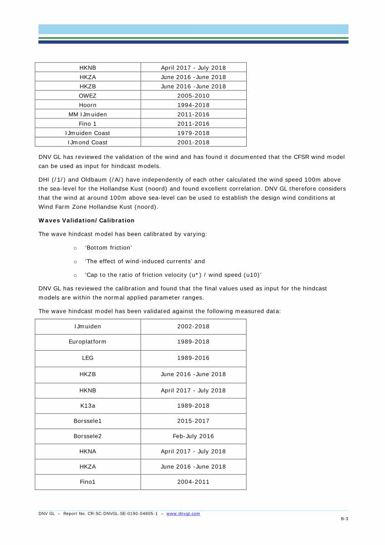
The CFSR wind used to force the wave model and the HD (water level and current) model has been validated against the following measured data:
Europlatform 2001-2018 K14 2008-2018 K13a 2001-2018 LEG 2001-2018 F16 2011-2018 F3 2011-2018 J6 2011-2018 L9 2011-2018 P11 2011-2018 Q1 August 2018 - September 2018
HKNA April 2017 - July 2018
DNV GL – Report No. CR-SC-DNVGL-SE-0190-04805-1 – www.dnvgl.com
B-3
HKNB April 2017 - July 2018 HKZA June 2016 -June 2018 HKZB June 2016 -June 2018 OWEZ 2005-2010 Hoorn 1994-2018
MM IJmuiden 2011-2016 Fino 1 2011-2016
IJmuiden Coast 1979-2018 IJmond Coast 2001-2018
DNV GL has reviewed the validation of the wind and has found it documented that the CFSR wind model can be used as input for hindcast models.
DHI (/1/) and Oldbaum (/A/) have independently of each other calculated the wind speed 100m above the sea-level for the Hollandse Kust (noord) and found excellent correlation. DNV GL therefore considers that the wind at around 100m above sea-level can be used to establish the design wind conditions at Wind Farm Zone Hollandse Kust (noord).
Waves Validation/Calibration
The wave hindcast model has been calibrated by varying:
o ‘Bottom friction’
o ‘The effect of wind-induced currents’ and
o ‘Cap to the ratio of friction velocity (u*) / wind speed (u10)’
DNV GL has reviewed the calibration and found that the final values used as input for the hindcast models are within the normal applied parameter ranges.
The wave hindcast model has been validated against the following measured data:
IJmuiden 2002-2018
Europlatform 1989-2018
LEG 1989-2016
HKZB June 2016 -June 2018
HKNB April 2017 - July 2018
K13a 1989-2018
Borssele1 2015-2017
Borssele2 Feb-July 2016
HKNA April 2017 - July 2018
HKZA June 2016 -June 2018
Fino1 2004-2011

DNV GL – Report No. CR-SC-DNVGL-SE-0190-04805-1 – www.dnvgl.com
B-4
F3 2014-2018
Eierlandse 1989-2018
DNV GL has reviewed the validation of the waves and has found it documented that the hindcast model can be used to establish the design wave conditions at Wind Farm Zone Hollandse Kust (noord).
HD (water level and current) Validation/Calibration
The HD hindcast model has been validated/calibrated against the following measured data:
Water Level Current
HKNA 2017-2018 2017-2018
HKNB 2017-2018 2017-2018
HKZA 2016-2018 2016-2018
HKZB 2016-2018 2016-2018
MM IJmuiden 2011-2015 NA
Brouwershavensche Gat 1994-2018 NA
Europlatform 1994-2018 NA
Eierland 1981-1983 NA
F16 2009-2016 NA
F3 2012-2016 NA
J6 2010-2016 NA
K13 1994-2018 NA
K14 2012-2017 NA
L9 2012-2017 NA
LEG 1994-2018 NA
Noordwijk 1994-2006 NA
Q1 2007-2017 NA
Vlaktevdraan 1994-2018 NA
Wierumergronden 1994-2018 NA

DNV GL – Report No. CR-SC-DNVGL-SE-0190-04805-1 – www.dnvgl.com
B-5
The Manning number (bottom friction) and wind friction have been calibrated. DNV GL has reviewed the calibration and found that the final values used as input in the hindcast model are within the normal applied parameter ranges.
DNV GL has reviewed the validation of the water level and current and has found it documented that the HD (water level and current) hindcast results can be used the establish the design water level and current conditions at Wind Farm Zone Hollandse Kust (noord).
MetOcean Database
The overall goal of the database is to support the establishment of MetOcean conditions for design, installation and maintenance of wind turbines, inter-array cables and substations for the project Wind Farm Zone Hollandse Kust (noord). The database is based on the hindcast model results described above and covers meteorology (wind) and hydrodynamics (water levels, currents and waves) for a period of 39 years (1979-2018). The database also includes results from extreme value analysis and correlations (for example correlations between extreme significant wave height and wind-speed, current and water level respectively, and wave periods associated with the extreme individual wave heights).
DNV GL has checked the meteorology (wind) and hydrodynamics (water levels, currents and waves) data available in the database, both for normal conditions (i.e. roses and distributions) and extreme conditions (including associated values), for the positions presented in /1/, and has found that the database is consistent with /1/.
Furthermore, DNV GL has made spot checks of the data output for other positions than presented in /1/ and found that data are plausible and in agreement with the overview maps covering the site (for example highest and lowest astronomical tide, mean significant wave height, extreme wind speed, extreme significant wave height and maximum extreme individual wave height with return period of 100 years), and has confidence that the data included in the database are consistent with the data presented in /1/.
Statement of Compliance for Wind Farm Zone Hollandse Kust
The Main Metocean Site conditions approved and to be presented in the Statement of Compliance for Wind Farm Zone Hollandse Kust (noord) are
Wind conditions General Air density at 100 m Approx. 1.22 kg/m3
(temperature and pressure dependent)
Minimum - Maximum air temperature -13.9°C to 28.6°C(40 year) Air humidity <100% Wind conditions – Normal (based on WRA study) Annual average wind speed (at 100m) 9.56 m/s Weibull A-parameter (at 100 m) 10.79 m/s Weibull k-parameter (at 100 m) 2.30 Wind conditions – Extreme Wind speed 50 year recurrence period, 10 min. (at 100 m) 41.0 m/s
(max. within the area) Wind speed 1 year recurrence period, 10 min. (at 100 m) 33.1 m/s
(max. within the area)

DNV GL – Report No. CR-SC-DNVGL-SE-0190-04805-1 – www.dnvgl.com
B-6
Marine conditions Highest astronomical tide (HAT) 2.2 m (LAT) Lowest astronomical tide (LAT) 0 m (LAT) Tidal variation HAT/LAT 2.2 m (LAT) Significant wave height for 50 year recurrence period, Hs,50-yr 7.3 m Significant wave height for 1 year recurrence period, Hs,1-yr 5.6 m Peak wave period Tp for extreme for 50 year recurrence wave Hs,50-yr 11.5 s Peak wave period Tp for extreme for 1 year recurrence wave Hs,1-yr 10.0 s Extreme deterministic wave height for 50 year recurrence period, Hmax,50-yr
14.0 m
Extreme deterministic wave height for 1 year recurrence period, Hmax,1-yr
10.4 m
Interval of wave periods THmax,50-yr, associated with Hmax,50-yr 8.5 s -11.8 s Interval of wave periods THmax,1-yr, associated with Hmax,1-yr 7.5 s – 10.8 s Extreme wave crest height for 50 year recurrence period 12.3 m (LAT) Extreme wave crest height for 1 year recurrence period 9.1 m (LAT) Extreme high water level with recurrence period of 50 year 4.0 m (LAT) Extreme high water level with recurrence period of 1 year 3.2 m (LAT) Extreme low water level with recurrence period of 50 year -1.0 m (LAT Extreme low water level with recurrence period of 1 year -0.5 m (LAT) Extreme current for 50 year recurrence period (depth averaged) 1.1 m/s Extreme current for 1 year recurrence period (depth averaged) 1.0 m/s Water level rise to year 2045 due to climate change 0.3 m Water density Approx. 1025 kg/m³ Minimum - Maximum sea temperature 1.3 to 20.2°C(monthly)
B6 Conditions to be considered in other certification phases No conditions have been identified.
B7 Outstanding issues There are no outstanding issues.
B8 Conclusion DNV GL finds that the MetOcean study is complete, is plausible and is carried out according to 'state of the art methods' and that
• the Normal MetOcean Conditions • the Extreme MetOcean Conditions
as defined in the documents listed in section B4 are derived in line with the requirements following section 2.3.2 of the DNVGL-SE-0190 and are suitable as design input for Wind Farm Zone Hollandse Kust (noord). Furthermore, DNV GL finds that the MetOcean Database performs well and is suitable for establishing the MetOcean design conditions for the Wind Farm Zone Hollandse Kust (noord).
DNV GL – Report No. CR-SC-DNVGL-SE-0190-04805-1 – www.dnvgl.com
C-1
APPENDIX C Geophysical Investigations
Evaluation of Geophysical Investigations for Hollandse Kust (noord) Wind Farm Zone
C1 Description of verified component, system or item In the Investigation Area of the Hollandse Kust (noord) Wind Farm Zone geophysical investigations have been performed. The geophysical investigations were divided into two separate investigations performed from 30th July to 1st September 2017 and from 12th September to 3rd November 2017 and consisted of Sidescan Sonar (SSS), Magnetometer (MAG), Multi Beam Echo Sounder (MBES), Single Beam Echo Sounder (SBES), Sub-Bottom Profiler (SBP), Single Channel Sparker (SC-UHRS) and ultra-high resolution multichannel sparker with hybrid streamer (MC-2DUHRS). The results and the found site conditions are documented by the customer and build the basis for the verification of the current report.
C2 Interface to other systems/components The geophysical investigation reports shall be considered for the Geotechnical Investigations and the Geological Ground Model.
C3 Basis for the evaluation Applied codes and standards:
Document No. Revision Title DNVGL-ST-0437 November 2016 Loads and site conditions for wind turbines DNVGL-ST-0126 April 2016 Support structures for wind turbines
C4 Documentation from customer List of reports:
Document No. Revision Title GH216-R3 3
18.05.2018 Geophysical Site Investigation Survey / Hollandse Kust (noord) Wind Farm Zone Survey 2017
GH216_FG_RVO-HKN_Operations_Report_Rev2
2 13.11.2017
Hollandse Kust (noord) Windfarm Zone Survey 2017 / Field Report / Volume 1 of 1
GH216_FM_RVO-HKN_Operations_Report_Rev2
2 06.06.2018
Hollandse Kust (noord) HKN Wind Farm Zone - Operations Report - MV Fugro Meridian / Volume 2 of 2
C5 Evaluation work Based on the regional geology the local geology in the windfarm area has been investigated based on
the MC-2DUHRS, SC-UHRS and SBP results and existing borehole information by Fugro.
DNV GL – Report No. CR-SC-DNVGL-SE-0190-04805-1 – www.dnvgl.com
C-2
This led to an interpretation of mainly five geological units in the area, namely, A: Holocene - Southern
Bight Formation (Bligh Bank Member), B: Upper Pleistocene - Naaldwijk Formation (Wormer Member and
Velsen Bed), C: Upper Pleistocene - of Kreftenheye and Boxtel Formations, D: Lower to Middle
Pleistocene - Yarmouth Roads Formation and E: Lower to Middle Pleistocene - Winterton Shoal Formation.
An in-depth interpretation is included in the definition of layer boundaries between these geological units.
Based on the given information in the report DNV GL assessed the interpretation for plausibility and
agrees to the given conclusions presented in the report.
It is further noted that Palaeochannels are present in the Wind Farm Zone. Due to the deviating infill soil
material it is possible that soil parameters may change within short distances adjacent to these sub-
ground phenomena.
Additionally, boulders have been detected in the Wind Farm Zone and have been documented in the
appendices of the main report, but with the note that further boulders are likely to be present.
It shall be noted that due to the distance of track lines during the investigations the level of detail in a 3-
dimensional ground model is limited, but can be expanded by findings of the geotechnical investigations.
Further limitations and recommendations are mentioned in the corresponding sections of the assessed
report and shall be considered in the further design process.
The quality of the data acquisition has been documented within the report and survey protocols have
been submitted with the Operations Reports given above.
DNV GL could not detect any deviations from quality which would have led to a critical error in the
performed interpretations.
DNV GL has evaluated that the above referenced documents from the customer provide sufficient
information to get a good general understanding of the geophysical conditions in the given wind farm
area. The above referenced reports provide sufficient geophysical details to serve as a geological model
for the (preliminary) design of future offshore wind farms. Such a model can be relied upon to establish
general geological conditions, support discussions on site variability and establish the scope of a future
geotechnical investigation campaign, e.g. with respect to park layout studies.
The given results have been documented in the report and it is evaluated by DNV GL that the
conclusions have been determined and presented in detail with good traceability.
The assessed report does fulfil the requirements in accordance with the standards specified as the basis
for the evaluation.
C6 Conditions to be considered in other certification phases No conditions have been identified.
C7 Outstanding issues There are no outstanding issues.

DNV GL – Report No. CR-SC-DNVGL-SE-0190-04805-1 – www.dnvgl.com
C-3
C8 Conclusion
The geophysical investigation reports may be used to support the Design Basis documentation for the
(preliminary) design of future offshore wind farms in the project area. The data in these reports are
suitable to serve as a geological ground model and can be used for establishing a Design Basis for
Offshore Wind Turbine Structures in accordance with DNVGL-ST-0437 and DNVGL-ST-0126.

DNV GL – Report No. CR-SC-DNVGL-SE-0190-04805-1 – www.dnvgl.com
D-1
APPENDIX D Geotechnical Investigations and Geological Ground Model
Evaluation of Geotechnical Investigations and Geological Ground Model for Hollandse Kust (noord) Wind Farm Zone
D1 Description of verified component, system or item Within the wind farm area geotechnical and geological investigations have been performed. The results and the found site conditions are documented by the customer and build the basis for the verification of the current report.
D2 Interface to other systems/components Knowledge obtained from the Geophysical Site Conditions has been considered during the assessment of the Geotechnical Investigations and the Geological Ground Model.
D3 Basis for the evaluation Applied codes and standards:
Document No. Revision Title DNVGL-ST-0437 November 2016 Loads and site conditions for wind turbines DNVGL-ST-0126 April 2016 Support structures for wind turbines
D4 Documentation from customer List of reports:
Document No. Revision Title Fugro Report No.: P903749/01
5 12.04.2019
Geotechnical Report - Investigation Data, Seafloor In Situ Test Locations, Hollandse Kust (noord) Wind Farm Zone, Dutch Sector, North Sea, 2324 pages
Fugro Report No.: P903749/02
6 12.04.2019
Geotechnical Report - Investigation Data, Geotechnical Borehole Locations, Hollandse Kust (noord) Wind Farm Zone, Dutch Sector, North Sea, 5078 pages
Fugro Report No.: P903749/03
5 01.05.2019
Geological Ground Model, Hollandse Kust (noord) Wind Farm Zone, Dutch Sector, North Sea, 763 pages
Fugro Report No.: P903749/04
4 12.04.2019
Geotechnical Report - Laboratory Test Data, Hollandse Kust (noord) Wind Farm Zone, Dutch Sector, North Sea, 2618 pages

DNV GL – Report No. CR-SC-DNVGL-SE-0190-04805-1 – www.dnvgl.com
D-2
Complete digital data of the reported site investigations in the project area is available. The assessment
of the shown reports relies on specific data shown in the listed reports. Additional information from the
digital data was made available, if necessary for the assessment.
D5 Evaluation work DNV GL has evaluated that the above referenced documents from the customer provide sufficient information to get a good general understanding of the geotechnical and geological conditions in the given wind farm area.
At the wind farm area thirty-three locations have been investigated by boreholes with a maximal investigation depth of 80 m below mudline. The corresponding information can be found in the Geotechnical Borehole Locations report. The assessment process by DNV GL has been documented with a verification comment sheet (VCS reference: VCS-21-Rev01-PD-644258).
Over all, cone penetration tests at seventy-five locations, piezocone penetration tests at seventy-five locations, seismic cone penetration tests at twenty-one locations, temperature cone penetration tests at twenty-three locations and pore pressure dissipation tests at thirty-eight locations have been conducted, distributed across the complete wind farm area. The corresponding information can be found in the Seafloor In Situ Test Locations report. The assessment process by DNV GL has been documented with a verification comment sheet (VCS reference: VCS-16-Rev02-PD-644258).
The geophysical and the geotechnical data is summarized and evaluated in the Geological Ground Model report. The stratigraphy interpreted for the wind farm area is summarized by soil unit DS, A, B, C and D. It is shown that the seismic cross sections generally match the conducted cone penetration test results. Based on the given information thicknesses of soil units DS, A, B, C and D are given. It is noted that geotechnical soil parameters do not necessarily vary between those units, however, it is also possible that decisive geotechnical soil parameters vary within one soil unit. Soil conditions across the wind farm area are predominantly characterised by sand deposits, with minor clays and intermediate soils. Sands are mainly medium dense to very dense (soil units DS and A) and partly slightly silty to silty (soil unit C). Soil units B and D are mainly sand but may contain high strength to very high strength clay with variable thickness. The sand and clay layers are partially interbedded with thin to thick laminae of clay and sand, respectively. The area is characterized by a number of channel systems that developed and had been refilled over time, again. Mainly, two channel systems are present. One at the base of soil unit B and the other at the base of soil unit C. The assessment process by DNV GL has been documented with a verification comment sheet (VCS reference: VCS-23-Rev02-PD-644258).
In addition to index laboratory tests which have been conducted and documented in the Geotechnical Borehole Locations report, advanced geotechnical laboratory tests have been performed and results can be found in the Laboratory Test Data report. These consist of particle size distribution, microscopic description and photography as well as static and cyclic triaxial tests, static and cyclic shear tests and resonant column tests. It has been checked that the laboratories are accredited according to ISO/IEC 17025 for the conducted tests where applicable. Advanced tests have been performed at batches from boreholes HKN04-BH-SA/HKN11-BH-SA, HKN21-BH-SA, HKN25-BH-SA, HKN26-BH-SA, HKN27-BH-SA, HKN37-BH-SA, HKN39-BH-SA and HKN47(A)-BH-SA. The corresponding laboratory test-setup is documented in the Laboratory Test Data report and has been checked by DNV GL. Further, the test procedures are described in detail, and failure conditions are
DNV GL – Report No. CR-SC-DNVGL-SE-0190-04805-1 – www.dnvgl.com
D-3
specified where necessary. The included test protocols and result tables correspond and are documented in the Laboratory Test Data report. For improved traceability, results of cyclic laboratory tests have been given in S-N curves and interaction diagrams. The assessment process by DNV GL has been documented with a verification comment sheet (VCS reference: VCS-22-Rev01-PD-644258).
The given reports have been checked by DNV GL and are in compliance with the applied codes and standards as given in section D3.
D6 Conditions to be considered in other certification phases The conditions identified during the technical evaluation are listed in the following. The conditions are assigned to the certification phases in which they need to be considered and evaluated.
For the Design Basis phase the following conditions shall be addressed:
- For the final layout of the wind farm zones geotechnical investigations need to be performed at each specific (e.g. turbine) location.
D7 Outstanding issues No outstanding issues have been identified.
D8 Conclusion It is evaluated that the used equipment is state-of-the-art in offshore practice and the found results do not deviate from experienced values for parameters of the present soils.
The chosen sites of the conducted investigations are sufficient to develop an illustration of lateral and vertical soil and seabed variations.
It was evaluated that the geological ground model can be relied upon to establish general geological conditions, support discussions on site variability and establish the scope of a future geotechnical investigation campaign, e.g. with respect to park layout studies.
In summary, the verification work performed by DNV GL confirms that the “Site assessment” as seen by the documentation from customer related to the Hollandse Kust (noord) Wind Farm Zone as listed under section D4 fulfils the relevant demands set up in the Certification Scheme DNVGL-SE-0190:2015-12, section 2.3.2 and the related “Basis for the evaluation” listed in section D4, if the condition in chapter D6 is observed.
The geotechnical investigation reports and the geological ground model can be used to support the
(preliminary) design of future offshore wind farms in the project area. The data presented in those
reports can be used for establishing a Design Basis in accordance with DNVGL-ST-0437 and DNVGL-ST-
0126.

DNV GL – Report No. CR-SC-DNVGL-SE-0190-04805-1 – www.dnvgl.com
E-1
APPENDIX E Geotechnical Parameters
Evaluation of Geotechnical Parameters for Hollandse Kust (noord) Wind Farm Zone
E1 Description of verified component, system or item Within the Hollandse Kust (noord) Wind Farm Zone geotechnical and geophysical investigations have been performed. The results and the found site conditions are used to further investigate and develop values for present geotechnical parameters that are useful for a detailed conceptual foundation design in the present Wind Farm Zone with a focus on monopile design. The approaches and methods chosen to achieve these values have been traced and assessed by DNV GL which is documented with this report.
E2 Interface to other systems/components The data base for the development of the assessed report has been certified by DNV GL with report CR-SC-DNVGL-SE-0190-02453-0_Geotechnical and needs to be seen in conjunction with the current report.
E3 Basis for the evaluation Applied codes and standards:
Document No. Revision Title DNVGL-ST-0437 November 2016 Loads and site conditions for wind turbines DNVGL-ST-0126 April 2016 Support structures for wind turbines
E4 Documentation from customer List of reports:
Document No. Revision Title Fugro Report No.: P903749/06
7 20.06.2019
Geotechnical Parameters, Hollandse Kust (noord) Wind Farm Zone, Dutch Sector, North Sea, 447 pages
The assessment of the shown report relies on specific data shown in the listed report and the formerly certified reports as mentioned in section E2.
E5 Evaluation work DNV GL has evaluated that the above referenced documents from the customer provide additional information that enables for a more detailed conceptual foundation design.
The assessment process by DNV GL has been documented with a verification comment sheet (VCS reference: VCS-24-Rev02-PD-644258).
Based on the present soil conditions the conducted CPTs have been evaluated which led to the development of for representative CPT groups, G1 to G4, across the Wind Farm Zone. The distribution of the CPT groups is given in the report which also includes a division of the geotechnical investigation area

DNV GL – Report No. CR-SC-DNVGL-SE-0190-04805-1 – www.dnvgl.com
E-2
in sub-areas that are most likely for the presence of the corresponding representative CPT profile. In addition, the corresponding probability of occurrence has been determined and is outlined in the report, too.
For the determination of values of geotechnical parameters, the report distinguishes between design, characteristic, indicative and derived values. It is noted that the report does not include design or characteristic values as these are directly connected to design models and methodologies. Therefore, the report evaluates measured data and derived values to determine indicative values and bandwidths for geotechnical parameters related to the corresponding CPT group, respectively, including also statistical approaches where reasonable. The geotechnical parameters that have been investigated are as follows: soil unit weight, net cone resistance, coefficient of earth pressure at rest, minimum and maximum index void ratio, relative density, undrained shear strength (based on triaxial compression and direct simple shear tests), external axial strain at half the maximum deviator stress, critical state line, effective angle of internal friction at large strain, peak effective angle of internal friction, angle of interface friction (steel/soil), constrained modulus, coefficient of permeability, shear modulus at small strain, normalised shear modulus and cyclic strength.
The chosen approaches and methods to derive indicative values and bandwidths have been checked for traceability and completion. The given information has been assessed to be in accordance with the applied codes and standards as given in section E3.
E6 Conditions to be considered in other certification phases The conditions identified during the technical evaluation are listed in the following. The conditions are assigned to the certification phases in which they need to be considered and evaluated.
For the Design Basis phase the following conditions shall be addressed:
- For the final layout of the Wind Farm Zone it is the responsibility of the designer to make the final decision, if additional boreholes, cone penetration tests and/or laboratory tests can be omitted to enable an economic and safe foundation design. Further, it is the responsibility of the designer to verify the applicability of the reported results for the foundation design.
E7 Outstanding issues No outstanding issues have been identified.
E8 Conclusion The given indicative values are valuable to define soil profiles for a conceptual foundation design. The geotechnical parameter report can be used to support the (preliminary) design of future offshore wind farms in the project area. In addition, the report adds useful recommendations for further reasonable investigations which would lead to a possible refinement of the foundation dimensions.
It is evaluated that the determination of indicative values and bandwidths is in accordance with the requirements of the applied codes and standards.
In summary, the verification work performed by DNV GL confirms that the “Site assessment” as seen by the documentation from customer related to the Hollandse Kust (noord) Wind Farm Zone as given under section E4 fulfils the relevant demands set up in the Certification Scheme DNVGL-SE-0190:2015-12, section 2.3.2 and the related “Basis for the evaluation” given in section E3, if the condition in section E6 and the information in section E2 are observed.

DNV GL – Report No. CR-SC-DNVGL-SE-0190-04805-1 – www.dnvgl.com
F-1
APPENDIX F Morphological and Scour Investigations
Evaluation of Morphological and Scour Investigations for Hollandse Kust (noord) Wind Farm Zone
F1 Description of verified component, system or item Within the wind farm area a morphology and scour mitigation study has been performed. The results and the found morphodynamic site conditions are documented by the customer and build the basis for the verification described in the current report.
F2 Interface to other systems/components Currently, no interfaces to other systems/components are present.
F3 Basis for the evaluation Applied codes and standards:
Document No. Revision Title DNVGL-ST-0437 2016-11 Loads and site conditions for wind turbines IEC 61400-3 2009-02 Wind Turbines – Part 3: Design requirements for offshore wind turbines
F4 Documentation from customer List of reports:
Ref. Document No. Revision Title /1/ 112027960-000-HY
E-0002-Final-v2 Final 2019-03-15
Morphodynamics and scour mitigation of Hollandse Kust (noord) Wind Farm Zone
F5 Evaluation work /1/ presents the bathymetrical/morphodynamic assessment for the planned Wind Farm Zone Hollandse Kust (noord). /1/ contains information regarding:
• Description of morphodynamic features in the wind farm zone • An analysis of the morphodynamics • Extrapolation of historical morphodynamic activities for the estimation of future seabed levels
The seabed bedforms at Wind Farm Zone Hollandse Kust (noord) consist of a combination of Megaripples and Sand Waves.
/1/ concludes that from the geological and geophysical data available non-erodible layers exist, but that they are located too deep to influence migration of the sand waves and the megaripples.
The Megaripples have migration speeds that are so large that many megaripples will pass each Turbine during the lifetime of the wind farms. Therefore, only their dimensions were determined, and their representative statistical values were included as an uncertainty band for predicted bed levels.
DNV GL – Report No. CR-SC-DNVGL-SE-0190-04805-1 – www.dnvgl.com
F-2
The Sand waves have been analysed in 3 steps based on the historical and recent seabed bathymetries
a. Determination of the sand wave migration direction b. Determination of the sand wave migration speed c. Characterization of the sand wave shape
Future migration
The 2017 Hollandse Kust (noord) Wind Farm Zone bathymetry was determined from multibeam survey carried out by Fugro on behalf of RVO.nl: These bathymetrical data together with 1996, 2002, 2009 and 2012 surveys were used to determine the seabed dynamics: a) sand wave migration directions, b) sand wave speeds and c) the sand wave characteristics such as wavelength and wave height.
The future bathymetries and corresponding bed level changes have been estimated by artificial shifting the mobile seabed components of the most recent 2017 bathymetry. In order to account for the variability of the migration speed and migration direction, 9 different combinations of 3 migration directions and 3 migration speeds have been considered. Hereby upper and lower bound future seabed level estimates have been obtained. DNV GL has reviewed this method and has found that the method can be used to determine the long-term bathymetrical changes, when contingency accounting for the uncertainties are applied:
In order to account for a) survey, b) megaripples and c) spatial resolution uncertainty, 0.20m upward and 0.15 m downward bands + spatial varying sand shape uncertainty have been added to the uncertainty. DNV GL has reviewed these uncertainty bands and found them to be on the safe side.
DNV GL has a) reviewed the study, b) has found that the study is carried out according to industry best practice and c) agrees on the following main data provided along with /1/:
• Lowest Seabed Level (LSBL) for time spans of 3 year • Highest Seabed Level (HSBL) for time spans of 3 year • Best Estimate Bathymetry (BEB) for time spans of 3 year
Unexploded Ordnances (UXO’s)
In addition to the future predictions /1/ also present a hindcast of the seabed levels for the period 1921 to 1945 to detect bandwidths as a vertical demarcation for the location of Unexploded Ordnances (UXO’s). DNV GL has reviewed and found the Best (BEOL), Lowest (LOL) and Highest (HOL) object levels are correctly modelled.
Mining Pit Area
A sand mining Pit is present in the area. Four bathymetrical surveys from 2012, 2013, 2016 and 2017 have been carried out in the area. Based on those measurements and by using hydrodynamic input (current and water level) the SEDTUBE sediment model has been setup in /1/ to simulate the long-term bathymetrical development. /1/ concludes that after 41 years (from 2017-2058) a significant north-northeastward migration of the sand mining Pit will take place more than 2 km downstream the present Pit location.
DNV GL has a) reviewed the study, b) found the that the bathymetrical changes are correctly modelled and c) agreed with the conclusion of the study.

DNV GL – Report No. CR-SC-DNVGL-SE-0190-04805-1 – www.dnvgl.com
F-3
Scour Mitigation Strategies
In /1/ different Scour Mitigation Strategies are presented. DNV GL has found that the methods are in line with industry practice.
F6 Conditions to be considered in other certification phases The conditions identified during the technical evaluation are listed in the following.
For the design phase the following condition shall be addressed:
• The final scour mitigation strategy will have to be defined by the designer, for the actual foundation and cable design to be used.
For the operation and maintenance phases the following condition shall be addressed:
• The seabed levels within the wind farm area shall be monitored and remedial actions taken before the seabed levels are compromised.
F7 Outstanding issues There are no outstanding issues.
F8 Conclusion DNV GL has found that the morphology study is complete, carried out according to industry best practice, is plausible, and that
• Best Estimate Bathymetry (BEB) • Lowest Sea Bed Level (LSBL) for the period 2018-2058 • Highest Sea Bed Level (HSBL) for the period 2018-2058
as defined in the documents listed in section F4 are derived in line with the requirements following section 2.3.2 of the DNVGL-SE-0190 and can be used as basis for determining design seabed levels for Hollandse Kust (noord) Wind Farm Zone. The condition in Section F4 needs to be observed.
Although the actual scour prediction and mitigation strategies must be defined by the designer for the actual foundation and cable concepts, DNV GL has found the presented methods to be in line with industry practice.

DNV GL – Report No. CR-SC-DNVGL-SE-0190-04805-1 – www.dnvgl.com
G-4
APPENDIX G List of Documents/References

About DNV GL Driven by our purpose of safeguarding life, property and the environment, DNV GL enables organizations to advance the safety and sustainability of their business. We provide classification and technical assurance along with software and independent expert advisory services to the maritime, oil and gas, and energy industries. We also provide certification services to customers across a wide range of industries. Operating in more than 100 countries, our 16,000 professionals are dedicated to helping our customers make the world safer, smarter and greener.