wind-pattern circulation as a palaeogeographic indicator...
TRANSCRIPT

This is a repository copy of Wind-pattern circulation as a palaeogeographic indicator: casestudy of the 1.5-1.6 Ga Mangabeira Formation, São Francisco Craton, Northeast Brazil.
White Rose Research Online URL for this paper:http://eprints.whiterose.ac.uk/116837/
Version: Accepted Version
Article:
Ballico, MB, Scherer, CMS, Mountney, NP orcid.org/0000-0002-8356-9889 et al. (4 more authors) (2017) Wind-pattern circulation as a palaeogeographic indicator: case study of the 1.5-1.6 Ga Mangabeira Formation, São Francisco Craton, Northeast Brazil. Precambrian Research, 298. pp. 1-15. ISSN 0301-9268
https://doi.org/10.1016/j.precamres.2017.05.005
© 2017 Elsevier B.V. This manuscript version is made available under the CC-BY-NC-ND 4.0 license http://creativecommons.org/licenses/by-nc-nd/4.0/
[email protected]://eprints.whiterose.ac.uk/
Reuse
Items deposited in White Rose Research Online are protected by copyright, with all rights reserved unless indicated otherwise. They may be downloaded and/or printed for private study, or other acts as permitted by national copyright laws. The publisher or other rights holders may allow further reproduction and re-use of the full text version. This is indicated by the licence information on the White Rose Research Online record for the item.
Takedown
If you consider content in White Rose Research Online to be in breach of UK law, please notify us by emailing [email protected] including the URL of the record and the reason for the withdrawal request.

Accepted Manuscript
Wind-pattern circulation as a palaeogeographic indicator: case study of the1.5-1.6 Ga Mangabeira Formation, São Francisco Craton, Northeast Brazil
M.B. Bállico, C.M.S. Scherer, N.P. Mountney, E.G. Souza, F. Chemale, S.A.Pisarevsky, A.D. Reis
PII: S0301-9268(16)30424-7DOI: http://dx.doi.org/10.1016/j.precamres.2017.05.005Reference: PRECAM 4765
To appear in: Precambrian Research
Received Date: 2 October 2016Revised Date: 5 May 2017Accepted Date: 21 May 2017
Please cite this article as: M.B. Bállico, C.M.S. Scherer, N.P. Mountney, E.G. Souza, F. Chemale, S.A. Pisarevsky,A.D. Reis, Wind-pattern circulation as a palaeogeographic indicator: case study of the 1.5-1.6 Ga MangabeiraFormation, São Francisco Craton, Northeast Brazil, Precambrian Research (2017), doi: http://dx.doi.org/10.1016/j.precamres.2017.05.005
This is a PDF file of an unedited manuscript that has been accepted for publication. As a service to our customerswe are providing this early version of the manuscript. The manuscript will undergo copyediting, typesetting, andreview of the resulting proof before it is published in its final form. Please note that during the production processerrors may be discovered which could affect the content, and all legal disclaimers that apply to the journal pertain.
1
Wind-pattern circulation as a palaeogeographic indicator: case study of the 1.5-1.6 Ga
Mangabeira Formation, São Francisco Craton, Northeast Brazil
Bállico, M.B.a*, Scherer, C.M.S.a, Mountney, N.P.b, Souza, E.G.a, Chemale, F.c
Pisarevsky, S.A.d, Reis, A.D.a
a Universidade Federal do Rio Grande do Sul – Instituto de Geociências, 9500 Bento
Gonçalves Avenue, 91501-970, Porto Alegre, Brazil
b Fluvial & Eolian Research Group, School of Earth and Environment, University of
Leeds, United Kingdom, LS2 9JT, UK
c Universidade do Vale dos Sinos – Programa de Pós-Graduação em Geologia, 950
Unisinos Avenue, 93022-000, São Leopoldo, Brazil
d Earth Dynamics Research Group, ARC Centre of Excellence for Core to Crust Fluid
Systems (CCFS) and The Institute for Geoscience Research (TIGeR), Department of
Applied Geology, Curtin University, GPO Box U1987, WA 6845, Australia
* Corresponding author: Bento Gonçalves Av. 9500, PO Box 15001, 91501-970, Porto
Alegre, Rio Grande do Sul, Brazil
+55 51 3308 6372 Phone
+55 51 3308 7047 Fax
Abstract
The preserved deposits of dune-scale aeolian bedforms provide valuable
palaeoenvironmental indicators of atmospheric circulation patterns and the latitudinal
position and distribution of land masses. However, no attempts to use palaeowind
directions and palaeogeographic reconstructions of ancient land mass distribution have
been published to model Precambrian atmospheric circulation. The Mangabeira

2
Formation is a large Mesoproterozoic aeolian erg succession (1.6 to 1.5 Ga) composed
of two aeolian units that accumulated in the São Francisco Craton, Brazil. The Lower
Unit records multiple drying-upward depositional cycles, each of which represents an
episode of erg expansion and contraction driven by climate changes. The Upper Unit is
composed dominantly of stacked aeolian dune strata that lack intervening interdune
deposits and which record extreme aridity. Palaeowind directions recorded from cross-
strata of transverse, crescentic aeolian dunes of the Lower and Upper Units record
dune migration under the influence of two dominant winds that blew to the southeast
and northwest. Analysis of these palaeowind data in relation to assessment of regional
palaeogeographic reconstructions for the period 1.6 to 1.5 Ga reveals a correlation
between atmospheric circulation and land mass distribution. At this time the São
Francisco Craton was located between the mid-latitudes and the equatorial zone. The
wind regime determined from analysis of dip azimuths of cross-strata of the Lower Unit
(1.6 to 1.54 Ga) are consistent with a palaeogeographic position between 25º to 35º S.
Analysis of cross-strata dip azimuths of the Upper Unit indicate northwest-directed
palaeowinds and a dominant monsoonal wind pattern from 1.54 to 1.5 Ga. During this
time the large land mass of the São-Francisco-Congo and Siberian cratons drifted
northwards through the equatorial zone from palaeolatitude 30º S to 30ºN.
Keywords: Mesoproterozoic erg; Mangabeira Formation; Palaeowinds;
Palaeogeography, Wind-pattern model
1. Introduction
Large aeolian dune deposits and related facies are the primary indicators of
extensive Precambrian desert environments. It has been argued that large examples of
such sedimentary systems were only been present at mid-palaeolatitudes (within 30
degrees of the palaeo-equator) during the Precambrian (Eriksson et al., 2013). Indeed,
present-day large desert systems (>12.000 km2, Pye and Tsoar, 2009) occur mostly
between 15º and 30º latitude. Numerous post-1.8 Ga Precambrian aeolian successions

3
have been documented (e.g. Ross, 1983; Pulvertaft, 1985; Deynoux et al., 1989;
Chakraborty, 1991; Chakraborty, 1993; Simpson and Eriksson, 1993; Clemmensen,
1988; Tirsgaard and Øxnevad, 1998; Bose et al., 1999; Biswas, 2005; Rodríguez-
López et al., 2014). Eriksson and Simpson (1998) proposed that the occurrence of
these ancient aeolian successions was related to the assembly of large land masses,
which encouraged the evolution of major aeolian erg (dune field) systems. Based on
the identification of diagnostic sedimentary structures, such as wind-ripple strata and
large-scale sets of cross strata, Precambrian aeolianites are generally associated with
extensive erg environments that developed in a broad range of climatic settings
(Eriksson and Simpson, 1998; Simpson et al., 2004; Heness et al., 2014). Although
Precambrian aeolian successions are widely recognised and correlated with various
tectonic settings and climatic regimes (e.g. Pulvertaft, 1985; Jackson et al., 1990;
Soegaard and Callahan, 1994; Tirsgaard and Øxnevad, 1998; Simpson et al., 2002),
no attempts have hitherto been published to show how the record of aeolian
accumulation and palaeogeographic reconstructions of the land mass distribution can
be used to model Precambrian atmospheric circulation.
Ancient aeolian landforms (e.g. dunes, draas and sand seas) reflect the
directions and intensity of palaeowinds – a major component of atmospheric
circulation. In turn, atmospheric circulation is dominated by the latitudinal distribution of
solar radiation and the distribution of land masses. Several models of atmospheric
circulation, based on palaeowind directions recorded by the deposits of aeolian
sandstones and on the palaeogeographic reconstructions of land masses in Pangaean
times, have been published (Parrish and Peterson, 1988; Peterson, 1988; Loope et al.,
2001, 2004; Scherer and Goldberg, 2007). Modelling of this type is particularly difficult
for Precambrian times because of the fragmentary nature of the sedimentary record
and the relatively poorly constrained palaeogeography (e.g. Li et al., 2008; Zhang et
al., 2012; Evans, 2013; Pisarevsky et al., 2003, 2014).

4
The Mangabeira Formation is a Proterozoic erg located on the São Francisco
craton in north-eastern Brazil. This large Proterozoic aeolian accumulation has a
preserved area of ~50.000 km2 and is up to ~700 m thick. The formation comprises two
units, each of which is characterized by a distinct depositional architecture and each of
which provides a detailed record of palaeowind directions via the preservation of sets
of inclined cross strata that represent aeolian dune lee slope deposits.
The aim of this study is to present palaeocurrent data to enable the
reconstruction of dominant palaeowind patterns in low (equatorial) and middle (~300S)
palaeolatitudes during the Mesoproterozoic (1.6 - 1.5 Ga). This wind-pattern model is
based on the analysis of aeolian cross-strata in the Mangabeira Formation and on
recent palaeogeographic reconstructions for these times (Pisarevsky et al., 2014).
Specific research objectives are (i) to understand the stratigraphic evolution of the
Mesoproterozoic erg of Mangabeira Formation, (ii) to present global-scale
palaeogeographic maps showing the distribution of major aeolian units, and (iii) to
discuss the wind regime and propose a wind-pattern model for the time period 1.6 to
1.5 Ga.
2. Geological Setting
The São Francisco Craton is located in north-eastern Brazil and comprises
Archaean Palaeoproterozoic basement with metamorphic and supracrustal rocks that
are overlain by Palaeoproterozoic to Phanerozoic platform-type cover deposits (e.g.,
Almeida, 1977; Barbosa et al., 2004; Cruz and Alkmim, 2006; Alkmim and Martins-
Neto, 2012). Two physiographic features in the northern part of the craton – the
Northern Espinhaço Range and Chapada Diamantina Range – expose Proterozoic
sedimentary successions. In the Chapada Diamatina Range, the Espinhaço
Supergroup and the São Francisco Supergroup are the main sedimentary units; the
former is of Palaeoproterozoic to Neoproterozoic age and is composed dominantly of
siliciclastic rocks; the latter is characterized mainly by carbonate successions of

5
Neoproterozoic age (Fig.1). The Espinhaço Supergroup spans an age range from
approximately c. 1.75 to 0.9 Ga based on radiometric age constraints (Schobbenhaus
et al., 1994; Babinski et al., 1999). This unit is composed principally of clastic
sedimentary rocks of continental and coastal origin (Pedreira and De Waele, 2008;
Danderfer et al., 2009; Alkmim and Martins-Neto, 2012), and associated volcanic
deposits (Schobbenhaus et al., 1994; Babinski et al., 1999).
As proposed by Chemale et al. (2012), three megasequences termed the
Lower, Middle and Upper sequences characterize the Espinhaço Supergroup, and
these sequences are related to the superimposition of numerous basins (Fig. 2). The
Lower Megasequence is represented by the Rio dos Remédios Group, which
comprises a volcanic-sedimentary succession related to an extensional tectonic event
between ca. 1.80 and 1.68 Ga, and includes continental clastic sequences of the Serra
da Gameleira, Lagoa de Dentro and Ouricuri do Ouro formations associated with
volcanic rocks of the Novo Horizonte Formation. The Middle Espinhaço megasequence
developed in a rift-sag basin that became filled with continental and coastal deposits.
This thermal sag phase spans an age range from 1.6 to 1.38 Ga (Pedreira, 1994;
Pedreira and De Waele, 2008; Guimarães et al., 2008; Alkmim and Martins-Neto,
2012; Guadagnin et al., 2015a). The Paraguaçu Group and the lowermost Tombador
Formation of the Chapada Diamatina Group comprise this sequence. The Paraguaçu
Group (c. 1.6 to 1.5 Ga) is represented by the Mangabeira and Açuruá formations. The
ca. 1.45 - 1.38 Ga Tombador Formation represents the superposition of multiple
depositional systems that accumulated in response to a basin sag phase (Magalhães
et al., 2015). The Upper Espinhaço Megasequence (ca. 1.19 - 0.9 Ga) is the
uppermost sedimentary succession of the Espinhaço Supergroup and is related to the
fill of a rift-sag basin. The Caboclo and Morro do Chapéu formations, the uppermost
two units of the Chapada Diamantina Group, comprise this sequence.
The Mangabeira Formation, which is the focus of this study, was formally
defined by Schobbenhaus and Kaul (1971), and described by Pedreira (1994). This

6
700 m-thick sedimentary succession (as measured in this study) records the
accumulation of a palaeo-desert environment that was characterized by aeolian dunes,
sandsheets and wadi deposits. Bállico et al. (2017) proposed a stratigraphic
architecture for the Lower Unit of the Mangabeira Formation, which is characterized by
drying-upward cycles. Provenance data for this unit were presented by Guadagnin et
al. (2015b) who demonstrated that sediments of the Mangabeira Formation were
recycled from sedimentary sources linked to a collisional tectonic setting. Analyzed
zircon grains were formed in the Paleoproterozoic Era, as a result of palaeoplate
amalgamation. Based on the chronostratigraphic distribution of detrital zircon ages
(Guadagnin et al. (2015b; Guadagnin and Chemale, 2015), the Mangabeira Formation
has an age of 1.5 to 1.6 Ga. Radiometric dates acquired from analysis of mafic sills
and dyke swarms that cut the base of the Mangabeira Formation (Babynski et al.,
1999; Silveira et al., 2013) reveal an age of ca. 1.5 Ga; the latter authors interpreted
1.5 Ga to be the likely minimum depositional age for this unit.
FIGURE 1
FIGURE 2
2.2. São Francisco-Congo craton and the Mesoproterozoic palaeogeography
Nuna or Columbia (e.g., Hoffman, 1997; Meert, 2002; Pesonen et al., 2003;
Zhao et al., 2002; Pisarevsky et al., 2014) was a Proterozoic supercontinent,
components of which included the Congo-São Francisco craton and other large
cratons, such as Siberia, India, Baltica, Laurentia and N. China. Stratigraphic
correlation, geochronological and palaeomagnetic data suggest that the São Francisco
and Congo cratons composed a single continent from ca. 2050 Ma until the opening of
the Atlantic Ocean, ca. 130 Ma (e.g., Trompette, 1994; D'Agrella Filho et al., 1996;
Deckart et al., 1998; Feybesse et al., 1998; Côrrea-Gomes and Oliveira, 2000;
Pedrosa-Soares et al., 2001, Zhao et al., 2002; Janasi, et al., 2011).
7
Pisarevsky et al. (2014) compiled a palaeomagnetic and geological database
using data from many continents, and reconstructed global palaeogeography from
1770 to 1270 Ma. The global-scale maps of Pisarevsky et al. (2014) show that the
Congo-São Francisco craton was located in southern mid-latitudes at 1.58 Ga and in
equatorial position at 1.5 Ga.
The palaeoposition of Congo-São Francisco at 1.5 Ga is supported by
palaeomagnetic and geological data. Silveira et al. (2013) dated the dike swarm at the
base of the Mangabeira Formation at 1506.7±6.9 Ma age (U–Pb baddeleyite). Ernst et
al. (2013) noted a good match between Large Igneous Province (LIP) “barcodes” of the
Congo-São Francisco and Siberia at 1500 Ma and at 1380 Ma and suggested the
affinity of these cratons at 1500-1380 Ma. This fit is also supported by palaeomagnetic
data (Ernst et al., 2013 and references therein). Pisarevsky et al. (2014) used this
match in their 1580 to 1270 Ma global reconstructions. Unfortunately, there are no
reliable ca. 1580 Ma palaeomagnetic poles from Siberia and Congo-São Francisco
(Pisarevsky et al., 2014), which implies that the suggested palaeo-positions of these
cratons at that time might be reconsidered if they contradict some new geological data.
3. Study Area and Methods
The Mangabeira Formation crops out over a large area (~50.000 km2) on the
São Francisco Craton. For this study, the detailed sedimentology of the Mangabeira
Formation was documented along a series of roadside cuttings in the southern part of
the Chapada Diamantina Range, over an area of ~1200 km2. It is in this region that the
outcrops are best preserved. The main road has a north to south orientation and
provides a dip-oriented section. Strata dip at 5 to 10° to the south and the sections
exhibit little deformation. For this study, 18 detailed sedimentological sections of the
Mangabeira Formation were measured and logged at 1:100 scale. Graphic logs record
grain size, physical sedimentary structures and palaeocurrent data (328 readings)
based on cross-strata dip and dip-direction. All measurements were corrected by

8
removing structural dip to negate the influence of tectonic overprint. Resultant foreset
dip azimuths were plotted on rose diagrams and on palaeogeographic maps. These
maps were corrected to remove the component of rotation known to have been
experienced by São Francisco Craton through time (see Pisarevsky et al., 2014). The
Euler rotation parameters were based on those provided by Pisarevsky et al. (2014).
4. The Mangabeira Formation: palaeowinds and stratigraphic architecture
In the southern area of the Chapada Diamantina, the Mangabeira Formation
can be subdivided into two units, each of which preserves a distinct stratigraphic
architecture and which records evidence for palaeowind directions.
4.1. Lower Unit
4.1.1. Description
The Lower unit is ~500 m thick and records a variety of aeolian facies. The
succession is arranged into vertically stacked depositional cycles that are each 2 to 20
m thick. Each preserved cycle is characterized by a well-defined facies succession
(Fig. 3). The base of each cycle is characterized by deposits of very fine- to medium-
grained, moderately sorted sandstone that occurs as tabular beds that are laterally
continuous for 0.6 to 6 metres (Fig. 4). The tabular bodies display horizontal to low-
angle cross-stratification (<5º), composed of three types of lamination. The first
lamination type comprises millimetric, inverse graded, horizontally to low-angle
translatent lamination, made up 0.1 to 0.2 m-thick beds (Fig. 3a). The base of laminae
is formed of very fine-grained sandstone that grade upward to medium-grained
sandstone, forming pin-stripe lamination (Fryberger and Schenk, 1988). The second
lamination type is formed by millimetric to centimetric interlayered sandstone and
mudstone, with crinkled-lamination, 5- to 100 mm thick (Fig. 3b). The third lamination
type is 2 mm-thick lenticular and laterally discontinuous compounded wind-ripple
lamination that occurs within sets of tangential cross-stratified sandstone. Other

9
lithofacies associated with the low-angle cross-stratificated sandstones comprise fine-
to medium-grained sandstone characterized by ripple cross-stratification (Fig. 3c).
These low-angle cross-stratificated sandstones occur as 0.1 m-thick sets, groups of
which occur collectively as stacked co-sets that are themselves 1 to 2 m thick and up to
5 m in lateral extent. Rare, small-scale (< 0.2 m thick) soft-sediment deformation
structures and thin lenses and drapes of massive mudstone (up to 10 mm thick) are
also rarely observed. These deposits are overlain by 0.2 to 3 m thick fine- to medium-
grained, well-sorted sandstones, with trough-tangential cross-stratification. The
foresets are formed by wedges of sand flow (i.e. grainflow) deposits, each 10- to 80
mm thick, that pinch out down-dip into milimetrical wind-ripple laminae (Fig. 3d). The
cosets display two arrangements: sets that are 0.2 to 0.5 m thick and sets up to 1.5 m
thick. Individual sets are wedge shaped. In orientations transverse to palaeoflow (as
revealed by cross strata azimuths), cross beds and their basal bounding surfaces are
characterized by troughs. These troughs display a spread of foreset azimuths from
005° to 050° in a single set (Fig. 4). In orientations parallel to palaeoflow, cross-strata
dip up to 300 and are tangential to planar basal bounding surfaces, which are
themselves sub-horizontal or inclined <5° in an upwind direction. Internally, the cross-
bedded sets are subdivided by inclined bounding surfaces that truncate the strata
below, whereas the strata above are concordant with these surfaces. These bounding
surfaces, which occur internally within sets, dip up to 15º (Fig. 4). Foreset dip
orientations are variable, with most foreset azimuths occurring in the range 045º to
335º (Fig. 4). The main foreset dip is <20º, varying between 18º and 30º. Very fine- to
fine-grained sandstones with inversely graded, horizontal lamination or wavy-crinkled
lamination (Fig. 3e) and millimetric and irregular laminae of mudstone occur
intercalated with inclined cross-strata in places. These set of beds are discontinuous
and irregular; thicknesses vary from 0.1 to 0.2 m; widths vary from 10 to 20 metres
(Fig. 3f).
4.1.2. Interpretation
10
Each of the depositional cycles of the Mangabeira Formation records an
upward change from aeolian sandsheet to aeolian dune and interdune deposits. The
tabular sandstones with low-angle stratification are interpreted as aeolian sandsheets
(Hunter, 1977; Kocurek and Nielson, 1986). The thin, horizontally to low-angle
translatent lamination with inverse grading laminae represent wind-ripple deposits
formed by the migration and climbing of wind ripples over a dry depositional surface
(Hunter, 1977; Fryberger and Schenk, 1988). The millimetric to centimetric interlayered
sandstones and mudstones with the crinkled-lamination are interpreted as adhesion
ripples that accumulated on a damp or wet surface (Kocurek, 1981; Kocurek and
Fielder, 1982; Chakraborty and Chaudhuri, 1993; Scherer and Lavina, 2005). Small-
scale tangential cross-beds with wind-ripple lamination and laterally discontinuous are
interpreted as residual deposits of aeolian dunes (Hunter, 1977) that accumulated in
sand-availability limited, dry conditions (cf. Kocurek and Nielson, 1986). The fine- to
medium-grained sandstones with ripple-cross stratification are interpreted as aqueous
2D- or 3D-ripple deposits. The thin massive mudstones indicate settling of suspended
sediments in a low-energy aqueous environment, probably related to the final stages of
ephemeral floods (Miall, 2006). Soft-sediment deformation structures as interpreted as
formed by fluid escape in unconsolidated sediments, probably as result of groundwater
fluctuation (Owen, 2003). Sets and cosets of trough cross-stratification, composed of
sandstone with well-sorted and well-rounded grains that are organized into grainflow
and wind-ripple laminae indicate migrating aeolian dunes (Hunter, 1977). The down-dip
pinch-out of packages of grainflow strata into wind-ripple lamination are interpreted as
lee-slope grainflow avalanches that reached dune toesets, whereas wind ripples
migrated over dune plinth areas (cf. Mountney, 2006; Scherer, 2000). Subhorizontal to
low-angle inclined, upwind-dipping surfaces (as seen in sections parallel to paleoflow)
are interpreted as interdune migration bounding surfaces (Kocurek, 1996). The trough
geometry of the interdune surfaces observed in sections transverse to palaeoflow
indicates that the main bedforms possessed sinuous crestlines (Rubin, 1987). Inclined

11
downwind-dipping bounding surfaces that occur within the cross-bedded sets are
reactivation surfaces, generated as a result of episodic erosion of the partial lee-side of
the bedforms during short term changes in wind direction and/or strength (Brookfield,
1977; Hunter and Rubin, 1983; Mountney, 2006; Rubin and Hunter, 1982; Scherer and
Lavina, 2005). Common trough-tangential cross-stratification combined with high
dispersion values of the foreset dip is typical of crescentic dunes with moderate to
highly sinuous crestlines. Discontinuous and irregular beds with translatent and wavy
crinkled lamination that occur between and intercalated with sets of aeolian dune
cross-strata are interpreted as aeolian interdune deposits. Inversely graded, horizontal
lamination is interpreted as subcritical climbing wind-ripple strata (Hunter, 1977),
indicating dry interdunes, which accumulated under conditions where the water table
was below the accumulation surface. Wavy crinkled laminations are interpreted as
adhesion structures that developed on damp interdune surfaces; these structures
indicate a context where the water table was located close to the accumulation surface
(Mountney and Thompson, 2002; Paim and Scherer, 2007). An alternative
interpretation of the crinkled lamination is a microbial origin (Eriksson et al., 2010;
Souza, 2012; Simpson et al., 2013; Bállico et al., 2017). The thin beds of interdune
origin with irregular geometry indicate dry or damp interdune hollows or corridors, that
occupied spatially isolated hollows between the dunes (Mountney and Jagger, 2004).
FIGURE 3
FIGURE 4
4.2. Upper Unit
4.2.1. Description
The Upper Unit is ~200 m thick. The basal contact with Lower Unit is covered
and not exposed in the studied area. Two main facies associations characterize this
unit (Fig. 5). The majority of deposits are fine- to coarse-grained sandstones that are
well sorted, with subrounded to rounded grains, arranged in cross-stratified sets.
12
Individual sets are 2 to 10 metres thick. In orientations transverse to paleoflow, simple
sets of cross bedding and their basal bounding surfaces reveal trough-shaped element
geometries (Fig. 6; troughs are 50 to 200 m wide). By contrast, in orientations parallel
to the direction of dip of the cross-strata, inclined cross bedding is tangential to basal
set bounding surface (Fig. 5a). Internally, foresets within sets have uppermost parts
that are composed of massive sandstone or inversely-graded grainflow lenses that dip
at ~20º (Fig. 5b). Toeset deposits are characterized by inversely graded wind-ripple
laminae, each up to 3 mm thick (Fig. 5c). In some places, the laminations are armoured
by very coarse-grained sandstone to granules, deposits of which form wedge-shaped
lenses (Fig. 5d). Some sets exhibit concordant cyclic cross-bedding, composed of
packages of grainflow strata that are separated by thinner packages of wind-ripple
laminae. These cyclic sets of cross-bedding are regularly spaced, each package being
0.2 to 0.8 m thick in orientations parallel to sand transport (Fig. 7). Internally, the cross-
bedded sets can be subdivided into sub-sets bounded by surfaces that truncate the
strata below, whereas the strata above are concordant with the dipping bounding
surfaces. The dipping bounding surfaces are themselves inclined up to 16º.
Palaeocurrent directions are variable; most of the wind currents are in the range 225º
SW to 270º W based on foreset dip azimuths (Fig. 6).
The second facies association occurs in a specific interval of the succession
and is composed by four lithofacies: (i) fine- to medium-grained sandstones with low-
angle stratification; (ii) fine-grained sandstone with millimetric spaced wrinkled
lamination (Fig. 5e); (iii) very fine- to fine-grained sandstone with ripple-cross
stratification in packages up to 25 mm thick; (iv) heterolithic beds of massive mudstone
and fine-grained sandstone with wavy-ripple lamination up to 50 mm thick (Fig. 5f).
Rare small-scale deformation structures are present in a few places. These
sedimentary structures occur interlayered as composite cosets of strata which
themselves form 0.7 to 2.5 m-thick and 10 m-wide tabular bodies (Fig. 5g).
4.2.2. Interpretation
13
The medium- to large-scale cross-strata sandstones compounded by grain flow
and wind-ripple strata are interpreted as formed by the migration of large aeolian
dunes. The presence of grainflow strata indicates high-angle, well-developed slipfaces
(Hunter, 1977). The unimodal trend of the cross-bed dip azimuths, and their occurrence
in trough-shaped sets indicates crescentic dunes with sinuous crestlines (Rubin, 1987).
The regularly spaced cyclic sets of cross-bedding with the alternation of grain-flow and
wind-ripple lamination suggests periods where grain flow lamination were developed by
avalanche in lee-faces dunes followed by intervals of erosion and deposition of wind-
ripple laminations. This most commonly occurs in response to seasonal changes in
wind direction (Hunter and Rubin, 1983; Kocurek et al., 1991; Chan and Archer, 2000;
Loope et al., 2001; Scherer and Lavina, 2005; Mountney, 2006; Kocurek et al., 2007;
Scherer and Goldberg, 2007). Thicker packages of grainflow strata that dip to the
southeast, as revealed in sections parallel to sand transport direction, were transported
by the stronger winds that dictated the dune orientation. By contrast, the wind-ripple
lamination records the action of weaker oblique to reverse winds. The laminations
characterized by armoured very coarse-grained sandstones to granules are granule
ripple deposits; these deposits likely accumulated in response to changes in effective
wind direction and strength (Fryberger et al., 1992). The concave-up surfaces that
truncate the foresets are interpreted as reactivation surfaces, which reflect frequent
changes in the wind flow. The association of water-laid sedimentary structures that
occur in bodies with a tabular geometry suggests unconfined, high-energy, ephemeral
flash flood deposits (Miall, 1996). The sandstones with low-angle-inclined stratification
are interpreted to record sediment transport in a flow that undertook a transition from
lower to upper flow regime conditions (Miall, 1977, 1996). The presence of wavy-ripple
sandstone indicates fair-weather waves on wide and shallow, ephemeral lakes. The
very fine- to fine-grained sandstones with ripple-cross stratification are interpreted as
2D- or 3D-ripples formed in lower flow regime (Miall, 1977). The wavy crinkled

14
lamination is interpreted as adhesion structures accumulated on damp or wet surfaces
by the adhering of dry sand to a wet or damp surface (Kocurek and Fielder, 1982).
FIGURE 5
FIGURE 6
5. Discussion
5.1. Stratigraphic Evolution
The Mangabeira Formation records prolonged aeolian sedimentation and
subordinate ephemeral fluvial systems (Fig. 8). The Lower Unit is ~500 m thick and
records multiple hiatuses of aeolian deposition and deflation expressed in drying-
upward cycles (Bállico et al, 2017). The Upper Unit is ~200 m thick and comprises the
deposits of large aeolian dunes that developed in a dry aeolian system with only rare
examples of fluvial deposition. The contact between these units was not exposed in the
studied area. However, based in the distinct depositional architecture and
reconstructed palaeowind directions, we suggest that these units are separated by an
unconformity. Both units accumulated in an intracratonic basin in the São Francisco
craton as part of the Supergroup Espinhaço (Guimarães et al., 2008; Guadagnin et al,
2015; Magalhães et al., 2015).
The Lower Unit records multiple drying-upward cycles that record cyclical
changes in depositional conditions (Fig. 8). These cycles have been interpreted as
episodes of erg expansion and retraction driven by climate changes (Bállico et al.,
2017), with each cycle characterized by aeolian sandsheet and water-lain deposits that
are replaced upward by aeolian dune and interdune deposits. Each cycle is bounded at
its top by laterally extensive supersurfaces. The aeolian sandsheets and water-laid
deposits accumulated in a relatively humid setting. The presence of closely associated
adhesion strata and wind-ripple strata suggest a near-surface water table (Kocurek and
Havholm, 1993). Moreover the presence of the water-laid deposits interlayered with the

15
sandsheets suggests periods of intense precipitation, which resulted in fluvial activity
whereby streams entered the erg via interdune corridors. A consequence of this flood-
related fluvial activity was an associated rise in water table level within the aeolian
dune field (Langford and Chan, 1989). During humid periods, the sand availability and
the transport capacity of the wind were limited, whereas sediment supply suitable for
later aeolian reworking was generated by fluvial sediment influx (Kocurek, 1999; cf
Almasrahy and Mountney, 2015). As the climate shifted to more arid conditions, the
aeolian sandsheets and water-laid deposits were replaced by aeolian dunes and
interdunes. In contrast to the aeolian sandsheets, the aeolian dunes and interdunes
developed in conditions where the water table was significantly below the accumulation
surface, which implies that all sediments were potentially available for aeolian transport
(Kocurek and Havholm, 1993). Accumulation was associated with a positive sediment
budget, controlled by aerodynamic factors (e.g. compression of streamlines over dune
stoss slopes which resulted in flow acceleration and erosion, followed by flow
deceleration and deposition on the downwind lee slope). The presence of small-scale
sets that grew into medium-scale sets of cross-strata can be explained by an
increasing availability of dry sand for aeolian construction, and a consequent increase
in the size of dunes or an increase in the angle of climb of the dunes as they
accumulated (Kocurek and Havholm, 1993; Mountney, 2006). Minor occurrences of
damp interdune deposits between aeolian dunes suggest an oscillation of the water
table, which sometimes intercepted the accumulation surface. The simple crescentic
dunes and well-developed slipfaces (with grainflow and wind-ripple strata), allied to
unimodal trends of the palaeowind indicators suggests a persistent wind regime, which
was associated with continuous sand availability. The unimodal wind regime behaviour
was punctuated by annual fluctuations, as revealed by the regularly spaced
reactivation surfaces present in the aeolian dune strata. Cycles of aeolian dune and
interdune strata are bounded by supersurfaces, which are interpreted as deflation
surfaces (Kocurek and Havholm, 1993; Bállico et al., 2017). The climax of each

16
episode of aridity was likely associated with the onset of the erg deflation. With
increasing aridity, the upwind sediment supply in the form of the dry sand became
exhausted and the wind transport system became undersaturated with respect to its
potential sand carrying capacity, thereby inducing a change from accumulation to
deflation of the erg.
The Upper Unit is composed mainly of aeolian dunes deposits without
intervening interdune deposits; this implies extreme aridity (Fig. 8). The absence of
damp/wet interdune deposits implies conditions in which the water table and its
capillary fringe lay deeply below the accumulation surface. The Upper Unit is therefore
representative of a dry aeolian system (terminology of Kocurek and Havholm, 1993). In
dry aeolian systems, accumulation occurs when the transport rate decreases
downwind and dune bedforms grow to a size whereby they occupy the entire
accumulation surface at the expense of intervening interdune flats (Kocurek and
Havholm, 1993). The onset of accumulation of dry aeolian systems requires a high
availability of sand for aeolian transport; climbing of aeolian dunes commences when
the depositional surface reaches a saturated condition (i.e. interdune flats are
eliminated – Kocurek and Havholm, 1993).
The presence of cyclic cross-bedding pattern suggests an annually oscillation in
the wind regime (Hunter and Rubin, 1983; Kocurek et al., 1991; Chan and Archer,
2000; Loope et al., 2001; Scherer and Lavina, 2005; Mountney, 2006; Kocurek et al.,
2007; Scherer and Goldberg, 2007). The common occurrence of these annual cycles
indicates a variable wind regime during the accumulation of the Upper Unit. Although
persistent SSW winds were likely responsible for the main component of aeolian dune
migration, reversing or oblique winds (NNE winds?) apparently reworked the frontal
face of the aeolian dunes, forming the wind-ripple strata and the common reactivation
surfaces. The presence of granule ripples (interpreted as megaripples) provides
additional evidence about the wind regime. Many authors have suggested that
megaripples form in response to a strong wind regime (Sakamoto-Arnold, 1981;

17
Fryberger et al., 1992; Yizhaq, 2008; Milana, 2009), which implies that during the
accumulation of the aeolian dunes of the Mangabeira Formation, the SSW winds were
strong and persistent, punctuated by seasonal oscillation. The relationship of the
localized fluvial package to the aeolian dune strata is not clear due a paucity of data.
The nature of these deposits indicates that the fluvial accumulation occurred in
response to multiple, successive flooding events that frequently entered into the erg
along interdune corridors, possibly in response to short-lived relatively humid
conditions (Fig. 8). The presence of mudstones with wavy lamination suggests that
these flooding events were confined to interdune depressions, forming small ponds,
similar to processes observed today in Skeleton Coast of the Namib Desert (Langford,
1989; Langford and Chan, 1989; Stanistreet and Stollhofen, 2002; Al-Masrahy and
Mountney, 2015).
FIGURE 8
5.2. Reconstruction of palaeowinds and implications for 1.6 - 1.5 Ga
palaeogeographic reconstruction of SF-Congo craton and surrounding
palaeoplates
In this section, we correlate and discuss the wind patterns recorded in the
aeolian strata of the Mangabeira Formation with the 1.6 to 1.5 Ga regional and global
palaeogeography. Our analysis focuses predominantly on the following: (i) the
interpreted wind regime and consequent suggestions about circulation cells and their
effects on the accumulation of aeolian sand seas; and (ii) the response of aeolian sand
seas to the palaeolatitudinal position of the São Francisco-Congo craton.
In both hemispheres, the ascending and descending branches of Hadley,
Ferrell and Polar cells are driven by the distribution of solar heating and the distribution
of landmasses, which controls the atmospheric circulation along the latitudes (Webster,
2004). In this way, a zonal generic circulation model consists of trade winds in both
hemispheres that converge from subtropical, high pressure zones, to tropical, low-

18
pressure zones, resulting in high humidity and intense precipitation at the equator, and
flow away to subtropical zone, with a dry air mass, forming the great deserts at mid-
latitudes (Charney, 1975; Parrish and Peterson, 1988; Parrish, 1993; Gasse and
Roberts, 2004; Webster, 2004). This zonal circulation pattern dominates at present and
influences most modern desert regions around the world. Subordinate to this zonal
wind circulation, there is a strongly seasonal monsoonal circulation that presently
occurs in South Asia, West Africa and Australia, where the winds cross the equatorial
zones due the high- and low-pressure gradient (Charney, 1975; Cook, 2003; Gasse
and Roberts, 2004; Park et al., 2011).
The Mesoproterozoic Mangabeira Formation records crescentic aeolian dunes
that developed in response to two main winds directions. The southeastern and the
northwestern mean directions (palaeowinds directions in the past geographic
coordinate system) of the lower and upper units, respectively, reflect changes in the
atmospheric circulation probably caused by changes in the palaeo-positions of
continents. From 1.60 Ga to ~1.54 Ga, the São Francisco craton occupied a mid-
latitude position (Fig. 9). The wind regimes recorded by the aeolian deposits of the
Lower Unit are consistent with the reconstructed palaeo-position of the craton at 25º to
35º S. This position mimics that of major, present-day deserts (e.g. the Namib Desert)
and is also shown to have operated in Phanerozoic palaeo-deserts (e.g. Mountney et
al., 1998; Chan and Archer, 2000; Loope et al., 2001; Mountney and Jagger, 2004;
Scherer and Goldberg, 2007, 2010; Pye and Tsoar, 2009). The easterly and
southeasterly migration of aeolian dunes is consistent with a zonal pattern of the
atmospheric general circulation in the southern subtropics. The descending branch of
the Hadley cell flowed towards the southeast (Charney, 1975; Webster, 2004), bringing
dry air which is favorable for a high evaporation in the oceans and an accumulation of
deserts in the landmasses. Palaeo-positions of other interpreted 1.6 to 1.5 Ga deserts
(e.g., Dala Sandstone, ~1.6 Ga, Fennoscandian Shield, Pulvertaft, 1985; Lundmark
and Lamminen, 2016; Mukun Group, 1.58 - 1.50 Ga, Siberian craton, Petrov, 2011,
19
2014) also correlate with palaeoclimate conditions and reconstructed atmospheric
circulation. For example, one succession that developed coeval to the Mangabeira
Formation is the Mukun Group in the Siberian Craton (1.58 to 1.50 Ga; Petrov, 2011,
2014). This succession is also characterized by alluvial, aeolian–fluvial, and fluvial–
sabkha successions (Petrov, 2011, 2014). The palaeowind directions of the aeolian
deposits of the Mukun Group exhibit a mean vector to the north (see Petrov, 2014; past
coordinate system), which is consistent with the zonal circulation pattern proposed for
the Lower Unit of the Mangabeira Fm. The Siberian craton is the northern neighbor of
the São Francisco Craton in palaeogeographic reconstructions for 1.60 and 1.54 Ga
(Fig. 9). Both land masses were located in the southern hemisphere, between
subtropical and tropical zones. Between 30ºS and the equator, the southeasterly trade
winds blew from southeast to northwest toward the equatorial zone (Fig. 9). Petrov
(2011) concludes that the Mukun Group accumulated in humid to semi-arid zones, and
this interpretation is consistent with the palaeogeographic reconstruction at 1.6 to 1.54
Ga (Fig. 9) and with the atmospheric conditions. Similar cyclicity is observed in both the
Lower Unit of Mangabeira Formation (São Francisco) and in the fluvial-aeolian
succession of the Mukun Group (Siberia; Petrov, 2011). However, the Lower Unit of the
Mangabeira Formation is represented by multiple cycles of drying-upward aeolian
sandsheets and dunes, whereas the Mukun Group records multiple cycles of fluvial-
aeolian deposits. We relate these drying-upward cycles to allocyclic controls on
sedimentation caused by climatic oscillations. The types of deposits in both the Lower
Unit of the Mangabeira Formation and in the Mukun Group suggest accumulation in
different environments but where both systems were influenced by the position of a
Hadley cell and by global climate. For example, during episodes of semi-arid climates
the formation of aeolian dunes was likely in subtropical zone (São Francisco); by
contrast, in the tropical zone (Siberian craton) accumulation of fluvial-aeolian deposits
was dominant.

20
FIGURE 9
Between 1.54 and 1.50 Ga, São-Francisco, Congo and Siberia had drifted
farther north (Fig. 10). São Francisco was located between 5º S and 5º N (Pisarevsky
et al., 2014). At present, the near-equatorial region is known as the Intertropical
Convergence Zone (ITCZ) – a narrow belt characterized by the meeting of moist trade
winds characterized by intense precipitation (Charney, 1975; Loope et al., 2001;
Webster, 2004; Tsoar et al., 2009; McGee et al., 2014). Usually the trade winds in the
ITCZ are weak and variable, due to the Coriolis Effect.
The Upper Unit of the Mangabeira Formation records pervasive northwesterly
directed palaeowind directions, which is more consistent with the southeasterly winds
that flow across the subtropical zones in a general westward equatorial direction
(Webster, 2004). This implies a different palaeo-position for the São Francisco craton
during the accumulation of the Upper Unit, consistent with the palaeo-reconstruction at
1.54 to 1.50 Ga (Fig. 10). However, if we assume that 1.54 to 1,50 Ga
palaeogeographic map is more consistent with the wind pattern recorded in the Upper
Unit, how might we explain the accumulation of large sand seas in an equatorial zone
without any evidence of "wet deposits", as observed in the Mukun Group? The
monsoonal wind pattern that prevailed at 1.54 to 1.50 Ga can explain this. The large
land masses of São Francisco-Congo and Siberia in mid-latitudes and near the equator
could have controlled the monsoonal pattern in low-latitudes. The monsoonal pattern
was characterized by cross-equatorial winds, moving from a high pressure centre in the
winter hemisphere to a low pressure center in the summer hemisphere, similar to what
happens today in southeastern Asia (Webster, 1987; Cook, 2003; Gasse and Roberts,
2004; Park et al., 2011). A similar regime could have existed over the Pangaea
supercontinent between the Permian and Jurassic periods (Parrish and Peterson,
1988; Parrish, 1993; Loope et al., 2001, 2004; Rowe et al., 2007; Scherer and
Goldberg, 2007, 2010). The monsoonal regime at that time is recorded in many aeolian

21
deposits in both hemispheres (Navajo Sandstone, Loope et al., 2001, 2004; Sergi
Formation, Scherer and Goldberg, 2010). The consistent northwestern palaeowind
directions recorded in the Upper Unit of the Mangabeira Formation, and the
palaeoposition of the ~50.000 km2 Mangabeira erg in the central part of a large land
mass (São-Francisco-Congo and Siberian cratons) forced the winds to cross the
equatorial zone (~5ºN), creating a strong monsoonal pattern. Even without a general
circulation model for the Mesoproterozoic, we can suggest that the aeolian dunes were
built by strong monsoonal winds that originated in high-pressure zones above the São-
Francisco-Congo craton in winter and directed towards the low-pressure zone above
the Siberian Craton in boreal summer (Fig. 10). We suggest that the ITCZ in boreal
summer was located above Siberia, at about 20ºN. On the contrary, in the austral
summer and boreal winter, the ITCZ was shifted by several degrees of latitude farther
south above the São Francisco craton, at ~15ºS. This explains the absence of wet
interdunes and other features such as slumps in the lee face of the dunes as
recognized in Jurassic aeolian dune deposits of the Navajo Sandstone, USA (cf. Loope
et al., 2001). These authors identified common slump deposits in the lee faces of the
aeolian dunes that were interpreted as deformation features developed in response to
intense rainfall events that occurred as a consequence of annual monsoon rainfall
beneath the northern margin of ITZC. For example, in the present-day, the Lençóis
Maranhenses – a coastal aeolian dune field in northern Brazil – experiences a
seasonal latitudinal positioning of the ITCZ, which determines the incidence of
dominant winds and rainfall precipitation (Tsoar et al., 2009).
Cyclic cross bedding in the aeolian cross strata provides additional evidence of
the monsoonal wind regime (Hunter and Rubin, 1983; Kocurek et al., 1991; Chan and
Archer, 2000; Loope et al., 2001; Scherer and Goldberg, 2010). The presence of cyclic
cross-bedding in the Upper Unit of the Mangabeira Formation, marked by sets of
grainflow strata alternating with sets of wind-ripple strata, suggests an alternation of
northwesterly directed winds, followed by reversed transverse or oblique northeasterly
22
directed winds, which caused slipface degradation, reworking, and production of
reactivation surfaces and the related formation of wind-ripple wedges. Thus, the dunes
migrated under the influence of strong and dominant winds, in this case during the
austral winter the southern hemisphere, when the trade winds blew from the high-
pressure zone above the Congo craton and crossed the equator towards the low-
pressure zones over the center of the Siberian craton. In turn, during the seasonal wind
shift in the boreal winter, the northern hemisphere winds blew from the high-pressure
zone over the Siberian craton towards the low-pressure zone in southern hemisphere,
reworking the frontal face of the aeolian dunes.
The palaeowind reconstructions presented above are based on sedimentological
evidence acquired from a succession that potentially could represent a relatively small
fraction of the total time span being considered (1.6 to 1.5 Ga) by the study. Moreover,
the wind conditions that prevailed during episodes of aeolian accumulation might
conceivably differ from those that prevailed during episodes of deflation or bypass for
which no sedimentary record exists. Thus, the palaeowind reconstructions are, by
necessity, based on a highly fragmentary sedimentological record that potentially could
lead to a biased interpretation.
FIGURE 10
7. Conclusions
The Mangabeira Formation of the São Francisco craton represents deposits of
an aeolian erg system and is represented by two distinct units. The Lower Unit records
multiple, stacked depositional cycles, each of which records a drying-upward trend.
Each cycle records an episode of erg expansion and contraction driven by climate
changes. The aeolian sandsheet and water-laid deposits that characterize the
lowermost deposits of each cycle accumulated in relatively humid environments,

23
whereas the aeolian dunes and interdunes that characterize the upper part of each
cycle are related to arid conditions. The Upper Unit is composed mainly of aeolian
dune deposits that lack associated interdune deposits and records extremely arid
conditions. Distinct palaeowind directions are observed: the Lower Unit shows that
aeolian dunes migrated towards the southeast (past coordinate system), whereas the
large aeolian dunes of the Upper Unit migrated towards the northwest (past coordinate
system). The geochronological data provide a maximum and minimum depositional
age of the Mangabeira Formation: it accumulated during the Calymmian period,
between 1.6 and 1.5 Ga. The peculiarities of these aeolian deposits likely relate to the
palaeo-position of the Mesoproterozoic continents (Pisarevsky et al., 2014). Our new
1.6 to 1.54 Ga palaeogeographic maps demonstrate a good correlation with the
sedimentological record in the Lower Unit. At that time, the São Francisco-Congo
craton and the Siberian Craton were located between the mid-latitudes and the
equatorial zone. The wind regime recorded from cross-strata of the Lower Unit is
consistent with the palaeogeographic positions of São Francisco between 25º to 35º S.
The eastern and southeastern migration of aeolian dunes is consistent with a zonal
atmospheric circulation pattern. In the subtropics of the southern hemisphere, the
descending branch of the Hadley cell blew toward the southeast, bringing dry air
favorable for the development of deserts on the landmasses.
Our new reconstruction and the proposed model of atmospheric circulation also
explains the record of palaeowinds in the Mukun Group of northern Siberia (Petrov,
2011, 2014). Between 1.54 to 1.50 Ga the large land mass that comprised the São-
Francisco-Congo and Siberian cratons had drifted farther north reaching
palaeolatitudes between 30º S and 30ºN. At that time, the São Francisco Craton was
located in the equatorial zone. This palaeogeography is consistent with northwesterly
directed palaeowind directions recorded in the Upper Unit. The presence of a large
landmass in the mid-latitude and equatorial regions could explain the monsoonal
pattern in low-latitudes.
24
The presence of cyclic aeolian cross bedding in the Upper Unit of the
Mangabeira Formation provides additional evidence of the proposed monsoonal wind
regime. As the dunes migrated under the influence of strong and dominant winds
during the austral winter of the southern hemisphere, the southeasterly trade winds
blew from the high-pressure zone above the Congo craton and crossed the equator
towards the low-pressure zone over the centre of the Siberian Craton. In turn, during
the seasonal wind shift in the boreal winter, the winds of the northern hemisphere blew
from the high-pressure zone over the Siberian Craton towards the low-pressure zone in
southern hemisphere, reworking the frontal face of the aeolian dunes.
The present work is the first attempt to correlate the palaeogeographic
configuration with aeolian deposits in Precambrian times. Future research might
involve the construction of new palaeogeographic models for this period, as new
palaeomagnetic and geochronological data become available, which implies that the
suggested palaeopositions of these cratons at that time might be reconsidered if they
contradict some new geological data. Although there are currently no global circulation
models for Mesoproterozoic, this work serves to contribute to an initial integration
between sedimentology – mainly sedimentary environments that are sensitive
palaeoclimatic indicators – and the evolution of the supercontinents and their position
around the globe, mostly in a time for which the sedimentary record is extremely
fragmentary.
Acknowledgements
This research was completed as part of the doctoral project carried out by the
first author. We are grateful to the institutions Petrobras and National Council for
Scientific and Technological Development (CNPq) for their provision of direct or indirect
support. We thank the Editor Randal R. Parrish, and reviewers Edward L. Simpson,
Juan Pedro Rodríguez-López and an anonymous reviewer for helpful comments that
led to considerable improvement of the manuscript.

25
References
Almeida, F.F.M., 1977. O Cráton do São Francisco. Revista Brasileira de Geociências
7, 349–364.
Alkmim, F.F., Martins-Neto, M.A., 2012. Proterozoic first-order sedimentary sequences
of the São Francisco craton, eastern Brazil. Marine Petroleum Geology 33, 127–
139.
Al-Masrahy, M. A., Mountney, N.P., 2015. A classification scheme for fluvial–aeolian
system interaction in desert-margin settings. Aeolian Research 17, 67–88.
Babinski, M., Pedreira, A.J., Brito Neves, B.B., Van Schmus, W.R., 1999. Contribuição
à geocronologia da Chapada Diamantina. In: Pedreira, A.J. (Ed.). VII Simpósio
Nacional de Estudos Tectônicos. Brazilian Geological Society, pp. 118–120.
Bállico, B.B., Scherer, C.M.S., Mountney, N.P., Souza, G.E., Reis, A.D., Raja
Gabaglia, G.P., Magalhães, A.J.C., 2017. Drying-upward cycles in a
Mesoproterozoic aeolian erg-margin succession: Mangabeira Formation,
Espinhaço Supergroup, Brazil. Sedimentary Geology 349, 1-14.
Barbosa, J., Martin, H., Peucat, J.J., 2004. Palaeoproterozoic dome-forming structures
related to granulite-facies metamorphism, Jequié block, Bahia, Brazil: petrogenetic
approaches. Precambrian Research 135, 105–131.
Biswas, A., 2005. Coarse aeolianites: Sand sheets and zibar-interzibar facies from the
Mesoproterozoic Cuddapah Basin, India. Sedimentary Geology 174, 149–160.
Bose, P.K., Chakrabarty, S., Sarkar, S., 1999. Recognition of ancient eolian
longitudinal dunes; a case study in upper Bhander Sandstone, Son Valley, India.
Journal of Sedimentary Research 69, 74–83.
Brookfield, M.E., 1977. The origin of bounding surfaces in ancient aeolian sandstones.
Sedimentology 24, 303–332.
Chakraborty, C., 1993. Morphology, internal structure and mechanics of small
longitudinal (seif) dunes in an aeolian horizon of the Proterozoic Dhandraul
Quartzite, India. Sedimentology 40, 79–85.

26
Chakraborty, T., 1991. Sedimentology of a Proterozoic erg: the Venkarpur Sandstone,
Pranhita-Godavari Valley, south India. Sedimentology 38, 301–322.
Chakraborty, T., Chaudhuri, A. K., 1993. Fluvial-aeolian interactions in a Proterozoic
alluvial plain: example from the Mancheral Quartzite, Sullavai Group, Pranhita-
Godavari Valley, India. Geol. Soc. London, Special Publication 72, 127–141.
Chan, M.A., Archer, A.W., 2000. Cyclic eolian stratification on the Jurassic Navajo
Sandstone, Zion National Park; periodicities and implications for paleoclimate. In:
Sprinkel, D.A., Chidsey Jr., T.C., Anderson, P.B. (Eds.) Geology of Utah’s Parks
and Monuments, Utah Geological Association Publication 28, pp. 606–617.
Charney, J.G., 1975. Dynamics of deserts and drought in the Sahel. Quarterly Journal
of the Royal Meteorological Society 101, 193–202.
Chemale, F., Dussin, I.A., Alkmim, F.F., Sousa, M., Queiroga, G., Armstrong, R.,
Santos, M.N., 2012. Unravelling a Proterozoic basin history through detrital zircon
geochronology: The case of the Espinhaço Supergroup, Minas Gerais, Brazil.
Gondwana Research 22, 200–206.
Clemmensen, L.B., 1988. Aeolian morphology preserved by lava cover, the
Precambrian Mussartût Member, Eriksford Formation, South Greenland. Bulletin
of Geological Society Denmark 37, 105–116.
Cook, K.H., 2003. Role of Continents in Driving the Hadley Cells. J. Atmos. Sci. 60,
957–976.
Corrêa-Gomes, L.C., Oliveira, E.P., 2000. Radiating 1.0 Ga mafic dyke swarms of
eastern Brazil and western Africa: evidence of post-assembly extension in the
Rodinia Supercontinent? Gondwana Research 3, 325–332.
Cruz, S.C.P., Alkmim, F.F., 2006. The tectonic interaction between the Paramirim
Aulacogen and the Araçuaí Belt, São Francisco Craton region, Eastern Brazil.
Anais da Acadêmia Brasileira de Ciências 78, 151–173.
D'Agrella Filho, M.S., Feybesse, J.L., Prian, J.P., Dupuis, D., N'Dong, J.E., 1996.
Paleomag- netism of Precambrian rocks from Gabon, Congo craton, Africa.

27
Journal of African Earth Sciences 22, 65–80.
Danderfer, A., De Waele, B., Pedreira, A.J., Nalini, H. a., 2009. New geochronological
constraints on the geological evolution of Espinhaço basin within the São
Francisco Craton-Brazil. Precambrian Research 170, 116–128.
Deckart, K., Féraud, G., Marques, L.S., Bertrand, H., 1998. New time constraints on
dyke swarms related to the Paraná-Etendeka magmatic province, and subsequent
South Atlantic opening, southeastern Brazil. Journal of Volcanology and
Geothermal Research 80, 67–83.
Deynoux, M., Kocurek, G., Proust, J.N., 1989. Late Proterozoic periglacial aeolian
deposits on the West African Platform, Taoudeni Basin, western Mali.
Sedimentology 36, 531–549.
Eriksson, K.A., Simpson, E.L., 1998. Controls on spatial and temporal distributions of
Precambrian eolianites. Sedimentary Geology 120, 275–294.
Eriksson, P.G., Simpson, E.L., Eriksson, K.A., Bumby, A.J., Steyn, G.L., Sarkar, S.,
2000. Muddy roll-up structures in clastic playa beds of the c. 1.8 GaWaterberg
Group, South Africa. Palaios 15, 177–183.Eriksson, P.G., Banerjee, S.,
Catuneanu, O., Corcoran, P.L., Eriksson, K.A., Hiatt, E.E., Laflamme, M.,
Lenhardt, N., Long, D.G.F., Miall, A.D., Mints, M. V., Pufahl, P.K., Sarkar, S.,
Simpson, E.L., Williams, G.E., 2013. Secular changes in sedimentation systems
and sequence stratigraphy. Gondwana Research 24, 468–489.
Ernst, R.E., Pereira, E., Hamilton, M.A., Pisarevsky, S.A., Rodriques, J., Tassinari,
C.C.G., Teixeira, W., Van-Dunem, V., 2013. Mesoproterozoic intraplate magmatic
“barcode” record of the Angola portion of the Congo Craton: Newly dated
magmatic events at 1505 and 1110Ma and implications for Nuna (Columbia)
supercontinent reconstructions. Precambrian Research 230, 103–118.
Evans, D.A.D., 2013. Reconstructing pre-Pangean supercontinents. Geological Society
of America Bulletin 125, 1735-1751.
Feybesse, J.L., Johan, V., Triboulet, C., Guerrot, C., Mayaga-Mikolo, F., Bouchot, V.,

28
N'dong, J.E., 1998. The West Central African belt: a model of 2.5–2.0 Ga
accretion and two-phase orogenic evolution. Precambrian Research 87, 161–216.
Fryberger, S.G., Schenk, C.J., 1988. Pin stripe lamination: a distinctive feature of
modern and ancient eolian sediments. Sedimentary Geology 55, 1–15.
Fryberger, S.G., Hesp, P., Hastings, K., 1992. Aeolian granule ripple deposits,
Namibia. Sedimentology 39, 319–331.
Guadagnin, F., Chemale, F., 2015. Detrital zircon record of the Paleoproterozoic to
Mesoproterozoic cratonic basins in the São Francisco Craton. Journal of South
American Earth Sciences 60, 104-116.
Guadagnin, F., Chemale, F., Magalhães, A.J.C., Alessandretti, L., Bállico, M.B.,
Jelinek, A.R., 2015a. Sedimentary petrology and detrital zircon U – Pb and Lu – Hf
constraints of Mesoproterozoic intracratonic sequences in the Espinhaço
Supergroup : Implications for the Archean and Proterozoic evolution of the São
Francisco Craton. Precambrian Research 266, 227–245.
Guadagnin, F., Chemale, F., Magalhães, A.J.C., Santana, A., Dussin, I.A., Takehara,
L., 2015b. Age constraints on crystal-tuff from the Espinhaço Supergroup - Insight
into the Paleoproterozoic to Mesoproterozoic intracratonic basin cycles of the
Congo-São Francisco Craton. Gondwana Research 27, 363–376.
Guimarães, J.T., Santos, R.A., Melo, R.C., 2008. Geologia da Chapada Diamantina
Ocidental (Projeto Ibitiara - Rio de Contas). Salvador, Companhia Baiana de
Pesquisa Mineral - CPRM. Série Arquivos Abertos 31, 64p.
Heness, E. A., Simpson, E.S., Bumby, A.J., Eriksson, P.G., Eriksson, K.A., Hilbert-
Wolf, H.L., Okafor, O.J., Linnelvelt, S., Malenda, H.F., Modungwa, T. 2014.
Evidence for climate shifts in the ~2.0 Ga upper Makgabeng Formation erg, South
Africa. Palaeogeography, Palaeoclimatology, Palaeoecology 409, 265–279.
Hoffman, P.F., 1997. Tectonic genealogy of North America. In: Van der Pluijm, B.A.,
Marshak, S. (Eds.), Earth Structure, an Introduction to Structural Geology and
Tectonics. McGraw Hill, New York, pp. 459–464.

29
Hunter, R.E., 1977. Basic types of stratification in small eolian dunes. Sedimentology
24, 361–387.
Hunter, R.E., Rubin, D.M., 1983. Interpreting Cyclic Crossbedding, with An Example
from the Navajo Sandstone.pdf, in: Brookfield, M.E., Ahlbrandt, T.S. (Eds.),
Developments in Sedimentology 38, Eolian Sediments and Processes. Elsevier,
New York, pp. 429–454.
Jackson, M.J., Simpson, E.L., Eriksson, K.A., 1990. Facies and sequence stratigraphic
analysis in an intracratonic, thermal-relaxation basin: the Early Proterozoic, Lower
Quilalar Formation and Ballara Quartzite, Mount Isa Inlier, Australia.
Sedimentology 37, 1053–1078.
Janasi, V.A., Freitas, V.A., Heaman, L.H., 2011. The onset of flood basalt volcanism,
Northern Paraná Basin, Brazil: a precise U–Pb baddeleyite/zircon age for a Chap-
ecó-type dacite. Earth and Planetary Science Letters 302, 147–153.
Kocurek, G., 1981. ERG reconstruction: The entrada sandstone (Jurassic) of northern
Utah and Colorado. Palaeogeography Palaeoclimatology Palaeoecology 36, 125–
153.
Kocurek, G., Fielder, G., 1982. Adhesion structures. Journal of Sedimentary Research
52, 1229–1241.
Kocurek, G., Nielson, J., 1986. Conditions favourable for the formation of warm-climate
aeolian sand sheets. Sedimentology 33, 795–816.
Kocurek, G., Havholm, K., Deynoux, M., Blakey, R.C., 1991. Amalgamated
accumulations resulting from climatic and eustatic changes, Akchar Erg,
Mauritania. Sedimentology 38, 751–772.
Kocurek, G., Havholm, K.G., 1993. Eolian sequence stratigraphy - A conceptual
framework. In: Weimer, P., Posamentier, H. (Eds.), Siliclastic Sequence
Stratigraphy, AAPG Memoir 58, pp. 393-409.
Kocurek, G., 1996. Desert aeolian systems. In: Reading, H.G. (Ed.), Sedimentary
Environments: Processes, Facies and Stratigraphy. Blackwell Science, Oxford,

30
pp. 125–153.
Kocurek, G., 1999. The Aeolian Rock Record (Yes, Virginia, it Exists, But it Really is
Rather Special to Create One). In: Goudie, A.S., Livingstone, I., Stokes, S. (Eds.),
Aeolian Environments, Sediments and Landforms. John Wiley and Sons Ltd,
Chichester, pp. 239–259.
Kocurek, G., Carr, M., Ewing, R., Havholm, K.G., Nagar, Y.C., Singhvi, A.K., 2007.
White Sands Dune Field, New Mexico: age, dune dynamics and recent
accumulations. Sedimentary Geology 197, 313–331.
Langford, R.P., 1989. Fluvial–aeolian interactions: part I. Modern systems.
Sedimentology 36, 1023–1035.
Langford, R.P., Chan, M.A., 1989. Fluvial-aeolian interactions: Part II, ancient systems.
Sedimentology 36, 1037–1051.
Li, Z.X., Bogdanova, S. V., Collins, A.S., Davidson, A., De Waele, B., Ernst, R.E.,
Fitzsimons, I.C.W., Fuck, R.A., Gladkochub, D.P., Jacobs, J., Karlstrom, K.E., Lu,
S., Natapov, L.M., Pease, V., Pisarevsky, S.A., Thrane, K., Vernikovsky, V., 2008.
Assembly, configuration, and break-up history of Rodinia: A synthesis.
Precambrian Research 160, 179–210.
Loope, D.B., 1985. Episodic deposition and preservation of eoliansands – a Late
Paleozoic example from southeastern Utah. Geology 13, 73–76.
Loope, D.B., Rowe, C.M., Joeckel, R.M., 2001. Annual monsoon rains recorded by
Jurassic dunes. Nature 412, 64–66.
Loope, D.B., Steiner, M.B., Rowe, C.M., Lancaster, N., 2004. Tropical westerlies over
Pangaean sand seas. Sedimentology 51, 315–322.
Lundmark, A.M., Lamminen, J., 2016. The provenance and setting of the
Mesoproterozoic Dala Sandstone , western Sweden , and paleogeographic
implications for southwestern Fennoscandia. Precambrian Research 275, 197–
208.
Magalhães, A.J.C., Raja Gabaglia, G.P., Scherer, C.M.S., Bállico, B.B., Guadagnin, F.,

31
Bento Freire, E., Silva Born, L.R., Catuneanu, O., 2015. Sequence hierarchy in
aMesoproterozoic interior sag basin: frombasin fill to reservoir scale, the
Tombador Formation,Chapada Diamantina Basin, Brazil. Basin Research 28, 393-
432.
McGee, D., Donohoe, A., Marshall, J., Ferreira, D., 2014. Changes in ITCZ location
and cross-equatorial heat transport at the Last Glacial Maximum, Heinrich Stadial
1, and the mid-Holocene. Earth Planetary Science Letters 390, 69–79.
Meert, J.G., 2002. Paleomagnetic evidence for a Paleo-Mesoproterozoic
Supercontinent Columbia. Gondwana Research 5, 207–215.
Miall, A.D., 1977. A review of the braided-river depositional environment. Earth Science
Reviews 13, 1–62.
Miall, A.D., 1996. The geology of fluvial deposits: sedimentary facies, basin analysis
and petroleum geology. New York: Springer-Verlag. 582 pp.
Miall, A.D., 2006. The Geology of Fluvial Deposits, 4th ed. Springer-Verlag, Berlin.
Milana, J.P., 2009. Largest wind ripples on Earth? Geology 37, 343–346.
Mountney, N.P., Howell, J., Flint, S., Jerram, D., 1998. Aeolian and alluvial deposition
within the Mesozoic Etjo Sandstone Formation, northwest Namibia. Journal of
African Earth Science 27, 175–192.
Mountney, N.P., Thompson, D.B., 2002. Stratigraphic evolution and preservation of
aeolian dune and damp/wet interdune strata: An example from the Triassic Helsby
Sandstone Formation, Cheshire Basin, UK. Sedimentology 49, 805–833.
Mountney, N.P., Jagger, A., 2004. Stratigraphic evolution of an aeolian erg margin
system: The Permian Cedar Mesa Sandstone, SE Utah, USA. Sedimentology 51,
713–743.
Mountney, N.P., 2006. Periodic accumulation and destruction of aeolian erg sequences
in the Permian Cedar Mesa Sandstone, White Canyon, southern Utah, USA.
Sedimentology 53, 789–823.
Owen, G., 2003. Load structures: gravity-driven sediment mobilization in the shallow
32
subsurface. In: Van Rensbergen, P., Hillis, R.R., Maltman, A.J., Morley, C.K.
(Eds.), Subsurface Sediment Mobilization. The Geological Society of London,
London, pp. 21–34.
Paim, P.S.G., Scherer, C.M.S., 2007. High-resolution stratigraphy and depositional
model of wind- and water-laid deposits in the ordovician Guaritas rift
(Southernmost Brazil). Sedimentary Geology 202, 776–795.
Park, H., Chiang, J.C.H., Bordoni, S., 2011. The Mechanical Impact of the Tibetan
Plateau on the Seasonal Evolution of the South Asian Monsoon. Journal of
Climate 25, 2394–2407.
Parrish, J.T., Peterson, F., 1988. Wind directions predicted from global circulation
models and wind directions determined from aeolian sandstones of the western
United States. Sedimentary Geology 56, 261–282.
Parrish, J.T., 1993. Climate of the Supercontinent Pangea. Journal of Geology 101,
215–233.
Pedreira, A.J., 1994. O supergrupo Espinhaço na Chapada Diamantina Centro -
Oriental, Bahia: sedimentologia, estratigrafia e tectônica. Ph.D. Thesis,
Universidade de São Paulo, Brasil.
Pedreira, A. J., De Waele, B., 2008. Contemporaneous evolution of the
Palaeoproterozoic-Mesoproterozoic sedimentary basins of the São Francisco-
Congo Craton. Geological Society of London, Special Publication 294, 33–48.
Peterson, F., 1988. Pennsylvanian to Jurassic eolian transportation systems in the
western United States. Sedimentary Geology 56, 207–260.
Petrov, P.Y., 2011. Facies characteristics and terrigenous sedimentation features of
the lower Riphean Mukun Group (Anabar Uplift, Siberia). Lithology and Mineral
Resources 46, 165–185.
Petrov, P.Y., 2014. The Mukun basin: Settings, paleoenvironmental parameters, and
factors controlling the early mesoproterozoic terrestrial sedimentation (Lower
Riphean section of the Anabar uplift, Siberia). Lithology and Mineral Resources

33
4649, 55–80.
Pedrosa-Soares, A.C., Noce, C.M., Wiedemann, C.M., Pinto, C.P., 2001. The Araçuaí–
West-Congo Orogen in Brazil: an overview of a confined orogen formed during
Gondwanaland assembly. Precambrian Research 110, 307–323.
Pesonen, L.J., Elming, S.-Å., Mertanen, S., Pisarevsky, S.A., D’Agrella-Filho, M.S.,
Meert, J.G., Schmidt, P.W., Abrahamsen, N., Bylund, G., 2003. Palaeomagnetic
configuration of continents during the Proterozoic. Tectonophysics 375, 289–324.
Pisarevsky, S.A., Wingate, M.T.D., Powell, C.McA., Johnson, S., Evans, D.A.D., 2003.
Models of Rodinia assembly and fragmentation. In: Yoshida, M., Windley, B.,
Dasgupta, S. (Eds). Proterozoic East Gondwana: supercontinent assembly and
breakup. Geological Society of London Special Publication 206, 35-55.
Pisarevsky, S.A., Elming, S-Å., Pesonen, L.J., Li, Z.X., 2014. Mesoproterozoic
paleogeography: Supercontinent and beyond. Precambrian Research 244, 207-
225.
Pulvertaft, T.C.R., 1985. Aeolian dune and wet interdune sedimentation in the Middle
Proterozoic Dala Sandstone, Sweden. Sedimentary Geology 44, 93–111.
Pye, K., Tsoar, H., 1990. Aeolian Sand and Sand Dunes. London: Springer, 396 pp.
Rodríguez-López, J.P., Clemmensen, L.B., Lancaster, N., Mountney, N.P., Veiga,
G.D., 2014. Archean to Recent aeolian sand systems and their sedimentary
record: Current understanding and future prospects. Sedimentology 61, 1487-
1534.
Ross, G.M., 1983. Proterozoic aeolian quartz arenites from the Hornby Bay Group,
Northwest Territories, Canada: implications for precambrian aeolian processes.
Precambrian Research 20, 149–160.
Rowe, C.M., Loope, D.B., Oglesby, R.J., Van der Voo, R., Broadwater, C.E., 2007.
Inconsistencies between Pangean reconstructions and basic climate controls.
Science 318, 1284–1286.
Rubin, D.M., Hunter, R., 1982. Bedform climbing in theory and nature. Sedimentology

34
29, 121–138.
Rubin, D.M., 1987. Cross-Bedding, Bedform and Paleocurrents. Soc. Econ.
Paleont.Mineral., Concepts Sedimentol. Paleont., Series 1., pp. 187.
Sakamoto-Arnold, C.M., 1981. Eolian features produced by the December 1977 wind-
storm, Southern San Joaquin Valley, California. Journal of Geology 89, 129–137.
Scherer, C.M.S., 2000. Eolian dunes of the Botucatu Formation (Cretaceous) in
southernmost Brazil: Morphology and origin. Sedimentary Geology 137, 63–84.
Scherer, C.M.S., Lavina, E.L.C., 2005. Sedimentary cycles and facies architecture of
aeolian-fluvial strata of the Upper Jurassic Guará Formation, southern Brazil.
Sedimentology 52, 1323–1341.
Scherer, C.M.S., Goldberg, K., 2007. Palaeowind patterns during the latest Jurassic-
earliest Cretaceous in Gondwana: Evidence from aeolian cross-strata of the
Botucatu Formation, Brazil. Palaeogeography Palaeoclimatology Palaeoecology
250, 89–100.
Scherer, C.M.S., Goldberg, K., 2010. Cyclic cross-bedding in the eolian dunes of the
Sergi Formation (Upper Jurassic), Recôncavo Basin: Inferences about the wind
regime. Palaeogeography Palaeoclimatology Palaeoecology 296, 103–110.
Schobbenhaus, C., Kaul, P.F.T., 1971. Contribuição a estratigrafia da Chapada
Diamantina, Bahia Central. Mineração e Metalurgia 53, pp. 116–120.
Schobbenhaus, C., Hoppe, A., Baummann, A., Lork, A., 1994. Idade U/Pb do
vulcanismo Rio dos Remédios Chapada Diamantina, Bahia. In: 38º Congresso
Brasileiro de Geologia, Resumos Expandidos, Sociedade Brasileira de Geologia,
pp. 397–398.
Silveira, M.E., Söderlund, U., Oliveira, P.E., Ernst, E.R., Leal, B.A., 2013. First precise
U–Pb baddeleyite ages of 1500 Ma mafic dykes from the São Francisco Craton,
Brazil, and tectonic implications. Lithos 174, 144–156.
Simpson, E.L., Eriksson, K.A., 1993. Thin eolianites interbedded within a fluvial and
marine succession: early proterozoic whitworth formation, mount isa inlier,

35
australia. Sedimentary Geology 87, 39–62.
Simpson, E.L., Eriksson, K.A., Eriksson, P.G., Bumby, A.J., 2002. Eolian Dune
Degradation and Generation of Massive Sandstone Bodies in the
Paleoproterozoic Makgabeng Formation, Waterberg Group, South Africa. J.
Sedimentary Research 72, 40–45.
Simpson, E.L., Bose, P.K., Alkmin, F.F., Rainbird, R., Martins-Neto, M., Bumby, A.,
Eriksson, P.G., Eriksson, K.A., Middleton, L. Sedimentary dynamics of
Precambrian aeolianites. 2004. In: Eriksson, P.G., Altermann, W., Nelson, D.R.,
Mueller, W.U., Catuneanu, O. (Eds.), The Precambrian Earth: Tempos and
Events. Developments in Precambrian Geology 12, pp. 642–657.
Simpson, E.L., Heness, E., Bumby, A., Eriksson, P.G., Eriksson, K.A., Hilbert-Wolf,
H.L., Linnevelt, S., Malendaa, H.F., Modungwab, T., Okafor, O.J., 2013. Evidence
for 2.0 Ga continental microbial mats in a paleodesert setting. Precambrian
Research 237, 36-50.
Soegaard, K., Callahan, D.M., 1994. Late Middle Proterozoic Hazel Formation near
Van Horn, Trans-Pecos Texas: Evidence for transpressive deformation in
Grenvillian basement. Geological Society of America Bulletin 106, 413–423.
Souza, E.G., 2012. Arquitetura de fácies e evolução estratigráfica dos depósitos
eólicos da Formação Mangabeira, Supergrupo Espinhaço - BA. Monografia
Conclusão Curso Geol. Universidade Federal do Rio Grande do Sul, Porto Alegre,
Brasil.
Stanistreet, I.G., Stollhofen, H., 2002. Hoanib River flood deposits of Namib Desert
interdunes as analoques for thin permeability barrier mudstone layers in aeolianite
reservoirs. Sedimentology 49, 719–736.
Tirsgaard, H., Øxnevad, I.E.I., 1998. Preservation of pre-vegetational mixed fluvio-
aeolian deposits in a humid climatic setting: an example from the Middle
Proterozoic Eriksfjord Formation, Southwest Greenland. Sedimentary Geology
120, 295–317.

36
Trompette, R., 1994. Geology of Western Gondwana (2000–500 Ma). A.A. Balkema,
Rotterdam/Brookfield, pp. 350 p.
Tsoar, H., Levin, N., Porat, N., Maia, L.P., Herrmann, H.J., Tatumi, S.H., Claudino-
Sales, V., 2009. The effect of climate change on the mobility and stability of
coastal sand dunes in Ceará State (NE Brazil). Quaternary Research 71, 217–
226.
Webster, P.J., 1987. The elementary monsoon. In: Fein, J. S., Stephens, P. L. (Eds.),
Monsoons: New York, Willey, pp. 3-32.
Webster, P.J., 2004. The Elementary Hadley Circulation. In: Diaz, H., Bradley, R.
(Eds.), The Hadley Circulation: Present, Past and Future. Kluwer Academic
Publishers, Netherlands, pp. 9–60.
Yizhaq, H., 2008. Aeolian megaripples: Mathematical model and numerical simulations,
Journal of Coastal Research 6, 1369–1378.
Zhang, S., Li, Z.-X., Evans, D.A.D., Wu, H., Li, H., Dong, J., 2012. Pre-Rodinia super-
continent Nuna shaping up: a global synthesis with new paleomagnetic results
from North China. Earth Planetary Science Letters 353–354, 145–155.
Zhao, G.C., Cawood, P.A., Wilde, S.A., Sun, M., 2002. A review of the global 2.1–1.8
Ga orogens: implications for a pre-Rodinian supercontinent. Earth Science Review
59, 125–162.
Figure Captions
FIGURE 1. (A) Location of the São Francisco craton and the Chapada Diamantina
Range. (B) Geological map of the Chapada Diamantina Range and the location of the
study area. Geological map based on Geological Survey of Brazil (CPRM). (C)
Location of vertical profiles.
FIGURE 2. Stratigraphic chart for the Proterozoic Espinhaço Supergroup (based of
Guadagnin et al., 2015a).

37
FIGURE 3. Representative log for the Lower Unit. The main characteristics of the
Lower Unit identified: (A) Millimetric, inverse graded, horizontally to low-angle
translatent lamination; (B) Millimetric to centimetric interlayered sandstone and
mudstone with crinkled-lamination; (C) ripple cross-stratification; (D) Aeolian dunes
formed by wedges of grainflow deposits that pinch out down-dip into milimetrical wind-
ripple laminae; (E) Interdunes deposits composed by very fine- to fine-grained
sandstones with wavy-crinkled lamination; (F) Relationship between aeolian dune and
interdune deposits.
FIGURE 4. Lateral panel showing the depositional architecture of the Lower Unit.
Aeolian dunes and aeolian sandsheets are the main architectural elements. Rose
diagrams show the orientation of aeolian dunes in present-day coordinates.
FIGURE 5. Representative log for the Upper Unit. The main characteristics of the
Lower Unit identified: (A) Tangential cross-stratification; (B) Foresets within sets
composed of massive sandstone or inversely-graded grainflow lenses that dip at ~20º;
(C) Inversely graded wind-ripple laminae; (D) Granule ripples; (E) Fine-grained
sandstone with wrinkled laminations; (F) Heterolithic beds of massive mudstone and
fine-grained sandstone with wavy-ripple lamination; (G) Fluvial sandstones.
FIGURE 6. Lateral panel showing the depositional architecture of the Upper Unit. Large
and simple aeolian dune deposits compose this unit. Rose diagrams show the
orientation of aeolian dunes in present-day coordinates.
FIGURE 7. Cyclic sets of cross-bedding in the Upper Unit. The sets are regularly
spaced each package is 0.2 to 0.8 meters thick composed of alternating between
grainflow and wind-ripple laminae.
FIGURE 8. Sedimentological log of the Mangabeira Formation. The Lower Unit (~500
m) records multiple drying-upward cycles and the Upper Unit (~200 m) is composed
mainly by aeolian dune deposits, without intervening interdune deposits. Rose
diagrams show the orientation of aeolian dunes in present-day coordinates (black
color) and in coordinates inferred at the time of sedimentation (yellow color). Number of

38
readings: 281 for the Lower Unit and 47 for the Upper Unit. The Euler rotation
parameters utilized to rotate the rose diagrams were based on those provided by
Pisarevsky et al. (2014).
FIGURE 9. Palaeogeographic map for 1.6 to 1.54 Ga. At this time the São Francisco
craton occupied a mid-latitude position. East and southeast migration of aeolian dunes
(past coordinate system) of the Lower Unit is consistent with a zonal circulation model
in the southern subtropics (see text for explanation). La = Laurentia, Ba = Baltica, In =
India, NAC = North Australian craton, WAC = West Australian Craton, SAC = South
Australian Craton, Sb = Siberia, SF = São Francisco, Kal = Kalahari, C = Congo, NC =
North China.
FIGURE 10. Palaeogeographic map between 1.54 Ga to 1.5 Ga (Pisarevsky et al.,
2014). At this time the São Francisco Cratons in an equatorial zone. This
palaeogeography is consistent with the northwesterly directed palaeowinds directions
recorded in the Upper Unit. The occurrence of a large landmass in the mid-latitudes
and equatorial area could explain the monsoonal pattern in low-latitudes (see text for
explanation). La = Laurentia, Ba = Baltica, In = India, NAC = North Australian craton,
WAC = West Australian Craton, SAC = South Australian Craton, Sb = Siberia, SF =
São Francisco, Kal = Kalahari, C = Congo, NC = North China.

39

40

41

42

43
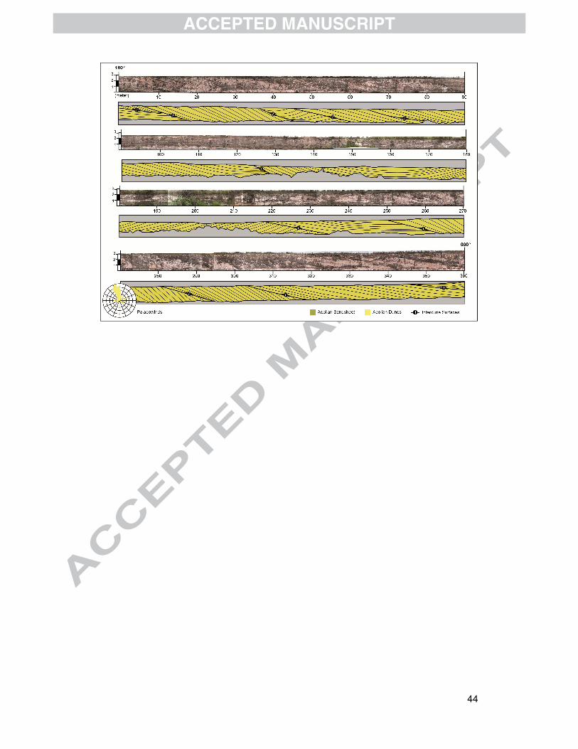
44

45

46
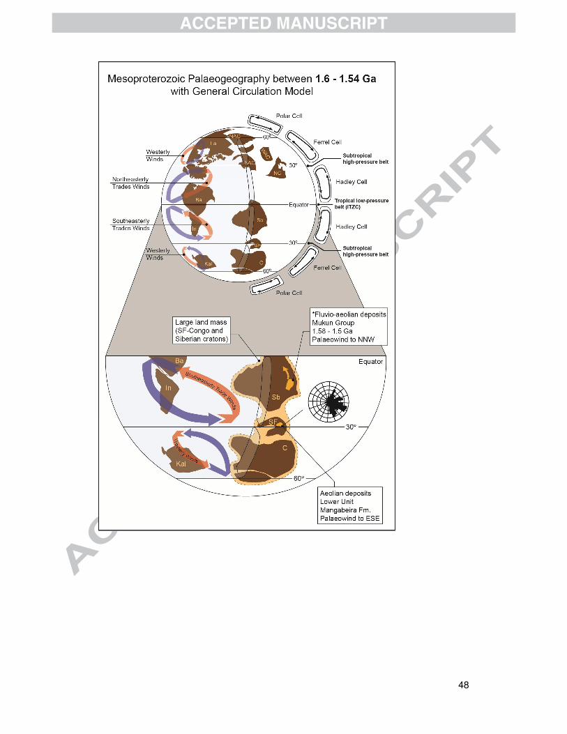
48
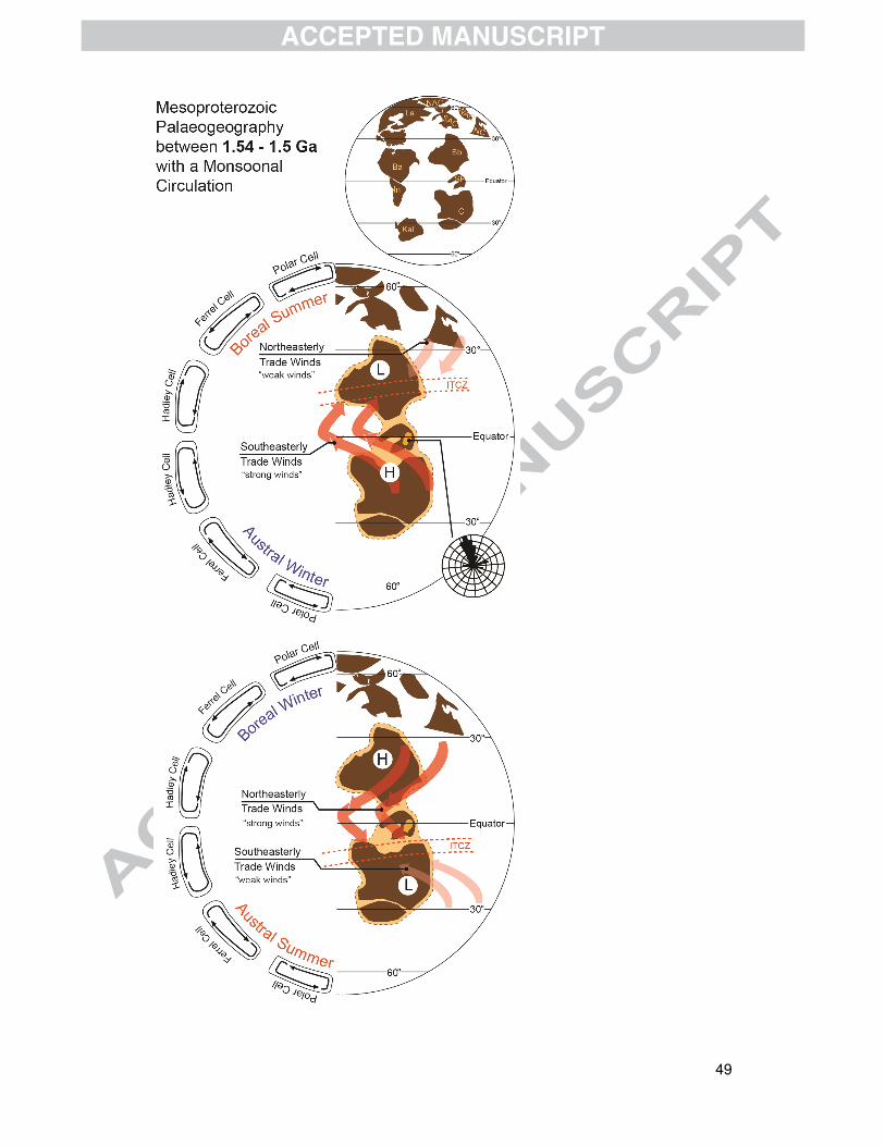
49

51
• First wind-pattern model for Mesoproterozoic (1.6 to 1.5 Ga); • Mesoproterozoic aeolian erg succession in the São Francisco Craton; • Palaeowinds directions as a palaeogeographic indicator