woollahra municipal council r1 recommendation to council
TRANSCRIPT

Woollahra Municipal Council Urban Planning Committee Agenda 16 November 2015
Item No. R1 Page 61
Item No: R1 Recommendation to Council
Subject: YARRANABBE PARK AND RUSHCUTTERS BAY PARK SEA WALLS ASSESSMENT OF HERITAGE SIGNIFICANCE
Author: Amelia Parkins, Strategic Heritage Officer Approvers: Chris Bluett, Manager - Strategic Planning
Allan Coker, Director - Planning & Development File No: 15/155149 Reason for Report: To respond to Council’s resolution of 12 October 2015 to investigate a local
heritage listing for Yarranabbe Park and Rushcutters Bay Park sea wall. Recommendation: A. THAT a planning proposal be prepared to list Yarranabbe Park and Rushcutters Bay Park sea
wall as a heritage item in the Woollahra Local Environmental Plan 2014.
B. THAT when requesting a gateway determination for the planning proposal at point A above, the Council seek delegation of the plan-making steps under section 59 of the Environmental Planning and Assessment Act 1979.
1. Background A Plan of Management for Rushcutters Bay Park, Yarranabbe Park and Plantation Reserve was prepared by Parkland Environmental Planners in 2005. In 2010, Woollahra Municipal Council commissioned Landscape Architects, Sturt Associates to prepare a standalone Plan of Management and Master Plan for Yarranabbe Park. The Yarranabbe Park Steering Committee was set up by Council to provide input, review and monitor the development of the Plan of Management (PoM) and Master Plan for Yarranabbe Park. The Yarranabbe Park PoM sets out actions and priorities for the park and was adopted by Council on 12 December 2011. At the meeting of the Yarranabbe Park Steering Committee of 13 August 2015, a council-commissioned feasibility study, prepared by JMD Design, for the construction of stairs breaching the sea wall at the northern end of Yarranabbe Park was presented. The feasibility study responded to an action from the Yarranabbe Park PoM and included a heritage assessment. A heritage study of Yarranabbe Park, prepared by Insite Land Solutions, commissioned by the Darling Point Society was also presented. On 12 October 2015 the Council adopted the following notice of motion from Councillor Keulemans:
A. THAT Council commend the Darling Point Society for commissioning a Heritage Report on Yarranabbe Park and thank them for their ongoing commitment to heritage preservation in our community.

Woollahra Municipal Council Urban Planning Committee Agenda 16 November 2015
Item No. R1 Page 62
B. THAT Council staff review the report commissioned by the Darling Point Society along with other relevant documentation and provide a report to the Urban Planning Committee, considering a local heritage listing of the Yarranabbe Park sea wall and Rushcutters Bay Park sea wall to the boundary with the City of Sydney, ensuring a contiguous heritage listing.
This report responds to the resolution of the Council by providing an assessment of cultural significance for the sea walls at Yarranabbe Park and Rushcutters Bay Park. To respond to the resolution, this assessment has been informed by the following documents: Report commissioned by the Darling Point Society: Heritage Study of Yarranabbe Park
Darling Point, prepared by Insite Land Solutions, April 2015; Yarranabbe Park Northern Plaza – Feasibility Study prepared by JMD Design Pty Ltd, July
2015 (appendix 3 – Assessment of Heritage Impact prepared by Geoffrey Britton); Rushcutters Bay Park, Yarranabbe Park and Plantation Reserve Plan of Management, 2005;
and Yarranabbe Park Plan of Management, prepared by Sturt Associates, 2012. 2. Context Rushcutters Bay Park and Yarranabbe Park are located on the foreshores of Rushcutters Bay on Sydney Harbour. Sydney Harbour is recognised as one of the finest harbours in the world and is one of Australia’s greatest cultural, recreational and commercial assets. The interface between the foreshore and the harbour at Darling Point is defined by the sea wall and park which have facilitated continuous enjoyment of the harbour since the early 1900s. Rushcutters Bay Park is located in both Sydney City Council and Woollahra Municipal Council areas. The boundary is marked by a stormwater drainage channel. The portion of Rushcutters Bay Park managed by Woollahra Council is bounded by Rushcutters Bay to the north (mean high water mark, marked by the outer face of the sea wall along the harbour), the Sydney Water owned stormwater channel to the west, New South Head Road to the south, New Beach Road to the south east, and the Cruising Yacht Club of Australia (CYCA) to the north east.

Woollahra Municipal Council Urban Planning Committee Agenda 16 November 2015
Item No. R1 Page 63
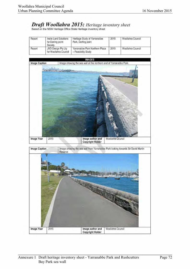
Figure 1. Cadastral map showing the location of Yarranabbe Park and Rushcutters Bay Park (Woollahra Council’s GIS mapping database, October 2015) Rushcutters Bay Park and Yarranabbe Park are separated by the D’Albora Marina and Sir David Martin Reserve. Sir David Martin Reserve adjoins D’Albora Marina and the southern boundary of Yarranabbe Park. The Reserve includes a number of buildings of various ages dating from the late 19th century, clustered around a former Parade Ground. Yarranabbe Park is bounded by New Beach Road to the east, Sir David Martin Reserve to the south and mean high water mark, marked by the outer face of the sea wall along the harbour. The parks are characterised by open grass, avenues of mature trees and the harbour. 3. The sea wall The sea wall is constructed from large rusticated sandstone blocks with a substantial finishing course with rusticated sides and a rounded upper profile. The blocks are approximately 1m wide. A pedestrian footpath has been constructed adjacent to the sea wall for the extent of both parks, wrapping around the rear of Sir David Martin Reserve and D’Albora Marina sites. The sandstone sea wall originally extended along the harbour edge continuously from Yarranabbe Park to Rushcutters Bay Park. The existing sea wall has been breached in a number of locations between Yarranabbe Park and Rushcutters Bay Park to allow for the marina activities at D’Albora Marina and Sir David Martin Reserve. Some sections of the wall were removed for the 2000 Sydney Olympic Sailing facility.

Woollahra Municipal Council Urban Planning Committee Agenda 16 November 2015
Item No. R1 Page 64
4. Ownership Rushcutters Bay Park is owned by Woollahra Municipal Council. Yarranabbe Park is located on Crown Land owned by the State of New South Wales. Crown Land is administered by the Department of Primary Industries under the Crown Lands Act 1989. The Park is managed through a Reserve Trust, with Woollahra Council as Trust Manager. 5. Historical overview
Rushcutters Bay Park and Yarranabbe Park are located on the western side of the promontory known as Darling Point, named after the wife of Governor Darling. The Aboriginal name for the point was Yarranabbe. The indigenous inhabitants of the area comprised of at least two clans, the Cadigal and the Birrabirralah1. However, by 1789 the majority of the Aboriginal population had been killed by the smallpox epidemic or moved away from the area. However, there are descendants still living in the area.
Rushcutters Bay Park and Yarranabbe Park were part of a major public works program that involved reclamation of the large area of marsh, channelling of the creek and construction of a ballast dyke sea wall.
The following table provides an overview of the historical development of Rushcutters Bay Park and Yarranabbe Park2:
Date Summary of historical events
Pre 1788 The land that is now known as Rushcutters Bay Park extending to Yarranabbe Park was a swamp area, with the mean high water mark on the east running approximately along the location as New Beach Road.
1810 Convict and landowner Thomas West (1773-1858) successfully petitioned Governor Macquarie for permission to erect a watermill3 on Rushcutters Creek in June 1810.
1830 New South Head Road was constructed, running through land granted to Thomas West.
1842 Sydney Town was incorporated. The creek flowing into the western side of Rushcutters Bay was fixed as the municipal boundary and remains the boundary today.
1860 The land adjacent to Rushcutters Bay was heavily cultivated, particularly by Chinese market gardens.
1875 A petition was signed by 500 residents of Rushcutters Bay urging the reclamation of land to the low water mark for the purpose of a public reserve. At this time there were complaints that the swamp area was unhealthy and unsightly.
1 Woollahra Council, Rushcutters Bay Park, Yarranabbe Park and Plantation Reserve Plan of Management, 2005. 2 Unless noted otherwise, information for this historical summary has been sourced from Rushcutters Bay Park, Yarranabbe Park and Plantation Reserve Plan of Management, 2005 and Insite Land Solutions, Heritage Study of Yarranabbe Park Darling Point, April 2015. 3 Australian Dictionary of Biography (http://adb.anu.edu.au/biography/west-thomas-13245)

Woollahra Municipal Council Urban Planning Committee Agenda 16 November 2015
Item No. R1 Page 65
1878 The Rushcutters Bay Act 1878 was passed dedicating Rushcutters Bay Park for Public Recreation.
1880 - 1890
The Rushcutters Bay foreshores, including land now known as Yarranabbe Park, was reclaimed by extending the land about 200m into the bay. At this time construction of the stormwater channel and a ballast dyke sea wall began.
1885 Rushcutters Bay Park was proclaimed as a Public Park on 11 December 1885 under the Public Parks Act 1884.
1889 The water frontage area was designated as a public landing place and a slip was provided for public use.
1890 A new vertical sea wall was constructed to replace the ballast dyke wall. The sea wall varied its location in parts from the ballast dyke wall, with portions of the new sea wall being constructed further out into the harbour than the first sea wall.
1899 Ten small allotments were created by the new alignment of the sea wall. Six boat sheds with associated slipways and jetties were constructed.
1902 NSW Volunteer Naval Brigade was utilising lands to the south of Yarranabbe Park. The land (now known as Sir David Martin Reserve) was gazetted for use as a naval recreation ground.
1904 First swimming sports were held in public baths at Rushcutters Bay (Yarranabbe Park).
1911 A row of palms was planted in a 15ft wide strip of land behind the boat sheds, which became known as Plantation Reserve. The reserve was intended as a link between the two foreshore parks.
1930 Aerial photographs and plans for Yarranabbe Park indicated a formal park design with circular garden beds. The avenue of figs was planted at this time as part of a municipality wide program of civic beautification works.
1944 The Cruising Yacht Club of Australia (CYCA) was formed.
1951 The CYCA acquired a boatshed at Rushcutters Bay and opened a club house to the east of Rushcutters Bay park in 1958.
1966 The Royal Navy Sailing Association formed to promote sailing in the Royal Australian Navy and operated from a boatshed at HMAS Rushcutter.
1968 HMAS Rushcutter was decommissioned (renamed Sir David Martin Reserve in 1991).
1974 The Harbour baths were demolished.
2000 Rushcutters Bay Park, Yarranabbe Park and Sir David Martin Reserve were used as the Olympic Sailing Shore Base for the Sydney 2000 Olympic and Paralympic Games.

Woollahra Municipal Council Urban Planning Committee Agenda 16 November 2015
Item No. R1 Page 66
6. Cultural significance 6.1 Heritage listing Yarranabbe Park and Rushcutters Bay Park are not listed as items of environmental heritage. However, they are in the vicinity of a number of heritage items, including Sir David Martin Reserve. The sea wall located to the west of Rushcutters Bay Park is listed as a heritage item in City of Sydney LEP 2012 and as an item of state heritage significance under the Heritage Act 1977. The listing describes the item as:
Rushcutters Bay Park and pumping station including grandstand, Reg Bartley Oval and picket fence, sea wall and landscaping.
Figure 2. An excerpt from City of Sydney LEP 2012 heritage map showing the extent of the heritage item (I1403)
6.2 Australia ICOMOS Burra Charter, 2013 To respond to the notice of motion the assessment of cultural significance was carried out in accordance with the Australia ICOMOS Burra Charter4 (Burra Charter). The Burra Charter is a guide to making good decisions about heritage places. The Burra Charter process describes the steps involved in identifying and managing the cultural significance of a place. This process is summarised below:
Step One: Understand significance Investigate the place Assessment of significance
4 The Burra Charter, 2013, The Australia ICOMOS Charter for Places of Cultural Significance

Woollahra Municipal Council Urban Planning Committee Agenda 16 November 2015
Item No. R1 Page 67
Step Two: Develop policy Identify all factors and issues Develop policy Prepare a management plan
Step Three: Manage in accordance with policy Implement the management plan Monitor the results and review the management plan
Cultural significance is the sum of the qualities or values that a place5 has, including the five values described in Article 1.2 of the Burra Charter- aesthetic, historic, scientific, social and spiritual. In NSW these values have been expanded to the seven criteria identified in the document Assessing Heritage Significance6. These criteria are: Criteria (a) Historic
Criteria (b) Historic Association Criteria (c) Aesthetic Criteria (d) Social Criteria (e) Technical/ Research Criteria (f) Rarity Criteria (g) Representativeness
The identification of the place as either having or not having cultural significance occurs in step one of the Burra Charter process. This is also known as an assessment of significance or heritage assessment. For a place to reach the threshold for heritage listing it needs to satisfy one or more of the seven criteria. 6.3 Assessment of significance The subject property was assessed in accordance with the Burra Charter process and using the NSW Heritage Office publication Assessing Heritage Significance. The assessment can be found in the draft heritage inventory sheet prepared for the property (annexure 1). The statement of significance found in the draft inventory sheet provides an overview of the cultural significance of the property:
The sea wall associated with Yarranabbe Park and Rushcutters Bay Park is an intact, representative example of a sea wall constructed in the late 19th century. The sea wall provides historical evidence of a major reclamation initiative to provide public recreation space undertaken by the NSW Government. The sea wall is part of the reclamation works that resulted in Yarranabbe Park and Rushcutters Bay Park. These parks form part of a large foreshore recreation precinct, which has provided locals and visitors with an opportunity to participate in recreational activities along the foreshore for over 100 years.
The assessment found that the sea wall satisfied historic, aesthetic and representative criteria and therefore warrants listing as a local heritage item in Woollahra LEP 2014.
5 Place is defined in the Burra Charter as: a geographically defined area. It may include elements, objects, spaces and views. Place may have tangible and intangible dimensions. 6 Assessing Heritage Significance, NSW Heritage Office 2001 (Heritage Manual Update)

Woollahra Municipal Council Urban Planning Committee Agenda 16 November 2015
Item No. R1 Page 68
7. Implications of heritage listing Heritage listing a site is a way of safe guarding part of the story of Australia’s past to enrich our present and future. The following provides a summary of the practical implications of a local heritage listing: Council is required to consider the effect of any proposed development to the item in the area
of the item; Heritage listing does not exclude changes or additions that do not detract from the heritage
significance of the item; and Maintenance of heritage items does not require formal approval.
8. Planning proposal The sea wall has been assessed as having sufficient heritage significance to warrant local listing. Heritage listing is achieved by preparing a planning proposal which aims to amend the Woollahra LEP 2014 by including the item in Schedule 5. The steps include: Prepare a planning proposal to list the sea walls as a heritage item in the Woollahra LEP 2014
(WLEP); Submit the planning proposal to the Department of Planning and Environment (including a
request for delegation of the plan-making steps); Receive a gateway determination from the Department; Carry out public consultation in accordance with the gateway determination (this will include
notification letters to adjoining properties and notification published on a weekly basis in the Wentworth Courier);
Report the findings of the public exhibition to the Urban Planning Committee; Subject to Council’s decision on whether to proceed, request the Parliamentary Counsel to
prepare a draft LEP to amend the Woollahra LEP 2014; Council makes (approves) the LEP, subject to obtaining delegations from the Minister,
otherwise the Minister makes the LEP; Gazettal of the LEP. 9. Conclusion The heritage significance of the Yarranabbe Park and Rushcutters Bay Park sea wall has been assessed in accordance with the Burra Charter and NSW heritage best practice guidelines. The sea wall fulfils three of the heritage assessment criteria for local heritage listing. The heritage significance of the sea wall is demonstrated by the physical fabric that provides evidence of a large scale, late 19th Century NSW Government reclamation initiative for the purpose of public recreation. The seawall has aesthetic significance as landmark element along the foreshore which complement the natural beauty of Rushcutters Bay. The sea wall and associated footpath and park provides the public with an opportunity to experience and enjoy sweeping views of Sydney Harbour. Annexures 1. Draft heritage inventory sheet - Yarranabbe Park and Rushcutters Bay Park sea wall

Woollahra Municipal Council Urban Planning Committee Agenda 16 November 2015
Annexure 1 Draft heritage inventory sheet - Yarranabbe Park and Rushcutters Bay Park sea wall
Page 69

Woollahra Municipal Council Urban Planning Committee Agenda 16 November 2015
Annexure 1 Draft heritage inventory sheet - Yarranabbe Park and Rushcutters Bay Park sea wall
Page 70

Woollahra Municipal Council Urban Planning Committee Agenda 16 November 2015
Annexure 1 Draft heritage inventory sheet - Yarranabbe Park and Rushcutters Bay Park sea wall
Page 71
Woollahra Municipal Council Urban Planning Committee Agenda 16 November 2015
Annexure 1 Draft heritage inventory sheet - Yarranabbe Park and Rushcutters Bay Park sea wall
Page 72

Woollahra Municipal Council Urban Planning Committee Agenda 16 November 2015
Annexure 1 Draft heritage inventory sheet - Yarranabbe Park and Rushcutters Bay Park sea wall
Page 73