a vision for schuylkill rail yards
DESCRIPTION
Final Report from CPLN 703 Planning Studio at the University of PennsylvaniaTRANSCRIPT

1
A Vision For SchuylkillRail Yards
CPLN 703 Planning Studio, University of Pennsylvania, Spring 2011

2

A Vision For SchuylkillRail Yards

Collaborators
Instructor:
Harris Steinberg
Students:
Philip Dawson
Mustufa Eran
Lauren Faber
Raman Gardner
Julieanne Herskowitz
Keyleigh Kern
Christy Leffall
Diana Lu
Michael Parkinson
Abigail Poses
Ashley Richards
Matthew VanOosten
Dominic Wong
Community and Economic Development
Public Private Development
Public Private Development
Urban Design
Public Private Development
Urban Design / Landscape Architecture
Community and Economic Development
Public Private Development
Urban Design
Community and Economic Development
Community and Economic Development
Urban Design
Public Private Development

Table of Contents
IntroductionExecutive Summary
Why the Yards?Problem StatementLocal and Regional ContextSite Opportunities and ConstraintsTimelineHistoric PlansTransportationEcology StakeholdersEconomicsSocial PolicyGovernanceCurrent PlansSummary
Values-Based ScenariosThe DeveloperThe Civic CitizenThe Environmentalist
The VisionThe PlanFramework : CirculationFramework : Public RealmFramework : Development
Phasing and ImplementationPhasingIntroducing the SYDC
Social and Environmental PolicySocial PolicyThe GID
Appendix
46
2022242628303234363840424446
48505458
6266687484
889094
98100110
116

6

7
The Schuylkill Yards, a 96-acre railyard serving Philadelphia’s 30th Street Station, is located in a prime area for development. The following section provides a brief summary of the site’s context in the neighborhood, city, and region, and provides recommendations for how to better connect and incorporate the Schuylkill Yards into the surrounding urban fabric. These recommendations include design strategies, governance structures, green infrastructure creation, and community benefits.

8
Executive Summary
Introduction: A City of Bold Plans
Philadelphia has always looked best when viewed from the Schuylkill River. It is a vantage point that perfectly shows the economic power of its downtown; the seat of its government; its most recognizable cultural icon; and the natural and transportation systems that tie it all together. It is also a place that illustrates how the city has developed over the past three centuries; a process that has been guided in large part by a series of bold visions and plans that imagined how a growing urban center could organize itself and build on its strengths.
These plans have never shied away from embracing a long-term view of Philadelphia’s prosperity, beginning with the earliest sketches of William Penn and Thomas Holmes, which imagined that a utopian colony on the banks of the Delaware River could someday stretch to the Schuylkill River in a neat fabric of streets and squares. Along the way, they maintained a progressive appreciation of the city’s natural assets, such as the vision for Fairmount Park, which safeguarded the city’s freshwater supply and bequeathed a legacy of green space to generations of Philadelphians.
The plans proposed by these visionaries also have not been lacking for a sense of grandeur, from the ambitious complex that showcased Philadelphia as the pride of the nation at the Centennial Exposition to the Beaux Arts vision that sought to beautify the industrial city through the creation of the Benjamin Franklin Parkway. That search for a new urban order reached its zenith around the middle of the twentieth century, as Edmund Bacon envisioned a city in which efficient expressways replaced traffic-choked streets, new modern homes replaced blighted downtown neighborhoods, and office towers replaced smokestacks.
While Bacon’s dream was certainly bold and transformative, current Philadelphia plans have tempered this intrepidness with other qualities like equitability, environmental consciousness, and preservation.
From Greenworks to Green City, Clean Waters, to Philadelphia 2035, the city’s current planning framework calls for meeting ambitious green infrastructure goals at the citywide level, and for adopting a strategy that views
every development site as a means to that end. Thus, while times have changed, the value of proposing bold visions, investing in long-term
strengths, and positioning the city for competitiveness has remained strikingly constant. It is within this tradition that Philadelphia should consider the development of the Schuylkill Yards.
Physical Context
A common thread in contemporary Philadelphia plans is their increasing awareness of the city’s place within the larger systems and geographies that will fuel its competitiveness in the 21st century. Philadelphia sits at the center of the fifth largest metropolitan area in the country, and is well-located on the Northeast Corridor between such urban centers as Washington, D.C., New York City, and Boston, all of which are connected via an intricate network of road, rail, and air travel. With a population of over one and a half million people, Philadelphia is the undisputed economic and cultural heart of that region, and its downtown, in turn, is the nexus of those strengths. Just as the boundaries of downtown have grown outward in past centuries from Old City, the center of the 21st century city has expanded yet again. From the Delaware River to 40th Street and from Washington Avenue to Girard Avenue, the area that the Philadelphia City Planning Commission has denominated “the metropolitan center” currently contains 49% of Philadelphia’s jobs, major universities and hospitals, and a growing residential population. Amidst this favorable
Observing the surrounding land uses, the Schuylkill Yards stand out as a strategically-located parcel of land that is ripe for more intensive development.
Executive Summary

9
characteristic, abutting the Schuylkill River just across from Center City Philadelphia, sits the Schuylkill Yards.
Observing the surrounding land uses, the Schuylkill Yards stand out as a strategically-located parcel of land that is ripe for more intensive development. With one of West Philadelphia’s most distinctive neighborhoods to the west; Drexel and the University of Pennsylvania to the south; the Art Museum and Center City to the east, and unparalleled views of the Philadelphia skyline, the site is well-disposed for uses other than a railyard. If there is one reason, however, why the Schuylkill Yards have yet to be developed, it is due to the fundamental importance the site currently holds to the city’s overall connectivity. The 96 acre site has served as a rail hub and gateway to Philadelphia since the late 19th century, and has come to host a web of transportation infrastructure that serves at once as its greatest asset and one of the most complicating factors for redevelopment.
The site is largely owned and controlled by Amtrak, and provides access to and from 30th Street Station for eleven national rail lines, including the Northeast Corridor (the most heavily traveled rail route in the United States). Even so, fully 55 acres of Amtrak’s property is comprised of the Penn Coach Yards, an area used for cleaning, fueling, and storing trains—all activities which the agency admits could be relocated to alternate locations in the future. The Southeastern Pennsylvania

10
Transportation Authority (SEPTA) displays similar usage patterns on their side of the site, where trains for each of the region’s 13 rail lines pass through every day on their way in and out of Center City. SEPTA has also reserved a substantial portion of their land for staging trains in preparation for rush hour—a use which they also recognize could be relocated elsewhere in the system if compelling plans for the site were to take shape.
Another small, yet important, right-of-way on the Schuylkill Yards pertains to the private freight company CSX, whose viaduct is part of a vital rail link between Philadelphia’s ports and points northward. In addition to rail infrastructure, the site is separated from the Schuylkill River to the east by Interstate 76 and the Vine Street Expressway interchange. Both highways offer essential roadway links to and through Center City, yet also present barriers to the site’s
overall connectivity and waterfront access.
Of the several significant landmarks that sit on or adjacent to the Schuylkill Yards, one of the most recognizable is the one building through which much of the surrounding transportation infrastructure connects: 30th Street Station. This landmark structure, built in the Classical Revival style, opened in 1933, and boasts 16 tracks on two levels of platforms in addition to commercial and office space. While it also serves as a gateway to Philadelphia for the thousands of travelers who use the station every day, the building struggles to overcome the isolation imposed upon it by heavy traffic from the surrounding built environment.
This challenge is shared by the Cira Centre, a 29-story skyscraper built on the Schuylkill Yards to the north of the station, but it
has not prevented the building from capitalizing on its location to attract office tenants, or from quickly becoming one of West Philadelphia’s architectural icons. It also presents an encouraging example of the type of development that can be incentivized through the Keystone Opportunity Improvement Zone tax abatement program.
Iconic architecture and new office tenants also proved to be a successful combination in the United States Post Office building on the south side of Market Street. The 1935 structure was successfully repurposed as a home for 5,000 IRS workers, and is considered part of the “grand civic room” being created in front of 30th Street Station. Another civic space of unrivalled status can be found in the Philadelphia Museum of Art, whose location directly across the river from the site offers tantalizing possibilities as a direct connection and view corridor to a redeveloped Schuylkill Yards. With one million visitors per year, the Museum is the city’s largest cultural institution has the potential to generate a critical mass of people along a corridor connecting it with 30th Street Station.
Such possibilities emphasize the fact that the site’s natural systems—the Schuylkill River foremost among them—can be seen as assets rather than as barriers for development. The Schuylkill River, a tidal waterway with both natural banks and bulkheads at its edge, has recently reclaimed this status with the construction of the Schuylkill Banks trail along its eastern edge. Thus, the Schuylkill River, whose name means “hidden river,” has evolved into anything but that for many
Executive Summary

11
Philadelphians. Yet, the historic streams that bisect the site remain well concealed beneath a century’s worth of development and sewers, constituting timely reminders of how human activity has altered the land from its natural state. Still, considering the Schuylkill Yards for new types of development demands a keen awareness of these waterways, as well as the topography and geography of the surrounding land. Situated as it is within the 100-year flood plain, the site is susceptible to flooding from large storm events and sea level rise, holding implications for the grading of land and placement of land uses.
The last, but by no means the least important, set of conditions for evaluating the site is its urban context. The Schuylkill Yards exists at the juncture of several rich, yet distinct pieces of Philadelphia’s urban fabric, and managing the integration of these parts is an essential step in crafting a coherent vision. The adjacent stakeholder that stands to benefit most directly from the development of the Schuylkill Yards is Drexel University. With a student body that has grown over 100% in the past decade to now include more than 22,000 students, Drexel has sought to undertake the physical development necessary to sustain such a burgeoning population. Drexel’s new President, John Fry, has pledged to make the school a world-class university and with the recent effort to complete a new campus master plan, the stage is set for the University’s continued expansion.

12
Growth has likewise been the trend at the University of Pennsylvania, which took a bold step toward the east through the adoption of its PennConnects Plan. With the addition of Penn Park, a complex of recreational facilities south of Walnut Street, the University has taken a pioneering role in redeveloping former industrial lands along the Schuylkill River.
Nevertheless, university expansion does not always take place on vacant land with little local impact. Powelton Village, located north of Drexel’s campus and west of the Schuylkill Yards, is renowned for its historic and architectural character, but also struggles with the continued encroachment of student residents into a limited local housing supply.
Mantua, a much poorer neighborhood to the north of Powelton Village, has begun to feel these same effects, but is still primarily concerned with the more pressing issues of high vacancy rates, crime, and unemployment. While there has been little interest in private sector development in Mantua for several decades, this is set to change, as the recent award of a Choice Neighborhoods grant is a potential game-changer in the short-term.
All of these areas have the good fortune to be united by an extensive network of public spaces and corridors, from the Benjamin Franklin Parkway to the Schuylkill Banks, to Drexel Park and Woodland Walk. They join together the Art Museum, Center City, and 30th Street Station in an arrangement that
has all the makings of a great civic triangle, but for the one leg that is missing. The decision to make that connection is not one that should be taken lightly, but if the history of Philadelphia’s boldest visions reveals anything, it is that transformative projects can and do happen, especially when they represent the best investment in the city’s future. A half century ago, trains arriving in Philadelphia from the west rode through Center City on an elevated viaduct before arriving at City Hall. Today, the so-called Chinese Wall is only a memory, and the soaring office district of Penn Center stands in its place, a monument to the coalescing of development, economic prosperity, and transportation infrastructure. For Philadelphia, the time for the next big vision has come, and the ingredients for it can all be found at the Schuylkill Yards.
Arguments for Development
A robust public transportation network is one of the region’s strongest assets, and no transit hub in the region can offer a higher volume of passengers to support development than 30th Street Station.
With existing Acela service and the prospect of higher-speed trains in the future, Philadelphia could shape up to be an affordable alternative to New York City, especially if ample space for new development were to open near the Amtrak station. Within the metropolitan area, Amtrak’s upcoming addition of 30 new regional bus departures every
Executive Summary

13
day promises to make 30th Street Station, and downtown Philadelphia, accessible to an even larger commutershed of workers.
“Eds and Meds” have long been the economic strengths of the city, and 46% of all jobs in those sectors are located within only 5% of the city’s land area—specifically that area within a 2 mile radius of the Schuylkill Yards. With economic data indicating that these will be two of the fastest-growing sectors in the nation from 2008 to 2018, Philadelphia can expect to gain 28,000 new jobs in Meds and Eds alone—jobs that will benefit from new facilities and good transportation access. Since universities add an average of one million square feet every decade, Drexel’s ambitions for expansion may find themselves constrained by a lack of available space.
Due to recent student population growth, opening up land for Drexel’s development along the Schuylkill River is the best way to ensure that demand for new classrooms, recreation facilities, and student housing is met without disrupting surrounding neighborhoods.
Design
The design moves proposed for the Schuylkill Yards complete a series of visions and principles that seek to improve connectivity, create an iconic destination, respect the site’s natural systems, build civic partnerships, promote equitable development, and help Philadelphia grow as a regional center. Thus, the resulting site plan works on three levels: as a district, as a piece within
a larger urban fabric, and as a node of centrality along the Northeast Corridor.
The final proposed site plan is divided into separate frameworks: movement, public realm and development. The movement framework is focused on using the Schuylkill Yards to strengthen the connections between West Philadelphia, Center City, and the Art Museum area, thus creating a civic triangle. To achieve this, several major infrastructure moves are proposed for both sides of the Schuylkill River. First, the street grid adjacent to the Schuylkill Yards will be extended onto the site itself. Due to the significant grade change that currently exists between the site and its surrounding neighborhoods, extending the street grid is only possible if the SEPTA Regional Rail tracks on the entire western portion of the site are buried. The tunnel that will house these Regional Rail tracks will continue beneath the
surface of the Schuylkill River, and will enable the creation of a new train station at 22nd Street.
Similar to the major infrastructure moves on the western portion of the site, the recommendations for the eastern half of the Schuylkill Yards will require significant time and investment. First, the plan calls for decking to be placed above Amtrak’s Northeast Corridor tracks. This platform will meet the river, thus providing waterfront access. In order to successfully accomplish this, the Vine Street Expressway’s southbound lane at the I-76 interchange will need to be relocated. Removing this lane, which is currently ensconced in a confusing knot of roads, will lower the height of the highway by 20 feet. The southbound lane of I-676 will be relocated to the eastern side of the Schuylkill River and will run as a two-way boulevard along the right-of-way currently occupied by a duplicate-service CSX freight

14
Legend
1. Spring Garden Park
2. Highline Park
3. Waterfront Park
4. Art Museum
Footbridge
5. Powelton / Vine
Street Bridge
6. Eastern Parkway
7. Race Street Bridge
8. Center City
Pedestrian Bridge
9. 22nd Street Station
10. 30th Street Plaza
line. This Eastern Parkway will meet up with I-76 at Grays Ferry Avenue. The final major movement recommendation is to enhance pedestrian connections across the river. In particular, the site plan calls for the construction of two pedestrian bridges between the site and the eastern side of the Schuylkill Banks.
The second framework for the proposed site plan revolves around the public realm. The recommendations made under this section strengthen the pedestrian connections and experience to and through the site. One of the primary elements of the public realm section is the creation of a park system. This is not limited to the parks within Schuylkill Yards, but also calls for the renovation of Drexel Park and the creation of new green spaces
around the site. These include a small park adjacent to the Spring Garden Street Bridge as well as a new green element at the base of one of the proposed pedestrian bridges. Finally, while not a neighborhood park, the plan also calls for the incorporation of sustainable features, such as green roofs, in a number of newly constructed buildings.
In addition to these smaller public realm moves, this plan also calls for the creation of two larger parks: Highline Park and Schuylkill River Park West. Highline Park will run in a north-south direction along the new 30th Street Boulevard from the Spring Garden Street Bridge to Penn Park, and will be located beneath the CSX elevated freight line. This will not only act as a public amenity for pedestrians, but will also house stormwater management features.
Schuylkill River Park West will sit on top of the deck that will run along the eastern portion of the Schuylkill Yards site. The park will provide linkages to Fairmount Park East, the Ben Franklin Parkway and the Art Museum with the aid of the new proposed pedestrian bridges. Providing connections between other public realm spaces is not the only public benefit. This park will be programmed to accommodate a variety of activities such as reserved areas for recreation, civic functions, and public art, and will contain a riverfront esplanade that links West Park and Penn Park.
The final element of the public realm design recommendations involves the areas around 30th Street Station. In particular, the site plan proposes the creation of a new public plaza on the northwest corner
Executive Summary

15

16
of 30th and Market Streets (directly across from the train station). This plaza will include a café, outdoor seating, and a public fountain. In addition to the new public plaza, the areas around 30th Street Station will have enhanced pedestrian connections. This includes the creation of a pedestrian walkway on the former SEPTA Regional Rail bridge, the extension of Woodland Walk from Penn’s campus to 30th Street Station, and the creation of a more pedestrian-friendly JFK Boulevard.
The final design framework revolves around development. The site plan conceives of the entire Schuylkill Yards site as a mixed-use district. Thus, the land uses have been allocated to specific areas of the site. All commercial uses will be located within a 10 minute walk of the train station. As Drexel University is expected to continue to expand in the coming years, the southwest edge of the site will be an extension of the university, with new institutional buildings and campus housing. The northern portion of the site will contain residential uses that will mimic the neighborhood fabric of Powelton Village and Mantua, albeit with greater density. In addition to on-site development uses, the plan is intended to drive development in both West Philadelphia and Center City. In West Philadelphia, this will likely manifest in the creation of small
businesses, community agriculture, and affordable infill housing. In Center City, the creation of a new 22nd Street transit station will spur catalytic development (mostly office uses) around that area.
Governance
As a complex, long-term public-private partnership, the Schuylkill Yards will require a governance structure that is capable of navigating the planning, funding, and political needs that such an initiative entails. Based on models that have been successfully applied in projects like Battery Park City and the Hudson Yards, the central entity that this vision recommends creating for that purpose is the Schuylkill Yards Development Corporation (SYDC). The SYDC will be a not-for-profit development corporation whose mission is to plan, create, coordinate, and maintain the
development of the Schuylkill Yards in the hopes that it will become a new prime destination for Philadelphians and visitors. Through public-private partnerships that seek to leverage public funding to attract private investment, the development of the Schuylkill Yards
will promote economic and cultural vitality of Philadelphia, generate additional tax revenue for the city, and connect Center City with West Philadelphia seamlessly into the urban fabric.
In order to ensure that development follows the values and principles
set forth in this vision, one of the SYDC’s first actions must be the approval of a master plan for the Schuylkill Yards. Such a document should assume a strong role in guiding future growth, but should also remain flexible enough to accommodate changing economic conditions and stakeholder priorities. Given the pivotal position that these groups will play in the development of the site, engaging them and forming partnerships with them should be another early focus of the SYDC. The boundaries of this organization incorporate Mantua, Powelton Village, and parts of University City and Center City. The inclusion of these areas will provide current stakeholders with formal representation under the SYDC and make it easier to seamlessly integrate the site with its surroundings. These boundaries will also enable the SYDC to implement the Green Infrastructure District (GID) and economic development policies that are essential to extending the benefits of development to adjacent neighborhoods.
In addition to incorporating stakeholder groups, the board of the SYDC must include influential elected leaders who can secure funding and marshal political support for its work. Upon its inception, both State and City officials will have to collaborate to draft the enabling legislation for the creation of the development corporation. In regard to financing development, the SYDC must be able to gather public and private funding to support initial infrastructure—a role that the Philadelphia Industrial Development
The SYDC will be a not-for-profit development corporation whose mission is to plan, create, coordinate, and maintain the development of the Schuylkill Yards in the hopes that it will become a new prime destination for Philadelphians and visitors.
Executive Summary

17
Corporation (PIDC) could champion as a partner in the project. Ultimately, the $3.2 billion infrastructure cost would be funded by debt market, government funding programs, and direct government subsidy. Even with these funding sources, extending the KOIZ tax abatements for new projects will likely be necessary to attract private developers to the Schuylkill Yards. As development continues, the site’s status as a prime regional destination should catalyze further growth in adjacent neighborhoods.
Social Policy
The development of the site is clearly in the long-term economic interests of the city and region. Even so, the overall benefit of large projects like the Schuylkill Yards can be partially negated by lax business practices which channel development dollars out of the area and by rising peripheral property values which endanger residents’ ability to remain in their homes. For that reason, it is necessary to implement a set of carefully-considered policies to ensure that growth serves to strengthen nearby communities while avoiding the negative externalities of gentrification. Some of the best precedents for undertaking development in partnership with communities can be found in the initiatives sponsored and implemented by the University of Pennsylvania and Drexel University. Penn’s West Philadelphia Initiatives transformed neighborhoods to the west of campus through a combination of home ownership promotion, public education

18
improvement, and commercial corridor development, while Drexel has pioneered a program to increase healthy food access in nearby communities. While these voluntary programs present a good model on which to build, the extent of the public investment in the Schuylkill Yards justifies a more comprehensive policy-based strategy. In order to combat the effects of rising property values and increased demand for real estate near the Schuylkill Yards, the City should approve the homestead tax exemption. Similarly, the application of an inclusionary zoning district in the area would ensure that buyers and renters of diverse socioeconomic conditions could reside in the new community that is created.
While these measures effectively address problems with occupied land, additional programs are needed to manage the excess of vacant land in Mantua. The approval of land banking enabling legislation by the Commonwealth could complement the the city’s current vacant land reform strategy by facilitating the assembly of parcels for redevelopment. While it is more challenging to implement, a community land trust is an alternative tool that could relieve pressure in the real estate market by preserving land for community development projects or affordable housing. Finally, the conversion of
some vacant plots into community gardens and public spaces is useful as a means of increasing fresh food access and enhancing the public environment.
Still other policies can leverage investment in the Yards to improve the conditions of adjacent land and the economic prospects of existing residents. As part of a specialized community benefits agreement, developers could be required to pay a “social impact fee” into a trust fund that the SYDC could designate for use in local revitalization initiatives. The SYDC could also manage a revolving loan fund for home repairs for low-income residents, which could be capitalized by a $1 million dollar investment from Drexel. Lastly, a trio of workforce development initiatives can help connect residents of Powelton Village and Mantua to
living-wage jobs that are generated through the Schuylkill Yards development. While job skills training can serve the large young adult population in these neighborhoods that are not connected to Penn or Drexel, first-source hiring
will guarantee the existence of a job pool for these qualified workers. Likewise, business development support can provide opportunities for self-employment and facilitate the revitalization of blighted commercial corridors. The Schuylkill Yards have the good fortune to be bounded by institutions and
communities that are actively articulating plans for their future. By pairing physical development with specialized community and economic development policies, the Schuylkill Yards can realize these visions and increase their benefit to the city and region.
Green Infrastructure
From Fairmount Park to the Fairmount Waterworks, Philadelphia historically led the nation in planning for the protection and purity of municipal water systems. Even so, the city’s once-groundbreaking sewer system is deficient by modern environmental standards, both due to its age and the possibility for combined sewer overflow (CSO), or the release of untreated runoff into waterways during major storm events. In keeping with tradition, the City and the Philadelphia Water Department (PWD) have responded with an ambitious series of plans designed to achieve Mayor Michael Nutter’s goal of making Philadelphia “the greenest city in America” in terms of stormwater management. As infrastructure is gradually replaced and upgraded at the citywide level, the Schuylkill Yards should capitalize on its status as an iconic public-private investment to create a sphere of advanced green infrastructure on site and in its surrounding neighborhoods. By establishing a Green Infrastructure District (GID), the Schuylkill Yards Development Corporation will manage a collective and coordinated effort to develop, maintain, and promote a network of stormwater management infrastructure in the area.
By establishing a Green Infrastructure District, the Schuylkill Yards Development Corporation will manage a collective and coordinated effort to develop, maintain, and promote a network of stormwater management infrastructure in the area.
Executive Summary
19
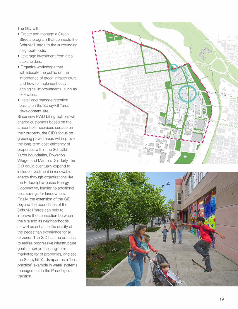
The GID will:• Create and manage a Green Streets program that connects the Schuylkill Yards to the surrounding neighborhoods;
• Leverage investment from area stakeholders;
• Organize workshops that will educate the public on the importance of green infrastructure, and how to implement easy ecological improvements, such as bioswales;
• Install and manage retention basins on the Schuylkill Yards development site.
Since new PWD billing policies will charge customers based on the amount of impervious surface on their property, the GID’s focus on greening paved areas will improve the long-term cost-efficiency of properties within the Schuylkill Yards boundaries, Powelton Village, and Mantua. Similarly, the GID could eventually expand to include investment in renewable energy through organizations like the Philadelphia-based Energy Cooperative, leading to additional cost savings for landowners. Finally, the extension of the GID beyond the boundaries of the Schuylkill Yards can help to improve the connection between the site and its neighborhoods as well as enhance the quality of the pedestrian experience for all citizens. The GID has the potential to realize progressive infrastructure goals, improve the long-term marketability of properties, and set the Schuylkill Yards apart as a “best practice” example in water systems management in the Philadelphia tradition.

20
Conclusion
Transportation infrastructure,
job growth, demand for real
estate, growing population,
and civic amenities each exist
somewhere in Philadelphia,
but nowhere outside of the
Schuylkill Yards do they
coalesce around 96 acres
of developable land at the
heart of the metropolitan
center. If ever an area
justified a bold vision in the
Philadelphia tradition, it is the
Schuylkill Yards, and these
characteristics form the heart
of a vision for the site as part
of the 21st century city.
Executive Summary

21

22

23
In order to make a strong case for undertaking development, this section traces the history of the Schuylkill Yards and details the site’s opportunities and constraints. The assets examined in this section include: the ecology of the site, transportation infrastructure, area stakeholders, the economy of the city and region, and ongoing initiatives to improve the design and environment of the city.

24
By 2035, the city of Philadelphia is expected to add between 100,000 and 400,000 residents after decades of population loss. With this growth, Center City’s boundaries will expand across the Schuylkill River to 40th Street, thereby placing the Schuylkill Yards at the heart of Center City. This 97-acre site sits adjacent to 30th Street Station, the third most heavily traveled rail station in the country and a major regional transit hub. It is within close proximity of many of Philadelphia’s most treasured physical and cultural assets—including the green refuges of the Fairmount Park system and the majestic architecture of the Art Museum. In
spite of this ideal location, the site is profoundly disconnected from these assets. At the railyards’ stark edges, Philadelphia’s rich urban fabric dissolves into a tangle of transportation uses, from the highly sensitive Northeast Corridor, to regional and local rail, maintenance facilities, an elevated freight line and major highway interchanges. The potential of its location, linking University to Center City, West Philadelphia to the Ben Franklin Parkway, and the Upper and Lower Schuylkill Rivers, has tantalized generations of Philadelphia’s visionaries, but none have overcome the challenges to its development.
Problem Statement
How do we transform the industrial landscape into
a productive part of the 21st century city?
How do we transform the Schuylkill Yards into a
productive part of Philadelphia’s future?
Why the Yards?

25
View of Center City and the Schuylkill Yards from the Spring Garden Street Bridge
Intersection of Spring Garden Street and 32nd Street
View of Penn Coach Yards and Cira Centre from the Spring Garden Street Bridge

26
Where is 30th Street?
30th Street Station and the Schuylkill Rail Yards are located in the northeast corner of the University City neighborhood in Philadelphia, Pennsylvania. The site itself is a transportation node that connects the eastern seaboard, the surrounding region, the city of Philadelphia and the adjacent neighborhoods through layers of transportation networks that flow through the site. In addition to serving as the hinge of Northeast Corridor train traffic, 30th Street Station is the beacon of the west side of the Schuylkill River, anchoring University City as a major participant in the traffic flow in and out of Center City Philadelphia.
Where is the site?
From a bird’s-eye view, the site is bounded by the Schuylkill Expressway (I-76) and the Schuylkill River to the East; Market Street to the South; the Drexel University campus, Powelton Village and Mantua neighborhoods to the west; and the Spring Garden Street Bridge to the North.
On the ground, however, the edges that surround the site and the layers within those boundaries become much more complex, particularly around the station. Layers of ownership and individual interests accompany the physical infrastructure that lies beneath the street. These various networks
include the underground subway and trolley tracks; Amtrak lines; distribution corridors (USPS connections to 30th St. Station); utilities; an access road to the rail yards; support columns for the roads above; and Amtrak platforms.
The infrastructure continues at and above street level. It includes four vehicular lanes located on Market Street towards the new IRS building to the south (and roughly the same number to the east), multiple lanes of vehicular standing areas and two traffic lanes the I-76 30th Street off-ramp. It also includes the elevated SEPTA regional rail platforms, the Cira Centre with its parking garage to the north, and multiple lanes of vehicular standing areas, four lanes of traffic, the SEPTA underground entrances, parking areas, the loading/unloading areas for Megabus and Bolt buses, the elevated CSX freight line, and the former Bulletin building to the west.
Just North of the Cira Centre garage, the site becomes much more simple in terms of its ownership, but impossible to navigate due to current train activity. The yards offer a vast, relatively flat, open space with views of rails and catenary lines on all sides. Beyond the lines to the east, however, the Center City skyline punctuates the view, melting into the green of the Schuylkill Banks and the expansive pedestal of the Philadelphia Art Museum. To the north and the west, catenary lines, the Spring Garden
Local and Regional Context
Street Bridge, and the CSX highline dominate the view from the ground, though there are glimpses of the Drexel buildings and the Powelton and Mantua neighborhoods. The towering presence of the Cira Centre and its garage characterize the view to the south. Views to the east and west of the complex reveal the Amtrak lines (active Northeast corridor lines and maintenance and support), emerging from the underside of the street platform. At street level, car traffic from the University City I–76 exit and cab traffic loop around the station and under the elevated SEPTA regional rail lines.
From the edges of the rail yard looking in, the space is an enormous void in the urban fabric of the city that surrounds it. Empty freight cars, haphazard parking lots, and piles of materials and debris characterize the activity on the site. Though trains snake through the chaos on a regular basis, the overall impression of the site is that of an industrial wasteland, not of a preeminent 21st century transportation node.
Why the Yards?

27

28
Site Opportunities and Constraints
views of the Philadelphia skyline, the site is well-disposed for uses other than a railyard. The 96-acre site has served as a rail hub and gateway to Philadelphia since the late 19th century, and has come to host a web of transportation infrastructure that serves at once as its greatest asset and one of the most complicating factors for redevelopment.
The largest area of the site is under Amtrak ownership, and provides access to and from 30th Street Station. Even so, fully 55 acres of Amtrak’s property is comprised of the Penn Coach Yards, an area used for cleaning, fueling, and storing trains—all activities which the agency admits could be relocated to alternate locations in the future. The Southeastern Pennsylvania Transportation Authority (SEPTA) displays similar usage patterns on their side of the site. SEPTA has also reserved a substantial portion of their land for staging trains there in preparation for rush hour—a use which they also recognize could be relocated elsewhere in the system if compelling plans for the site were to take shape.
Another small, yet important, right-of-way on the Schuylkill Yards pertains to the private freight company CSX, whose viaduct is part of a vital rail link between Philadelphia’s ports and points northward. In addition to rail infrastructure, the site is also separated from the Schuylkill River to the east by Interstate 76 and the
Vine Street Expressway interchange. Both highways offer essential roadway links to and through Center City, yet also present barriers to the site’s overall connectivity and waterfront access.
Of the several significant landmarks that sit on or adjacent to the Schuylkill Yards, one of the most recognizable is the one building in which much of the surrounding transportation infrastructure connects: 30th Street Station. While it also serves as a gateway to Philadelphia for the thousands of travelers who use the station everyday, the building struggles to overcome the isolation imposed upon it by heavy traffic from the surrounding built environment.
This challenge is shared by the Cira Centre, a 29-story skyscraper built on the Schuylkill Yards to the north of the station, but it hasn’t prevented the building from capitalizing on its accessibility to attract office tenants, or from quickly becoming one of West Philadelphia’s architectural icons. Iconic architecture and new office tenants also proved to be a successful combination in the United States Post Office building on the south side of Market Street. The 1935 structure was successfully repurposed as a home for 5,000 IRS workers. The western side of this space is distinguished by the Bulletin Building, a 1954 newspaper headquarters built in the International Style that has been repurposed as a modern office building under Drexel University’s
Infrastructure
Landmarks
Natural Systems
With one of West Philadelphia’s most distinctive neighborhoods to the west, Drexel and the University of Pennsylvania to the south, the Art Museum and Center City within walking distance, and unparalleled
Why the Yards?

29
ownership. Another civic space of unrivalled status can be found in the Philadelphia Museum of Art, whose location directly across the river from the site Yards offers tantalizing possibilities as a direct connection and view corridor to a redeveloped Schuylkill Yards.
Such possibilities emphasize the fact that the site’s natural systems—the Schuylkill River foremost among them—can be seen as assets rather than barriers for development. The River, a tidal waterway with both natural banks and bulkheads at its edge, has recently reclaimed this status with the construction of the Schuylkill Banks trail along its eastern edge. So it is that the Schuylkill, whose name means “hidden river,” has evolved into anything but that for many Philadelphians. Yet, the historic streams remain well concealed beneath a century’s worth of development and sewers, constituting timely reminders of how human activity has altered the land from its natural state. Situated as it is within the 100-year flood plain, the site is susceptible to flooding from large storm events and sea level rise, holding implications for the grading of land and placement of land uses.
The adjacent stakeholder that stands to benefit most directly from the development of the Yards is Drexel University. With a student body that has grown rapidly to over 22,000 in recent years, Drexel has sought to undertake the physical development necessary to sustain such a burgeoning population. With new President John Fry’s pledge to make Drexel a world-class university
and the recent inauguration of a new campus master plan, the stage is set for the University’s continued expansion.
Growth has likewise been the trend at the University of Pennsylvania, which took a bold step toward the east through the adoption of its PennConnects Plan. With PennPark, a complex of recreational facilities south of Walnut Street, set to open this year, the University has taken a pioneering role in redeveloping former industrial lands along the Schuylkill, and provided a green corridor to the south of the Schuylkill Yards site.
Powelton Village, located north of Drexel’s campus and west of the Yards, is renowned for its historic and architectural character, but also struggles with the continued encroachment of student residents into a limited local housing supply.Mantua, a much poorer neighborhood above Powelton Village, has begun to feel these effects, but is still primarily concerned with the more pressing issues of high vacancy rates, crime, and unemployment.
All of these areas have the good fortune to be united by an extensive network of public spaces and corridors, from the Benjamin Franklin Parkway to the Schuylkill Banks, to Drexel Park and Woodland Walk. They join together the Art Museum, Center City, and 30th Street Station in an arrangement that has all the makings of a great civic triangle, but for the one leg that is missing. For Philadelphia, the time for next big vision for the 21st century city has come, and the ingredients for it can all be found at the Schuylkill Yards.
Local Institutions
Neighborhoods
Civic Triangle
Public Realm

1805 - First Permanent Bridge at Market Street
1855- Founding Of Fairmount Park
1871: Relocation of the University of Pennsylvania from Old City to West Philadelphia.
1891: Founding of Drexel University by financier and philanthropist Anthony J. Drexel
1907- Construction oF Market-Frankford El
1933: Completion of 30th Street Station by the architectural firm of Graham, Anderson, Probst & White. Upon its completion, the new structure becomes the principal transportation hub for the entire city and much of the region.
1935: Completion of 30th Street Post Office.
From Transportation Hub...
1858: Extension of the trolley lines along Market Street into West Philadelphia
1800 19001850

1955: The Philadelphia Evening Bulletin relocates from Center City to a new headquarters at 3100 Market Street, designed by George Howe in concert with Robert Montgomery Brown.
.....To Institutional Core
1960: Completion of the Schuylkill Expressway.
1960s: The urban renewal era sees the destruction of “Black Bottom”, a predominantly low-income, African American neighborhood, where residents were forced out of their homes through the use of eminent domain. The land is used primarily for the University City Science Center.
1991: 30th Street Station completes a $75 million rehabilitation
2010: John Fry is hired as the new president of Drexel University. He sets out a mission to improve the Drexel campus and commissions the creation of a new master plan to prepare for the University’s projected growth over the next 20 years.
2007: The University of Pennsylvania unveils its PennConnects Plan, which seeks to expand the campus eastward to Center City and provide better pedestrian connections to the surrounding neighborhoods.
20001950

1876: Philadelphia Centennial Exhibition is staged, attracting nearly 10 million visitors to city. The is the United States’ first World’s Fair and 250 buildings are erected, and more than 30,000 firms are on display. The Exhibition leads to the residential boom of the Powelton Village, Mantua, Belmont, and Parkside-Girard neighborhoods in the following decades.
1920: Architect Paul Cret presents his proposed design for a Philadelphia World’s Fair on the occasion of the U.S. Sesquicentennial. Major proposals in the plan include a bridge that stretched across Arch Street which would house exhibition buildings, another bridge across the Schuylkill River based at the foot of the new Philadelphia Museum of Art, and the placement of the exhibition buildings on the site of the Schuylkill Yards.
The Schuylkill Yards....

1959: Ed Bacon’s vision of Philadelphia in 2009 includes plans for a 1976 World’s Fair that would showcase American technology and help spur economic activity. Major elements of the plan include the construction of amusement grounds on the site of the Schuylkill Yards and an overhead cable car system that would run over the site on its way from Fairmount Park to Chestnut Street. A counterproposal to Bacon’s plan is presented by a group called the Young Professionals, who wanted the fair to be more socially conscious and inclusive, but a struggle over development rights and a lack of funding prevents either plan from coming to fruition.
1986: Architect Charles Moore, in partnership with Dan Peter Kopple & Associates (and developer H. Leonard Fruchter) releases a plan for the site east of Schuylkill Yards. While the $180 million plan is based primarily on the eastern side of the river, it does include a connection to a proposed development on the west side of the river.
Early 1990s: Amtrak commissions KPF to conduct a feasibility study and master plan for 30th Street Station. The plan determines that any development on the site should be a large multi-use project that is accessible to downtown Philadelphia. KPF produces two plans, one of which proposed that a new baseball stadium be built on the Schuylkill Yards.
A Site Known for Big Plans

34
Northeast Corridor
Megaregion Network
Philadelphia’s 30th Street Station is situated along Amtrak’s Northeast Corridor (NEC) route. The NEC is the United States’ busiest rail line with over 10 million passengers a year. The majority of this travel centers around the cities of Boston, New York, Philadelphia, and Washington, DC, which creates a truly regional network of cities that garner positive social and economic benefits from these proximities. With the NEC connecting Philadelphia to this vital northeast megaregion, 30th Street Station must be thought of as the front door to Philadelphia and bolstered as such.
Regional Networks
Philadelphia’s 30th Street Station is also a central station for the Southeastern Pennsylvania Transportation Authority (SEPTA), whose fourteen different Regional Rail lines pass through the station, providing local and regional connections for much of greater Philadelphia. SEPTA’s Airport line creates an additional dimension of accessibility by connecting 30th Street Station to the Philadelphia International Airport. Along with rail, the operation of low-cost bus services like Megabus and Bolt Bus from 30th Street Station provides greater mode choice in regional travel. With this rich network of transportation options, 30th Street Station is not only connected to the larger northeast megaregion, but also to southeastern Pennsylvania
and western New Jersey. Outside of the 30th Street Station area, the Port Authority Transit Corporation (PATCO) subway also connects New Jersey to Philadelphia, and it intersects with the rail transit network only a short distance from 30th Street, which strengthens the regional pull.
Local Transit Networks
The site is also located at the confluence of SEPTA’s extensive local transit network. Five SEPTA subway-surface trolley lines, SEPTA’s Market-Frankford subway-elevated line, and numerous SEPTA bus lines all stop within one block of 30th Street Station. These services are vital in creating a complete transit system which provides Philadelphia with a web of accessibility, independent of the private automobile.
Transportation : Local and Regional Context
Case Study : The Big Dig
The Big Dig, formally known as the Central Artery/Tunnel Project, was a public works project in Boston that buried a large portion of the elevated I-93 highway that used to cut through the heart of the city. Intended to relieve traffic congestion and reconnect the neighborhoods separated by the highway, the Big Dig proved to be a challenging engineering project because it involved constructing tunnels under existing roads and highways, while minimizing
disruption to daily traffic. Both the federal and state government had to contribute a total of $22 billion to the project, making it one of the most expensive public projects in the country. Nevertheless, it was successful in replacing parking lots that were under the highway with parks, reconnecting the North End neighborhoods with downtown, and reducing average travel time through Boston significantly.
Why the Yards?

35
Interstate Highway
Networks
Philadelphia is also home to three different interstate highway routes: I-95, I-76, and I-676. I-76 abuts the eastern portion of the Schuylkill Yards, while I-676 runs perpendicular to the site. These highways both intersect with I-95, which is the busiest and most congested interstate in the United States, and is connected to New York City, Philadelphia, Baltimore, and Washington, DC. While the site is largely a transit oriented development (TOD), it is necessary to consider the importance of the automobile on the site and the connections it makes.
Parking
There is a significant amount of parking in the area around Schuylkill Yards, especially with the recent addition of 1600 spaces for the IRS employees working in the former post office building. Several excessively large structured parking facilities exist both on the west and east side of the Schuylkill River. While parking remains a key part of how the area around the station functions today, the success of a new TOD relies on the restrictionof the automobile and the increased use of the transit facilities.
Parking and Car Share Facilities Around the Site
Local Transit Connections
Regional Transit and Air Links

36
The Schuylkill
Watershed
The Schuylkill Yards is located within the Schuylkill watershed. The eastern boundary of the site is the Schuylkill River, which begins in the Appalachian Mountains and terminates at the intersection of the Delaware River in South Philadelphia. The river, which is approximately 130 miles long, has a watershed of roughly 2,000 square miles, and flows through over fifteen towns. The Schuylkill is a tidal river, which means that the water line fluctuates between three and six feet over the course of the year.
River Edge Conditions
The river has a number of different edge conditions as it passes through Philadelphia. Adjacent to the Schuylkill Yards, the river is lined with concrete bulkheads. This is because the river’s edge is obstructed from the site by the Schuylkill Expressway. The eastern side of the river is lined by the recreational Schuylkill River Trail. The edge conditions of this side of the river are distinguished by gabion baskets, rip rap, and concrete blocks. This side of the river is also opened at points to allow periodic flooding at high tide.
Geology and Soils
The site has three different types of bedrock: the Wissahickon formation, granite promontory, and Trenton gravel. The first geologic type, the Wissahickon formation, runs along the edge of the Schuylkill River, lending its name to a park and smaller river north of the Schuylkill Yards. There is a granite promontory along the northern edge of the site as well. The eastern half of the site rests on Trenton Gravel, and is composed of silt and rock deposits from glacial movement. The Schuylkill Yards also lies along the separation between the Piedmont and Coastal
Ecology
Case Study : Millennium Park
Millennium Park is a 24.5-acre park built on top of active rail yards and parking areas in the downtown “Loop” of Chicago, Illinois. Mayor Richard Daley reclaimed airspace rights over the site from the Illinois Central Railroad in order to develop it into an underground parking garage with a public park deck on top of it. The City recruited famous designers like Frank Gehry to design elements of the park. The Millennium Park, Inc., led by businessman John Bryan, was set up to solicit private funding, but the City still had to shoulder $270 million of the $495 million construction cost for the park, including over $65 million in tax
increment financing. The park has been immensely popular among residents and tourists since its opening in 2004, a phenomenon which has been attributed to the diverse use and programming of the spaces. In addition to an iconic outdoor music venue, botanical garden, and interactive art displays, there are many organized activities throughout the year. Chicago is committed to preserving the quality of the park (contributing 60% of the operation and maintenance budget), while remaining costs are funded by private sponsorship.
Why the Yards?

37
Schuylkill Yards
plain. The soil classification for the site is “urban”, which usually designates a mix of different soils, building materials, and inorganic deposits. Depending of the level of contamination, the Schuylkill Yards may need remediation or capping with fill before any development can occur.
The Flood Plain
The eastern half of the rail yard lies within the FEMA designated “100-year flood” zone. These areas tend to be more sensitive to development based on the possibility of flooding over the life of the building. Sea level rise will likely be a pressing issue on this land. The site is not in immediate danger of being submerged, but it is already susceptible to large storm events, which will continue to reach higher levels over time.
Sewer Outfalls
The site is only partially sewered. The minimal connections to Philadelphia’s existing grid are linked to the combined sewer and storm water outfalls. 30th Street Station is connected to its own private sewer grid. The challenges for development on the Schuylkill Yards will be to provide a strategy for sewer and storm water management that complements the Philadelphia Water Department’s plan to completely overhaul the storm water system in the city.
100 Year and 500 Year Floodplain
Nearby Sewer Outfalls
Nearby River Edge Conditions

38
Development at the Schuylkill Yards would engage a wide range of stakeholders given the intensive current usage of the site, the complex arrangement of site ownership, and the significant impacts development would levy upon neighboring communities and institutions. Stakeholders represent groups that have an active or passive interest in the site’s development based on either their ability to affect the direction of that growth or the impact that they would receive as a result of it. In general, active stakeholders are those organizations which directly own and use parts of the site, whereas passive stakeholders encompass the larger collection of individuals and groups in the surrounding geographies. Stakeholders can be more specifically categorized into four groups:
Ownership/
Infrastructure
Amtrak and SEPTA operate rail infrastructure on and around the site. Amtrak operates the Northeast Corridor and owns 55 acres of the site (meaning that Amtrak has control of four million square feet of development rights). Brandywine Realty Trust owns and operates the Cira Centre, the site’s first and only commercial structure. Pending an increase in demand, Brandywine has plans for additional commercial development on site and south of the site at 30th and Walnut Sts.
Institutional
Drexel University lies at the site’s southwestern border. Its exponential growth in student population in the last decade has led to plans for physical expansion, which could include site uses for student housing and institutional buildings. The University of Pennsylvania owns and operates buildings south of the site. The University’s PennConnects plan proposes the development of PennPark and additional high density uses south of Walnut Street. The University City District and Center City District are special service districts surrounding the site. Their scale and capacity may change given development at the Schuylkill Yards.
Government
The Philadelphia City Planning Commission (PCPC) and the Pennsylvania Department of Transportation (PennDOT) have planned redevelopment of outdoor public realm spaces along Market Street and John F. Kennedy Boulevard adjacent to 30th Street Station. This project is called Station Square, and is slated for completion in fall of 2011. PennDOT owns and maintains the highways, bridges, and roads that surround the site, including I-76, 30th Street, the Spring Garden Street Bridge, and the Vine Street Expressway.
Community
The Powelton Village neighborhood lies directly west of the Schuylkill Yards. The neighborhood is bounded by Lancaster Avenue to the southwest, Spring Garden Street to the north and 34th, Race, and 32nd Streets to the east. Powelton Village is a historic community of Italianate and Victorian-style residences and was added to the U.S. National Register of Historic Places in 1985 due to its well-preserved architecture. Since the late 1990s, the neighborhood’s character has changed to accommodate an influx of students, primarily from Drexel University. Today, over 76% of the area’s residents are students. The key community stakeholder is the Powelton Village Civic Association (PVCA), whose recently released Powelton Village Directions plan cites a trend in investor-ownership of student housing as the biggest threat to the neighborhood. Illegal student co-housing arrangements have driven the median price of housing up over the past ten years, from $90,000 in 2000 to $312,000 in 2008. The PVCA has stated that they would welcome increased development at the Schuylkill Yards, which they hope would absorb much of the Drexel spillover from the community.North of Powelton Village is the more challenged community of Mantua. In contrast to Powelton Village’s tree-lined streets and historic residences, the community
Stakeholders
Why the Yards?

39
of Mantua has struggled over the last several decades. Mantua is bounded by Spring Garden Street to the south, 40th Street to the west and the curving Mantua Avenue to the north and east. Originally settled by Italian and Irish immigrants in the late 19th century, Mantua’s population peaked in the 1950s. At the time, Haverford Avenue was a thriving commercial corridor. By the 1960s, the community began to experience problems related to gang and drug-warfare. Many grassroots groups have emerged to engage Mantua residents and address these social ills. The Young Great Society and the Mantua Community Planners were formed by local activists Henry Wrice and Andrew
Jenkins in the 1960s.The current community of 6,500 residents is predominantly working-class and African-American. In 2005, the household median income was just over $19,000, compared to a city-wide average of $30,000. Though a small number of students have crossed into Mantua seeking affordable housing, Mantua continues to struggle to attract and keep a middle-income population due to problems of crime, poverty, and vacancy. Mantua’s community stakeholders include Mantua Cares and the Mantua Community Improvement Committee (MCIC). MCIC has developed to encompass a special services district--the Mantua Neighborhood Special
Services District--which has community stewardship and economic development objectives similar those of UCD. Development at the Schuylkill Yards represents an ideal opportunity for Mantua to leverage this access for local improvements. MCIC is spearheading the development of a shopping center at 36th Street and Haverford Avenue, which may provide a catalyst to restore that corridor to its former glory.

40
Just as the Schuylkill Yards derive a great deal of intrinsic value from their transportation and ecological assets, their appeal as a site for development is closely tied to the economic characteristics of the City and region, where they are located in the area of greatest population and employment density. That region—the 5th largest metropolitan area in the United States—is well-positioned between New York and Washington, D.C. Its population of nearly 6 million people ranges across five entire counties, and over 1.5 million reside in the City of Philadelphia alone.
Eds and Meds
Philadelphia is also an area that has remained economically competitive,
with over 3.1 million jobs, a particular strength in the “Eds and Meds” sectors, and a significant regional strength in manufacturing. The nexus of these economic assets has traditionally been recognized as the City’s resilient central business district, which houses major employers like Comcast and Thomas Jefferson University Hospital. Looking towards the future, however, it increasingly makes sense to speak of a “metropolitan center,” a designation conferred by the Philadelphia City Planning Commission in the City’s new Comprehensive Plan. Conceived of as the probable boundaries of Center City in 2035, the district stretches from the Delaware River to 40th Street and from Washington Avenue to Girard
Avenue. Today, this area contains 49% of the city’s jobs and produces over $20 billion in salaries annually, while in University City, Eds and Meds jobs abound at two to four times their regional concentrations.
Metropolitan Growth
Furthermore, development and demand have remained comparatively strong in the metropolitan center, with $12.3 billion in development completed in the districts from 2007 to 2009, and office vacancy rates on East Market Street and University City among the lowest in the region. In University City, anchor institutions have been particularly influential in laying a foundation for growth through institutional development
Economic Context
Case Study : Battery Park City
Battery Park City is a 92-acre planned neighborhood on the lower west side of Manhattan. Originally conceived of as part of an urban renewal effort, the State of New York created the Battery Park City Authority to implement the project in 1968. The BPCA is a public benefit corporation which serves as the master developer, with the power to plan, finance (by issuing bonds), subdivide, and develop the area. In 1972, the Authority issued $200 million in bonds to fund infrastructure, and, in 1979, it adopted a master plan. This
framework guided the Authority in subdividing parcels and developing the site based on market conditions. The BPCA is funded mainly by rents and PILOT (payment in lieu of taxes), with these excess funds being remitted to support affordable housing programs in the city. The Battery Park City Conservancy was also created to maintain all the open space within Battery Park City, and is funded by residents, developers, and the BPCA.
Why the Yards?

41
projects, with Penn alone producing an economic impact of $1.1 billion in Pennsylvania in 2010 through its capital expenditures.
Despite these strengths, however, there is still a need to work to ensure that future growth takes place in the metropolitan center. Although the number of jobs in the Philadelphia region has been increasing for decades, the City’s share of those jobs—and until recent years, its population—had been steadily decreasing. Meeting the challenge of attracting residents and businesses to the City is a complicated one that involves policies from education to local taxes. Nevertheless, from a planning perspective, there is great deal of value in identifying sites that are conducive to the development that the City wants to attract, and it is through this lens that the unique potential of the Schuylkill Yards becomes clear. Located at the hinge of these economic engines, there is no area in the region where so many acres of land could be developed in proximity to so many people, so many jobs, and such extensive transportation infrastructure. As Philadelphia continues to develop as a place to live and work over the next 50 years, the Schuylkill Yards will provide it with ample space to grow near the heart of the metropolitan center.
Share of Regional Employment by Neighborhood
Eds and Meds Employment By Census Tract

42
Social Policies and Demographics
Although the Schuylkill Yards currently includes no residential land uses, understanding the characteristics of its surrounding neighborhoods is an important factor for gauging the effects of new development. The demographic differences between Powelton Village, Mantua, and the rest of Philadelphia formed the basis for the social policy recommendations made elsewhere in this plan, and indicate mutually-beneficial areas for growth.
Mantua
Mantua’s demographic profile reflects its continued struggles with poverty and social problems. As
of 2010, the community housed a population of over 2,300 residents, but census records reveal that this represents an 8% decline from 2000 numbers, indicating that population loss continues to worsen the area’s vacancy rate. At 24%, this sits significantly above the citywide level of 14.6%, and is problematic for the neighborhood due to the lack of demand for private sector development.
Other characteristics of Mantua’s population are its racial uniformity and age distribution. Over 90% African American, the neighborhood also has a high proportion of teenage and young adult residents. The rate
of single female households with children in Mantua is three times that of the rest of Philadelphia, and its population of married households, by extension, is one-third the city’s rate. Finally, despite its proximity to well-paying jobs in Center City and University City, Mantua’s median income of only $19,278 indicates that there is a poor connection between residents and employment opportunities.
Powelton Village
Powelton Village, located to the north of Drexel University’s campus, is more densely populated than Mantua, with over 3,000 residents
Case Study : Hudson Yards
The Hudson Yards is a 360-acre area on the west side of Midtown Manhattan, created with city leadership to become the new central business district of New York City in response to a shortage of office space. The Hudson Yards Development Corporation was created to oversee the development of the area, its primary function being the preparation of infrastructure and site conditions for private developers. Among the main catalytic interventions the City undertook for the area is the extension of the #7 subway line as well as the construction of a park system that spans the length of the district. The HYDC is also utilizing
tax benefits and development bonuses to incentivize development. A major section of the site, known as the West Side Rail Yards, is set to be developed by The Related Companies. The 26-acre parcel will be built on a podium above the Long Island Rail Road tracks, and will be a transit-oriented development with a mixture of office, residential, retail, hotels, open space, a cultural facility, and a public school. The master plan will be developed in phases depending on the economic conditions, and Related is in the process of securing a major tenant before commencing construction.
Why the Yards?

43
as of 2009. While many houses in Powelton are large homes on sizeable plots of land, a combination of subdividing and construction of student housing has created this population differential. The neighborhood is also more racially diverse than Mantua, being comprised of 60% Caucasian, 17% African American, and 14% Asian residents. The effect of the large student population is evident in the area’s age distribution. With only 2% of the community under 18 and 2% over 65, it is almost entirely comprised of college-aged youth and working adults. This characteristic is further confirmed by the fact that less than 5% of all households in Powelton Village report having children.
Despite public perception of demand for student housing exerting pressure on permanent residents, a vacancy rate of nearly 16% in Powelton indicates that a significant amount of unoccupied housing stock remains in the neighborhood. Finally, it is interesting to note that the community’s median income of $27,500, while higher than Mantua’s, is lower than might be initially expected in an area without a history of poverty. The reason for the discrepancy is that U.S. Census and ACS data on Powelton Village are confounded by the presence of the large student population, which artificially depresses median income and makes it difficult to formulate a profile of permanent residents. For that reason, self-reported information from the Powelton Village Civic Association’s community plan was used to supplement these sources in understanding the area’s current conditions and challenges.
Median Income in Mantua and Powelton
Housing Vacancy in Mantua and Powelton

44
Governance
KOIZ
In 1999, the Commonwealth of Pennsylvania established the Keystone Opportunity Zone (KOZ) program. The purpose of this policy was to encourage economic development and private sector investment in distressed communities across the state. Three years later, the program expanded and added the Keystone Opportunity Improvement Zones (KOIZ) program. While the benefits granted under the KOZ and KOIZ programs are exactly the same, there are some fundamental differences between the two initiatives. The first is that there are different expiration dates for the programs. The expiration date for the KOZ program was December 31, 2010, while KOIZ has a December 31, 2018 end date.
The second major difference between the two programs is that when the KOZ program was created, a local community had to nominate a property within their boundaries for designation. The property would then subsequently have to be approved by the State. When the program was expanded under KOIZ, the State nominated the parcel for designation, which then subsequently needed approval from local community. KOZ/KOIZ programs offer significant tax relief to qualifying new residents and/or businesses that move into KOZ/KOIZ designated areas. Abatements potentially realized by
such developments include relief from: •corporate net income tax•personal income tax•capital stock/foreign franchise tax•insurance gross premiums tax•bank shares tax•mutual thrift institutions tax•sales & use tax (M)•business privilege tax (M)•net profits tax (M)•real estate property tax (M)•use and occupancy tax (M)
The M designation signifies that the taxes that are abated are for the City of Philadelphia. All of the other tax abatements on the list fall under the Commonwealth of Pennsylvania. New and out-of-state businesses are automatically qualified for relocation in a KOZ/KOIZ area. All other businesses, however, are required to “[1] increase full-time employment by at least 20% in the first full year of operation…[2] make a capital investment in the property…or [3] enter into a lease agreement for property located within the subzone…at least equivalent to 5% of the gross revenues of that business in the immediately preceding calendar or fiscal year.”
All businesses seeking relocation into a KOZ/KOIZ zone must be approved by the KOZ/KOIZ Manager of the Department of Community and Economic Development. The Cira Centre was the first commercial office development in Philadelphia to participate in the KOIZ program. Despite the apparent
advantages of attracting new investment to a KOIZ area, the extreme tax benefits afforded such businesses and developers are also considered very contentious and their advantages are highly debated. Economists have argued that such tax benefits are overly generous and prevent the city and distressed communities from reaping the benefits of the new high-income businesses that locate within the KOIZ area. Another issue raised after the construction of the Cira Centre suggests that instead of attracting new business to the KOIZ area, existing area-businesses relocate from non-KOIZ areas into KOIZ-designated areas as to take advantage of the considerable tax savings. As of 2007, 60% of the businesses occupying the Cira Centre had relocated from just across the river in Center City. A 2007 report by Econsult Corporation measuring the fiscal benefits of the Cira Centre on the local economy, however, found that the ongoing operation of the Cira Centre has resulted in economic and fiscal gains equal to $11.9 million annually in local wage and earnings taxes from 2006 to 2018.
Zoning
The Schuylkill Yards is currently zoned G2 General Industrial, which permits development of 100% of a lot for light or heavy manufacturing with no required open space.
Why the Yards?

45
The area surrounding the Schuylkill Yards is primarily composed of three zoning classifications: institutional (IDD), residential (R), and commercial (C). IDDs require a minimum lot area of three acres of contiguous property, and permit occupation of up to 70% of the land with a maximum gross floor area of 400 percent for all buildings. In the area around the Schuylkill Yards, the campuses of the University of Pennsylvania (including its hospitals) and Drexel University have IDD classifications. The residential classifications surrounding the Schuylkill Yards include R5A, R9, and R10. All of these permit multi-family residential units, but differ in regard to setback requirements. The commercial zoning classifications around the site are primarily C4 and C5, which differ primarily in their permitted height and floor area of buildings. While C5 parcels are mostly found in Center City, C4 is located in both Center City and University City (primarily along Market Street).
Key:
Residential
Commercial
Institutional
Industrial
Fairmount Park
KOIZ Designation
Zoning Map

46
documents forms the planning framework in which development of the site must occur.
University of
PennsylvaniaThe transformative PennConnects plan breaks with past tradition by pushing east with new development and “establish[ing] a University presence along the Schuylkill Corridor.” Working mostly at ground-level, Penn has planned for the construction of a variety of recreational uses, and has reserved certain areas for future academic and retail space. Conceptually, PennConnects is notable for its emphasis on integrating underutilized industrial land into the landscape of the 21st century city, and for centering that development in a highly-accessible area between University City and Center City. Brandywine Realty Trust has likewise recognized the value of this land for for-profit development, with plans to construct a highrise building similar to the Cira Centre south of Chestnut Street.
Drexel UniversityDrexel University has undergone a staggering increase in enrollment that has fueled demand for new academic buildings and student residences. The school’s 2007 campus master plan recognized these needs by recommending sites for new construction on the northern side of campus, and identifying spheres of land uses that
would support a gradual transition from the dense environment near 30th Street to a neighborhood scale. The University’s new administration has commissioned the planning firm Goody Clancy to compose a new Master Plan which, although very early in development, shows signs of advancing similar goals.
Powelton VillageThe Powelton Village Civic Association has been proactive in the face of change with the release of its Powelton Village Directions plan in February 2011. Recent estimates suggest that 76% of the neighborhood’s population is comprised of student residents. Thus, the community has committed itself to finding ways to maintain its character while improving the built environment in the face of institutional expansion. The new plan advocates preserving historic buildings, increasing green space, revitalizing the Lancaster Avenue commercial corridor, and working closely with Drexel University to ensure mutually-beneficial growth.
Station SquareArea institutions have also focused on transforming the area around 30th Street Station into an appropriately iconic gateway into University City. Although it has been replaced by a less invasive vision, the original Station Square Plan developed for the Philadelphia City Planning Commission called for
Current Plans
Located in the midst of growing universities, vibrant residential communities, and vital natural systems, a vision for the Schuylkill Yards should be crafted with sensitivity and attention to existing plans which affect its surroundings. From neighborhood visions for preserving local character to the comprehensive plan that will guide the growth of the City and region for decades, each of the following
Penn Connects
Drexel
Powelton Village Directions
Why the Yards?

47
the creation of a green, pedestrian-centered plaza, complete with fountains and public art. The University City District offered another alternative to this vision with a Gateway Study that proposed pedestrian-scale lampposts, illuminated gateway pillars, and distinctive signage to herald entry to the area.
Green Plans
Following Philadelphia’s goal of becoming “the greenest city in America,” an increasingly rich and progressive subset of plans addresses the management of ecological systems in proximity to the site and the Schuylkill River corridor.
SRDCThe Schuylkill River Development Corporation, notable for its creation of Schuylkill Banks Park, has developed a master plan and a business plan that call for connecting communities to the Schuylkill River through landscaped greenways, making the waterfront a destination for public activities, and encouraging the development of vacant or brownfield sites into parkland.
GreenworksGreenworks is the City of Philadelphia’s overarching sustainability plan, setting targets to reduce its energy and environmental footprint, green city neighborhoods, and ensure that 75% of residents live within 10 minutes of park space by 2015.
Green 2015Green 2015 provides a framework for the Department of Parks and Recreation to achieve this goal by creating the first 500 acres of new green space. In addition to defining specific sites that could feasibly be converted to parkland, the plan calls for greening blighted areas and schools, and improving stormwater management.
Especially relevant for prospective developers is Green City, Clean Waters, the Philadelphia Water Department’s plan for transitioning to a more sustainable system of stormwater management. The document espouses systemic strategies for realizing this vision, including the implementation of a large-scale street tree program, increased access to waterfronts, and requirements for green stormwater infrastructure at new developments.
Finally, perhaps the most important document defining the local planning framework is Philadelphia 2035, the City’s new comprehensive plan. The recently released draft of the document offers strategies to guide growth around the broad themes of connecting to the region and world, thriving on new opportunities, and renewing resources. Most importantly for the Schuylkill Yards, the comprehensive plan recognizes the metropolitan center of Center City and University City as the future downtown, embraces appropriate development and economic growth in strong sectors, and calls for improving access to waterfronts for all neighborhoods.
Station Square
SRDC
Green City, Clean Waters

48
Why the Yards? Why Now?
A robust public transportation network is one of the region’s strongest assets, and no transit hub in the region can offer a higher volume of passengers to support development than 30th Street Station. With existing Acela service and the prospect of higher-speed trains in the future, Philadelphia could shape up to be an affordable alternative to locating in New York City, especially if ample space for new development were opened up near the Amtrak station. Within the metropolitan area, Amtrak’s upcoming addition of 30 new regional bus departures every day promises to make 30th Street Station, and downtown Philadelphia, accessible to an even larger commutershed of workers.
“Eds and Meds” have long been the economic strengths of the city, and 46% of all jobs in those sectors are located within only 5% of the city’s land area—specifically that area within a 2 mile radius of the Schuylkill Yards. With economic data indicating that these will be two of the fastest-growing sectors in the nation from 2008 to 2018, Philadelphia can expect to gain 28,000 new jobs in Meds and Eds alone—jobs that will benefit from new facilities
Why the Yards?

49
and good transportation access. Since universities add an average of one million square feet every decade, Drexel’s ambitions for expansion may find themselves constrained by a lack of available space. With its student population having increased by almost 250% since 1995, opening up land for Drexel’s development along the Schuylkill River is the best way to ensure that demand for new classrooms, recreation facilities, and student housing is met with minimal conflict in surrounding neighborhoods. Development should create walkable places to live, work, and play, attracting new residents to the most accessible parts of the downtown that are in close proximity to cultural assets. Transportation infrastructure, job growth, demand for real estate, growing population, and civic amenities each exist somewhere in Philadelphia, but nowhere outside of the Schuylkill Yards do they coalesce around 96 acres of developable land at the heart of the metropolitan center. If ever an area justified a bold vision in the Philadelphia tradition, it is the Schuylkill Yards, and these characteristics form the heart of a vision for the site as part of the 21st century city.

50
Values Based Scenarios Intro

51
The first step in developing a vision for the Schuylkill Yards involved looking at the site from three extreme perspectives: The Developer, The Civic Citizen, and The Environmentalist. The Developer explored how to maximize profits, and thus proposed extensive infrastructure moves as well as a considerable amount of development. The Civic Citizen represented the interests of the City of Philadelphia or a prominent institution, such as Drexel University. This vision looked at creating a development that would be profitable while forming a cohesive part of the surrounding community in terms of both building construction and open space. Finally, The Environmentalist attempted to preserve and enhance the ecological assets of the site to create a zero-carbon development.

52
Values-Based ScenariosThe Developer
Introduction
In order to generate this alternative, the major constraints of the site, including the infrastructural elements of highways, Amtrak, and SEPTA rail tracks were carefully considered. The site plan also had to contend with the significant grade change between the western and eastern edges of the site, as well as the fact that the site is isolated and inaccessible from every direction despite its prime location.
Developer ScenarioThe three overriding principles in this scenario are to: enhance feasibility and profitability; facilitate economic development; and, create a transit-oriented destination. In order to successfully accomplish these principles, several visions and goals were created.
Promote Long-Term
Vision
Due to its prime location, the Schuylkill Yards can be developed as a Philadelphia destination, forming a civic triangle with City Hall and the Philadelphia Museum of Art.
Partner with City
In order to create a destination, a partnership with the City and other stakeholders in the area is of utmost importance. This partnership would ensure that the Schuylkill Yards
has the infrastructure to support its development; address the needs of the communities; and, provide civic amenities that are beneficial to the public.
Phase Development
As the proposed plan for the Schuylkill Yards is a large-scale development project, a phasing strategy and flexible master plan are necessary. These elements would allow the programming and design of the site to respond to changes in market demand and taste.The success of the project ultimately depends on the ability of the market to absorb the newly created space.The inspiration for this development was derived from other large-scale developments like Battery Park City.
Facilitate Economic
Development
The neighborhoods adjacent to the site are underserved and disconnected from the core of the city. The goal for the Schuylkill Yards is for this growth to serve as a catalyst for economic development for residents of West Philadelphia.
Extend Urban Fabric
The site plan calls for extending the major local streets into the site. This allows the urban fabric to flow into the Schuylkill Yards, thus making the site a part of West Philadelphia.
Additional connections need to be created in order to better integrate the site into both West Philadelphia and Center City.
Develop mixed-use
neighborhoods
In this development scheme, the Schuylkill Yards will become a mixed-use neighborhood that will include residential, institutional, and commercial zones. A mixed-use development can provide employment and essential amenities to local residents, while creating a vibrant and resilient neighborhood.
Integrate Open Space
into the Park System
Mantua and Powelton currently sit at the foot of the Fairmount Park system yet many barriers exist to prevent residents from reaping the benefits of these open spaces. Thus, the Schuylkill Yards development needs to integrate open space on the site with the park system. This will help enable residents to have access to a crown jewel of the city.
Open Up Riverfront
This vision for the Schuylkill Yards also aims to open up the riverfront that is currently dominated by highways and rail tracks. This will create direct access from West
Values - Based Scenarios

53
Land Use Map
Massing Diagram

54
Philadelphia to the riverfront, while connecting with the soon-to-be-opened Penn Park to bridge the gap between the upper and lower Schuylkill River.
Transit-Oriented
Destination
The Schuylkill Yards will become a true transit-oriented destination by taking advantage of the transportation access available at 30th Street station. This plan will allow residents, workers, and visitors to enter and exit the site in the most efficient manner.
Create Site Circulation
There is currently only one vehicular access point to the site. Thus, improving automobile circulation is of prime importance. One way to solve this problem (in addition to continuing the local street grid) is to extend I-76 to meet 30th Street, and create an additional diagonal street. This will create a complete circulation system within the site and will reconfigure traffic in and out of 30th Street Station.
Developer Alternative
Master Plan
This plan was developed from the perspective of a profit-minded developer. Thus, the goal of this alternative is to create a cohesive urban fabric, and to provide seamless connections to and through the site. The master plan for the site (which is bounded by Spring Garden Street, Arch Street,
31st Street and the Schuylkill Expressway), calls for covering the site with a deck. The deck is designed to cap the SEPTA Regional Rail lines, Amtrak’s Northeast Corridor tracks, and the Schuylkill Expressway. The deck will create on-grade connections at Powelton Avenue, Spring Garden Street, and 30th Street.
The long-term vision for the site recommends burying the SEPTA Regional Rail lines from their current above-grade position. This will enable street level connections at 30th Street Station as well as the creation of an urban plaza outside the station. Finally, the plan recommends terminating the CSX Highline on the southern edge of the site. This master plan has a definitive street hierarchy that divides the site into blocks that are zoned for appropriate uses based on location and existing adjacent uses. There are four primary streets that provide connections to surrounding areas and within the site.
The first primary street on site will be the newly created 30th Street Boulevard that runs north from Market Street along the view corridor to the Art Museum, connecting to Spring Garden Street where it intersects with the on-and off-ramps from the Schuylkill Expressway. This street will act as a new gateway to the city and to the Schuylkill Yards site directly from the Expressway. The blocks around this boulevard will be zoned commercial with ground floor retail as they are within 10 minutes walking distance of 30th Street Station. The site is attractive for investment due to its presence within the KOIZ tax
abatement area. The second primary street in this master plan is 32nd Street, which runs diagonally to connect Spring Garden Street to Market Street, thereby providing fast and easy connectivity from Powelton Village to 30th Street Station. The super blocks along the southern part of 32nd Street will be zoned for institutional uses (in order to allow for growth from the Drexel University campus expansion plans), while the northern portion will be zoned to allow for residential (including student housing) facilities.
The final two primary streets on the Schuylkill Yards site will be Powelton Avenue (which will continue east through through the site as a boulevard that connects to the Vine Street Expressway) and Arch Street, which will continue east and loop around 30th Street Station.This master plan has been designed to maximize opportunities for everyone to enjoy a high quality public realm through a linked system of open spaces. The interstitial spaces on-site are planned as parks and plazas connected by pedestrian paths. Throughout the master plan there is a hierarchy of public spaces that are located within easy access for residents, students, commuters, officeworkers and tourists. The western edge of the deck, which is directly above Amtrak’s Northeast Corridor and the Schuylkill Expressway, is designed as an urban park. This park will be a new destination for Philadelphia, and it can be
Values - Based Scenarios

55
heavily programmed and used for the display of public art, sculptures, etc. A pedestrian bridge across the river will connect the park to the Art Museum, which will encourage visitors to walk from 30th Street Station through the park, over the river, before terminating their trip at the steps of the Art Museum. The deck and its uses have been planned to minimize the load on active rail lines and the Schuylkill Expressway. For example, the rough edge adjacent to Powelton Village will be easy to build on, while the open space that currently exists in the center of the Schuylkill Yards will house the maximum density. Here, the foundations for all development can be built into the ground. As this is the lowest portion of the site, the space between the deck level and the ground can be used for parking and services. Heavy development will be avoided on the deck above Amtrak’s Northeast Corridor and the Schuylkill Expressway.
Overall, this master plan provides a direction for achieving the goal of creating a interconnected urban fabric in a way that serves community expectations, now and well into the future.
Site Plan
Development Section

56
Values-Based ScenariosThe Civic Citizen
Introduction: Vision &
Principles
This plan seeks to place the city’s cultural core along the Schuylkill River at the heart of an expanded Center City. It builds upon treasured Philadelphia assets - the green refuges of the Fairmont Park system; vistas connecting the landmark architecture of City Hall and the Art Museum; and a dense, walkable urban fabric- to create an exciting, new public destination.
The Schuylkill Yards sits at the nexus of a number of citywide and regional systems, but currently it divides rather than connects them. This civic vision seeks not only to find a catalyzing use for the Schuylkill Yards, but also to strengthen the networks that link all Philadelphians. Development will physically, visually, and conceptually bridge the Schuylkill, draw the surrounding neighborhoods into a more central place in the city’s transit network, and extend pedestrian greenways.
This plan and Drexel’s institutional growth will inevitably exert pressure on the neighboring communities. The vision of the Civic Citizen sees this as an opportunity to leverage this development into a material improvement for the residents of Powelton Village and Mantua. The goal is to improve the quality of life in the area to the benefit of current and future residents alike.
Site Plan
From the lens of the Civic Citizen comes a site plan with two foci: the institutional expansion of Drexel University and the integration of the adjacent communities of Mantua and Powelton Village. The drivers of this site plan are the recognition that Drexel University is actively expanding, the fact that any development on the site would have a tremendous impact on the surrounding communities, and the desire to tap into existing cultural amenities such as the Schuylkill River Trail and the Philadelphia Museum of Art.
This scheme envisions decking over the westernmost portion of the site. Although constructing buildings on a deck incurs a greater cost than developing them at grade in the vacant portions of the site, it avoids creating an isolated enclave of development in the middle of active rail yards. By extending the street grid of the adjacent neighborhoods, this scheme seeks to maintain view corridors to downtown Philadelphia and affect a gradual transition between the existing urban fabric and new development. Additionally, the design calls for Powelton Avenue to link with Vine Street.
Where the deck ends, pedestrians are met with a sloped lawn that leads to the linear, pedestrian promenade. The promenade is buffered on its eastern edge with
landscaping. It will, however, remain visually permeable and allow for users to see the activity on the tracks. The juxtaposition of new and aging infrastructure creates an interesting pedestrian environment that is a truly unique experience. To the north of the landscape buffer and east of the pedestrian promenade sits a proposed civic-space.
In order to meet the design goal of capitalizing on cultural amenities, the site plan calls for a new Civic Performance Center. The Center would not only serve as a new regional destination, but would also flank a new pedestrian bridge that spans the Schuylkill River, Amtrak’s Northeast Corridor, and I-76. Providing this bridge in its proposed location would link the western Schuylkill with the trail on the east and reactivate a long forgotten, but important waterfront in Philadelphia.
At the southern end of the Schuylkill Yards, the site plan suggests a new ‘front door’ to 30th St. Station. The design calls for the relocation of John F. Kennedy Boulevard 100 feet north of its current location. The old Boulevard would then become a pedestrian thoroughfare lined with shops, cafes, bars and restaurants, creating a walkable environment that encourages 24-hour activity. The new space would serve travelers and act as a new hot spot for Drexel students to congregate.
Values - Based Scenarios

57
Implementation and
Governance:
Revolving Loan Fund
A revolving loan fund is a source of money from which loans are given for a specific purpose to a person or business. As the loan is repaid, funds become available for making new loans to other individuals or businesses. Hence, the money “revolves” from one individual to another.
The Civic Citizen’s vision proposes the creation of a revolving loan fund in the neighborhoods of Powelton Village and Mantua. The revolving loan fund should be used to encourage owner-occupied homeownership in these neighborhoods. Homeownership is particularly important in Powelton Village and Mantua as the rising student population has led to an increase in the number of renters in these neighborhoods. The encroachment of students on these neighborhoods can be illustrated by the growth of Drexel University’s student population over the past decade.
KOIZ
The proposed project would capitalize on existing tax-based incentives and policies that encourage and financially assist private sector development in Philadelphia. Currently, the entire project site and some of the surrounding lots are designated within Keystone Opportunity Improvement Zones (KOIZ). This
Proposed Land Trust and Revolving Loan Fund
Proposed New KOIZ Zones
Massing Diagram

58
bonds to finance the construction of the deck structure over the project site. Additionally, SYDC would be responsible for the acquisition and leasing of development rights on the project site. In order to realize these fiscal benefits, SYDC would retain ownership of a majority of the site and sell the development rights and ground leases to potential private sector developers who would then build on the site.
Schuylkill Yards
District
The proposed project would also create the Schuylkill Yards District. The District, modeled after the Hudson Yards District, would collect a recurring property tax on new development within its boundaries. Tax revenue would go toward ongoing street and infrastructure maintenance. Additionally, three zones would be created within the District that would have varying levels of property tax rates. Tax incentives and FAR bonuses would increasingly ramp up closer to the development site.
Social Policies:
Community Land
Trust
It is expected that property taxes will rise in the surrounding neighborhoods of Mantua and Powelton Village due to the development of the project site. In response to these potential issues, a community land trust would be created in Mantua to maintain existing homeownership in the neighborhood and to ensure that residents are not priced out of their homes. There are currently 86 Community Land Trusts in the United States. Almost 3/4 of Community Land Trust residents earn less than half of the Area Median Income. In this structure, a community organization owns the land while the residents own the houses on the land - usually through a long-term, 99-year lease. Through the use of inheritance rights and other strict limitations, housing costs and resale prices are regulated to ensure that homeowners can remain in their homes for generations.
designation offers significant tax benefits to employers and residents moving into the KOIZ area. This Municipal and State tax abatement program will help to incentivize development on these parcels. The program is set to expire in 2018, yet it is likely that it will be extended past this date. Development of the project site will require additional incentives and a formal implementation program as discussed below.
Schuylkill Yards
Development
Authority
The implementation of this project was influenced by the structure and financing strategies of Hudson Yards and Battery Park City. For the development of Hudson Yards, the Hudson Yards Industrial Corporation was created to float bonds for the construction of the 7th Avenue Subway Line Extension. Recognizing the costly, upfront infrastructure expenditures required to induce development on the project site, the Civic Citizen team would create a Schuylkill Yards Development Corporation (SYDC). SYDC would have the ability to float
Total Square Feet: 9,765,000
Residential: 3,906,000 SFOffice: 4,882,500 SFRetail: 976,500 SF
Values - Based Scenarios

59
Site Plan

60
Introduction
This development plan is from the perspective of an environmentally-minded developer. The foundational idea of this plan was to create a “Zero Waste Site.” The proposed name for this environmentalist scenario is PhillyZero. The goal of this vision for the Schuylkill Yards is to implement a zero carbon, zero-waste development. The design moves for Philly Zero are based on seven principles and a series of values and outcomes associated with them.
Vision and Principles
Environmental
Justice Equity | Power | Distribution
The goal of the environmental justice vision is to avoid, minimize, and mitigate disproportionately high and adverse social, and environmental effects on minority and low-income populations.
ConnectivityAccess | Networks | Natural Systems
The connectivity vision involves four key elements. The first is to build and strengthen existing and future transportation, social and physical linkages. The second is to connect to greater park and ecological systems in Philadelphia. Philly Zero will also create additional
pedestrian bridges to connect West Philadelphia to Center City. Lastly, new development will maintain a pedestrian scale to stabilize commercial activity adjacent to the site along 32nd Street.
Water Protection | Quality | Volume
The water goals of PhillyZero address three different issues. The first is to protect and manage the water assets of the local and greater Philadelphia area. Second, PhillyZero will utilize green infrastructure and onsite storm water management to protect water quality of Schuylkill. Third, the project will protect sensitive development from flooding and storm surges.
AirHealth | Quality | Circulation
The air vision for PhillyZero blends health needs with sustianability goals. This is accomplished by: mitigating negative externalities caused by adjacent uses, utliizing building technologies to collect particulate matter from the air, strategically planting urban forests for carbon sequestering, and creating an ecological buffer to protect local communities.
EarthRemediation | Infiltration | Stabilization
The earth vision is one of the most important to Philly Zero. This includes three main principles. First, PhillyZero will create, preserve and remediate the site to ensure responsible variety of uses. Second, the development will utilize bioremediation techniques in place of capping to ensure long-term safety. Third, building and structure placement will be based on the existing capacities of soil.
Flora | Fauna | Plants |
EcosystemsBiodiversity | Stewardship | Education
The location of the Schuylkill Yards makes local ecological issues paramount to any development. PhillyZero will support the local ecologies of the Schuylkill River, West Philadelphia and Fairmount Park and encourage local engagement.It will also create a riverbank ecology that supports terrestrial and marine wildlife and habitat and establish an ecological corridor that links to Fairmount Park. Ecological connections, including those to the West Side Greenway are necessary to seam Penn Park, West Park, and other green assets on the West side of the river.
Values-Based ScenariosThe Environmentalist
Values - Based Scenarios

61
Schematic Design : Sections
Wetland : 30 Acres Recreation : 16 Acres
Commercial District : 2.6 Million SF
Drexel Extension : 500,000 SF (620 Units Housing) , 100,000 SF Retail
Housing : 1000 Units, 150,000 Retail
Rail Park : 3.5 AcresDeck : 24 Acres Urban Forest : 15.5 Acres
Key
1. Living Machine
2. Housing
3. Pedestrian Promenade
4. SEPTA Rail
5. Water Wall
6. Rail Park
7. Lawn
8. Pedestrian Bridge
9. Wetland
1
2
3
45
6
8
7
Section Through Deck
1” = 50 ‘
2
7
3
9 48
Section Through Park Looking South
Section Through Market St Looking North
Sustainable
DevelopmentReuse | Passive systems | Innovative technology
Environmentally-sensitive design and development are not mutually exclusive. In order to develop and meet environmental goals, PhillyZero will employ carbon neutrality and zero waste concepts, create green buildings that support closed loop waste management, and utilize renewable energy systems to generate energy onsite.
Site Plan
Recommendations
Approaching the site for a systems-based perspective is important to this plan. The new development needs to link into the larger framework of West Philadelphia, including the Schuylkill River Trail, East Coast Greenway, Fairmount Park system, and public transit. At the neighborhood level, the Schuylkill Yards will link to the existing storm water infrastructure of West Philadelphia, and will utilize daylighting, constructed

62
wetlands, and a living machine to transition West Philadelphia from combined sewer overflows to green infrastructure.
Natural elements
PhillyZero employs a series of natural systems:
- Build a salt marsh to restore the Schuylkill waterfront and serve as a buffer from the highway- Plant an urban forest at the western edge to protect the surrounding neighborhoods- Provide a variety of trails and open spaces for passive and active activity on the park- Incorporate stormwater management elements, such as pervious pavement and rain gardens-Utilize green infrastructure, such as retention basins, daylighting historic streams, and living machines-Plant native and flood plain species
Structures and
Development
-Convert I-676 to a parkway -Bring I-76 to grade and convert it to a boulevard -Develop a viewing deck over the SEPTA rails and encourage commercial development at the deck to stabilize the 32nd Street corridor -Maintain the views and connect the surrounding neighborhoods to the park-Avoid development within the flood plain
Implementation and
Governance
Create a public, non-profit and/or public-private entity (land trust, conservancy, authority) to manage development and finance and maintain park space.
Policies
Many programs and policies at the local and federal level reinforce the mission of PhillyZero and offer funding opportunities that support its overall mission. As a potential brownfield site, PhillyZero can qualify for large federal programs, such as the EPA’s Brownfields Program, loans, and job training opportunities. Additional direct funding sources include programs such as the EPA Environmental Justice Small Grants Program and Clean Air Act grants. The HUD-DOT-EPA Partnership for Sustainable Communities awards grant funding for community partnerships focused on smart growth development involving transportation and other infrastructure. At the federal level, legislation such as the Community Reinvestment Act can also apply to brownfields and be used for capital attainment. Finally, development on the site may also qualify for the Brownfields Tax Incentive and New Markets Tax Credit.
The Commonwealth of Pennsylvania offers its own programs for land recycling, volunteer cleanup and brownfield redevelopment. The site could enjoy long-term tax benefits, as it is located within a Keystone Opportunity Improvement Zone (KOIZ), which encourages
development by reducing the tax burden for property owners, residents, and businesses.A number of Philadelphia plans affect the local policy framework around ecological issues, including Greenworks Philadelphia, Green 2015, Philadelphia 2035 and Green City, Clean Waters.
Governance models
There are several governance models that can be used to manage and finance the development process and manage the completed site. The Battery Park City Authority, for example, is a state-created public benefit corporation that has the authority to acquire, hold, and lease properties. One subsidiary of the Authority includes a conservancy- a non-profit that is mandated to manage and maintain green and open space. This conservancy is funded by residents of Battery Park City and its commercial and residential developers, as well as the Battery Park City Authority. Central Park Conservancy, similarly, is also almost entirely funded by the private sector. Either of these frameworks provides an attractive option for preserving open space and safeguarding the site’s restored ecology over time. Another useful model is a land trust, which can either acquire and manage the open space, or obtain a conservation easement. The land trust would be a tax-exempt non-profit that relies on funding from donations, grants and public land acquisition programs. Examples of similar land trusts include the Brooklyn Queens Land Trust and the Community Land Trust Corporation in Philadelphia.
Values - Based Scenarios

63
Site Plan

64

65
The values-based scenarios generated valuable lessons that shaped the final vision. This vision revolves around three frameworks: circulation, public realm, and development.

66
The Vision
A VISION FOR SCHUYLKILL YARDS TRANSFORMS A REGIONAL
TRANSPORTATION CENTER INTO THE HEART OF A CONNECTED,
EQUITABLE, HEALTHY, AND VIBRANT 21ST CENTURY PHILADELPHIA.
Grow as a Regional
Center
Philadelphia is growing. The Schuylkill Yards is located amidst the innovative institutions and transportation infrastructure that drives regional growth. Drexel, Penn, the Science Center, HUP, CHOP, and 30th Street Station are all catalysts for further institutional expansion at the Schuylkill Yards. This vision for Schuylkill Yards builds on the strength of Philadelphia’s education and medical institutions and the reach of its commutershed to grow Philadelphia as a regional center.
Create an Iconic
Destination
In keeping with Philadelphia’s tradition of big plans, this plan transforms the area around 30th Street Station from a stop to be traveled through to a defining gateway at which to arrive. There have been many big plans for this site, none of which have been carried through. Creating an iconic destination is not just about big plans; it is also about world class architecture. The Schuylkill Yards
will continue the precedent set by structures like 30th Street Station and Cira Centre.
Connect Urban Assets
The site of Philadelphia’s earliest cross-river linkages, the Schuylkill Yards have always been as important for what they are as what they unite. This vision connects Philadelphia’s most precious assets, linking Center City’s economic power with University City’s institutional might through catalytic development at their juncture, and providing new access to the Schuylkill River and the Ben Franklin Parkway. These connections are meant to link people to the places they want to go. The Schuylkill Yards will also connect currently fragmented ecological systems to create a stronger, more resilient watershed.
Respect Natural
Systems
This plan for the Schuylkill Yards is shaped by a profound respect for natural systems. It looks beyond simply minimizing the effect of onsite development, branching out to the
The Vision

67
region. The surrounding Schuylkill Yards seeks to make a substantial contribution of world class parks, streets, innovative stormwater management systems, and new urban trail networks that will serve the entire city.
Showcase Unique
Features
With the dramatic transition from the Piedmont to the river basin and unparalleled views of Philadelphia’s skyline and the Art Museum, the Schuylkill Yards can host a development that cannot be supported anywhere in the city. This proposed vision for Schuylkill Yards is carefully crafted to showcase these unique features. The most unique feature and asset of the Schuylkill Yards, however, is the Schuylkill River. The design of the site will take advantage of views and interactions will the river.
Build Civic
Partnerships
The plan for the Schuylkill Yards leverages the varied capacities of the Philadelphia community by building productive civic partnerships. The Schuylkill Yards needs the community to thrive, and in return will create a better quality of life for the residents of Powelton Village and Mantua. Harnessing the patient resources of the public sector, the dynamism of developers, and the participation of
neighboring communities, it realizes what none could accomplish alone. The Schuylkill Yards will create new public-private partnerships that sustain the development and the community at large.
Promote Equitable
Development
This vision promotes equitable development, revitalizing struggling neighborhoods with bold and targeted initiatives and providing access to new and improved amenities for all Philadelphians. The Schuylkill Yards will host new public services, including parks, retail, and community space, as well as support revitalization in Mantua and Powelton Village.
The following proposed vision for the Schuylkill Yards sees a transformed 21st century Philadelphia thriving as a regional center, marked by an iconic destination which unifies the city’s varied assets and vital systems. This central landmark integrates seamlessly with its surroundings while highlighting their peerless features. Schuylkill Yards creates synergies with other developments and agencies in Philadelphia to create a more livable region. The robust partnerships that realized this plan continue to guide the city’s equitable, healthy, and vibrant development. The next section will demonstrate how these visions have been represented in the urban design scheme.

68
The Plan
The proposed physical plan of the Schuylkill Yards fulfills all of the stated visions and principles in order to create a vibrant and livable place; as well as a destination that unites equity, ecology, connectivity, and development into a unique and cohesive whole. The development works on three levels: as a district, as a piece, within a larger urban fabric, and as a node of centrality along the most travelled transit corridor in the United States.
Key Concepts
The site is bounded by the Schuylkill River to the east, Market Street to the south, 32nd Street to the west, and Spring Garden Street to the north. This vision proposes a new, connected, mixed-use district founded on a series of major infrastructural moves and design frameworks. This includes tunneling SEPTA; decking over Amtrak’s Northeast Corridor and the Schuylkill Expressway; creating a series of new car and pedestrian bridges from West Philadelphia to Center City; and, extending 30th Street north to the Spring Garden Street Bridge.
These moves allow for a series of new urban elements: a Drexel University campus extension; a new commercial district around 30th Street Station; a mixed-use corridor and riverfront housing development; and parks along the river’s edge, underneath the CSX Highline, and along the Spring Garden Bridge.
Regional Extensions
Regional and off-site connections are as important to the urban design vision for the Schuylkill Yards as the proposed development on-site. The creation of the Schuylkill Yards Development Corporation will spur economic growth and stability in Powelton Village and Mantua. Green infrastructure and stormwater management systems will also tie the Schuylkill Yards into the Water Department grid.
Roadway improvements will increase the quality of pedestrian linkages throughout West Philadelphia. This includes a urban trail linkage between West Park and Penn Park. The proposed Schuylkill River Park West will also be connected to the Schuylkill River trail by two new pedestrian bridges. Highline Park will also connect Schuylkill Yards to Penn Park.
The Schuylkill Yards provides more than just physical connections. It is intended to spur development off-site in multiple locations, including the area surrounding 22rd and Market Street, Cira Centre South, and on and around vacant parcels that are present in Mantua and Powelton Village.
Three frameworks come together to form the urban design scheme. They are: movement, public realm, and development.
Legend
1. Spring Garden Park
2. Highline Park
3. Waterfront Park
4. Art Museum
Footbridge
5. Powelton / Vine
Street Bridge
6. Eastern Parkway
7. Race Street Bridge
8. Center City
Pedestrian Bridge
9. 22nd Street Station
10. 30th Street Plaza
The Vision

69

70
The movement framework begins with a series of major urban connections, moving down in scale from new neighborhood connections, and further down to pedestrian oriented neighborhood streets.
The major connective tissue of the plan is the linkage of the Schuylkill Yards to West Philadelphia and Center City. The street grid is intended to encourage a diversity of urban experiences, from active commercial corridors to more intimate local streets. The street network (especially the proposed extension of 30th Street to Spring Garden Street) will also alleviate current traffic congestion issues around the station.
In order to support the proposed street network and further design moves, the SEPTA Regional Rail
lines on-site will be relocated to a tunnel below the current surface line. This will allow for a new underground SEPTA transit hub at 30th Street that will connect regional and local rail, as well as a 22nd Street transit station along the east side of the river. The plan also proposes decking over Amtrak’s Northeast Corridor and I-76, and relocating the Penn Coach Yards and associated service activities to a new site northwest of the Schuylkill Yards, located near the Philadelphia Zoo. The deck will raise the riverfront buildings and park out of the floodplain, which is a development constraint for the eastern half of the Schuylkill Yards.
The relocation of SEPTA’s Regional Rail lines and the Penn Coach Yards will provide the opportunity to build on grade from 32nd Street to 30th Street. This will limit the amount
of deck infrastructure needed for the development, lowering overall infrastructure costs.
The tunneling of SEPTA on the western portion of the site allows for instant connections to be made at grade between the new development and the neighborhoods of Mantua and Powelton Village. This creates an extended urban fabric which helps the new development to fit more seamlessly into the surrounding communities. The street system becomes an important part of reaching out to these communities and creating inclusion throughout the area.
Together, this street network seeks to create a strong urban fabric, one that unifies the various edge conditions as well as the various grading issues across the site. With the development of the site happening over tunnels, at grade, and over decked portions, it is vital to create continuity while also responding to the site’s unique features.
The next two sections will elaborate further on the central features of the site’s circulation system, including the 30th Street Extension, the Vine Street Expressway redesign, Eastern Parkway and the Spring Garden Street Bridge phasing plan.
Framework: Movement
Diagram of Ground Conditions on Site
The Vision

71
Key Elements:
Extension of West
Philadelphia Grid
30th Street Extension
Spring Garden Bridge
Improvements
Eastern Parkway
Pedestrian Bridges
Vine Street
Expressway ReDesign
Schuylkill River West
Parkway

72
Tying into the deck infrastructure is the proposed extension of 30th Street to the Spring Garden Street Bridge. This new 30th Street is meant to act as a locus of commercial and civic activity, becoming a retail corridor and transit link between 30th Street and the Museum of Art. This street will also eliminate the need for an entrance to the Schuylkill Expressway at Market Street, dispersing traffic and alleviating congestion around the station and along Market Street.
Tying into the robust east-west connections across the new development, the new 30th Street becomes the key proposed north/south link. The largest street on the site, 30th Street is envisioned as a commercial boulevard that is pedestrian friendly. Currently the automobile traffic that exits the tangle of highways adjacent to the site mostly convenes around 30th Street Station, causing congestion. The new 30th Street will direct traffic from the Spring Garden Street Bridge through the site to the station.
The boulevard will also become a key connector between the new development and the world renowned Philadelphia Museum of Art. Physically, 30th street will act as the main link between the site and its surrounding areas to the Art Museum. The addition of 30th Street will reduce travel time between 30th Street Station and the Art Museum,
30th Street Extension
as it is a more direct route, and will provide a leisurely, beautiful path.
The new 30th Street lies at the heart of the live/work/play area of the new development. Offices, retail stores and residences abound while the two largest green spaces of the new development, Highline Park and Schuylkill River Park West, are just to the west and east of the road, creating a variety of experiences in close proximity to each other. The new 30th Street will become one of Philadelphia’s great streets, a new locus of activity that is both a social and economic game-changer.
The Vision

73
View Down 30th Street From SEPTA Platform
Site Section

74
Transportation Improvements
The interchange of the Vine Street and Schuylkill Expressways is a confusing tangle of roads that is located more than twenty feet above the elevation of the Schuylkill roadway. The height of this knuckle of infrastructure creates a barrier that impedes the plan of decking over the site. In order to build a deck in the Schuylkill Yards that can meet the river, the Westbound lane of the Vine Street Expressway that meets the eastbound lane of the Schuylkill Expressway will be removed and this traffic will be rerouted to a southbound boulevard that runs along the eastern side of the Schuylkill River. Removing this interchange lowers the overall height
of the roadway, better facilitating the construction of the riverfront deck. The southbound parkway will meet up with the Schuylkill Expressway at Grays Ferry Avenue.
This new southbound parkway will be located within the current track bed of the CSX freight line located adjacent to the Schuylkill River Trail that is presently underutilized. Repurposing this freight line will not interrupt freight service as the line on the east side of the river acts more as a staging area, re-linking with the highline directly south of the Schuylkill Yards site. In doing so, freight traffic will remain uninterrupted while the city
is provided with a valuable new roadway that opens up the riverfront like never before. This parkway will create more room along the Schuylkill River for the extension of the Schuylkill River Trail south to Grays Ferry Avenue, creating additional green connections to the new development and Penn Park, adding value to the already thriving Schuylkill River Trail.
The parkway will also open the river trail to new street-facing development opportunities. There are no street-level businesses that face the river on the eastern side because the CSX line creates a huge barrier between the Schuylkill Banks and downtown development. Additional office and residential development can be created, as well a vibrant food and retail area with views to the river.
This vision also proposes streetscaping and pedestrian improvements on the key bridges over the river, particularly the Spring Garden Street Bridge. Located along the northern edge of the new development, this bridge is an important connection. It lies at the crossroads of the Schuylkill Yards, Mantua/Powelton Village neighborhoods, the river trails and the Art Museum. The current design of the bridge is not amenable to pedestrian and bike traffic and is not the high-functioning, connective bridge necessary in such a prominent location. Therefore, this plan increases the widths of the sidewalks and bike lanes
Current Arrangement of Spring Garden Street Bridge
Proposed Reconstruction of Spring Garden Street Bridge
The Vision

75
as well as adds streetscaping amenities and human-scale lighting to attract users. Since the new 30th Street will connect to Spring Garden Street and additional highway traffic will be diverted to the bridge, pedestrian safety and congestion issues will remain a vital concern. By making this bridge a comfortable experience, better connections will be made between the neighborhoods, the Art Museum, river trails and the new development, creating a grand civic bridge for the city.
Given its location, it is also imperative that the site builds connections eastward. While the existing road network that crosses the Schuylkill River into the site from Center City Philadelphia provides relatively good vehicle accessibility, pedestrian and bicycle access still needs improvements. These needs are met through the creation of two new pedestrian bridges that both originate at the Schuylkill Yards. One will go to center city and the other will span across to the Art Museum area.
Diagram of CSX Rail Lines Around the Yards
View of Eastern Parkway From South Street

76
Framework: Public Realm
Equally important to the development of physical connections is the improvement of the public realm at the Schuylkill Yards. As part of the public realm framework, this plan adds new world class parks, pedestrian connections, and green streets. These public realm networks integrate recreation, ecology, and transportation into a multi-layered system.
The park network will include large urban parks as well as smaller neighborhood parks. These parks are meant to provide an amenity for the site’s new residents and the residents from nearby neighborhoods. The pedestrian connections will seam together fragments of existing networks,
including Woodland Walk, the East Coast Greenway, and the Schuylkill River Trail, into a unified system. The proposed green streets will serve to create a more amenable pedestrian experience throughout the district and region.
Neighborhood Parks
In addition to two world-class parks, the Schuylkill Yards will be home to a number of smaller neighborhood parks and public spaces. This includes a renovation of Drexel Park, which will be converted to community agriculture. Drexel Park is the hinge between the Schuylkill Yards and Mantua, and should be converted to a use that brings both neighborhoods together.
The second neighborhood park is Spring Garden Park. This park will be the connection between the Wissahickon formation and the Schuylkill Yards. The original Wissahickon schist will be exposed and reconstructed along the edge of the Spring Garden Street Bridge. This exposed rock will house a water wall and a rock-climbing feature.
Smaller parks will also be located at the major intersections of public realm networks. This will include parks at the intersection of 32nd and Market Street, at the foot of the Fairmount pedestrian bridge and the 30th Street extension, and on the grounds of the new Drexel student housing precinct. The interiors of residential and institutional blocks will also house private parks and possibly community gardens.
In addition to on-grade and decked parks, there will be a number of green roofs and elevated public spaces. The residential building typology commonly used on-site, the podium and point tower, can easily accommodate green roofs. Another goal with the smaller green amenities is to reduce the amount of impermeable surfaces, as well as capture or slow down stormwater as much as possible. These permeability concerns are even more relevant at the Schuylkill Yards, where many areas will require impermeable surfaces due to existing transportation uses.
Highline Park in Winter
The Vision

77
Key Elements:
Highline Park
Schuylkill River Park
West
Spring Garden Park
Woodland Walk
Extension
30th Street Plaza
SEPTA Pedestrian
Bridge
Green Streets

78
Highline Park
The first of these public realm moves is Highline Park, which will be the green spine of the Schuylkill Yards. Highline Park will run north-south from the Spring Garden Bridge along 30th Street to Penn Park. It will be located on grade directly below the CSX freight line. Highline Park will be a year-round destination, providing a sheltered outdoor play area for Schuylkill Yards.
Highline Park is also linked into the larger storm water management and open space systems of the entire district. Along the edges of the park will be a series of water retention elements and bioswales. The grading of the Schuylkill Yards also allows water to be directed to Highline Park and not into the deck, further enhancing the park’s capabilities for managing stormwater.
This park is meant to be a unique, multi-use destination for West Philadelphia. The iron and stone structure of the CXS line acts as an iconic element for the park, and will remain even if the track ceases to be used for freight operations in the future. It provides a gritty but interesting reminder of the site’s industrial past, and, if maintained, can provide a unique symbol for Highline Park.
Schuylkill River Park
West
In addition to the green spine, this plan proposes the creation of the Schuylkill River Park West. The
Pedestrian
Connections
The pedestrian connections will also tie into a regional network of green streets. This Green Streets program connects West Philadelphia to regional assets such as the zoo, Fairmount Park, educational institutions and transit nodes. These green streets proposals also serve to strengthen the gateways to Mantua and Powelton Village, like 34th Street and the Spring Garden Street Bridge.
This network, as part of a new green infrastructure improvement district, will also support the goals of Green City, Clean Waters though street greening and stormwater management systems.
These stormwater management systems may include: rain gardens and bioswales, permeable pavements, cisterns, and other water retention systems underneath the parks. The placement of Schuylkill River Park West on top of the deck allows for retention basins to be coupled with a living machine (a biological wastewater treatment technology that relies on wetland plants and bacteria for water purification) in the interstitial areas between rail uses.
The next section examines an area of particular interest to the public realm plan of Schuylkill Yards: the zone bounded by the Schuylkill River to the east, Market Street to the south, Arch Street to the north, and 32nd Street to the west.
park will extend the Fairmount Park system into 30th Street and the heart of West Philadelphia. This park is placed on top of the deck and links to Fairmount Park East, the Ben Franklin Parkway, and the Art Museum through new pedestrian bridges.
Schuylkill River Park West is designed to accommodate a variety of activities, including public art and flexible programming for civic and recreational functions. It could act as a new site for actvitiies, such as watching the 4th of July fireworks at the Art Museum. It also contains a riverfront esplanade, linking West Park and Penn Park.
Ecology
Improvements will be made to the river’s edge on both sides, including riverbank stabilization, riparian planting, habitat restoration, and flood control.
The Schuylkill River Trail itself will also be restored and connected to the west side of the river by two new pedestrian bridges. Parks and streets will utilize native and noninvasive plant species. Many of the parks will also highlight the ecological features of the Schuylkill River watershed, including the Wissahickon schist, local trees from Fairmount Park, and native flora. Interpretive signage will give visitors and residents a better understanding of local Philadelphia ecologies.
The Vision

79
Highline Park at Dusk
Section through Highline Park

80 The Vision

81

82
30th Street Station Public Realm
The area around 30th Street Station is the heart of these public realm networks. Woodland Walk will extend diagonally from Penn, through Drexel to 30th Street Station. Currently, there is no grand civic space around the station, which is unfortunate as tens thousands of people pass through the area every day, and are in need of an outdoor civic locus. The connections between the Penn campus and a pedestrian path will also link Drexel into the new campus extension. These moves can tie into streetscaping improvements along Market Street, including the current Station Square proposal.
The plan also calls for a new commercial tower, taller than the Cira Centre, at the intersection of 31st Street and JFK Boulevard. Additional commercial buildings and hotels will also be located within the eastern half of the precinct. The western half of the precinct will acts as the interface between the Drexel campus and a new Drexel extension.
30th Street Plaza
These improvements will include: a new civic plaza that is framed by 30th Street Station, the Bulletin Building, and the new transit hub. This plaza will create a better transit and waiting experience with a café, outdoor seating, and a public fountain.
The transit hub around 30th Street will be linked to Center City for pedestrians through the former SEPTA rail bridge, which will become a pedestrian walkway.
Woodland Walk
The trip between the Penn campus and 30th Street Station currently ends abruptly at Market street. This urban design plan extends Woodland Walk to the new transit hub and 30th Street extension. At the transit node, walkers would be able to continue up 30th Street to the Art Museum, or take the SEPTA bridge across to Center City. The nexus of the Woodland Walk extension, JFK extension, and Highline Park is framed by a parcel destined to be West Philadelphia’s new tallest structure.
JFK Boulevard
JFK Boulevard currently runs into the east entrance of 30th Street Station and then picks up for two blocks before terminating at 32nd Street. The northern side of the street is presently occupied by parking lots and rail infrastructure. The creation of the deck would allow for construction in this zone, making JFK a more pedestrian friendly and utilized street. The creation of a bus loading and unloading zone within the new transit terminal would also alleviate Bolt and Megabus traffic at the intersection of 30th street and JFK. The new JFK Boulevard
will become a grand gateway to the station. The street will still accommodate cars but will be designed with wide sidewalks and double allees of trees, extending into the Drexel campus. This new street could also be closed off to car traffic for special events, such as street fair and farmers markets. The removal of the on and off-ramps at Market Street for the Schuylkill Expressway will allow the new Parkside Boulevard to extend all the way to the Walnut Street Bridge. This road will give visitors the opportunity to walk along the river’s edge all the way to Penn Park, a luxury which is currently unavailable. Public realm and streetscaping improvements will also extend to the major bridges, including Market, Chestnut, and Walnut Street.
30th Street Station is a melting pot of many diffferent types of people, with different needs and interests. New parks and streets are intended to cater to anything from people-watching to lunch breaks to farmer’s markets. This can only be achieved to a variety of parks, plazas, and streets.
The Vision

83
VIew of 30th Street Plaza
Illustrative Plan of 30th Station and Vicinity

84 The Vision

85

86
Framework: Development
The development and land use framework will impact the movement and public realm systems to create a series of districts, including a mixed-use corridor, an institutional expansion, and residential districts.The location of these land uses is determined by proximity to local anchors. Commercial uses will be located within a 10 minute walk of 30th Street Station. This will phase into a mixed-use residential corridor along the 30th Street extension, which ties into Spring Garden and the Art Museum. The southwest edge of the site is an extension of Drexel University, with new institutional buildings and on-campus housing. The northern edge of the Schuylkill Yards will change to mainly mid-rise residential
uses, which will seam into the fabric of Mantua and Powelton Village. Together, these districts create a diverse but coherent whole that blends neighborhoods, institutions, and business centers into a connected urban framework. The height and density of the buildings will gradually increase towards the center of the site and Highline Park, and then transition down towards the river to maximize residential views to the Schuylkill River Park and Trail.
The plan for the Schuylkill Yards is also intended to drive further development in West Philadelphia and Center City. The tunneling of SEPTA’s Regional Rail lines, and the addition of new pedestrian and
automobile connections is expected to spur catalytic development along the eastern edge of the river and new 22nd Street transit station.
This proposal for the Schuylkill Yards will also drive small-scale neighborhood development projects like small businesses, community agriculture, and affordable infill housing in West Philadelphia. The ultimate goal of this development scheme for the Schuylkill Yards is to create a place that links and strengthens Philadelphia across a variety of scales.
Section Through Schuylkill River Park West
The Vision

87
Key Elements:
Drexel Extension
30th Street
Commercial Precinct
Riverfront Housing
30th Street Corridor
22nd Street Station
Cira Centre South

From Rail Yard .....

....To World Class Park

90

91
In order to implement the extensive design recommendations associated with the final vision for the Schuylkill Yards, this section proposes a feasible phasing strategy for development. It also details the benefits that the city and region will experience as a result of this growth. Finally, this section discusses a recommended model for a governing entity that will be capable of overseeing a large, long-term development project like the Schuylkill Yards.

92
Phasing Strategy
Phasing Strategy &
Fiscal Analysis
Key areas of the the 96-acre site will be developed incrementally so that public investments will generate maximum benefits.
The total public investment for this project is roughly $3.2 billion, which is split in two broad categories.
The first category is a $2.5 billion investment towards major infrastructure which includes: tunneling SEPTA; relocating the Penn Coach Yards; building the public park; and erecting a pedestrian bridge across the Schuylkill River and Highline Park. The second category will cost approximately $700 million and will be used to implement on-site infrastructure. This encompasses site remediation costs; the installation of public utilities, streets; and features of the public realm. These improvements in a phase wise manner will prepare the site for developers to build. This master plan allows a fairly dense development of 14 million square feet with a mix of uses that includes 3 million sq. ft. of institutional uses; 9 million sq. ft. of residential uses; 6 million sq. ft. of office space; and, 1 million sq. ft. of standalone retail space. The average FAR on site is 6. The private development costs of this 14 million sq. ft. of new construction is $3.8 billion and the capped value
of this development on stabilization is $4.5 billion creating a net gain of $700 million on this site specifically (numbers in 2011 dollars).
The phasing plan has been developed in five year increments starting in 2021 when the soft sites around the Schuylkill Yards boundary will be absorbed by the markets. The strategy is first to build along the edges. This is planned for two reasons. First, this development will be connected to the adjacent neighborhoods and uses. Second, over time, the development will grow inwards, towards the center of the site, driven by the improvements made along the edges, attracting higher returns.
Phase 1
The first phase proposes tunneling SEPTA and relocating the Penn Coach Yards, which will open up the western edge of the site for easy development. Approximately 10 acres of the site will be remediated and made available for development, which will allow for the expansion of Drexel’s campus (including student housing), and some retail catering to the new development.
Phase 2
By 2026, the Spring Garden Street Bridge will be enhanced or reconstructed as part of PennDOT’s plan. At this stage, the 30th Street
Boulevard that connects the Spring Garden Street Bridge to Market Street (as well as the public plaza outside the station) will be built. These moves will ensure that the Schuylkill Yards (and 30th Street Station in particular) will have direct access from I-76, which will help to drive a development of new office buildings around the 30th Street Plaza and link it to the development on the western edge.
Phase 3
In phase three, private development will grow from west to east towards the core of the site. By then I-76 will be due for repair/reconstruction. At this juncture, the I-676 southbound boulevard on the east side of the river will be incorporated and the existing infrastructure of I-76 will be realigned to allow for the building of the park deck in the next phase. The elevated former rail line will be landscaped to serve as a green connector to Center City. This will open up opportunities to drive development along this new elevated green spine and create a corridor of office development that connects to 30th Street Station.
Phasing & Implementation

93
Major Infrastructure
On Site Infrastructure
Private Development
Cost StructureMove Rail YardsTunnel SEPTA
10 Acres
Institutional ResidentialRetail
Major Infrastructure: $1,700M Site Infrastructure: $ 70MTotal Investment: $1,770M
Private Dev: $ 170MValue of Dev: $ 185MNet Gain on Dev: $ 15M
Phase 1 (2021-2025)
Major Infrastructure
On Site Infrastructure
Private Development
Cost Structure
Spring Garden Enhanced30th Street BlvdPublic Plaza – 30th Street
5 Acres
InstitutionalOfficeResidentialRetail
Major Infrastructure: $100M Site Infrastructure: $ 35MTotal Investment: $135M
Private Dev: $250MValue of Dev: $275M Net Gain on Dev: $ 25M
Phase 2 (2026-2030)
Major Infrastructure
On Site Infrastructure
Private Development
Cost StructureI-76 Southbound on Schuylkill EastElevated Green Walk to center city
5 Acres
InstitutionalOfficeRetail
Major Infrastructure: $150M Site Infrastructure: $ 35MTotal Investment: $185M
Private Dev: $340MValue of Dev: $ 380M Net Gain on Dev: $ 40M
Phase 3 (2031-2035)

94
Phase 4
By phase four, 25-30% of the buildable land created will be absorbed. Building the public park and the pedestrian bridge connecting the park to the Art Museum will add great value to the site and will help to attract more development going forward. At this stage, public investment in the project will decrease and private investment towards development on-site will increase. Gradually, the site will start filling inwards and development between the newly built park and 30th Street Boulevard will attract premium rents as residents and office goers will have access to this new recreational amenity and great views of the river and museum. As development moves towards the center, the Highline Park will be completed. Eventually, the site will be positioned to fill in the core and in 40-50 years, there will be a complete build out.
The estimated gap of this project is $2.1 billion dollars. This deficit will have to be bridged by a public subsidy shared by the State and City and cannot be met by the value of real estate generated on-site. The overall fiscal impact of this project in the long run, however, does justify this huge public investment. This project has great potential in fuelling the growth of Philadelphia, by the creation of new jobs, increasing property values, generating a higher tax base and bringing in tourism dollars for the city.
Precedents
There are several examples of large-scale public-private partnerships. In
Boston, the Big Dig project received a federal subsidy of $14.6 billion. Since the Big Dig’s completion, $7 billion dollars have been invested by the private sector, creating 43,000 new jobs and increasing property values by 10-15%. Similarly, the City of Chicago invested $270 million in Millennium Park. Visitors to Chicago have brought in an additional $2.6 billion to the city since the park was completed and the increase in real estate value is estimated to be $1.4 billion.
Econsult Report
A 2007 Econsult research report prepared for Brandywine Realty Trust (BRT) also supports the economic impact estimates this plan makes for the Schuylkill Yards. This report offers a comprehensive analysis of planned investments by BRT, the University of Pennsylvania and Drexel. These investments are expected to complete the extension of Philadelphia’s CBD on the west side of the Schuylkill River in the next three decades. The results from the report suggests that a $7 billion direct investment will have an output of $10 billion and create 40,000 jobs. These investments will basically complete the extension of Philadelphia’s Center City across the river into West Philadelphia, and are essential parts of an exciting mix of new developments in West Philadelphia, along with additional investments planned by other institutions such as Children’s Hospital of Philadelphia, the University City Science Center, and the University of the Science in Philadelphia.
Based on information provided by BRT, Penn, and Drexel, Econsult estimated the potential scale of economic and fiscal impacts that could be generated by these institutions’ expansion plans upon full build-out. These impacts include those generated by the principals’ up front and one-time construction expenditures, as well as by the greater ongoing and annual operating activities that result from these expansions.
The economic benefits currently generated in West Philadelphia by BRT’s commercial development (Cira Centre) and by Penn and Drexel’s recent construction and ongoing operations have already been established to be quite significant. Nevertheless, the potential future construction and business activity envisioned by the principals over the next thirty years promises even greater economic and fiscal impacts for the City of Philadelphia and the Commonwealth of Pennsylvania, as each of the three principals is working in parallel on an impressive list of development projects.
Overall, this project will not only improve the quality of life in Philadelphia but will benefit the city and state economically in the long run.
Phasing & Implementation

95
Major Infrastructure
On Site Infrastructure
Private Development
Cost Structure
Deck above NE CorridorPublic Park on deckBridge to Museum
20 Acres
OfficeRetailInstitutionalResidential
Major Infrastructure: $500M Site Infrastructure: $140MTotal Investment: $640M
Private Dev: $450MValue of Dev: $ 510M Net Gain on Dev: $ 60M
Phase 4 (2036-2040)
Major Infrastructure
On Site Infrastructure
Private Development
Cost Structure
Highline Park
10 Acres
InstitutionalOfficeRetail
Major Infrastructure: $ 50M Site Infrastructure: $ 70MTotal Investment: $120M
Private Dev: $520MValue of Dev: $600M Net Gain on Dev: $ 95M
Phase 5 (2041-2045)
Major Infrastructure
On Site Infrastructure
Private Development
Cost Structure
50 Acres
InstitutionalOfficeRetailResidential
Major Infrastructure: -----Site Infrastructure: $350MTotal Investment: $350M
Private Dev: $2,100MValue of Dev: $2,550M Net Gain on Dev: $ 450M
Phase 6-8 (2046-2060)

96
Introducing the SYDC
In order to implement such large-scale development, there needs to be a strong governance entity to oversee the development process. This plan proposes the creation of a new entity, named the Schuylkill Yards Development Corporation (SYDC). The structure of this non-profit entity was developed after studying the governance of several other large-scale development projects including Battery Park City, Hudson Yards, and the Schuylkill River Trail.
The Schuylkill Yards Development Corporation will be a not-for-profit development corporation whose mission is to plan, create, coordinate, and maintain the development of the Schuylkill Yards in the hopes that it will become a new prime destination for Philadelphians and visitors. Through public-private partnerships that seek to leverage public funding to attract private investment, the development of the Schuylkill Yards will promote the economic and cultural vitality of Philadelphia, generate additional tax revenue for the city, and connect Center City with West Philadelphia seamlessly into the urban fabric.
The boundaries of SYDC stretches beyond the site itself, to include the neighborhoods of Powelton Village and Mantua and part of Center City. SYDC encompasses more than the site itself, as the development of the Schuylkill Yards can be a transformative project that has the potential to catalyze and impact
development beyond the site area. It is also extended to include part of Center City as the proposed vision will open up the possibility of a Regional Rail station at 22nd Street.
There are several key elements in making SYDC an effective entity to fulfill its stated goals.
Strong commitment
and leadership
First and foremost, there needs to be strong commitment and leadership in the operations of SYDC. Due to the resources and complications involved in implementing the long-term vision for the development of the Schuylkill Yards, it needs to be created at the state or city level and should have active government involvement on its board. Other large-scale development projects such as Battery Park City, Millennium Park, and the Big Dig all benefitted from strong governmental leadership. This strong leadership ensures that the project will be able to secure the required support and funding, while outliving the multiple administrations that the project would span. Behind this leadership and commitment, however, SYDC also needs to be transparent and accountable in their governance, operation and budgeting.
Financing
The second key element to the success of the SYDC is the ability to finance the proposed infrastructure projects associated with the development. Although the development of the Schuylkill Yards will be realized through a combination of public and private funds, initial public investment is essential in leveraging private investment in later stages (since a large amount of infrastructure cost is required upfront).
For the Hudson Yards district development in New York City, the infrastructure development is primarily implemented by the Hudson Yards Infrastructure Corporation (HYIC), which is a separate entity from the Hudson Yards Development Corporation (HYDC). The development of the Schuylkill Yards will emulate this structure by taking advantage of the existing and effective entity, the Philadelphia Industrial Development Corporation (PIDC). PIDC has demonstrated their capabilities through their preparation of the Navy Yard into an industrial and high-tech industries employment center. PIDC will have the ability to issue debt; manage the funding received from other sources, and work with other partners to implement the infrastructure.
Phasing & Implementation

97
The Schuylkill Yards Development Corporation will be a not-for-profit
development corporation whose mission is to plan, create, coordinate,
and maintain the development of the Schuylkill Yards in the hopes that
it will become a new prime destination for Philadelphians and visitors.
The boundaries of SYDC stretches beyond the site itself, to include the
neighborhoods of Powelton Village and Mantua and part of Center City.
SYDC encompasses more than the site itself, as the development of the
Schuylkill Yards can be a transformative project that has the potential to
catalyze and impact development beyond the site area.

98
Close Partnerships
SYDC needs to form strong partnerships with the stakeholders in order to become an effective liaison in coordinating the efforts of the various parties.
The major stakeholders for the project include the City of Philadelphia, Amtrak, SEPTA, Drexel, and Penn. All involved parties will need to contribute seed capital for the initial operations of the entity in the early stage of the project, with the goal of turning it into a self-sustaining entity through revenue generated from developments within the area. As development on the Schuylkill Yards takes shape, it will also partner with the University City District and other institutions in the area to organize community initiatives for the betterment of the surrounding neighborhoods.
Zoning and Master
Plan
Although there is a lack of development in and around the Schuylkill Yards at the moment, a set of rules are necessary to guide future development. SYDC will also shoulder the main responsibility of creating and adopting a master plan for the area. Philadelphia is currently revising its zoning map, and intends to rezone most of the Schuylkill Yards to the highest intensity commercial use.
The necessity of creating a master plan was illustrated in the large-
scale developments of Battery Park City and the Hudson Yards. These examples showed how a master plan is best used as a framework to guide investments and direct development activities. This needs to be flexible enough to allow developments to evolve and respond to changing demands. The urban design vision presented above is an illustration of the possible master plan.
This vision will also be devised to be incorporated into the Philadelphia zoning code. Aside from formalizing land use and densities, the zoning code will stipulate setbacks, open space, design, and other requirements to ensure high quality developments throughout the site.
Green Infrastructure
Expanding on the sustainability goals of Philadelphia, a Green Infrastructure District (GID) will be created under the umbrella of SYDC in order to better galvanize efforts in providing and maintaining green infrastructure throughout the Schuylkill Yards. It will maintain the gardens, trails, parks, and other green infrastructure within the site. In addition, the GID will assist the Schuylkill Yards area in tapping into the $2 billion in funding for the Green City, Clean Waters plan that focuses on stormwater management infrastructure such as green streets, rain garden, and green roofs, throughout the SYDC boundaries. The operations of the GID would be supported by SYDC and the City’s budget, as well as other private donations.
Phasing & Implementation

99
Funding
In spite of the potential private investment the development of the Schuylkill Yards can attract, the collection of these funds is contingent upon the provision of infrastructure and utilities on-site. The total cost for implementing the entire infrastructure system on site is estimated to be $3.2 billion. This would be primarily funded in three major ways: debt market, government funding programs, and direct government subsidies. As discussed, PIDC would have the ability to issue debt in the public market in order to raise funds for infrastructure implementation.
Meanwhile, SYDC will work on securing grants and loans from State or Federal programs such as the Pennsylvania Infrastructure Bank, Pennsylvania Infrastructure Authority (PennVest), and the Redevelopment Assistance Capital Program to fund specific projects of the development. Nonetheless, the debt market and government funding programs alone would not be sufficient to meet the financial needs of this large-scale transformative project given the large financing gap. It is therefore important for SYDC and the City of Philadelphia to demonstrate to the public the potential benefits that this project can bring to the city and state, and seek support from leaders in Pennsylvania and Congress to help bridge this financing gap.
After putting the infrastructure in place, the next step would be to attract private development. Due
to uncertainties in the market and skepticism about developing on the Schuylkill Yards, there needs to be an incentives program to attract private developers to the site, especially in the initial phases of the development. As the Schuylkill Yards is currently a designated KOIZ zone, SYDC will lobby to extend the KOIZ benefits for the Schuylkill Yards to extend beyond the current 2018 deadline because this is an important instrument to incentivize commercial development. These incentives can be phased out in the later stages when momentum for development on the Schuylkill Yards grows.

100

101
Any development that occurs on the Schuylkill Yards will have an impact on adjacent neighborhoods. This section discusses policies that can be implemented to ensure that the surrounding community receives some benefits as a result of the project. It also proposes environmental initiatives that will improve the overall quality of the public realm in and around the site.

102
Social Policies
The site plan draws on the civic principles of William Penn and Ed Bacon, Philadelphia’s great historic planners. The social policy plans for this development attempt to address some of the current social and economic challenges facing the site’s adjacent neighborhoods of Mantua and Powelton Village. The social policy plan draws upon shared interests between site developers and community groups to provide strategies to mitigate the negative externalities that may be levied upon neighborhoods.
A large-scale, mixed-use development will have significant physical and economic impacts in the surrounding communities. These impacts can potentially benefit Mantua and Powelton Village by creating jobs and relieving student housing pressures, but could also displace low-income populations and increase neighborhood traffic.
Current Initiatives
Similar to Penn and the University City District’s joint West Philadelphia Initiatives (WPI), Drexel has plans to implement community initiatives aimed at stabilizing the surrounding neighborhoods. Drexel’s programs seek to expand homeownership, support local public schools, and enhance community health.
The five-point West Philadelphia Initiatives devised by Penn and UCD encompass enhancing public education; improving safety; cleaning and greening; commercial corridor retail development; and promoting local homeownership among faculty and staff. Drexel currently supports local homeownership among their employees by offering down payment assistance. This program could be expanded to further stabilize neighborhoods by protecting homeownership
for current residents by providing low-cost or free legal assistance to families vulnerable to losing their homes for reasons such as entangled title. Entangled title refers to homeownership that is often passed down through familial ties without legal title transfers, creating legal and capital limitations for current owners. Drexel’s homeownership counseling could utilize resources provided by the university’s law school to address homeownership issues for current low-income residents.
Drexel’s community health initiative addresses healthy food access and may be expanded to include a nursing model-in-place at its Hahnemann Hospital facilities in Center City. For this initiative, Drexel will partner with The Food Trust to expand healthy food access in Powelton Village and Mantua. The Food Trust administers the Healthy Corner Store Initiative, which targets school-age youth by increasing access to healthy snacks in corner stores located near schools.
While Drexel already plans to support the local Powel School by providing capital funding to renovate its library, Mantua’s Morton McMichael School faces broader challenges. Lucy Kerman, Drexel’s Vice Provost for Community and University Partnerships, indicated that a community-driven needs assessment should be conducted to facilitate the process to support McMichael School. The trust fund
Social & Environmental Policy

103
In order to forge an equitable way forward,
this vision proposes a neighborhood-based
strategic plan that will work through citywide
policy, development district regulations, and
a specialized community benefits agreement.
It will support the goals of community
development, environmental justice, economic
inclusion, and protect housing affordability and
land tenure for low-income residents.
Community Assets Key
New Housing
Grocery Store
Schools
Parks
Library /
Community Center

104
strengthening enforcement of housing code violations. An inclusionary zoning ordinance may be appropriate to provide for the future supply of quality affordable housing units either on-site or within the surrounding communities, thereby promoting the formation of mixed-income neighborhoods. Inclusionary zoning requires a residential developer to set aside a certain number of housing units for low-and moderate-income homeowners.
Philadelphia is currently the only county in Pennsylvania that does not allow the homestead tax exemptions for elderly low-income homeowners. An increase in assessed values as a result of either new Drexel development or the development of the Schuylkill Yards would mean an increase in property taxes in adjacent neighborhoods. This would effectively threaten homeownership for many of the current low-income elderly residents, particularly in Mantua. To protect this homeowner demographic, Philadelphia should enact the homestead tax exemption and consider extending this protection to additional low-income households in targeted redevelopment areas.
Social Impact
Agreement
Given the potential of economic development as a result of developing the Schuylkill Yards and its proximity to low-income neighborhoods in West Philadelphia, it is reasonable to suggest that some merger between a community benefits agreement and developer
impact fees could be drafted by the SYDC, community organizations, and developers.This policy has been labeled as a “social impact agreement” or “social impact fee.” With this agreement, site developers and community organizations could facilitate mutually beneficial partnerships based on shared interests.
Social impact fees from the site’s developers would go into a trust fund managed by SYDC. Trust fund dollars would then support community development and public amenities in the surrounding neighborhoods (including local public schools, recreation centers, and libraries). They could also fund the capacity-building activities and start-up costs necessary for organizing a land trust. To stabilize the supply of quality housing, the SYDC should administer a revolving loan fund for home repairs for low-income residents. This fund could be capitalized by a $1 million dollar investment from Drexel.
allocation could be used to fund the needs assessment and subsequent improvements.
Community
Development
Policy and
Recommendations
The development of the Schuylkill Yards will bring new amenities to a critical transportation nexus in the city. This development will attract a higher income residential demographic as well as new institutional and business interests seeking to capitalize on accessibility, density and stunning views of the Schuylkill River. This increased demand for residential and commercial property will drive up real estate values in the surrounding neighborhoods, creating gentrification, and may subsequently displace low-income residents. In order to forge an equitable way forward, this vision proposes a neighborhood-based strategic plan that will work through citywide policy, development district regulations, and a specialized community benefits agreement. It will support the goals of community development, environmental justice, economic inclusion, and protect housing affordability and land tenure for low-income residents.
Citywide Policy
Recommendations
These policy recommendations highlight municipal-level reforms that can preserve and promote affordable housing while
Social & Environmental Policy

105
Workforce
Development
In community stakeholder interviews, members of the Mantua Leadership Council (MLC) expressed that economic and workforce inclusion were their key concerns, given the scale of the proposed Schuylkill Yards development. The primary concern of the Powelton Village Civic Association (PVCA), on the other hand, is the effects of student-housing demand on transforming community character and driving up real estate prices. Thus, to ease the concerns of community stakeholders,any development of the Schuylkill Yards should include sufficient student housing development for Drexel in order to relieve housing pressure in the surrounding neighborhoods.
The social impact agreement should have provisions for building on-site

106
affordable housing and first-source hiring for construction. Workforce development should seek to position residents to benefit from the estimated 13,000 education and medical sector jobs that may emerge within the district by 2018.
In response to discrimination in the Philadelphia building trades, Mayor Nutter has created the Mayor’s Advisory Commission on Construction Industry Diversity. The Commission addresses barriers and opportunities that minorities and women face for contracts as well as qualifications for union membership. In conjunction with the goals laid out by the Commission, the Convention Center expansion project adopted a Diversity and Inclusion Program, where 40% of the workers will be minority (25% African-American; 10% Hispanic-American; and 5% Asian American) and 10% will
be female. The Schuylkill Yards Development Corporation should require similar diversity in hiring, and should monitor employment on-site with partnerships with the Greater Philadelphia Urban Affairs Coalition (GPUAC).
In order to reach these hiring goals, the impact agreement should support a workforce training and union apprenticeship program targeted at the local low-income, minority, and female populations. This will help to ensure that residents in the neighboring communities develop the skills needed to access the different phases of construction opportunities on-site. The impact agreement should also support job skills training for youth and community residents, and provide business development support in the form of business incubators for local entrepreneurs. Part of this
training could be accomplished by the expansion of UCD’s West Philadelphia Skills Initiative (WPSI), which helps neighborhood residents develop higher job skill sets.
Some of the institutions WPSI could partner with are: Drexel University, Children’s Hospital of Philadelphia, the National Board of Examiners, the University of the Sciences and the Philadelphia Ronald McDonald House. The WPSI includes an Apprenticeship program in the medical-tech area, where an individual works and takes classes part-time, receives tuition-free courses at the Community College of Philadelphia, and graduates with an Associate’s Degree and two years of paid work experience. The current program targets 18-24 year old high school graduates, who especially benefit from that fact that these jobs do not require a four-year degree, but can still lead to full-time living-wage jobs.
Vacancy Strategies
One of the most dramatic physical dynamics of the adjacent neighborhoods is Mantua’s high rates of residential and land parcel vacancy. Nearly a quarter of Mantua’s land area sits vacant, compared to only 4% in Powelton Village and 7% citywide. According to 2005-2009 American Community Survey data, 24% of residential units in Mantua are vacant, compared to 16% in Powelton Village and 14.6% citywide. This residential vacancy data does not represent what is visible in the neighborhoods as Mantua’s residential vacancy is
Social & Environmental Policy

107
One of the most dramatic physical dynamics of
the adjacent neighborhoods is Mantua’s high
rates of residential and land parcel vacancy.
Nearly a quarter of Mantua’s land area sits
vacant, compared to only 4% in Powelton and
7% citywide According to 2005-2009 American
Community Survey data, 24% of residential
units in Mantua are vacant, compared to 16% in
Powelton and 14.6% citywide.
Vacancy Key
City-Owned
Private
RDA Owned
SYDC Boundary

108
manifested in boarded and blighted homes and storefronts, whereas Powelton Village’s is relatively hidden.
The proximity of Drexel’s infill development plans coupled with development at the Schuylkill Yards would catalyze revitalization in Mantua. This plan’s proposed network of green streets extends into both Powelton Village and Mantua, and would add significant value to Haverford Avenue, a former thriving commercial corridor in Mantua.
Government agencies, such as the Redevelopment Authority (RDA), owns a significant portion of the land in Mantua, which presents an opportunity to assemble land parcels for long-term community development. Land banking legislation is awaiting approval at the state level, while vacant land reform in Philadelphia is currently underway via channels within the Managing Director’s Office. Philadelphia’s vacant land strategies could focus a pilot program in Mantua that would facilitate land transfers via redevelopment mandates, requiring them to be satisfied within a particular timeframe to reduce prolonged blight.
A community land trust (CLT) could serve to protect portions of the Mantua neighborhood from future real estate market pressure by preserving particular parcels of land for community development projects and affordable housing development.
Creating a CLT is a time and labor-intensive community-driven endeavor, likely beyond the organizational capacity of current grassroots groups in Mantua. Community land trusts have been criticized as community
development tools because they limit wealth-building for low-income populations through limited equity captures from sales. Despite this phenomenon, community land trusts often protect homeownership tenure by reducing instances of predatory lending, while increasing alternatives to foreclosure. Land trusts provide easier access to credit for capital improvements and help low-income residents build credit through safe mortgage and home equity loans. Lastly, land trusts provide a source of neighborhood revitalization through shared ownership and stewardship.
The Women’s Community Revitalization Project (WCRP), along with other community-based organizations in the Kensington neighborhood, has recently and successfully organized a land trust. Housed under WCRP, the Community Justice Land Trust will encompass a three acre footprint planned to provide affordable housing, a community garden, and public space amenities.
Social & Environmental Policy

109

From Vacant Lot .....

....To Community Garden

112
The Green Infrastructure District
Philadelphia was one of the first cities in the United States to institute a sewer system. The system was implemented in the latter half of the 19th century, and many of the original elements are still in place today. While the age of the system is certainly a cause for concern, one of the more troubling aspects of this system is that large portions of this infrastructure operate as a “combined sewer system” (CSS). This means that both sewage and stormwater are carried in one pipe to a water treatment plant, where the water is treated and then ultimately released into a waterway. The problem with only having one pipe to manage and carry rainwater and sewage is that, during rainstorms, the system can reach capacity, which can result in the overflow and discharge of both sewage and stormwater directly into the city’s waterways. This event is known as “combined sewer overflow” (CSO). In Philadelphia, four watersheds receive CSO discharge, including the Schuylkill River. Furthermore, if the water from the CSS is released into the city’s water supply without being treated, the area’s water sources will absorb multiple pollutants.The Philadelphia Water Department has identified stormwater runoff volume and quality as the number pollution source of the area’s rivers and streams.
There are a number of initiatives that are currently operating in Philadelphia to reduce the problems
associated with CSO. The first is Green Cities, Clean Waters, which was introduced by the Philadelphia Water Department in 2009. This plan seeks to incorporate green infrastructure into the Philadelphia landscape in order to reduce the problems associated with CSO and to create a more ecologically friendly environment. The Philadelphia Water Department has stated that the goal of this plan “is to unite the City of Philadelphia with its water environment, creating a green legacy for future generations while incorporating a balance between ecology, economics, and equity.” Furthermore, the plan, “will integrate CSO and water resources management into the socioeconomic fabric of the City by creating amenities for the people who live and work” in Philadelphia.
In addition to Green Cities, Clean Waters, the Water Department has implemented a new billing system that attempts to reduce the amount of impervious space in Philadelphia. Rainwater that washes over impervious pavement (such as concrete and asphalt) picks up the pollutants that reside on these surfaces, which, during CSO-type events, ultimately contaminates the local water systems. Thus, as a way of reducing the amount of impervious surface space in the city, the Philadelphia Water Department has instituted a new policy of billing property owners by the amount of impervious area on a property. The new billing system is being phased
in and will be fully implemented by 2015. In addition to encouraging a healthier landscape, the new billing system will also help the City recover the increasing costs associated with stormwater management. The final positive element associated with the new billing initiative is that it will allow the PWD to collect revenue from properties that are not currently customers, such as parking lots, or properties that do not have water or sewer service.
The new Schuylkill Yards Development Corporation attempts to take the stormwater initiatives that are currently being implemented in Philadelphia, and adds some new elements. The ultimate goal is to use the development at the Schuylkill Yards to create an overall environmentally-friendly and energy-efficient district. Thus, in order to implement ecological infrastructure improvements to the Schuylkill Yards site and its surrounding neighborhoods, the SYDC will establish a Green Infrastructure District (GID). The GID will manage a collective and coordinated effort to develop, maintain, and promote a network of stormwater management infrastructure and other green infrastructure elements.
Social & Environmental Policy

113
• Create and manage a Green Streets program
that connects the Schuylkill Yards to the
surrounding neighborhoods.
• Leverage investment from area stakeholders
• Organize workshops that will educate
the public on the importance of green
infrastructure, and how to implement easy
ecological improvements, such as bioswales.
• Install and manage retention basins on the
Schuylkill Yards development site

114
Green Streets
While there are a number of elements associated with the operation of the GID, the most comprehensive will be the Green Streets program. This initiative will engage in streetscape improvements, such as the implementation of street trees, bioswales, and raingardens. The Green Streets program will also work to find ideal ways of reducing the impervious pavement that exists in the area. This may mean identifying vacant lots and finding alternative uses for these properties, such as community gardens, or other urban agriculture programs. To reduce impervious pavement, the GID may also encourage property owners (such as store owners who have an attached surface parking lot) to install pervious surfaces on their lots, which will also reduce the property’s stormwater management charges.
There is precedent for the creation of a program such as the GID and its Green Streets initiative. Cleveland, Ohio has implemented a program called the Green Design Overlay District. Green overlay districts are most often used to increase density, conserve local ecologies, and mandate greater energy efficiency from new buildings. Many of these regulations are tailored to suburban or greenfield sites, but this initiative can provide a model for the GID. Cleveland, Ohio has proposed a Green Design Overlay District (GDO) to manage and enforce green regulations in specific
areas of the city. The Cleveland GDO focuses on neighborhood design, building orientation, use of recycled and sustainable materials, energy efficiency, and stormwater management. These last three concepts are particularly important elements for the GID to emulate.The Green Streets program will not only create a street tree canopy throughout the neighborhoods of Mantua, Powelton Village, and the Schuylkill Yards site, but it will also provide a pleasant pedestrian experience, and gateways into the neighborhoods.
The use of these green infrastructure elements can act as an efficient form of stormwater management, which will ultimately reduce basement flooding and overall CSO. As the GID grows and expands, it can begin to focus on other ecologically friendly forms of infrastructure. This may include green energy initiatives, such as the use of solar and wind energy. One possible strategy would be to organize an energy cooperative under the umbrella of the GID. There is precedent for such an initiative. The Energy Cooperative, which is based out of Philadelphia, is an energy provider that is member-owned. This organization promotes the efficient use of energy and the use of renewable energy; provides education on the importance of responsible energy use; and ultimately provides energy cost savings to its members.
Detail of Permeable Pavements
Detail of Bio Swales
Detail of Cisterns
Social & Environmental Policy

115
Streets Prior to Greening
Streets After Greening Initiatives

116 Social & Environmental Policy

117

118

119

120
Economic Data
Leakage
Calculating the leakage determines whether residents are leaving the immediate area for business and services that are locally available. In leakage suggests that the local area attracts consumers from thelarger secondary trade area (STA). Out leakage suggests that demand is unmet and consumers have to leave the community to shop in the STA. The primary trade area includes businesses
445 Food and Beverage Stores
446 Health and Personal Care Stores
448 Clothing and Clothing Accessories Stores
451 Sporting Goods, Hobby, Book, and Music Stores
452 General Merchandise Stores (incl dept stores)
pop tot 16 8 8 11 134410sv 0.5 33478 16135 9845 13140 560
486 192 687 224 112353091sv 2.5 847570 267662 805135 188652 247646
pta to sta sv 0.405309 0.618563 0.125473 0.714720 0.023204
453 Miscellaneous 7221 Full-Service 7222 Limited-Service Eating 7224 Drinking Places21 73 17 9
19554 43528 6800 4087421 1122 281 103
283787 682944 81960 60836
0.707042 0.654012 0.851352 0.689360
were broken up as full-service restaurants, limited service (such as coffee and donut shops), and drinking places. No category had positive inleakage, which implies that demand is unmet and that there is a market for more retail and food service. Notably, clothing and accessories were exceptionally high out leakage. Limited-service food establishments had the highest sales volume to almost meet demand.
within a half-mile radius of our site; the secondary trade area encompasses a two and half mile radius.
Business types included food and beverage (including grocery), health and personal care, clothing and accessories, ‘sporting goods, books and music,’ general merchandise (including department stores), andmiscellaneous (such as florists). Food service establishments
Appendix

121
445 Food and Beverage Stores
446 Health and Personal Care Stores
448 Clothing and Clothing Accessories Stores
451 Sporting Goods, Hobby, Book, and Music Stores
452 General Merchandise Stores (incl dept stores)
pop tot 16 8 8 11 134410sv 0.5 33478 16135 9845 13140 560
486 192 687 224 112353091sv 2.5 847570 267662 805135 188652 247646
pta to sta sv 0.405309 0.618563 0.125473 0.714720 0.023204
453 Miscellaneous 7221 Full-Service 7222 Limited-Service Eating 7224 Drinking Places21 73 17 9
19554 43528 6800 4087421 1122 281 103
283787 682944 81960 60836
0.707042 0.654012 0.851352 0.689360
Location Quotients
Overall Takeaways
The most salient result of the Location Quotient Analysis was to confirm the region’s “Meds and Eds” strengths, and to single out the City of Philadelphia as the heart of those sectors.
The cost of development at the Schuylkill Yards make it poorly suited for hosting some underrepresented sectors like manufacturing, but it could improve the City’s concentration of retail.
Philadelphia
Metropolitan Statistical
Area (MSA) and the
United States
Compared to the U.S. as a whole, the region has high concentrations of Educational Services (“Eds”); Management of Companies and Enterprises; Professional, Scientific, and Technical Services; and Health Care and Social Assistance (these last two constituting “Meds”)
Base multiplier of 6.25: Every basic (export) job in the region produces 5.25 non-basic (local-serving) jobs
Accommodation and Food Services and Manufacturing are among currently underrepresented sectors in the region that could conceivable stand to grow.
City of Philadelphia
and the Philadelphia
Metropolitan Statistical
Area (MSA)
Compared to the region, the City of Philadelphia has very high concentrations of Educational Services (location quotient of 2.5), and high concentrations of Health Care and Social Assistance (1.36)
Compared to the region, Philadelphia is underrepresented in Manufacturing, Wholesale Trade, Retail Trade, and Construction.
City of Philadelphia
and the United States
Philadelphia’s “Meds and Eds” strengths stand out most dramatically when compared to the U.S. The City has a location quotient of 4.62 for Educational Services, and an LQ of 1.6 for Health Care and Social Assistance
Other moderately strong sectors in the City include Professional, Scientific, and Technical Services and Finance and Insurance

122
2008 County Business Patterns: City and MSA
Major Indus-try Industry Code
Industry Code Description Philadelphia Employ-ment
MSA Employ-ment
% of City Employment in Industry
% of MSA Employment in Industry
LQ Unadjusted Basic Jobs
Adjusted Basic Jobs
Adjusted Non-Basic Jobs
Base Multi-plier
11---- Forestry, fishing, hunting, and agriculture sup-port
10 925 0.002% 0.036% 0.05 -203 0 10
21---- Mining 7 1,118 0.001% 0.044% 0.03 -250 0 722---- Utilities 1750 12,775 0.296% 0.498% 0.60 -1189 0 1,75023---- Construction 12044 125,171 2.040% 4.878% 0.42 -16753 0 12,04431---- Manufacturing 29757 211,413 5.041% 8.239% 0.61 -18881 23805.6 5,95142---- Wholesale trade 19851 141,983 3.363% 5.533% 0.61 -12814 -12814 32,66544---- Retail trade 50433 312,379 8.543% 12.174% 0.70 -21433 10086.6 40,34648---- Transportation & warehousing 22696 85,132 3.845% 3.318% 1.16 3110 0 22,69651---- Information 15782 71,765 2.673% 2.797% 0.96 -728 -728 16,51052---- Finance & insurance 39396 187,513 6.674% 7.308% 0.91 -3744 -3744 43,14053---- Real estate & rental & leasing 9685 42,310 1.641% 1.649% 0.99 -49 0 9,68554---- Professional, scientific & technical services 48979 204,941 8.297% 7.987% 1.04 1830 1830 47,14955---- Management of companies & enterprises 15959 87,387 2.703% 3.406% 0.79 -4145 -4145 20,10456---- Admin, support, waste mgt, remediation ser-
vices28346 175,023 4.802% 6.821% 0.70 -11920 0 28,346
61---- Educational services 70920 123,230 12.014% 4.802% 2.50 42569 42569 28,35162---- Health care and social assistance 134240 428,752 22.740% 16.709% 1.36 35601 0 134,24071---- Arts, entertainment & recreation 9494 41,064 1.608% 1.600% 1.00 47 0 9,49472---- Accommodation & food services 53413 195,800 9.048% 7.631% 1.19 8367 0 53,41381---- Other services (except public administration) 27813 117,119 4.711% 4.564% 1.03 868 868 26,94599---- Unclassified establishments 60 175 0.010% 0.007% 1.49 20 0 60
Total 590331 2,565,967 Totals 57729 532906 10.225947
Location Quotient: City and MSA
Appendix

123
2008 County Business Patterns: City and MSA
Major Indus-try Industry Code
Industry Code Description Philadelphia Employ-ment
MSA Employ-ment
% of City Employment in Industry
% of MSA Employment in Industry
LQ Unadjusted Basic Jobs
Adjusted Basic Jobs
Adjusted Non-Basic Jobs
Base Multi-plier
11---- Forestry, fishing, hunting, and agriculture sup-port
10 925 0.002% 0.036% 0.05 -203 0 10
21---- Mining 7 1,118 0.001% 0.044% 0.03 -250 0 722---- Utilities 1750 12,775 0.296% 0.498% 0.60 -1189 0 1,75023---- Construction 12044 125,171 2.040% 4.878% 0.42 -16753 0 12,04431---- Manufacturing 29757 211,413 5.041% 8.239% 0.61 -18881 23805.6 5,95142---- Wholesale trade 19851 141,983 3.363% 5.533% 0.61 -12814 -12814 32,66544---- Retail trade 50433 312,379 8.543% 12.174% 0.70 -21433 10086.6 40,34648---- Transportation & warehousing 22696 85,132 3.845% 3.318% 1.16 3110 0 22,69651---- Information 15782 71,765 2.673% 2.797% 0.96 -728 -728 16,51052---- Finance & insurance 39396 187,513 6.674% 7.308% 0.91 -3744 -3744 43,14053---- Real estate & rental & leasing 9685 42,310 1.641% 1.649% 0.99 -49 0 9,68554---- Professional, scientific & technical services 48979 204,941 8.297% 7.987% 1.04 1830 1830 47,14955---- Management of companies & enterprises 15959 87,387 2.703% 3.406% 0.79 -4145 -4145 20,10456---- Admin, support, waste mgt, remediation ser-
vices28346 175,023 4.802% 6.821% 0.70 -11920 0 28,346
61---- Educational services 70920 123,230 12.014% 4.802% 2.50 42569 42569 28,35162---- Health care and social assistance 134240 428,752 22.740% 16.709% 1.36 35601 0 134,24071---- Arts, entertainment & recreation 9494 41,064 1.608% 1.600% 1.00 47 0 9,49472---- Accommodation & food services 53413 195,800 9.048% 7.631% 1.19 8367 0 53,41381---- Other services (except public administration) 27813 117,119 4.711% 4.564% 1.03 868 868 26,94599---- Unclassified establishments 60 175 0.010% 0.007% 1.49 20 0 60
Total 590331 2,565,967 Totals 57729 532906 10.225947

124
2008 County Business Patterns: City and Nation
Major Indus-try Industry Code
Industry Code Description Philadelphia Employment
National Employ-ment
% of City Employment in Industry
% of US Employment in Industry
LQ Unadjusted Basic Jobs
Adjusted Basic Jobs
Adjusted Non-Basic Jobs
Base Multi-plier
11---- Forestry, fishing, hunting, and agriculture sup-port
10 167,039 0.002% 0.138% 0.01 -806 0 10
21---- Mining 7 629,271 0.001% 0.520% 0.00 -3066 0 722---- Utilities 1750 639,403 0.296% 0.529% 0.56 -1372 0 1,75023---- Construction 12044 7,043,631 2.040% 5.826% 0.35 -22348 0 12,04431---- Manufacturing 29757 13,096,159 5.041% 10.832% 0.47 -34187 23805.6 5,95142---- Wholesale trade 19851 6,165,204 3.363% 5.099% 0.66 -10252 -10252 30,10344---- Retail trade 50433 15,614,757 8.543% 12.915% 0.66 -25809 10086.6 40,34648---- Transportation & warehousing 22696 4,438,903 3.845% 3.671% 1.05 1022 0 22,69651---- Information 15782 3,434,234 2.673% 2.840% 0.94 -986 -986 16,76852---- Finance & insurance 39396 6,511,616 6.674% 5.386% 1.24 7602 7602 31,79453---- Real estate & rental & leasing 9685 2,196,314 1.641% 1.817% 0.90 -1039 0 9,68554---- Professional, scientific & technical services 48979 8,032,847 8.297% 6.644% 1.25 9757 9757 39,22255---- Management of companies & enterprises 15959 2,887,407 2.703% 2.388% 1.13 1861 1861 14,09856---- Admin, support, waste mgt, remediation ser-
vices28346 10,224,557 4.802% 8.457% 0.57 -21577 0 28,346
61---- Educational services 70920 3,141,297 12.014% 2.598% 4.62 55582 55582 15,33862---- Health care and social assistance 134240 17,217,256 22.740% 14.240% 1.60 50174 0 134,24071---- Arts, entertainment & recreation 9494 2,069,346 1.608% 1.712% 0.94 -610 0 9,49472---- Accommodation & food services 53413 11,926,329 9.048% 9.864% 0.92 -4819 0 53,41381---- Other services (except public administration) 27813 5,452,603 4.711% 4.510% 1.04 1190 1190 26,62399---- Unclassified establishments 60 15,378 0.010% 0.013% 0.80 -15 0 60
Total 590331 120,903,551 Totals 98646 491989 5.984314
Location Quotient: City and Nation
Appendix

125
2008 County Business Patterns: City and Nation
Major Indus-try Industry Code
Industry Code Description Philadelphia Employment
National Employ-ment
% of City Employment in Industry
% of US Employment in Industry
LQ Unadjusted Basic Jobs
Adjusted Basic Jobs
Adjusted Non-Basic Jobs
Base Multi-plier
11---- Forestry, fishing, hunting, and agriculture sup-port
10 167,039 0.002% 0.138% 0.01 -806 0 10
21---- Mining 7 629,271 0.001% 0.520% 0.00 -3066 0 722---- Utilities 1750 639,403 0.296% 0.529% 0.56 -1372 0 1,75023---- Construction 12044 7,043,631 2.040% 5.826% 0.35 -22348 0 12,04431---- Manufacturing 29757 13,096,159 5.041% 10.832% 0.47 -34187 23805.6 5,95142---- Wholesale trade 19851 6,165,204 3.363% 5.099% 0.66 -10252 -10252 30,10344---- Retail trade 50433 15,614,757 8.543% 12.915% 0.66 -25809 10086.6 40,34648---- Transportation & warehousing 22696 4,438,903 3.845% 3.671% 1.05 1022 0 22,69651---- Information 15782 3,434,234 2.673% 2.840% 0.94 -986 -986 16,76852---- Finance & insurance 39396 6,511,616 6.674% 5.386% 1.24 7602 7602 31,79453---- Real estate & rental & leasing 9685 2,196,314 1.641% 1.817% 0.90 -1039 0 9,68554---- Professional, scientific & technical services 48979 8,032,847 8.297% 6.644% 1.25 9757 9757 39,22255---- Management of companies & enterprises 15959 2,887,407 2.703% 2.388% 1.13 1861 1861 14,09856---- Admin, support, waste mgt, remediation ser-
vices28346 10,224,557 4.802% 8.457% 0.57 -21577 0 28,346
61---- Educational services 70920 3,141,297 12.014% 2.598% 4.62 55582 55582 15,33862---- Health care and social assistance 134240 17,217,256 22.740% 14.240% 1.60 50174 0 134,24071---- Arts, entertainment & recreation 9494 2,069,346 1.608% 1.712% 0.94 -610 0 9,49472---- Accommodation & food services 53413 11,926,329 9.048% 9.864% 0.92 -4819 0 53,41381---- Other services (except public administration) 27813 5,452,603 4.711% 4.510% 1.04 1190 1190 26,62399---- Unclassified establishments 60 15,378 0.010% 0.013% 0.80 -15 0 60
Total 590331 120,903,551 Totals 98646 491989 5.984314

126
2008 County Business Pat-terns
Major Indus-try Industry Code
Industry Code Description MSA Employ-ment
National Employ-ment
% of MSA Employment in Industry
% of US Employment in Industry
LQ Unadjusted Basic Jobs
Adjusted Basic Jobs
Adjusted Non-Basic Jobs
Base Multi-plier
11---- Forestry, fishing, hunting, and agriculture sup-port
925 167,039 0.036% 0.138% 0.26 -2620 0 925
21---- Mining 1,118 629,271 0.044% 0.520% 0.08 -12237 0 1,11822---- Utilities 12,775 639,403 0.498% 0.529% 0.94 -795 0 12,77523---- Construction 125,171 7,043,631 4.878% 5.826% 0.84 -24318 0 125,17131---- Manufacturing 211,413 13,096,159 8.239% 10.832% 0.76 -66530 169,130 42,28342---- Wholesale trade 141,983 6,165,204 5.533% 5.099% 1.09 11137 11,137 130,84644---- Retail trade 312,379 15,614,757 12.174% 12.915% 0.94 -19017 62,476 249,90348---- Transportation & warehousing 85,132 4,438,903 3.318% 3.671% 0.90 -9076 0 85,13251---- Information 71,765 3,434,234 2.797% 2.840% 0.98 -1121 0 71,76552---- Finance & insurance 187,513 6,511,616 7.308% 5.386% 1.36 49315 49,315 138,19853---- Real estate & rental & leasing 42,310 2,196,314 1.649% 1.817% 0.91 -4303 0 42,31054---- Professional, scientific & technical services 204,941 8,032,847 7.987% 6.644% 1.20 34458 34,458 170,48355---- Management of companies & enterprises 87,387 2,887,407 3.406% 2.388% 1.43 26107 26,107 61,28056---- Admin, support, waste mgt, remediation ser-
vices175,023 10,224,557 6.821% 8.457% 0.81 -41975 0 175,023
61---- Educational services 123,230 3,141,297 4.802% 2.598% 1.85 56561 56,561 66,66962---- Health care and social assistance 428,752 17,217,256 16.709% 14.240% 1.17 63346 0 428,75271---- Arts, entertainment & recreation 41,064 2,069,346 1.600% 1.712% 0.94 -2854 0 41,06472---- Accommodation & food services 195,800 11,926,329 7.631% 9.864% 0.77 -57316 0 195,80081---- Other services (except public administration) 117,119 5,452,603 4.564% 4.510% 1.01 1397 1,397 115,72299---- Unclassified establishments 175 15,378 0.007% 0.013% 0.54 -151 0 175
Total 2,565,967 120,903,551 Totals 410,582 2,155,393 6.25
Location Quotient: MSA and Nation
Appendix

127
2008 County Business Pat-terns
Major Indus-try Industry Code
Industry Code Description MSA Employ-ment
National Employ-ment
% of MSA Employment in Industry
% of US Employment in Industry
LQ Unadjusted Basic Jobs
Adjusted Basic Jobs
Adjusted Non-Basic Jobs
Base Multi-plier
11---- Forestry, fishing, hunting, and agriculture sup-port
925 167,039 0.036% 0.138% 0.26 -2620 0 925
21---- Mining 1,118 629,271 0.044% 0.520% 0.08 -12237 0 1,11822---- Utilities 12,775 639,403 0.498% 0.529% 0.94 -795 0 12,77523---- Construction 125,171 7,043,631 4.878% 5.826% 0.84 -24318 0 125,17131---- Manufacturing 211,413 13,096,159 8.239% 10.832% 0.76 -66530 169,130 42,28342---- Wholesale trade 141,983 6,165,204 5.533% 5.099% 1.09 11137 11,137 130,84644---- Retail trade 312,379 15,614,757 12.174% 12.915% 0.94 -19017 62,476 249,90348---- Transportation & warehousing 85,132 4,438,903 3.318% 3.671% 0.90 -9076 0 85,13251---- Information 71,765 3,434,234 2.797% 2.840% 0.98 -1121 0 71,76552---- Finance & insurance 187,513 6,511,616 7.308% 5.386% 1.36 49315 49,315 138,19853---- Real estate & rental & leasing 42,310 2,196,314 1.649% 1.817% 0.91 -4303 0 42,31054---- Professional, scientific & technical services 204,941 8,032,847 7.987% 6.644% 1.20 34458 34,458 170,48355---- Management of companies & enterprises 87,387 2,887,407 3.406% 2.388% 1.43 26107 26,107 61,28056---- Admin, support, waste mgt, remediation ser-
vices175,023 10,224,557 6.821% 8.457% 0.81 -41975 0 175,023
61---- Educational services 123,230 3,141,297 4.802% 2.598% 1.85 56561 56,561 66,66962---- Health care and social assistance 428,752 17,217,256 16.709% 14.240% 1.17 63346 0 428,75271---- Arts, entertainment & recreation 41,064 2,069,346 1.600% 1.712% 0.94 -2854 0 41,06472---- Accommodation & food services 195,800 11,926,329 7.631% 9.864% 0.77 -57316 0 195,80081---- Other services (except public administration) 117,119 5,452,603 4.564% 4.510% 1.01 1397 1,397 115,72299---- Unclassified establishments 175 15,378 0.007% 0.013% 0.54 -151 0 175
Total 2,565,967 120,903,551 Totals 410,582 2,155,393 6.25

128
Shift-share Analysis:
Two series of shift share-analyses of employment levels in Philadelphia were conducted for this report. The first shift-share analysis compared Philadelphia employment at the County and Metropolitan Statistical Area (MSA) levels for the years of 1998 and 2001 as reference years compared to the year 2008. The results showed signifcant employment shifts of more than 30%. The results revealed that, at the city level, the manufacturing, finance and insurance sectors have declined, while the education, arts, and service sectors have risen. At the MSA level it is evident that the region is doing better than Philadelphia as seen by comparatively substantial gains in the transportation, warehousing, arts, healthcare, and services and accommodations sectors. The second shift share analysis exclusively examined the education and medical employment sectors in Philadelphia since these industries have historically held a large share of employment. Due to data limitations, 2003 was used as the reference year and, again, compared to 2008. The results indicate that Philadelphia gained 9,499 Eds and Meds jobs due to national patterns, 5647 jobs due to the local industry composition, and 3427 jobs due to local competitive factors.
Appendix
Industry CodeIndustry Code Description 1998 2008 % Change 1998 2008 National Share Industry Mix------ 'Total' 2112593 2565967 21% 108,117,731 120,903,551 12% 0%11---- 'Forestry, fishing, hunting, and agriculture support' F 925 na 187,133 167,039 12% -23%21---- 'Mining' G 1118 na 497,843 629,271 12% 15%22---- 'Utilities' 11743 12775 9% 682,217 639,403 12% -18%23---- 'Construction' L 125171 na 5,798,261 7,043,631 12% 10%31---- 'Manufacturing' 244778 211413 -14% 16,945,834 13,096,159 12% -35%42---- 'Wholesale trade' 120335 141983 18% 5,884,946 6,165,204 12% -7%44---- 'Retail trade' 259624 312379 20% 14,240,726 15,614,757 12% -2%48---- 'Transportation & warehousing' 54494 85132 56% 3,462,472 4,438,903 12% 16%51---- 'Information' L 71765 na 3,141,957 3,434,234 12% -3%52---- 'Finance & insurance' 140640 187513 33% 5,770,209 6,511,616 12% 1%53---- 'Real estate & rental & leasing' 34583 42310 22% 1,812,621 2,196,314 12% 9%54---- 'Professional, scientific & technical services' M 204941 na 6,051,636 8,032,847 12% 21%55---- 'Management of companies & enterprises' L 87387 na 2,703,798 2,887,407 12% -5%56---- 'Admin, support, waste mgt, remediation services' 161694 175023 8% 7,774,610 10,224,557 12% 20%61---- 'Educational services' L 123230 na 2,323,744 3,141,297 12% 23%62---- 'Health care and social assistance' 325807 428752 32% 13,757,996 17,217,256 12% 13%71---- 'Arts, entertainment & recreation' 24146 41064 70% 1,583,783 2,069,346 12% 19%72---- 'Accommodation & food services' 134642 195800 45% 9,466,088 11,926,329 12% 14%81---- 'Other services (except public administration)' 97999 117119 20% 5,037,866 5,452,603 12% -4%99---- 'Unclassified establishments' K C na 916,349 15,378 12% -110%
Total 1610485 2565800 108040089 120903551
Phila MSA US
Industry Code Industry Code Description 1998 2008 % Change 1998 2008 National Share Industry Mix------ 'Total' 586689 590331 1% 108,117,731 120,903,551 12% 0%11---- 'Forestry, fishing, hunting, and agriculture support' B A na 187,133 167,039 12% -23%21---- 'Mining' B 7 na 497,843 629,271 12% 15%22---- 'Utilities' G G na 682,217 639,403 12% -18%23---- 'Construction' 12775 12044 -6% 5,798,261 7,043,631 12% 10%31---- 'Manufacturing' 45209 29757 -34% 16,945,834 13,096,159 12% -35%42---- 'Wholesale trade' 21624 19851 -8% 5,884,946 6,165,204 12% -7%44---- 'Retail trade' 51050 50433 -1% 14,240,726 15,614,757 12% -2%48---- 'Transportation & warehousing' 23550 22696 -4% 3,462,472 4,438,903 12% 16%51---- 'Information' 19166 15782 -18% 3,141,957 3,434,234 12% -3%52---- 'Finance & insurance' 47061 39396 -16% 5,770,209 6,511,616 12% 1%53---- 'Real estate & rental & leasing' 10133 9685 -4% 1,812,621 2,196,314 12% 9%54---- 'Professional, scientific & technical services' 55156 48979 -11% 6,051,636 8,032,847 12% 21%55---- 'Management of companies & enterprises' 15061 15959 6% 2,703,798 2,887,407 12% -5%56---- 'Admin, support, waste mgt, remediation services' 32345 28346 -12% 7,774,610 10,224,557 12% 20%61---- 'Educational services' 48250 70920 47% 2,323,744 3,141,297 12% 23%62---- 'Health care and social assistance' 122210 134240 10% 13,757,996 17,217,256 12% 13%71---- 'Arts, entertainment & recreation' 7252 9494 31% 1,583,783 2,069,346 12% 19%72---- 'Accommodation & food services' 40036 53413 33% 9,466,088 11,926,329 12% 14%81---- 'Other services (except public administration)' 26665 27813 4% 5,037,866 5,452,603 12% -4%99---- 'Unclassified establishments' 6471 B na 916,349 15,378 12% -110%
Total 584014 588815 108040089 120903551
Phila Cty US

129
Industry CodeIndustry Code Description 1998 2008 % Change 1998 2008 National Share Industry Mix------ 'Total' 2112593 2565967 21% 108,117,731 120,903,551 12% 0%11---- 'Forestry, fishing, hunting, and agriculture support' F 925 na 187,133 167,039 12% -23%21---- 'Mining' G 1118 na 497,843 629,271 12% 15%22---- 'Utilities' 11743 12775 9% 682,217 639,403 12% -18%23---- 'Construction' L 125171 na 5,798,261 7,043,631 12% 10%31---- 'Manufacturing' 244778 211413 -14% 16,945,834 13,096,159 12% -35%42---- 'Wholesale trade' 120335 141983 18% 5,884,946 6,165,204 12% -7%44---- 'Retail trade' 259624 312379 20% 14,240,726 15,614,757 12% -2%48---- 'Transportation & warehousing' 54494 85132 56% 3,462,472 4,438,903 12% 16%51---- 'Information' L 71765 na 3,141,957 3,434,234 12% -3%52---- 'Finance & insurance' 140640 187513 33% 5,770,209 6,511,616 12% 1%53---- 'Real estate & rental & leasing' 34583 42310 22% 1,812,621 2,196,314 12% 9%54---- 'Professional, scientific & technical services' M 204941 na 6,051,636 8,032,847 12% 21%55---- 'Management of companies & enterprises' L 87387 na 2,703,798 2,887,407 12% -5%56---- 'Admin, support, waste mgt, remediation services' 161694 175023 8% 7,774,610 10,224,557 12% 20%61---- 'Educational services' L 123230 na 2,323,744 3,141,297 12% 23%62---- 'Health care and social assistance' 325807 428752 32% 13,757,996 17,217,256 12% 13%71---- 'Arts, entertainment & recreation' 24146 41064 70% 1,583,783 2,069,346 12% 19%72---- 'Accommodation & food services' 134642 195800 45% 9,466,088 11,926,329 12% 14%81---- 'Other services (except public administration)' 97999 117119 20% 5,037,866 5,452,603 12% -4%99---- 'Unclassified establishments' K C na 916,349 15,378 12% -110%
Total 1610485 2565800 108040089 120903551
Phila MSA US
Industry Code Industry Code Description 1998 2008 % Change 1998 2008 National Share Industry Mix------ 'Total' 586689 590331 1% 108,117,731 120,903,551 12% 0%11---- 'Forestry, fishing, hunting, and agriculture support' B A na 187,133 167,039 12% -23%21---- 'Mining' B 7 na 497,843 629,271 12% 15%22---- 'Utilities' G G na 682,217 639,403 12% -18%23---- 'Construction' 12775 12044 -6% 5,798,261 7,043,631 12% 10%31---- 'Manufacturing' 45209 29757 -34% 16,945,834 13,096,159 12% -35%42---- 'Wholesale trade' 21624 19851 -8% 5,884,946 6,165,204 12% -7%44---- 'Retail trade' 51050 50433 -1% 14,240,726 15,614,757 12% -2%48---- 'Transportation & warehousing' 23550 22696 -4% 3,462,472 4,438,903 12% 16%51---- 'Information' 19166 15782 -18% 3,141,957 3,434,234 12% -3%52---- 'Finance & insurance' 47061 39396 -16% 5,770,209 6,511,616 12% 1%53---- 'Real estate & rental & leasing' 10133 9685 -4% 1,812,621 2,196,314 12% 9%54---- 'Professional, scientific & technical services' 55156 48979 -11% 6,051,636 8,032,847 12% 21%55---- 'Management of companies & enterprises' 15061 15959 6% 2,703,798 2,887,407 12% -5%56---- 'Admin, support, waste mgt, remediation services' 32345 28346 -12% 7,774,610 10,224,557 12% 20%61---- 'Educational services' 48250 70920 47% 2,323,744 3,141,297 12% 23%62---- 'Health care and social assistance' 122210 134240 10% 13,757,996 17,217,256 12% 13%71---- 'Arts, entertainment & recreation' 7252 9494 31% 1,583,783 2,069,346 12% 19%72---- 'Accommodation & food services' 40036 53413 33% 9,466,088 11,926,329 12% 14%81---- 'Other services (except public administration)' 26665 27813 4% 5,037,866 5,452,603 12% -4%99---- 'Unclassified establishments' 6471 B na 916,349 15,378 12% -110%
Total 584014 588815 108040089 120903551
Phila Cty US

130
Pro Forma
Phase wise Proforma
Period 2011- 2020
2021-2025
2026-2030
2031-2035
2036-2040
2041-2045
2046-2050
2051-2055
2056-2060
Phase 1 2 3 4 5 6 7 8Percentage of Site Developed 5% 5% 10% 10% 15% 20% 20% 15%
Major Infrastructure Costs ($77) ($262) ($844) ($113) $0 $0 $0 Site Infrastucture Costs ($47) ($54) ($122) ($139) ($237) ($269) ($407) ($462)Total Public Investment ($131) ($385) ($983) ($350) ($269) ($407) ($462)
Private Development Costs ($231) ($262) ($595) ($675)Capped Value of Private Devel-opment
$279 $323 $749 $869 $1,510 $1,751 $2,706 $3,137
Return on Private Investment $48 $61 $154 $193 $360 $445 $729 $892
Project Gap ($70) ($230) ($790) $11 $176 $322 $430
NPV of Project ($2,101)
AssumptionsInflation 2.54%Rent Growth 3.00%Rent Premium 5.00% (Phase
4 on-wards)
Net Effective RentsInstitutional $23.90 Residential $12.96 Office $29.90 Stand Alone Retail $33.95
Appendix

131
Summary of Public and Private Investment
Major Infrastructure CostsTunneling Septa $1,200,000,000Moving Railyards $700,000,000Public Plaza $50,000,00030th Street Blvd on Deck $50,000,000Elevated Green Walk $25,000,000Deck for Park $100,000,000Park on Deck $150,000,000Bridge to Museum $50,000,000Highline Park $50,000,000Total major Infrastructure Costs $2,375,000,000
On Site InfrastructureSite remidiation, Landfill, Utili-ties, and streets
$700,000,000
Total Costs $3,075,000,000Contingencies $125,000,000Total Public Investment $3,200,000,000
Use Development CostsResidential (7,000,000 x $250) $1,750,000,000Office (4,000,000 x $350) $1,400,000,000Institutional (2,000,000 x $250) $500,000,000Stand Alone Retail (1,000,000 x $150)
$150,000,000
Total Private Investment $3,800,000,000
Notes:All cost expressed in 2011 dol-lars

132
History References:
David Steinman and Sara Ruth Watson, Bridges and their Builders (New York: Dover, 1957), p. 210.
J. Thomas Scharf and Thompson Westcott, History of Philadelphia. 1609 - 1884. (Philadelphia: L.H. Everts & Co., 1884), vol. 3, p. 2144.
Joseph Jackson, Market Street, Philadelphia: The Most Historic Highway in America, Its Merchants and Its Story, (Philadelphia: Public Ledger), 1918.
http://www.carpentershall.org/history/houses4ships.htm
http://www.uchs.net/Rosenthal/blockley.html
West Philadelphia Community History Center: http://www.archives.upenn.edu/histy/features/wphila/exhbts/grubel/index.html
KOIZ:
Philadelphia KOIZ Website: http://www.philakoz.org/index.html
Tristan Nadal, “Measuring the Social and Econmic Impact of Keystone Opportunity Improvement Zones and the Cira Centre in Philadelphia” UPENN Senior Seminar, 2007. http://repository.upenn.edu/
Estimated Economic Fiscal Impact of the Cira Centre, report by Econsult Corporation for
Brandywine Realty Trust, January 2007. http://www.econsult.com/articles/033007_Cira_Center.pdfKOZ Guidelines: http://www.fcadc.com/incentives/pdf/KOZ_Guidelines.pdf
Images:
1693 – Powell Family: detail from “A Map of Philadelphia and Parts Adjacent” Nicholas Scull & George Heap, 1749. as reprinted in Scharf & Wescott, History of Philadelphia, Philadelphia, 1884. Accessed from: http://www.archives.upenn.edu/histy/features/wphila/exhbts/grubel/21early.html
New Suspension Bridge at Fairmount. Source: Smithsonian Institution.
Biddle Hall: Source: Free Library of Philadelphia
College Hall. Source: University of Pennsylvania
Drexel University. Source: The Official Office Building Directory and Architectural Handbook of Philadelphia, The Commercial Publishing and Directory Co., Philadelphia, 1899, p. 229.
Blockley Almshouse. Source: John Casper Wild, tinted lithograph, 1838. courtesy Print & Picture Collection, The Free Library of Philadelphia.
Appendix
Bulletin Building: Robert AM Stern, George Howe : toward a modern American architecture, (New Haven, CT: Yale University), 1975.
Market Frankford El: City of Philadelphia Department of Records30th St Station: http://www.american-architecture.info/
Post Office: City of Philadelphia Department of RecordsI-76: PhillyHistory.org
Drexel Today: 2007 Drexel University Master Plan.
Black bottom: Adam Amrhein.
1876 railroad for bicentennial: http://www.archives.upenn.edu/histy/features/wphila/exhbts/grubel/24develop2.html
Philadelphia Plans:
Green Cities, Clean Waters,PWD: http://www.phillywatersheds.org/ltcpu/LTCPU_Complete.pdf
Philadelphia 2035, Philadelphia City Planning Commission: http://www.philaplanning.org/plans/phila2035/phila2035update031210.pdf
Greenworks, Mayor’s Office of Sustainability, City of Philadelphia: http://www.phila.gov/green/greenworks/pdf/Greenworks_OnlinePDF_FINAL.pdf2009
Sources

133
Station Square, Philadelphia City Planning Commission, 2008, http://www.philaplanning.org/plans/stationsquare.pdf.
Case Studies:
The Related Companies, “Hudson Yards”, http://www.related.com/destinations/HudsonYards/ The New York Observer, “Related’s West Side Rail Yards…in 2019”, http://www.observer.com/2009/slideshow/steve-ross-vision-west-side
The Real Deal Online, “Related Searches for Hudson Yards Tenant”, Jan 17, 2011, http://therealdeal.com/newyork/articles/35636
Tom Topousis, “West Side Is Gaining ‘Yard’age”, New York Post, May 31, 2010, https://content.related.com/Lists/InTheNews/Attachments/380/NYPost_WestSideYardsYardage_5-31-10.pdf http://www.brunerfoundation.org/rba/pdfs/2009/MP.FINAL.pdf
http://www.brunerfoundation.org/rba/pdfs/2009/MP.FINAL.pdf
http://explorechicago.org/city/en/millennium/millennium_park_history.html
Kornbluh, Andrea Tuttle. Review of Millennium Park: Creating a Chicago Landmark by Timothy J. Gilfoyle. H-Urban, November, 2006.
New York City Department of City Planning , “Hudson Yards Overview”, http://www.nyc.gov/html/dcp/html/hyards/hymain.shtml
Hudson Yards Development Corporation, “About HYDC”, http://www.hydc.org/html/about/about.shtml
New York City Department of City Planning , “Hudson Yards Overview”, http://www.nyc.gov/html/dcp/html/hyards/hymain.shtml
Hudson Yards Development Corporation, “MTA Rail Yards”, http://www.hydc.org/html/project/mta-rail.shtml
Metropolitan Transportation Authority, “MTA Finalizes Hudson Yards Deal”, http://www.mta.info/news/stories/?story=672007 Traffic Data Report for New York State
http://en.wikipedia.org/wiki/Henry_Hudson_Parkway
http://www.nycroads.com/roads/henry-hudson/
Associated Press. “Boston’s $14.8B Big Dig finally complete.” USA Today. December 25, 2007. http://www.usatoday.com/news/nation/2007-12-25-big-dig_N.htm
MassDOT. “The Central Artery Tunnel Project- The Big Dig.” http://www.massdot.state.ma.us/Highway/bigdig/bigdigmain.aspx Sean P. Murphy. “Big Dig’s red ink engulfs state.” The Boston Globe. July 17, 2008. http://www.boston.com/news/local/articles/2008/07/17/big_digs_red_ink_engulfs_state/
Sara Rimer. “A Star (Even in Winter) Boston’s New Waterfront.” The New York Times. January 1, 2010. http://travel.nytimes.com/2010/01/01/travel/escapes/01boston.html The Associated Press.
The City that Might Have Been: Edmund Bacon’s PhiladelphiaDate: October 19, 2010Byline: Hillary Kativahttp://www.edbacon.org/bacon/news/phb101910.htm
“Designing Dream Castles Alongside The Schuylkill. July 20, 1986|By Thomas Hine.”http://articles.philly.com/1986-07-20/entertainment/26096322_1_hotel-industry-eminent-architects-developer.
Amtrak 30th street station Feasibility Study and Master Plan. KPF.
“Next Big World’s Fair.”New York Times.Published January 30, 1921.
GIS and Statistical
Data:
Maps and Statistics were created using data from the 2000 Census, American Community Survey, PASDA, as well as local Philadelphia planning agencies.

134
Interview List
Peter AngelidesEconsult
Glenn BryanAssistant Vice PresidentPenn Office of City and Community Relations
Stephen BuckleyDeputy Commissioner for TransportationStreets Department City of Philadelphia (MOTU)
Byron S. ComatiDirector of Strategic Planning and Analysis,Finance and PlanningSEPTA
Jay CrossRelated Companies
Charles DaviesAssistant District Executive for DesignPennDOT
Philip EconomouSenior Director, Real Estate DevelopmentNational Railroad Passenger CorporationAmtrak
Jill FeldsteinOrganizing and Advocacy CoordinatorWomen’s Community Revitalization Project
David GouverneurUniversity of Pennsylvania
John GradyPhiladelphia Industrial Development Corporation
Prema GuptaDirector of Planning and Economic DevelopmentUniversity City District (UCD)
Mike Jones Coordinator of Neighborhood PlanningPowelton Village Civic Association (PVCA)
Lucy Kerman Vice Provost University and Community Partnerships Drexel University
James KinzigAegis Property Group
Aron KirschSenior Vice President, Planning and ConstructionHudson Yards Development Corporation
Scott KnowlesAsistant Professor, Department of History and PoliticsDrexel University
Mark KocentPrincipal PlannerFacilities and Real Estate ServicesUniversity of Pennsylvania
Paul LevyPresidentCenter City District (CCD)
Chris MarcinkowskiUniversity of Pennsylvania
Walter PalmerBlack Bottom Resident/ProfessorPenn School of Social Policy and Practice
James PriceAegis Property Group
Richard ReddingDirector of Community PlanningPhiladelphia City Planning Commission
Tony RimikisSenior VP, Urban DevelopmentBrandywine Realty Trust
Michael SamuelianRelated Companies
Paul SehnertUniversity of Pennsylvania
Elaine SimonChair, Urban Studies ProgramUniversity of Pennsylvania
Edward K. UhlirMillennium Park, Inc.
Gerald WashingtonCommunity LeaderMantua Leadership Council
Rick YoungFounder & PresidentMantua Community Improvement Committee (MCIC)
Appendix

135
Acknowledgements
The group would like to acknowledge several individuals without whom this report would not have come to fruition.
Paul Levy, John Grady, Phil Economou, Chuck Davies, Byron Comati, Tony Rimikis, Stephen Buckley, Scott Knowles and Lucy Kerman all took time out of their busy schedules to visit our class and provide invaluable guidance.
Penn faculty members David Gouverneur, Laura Wolf-Powers, John Landis, Paul Sehnert, Mark Kocent and Chris Marcinkowski all conducted desk crits in the studio on our design and policy recommendations.
Kate Daniel and Roslynne Carter of the City Planning Department were instrumental in organizing the details of our midreview and final review presentations, and gave us candy and support when we became too stressed.
Finally, the leadership of our instructor, Harris Steinberg provided us with inspiration and an incredible semester.
Thank you all!
