an assessment of streambank erosion and a revetment
TRANSCRIPT
An Assessment of Streambank Erosion and a
Revetment Concept Design on the
Kuskokwim River at Akiak, Alaska
Prepared By
The Natural Resources Conservation Service
US Department of Agriculture
Palmer, Alaska
for the
Akiak Tribal Council
April 2013
CONTENTS Executive Summary ....................................................................................................................................................... 2
1. Purpose ................................................................................................................................................................. 3
2. Overview .............................................................................................................................................................. 3
3. Description of Problem ........................................................................................................................................ 4
3.1 Location ........................................................................................................................................................ 4
3.2 Kuskokwim hydrology .................................................................................................................................. 5
3.3 Kuskokwim Morphology .............................................................................................................................. 6
4. Field Activities ...................................................................................................................................................... 7
5. Design Approach ................................................................................................................................................ 11
6. Design Concept ................................................................................................................................................... 12
6.1 Design Issues .............................................................................................................................................. 12
6.2 Rough Cost Estimate .................................................................................................................................. 13
6.3 River Training as a possible solution .......................................................................................................... 16
6.4 Project economics ...................................................................................................................................... 16
7. Conclusions ......................................................................................................................................................... 16
Appendix I ............................................................................................................................................................... 18
Appendix II .............................................................................................................................................................. 24
April 2013 Page | 1
EXECUTIVE SUMMARY
In 2012 the Natural Resources Conservation Service (NRCS) was asked to investigate an ongoing
streambank erosion issue at Akiak, Alaska, and provide a design to stabilize the streambank. In
October of 2012 NRCS engineers visited the community to perform a survey of the river and to
talk with community members about the issue.
Due to the resources required to complete a final design for a project of this magnitude, the
NRCS engineering effort is limited to providing a scoping document for a potential project. This
report presents a conceptual rock revetment design and corresponding cost estimate for a
potential project.
The Lower Kuskokwim River is one of the largest rivers in the United States, with
correspondingly complex hydraulic conditions. The channel is continuously evolving and the
section of river immediately downstream from Akiak has undergone significant geomorphic
changes, documented by aerial photography, over the past 60 years. In this section of river one
major channel thread has reduced in length from 26 miles to less than 12.6 miles. Although this
has been a gradual change, it is a major transition, and is indicative of reach‐scale instability.
A significant factor in the erosion at Akiak is the change in the primary and secondary flow
paths, as they merge, immediately upstream from the community. The evolution of these flow
paths are likely related to ongoing changes downstream. Where these flow paths merge there
is a scour hole reaching depths as much as 78 feet below the top of the streambank. This scour
hole likely de‐stabilizes the toe of the streambank, resulting in increased bank erosion.
The two possible methods to address this type of erosion problem are, 1) a streambank
hardening project such as a rock revetment or steel pile wall, or 2) a river training method such
as stream barbs or rock groins. The NRCS has only evaluated a rock revetment approach. A
river training method could be a viable and more economic approach, but a project of this
magnitude could impact navigability and is therefore outside the scope of the NRCS.
The design concept presented in this report is a rock riprap revetment that is 2600 feet long
and utilizes over 125,000 cubic yards of rock riprap to construct. In current dollars the project is
estimated to cost approximately $80 million dollars. There are considerable design and
construction issues to resolve in taking this project from a conceptual design to a final design,
and the cost estimate should be viewed as an order‐of magnitude estimate.
April 2013 Page | 2
1. PURPOSE
In mid‐2012, the United States Department of Agriculture, Natural Resources Conservation Service (NRCS) was tasked with investigating a streambank erosion problem at Akiak, Alaska and developing a preliminary design, or design options, and a cost estimate. This report documents the data that was collected, discusses the morphology of the Kuskokwim River, and identifies factors contributing to the erosion problem. It contains a conceptual design and rough cost estimate to identify the scale of a streambank stabilization project and to act as a possible starting point for more thorough design work.
2. OVERVIEW
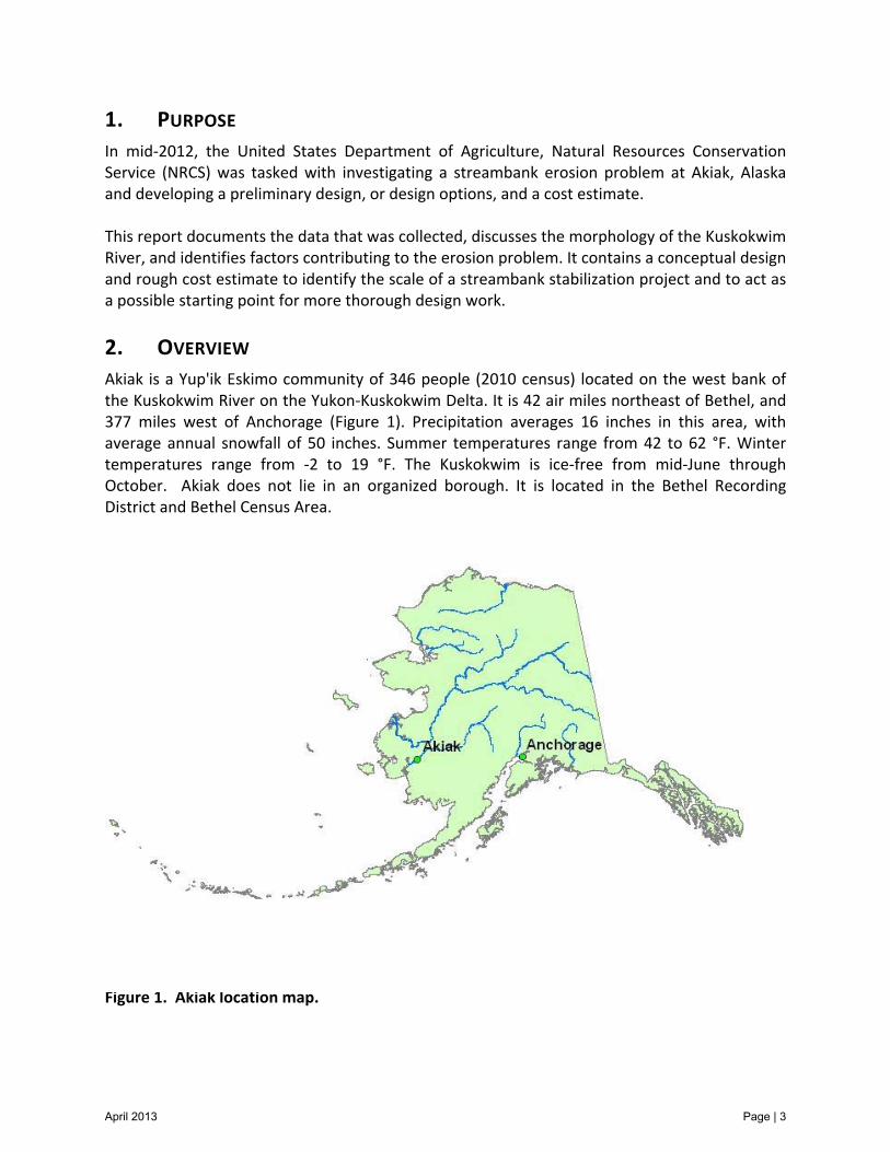
Akiak is a Yup'ik Eskimo community of 346 people (2010 census) located on the west bank of the Kuskokwim River on the Yukon‐Kuskokwim Delta. It is 42 air miles northeast of Bethel, and 377 miles west of Anchorage (Figure 1). Precipitation averages 16 inches in this area, with average annual snowfall of 50 inches. Summer temperatures range from 42 to 62 °F. Winter temperatures range from ‐2 to 19 °F. The Kuskokwim is ice‐free from mid‐June through October. Akiak does not lie in an organized borough. It is located in the Bethel Recording District and Bethel Census Area. Figure 1. Akiak location map.
April 2013 Page | 3
3. DESCRIPTION OF PROBLEM
3.1 LOCATION
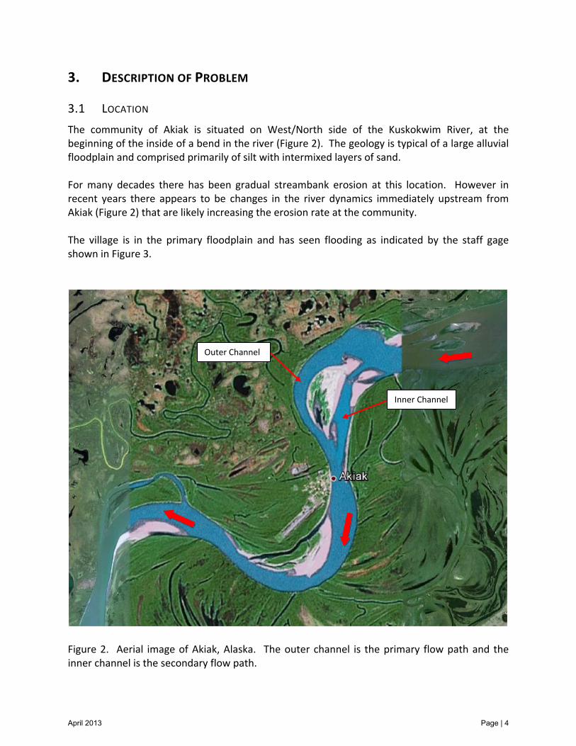
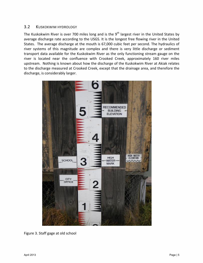
The community of Akiak is situated on West/North side of the Kuskokwim River, at the beginning of the inside of a bend in the river (Figure 2). The geology is typical of a large alluvial floodplain and comprised primarily of silt with intermixed layers of sand. For many decades there has been gradual streambank erosion at this location. However in recent years there appears to be changes in the river dynamics immediately upstream from Akiak (Figure 2) that are likely increasing the erosion rate at the community. The village is in the primary floodplain and has seen flooding as indicated by the staff gage shown in Figure 3.
Figure 2. Aerial image of Akiak, Alaska. The outer channel is the primary flow path and the inner channel is the secondary flow path.
Outer Channel
Inner Channel
April 2013 Page | 4
3.2 KUSKOKWIM HYDROLOGY
The Kuskokwim River is over 700 miles long and is the 9th largest river in the United States by average discharge rate according to the USGS. It is the longest free flowing river in the United States. The average discharge at the mouth is 67,000 cubic feet per second. The hydraulics of river systems of this magnitude are complex and there is very little discharge or sediment transport data available for the Kuskokwim River as the only functioning stream gauge on the river is located near the confluence with Crooked Creek, approximately 160 river miles upstream. Nothing is known about how the discharge of the Kuskokwim River at Akiak relates to the discharge measured at Crooked Creek, except that the drainage area, and therefore the discharge, is considerably larger.
Figure 3. Staff gage at old school
April 2013 Page | 5
3.3 KUSKOKWIM MORPHOLOGY
The Kuskokwim River exists primarily in a natural state with very few man‐made structures throughout its course. Most of the human influence on streamflow in the Kuskokwim drainage basin is in the form of small‐scale streambank stabilization projects such as those at McGrath, Aniak, and Kwethluk, and a larger pipe‐pile bulkhead (seawall) project at Bethel. Over time, it is normal for the active channel in a natural river system to migrate across the primary floodplain due to naturally occurring erosion and deposition. There is ample historical evidence of this process along the Kuskokwim River as relic channels, sloughs, and cutoff oxbows are easily identified in the aerial photography. In Appendix I a series of aerial photos illustrate how portions of the channel of the Kuskokwim River and Kuskokuak Slough have gone through this evolutionary process between 1952 and 2005. These images show this to be a very gradual process that is ongoing. They show an abandoned slough channel that is connected to the Kuskokuak Slough being intersected by encroaching streambank erosion on the main channel of the Kuskokwim between the 1952 and 1957 images. That connection between the main channel and the slough channel continues to mature in the 1972, 1995, and 2005 imagery, as a major oxbow is gradually abandoned, reducing the length of the channel by several miles. In comparing USGS maps that were generated using 1950’s aerial imagery (Figure 4) to 2005 aerial imagery (Figure 5) it is obvious that the process described above has resulted in major planform changes to the section of the Kuskokwim River downstream from Akiak. In this section of the river the channel has abandoned two major oxbows. By abandoning these oxbows the length of the Kuskokuak Slough, which is one of the two channels of the Kuskokwim River at this location, decreased in length from approximately 26 miles to approximately 12.6 miles. This change more than doubled the channel slope, which has increased the conveyance of the Kuskokuak Slough. The increase in slope drives the channel evolution of that reach as it proceeds towards its original quasi‐equilibrium slope. On a river of this size the effects of this process likely extend many miles upstream. The imagery presented in Appendix I show that this has been a gradual process that has been ongoing for over 50 years. The Kuskokuak Slough has enlarged throughout this time period and appears likely to become the primary channel of the Kuskokwim River in this area. It is reasonable to expect that these changes would result in increased erosion upstream in the river system. During site visits to Kwethluk in 2010, residents stated that the Kuskokuak Slough had indeed gotten considerably larger and the velocity had increased in recent years. NRCS engineers also observed a considerable amount of active erosion along the Kuskokuak Slough and the slough
April 2013 Page | 6
leading to the community of Kwethluk. These characteristics are consistent with an increase in channel slope and conveyance. There is also evidence of recent morphologic responses in the channel, in the vicinity of Akiak. The primary change is the degradation of the channel bed and increase of discharge in the inner channel of the river bend, immediately upstream from Akiak. This location is approximately 8.5 river miles upstream from the first abandoned oxbow (identified in Figures 4 & 5). The channel adjustments near Akiak are likely related to the abandoning of the oxbows downstream. The change in the balance of flow between the inner channel and the outer channel upstream from Akiak may be a major factor in the recent increase in erosion at the community of Akiak. Rather than the primary flow path following the outside of the bend as it passes Akiak, as it has for many years, a significant portion of the discharge now follows the inner channel and then merges with the flow in the outer channel immediately upstream from the community. Where the two flow paths merge the flow in the outer channel is “pushed” against the streambank resulting in an increase in bank erosion. In addition where these flow paths merge there is an extremely deep scour hole, reaching depths as great as 78 feet below the top of the streambank elevation. Figure 6 shows a color banded elevation map of the survey data that was gathered by the NRCS in October, 2012. It is unlikely that the system has stabilized. It is likely that the Kuskokuak Slough will continue to evolve into the primary channel and this could continue to impact the river system upstream. It is difficult to forecast how these changes could impact the community of Akiak. However, if the percentage of discharge in the inner channel continues to increase, then the rate of erosion of the streambank is likely to increase.
4. FIELD ACTIVITIES
NRCS engineering staff arrived in Akiak on October 1, 2012, at the request of the Akiak community. The goal of the visit was to obtain a detailed survey of the Kuskokwim River within the immediate vicinity of Akiak, as well as to obtain a survey of the riverbank and adjacent floodplain within which the city is located. Staff also listened to community members concerns with the erosion and opinions on potential solutions. A cross section survey of the river was performed with Trimble R8 survey grade GPS equipment and an Ohmex Sonarmite echo sounder.
April 2013 Page | 7

Figure 4. USGS quad map showing the Kuskokwim River and Kuskokuak Slough alignment between Akiak and Kwethluk, circa 1952.
April 2013 Page | 8
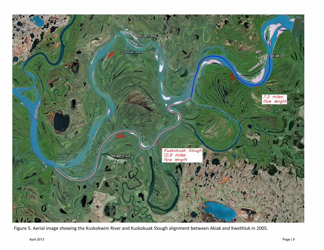
Figure 5. Aerial image showing the Kuskokwim River and Kuskokuak Slough alignment between Akiak and Kwethluk in 2005.
April 2013 Page | 9

Figure 6. NRCS survey data from October 2012 showing channel bed elevation. Note: elevation of highwater mark on staff gauge in Figure 3 is 32.8 feet, and the water surface elevation during the survey was 22feet.
April 2013 Page | 10
The survey extents were from about 5000 feet upstream of Akiak to the downstream end of the village, for a total river length of approximately 9000 feet. In addition, a more detailed bathymetric survey was done near the bank in the region experiencing active erosion. However, due to precarious hydraulics it was not possible to perform the survey as close to the bank as would have been preferred in the area of the greatest erosion, as this was being done during a high water event. For this reason it is likely that the bank slope is steeper, in the near‐bank region, than it is depicted by the survey data. This is a noteworthy issue because it likely results in the quantity of riprap being underestimated, in this area. The land based survey detailed the riverbank as well as a few of the structures nearest the bank. The survey did not map out all the buildings and roads within the village as the aerial imagery is sufficient for identifying those items. A quick search turned up no local survey monuments of any significance so static data was gathered for an OPUS solution. Static data was collected and an OPUS solution was run on the data to obtain a set of coordinates for the instrument point. The project coordinates are NAD83(2011) State Plane Alaska Zone 7, NAVD88 (Computed using GEOID12A).
Upon completion of the survey, NRCS staff held a public meeting in which they relayed to the community what work was performed. They also informed the community that the work being done was preliminary in nature and that there was no immediately available funding through NRCS to do a complete design and solve the ongoing erosion problems of the Kuskokwim River. The survey data is presented graphically in Appendix II.
5. DESIGN APPROACH
Stabilizing an eroding streambank can be accomplished by several different methods. In some situations stabilization can be accomplished by simply establishing healthy vegetation. In high velocity and high shear stress situations the most common approach to stabilization is to design and construct an appropriate rock revetment. Rock revetments are very costly to construct. Where river hydraulic conditions permit, designs that modify the flow conditions, rather than armor the streambank, can reduce project costs. These methods typically modify the flow conditions in a way that directs the river’s energy away from the streambank. This can be done with stream barbs, spur dikes, rock groins, and other constructed features. Collectively these techniques are often referred to as ‘river training’ methods. There are risks associated with all of these approaches. The obvious risk of any stabilization project is that the project fails prematurely. Another risk, with both revetments and river training techniques, is that you create another, possibly larger, problem downstream from the project. The location of Akiak may, to some extent, mitigate potential downstream effects as the river is transitioning to the inside of a bend immediately downstream from the community.
April 2013 Page | 11
Prior to completing a final design for a project at this location the downstream effects would need to be evaluated. The NRCS has not considered any river training techniques in this assessment. A project of that nature would alter the hydraulics significantly, and potentially alter the navigability of the river. Given the size of the Kuskokwim River, evaluating this type of project exceeds the professional experience of current NRCS Alaska engineering staff. At the current time NRCS is providing a design concept and a rough estimate of project cost for a rock revetment approach to stabilizing the eroding streambank at Akiak. This design concept is intended to be used for planning purposes only.
6. DESIGN CONCEPT
Figure 7 is a Plan View drawing showing the proposed extent of the rock revetment with keyways on each end. The estimated overall length of the project is 2600 linear feet. The project must extend far enough upstream from Akiak to avoid being flanked by bank erosion due to the potential increase in discharge in the inner channel. Figure 8 shows the proposed rock revetment cross‐sections at the Stations 0+86, 7+47, 12+81, 18+15, and 24+23. The volume of rock riprap required to construct each of these cross‐sections is 36, 36, 95, 42, and 25 cubic yards per linear foot of streambank, respectively. The two keyways will require additional rock riprap. The estimated total amount of rock riprap required to construct this design concept is 125,260 cubic yards. The extreme depth of the channel at the potential project site creates several design and construction issues. A thorough analysis is likely to result in a finished rock slope of 2.5 feet horizontally for every vertical foot of drop, or possibly flatter. In a large portion of the site the existing ground is much steeper than the proposed rock slope, but the depth is too great to make excavation a practical solution. Thus, the required slope will likely be created by placing an excess of rock riprap as shown in Figure 8.
6.1 DESIGN ISSUES
This is a concept design. This represents a potential solution to the erosion problem for the purpose of determining a preliminary cost estimate. There are several issues that would need to be further evaluated to complete this design. Addressing the following potential issues will likely impact the material quantities, and therefore the project costs could vary considerably as a final design is developed. A few of the major issues requiring further consideration and evaluation are:
April 2013 Page | 12
1) How angle of attack impacts the project as the inner channel conveyance increases 2) Detailed survey of the specific project site 3) Minimum viable length of the project 4) Rock riprap sizes 5) Rock layer thicknesses 6) Weighted toe design 7) Scour depth 8) Keyways 9) Downstream effects and mitigation 10) Maintenance costs 11) Constructability
6.2 ROUGH COST ESTIMATE
It is difficult to accurately estimate the cost of a concept design. The main reason for this is that many of the details of the design are not sufficiently developed to allow the quantities, and therefore the cost, to be estimated accurately. However, based on recent experience with contracting this type of project, rock riprap is usually the largest single bid item, typically representing approximately 30 to 40% of the total project cost. The riprap will have to be produced at a rock quarry, likely in the Kalskag area, then barged to the project site, and primarily placed from the barge. For a 2007 NRCS project in Kongiganak the rock riprap (in‐place) cost was $337/CY. Because this rock riprap should come from a closer source, for the purposes of planning the rock riprap is estimated to cost $250/CY, in‐place at Akiak. With a rock riprap quantity of 125,260 CY to be placed at a cost of $250/CY, the cost for riprap in‐place is estimated to be $31,315,000. Assuming that this represents 40% of the total project costs, the total cost is estimated to be $78,287,500. Given the low resolution of this conceptual design the cost should be considered to be approximately $80 million dollars.
April 2013 Page | 13
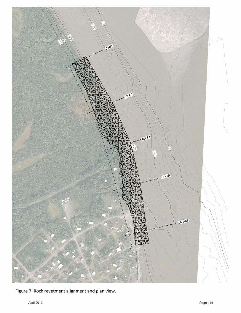
Figure 7. Rock revetment alignment and plan view.
April 2013 Page | 14
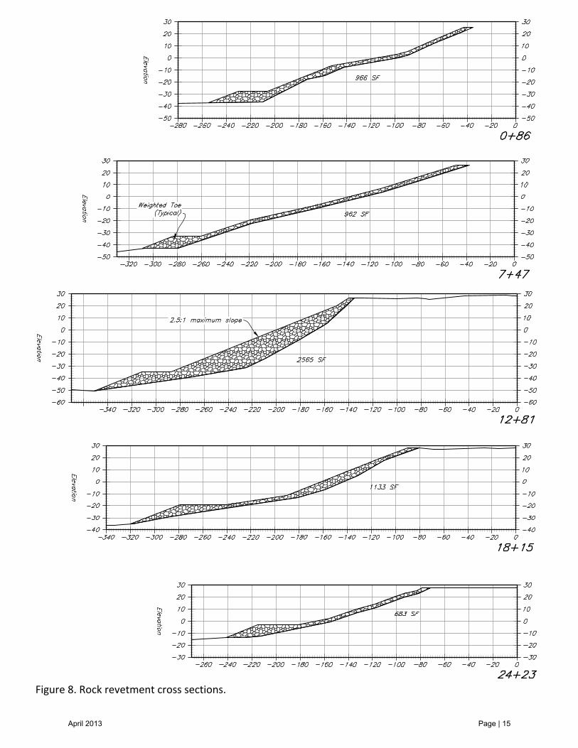
Figure 8. Rock revetment cross sections.
April 2013 Page | 15

6.3 RIVER TRAINING AS A POSSIBLE SOLUTION
It may be possible to stabilize the eroding streambank through river training techniques. These projects also require a considerable amount of rock riprap; however they typically require less than a revetment design and can be less expensive. A more detailed survey and hydraulic analysis would be required to determine if a river training option would be viable, and if it would result in cost savings. Due to the size of the watershed at Akiak, and the modeling/analysis effort required, this is beyond the scope of what the NRCS can offer.
6.4 PROJECT ECONOMICS
A rigorous cost/benefit analysis of this project is beyond the scope of this report. However, the United States Army Corp of Engineers (USACE) did complete a community erosion assessment for Akiak in June 2009. The USACE assessment concluded that the 50‐year total loss due to streambank erosion would be approximately $18.87 million. The USACE report estimates that the erosion could be addressed via a 275‐foot long revetment which would cost an estimated $3.4 million to construct. The NRCS opinion is that for a project to have a chance to succeed it would have to be much more extensive in length, and therefore much more expensive. Thus, the project presented in this report will result in a less favorable cost/benefit analysis.
7. CONCLUSIONS
There is an erosion problem at the community of Akiak. In a USACE report dated December 1983, Akiak residents described erosion issues that had been ongoing for the previous 40 years. To date, that totals at least 70 years of ongoing erosion issues at the community. It is difficult to predict exactly how the rates of erosion may vary in the coming years and decades, but it’s reasonable to expect that the erosion will continue. This report identifies some of the major morphologic responses that are easily identified in aerial photos of the Kuskokwim River, between Akiak and Kwethluk, and briefly discusses how these responses are likely related to the erosion issue at Akiak. The NRCS has developed a concept design that could be developed into a final design capable of stabilizing the eroding streambank. The rough estimate of a cost for this project is $80M in current dollars. There will be both design and construction issues with the proposed concept that would have to be resolved if a final design is developed. As most construction projects mature, the issues that arise are resolved at the detriment of the project cost.
April 2013 Page | 16
It is possible that, instead of a revetment, a river training technique could be utilized, and this approach might reduce the project cost. However, whether via rock revetment or river training, stabilizing the streambank at Akiak, for any significant period of time, is going to be a construction project of considerable scope and cost. This project will be on par with the Bethel seawall, although shorter in length. The NRCS does not have a history of executing river projects of this magnitude. Therefore, if a project at Akiak moves forward it will not likely be under the authority of the NRCS.
April 2013 Page | 17

APPENDIX I
Aerial Photography of the Kuskokwim River Between Akiak and Kwethluk
April 2013 Page | 18
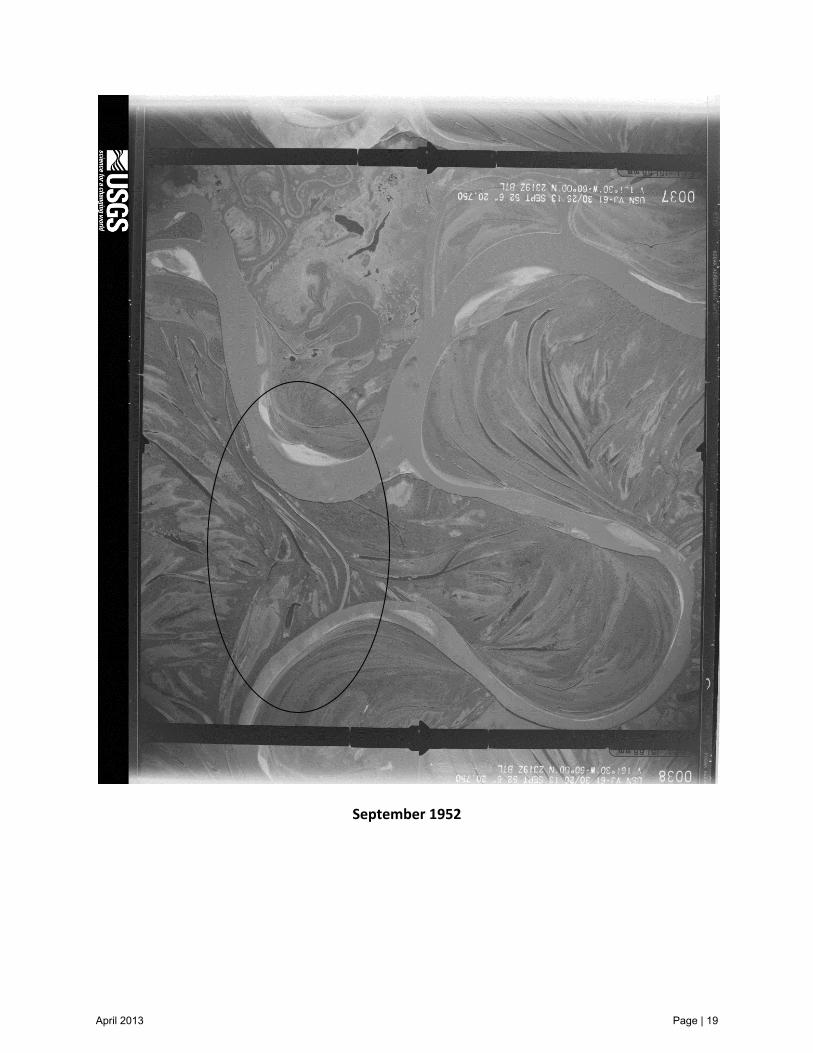
September 1952
April 2013 Page | 19
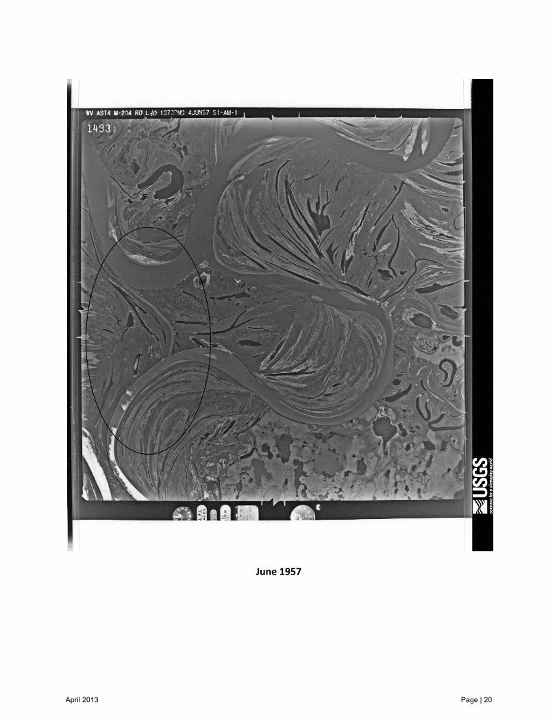
June 1957
April 2013 Page | 20
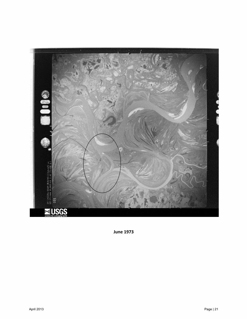
June 1973
April 2013 Page | 21
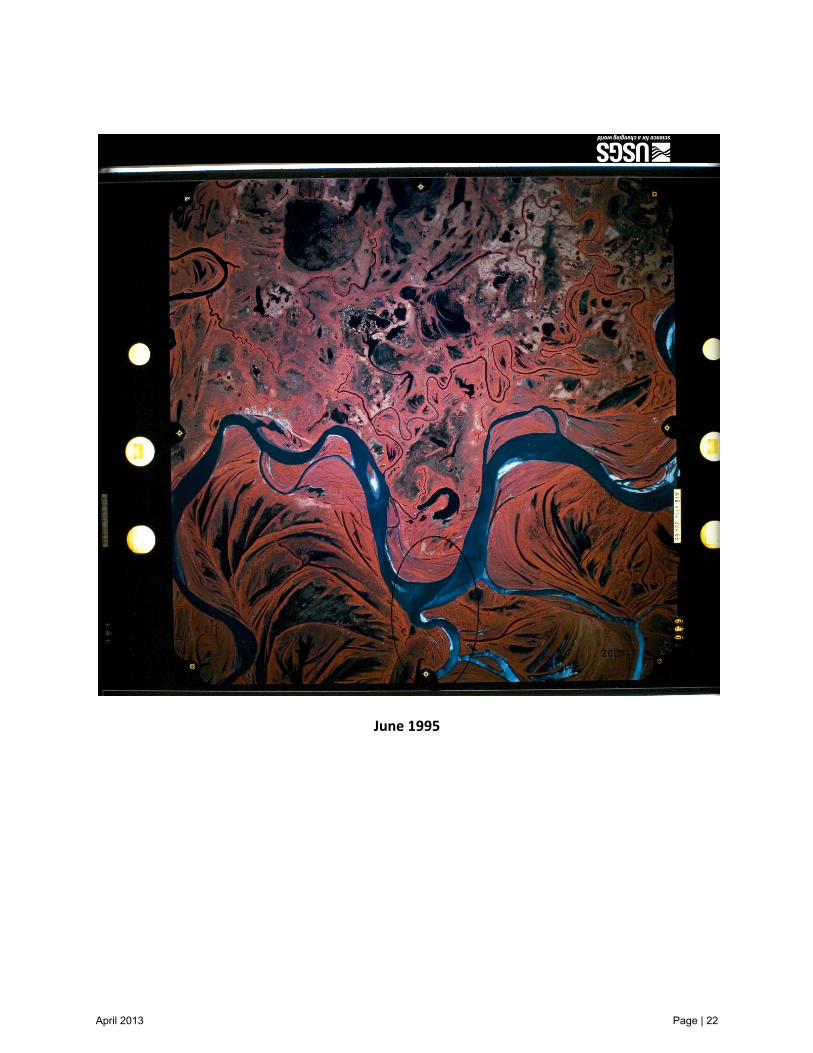
June 1995
April 2013 Page | 22

2005
April 2013 Page | 23

APPENDIX II
NRCS Survey Data
April 2013 Page | 24
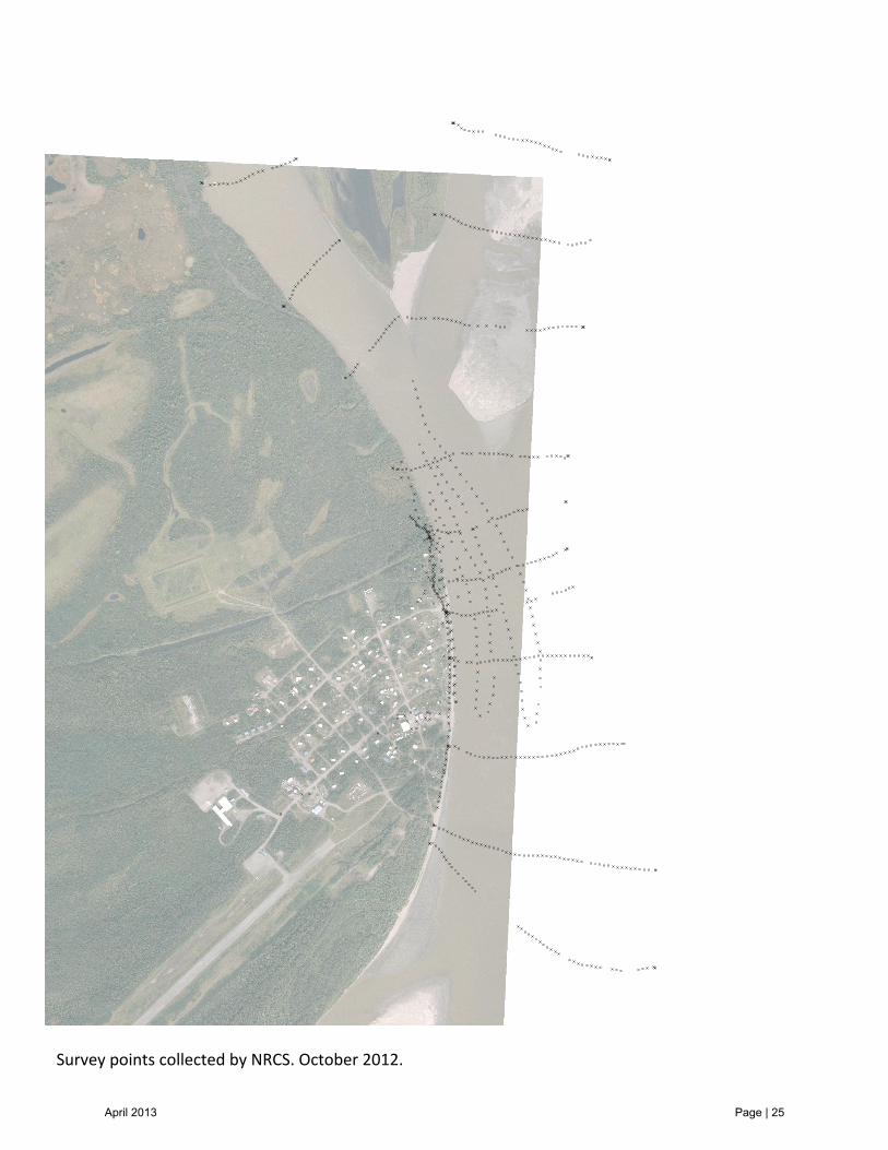
Survey points collected by NRCS. October 2012.
April 2013 Page | 25