appendix 5.8 visual
TRANSCRIPT

APPENDIX 5.8 VISUAL
Proposed Beaufort West Wind Farm 33kV / 132kV
Substation, 132kV Powerline and Associated
Infrastructure Projects
VISUAL IMPACT REPORT
21 OCTOBER 2021
ii Beaufort West Wind Farm 33kV / 132kV Substation, 132kV Powerline and FINAL: Visual Impact Report Associated Infrastructure Projects 21 October 2021
VISUAL IMPACT REPORT
Proposed Beaufort West Wind Farm
33kV / 132kV Substation, 132kV Powerline and Associated Infrastructure Projects
Submitted to:
SLR Consulting (South Africa) (Pty) Ltd
68 on Main, Old Main Road
Kloof, Durban, 3640
+27 11 467 0945
Prepared by:
G Y L A
Graham A Young Landscape Architect
PO Box 331
Groenkloof
0027
+27 (0)82 462 1491
Report Revision No: FINAL
Date Issued: 21 October 2021
Prepared By: Graham Young: Graham A Young Landscape Architect
Reviewed By:
Signed:
Graham Young PrLArch, FILASA
Reference: 079_2021: Beaufort West and Trakas Proposed 33kV / 132kV Substation,132kV Powerline and Associated Infrastructure, Western Cape
Expertise of Specialist
iii Beaufort West Wind Farm 33kV / 132kV Substation, 132kV Powerline and FINAL: Visual Impact Report Associated Infrastructure Projects 21 October 2021
EXPERTISE OF THE SPECIALIST
Name: Graham A Young
Qualification: BL (Toronto) ML (Pretoria)
Professional Registration: South African Council for the Landscape Architectural Profession
(SACLAP) Reg. No. 87001
Fellow Institute of Landscape Architects of South Africa (FILASA)
Experience in Years: Over 40 years
Experience Graham Young is a registered landscape architect with an interest and
experience in landscape architecture, urban design, and environmental
planning. He holds a degree in landscape architecture from the
Universities of Toronto (BL) and Pretoria (ML). He has carried out visual
impact assessments in Canada and throughout Africa, where he has
spent most of his working life. He has served as President of the Institute
of Landscape Architects of South Africa (ILASA) and as Vice President of
the Board of Control for Landscape Architects. He is a Fellow of the
ILASA and a professionally registered landscape architect in South Africa
(SACLAP). He is Secretary-General for the International Federation of
Landscape Architect, Africa Region (IFLA Africa).
He runs his practice, Graham A Young Landscape Architect (GYLA). A
specialty is Visual Impact Assessments for which he has been cited with
an Institute of Landscape Architects of South Africa (ILASA), Merit Award
(1999). Aspects of this work also include landscape characterization
studies, end-use studies for quarries, and computer modelling and
visualization. He has completed over 300 specialist reports for Projects
and conducted several VIA reviews. He has served as a specialist
witness in legal cases involving visual impact issues. Mr Young helped
develop the Guideline for Involving Visual and Aesthetic Specialists in
EIA Processes (Oberholzer 2005) and produced a research document for
Eskom, The Visual Impacts of Power Lines (2009). In 2011 he produced
‘Guidelines for involving visual and aesthetic specialists’ for the
Aapravasi Ghat Trust Fund Technical Committee, which manages a
World Heritage Site in Mauritius, along with the Visual Impact
Assessment Training Module Guideline Document for the same client.
Protection of Personal Information Act
iv Beaufort West Wind Farm 33kV / 132kV Substation, 132kV Powerline and FINAL: Visual Impact Report Associated Infrastructure Projects 21 October 2021
DECLARATION OF INDEPENDENCE
DETAILS OF THE SPECIALIST, DECLARATION OF INTEREST AND UNDERTAKING UNDER OATH
(For official use only)
File Reference Number:
NEAS Reference Number: DEA/EIA/
Date Received:
Application for authorisation in terms of the National Environmental Management Act, Act No. 107 of 1998, as amended and the Environmental Impact Assessment (EIA) Regulations, 2014, as amended (the Regulations)
PROJECT TITLE
PROPOSED CONSTRUCTION AND OPERATION OF THE BEAUFORT WEST WIND FARM 33kV / 132kV SUBSTATION, 132kV POWERLINE AND ASSOCIATED INFRASTRUCTURE PROJECTS, NEAR BEAUFORT WEST IN THE PRINCE ALBERT LOCAL MUNICIPALITY, WITHIN THE CENTRAL KAROO DISTRICT IN THE WESTERN CAPE PROVINCE
Kindly note the following:
1. This form must always be used for applications that must be subjected to Basic Assessment or Scoping & Environmental Impact Reporting where this Department is the Competent Authority.
2. This form is current as of 01 September 2018. It is the responsibility of the Applicant / Environmental Assessment Practitioner (EAP) to ascertain whether subsequent versions of the form have been published or produced by the Competent Authority. The latest available Departmental templates are available at https://www.environment.gov.za/documents/forms.
3. A copy of this form containing original signatures must be appended to all Draft and Final Reports submitted to the department for consideration.
4. All documentation delivered to the physical address contained in this form must be delivered during the official Departmental Officer Hours which is visible on the Departmental gate.
5. All EIA related documents (includes application forms, reports or any EIA related submissions) that are faxed; emailed; delivered to Security or placed in the Departmental Tender Box will not be accepted, only hardcopy submissions are accepted.
Protection of Personal Information Act
v Beaufort West Wind Farm 33kV / 132kV Substation, 132kV Powerline and FINAL: Visual Impact Report Associated Infrastructure Projects 21 October 2021
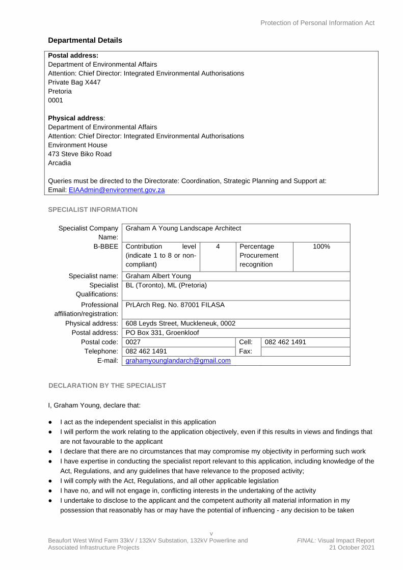
Departmental Details
Postal address:
Department of Environmental Affairs
Attention: Chief Director: Integrated Environmental Authorisations
Private Bag X447
Pretoria
0001
Physical address:
Department of Environmental Affairs
Attention: Chief Director: Integrated Environmental Authorisations
Environment House
473 Steve Biko Road
Arcadia
Queries must be directed to the Directorate: Coordination, Strategic Planning and Support at:
Email: [email protected]
SPECIALIST INFORMATION
Specialist Company
Name:
Graham A Young Landscape Architect
B-BBEE Contribution level
(indicate 1 to 8 or non-
compliant)
4 Percentage
Procurement
recognition
100%
Specialist name: Graham Albert Young
Specialist
Qualifications:
BL (Toronto), ML (Pretoria)
Professional
affiliation/registration:
PrLArch Reg. No. 87001 FILASA
Physical address: 608 Leyds Street, Muckleneuk, 0002
Postal address: PO Box 331, Groenkloof
Postal code: 0027 Cell: 082 462 1491
Telephone: 082 462 1491 Fax:
E-mail: [email protected]
DECLARATION BY THE SPECIALIST
I, Graham Young, declare that:
● I act as the independent specialist in this application
● I will perform the work relating to the application objectively, even if this results in views and findings that
are not favourable to the applicant
● I declare that there are no circumstances that may compromise my objectivity in performing such work
● I have expertise in conducting the specialist report relevant to this application, including knowledge of the
Act, Regulations, and any guidelines that have relevance to the proposed activity;
● I will comply with the Act, Regulations, and all other applicable legislation
● I have no, and will not engage in, conflicting interests in the undertaking of the activity
● I undertake to disclose to the applicant and the competent authority all material information in my
possession that reasonably has or may have the potential of influencing - any decision to be taken
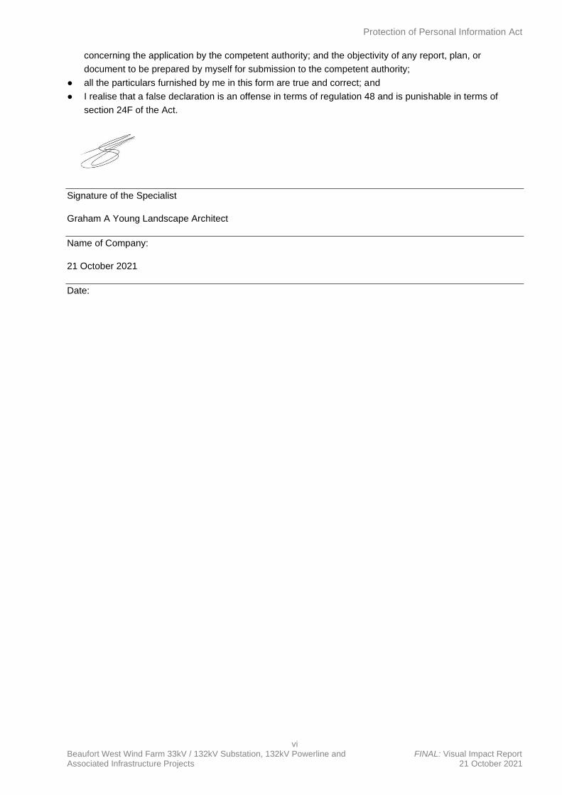
Protection of Personal Information Act
vi Beaufort West Wind Farm 33kV / 132kV Substation, 132kV Powerline and FINAL: Visual Impact Report Associated Infrastructure Projects 21 October 2021
concerning the application by the competent authority; and the objectivity of any report, plan, or
document to be prepared by myself for submission to the competent authority;
● all the particulars furnished by me in this form are true and correct; and
● I realise that a false declaration is an offense in terms of regulation 48 and is punishable in terms of
section 24F of the Act.
Signature of the Specialist
Graham A Young Landscape Architect
Name of Company:
21 October 2021
Date:
Specialist Requirements
vii Beaufort West Wind Farm 33kV / 132kV Substation, 132kV Powerline and FINAL: Visual Impact Report Associated Infrastructure Projects 21 October 2021
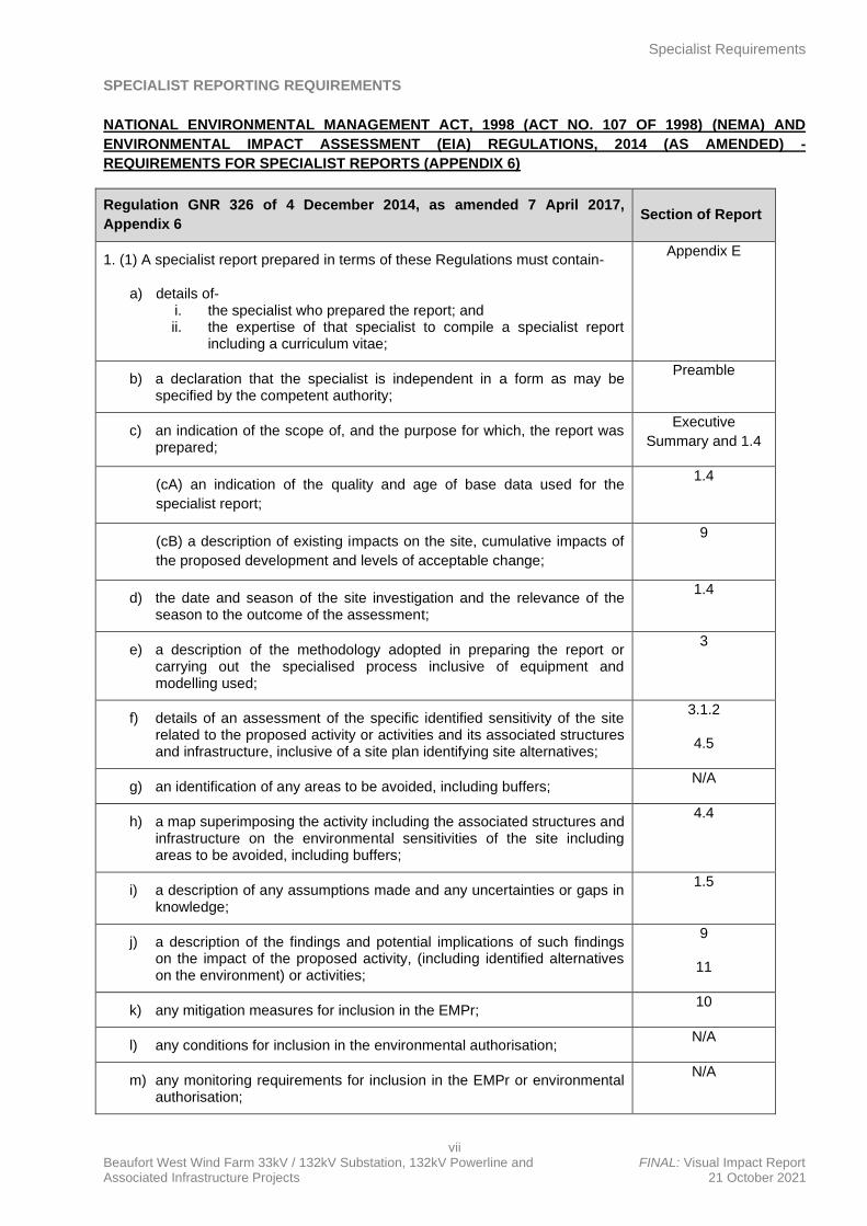
SPECIALIST REPORTING REQUIREMENTS
NATIONAL ENVIRONMENTAL MANAGEMENT ACT, 1998 (ACT NO. 107 OF 1998) (NEMA) AND
ENVIRONMENTAL IMPACT ASSESSMENT (EIA) REGULATIONS, 2014 (AS AMENDED) -
REQUIREMENTS FOR SPECIALIST REPORTS (APPENDIX 6)
Regulation GNR 326 of 4 December 2014, as amended 7 April 2017,
Appendix 6 Section of Report
1. (1) A specialist report prepared in terms of these Regulations must contain-
a) details of- i. the specialist who prepared the report; and ii. the expertise of that specialist to compile a specialist report
including a curriculum vitae;
Appendix E
b) a declaration that the specialist is independent in a form as may be specified by the competent authority;
Preamble
c) an indication of the scope of, and the purpose for which, the report was prepared;
Executive
Summary and 1.4
(cA) an indication of the quality and age of base data used for the
specialist report;
1.4
(cB) a description of existing impacts on the site, cumulative impacts of
the proposed development and levels of acceptable change;
9
d) the date and season of the site investigation and the relevance of the season to the outcome of the assessment;
1.4
e) a description of the methodology adopted in preparing the report or carrying out the specialised process inclusive of equipment and modelling used;
3
f) details of an assessment of the specific identified sensitivity of the site related to the proposed activity or activities and its associated structures and infrastructure, inclusive of a site plan identifying site alternatives;
3.1.2
4.5
g) an identification of any areas to be avoided, including buffers; N/A
h) a map superimposing the activity including the associated structures and infrastructure on the environmental sensitivities of the site including areas to be avoided, including buffers;
4.4
i) a description of any assumptions made and any uncertainties or gaps in knowledge;
1.5
j) a description of the findings and potential implications of such findings on the impact of the proposed activity, (including identified alternatives on the environment) or activities;
9
11
k) any mitigation measures for inclusion in the EMPr; 10
l) any conditions for inclusion in the environmental authorisation; N/A
m) any monitoring requirements for inclusion in the EMPr or environmental authorisation;
N/A
Specialist Requirements
viii Beaufort West Wind Farm 33kV / 132kV Substation, 132kV Powerline and FINAL: Visual Impact Report Associated Infrastructure Projects 21 October 2021
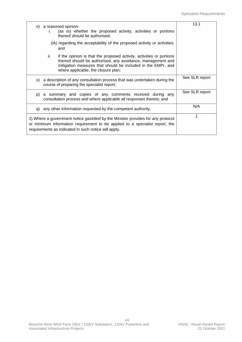
n) a reasoned opinion- i. (as to) whether the proposed activity, activities or portions
thereof should be authorised;
(iA) regarding the acceptability of the proposed activity or activities;
and
ii. if the opinion is that the proposed activity, activities or portions thereof should be authorised, any avoidance, management and mitigation measures that should be included in the EMPr, and where applicable, the closure plan;
13.1
o) a description of any consultation process that was undertaken during the course of preparing the specialist report;
See SLR report
p) a summary and copies of any comments received during any consultation process and where applicable all responses thereto; and
See SLR report
q) any other information requested by the competent authority. N/A
2) Where a government notice gazetted by the Minister provides for any protocol
or minimum information requirement to be applied to a specialist report, the
requirements as indicated in such notice will apply.
1
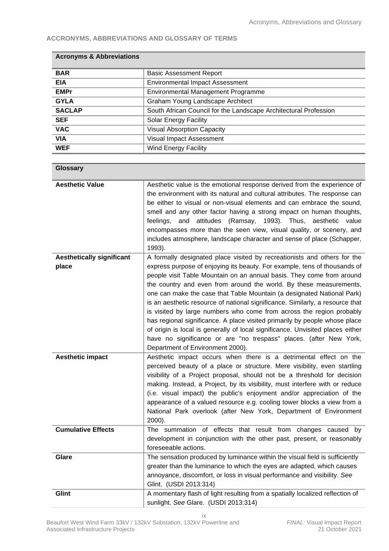
Acronyms, Abbreviations and Glossary
ix Beaufort West Wind Farm 33kV / 132kV Substation, 132kV Powerline and FINAL: Visual Impact Report Associated Infrastructure Projects 21 October 2021
ACCRONYMS, ABBREVIATIONS AND GLOSSARY OF TERMS
Acronyms & Abbreviations
BAR Basic Assessment Report
EIA Environmental Impact Assessment
EMPr Environmental Management Programme
GYLA Graham Young Landscape Architect
SACLAP South African Council for the Landscape Architectural Profession
SEF Solar Energy Facility
VAC Visual Absorption Capacity
VIA Visual Impact Assessment
WEF Wind Energy Facility
Glossary
Aesthetic Value
Aesthetic value is the emotional response derived from the experience of
the environment with its natural and cultural attributes. The response can
be either to visual or non-visual elements and can embrace the sound,
smell and any other factor having a strong impact on human thoughts,
feelings, and attitudes (Ramsay, 1993). Thus, aesthetic value
encompasses more than the seen view, visual quality, or scenery, and
includes atmosphere, landscape character and sense of place (Schapper,
1993).
Aesthetically significant
place
A formally designated place visited by recreationists and others for the
express purpose of enjoying its beauty. For example, tens of thousands of
people visit Table Mountain on an annual basis. They come from around
the country and even from around the world. By these measurements,
one can make the case that Table Mountain (a designated National Park)
is an aesthetic resource of national significance. Similarly, a resource that
is visited by large numbers who come from across the region probably
has regional significance. A place visited primarily by people whose place
of origin is local is generally of local significance. Unvisited places either
have no significance or are "no trespass" places. (after New York,
Department of Environment 2000).
Aesthetic impact
Aesthetic impact occurs when there is a detrimental effect on the
perceived beauty of a place or structure. Mere visibility, even startling
visibility of a Project proposal, should not be a threshold for decision
making. Instead, a Project, by its visibility, must interfere with or reduce
(i.e. visual impact) the public's enjoyment and/or appreciation of the
appearance of a valued resource e.g. cooling tower blocks a view from a
National Park overlook (after New York, Department of Environment
2000).
Cumulative Effects
The summation of effects that result from changes caused by
development in conjunction with the other past, present, or reasonably
foreseeable actions.
Glare The sensation produced by luminance within the visual field is sufficiently
greater than the luminance to which the eyes are adapted, which causes
annoyance, discomfort, or loss in visual performance and visibility. See
Glint. (USDI 2013:314)
Glint A momentary flash of light resulting from a spatially localized reflection of
sunlight. See Glare. (USDI 2013:314)
Acronyms, Abbreviations and Glossary
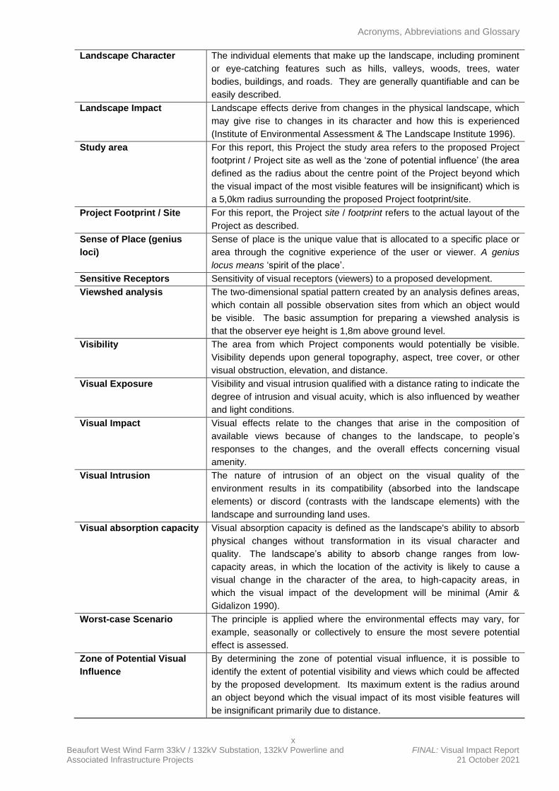
x Beaufort West Wind Farm 33kV / 132kV Substation, 132kV Powerline and FINAL: Visual Impact Report Associated Infrastructure Projects 21 October 2021
Landscape Character
The individual elements that make up the landscape, including prominent
or eye-catching features such as hills, valleys, woods, trees, water
bodies, buildings, and roads. They are generally quantifiable and can be
easily described.
Landscape Impact
Landscape effects derive from changes in the physical landscape, which
may give rise to changes in its character and how this is experienced
(Institute of Environmental Assessment & The Landscape Institute 1996).
Study area
For this report, this Project the study area refers to the proposed Project
footprint / Project site as well as the ‘zone of potential influence’ (the area
defined as the radius about the centre point of the Project beyond which
the visual impact of the most visible features will be insignificant) which is
a 5,0km radius surrounding the proposed Project footprint/site.
Project Footprint / Site For this report, the Project site / footprint refers to the actual layout of the
Project as described.
Sense of Place (genius
loci)
Sense of place is the unique value that is allocated to a specific place or
area through the cognitive experience of the user or viewer. A genius
locus means ‘spirit of the place’.
Sensitive Receptors Sensitivity of visual receptors (viewers) to a proposed development.
Viewshed analysis
The two-dimensional spatial pattern created by an analysis defines areas,
which contain all possible observation sites from which an object would
be visible. The basic assumption for preparing a viewshed analysis is
that the observer eye height is 1,8m above ground level.
Visibility
The area from which Project components would potentially be visible.
Visibility depends upon general topography, aspect, tree cover, or other
visual obstruction, elevation, and distance.
Visual Exposure
Visibility and visual intrusion qualified with a distance rating to indicate the
degree of intrusion and visual acuity, which is also influenced by weather
and light conditions.
Visual Impact
Visual effects relate to the changes that arise in the composition of
available views because of changes to the landscape, to people’s
responses to the changes, and the overall effects concerning visual
amenity.
Visual Intrusion
The nature of intrusion of an object on the visual quality of the
environment results in its compatibility (absorbed into the landscape
elements) or discord (contrasts with the landscape elements) with the
landscape and surrounding land uses.
Visual absorption capacity Visual absorption capacity is defined as the landscape's ability to absorb
physical changes without transformation in its visual character and
quality. The landscape’s ability to absorb change ranges from low-
capacity areas, in which the location of the activity is likely to cause a
visual change in the character of the area, to high-capacity areas, in
which the visual impact of the development will be minimal (Amir &
Gidalizon 1990).
Worst-case Scenario
The principle is applied where the environmental effects may vary, for
example, seasonally or collectively to ensure the most severe potential
effect is assessed.
Zone of Potential Visual
Influence
By determining the zone of potential visual influence, it is possible to
identify the extent of potential visibility and views which could be affected
by the proposed development. Its maximum extent is the radius around
an object beyond which the visual impact of its most visible features will
be insignificant primarily due to distance.
Executive Summary
xi Beaufort West Wind Farm 33kV / 132kV Substation, 132kV Powerline and FINAL: Visual Impact Report Associated Infrastructure Projects 21 October 2021
EXECUTIVE SUMMARY
INTRODUCTION
Graham A Young Landscape Architect (GYLA) has been appointed by SLR South Africa Consulting (Pty)
Ltd, on behalf of South Africa Mainstream Renewable Power Developments (PTY) Ltd, hereafter referred to
as “Mainstream”, to undertake a desktop Visual Impact Assessment for the proposed construction of one (1)
33 kilovolt (kV) / 132kV onsite Substation1, one (1) Battery Energy Storage System (BESS), one (1) 132kV
powerline (namely the associated electrical infrastructure), one (1) laydown area and one (1) Operations &
Maintenance (O&M) Building which will be added to the authorised Beaufort West Cluster of wind
developments2, 60km south of the town of Beaufort West in the Western Cape Province.
Two (2) applications for Environmental Authorisation (EA) will be lodged for two (2) separate projects [i.e.,
separate Basic Assessment (BA) processes]. One (1) application will be lodged for the 33/132kV yard of the
onsite substation, BESS, laydown area and O&M building, while another application will be lodged for the
132kV switching station yard of the onsite substation and associated 132kV powerline1. This Visual Impact
Assessment report however covers both proposed applications.
The proposed developments fall within the Prince Albert Local Municipality, within the Central Karoo District
Municipality.
The proposed developments will service both of Mainstream’s authorised wind farm projects (namely the
Beaufort West Wind Farm - 12-12-20-1784-1-AM2 and Trakas Wind Farm - 12-12-20-1784-2-AM2) and
associated electrical infrastructure. It should be noted that the two (2) proposed onsite substation, BESS,
laydown area, O&M building and powerline projects will be located within the site proposed for the
authorised Beaufort West and Trakas Wind Farms.
In terms of the 2014 Environmental Impact Assessment (EIA) Regulations (as amended), various aspects of
the proposed developments may have an impact on the environment and are listed activities. These
activities require authorisation from the National Competent Authority (CA), namely the Department of
Forestry, Fisheries and the Environment (DFFE), before the commencement thereof. Specialist studies have
been commissioned to verify the sensitivity and assess the impacts of the proposed developments, under
the Gazetted specialist protocols (GN R 320 and GN R 1150 of 2020). As mentioned, This Visual Impact
Assessment report covers both proposed applications.
The scope of this report is for two (2) applications, namely 33kV the Beaufort West Wind Farm Substation
and Associated Infrastructure (BESS, laydown area and O&M building) application, as well as the Eskom
132kV Substation and Associated 132kV Powerline application.
PROJECT STUDY AREA
The proposed projects are located approximately 60km south of the town of Beaufort West in the Prince
Albert Local Municipality, within the Central Karoo District Municipality of the Western Cape Province.
The proposed projects will be located on the following properties / farm portions:
• Portion 1 of the Farm Trakaskuilen No. 15 (C061000000000015000001); and
• Remainder of the Farm Trakaskuilen No. 15 (C061000000000015000010).
1 Onsite substation will consist of 33/132kV yard which will be owned and operated by Mainstream, as well as 132kV switching station yard which will be owned and operated by Eskom. 33/132kV yard of onsite substation and associated infrastructure (BESS, laydown area and O&M building) forms part of separate proposed application for EA, while 132kV switching station yard of onsite substation and 132kV overhead powerline forms part of another separate application for EA.
2 Beaufort West (12-12-20-1784-1-AM2) and Trakas Wind Farms (12-12-20-1784-2-AM2) and their supporting powerline and substation infrastructure (Beaufort West 132KV-400KV Linking Station, 132KV Power Line and onsite 132KV Substation – 14-12-16-3-3-2-925-1 & Trakas 132KV-400KV Linking Station, 132KV Power Line and onsite 132KV Substation – 14-12-16-3-3-2-925-2), collectively referred to as “the Beaufort West Cluster”
Executive Summary
xii Beaufort West Wind Farm 33kV / 132kV Substation, 132kV Powerline and FINAL: Visual Impact Report Associated Infrastructure Projects 21 October 2021
It should be noted that the proposed onsite substation, BESS, laydown area, O&M building and powerline
projects (which form part of separate respective new applications and BA processes) will be located within
the site proposed for the authorised Beaufort West Cluster, which is proposed on Portion 1 and Remainder
of the Farm Trakaskuilen No. 15.
TERMS OF REFERENCE
A desktop specialist study is required to establish the visual baseline and to identify and assess the visual
impacts arising from the developments, based on the general requirements for a comprehensive VIA. The
following terms of reference were established:
• A desktop analysis, using satellite imagery and scrutinizing previous visual impact reports3 of the
projects will allow for a description and characterization of the receiving environment
• A preliminary site inspection (October 2020)
• Describe the visual characteristics of the components of the projects
• Identify issues that must be addressed in the impact assessment phase
• Rate the significance of the impact of the projects
• Proposed mitigation measures to reduce the potential impact of the projects
• Assess the cumulative impact of the projects.
ASSUMPTIONS AND LIMITATIONS
The following assumptions and/or limitations have been made in the study:
• The description of project components is limited to what has been supplied to the author by SLR
Consulting before the date of completion of this report.
• The visual sensitivity to the projects is assumed to be moderate to low, due to the site for the
projects being located within approved wind farm sites
FINDINGS
The existing visual condition of the landscape that may be affected by the proposed developments has been
described. It was important to assess whether the introduction of a new power line, substation and
associated infrastructure into the study area would be a degrading factor in the context of the natural Karoo
character of the landscape, keeping in mind that the proposed developments will occur within authorised
wind farms. In addition, although the proposed developments will be visible from the N12 national route
which traverses the study area, the section of the route within the study area is not considered to be of
scenic value. In addition, the level of contrast is significantly reduced by the presence of existing power lines
and associated infrastructure as well as the N12 road, which are prominent features in an open and relatively
flat landscape.
Impacts to views are the highest when viewers are identified as being sensitive to change in the landscape,
and their views are focused on and dominated by the change. The study area only five (5) potentially
sensitive receptors, however, these receptors have vested interest in the projects and therefore not
considered in the assessment. Travellers along the N12, who are tourists, were also considered as
potentially sensitive receptors.
The significance of impact, without mitigation and based on the worst-case scenario, for the sensitive
receptors during the construction, operational and decommissioning phases, is neutral i.e. where the impact
would not have any effect on the visual environment (over and above the authorised 132kV power line and
3 Oberholzer, B and Lawson, Q. Proposed Renewable Energy Facilities in the Western and Northern Cape by Mainstream SA –
Beaufort West Site, in the Great Karoo: Visual Impact Assessment. Unpublished Report. Stanford. 27 September 2010. Gibb, A. SiVEST, Proposed construction of a linking station, two (2) power lines and two (2) on-site substations for the Beaufort West and Trakas Wind Farms, near Beaufort West in the Western Cape Province: Visual Impact Assessment, Rev 1. Unpublished Report. Rivonia. 7 December 2018
Executive Summary
xiii Beaufort West Wind Farm 33kV / 132kV Substation, 132kV Powerline and FINAL: Visual Impact Report Associated Infrastructure Projects 21 October 2021
associated infrastructure developments), nor will it have a direct influence on the decision to develop the
area.
Mitigation measures are, however, proposed that relate mostly to good housekeeping during the construction
phase. This is applicable to both proposed applications / projects.
CUMULATIVE EFFECTS
Five (5) renewable energy developments were identified within a 30km radius of the proposed power line,
substation and associated infrastructure developments. It was determined that these, namely the Beaufort
West WEF, Trakas WEF and the three (3) Kwagga WEFs, would have a significant impact on the landscape
and receptors within the visual assessment zone. These facilities are adjacent to each other and in effect
form one (1) large wind farm incorporating the proposed grid connection infrastructure. It is anticipated that
the concentration of WEFs will alter the inherent sense of place of the study area and introduce an
increasingly industrial character into a largely natural landscape, resulting in some form of cumulative
impacts. Although, it is anticipated that these impacts could be mitigated with the implementation of the
recommendations and mitigation measures stipulated for each of these developments by the visual
specialists (Oberholzer, 2010). In addition, impacts would be reduced to some degree with the presence of
the existing 400kV power line infrastructure and the N12 national route in the vicinity of the WEFs, which
have already partly transformed the visual character.
VISUAL IMPACT STATEMENT
It is the opinion of GYLA that the visual effects associated with the proposed developments are of neutral
significance. Given the low level of human habitation and the absence of sensitive receptors, the spatial
extent of the zone of potential influence is reduced and the impact of the respective power line, substation
and associated infrastructure developments would be dwarfed by the cumulative effect of the other
renewable energy developments. The respective projects are thus deemed acceptable from a visual
perspective, and should each be approved, provided that the mitigation/management measures are
effectively implemented, managed, and monitored in the long term.
*** GYLA ***
List of Figures
xiv Beaufort West Wind Farm 33kV / 132kV Substation, 132kV Powerline and FINAL: Visual Impact Report Associated Infrastructure Projects 21 October 2021
TABLE OF CONTENT
EXPERTISE OF THE SPECIALIST iii
DETAILS OF THE SPECIALIST, DECLARATION OF INTEREST AND UNDERTAKING UNDER
OATH iv
SPECIALIST INFORMATION v
DECLARATION BY THE SPECIALIST v
SPECIALIST REPORTING REQUIREMENTS vii
ACCRONYMS, ABBREVIATIONS AND GLOSSARY OF TERMS ix
EXECUTIVE SUMMARY xi
INTRODUCTION xi
PROJECT STUDY AREA xi
TERMS OF REFERENCE xii
ASSUMPTIONS AND LIMITATIONS xii
FINDINGS xii
CUMULATIVE EFFECTS xiii
VISUAL IMPACT STATEMENT xiii
1. INTRODUCTION 1
1.1 Project Overview and Background 1
1.2 Project location and study area 1
1.3 Aim of the Specialist Study 2
1.4 Terms and Reference 2
1.5 Assumption, Uncertainties, and Limitations 2
2. LEGAL REQUIREMENTS AND GUIDELINES 4
2.1 National Legislation and Guidelines 4
3. APPROACH AND METHODOLOGY 5
3.1 Approach 5
3.1.1 The Visual Resource 5
3.1.2 Sensitivity of Visual Resource 5
3.1.3 Sense of Place 5
3.1.4 Sensitive Receptors 5
4. DESCRIPTION OF THE PROJECT 7
4.1 Project Location 7
4.2 History of Authorised Beaufort West Cluster 7
4.3 Project Components 10
4.4 Site Layout 14
4.5 Alternatives 14
5. POTENTIAL VISUAL ISSUES 15
6. VISUAL CHARACTER AND SENSITIVITY OF THE STUDY AREA 18
6.1 Landscape and Land Use Characteristics 18
6.2 Visual Character and Sense of Place 19
List of Figures
xv Beaufort West Wind Farm 33kV / 132kV Substation, 132kV Powerline and FINAL: Visual Impact Report Associated Infrastructure Projects 21 October 2021
7. VISUAL RESOURCE 20
7.1 Visual Resource Value, Scenic Quality, and Landscape Sensitivity 20
7.2 Visual Sensitivity 21
8. LANDSCAPE IMPACT 22
9. VISUAL IMPACT 23
9.1 Visual Receptors 23
9.2 Sensitive Viewers 23
9.3 Visibility 23
9.4 Visual Intrusion 23
9.5 The intensity of Visual Impact 23
10. MANAGEMENT MEASURES 26
10.1 Preparatory Works and Construction Concerns 26
10.2 Earthworks 26
10.3 Ecological approach 26
10.4 Mounting Structures and associated infrastructure 27
10.5 Good housekeeping 27
10.6 Lighting 27
10.7 Branding and Marketing 27
11. SIGNIFICANCE OF VISUAL IMPACT 28
11.1 Alternatives 28
12. CUMULATIVE EFFECT 30
12.1 The cumulative effect of WEFs and Associated Infrastructure 30
13. CONCLUSION 32
13.1 Visual Impact Statement 32
14. REFERENCES 33
APPENDIX A: DETERMINING THE VISUAL RESOURCE VALUE OF A LANDSCAPE 34
APPENDIX B: METHOD FOR DETERMINING THE INTENSITY OF LANDSCAPE AND VISUAL
IMPACT 38
APPENDIX C: CRITERIA FOR SIGNIFICANCE OF IMPACT ASSESSMENT (SLR Consulting)
45
APPENDIX D: CURRICULUM VITAE 48
List of Figures
xvi Beaufort West Wind Farm 33kV / 132kV Substation, 132kV Powerline and FINAL: Visual Impact Report Associated Infrastructure Projects 21 October 2021
LIST OF FIGURES
Figure 1 Regional Context
Figure 2 Propose Layout – Both Options
Figure 3 Authorised Layout
Figure 4 View Sites and Visual Receptors
Figure 5 Landscape Character
Figure 6 Authorised vs Proposed Zones of Influence
Figure 7 Renewable Energy Developments Within a 30km Radius
List of Tables
xvii Beaufort West Wind Farm 33kV / 132kV Substation, 132kV Powerline and FINAL: Visual Impact Report Associated Infrastructure Projects 21 October 2021
LIST OF TABLES
Table 1 Summary of the Key Project Components
Table 2 Value of the Visual Resource
Table 3 Intensity of Visual Impact for Both Options
Table 4 Significance of Impact for Both Options
Introduction
Beaufort West Wind Farm 33kV / 132kV Substation, 132kV Powerline and FINAL: Visual Impact Report Associated Infrastructure Projects 21 October 2021
1. INTRODUCTION
1.1 Project Overview and Background
Graham A Young Landscape Architect (GYLA) has been appointed by SLR South Africa Consulting (Pty)
Ltd, on behalf of South Africa Mainstream Renewable Power Developments (PTY) Ltd, hereafter referred to
as “Mainstream”, to undertake a desktop Visual Impact Assessment for the proposed construction of one (1)
33 kilovolt (kV) / 132kV onsite Substation4, one (1) Battery Energy Storage System (BESS), one (1) 132kV
powerline (namely the associated electrical infrastructure), one (1) laydown area and one (1) Operations &
Maintenance (O&M) Building which will be added to the authorised Beaufort West Cluster of wind
developments5, 60km south of the town of Beaufort West in the Western Cape Province.
Two (2) applications for Environmental Authorisation (EA) will be lodged for two (2) separate projects [i.e.,
separate Basic Assessment (BA) processes]. One (1) application will be lodged for the 33/132kV yard of the
onsite substation, BESS, laydown area and O&M building, while another application will be lodged for the
132kV switching station yard of the onsite substation and associated 132kV powerline4. This Visual Impact
Assessment report however covers both proposed applications.
The proposed developments fall within the Prince Albert Local Municipality, within the Central Karoo District
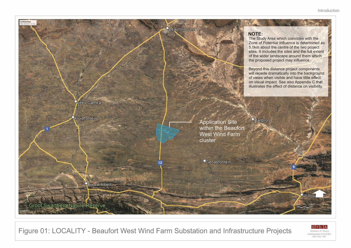
Municipality. Refer to Figure 01 below.
The proposed developments will service both of Mainstream’s authorised wind farm projects (namely the
Beaufort West Wind Farm - 12-12-20-1784-1-AM2 and Trakas Wind Farm - 12-12-20-1784-2-AM2) and
associated electrical infrastructure. It should be noted that the respective proposed onsite substation, BESS,
laydown area, O&M building and powerline projects will be located within the site proposed for the
authorised Beaufort West and Trakas Wind Farms.
In terms of the 2014 Environmental Impact Assessment (EIA) Regulations (as amended), various aspects of
the proposed developments may have an impact on the environment and are listed activities. These
activities require authorisation from the National Competent Authority (CA), namely the Department of
Forestry, Fisheries and the Environment (DFFE), before the commencement thereof. Specialist studies have
been commissioned to verify the sensitivity and assess the impacts of the proposed developments, under
the Gazetted specialist protocols (GN R 320 and GN R 1150 of 2020). As mentioned, This Visual Impact
Assessment report covers both proposed applications.
The scope of this report is for two (2) applications, namely the 33/132kV Beaufort West Wind Farm
Substation and Associated Infrastructure (BESS, laydown area and O&M building) application, as well as the
Eskom 132kV Switching Substation and Associated 132kV Powerline application.
1.2 Project location and study area
The proposed projects are located approximately 60km south of the town of Beaufort West in the Prince
Albert Local Municipality, within the Central Karoo District Municipality of the Western Cape Province (as
shown in Figure 01).
The proposed projects will be located on the following properties/farm portions:
• Portion 1 of the Farm Trakaskuilen No. 15 (C061000000000015000001); and
• Remainder of the Farm Trakaskuilen No. 15 (C061000000000015000010).
4 Onsite substation will consist of 33/132kV yard which will be owned and operated by Mainstream, as well as 132kV switching station
yard which will be owned and operated by Eskom. 33/132kV yard of onsite substation and associated infrastructure (BESS, laydown area and O&M building) forms part of separate proposed application for EA, while 132kV switching station yard of onsite substation and 132kV overhead powerline forms part of another separate application for EA.
5 Beaufort West (12-12-20-1784-1-AM2) and Trakas Wind Farms (12-12-20-1784-2-AM2) and their supporting powerline and substation
infrastructure (Beaufort West 132KV-400KV Linking Station, 132KV Power Line and onsite 132KV Substation – 14-12-16-3-3-2-925-1 & Trakas 132KV-400KV Linking Station, 132KV Power Line and onsite 132KV Substation – 14-12-16-3-3-2-925-2), collectively referred to as “the Beaufort West Cluster”
Introduction
2 Beaufort West Wind Farm 33kV / 132kV Substation, 132kV Powerline and FINAL: Visual Impact Report Associated Infrastructure Projects 21 October 2021
It should be noted that the proposed onsite substation, BESS, laydown area, O&M building and powerline
projects (which form part of separate respective new applications and BA processes) will be located within
the site proposed for the authorised Beaufort West Cluster (Beaufort West Wind Farm - 12-12-20-1784-1-
AM2 and Trakas Wind Farm - 12-12-20-1784-2-AM2), which is authorised on Portion 1 and Remainder of the
Farm Trakaskuilen No. 15.
The study area extends 5,0km project structures6, as indicated in Figure 01.
1.3 Aim of the Specialist Study
The main aim of the study is to ensure that the visual/aesthetic consequences of the proposed developments
are understood.
1.4 Terms and Reference
A desktop specialist study is required to establish the visual baseline and to identify and assess the visual
impacts arising from the developments, based on the general requirements for a comprehensive VIA. The
following terms of reference were established:
• A desk top analysis, using satellite imagery and scrutinizing previous visual impact reports7 of the
projects will allow for a description and characterization of the receiving environment
• A preliminary site inspection (October 2020)
• Describe the visual characteristics of the components of the projects
• Identify issues that must be addressed in the impact assessment phase
• Rate the significance of the impact of the projects
• Proposed mitigation measures to reduce the potential impact of the projects
• Assess the cumulative impact of the projects.
1.5 Assumption, Uncertainties, and Limitations
The following assumptions and/or limitations have been made in the study:
• The description of project components is limited to what has been supplied to the author by SLR
Consulting before the date of completion of this report.
• The visual sensitivity to the projects is assumed to be moderate to low, due to the site being located
within approved wind farm sites.
6 Distance Zones set of pre-determined distances from a viewpoint and help in delineating the extent of a study area (5.0km beyond
project structures). Beyond 5km the effect of the substation, associated infrastructure and 132kV power line (along with its poles), will dimmish dramatically to the point as being insignificant from a visual impact point of view.
7 Oberholzer, B and Lawson, Q. Proposed Renewable Energy Facilities in the Western and Northern Cape by Mainstream SA –
Beaufort West Site, in the Great Karoo: Visual Impact Assessment. Unpublished Report. Stanford. 27 September 2010. Gibb, A. SiVEST, Proposed construction of a linking station, two (2) power lines and two (2) on-site substations for the Beaufort West and Trakas Wind Farms, near Beaufort West in the Western Cape Province: Visual Impact Assessment, Rev 1. Unpublished Report. Rivonia. 7 December 2018
Introduction
Beaufort West Wind Farm 33kV / 132kV Substation, 132kV Powerline and FINAL: Visual Impact Report Associated Infrastructure Projects 21 October 2021
Legal Requirements & Guidelines
4 Beaufort West Wind Farm 33kV / 132kV Substation, 132kV Powerline and FINAL: Visual Impact Report Associated Infrastructure Projects 21 October 2021
2. LEGAL REQUIREMENTS AND GUIDELINES
This report adheres to the following legal requirements and guideline documents.
2.1 National Legislation and Guidelines
National Environmental Management Act (Act 107 of 1998) (NEMA), EIA Regulations
The specialist report is as per the specification on conducting specialist studies, as per Government Gazette
(GN) R 982 of the National Environmental Management Act (NEMA) (Act 107 of 1998). The mitigation
measures as stipulated in the specialist report can be used as part of the Environmental Management
Programme (EMPr) and will be in support of the Basic Assessment (BA) and Appendix 6 of the EIA
Regulations (04 December 2014, as amended on 7 April 2017).
Western Cape Department of Environmental Affairs & Development Planning: Guideline for Involving Visual
and Aesthetic Specialists in EIA Processes Edition 1 (CSIR, 2005)
Although the guidelines were specifically compiled for the Province of the Western Cape8, they provide
guidance that is appropriate for any BA process. The Guideline document also seeks to clarify instances
when a visual specialist should get involved in the BA process.
8 The Western Cape Guidelines are the only official guidelines for visual impact assessment reports in South Africa and can be
regarded as best practice throughout the country. Graham Young was a contributor to this document, authored by B. Oberholzer.
Approach and Methodology
5 Beaufort West Wind Farm 33kV / 132kV Substation, 132kV Powerline and FINAL: Visual Impact Report Associated Infrastructure Projects 21 October 2021
3. APPROACH AND METHODOLOGY
3.1 Approach
The assessment of likely effects on a landscape resource and visual amenity is complex, since it is
determined through a combination of quantitative and qualitative evaluations. When assessing visual impact,
the worst-case scenario is considered. Landscape and visual assessments are separate, although linked,
procedures. The landscape, its analysis, and the assessment of impacts on the landscape all contribute to
the baseline for visual impact assessment studies. The assessment of the potential impact on the landscape
is carried out as an impact on an environmental resource, i.e. the physical landscape. Visual impacts, on the
other hand, are assessed as one (1) of the interrelated effects on people (i.e. the viewers and the impact of
an introduced object into a view or scene).
3.1.1 The Visual Resource
Landscape character, landscape quality, and “sense of place” (Lynch, 1992) are used to evaluate the visual
resource i.e. the receiving environment. A qualitative evaluation of the landscape is essentially a subjective
matter. In this study, the aesthetic evaluation of the study area is determined by the professional opinion of
the author, based on on-site observations and the results of contemporary research in perceptual
psychology along with descriptions in previous visual impact assessments of project components.
3.1.2 Sensitivity of Visual Resource
The sensitivity of a landscape or visual resource is the degree to which a landscape type or area can
accommodate change arising from development, without detrimental effects on its character. Its
determination is based upon an evaluation of each key element or characteristic of the landscape likely to be
affected. The evaluation will reflect such factors as its “quality, value, contribution to landscape character,
and the degree to which the particular element or characteristic can be replaced or substituted” (LiEMA,
2013).
3.1.3 Sense of Place
The study area’s sense of place is derived from the emotional, aesthetic, and visual response to the
environment, and, therefore, it cannot be experienced in isolation. The landscape context must be
considered. The combination of the natural landscape together with the man-made structures and features
contribute to the sense of place for the study area. It is this combination that defines the study area and
establishes its visual and aesthetic identity.
3.1.4 Sensitive Receptors
The sensitivity of visual receptors and viewing areas is dependent on the location and context of the
viewpoint, the expectations and occupation or activity of the receptor, or the importance of the view, which
may be determined concerning its popularity or numbers of people affected, its appearance in guidebooks,
on tourist maps, and in the facilities provided for its enjoyment and references to it in literature or art.
Typically, sensitive receptors may include:
• Users of all outdoor recreational facilities, including public rights of way, whose intention or
interest may be focused on the landscape i.e. nature reserves.
• Communities where development results in negative changes in the landscape setting or valued
views enjoyed by the community.
• Occupiers of residential/tourist properties with views negatively affected by the development i.e.
game lodges.
• People travelling through recognized nature reserves or areas of declared scenic beauty (i.e.
tourist routes)
Viewing areas, typically from residences and tourist facilities/routes, are typically the most sensitive since
Approach and Methodology
6 Beaufort West Wind Farm 33kV / 132kV Substation, 132kV Powerline and FINAL: Visual Impact Report Associated Infrastructure Projects 21 October 2021
views from within these areas are potentially frequent and of long duration.
Other, less sensitive, receptors include:
• People engaged in outdoor sport or recreation (other than appreciation of the landscape, as in
landscapes of acknowledged importance or value).
• People travelling through or past the affected landscape in cars or other transport modes, other
than recognized areas of scenic beauty.
• People at their place of work.
Landscape sensitivity, on the other hand, relates to the nature and character of the study area’s landscape
potential to accept change caused by the proposed development [Visual Absorption Capacity (VAC)]. Due
to the location of the site within land already developed or earmarked for urban development, the area’s
landscape has a low sensitivity to the potential visual impacts and has a high VAC.
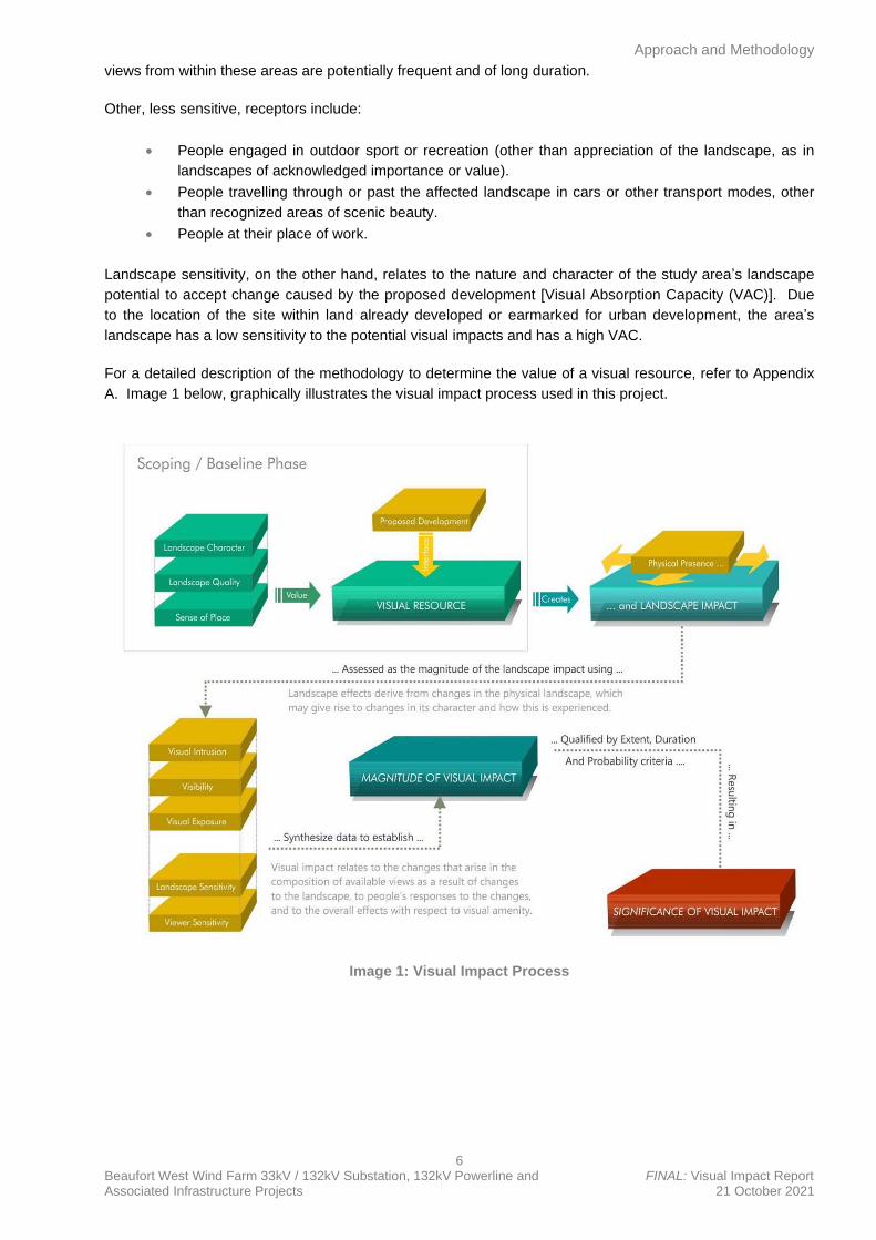
For a detailed description of the methodology to determine the value of a visual resource, refer to Appendix
A. Image 1 below, graphically illustrates the visual impact process used in this project.
Image 1: Visual Impact Process
Description of the Project
7 Beaufort West Wind Farm 33kV / 132kV Substation, 132kV Powerline and FINAL: Visual Impact Report Associated Infrastructure Projects 21 October 2021
4. DESCRIPTION OF THE PROJECT
4.1 Project Location
The proposed projects are located approximately 60km south of the town of Beaufort West in the Prince
Albert Local Municipality, within the Central Karoo District Municipality of the Western Cape Province.
The proposed projects will be located on the following properties/farm portions:
• Portion 1 of the Farm Trakaskuilen No. 15 (C061000000000015000001); and
• Remainder of the Farm Trakaskuilen No. 15 (C061000000000015000010).
It should be noted that the proposed onsite substation, BESS, laydown area, O&M building and powerline
projects (which form part of separate respective new applications and BA processes) will be located within
the site proposed for the authorised Beaufort West Cluster (Beaufort West Wind Farm - 12-12-20-1784-1-
AM2; Trakas Wind Farm - 12-12-20-1784-2-AM2; Beaufort West 132KV-400KV Linking Station, 132KV
Power Line and onsite 132KV Substation – 14-12-16-3-3-2-925-1 and Trakas 132KV-400KV Linking Station,
132KV Power Line and onsite 132KV Substation – 14-12-16-3-3-2-925-2), which is authorised on Portion 1
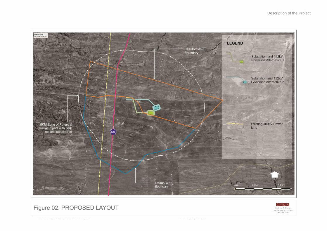
and Remainder of the Farm Trakaskuilen No. 15. Refer to Figure 02 below.
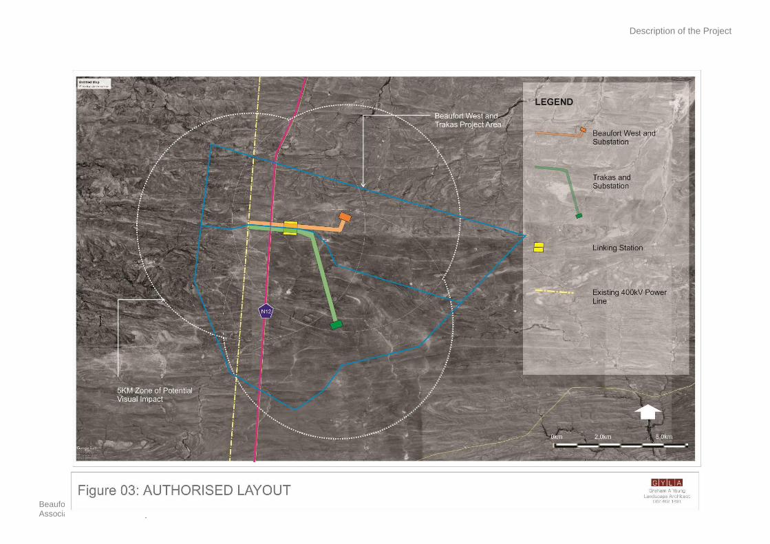
4.2 History of Authorised Beaufort West Cluster
The proposed substation, BESS, laydown area, O&M building and associated powerline projects, which form
part of separate respective applications and BA processes, will service both of Mainstream’s authorised wind
farm projects (namely the Beaufort West and Trakas Wind Farms) and associated electrical infrastructure
which form part of the Beaufort West Cluster5.
The authorised Beaufort West Cluster consists of two (2) wind farm projects with associated electrical
infrastructure, which include a 132kV/400kV Linking Substation, two (2) 33kV/132kV onsite substations [one
(1) per wind farm] and 132kV powerlines. The two (2) wind farms which form part of the Beaufort West
Cluster were first authorised as one (1) larger wind farm (namely the Beaufort West Wind Farm) in March
2012 (12-12-20-1784). Thereafter, in February 2017, the authorised Beaufort West Wind Farm was split into
the Beaufort West (12-12-20-1784-1) and Trakas (12-12-20-1784-2) Wind Farms respectively.
Both above-mentioned Wind Farms were amended in 2020 to increase the turbine hub heights and increase
the rotor diameters (Beaufort West Wind Farm – March 2020: 12-12-20-1784-1-AM5 and Trakas Wind Farm
– February 2020: 12-12-20-1784-1-AM1). Further administrative amendments were granted to both
respective Wind Farms in 2020 (Beaufort West Wind Farm – March 2020: 12-12-20-1784-1-AM2 and Trakas
Wind Farm – February 2020: 12-12-20-1784-2-AM2) that included changing the holder of the Environmental
Authorisations, adding Battery Energy Storage Facilities and amending project descriptions.
The supporting powerlines, linking station and onsite substation infrastructure were authorised for both
respective wind farms in January 2017 (14-12-16-3-3-2-925). This authorisation was subsequently amended
to split and assign each substation and powerline to each respective wind farm in August 2021 (Beaufort
West 132KV-400KV Linking Station, 132KV Power Line and onsite 132KV Substation – 14-12-16-3-3-2-925-
1 and Trakas 132KV-400KV Linking Station, 132KV Power Line and onsite 132KV Substation – 14-12-16-3-
3-2-925-2). Refer to Figure 03 below.
Description of the Project
8 Beaufort West Wind Farm Substation and DRAFT: Visual Impact Report
Associated Infrastructure Project 21 October 2021
Description of the Project
9 Beaufort West Wind Farm 33kV / 132kV Substation, 132kV Powerline and FINAL: Visual Impact Report Associated Infrastructure Projects 21 October 2021
Description of the Project
10 Beaufort West Wind Farm 33kV / 132kV Substation, 132kV Poweline and FINAL: Visual Impact Report Associated Infrastructure Projects 21 October 2021
4.3 Project Components
As mentioned above, the proposed projects will service Mainstream’s authorised Beaufort West and Trakas
Wind Farms (including associated electrical infrastructure). The proposed projects require several key
components to facilitate the transmission and distribution of electricity at a large scale. This includes:
33/132kV yard of Onsite Substation, BESS, Laydown Area and O&M Building Application:
• One (1) 33 / 132kV substation9;
• One (1) solid-state (Lithium-ion) Battery Energy Storage System (BESS) within the
proposed substation footprint;
• One (1) temporary Assembly & Storage Area within site area for the assembly and
storage of precast turbine structures; and
• One (1) permanent Operations & Maintenance (O&M) Building.
132kV switching station yard of Onsite Substation and 132kV Powerline Application:
• One (1) 132kV switching substation9;
• One (1) 132kV overhead powerline; and
• A road in the servitude under the proposed powerline from the proposed onsite switching
substation to an authorised linking station (14-12-16-3-3-2-925-1).
The proposed substation will have a capacity of 33kV/132kV and will occupy a footprint of up to
approximately 3 hectares (ha). It should be noted that the onsite substation forms part of both applications as
it will consist of a 33/132kV yard which will be owned and operated by Mainstream, as well as a 132kV
switching station yard which will be owned and operated by Eskom. The 33/132kV yard of onsite substation
forms part of separate proposed application for EA with the associated infrastructure (namely the BESS,
laydown area and O&M building) and is subject to a separate BA process. In addition, the 132kV switching
station yard of the onsite substation forms part of another separate application for EA with the 132kV
overhead powerline and is also subject to a separate BA process.
The proposed 3.45km powerline (which forms part of a separate application and BA process, along with the
132kV yard of the onsite substation) will have a capacity of up to 132kV, while an area of approximately
34.5ha (i.e., 3.45km line with 100m powerline corridor buffer) will be assessed. This is to allow flexibility
when routing the powerline within the authorised corridor. The powerline forms part of the application and BA
process for the 132kV switching station yard of the onsite substation.
A solid-state (Lithium-ion) BESS will be required and will occupy an area of up to 4ha within the proposed
substation footprint. The BESS forms part of the application and BA process for the 33/132kV yard of the
onsite substation, laydown area and O&M building.
A road will also be required in the servitude under the proposed powerline (approx. 4-8m wide) and will run
from the proposed onsite substation (part of both respective applications) to the authorised linking station
(14-12-16-3-3-2-925-1). The road forms part of the application and BA process for the 132kV switching
station yard of the onsite substation and associated 132kV powerline.
In addition to the above, a temporary area (of up to 7ha) within the site area will be required for the assembly
and storage of the precast turbine structures. A permanent O&M building will also be required and will
occupy a footprint of up to approximately 1,2ha. The Temporary Assembly & Storage Area and Permanent
O&M Building form part of the application and BA process for the 33/132kV yard of the onsite substation and
BESS.
9 Onsite substation will consist of 33/132kV yard which will be owned and operated by Mainstream, as well as 132kV switching station yard which will be owned and operated by Eskom. 33/132kV yard of onsite substation and associated infrastructure (BESS, laydown area and O&M building) forms part of separate proposed application for EA, while 132kV switching station yard of onsite substation and 132kV overhead powerline forms part of another separate application for EA.
Description of the Project
11 Beaufort West Wind Farm 33kV / 132kV Substation, 132kV Powerline and FINAL: Visual Impact Report Associated Infrastructure Projects 21 October 2021
Table 1 below represents these various components of the respective projects and their specifications, as
well as a detailed breakdown of the impact footprint. Temporary areas necessary for construction are also
included. The location of these components with the project sites is shown in Figure 02 below.
Description of the Project
12 Beaufort West Wind Farm 33kV / 132kV Substation, 132kV Poweline and FINAL: Visual Impact Report
Associated Infrastructure Projects 21 October 2021
Table 1 Summary of the key project components
Project Components Location and size / extent (i.e., Farm Names and Areas)
Location • Portion 1 of the Farm Trakaskuilen No. 15 - C061000000000015000001
• Remainder of the Farm Trakaskuilen No. 15 - C061000000000015000010
Onsite Substation • One (1) new substation with capacity of 33kV/132kV
• Total footprint of up to approx. 3ha
• Will contain transformers for voltage step up from low voltage (33kV) to medium voltage (132kV)
• Direct Current (DC) power from the authorised Beaufort West Wind Farm (12-12-20-1784-1-AM2)
and Trakas Wind Farm (12-12-20-1784-1-AM2) will be converted into Alternating Current (AC) power
in the inverters and the voltage will be stepped up to medium voltage in the inverter transformers
• Two (2) onsite substation alternatives, each with their own associated powerline, are being
considered and assessed
• Onsite substation forms part of both applications as it will consist of a 33/132kV yard which will be
owned and operated by Mainstream, as well as a 132kV switching station yard which will be owned
and operated by Eskom.
Grid Connection (Powerline) • Capacity of up to 132kV
• Length of up to approx. 3,45km
• Powerline corridors with widths of 100m (i.e., 50m on either side of centre line) being proposed and
assessed (i.e., 3.45km line with 100m buffers being assessed)
• This will allow for flexibility when routing powerline within the authorised corridor
• Powerline forms part of application and BA process for 132kV switching station yard of onsite
substation
Battery Energy Storage System (BESS) • One (1) BESS with total footprint of up to approx. 4ha
• Type of technology will be solid state, Lithium-ion
• Batteries will be used to store ‘energy’
• Batteries to be used are already assembled prior to delivery and come as ‘plug and play’ modular
units
• BESS forms part of application and BA process for 33/132kV yard of onsite substation, laydown area
and O&M building
Roads
• One (1) new road will be required in servitude under proposed powerline
• Width of up to approx. 4-8m wide
• Will run from proposed onsite substation (part of this application) to authorised linking station (14-12-
16-3-3-2-925-1)
Description of the Project
13 Beaufort West Wind Farm 33kV / 132kV Substation, 132kV Powerline and FINAL: Visual Impact Report Associated Infrastructure Projects 21 October 2021
• Road forms part of application and BA process for 132kV switching station yard of onsite substation
and associated 132kV powerline
Temporary Assembly & Storage Area • A temporary area will be required for assembly and storage of precast turbine structures
• Will require an area of up to 7ha
• Temporary Assembly & Storage Area forms part of application and BA process for 33/132kV yard of
onsite substation, BESS and O&M building
Permanent Operations and Maintenance (O&M) Building • One (1) permanent O&M building will be required
• Will occupy a footprint of up to approx. 1,2ha
• Permanent O&M Building forms part of application and BA process for 33/132kV yard of onsite
substation, BESS and laydown area
Description of the Project
14 Beaufort West Wind Farm 33kV / 132kV Substation, 132kV Poweline and FINAL: Visual Impact Report Associated Infrastructure Projects 21 October 2021
4.4 Site Layout
The site layout for the proposed projects makes provision for two (2) site area alternatives (each up to
approximately 20ha) for the onsite substation and associated infrastructure (including BESS, O&M building
and laydown area). In addition, powerline corridors with widths of 100m (i.e., 100m powerline corridor buffer,
50m on either side of centre line) have also been assessed for the 132kV switching station yard of the
substation and 132kV powerline application / project (as detailed in Table 1 above).
The site layout being proposed for the respective projects is shown in Figure 02 above.
4.5 Alternatives
A comprehensive design process has been undertaken to inform the layout alternatives for the proposed
projects.
As part of the proposed projects / BA processes, two (2) site area alternatives of up to approximately 200
000m2 (i.e., 500m x 400m or 20ha) each have been assessed for the onsite substation, BESS, laydown area
and O&M building. In addition, as part of the site area alternatives, powerline corridors with widths of 100m
(i.e., 100m powerline corridor buffer, 50m on either side of centre line) have also been assessed for the
132kV switching station yard of the substation and 132kV powerline application / project. This is to allow
flexibility when routing the powerline within the authorised corridor.
It is important to note that the proposed site area alternatives (including powerline corridor alternatives) will
be located within the site for the authorised Beaufort West (12-12-20-1784-1-AM2) and Trakas (12-12-20-
1784-2-AM2) Wind Farms respectively. As such, the location of the proposed onsite substation, BESS,
laydown area, O&M building and powerline has previously been assessed as part of the development
footprint for the authorised Beaufort West Cluster.
In addition, the alternatives associated with the proposed projects (including powerline corridors) have been
assessed against the ‘no-go’ alternative. The ‘no-go’ alternative is the option of not constructing the
projects, where the status quo of the current activities on the project sites would prevail.
Potential Visual Issues
15 Beaufort West Wind Farm 33kV / 132kV Substation, 132kV Poweline and FINAL: Visual Impact Report Associated Infrastructure Projects 21 October 2021
5. POTENTIAL VISUAL ISSUES
Wind farm infrastructure projects typically include medium to large-scale infrastructure that can cause
change to the fabric and character of an area and possible visual intrusion in sensitive landscapes. In the
case of these projects, the receiving environment is mostly open, and the site occurs in an area already
approved for wind farm activity. Refer to Figure 04 below, which indicates the location of the photo
panoramas and potential sensitive viewer locations.
Typical issues associated with industrial development are:
• Who will be able to see the new developments?
• What will they look like, and will they contrast with the receiving environment or blend with it?
• Are there sensitive views in the area that may be affected by the developments, and if so, how?
• What will be the impact of the developments during the day and at night?
• What will the cumulative impact be, if any?
These potential impacts will be considered and rated in the assessment section of the report (Section 11). At
the time of writing the results of the public participation process was not known, and whether visual issues
were raised by the public to indicate a sensitivity to visual and aesthetic concerns. However, because the
projects activities will take place within authorised wind farm projects, Beaufort West (12-12-20-1784-1-AM2)
and Trakas (12-12-20-1784-2-AM2) Wind Farms respectively, it is assumed that visual sensitivities will be
low.
Potential Visual Issues
16 Beaufort West Wind Farm 33kV / 132kV Substation, 132kV Poweline and FINAL: Visual Impact Report
Associated Infrastructure Projects 21 October 2021
Description of the Project
17 Beaufort West Wind Farm 33kV / 132kV Substation, 132kV Powerline and FINAL: Visual Impact Report Associated Infrastructure Projects 21 October 2021
The Environmental Setting
18 Beaufort West Wind Farm 33kV / 132kV Substation, 132kV Poweline and FINAL: Visual Impact Report Associated Infrastructure Projects 21 October 2021
6. VISUAL CHARACTER AND SENSITIVITY OF THE STUDY AREA
Defining the visual character of an area is an important part of assessing visual impacts, as it establishes the
visual baseline or existing visual environment in which the development would be constructed. The visual
impact of a development is measured by establishing the degree to which the development would contrast
with or conform to the visual character of the surrounding area. The inherent sensitivity of the area to visual
impacts or visual sensitivity is thereafter determined, based on the visual character, the economic
importance of the scenic quality of the area, the inherent cultural value of the area and the presence of visual
receptors. Physical and land use related characteristics, as outlined below, are important factors contributing
to the visual character of an area. (SiVEST, 2021:27)
6.1 Landscape and Land Use Characteristics10
The study area is largely characterised by open plains interspersed with dry river courses and low ridges.
Slopes are predominantly less than 2%, although there are some steeper slopes associated with low ridges.
The consequence of this open, flat landscape is that generally wide-ranging vistas are experienced
throughout the study area (refer to Figure 05 above). The most prominent feature in the landscape is the
Groot Swartberg range located approximately 45km south of the project site, as indicated in View 2 Figure
05 above.
Adding to the openness of the landscape, and hence wide-ranging vistas, is the low and sparse Gamka
Karoo vegetation type (Mucina and Rutherford, 2006) that covers the entire study area. Much of the
vegetation has been retained across the study area, with only a few instances of low-growing tree species.
A significant portion of the study area is ‘bare (none vegetated)’, and while some of these ‘bare’ areas are
representative of transformation due to human activity, in many cases these patches of land are undisturbed
areas with very sparse vegetation cover. Agricultural activity in the area is severely restricted by the arid
nature of the local climate and shallow soils. As such, the natural vegetation has been retained across much
of the study area. Sheep farming is the dominant activity, although the climatic and soil conditions have
resulted in low densities of livestock and relatively large farm properties across the area. Thus, the area has
a very low density of rural settlement, with relatively few scattered farmsteads in evidence. Figure 04 above
indicates the location of farmsteads within the study area. Built form in much of the study area is limited to
isolated farmsteads, including farm worker’s dwellings and ancillary farm buildings, gravel access roads,
telephone lines, fences and windmills.
The N12 national route is a dominant man-made feature in the landscape, bisecting the study area in a
north-south direction, linking Beaufort West with De Rust and Oudtshoorn in the south. Other roads in the
study area are mostly localized gravel access roads.
Existing powerlines in this area are also significant man-made features in an otherwise undeveloped
landscape. High voltage (400kV) powerlines bisect the study in a north-south alignment, while lower voltage
lines (22kV) are aligned directly adjacent to the N12 National Route In addition, the Trakaskuilen substation
is situated close to the N12, in the Beaufort West Wind Farm (12-12-20-1784-1-AM2) application site.
Although it is unclear whether this substation is operational, it is a substantial structure that has resulted in a
degree of transformation in the landscape.
As stated above, the sparse human habitation and the predominance of natural vegetation cover across
much of the study area would give the viewer the general impression of a largely natural setting with rural
elements. In addition, there are no towns or settlements in the visual assessment zone and thus, in general,
there are very low levels of human transformation and visual degradation within the study area. There are
however significant elements of human transformation, which are considered to have degraded the visual
character to some degree. These elements include existing 400kV and 22kV powerlines, the Trakaskuilen
10 Derived from SiVEST (2018)
The Environmental Setting
19 Beaufort West Wind Farm 33kV / 132kV Substation, 132kV Powerline and FINAL: Visual Impact Report Associated Infrastructure Projects 21 October 2021
substation and the N12 National route. The influence of the level of human transformation on the visual
character of the area is described in more detail below.
6.2 Visual Character and Sense of Place11
According to Lynch (1992), a sense of place is the extent to which a person can recognize or recall a place
as being distinct from other places - as having a vivid, or unique, or at least particular, character of its own.
The sense of place for the study area derives from a combination of the local landscape types described
above, and their impact on the senses. The activities and land-uses in the study area are common within the
sub-region and typical of an expanding (residential/industrial) urban area i.e. a mixture of uses and activities.
The greater area surrounding the development site is an important component when assessing visual
character. The area can be considered to have the typical Karoo or “platteland” landscape sense of place,
which would characteristically be encountered across the high-lying dry western and central interior of South
Africa. Over the last couple of decades, an increasing number of tourism routes have been established in the
Karoo and within a context of increasing urbanisation in South Africa’s major centres, the Karoo is being
marketed as an undisturbed getaway. The typical Karoo landscape can be considered a valuable ‘cultural
landscape’ in the South African context. Although the cultural landscape concept is relatively new, it is
becoming an increasingly important concept in terms of the preservation and management of rural and urban
settings across the world (Breedlove, 2002).
The typical Karoo landscape consisting of wide-open plains, and isolated relief, interspersed with isolated
farmsteads, windmills and stock holding pens, is an important part of the cultural matrix of the South African
environment. The Karoo farmstead is also a representation of how the harsh arid nature of the environment
in this part of the country has shaped the predominant land use and economic activity practiced in the area,
as well as the patterns of human habitation and interaction. The presence of small towns, such as Beaufort
West, engulfed by an otherwise rural environment, form an integral part of the wider Karoo landscape. As
such, the Karoo landscape as it exists today has value as a cultural landscape in the South African context.
Considering this, it is important to assess whether the introduction of new power lines, substations and
associated infrastructure into the study area would be a degrading factor in the context of the natural Karoo
character of the landscape, keeping in mind that the proposed developments will occur within authorised
wind farms. In addition, although the proposed development will be visible from the N12 national route which
traverses the study area, the section of the route within the study area is not considered to be of scenic
value.
11 Derived from SiVEST (2018)
Visual Resource
20 Beaufort West Wind Farm 33kV / 132kV Substation, 132kV Powerline and FINAL: Visual Impact Report Associated Infrastructure Projects 21 October 2021
7. VISUAL RESOURCE
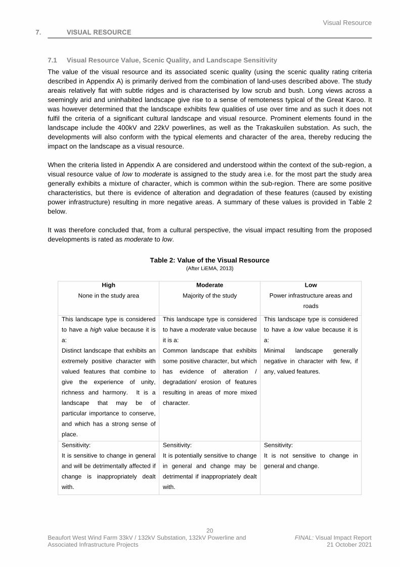
7.1 Visual Resource Value, Scenic Quality, and Landscape Sensitivity
The value of the visual resource and its associated scenic quality (using the scenic quality rating criteria
described in Appendix A) is primarily derived from the combination of land-uses described above. The study
areais relatively flat with subtle ridges and is characterised by low scrub and bush. Long views across a
seemingly arid and uninhabited landscape give rise to a sense of remoteness typical of the Great Karoo. It
was however determined that the landscape exhibits few qualities of use over time and as such it does not
fulfil the criteria of a significant cultural landscape and visual resource. Prominent elements found in the
landscape include the 400kV and 22kV powerlines, as well as the Trakaskuilen substation. As such, the
developments will also conform with the typical elements and character of the area, thereby reducing the
impact on the landscape as a visual resource.
When the criteria listed in Appendix A are considered and understood within the context of the sub-region, a
visual resource value of low to moderate is assigned to the study area i.e. for the most part the study area
generally exhibits a mixture of character, which is common within the sub-region. There are some positive
characteristics, but there is evidence of alteration and degradation of these features (caused by existing
power infrastructure) resulting in more negative areas. A summary of these values is provided in Table 2
below.
It was therefore concluded that, from a cultural perspective, the visual impact resulting from the proposed
developments is rated as moderate to low.
Table 2: Value of the Visual Resource (After LiEMA, 2013)
High
None in the study area
Moderate
Majority of the study
Low
Power infrastructure areas and
roads
This landscape type is considered
to have a high value because it is
a:
Distinct landscape that exhibits an
extremely positive character with
valued features that combine to
give the experience of unity,
richness and harmony. It is a
landscape that may be of
particular importance to conserve,
and which has a strong sense of
place.
This landscape type is considered
to have a moderate value because
it is a:
Common landscape that exhibits
some positive character, but which
has evidence of alteration /
degradation/ erosion of features
resulting in areas of more mixed
character.
This landscape type is considered
to have a low value because it is
a:
Minimal landscape generally
negative in character with few, if
any, valued features.
Sensitivity:
It is sensitive to change in general
and will be detrimentally affected if
change is inappropriately dealt
with.
Sensitivity:
It is potentially sensitive to change
in general and change may be
detrimental if inappropriately dealt
with.
Sensitivity:
It is not sensitive to change in
general and change.
Visual Resource
21 Beaufort West Wind Farm 33kV / 132kV Substation, 132kV Powerline and FINAL: Visual Impact Report Associated Infrastructure Projects 21 October 2021
7.2 Visual Sensitivity
Visual sensitivity can be defined as the inherent sensitivity of an area to potential visual impacts associated
with a proposed development. It is based on the physical characteristics of the area (i.e. topography,
landform and land cover), the spatial distribution of potential receptors, and the likely value judgments of
these receptors towards a new development (Oberholzer, 2005). A viewer’s perception is usually based on
the perceived aesthetic appeal of an area and on the presence of economic activities (such as recreational
tourism) which may be associated with this aesthetic appeal.
According to Swartz (2018:43), the study area is rated as having a low to moderate visual sensitivity. It
should be stressed however that the concept of visual sensitivity has been utilised indicatively to provide a
broad-scale indication of whether the landscape is likely to be sensitive to visual impacts and is based on the
physical characteristics of the study area, economic activities and land use that predominates. No formal
protected areas, leisure-based tourism activities, or sensitive receptor locations were identified in the study
area and relatively few potentially sensitive receptors were found to be present.
In this instance, the proposed revised grid connection infrastructure is intended to serve the
authorised Beaufort West (12-12-20-1784-1-AM2) and Trakas (12-12-20-1784-2-AM2) Wind Farms and
as such, the powerline, substation and associated infrastructure will be perceived as part of the
greater wind farm developments and the visual impact will be relatively minor when compared to the
visual impact associated with wind farms.
Landscape Impact
22 Beaufort West Wind Farm 33kV / 132kV Substation, 132kV Powerline and FINAL: Visual Impact Report Associated Infrastructure Projects 21 October 2021
8. LANDSCAPE IMPACT
The landscape impact (i.e. the change to the fabric and character of the landscape caused by the physical
presence of the intervention) of the proposed Projects when compared against the authorized powerline and
infrastructure components, is considered neutral. The proposed developments will cause no more impact
than that of the authorised powerlines and sub-stations (14-12-16-3-3-2-925-1 & 14-12-16-3-3-2-925-2), due
to the reduction in the area required by the proposed Projects.
As stated in the approach section, the physical change to the landscape at the Projects’ site must be
understood in terms of the Projects’ visibility (impact on sensitive viewers and viewing areas) and their effect
on the visual aesthetics of the area (as experienced through viewing the landscape – visual intrusion). The
following sections discuss the effect the Projects would have on the visual and aesthetic environment.
Visual Impact
23 Beaufort West Wind Farm 33kV / 132kV Substation, 132kV Powerline and DRAFT: Visual Impact Report Associated Infrastructure Projects 21 October 2021
9. VISUAL IMPACT
9.1 Visual Receptors
A sensitive receptor location is defined as a location from where receptors would potentially be adversely
impacted by a proposed development. Adverse impacts often arise where new development is seen as an
intrusion that alters the visual character of the area and affects the ‘sense of place’. The degree of visual
impact experienced will however vary from one (1) receptor to another, as it is largely based on the viewer’s
perception. A distinction must be made between a receptor location and a sensitive receptor location. A
receptor location is a site from where the proposed development may be visible, but the receptor may not
necessarily be adversely affected by any visual intrusion associated with the development. Less sensitive
receptors would include locations of commercial activities and certain movement corridors, such as roads
that are not tourism routes. More sensitive receptor locations typically include sites that are likely to be
adversely affected by the visual intrusion of the proposed development. They include tourism facilities,
scenic sites and certain residential dwellings in natural settings. (Swartz, 2018:46).
9.2 Sensitive Viewers
Although five (5) potentially sensitive receptor locations (Figure 04) occur within the study area, it is
concluded that none of these are sensitive to the projects. Accordingly, these receptors were excluded from
the assessment as it is assumed that the occupants would have a vested interest in the wind farm
development and the associated grid connection infrastructure (Swartz, 2018:47).
Furthermore, although the section of the N12 traversing the study area is not considered a scenic route, it is
likely that the road is utilised, to some extent, for its tourism potential and as a result, it is classed as a
potentially sensitive receptor road – i.e. a road being used by motorists who may object to the potential visual
intrusion of the proposed powerline, substation and associated infrastructure (Swartz, 2018:47).
9.3 Visibility
The proposed 132kV powerline, substation and associated infrastructure will be visible from the N12,
although these elements are between 1 and 5kms from the road and thus the visual impacts will be reduced.
i.e. visual exposure is limited to middle and background views.
Other roads in the study area are mostly gravel access roads used by residents. These roads are not valued
or utilised for their scenic or tourism potential and as such are not considered to be visually sensitive. The
potentially sensitive visual receptor locations relative to the zone of potential visual impact are indicated in
Figure 05 above.
9.4 Visual Intrusion
Visual intrusion deals with the notion of contextualism i.e. how well does a project component fit with or
disrupt/enhance the ecological and cultural aesthetic of the landscape as a whole? As the proposed 132kV
powerline, substation and associated infrastructure will only be built when the authorised wind farms are
built, they will appear as part of the overall power infrastructure and will not appear out of context. i.e. the
VAC is high.
9.5 The intensity of Visual Impact
The magnitude of visual impact is determined using visibility, visual intrusion, visual exposure, and viewer
sensitivity criteria. Referring to the discussions in the previous sections and using the criteria listed in
Appendix B, the magnitude of the worst-case scenario visual impact of the Project is rated in Table 3 below
for all phases of the projects. To assess the magnitude of visual impact, four (4) main factors are considered
as follows:
• Visual Intrusion: The nature of intrusion or contrast (physical characteristics) of a project component
on the visual quality of the surrounding environment and its compatibility/discord with the landscape
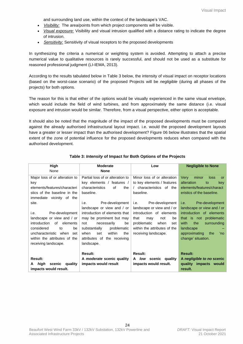
Visual Impact
24 Beaufort West Wind Farm 33kV / 132kV Substation, 132kV Powerline and DRAFT: Visual Impact Report Associated Infrastructure Projects 21 October 2021
and surrounding land use, within the context of the landscape’s VAC.
• Visibility: The area/points from which project components will be visible.
• Visual exposure: Visibility and visual intrusion qualified with a distance rating to indicate the degree
of intrusion.
• Sensitivity: Sensitivity of visual receptors to the proposed developments
In synthesizing the criteria a numerical or weighting system is avoided. Attempting to attach a precise
numerical value to qualitative resources is rarely successful, and should not be used as a substitute for
reasoned professional judgment (LI-IEMA, 2013).
According to the results tabulated below in Table 3 below, the intensity of visual impact on receptor locations
(based on the worst-case scenario) of the proposed Projects will be negligible (during all phases of the
projects) for both options.
The reason for this is that either of the options would be visually experienced in the same visual envelope,
which would include the field of wind turbines, and from approximately the same distance (i.e. visual
exposure and intrusion would be similar. Therefore, from a visual perspective, either option is acceptable.
It should also be noted that the magnitude of the impact of the proposed developments must be compared
against the already authorised infrastructural layout impact. i.e. would the proposed development layouts
have a greater or lesser impact than the authorised development? Figure 06 below illustrates that the spatial
extent of the zone of potential influence for the proposed developments reduces when compared with the
authorised development.
Table 3: Intensity of Impact for Both Options of the Projects
High
None
Moderate
None
Low
Negligible to None
Major loss of or alteration to
key
elements/features/characteri
stics of the baseline in the
immediate vicinity of the
site.
i.e. Pre-development
landscape or view and / or
introduction of elements
considered to be
uncharacteristic when set
within the attributes of the
receiving landscape.
Result:
A high scenic quality
impacts would result.
Partial loss of or alteration to
key elements / features /
characteristics of the
baseline.
i.e. Pre-development
landscape or view and / or
introduction of elements that
may be prominent but may
not necessarily be
substantially problematic
when set within the
attributes of the receiving
landscape.
Result:
A moderate scenic quality
impacts would result
Minor loss of or alteration
to key elements / features
/ characteristics of the
baseline.
i.e. Pre-development
landscape or view and / or
introduction of elements
that may not be
problematic when set
within the attributes of the
receiving landscape.
Result:
A low scenic quality
impacts would result.
Very minor loss or
alteration to key
elements/features/charact
eristics of the baseline.
i.e. Pre-development
landscape or view and / or
introduction of elements
that is not problematic
with the surrounding
landscape –
approximating the ‘no
change’ situation.
Result:
A negligible to no scenic
quality impacts would
result.
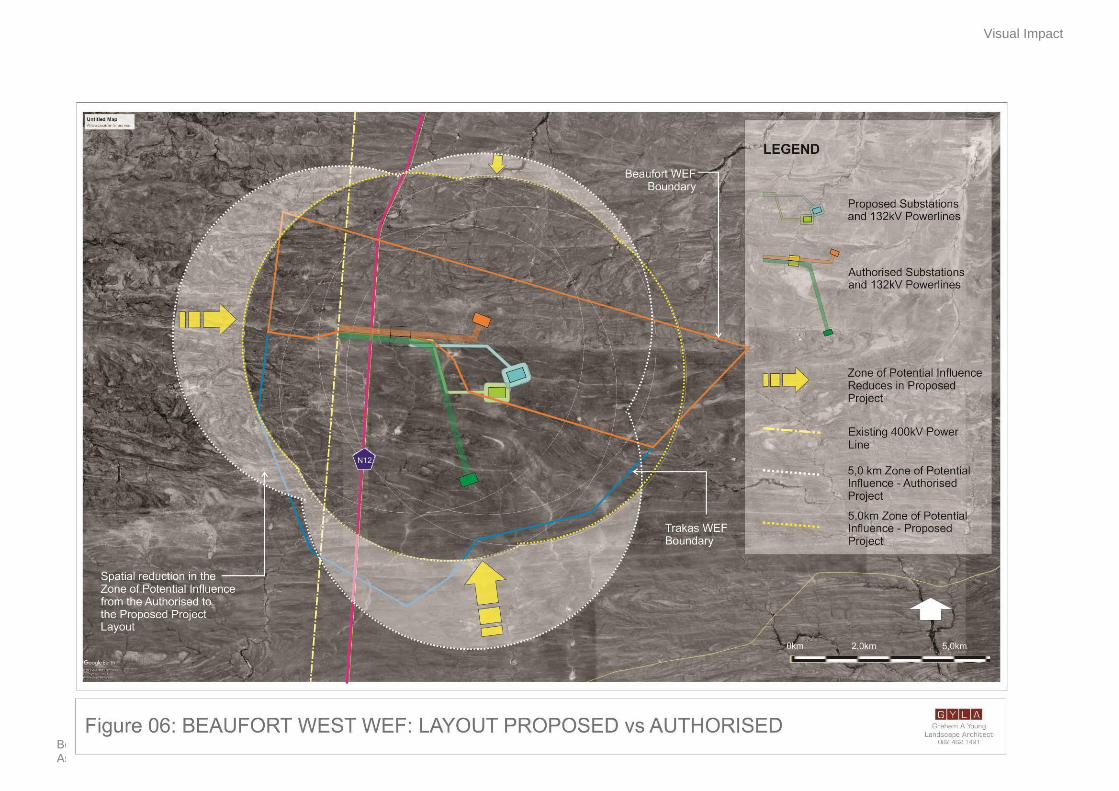
Visual Impact
25 Beaufort West Wind Farm 33kV / 132kVSubstation, 132kV Powerline and FINAL: Visual Impact Report Associated Infrastructure Project 21 October 2021
Management Measures
26 Beaufort West Wind Farm 33kV / 132kVSubstation, 132kV Powerline and FINAL: Visual Impact Report Associated Infrastructure Project 21 October 2021
10. MANAGEMENT MEASURES
In considering mitigating measures, three (3) rules are considered - the measures should be feasible
(economically), effective (how long will it take to implement and what provision is made for
management/maintenance), and acceptable (within the framework of the existing landscape and land use
policies for the area). To address these, the following principles have been established:
• Mitigation measures should be designed to suit the existing landscape character and needs of the
locality. They should respect and build upon landscape distinctiveness.
• It should be recognized that many mitigation measures, especially the establishment of planted
screens and rehabilitation, are not immediately effective.
The following general actions are recommended, and applicable to both proposed applications / projects
during construction, operation and decommissioning:
10.1 Preparatory Works and Construction Concerns
• With the preparation of the portions of land onto which activities will take place, the minimum amount
of existing vegetation and topsoil should be removed.
• Ensure, wherever possible, natural indigenous vegetation is retained and incorporated into the site
rehabilitation.
• All topsoil that occurs within the proposed footprint of an activity must be removed and stockpiled for
later use. The construction contract must include the stripping and stockpiling of topsoil. Topsoil
would be used later, during the rehabilitation phase of disturbed areas. The presence of degraded
areas and disused construction roads, which are not rehabilitated, will increase the overall visual
impact.
• Specifications with regards to the placement of construction camps, as well as a site plan of the
construction camp, indicating waste areas, storage areas, and placement of ablution facilities should
be included in the EMPr. These areas should either be screened or positioned in areas where they
would be less visible from human settlements and main roads.
• Adopt responsible construction practices aimed at strictly containing the construction/establishment
activities to specifically demarcated areas.
• Building or waste material discarded should be undertaken at an authorised location, which should
not be within any sensitive areas.
10.2 Earthworks
• Earthworks should be executed in such a way that only the footprint and a small ‘construction buffer
zone’ around the proposed activities are exposed. In all other areas, the naturally occurring
vegetation should be retained, especially along the periphery of the sites.
• All cut and fill slopes (if any) and areas affected by construction work should be progressively top
soiled and re-vegetated as soon as possible.
• Any soil must be exposed for the minimum time possible once cleared of vegetation, to avoid
prolonged exposure to wind and water erosion and to minimise dust generation.
10.3 Ecological approach
• Where new vegetation is proposed to be introduced to the site, an ecological approach to
rehabilitation, as opposed to a horticultural approach, should be adopted. For example, communities
of indigenous plants will enhance biodiversity, a desirable outcome for the area. This approach can
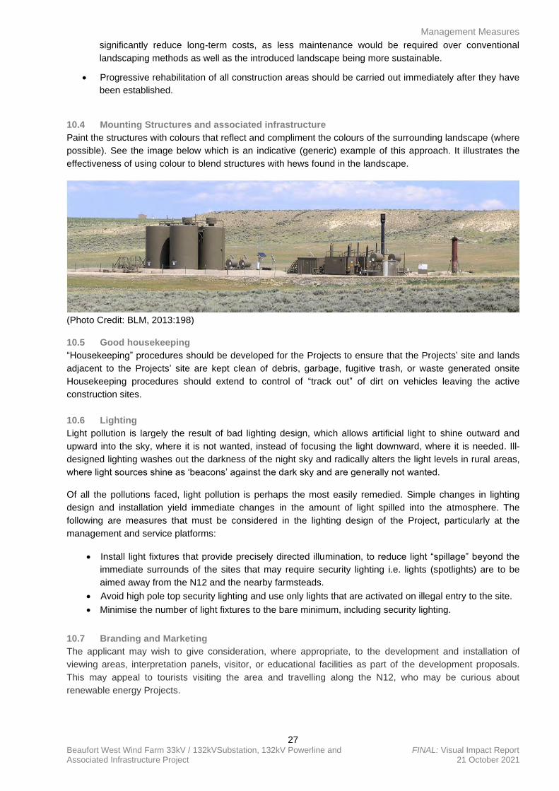
Management Measures
27 Beaufort West Wind Farm 33kV / 132kVSubstation, 132kV Powerline and FINAL: Visual Impact Report Associated Infrastructure Project 21 October 2021
significantly reduce long-term costs, as less maintenance would be required over conventional
landscaping methods as well as the introduced landscape being more sustainable.
• Progressive rehabilitation of all construction areas should be carried out immediately after they have
been established.
10.4 Mounting Structures and associated infrastructure
Paint the structures with colours that reflect and compliment the colours of the surrounding landscape (where
possible). See the image below which is an indicative (generic) example of this approach. It illustrates the
effectiveness of using colour to blend structures with hews found in the landscape.
(Photo Credit: BLM, 2013:198)
10.5 Good housekeeping
“Housekeeping” procedures should be developed for the Projects to ensure that the Projects’ site and lands
adjacent to the Projects’ site are kept clean of debris, garbage, fugitive trash, or waste generated onsite
Housekeeping procedures should extend to control of “track out” of dirt on vehicles leaving the active
construction sites.
10.6 Lighting
Light pollution is largely the result of bad lighting design, which allows artificial light to shine outward and
upward into the sky, where it is not wanted, instead of focusing the light downward, where it is needed. Ill-
designed lighting washes out the darkness of the night sky and radically alters the light levels in rural areas,
where light sources shine as ‘beacons’ against the dark sky and are generally not wanted.
Of all the pollutions faced, light pollution is perhaps the most easily remedied. Simple changes in lighting
design and installation yield immediate changes in the amount of light spilled into the atmosphere. The
following are measures that must be considered in the lighting design of the Project, particularly at the
management and service platforms:
• Install light fixtures that provide precisely directed illumination, to reduce light “spillage” beyond the
immediate surrounds of the sites that may require security lighting i.e. lights (spotlights) are to be
aimed away from the N12 and the nearby farmsteads.
• Avoid high pole top security lighting and use only lights that are activated on illegal entry to the site.
• Minimise the number of light fixtures to the bare minimum, including security lighting.
10.7 Branding and Marketing
The applicant may wish to give consideration, where appropriate, to the development and installation of
viewing areas, interpretation panels, visitor, or educational facilities as part of the development proposals.
This may appeal to tourists visiting the area and travelling along the N12, who may be curious about
renewable energy Projects.
Significance of Visual Impact
28 Beaufort West Wind Farm 33kV / 132kVSubstation, 132kV Powerline and FINAL: Visual Impact Report Associated Infrastructure Project 21 October 2021
11. SIGNIFICANCE OF VISUAL IMPACT
The identification and assessment of environmental impacts is a multi-faceted process, using a combination
of quantitative and qualitative descriptions and evaluations. It involves applying scientific measurements and
professional judgment to determine the significance of environmental impacts associated with the proposed
Project. The process involves consideration of, inter alia: the purpose and need for the Projects; views and
concerns of interested and affected parties (I&APs); social and political norms and the public’s interest (SLR,
2021).
The table below (Table 4) summarises the consequence and significance of the visual impact of the Projects.
These results are based on the worst-case scenario, when the impacts of all aspects of the Projects are
taken together using the impact criteria in Appendix D. Consequence of impact is a function of intensity,
duration, and spatial extent (SLR, 2021). The intensity of impact is taken from the situation as described in
Table 3: Intensity of Visual Impact above. These facilities are rated together, from a visual impact
perspective, as the one (1) would not exist without the other and they must be understood as the
collective/cumulative. Also, the visual impacts for the Construction, Operational and Decommissioning
Phases are potentially similar and are therefore rated together in Table 4 below.
It should be noted that the visual impacts during the Construction, Operational and Decommissioning
Phases for both respective applications / projects are identical. The table below (Table 4) is therefore
applicable to both proposed applications / projects.
Table 4: Significance of Visual Impact for Both Options of the Projects
Issue: Neutral visual impact
Description of Impact
The visual impact will be neutral to slightly less than the authorised development.
Type of Impact Direct
Nature of Impact Neutral
Phases Construction, Operational and Decommissioning
Criteria Without Mitigation With Mitigation
Intensity Very Low Very Low
Duration Very short-term Very short-term
Extent Local Local
Consequence Very low Very low
Probability Unlikely/improbable Unlikely/improbable
Significance Insignificant Insignificant
Degree to which impact can be
reversed
The impact is inconsequential, therefore not requiring any
consideration.
Degree to which impact may
cause irreplaceable loss of
resources
The project will not cause irreplaceable loss of visual resources
Degree to which impact can be
mitigated
The impact is negligible, however normal good housekeeping and
management are recommended.
11.1 Alternatives
As mentioned in Section 4.5, two (2) site area alternatives of up to approximately 200 000m2 (i.e., 500m x
400m or 20ha) each have been assessed for the onsite substation, BESS, laydown area and O&M building.
Powerline corridors with widths of 100m (i.e., 100m powerline corridor buffer, 50m on either side of centre
Significance of Visual Impact
29 Beaufort West Wind Farm 33kV / 132kVSubstation, 132kV Powerline and FINAL: Visual Impact Report Associated Infrastructure Project 21 October 2021
line) have also been assessed as part of the site area alternatives for the 132kV switching station yard of the
substation and 132kV powerline application / project, to allow flexibility when routing the powerline within the
authorised corridor.
In addition, the alternatives (including powerline corridors) have been assessed against the ‘no-go’
alternative. The ‘no-go’ alternative is the option of not constructing the projects, where the status quo of the
current farming activities on the sites would prevail.
As mentioned previously, from a visual perspective, either of the two (2) site area alternatives and powerline
corridor alternatives can be considered, as the potential impact of any one (1) alternative is neutral, when
compared to the authorised development option. Both options for each respective application / project would
be viewed within the matrix of turbines, which would command visual attention.
Cumulative Effect
30 Beaufort West Wind Farm 33kV / 132kVSubstation, 132kV Powerline and FINAL: Visual Impact Report Associated Infrastructure Project 21 October 2021
12. CUMULATIVE EFFECT
Concerning an activity, cumulative impact means “the past, current and reasonably foreseeable future
impact of an activity, considered together with the impact of activities associated with that activity, that in
itself may not be significant, but may be significant when added to the existing and reasonably foreseeable
impacts eventuating from similar or diverse activities” (NEMA EIA Reg GN R982 of 2014).
The South African Renewable Energy EIA Application Database (REEA) available at the time (namely
“REEA_OR_2021_Q2”) shows that there are no operational renewable energy developments situated within
a 30km radius of the proposed projects’ site. In addition, only a few renewable energy projects (wind) are
authorised within proximity to the town of Beaufort West. This includes the Beaufort West Cluster which
consists of two (2) authorised wind farm projects (namely the Beaufort West Wind Farm – 12-12-20-1784-1-
AM2 and Trakas Wind Farm - 12-12-20-1784-2-AM2) and associated electrical infrastructure (14-12-16-3-3-
2-925-1 & 14-12-16-3-3-2-925-2).
In addition to the above, ABO Wind Renewable Energies (Pty) Ltd is proposing the construction of three (3)
WEF’s and their associated infrastructure on properties immediately east of the authorised Beaufort West
Wind Farm site (CSIR, May 2021).
The application for EA for the Leeu Gamka Solar Power Plant (12/12/20/2296), which was identified within a
30km radius of the proposed project site, has been withdrawn and/or lapsed and therefore is not included in
the cumulative assessment.
The cumulative impact assessed is therefore the collective impact of the respective onsite substation, BESS,
laydown area, O&M building and powerline applications along with the authorised Beaufort West Wind Farm
and Trakas Wind Farm, including the associated electrical infrastructure, as well as the three (3) proposed
Kwagga WEFs immediately north and east of the development site, which are located within a 30km radius
of the projects’ site.
12.1 The cumulative effect of WEFs and Associated Infrastructure
Intervisibility for the projects described above and within a 30km radius of the development site will be
evident. The combined effect over time of these developments would result in the study area being impacted
upon in a manner beyond the anticipated neutral negative impacts of the proposed Projects alone.
WEFs (including their associated electrical infrastructure) have the potential to cause large-scale visual
impacts and the location of several such developments near each other could significantly alter the sense of
place and visual character in the broader region. Although powerlines and substations are relatively small
developments when compared to renewable energy facilities, they may still introduce a more industrial
character into the landscape, thus altering the sense of place.
The authorised Beaufort West (12-12-20-1784-1-AM2) and Trakas (12-12-20-1784-2-AM2) wind farms are
both integrally linked to the proposed grid connection projects (14-12-16-3-3-2-925-1 & 14-12-16-3-3-2-925-
2) and are located within the 5km visual assessment zone of potential impact for these projects. In addition,
the proposed wind farms and the grid connection infrastructure are all within the 5km viewing distance of the
potentially sensitive receptor locations identified in the study area. The proposed powerline, substation and
associated infrastructure projects are however located entirely on the two (2) authorised wind farm
application sites and as such will be perceived as part of the greater Beaufort West Cluster of wind
developments5. It could therefore be argued that the proposed powerline, substation and associated
infrastructure developments will not increase the cumulative impacts of the authorised wind farms and
associated electrical infrastructure to any significant degree.
The visual assessment undertaken for the combined Beaufort West and Trakas Wind Farm identified visual
impacts in their report (Oberholzer, 2010:20) and determined an overall impact rating of High (before
Cumulative Effect
31 Beaufort West Wind Farm 33kV / 132kVSubstation, 132kV Powerline and FINAL: Visual Impact Report Associated Infrastructure Project 21 October 2021
mitigation) and Medium-High (after mitigation). The impacts for the three (3) Kwagga Wind Farms have not
been published at the date of writing this report, however, it is reasonable to expect that these would be high,
given the vast spatial extent of the project and their relationship to the N12.
It should be noted that the above cumulative impact ratings would remain unchanged regardless of whether
the respective proposed powerline, substation and associated infrastructure projects are developed, as the
impact of the 132kV powerline, substation and associated infrastructure would be dwarfed by the cumulative
impact of the other renewable energy developments in the area.
Conclusion
32 Beaufort West Wind Farm 33kV / 132kVSubstation, 132kV Powerline and FINAL: Visual Impact Report Associated Infrastructure Project 21 October 2021
13. CONCLUSION
The existing visual condition of the landscape that may be affected by the proposed developments has been
described. It was important to assess whether the introduction of a new powerline, substation and associated
infrastructure into the study area would be a degrading factor in the context of the natural Karoo character of
the landscape, keeping in mind that the proposed developments will occur within authorised wind farms. In
addition, although the proposed developments will be visible from the N12 national route which traverses the
study area, the section of the route within the study area is not considered to be of scenic value. In addition,
the level of contrast is significantly reduced by the presence of existing powerlines and associated
infrastructure as well as the N12 road, which are prominent features in an open and relatively flat landscape.
Impacts to views are the highest when viewers are identified as being sensitive to change in the landscape,
and their views are focused on and dominated by the change. Only five (5) potentially sensitive receptors
were identified within the study area, however, these receptors have vested interest in the projects and
therefore not considered in the assessment. Travellers along the N12, who are tourists, were also
considered as potentially sensitive receptors.
The significance of impact, without mitigation and based on the worst-case scenario, for the sensitive
receptors during the construction, operational and decommissioning phases, is neutral i.e. where the impact
would not have any effect on the visual environment (over and above the authorised 132kV powerline and
associated infrastructure development), nor will it have a direct influence on the decision to develop the area.
Mitigation measures are, however, proposed that relate mostly to good housekeeping during the construction
phase. This is applicable to both proposed applications / projects.
Five (5) renewable energy developments were identified within a 30km radius of the proposed powerline,
substation and associated infrastructure projects. It was determined that these, namely the Beaufort West
WEF, Trakas WEF and the three (3) Kwagga WEFs, would have a significant impact on the landscape and
receptors within the visual assessment zone. These facilities are adjacent to each other and in effect form
one (1) large wind farm incorporating the proposed grid connection infrastructure. It is anticipated that the
concentration of WEFs will alter the inherent sense of place of the study area and introduce an increasingly
industrial character into a largely natural landscape, resulting in some form of cumulative impacts. Although,
it is anticipated that these impacts could be mitigated with the implementation of the recommendations and
mitigation measures stipulated for each of these developments by the visual specialists (Oberholzer, 2010).
In addition, impacts would be reduced to some degree with the presence of the existing 400kV powerline
infrastructure and the N12 national route in the vicinity of the WEFs, which have already partly transformed
the visual character.
13.1 Visual Impact Statement
It is the opinion of GYLA that the visual effects associated with the proposed developments are of neutral
significance. Given the low level of human habitation and the absence of sensitive receptors, the spatial
extent of the zone of potential influence is reduced and the impact of the powerline, substation and
associated infrastructure would be dwarfed by the cumulative effect of the other renewable energy
developments. The respective projects are thus deemed acceptable from a visual perspective, and should
each be approved, provided that the mitigation/management measures are effectively implemented,
managed, and monitored in the long term.
**GYLA**
References - Bibliography
33 Beaufort West Wind Farm 33kV / 132kVSubstation, 132kV Powerline and FINAL: Visual Impact Report Associated Infrastructure Project 21 October 2021
14. REFERENCES
Amir, S. & Gidalizon, E. 1990. Expert-based method for the evaluation of visual absorption capacity of the
landscape. Journal of Environmental Management. Vol. 30, Issue 3: 251 – 263.
Breedlove, G., 2002. A systematic for the South African Cultural Landscapes with a view to implementation.
Thesis – University of Pretoria.
Crawford, D., 1994. Using remotely sensed data in landscape visual quality assessment. Landscape and
Urban Planning. 30: 71-81.
Hull, R.B. & Bishop, I.E., 1988. Scenic Impacts of Electricity Transmission Towers: The Influence of
Landscape Type and Observer Distance. Journal of Environmental Management. 27: 99-108.
Ittelson, W.H., Proshansky, H.M., Rivlin, L.G. and Winkel, G.H., 1974. An Introduction to Environmental
Psychology. Holt, Rinehart and Winston, New York.
Kellerman, L. et al. 2021. Scoping and Environmental Impact Assessment for the Proposed Development of
the 279 MW Kwagga Wind Energy Facility near Beaufort West in the Western Cape. May 2021. CSIR
Unpublished Report, Stellenbosch.
Landscape Institute – Institute of Environmental Management and Assessment (LI-IEMA), 2013. Guidelines
for Landscape & Visual Impact Assessment. 3rd Edition, Routledge, London.
Lange, E., 1994. Integration of computerized visual simulation and visual assessment in environmental
planning. Landscape and Environmental Planning. 30: 99-112.
Lynch, K., 1992. Good City Form, The MIT Press, London. (131)
Oberholzer, B., 2005. Guideline for involving visual & aesthetic specialists in EIA processes: Edition 1. CSIR
Report No ENV-S-C 2005 053 F. Republic of South Africa, Provincial Government of the Western Cape,
Department of Environmental Affairs & Development Planning, Cape Town.
Sama, J. (2000), Program Policy, Assessing and Mitigating Visual Impact, Department of Environmental
Conservation. New York.
Sheppard, S.R.J. 2005. Validity, reliability, and ethics in visualisation. In Bishop, I. & Lange, E. (Eds.)
Visualisation in Landscape and Environmental Planning: Technology and Applications. Taylor and Francis,
London.
Schapper, J. (October 1993), The importance of aesthetic value in the assessment of landscape heritage.
More than meets the eye: identifying and assessing aesthetic value. Report of the Aesthetic Value Workshop
held at the University of Melbourne.
Swartz, K. 2018. Proposed Construction of a Linking Station, two (2) Power Lines and two (2) On-site
Substations for the Beaufort West and Trakas Wind Farms, near Beaufort West in the Western Cape
Province, Visual Impact Assessment Report. 07 December 2018. SiVest Unpublished Report Rev 1,
Johannesburg.
United States Department of the Interior. 2013. Best Management Practices for Reducing Visual Impacts of
Renewable Energy Facilities on BLM-Administered Lands. Bureau of Land Management. Cheyenne,
Wyoming. 342 pp, April. First Edition.
Appendix A
34 Beaufort West Wind Farm 33kV / 132kVSubstation, 132kV Powerline and FINAL: Visual Impact Report Associated Infrastructure Project 21 October 2021
APPENDIX A: DETERMINING THE VISUAL RESOURCE VALUE OF A LANDSCAPE
To reach an understanding of the effect of development on a landscape resource, it is necessary to consider
the different aspects of the landscape as follows:
Landscape Elements and Character
The individual elements that make up the landscape, including prominent or eye-catching features such as
hills, valleys, savannah, trees, water bodies, buildings and roads, are generally quantifiable and can be
easily described.
Landscape character is therefore the description of pattern, resulting from particular combinations of natural
(physical and biological) and cultural (land use) factors and how people perceive these. The visual
dimension of the landscape reflects the way in which these factors create repetitive groupings and interact to
create areas that have a specific visual identity. The process of landscape character assessment can
increase appreciation of what makes the landscape distinctive and what is important about an area. The
description of landscape character thus focuses on the nature of the land, rather than the response of a
viewer.
Landscape Value – all encompassing (Aesthetic Value)
Aesthetic value is the emotional response derived from the experience of the environment with its natural
and cultural attributes. The response can be either to visual or non-visual elements and can embrace sound,
smell and any other factor having a strong impact on human thoughts, feelings and attitudes (Ramsay,
1993). Thus, aesthetic value encompasses more than the seen view, visual quality or scenery, and includes
atmosphere, landscape character and sense of place (Schapper, 1993).
Aesthetic appeal (value) is considered high when the following are present (Ramsay, 1993):
• Abstract qualities: such as the presence of vivid, distinguished, uncommon or rare features or abstract
attributes.
• Evocative responses: the ability of the landscape to evoke particularly strong responses in community
members or visitors.
• Meanings: the existence of a long-standing special meaning to a particular group of people or the ability
of the landscape to convey special meanings to viewers in general.
• Landmark quality: a particular feature that stands out and is recognised by the broader community.
Sense of Place
Central to the concept of a sense of place is that the place requires uniqueness and distinctiveness. The
primary informant of these qualities is the spatial form and character of the natural landscape, together with
the cultural transformations and traditions associated with historic use and habitation. According to Lynch
(1992), sense of place "is the extent to which a person can recognize or recall a place as being distinct from
other places - as having a vivid, or unique, or at least particular, character of its own". Sense of place is the
unique value that is allocated to a specific place or area through the cognitive experience of the user or
viewer. In some cases, these values allocated to the place are similar for a wide spectrum of users or
viewers, giving the place a universally recognized and therefore, strong sense of place.
Scenic Quality
Assigning values to visual resources is a subjective process. The phrase, “beauty is in the eye of the
beholder,” is often quoted to emphasize the subjectivity in determining scenic values. Yet, researchers have
found consistent levels of agreement among individuals asked to evaluate visual quality.
Studies for perceptual psychology have shown human preference for landscapes with a higher visual
complexity, particularly in scenes with water, over homogeneous areas. Based on contemporary research
Appendix A
35 Beaufort West Wind Farm 33kV / 132kVSubstation, 132kV Powerline and FINAL: Visual Impact Report Associated Infrastructure Project 21 October 2021
landscape quality increases when:
• Topographic ruggedness and relative relief increase;
• Where water forms are present;
• Where diverse patterns of grasslands and trees occur;
• Where natural landscape increases and man-made landscape decreases and
• Where land use compatibility increases and land use edge diversity decreases (Crawford, 1994).
Scenic Quality - Explanation of Rating Criteria:
(After The Visual Resource Management System, Department of the Interior of the USA Government,
Bureau of Land Management)
Landform: Topography becomes more interesting as it gets steeper or more massive, or more severely or
universally sculptured. Outstanding landforms may be monumental, as the Fish River or Blyde River Canyon,
the Drakensberg or other mountain ranges, or they may be exceedingly artistic and subtle as certain
pinnacles, arches, and other extraordinary formations.
Vegetation: (Plant communities) Give primary consideration to the variety of patterns, forms, and textures
created by plant life. Consider short-lived displays when they are known to be recurring or spectacular
(wildflower displays in the Karoo regions). Consider also smaller scale vegetational features, which add
striking and intriguing detail elements to the landscape (e.g., gnarled or wind beaten trees, and baobab
trees).
Water: That ingredient which adds movement or serenity to a scene. The degree to which water dominates
the scene is the primary consideration in selecting the rating score.
Colour: Consider the overall colour(s) of the basic components of the landscape (e.g., soil, rock, vegetation,
etc.) as they appear during seasons or periods of high use. Key factors to use when rating "colour" are
variety, contrast, and harmony.
Adjacent Scenery: Degree to which scenery outside the scenery unit being rated enhances the overall
impression of the scenery within the rating unit. The distance which adjacent scenery will influence scenery
within the rating unit will normally range from 0-8 kilometres, depending upon the characteristics of the
topography, the vegetative cover, and other such factors. This factor is generally applied to units which
would normally rate very low in score, but the influence of the adjacent unit would enhance the visual quality
and raise the score.
Scarcity: This factor provides an opportunity to give added importance to one or all of the scenic features
that appear to be relatively unique or rare within one physiographic region. There may also be cases where a
separate evaluation of each of the key factors does not give a true picture of the overall scenic quality of an
area. Often it is a number of not so spectacular elements in the proper combination that produces the most
pleasing and memorable scenery - the scarcity factor can be used to recognize this type of area and give it
the added emphasis it needs.
Cultural Modifications: Cultural modifications in the landform / water, vegetation, and addition of structures
should be considered and may detract from the scenery in the form of a negative intrusion or complement or
improve the scenic quality of a unit.
Scenic Quality Inventory and Evaluation Chart
(After The Visual Resource Management System, Department of the Interior of the USA Government,
Bureau of Land Management)
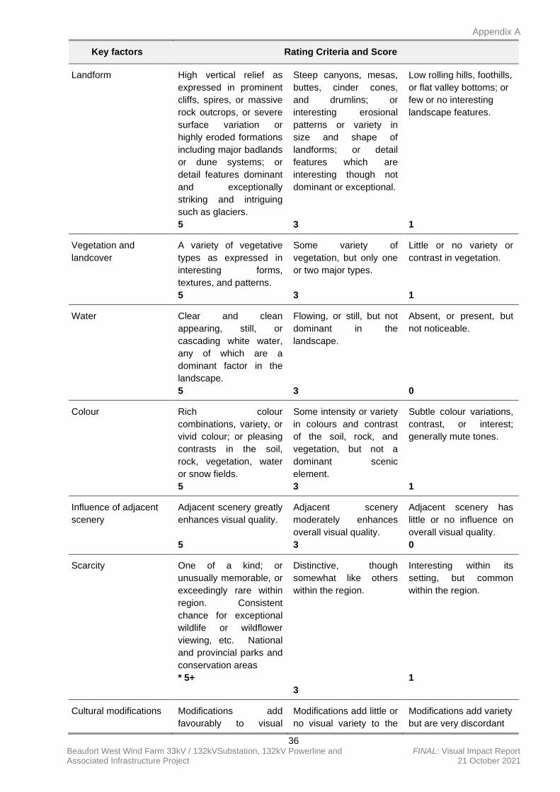
Appendix A
36 Beaufort West Wind Farm 33kV / 132kVSubstation, 132kV Powerline and FINAL: Visual Impact Report Associated Infrastructure Project 21 October 2021
Key factors Rating Criteria and Score
Landform High vertical relief as
expressed in prominent
cliffs, spires, or massive
rock outcrops, or severe
surface variation or
highly eroded formations
including major badlands
or dune systems; or
detail features dominant
and exceptionally
striking and intriguing
such as glaciers.
5
Steep canyons, mesas,
buttes, cinder cones,
and drumlins; or
interesting erosional
patterns or variety in
size and shape of
landforms; or detail
features which are
interesting though not
dominant or exceptional.
3
Low rolling hills, foothills,
or flat valley bottoms; or
few or no interesting
landscape features.
1
Vegetation and
landcover
A variety of vegetative
types as expressed in
interesting forms,
textures, and patterns.
5
Some variety of
vegetation, but only one
or two major types.
3
Little or no variety or
contrast in vegetation.
1
Water Clear and clean
appearing, still, or
cascading white water,
any of which are a
dominant factor in the
landscape.
5
Flowing, or still, but not
dominant in the
landscape.
3
Absent, or present, but
not noticeable.
0
Colour Rich colour
combinations, variety, or
vivid colour; or pleasing
contrasts in the soil,
rock, vegetation, water
or snow fields.
5
Some intensity or variety
in colours and contrast
of the soil, rock, and
vegetation, but not a
dominant scenic
element.
3
Subtle colour variations,
contrast, or interest;
generally mute tones.
1
Influence of adjacent
scenery
Adjacent scenery greatly
enhances visual quality.
5
Adjacent scenery
moderately enhances
overall visual quality.
3
Adjacent scenery has
little or no influence on
overall visual quality.
0
Scarcity One of a kind; or
unusually memorable, or
exceedingly rare within
region. Consistent
chance for exceptional
wildlife or wildflower
viewing, etc. National
and provincial parks and
conservation areas
* 5+
Distinctive, though
somewhat like others
within the region.
3
Interesting within its
setting, but common
within the region.
1
Cultural modifications Modifications add
favourably to visual
Modifications add little or
no visual variety to the
Modifications add variety
but are very discordant
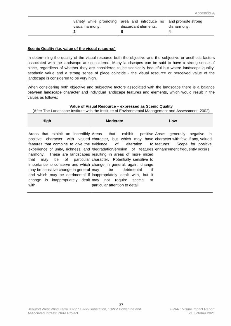
Appendix A
37 Beaufort West Wind Farm 33kV / 132kVSubstation, 132kV Powerline and FINAL: Visual Impact Report Associated Infrastructure Project 21 October 2021
variety while promoting
visual harmony.
2
area and introduce no
discordant elements.
0
and promote strong
disharmony.
4
Scenic Quality (i.e. value of the visual resource)
In determining the quality of the visual resource both the objective and the subjective or aesthetic factors
associated with the landscape are considered. Many landscapes can be said to have a strong sense of
place, regardless of whether they are considered to be scenically beautiful but where landscape quality,
aesthetic value and a strong sense of place coincide - the visual resource or perceived value of the
landscape is considered to be very high.
When considering both objective and subjective factors associated with the landscape there is a balance
between landscape character and individual landscape features and elements, which would result in the
values as follows:
Value of Visual Resource – expressed as Scenic Quality (After The Landscape Institute with the Institute of Environmental Management and Assessment, 2002)
High
Moderate
Low
Areas that exhibit an incredibly
positive character with valued
features that combine to give the
experience of unity, richness, and
harmony. These are landscapes
that may be of particular
importance to conserve and which
may be sensitive change in general
and which may be detrimental if
change is inappropriately dealt
with.
Areas that exhibit positive
character, but which may have
evidence of alteration to
/degradation/erosion of features
resulting in areas of more mixed
character. Potentially sensitive to
change in general; again, change
may be detrimental if
inappropriately dealt with, but it
may not require special or
particular attention to detail.
Areas generally negative in
character with few, if any, valued
features. Scope for positive
enhancement frequently occurs.
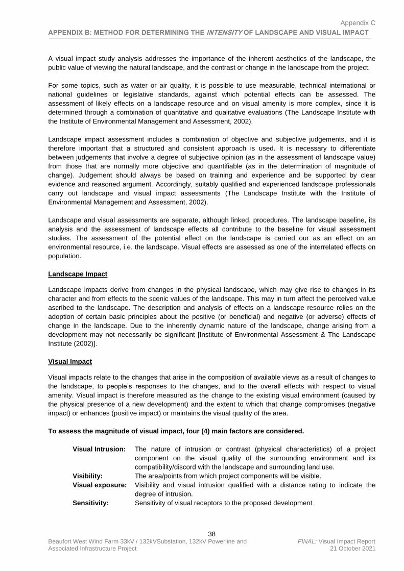
Appendix C
38 Beaufort West Wind Farm 33kV / 132kVSubstation, 132kV Powerline and FINAL: Visual Impact Report Associated Infrastructure Project 21 October 2021
APPENDIX B: METHOD FOR DETERMINING THE INTENSITY OF LANDSCAPE AND VISUAL IMPACT
A visual impact study analysis addresses the importance of the inherent aesthetics of the landscape, the
public value of viewing the natural landscape, and the contrast or change in the landscape from the project.
For some topics, such as water or air quality, it is possible to use measurable, technical international or
national guidelines or legislative standards, against which potential effects can be assessed. The
assessment of likely effects on a landscape resource and on visual amenity is more complex, since it is
determined through a combination of quantitative and qualitative evaluations (The Landscape Institute with
the Institute of Environmental Management and Assessment, 2002).
Landscape impact assessment includes a combination of objective and subjective judgements, and it is
therefore important that a structured and consistent approach is used. It is necessary to differentiate
between judgements that involve a degree of subjective opinion (as in the assessment of landscape value)
from those that are normally more objective and quantifiable (as in the determination of magnitude of
change). Judgement should always be based on training and experience and be supported by clear
evidence and reasoned argument. Accordingly, suitably qualified and experienced landscape professionals
carry out landscape and visual impact assessments (The Landscape Institute with the Institute of
Environmental Management and Assessment, 2002).
Landscape and visual assessments are separate, although linked, procedures. The landscape baseline, its
analysis and the assessment of landscape effects all contribute to the baseline for visual assessment
studies. The assessment of the potential effect on the landscape is carried our as an effect on an
environmental resource, i.e. the landscape. Visual effects are assessed as one of the interrelated effects on
population.
Landscape Impact
Landscape impacts derive from changes in the physical landscape, which may give rise to changes in its
character and from effects to the scenic values of the landscape. This may in turn affect the perceived value
ascribed to the landscape. The description and analysis of effects on a landscape resource relies on the
adoption of certain basic principles about the positive (or beneficial) and negative (or adverse) effects of
change in the landscape. Due to the inherently dynamic nature of the landscape, change arising from a
development may not necessarily be significant [Institute of Environmental Assessment & The Landscape
Institute (2002)].
Visual Impact
Visual impacts relate to the changes that arise in the composition of available views as a result of changes to
the landscape, to people’s responses to the changes, and to the overall effects with respect to visual
amenity. Visual impact is therefore measured as the change to the existing visual environment (caused by
the physical presence of a new development) and the extent to which that change compromises (negative
impact) or enhances (positive impact) or maintains the visual quality of the area.
To assess the magnitude of visual impact, four (4) main factors are considered.
Visual Intrusion: The nature of intrusion or contrast (physical characteristics) of a project
component on the visual quality of the surrounding environment and its
compatibility/discord with the landscape and surrounding land use.
Visibility: The area/points from which project components will be visible.
Visual exposure: Visibility and visual intrusion qualified with a distance rating to indicate the
degree of intrusion.
Sensitivity: Sensitivity of visual receptors to the proposed development
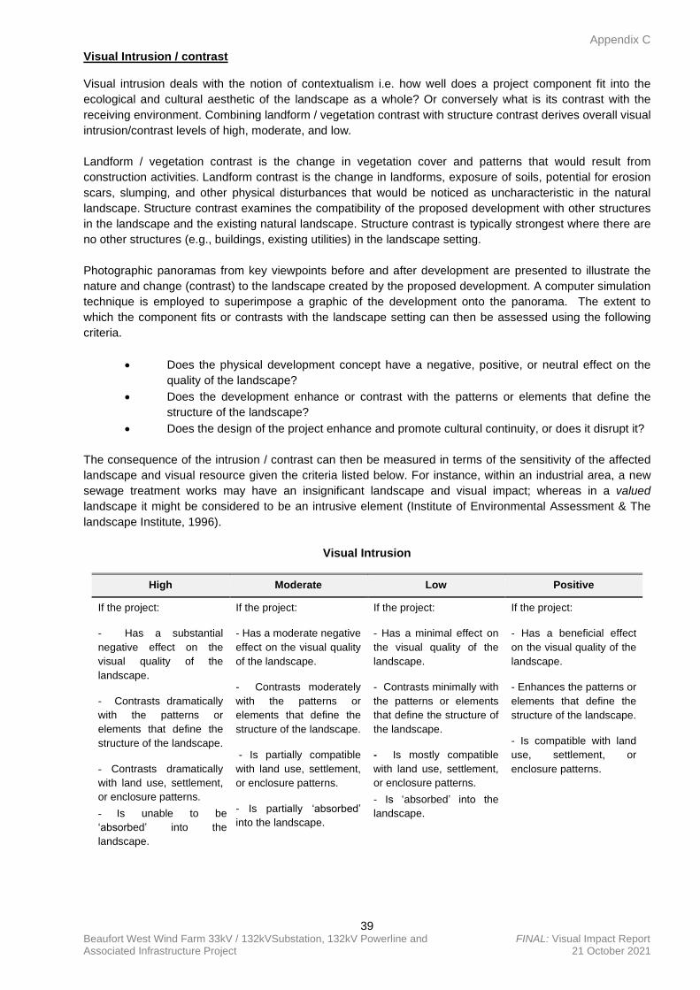
Appendix C
39 Beaufort West Wind Farm 33kV / 132kVSubstation, 132kV Powerline and FINAL: Visual Impact Report Associated Infrastructure Project 21 October 2021
Visual Intrusion / contrast
Visual intrusion deals with the notion of contextualism i.e. how well does a project component fit into the
ecological and cultural aesthetic of the landscape as a whole? Or conversely what is its contrast with the
receiving environment. Combining landform / vegetation contrast with structure contrast derives overall visual
intrusion/contrast levels of high, moderate, and low.
Landform / vegetation contrast is the change in vegetation cover and patterns that would result from
construction activities. Landform contrast is the change in landforms, exposure of soils, potential for erosion
scars, slumping, and other physical disturbances that would be noticed as uncharacteristic in the natural
landscape. Structure contrast examines the compatibility of the proposed development with other structures
in the landscape and the existing natural landscape. Structure contrast is typically strongest where there are
no other structures (e.g., buildings, existing utilities) in the landscape setting.
Photographic panoramas from key viewpoints before and after development are presented to illustrate the
nature and change (contrast) to the landscape created by the proposed development. A computer simulation
technique is employed to superimpose a graphic of the development onto the panorama. The extent to
which the component fits or contrasts with the landscape setting can then be assessed using the following
criteria.
• Does the physical development concept have a negative, positive, or neutral effect on the
quality of the landscape?
• Does the development enhance or contrast with the patterns or elements that define the
structure of the landscape?
• Does the design of the project enhance and promote cultural continuity, or does it disrupt it?
The consequence of the intrusion / contrast can then be measured in terms of the sensitivity of the affected
landscape and visual resource given the criteria listed below. For instance, within an industrial area, a new
sewage treatment works may have an insignificant landscape and visual impact; whereas in a valued
landscape it might be considered to be an intrusive element (Institute of Environmental Assessment & The
landscape Institute, 1996).
Visual Intrusion
High Moderate Low Positive
If the project:
- Has a substantial
negative effect on the
visual quality of the
landscape.
- Contrasts dramatically
with the patterns or
elements that define the
structure of the landscape.
- Contrasts dramatically
with land use, settlement,
or enclosure patterns.
- Is unable to be
‘absorbed’ into the
landscape.
If the project:
- Has a moderate negative
effect on the visual quality
of the landscape.
- Contrasts moderately
with the patterns or
elements that define the
structure of the landscape.
- Is partially compatible
with land use, settlement,
or enclosure patterns.
- Is partially ‘absorbed’
into the landscape.
If the project:
- Has a minimal effect on
the visual quality of the
landscape.
- Contrasts minimally with
the patterns or elements
that define the structure of
the landscape.
- Is mostly compatible
with land use, settlement,
or enclosure patterns.
- Is ‘absorbed’ into the
landscape.
If the project:
- Has a beneficial effect
on the visual quality of the
landscape.
- Enhances the patterns or
elements that define the
structure of the landscape.
- Is compatible with land
use, settlement, or
enclosure patterns.
Appendix C
40 Beaufort West Wind Farm 33kV / 132kVSubstation, 132kV Powerline and FINAL: Visual Impact Report Associated Infrastructure Project 21 October 2021
Result
Notable change in
landscape characteristics
over an extensive area
and/or intensive change
over a localized area
resulting in major changes
in key views.
Result
Moderate change in
landscape characteristics
over localized area
resulting in a moderate
change to key views.
Result
Imperceptible change
resulting in a minor
change to key views.
Result
Positive change in key
views.
Visual intrusion also diminishes with scenes of higher complexity, as distance increases, the object becomes
less of a focal point (more visual distraction), and the observer’s attention is diverted by the complexity of the
scene (Hull and Bishop, 1988).
Visibility
A viewshed analysis was carried out to define areas, which contain all possible observation sites from which
the developments would be visible. The basic assumption for preparing a viewshed analysis is that the
observer eye height is 1.8m above ground level. Topographic data was captured for the site and its environs
at 10 m contour intervals to create the Digital Terrain Model (DTM). The DTM includes features such as
vegetation, rivers, roads and nearby urban areas. These features were ‘draped’ over the topographic data to
complete the model used to generate the viewshed analysis. It should be noted that viewshed analyses are
not absolute indicators of the level of significance (magnitude) of the impact in the view, but merely a
statement of the fact of potential visibility. The visibility of a development and its contribution to visual impact
is predicted using the criteria listed below:
Visibility
High Moderate Low
Visual Receptors
If the development is visible from
over half the zone of potential
influence, and/or views are
mostly unobstructed and/or the
majority of viewers are affected.
Visual Receptors
If the development is visible
from less than half the zone of
potential influence, and/or
views are partially obstructed
and or many viewers are
affected
Visual Receptors
If the development is visible
from less than a quarter of the
zone of potential influence,
and/or views are mostly
obstructed and/or few viewers
are affected.
Visual Exposure
Visual exposure relates directly to the distance of the view. It is a criterion used to account for the limiting
effect of increased distance on visual impact. The impact of an object in the foreground (0 – 800m) is greater
than the impact of that same object in the middle ground (800m – 5.0km), which, in turn, is greater than the
impact of the object in the background (greater than 5.0km) of a particular scene.
Distance from a viewer to a viewed object or area of the landscape influences how visual changes are
perceived in the landscape. Generally, changes in form, line, colour, and texture in the landscape become
less perceptible with increasing distance.
Areas seen from 0 to 800m are considered foreground; foliage and fine textural details of vegetation are
normally perceptible within this zone.
Areas seen from 800m to 5.0km are considered middle ground; vegetation appears as outlines or patterns.
Depending on topography and vegetation, middle ground is sometimes considered to be up to 8.0km.
Areas seen from 5.0km to 8.0km and sometimes up to 16km and beyond are considered background.
Landforms become the most dominant element at these distances.
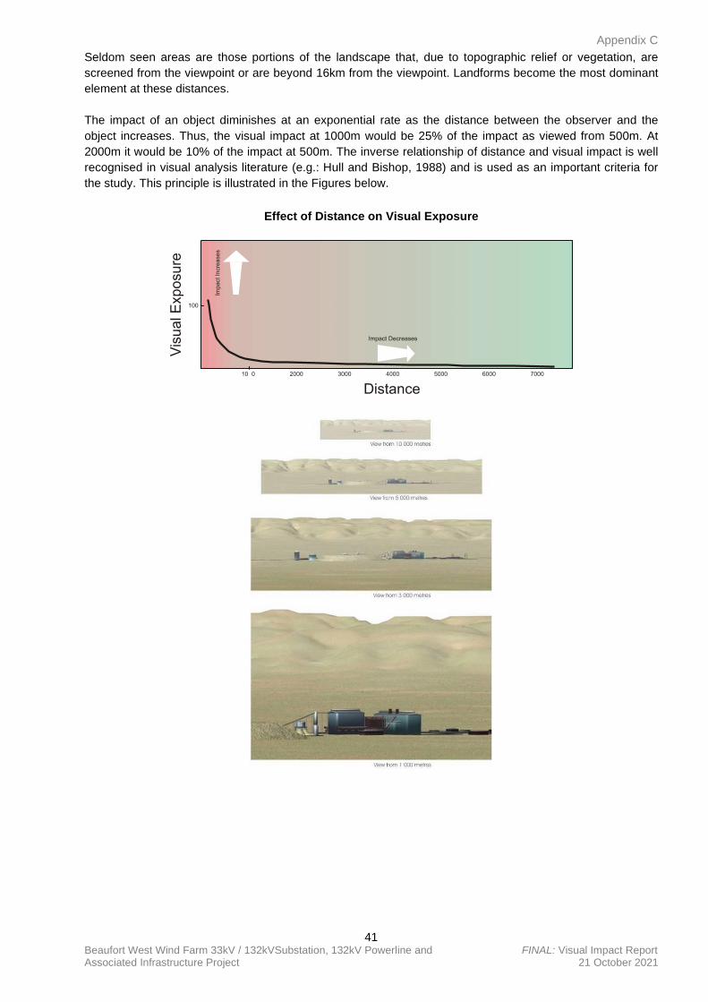
Appendix C
41 Beaufort West Wind Farm 33kV / 132kVSubstation, 132kV Powerline and FINAL: Visual Impact Report Associated Infrastructure Project 21 October 2021
Seldom seen areas are those portions of the landscape that, due to topographic relief or vegetation, are
screened from the viewpoint or are beyond 16km from the viewpoint. Landforms become the most dominant
element at these distances.
The impact of an object diminishes at an exponential rate as the distance between the observer and the
object increases. Thus, the visual impact at 1000m would be 25% of the impact as viewed from 500m. At
2000m it would be 10% of the impact at 500m. The inverse relationship of distance and visual impact is well
recognised in visual analysis literature (e.g.: Hull and Bishop, 1988) and is used as an important criteria for
the study. This principle is illustrated in the Figures below.
Effect of Distance on Visual Exposure
Appendix C
42 Beaufort West Wind Farm 33kV / 132kVSubstation, 132kV Powerline and FINAL: Visual Impact Report Associated Infrastructure Project 21 October 2021
Sensitivity of Visual Receptors
When visual intrusion, visibility and visual exposure are incorporated and qualified by sensitivity criteria
(visual receptors), the magnitude of the impact of the development can be determined.
The sensitivity of visual receptors and views will be depended on:
• The location and context of the viewpoint.
• The expectations and occupation or activity of the receptor.
• The importance of the view (which may be determined with respect to is popularity or
numbers of people affected, its appearance in guidebooks, on tourist maps, and in the
facilities provided for its enjoyment and references to it in literature or art).
The most sensitive receptors may include:
• Users of all outdoor recreational facilities including public rights of way, whose intention or
interest may be focused on the landscape.
• Communities where the development results in changes in the landscape setting or valued
views enjoyed by the community.
• Occupiers of residential properties with views affected by the development.
• These would all be high
Other receptors include:
• People engaged in outdoor sport or recreation (other than appreciation of the landscape, as
in landscapes of acknowledged importance or value).
• People travelling through or past the affected landscape in cars, on trains or other transport
routes.
• People at their place of work.
The least sensitive receptors are likely to be people at their place of work, or engaged in similar activities,
whose attention may be focused on their work or activity and who therefore may be potentially less
susceptible to changes in the view.
In this process more weight is usually given to changes in the view or visual amenity which are greater in
scale, and visible over a wide area. In assessing the effect on views, consideration should be given to the
effectiveness of mitigation measures, particularly where planting is proposed for screening purposes
(Institute of Environmental Assessment & The Landscape Institute, 1996).
Sensitivity of Visual Receptors
High Moderate Low
Users of all outdoor recreational
facilities including public rights of
way, whose intention or interest
may be focused on the landscape.
Communities where the
development results in changes in
the landscape setting or valued
views enjoyed by the community.
Occupiers of residential properties
with views affected by the
development.
People engaged in outdoor sport
or recreation (other than
appreciation of the landscape, as
in landscapes of acknowledged
importance or value).
People travelling through or past
the affected landscape in cars, on
trains or other transport routes.
The least sensitive receptors are
likely to be people at their place of
work, or engaged in similar
activities, whose attention may be
focused on their work or activity
and who therefore may be
potentially less susceptible to
changes in the view (i.e. office and
industrial areas).
Roads going through urban and
industrial areas
Appendix C
43 Beaufort West Wind Farm 33kV / 132kVSubstation, 132kV Powerline and FINAL: Visual Impact Report Associated Infrastructure Project 21 October 2021
Magnitude of the Visual Impact
Potential visual impacts are determined by analysing how the physical change in the landscape, resulting
from the introduction of a project, are viewed and perceived from sensitive viewpoints. Impacts to views are
the highest when viewers are identified as being sensitive to change in the landscape, and their views are
focused on and dominated by the change. Visual impacts occur when changes in the landscape are
noticeable to viewers looking at the landscape from their homes or from parks, and conservation areas,
highways and travel routes, and important cultural features and historic sites, especially in foreground views.
The magnitude of impact is assessed through a synthesis of visual intrusion, visibility, visual exposure and
viewer sensitivity criteria. Once the magnitude of impact has been established this value is further qualified
with spatial, duration and probability criteria to determine the significance of the visual impact.
For instance, the fact that visual intrusion and exposure diminishes significantly with distance does not
necessarily imply that the relatively small impact that exists at greater distances is unimportant. The level of
impact that people consider acceptable may be dependent upon the purpose they have in viewing the
landscape. A particular development may be unacceptable to a hiker seeking a natural experience, or a
household whose view is impaired, but may be barely noticed by a golfer concentrating on his game or a
commuter trying to get to work on time (Ittleson et al., 1974).
In synthesising these criteria a numerical or weighting system is avoided. Attempting to attach a precise
numerical value to qualitative resources is rarely successful, and should not be used as a substitute for
reasoned professional judgement (Institute of Environmental Assessment and The landscape Institute,
1996).
Intensity (Magnitude) of Visual Impact
High Moderate Low Negligible
Total loss of or major
alteration to key
elements/features/chara
cteristics of the baseline.
I.e. Pre-development
landscape or view
and/or introduction of
elements considered to
be totally
uncharacteristic when
set within the attributes
of the receiving
landscape.
High scenic quality
impacts would result.
Partial loss of or
alteration to key
elements/features/chara
cteristics of the baseline.
I.e. Pre-development
landscape or view
and/or introduction of
elements that may be
prominent but may not
necessarily be
substantially
uncharacteristic when
set within the attributes
of the receiving
landscape.
Moderate scenic quality
impacts would result
Minor loss of or
alteration to key
elements/features/chara
cteristics of the baseline.
I.e. Pre-development
landscape or view an/or
introduction of elements
that may not be
uncharacteristic when
set within the attributes
of the receiving
landscape.
Low scenic quality
impacts would result.
Very minor loss or
alteration to key
elements/features/chara
cteristics of the baseline.
I.e. Pre-development
landscape or view
and/or introduction of
elements that are not
uncharacteristic with the
surrounding landscape –
approximating the ‘no
change’ situation.
Negligible scenic quality
impacts would result.
Cumulative effects
Cumulative landscape and visual effects (impacts) result from additional changes to the landscape or visual
amenity caused by the proposed development in conjunction with other developments (associated with or
separate to it), or actions that occurred in the past, present or are likely to occur in the foreseeable future.
They may also affect the way in which the landscape is experienced. Cumulative effects may be positive or
negative. Where they comprise a range of benefits, they may be considered to form part of the mitigation
measures.
Appendix C
44 Beaufort West Wind Farm 33kV / 132kVSubstation, 132kV Powerline and FINAL: Visual Impact Report Associated Infrastructure Project 21 October 2021
Cumulative effects can also arise from the intervisibility (visibility) of a range of developments and/or the
combined effects of individual components of the proposed development occurring in different locations or
over a period of time. The separate effects of such individual components or developments may not be
significant, but together they may create an unacceptable degree of adverse effect on visual receptors within
their combined visual envelopes. Intervisibility depends upon general topography, aspect, tree cover or other
visual obstruction, elevation and distance, as this affects visual acuity, which is also influenced by weather
and light conditions (Institute of Environmental Assessment and The landscape Institute. 1996).
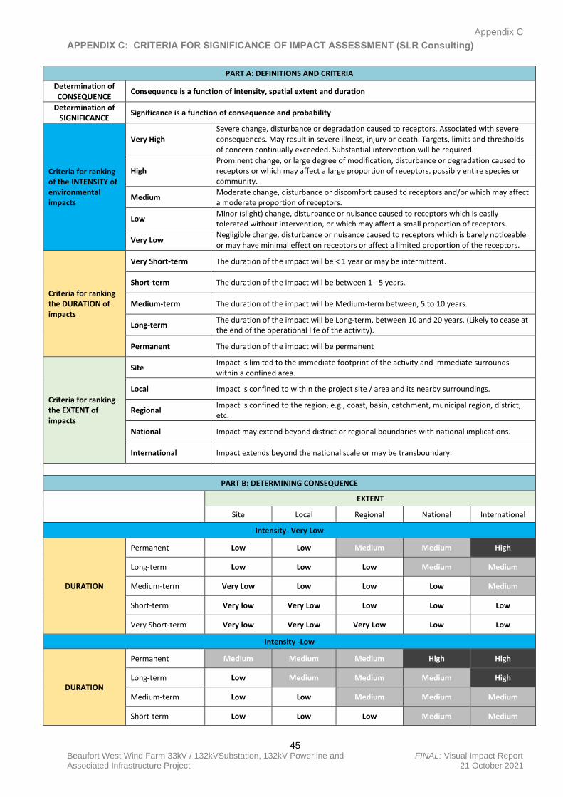
Appendix C
45 Beaufort West Wind Farm 33kV / 132kVSubstation, 132kV Powerline and FINAL: Visual Impact Report Associated Infrastructure Project 21 October 2021
APPENDIX C: CRITERIA FOR SIGNIFICANCE OF IMPACT ASSESSMENT (SLR Consulting)
PART A: DEFINITIONS AND CRITERIA
Determination of CONSEQUENCE
Consequence is a function of intensity, spatial extent and duration
Determination of SIGNIFICANCE
Significance is a function of consequence and probability
Criteria for ranking of the INTENSITY of environmental impacts
Very High Severe change, disturbance or degradation caused to receptors. Associated with severe consequences. May result in severe illness, injury or death. Targets, limits and thresholds of concern continually exceeded. Substantial intervention will be required.
High Prominent change, or large degree of modification, disturbance or degradation caused to receptors or which may affect a large proportion of receptors, possibly entire species or community.
Medium Moderate change, disturbance or discomfort caused to receptors and/or which may affect a moderate proportion of receptors.
Low Minor (slight) change, disturbance or nuisance caused to receptors which is easily tolerated without intervention, or which may affect a small proportion of receptors.
Very Low Negligible change, disturbance or nuisance caused to receptors which is barely noticeable or may have minimal effect on receptors or affect a limited proportion of the receptors.
Criteria for ranking the DURATION of impacts
Very Short-term The duration of the impact will be < 1 year or may be intermittent.
Short-term The duration of the impact will be between 1 - 5 years.
Medium-term The duration of the impact will be Medium-term between, 5 to 10 years.
Long-term The duration of the impact will be Long-term, between 10 and 20 years. (Likely to cease at the end of the operational life of the activity).
Permanent The duration of the impact will be permanent
Criteria for ranking the EXTENT of impacts
Site Impact is limited to the immediate footprint of the activity and immediate surrounds within a confined area.
Local Impact is confined to within the project site / area and its nearby surroundings.
Regional Impact is confined to the region, e.g., coast, basin, catchment, municipal region, district, etc.
National Impact may extend beyond district or regional boundaries with national implications.
International Impact extends beyond the national scale or may be transboundary.
PART B: DETERMINING CONSEQUENCE
EXTENT
Site Local Regional National International
Intensity- Very Low
DURATION
Permanent Low Low Medium Medium High
Long-term Low Low Low Medium Medium
Medium-term Very Low Low Low Low Medium
Short-term Very low Very Low Low Low Low
Very Short-term Very low Very Low Very Low Low Low
Intensity -Low
DURATION
Permanent Medium Medium Medium High High
Long-term Low Medium Medium Medium High
Medium-term Low Low Medium Medium Medium
Short-term Low Low Low Medium Medium
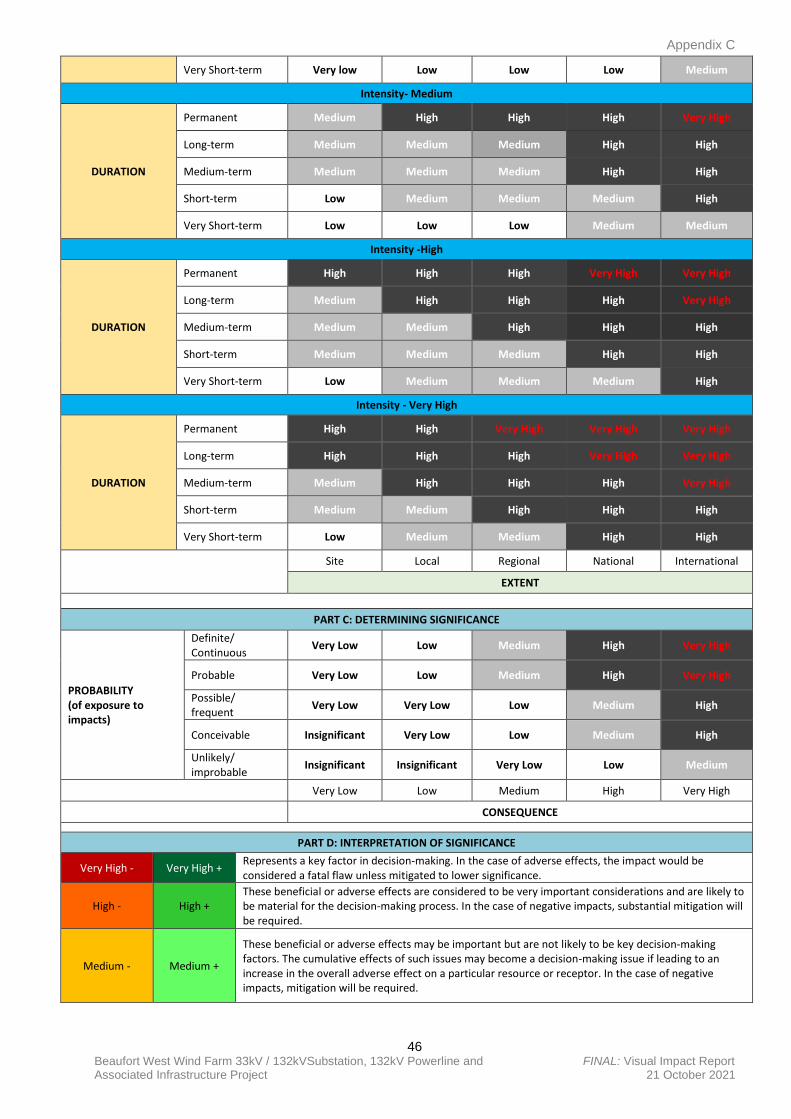
Appendix C
46 Beaufort West Wind Farm 33kV / 132kVSubstation, 132kV Powerline and FINAL: Visual Impact Report Associated Infrastructure Project 21 October 2021
Very Short-term Very low Low Low Low Medium
Intensity- Medium
DURATION
Permanent Medium High High High Very High
Long-term Medium Medium Medium High High
Medium-term Medium Medium Medium High High
Short-term Low Medium Medium Medium High
Very Short-term Low Low Low Medium Medium
Intensity -High
DURATION
Permanent High High High Very High Very High
Long-term Medium High High High Very High
Medium-term Medium Medium High High High
Short-term Medium Medium Medium High High
Very Short-term Low Medium Medium Medium High
Intensity - Very High
DURATION
Permanent High High Very High Very High Very High
Long-term High High High Very High Very High
Medium-term Medium High High High Very High
Short-term Medium Medium High High High
Very Short-term Low Medium Medium High High
Site Local Regional National International
EXTENT
PART C: DETERMINING SIGNIFICANCE
PROBABILITY (of exposure to impacts)
Definite/ Continuous
Very Low Low Medium High Very High
Probable Very Low Low Medium High Very High
Possible/ frequent
Very Low Very Low Low Medium High
Conceivable Insignificant Very Low Low Medium High
Unlikely/ improbable
Insignificant Insignificant Very Low Low Medium
Very Low Low Medium High Very High
CONSEQUENCE
PART D: INTERPRETATION OF SIGNIFICANCE
Very High - Very High + Represents a key factor in decision-making. In the case of adverse effects, the impact would be considered a fatal flaw unless mitigated to lower significance.
High - High + These beneficial or adverse effects are considered to be very important considerations and are likely to be material for the decision-making process. In the case of negative impacts, substantial mitigation will be required.
Medium - Medium +
These beneficial or adverse effects may be important but are not likely to be key decision-making factors. The cumulative effects of such issues may become a decision-making issue if leading to an increase in the overall adverse effect on a particular resource or receptor. In the case of negative impacts, mitigation will be required.
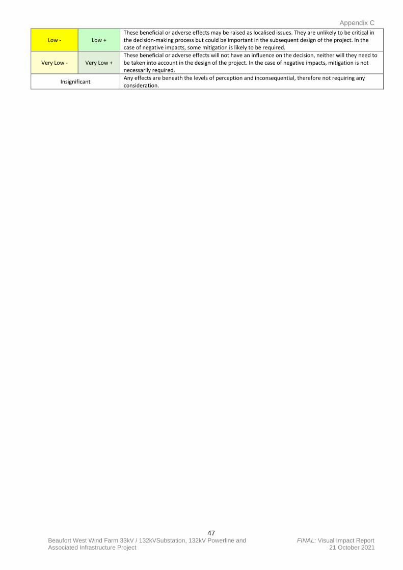
Appendix C
47 Beaufort West Wind Farm 33kV / 132kVSubstation, 132kV Powerline and FINAL: Visual Impact Report Associated Infrastructure Project 21 October 2021
Low - Low + These beneficial or adverse effects may be raised as localised issues. They are unlikely to be critical in the decision-making process but could be important in the subsequent design of the project. In the case of negative impacts, some mitigation is likely to be required.
Very Low - Very Low + These beneficial or adverse effects will not have an influence on the decision, neither will they need to be taken into account in the design of the project. In the case of negative impacts, mitigation is not necessarily required.
Insignificant Any effects are beneath the levels of perception and inconsequential, therefore not requiring any consideration.
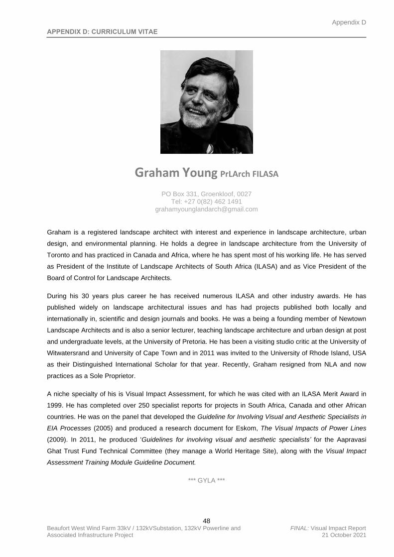
Appendix D
48 Beaufort West Wind Farm 33kV / 132kVSubstation, 132kV Powerline and FINAL: Visual Impact Report Associated Infrastructure Project 21 October 2021
APPENDIX D: CURRICULUM VITAE
Graham Young PrLArch FILASA
PO Box 331, Groenkloof, 0027 Tel: +27 0(82) 462 1491
Graham is a registered landscape architect with interest and experience in landscape architecture, urban
design, and environmental planning. He holds a degree in landscape architecture from the University of
Toronto and has practiced in Canada and Africa, where he has spent most of his working life. He has served
as President of the Institute of Landscape Architects of South Africa (ILASA) and as Vice President of the
Board of Control for Landscape Architects.
During his 30 years plus career he has received numerous ILASA and other industry awards. He has
published widely on landscape architectural issues and has had projects published both locally and
internationally in, scientific and design journals and books. He was a being a founding member of Newtown
Landscape Architects and is also a senior lecturer, teaching landscape architecture and urban design at post
and undergraduate levels, at the University of Pretoria. He has been a visiting studio critic at the University of
Witwatersrand and University of Cape Town and in 2011 was invited to the University of Rhode Island, USA
as their Distinguished International Scholar for that year. Recently, Graham resigned from NLA and now
practices as a Sole Proprietor.
A niche specialty of his is Visual Impact Assessment, for which he was cited with an ILASA Merit Award in
1999. He has completed over 250 specialist reports for projects in South Africa, Canada and other African
countries. He was on the panel that developed the Guideline for Involving Visual and Aesthetic Specialists in
EIA Processes (2005) and produced a research document for Eskom, The Visual Impacts of Power Lines
(2009). In 2011, he produced ‘Guidelines for involving visual and aesthetic specialists’ for the Aapravasi
Ghat Trust Fund Technical Committee (they manage a World Heritage Site), along with the Visual Impact
Assessment Training Module Guideline Document.
*** GYLA ***
VISUAL IMPACT SITE SCREENING VERIFICATION REPORT BEAUFORT WEST WIND FARM SUBSTATION, POWERLINE AND ASSOCIATED
INFRASTRUCTURE PROJECTS
VISUAL IMPACT SITE SCREENING VERIFICATION REPORT
PROPOSED CONSTRUCTION AND OPERATION OF THE BEAUFORT WEST WIND FARM
SUBSTATION, POWERLINE AND ASSOCIATED INFRASTRUCTURE PROECTS, NEAR
BEAUFORT WEST IN THE PRINCE ALBERT LOCAL MUNICIPALITY, WITHIN THE CENTRAL
KAROO DISTRICT IN THE WESTERN CAPE PROVINCE
Submitted to:
SLR Consulting (Durban Office)
68 on Main, Old Main Road
Kloof
Durban, 2640
Prepared by:
G Y L A
Graham A Young Landscape Architect
PO Box 331
Groenkloof
0027
+27 (0)82 462 1491
Report Revision No: FINAL
Date Issued: 21 October 2021
Prepared By: Graham Young PrLArch, FILASA
Reviewed By:
Signed:
Graham Young PrLArch, FILASA
Reference: 079_2021: Beaufort West WEF Substation and Associated 132kV Infrastructure

CONTENTS
INTRODUCTION .......................................................................................................................... 4
SITE SENSITIVITY VERIFICATION METHODOLOGY ......................................................... 8
OUTCOME OF SITE SENSITIVITY VERIFICATION ............................................................. 8
CONCLUSION ............................................................................................................................ 10
INTRODUCTION
South Africa Mainstream Renewable Power Developments (PTY) Ltd (‘Mainstream’) is proposing to
add one (1) 33 kilovolt (kV) / 132kV onsite Substation1, one (1) Battery Energy Storage System (BESS),
one (1) 132kV powerline (namely the associated electrical infrastructure), one (1) laydown area and
one (1) Operations & Maintenance (O&M) Building to their authorised Beaufort West Cluster of wind
developments2, 60km south of the town of Beaufort West in the Western Cape Province (the ‘proposed
development’). The proposed development area falls within the Prince Albert Local Municipality, within
the Central Karoo District Municipality. Refer to Figure 01 below.
Two (2) applications for Environmental Authorisation (EA) will be lodged for two (2) separate projects
[i.e., separate Basic Assessment (BA) processes]. One (1) application will be lodged for the 33/132kV
yard of the onsite substation, BESS, laydown area and O&M building, while another application will be
lodged for the 132kV switching station yard of the onsite substation and associated 132kV powerline1.
This Visual Impact Assessment report however covers both proposed applications.
The authorised Beaufort West Cluster consists of two (2) wind farm projects with associated electrical
infrastructure, which include a 132kV/400kV Linking Substation, two (2) 33kV/132kV onsite substations
[one (1) per wind farm] and 132kV powerlines. The two (2) wind farms which form part of the Beaufort
West Cluster were first authorised as one (1) larger wind farm (namely the Beaufort West Wind Farm)
in March 2012 (12-12-20-1784). Thereafter, in February 2017, the authorised Beaufort West Wind Farm
was split into the Beaufort West (12-12-20-1784-1) and Trakas (12-12-20-1784-2) Wind Farms
respectively.
Both above-mentioned Wind Farms were amended in 2020 to increase the turbine hub heights and
increase the rotor diameters (Beaufort West Wind Farm – March 2020: 12-12-20-1784-1-AM5 and
Trakas Wind Farm – February 2020: 12-12-20-1784-1-AM1). Further administrative amendments were
granted to both respective Wind Farms in 2021 (Beaufort West Wind Farm – March 2020: 12-12-20-
1784-1-AM2 and Trakas Wind Farm – February 2020: 12-12-20-1784-2-AM2) that included changing
the holder of the EAs, adding Battery Energy Storage Facilities and amending project descriptions.
The supporting powerlines, linking station and onsite substation infrastructure were authorised for both
respective wind farms in January 2017 (14-12-16-3-3-2-925). This authorisation was subsequently
amended to split and assign each substation and powerline to each respective wind farm in August
2021 (Beaufort West 132KV-400KV Linking Station, 132KV Power Line and onsite 132KV Substation
– 14-12-16-3-3-2-925-1 and Trakas 132KV-400KV Linking Station, 132KV Power Line and onsite
132KV Substation – 14-12-16-3-3-2-925-2).
The proposed substation, BESS, laydown area, O&M building and associated powerline, which form
part of separate respective new applications and BA processes, will service both of Mainstream’s
authorised wind farm projects (namely the Beaufort West and Trakas Wind Farms) and associated
electrical infrastructure.
1 Onsite substation will consist of 33/132kV yard which will be owned and operated by Mainstream, as well as 132kV switching station yard which will be owned and operated by Eskom. 33/132kV yard of onsite substation and associated infrastructure (BESS, laydown area and O&M building) forms part of separate proposed application for EA, while 132kV switching station yard of onsite substation and 132kV overhead powerline forms part of another separate application for EA.
2 Beaufort West (12-12-20-1784-1-AM2) and Trakas Wind Farms (12-12-20-1784-2-AM2) and their supporting powerline and substation infrastructure (Beaufort West 132KV-400KV Linking Station, 132KV Power Line and onsite 132KV Substation – 14-12-16-3-3-2-925-1 & Trakas 132KV-400KV Linking Station, 132KV Power Line and onsite 132KV Substation – 14-12-16-3-3-2-925-2), collectively referred to as “the Beaufort West Cluster”
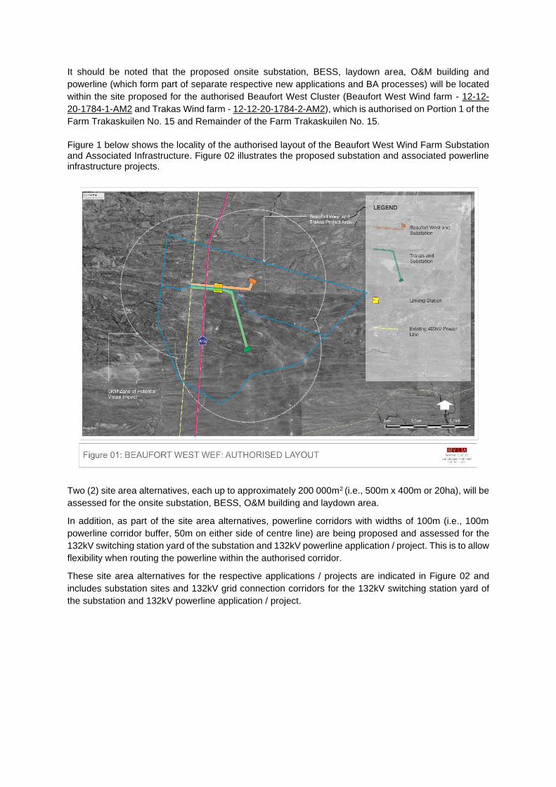
It should be noted that the proposed onsite substation, BESS, laydown area, O&M building and
powerline (which form part of separate respective new applications and BA processes) will be located
within the site proposed for the authorised Beaufort West Cluster (Beaufort West Wind farm - 12-12-
20-1784-1-AM2 and Trakas Wind farm - 12-12-20-1784-2-AM2), which is authorised on Portion 1 of the
Farm Trakaskuilen No. 15 and Remainder of the Farm Trakaskuilen No. 15.
Figure 1 below shows the locality of the authorised layout of the Beaufort West Wind Farm Substation and Associated Infrastructure. Figure 02 illustrates the proposed substation and associated powerline infrastructure projects.
Two (2) site area alternatives, each up to approximately 200 000m2 (i.e., 500m x 400m or 20ha), will be
assessed for the onsite substation, BESS, O&M building and laydown area.
In addition, as part of the site area alternatives, powerline corridors with widths of 100m (i.e., 100m
powerline corridor buffer, 50m on either side of centre line) are being proposed and assessed for the
132kV switching station yard of the substation and 132kV powerline application / project. This is to allow
flexibility when routing the powerline within the authorised corridor.
These site area alternatives for the respective applications / projects are indicated in Figure 02 and
includes substation sites and 132kV grid connection corridors for the 132kV switching station yard of
the substation and 132kV powerline application / project.
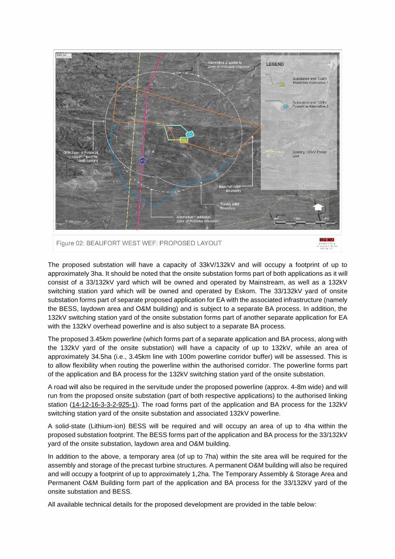
The proposed substation will have a capacity of 33kV/132kV and will occupy a footprint of up to
approximately 3ha. It should be noted that the onsite substation forms part of both applications as it will
consist of a 33/132kV yard which will be owned and operated by Mainstream, as well as a 132kV
switching station yard which will be owned and operated by Eskom. The 33/132kV yard of onsite
substation forms part of separate proposed application for EA with the associated infrastructure (namely
the BESS, laydown area and O&M building) and is subject to a separate BA process. In addition, the
132kV switching station yard of the onsite substation forms part of another separate application for EA
with the 132kV overhead powerline and is also subject to a separate BA process.
The proposed 3.45km powerline (which forms part of a separate application and BA process, along with
the 132kV yard of the onsite substation) will have a capacity of up to 132kV, while an area of
approximately 34.5ha (i.e., 3.45km line with 100m powerline corridor buffer) will be assessed. This is
to allow flexibility when routing the powerline within the authorised corridor. The powerline forms part
of the application and BA process for the 132kV switching station yard of the onsite substation.
A road will also be required in the servitude under the proposed powerline (approx. 4-8m wide) and will
run from the proposed onsite substation (part of both respective applications) to the authorised linking
station (14-12-16-3-3-2-925-1). The road forms part of the application and BA process for the 132kV
switching station yard of the onsite substation and associated 132kV powerline.
A solid-state (Lithium-ion) BESS will be required and will occupy an area of up to 4ha within the
proposed substation footprint. The BESS forms part of the application and BA process for the 33/132kV
yard of the onsite substation, laydown area and O&M building.
In addition to the above, a temporary area (of up to 7ha) within the site area will be required for the
assembly and storage of the precast turbine structures. A permanent O&M building will also be required
and will occupy a footprint of up to approximately 1,2ha. The Temporary Assembly & Storage Area and
Permanent O&M Building form part of the application and BA process for the 33/132kV yard of the
onsite substation and BESS.
All available technical details for the proposed development are provided in the table below:
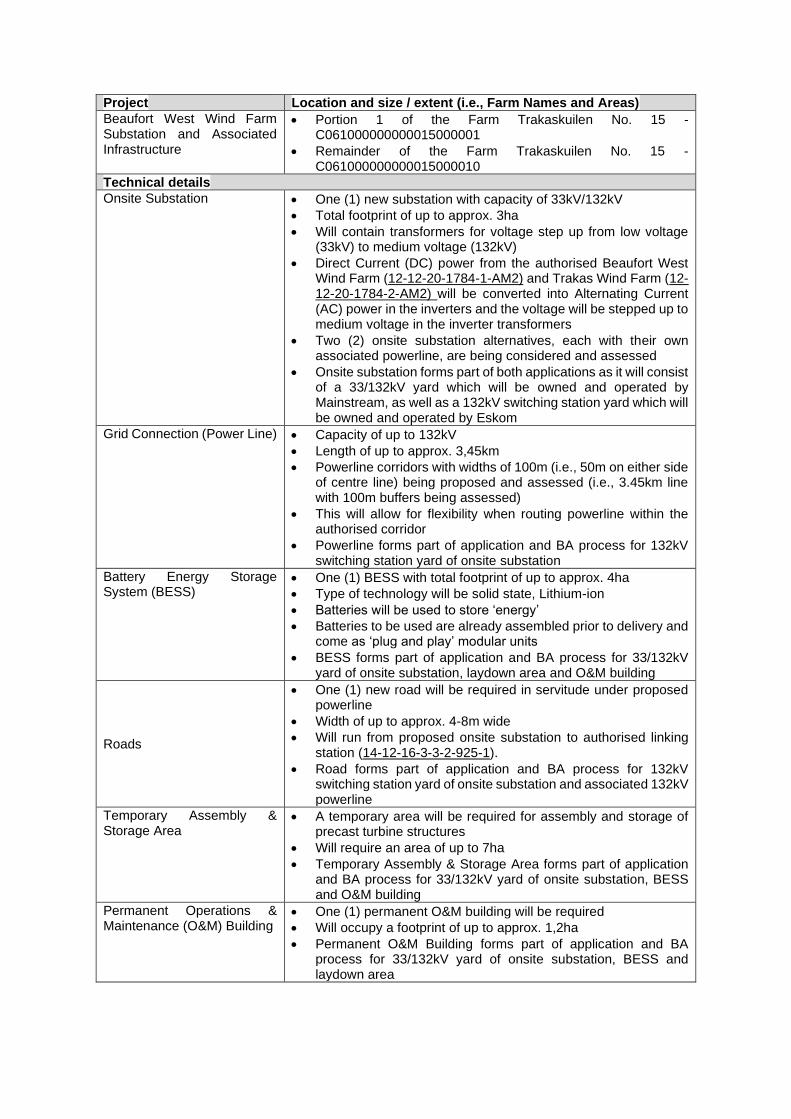
Project Location and size / extent (i.e., Farm Names and Areas)
Beaufort West Wind Farm Substation and Associated Infrastructure
• Portion 1 of the Farm Trakaskuilen No. 15 - C061000000000015000001
• Remainder of the Farm Trakaskuilen No. 15 - C061000000000015000010
Technical details
Onsite Substation • One (1) new substation with capacity of 33kV/132kV
• Total footprint of up to approx. 3ha
• Will contain transformers for voltage step up from low voltage (33kV) to medium voltage (132kV)
• Direct Current (DC) power from the authorised Beaufort West Wind Farm (12-12-20-1784-1-AM2) and Trakas Wind Farm (12-12-20-1784-2-AM2) will be converted into Alternating Current (AC) power in the inverters and the voltage will be stepped up to medium voltage in the inverter transformers
• Two (2) onsite substation alternatives, each with their own associated powerline, are being considered and assessed
• Onsite substation forms part of both applications as it will consist of a 33/132kV yard which will be owned and operated by Mainstream, as well as a 132kV switching station yard which will be owned and operated by Eskom
Grid Connection (Power Line) • Capacity of up to 132kV
• Length of up to approx. 3,45km
• Powerline corridors with widths of 100m (i.e., 50m on either side of centre line) being proposed and assessed (i.e., 3.45km line with 100m buffers being assessed)
• This will allow for flexibility when routing powerline within the authorised corridor
• Powerline forms part of application and BA process for 132kV switching station yard of onsite substation
Battery Energy Storage System (BESS)
• One (1) BESS with total footprint of up to approx. 4ha
• Type of technology will be solid state, Lithium-ion
• Batteries will be used to store ‘energy’
• Batteries to be used are already assembled prior to delivery and come as ‘plug and play’ modular units
• BESS forms part of application and BA process for 33/132kV yard of onsite substation, laydown area and O&M building
Roads
• One (1) new road will be required in servitude under proposed powerline
• Width of up to approx. 4-8m wide
• Will run from proposed onsite substation to authorised linking station (14-12-16-3-3-2-925-1).
• Road forms part of application and BA process for 132kV switching station yard of onsite substation and associated 132kV powerline
Temporary Assembly & Storage Area
• A temporary area will be required for assembly and storage of precast turbine structures
• Will require an area of up to 7ha
• Temporary Assembly & Storage Area forms part of application and BA process for 33/132kV yard of onsite substation, BESS and O&M building
Permanent Operations & Maintenance (O&M) Building
• One (1) permanent O&M building will be required
• Will occupy a footprint of up to approx. 1,2ha
• Permanent O&M Building forms part of application and BA process for 33/132kV yard of onsite substation, BESS and laydown area
In terms of the National Environmental Management Act (Act 107 of 1998, as amended) (NEMA)
Environmental Impact Assessment (EIA) Regulations [4 December 2014, Government Notice (GN)
R982, R983, R984 and R985, as amended], various aspects of the proposed developments may have
an impact on the environment and are listed activities. These activities require authorisation from the
National Competent Authority (CA), namely the Department of Forestry, Fisheries and the Environment
(DFFE), prior to the commencement thereof. As mentioned, two (2) separate applications for EA for the
proposed developments will be submitted to the DFFE, in the form of separate respective BA processes,
in terms of the NEMA EIA Regulations of 2014 (as amended). One (1) application will be lodged for the
33/132kV yard of the onsite substation, BESS, laydown area and O&M building, while another
application will be lodged for the 132kV switching station yard of the onsite substation and associated
132kV powerline.
In accordance with GN 320 and GN 1150 (20 March 2020)3 of the NEMA EIA Regulations of 2014 (as
amended), prior to commencing with a specialist assessment, a site sensitivity verification must be
undertaken to confirm the current land use and environmental sensitivity of the proposed project area
as identified by the National Web-Based Environmental Screening Tool (i.e. Screening Tool).
As the visual specialist, Graham Young Landscape Architect has been commissioned to verify the
sensitivity of the Beaufort West Wind Farm Substation, Powerline and Associated Infrastructure project
sites under these specialist protocols.
The scope of this report is for two (2) applications, namely 33kV the Beaufort West Wind Farm
Substation and Associated Infrastructure (BESS, laydown area and O&M building) application, as well
as the Eskom 132kV Substation and Associated 132kV Powerline application.
SITE SENSITIVITY VERIFICATION METHODOLOGY
The sensitivity of the proposed development areas for the ‘landscape/visual theme’ was established
through the following methodology:
• A desk top analysis, using satellite imagery;
• Scrutinizing previous visual specialist reports4 on the project;
• A preliminary site inspection (October 2021); and
• any other available and relevant information.
OUTCOME OF SITE SENSITIVITY VERIFICATION
The Screening Tool did not specifically identify landscape and visual sensitivities for the respective
projects. The site sensitivity verification in this report therefore refers only to its findings and a
comparative analysis cannot be done.
3 GN 320 (20 March 2020): Procedures for The Assessment and Minimum Criteria for Reporting on Identified Environmental Themes in terms of Sections 24(5)(A) and (H) and 44 of the National Environmental Management Act, 1998, when applying for Environmental Authorisation 4 Oberholzer, B and Lawson, Q. Proposed Renewable Energy Facilities in the Western and Northern Cape by Mainstream SA – Beaufort West Site, in the Great Karoo: Visual Impact Assessment. Unpublished Report. Stanford. 27 September 2010.
Gibb, A. SiVest, Proposed construction of a linking station, two (2) power lines and two (2) on-site substations for the Beaufort West and Trakas Wind Farms, near Beaufort West in the Western Cape Province: Visual Impact Assessment, Rev 1. Unpublished Report. Rivonia. 7 December 2018
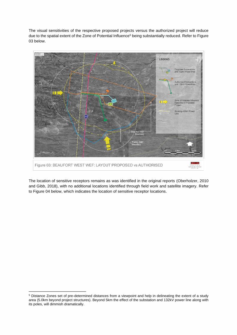
The visual sensitivities of the respective proposed projects versus the authorized project will reduce
due to the spatial extent of the Zone of Potential Influence5 being substantially reduced. Refer to Figure
03 below.
The location of sensitive receptors remains as was identified in the original reports (Oberholzer, 2010
and Gibb, 2018), with no additional locations identified through field work and satellite imagery. Refer
to Figure 04 below, which indicates the location of sensitive receptor locations.
5 Distance Zones set of pre-determined distances from a viewpoint and help in delineating the extent of a study area (5.0km beyond project structures). Beyond 5km the effect of the substation and 132kV power line along with its poles, will dimmish dramatically.
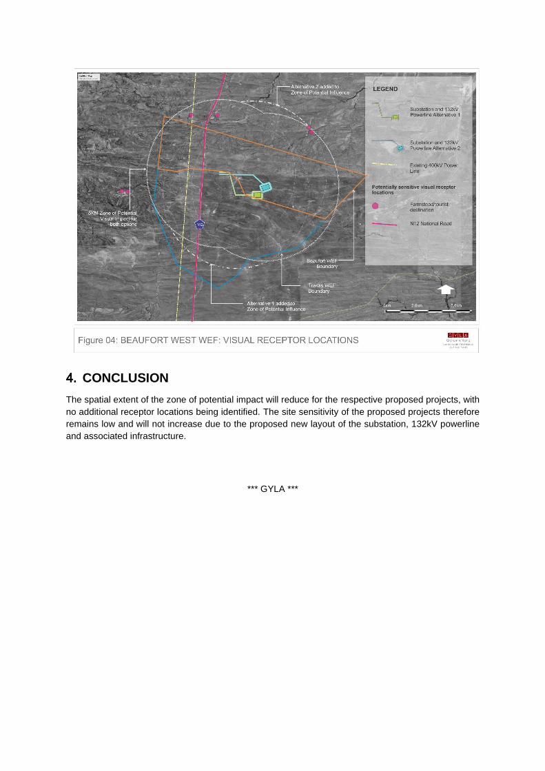
CONCLUSION
The spatial extent of the zone of potential impact will reduce for the respective proposed projects, with
no additional receptor locations being identified. The site sensitivity of the proposed projects therefore
remains low and will not increase due to the proposed new layout of the substation, 132kV powerline
and associated infrastructure.
*** GYLA ***