approaches to applying iem in pa management and local land use plans_gen orientation
TRANSCRIPT

By Elmer Mercado, EnP
by Elmer Mercado, EnP November 2013

} Responsiveness to changing external and local conditions ◦ Newly enacted laws with land use implications � National Tourism Act of 2009 (RA 9593) � Climate Change Act of 2009 (RA 9729) � National Cultural Heritage Act of 2009 (RA 10066) � Disaster Risk Reduction Management Act of 2010 (RA
10121) � National Climate Change Action Plan (NCCAP)
-2010-2022
by Elmer Mercado, EnP November 2013

◦ Extreme changes in bio-physical and environmental conditions � Extreme weather events and conditions (i.e. Ondoy
(2009), Peping (2009), Sendong (2010), Habagat (2011), Pablo (2012)
� Increased threats and vulnerabilities to disasters � Rapidly changing urban conditions and urbanisation
(60:40/urban:rural population shift); increased population
� Deteriorating natural resource conditions; increased water pressure; food security
◦ Increasing local land and resource use conflicts/pressure
by Elmer Mercado, EnP November 2013

by Elmer Mercado, EnP November 2013

} JMC 98-01; JMC-2003-01, } “Comprehensive land use and forest land use plans are
important tools in the holistic and efficient management of forest resources. Toward this end, the DENR and the LGUs together with other government agencies shall undertake forest land use planning as an integral activity of comprehensive land use planning to determine the optimum and balanced use of natural resources to support local, regional and national growth and development;”
by Elmer Mercado, EnP November 2013

} Executive Order (EO) 124, s. 1993 and Administrative Order 363, s. 1997 – prescribed guidelines for the protection of areas non-negotiable for conversion or reclassification such as protected areas, watersheds and recharged areas for aquifers, prime agricultural and irrigated/irrigable lands. It also identifies areas that are “highly restricted” for conversion such as agrarian reform lands, environmentally critical areas, agro-industrial lands, highlands or areas above 500 meters.
by Elmer Mercado, EnP November 2013

} Integrated, inclusive and wholistic approach (beyond LGU) vs stand alone and exclusive (within LGU)
} Strategic visioning and iterative analysis (systems-based and relationships) vs fixed and static perspectives (sectoral and subject-specific)
} Dynamic, participative and adaptive (responsive and active) vs top-down management approaches (linear)
by Elmer Mercado, EnP November 2013

} Conceptual Framework ◦ Integrated ecosystems (or watershed) management or
‘ridge-to-reef’ ◦ Vertical and horizontal integration of plans, frameworks
and sectors; ◦ inter-LGU and inter-governmental co-management of local
resources (i.e. watersheds, coastal/inland waters, lakes, protected areas, etc.) and common service facilities/infrastructure (i.e. SLF, sewage/drainage, water systems, road/transport systems)
} Coverage areas ◦ Public and private lands (A&D); upland, lowland and coastal
ecosystems ◦ New planning areas – ancestral lands, cultural/heritage,
forest/coastal/inland waters,
by Elmer Mercado, EnP November 2013

} Biophysical framework - The ‘ridge-to-reef’ transect, also known as the integrated watershed ecosystems management framework, seeks to present the interrelationship and effect of upland/forest ecosystems with lowland and coastal ecosystems and vice versa (see Figure 2).
by Elmer Mercado, EnP November 2013

by Elmer Mercado, EnP November 2013

IEM refers to an integrated planning and management framework that covers the ‘ridge-to-reef’ landscape of a watershed or sub-watershed from its upland, lowland and coastal ecosystems and the interactions, interdependencies and linkages of its bio-physical, human and physical resources and development.
by Elmer Mercado, EnP November 2013

by Elmer Mercado, EnP November 2013

by Elmer Mercado, EnP November 2013
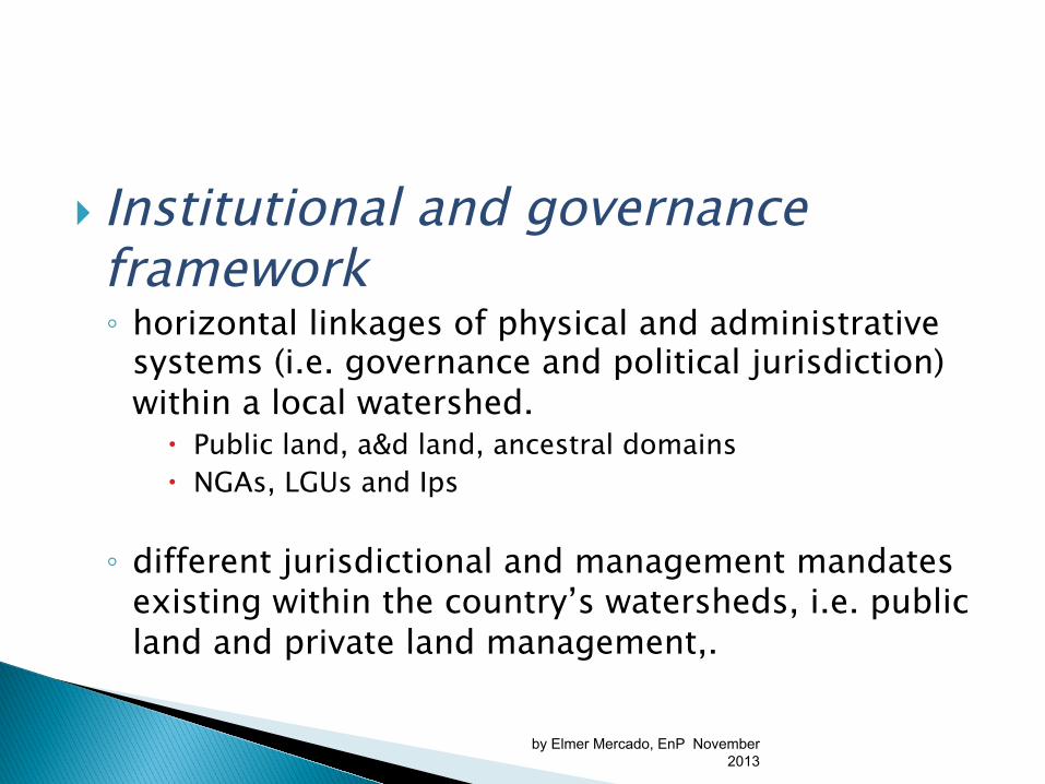
} Institutional and governance framework ◦ horizontal linkages of physical and administrative
systems (i.e. governance and political jurisdiction) within a local watershed.
� Public land, a&d land, ancestral domains � NGAs, LGUs and Ips
◦ different jurisdictional and management mandates existing within the country’s watersheds, i.e. public land and private land management,.
by Elmer Mercado, EnP November 2013

Protected Area/Public Land
(DENR/PAMB)
A&D (LGU) Ancestral Land (IPs)
by Elmer Mercado, EnP November 2013

Protected Areas
by Elmer Mercado, EnP November 2013
Watersheds/ Sub-
watersheds
LGUs
LGUs
LGUs
LGUs

Local Communities/Household/Individuals
Province
Municipal/City
Barangays/Sitios
by Elmer Mercado, EnP November 2013

} The integration of ecoystems/watershed management plans into local comprehensive land use plans and zoning arrangements of affected LGUs within a watershed divide. ◦ on-site management falls with local government
units and communities; ◦ land and water use management, governance
arrangements, and enforcement
by Elmer Mercado, EnP November 2013
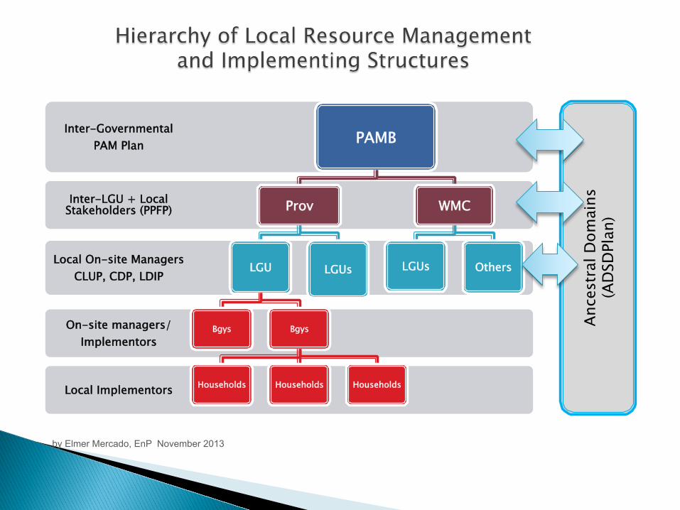
Local Implementors
On-site managers/ Implementors
Local On-site Managers CLUP, CDP, LDIP
Inter-LGU + Local Stakeholders (PPFP)
Inter-Governmental PAM Plan PAMB
Prov
LGU
Bgys Bgys
Households Households Households
LGUs
WMC
LGUs Others
by Elmer Mercado, EnP November 2013
Ance
stra
l Dom
ains
(A
DSD
Plan
)

} inter-LGU coverage of land and water ecosystems shared by several LGUs. ◦ Identification of major watershed/sub-watersheds in LGU
and use as physical platform for local land use plans; ◦ watersheds and river basins, coastal and inland waters,
lakes, protected and key biodiversity areas, landscapes and seascapes, among others.
} ecosystems go beyond established territorial or political boundaries and jurisdictions and require inter-LGU, if not inter-governmental, management arrangements to be effectively managed.
} establishment of inter-LGU and/or inter-agency cooperation agreements or arrangements ◦ eCLUP; common implementation and management
arrangements in shared ecosystems/resources
by Elmer Mercado, EnP November 2013

by Elmer Mercado, EnP November 2013

} Integration of climate change adaptation and disaster risk reduction;
} • Adoption of the ridge-to-reef or integrated watershed ecosystems management framework to emphasize the interrelationship between the upland, lowland and coastal ecosystems
} Primacy or ‘precendence’ of physical framework plans ( RPDP, PPFP, CLUP) over sectoral and other development plans
by Elmer Mercado, EnP November 2013

} Integration of public and private land use management and newly mandated resoure use regimes ◦ Ancestral lands, biodiversity, cultural heritage,
forestlands, coastal/inland waters, protected areas, among others
} Inclusion of green growth/eco-efficiency and urban design considerations in urban dev’t;
by Elmer Mercado, EnP November 2013

} Establishment of inter-LGU and/or inter-agency arrangements to facilitate CLUP implementation
} Highlight the linkage of CLUP to PPFP and other plans (e.g. ADSDPP, barangay dev’t plans and sectoral plans)
by Elmer Mercado, EnP November 2013

} Protection Land Use Areas ◦ private lands, public lands and waters that are set
aside for conservation, preservation, and rehabilitation because of their long-term strategic benefit and because of the observed and projected impact of climate-related events and disasters to these areas;
by Elmer Mercado, EnP November 2013

Designation Criteria
Protection Objective
§ water source § biodiversity area, § high-risk areas climate
change/disaster risk, § areas with cultural and
historical value, § prime agriculture/production
lands, § shoreline easement and
buffer zones, § salvage areas, § inland waters and marine
protected areas, § other areas classified by law
for protection/conservation
} maintained, protected and managed in the future or within the duration of the land use plan period (i.e. 10 or 15 years) until such time that the area’s land use category has been changed to another land use category;
by Elmer Mercado, EnP November 2013

Allowed activities Zoning arrangements
q restricted to complement and enhance the areas’ existing functions or purpose (restricted land use)
q Prohibited or banned – destructive, injurious, disruptive, or disturbing to the efficient, sustainable, and effective functioning of the protection land use area
q Restrictive land use zones § Passive, non-mechanical/
motorised § No permanent structures/
facilities; § Scientific observation decks/
posts and resting areas only (light/natural materials);
§ IP cultural/spiritual rituals (i.e. human activity)
q Prohibited or strict protection land use zones § Scientific research, inventory/
assessments and monitoring; § IP spiritual/cultural practices
(i.e. extraction of resources)
by Elmer Mercado, EnP November 2013

q Protection land use areas maybe generated q forest land use plans (FLUPs), q coastal resource management plans (CRMPs), q protected area management plans (PAMP), q watershed management plans (WSMPs) and q ancestral domain management plans (ADSDP), among
others.
by Elmer Mercado, EnP November 2013

by Elmer Mercado, EnP November 2013

by Elmer Mercado, EnP November 2013

} areas where all types of productive, economic, human and social/cultural activities and uses can be conducted subject to restrictions imposed by LGU zoning ordinances (A&D lands) and national government polices (public lands)
by Elmer Mercado, EnP November 2013

General Categories Sub-categories
} Settlements/built-up areas
} commercial, } industrial, } institutional, } infrastructure, } agriculture/fisheries
production } production forestry } Mining/quarry sites/
areas
} Mixed-use } Socialised housing/
resettlement; } Sanitary/
environmental/agricultural facilities;
} Utility and transport hubs (i.e. land, air and sea)
} Energy and energy-related facilities
by Elmer Mercado, EnP November 2013

q areas that surround or bound identified protection land use areas;
q serve as a layer (either in land or water form) to separate between protection land use areas and production/multiple land use and development areas
q may also be designated within Production or Multiple Land Use and Development Areas
by Elmer Mercado, EnP November 2013

Allowable activities/uses Types of BZ/TZs within Production/Multiple Use
q limited or controlled use depending on the specific purpose or function (as buffer or transition) of the protection land use areas
q progressive layers of activity zones (from restrictive to less restrictive activities/uses) from outer boundary of the protection land use area to a production land use area
q agriculture and forestland/timberland
q Industrial/residential q Sensitive habitat and urban
ecological areas q Public facility and infrastructure q Sensitive security and military
installations q Cultural/heritage and
monument areas q Transport corridors; q Health and educational
facilities/institutions and campuses
q Public utility and energy facilities
q Cemeteries, churches and memorials/monuments
by Elmer Mercado, EnP November 2013

by Elmer Mercado, EnP November 2013

by Elmer Mercado, EnP November 2013

by Elmer Mercado, EnP November 2013

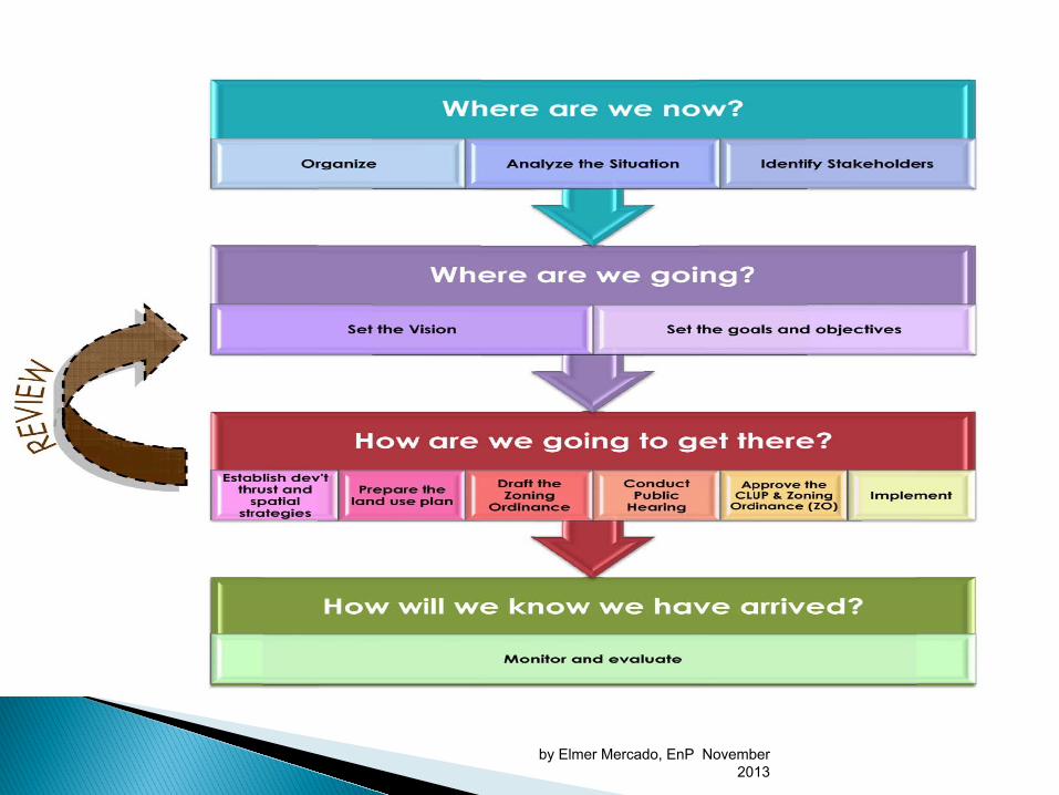
} Step 1: Organize ◦ CLUP data and local plans inventory � Gather available data: CCA/DRR, forest/coastal,
cultural-heritage, ancestral lands, protected area, biodiversity, etc.
� Identify key watershed/sub-watershed covering LGU (map)
� Identify PA area and CADC/CADT areas (map)
by Elmer Mercado, EnP November 2013

} Step 2: Analyze the Situation ◦ Review existing CLUP ◦ Review PPDFP priorities and agenda ◦ Conduct new assessments (sectoral and special area
studies) ◦ Integrate climate change projections, disaster risk
assessments and projected future impacts; � climate change/DRR vulnerabilities will be separate
section in situation analysis and future projections (30 or 50-year cycle)
by Elmer Mercado, EnP November 2013
by Elmer Mercado, EnP November 2013

} Step 5: Set the Goals and Objectives ◦ Identify indicators
} Step 6: Establish development thrust and spatial strategies ◦ Identify key protection, buffer and production areas ◦ Identify the growth directions in relation to: � Environmental/ecological/biophysical implications � Climate change projections and disaster risks
by Elmer Mercado, EnP November 2013

} Step 7: Prepare the Land Use Plan ◦ Review requirements based from the results of
sectoral studies, vision and development thrust, and market analysis
} Step 8: Draft the Zoning Ordinance ◦ Identify areas where Co-Management Agreement
(CMA) and inter-LGU cooperation may apply
by Elmer Mercado, EnP November 2013
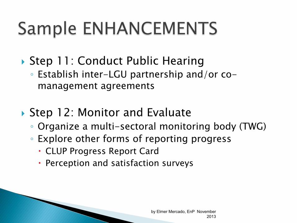
} Step 11: Conduct Public Hearing ◦ Establish inter-LGU partnership and/or co-
management agreements
} Step 12: Monitor and Evaluate ◦ Organize a multi-sectoral monitoring body (TWG) ◦ Explore other forms of reporting progress � CLUP Progress Report Card � Perception and satisfaction surveys
by Elmer Mercado, EnP November 2013

} Combines traditional Euclidean with Performance, Incentive & Form-based Zoning
} Regulations for both Public and Private Lands } Ancestral, Forest, Coastal and Heritage Zones } Harmonized with Nat’l. Bldg. Code, Forestry Code,
etc. } Uses Base (Principal + Accessory + Conditional Uses),
Overlay Zones & Floating Zones
by Elmer Mercado, EnP November 2013

} CCA – DRR (flood proofing, avoidance of heat islands, etc.) & Urban Design Provisions (parking, billboards, see-through fencing, scenic zoning)
} Performance Standards towards Green Cities (Environment, Green Spaces, Site Development, Infrastructure Capacities, Socio-Economic Impact)
by Elmer Mercado, EnP November 2013

by Elmer Mercado, EnP November 2013

} Land use/cover and PA management maps } Plastic covers } Pentel pens } Meta-cards/manila paper } Masking tape } Active participation
} No right or wrong answer
by Elmer Mercado, EnP November 2013

} Activity 1: Identifying and defining existing watersheds/sub-watersheds inside an LGU q Using a base map (topo/slope map), delineate major
watersheds within the LGUs; identify other LGUs sharing same watershed with your LGU;
q List down LGU barangays covering each watershed inside the LGU; as well as non-LGU barangays sharing the same watershed, if any;
q Identify key water/river outlet of LGU watersheds/sub-watersheds; identify any LGUs (including barangays) that are covered/traversed by main water/river outlet of LGU watersheds;
q Identify and discuss main ecological services/benefits performed by key LGU watersheds/sub-watershed to local community/population
by Elmer Mercado, EnP November 2013

} Activity 2: Mapping of existing public and private land use management regimes ◦ Demarcate public, private (A&D lands) and ancestral
domains/claims; ◦ Indicated estimate total land area coverage
(hectares)/population affected (hh/pax) ◦ Overlay land use/cover changes map in each LGUs ◦ Overlay CLUP maps and zoning arrangement. ◦ Identify issues and challenges (top 3) in each
management area and discuss ◦ Identify possible recommendations or actions
needed
by Elmer Mercado, EnP November 2013

Activity 3: Demarcate protected/conserved areas (terrestrial and coastal/inland waters) in private (A&D) lands
� Prime agricultural lands; � SAFDZs
� Indicate land area coverages/population affected (hh/pax)
� Identify Issues and challenges (top 3) in each management area vs CLUP and discuss
� Identify possible recommendations and actions needed
by Elmer Mercado, EnP November 2013

Activity 4: Demarcate protected/ conservation areas (terrestrial and coastal/inland waters) in public domain Land (Terrestrial): } Protected areas (e.g. protection, MUZ, BZ) } Watersheds (e.g. watershed divide within LGU)
� Indicate estimate land area coverages (hectares)/population affected (hh/pax)
� Identify issues and challenges in each management area vs existing/proposed CLUP/zoning ordinance
by Elmer Mercado, EnP November 2013

Coastal/Inland waters: } Riverbank/shoreline water easements (e.g. 3,
20, 40m) } Marine protected areas/fish sanctuaries/other
sanctuaries (e.g. ‘diwal’, ‘crocodile’, etc.)
� Indicate estimate land area coverages (hectares)/population affected (hh/pax)
� Identify issues and challenges in each management area vs existing/proposed CLUP/zoning ordinance
by Elmer Mercado, EnP November 2013

Activity 5: Demarcate geohazards/CC-based risk/vulnerable areas } Storm surge, landslides, flooding,
earthquake zones, drought,
� Identify total land coverage (hectares)/people affected (hh/pax)
� Identify Issues and challenges (top3) in each management area vs CLUP and discuss
� Identify possible recommendations and needed actions
by Elmer Mercado, EnP November 2013

} Basic biophysical, socio-economic template } Terrestial ecosytem (upland/forestlands) } Coastal ecosystem } Lowland/A&D ecosystem
by Elmer Mercado, EnP November 2013

} A. Total Land Area } Less - Total protection areas/land and water
uses in public lands } - water easements (coastal/inland waters) } - prime agricultural lands+ projected irrigated
lands; } - disaster/climate change risk areas } _______________________________________ } B. Total Land and Water Area for future
development = both public and private lands (A&D)
by Elmer Mercado, EnP November 2013
} Activity 6: Consolidate recommendations and possible actions to address key issues and challenges for each management and resource area
by Elmer Mercado, EnP November 2013

Issues and Challenges Actions Needed/ Recommendations
Responsible Agency
1. Land Use/Cover Changes
2. PA Management Zones SPZ MUZ BZ
3. etc…. by Elmer Mercado, EnP November
2013