area 1: upper john day subbasin - northwest power...
TRANSCRIPT

DraftJohn Day Subbasin Summary
August 3, 2001
Prepared for theNorthwest Power Planning Council
Lead WriterSuzanne Knapp, Oregon Department of Fish and Wildlife
Subbasin Team LeaderTim Unterwegner, Oregon Department of Fish and Wildlife
ContributorsOregon Department of Fish and WildlifeOregon Water Resources DepartmentConfederated Tribes of the Warm Springs Reservation of OregonConfederated Tribes of the Umatilla Indian ReservationColumbia River Intertribal Fish CommissionNorth Fork Watershed CouncilPine Hollow/Jackknife Watershed CouncilGilliam County SWCD, Gilliam-East John Day WSC, Gilliam County CourtWheeler County Soil and Water Conservation DistrictSherman County Soil and Water Conservation DistrictGrant Soil and Water Conservation DistrictOregon Water TrustMalheur National Forest, USFSUmatilla National Forest, USFSBureau of Land ManagementU.S. Bureau of ReclamationU.S. Geological Survey, Columbia River Research LabNational Marine Fisheries ServiceOregon State UniversityOregon Natural Heritage ProgramGrant County Court
DRAFT: This document has not yet been reviewed or approved by the Northwest Power Planning Council
John Day Subbasin Summary Draft i

John Day Subbasin Summary
Table of Contents
Background.......................................................................................................................................1Introduction.......................................................................................................................................1Subbasin Description........................................................................................................................2
General Location and Description................................................................................................2Water Quality..............................................................................................................................14Vegetation...................................................................................................................................19Major Land Uses.........................................................................................................................23Lower John Day Subbasin..........................................................................................................24Middle Fork John Day Subbasin................................................................................................25
Fish and Wildlife Resources...........................................................................................................25Fish and Wildlife Status..............................................................................................................25Habitat Areas and Quality...........................................................................................................50Watershed Assessments..............................................................................................................55Major Limiting Factors...............................................................................................................59Artificial Production...................................................................................................................67Existing and Past Efforts.............................................................................................................67
Present Subbasin Management.......................................................................................................92Existing Plans, Policies, and Guidelines.....................................................................................92Existing Goals, Objectives and Strategies................................................................................102Research, Monitoring and Evaluation Activities......................................................................127Fish and Wildlife Needs...........................................................................................................131
References.....................................................................................................................................137Subbasin Summary Recommendations........................................................................................144
John Day Subbasin Summary Draft ii
List of Tables
Table 1. Notable rivers and streams in the North Fork John Day watershed. These streams are not necessarily priorities in the subbasin or listed in any priority order............................................................................................................................5
Table 2. Notable rivers and streams in the Middle Fork John Day watershed. These streams are not necessarily priorities in the subbasin or listed in any priority order.. .6
Table 3. Notable rivers and streams in the Upper John Day watershed. These streams are not necessarily priorities in the subbasin or listed in any priority order......................6
Table 4. Notable rivers and streams in the Lower John Day River watershed. These streams are not necessarily priorities in the subbasin or listed in any priority order.. .7
Table 5. Average precipitation (inches) at selected sites in the John Day Subbasin (OWRD 1986)..............................................................................................................8
Table 6. Average temperature (°F) at selected sites in the John Day Subbasin (OWRD 1986).............................................................................................................................9
Table 7. Principal aquifers in John Day Subbasin watersheds.........................................13Table 8. North Fork John Day River Subbasin 303(d) listed stream segments and water
quality parameters of concern....................................................................................15Table 9. Middle Fork John Day River Subbasin 303(d) listed stream segments and
parameters of concern................................................................................................16Table 10. Upper John Day River Subbasin 303(d) listed stream segments and parameters
of concern...................................................................................................................17Table 11. Lower John Day River Subbasin 303(d) listed stream segments and parameters
of concern...................................................................................................................18Table 12. List of vegetation types within ecological sites in the John Day Subbasin.......19Table 13. List of rare and species-of-concern plants found in the Blue Mountains,
including BLM lands, private lands, and the Wallowa-Whitman, Ochoco, Umatilla and Malheur National Forests. Federally listed species of concern plants are bolded.....................................................................................................................................20
Table 14. Noxious weeds found in the John Day Subbasin.............................................22Table 15. Land ownership in the John Day Subbasin......................................................24Table 16. Water withdrawals for the John Day Subbasin................................................24Table 17. Fish species of known occurrence in the John Day River Subbasin................25Table 18. Special status fish species in the John Day Subbasin.......................................26Table 19. Periodicity of summer steelhead and chinook salmon life history in the John
Day River...................................................................................................................27Table 20. Distribution of spring chinook salmon in John Day Subbasin streams............27Table 21. Total stream miles used by spring chinook salmon by life stage in the John
Day Subbasin..............................................................................................................28Table 22. Stream locations, by county, of O. mykiss populations in the John Day
Subbasin.....................................................................................................................35Table 23. Total stream miles used by O. mykiss by life stage in the John Day Subbasin.
....................................................................................................................................37Table 24. Observed 6-year average of wild steelhead abundance, conservation
abundance thresholds for John Day River sub-populations. Abundance expressed as spawners/stream mile.................................................................................................38
John Day Subbasin Summary Draft iii

Table 25. Coded-wire-tagged steelhead captured by anglers in the John Day River Basin.....................................................................................................................................39
Table 26. Description of time periods in which fisheries occur within the John Day Subbasin.....................................................................................................................39
Table 27. List of common waterfowl species found in the John Day Subbasin...............47Table 28. Upland birds found in the John Day Subbasin area..........................................48Table 29. Sensitive wildlife species in the John Day Subbasin (ONHP 1995)................49Table 30. Species groups within the physiographic provinces within the John Day
Subbasin.....................................................................................................................50Table 31. Detrimental effects of land use activities on fish habitat and water quality
(CRITFC 1995)..........................................................................................................60Table 32. Affected life stages of species of concern in some of the low flow tributaries in
the Upper John Day Subbasin....................................................................................62Table 33. Affected life stages of species of concern in some of the low flow tributaries in
the Middle and Lower John Day Subbasin................................................................62Table 34. Affected life stages of species of concern in some of the low flow tributaries in
the Middle Fork John Day Subbasin..........................................................................62Table 35. Affected life stages of species of concern in some of the low flow tributaries in
the North Fork John Day Subbasin............................................................................64Table 36. Wildlife habitat losses associated with the federal Columbia River hydropower
system.........................................................................................................................65Table 37. Fish liberations in the John Day Subbasin........................................................67Table 38. Screens meeting NMFS criteria in John Day Subbasin....................................69Table 39. CTWSRO and Grant SWCD existing and past efforts in the John Day
Watershed Restoration Project in the John Day Subbasin.........................................72Table 40. OSP compliance rates for anadromous fish in the Upper and Lower patrol
sections.......................................................................................................................77Table 41. Projects administered by Grant SWCD. IRO=irrigation reorganization, GPL =
gravity pipe line, IFG=infiltration gallery, RFC=irrigation return flow cooling.......79Table 42. Fish habitat conservation practices facilitated by Wheeler County SWCD,
1999-2000...................................................................................................................79Table 43. John Day Water Conservation Demo Projects by the U.S. Bureau of
Reclamation................................................................................................................80Table 44. Fish and wildlife habitat projects since 1992...................................................83Table 45. Ongoing watershed projects within Gilliam County........................................89Table 46. Habitat conservation practices facilitated by Wheeler SWCD in 1999 – 2000.
....................................................................................................................................91Table 47. River sections and streams needing improved habitat and screening for
summer steelhead production...................................................................................112Table 48. List of fisheries RME projects and objectives in the John Day Subbasin......129Table 49. List of habitat RME projects and objectives in the John Day Subbasin.........130
List of Figures
Figure 1. Map of John Day Subbasin.................................................................................3Figure 2. Counties of the John Day Subbasin. (Source: USDI 2000)...............................4
John Day Subbasin Summary Draft iv

Figure 3. Four major watersheds in the John Day River Subbasin. Watersheds are color-coded............................................................................................................................5
Figure 4. Major physiographic features of the John Day Subbasin (Source: OWRD 1986).............................................................................................................................8
Figure 5. Average stream flow at the Service Creek gauging station (RM 158), 1929 – 1998............................................................................................................................10
Figure 6. Hydrograph of stream flows at the McDonald Ferry gauging station (RM 21) on the Lower John Day River, October 1980 – September 2000...............................10
Figure 7. Map of major river systems in the John Day subbasin.....................................11Figure 8. Hydrograph of stream flows at the Monument gauging station (RM 15) on the
North Fork John Day River, October 1980 - September 2000...................................12Figure 9. Hydrograph of stream flows at Ritter gauging station (RM 15) on Middle Fork
John Day River...........................................................................................................12Figure 10. Hydrograph of stream flows at the Picture Gorge gauging station (RM 205) in
the Upper John Day, October 1980 - September 2000...............................................13Figure 11. Water quality limited 303(d) streams in the North Fork John Day subbasin..14Figure 12. Water quality limited 303(d) streams in the Middle Fork John Day Subbasin.
....................................................................................................................................16Figure 13. Water quality limited 303(d) streams in the Upper John Day subbasin..........17Figure 14. Water quality limited 303(d) streams in the Lower John Day River..............18Figure 15. Distribution of spring chinook salmon life history stages in the John Day
Subbasin.....................................................................................................................29Figure 16. Results of spring chinook spawning surveys in the John Day River Subbasin,
1959-2000...................................................................................................................30Figure 17. Results of spring chinook spawning surveys in the John Day River Subbasin,
1981-2000...................................................................................................................30Figure 18. Results of spring chinook spawning surveys in the Granite Creek system,
1959-2000...................................................................................................................30Figure 19. Estimated John Day and Columbia mainstem harvest rates and Columbia
mainstem passage loss of natural origin John Day River spring chinook salmon, 1959-1999...................................................................................................................32
Figure 20. Natural logarithm of adult recruits to the spawning grounds divided by adult spawners (ln(R/S)) by brood year, 1959-1994...........................................................33
Figure 21. Difference between observed and predicted ln (R/S) by brood year for natural origin spring chinook salmon in the John Day Basin by brood year, 1959-1994. Recruits are to the Columbia River mouth and include 3-year old jacks...................34
Figure 22. Distribution of O. mykiss in the John Day Subbasin below known barriers.. .36Figure 23. Location of index sites for O. mykiss spawning ground surveys....................37Figure 24. Spawning density (redds/mile) of summer steelhead in the John Day
Subbasin, 1959 – 2000...............................................................................................38Figure 25. Map of bull trout life history distribution in the John Day Subbasin..............41Figure 26. Distribution of westslope cutthroat trout in the John Day Subbasin................42Figure 27. Habitat survey areas in the Middle Fork and North Fork John Day subbasins.
....................................................................................................................................71
Appendix Figures and TablesAppendix Table 1. Stream flow gauging stations in the John Day Subbasin.................266
John Day Subbasin Summary Draft v
Appendix Table 2. List of wildlife species found in the John Day Subbasin (Source: ONHP)......................................................................................................................267
Appendix Table 3. Federally listed and proposed endangered and threatened species, candidate species, and species of concern that may occur within the John Day River basin..........................................................................................................................269
Appendix Figure 1. Map of North Fork John Day drainage. (OWRD map).................271Appendix Figure 2. Map of Middle Fork drainage area in the John Day Subbasin.
(OWRD map)...........................................................................................................272Appendix Figure 3. Map of Upper John Day drainage area, including South Fork John
Day River. (OWRD map)........................................................................................273Appendix Figure 4. Partial map of Lower John Day and Upper John Day drainage areas.
(OWRD map)...........................................................................................................274Appendix Figure 5. Partial map of Lower John Day and North Fork John Day drainage
areas. (OWRD map)................................................................................................275Appendix Figure 6. Map of the Lower John Day River drainage basin, Oregon. (OWRD
map)..........................................................................................................................276Appendix Figure 7. Topographic map of lower John Day River area............................277Appendix Figure 8. Topographic map of lower John Day River area near Condon......278Appendix Figure 9. Topographic map of Lower John Day River area near Clarno......279Appendix Figure 10. Topographic map of South Fork area of John Day Subbasin.......280Appendix Figure 11. Topographic map of Upper John Day Subbasin around John Day.
..................................................................................................................................281Appendix Figure 12. Topographic map of North Fork John Day subbasin around Ukiah.
..................................................................................................................................282Appendix Figure 13. Map of soil types in the John Day Subbasin................................283Appendix Figure 14. Map of water quality limited (303 (d)) streams in the John Day
Subbasin where spring chinook salmon and summer steelhead are distributed.......284Appendix Figure 15. Map of vegetation types in the John Day Subbasin.....................285Appendix Figure 16. Map of land cover and land use in the John Day Subbasin..........286Appendix Figure 17. Map of land ownership in the John Day Subbasin.......................287Appendix Figure 18. Map of historic wildlife habitat types in the John Day Subbasin.288Appendix Figure 19. Map of current wildlife habitat types in the John Day Subbasin. 289Appendix Figure 20. Map of streamflow restoration priorities in the John Day Subbasin.
..................................................................................................................................290
John Day Subbasin Summary Draft vi

John Day Subbasin Summary
BACKGROUND
The John Day Subbasin Summary was drafted to meet the interim need for a facilitated, subbasin project review by the Independent Scientific Review Panel. Termed the “rolling provincial review”, this review and renewal process will establish the budgets and approved activities for existing and newly funded BPA projects. Secondarily, this Summary is a substantial beginning towards developing the formal and final John Day Subbasin Plan – a comprehensive document meeting the objectives and standards set forth in the Northwest Power Planning Council’s amended Fish and Wildlife Program and against which future proposed projects will be assessed. These plans will be a crucial program for implementation of BPA’s Endangered Species Act responsibilities in its funding decisions.
This Subbasin Summary addresses existing assessment and planning type information for the John Day Subbasin. Numerous agencies, entities, and individuals contributed to its development.
INTRODUCTION
The John Day River in northeastern Oregon is unique - it is the second longest free-flowing river in the continental United States, and its spring chinook salmon and summer steelhead populations are two of the last remaining intact wild populations of anadromous fish in the Columbia River basin. The John Day River has also been kept relatively free of hatchery influences. Many segments of the John Day River have been designated under the federal Wild Scenic Rivers Act and Oregon’s State Scenic Waterways Act. Among other things, these designations recognize the John Day’s significant fish and wildlife values.
Although the John Day is widely recognized for its unique fisheries values, both the spring chinook salmon and summer steelhead populations are depressed relative to historic levels. Much of the subbasin’s fish and wildlife habitat has been and continues to be degraded by human activities of one form or another. These habitat losses present substantial opportunities for mitigating fish population losses and protecting and restoring the subbasin’s ecosystems.
The National Marine Fisheries Service’s recent Biological Opinion on the federal Columbia River hydropower system recognizes the importance of the John Day subbasin to fish and wildlife restoration efforts (NMFS 2000). NMFS has specifically identified the Upper John Day as a priority subbasin that will receive immediate attention for habitat and species recovery for the Mid-Columbia steelhead ESU (NMFS 2000). NMFS assigned priority status to the upper John Day subbasin because the subbasin has significant potential for improvement in productive capacity, contains significant amounts of quality habitat on federal lands to anchor restoration efforts, and has significant numbers of water diversions where immediate and significant gains could be secured by addressing flow, passage, and screening problems.
The cooperative nature of current programs and coordinating agencies and entities, and the variety of innovative, effective projects on the ground are an asset to the basin in
John Day Subbasin Summary Draft 1

implementing recovery and restoration efforts. Improving and expanding on existing, successful efforts, including habitat enhancement, passage improvement, research and monitoring and evaluation activities, is key to meeting restoration goals within the basin.
SUBBASIN DESCRIPTION
General Location and DescriptionLocated in the southern section of the Columbia Plateau Ecological Province, the
John Day Subbasin covers nearly 8,100 mi2 in north-central and northeastern Oregon (Figure 1). It is the fourth largest subbasin in the State of Oregon. Topographically, the John Day Subbasin is an interior plateau generally situated between the Blue Mountains to the east and the Cascade Range to the west. More specifically, the subbasin is bounded by the Columbia River to the north (Lake Umatilla), the Blue Mountains to the east, the Aldrich Mountains and Strawberry Range to the south, and the Ochoco Mountains to the west. Subbasin corners are approximated by the following Ranges and Townships: NW corner (R17E/T3N), NE corner (R36E/T4S), SW corner (R18E/T13S), and SE corner (R29E/T19S).
The John Day River flows generally northwest from its origin in the Blue Mountains and joins the Columbia River at river mile (RM) 217 upstream from the town of Rufus. The mainstem portion of the John Day River begins in the Strawberry Mountains in the Malheur National Forest and flows west through the town of John Day (RM 247) and then north from Dayville (RM 212). Major rivers flowing into the mainstem are the North Fork, Middle Fork, and South Fork John Day rivers. The largest tributary is the North Fork, which originates in the Wallowa-Whitman National Forest in the Blue Mountains at elevations near 8,000 ft. The North Fork John Day River flows westerly for 117 miles and joins the mainstem near Kimberly (RM 185), 15 miles below the town of Monument. The Middle Fork John Day River originates south of the North Fork in the Malheur National Forest (Blue Mountains), flows westerly for 75 miles, and merges with the North Fork about 18 miles above Monument. The South Fork John Day River originates in the southwest portion of Malheur National Forest and flows 60 miles north until it merges with the mainstem near Dayville.
Three segments of the John Day River are designated as federal Wild and Scenic under the 1988 Omnibus Oregon Wild and Scenic Rivers Act and are sub-classified as wild, scenic, or recreational (Figure 1). These three segments are the Lower John Day mainstem from Tumwater Falls (RM 10) upstream to Service Creek at RM 158 (recreational); the North Fork John Day River from Camas Creek (RM 57) upstream to the headwaters (wild, scenic, and recreational portions); and, the South Fork John Day River from Smokey Creek (RM 6.5) upstream to the Malheur National Forest boundary (recreational). Outstandingly Remarkable Values (ORV) of the Wild and Scenic River designation include scenery, recreational opportunities, and fisheries. The entire Middle Fork John Day River is designated a State Scenic Waterway as are portions of the North Fork and mainstem John Day River (Figure 1).
John Day Subbasin Summary Draft 2
Figure 1. Map of John Day Subbasin.
John Day Subbasin Summary Draft 3

The subbasin includes major portions of Grant, Wheeler, and Gilliam counties and small portions of Crook, Harney, Jefferson, Wasco, Sherman, Umatilla, Union, and Morrow Counties in the State of Oregon (Figure 2).
Figure 2. Counties of the John Day Subbasin. (Source: USDI 2000).
Drainage AreaThe John Day Subbasin drains a large portion of northeast Oregon (nearly 8,100 mi2),
flowing 284 miles from its source in the Strawberry Mountains (9,000 ft.), to its mouth at RM 217 (200 ft.) on the Columbia River (Figure 1). The John Day system contains over 500 river miles and is the second largest undammed tributary in the western United States, after the Yellowstone River.
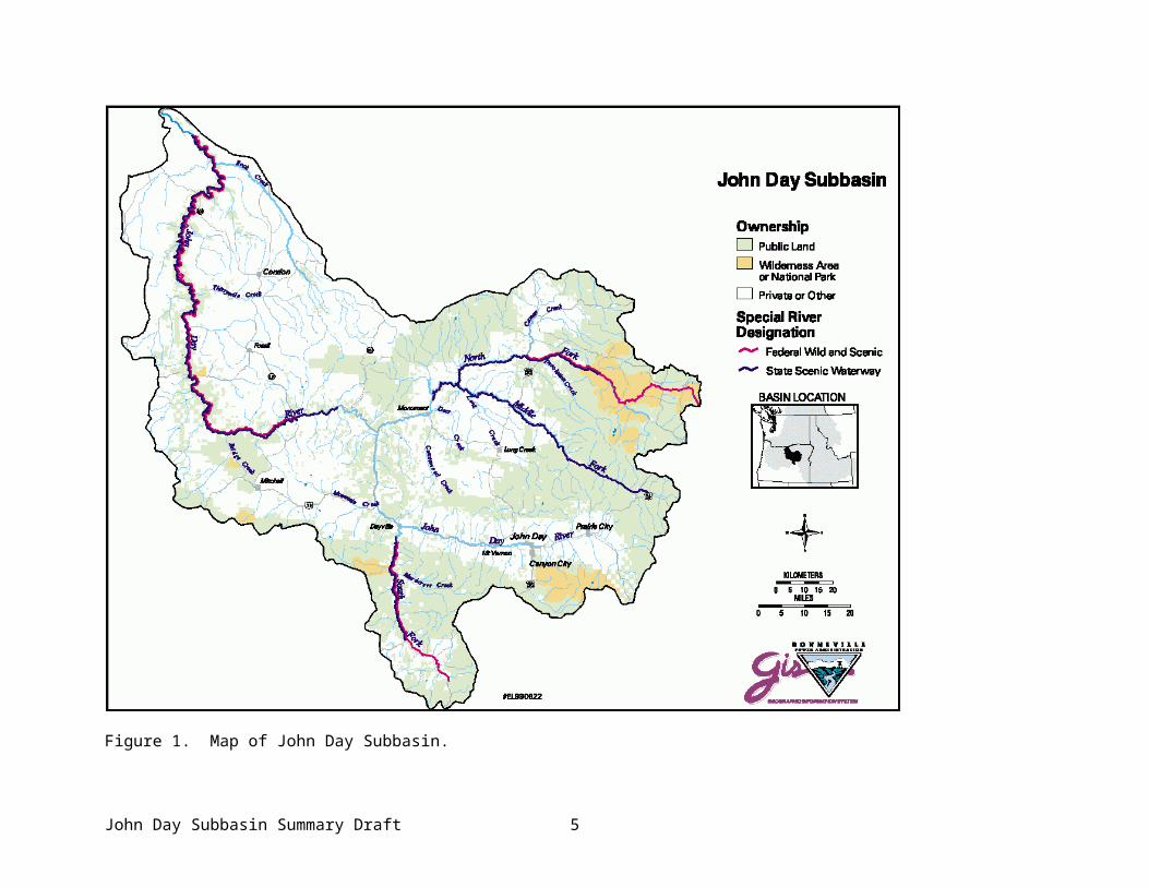
The John Day River Subbasin is comprised of four major watersheds areas – the North Fork John Day, Middle Fork John Day, Upper John Day, and Lower John Day (Figure 3). The Upper John Day subbasin includes the upper mainstem and the South Fork John Day River. The Lower John Day includes the mid- and lower mainstem (Blalock Canyon is part of the Umatilla Subbasin). Most water in the John Day Subbasin is derived from the upper watersheds.
John Day Subbasin Summary Draft 4
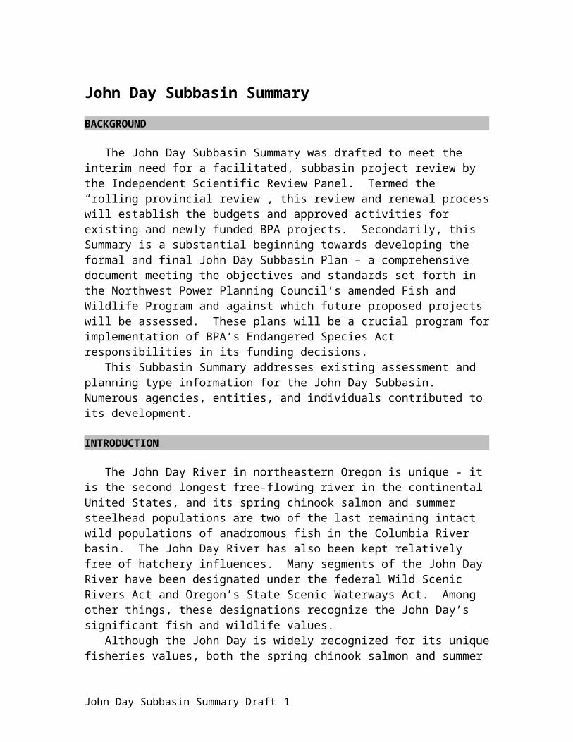
Figure 3. Four major watersheds in the John Day River Subbasin. Watersheds are color-coded.
North Fork: The North Fork John Day watershed drains approximately 1,800 mi2, with a perimeter of 306 mi. Notable rivers and streams located in the North Fork John Day watershed are listed in Table 1 and shown in Appendix Figure 1. Elevation ranges from 1,830 ft. near the mouth of the North Fork to over 8,300 ft in the headwater areas.
Table 1. Notable rivers and streams in the North Fork John Day watershed. These streams are not necessarily priorities in the subbasin or listed in any priority order.
Big Creek Desolation Creek John Day River, NF Pine CreekBig Wall Creek Ditch Creek Junkens Creek Potamus CreekBridge Creek Fivemile Creek Lake Creek Rudio CreekCable Creek Fox Creek Lane Creek Skookum CreekCamas Creek Gilbert Creek Little Wall Creek Stony CreekClear Creek Granite Creek Mallory Creek Swale CreekCottonwood Creek Hideaway Creek Meadow Brook Crk Wilson CreekDeer Creek Indian Creek Owing Creek
Source: EPA Watershed Profile
John Day Subbasin Summary Draft 5

Middle Fork: The Middle Fork John Day watershed drains 806 mi2 with a perimeter of 158 mi. The Middle Fork John Day River is the major river in the subbasin. Notable rivers and streams are listed in Table 2 and shown in Appendix Figure 2. Watershed elevation ranges from 2,200 ft near the mouth of the Middle Fork to over 8,200 ft in the headwater areas. The North and Middle Forks of the John Day River start in the mineral-rich Blue Mountains.
Table 2. Notable rivers and streams in the Middle Fork John Day watershed. These streams are not necessarily priorities in the subbasin or listed in any priority order.
Basin Creek Eightmile Creek Lick Creek Slide CreekBig Creek Elk Creek Long Creek Squaw CreekBridge Creek Indian Creek Pass Creek Twelvemile CreekCamp Creek Granite Boulder Crk Pine Creek Vinegar CreekClear Creek John Day River, MF Sixmile Creek
Upper John Day: The Upper John Day watershed drains approximately 2,135 mi2.above Picture Gorge (RM 205, near the confluence of Mountain Creek; Figure 1) and includes the South Fork John Day subbasin. This watershed area drains portions of the Blue Mountains, including the Strawberry, Aldrich, and Ochoco Mountains. Notable rivers and streams are listed in Table 3 and shown in Appendix Figure 3. Area perimeter is 304 mi.
Table 3. Notable rivers and streams in the Upper John Day watershed. These streams are not necessarily priorities in the subbasin or listed in any priority order.
Antelope Creek Dixie Creek Morgan Creek Smokey CreekBear Creek Fields Creek Mountain Creek South Fork John DayBeech Creek Flat Creek Murderers Creek Squaw CreekBirch Creek Fopiano Creek Pine Creek Stockdale CreekBlack Canyon Creek Indian Creek Poison Creek Strawberry CreekCanyon Creek John Day River Rail Creek Sunflower CreekCorral Creek Johnson Creek Reynolds Creek Utley CreekCottonwood Creek Laycock Creek Riley Creek Venator CreekCummings Creek Lewis Creek Rock Creek Wildcat CreekDeer Creek Lonesome Creek Rosebud Creek Wind Creek
The South Fork John Day subbasin, included in the Upper John Day watershed, drains approximately 600 mi2 and ranges in elevation from 2,300 ft to 7,400 ft. Major tributaries include Rosebud, Poison, Venator, Flat, Utley, Deer, Indian, Rail, and Pine creeks.
Lower John Day: The Lower John Day watershed includes the middle and lower sections of the John Day River and drains the areas downstream of the confluence of the mainstem and North Fork John Day rivers at Kimberly (RM 185). Notable rivers and streams in this watershed are included in Table 4 and shown in Appendix Figure 4, Appendix Figure 5, and Appendix Figure 6. The area encompasses 3,148 mi2 with a perimeter of 301 mi.
John Day Subbasin Summary Draft 6
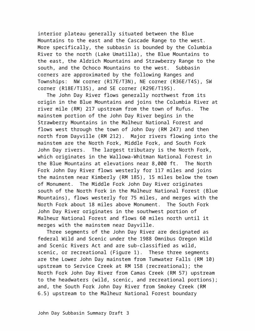
Table 4. Notable rivers and streams in the Lower John Day River watershed. These streams are not necessarily priorities in the subbasin or listed in any priority order.
Alder Creek Currant Creek Jackknife Creek Rock CreekBear Creek Deep Creek John Day River Rowe CreekBologna Creek Dry Creek Juniper Creek Scott Canyon CreekBridge Creek Dry Fork Kahler Creek Service CreekBrown Creek Girds Creek Lake Creek Sixmile CreekBuckhorn Creek Grass Valley Canyon Pine Hollow Crk Thirtymile CreekButte Creek Hay Creek Long Rock Creek Wyman CreekCherry Creek Hoover Creek Muddy CreekCove Creek Horseshoe Creek Parrish Creek
Topography/GeomorphologyThe John Day Subbasin is characterized by diverse landforms ranging from loess-covered
plateaus in the lower sections to glaciated alpine peaks in the headwaters. Elevations range from 200 ft at the mouth of the John Day River to over 9,000 ft in the Strawberry Mountains. Two major physiographic provinces exist in the John Day Subbasin – the Deschutes-Umatilla Plateau and the Blue Mountains. A third province, the Columbia Basin, is a minor province along the confluence with the Columbia River. The Deschutes-Umatilla Plateau is in the lower subbasin situated to the north and west. This plateau is of nearly level to rolling land deeply dissected by the mainstem and tributaries (Appendix Figure 7, and Appendix Figure 8, and Appendix Figure 9). The Blue Mountain Province is in the upper basin to the south and east. The upper subbasin is physiographically diverse, containing mountains, rugged hills, plateaus cut by streams, alluvial basins and valleys (Appendix Figure 10, Appendix Figure 11, and Appendix Figure 12).
Rock assemblages within the John Day Subbasin include masses of oceanic crust, marine sediments, volcanic materials, ancient river and lake deposits, and recent river and landslide deposits. Major geologic events included volcanic eruptions, uplifting, faulting, and erosion. Volcanic activity in the form of lava flows, mudflows, and ash fall formed and stratified three key formations in the subbasin over the course of approximately 37 to 54 million years– the Clarno Formation, John Day Formation, and the Columbia River Basalt Group. The Columbia River Basalt Group, a less erodable formation, resulted from a series of flood basalts 12 to 19 million years ago. Columbia River Basalts are the dominant rocks at elevations below 4,000 ft. Igneous rocks are exposed in the higher reaches of the subbasin, while the lower basin exposures are primarily extrusive rocks, ash, and wind-blown loess (Appendix Figure 13).
After volcanic activity ceased (10 million years ago), erosion and faulting continued to alter the landscape. The Mascall Formation resulted from waterlaid fine volcanic sediments. The Rattlesnake Formation, a thick sequence of sand and gravel, was deposited in the ancestral John Day Valley. A final layer of predominantly unconsolidated silt, sand, and gravel comprises the Quaternary Alluvium.
Distribution of the basin’s major geologic units was mostly controlled by topographic and structural features developed during the pre-Tertiary period, including the Strawberry and Aldrich Mountains, Blue Mountains, and the Blue Mountain Anticline (a long structural
John Day Subbasin Summary Draft 7

upwarping in the earth’s crust; Figure 4). An east-west fault zone exists along the base of the Strawberry and Aldrich Mountains and includes the John Day Fault.
Figure 4. Major physiographic features of the John Day Subbasin (Source: OWRD 1986).
ClimateClimate in the John Day Subbasin ranges from sub-humid in the upper basin to semi-arid in
the lower basin. The area has a continental climate characterized by low winter and high summer temperatures, low average annual precipitation, and dry summers. Most precipitation falls between November and March (Table 5). Less than 10% of the annual precipitation falls as rain during July and August, usually from sporadic thunderstorms. The upper elevations receive up to 50 inches of precipitation annually, mostly in the form of snow; lower elevations receive 12 inches or less of precipitation. The John Day Subbasin receives less precipitation than most portions of the Columbia Basin (OWRD 1986).
Table 5. Average precipitation (inches) at selected sites in the John Day Subbasin (OWRD 1986).Site Elev Yrs Ann Oct Nov Dec Jan Feb Mar Apr May Jun Jly Aug SepArlington 285 74 9.07 0.71 1.34 1.59 1.47 0.97 0.66 0.52 0.54 0.47 0.17 0.22 0.41Moro 1838 75 11.28 0.84 1.66 1.69 1.77 1.14 0.97 0.75 0.88 0.54 0.19 0.27 0.59Monument 1995 22 13.42 0.98 1.58 1.66 1.49 0.90 1.14 1.20 1.34 1.27 0.46 0.66 0.74Dayville 2400 77 11.41 0.84 1.12 1.34 1.21 1.00 1.06 1.02 1.54 1.25 0.42 0.48 0.55Mitchell 2645 46 11.36 0.85 0.89 1.10 1.00 0.86 1.06 1.10 1.69 1.26 0.53 0.41 0.61Antelope 2680 61 12.60 0.90 1.56 1.61 1.54 1.11 1.02 0.79 1.35 1.02 0.28 0.49 0.77Condon 2880 80 12.70 1.07 1.57 1.54 1.43 1.14 1.11 0.97 1.28 1.14 0.39 0.39 0.68John Day 3063 30 10.33 0.78 1.12 1.12 1.08 0.60 0.77 0.96 1.09 1.09 0.38 0.69 0.65Ukiah 3355 60 17.60 1.36 1.94 2.19 1.95 1.43 1.43 1.38 1.63 1.61 0.53 0.70 0.91Long Crk 3720 29 15.65 1.14 2.10 1.40 1.40 1.21 1.72 1.26 2.03 1.63 0.47 0.55 0.74Austin 4213 64 20.40 1.44 2.15 2.97 2.88 2.05 2.30 1.33 1.68 1.42 0.58 0.68 0.92
John Day Subbasin Summary Draft 8
Mean annual temperatures vary inversely with elevation (Table 6). Mean annual temperature is 38 °F in the upper subbasin, to 58 °F in the lower basin. Throughout the subbasin, actual temperatures vary from sub-zero during winter months to over 100 °F during the summer. Inflows of moist Pacific air moderate extreme winter temperatures. The average frost-free period is 50 days in the upper basin and 200 days in the lower basin.
Table 6. Average temperature (°F) at selected sites in the John Day Subbasin (OWRD 1986).Site Elev Yrs Ann Oct Nov Dec Jan Feb Mar Apr May Jun Jly Aug SepArlington 285 64 54.3 54.3 42.1 36.5 33.0 39.1 46.5 53.5 61.7 68.7 75.8 74.6 66.2Moro 1838 66 48.9 50.0 38.8 33.3 29.8 35.3 41.4 47.3 54.6 61.5 68.7 67.5 60.1Monument 1995 22 50.1 50.2 40.3 32.8 31.5 38.3 42.3 47.6 55.4 63.6 69.6 69.0 60.6Dayville 2400 64 50.4 50.6 40.9 35.0 33.5 38.3 43.2 48.8 55.4 62.5 69.3 67.5 59.6Mitchell 2645 76 49.0 50.4 38.2 35.0 33.2 37.2 41.1 46.8 53.7 61.0 68.2 65.3 58.5Antelope 2680 60 48.6 49.9 39.7 33.9 30.9 35.9 40.4 46.0 53.0 60.1 67.6 66.5 59.1Condon 2880 76 47.5 48.6 38.3 32.3 29.2 34.1 39.7 47.0 52.2 59.2 66.7 65.6 57.3John Day 3063 32 48.8 49.7 39.7 33.6 30.8 36.2 40.1 45.7 53.5 61.4 68.6 67.2 59.7Ukiah 3355 59 43.5 45.4 35.2 30.0 24.2 30.2 35.8 42.5 48.4 55.2 61.7 60.1 53.3Long Crk 3720 29 45.8 47.3 37.4 31.9 29.7 35.3 37.5 42.4 49.5 57.2 63.6 62.9 55.7Austin 4213 64 41.1 43.1 31.9 24.8 21.2 26.9 32.2 40.3 43.4 54.3 61.9 59.8 52.3
The Deschutes-Umatilla Plateau experiences cold winters and hot summer, with moderated night temperatures. Most precipitation is discharged over the Coast Range and Cascade Mountains before reaching the plateau; therefore, precipitation is low over this physiographic province. The Blue Mountains exhibit a great range of climates because of the diversity of the region. Physical features of the area create microclimates that deviate from the general pattern of warmer lower elevations and colder higher elevations. Eastern Oregon’s precipitation is highly influenced by elevation.
HydrologyMost water in the John Day Subbasin is derived from the upper watershed, primarily in the
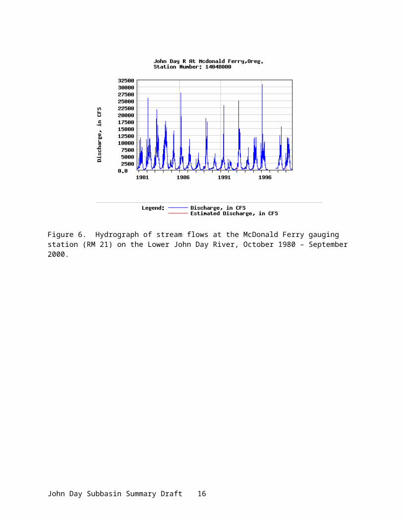
form of melting snow. The John Day River is a free-flowing system; discharge is highly variable from peak to low flows. Discharge usually peaks from March through June and seasonal low flows typically occur from August to October (Figure 5). The John Day River tends to experience flood events in December and January when warm temperatures and high precipitation result in rain on snow events, which lead to extreme runoff. A number of gauging stations operated by the U.S. Geological Survey (USGS) record stream flows throughout the subbasin (Appendix Table 1). Average annual discharge of the John Day River into the Columbia River is approximately 1.5 million acre feet (or 2,103 cubic feet per second), with a range of 1 million to 2.25 million acre feet (af). Peak flow at the McDonald Ferry gauging station (RM 21; Figure 6) is typically over 100 times greater than the lowest flows of the same year. From year to year, peak flows can vary as much as 300-700%. Water quantity in the area below Kimberly (RM 185) is determined more by input from upper basin tributaries than by inputs originating below Kimberly. Many tributary streams cease to flow in the summer. Main tributaries for the Lower John Day are Rock Creek (with the largest flow), Thirtymile, Bridge, and Butte creeks (Figure 7).
John Day Subbasin Summary Draft 9

The hydrologic curve has shifted from historic times, with peak flows greater than in the past and late season flows more diminished. These effects are due to greatly reduced rates of soil infiltration, reduced capacity for ground water / riparian storage, and diminished in-channel storage in beaver ponds.
Figure 5. Average stream flow at the Service Creek gauging station (RM 158), 1929 – 1998.
Figure 6. Hydrograph of stream flows at the McDonald Ferry gauging station (RM 21) on the Lower John Day River, October 1980 – September 2000.
John Day Subbasin Summary Draft
0500
10001500200025003000350040004500500055006000
1/1 2/1 3/1 4/1 5/1 6/1 7/1 8/1 9/1 10/1 11/1 12/1
Day
Flow
(cfs
)
10
John Day
Prairie CityMitchell
Condon
LonerockFossil
Rock Creek
So. Fo rk J ohn Day River
John Day River
Gras
s V
al ley
Cany
on
Bridge Cr.
Mountain Cr .
Cottonwood Cr.
Mid. Fork J ohn Day Riv er
Desolation Cr.
Camas Cr.
John Day Ri ve r
Big W all Cr.
Columbia River
(/395
.-,84
(/97
(/395
(/26(/26
(/207
(/19
No. Fork John Day River
TumwaterFalls
Izee Falls
#
#10
25
50
75
100
125 150 175
2550 75 100
25
50
75200
225 250275
25
50
Morrow Co.
Wasco Co.
Gilliam Co.
Jeffe
rson
Co
Whe
eler
Co.
Grant Co.
Umatilla Co.
Monument
Kimberly
SprayServiceCreek
Twickenham
Cany on Creek
Long C
reek
Butte Creek
Thirtymile Creek
G ranite CreekRitter(/218
(/244
Clarno
Picture Gorge
5 0 5 10 15 Miles
N
EW
S
Legend
John Day Subbasin
Note: River mile markers are approximate.
Figure 7. Map of major river systems in the John Day subbasin.
North Fork John Day: The North Fork Subbasin supplies approximately 60% of the water to the John Day Subbasin. Average annual discharge of the North Fork near Monument is 904,000 AF, which includes flow from the Middle Fork. Flows vary widely from winter highs to summer lows (Figure 8).
John Day Subbasin Summary Draft 11

Figure 8. Hydrograph of stream flows at the Monument gauging station (RM 15) on the North Fork John Day River, October 1980 - September 2000.
Middle Fork John Day: Average annual discharge of the Middle Fork John Day River at Ritter (RM 15) is approximately 185,000 AF. Estimated annual discharge at the mouth of the Middle Fork is 268,000 AF (OWRD 1991; Figure 9).
Figure 9. Hydrograph of stream flows at Ritter gauging station (RM 15) on Middle Fork John Day River.
John Day Subbasin Summary Draft 12

Upper Mainstem John Day: Average annual discharge at Picture Gorge is 346,000 AF (includes 100,000 AF from South Fork which empties into the mainstem 7 mi upstream of Picture Gorge.) Discharge peaks between March and early June; lowest flow is during August and September (Figure 10).
Figure 10. Hydrograph of stream flows at the Picture Gorge gauging station (RM 205) in the Upper John Day, October 1980 - September 2000.
Four types of aquifers comprise each of the four watersheds (Table 7). The Columbia Plateau aquifer system and the Miocene basaltic-rock aquifer are the two most common. Approximately 31% of the total area has no principal aquifer.
Table 7. Principal aquifers in John Day Subbasin watersheds.
Aquifer TypeTotalMiles2 Rock Type
Percent CompositionNF MF U L
Columbia Plateau aquifer system
3115 Basalt, volcanic rock 32.3 12.9 0.9 53.9
Volcanic and Sedimentary Rock aquifers
508 Basalt, volcanic rock 42.7 0.6 24.8 31.9
Miocene basaltic-rock aquifers
1391 Basalt, volcanic rock 5.8 10.6 66.5 17.1
Pacific Northwest basin-fill aquifers
483 Unconsolidated sand, gravel 15.3 0.0 57.3 27.3
No Principal Aquifer 2425 N/A 19.4 9.7 32.6 38.4NF = North Fork John Day, MF = Middle Fork John Day, U = Upper John Day, L = Lower John Day.
John Day Subbasin Summary Draft 13

Water Quality The Oregon Department of Environmental Quality (ODEQ) has identified much of the John
Day Subbasin as water quality limited (Appendix Figure 14). Many of these streams are habitat areas for spring chinook salmon and summer steelhead. Water quality limited means instream water quality fails to meet established standards for certain parameters for all for a portion of the year. Water quality parameters (and standards) of temperature (64°F/55°F, rearing/spawning), dissolved oxygen (98% sat), habitat modification (pool frequency), and flow modification (flows) relate to the beneficial use for fish life. Standards for bacteria (fecal coliform) relate to the beneficial use for recreation. All segments of the Wild and Scenic River are listed on ODEQs 303(d) list of affected waters for temperature. Most water quality problems in the John Day subbasin stem from historical mining and dredging, unmanaged livestock grazing, cumulative effects of timber harvest and road building, and water withdrawals for irrigation. In the lower subbasin, some dry-land agricultural practices, such as summer fallow, can affect water quality by modifying subbasin hydrology, potentially affecting sediment delivery, as well as peak and late season flows.
North Fork John Day: The North Fork has the best chemical, physical, and biological water quality in the John Day Subbasin (USDI 2000). Most of the streams in this subbasin are considered in good condition, with the exception of elevated late summer water temperature that do not meet ODEQ standards (Figure 11). Temperature and habitat modification are the primarily water quality limitations for the North Fork (Table 8). The North Fork does not meet PACFISH pool frequency management objectives (USDA and USDI 1994). Because the North Fork contributes 60% of the flow to the mainstem John Day, the influence of the North Fork on temperature is significant, which relates directly to fisheries. Other water quality problems in the North Fork include leaching of toxic mine waste and a high degree of stream sedimentation from highly erodable soils. Hot geothermal springs also exist, but their effects on water quality are not fully known.
Figure 11. Water quality limited 303(d) streams in the North Fork John Day subbasin.
John Day Subbasin Summary Draft 14

Table 8. North Fork John Day River Subbasin 303(d) listed stream segments and water quality parameters of concern.
Stream Parameters of Concern Stream Parameters of Concern
Alder Creek Sedimentation, Habitat Mod. Ditch Creek TemperatureBacon Creek Habitat Modification Fivemile Creek Temperature, Habitat Mod.Baldy Creek Temperature, Habitat Mod.
SedimentationFox Creek TemperatureFrazier Creek Temperature, Habitat Mod.
Bear Creek Habitat Modification Granite Creek Temperature, Habitat Mod.SedimentationBeaver Creek Temperature
Beaver Creek, SF Habitat Modification Hidaway Creek Temperature, Habitat Mod.Bear Wallow Crk Temperature, Habitat Mod. Hog Creek SedimentationBig Creek Temperature Indian Creek Temperature, Habitat Mod.Big Wall Creek Sedimentation, Habitat Mod.,
TemperatureJohn Day River NF Temperature, Habitat Mod.Lane Creek Temperature
Boulder Creek Habitat Modification Mallory Creek TemperatureBowman Creek Temperature, Habitat Mod. Olive Creek Habitat ModificationBridge Creek Temperature Onion Creek TemperatureBull Creek Habitat Modification Owens Creek Temperature, Habitat Mod.Bull Run Creek Temperature, Sedimentation
Habitat ModificationPorter Creek Sedimentation, Habitat Mod.Potamus Creek Temperature
Cable Creek Temperature, Habitat Mod. Rancheria Creek TemperatureCamas Creek Temperature, Habitat Mod. Rudio Creek TemperatureClear Creek Temperature Skookum Creek Temperature, Habitat Mod.Corral Creek Habitat Modification Stadler Creek TemperatureCottonwood Crk Biological Criteria Swale Creek Temperature, Sedimentation
Habitat ModificationCottonwood Crk EF Biological CriteriaCrane Creek Temperature, Habitat Mod. Taylor Creek Temperature, Habitat Mod.Crawfish Creek Temperature, Habitat Mod. Trail Creek Temperature, Habitat Mod.Davis Creek Habitat Modification Trail Creek, North Habitat ModificationDeep Creek Habitat Modification Trail Creek, South Temperature, Habitat Mod.Desolation Creek Temperature Wilson Creek Temperature, Sedimentation
Habitat ModificationSource: ODEQ
Middle Fork John Day: Water quality in the Middle Fork John Day Subbasin generally exhibits satisfactory chemical, physical, and biological quality (USDI 2000). The Middle Fork usually has worse water quality problems than its tributaries, with the most serious water quality problem being elevated summer temperatures (Figure 12; Table 9). Sedimentation from streambank erosion is not a serious problem in the Middle Fork. Season-long cattle grazing contributes to elevated fecal coliform counts during summer. However, agricultural runoff presents a low level of potential impact to water quality.
John Day Subbasin Summary Draft 15

Figure 12. Water quality limited 303(d) streams in the Middle Fork John Day Subbasin.
Table 9. Middle Fork John Day River Subbasin 303(d) listed stream segments and parameters of concern.
Stream Parameters of Concern Stream Parameters of ConcernBig Boulder Creek Temperature Little Butte Creek, EF TemperatureBig Creek Temperature Little Butte Creek,
WFTemperature
Camp Creek Temperature Long Creek TemperatureCaribou Creek Temperature Lunch Creek TemperatureClear Creek Temperature Mill Creek TemperatureClear Creek, Dry Fork
Temperature Mosquito Creek Temperature
Coyote Creek Temperature Placer Gulch TemperatureCrawford Creek Temperature Ragged Creek TemperatureDavis Creek Temperature Squaw Creek TemperatureGranite Boulder Creek
Temperature Summit Creek Temperature
John Day River MF Temperature, Flow Mod.
Vinegar Creek Temperature
Little Boulder Creek
Temperature
(Source: ODEQ)
Upper John Day (including South Fork): Water quality is fair in the upper subbasin during most of the year (USDI 2000). Low summer flows on the mainstem John Day River above Dayville contribute to elevated temperatures (Figure 13; Table 10) and higher stream flows contribute to turbidity. Problematic eutrophication and consequent elevation of pH and dissolved oxygen in
John Day Subbasin Summary Draft 16

the South Fork and mainstem John Day rivers are a partial result of irrigation return flow (non-point) and possibly cattle feedlots (point source). However, agricultural runoff presents a low level of potential impact to water quality. In the South Fork, water quality is generally satisfactory for the primary parameters (USDI 2000). Sediment loading, from moderately severe streambank erosion, and elevated water temperature are the primary water quality concerns in the South Fork. For example, lack of riparian shade results in water temperatures as high as 77° F near Izee (ODEQ).
Figure 13. Water quality limited 303(d) streams in the Upper John Day subbasin.
Table 10. Upper John Day River Subbasin 303(d) listed stream segments and parameters of concern.Stream Parameters of Concern Stream Parameters of ConcernBadger Creek Temperature John Day River SF TemperatureBattle Creek Temperature Lonesome Creek TemperatureBear Creek Temperature McClellan Creek TemperatureBelshaw Creek Temperature Mountain Creek TemperatureCanyon Creek Temperature Murderers Creek TemperatureCorral Creek Biological Criteria Pine Creek (Upper John Day) TemperatureCottonwood Creek Temperature Rail Creek TemperatureDads Creek Temperature Reynolds Creek TemperatureDans Creek Temperature Slife Creek TemperatureDeardorf Creek Temperature Strawberry Creek TemperatureDeer Creek Temperature Sunflower Creek TemperatureDeer Creek NF Temperature Tinker Creek TemperatureDog Creek Temperature Utley Creek Biological CriteriaFlat Creek Temperature Venator Creek TemperatureGrasshopper Crk Temperature Wind Creek TemperatureGrub Creek TemperatureIndian Creek TemperatureJohn Day River Temperature, Flow Mod.
John Day Subbasin Summary Draft 17

Stream Parameters of Concern Stream Parameters of ConcernDissolved Oxygen, Bacteria
Lower John Day: During the summer months from July to September, groundwater provides much of the base flow to the Lower John Day River. Although ODEQ has listed the lower river as water quality limited for temperature, other water quality constituents such as total phosphates, biochemical oxygen demand, and fecal coliform can also limit water quality during late summer when flows are the lowest and water temperatures are the greatest (Figure 14; Table 11). Severe streambank erosion and sedimentation exists in some tributaries to the mainstem. Agricultural runoff presents a moderate level of potential impact to water quality. Total Maximum Daily Loads (TMDL) are expected to be developed for this section in 2005.
Figure 14. Water quality limited 303(d) streams in the Lower John Day River.
Table 11. Lower John Day River Subbasin 303(d) listed stream segments and parameters of concern.
Stream Parameters of Concern Stream Parameters of ConcernBear Creek Temperature Henry Creek TemperatureBridge Creek Temperature John Day River TemperatureFerry Canyon Creek Temperature Nelson Creek TemperatureGable Creek Temperature Pine Creek Biological CriteriaGrass Valley Canyon Temperature Rock Creek TemperatureHay Creek Temperature Sorefoot Creek TemperatureHeflin Creek Temperature Stahl Creek Temperature(Source: ODEQ) Thirtymile Creek Temperature
Eutrophication is also active during the low-flow summer months when water temperatures are high. During this process, excessive growth of algae and aquatic plants increase organic
John Day Subbasin Summary Draft 18

matter in the water, resulting in elevated pH levels, increased biochemical oxygen demand, and decreased dissolved oxygen, which are all harmful to aquatic life.
VegetationThe present plant communities bear little resemblance to the original flora found in the John
Day Subbasin as a result of unmanaged grazing, fire suppression, and introduction of exotic plants (Wissmar et al. 1994). Native bunchgrasses have been largely replaced by western juniper (Juniperus ocidentalis), sagebrush (Artemesia sp.), and exotic plants (e.g.,cheatgrass). Land cover is predominantly forest and rangelands with small amounts of agricultural land (USDI 1998; Appendix Figure 15).
Classifiable plant communities (ecological sites) in the John Day Subbasin are categorized into four basic divisions, according to the topographic position which they occupy: riparian, terrace, upland, and forest-woodland (Table 12). Grass, shrub, and juniper communities dominate the valley; ponderosa pine, lodgepole pine, Douglas fir, and white fir communities dominate higher elevations. Soil diversity also contributes to the variety of vegetation types (Figure 4).
Riparian: Riparian areas are the green corridors of vegetation along perennial streams. Most of the riparian zone in the John Day Subbasin is flooded during part of the growing season and dry during mid- to late summer. Riparian zones are comprised of areas of undeveloped soils and developed, well-drained soils. Remnant natural hardwoods include alder, mountain ash, red-osier dogwood, willow, and cottonwood. Kentucky bluegrass, Nebraska sedge, and Baltic rush are non-native riparian species.
Riverine Terrance: The riverine terrace zone is formed from abandoned floodplains where soils are drained and subsurface water is diminished. This zone is a transition between riparian and upland vegetation. Primary, secondary, and or even tertiary terraces are ascribed according to their river proximity. Vegetation is comprised of xeric and exotic plants, including shrub-steppe vegetation.
Upland: The upland zone is characterized by steep slopes with shallow soils on ridges, south and west-facing slopes, and deeper well-drained soils on north and east-facing slopes. The upper soil layer is sometimes bound by a biological soil crust consisting of algae, fungi, mosses, and lichens. Sagebrush-steppe covers much of the uplands; the various species found (big, low, stiff) is dependent on soil type. Native grasses remain in areas of steep topography, including blue bunch wheatgrass and Idaho fescue.
Forest and Woodland: The John Day Subbasin encompasses about 1.8 million acres of forested lands; half of the subbasin’s uplands are forested. The forest and woodland zone is in higher elevational sites (> 4,000 ft) with greater precipitation and cooler temperatures. Soil is generally deeper which allows for growth of larger trees. Ponderosa pine is the principal forest cover, dominating south slopes. Moister areas favor Douglas fir, white fir, western larch, lodgepole pine, and western white pine. At higher elevations (> 6,000 ft), fir, lodgepole pine, Englemann spruce, and subalpine fir are present.
Table 12. List of vegetation types within ecological sites in the John Day Subbasin.
Ecological Site Vegetation TypesRiparian Undeveloped soils Service berry, hackberry, mock orange, annual/perennial grasses and forbs;
also may lack vegetation Developed soils Willow, alder, sedges, rushes, cottonwood
John Day Subbasin Summary Draft 19
Ecological Site Vegetation TypesRiverine Terrace Sagebrush, annual grasses, Great Basin wild rye, perennial bunchgrass,
forbs, western juniper, cheatgrass, rabbitbrushUpland Junipers, sagebrush, bitterbrush, snakeweed, cheatgrass, blue bunch wheat
grass, Idaho fescue, needle and thread grassForests /Woodlands Ponderosa pine, mountain mahogany, elk sedge, Idaho fescue, Douglas fir,
western juniper, lodgepole pine, western larch, firSource: USDI 2000.
Numerous rare plants are found in the John Day Subbasin (Table 13). These plants are listed either through the Oregon Natural Heritage Program or under state or federal listings.
Table 13. List of rare and species-of-concern plants found in the Blue Mountains, including BLM lands, private lands, and the Wallowa-Whitman, Ochoco, Umatilla and Malheur National Forests. Federally listed species of concern plants are bolded.
Common Name Scientific Name Common Name Scientific NameBrandegee onion Allium brandegei King’s bladderpod Lesquerella kingii
diversifoliaSierra onion Allium campanulatum Biscuit-root Lomatium
erythrocarpumBlue Mountain onion Allium dictuon Greenman’s lomatium Lomatium greenmaniiGeyer’s onion Allium Geyeri geyeri Biscuit-root Lomatium pastoralisSwamp onion Allium madidum Rollin’s lomatium Lamatium rollinsiiOnion Allium pleianthum Colonial luina Luina serpentinaOnion Allium tolmiei platyphyllum Biddle’s lupine Lupinus biddleiAromatic everlasting Antennaria aromatica Cucick’s lupine Lupinus cusickiiNorthern wormwood Artemesia campestris var.womskioldii Lupine Lupinus burkei
daeruleomontanusPrairie sage Artemesia ludoviciana estesii Sabin’s lupine Lupinus sabiniiGreen spleenwort Asplenium viride Stiff clubmoss Lycopodium annotinumArthur’s milk-vetch Astragalus arthuri Ground cedar Lycoposium complanatumMourning milk-vetch Astragalus atratus owyheensis Hepatic monkey flower Mimulus jungermannioidesCusick’s milk-vetch Astragalus cusickii Bank monkey-flower
Monkey flowerMimulus clivicolaMimulus hymenophyllus
Laurence’s milk-vetch Astragalus collinus var. laurentii Monkey flower Mimulus patulusJohn Day milk-vetch Astragalus diaphanus diaphanus Washington monkey flower Mimulus washingtonensis washington
So. John Day milk-vetch Astragalus diaphanous var. diurnusHowell’s milk-vetch Astragalus howellii Macfarlane’s four o’clock Mirabilis macfarlaneiMulford’s milk-vetch Astragalus mulfordiae Little mousetail Myosurus minimus ssp. apusRobbin’s milk-vetch Astragalus robbinsii alpiniformis Pine broomrape Orobanche pinorumBastard milk-vetch Astragalus tegetarioides Herderson ricegrass Oryzopsis hendersonii
Paper birch Betula papyrifera commutata
Bridge’s cliff-brake Pellea bridgesii
Bolandra Bolandra oregana Wallowa penstemon Penstemon spatulatus
Crenulate grape-fern Botrychium crenalatum Least phacelia Phacelia minutissima
Lance-leaved grape-fern Botrychium lanceolatum Many-flowered phlox Phlox multiflora
Moonwort Botrychium lunaria Blunt-flowered rein orchid Platanthera orbiculata
Gray moonwort Botrychium minganese Oregon semaphoregrass Pleuropogon oreganos
John Day Subbasin Summary Draft 20

Common Name Scientific Name Common Name Scientific NameMontane grape-fern Botrychium montanum Diverse-leaved pondweed Potamogeton diversifolius
Twin-spike moonwort Botrychium pedunculosum
Wallowa primerose Primula cusickiana
Stalked moonwort Botrychium pedunculosum
Blue Mountain buttercup Ranunculus oresterus
Grape-fern Botrychium pinnatum Northern gooseberry Ribes oxyacanthoides irrigum
Grape-fern Botrychium simplex Columbia cress Rorripa columbiae
Bartonberry Rubus bartonianusBuplerum Buplerum americanum Farr’s willow Salix farriae
Long-bearded marioposa-lily
Calochortus longebarbatus longebarbatus
Wedge-leaved saxifrage Saxifraga ascendens oregonensis
Long-bearded sego lily Calochortus longebarbatus peckii
Payson’s groundsel Senecio dimorphophyllus paysonii
Low northern sedge Carex concinna Porter’s butterweed Senecio porteri
New sedge Carex nova Scapose silene Silene scaposa scaposa
Fraternal paintbrush Castilleja fraterna Spalding’s silene Silene spaldingii
Purple alpine paintbrush Castilleja rubida Subalpine spirea Spiraea densiflora splenduns
John Day chaenactis Chaenactis nevii Peck’s styloclineAlpine meadowrue
Stylocline psilocarphoidesThalictrum alpinum hebetum
Fee’s lip-fern Cheilanthes feei Arrowleaf thelypoday Thelypodium eucosmum
Bristle-flowered collomia Collomia macrocalyx Howell’s thelypody Thelypodium howellii spectabilis
Steller’s rock-brake Cryptogramma stelleriClustered lady-slipper Cypripedium
fasciculatumAmiercan globeflower Trollius lasux albiflorus
Lemmon’s draba Draba lemmonii cyclomorpha
Lichen Texosporum sancti-jacobi
Draba Draba sphaeroides cusickii
Male fern Dryopteris filix-masEngelmann’s daisy Eriogeron engelmannii
davisiiCusick’s buckwheat Eriogonum cusickiiOchre-flowered eriogonum Eriogonum
ochrocephalum calcareum
Buckwheat Eriogonum scopulorumRoss’s avens Geum rossii turbinatumSnake River goldenweed Happlopappus radiatusGooseberry-leaved alumroot
Heuchera grossularifolia grosul.
Bellard’s kobresia Kobresia myosuroidesSimple kobresia Kobresia simpliciusculaPrickly phox Leptodactylon pungens
hazeliae
John Day Subbasin Summary Draft 21

Exotic plants (noxious weeds) and uncontrolled growth of some native species (e.g.,juniper) are a growing problem within the subbasin. The single greatest threat to native rangeland biodiversity and recovery of less than healthy watersheds is the rapidly expanding invasion of noxious weeds (USDI 2000). Although many weeds occupy lands in the John Day Subbasin (Table 14), those causing most concern are diffuse, spotted, and Russian knapweeds; Dalmatian toadflax; yellow starthistle; Scotch thistle; purple loosestrife; rush skeletonweed; leafy spurge; poison hemlock; and, medusahead rye (USDI 2000).
Table 14. Noxious weeds found in the John Day Subbasin.
Common Name Scientific Name Location (County)Goatgrass Aegilops cylindrinca Union, Umatilla, GilliamQuackgrass Agropyron repens Union, UmatillaCamelthorn Alhagi pseudalhagi UmatillaRagweed Ambrosia artemisiifolia UmatillaCommon burdock Arctium minus GrantWild oat Avena fatua Union, UmatillaCheatgrass Bromus tectorum Grant, Umatilla, Union, GilliamWhitetop Cardaria draba Grant, Union, UmatillaMusk thistle Carduus nutans Union, UmatillaLonspine sandbur Cenchrus longispinus UmatillaDiffuse knapweed Dentaurea diffusa Union, Umatilla, GilliamSpotted knapweed Centaurea maculosa Grant, Union, Umatilla, GilliamRussian knapweed Centaurea repens Grant, Union, Umatilla, GilliamYellow starthistle Centaurea solstitialis Union, Umatilla, GilliamSquarrose knapweed Centaurea squarrosa GrantRush skeltonweed Chondrilla juncea Grant, Union, Umatilla, GilliamWater hemlock Cicuta douglasii GrantPoison hemlock Conium maculatum Grant, Umatilla, GilliamField bindweed Convolvulus arvensis Grant, Umatilla, GilliamCommon crupina Crupina vulgaris Grant, UmatillaDodder Cuscuta approximata Grant, UmatillaDodder Cuscata pentagona UmatillaTeasel Dipsacus sylvestris Grant, GilliamMedusahead rye Elymus caput-medusae Grant, GilliamLeafy spurge Euphorbia esula Umatilla, Union, GilliamSpikeweed Hemizonia pungens UmatillaSt. Johnswort Hypericum perforatum Grant, UmatillaKochia Kochia scoparia Grant, Umatilla, GillaimDalmationa toadflax Linaria dalmatica Grant, Umatilla, Union, GilliamYellow toadflax Linaria vulgaris GilliamPurple Loosestrife Lythrum salicaria Grant, UmatillaScotch thistle Onopordum acanthium Grant, Umatilla, GilliamMediterranean sage Salvia aethiopis GrantTansy ragwort Senecio jacobaea Umailla, UnionMilkthistle Silybum marianum GrantJohnsongrass Sorghum halepense Umatilla
John Day Subbasin Summary Draft 22

Common Name Scientific Name Location (County)Austrian peaweed Sphaerophysa salsula UmatillaSaltcedar Tamarix sp. GilliamBroad-leaved cocklebur Xanthium strumarium GrantSacred durtura GilliamHawkweed-yellow GilliamHawkweed-orange Gilliam
Major Land UsesHistorically, the John Day Subbasin was used by Native Americans, fur trappers, and
homesteaders. After the treaty of 1855, homesteads and ranches were established on the river corridor where fertile bottomlands could be farmed and water was available for irrigation and livestock. Gold mining was an important use in the upper John Day subbasin in the early part of the century. Small communities were established along the river to provide goods and services for mines, homesteads, and ranches.
The John Day Subbasin is not a highly populated area (0.9 – 2.2 people/mi2). In 1990, approximately 13,300 people lived in the basin, primarily in Grant, Wheeler, Gilliam, and Sherman counties. Non-farm families were more predominant (87%) than farming families (13%). Major towns include Arlington, Condon, Fossil, Mitchell, John Day, Canyon City, and Prairie City (www.census.gov; Figure 7).
Today the economy is heavily based on government, tourism, and agriculture, although some mining still continues. The historically large contribution of timber to the basin economy has declined in the last decade due to a number of factors including lack of raw materials, sagging domestic lumber market, and increased domestic imports. Expansion of the economy is limited by the small population, isolation from major cities, and limited transportation facilities. The timber industry (logging) is most important in the forested upper portions of the basin (Appendix Figure 16). Livestock agriculture is important throughout the basin, comprised mostly of cattle and sheep ranching and associated hay crops. Predominant irrigated crops are grass and alfalfa hay. Dry-land production of grain crops is the major economic activity on the plateaus of the lower subbasin. Mining for gold and other locatable minerals continues on the upper North Fork, upper Middle Fork, and on tributaries of the upper mainstem John Day River. Bentonite is currently mined along the lower mainstem John Day River near Clarno (Figure 7). Mining for rock and gravel used for road construction occurs throughout the basin.
Tourism and recreation are growing industries, constituting a significant sector of the subbasin’s economy and are inextricably tied to the production of natural resources. Hunting, fishing, boating, camping, wildlife observation, photography, hiking, swimming, and scenic viewing are among the most common recreational activities. Federal Wild and Scenic river segments and State Scenic Waterway designations have undoubtedly contributed to the rise in tourism and recreation. These river segments contain outstandingly remarkable values and provide opportunities for white water rafting, warm-water bass fishing, and wildlife viewing. The John Day Fossils Beds National Monument (14,000 acres), managed by the National Park Service, attracts visitors to its Sheep Rock, Painted Hills, and Clarno units with their cultural and paleontologic resources (Appendix Figure 17). The mainstem of the John Day River flows through the Sheep Rock Unit.
The U.S. Forest Service manages approximately 30% of the John Day Subbasin and most of the remainder is privately owned, especially in the lower basin (Table 15; Appendix Figure 17). Over 95% of the lands within the subbasin are zoned for agriculture and forestry. Private and
John Day Subbasin Summary Draft 23

federally listed lands are used mainly for livestock grazing and forage production. National Forest lands are in the higher elevations of the upper subbasins in the Malheur, Ochoco, Umatilla, and Wallowa-Whitman National Forests. Wilderness areas include the North Fork John Day Wilderness, Strawberry Wilderness, Black Canyon Wilderness, and Bridge Creek Wilderness (Figure 1). Wilderness areas are managed with access limited to hiking or horseback and timber harvest and associated road construction activities prohibited. Outside of wilderness and protected areas, primary use is for timber production. The Bureau of Land Management administers widely scattered parcels throughout the subbasin, but a current land exchange program is seeking to consolidate BLM lands. State owned lands are mostly wildlife management areas (Appendix Figure 17). Urban lands comprise only 0.3% of the land base. The Bureau of Indian Affairs (U.S. Dept. of Interior) manages about 20 off-reservation trust lands for the Warm Springs Tribes, located in the lower John Day River (Appendix Figure 17). The Warm Springs Tribes either owns or manages approximately 35,000 acres throughout the basin.
Table 15. Land ownership in the John Day Subbasin.
Land Holder Area (mi2) Percent of SubbasinPrivate 5,027 62U.S. Forest Service 2,396 30Bureau of Land Management 587 7National Park Service 20 < 1%Corps of Engineers 2 < 1%Oregon Dept. Fish & Wildlife 50 < 1%Oregon State Land Board 13 < 1%Oregon Dept. Forestry 4 < 1%Bureau of Indian Affairs 4 < 1%Confederated Tribes of Warm Springs
54.7
Source: USDI 2000
Major out-of-stream water use is irrigation. About 60,100 acres are currently irrigated in the John Day Subbasin, mostly by surface irrigation. Surface withdrawals total 189.61 million gallons of water/day, with most water withdrawn in the Upper John Day Subbasin (Table 16). Irrigated agriculture comprises nearly 2% of the upper basin, consisting mostly of grass hay, alfalfa, and clover. Irrigated lands are mostly along the upper mainstem from Picture Gorge to the Blue Mountain Hot Springs, in the Spray, Twickenham, and Clarno areas of the middle mainstem, and the lower areas of the North Fork where orchard production and cattle grazing exist (ODFW et al. 1990; Appendix Figure 16). Water appropriation in the John Day Subbasin varies by season. The average proportion of consumptive use to natural flow is 2% in winter, 15% in spring, 73% in summer, and 14% in fall (OWRD 2000). At times, appropriation is more than natural flows, most notably in summer.
Table 16. Water withdrawals for the John Day Subbasin.
Category Value (million gal/day)Lower John Day SubbasinGround-water withdrawals 5.47
John Day Subbasin Summary Draft 24

Surface-water withdrawals 31.47Total water withdrawals 36.94Middle Fork John Day SubbasinGround-water withdrawals 0.32Surface-water withdrawals 11.05Total water withdrawals 11.37Upper John Day SubbasinGround-water withdrawals 1.30Surface-water withdrawals 116.73Total water withdrawals 118.03North Fork John Day SubbasinGround-water withdrawals 0.25Surface-water withdrawals 30.36Total water withdrawals 30.61
Much of the John Day Subbasin is within the ceded lands of the Confederated Tribes of the Umatilla Indian Reservation (CTUIR) and the Confederated Tribes of the Warm Springs Reservation of Oregon (CTWSRO). The Tribes have reserved treaty rights to the use of this land and its resources. This area is still used for ceremonial and subsistence purposes, including hunting, fishing, livestock grazing, and gathering plants.
FISH AND WILDLIFE RESOURCES
Fish and Wildlife Status
FisheriesAn estimated 27 species of fish, including 17 native species, are found in the John Day River subbasin (Table 17).
Table 17. Fish species of known occurrence in the John Day River Subbasin.
Species Origin Location StatusTorrent sculpin (Cottus rhotheus) N B CMottled sculpin (Cottus bairdi semiscaber) N B CSpring chinook (Oncorhynchus tschawytscha) N UM, NF, MF CSummer steelhead (Oncorhynchus mykiss) N B TWestslope cutthroat (Oncorhynchus clarki lewisi) N UM, NF SBull trout (Salvelinus confluentus) N UM, MF, NF TRedband trout (Oncorhynchus mykiss gibbsi) N B SBrook trout (Salvelinus fontinalis) I UM, NF OSpeckled dace (Rhinichthys osculus) N B CLongnose dace (Rhinichthys cataractae dulcis) N B CRedside shiner (Richarsonius balteatus balteatus) N B CChiselmouth (Acrocheilus alutaceus) N B CCarp (Cyprinus carpio) I LM CBridgelip sucker (Catastomus columbianus) N B CLargescale sucker (Catastomus macrocheilus) N B C
John Day Subbasin Summary Draft 25

Species Origin Location StatusNorthern pikeminnow (Ptychocheilus oregonensis) N B CPacific lamprey (Lampetra tridentata) N B SBrook lamprey (Lampetra richardsoni) N B UMountain whitefish (Prosopium williamsoni) N UM, MF, NF CBlack bullhead (Ictalurus melas) I LM, L OBrown bullhead (Ictalurus nebulosus) I LM, L OChannel catfish (Ictalurus punctatus) I LM CLargemouth bass (Micropterus salmoides) I LM, L OSmallmouth bass (Micropterus dolomieui) I LM, UM, NF CBlack crappie (Pomoxis nigromaculatus) I L OBluegill (Lepomis macrochirus) I L OLahonton cutthroat trout (Oncorhynchus clarki) I L OI=Introduced, N=Native, L=Lakes or ponds, B=Basinwide, LM=Lower Mainstem, UM=Upper Mainstem, MF=Middle Fork, NF=North Fork, C=Common, O=Occasional, S=Sensitive, T=Threatened
Historically, the John Day River was one of the most significant anadromous fish producing rivers in the Columbia River basin (CRITFC 1995). Today, the John Day River continues to support some of the most diverse native and non-native fish assemblages and healthiest populations of anadromous fish in the Basin. The relative health of these populations has been largely attributed to the absence of any large dams, limited releases of hatchery fish, and to a lesser extent, the presence of quality habitat in headwater areas. The John Day Subbasin supports runs of spring and fall chinook salmon, summer steelhead, and Pacific lamprey; resident populations of westslope cutthroat, interior redband, and bull trout also exist. However, recent runs of spring chinook salmon (2,000 – 5,000 fish) and summer steelhead (5,000-40,000 fish) are a fraction of their former abundance. The current management policy is designed to maintain native, wild stocks of salmon and steelhead, and to preserve the genetic diversity of these native stocks for maximum habitat use and fish production (ODFW et al. 1990). Although there were hatchery releases of coho salmon and summer and winter steelhead in years past, these releases were discontinued (see Artificial Production). The North Fork Subbasin currently has the highest escapement levels of anadromous fish in the John Day Subbasin. Special status species are listed in Table 18.
Table 18. Special status fish species in the John Day Subbasin.
Species Status Species StatusMid-Columbia Steelhead Threatened Westslope Cutthroat trout SensitiveBull trout Threatened Pacific lamprey SensitiveRedband trout Sensitive
Spring Chinook Salmon (Oncorhynchus tschawytscha)Spring chinook salmon adults travel through the Columbia River in April and May and enter the
John Day River in May and June (Table 19). Adult fish migrate upriver and arrive at spawning and rearing areas in the Upper John Day, Middle Fork John Day, North Fork John Day, and Granite Creek, a tributary to the North Fork, by early July (Figure 15). In some years, small
John Day Subbasin Summary Draft 26

numbers of adults return to the South Fork John Day River, Camas Creek, Desolation Creek, and Canyon Creek. Most spring chinook return as 4-year-olds (75%), with 3-(2.5%) and 5-year-old (22.5%) returns comprising the remainder (Lindsay et al. 1986). Fish spawn from late August through late September (Table 19). Emergence of fry commences in March and April following high water. Juveniles reside in rearing areas for approximately 12 months before migrating downstream the following spring, with migration peaking past Spray (RM 170) on the mainstem during the second week in April (Lindsay et al. 1986).
Table 19. Periodicity of summer steelhead and chinook salmon life history in the John Day River.
Species Life History Stage Jan Feb Mar Apr May Jun Jul Aug Sep Oct Nov Dec
SUMMERSTEELHEAD
SPRING CHINOOK SALMON
FALL CHINOOK SALMON
Adult MigrationAdult SpawningEgg IncubationJuvenile RearingSmolt Migration
Adult MigrationAdult HoldingAdult SpawningEgg IncubationJuvenile RearingSmolt Migration
Adult MigrationAdult SpawningEgg IncubationJuvenile RearingSmolt Migration
Source: USDI 2000
Spring chinook salmon are found in about 38 streams in the John Day Subbasin (Table 20; Figure 15). Spawning habitat is primarily limited to the mainstem and major tributaries of the North Fork, such as Granite, Clear, and Bull Run creeks. Rearing habitats are both on the mainstem reaches and the lower reaches of significant tributaries. Of the 9,603 total stream miles available for spring chinook salmon in the subbasin, 6% is used and 94% is unused (Table 21).
Table 20. Distribution of spring chinook salmon in John Day Subbasin streams.
Tributary Stream Main Stream Miles of Trib. Miles Used % UsedJohn Day River Columbia River 277.6 181.8 65%Bull Run Creek Granite Creek 9.3 3.1 32%Clear Creek Granite Creek 8.0 2.3 28%Indian Creek John Day 11.8 3.4 28%
John Day Subbasin Summary Draft 27
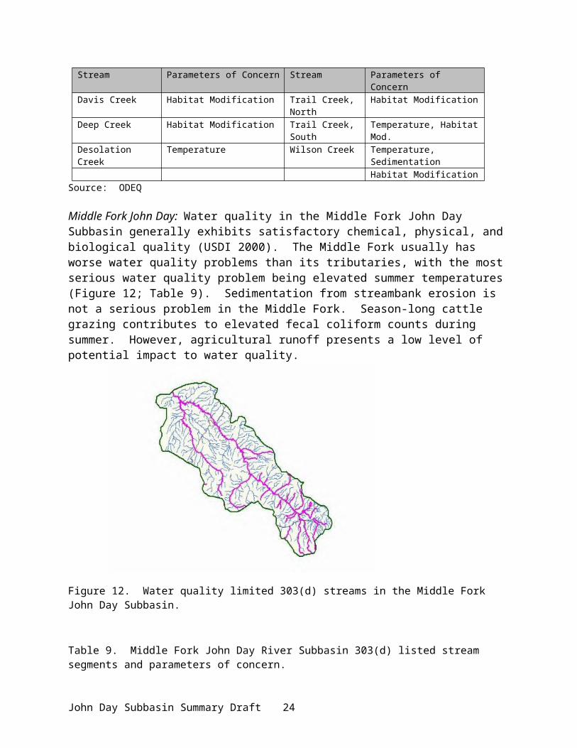
Tributary Stream Main Stream Miles of Trib. Miles Used % UsedNorth Fork John Day 111.0 59.6 53%Beaver Creek John Day River 4.10 0.8 20%Beech Creek John Day River 18.7 1.7 8%Canyon Creek John Day River 27.5 10.4 37%Dads Creek John Day River 8.6 4.2 48%Deardorff Creek John Day River 9.6 1.0 9%Dixie Creek John Day River 11.4 1.3 11%Reynolds Creek John Day River 9.3 1.4 14%South Fork John Day River 57.3 27.6 48%Big Boulder Creek
Middle Fork 6.5 2.1 31%
Big Creek Middle Fork 11.6 1.0 8%Butte Creek Middle Fork 4.9 2.2 44%Camp Creek Middle Fork 15.6 11.3 72%Clear Creek Middle Fork 12.7 3.9 30%Coyote Creek Middle Fork 2.5 0.6 23%Deerhorn Creek Middle Fork 3.4 1.5 44%Eightmile Creek Middle Fork 8.9 0.7 8%Granite Boulder Middle Fork 8.1 4.0 8%Granite Creek Middle Fork 5.9 1.3 21%Huckleberry Crk Middle Fork 6.4 0.5 8%Indian Creek Middle Fork 13.6 1.7 12%Slide Creek Middle Fork 10.2 0.3 3%Squaw Creek Middle Fork 9.4 2.8 30%Big Wall Creek North Fork 21.3 2.3 10%Camas Creek North Fork 36.7 15.5 42%Deer Creek North Fork 11.1 2.5 22%Desolation Creek North Fork 21.1 5.0 23%Ditch Creek North Fork 19.5 1.9 9%Granite Creek North Fork 16.2 10.0 61%Mallory Creek North Fork 14.3 4.0 27%Middle Fork North Fork 71.0 40.3 56%Potamus Creek North Fork 18.4 0.6 3%Rudio Creek North Fork 16.8 3.4 20%Stony Creek North Fork 6.8 3.0 44%
Source: StreamNet
Table 21. Total stream miles used by spring chinook salmon by life stage in the John Day Subbasin.
Use Type Miles of Stream Used Percent of stream miles usedPrimarily spawning and rearing 114.4 1%Primarily rearing and migration 300.0 3%Primarily migration 181.8 1%
Total 596.2 6%Source: StreamNet
Spring chinook spawning surveys have been conducted in index areas of Granite Creek, Clear Creek, Bull Run Creek, North Fork John Day River, Middle Fork John Day River, and upper John Day River since 1959. The population trend for spring chinook salmon in the John Day River is essentially flat for the period of record (Figure 16), although the population appears to be increasing during the last 20 years (Figure 17). This increasing trend has been attributed to
John Day Subbasin Summary Draft 28

improvements in fish habitat in the mainstem John Day River above the town of John Day and in the Middle Fork John Day River above the town of Galena. The population in the Granite Creek system has shown a dramatic decrease in abundance over the last 30 years (Figure 18). Reasons for this decline are not clear, however, the decline appears to correlate with recent intensive forest management activities and degradation from historic mining.
John Day
Prairie CityMitchell
Condon
Lonerock
Fossil
#
#Izee Falls
TumwaterFalls
Ri
(/19
(/207
(/26(/26
(/395
%g41
%g41
(/97.-,84
(/395
B Cr.
oh
M
n
wo. F
Fossil
Lonerock
Condon
MitchellPrairie City
John Day
Primarily Migration
Primarily SpawningPrimarily Rearing
N
EW
S
Legend
5 0 5 10 15 20 Miles
Data Source: ODFW, 1999.
John Day SubbasinSpring Chinook Distribution
Figure 15. Distribution of spring chinook salmon life history stages in the John Day Subbasin.
John Day Subbasin Summary Draft 29

Figure 16. Results of spring chinook spawning surveys in the John Day River Subbasin, 1959-2000.
Figure 17. Results of spring chinook spawning surveys in the John Day River Subbasin, 1981-2000.
Figure 18. Results of spring chinook spawning surveys in the Granite Creek system, 1959-2000.
In 2000, record numbers of spring chinook salmon spawned in the index areas of the John Day River. A total of 477 redds were counted in the North Fork John Day, when in 1995 only 27 redds were tallied (ODFW, unpublished data). In the declining Granite Creek system, 241 redds were counted, more than double the 20-year average. Spawning populations in both the mainstem and Middle Fork John Day rivers were the highest recorded since 1959. Contributing factors probably include improved ocean conditions, success in habitat restoration (screened
John Day Subbasin Summary Draft 30

diversions, improved adult and juvenile fish passage, efficient irrigation, riparian cover), and improved management practices.
Although no releases of hatchery chinook salmon have been made into the John Day River subbasin, a small number of stray hatchery adults has been recovered during spawning surveys in the fall (Wilson et al. 2000). This small number (less than 1% of the total adult return) is thought to have little risk to the genetic integrity of the population.
There has been no spring chinook sport fishery since 1976, but the Confederated Tribes of the Umatilla Indian Reservation have a limited subsistence fishery on the North Fork John Day River and on Granite Creek. Tribal, Oregon State Police, and ODFW closely monitor the quota for this fishery and the fishery itself.
John Day spring chinook salmon have contributed to significant fisheries in the Columbia river mainstem (Beamesderfer et al. 1997; Figure 19). Annual returns of spring chinook to the John Day River are affected by Columbia River mainstem fisheries and river impoundment passage losses through Bonneville, The Dalles, and John Day reservoirs (Figure 19). Columbia mainstem harvest rates were greatly reduced in 1975 to protect weak upriver stocks and have been maintained at low levels through ESA constraints beginning in the early 1990's and continuing to date on mainstem fishery impacts to Snake River populations. Upstream passage loss of John Day River spring chinook through Bonneville, The Dalles, and John Day impoundments is estimated to be about 20% on average since 1959 (Beamesderfer et al. 1997). Virtually no spring chinook salmon originating above Bonneville Dam contribute to harvests in ocean fisheries (Marmorek et al. 1996).
Long term indices of survival and productivity for spring chinook in each of the three major spawning areas of the John Day Basin show similar variations across brood years (Figure 20 and Figure 21). Adult recruitment to the spawning grounds has been at or above replacement for a majority of the years of record (brood years 1959-1994) in the upper John Day mainstem and Middle Fork, and for just over half of the years in the North Fork system including Granite Creek (Figure 21). Deviations across all brood years between observed and predicted values of survival indices reflect annual changes in density independent mortality from sources other than harvest and upstream passage loss. In general, survival was greater than average before the early 1970's and less than average from the early 1970's to early 1980's (). Widescale climatic environmental factors influencing management actions, that affect juvenile migration in the Columbia and Snake main stems, and affecting ocean conditions have been found to coincide across mid-Columbia and Snake Basin spring chinook populations with variations in recruitment common across populations, although to varying degrees (Schaller et al. 1999). While long term indices of survival from juvenile to returning adult are unavailable, recent monitoring efforts in the basin will develop the information needed for smolt to adult survival estimates.
Fall Chinook Salmon (Oncorhynchus tschawytscha)A remnant run of fall chinook salmon spawns sporadically in the lower river below
Cottonwood Bridge (RM 38). Because spawning ground surveys have not been conducted for this species, data is lacking on abundance, timing, and distribution. It is believed fish historically spawned below Tumwater Falls (RM 10), which were part of a larger population spawning in the mainstem Columbia. That population was all but exptirpated once John Day Dam was constructed. Some spawning has been observed as recently as 1995 and appears related to high stray rates from Umatilla River releases (Unterwegner 2000).
John Day Subbasin Summary Draft 31

Coho Salmon (Oncorhynchus kisutch)
Coho salmon have been extirpated from the John Day Subbasin. They were historically found in the Middle Fork of the John Day River. A number of hatchery coho salmon releases were made in the 1960s (see Artificial Production), but no natural production has resulted.
Figure 19. Estimated John Day and Columbia mainstem harvest rates and Columbia mainstem passage loss of natural origin John Day River spring chinook salmon, 1959-1999.
John Day Subbasin Summary Draft 32

Figure 20. Natural logarithm of adult recruits to the spawning grounds divided by adult spawners (ln(R/S)) by brood year, 1959-1994.
John Day Subbasin Summary Draft 33

Figure 21. Difference between observed and predicted ln (R/S) by brood year for natural origin spring chinook salmon in the John Day Basin by brood year, 1959-1994. Recruits are to the Columbia River mouth and include 3-year old jacks.
John Day Subbasin Summary Draft 34

Summer Steelhead (Oncorhynchus mykiss)The John Day River supports what may be the largest wild run of summer steelhead in the
Columbia River basin with an estimated run of between 5,000 and 40,000 fish. No hatchery steelhead have been released in the John Day River subbasin since the late 1960's, and those releases were from a stock that had very little probability of survival (see Artificial Production). Low, warm water in the lower John Day River during summer months precludes adult summer steelhead from exiting the Columbia River and entering the John Day until mid- to late September (Table 19). After entering the John Day River, they gradually move upriver entering spawning tributaries along the way. Spawning commences in April in lower river tributaries and continues through mid-June in high elevation tributaries of the North Fork (Table 19). Emergence of summer steelhead fry is usually complete by mid-July. Little information is available on steelhead movement in the basin. A radio tracking study on Pacific lamprey is currently tracking a dozen steelhead in the John Day Subbasin that were tagged at John Day Dam by University of Idaho researchers.
Spawning and rearing habitats for steelhead are widely distributed throughout the John Day Subbasin, but are mostly found in streams in Grant and Wheeler counties (Table 22; Figure 22). Of the 508 streams and 9,603 total stream miles available for summer steelhead in the subbasin, 28% is used (approximately 2,780 stream miles) for various life history stages and 72% is unused (Table 23). The steelhead population in the John Day Subbasin is comprised of 6 sub-populations: Lower John Day, Upper John Day, Lower North Fork, Upper North Fork, South Fork, and Middle Fork. The sub-population at the highest probability of becoming sensitive is in the Upper Mainstem John Day River. In the South Fork John Day River, Izee Falls (RM 29) presents a natural barrier to anadromous fish distribution (Figure 22).
Table 22. Stream locations, by county, of O. mykiss populations in the John Day Subbasin.
County Number of Streams County Number of Streams
Crook 4 Sherman 13Gilliam 31 Umatilla 52Grant 315 Union 2
Jefferson 7 Wasco 7Morrow 49 Wheeler 92
Source: StreamNet
John Day Subbasin Summary Draft 35

(/26
No. Fork John Day River
(/19
(/207
(/26(/26
(/395
%g41
%g41
(/97
.-,84
(/395
Columbia River
Big W all Cr.
Jo hn Da
y Riv er
Camas Cr.
Desola t ion Cr.
Mid. Fork Jo h n Day River
Cottonw
oo d Cr.
Mou ntain Cr.
Br idge Cr.
Gra
ss V
all
e y C
anyo
n
John Day River
So. F ork John Day R
iver
Rock Creek
Fossil
Lonerock
Condon
MitchellPrairie City
John Day
#
#
Izee Falls
TumwaterFalls
Primarily Spawning & RearingPrimarily Migration
N
EW
S
Legend
5 0 5 10 Miles
Data Source: ODFW, 1999.
John Day SubbasinSummer Steelhead Distribution
Figure 22. Distribution of O. mykiss in the John Day Subbasin below known barriers.
John Day Subbasin Summary Draft 36

Table 23. Total stream miles used by O. mykiss by life stage in the John Day Subbasin.
Use Type Miles of Stream Used Percent of stream miles usedPrimarily spawning and rearing 2566.3 26%Primarily rearing and migration 29.7 < 1%%Primarily migration 181.8 1%
Total 2,777.8 28%Source: StreamNet. Note: Discrepancy with ODFW total stream miles of 1,750 miles, determined by adding all miles from stream surveys conducted in the ‘60s-70s where O.mykiss fry were noted.
The steelhead population is monitored by spawning ground surveys each spring on approximately 85 miles of tributaries (Figure 23). Spawning densities vary considerably (Figure 24) depending on environmental conditions, including ocean productivity. A downward trend is indicated for the past 40 years (Figure 24). Indications are that smolt to adult survival rates have increased in at least the last two years.
John Day
Prairie CityMitchell
Condon
Lonerock
Fossil
#
# Izee Falls
TumwaterFalls
No. Fork John Day River
(/19
(/207
(/26(/26
(/395
%g41
%g41
(/97.-,84
(/395
Columbia R iver
Big W a ll Cr.
John Da
y River
Camas Cr.
Desolation Cr.
Mid. Fork Joh n Day RiverCotton woo
d Cr.
Mountain Cr.
Bridge Cr.
Gras
s Vall
e y Ca
nyon
John Day River
So. Fo rk John Day R iver
Rock Creek
Fossil
Lonerock
Condon
MitchellPrairie City
John Day
N
EW
S
5 0 5 10 15 Miles
John Day SubbasinSpawning Area Survey
Legend
Spawn Survey Reaches
Data Source: ODFW.
Figure 23. Location of index sites for O. mykiss spawning ground surveys.
John Day Subbasin Summary Draft 37

Figure 24. Spawning density (redds/mile) of summer steelhead in the John Day Subbasin, 1959 – 2000.
In March 1999, the National Marine Fisheries Service (NMFS) listed the John Day River summer steelhead as a threatened species as part of the Middle Columbia Evolutionarily Significant Unit (ESU) under the Endangered Species Act (ESA). Chilcote (2001) evaluated the six subpopulations within the John Day subbasin with respect to viability. In contrast to NMFS, Chilcote found that all subpopulations were at no risk to extinction, although the upper mainstem, Middle Fork, and South Fork subpopulations had moderate probability of becoming Sensitive after 90 years (Table 24).
Table 24. Observed 6-year average of wild steelhead abundance, conservation abundance thresholds for John Day River sub-populations. Abundance expressed as spawners/stream mile.
Sub-population Observed Abundance Viable Threshold Critical ThresholdLower John Day 2.7 0.8 0.1Lower NF John Day 2.9 0.9 0.3Upper NF John Day 1.9 0.8 0.4MF John Day 4.8 2.2 0.8South Fork John Day 2.6 1.7 0.6Upper John Day 2.6 1.5 0.5
Source: Chilcote 2001.
Very little life history or genetic information has been collected on summer steelhead within the John Day Subbasin. Available information indicates steelhead smolt primarily as 2-year-olds (74%) and spend one year (58%) in the ocean before returning as adults. A smaller proportion of fish smolt as either 1- or 3-year-olds (10% and 16%, respectively) or spend 2 years in the ocean (39%) before returning as an adult.
Stray hatchery fish have been observed during incidental and statistical creel programs since 1986, with what appears to be an increasing trend. Coded-wire tag recovery identified stray fish origins (Table 25; each listing is an individual fish).
John Day Subbasin Summary Draft 38

Table 25. Coded-wire-tagged steelhead captured by anglers in the John Day River Basin.
Year Release Location Recovery Location1996 Irrigon Hatchery Rock Creek (RM 18)1996 Hells Canyon (Snake R.) Rock Creek1996 Little Sheep (Wallowa R.) Rock Creek1986 Round Butte (Deschutes R.) Rock Creek1988 Upper Columbia Little Ferry Canyon (RM 55)1994 Big Canyon (Wallowa R.) North Fork John Day River (RM 185)1992 Wallowa Hatchery North Fork John Day River
Stray hatchery steelhead (ad-clipped) are removed during a fishery in the lower river (Table 26) to minimize the potential for negative interactions between out-of-basin strays and wild fish. The lower river up to RM 40 at Cottonwood Bridge contains the highest concentration of hatchery strays (OSP 2000). A fishery on wild steelhead has been limited to catch and release only within the last five years. Prior to 1996, harvest of wild fish was allowed, with a 2 fish per day bag limit. Estimated catch of hatchery stray and wild steelhead ranged from a low of 305 in 1979 to a high of 9,657 in 1988. The Umatilla Tribes conduct a small subsistence fishery in certain areas of the subbasin.
Table 26. Description of time periods in which fisheries occur within the John Day Subbasin.
Fishery Location Time Period CommentsMouth of John Day to Cottonwood Bridge (RM 38)
Year Round Catch and release of all unmarked steelhead
Cottonwood Bridge (RM 38) to Kimberly (RM 185)
Year Round Catch and release of all unmarked steelhead
Kimberly (RM 185) to Mouth of Indian Creek (RM 257)
Sept. 1 – April 15 Catch and release of all unmarked steelhead
Mouth of North Fork to RM 60 at Hwy 395 Bridge
Sept. 1 – April 15 Catch and release of all unmarked steelhead
Mouth of Middle Fork to RM 24.2 at Hwy 395 Bridge
Sept. 1 – April 15 Catch and release of all unmarked steelhead
South Fork John Day River Closed to adult steelhead fishingAll Other Tributaries Closed to adult steelhead fishing
Bull Trout (Salvelinus confluentus) Bull trout were historically found throughout much of the upper John Day Basin, including
the North and Middle forks and tributaries (Buchanan et. al. 1997). Current distribution is limited to those streams with excellent water quality and high quality habitat. Historic and current bull trout distribution is portrayed in Figure 25. Bull trout populations are depressed in the John Day Subbasin, with the population trend unknown. Bull trout populations are limited by degraded habitat resulting from past and ongoing land management activities, loss of prey species, and hybridization and competition with brook trout. Concerns with the small population size are compounded by fragmentation and isolation of some populations and lack of connectivity between local populations. Bull trout within the John Day Subbasin are included as part of a larger Columbia River population that was listed under the ESA as threatened in 1998.
John Day Subbasin Summary Draft 39

A John Day Recovery Unit Team of State, Federal, and Tribal entities is in the process of developing recovery strategies for the bull trout population in the John Day Subbasin.
A study to determine bull trout life history in the John Day River above Prairie City is currently underway (Bull Trout Life History Project). Preliminary results from that study indicate that a remnant fluvial population persists and that movement is highly correlated to water temperatures and time of spawning. Adult bull trout migrate upstream toward spawning areas as early as July and commence spawning in early September. Spawning is usually complete by early November, at which time the adults immediately move downstream. It is assumed that bull trout in the Middle Fork and North Fork subbasins exhibit a similar migration pattern.
A current study on chinook salmon incidentally collected 11 bull trout with a beach seine near the town of Spray (RM 170; Figure 25) on the mainstem John Day River in March and April 2000. This location is approximately 20 miles downstream from the previously known lower distribution of bull trout in the North Fork. The last two bull trout captured were tagged with radio transmitters to monitor movement. Fish were tracked upstream into the North Fork John Day River at least 90 miles (near the mouth of Granite Creek) before the radio tags expired.
The Middle Fork bull trout population is considered to be the most vulnerable and at the highest risk of extinction because they are found in only four tributaries that are relatively far apart and separated by apparently unsuitable habitat. A population assessment for bull trout in Big, Granite Boulder, and Clear creeks was completed in 1999 (Hemmingsen, in progress). Preliminary assessment results estimated the population in Clear Creek was approximately 640 fish and the population in Big Creek was approximately 1,950 fish. No estimate was made for Granite Boulder Creek. Additional surveys were conducted during summer 2000 in Vinegar Creek and part of Davis Creek. A single bull trout was found in Vinegar Creek.
Historically, a few anglers who selectively angled for them caught bull trout. Harvest of bull trout has been prohibited in the John Day River subbasin since 1994. Since then, increased efforts toward angler education and enforcement have been initiated. Stocking of catchable rainbow trout was discontinued in the Middle Fork John Day and Desolation Creek to prevent incidental catch of bull trout.
John Day Subbasin Summary Draft 40

#
# ## ## # ### ##
# ## #### # # ####### # #
# # ## ### ## #### ##
## # ###
###
# ## ## #### ####
# # # ### ### ## #### ## ## ### #### ### # ### ## ## ## # ## ### ## # ### ## ######
#####
### ## ##
#
Prairie CityMitchell
Condon
Lonerock
Fossil
#
#Izee Falls
TumwaterFalls
No. Fork John Day River
(/19
(/207
(/26(/26
(/395
%g41
%g41
(/97.-, 84
(/395
Columbia River
Big W all Cr.
J ohn Da
y River
Camas Cr.
Desola t ion Cr.
Mid. Fork Jo hn Day River
Cotton w
ood Cr.
Mountain Cr.
Bridge Cr.
Gra
ss V
alley
Can
yon
John Day River
So. F ork John Day River
Rock Creek
John Day
&Spray
John Day SubbasinBull Trout Distribution
Legend
N
EW
S
Bull Trout DistributionPrimarily Spawning, Rearing or ResidencePrimarily Migration
# Bull Trout Sightings
5 0 5 10 15 20 Miles
Data Source: ODFW, 2000.
Figure 25. Map of bull trout life history distribution in the John Day Subbasin.
Westslope Cutthroat (Oncorhynchus clarki lewisi)The John Day River supports the only westslope cutthroat population found in Oregon. Westslope cutthroat are confined to the upper John Day River and tributaries above Fields Creek and a few tributaries in the North Fork John Day River (Figure 26). Westslope cutthroat are listed as a sensitive species in Oregon and were petitioned for listing under the ESA. The US Fish and Wildlife Service determined that listing was not warranted.
Overlap of westslope cutthroat and redband trout/steelhead (O. mykiss) distribution occurs wherever westslope cutthroat are found within the subbasin, but there appears to be partial partitioning of habitat. Westslope cutthroat occupy the upper reaches of streams where the better
John Day Subbasin Summary Draft 41
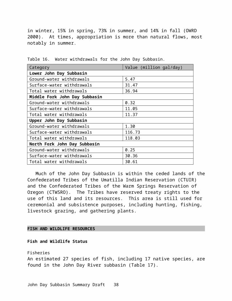
water quality and habitat exists, whereas O. mykiss tend to occupy lower reaches. There is also a sympatric zone where both species and hybrids occur. It is unknown how much risk hybridization poses to the westslope cutthroat population. Hybridization with O. mykiss has been documented throughout westslope cutthroat distribution in the John Day River subbasin (Spruell et al. 1999).
No. Fork John Day River
(/19
(/207
(/26(/26
(/395
%g41
%g41
(/97.-,84
(/395
Columbia River
Big Wall Cr.
J ohn Da
y River
Camas Cr.
Desolation Cr.
Mid. Fork Joh n Day River
Cotton w
ood Cr.
Mountain Cr.
Br idge Cr.
Gras
s Vall
e y C
anyo
n
John Day River
So. Fork Jo hn Day River
Rock Creek
Fossil
Lonerock
Condon
MitchellPrairie City
John Day
Presence OnlyN
EW
S
5 0 5 10 Miles
Data Source: ODFW, 1999.
Legend
John Day SubbasinWestslope Cutthroat Trout Distribution
Figure 26. Distribution of westslope cutthroat trout in the John Day Subbasin.
Very little is known about the life history of westslope cutthroat within the John Day River subbasin. It is assumed they exhibit life history traits similar to other populations in basins throughout the interior Columbia River basin. Spawning commences in April and May with emergence of fry occurring approximately three to four weeks later. During a study of bull trout within the upper John Day River, researchers were able to characterize movements of westslope cutthroat and collect some life history information. It is apparent that fluvial and resident life
John Day Subbasin Summary Draft 42
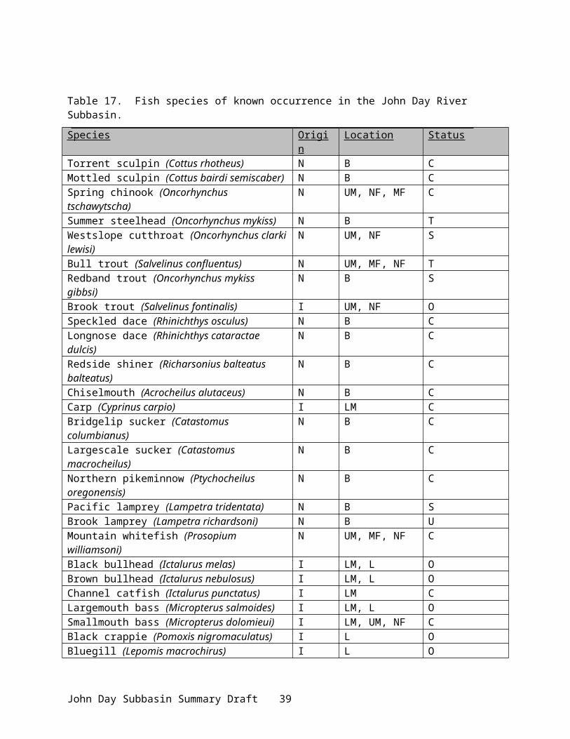
history patterns are present within the John Day River subbasin. A graduate research study (OSU) on westslope cutthroat is currently being conducted on upper mainstem John Day River tributaries to study late-fall and early-spring movements and habitat use. This project is being done in conjunction with ODFW’s Native Trout Program.
Redband Trout (O. mykiss)Redband trout are found throughout the subbasin, although it is difficult to distinguish the resident form from juvenile anadromous O. mykiss. It is assumed that distribution of redband trout is the same as summer steelhead within the subbasin, particularly since spawning of the two subspecies overlaps and they are not reproductively isolated, except in the upper South Fork. Little life history information is available for redband trout in the John Day subbasin, although it is assumed they exhibit similar life history traits as other eastern Oregon populations.
Rainbow Trout (O. mykiss)Oregon Department of Fish and Wildlife has historically stocked several streams throughout the subbasin with hatchery rainbow trout. Fingerlings were stocked into the Middle Fork John Day River and South Fork John Day River, and legal sized rainbow were stocked into Canyon Creek, the North Fork John Day River, Camas Creek, and Desolation Creek (see Artificial Production). All stocking of hatchery rainbow trout into flowing waters within the subbasin has been discontinued.
Brook Trout (Salvelinus fontinalis)Brook trout were historically stocked (from the 1940 through 1960's) into several lakes throughout the subbasin. In many cases they were able to exit the lake into streams, where they reproduced and continued to reside. Naturalized brook trout currently occupy the upper John Day River, Canyon Creek, Slide Creek, and several tributaries of the North Fork John Day River. Brook trout are known to be a threat to bull trout because of the potential for hybridization (Buchanan et al. 1997) and are thought to be threats to other native salmonids because of competition for food and habitat.
Stocking of brook trout has been discontinued, except into Bull Prairie Reservoir, Magone Lake, and Strawberry Lake where the potential for escape to flowing water is very low.
Smallmouth Bass (Micropterus dolomieui)The John Day River supports a population of smallmouth bass that is nationally known in the sport fishing community. This population began in 1971 with the stocking of 62 adult bass into the John Day River one mile above Service Creek (RM 158) in May and an additional 18 adult bass that were stocked at Kimberly (RM 185) the following October (Shrader and Gray 1999). Since that original introduction, the population has expanded to all suitable habitat. Smallmouth bass are found in the John Day River up to Dayville (RM 212) and in the North Fork up to about Wall Creek (RM 22.5).
Smallmouth bass have been implicated in reducing indigenous fish populations in several studies (Zimmerman 1999). However, Shrader and Gray (1999) concluded that smallmouth are not a significant predator on migrating salmonids in the John Day River based on current distribution. However, a concern remains that overlap in summer distribution may result in increased predation on salmonids.
John Day Subbasin Summary Draft 43

Pacific Lamprey (Lampetra tridentata) and Western Brook Lamprey (Lampetra richardsoni)The John Day River once supported a tribal fishery for lamprey (Close et al. 1999), particularly in the Middle and North Fork drainages. Currently, remnant populations of anadromous Pacific lamprey and non-anadromous western brook lamprey exist in the subbasin (Close et al. 1999), however very little is known about them. Anecdotal information has been collected through tribal surveys and a current USGS research project (Upstream Migration of Pacific Lampreys in the John Day River). It is believed that the John Day River may support a run of approximately 10,000 Pacific lamprey, based on an apparent large drop (72%) in ladder passage estimates of adult lamprey between John Day Dam (RM 215) and McNary Dam (RM 292) on the Columbia River. Larval and adult stages have been documented in the basin, especially in the North Fork (Jackson et al. 1998). Sampling of juvenile lamprey by CTUIR has shown that the John Day basin has the highest juvenile densities relative to other subbasins (Columbia Basin Pacific Lamprey Technical Work Group 1999). Tracking of adult lamprey by the USGS has shown erratic movement, possibly temperature related, with most movement in the fall. Adult lampreys have been found in large rubble fields in low water areas (Bayer 2000). The primary limiting factor for adult lamprey is Columbia River dam passage; juvenile lamprey may be preyed upon by smallmouth bass. Lampreys are of significant cultural value to the Warm Springs and Umatilla Tribes. There is no current restoration plan for lamprey in the John Day Subbasin.
WildlifeA variety of wildlife species, including large and small mammals, waterfowl, passerines, raptors, reptiles, and amphibians, are associated with John Day subbasin riverine, wetland, and upland habitats (Table 29). Nearly two-thirds of the wildlife species statewide are adaptable and thrive in both natural and human-impacted environments (e.g.,coyote, raccoon, red-tailed hawk, great horned owl, American robin, Brewer’s blackbird, dark-eyed Junco). One-third of the state’s species depend on natural or non-human disturbed environments.
Many wildlife species reside within the subbasin in association with Shrub Steppe habitat. However, because of the decline of shrub-steppe habitat, these wildlife assemblages are in a state of decline. Certain populations of wildlife species are being managed by federal and state wildlife managers throughout the subbasin, including big game, fur bearers, upland birds, and waterfowl species.
Many raptors (e.g., golden eagle, American kestrel, prairie falcon) inhabit the subbasin.
California Bighorn Sheep (Ovis canadensis californiana)Bighorn sheep were extirpated from Oregon by the mid-1940s. Historical information suggests that one of the major causes for the demise of this species was a combination of contact with domestic sheep and unregulated hunting. Reintroduction of bighorn sheep into the upper John Day River basin began in 1971 on Canyon Mountain, with subsequent releases on Aldrich Mountain in 1978, and another release on McClellan Mountain in 1988. Reintroduction of bighorn sheep in the lower John Day River canyon (below Service Creek) began in 1989 with the release of 14 sheep at Devils Canyon. Other releases were made in 1990, 1995, and 1999 at Horseshoe Bend, Adobe Point, and Little Ferry Canyon, respectively. The total population estimate for the basin is approximately 500 sheep. The existing sheep population provides a limited amount of hunting and a source of sheep for other reintroduction efforts. To date, over 100 bighorn sheep have been trapped from the basin and have been used to reintroduce sheep to suitable habitat areas in Oregon and other states.
John Day Subbasin Summary Draft 44

Current management of Oregon’s sheep program is described in the Bighorn Sheep Plan (ODFW 1992a). While most of the John Day canyon is in public ownership, options for management of bighorn sheep within the canyon are limited due to the juxtaposition of private lands to the canyon. Private lands limit access to most areas that are inhabited by sheep and may curtail management options in the future. One of the major concerns for bighorn sheep habitat is the spread and increase of noxious weed species within the river canyon.
Rocky Mountain Elk (Cervus elaphus nelsonii)Rocky Mountain elk are expanding their range from the forests to the shrub-steppe, wheat fields, CRP lands, and other open habitat areas of the John Day subbasin. These areas provide adequate forage and a lack of disturbance from human activities. Elk are readily adaptable to pioneer new habitat areas. Management of elk in eastern Oregon is guided by the Rocky Mountain Elk Plan (ODFW 1992b). The plan was developed through a public review process and identifies acceptable population numbers and management options for each big game management unit. Big game management units within the John Day Subbasin include Northside, Murderers Creek, Desolation Unit, Heppner, Fossil, Ukiah, Biggs, Beulah, Silvies, and a portion of the Grizzly. Elk populations within the above management units are managed to achieve population levels that are within 10% of the identified population level. Due to elk depredation problems in the East Biggs Unit and the Columbia Basin Units, these areas have been identified as “de-emphasis” areas and elk populations are managed to achieve minimum population levels (ODFW 1992b).
Generally, areas below 4,500 ft elevation that provide adequate habitat are used as winter range. Maintenance and/or improvement of the various winter range areas are required to maintain identified population levels and to reduce conflicts with agricultural operations. A radio telemetry study in the Desolation Unit (North Fork) in the 1980s identified three major wintering grounds for elk (Hattan et al. 1987). Approximately 50% of the elk from the Heppner and Fossil units inhabit the south-facing ridges and canyons of the mainstem John Day River and North Fork during the winter
Mule Deer (Odocoileus hemionus ) Mule deer are distributed throughout the basin, and are commonly found in brushy canyons
and ridge areas. In general, deer populations are declining throughout much of eastern Oregon, primarily due to a reduction in habitat quality and quantity, weather conditions, and predation. Habitat quality and quantity on winter ranges have been impacted by unmanaged livestock grazing, encroachment of human developments, invasion of noxious weed species or juniper, and loss of riparian vegetation. Management strategies regarding mule deer were developed through a public review process and are identified in the Mule Deer Plan (ODFW 1990).
Mule deer populations are vulnerable to competition with increasing numbers of elk on the winter ranges where elk have not been present since pre-settlement times. Due to habitat changes and loss of bitterbrush and mountain mahogany brush that stands above heavy snow, deer are more vulnerable to severe winters of deep snow that last for long periods. Control of fire on private and public lands has allowed competition by juniper and conifers to shade out brush species in transitional range between open country and forests. Increased predation by cougar, bear, and coyote is a major limiting factor. Landowner tolerance on agricultural fields is very important to the maintenance of John Day subbasin deer herds.
Pronghorn Antelope (Antilocapra americana)
John Day Subbasin Summary Draft 45
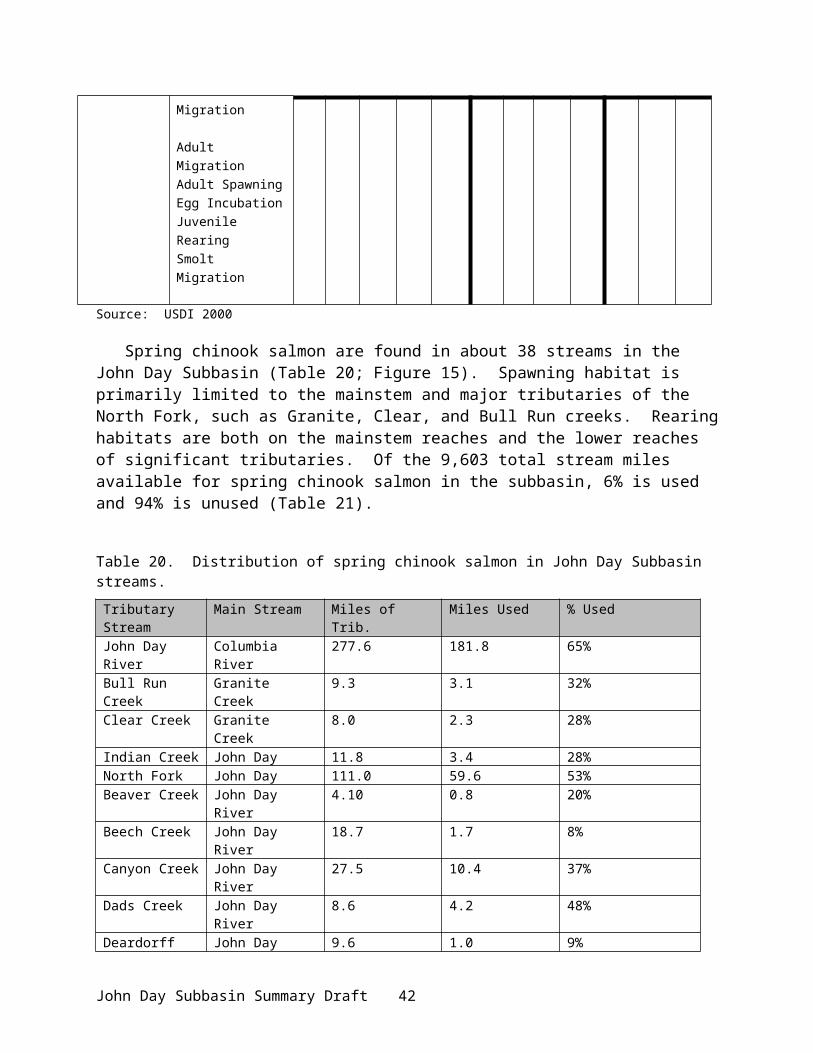
Antelope populations are limited and are scattered throughout the subbasin. Most suitable antelope habitat lies in the upper John Day basin, from Prairie City to Picture Gorge, which supports 150-200 head, nearly all of which live on private land. The mainstem herd remains static at approximately 150, while the Murderers Creek herd is slowly recovering from habitat loss due to a medusahead rye invasion that began in the early 1990s. A major rehabilitation project was initiated by ODFW, BLM, the Rocky Mountain Elk Foundation and the Oregon Hunters Association to burn, spray, and reseed this critical winter range. Several small groups of antelope, totaling from 150 to 200 animals, are present in the lower subbasin and can be found near Spray (RM 170), Clarno (RM 107), and scattered through all drainages from Butte Creek (RM 98) to Rock Creek (RM 22.5; Figure 7).
White-tailed Deer (Odocoileus virginianus)White-tailed deer populations are low throughout the basin. White-tailed deer prefer heavy
shrub patches and thick riparian vegetation and are gradually extending their range throughout the basin. As riparian and deciduous vegetation conditions improve, the white-tailed deer population is expected to increase. White-tailed deer are infrequently sighted in the upper Camas Creek drainage near Ukiah and throughout the Butte Creek and Rock Creek drainages, and in the Middle Fork and mainstem.
Cougar (Felis concolor)Cougar, once considered an unprotected predator, have steadily increased since becoming
classified as a game mammal in 1978. Prior to their classification as a game mammal, populations had reached an estimated low of 200 animals statewide. Cougars are now found in most habitats of the subbasin and are having a significant, if not thoroughly known, impact on deer, elk, and bighorn sheep herds. Cougar populations are modeled and are estimated at 7.8 animals per mi2 of suitable habitat. In 1992, ODFW estimated the population to be growing at 4-5% per year, a trend that is likely unchanged today (ODFW 1993a). Cougar populations are managed through the Cougar Plan (ODFW 1993a).
Canada Lynx (Lynx canadensis)The Canada lynx was federally listed as threatened in 2000. Potentially suitable habitat in
the John Day Subbasin includes those plant communities above 4,500 feet in elevation that could support vegetation capable of providing denning, foraging, or travel habitat for lynx. The Bureau of Land Management has established one lynx travel management zone along the South Fork John Day River between Smokey Creek and upriver to Wind Creek. Lower elevations are not considered potentially suitable lynx denning and foraging habitat as the main prey species (snowshoe hare) does not inhabit those elevations in sufficient numbers.
Black Bear (Ursus americanus)The black bear is an important part of the ecosystem and has been considered an indicator of
ecosystem health (ODFW 1993b). Black bear have dramatically increased in most forested communities in the John Day Subbasin. Recent rules restricting the use of baiting and pursuit hounds have reduced hunting pressure; harvest is mostly opportunistic during other big game seasons. Reproductive potential of the bear is relatively high. Because diet is very diverse, limiting factors are most often weather- related to food availability in the spring and fall seasons. Bailey (1936) estimated that Oregon’s 1930-33 bear population was approximately 9,000 animals. The 1993 population was estimated conservatively at 25,000, based on 0.3 bears per mi2 of
John Day Subbasin Summary Draft 46

suitable habitat in eastern Oregon (ODFW 1993b). Black bear are managed through the black bear management plan (ODFW 1993b).
Beaver and Other Small MammalsBeaver, otter, mink, and muskrat reside along the John Day River and its tributaries.
Historically, beaver were reported to be very abundant in the basin (Wissmar et al. 1994), performing a valuable service in creating wetland habitat. The John Day Subbasin continues to have good populations of river otter and beaver; other aquatic-dependent species (raccoon, muskrat, mink) are common as well. However, loss of historic habitat and the extensive irrigation systems in the upper John Day Subbsin have resulted in beavers being considered nuisance animals by some people. They cut down trees that fall across fences, plug irrigation diversions, and fall trees into streams that can cause bank erosion.
Wading and Shore Birds A number of wading and shore birds inhabit the basin (e.g.,spotted sandpiper, killdeer), but
the primary species is Great Blue Heron (Aerodus sp.). This colony-nesting species forages in shallow wetlands, irrigated fields, or moving waters. Most heron rookeries are found in mature cottonwood galleries along riparian areas. Historic impacts to rivers and wetlands (dredging, diking, stream channelization) have greatly reduced riparian associated wetlands created by beaver dams and seasonal flooding, thereby limiting the replacement galleries used for nesting by great blue herons and winter roosting bald eagles. Loss of roosting and foraging habitat has affected the great blue heron population. Until the late 1970's, there was a great blue heron rookery located in a cottonwood grove at the mouth of Bridge Creek. However, the cottonwood grove eventually succumbed to a combination of ice-damage, flooding, and human removal.
WaterfowlTwenty-three species of ducks and five species of geese occur in the planning area during
migration and nesting seasons (Table 27; USDA 1985). Duck use is primarily on rivers, streams and small farm ponds. Historically, beaver dams on the forks of the John Day provided more ponds and open, slow moving waters for waterfowl resting, nesting and feeding. Dredging for gold, diking, intensive agricultural development, and channelization have eliminated most wetlands. Great Basin Canada geese nest along the John Day River and feed in pastures and grain fields.
Fox Valley in central Grant County below Long Creek (Table 27) is used as a resting and feeding site for sandhill cranes if fields are flooded with spring moisture. The fields are along Hwy 395, providing a public viewing opportunity of up to 450 sandhill cranes. Natural wetlands along Fox Creek to the west were drained for agriculture many years ago.
Table 27. List of common waterfowl species found in the John Day Subbasin.
Common Name Scientific Name Common Name Scientific NameWood duck Aix sponsa Green-winged teal Anas creccaMallard Anas platyrhynchos Northern pintail Anas acutaBlue-winged teal Anas discors Cinnamon teal Anas cyanopteraNorthern shoveler Anas clypeata Gadwall Anas streperaAmerican wigeon Anas americana Ring-necked duck Aythya collarisCommon goldeneye Bucephala
clangulaBufflehead Bucephala albeola
John Day Subbasin Summary Draft 47

Common Name Scientific Name Common Name Scientific NameCommon merganser Mergus merganser Ruddy duck Oxyura jamaicensisLesser scaup Aythya affinis Hooded merganser Lophodytes
cucallantusAmerican coot Fulicia americana Greater scaup Aythya marilaCanada goose Branta canadensis Greater white-fronted goose Anser albifronsSnow goose Chen caerulescens Greater sandhill crane Grus canadensis tabid
Upland Game BirdsChukar, pheasant, Hungarian partridge, and wild turkey are not native to the subbasin, but
are very popular species to hunters (Table 28). In general, mountain quail have decreased throughout most of their range and valley quail have increased in suitable habitat areas. Eastern Oregon populations of mountain quail are strongly dependent on brushy and diverse riparian habitat; populations have disappeared or declined as these habitats have deteriorated (ODFW 1998). Increased sightings in recent years suggest populations may be slightly recovering in response to moderate winters, riparian improvements, and the end of an extensive drought cycle.
Table 28. Upland birds found in the John Day Subbasin area.
Common Name Scientific Name Common Name Scientific NameChukar partridge Alectoris chukar California valley quail Callipepla californicaMountain quail Oreortyx pictus Ring-necked pheasant Phasianus colchiusBlue grouse Dendrogapus obscurus Ruffed grouse Bonasa umbellusHungarian partridge Perdix perdix Wild turkey Meleagris gallopaoe
The Columbian sharp-tailed grouse (Typanuchus phasianellus columbianus) was common in the John Day basin prior to white settlement. Loss of grassland and open-canopy sagebrush habitat extirpated the species due to conversion to agriculture, successional transitions caused by fire exclusion, and excessive livestock grazing. The federal CRP program is reestablishing this habitat where grain fields have stood, but the stability of the program depends on congressional funding and has no certainty. A reintroduction program may be possible if enough suitable habitat can be established permanently.
Bald Eagle (Haliaeetus leucocephalus)This species is a winter inhabitant of the John Day Subbasin, primarily from November to
March. The estimated number of wintering bald eagles along the Upper John Day River from 1991-1993 was between 64 and 96. Roost trees are primarily cottonwoods in agricultural areas or commercially valuable conifers in forested areas, mostly on private lands. Consequently, the potential for losing roosts to land clearing or timber harvest is great (Isaacs et al. 1993). Most habitat for bald eagles is along the John Day River riparian corridor. Bald eagles are federally listed as Threatened, but are proposed for de-listing. They are protected by the Migratory Birds Treaty Act.
Threatened, Endangered, and Sensitive Species Although the status of wildlife populations varies throughout the basin and by species, many wildlife species within the basin are listed as Federal and/or State Threatened, Endangered, and Sensitive or Species of Concern (Table 29; Appendix Table 3). The Oregon Natural Heritage Program has identified two herptile, 21 bird, and 4 mammal species as Sensitive Species in the John Day Subbasin (ONHP 1995; Table 29).
John Day Subbasin Summary Draft 48

Table 29. Sensitive wildlife species in the John Day Subbasin (ONHP 1995).
Group Common Name Scientific NameHerptiles Northern Leopard Frog Rana pipiens
Spotted Frog Rana pretiosaBirds Bank Swallow Riparia riparia
Black-backed Woodpecker Picoides articusBobolink Dolichonyx oryzivorusBurrowing Owl Speotyto cuniculariaFerruginous Hawk Buteo regalisFlammulated Owl Otus flammeolusGrasshopper Sparrow Ammodramus
savannarumGreat Gray Owl Strix nebulosaGreater Sandhill Crane Grus candensis tabidaLewis’ Woodpecker Menageries lewisNorthern Goshawk Accipiter gentilesNorthern Pygmy Owl Glaucidium gnomaPileated Woodpecker Dryocopus pileatusPygmy Nuthatch Sitta pygmaeaTricolored Blackbird Agelaius tricolorSwainson’s Hawk Buteo swainsoniThree-toed Woodpecker Picoides tridactylusUpland Sandpiper Bartramia longicaudaWestern Bluebird Sialia mexicanaWhite-headed Woodpecker Picoides albolarvatusWilliamson’s Sapsucker Sphyrapicus throideus
Mammals American Marten Martes AmericanaPallid Bat Antrozous pallidusPygmy Rabbit Brachylagus idahoensisWashington Ground Squirrel Spermophilus washingtoniWhite-tailed Jackrabbit Lepus townsendii
Some species have naturally low, localized populations, such as the tricolored blackbird, bobolink, and upland sandpiper. The Swainson’s hawk population has declined due to environmental problems in southern hemisphere wintering grounds. Habitat alteration or conversion is believed responsible for the sensitive status of many species listed above and in Appendix Table 3.
The ferruginous hawk, Washington ground squirrel, burrowing owl, white-tailed jackrabbit and grasshopper sparrow are dependent on grassland and shrub-steppe communities, which have been extensively converted to agriculture and altered by grazing. The American Marten, several woodpecker species, and the pygmy nuthatch require old-growth timber and/or heart-rotted snags. The spotted bat, a BLM sensitive species in Oregon, was found in the Clarno area in 1984, and may yet maintain localized populations (Puchy and Marshall 1993). Nesting populations of Lewis woodpeckers are low, but are annually observed along the North Fork of the John Day River and near the town of Lonerock.
John Day Subbasin Summary Draft 49
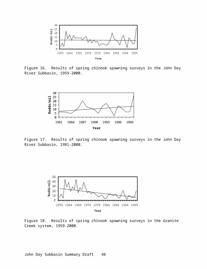
The John Day Subbasin comprises a portion of three Physiographic provinces: High Lava Plains, Blue Mountains, and Columbia Basin (ONHP 1995). Numbers of species using each province are specified in Table 30 (Puchy and Marshall 1993). The Blue Mountain and High Lava Plains provinces contain coniferous forest, juniper steppe, sagebrush steppe, riparian, and marsh community types. The portion of the John Day Subbasin within the Blue Mountain Province has average wildlife diversity. The High Lava Plains Province has below average wildlife diversity in all animals groups when compared to other provinces in the state (Puchy and Marshall 1993).
Table 30. Species groups within the physiographic provinces within the John Day Subbasin.
Province Species groups NumberHigh Lava Plains Herptiles 20
Birds 194Mammals 56
Blue Mountain Herptiles 17Birds 231Mammals 75
Columbia Basin Herptiles 25Birds 215Mammals 58
Habitat Areas and Quality
Historical descriptions of the John Day Subbasin indicate that the John Day River was once a relatively stable river with good summer streamflows and water quality, and heavy riparian cover. Streambanks were covered with dense growths of aspen, poplar, and willow, cottonwood galleries were thick and wide, and beaver were very abundant (Wissmar et al. 1994). Large spring and fall chinook salmon migrations and numerous beaver sightings indicated that John Day River waters contained a high degree of instream habitat diversity. Terrestrial habitat was dominated by native bunchgrasses and sagebrush (Appendix Figure 18).
Watershed conditions in the John Day Subbasin have changed significantly over the past 150 years (Appendix Figure 19). Water and land use practices contributing to these changes included placer and dredge mining, unmanaged livestock grazing, timber harvest, certain intensive agricultural practices, road construction, flood events, and stream channelization. These watershed disturbances have caused risks to ecological integrity by reducing biodiversity and threatening riparian-associated species (ICBEMP 2000). Terrestrial habitat areas were irrevocably changed with the introduction of livestock grazing and intensive agricultural conversion. Nonetheless, on federally administered lands habitat conditions are in an upward trend (Federal Caucus 2000). Habitat conditions on some private lands, in particular those involved in cooperative restoration programs, are generally considered to be improving.
FisheriesThe John Day Subbasin drains an area of 8,100 mi2, with 1,551 linear river miles of habitat
available for fish. Primary habitat for anadromous salmonid spawning and rearing is in the upper basin. The lower (RM 0 to RM 109) and middle (RM 109 to RM 212) mainstem portions function primarily as a migration corridor for anadromous fish (with limited spawning and
John Day Subbasin Summary Draft 50

rearing in primary tributaries) and provide habitat for warm-water fish. Core habitats for spring chinook are still intact. In addition, core remnants and ecological processes remain for rebuilding and maintaining functioning systems (ICBEMP 2000). The most productive, large-scale habitat for the production of salmonids is in the North Fork John Day subbasin, where wilderness designation helps to protect existing, excellent habitat. Large segments of steelhead habitat within the John Day River and its tributaries are mostly intact and accessible to returning adults. The mainstem and tributaries and Middle and North forks of the John Day River have benefited from efforts to improve streamside quality. Trend analysis indicates that these and other streamside enhancement projects have improved water quality in downstream reaches (Cude 1995).
Primary habitat for many resident salmonids is also found in the upper subbasins and tributaries. Spring chinook salmon habitat includes the middle and upper North Fork, Camas Creek to east of Ukiah, Desolation Creek to its forks, Granite Creek and Clear Creek (Figure 7; ODFW et al. 1990). In addition, the lower parts of tributaries to the above streams are utilized seasonally for cold water refugia (Figure 15). Summer steelhead habitat includes all the above reaches plus Wall, Camas, Desolation, and Granite Creek drainages (Figure 19; ODFW et al. 1990).
However, past and current land use practices (logging, grazing, mining, road building) have degraded and continue to affect habitat quality for fish. Loss of large woody debris from destruction of riparian areas has diminished instream structure and pool frequency. The quantity and quality of flows in summer, the period when most salmon populations spawn, has been diminished by the various land and water uses. Spawning gravels have been destroyed, displaced, or embedded with silt in many North Fork streams.
Riparian and wetland habitat degradation has been the most problematic (ICBEMP 2000). Approximately 600 miles of stream with degraded fish habitat have been identified, resulting in high spring and low summer flows, high summer and low winter water temperatures, reduced pool habitats, accelerated streambank erosion, excessive stream sedimentation, and reduced instream cover. Riparian and wetland areas were diked, drained, channeled, and dredged. Water use for irrigation and a changed hydrologic cycle have created extremely low flow conditions in late summer. Riparian areas are also destroyed by excessive runoff, a byproduct of poor land conservation measures. Some areas are still impacted by historic activities (mining); dredge spoils continue to retard riparian plant development and acid mine leakage remains a problem. Although improved grazing management has benefited riparian areas, poor land management practices continue and problems persist. Cattle grazing, road building, and timber harvest have altered the watersheds by, among other things, compacting soils, reducing vegetative cover, increasing soil erosion potential, decreasing infiltation and storage, and increasing runoff.
Natural watershed recovery is limited by the semiarid climate. Managers believe that irrigation system efficiency improvements, along with upland and riparian zone restoration, would provide the greatest long-term benefits for fish and wildlife. Establishing instream flows and protection and restoration of riparian environments would greatly help to rehabilitate habitat for fish. Some riparian areas on public and private lands are already improving in ecological condition from restoration efforts.
Some reservoirs also exist within the John Day Subbasin. Canyon Meadows reservoir on Canyon Creek (RM 24.3) in the Malheur National Forest potentially blocks upstream passage of steelhead. Over the years the dam has weakened and will eventually fail. Although failure will open upstream habitat, there is concern dam failure will destroy habitat below.
John Day Subbasin Summary Draft 51

Because of the physiographic diversity of the subbasin and its land uses, habitat quality varies by area.
Lower John Day Mainstem (Service Creek to Columbia): High water temperature, low flows, and pollutants have degraded the aquatic system. This section is designated a Federal and State Wild and Scenic River from Tumwater Falls to Service Creek. Season-long grazing occurs in the Lower John Day, bringing erosion. High flood flows are most evident in this portion.
North Fork John Day River: Best water quality is generally found in the North Fork area. Fifty-four miles upstream of Camas Creek are designated Federal Wild and Scenic and an additional 40 miles from RM 20 to the headwaters have been designated as a State Scenic Waterway. Fish are identified as an Outstandingly Remarkable Value (ORV) in this area. Some “good” habitat remains in protected wilderness areas and should remain protected. However, past and present watershed disturbances (e.g., intensive logging, unmanaged grazing) have led to increased peak flows, which erode streambanks and upland soil, increasing sediment (large-scale fines) delivery to the streams. Erosion is accelerated through the loss of riparian areas and structure. Past mining practices destroyed in-stream structure in parts of the upper North Fork and its tributaries and altered the floodplain with gravel spoils. Dredge mining disturbed riparian vegetation, overturned bottom substrates, channelized streams, and devastated spawning gravels with the deposition of fine sediments (Wissmar et al. 1994). In some tributary systems in the North Fork (Granite and Camas creeks), localized toxic mine effluents are a concern. Snowmelt and rain percolating through piled dredge spoils carries arsenic and heavy metals into the stream (Cockle 2001). The Granite Creek watershed has been extensively roaded and logged, in addition to significant floodplain alteration. The cumulative effect of degraded water quality in the tributaries has directly affected the aquatic ecosystem throughout the North Fork John Day River. The ecological integrity rating for aquatic habitat in the North Fork John Day Subbasin is moderate (Quigley and Arbeldbide 1997).
Middle Fork John Day River: High water temperatures, livestock waste, and sediment due to livestock over-grazing, clearing and road building, and historic mining activity (dredge mine tailings) have degraded the aquatic system. This section is designated a state scenic highway.
South Fork John Day River: High water temperatures, livestock waste, and sediment due to livestock grazing, land clearing, and road building in the upper South Fork and tributaries have degraded the aquatic habitat. Water withdrawals have diminished flows. A portion of the South Fork John Day from north of the P.W. Schneider Wildlife Management Area Boundary to the Forest Boundary is designated a Federal and State Wild and Scenic River/Waterway.
Upper John Day River (Service Creek to Headwater): High temperatures, livestock waste, and sediment from over-grazing and clearing and road building have degraded the aquatic system in the upper John Day mainstem. Water withdrawals and logging also impact the system. These problems generally have limited spring chinook spawning/rearing in the mainstem to areas above Prairie City. The hydrograph has also been altered. Some “good” habitat remains and should be protected.
WildlifeBoth the quantity and quality of natural wildlife habitat in the John Day Subbasin have declined since the mid-1800s (USDI 2000; Appendix Figure 18 and Appendix Figure 19). Habitats for wildlife have become increasingly fragmented, simplified in structure, and infringed on or dominated by exotic plants (ICBEMP 2000). The most obvious disturbance in the subbasin is cattle grazing (OWRD 1986). This area is sensitive to overgrazing by exotic ungulates because the native grassland vegetation evolved in the absence of large herbivores (Li et al. 1994). Other
John Day Subbasin Summary Draft 52

major habitat changes in recent history have been the result of logging activities, inundation of lower river habitat from Columbia River hydropower development, human development, irrigated and dry-land agricultural conversion, wildfire suppression, drought, recreational activities, road densities, and noxious weed encroachment (USDI 1998). Habitat quality is variable depending on the degree to which habitats have been converted into other land uses and impacted by human activities and invasion of noxious weeds. Although agricultural development has altered native habitat areas, non-native habitat has increased for those species adaptable to the habitats created.
Habitat areas in the John Day Subbasin are characterized as 1) riparian/wetland areas along the river mainstem and major tributaries, 2) rising upland terraces and plateaus with Shrub Steppe vegetation interspersed with irrigated cropland in the lower reaches, and 3) mixed and conifer forests in the upper river reaches (Appendix Figure 16). Although riparian habitat has been largely degraded, riparian habitat quality is improving in areas receiving enhancement and protection. Photo-monitoring and other assessments by BLM show condition variations, but where riparian-oriented management has been implemented, vegetative structure, density, and diversity have increased (USDI 2000). In general, riparian areas in the lower and middle mainstem portion are “functional-at-risk”, indicating functional condition but susceptibility to degradation (USDI 2000). Overall, a moderate level of wetland has been lost. Conversion of the river-bottom areas to agricultural development has effectively reduced the natural meadow habitat typically associated with riverine habitats.
Rangeland health and diversity have declined throughout the Columbia Basin (ICBEMP 2000). Less than 1 percent of the native Shrub Steppe habitat remains in the Columbia Plateau Eco-region within Oregon. Native woodland, grassland, and sagebrush habitats have been permanently altered. Loss of the shrub-steppe habitat is primarily due to irrigated and dry-land agricultural conversion, historic and unmanaged cattle and sheep grazing, and invasion of exotic plants (ICBEMP 2000). The native western juniper is encroaching into many sites, which did not support juniper in recent history. This has had the effect of reducing forage production and altering the water table. Western juniper can intercept and transpire as much as 25% of the precipitation (Wissmar et al. 1994).
Forest management practices on both public and private lands have also affected wildlife habitat quantity and quality (Appendix Figure 19). Old growth forest habitats have been affected by intensive timber harvest and large-scale fire exclusion. Various road-associated factors have also negatively affected habitats and species, primarily due to loss of habitat and fragmentation, and secondarily to traffic and human activities (ICBEMP 2000). The ecological integrity rating for forest habitats in the North Fork John Day Subbasin is low (Quigley and Arbeldbide 1997).
The development of dams on the Columbia River for hydropower, navigation, flood control, and irrigation has resulted in widespread inundation of riparian, riverine, and upland habitats (NWPPC 1994). Overall, approximately 70,000 Habitat Units (HUs) and 78,000 acres of wildlife habitat were adversely impacted or inundated by the construction of Bonneville, The Dalles, John Day, and McNary dams (Rasmussen and Wright 1990a,b,c,d). Bottomlands and riverine habitats at the Columbia River/John Day River confluence areas have been drastically altered by fluctuating water levels caused by hydropower operations at John Day Dam, wetland draining and filling, dredging, diking, road construction, shoreline riprapping, and stream channelization. A secondary effect on wildlife is the loss of terrestrial habitat to irrigated agricultural development, which prospered from hydropower development.
A portion of the John Day Subbasin is specially managed for wildlife and other uses which indirectly protect fish and wildlife resources. Each National Forest has areas that are designated
John Day Subbasin Summary Draft 53

as Wildlife Emphasis Areas in their respective Forest Plans. These areas are managed primarily for the benefit of fish and wildlife. Other parts of National Forests are designated as wilderness where wildlife and fish are the beneficiaries of relatively pristine habitats. Special Fish and Wildlife Habitat Areas
P.W. Schneider State Wildlife Area This area is located in the Upper John Day subbasin near the South Fork confluence (Appendix Figure 17) and was formerly the Murderers Creek Wildlife Management Area. It comprises an area of 106,731 acres (in separate parcels) for the purpose of protecting and enhancing a major winter range for mule deer (Allen 1993). Total acreage consists of parcels owned by ODFW, B&S Logging Company, BLM, and the USFS (Malheur National Forest). The land currently provides habitat for 50% of the Murderers Creek Unit mule deer population and provides winter habitiat for approximately 500 Rocky Mountain elk, 100 pronghorn antelope, and 150 bighorn sheep (ODFW, unpublished data).
Bridge Creek State Wildlife Area Managed by ODFW, this area is located in the North Fork John Day Subbasin along Camas Creek and comprises 13,587 acres (Appendix Figure 17). This area is managed to provide for the protection and enhancement of winter range for Rocky Mountain elk (Melland et al. 1985). Total acreage consists of parcels owned by ODFW and BLM. The land currently provides winter range habitat for approximately 500 Rocky Mountain elk (ODFW, unpublished data).
Corps LandsThe U.S. Army Corps of Engineers (USACE) manages approximately 30,940 acres of land and water along the Columbia River for fish and wildlife conservation as mitigation for John Day Dam. A significant portion of the acreage is located along both sides of the John Day River from its confluence with the Columbia River to Tumwater Falls, near RM 9. This area includes part of the John Day Wildlife Refuge.
John Day River Wildlife RefugeThe John Day River, from its' confluence with the Columbia River upstream to Thirtymile Creek (Figure 7) was legislatively closed to waterfowl hunting in 1921 and at a later date the area received refuge status. The intent of the refuge was to provide winter resting and nesting habitat for waterfowl.
Wilderness AreasBridge Creek Wilderness and Black Canyon Wilderness areas in the Ochoco Mountains National Forest, Strawberry Mountain Wilderness area in the Malheur National Forest, and North Fork John Day Wilderness area in the Umatilla National Forest (Figure 1) provide relatively intact habitat that is close to historic conditions.
John Day Fossil Beds National MonumentThe monument consists of 3 separate units – Sheep Rock (8,916 acres), Painted Hills (3,129 acres), and Clarno (1,969 acres), totaling over 14,000 acres (Appendix Figure 17). All units support similar plant communities, though species of these communities vary from unit to unit. The plant communities are classified as “intermontane sagebrush steppe” with a mixture of dryland grasses, forbs, shrubs, and Western juniper dominating.
John Day Subbasin Summary Draft 54

DeWitt (Oxbow) Conservation AreaThe Warm Springs Tribes manage 1,022 acres on the Middle Fork John Day River for the production of fish and wildlife. The property contains critical spawning and rearing habitats for chinook and steelhead and is on the lowermost reach of the Granite Boulder Creek bull trout distribution.
Dunston PreserveThe Nature Conservancy manages approximately 1,000 acres on the Middle Fork of the John Day River for the preservation of fish and wildlife habitats. The Preserve is downstream of the Tribes’ DeWitt property.
Pine Creek RanchThe CTWSRO own approximately 30,000 acres on the lower John Day River near Clarno, which is managed for the benefit of wildlife and steelhead.
Forrest RanchThe CTWSRO are in the process of acquiring 800 acres on the Middle Fork and 3,600 acres on the upper mainstem John Day to be managed for fish and wildlife. The Middle Fork parcel contains some of the highest spawning densities of spring chinook in the entire subbasin.
Watershed Assessments
Some of the most extensive watershed assessments in the nation have been undertaken in Oregon, a number of which have been conducted in the John Day Subbasin by various agencies and entities.
●The US Forest Service has conducted a number of watershed analyses in various national forests. Completed watershed analyses include:
Umatilla National Forest (North Fork Drainage)Camas Ecosystem Analysis (May 1995)Wall Ecosystem Analysis (Sept. 1995)Desolation Ecosystem Analysis (July 1999)Tower Fire Ecosystem Analysis (Jan. 1997)Granite Creek Watershed Analysis (July 1997)Upper North Fork John Day Watershed Analysis (July 1997)
Malheur National Forest (Upper John Day)Deer Creek Ecosystem Analysis (2000)Murderers Creek Ecosystem Analysis (1997)Strawberry Mountain Ecosystem Analysis (1997)
Identified issues were road densities and water quality (sediment and temperature)
Malheur National Forest (Middle Fork Drainage)Upper Middle Fork John Day River Ecosystem Analysis (1998)Galena Watershed analysis (1999)
Identified issues were road densities and water quality.
●The Oregon Natural Heritage Program maintains a database on habitats and species occurrences throughout the State of Oregon (ONHP 1995).
John Day Subbasin Summary Draft 55
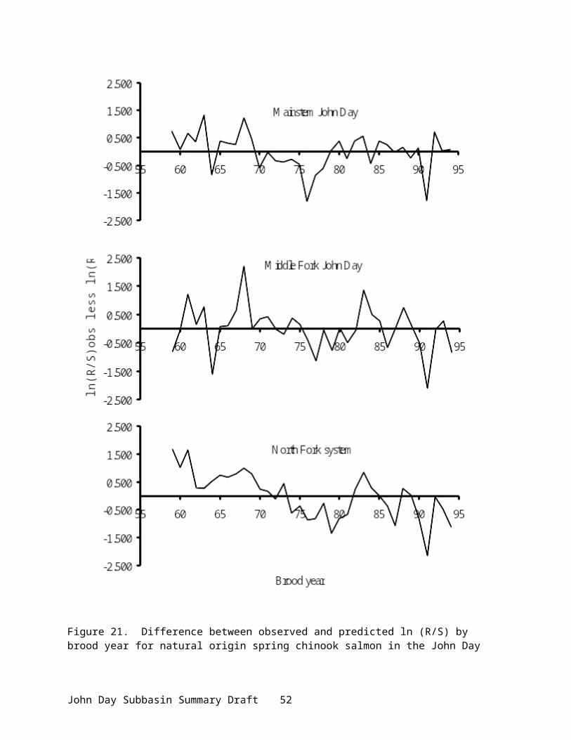
●The Oregon Trust Agreement Planning Project (BPA 1993) and Oregon GAP Analysis Project (ODFW 1997a) identified gaps in bio-diversity and needs for terrestrial habitat restoration. The result was a prioritized list of potential habitat restoration opportunities in the Lower Mid-Columbia Subregion, including the John Day Subbasin. The GAP Analysis Project concluded that of the current land base within the John Day Subbasin, 49% is in a low protected status for wildlife, 31% is in a moderate protected status, and 20% is in a high protected status.
●A Columbia Basin- wide loss assessment was conducted in the late 1980s to quantify construction/inundation impacts from federal hydropower development. Wildlife mitigation objectives for the John Day Subbasin are based partially on the results of this loss assessment effort. Estimated wildlife losses caused by the construction/inundation of the federal hydropower system were amended into the Northwest Power Planning Council’s (NWPPC) Fish and Wildlife Program. Losses were measured in Habitat Units (HUs) for selected target/indicator species and are linked to priority habitats (Rassmussen and Wright 1990a,b,c,d).
●The Bureau of Reclamation and Oregon Water Resources Department have pursued five stream restoration programs in the John Day Subbasin, including the Upper South Fork of the John Day River (USBR 1992a), the South Fork John Day River (USBR 1992b), the Upper Mainstem John Day River (USBR 1992c), the North Fork John Day River (OWRD 1993), and Rock Creek (USBR 1993). The Stream Restoration Programs identify, prioritize, and coordinate needed watershed work to enhance conservation and use of natural resources. The programs seek to identify and fill in the gaps which presently hinder the restoration and protection of the state’s riverine resources. ●Ongoing Water Optimization studies are being conducted by the U.S. Bureau of Reclamation in conjunction with the Stream Restoration Programs in the Upper John Day watershed. (same citiations).
●Upper John Day River Basin Master Water Plan Working Paper (USBR 1990) – As part of the Upper John Day Water Optimization project, the primary goal of this study was to develop a master water plan for achieving better seasonal distribution of runoff and reduce seasonal water shortages in the upper John Day basin. Three major types of measures were investigated: irrigation efficiency improvements, watershed/riparian improvements, and storage water development.
●Streamflow Restoration Prioritization – ODFW and OWRD have established priorities for restoration of streamflow from consumptive uses as part of the Oregon Plan for Salmon and Watersheds (Measure IV.A.8). ODFW has identified the “need” for streamflow restoration through ranking of biological and physical factors, water use patterns and the extent to which flow is a primary limiting factor (Appendix Figure 20). OWRD ranked the opportunities and likelihood for achieving meaningful streamflow restoration. Rankings were performed for subwatersheds at approximately the fifth field hydrologic units (HUCs). OWRD Watermasters will incorporate the priorities into their field work activities as a means to implement flow restoration measures. The “needs” priorities will be used by the Oregon Watershed Enhancement Board as one criterion in determining funding priorities for enhancement and restoration projects. Watershed councils and other entities may also use the needs priorities as one piece of information determining high priority restoration projects.
John Day Subbasin Summary Draft 56

●John Day River Basin Report (OWRD 1986) – identifies the current water resource conditions and water problems of the John Day Subbasin. Purpose was to provide data needed to revise the basin water resources program, succeeding the last basin report written in 1962 (OSWRB 1992; Oregon State Water Resources Board, Oregon’s Long-Range Requirement for Water). The report includes an in-depth description of the subbasin.
●Interior Columbia Basin Ecosystem Management Project (ICBEMP) – Initiated by the Forest Service and Bureau of Land Management to respond to several critical issues in the interior Columbia Basin, including forest and rangeland health, anadromous fish concerns, and terrestrial species concerns, provides a comprehensive assessment for USFS and BLM-administered lands in Oregon (USDA and USDI 2000). Several assessments derived from this project and conducted by the Project’s Science Integration Team include Source Habitats for Terrestrial Vertebrates of Focus in the Interior Columbia Basin: Broad-scale Trends and Management Implications (Widom, et al 1998), An Assessment of Ecosystem Components in the Interior Columbia Basin and Portions of the Klamath and Great Basins (Quigley and Arbelbide 1997), and An Integrated Scientific Assessment for Ecosystem Management in the Interior Columbia Basin and Portions of the Klamath and Great Basins (Quigley et al. 1996). These assessments characterize historical and current conditions and associated trends, and document accelerated changes in vegetation patterns, fish and wildlife distributions, and terrestrial and aquatic ecosystem processes that have occurred in the past century. Data from ICBEMP identified known strong populations of salmonid species with high genetic integrity east of the Cascades, which included the John Day Subbasin.
●The Northwest Power Planning Council documented changed conditions within the Columbia Basin hydropower system in its Return to the River report (NWPPC 1996).
●Columbia Basin System Planning Salmon and Steelhead Production Plan for the John Day River Subbasin (ODFW, CTUIR, and CTWSRO 1990) – developed in response to the need for an Integrated System Plan, as part of the Northwest Power Planning Council’s Fish and Wildlife Program. The plan provided the basis for salmon and steelhead production strategies, documented current and potential production, summarized agency and Tribal management goals and objectives, documented current management efforts, identified problems and opportunities associated with increasing salmon and steelhead numbers, and presented preferred and alternative management strategies.
●Proposed John Day River Plan and Environmental Impact Statement (USDI 2000) – developed by the BLM, State of Oregon, CTWSRO, Bureau of Indian Affairs, and the John Day River Coalition of Counties to provide proposed decisions for management of federally designated Wild and Scenic River segments and State of Oregon designated state Scenic Waterways. The plan includes detailed descriptions of the subbasin ecosystem and environmental conditions of specific river segments.
●Forest Service Resource Management Plans and Environmental Impact Statements were developed in the early 1990s for each National Forest within the John Day Subbasin (USDA 1989, 1990a, 1990b, 1990c), in accordance with the National Forest Management Act (1976).
John Day Subbasin Summary Draft 57

Plans and documents included assessments of current resource conditions, issues, concerns, and opportunities, and proposed management actions.
●The Oregon Department of Environmental Quality and the Natural Resource Conservation Service initiated a process to develop a Unified Watershed Assessment (UWA) as part of the federal Clean Water Action Plan (CWAP) put forth by the USDA and EPA. Using existing assessment information, public input, and Tribal, Federal, and State participation, the 1998 Unified Watershed Assessment and Restoration Priorities for Oregon assessed the condition of water resources and prioritized watersheds for restoration. (www.deq.state.or.us). The Assessment is intended to identify potential opportunities to link the Oregon Plan, Tribal restoration plans, Federal plans, and other collaborative watershed assessment and restoration efforts. Sub-basins that contain core and fringe populations of salmon with high genetic integrity (including the John Day Subbasin) were identified as presenting key opportunities for restoring fisheries and water quality.
●In association with the UWA effort, the Division of State Lands (DSL) produced a Watershed Assessment Report (ODSL 1998) that prioritized subbasins based on the greatest natural resource value, the least impact to condition, and the greatest risk to condition. These three categories of criteria were used to establish priority rankings for subbasins that could benefit most from a watershed management or restoration approach. The John Day Subbasin was ranked among the top twentyone.
●The DEQ has also inventoried state waters for listing through the Oregon DEQ’s Clean Water Act Section 303(d).
●The Inter-tribal Wy-Kan-Ush Mi-Wa-Kish-Wit (Spirit of the Salmon) restoration plan (CRITFC 1995) provides a foundation for meeting Tribal treaty and trust obligations in the Columbia River basin. The long-term plan also addresses the causes of anadromous fish declines, provides information on fish stock status and habitat, and makes recommendations to protect and restore declining fish populations.
●The Oregon Water Trust developed an assessment of water rights within the subbasin for potential future acquisition (Hall 1994). This streamflow prioritization document presents information on streamflows and water use, water quality data, and affected salmonid species and life stages.
●Under the Oregon Plan, many Watershed Councils and soil and water conservation districts have developed or are developing watershed assessments and restoration actions plans.
Sherman County SWCD - Jackknife Canyon Survey (June 2000). A Proper Functioning Condition survey was conducted on designated index reaches of Jackknife Canyon, a tributary to the John Day River in southern Sherman County, by private individuals and staff from NRCS, SWCD, and BLM. Results: reaches were either functional or functional at risk where surface water was found. Dry reaches were considered a natural feature. No changes in riparian management were recommended.
John Day Subbasin Summary Draft 58

Sherman County SWCD - Stream Condition Assessment of Pine Hollow Watershed (1995, 1997, 1998). Examined 8 reaches of 1 mile each using Proper Functioning Condition and low-level aerial video. Results: reaches functioning at risk or non-functioning due to lack of riparian vegetation and buildup of gravel deposits. Juniper encroaching on remnant riparian vegetation. Some functional areas with older trees interspersed.
Sherman County SWCD - Pine Hollow Watershed Enhancement Action Plan. Describes issues, goals, objectives for Pine Hollow Watershed; description of watershed and watershed condition, limiting factors; and future actions plans (Sherman and Wasco County Soil and Water Conservation District, 12/2000).
Gilliam-East John Day WSC and Gilliam SWCD. Future watershed assessment plans call for developing and implementing a comprehensive monitoring program, and conducting and implementing Watershed assessments and action plans.
●A number of assessments, improvement plans, and engineering reports have been prepared for the Rock Creek drainage in the Lower John Day River in Gilliam, Morrow, and Wheeler counties (Wheeler 1968, Mitchell 1975, USDA 1975, and Rose 1991). These extensive reports characterize the basin and describe potential watershed problems and projects within this large drainage.
Major Limiting Factors
The John Day Subbasin is an example of the sensitivity of watersheds in the interior Columbia Basin to human activity. Loss of quality habitat and a loss of connectedness are the over-riding limiting factors to fish and wildlife production in the John Day Subbasin (CTUIR 1984, ODFW et al. 1990, NWPPC 1994). Because salmon, steelhead, lamprey, and some trout are migratory fish to varying degrees, intact and healthy habitat is required throughout their life cycle range for healthy populations to exist. For wildlife, habitat loss has restricted the range of many species through fragmentation and isolation, and altered species communities. Furthermore, both migratory fish and wildlife have limiting factors outside the subbasin. For example, neotropical birds need good overwintering habitat; anadromous fish need good passage conditions and estuary rearing habitat.
Limiting factors also include lack of resources to monitor populations and obtain information, lack of necessary tools to monitor environmental variables, or lack of a coordinated framework to tie efforts and results together. Factors that have caused the decline of natural resources are limiting in themselves.
Two key physical concerns form the context for the analysis of habitat conditions, the limiting factors for fish and wildlife resources, and ultimately the restoration recommendations for the John Day Subbasin. First, historic, recent and current land use practices have altered the hydrologic cycle – the storage, movement, and character of the water resource over entire areas of the John Day Subbasin and its tributary system. Changes in the hydrologic cycle are demonstrated by excessive runoff, altered peak flow regimes, lack of ground water recharge, reduction in soil moisture storage, and low late-season flow. Second, historic and current land uses, in combination with hydrologic changes, have resulted in some portions of the John Day Subbasin reflecting marked stream channel instability (i.e., channel widening, downcutting,
John Day Subbasin Summary Draft 59

vertical cut banks, and excessive gully development). Each of the limiting factors specifically within the John Day Subbasin and highlighted in this report is related in part to the broad-scale problems of hydrology and basin-wide stream channel instability. The actual causes of these conditions in the John Day watershed are multiple; therefore, the restoration of stream flows and stream channel stability will require combined action across many land uses and geographic areas in the basin (Vandemoer 2001).
Fish Habitat and ProductionAquatic habitats in the subbasin have undergone both chronic and acute destabilization
throughout recent history. Historic unmanaged grazing, mining, logging, stream channelization, riparian clearing, wetlands filling, and other developments have all contributed to reduced riparian and stream habitat productivity. Ongoing effects from mismanaged livestock grazing, instream heavy equipment use, road-related activities, and catastrophic floods are responsible for many negative effects to spawning and rearing habitat. Spring chinook salmon, summer steelhead, and Pacific lamprey production is limited primarily by existing spawning and rearing conditions. Land use activities have not only detrimentally affected habitats for fish, but also water quality and quantity, and trophic organization (Table 31; CRITFC 1995). These activities act to destabilize natural hydrologic processes and amplify the impacts of natural events such as storms. Riparian habitat degradation is the most serious habitat problem in the subbasin for fish (Wissmar et al 1994, ICBEMP 2000, USDI 1998). This loss leads to secondary effects that are equally harmful and limiting, including increased water temperature, low summer flows, excessive winter runoff, and sedimentation.
Table 31. Detrimental effects of land use activities on fish habitat and water quality (CRITFC 1995).
Detrimental Effects Land Use Activity Channel cross sectioning (increase) Grazing, Logging Surface fines (increase) Grazing, Logging, Road building, Mining, AgricultureCobble embededness (increase) Grazing, Logging, Road building, Mining, AgricultureWater temperature (increase) Grazing, Logging, Road building, AgricultureOrganic pollution (increase) Grazing, AgricultureInorganic pollution (increase) Mining, AgricultureRunoff (increase) Grazing, Logging, AgricultureWetland destruction (increase) Grazing, AgricultureMigration problems (increase) AgricultureMigration blockages (increase) Road buildingPeak flow (increase) Road buildingMass failure and surface erosion (increase) Road buildingBank stability (decrease) GrazingRiparian vegetation (decrease) Grazing, Logging, AgriculturePool volume (decrease) Grazing, Logging, Road building, Mining, AgricultureGroundwater base flow (decrease) Grazing, Logging, Road building, AgricultureLarge woody debris (decrease) LoggingSummer low flow (decrease) Agriculture
Source: CRITFC 1995.
Riparian Habitat Loss
John Day Subbasin Summary Draft 60
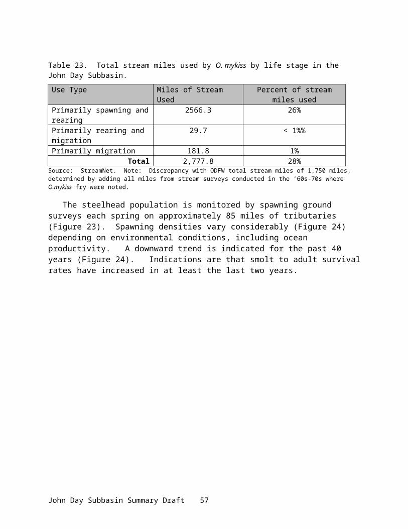
Approximately 600 degraded stream miles have been identified in the John Day Subbasin (ODFW et al. 1990). Plentiful riparian cover along streambanks is a vital part of a healthy watershed, providing multiple benefits in the form of nutrient cycling, shading and cover, bank stability, water storage, and filtration and retention (Wissmar et al. 1994). Riparian vegetation also hosts various insect species for the aquatic food chain. Loss of riparian cover leads to accelerated surface runoff and erosion, which in turn leads to siltation of spawning beds. Loss of riparian areas increases solar insolation, elevating water temperatures in summer, or reducing the tempering of water temperature in winter. Cumulative losses of habitat complexity can make fish populations more vulnerable to flash floods (Li et al. 1994). Loss of riparian cover potentially exposes spawning adults and rearing juveniles to predation and disturbance (Federal Caucus 2000). When riparian vegetation is lost, channel structure becomes more simple as inputs of large woody debris and their influence on channel structure are diminished, affecting instream habitat (Li et al.1994).
SedimentationFine sediment in spawning substrate has a major effect on salmon survival from egg to smolt (Rhodes et al. 2000). As silt settles into coarse gravels, spawning habitat is eliminated and eggs are suffocated by reduced water and oxygen flow. Sedimentation increases temperature and reduces dissolved oxygen concentrations (Federal Caucus 2000) and is abrasive to gill tissue.
FlowsPeak flows from increased, unretained runoff scour redds and dislodge eggs or alevins. Low summer streamflows also occur in many of the streams in the John Day Subbasin, primarily as a combined result of water rights uses and degraded channels. Many of these streams are in the upper reaches of the mainstem John Day River and the Middle Fork John Day River. Lack of flow interferes with movement, spawning, and rearing of salmon, steelhead, and trout (, Table 33, Table 34, and ) and significantly impairs habitat productivity and causes stream intermittency. Studies suggest that minimum water depth for passage by chinook is 24 cm (Hall 1994). Lack of adequate water depth reduces the connectivity between aquatic systems, impeding passage to traditional spawning grounds (chinook salmon), affecting rearing of juvenile steelhead, and impacting all life stages of redband, bull, and westslope cutthroat trout. Low flows also reduce the depth of pools used for holding adults and rearing juveniles. Low stream flows limit adult lamprey migration in mid-summer, during their peak migration period (Close et al 1995) and when coupled with elevated temperatures in the lower river, restrict movement of adult steelhead into the river system in the fall, delaying their migration (ODFW 2001). Low summer flows also have the effect of concentrating pollutants (phosphates, nitrogen), which can be hazardous to aquatic health (Cude 1995).
Table 32. Affected life stages of species of concern in some of the low flow tributaries in the Upper John Day Subbasin.
Species Life Stage TributarySpring chinook salmon migration, juvenile stage Dixie Crk
juvenile Canyon CrkSummer steelhead migration, juvenile to adult Dixie Crk, Canyon Crk, E.F. Beech
John Day Subbasin Summary Draft 61

Crk, Fields Crk,migration, spawning to rearing Indian Crk, Pine Crk
Redband trout resident Dixie Crk, Indian Crk, Canyon Crk, Fields Crk,
juvenile to adult E.F. Beech CrkBull trout resident Indian CrkCutthroat trout migration, spawning to rearing Indian Crk, Pine Crk
juvenile to adult Canyon Crk, Fields CrkFrom: Hall 1994.
Table 33. Affected life stages of species of concern in some of the low flow tributaries in the Middle and Lower John Day Subbasin.
Species Life Stage TributarySpring chinook salmon juvenile to adult John Day R. at Columbia R.Summer steelhead juvenile to adult Kahler Crk, Hay Crk, Rock Crk,
John Day R. at Columbia R.Redband trout resident Kahler Crk, Hay Crk, Rock Crk,
juvenile to adult John Day R. at Columbia R.Cutthroat trout juvenile to adult John Day R. at Columbia R.
From: Hall 1994.
Table 34. Affected life stages of species of concern in some of the low flow tributaries in the Middle Fork John Day Subbasin.
Species Life Stage TributarySpring chinook salmon juvenile stage Clear Crk, Placer Gulch, Ruby Crk,
Vinegar Crk, Beaver Crkadults spawning/holding M.F. John Day at North Fork
Summer steelhead juvenile to adult Clear Crk, Placer Gulch, Ruby Crk, Vinegar Crk, Beaver Crk
migration, spawning to rearing
M.F. John Day at North Fork
Redband trout resident Clear Crk, Placer Gulch, Ruby Crk, Vinegar Crk, Beaver Crk, M.F. John Day at North Fork
Bull trout juvenile to adult Clear Crk
John Day Subbasin Summary Draft 62

Table 35. Affected life stages of species of concern in some of the low flow tributaries in the North Fork John Day Subbasin.
Species Life Stage TributarySpring chinook salmon migration,
spawning/holdingCamas Crk
Summer steelhead juvenile to adult Rudio Crk, Cottonwood Crk, Camas Crk, Long Crk
Redband trout resident Rudio Crk, Cottonwood Crk, Camas Crk,Long Crk
Bull trout all life stages Clear Crk, Lightning Crk, Salmon CrkNote: withdrawal of water is limited in the North Fork salmonid production areas.
TemperatureLow flows, reduced riparian cover, and sedimentation also elevate water temperature, considered one of the most important habitat factors in the subbasin endangering salmonids and the top impairment to water quality (Li et al. 2000). Overgrazing on riparian vegetation increases the amount of insolation reaching streams, resulting in cumulative increases in stream temperatures downstream (Li et al. 1994). Water quality problems related to temperature are found in all major subbasin watersheds. The preferred temperature range for salmonids is between 45° - 60° F, with bull trout preferring colder temperatures (Oregon Plan, Monitoring Protocol). Generally, temperature above 64°F is beyond the thermal threshold of cold-water salmonids. Elevated temperature increases metabolic rate, increases the risk of disease, reduces dissolved oxygen, and affects behavior patterns (Oregon Plan, Monitoring Protocol), all of which impose high metabolic costs and impair survival (Li et al. 1994). High water temperatures in the mainstem tributaries limit salmonid production and force salmonids to limited cold-water refugia in the upper reaches of the mainstem, South Fork, North Fork, and Middle Fork rivers. Low flow and high water temperature have reduced the historic range of spawning and rearing habitat and contribute to spring chinook pre-spawning mortality. Increased temperatures also interfere with the ability of juvenile salmon to achieve smoltification. Mid-summer temperatures have been recorded above 70°F in many tributary systems (ODEQ data).
Instream Habitat LossLoss of instream habitat and habitat diversity limits salmonid production. Unmanaged livestock grazing in riparian areas has led to entrenchment of streams or wider and shallower channels, reducing or destroying in-stream habitat necessary for spawning and rearing. Human-caused channelization has eliminated floodplains and wetlands and reduced channel complexity, eliminating rearing habitat for juveniles and disconnecting floodplains with the stream. A reduction in beaver populations has also limited their contribution to forming wetland and riparian habitat (Wissmar et al 1994). Reduced riparian areas also limit woody debris in streams, diminishing pool quality and frequency, which are important for holding adults and rearing juveniles. Spawning habitat was destroyed by gold dredging in years past as stream channel hydrology was altered, preferred gravels displaced, and riparian vegetation eliminated (Wissmar et al. 1994). Loss of floodplains and wetlands has eliminated rearing areas for juveniles. Loss of instream habitat also increases vulnerability to predation (Federal Caucus 2000).
John Day Subbasin Summary Draft 63

Passage Barriers and IrrigationCommon irrigation practices also present passage barriers to migrating salmonids within the John Day Subbasin (ODFW et al 1990; OWRD 1993). Commonly-used push-up dams greatly restrict passage, both for upstream and downstream migrations. A number of diversions do not meet NMFS specifications for screening or are totally unscreened, resulting in impingement or entrainment of rearing or migrating juvenile salmonids. Other passage barriers include thermal or flow barriers, and impassable culverts, which restrict or limit movement of fish. Irrigation withdrawals can “dewater” sections of streams precluding passage and impairing water quality. Overland return flows from irrigation systems can warm streams, contribute to high levels of fecal coliform, and in some instances load them with silt.
WildlifeWildlife abundance has been limited by loss of habitat quantity, quality, and diversity. Factors contributing to habitat limitations for wildlife include:
Hydropower System Development and OperationsThe development and operation of the federal Columbia River hydropower system (FCRPS), which includes 13 mainstem dams for hydropower, navigation, flood control, and irrigation in the Columbia River Basin, resulted in widespread changes in riparian, riverine, and upland habitats. Because of the significant loss of mainstem habitat and habitat function associated with the FCRPS, tributary habitat has become more critical to the survival and recovery of listed species throughout the Columbia basin, and particularly in the John Day Subbasin. Wildlife loss assessments conducted in the late 1980’s documented losses associated with each hydropower facility (Table 36).
Table 36. Wildlife habitat losses associated with the federal Columbia River hydropower system.
Hydropower Facility Habitat Acres Inundated Habitat Units LostBonneville 20,749 12,317The Dalles 1,923 2,230John Day 27,455 14,398McNary 15,502 19,397
Source: Rassmussen and Wright 1990a,b,c,d
However, hydropower development has resulted in urban expansion, the building of numerous road and railways, and other structures. The creation of reservoirs has permitted the expansion of irrigation, thus resulting in extensive habitat conversion. The frequency and duration of water level changes has influenced vegetation succession on islands and along shorelines. In some cases, these fluctuating water levels have created barren vegetation zones and exposed wildlife to increased predation. Low water levels create land bridges that provide predators access to nesting islands. For example, inundation of gravel bars and sandy islands reduced the available area for nesting and resting waterfowl (BPA 1984). Other results of hydropower development and operation include the draining and filling of wetlands, stream channelization and shoreline riprapping, construction and maintenance of transmission power corridors, increased access to and harassment of wildlife, and increased erosion and sedimentation in the Columbia River and its tributaries.
Because of the direct and indirect effects of the FCRPS, tributary habitat improvements are required as part of the off-site mitigation activities of the U.S. Army Corps of Engineers, the
John Day Subbasin Summary Draft 64

Bureau of Reclamation, and the Bonneville Power Administration for continued operation of the system under the Endangered Species Act.
Land Management PracticesDry-land farming and mismanaged livestock grazing of open rangeland have been responsible for the elimination and degradation of the riparian zone throughout much of the John Day Subbasin. Wildlife abundance has also been adversely affected by irrigated agriculture through the reduction of habitat diversity as monocultures are created. Forest practices have also decreased the amount of available habitat and reduced the quality of remaining habitat. Fire suppression has contributed to the decline of upland shrub communities by allowing western juniper, a major competitor for water, to expand into these communities. Of recent concern is the accelerated, dispersed residential development and associated impacts occurring throughout the basin.
Human DisturbanceUrban expansion, highway traffic, free-ranging dogs, noise pollution, light pollution, and recreation can disturb wildlife populations and limit wildlife usage of quality habitat areas.
Major limiting factors resulting from the above activities include:Habitat Loss
The most significant habitat losses have occurred within the wetland/riparian habitat types throughout the basin, resulting primarily from agricultural conversion and stream channel modification. Conversion of the river flood plains to agricultural production reduced the occurrence of natural meadows typically associated with riverine habitats. Loss of winter range is another major limiting factor for big game populations. Efforts to maximize crop production have resulted in the loss of available grazing areas for big game species as a source for winter forage. Past grazing practices have resulted in the conversion of native ranges, interspersed with various deciduous species, to grass ranges consisting of introduced grasses or low-value grasses with species of noxious weeds. Deer, elk, and antelope are becoming more dependent on private agricultural cropland and pasture (crop depredation) as winter range is physically lost and non-native weed species increasingly spread throughout the historical winter range of the subbasin.
Noxious WeedsNoxious weeds are one of the greatest threats to rangeland biodiversity in the subbasin (USDI 2000). Noxious weeds displace native plants, degrade soils, and reduce nutrient cycling and energy flow (Quigley and Arbelbide 1997). Among other effects, noxious weeds reduce the quality of deer and elk winter range. Weeds causing most concern in the John Day Subbasin are diffuse, spotted, and Russian knapweeds (Centaurea spp); Dalmation toadflax (Linaria dalmatica); yellow starthistle (Centaurea solstitialis); Scotch thistle (Onopordum acanthium); purple loosestrife (Lythrum salicaria); rush skeletonweed (Chondrilla juncea); leafy spruge (Euphorbia esula); poison hemlock (Conium maculatum); and medusahead rye(Taeniatherum caput-medusae;USDI 2000). Medusahead rye is of particular concern because it is an aggressive annual that outcompetes most other native and introduced plants. Medusahead interrupts the food chain at its lowest levels by creating a monoculture within which the diversity of insects, flora, and dependent fauna is severely reduced. The expansion of cheatgrass has caused a decline of dry shrublands.
John Day Subbasin Summary Draft 65
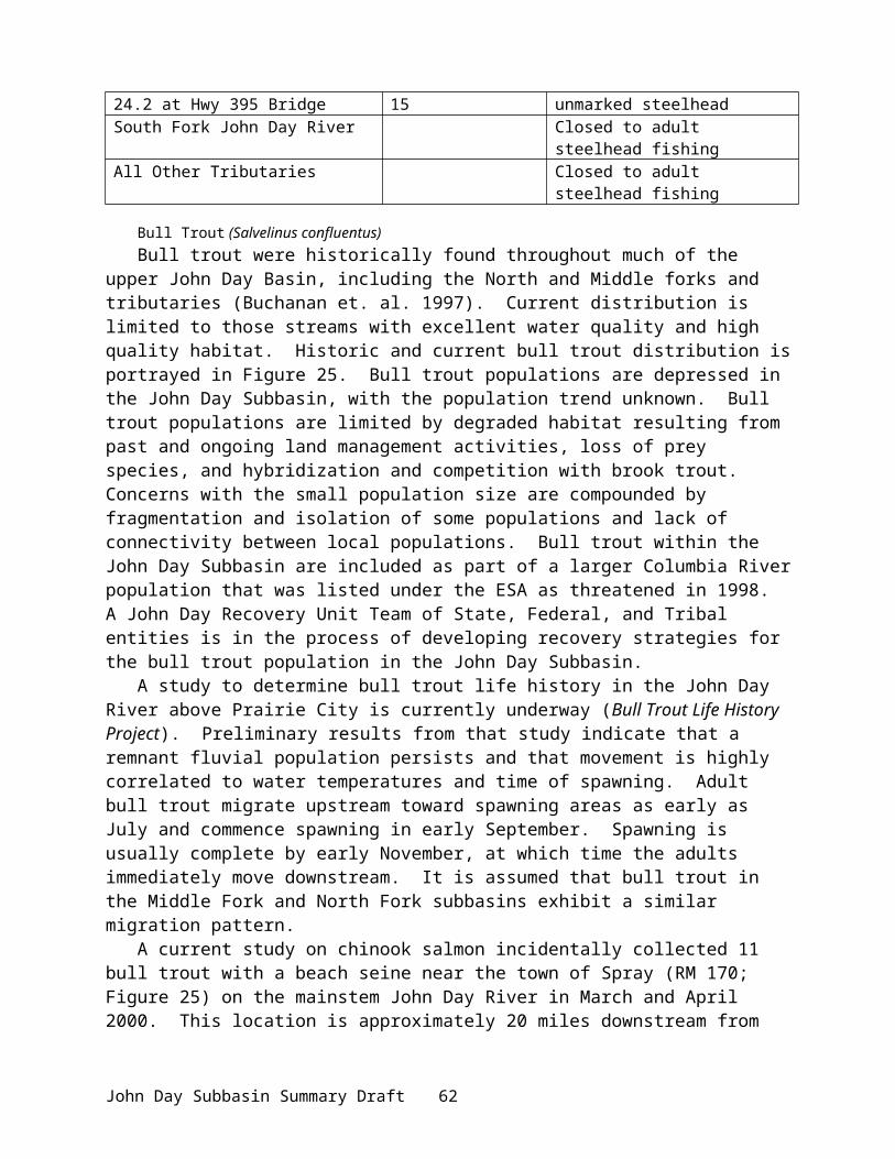
Nutrient Cycling & Food WebsContinued decline in populations of salmon and other fish species results in loss of overall biomass being contributed to the subbasin. This reduction has limited wildlife abundance.
Land PricesLand prices continue to rise as population growth continues, making it more economically difficult to preserve remaining undeveloped lands for wildlife and fish. Opportunities to restore wildlife populations and improve habitat diminish over time as habitat loss and degradation continues.
Artificial Production
No hatchery programs currently exist for flowing waters in the John Day Subbasin. However, hatchery releases of various anadromous and resident species have been made in the past (Table 37). Source of fish was from hatcheries outside the basin. The last anadromous hatchery releases were made 30 years ago.
Table 37. Fish liberations in the John Day Subbasin.
Species Years Number ReleasedAnadromous
Summer Steelhead 1947, 1969 37,495Winter Steelhead 1963 10,667Unknown Steelhead 1967 98,090Coho Salmon 1964 – 1966, 1968 711,000
Non-AnadromousRainbow Trout 1990 - 1998 123,060
Source: ODFW district files
Existing and Past Efforts
Long before any species were listed under the ESA, there have been efforts in the John Day Subbasin to restore certain aspects of watershed function. Soil erosion, stream channel instability, and riparian function-oriented projects have been underway in the basin in different land use sectors for many years using a combination of federal, state, tribal, local and privately-led efforts. Movement toward conservation tillage in the agricultural sector, improvements in grazing management, and improved timber management practices, while oriented toward their particular sector, also achieve value for salmon in the long run. Improvements in the scientific understanding of species distribution and needs, watershed management, and techniques for watershed restoration are expected to enhance these on-going efforts for additional benefit to fish and wildlife resources.
The following section describes existing and past efforts undertaken by federal, state, tribal, local and private entities in addressing the needs of fish and wildlife resources in the John Day Subbasin. The challenge for resource managers is to find an appropriate analytical and institutional framework and means to harness this exceptional energy toward comprehensive salmon recovery.
John Day Subbasin Summary Draft 66
Fisheries and Fisheries Habitat
BPA-Funded Activities and Programs
Restoration of fish habitat has been ongoing since the early 1960s. BPA-funded fish habitat improvements began in 1984 as part of the John Day River Implementation Plan. Extensive work has been done on public land, in coordination with the USFS, BLM, and others. Habitat improvement projects have also been pursued on private land through local and county resource agencies, watershed councils, and by private landowners.
Restoration projects include: bank stabilization through fencing, spring development to improve livestock distribution, livestock fence exclosures, planting, rock or juniper riprap, boulder and root wad placement, deflectors, weirs, channel restoration, pool excavation, toxic mine discharge piping, and riparian planting and fencing. Where implemented, these projects have decreased erosion, increased flow, improved riparian cover and pool-to-riffle ratio, and decreased high summer water temperatures. The historic projects, especially instream structure, have largely been discontinued due to the assertion that they lacked direct fish benefits (Beschta et al. 1991). Increasing emphasis is being placed on changing land management actions, which created the habitat problems, and on riparian and watershed protection and restoration.
Diversion screening and alternative diversion methods provide for fish passage improvements. Efforts have also focused on improving efficiency of water use and the avoidance of water quality problems. Specific agency and entity actions and accomplishments follow:
Oregon Department of Fish and WildlifeStudy of Wild Spring Chinook Salmon in the John Day River System (Project No.7900400): A study of life history and natural escapement conducted from 1978 to 1985 provided information on production and productivity of the John Day spring chinook and determined timing of migration within, and out of, the John Day River (Lindsay et al. 1986). Results: recommended escapement levels for harvest regulations, determination of necessary operational changes at Columbia River dams to increase survival of John Day migrants, recommended habitat improvements to increase smolt production within the basin. The recommendation of augmenting John Day spring chinook with hatchery stock to maintain Columbia Basin runs was later rejected as a threat to wild stocks.
John Day Basin Spring Chinook Salmon Escapement and Productivity Monitoring, (Project No. 980160): Provides annual estimates of spring chinook spawner escapement, age-structure, productivity, and smolt-to-adult survival to meet the data needs for an index stock to monitor long-term trends of survival and productivity in-basin and among populations throughout the Columbia Basin. This monitoring allows a relative comparison of population health to assess extraneous and in-basin survival factors. Spawning ground surveys were initiated in 1998 (Jonasson et al. 1998) and smolt tagging was started in 2000 (1,800 tagged; Wilson et al. 2000). Results: estimated number of spring chinook escapement and redds for the entire basin, age composition, sex ratios, rearing origin.
Bull Trout Life History Project – NE Oregon (Project No. 9405400): Baseline information on Bull Trout in the John Day Subbasin is lacking. Started in 1994, this project determines status,
John Day Subbasin Summary Draft 67
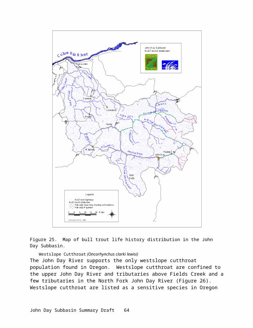
life history, genetic, habitat needs, and limiting factors for bull trout populations in numerous basins, including the John Day, to develop a rehabilitation plan for population enhancement (Buchanan et al 1997). Results: Documentation of bull trout movement and age composition; population estimates in the Middle Fork and distribution in Middle Fork tributaries, and genetic profiling. Development of local basin bull trout working group and steering committee has lead to the current Bull Trout Recovery Team.
Protect and Enhance Anadromous Fish Habitat in the John Day Subbasin,( Project No. 8402100): Improves quantity and quality of spawning and rearing habitat available for salmon and steelhead through riparian fencing, planting and instream work on Middle Fork and mainstem John Day River tributaries. Projects are aimed at restoring degraded instream and riparian habitats on private lands. Initiated in FY 1984, project work for 2001 includes new fencing on 6 miles of the Middle Fork John Day River and Indian Creek, leveling dredge tailings on 2.4 miles of Granite Creek (North Fork), and ongoing O&M and M&E. Results: 110 miles of riparian fencing, 125 livestock watering sites installed, 44 miles of stream received instream structures, and about 1,425 acres were protected by of riparian fence.
Northeast Oregon Fish Screening and Passage Project (Project No. 9306600): Cost shares with Mitchell Act, OWEB, and State fish passage screening program funding to fabricate and maintain juvenile fish screens and provide passage. Results: Old screens have been updated to meet current NMFS criteria (BPA-funded) and new screens have been constructed (Mitchell Act). A new screens workshop facility was built in John Day in 1995 for basin and statewide service. To date, 86 screens have been replaced to meet criteria (Table 38) and 86 new screens have been constructed. About 30 unscreened legal diversions still exist in the John Day basin. Operation and maintenance is performed on 314 screens in the John Day subbasin (NMFS funding). This project provides substantial protection and enhancement of anadromous and resident stocks in the John Day basin.
Table 38. Screens meeting NMFS criteria in John Day Subbasin.
Location Number of ScreensMainstem John Day River 69Middle Fork John Day River 14North Fork John Day River 0South Fork John Day River 3Note: 228 existing screens do not meet current NMFS criteria. These will be replaced using BPA or OWEB funds, or by a BPA/OWEB cost share.
Three fish screening projects have been funded by OWEB and carried out by ODFW: 1) Bates Pond dam and fishway (Bates, Oregon) on the Middle Fork of the John Day River, 2) Keerins screen system (Izee, Oregon) on the South Fork John Day River, and 3) St. Clair screen system (Izee, Oregon) on the South Fork John Day River.
Genetic Profiling: Several genetic profiling studies on summer steelhead and westslope cutthroat trout have been completed (Spruell and Allendorf 1997; Spruell et al. 1999).
John Day Subbasin Summary Draft 68

Habitat Inventories Project: Habitat and fish production surveys (presence/absence) have been conducted for bull trout on the Middle Fork and North Fork John Day rivers (Figure 25 and Figure 27). Similar surveys were conducted for westslope cuttroat trout in the upper mainstem. There are still large gaps in habitat surveys for summer steelhead.
Confederated Tribes of the Umatilla Indian ReservationRestore and Enhance Salmon in the Umatilla Basin (Project No. 8201000): Project goals were to compile a database, develop priorities, and recommend initiatives for a coordinated approach by CTUIR and ODFW to restoring and enhancing anadromous fish within the Umatilla Reservation and ceded lands of the Confederated Tribes, including lands within the John Day Subbasin. Results: project compiled data by using existing information, consultation with State and Federal entities, and reconnaissance-level field investigations. Information was used to identify, evaluate, prioritize, and recommend site-specific solutions to major problems impacting the salmon resource. Pacific Lamprey Population Studies (Project No. 9402600): Depressed Pacific lamprey populations have prompted the Tribes to assess their status and survival limitations within the John Day Subbasin. Preliminary surveys in 1998 identified adult and juvenile lamprey primarily in the North Fork Drainage (Close et al. 1999). Work has also involved examining physiochemical and micro and macro habitat factors affecting distribution and abundance (Jackson et al 1998). A Lamprey working group meets periodically to share findings and set research and action priorities (Columbia Basin Pacific Lamprey Technical Work Group 1999). Lessons learned from Umatilla basin lamprey restoration work will be applied toward John Day Subbasin efforts.
John Day Subbasin Summary Draft 69

Figure 27. Habitat survey areas in the Middle Fork and North Fork John Day subbasins.
North Fork John Day Habitat Project (Project No. 20003100). A new, cooperative project with the NRCS, USFS, ODFW, NMFS, NF Watershed Council, CTWSRO, and SWCDs, with the goal of protecting and enhancing habitat for improved natural production of indigenous wild chinook salmon and steelhead stocks within the North Fork Subbasin. Activities will be directed at installing riparian fencing, developing off-stream water sources, and conducting instream work on primarily private property. Secondary tools will include mechanical bank stabilization, bioengineered stream structures, channel reconfiguration, and vegetation planting. Monitoring of project success will include stream channel transects, photo documentation, physical surveys, fish population inventories, and stream temperature measurements.
Confederated Tribes of the Warm Springs Reservation of Oregon
John Day Subbasin Summary Draft 70

John Day Watershed Restoration Project (9801800): This is a cooperative program between the Warm Springs Tribes, the Grant Soil and Water Conservation District, and other agencies. Programs include Water Conservation, Passage Improvement, Land Acquisition, Demonstration, and Monitoring and Evaluation (Table 39). Results: Phase I-IV implementation activities completed (Table 39). This program has received considerable recognition for its effectiveness and ability to maximize on-the-ground achievements. The program is further discussed below under Grant Soil and Water Conservation District programs.
Table 39. CTWSRO and Grant SWCD existing and past efforts in the John Day Watershed Restoration Project in the John Day Subbasin.
Program Projects SitesWater Conservation
Return Flow Cooling Holliday, Crown Ranch/Mullin, Ediger, Vidondo return flow cooling
Irrigation Conversion Clausen, Page, Lee, Morris, and Pike irrigation conversion, Field tailwater reuse, Homes pipeline
Passage Improvement
Pumping Stations Page, Clausen, Morris, Lee, Pike, Rudishauser pumping stations
Infiltration Galleries Lemon’s, Field, Rudishauser, and Courschesne infiltration galleries
Permanent Diversions Holliday, Enterprise, Holmes, Indian Creek, Keerins, Southside Ditch, Mullin, Smokey Creek, St. Clair diversions
Land Acquisition Land Acquisition Oxbow Ranch, Forrest Ranch, Pine Creek Ranch
Conservation Easements Various landownersDemonstration Program
Seasonal Corridor Fencing Various landownersBeaver Management Various damage areasNative Plant Nursery Replanting in project areas
Monitoring and Evaluation
Project Monitoring (photopoints, surveys, inventories, assessments)
Construction projects
Water Quality Monitoring 45 stations in mainstem and tributariesBaseline Resource Assessment & Trend Monitoring
Water Conservation Program: Return flow cooling projects convert existing surface irrigation return flow conveyance systems to below ground systems for the purpose of improving water quality through reduction in return flow temperatures and nutrients. Reduced return flow temperatures into the mainstem John Day River have provided a localized cooling effect on the water column, creating an area of thermal refugia for salmonids. Irrigation conversion projects replace flood irrigation and open conveyance systems with more efficient sprinkler and closed conveyance systems, enhancing instream flows within and downstream of project areas. The Field’s project reuses irrigation tailwater, which reduces diversion rates.
Passage Improvement Program: Push-up dams are being replaced with pumping systems, infiltration galleries, and low maintenance, permanent diversion structures to provide for fish passage at all instream flow levels.
John Day Subbasin Summary Draft 71

Land Acquisition Program: Program has acquired over 35,000 acres of land, located on the Middle Fork John Day and on the upper mainstem and lower John Day River. Areas contain prime habitat for chinook, steelhead, lamprey and other species. All ranches were acquired or are leased by CTWSRO. The Tribes and ODFW have an active program of acquiring conservation easements and assisting landowners with conservation planning related to their long-term property ownership (e.g.,trust and estate planning). The Tribes are in the process of developing a local land trust that would act as a local resource for these efforts.
Projects within the Demonstration Program are generally experimental, but are necessary activities to address resource issues and concerns in the basin. Beaver management consists of live-trapping beaver from damage areas and moving them to suitable habitats elsewhere in the basin. The native plant nursery helps to reestablish vegetation disturbed or impacted from project construction or previous management practices.
Monitoring efforts include photopoints, channel and vegetation surveys, macroinvertebrate inventories, fish production, water quality and quantity assessments, habitat typing, mainstem corridor aerial photo analysis, spawning ground counts, mark-recapture studies, and snorkel surveys.
Columbia River Intertribal Fish CommissionMonitor Fine Sediment and Sedimentation in John Day and Grande Ronde Rivers (Project No. 9703400): Sedimentation concerns have arisen from land use practices of timber harvest, grazing, and dredge mining in the North Fork subbasin. This project measure surface fine sediment and overwinter sedimentation in salmon spawning habitat during the incubation period in portions of the Grande Ronde and John Day rivers (North Fork and Granite Creek). Results: Monitoring sites established and methods refined. Trend analysis using the grid method indicates sediment problems increasing in the North Fork and decreasing in Granite Creek.
U.S. Geological SurveyUpstream migration of Pacific lampreys in the John Day River (Project No. 2000052): Identification of biological and ecological factors limiting lamprey production is critical to population assessment and recovery efforts. Initiated in 2000, the project will provide documentation of life history strategies and habitat preferences of adult Pacific lamprey in the John Day Subbasin, which will help identify factors limiting lamprey populations, identify areas in need of rehabilitation, and help to assess the efficacy of management actions. Initial radio tracking has identified erratic movements with most movement in the fall, refuge areas, and passage problems at Tumwater Falls in the lower river.
U.S. Forest ServiceNorth Fork John Day Fish Habitat Enhancement, (Project No. 9303800): Project objective is to improve habitat quality for anadromous and resident fish species by restoring riparian vegetation and ecosystem function in areas impacted by grazing. Tasks include resetting and construction of seasonal electric fence to control cattle and sheep grazing, construction of barbed wire exclosure fences, providing instream improvements, and monitoring fish use of streams and impacts of enhancement projects. Radio tagging was used to identify use of pool habitat by adult salmon during migration. Summer holding areas were mapped and characterized; distribution patterns allow discrimination between habitat used in managed and unmanaged watersheds. Photography is used to observe vegetative responses associated with fenced areas. Smolts inhabitating created or augmented side channel habitat (#/m2) is also assessed. Results: Since 1993, about 76 miles of seasonal electric livestock exclosure fence has been constructed to
John Day Subbasin Summary Draft 72
protect and restore approximately 60 miles of riparian habitat. Monitoring results indicate that the fences are 98% effective in excluding livestock. Creation of more rearing habitat and stabilization of banks is planned for Granite Creek.
John Day River Habitat Improvement (Project No. 82002900): The U.S. Forest Service and Bureau of Land Management installed various instream structures to add diversity and riparian fences were erected to facilitate riparian recovery and shading. Instream structures include log weirs and boulders, creating riffles and pools for spawning and rearing. Results: Work was performed on Camp Creek (Middle Fork John Day), Clear Creek (North Fork John Day), and Deer Creek (South Fork John Day). Oregon Department of Fish and Wildlife subsequently evaluated the effectiveness of these efforts, as well as fisheries benefits and costs.
Murderers / Deer Creeks Habitat Improvement (Project No. 833840): Project goal was to increase and improve the quality of pool habitat in 3 tributaries of the South Fork John Day River (Murderers, Deer, and Tex creeks) in the Malheur National Forest. Earlier stream surveys (1960 and 1981) indicated pool habitat for rearing juvenile salmonids and steelhead was limiting. Work entailed construction of log weirs and placement of rock. Results: Smolt habitat capability was reportedly increased by 300 percent.
Clear / Granite Creeks Habitat Improvement (Project No. 8339400): Project goal was to improve spawning habitat in Clear and Granite creeks in the Umatilla National Forest. Earlier dredging operations on these creeks (1920-1954) removed major portions of spawning gravel and completely altered the natural hydrology of these streams. Project activities consisted of screening gravel from gold dredge tailings and placing it in 138 spawning sites. Results: An increase in spawning area thereby reducing crowding of spring chinook redds, increased survival of deposited eggs, and improved spawning and spawning habitat in Clear and Granite Creeks.
North Fork John Day Habitat Improvement (Project No. 833950): Project constructed side channels, strategically placed boulders, and constructed boulder weirs along the North Fork John Day River, Umatilla National Forest, to repair rearing habitat degraded by gold dredging. Results: Project activities have improved rearing habitat and provided potential for increased survival from egg to smolt.
North Fork John Day Habitat Improvement (Project No. 8400800): Continued and expanded effort of previous habitat improvement projects initiated in 1979 to restore areas along the North Fork John Day River devastated by gold dredging. Project funding provides for tributary surveys in the North Fork John Day River, restoration of salmonid habitat in selected stream by riparian fencing and instream work, opening of side channels and reclamation of dredged areas, and solutions to toxic mine drainage. Project results are monitored by ODFW. In 1997, this project became an O&M contract for 50 miles of barb wire fence and 900 instream structural improvements. Results: Improved stream conditions, increased number of pools, and increased riparian vegetation.
Mainstem and Upper John Day Habitat Improvement (Project No. 8402200): Implementation of a habitat improvement program for wild spring chinook and steelhead by the Malheur National Forest. Project focused on instream work on about 25 tributaries of the Middle Fork & upper mainstem in the John Day River Basin. Program goals included increased wild chinook
John Day Subbasin Summary Draft 73
and steelhead production, improved riparian habitat, improved water quality, and improved seasonal flow distribution. Primary treatment techniques included structural improvements for adult and juvenile passage, riparian protection, structural streambank stabilization, and structural rearing habitat improvements.
Grand Ronde, Imnaha, and John Day Telemetry Tracking (Project No. 9307000): Performed by the Pacific Northwest Research Station, the project determined freshwater life history patterns and use of thermal refugia by adult spring chinook salmon using radio-tagged fish. GPS data enhanced accuracy of fish locations and allowed rapid download to a GIS; thermal infrared videography examined the spatial variability of stream temperatures. Results: Mapping of cold-water habitats and documentation of use by spring chinook. Habitat selection by spring chinook differed among drainages, reflecting differences in habitat structure, availability, and temperature. High stream temperature limits the distribution of adult spring chinook salmon in the John Day basin.
North Fork John Day Dredge-Tailings Restoration (Project No. 9605300): Lead by the Umatilla National Forest and assisted by ODFW, sites of previous gold dredging on the North Fork John Day River and its tributaries are being restored. Project redeposits tailings allowing the river to flow over portions of the floodplain previously unavailable. Channel complexity and fish habitat quality and quantity increase as the river reclaims its floodplain, dissipating the energy of high flow events and depositing sediment that promotes riparian vegetation growth. Results: reshaped 220,000 yd3 of dredge tailings along 1.8 mi of Granite Creek, planted 5,000 lbs of native grass/hardwood seed, completed photographic and geomorphic baseline data collection.
Bureau of Land ManagementCottonwood Creek Habitat Improvement (Project No. 8347300): Project activities included construction of a series of log weirs to slow water velocities and improve limited spawning and rearing habitat for steelhead on Cottonwood Creek, a tributary of the John Day River. The weirs provided additional spawning and rearing habitat and added more instream cover for fish. Weirs and boulders were designed to encourage gravel recruitment and increase natural steelhead production.
South Fork John Day & Mainstem Habitat Improvement (Project No. 8507100): The purpose of this project was to increase the amount of usable habitat, particularly rearing habitat for summer steelhead. Activities included enhancement of fish habitat in the SFJDR, Deer Creek, and Cottonwood Creek through instream work, and continuation of O&M on project sites from 1982 - 1986.
U.S. Corps of EngineersLower Columbia Fish Passage Evaluations (Project No. 9204100): Assess the success of adult salmon and steelhead passage at the four dams and reservoirs in the lower Columbia River and into the tributaries, including the John Day River, and evaluate specific flow and spill conditions on adult fish migration. This project was designed to provide data on which dam and system operations can be based to ensure adequate fish passage conditions are provided. Work conducted in the Lower Columbia from 1996-2000 used radio telemetry.
North Fork Watershed Council
John Day Subbasin Summary Draft 74
Eliminate Gravel Push-Up Dams on Lower North Fork John Day (Project No. 980170): Eliminates gravel push-up dams on the lower North Fork John Day to remove impediments to anadromous fish migration, improve water quality and habitat for both anadromous and resident fish, reduce sediment load from construction and washouts, and shrink surface area of water during annual periods of highest temperatures and solar radiation. Results: Permanent pumping stations were installed at River Meadows and Schultz Ranch.
Misc. Entities and AgenciesFish Habitat Project Field Reviews and Evaluations (Project No. 9106900): Questions on whether BPA-funded habitat projects were meeting enhancement goals were addressed through an interdisciplinary team performing field reviews of BPA stream habitat restoration projects throughout the John Day River subbasin and other subbasins. The objective was to obtain specific recommendations for improving future projects. Study concluded that habitat projects, particularly those for instream structure, did not always address the most critical limiting factors (Beschta et al. 1991)
Non-BPA-Funded Activities and Programs (Fisheries)
Oregon Department of Fish and WildlifeStreamflow Restoration Prioritization: ODFW has established the priorities for streamflow restoration needs in the John Day Basin (Appendix Figure 20), as well as all other basins in the state. Priorities are based on individual rankings of several biological and physical factors, water use patterns and restoration optimism. Biological and physical factors included the number of native anadromous species, presence of a designated “Core Area”, fish related ecological benefits, other types of ecological benefits, physical habitat condition, the extent of human influence, water quality, current status or proposed as sensitive, threatened, or endangered, presence of instream flow protection (Instream Water Rights), and natural low flow problems. Water use pattern factors included the estimated amount of consumptive use and the frequency that an existing Instream Water Right is not satisfied. The final factor in the ranking of restoration need was an optimism factor of how well the fish resources would respond if flow were restored. Many of these factors were derived from existing data sources while others were ranked by ODFW’s District Fish Biologists, based on local knowledge and professional judgment. Extensive use was made of Geographic Information Systems (GIS) and relational database analytical methods. Flow restoration priorities project was funded by the Oregon Watershed Enhancement Board, through a grant to the Oregon Water Resources Department.
Oregon State PoliceThe Oregon State Police (OSP) patrols the upper and lower subbasin to enforce laws and regulations designed to protect fish and wildlife, and educate the public about these laws. Specific resource protection action plans are developed each year in consultation with ODFW and other affected agencies to protect all returning anadromous fish after entering the basin and their habitats. Salmon and Steelhead Action Plans have been developed and implemented for nearly 10 years in the John Day Subbasin. Operational (enforcement) areas include the lower John Day River upstream to Clarno (RM 107), mainstem sections above Kimberly (RM 185), and North Fork, Middle Fork, and South Fork John Day rivers and their tributaries.
Operational actions include monitoring anglers for illegal harvest and licensing requirements (compliance; Table 40) and responding to natural resource violations regarding fish passage and habitat protection. Lower river monitoring reflects harvest of hatchery stray steelhead. No
John Day Subbasin Summary Draft 75

harvest is allowed on wild chinook salmon or steelhead. In 2000, increased natural resource violations were reported (petroleum discharges, illegal fill or solid waste, wetland degradation). Responses were coordinated with DEQ and DSL.
Table 40. OSP compliance rates for anadromous fish in the Upper and Lower patrol sections.
Salmon SteelheadYear Compliance Rate Year Compliance Rate
Upper John Day River2000 86% 2000 100%1999 89% 1999 92%1998 94% 1998 97%1997 97% 1997 93%
Lower John Day River1999-2000 91%1997-1998 88%
Oregon State UniversityOregon State University research studies in the John Day Subbasin (a few were BPA funded) were primarily focused on studying longitudinal temperature profiles and the effects of land use on those profiles. Secondly, fish species richness was correlated to changes in longitudinal temperature profiles. Results: Temperature signals indicate the value of riparian vegetation as a component of salmon habitat; human effects have reduced stream and floodplain interactions; grazing has compacted the soil and removed riparian vegetation. The capacity of meadows to contribute to the salmon food chain has been greatly reduced.
Three studies were specifically related to evaluation of habitat post-rehabilitation efforts. A bioeconomic study of habitat restoration (Adams et al. 1993) suggested increased summer streamflow and reduced temperatures could increase fish use of habitats. A study of sill/log weir emplacements in Camp creek (Li et al. 1992) found that installation of log weirs did not address the critical problem and limiting factor of temperature. The field review of stream enhancement efforts (Beschta et al. 1991) found that log weirs were not effective in increasing pool volume.
Other studies included Close et al. (1995), which provided a status report of Pacific lamprey in the John Day Subbasin. Torgersen et al. (1999) quantified distribution and behavior of adult spring chinook salmon related to patterns of stream temperature and physical habitat. Li et al. (1994) studied the cumulative effects of riparian disturbance by grazing on the trophic structure of streams in the John Day Subbasin. Li et al. (2000) characterized the status, integrity, and functioning of watersheds using temperature as an indicator, with the purpose of identifying factors leading to salmonid recovery. Tait et al. (1994) studied the influences of riparian cover on benthic community structure. Wissmar et al. (1994) provided an in-depth assessment and synopsis of human-caused disturbances on stream and riparian ecosystems in the John Day Subbasin.
Ongoing research projects include 1) Strategies for Riparian Recovery: Plant Succession and Salmon, and 2) Research/Evaluate Restoration of Northeast Oregon Streams and Develop Management Guidelines. Goals are to evaluate passive and active restoration projects (1) and establish future guidelines for restoring stream systems (2). A newly started graduate research project (Seasonal variability of westslope cutthroat trout habitat associations and movement patterns in headwater tributaries of the John Day River) is being coordinated between the Native Trout Program of ODFW and Oregon State University.
John Day Subbasin Summary Draft 76
Oregon Watershed Enhancement BoardThe OWEB funded ODFW and OWRD, through a grant to OWRD, to determine streamflow restoration priorities in Columbia River tributaries, including those in the John Day Subbasin. OWEB has also funded projects completed by Grant SWCD on the South Fork John Day River. These projects include improving riparian vegetation through fence construction, water quality monitoring, and placement of juniper riprap to stabilize streambanks. Several grants totaling over $90,000 have been made to the Monument SWCD for work on Cottonwood Creek and are an extension of earlier projects on East Fork Cottonwood Creek (in the last 15 years, another $375,000 has been spent in the Fox Creek drainage, a tributary to Cottonwood Creek, by private landowners and by ODFW through the BPA program). Project elements have included grazing management, seedings, fencing, brush control, riprap and stream jetties.
Oregon Water Resources DepartmentA Stream Restoration Program for the Middle Fork was adopted by the Water Resources Commission in May 1991. Other draft programs were developed in the early 1990s, which included the North Fork, Upper South Fork, South Fork, and Upper Mainstem John Day. Collectively, these programs sought to recognize and facilitate coordination between existing programs and agencies dealing with water resource issues in the John Day Subbasin, and to fill gaps that hindered resource protection and restoration.
Currently, the OWRD follows the Oregon Plan measures for establishing priorities and implementing projects. In conjunction with ODFW, OWRD established priorities for streamflow restoration in the John Day Subbasin in 1999. OWRD ranked the opportunities and optimism for achieving meaningful streamflow restoration in each subbasin, based on the availability and perceived effectiveness of several flow restoration measures. These included transfers and leases to instream uses, cancelled water rights, enforcement and monitoring, improved diversion methods, stream inventories, conservation planning, improved efficiencies, and measurement and reporting of use. By overlaying the identified need and opportunities for restoration, the State of Oregon has identified the sub watersheds where it will apply its resources toward achieving streamflow restoration.
Bridge Creek Watershed CouncilBridge Creek WSC conducts volunteer monitoring of upland projects using photographs.
Pine Hollow Watershed CouncilThe Pine Hollow Watershed Council encourages recovery of in-stream and riparian habitat by mitigating high runoff events from uplands in the Lower John Day watershed. Within its Pine Hollow Watershed Enhancement Action Plan, the council seeks to reduce soil erosion, and flood damage and improve water quality and vegetative cover in the area’s streams, in part for local compliance with Senate Bill 1010. The Council further works to improve upland range condition for the benefit of both wildlife and livestock. Accomplishments: 3 fencing projects, 4 ranch management plans, 3 water and sediment control basins, 1 spring development, 3 critical area grass seedings (to 1997).
North Fork Watershed CouncilThe North Fork Watershed Council has been implementing projects since 1997 and active since 1995. The NF Watershed Council continued work on planning, restoration, enhancement, and educational activities within the North Fork and Middle Fork subbasins. Watershed Council
John Day Subbasin Summary Draft 77

activities over the past year have included riparian plantings, riparian fencing, and development of offstream watering facilities for livestock, and analysis of a project to open habitat for chinook and steelhead. The Watershed Council conducts water quality monitoring at over 30 sites throughout the subbasin. Completed projects are as follows:Paul Creek Riparian Fencing (USFWS)Schultz Ranches Push-Up Dam Elimination (BPA)River Meadows Push-Up Dam Elimination (BPA)Smith Push-Up Dam Elimination (BPA)Andersen Erosion Control (OWEB)Rudio Creek Streamflow Restoration (OWEB)Burnette riparian fencing (OWEB/ODFW)Watershed council and coordinator support (OWEB) Anderson erosion control (OWEB) Henslee riparian project (USFWS)
Grant Soil and Water Conservation DistrictGrant SWCD has been actively involved in habitat enhancement projects for many years. In 1992, the Directors established elimination of diversions limiting fish passage and improvement of water quality as the District’s highest priorities. They have acted as a subcontractor for most of the ODFW, CTWRSO, and USBR projects and are responsible for ensuring projects are designed and implemented and that construction funds are distributed. In addition to BPA-funded projects listed in Table 39, Table 41 lists projects using funds from USBR, private, Farm Services Administration, OWRD, ODFW, and OWEB.
Table 41. Projects administered by Grant SWCD. IRO=irrigation reorganization, GPL = gravity pipe line, IFG=infiltration gallery, RFC=irrigation return flow cooling.
ProjectsCathedral Ditch IRO Reynolds IRO Ediger Irrig. Eff. Morris Pike IROWidows Creek GPL Carter RFC Field IFG Demo. SF Stream Rest.Warren’s Crk. bypass Knight Irrig. Eff. Page IRO St. Clair DiversionRetrofit IFGs Noxious Weed Control. Grub Crk Fence Beech Crk crossing
Sherman County Soil and Water Conservation DistrictMitigate Effects of Runoff & Erosion on Salmonid Habitat in Pine Hollow. Goal is to slow runoff during peak flow events to allow a slow, safe release of water during summer and further allow buildup of sediment and riparian vegetation to improve spawning and rearing habitat by increasing flow during critical months, reducing damage to riparian vegetation, reducing summer water temperatures, and allowing recovery of channel morphology.
Wheeler County Soil and Water Conservation District
Table 42. Fish habitat conservation practices facilitated by Wheeler County SWCD, 1999-2000.
Conservation Practice QuantityRiparian Fences (corridor fences) 23,240 feetRiparian Planting 3,750 feetWater Developments (for cattle) 4Stream Channel Stabilization 690 feet
John Day Subbasin Summary Draft 78

The above practices (Table 42) include several key 1999-2000 projects within the Wheeler County SWCD. These include:
▪The Lower John Day River Enclosure Project between Service Creek and Twickenham has developed partnerships between landowners, local, state, and federal agencies and the Wheeler SWCD. Cost-share funds are received from OWEB and NRCS. The project has constructed corridor and cross-fencing along 13 miles, installed water developments at 5 locations, and planted riparian areas. This project has protected a large section of the John Day River from grazing pressure, increasing bank stability and reducing erosion.
▪The West Branch Bridge Creek Riparian Fence Project will exclude livestock from 1 mile of the creek and construct a cross fence, with photo-monitoring for 5 years. The project is a cooperative effort between landowner, SWCD, OWEB, and Bridge Creek Watershed Council.
▪The Parrish Creek Riparian Pasture Project (Spray, OR) constructed a 7-mi fence along Parrish Creek, created a 1,000 acre riparian pasture and new livestock management plan, and developed off-site stock water. Since 1999, riparian vegetation has dramatically improved.
▪The Kahler Creek Projects were successfully completed in 2000 and included riparian corridor fencing, juniper riprap, log weirs, and water developments to improve riparian condition. Landowner conservation practices have continued.
▪The Corncob Creek Riparian Improvement Project completed 2,800 ft of riparian fencing and 2 cross fences and planted the excluded area with willow and cottonwood cuttings. Cooperative entities included Wheeler and Monument SWCDs, BLM, OWEB, and the landowner. Future work will include off-site spring development, juniper clearing, annual grass control, and perennial grass reintroduction.
▪The Alder Creek Juniper Control Project will replace 360 acres of invasive juniper trees with perennial grasses to enhance soil absorption, decrease erosion, increase late season flows, and potentially lower water temperatures. Cooperators include OWEB, Wheeler SWCD, and ranch owner.
▪The Johnson Creek Solar Water Development Project (Longview Ranch, OWEB, ODFW, Wheeler SWCD, BLM) installed a solar panel near Johnson Creek (Kimberly, OR) to provide power for pumping water to an upland storage tank for livestock and wildlife. Exclusion fencing and helicopter seeding will improve wildlife habitat along Johnson Creek
▪The Mountain Creek Riparian Planting Project will begin in spring 2001 to plant 2,000 ft of Mountain Creek with native riparian vegetation (river birch, alder, willow, cottonwood) as a follow-up to an ODFW riparian fencing project in 1995.
U.S. Bureau of ReclamationIn 1991, the NWPPC asked the USBR to undertake water conservation demonstration projects in selected Columbia River tributary subbasins. Table 43 lists projects completed in the John Day Subbasin. Many of these projects were completed with the assistance of Grant SWCD.
Table 43. John Day Water Conservation Demo Projects by the U.S. Bureau of Reclamation.
Activity or Project SiteReplace push-up dam w/ low-head structure, fishway and spillway
Luce-Long, Holliday Ditch, Keerins diversions
Replace open irrigation ditches w/ pipelines Widows Creek Gravity Irrigation Pipeline Systems
Eliminate push-up dam Holmes pipeline
John Day Subbasin Summary Draft 79

Replace push-up dam w/infiltration gallery and convert from flood to sprinker irrigation
Fields Infiltration Gallery and Irrigation Efficiency
Replace push-up dam with infiltration gallery Lemon, Courchesne, Rudishauser Infiltration galleries
Replace 3 push-up dams w/pumps and replace open ditches w/pipelines
Cathedral Rock Ditches Project
Replace push-up dam w/pump and covert to sprinkler irrig. Clausen Ditch ConversionConvert from flood irrigation to wheel lines Knight Irrigation ReorganizationReplace push-up dam w/pump; convert from flood irrigation Ediger, Page and Morris-Pike
Irrigation ReorganizationConvert from flood to sprinkler irrigation Lee Irrigation OrganizationConstruct subsurface drainage system to return cooler water to the stream
Crown Ranch and Holliday Ranches Return Flow Cooling
From: USBR 2000.
Oregon Water TrustWater Right Acquisition Program (FY 2000-2002): Oregon’s Instream Water Rights Law allows water right holders to donate, lease, or sell water rights for transfer to instream use. Oregon Water Trust (OWT), a private, non-profit group, negotiates voluntary donations, leases, or permanent purchases of out-of-stream water rights to convert to instream water rights in those streams where acquisition will provide the greatest potential benefits for fish and water quality. Results: OWT has negotiated donated leases of all or a portion of 18 water right certificates from 3 different properties on the Middle Fork John Day River and tributaries. These leases provide over 5 ft3/s flow in critical chinook and steelhead spawning and rearing habitat areas. The rights are held in trust for the people of Oregon by the Oregon Water Resources Department. Streams affected include Big Boulder Creek, Big Creek, Hawkins Creek, and Middle Fork John Day and tributaries.
John Day Subbasin Summary Draft 80
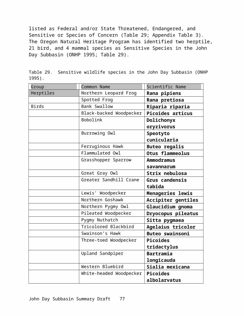
Restoration and Enhancement BoardA surcharge on angling licenses provides money to ODFW's Restoration and Enhancement Board (R&E), which then allocates money to anadromous and resident fish enhancement projects. Within the John Day River Basin, R & E has funded projects, which benefit anadromous and resident salmonids. These projects include, riparian fencing on a variety of private properties that excludes livestock grazing on approximately 25 miles of stream and improving passage at two irrigation diversion dams on the South Fork John Day River.
Oregon Department of ForestryThe Oregon Department of Forestry is involved in the Blue Mountain Demonstration Project on the Middle and North Fork John Day rivers, in cooperation with the Forest Service and BLM.
Bureau of Land ManagementThe Bureau of Land Management is involved in the Northeast Oregon Assembled Land Exchange on the North Fork System in which isolated BLM land parcels are exchanged for more suitable land from other landowners (USDI 1998). Approximately 30,000 acres of private lands within the North Fork drainage were recently acquired by BLM through the Clearwater Land Exchange (Lane 2001). Lands in the South Fork and Mainstem subbasins were disposed of to allow for acquisition. The acquisition allows for public management of approximately 56 miles of anadromous fish streams, secures important big game winter range, provides a consistent habitat base for many wildlife species, and ensures public access and use of natural resources. All exchanged land will be primarily managed for fish, wildlife, and recreation. Planned work on exchanged lands includes closure of “draw-bottom” roads, an inventory for future road closures, and stream habitat surveys (Morris 2001).
BLM and USFS contracted with ODFW in recent years to conduct stream habitat surveys in the North Fork (BLM) and Middle Fork (USFS) subbasins. Surveys produced information on bull trout distribution and habitat (Figure 25).
John Day Bull Trout Recovery TeamStrategies for bull trout recovery are currently being drafted by the Bull Trout Recovery Team. Besides the placement of angling regulations in 1994, instream water rights for bull trout have been issued for 24 streams or stream reaches within the John Day Subbasin. An additional 18 water rights requests have been submitted, but are being contested by other water users.
The Nature ConservancyThe Nature Conservancy is working with numerous agencies to create a 1,200-acre preserve for salmon and steelhead production on the Middle Fork of the John Day River (Dunstan Ranch). The Conservancy is working in partnership with the Oregon Department of Fish and Wildlife, the Umatilla and Warm Springs Tribes, Oregon Trout and others to restore 4 miles of spawning gravels, rearing habitat, and stream channels, and revitalize a floodplain ecosystem. Restoration measures could triple the spring chinook and double the summer steelhead populations in the Middle Fork of the John Day River. Project funding has been through the Federal Highway Administration, OWEB, and the National Fish and Wildlife Foundation.
John Day Subbasin Summary Draft 81

US Forest ServiceFish and Wildlife habitat improvement projects have occurred on National Forest System lands in the past and are proposed in the future. Completed projects within the last 1 - 6 years for the Umatilla, Wallowa-Whitman, and Malheur National Forests are listed below (Table 44).
Table 44. Fish and wildlife habitat projects since 1992.
Year Forest/Agency Location Activity
1999 Umatilla NF, North Fork John Day RD Clear Creek Dredge tailing redistribution,
floodplain restoration
1998 Wallowa-Whitman NF, Baker RD Boulder Creek Head cuts repair
1998 Umatilla NF, North Fork John Day RD Oriental Creek 8 miles of road obliteration and
recontouring
1998 Umatilla NF, North Fork John Day RD
Morsay and Thompson creeks Buck and pole aspen exclosures
1998 Umatilla NF, North Fork John Day RD Bear Wallow Creek Cattle exclosure fence
1998 Umatilla NF, North Fork John Day RD Clear Creek Dredge tailing restoration
1998 Umatilla NF, North Fork John Day RD Texas Bar Creek Hardwood and conifer riparian
planting
1997 Wallowa-Whitman NF, Baker RD Boulder Creek Riparian hardwood propagation and
planting
1997 Wallowa-Whitman NF, Baker RD Channel Creek Obliterate 3/8 mile road near creek
1997 Umatilla NF, North Fork John Day RD North Fork John Day River Dredge tailing redistribution (5 miles
of river)
1997 Umatilla NF, North Fork John Day RD Texas Bar Creek
Cottonwood and hardwood planting, road obliteration, and 1.5 miles of riparian exclosure
1997 Umatilla NF, North Fork John Day RD
Little Indian, Butcherknife Spring, Sugarbowl, Taylor, Smith, Park, and Dry Camas creeks
Riparian exclosures to exclude livestock access
1997 Umatilla NF, North Fork John Day RD South Cable Creek Road obliteration and recontouring
1997 Umatilla NF, North Fork John Day RD Neeves Creek Landslide stabilization
1997 Umatilla NF, North Fork John Day RD Deer Lick Creek Buck and pole aspen exclosure
1996 Wallowa-Whitman NF, Baker RD Boulder Creek Riparian hardwood propagation and
planting
1996 Wallowa-Whitman NF, Baker RD
Boulder, Onion, and Granite cr.
Collected switches for propagation at nursery
1996 Wallowa-Whitman NF, Baker RD South Fork Boulder Creek Rock haul for head cut (1997 work)
1996 Wallowa-Whitman NF, Baker RD
Upper North Fork John Day River and Bull Creek
Peavy Cabin road rehab, matting and log placement for post-fire stabilization
John Day Subbasin Summary Draft 82

Year Forest/Agency Location Activity
1996 BLM- Prineville District North Fork John Day River 2.5 miles fence constructed, changed season of use on 3 miles
1996 Umatilla NF, North Fork John Day RD North Fork John Day River Dredge tailing redistribution
1996 Umatilla NF, North Fork John Day RD
Sheep and Texas Bar creeks
Removed two culverts, re-sloped two closed roads
1996 Umatilla NF, North Fork John Day RD Bully Creek 1 mile new electric exclosure
1996 Umatilla NF, North Fork John Day RD Hinton Creek ¼ mile new electric exclosure
1996 Umatilla NF, North Fork John Day RD
Matlock and Dry Matlock creeks
3.5 miles New Zealand fence, changed allotment boundary to exclude riparian grazing
1995 Umatilla NF, North Fork John Day RD North Fork John Day River 2 miles of dredge tailing reclamation
1995 Umatilla NF, North Fork John Day RD North Fork John Day River 2 miles of riparian fencing
1995 Umatilla NF, North Fork John Day RD Oriental Creek 12 miles road obliteration and culvert
removal
1995 Umatilla NF, North Fork John Day RD
North Fork Basin and Indian Creeks 76 miles of electric fence
1994 Wallowa-Whitman NF, Baker RD Bull Run Creek System Riparian planting
1994 Umatilla NF, North Fork John Day RD Indian Creek Closed roads, waterbars, erosion
control (3 miles)
1994 Umatilla NF, North Fork John Day RD North Fork John Day River Recreation Sites - erosion control and
vehicle access restrictions for 11 sites
1993 Wallowa-Whitman NF, Baker RD
Bull Run and Granite Creeks
Seed collection/willow cuttings were taken for upcoming riparian planting program. No instream work or planting done in 1993
1993 Umatilla NF, North Fork John Day RD
Camas, Bear Wallow, Lane, Clear, Butcherknife, Sugar Bowl, Dry Camas, Taylor Creeks and NFJD River
4,786 black cottonwood, willow, ponderosa pine, and alder seedlings planted
1993 Umatilla NF, North Fork John Day RD Hinton Creek
1 mile of fencing and erosion control (check dams, woody debris, rock; approximately 50 pieces)
1993 Umatilla NF, North Fork John Day RD
Kelsay, Sponge, Desolation, Indian, Bruin, Cable, Hidaway, Dry Camas, Morsay, Sugar Bowl, Taylor, Tribble, Matlock, Smith, Hinton, Bear Wallow, Squaw, and Owens creeks and Albee Meadows
Livestock fencing exclosures were constructed to protect 33 miles of riparian habitat
1993 Umatilla NF, North Fork John Day RD Desolation Creek Gabion ford and culverts removed to
improve passage
John Day Subbasin Summary Draft 83
Year Forest/Agency Location Activity
1993 Umatilla NF, North Fork John Day RD
Meadow Brook, Meadow, Deerlick, Wilkins, Five Mile, Matlock, and Juniper creeks, and North Fork John Day River
Road obliteration/improvements: 1.6 miles road ripped, 1.95 miles seeding, 890 linear feet of barricades, 5 water bars, 255 linear feet inflow/outflow ditches, 25 entrance cross ditches, 3882 linear feet entrance treatment, and 45 log blocks
1993 Umatilla NF, North Fork John Day RD North Fork John Day River ½ mile dredge tailing reclamation
1992 Umatilla NF, North Fork John Day RD Desolation Creek 60 weirs repaired/rebuilt and 200
willows planted
1992 Umatilla NF, North Fork John Day RD Hinton Creek 3 culverts removed/rock deflector
constructed to prevent erosion
1992 Umatilla NF, North Fork John Day RD Clear Creek 700 willows planted
1999 Maheur NF Mainstem Upper John Day Deardorff Bridge replacement on main stem Upper John Day (1999)
2000 Malheur NF Middle Fork John Day Fencing of Phipps Meadow2000 Malheur NF Vinegar and Middle Fork Ditch improvement and fish screens2000 Malheur NF Vinegar Hill scenic area Alpine meadow restoration1998 Malheur NF Summit Fire area Hardwood riparian plantings
1999 Malheur NF Summit Fire areaLarge woody debris placement, grazing restrictions, 45 miles road closures
Wildlife habitats are directly managed on the forest through nonstructural habitat improvement methods involving prescribed burning, seeding of species palatable to wildlife, fertilization, and other treatments of vegetation and structural methods involving either natural or artificial improvement structures, such as brush piles, water ponds, nest boxes or platforms, and snags. Monitoring of the effectiveness of ongoing fish and wildlife habitat improvements is currently underway and will continue as new projects are completed. (USDA and USDI 1999)
Proposed future projects for the Malheur National Forest include:Upper John Day River
Canyon Creek Ecosystem analysis (2002)BST Murderers Creek roads to reduce sedimentBridge replacement on FR 2490, replace 3 culverts, improve fish passage, improve channel morphology (2001)Road closures associated with timber sales – Mule Timber SaleWoody debris in South Fork Deer Creek – Jobs Timber SaleClose new or temporary roads after use – Mule and Jobs Timber salesCanyon Meadows Dam Improvements (ODFW lead)Road closures by barrier – Mossy Timber SalePull culverts and close FR road along NF Reynolds Creek (2001)Road closures around Wildcat Fire – Over Timber Sale
North Fork John Day River Road closure, Fox Valley (2001)Hardwood plantings, Fox Valley (past and 2001)
John Day Subbasin Summary Draft 84

Aspen regeneration, Fox Valley (2001)Middle Fork John Day River Subbasin
Camp Creek Ecosystem Analysis (2001)Water Quality Restoration Plan (2001)Preliminary plan toward TMDL Riparian Delineation Project (2001)Road closures under Clear and Olmstead Timber SaleSquaw Meadow restoration (2001)Camp Creek diversion improvements (2001)SE Galena EIS – further road closures, rehab of mine tailingsCamp Creek – bridge across MFJDForest-wide culvert inventory (2001); emphasis on fish passage design criteriaChannel restoration in old mine tailing areas and gullied channels (2002).
Wildlife and Wildlife Habitat
Bonneville Power Administration Funded Projects
Funding for wildlife projects has included evaluations of the impacts of the federal Columbia River hydropower system on wildlife populations and habitat, planning for habitat protection and enhancement, and implementation of specific habitat protection and enhancement projects.
●Status Review of Wildlife Mitigation at Columbia Basin Hydroelectric Projects, Columbia Mainstem & Lower Snake Facilities was completed (BPA 1984). This effort was prepared for BPA in fulfillment of section 1004(b)(1) of the NWPPC FWP (NWPPC 1982). It reviewed the status of past, present, and proposed future wildlife planning and mitigation programs at existing hydroelectric projects in the Columbia River Basin. It was intended that this evaluation would form the basis for determining any remedial measures for additional project analysis.
●Wildlife Impact Assessment: Bonneville, McNary, The Dalles, and John Day Projects. This project estimated the impacts of hydroelectric construction/inundation on wildlife and wildlife habitat (Rassmussen and Wright 1990a,b,c,d). A total of 65,629 acres and 48,442 Habitat Units were estimated lost as a result of construction and inundation of these four mainstem dams.
Securing Wildlife Mitigation Sites in Oregon( Project No. 199705900): This project is an on-going habitat acquisition project sponsored by the Oregon Wildlife Coalition. The goals of this project are to:
1. Fund project coordination activities to identify, plan, propose, and implement mitigation projects within the Columbia Basin, including the John Day Subbasin.
2. Prioritize potential mitigation projects3. Permanently protect priority habitats through fee-title acquisition, perpetual conservation
easement, perpetual or long-term lease, and/or acquisition of instream water rights4. Enhance acquired, eased, or leased habitats through alteration of land management
practices, active restoration of habitats, control of noxious weeds and other non-native vegetation, control of public access, etc. to provide benefits to target/indicator fish and wildlife species
5. Develop and implement a monitoring and evaluation plan with both HEP-based and non-HEP based monitoring criteria
John Day Subbasin Summary Draft 85

Oregon Trust Agreement Planning Project (Project No. 199208400). This project was initiated in 1992 by the Oregon Wildlife Coalition to create a list of potential mitigation opportunities by priority and to attempt to determine costs of mitigating for wildlife losses in Oregon. Using screening criteria, this project resulted in a prioritized list of 287 potential wildlife mitigation sites and cost estimates for general habitats within the mitigation area.
Assessing Oregon Trust Agreement Planning Project Using Gap Analysis (Project No. 95-65). This project was a refinement of the previous effort to identify wildlife mitigation opportunities within Oregon. The primary goal of the project was to prioritize and depict the contribution of each proposed mitigation site to target species and habitats as well as to overall biodiversity in the state and/or eco-region within which it is found. From the results of the project the Oregon Wildlife Coalition identified and ranked a short list of higher priority projects sites.
Confederated Tribes of the Warm Springs Reservation of Oregon●Acquisition of Pine Creek Ranch, Project No. 980220 : FY1998 and FY1999 BPA watershed and wildlife funds have been allocated toward the implementation of this project, which will allow protection and restoration of a more normative ecosystem condition in the Pine Creek watershed. Objectives for managing the Pine Creek acquisition include: removing livestock from damaged riparian and upland areas, fencing, controlling noxious weeds, and burning to remove juniper. Proposed actions will improve wildlife habitat values and benefit many species of wildlife. ●Acquisition of the Oxbow Ranch – Middle Fork John Day River, (High Priority Project -Project No. 20134: The Tribes are in the process of acquiring approximately 1,022 acres of land and 8.6 cfs of water rights on the Middle Fork John Day River. This property is one of five remaining private land parcels in the Middle Fork within critical habitat areas and contains habitat for steelhead, chinook, lamprey, bull trout, and other species.
●Acquisition of the Forrest Ranch (High Priority Project): The Tribes are also in the process of acquiring the Forrest Ranch with 800 acres (8.6 cfs water rights) on the Middle Fork John Day River and 3,663 acres (17.0 cfs water rights) on the mainstem John Day. The Middle Fork parcel contains some of the highest priority chinook habitats in the entire basin. The mainstem parcel represents a critical linkage between up- and downstream habitats in the upper drainage.
Non-BPA Funded Projects (Wildlife)
●McKern (1976) and Tabor (1976) Inventory of Riparian Habitats and Associated Wildlife along Columbia and Snake Rivers. An inventory of riparian habitats and associated wildlife under existing conditions to establish baseline data. Study area included Columbia River from mouth to Canadian border.
●Tabor et al. (1981) Study of Impacts of Project Modification and River Regulation on Riparian Habitats and Associated Wildlife Along the Columbia River. Determined the effects of river regulation for maximum power production on key riparian habitats and wildlife. Study area included Columbia River from Vancouver (river kilometer 171) to Grand Coulee Dam.
John Day Subbasin Summary Draft 86

●USACE 2000 – Salmon Recovery Through John Day Reservoir. Includes reconnaissance-level assessment of the potential impacts to wildlife from four alternatives proposed to draw down John Day Reservoir.
NRCS and local soil and water conservation districts have worked with private landowners to convert agricultural land back to native habitat (Conservation Reserve Program). These efforts have benefited wildlife by improving upland habitat conditions, water quality and quantity, and restoring vegetation to more natural conditions. Gilliam and Wheeler counties have both enrolled their maximum allowed 25% of cropland acres in the regular Conservation Reserve Program (CRP). There are a total of 66,137 acres in Gilliam County and 6,929 in Wheeler County, all of which expire between 2007 and 2009. The condition of the CRP stands is generally good.
The Oregon Watershed Enhancement Board administers funds for the Oregon Plan and the Healthy Streams Partnership. The recently developed Oregon Plan emphasizes treating the entire watershed and accountability of state agencies for implementing watershed improvement projects. This will result in a more ecosystem-based management strategy that should benefit all residents of the watershed. Approximately $26 million are to be distributed for implementation of watershed enhancement projects throughout Oregon in the 1999-2001 biennium.
Partners for Wildlife is a program funded by the U.S. Fish and Wildlife Service to increase wildlife habitat on private lands. This program funds some planting programs using native species of plant.
Oregon Department of Fish and Wildlife's Access and Habitat Board administers funds collected from a $2 surcharge on hunting licenses. The Board identifies and recommends funding for projects that improve wildlife habitat and facilitate hunting access on private lands. To date the Board has funded dozens of projects throughout the John Day River basin that improve wildlife forage through seeding, protected riparian areas by corridor fencing, improved wildlife water sources by developing springs, removed junipers that are encroaching onto deer and elk winter ranges, closing roads, and helping with prescribed burns.
The DEAR and Green Forage programs are administered by Oregon Department of Fish and Wildlife. These programs focus on improving deer and elk winter range and controlling deer and elk damage to private lands. Projects include fertilizing fields to improve forage production and productivity, seeding recently logged areas with wildlife forage mix, prescribed burning, thinning junipers, fencing riparian areas, and closing roads to reduce big game harassment.
Watershed CouncilsGilliam-East John Day Watershed Council, Gilliam County and Gilliam SWCD: Landowners enrolled in a Geographic Priority Area to promote and implement conservation planning and projects through the Environmental Quality Incentives Program (Table 45). Three working groups within Gilliam Country represent the Lonerock area (South Gilliam County), the Hay/Scott Canyon area (mid-Gilliam Country), and Ferry Canyon area (mid-Gilliam County); projects are ongoing and some are partially funded through the County Court (Table 45). Ferry Canyon also won the 2000 Oregon Wheat League, Environmental Stewardship Award. The
John Day Subbasin Summary Draft 87

Gilliam-East John Day Watershed Council and the SWCD encourages, assists, and facilitates the voluntary organization of landowner groups.
Table 45. Ongoing watershed projects within Gilliam County.
Program Area Accomplishment CommentsEQIP Program-Environmental Quality Incentives Program
Lonerock,Ferry Canyon
stock water/spring development, fencing, juniper control, sediment ponds, grazing plans, terrace building, alternate cropping practices
landowners
Hay/Canyon Watershed Assess
Hay/Scott Canyon Area
Planned watershed assessment funding pending
Pond/Spring Development Program
Gilliam County
develop off-stream stock water sources successful program
Alternate Crops Research Committee
Gilliam County
cost-share program to encourage farm research on alternative crops
successful program
The Alternative crops program promotes diversification of crops in Gilliam County to reduce erosion and sedimentation by using alternative crops that require less tillage, improving soil sustainability and health.
Extensive work was directed at Rock Creek in the Lower John Day River in past years (citations). Work has involved innovative streambank stabilization, sediment ponds, and erosion control.
Other ongoing or current projects in Gilliam County include:Bio-engineering of streambanks using willow cuttings, juniper rip-rap, etc. CREP enrollment
Future projects planned within Gilliam County through Watershed Council activities, SWCD and Gilliam County include
Installation of NMFS approved screening systems, consolidation of irrigation systems, replacement of push-up dams, correcting point of diversion, and improving efficiency of existing irrigation systems.
A project to research the use of wheat varieties for increased production will assist to convert marginal cropland into permanent rangeland.
Mainstem John Day River Project (in preliminary planning phase) includes several miles of riparian fencing, offstream livestock watering systems, sediments ponds, spring developments, reseeding bottomground to permanent grass stand, bio-engineering of riverbank
Individual Farm Conservation Plans writtenContinued educational programs for students and landowners.
Sherman County Soil and Water Conservation DistrictThe District establishes and encourages practices that reduce soil erosion and improve water quality, assists in the enhancement and restoration of watersheds, partners with interested
John Day Subbasin Summary Draft 88
persons on development of Agricultural Water Quality Management Plans, and involve schools in active soil and water conservation activities. Programs include:●Conservation Reserve Program (CRP)– provide information and support to CRP participants; review and approve conservation plans●Environmental Quality Incentive Program (EQUIP) – Serve on local action groups and Basin
work groups; review and approve conservation plans. ●Wildlife Damage Control Measures – take an active role in solving problems caused by
movement of wildlife into agricultural areas. ●Noxious Weeds – maintain an active partnership with Weed District; include weed information
in newsletters and annual reports; involve Weed District in watershed projects.●Coordinated Resource Management Planning (CRMP) – promote CRMP activities in all
projects.●Watershed Enhancement and Restoration – in conjunction with SB 1010 and the Oregon Plan,
enhance the following watersheds: Pine Hollow/Jackknife and Grass Valley Canyon●Serve as Local Management Agency for Lower John Day River planning ●Develop protective regulations under ESA Section 4(d) ●Provide educational trips to schools, publish a newsletter, develop monitoring and assessment projects for schools, provide information on best agricultural practices.
John Day Subbasin Summary Draft 89

Wheeler County Soil and Water Conservation District
Table 46. Habitat conservation practices facilitated by Wheeler SWCD in 1999 – 2000.
Conservation Practice Quantity Ranch planning (grazing) 7,411 acresCross fences (grazing) 17,306 feetJuniper / Brush control 716 acresRange Seeding 268 acresUpland Tree / Shrub planting 171 acresNoxious Weed Control 110 acres
(Details on practice projects are also included in the Fish section.)
The Wheeler SWCD Noxious Weed Control Program (Table 46) is a cooperative effort with the Bridge Creek Watershed Council and Oregon Dept. of Agriculture, BLM, and USFS to control weeds in the Bridge Creek Watershed. A Weed Board was established in May 2000 with 40 landowners participating in an herbicide cost share program. A CRMP was formed for Bridge Creek in 1997 as well as EQIP programs.
Grant County Soil and Water Conservation DistrictGrant County SWCD has been actively involved in habitat enhancement projects for many years. They have acted as a subcontractor for most of the ODFW, CTWRSO, and BOR projects and are responsible for ensuring projects are implemented. The GSWCD is the primary implementation agency for the water conservation projects listed above within the section for the Confederated Tribes of Warm Springs actions. The GSWCD handles the construction portion of the projects, while the Tribes complete much of the planning, compliance, financing, and monitoring associated with the program.
This program may well represent one of the most successful partnerships between federal, Tribal, state, county, and private parties and is likely to be the largest ongoing effort of new project starts in the John Day basin. A key to this program is the landowner relationships built and maintained by the GSWCD while leading construction activities. The program has gained significant notoriety recently, being recognized as an innovative and highly successful example of effective partnering and program implementation. The GSWCD also conducts other efforts, using state and federal funds
Bridge Creek Watershed Council Conducts volunteer monitoring of upland projects using photographs.Completed the Bridge Creek Demonstration Project in the Bridge Creek watershed (noxious weed control), in cooperation with Wheeler SWCD. Significant weed reductions have occurred for half the landowner participants. Effectiveness monitoring will continue for 5 years.
John Day Subbasin Summary Draft 90

PRESENT SUBBASIN MANAGEMENT
Existing Plans, Policies, and Guidelines
Multiple agencies and entities are involved in management and protection of fish and wildlife populations and their habitats in the John Day Subbasin. Federal, state, and local regulations, plans, policies, initiatives, and guidelines are followed in this effort. The CTWSRO, CTUIR, and ODFW share co-management authority over the fisheries resource. Federal involvement in this arena stems from Endangered Species Act responsibilities. Numerous federal, state, and local land managers are responsible for multipurpose land and water use management, including the protection and restoration of fish and wildlife habitat. Management entities and their associated legal and regulatory underpinnings for resource management and protection and species recovery are outlined below.
FederalAs a result of the federal government’s significant role in the Columbia Basin, not only through the development of the federal hydropower system but as a land manager, and its responsibilities under Section 7(a) of the Endangered Species Act (ESA), several important documents have been published in the last year that will guide federal involvement in the John Day Subbasin and Columbia Plateau. These documents are relevant to and provide opportunities for states, tribes, local governments, and private parties to strengthen existing projects, pursue new or additional restoration actions, and develop the institutional infrastructure for comprehensive fish and wildlife protection. The key documents include the FCRPS Biological Opinion (discussed previously), the federal All-H paper entitled, Conservation of Columbia Basin Salmon: A Coordinated Federal Strategy for the Recovery of the Columbia-Snake River Basin Salmon, and the Interior Columbia Basin Ecosystem Management Project (ICBEMP). All are briefly outlined below.
FCRPS BiOpThis is a biological opinion written by NMFS and the Fish and Wildlife Service (FWS) regarding the operation of the federal hydropower system on the Columbia River, and fulfills consultation requirements with the U.S. Army Corps of Engineers (USACE), the Bureau of Reclamation (USBR), and the Bonneville Power Administration (BPA) under Section 7 of the ESA. Significantly for this report, the BiOp concluded that off-site mitigation in tributaries is necessary to continue to operate the hydropower system.
Federal Caucus All-H PaperThis document is a framework for basin-wide salmon recovery and identifies strategies for harvest management, hatchery reform, habitat restoration, and hydropower system operations. Significantly for this report, the John Day Subbasin is identified as a priority subbasin for initial early actions to support and enhance salmon recovery.
ICBEMPThis document is a framework for land management for federal lands over the interior Columbia Basin, and was produced by the primary federal land management agencies, including the Forest Service (USFS) and the Bureau of Land Management (BLM). Significantly for this report, this
John Day Subbasin Summary Draft 91

document (if approved) will affect how these federal agencies prioritize actions and undertake and fund restoration activities.
By understanding the priorities outlined in these documents, significant opportunities for federally-funded restoration activities can be refined and further identified for the John Day Subbasin.
Bonneville Power Administration The Bonneville Power Administration has mitigation responsibility for fish and wildlife restoration under the Fish and Wildlife Program of the Northwest Power Planning Council as related to hydropower development. It is also accountable and responsible for mitigation related to federal Biological Opinions and Assessments for recovery of threatened, endangered, and sensitive species. The recently released FCRPS Biological Opinion calls for the BPA to expand habitat protection measures on non-federal lands. BPA plans to rely on the Council’s program as its primary implementation tool for the FCRPS BiOp off-site mitigation requirements.
US Forest Service and Bureau of Land ManagementThe U.S. Forest Service is required to manage habitat to maintain viable populations of anadromous fish and other native and desirable non-native vertebrate species. Land and Resource Management Plans (Forest Plans) were developed for the Ochoco National Forest (USDA 1989), Wallowa-Whitman National Forest (USDA 1990), Umatilla National Forest (USDA 1990), and the Malheur National Forest (USDA 1990). These Forest Plans guide all natural resource management activities, establish forest-wide multiple-use goals and objectives, and establish management standards and guidelines for the National Forests.
The Bureau of Land Management, in accordance with the Federal Land Policy and Management Act of 1976, is required to manage public lands to protect the quality of scientific, scenic, historical, ecological, environmental, air and atmospheric, water resource, and archeological values. Both the USFS and BLM are required by the Clean Water Act to ensure that activities on administered lands comply with requirements concerning the discharge or run-off of pollutants.
In the Columbia River Basin, the Forest Service and the Bureau of Land Management manage salmonid habitat under the direction of PACFISH (USDA and USDI 1994) and INFISH (Inland Native Fish Strategy; USDA 1995). These interim management strategies aim to protect areas that contribute to salmonid recovery and improve riparian habitat and water quality throughout the Basin, including the John Day Subbasin. These strategies have also facilitated the ability of the federal land managers to meet requirements of the ESA and avoid jeopardy. PACFISH guidelines are used in areas east of the Cascade Crest for anadromous fish. INFISH is for the protection of habitat and populations of resident fishes outside anadromous fish habitat. To meet recovery objectives, these strategies:
Establish watershed and riparian goals to maintain or restore all fish habitat.Establish aquatic and riparian habitat management objectives.Delineate riparian management areas.Provide specific standards and guidelines for timber harvest, grazing, fire suppression and
mining in riparian areas. Provide a mechanism to delineate a system of key watersheds to protect and restore
important fish habitats.Use watershed analyses and subbasin reviews to set priorities and provide guidance on
priorities for watershed restoration.Provide general guidance on implementation and effectiveness monitoring.
John Day Subbasin Summary Draft 92

Emphasize habitat restoration through such activities as closing and rehabilitating roads, replacing culverts, changing grazing and logging practices, and replanting native vegetation along streams and rivers.
The Interior Columbia Basin Ecosystem Management Project (ICBEMP) is a regional-scale land-use plan that covers 63 million acres of federal lands in Oregon, Washington, Idaho, and Montana (www.icbemp.gov). The BLM and USFS released a Supplemental Draft Environmental Impact Statement for the ICBEMP Project in March 2000. The EIS focuses on the critical broad scale issues related to: landscape health; aquatic and terrestrial habitats; human needs; and products and services. If approved, ICBEMP will replace the interim management strategies, providing for longer-term management of lands east of the Cascades. As ICBEMP is implemented, subbasin and watershed assessments and plans will target further habitat work (NMFS 2000).
Both the USFS and BLM are developing Biological Assessments for Columbia River bull trout, Mid-Columbia steelhead, steelhead proposed critical habitat, Snake River chinook salmon proposed critical habitat, and westslope cutthroat trout.
The Bureau of Land Management is developing the Northeastern Oregon Assembled Land Exchange (NOALE) and Resource Management Plan (RMP) for the retention, exchange, and disposal of public land (USDI 1998). The goal of the exchange is to enable the BLM to more effectively meet ecosystem management objectives, to consolidate BLM managed lands for more effective and efficient resource protection, enhancement, and use; and to ensure that retained lands have sufficient public benefit to merit the costs of management (Land Exchange Act). A number of land parcels have been and is targeted to be exchanged in the John Day Subbasin.
Management of the Wild and Scenic designated reaches of the John Day River system is embodied in the John Day River Proposed Management Plan Amendments and Final Environmental Impact Statement (USDI 2000). This plan was a cooperative effort among 5 partners in the subbasin - the Bureau of Land Management, State of Oregon, Warm Springs and Umatilla Tribes, Bureau of Indian Affairs, and the John Day Coalition of Counties. Wild and Scenic Rivers are designated based on Outstandingly Remarkable Values that protected under the management plan.
US Fish and Wildlife ServiceThe U.S. Fish and Wildlife Service administers the Endangered Species Act (ESA) for resident fish and wildlife. This act provides for the conservation of the ecosystem upon which T&E species of fish, wildlife, and plants depend and directs enforcement of federal protection laws. Within the John Day Subbasin, the wintering bald eagle and bull trout are federally listed species, although the endangered gray wolf (from Idaho reintroductions) has also been discovered in the John Day Subbasin (near Ukiah). A bull trout recovery strategy is currently being drafted for the John Day Subbasin, to be incorporated in the Draft Bull Trout Recovery Plan being prepared by the USFWS. The federal Migratory Bird Act also protects migratory birds and their habitats within the subbasin.
National Marine Fisheries ServiceThe National Marine Fisheries Service administers the ESA as it pertains to anadromous fish only. The NMFS has jurisdiction over actions pertaining to Middle-Columbia Summer Steelhead, which are widespread in the subbasin. Under the ESA’s 4(d) rule, “take” of listed species is prohibited and permits are required for handling. Special permit applications have been pursued for research and management activities in the John Day Subbasin. Harvest
John Day Subbasin Summary Draft 93

management plans for Middle-Columbia summer steelhead also require a Fisheries Management and Evaluation Plan; one is in the process of being developed for the John Day Subbasin (ODFW 2001). Biological Opinions, recovery plans, and habitat conservation plans for federally listed fish and aquatic species help target and identify appropriate watershed protection and restoration measures.
The recent Federal Columbia River Power System (FCRPS) Biological Opinion and the Basinwide Salmon Recovery Strategy (All-H Paper) contain actions and strategies that are specific to the John Day Subbasin for habitat restoration and protection as the John Day Subbasin was targeted as a priority subbasin. Other aspects of hatchery and harvest apply as well. Action Agencies (USBR, USACE, BPA) are identified that will potentially lead fast-start efforts in specific aspects of restoration on non-federal lands. Federal land management will be implemented by current programs that protect important aquatic habitats (PACFISH, ICBEMP). Actions within the FCRPS BiOp are intended to be consistent with or complement the NWPPC’s amended Fish and Wildlife Program, the Clean Water Action Plan, the Unified Federal Policy for a Watershed Approach to Federal Land and Resource Management, the Inter-Governmental Task Force for Monitoring Principles (Oregon Plan), and state and local watershed planning efforts.
Environmental Protection AgencyThe U.S. Environmental Protection Agency is responsible for implementing and administering the Clean Water Act (CWA). Accelerated and strengthened efforts to achieve clean water and aquatic habitats was the intent of the Clean Water Initiative (1998), the core of which is the Clean Water Action Plan (CWAP), a federal partnership to promote and enhance locally based watershed improvements (the Unified Federal Policy for Ensuring a Watershed Approach to Federal Land and Resource Management). A key action with the CWAP was Unified Watershed Assessments (UWA), which identified watersheds not meeting CWA 303(d) standards and other restoration goals, and established restoration priorities. Restoration strategies called Total Maximum Daily Loads (TMDL) are being developed for the Columbia River mainstem and tributaries (including the John Day Subbsin), based on court orders and negotiated agreements through CWA litigation. Watershed level efforts through the CWAP will improve water quality, restore habitat, and recover threatened and endangered species.
U.S. Department of AgricultureWithin the U.S. Department of Agriculture (USDA), the Natural Resource Conservation Service (NRCS) oversees the implementation of conservation programs to help solve natural resource concerns. The Environmental Quality Incentives Program (EQIP), established in the 1996 Farm Bill, provides a voluntary conservation program for farmers and ranchers who face serious threats to soil, water, and related natural resources. The Conservation Reserve Program (CRP) puts sensitive croplands under permanent vegetative cover. The Conservation Reserve Enhancement Program (CREP) helps to establish forested riparian buffers. The NRCS assists landowners to develop farm conservation plans and provides engineering and other support for habitat protection and restoration (PL 566). The Farm Services Administration provides funds.
John Day Subbasin Summary Draft 94

U.S. Bureau of Reclamation As a water management agency, the Bureau of Reclamation has responsibility for certain hydropower and irrigation projects in the Columbia River basin. Though none of these projects is in the John Day River basin, Reclamation has used its technical assistance programs to work with John Day basin interests in addressing water conservation, fish passage, and water quality issues. Through cooperative agreements with the Warm Springs Tribes, Reclamation supports the Tribes’ efforts in the John Day Subbasin to implement projects that improve instream anadromous fish habitat and to develop a water quality monitoring plan. It is planned that the USBR will work with NMFS and take lead responsibility in the John Day Subbasin to eliminate fish passage barriers, ensure fish screens meet current criteria, and acquire instream flows in the Upper Mainstem, Middle Fork, and North Fork John Day rivers under the recent FCRPS Biological Opinion.
U.S. v OregonU.S. v Oregon is a federal court case addressing treaty fishing rights in the Columbia River Basin. Under U.S. v Oregon, a management plan for upper Columbia River fish runs was established by United States entities, the states of Oregon and Washington, and the Warm Springs, Yakama, Nez Perce, and Umatilla Tribes. The goal of the Columbia River Fish Management Plan (CRFMP) is to rebuild weak runs to full productivity and fairly share the harvest of upper river runs. Production information by subbasin was determined to be a necessary part of developing and revising the Plan. Production factors developed for the John Day Subbasin through US. v Oregon determines basin-specific escapement levels and harvest rates for tribal and non-tribal fisheries.
Tribal GovernmentBy treaty with the United States in 1855, the Umatilla and Warm Springs Tribes reserved certain rights within the John Day Subbasin in compensation for ceding lands to the federal government. These reserved rights provide part of the basis for a wide range of rights and interests for the protection, enhancement, management, and harvest of anadromous fish in the subbasin.
Confederated Tribes of the Warm Springs Reservation of OregonThe CTWSRO maintains an office in Canyon City, called the John Day Basin Office (JDBO) with the primary purpose of implementing the Tribe’s John Day Basin Watershed Restoration Program. The office implements watershed programs and projects such as water conservation, riparian restoration, land acquisition, planning, monitoring, and research. The JDBO is the primary lead agency for implementation of the interagency Water Optimization Study and stream restoration plans.
Confederated Tribes of the Umatilla Indian ReservationThe CTUIR is responsible for protecting and enhancing treaty fish and wildlife resources and habitats for present and future generations. Members of the CTUIR have federal reserved treaty fishing and hunting rights pursuant to the 1855 Treaty with the United States government. CTUIR co-manages fisheries resources with ODFW and individually and/or jointly implements restoration and mitigation activities throughout the areas of interest and influence in northeast Oregon and southeast Washington. The lands include but are not limited to the areas of the John Day Subbasin in which CTUIR held aboriginal title and exercised usual and accustomed use. CTUIR fish and wildlife activities relate to all aspects of management (habitat, fish passage, hatchery actions, harvest, research, etc.). CTUIR policies and plans applicable to subbasin
John Day Subbasin Summary Draft 95

management include the CTUIR Columbia Basin Policy (1996), Wy-Kan-Ush-Mi Wa-Kish-Wit: Spirit of the Salmon (CRITFC 1995), and the CTUIR Wildlife Mitigation Plan for the John Day and McNary dams (Childs 1997).
Columbia River Inter-tribal Fish CommissionThe tribal Columbia River Anadromous Fish Restoration Plan, or Wy-Kan-Ush-Mi Wa-Kish-Wit (CRITFC 1995) was developed by the Nez Perce, Umatilla, Warm Springs and Yakama tribes. Recommendations set forth in this plan for salmon recovery address three types of actions: institutional, technical, and watershed, with the over-riding goal of simply putting fish back in the river (gravel to gravel management). Objectives and strategies specific to the John Day Subbasin are included in Wy-Kan-Ush-Mi Wa-Kish-Wit.
State GovernmentSenate Bill 1010
Under this legislative plan, agricultural water quality issues are identified and addressed through a committee process. Landowners aid in creating individualized farm plans designed to improve water quality throughout the area. Efforts will reduce water pollution from agricultural sources and protect beneficial uses of watersheds. Watershed councils and SWCDs follow SB1010 directives.
House Bill 3609This legislation directs the development of plans for fully seeded, sustainable production of natural anadromous fish runs in Oregon river subbasins above Bonneville Dam, including the John Day Subbasin, through consultation among state and tribal entities. Adopted plans will be based on sound science and adaptive management, incorporate M&E and objectives and outcomes benefiting fish and wildlife, and be consistent with State of Oregon efforts to recover salmonid populations under the federal ESA.
Oregon PlanPassed into law in 1997 by Executive Order, the Oregon Plan for Salmon and Watersheds (www.oregon-plan.org) and the Steelhead Supplement to the Oregon Plan outlines a statewide approach to ESA concerns based on watershed restoration and ecosystem management to protect and improve salmon and steelhead habitat in Oregon. The Oregon Plan Monitoring Program, successfully implemented in coastal watersheds, provides the necessary approach for rigorous sampling design to answer key monitoring questions, which will be applied to the John Day Subbasin. The Oregon Watershed Enhancement Board (OWEB) facilitates and promotes coordination among state agencies, administers a grant program, and provides technical assistance to local Watershed Councils and others to implement the Oregon Plan through watershed assessments and restoration action plans.
Oregon Department of Fish and WildlifeOregon Department of Fish and Wildlife is responsible for protecting and enhancing Oregon fish and wildlife and their habitats for present and future generations. ODFW co-manages fishery resources with the CTWSRO and the CTUIR. Management of the fish and wildlife and their habitats in and along the John Day Subbasin is guided by ODFW policies, collaborative efforts with affected tribes, and federal and state legislation. Direction for ODFW fish and wildlife management and habitat protection is based on the amendments and statutes passed by the Oregon Legislature through the 2001 session. For example, Oregon Administrative Rule (OAR) 635 Division 07 – Fish Management and Hatchery Operation sets forth policies on general fish
John Day Subbasin Summary Draft 96
management goals, the Natural Production Policy, the Wild Fish Management Policy, and other fish management policies. OAR 635 Division 008 – Department of Wildlife Lands sets forth management goals for each State Wildlife Area, OAR Divisions 068-071 set deer and elk seasons, and OAR Division 100 – Wildlife Diversity Plan sets outlines wildlife diversity program goals and objectives, identifies species listings, establishes survival guidelines, and creates other wildlife diversity policy. OAR Division 400 – Instream Water Rights Rules provides guidelines for inflow measurement methodologies, establishes processes for applying for instream water rights, and sets forth other instream water rights policies. OAR Division 415 - Fish and Wildlife Habitat Mitigation Policy establishes mitigation requirements and recommendations, outlines mitigation goals and standards, and provides other mitigation guidelines. Another pertinent ODFW policy is the Oregon Guidelines for Timing of In-Water Work to Protect Fish and Wildlife Resources (ODFW 1997b). Vision 2006 is a six-year strategic operational plan providing guidance for the Department in the next six years.
Mule Deer Management PlanThe goal of ODFW’s Mule Deer Management Plan (ODFW 1990) is to manage mule deer
population to provide optimum recreational benefits to the public, and to be compatible with habitat capability and primary land uses. The plan summarizes the life history of mule deer and their management in Oregon, lists concerns and the strategies to be used in addressing identified problems, and provides management direction to inform the interested public of how mule deer will be managed.
Elk Management PlanThe goal of ODFW’s Elk Management Plan (ODFW 1992) is to protect and enhance elk
populations in Oregon to provide optimum recreational benefits to the public and to be compatible with habitat capability and primary land uses. The plan summarizes the life history of elk and their management in Oregon. The plan also lists concerns and the strategies to be used in addressing identified problems and provides management direction to inform the interested public of how elk will be managed.
Bighorn Sheep Management PlanODFW’s Bighorn Sheep Management Plan (ODFW 1992) summarizes the history and
status of Oregon’s bighorn sheep and presents a means by which they will be restored to remaining suitable habitat. The plan serves as a guide for transplanting efforts, assists concerned resource management agencies with wildlife planning efforts, and provides management direction for Oregon’s bighorn sheep program. The plan describes 16 bighorn sheep management concerns and recommends strategies to address these concerns.
Cougar Management PlanThe three goals of ODFW’s Cougar Management Plan (ODFW 1993) are 1) recognize the
cougar as an important part of Oregon’s wildlife fauna, valued by many Oregonians, 2) maintain healthy cougar populations within the state and into the future, and 3) conduct a management program that maintains healthy populations of cougar and recognizes the desires of the public and the statutory obligations of the Department. The plan summarizes the life history of cougar and their management in Oregon. The plan also lists concerns and the strategies to be used in addressing identified problems. Management direction is provided to inform the interested public of how cougar will be managed.
Black Bear Management PlanThe three goals of ODFW’s Black Bear Management Plan (ODFW 1987) are 1) recognize
the black bear as an important part of Oregon’s wildlife fauna, valued by many Oregonians, 2) maintain healthy black bear populations within the state and into the future, and 3) conduct a
John Day Subbasin Summary Draft 97

management program that maintains healthy populations of black bear and recognizes the desires of the public and the statutory obligations of ODFW. The plan summarizes the life history of black bear and their management in Oregon. The plan lists concerns and the strategies to be used in addressing identified problems and provides management direction to inform the interested public of how black bear will be managed.
Migratory Game Bird Program Strategic Management PlanThe mission of ODFW’s Migratory Game Bird Program Strategic Management Plan
(ODFW 1993) is to protect and enhance populations and habitats of native migratory game birds and associated species at prescribed levels as determined by national, state, and flyway plans) throughout natural geographic ranges in Oregon and the Pacific Flyway to contribute to Oregon’s wildlife diversity and the uses of those resources. Strategies are described that assist in the development of specific operational plans to achieve the program mission and integrate with other state and federal agencies and private organizations. The plan mandates the formation and implementation of more specific operational plans, especially in regard to habitat programs and biological surveys.
Oregon Wildlife Diversity Plan ODFW’s Oregon Wildlife Diversity Plan (ODFW 1993) provides policy direction for the
maintenance and enhancement of the vertebrate wildlife resources in Oregon. The plan identifies goals and objectives for maintaining a diversity of non-game wildlife species in Oregon, and provides for coordination of game and non-game activities for the benefit of all species.
Oregon State PoliceThe Fish and Wildlife Division of the Oregon State Police (OSP) is responsible for enforcement of fish and wildlife regulations in the State of Oregon. The Coordinated Enforcement Program (CEP) ensures effective enforcement by coordinating enforcement priorities and plans by and between OSP officers and ODFW biologists. OSP develops yearly Actions Plans to guide protection efforts for critical species and their habitats. Action Plans are implemented through enforcement patrols, public education, and agency coordination. Voluntary and informed compliance is cornerstone with the Oregon Plan concept. The need for continued fish protection is a priority in accordance with Governors Excecutive Order 99-01.
Oregon Division of State LandsThe Oregon Division of State Lands (ODSL) regulates fill and/or removal of material from the bed or banks of streams (ORS 196.800 – 196.990) through the issuance of permits. Permit applications are reviewed by ODFW, U.S. Army Corps of Engineers, DEQ, the counties, and adjoining landowners, and may be modified or denied based on project impacts to fish populations or significant comments received during the review process.
Oregon Water Resources DepartmentThe Oregon Water Resources Department (OWRD) regulates water use in the subbasin in accordance with Oregon Water Law and the John Day, Bridge Creek, Cochran Creek and Cherry Creek Decrees. Statutes for water appropriation (ORS 537) govern the use of public waters; Water Right Certificates appurtenant to the different lands within the subbasin specify the maximum rate and volume of water that can be legally diverted. Oregon water law is based on the prior appropriation doctrine, which results in water being distributed to senior water right holders over junior water right holders during times of deficiency. The law also requires the diverted water be put to beneficial use without waste. WRD acts as trustee for in-stream water rights issued by the state of Oregon and held in trust for the people of the state. The Water
John Day Subbasin Summary Draft 98

Allocation Policy (1992) tailors future appropriations to the capacity of the resource, and considers water to be “over-appropriated” if there is not enough water to meet all demands at least 80% of the time (80% exceedence). The OWRD is a partner in the Oregon Plan.
Oregon Department of ForestryThe Oregon Department of Forestry enforces the Oregon Forest Practices Act (OAR 629-Division 600 to 680 and ORS 527) regulating commercial timber production and harvest on state and private lands. The OFPA contains guidelines to protect fish bearing streams during logging and other forest management activities, which address stream buffers, riparian management, and road maintenance. The ODF is a partner in the Oregon Plan and uses its guidelines for watershed work and assessments in the John Day Subbasin.
Oregon Department of Environmental QualityThe Oregon Department of Environmental Quality (DEQ) is the regulatory agency responsible for implementing the 1972 federal Clean Water Act and enforcing state water quality standards for protection of aquatic life and other beneficial uses. It is instrumental in designating 303(d) water quality limited streams and in processing TMDL programs.
Oregon Department of Parks and RecreationThe Oregon Department of Parks and Recreation implements the State Scenic Waterways
Act.
The Land Conservation and Development CommissionThe Land Conservation and Development Commission regulates land use on a statewide level. County land use plans must comply with statewide land use goals. Effective land use plans and policies are essential tools to protect against permanent fish and wildlife habitat losses and degradation, particularly excessive development along streams, wetlands, and floodplains and in sensitive wildlife areas.
Oregon Department of AgricultureThe Department of Agriculture oversees several programs in the Natural Resource Division that address soil, water, and plant conservation in the John Day Subbasin. Soil and Water Conservation Districts, Watershed Councils, the Environmental Quality Incentives Program (EQIP), and Coordinated Resource Management Planning (CRMP) are under the jurisdiction of the Department of Agriculture. The Coordinated Resource Management Planning (CRMP) group addresses watershed management issues within specific subbasins and develops stream restoration goals and objectives.
County and Local GovernmentWatershed Councils
Watershed Councils are used as a vehicle for implementing the Oregon Plan. They conduct watershed assessments, conduct monitoring, and determine actions necessary to meet state water quality standards. Watershed Councils in the John Day Subbasin include Bridge Creek, Gilliam-East John Day, North Fork, Upper South Fork John Day Basin, Pine Hollow/Jack Knife, Grass Valley, and Wheeler watershed councils.
Soil and Water Conservation DistrictsThe various soil and water conservation districts are responsible for protecting and promoting the natural resources within their boundaries. Soil and Water Conservation Districts within the John
John Day Subbasin Summary Draft 99

Day Subbasin include: Gilliam County SWCD, Wheeler County SWCD, Sherman/Wasco County SWCD, Grant SWCD, and Monument SWCD. SWCDs follow specific Oregon Revised Statues. ORS 568.225 stipulates the need conservation of renewable natural resources. ORS 568.210 to 568.808 and 569.900 to 568.933 authorize the SWCDs to participate in effectuating the policy set forth in ORS 568.225.
CountiesCounty Courts have established Comprehensive Plans for land use within each county. A riparian element within the Plan is designed to establish certain regulatory control over specific activities to 1) ensure open space, 2) protect scenic, historic, and natural resources for future generations, and 3) promote healthy and visually attractive environments in harmony with the natural landscape. A riparian setback is specified in the Riparian Overlay Area Designation to conserve fish and wildlife habitat and enhance streambank stability. Some counties also assist with funding of county watershed activities in collaboration with OWEB.
Other Entities and OrganizationsOregon Water Trust
Oregon Water Trust (OWT) leases and purchases consumptive water rights for in-stream use. Added responsibility for water brokerage contracts to restore instream flows is implied in the FRCPS BiOp.
Wy’East RC&D CouncilThe Wy’East RC&D Council is a locally led (non-profit 501(c)(3)) rural development organization, representing city, county, conservation districts, and tribal government. It provides leadership, guidance, local initiative, organization, and mechanism for participation of local entities to ensure the orderly development, efficient use, proper management, and conservation of natural resources to enhance quality of life and provide for sustained use of natural resources. Guiding principals are to prevent watershed damage, restore damaged watersheds, maintain watershed conservation.
The Nature ConservancyThe Nature Conservancy protects the lands and waters, which plant and animals species need to survive. It is instrumental in purchasing lands for habitat protection, working with agencies with similar objectives, and has been involved in the John Day Subbasin.
Northwest Power Planning Council - NWPPC Formed under the Pacific Northwest Electric Power Planning and Conservation Act of 1980, the NWPPC is directed to develop a program to “protect, mitigate, and enhance fish and wildlife, included related spawning grounds and habitat, in the Columbia River and its tributaries… affected by the development, operation, and management of [hydroelectric project]…” The BPA funds the Council’s program.
Columbia River Basin ForumFormerly called The Three Sovereigns, the Columbia River Basin Forum is designed to improve management of fish and wildlife resources in the Columbia River Basin. The process is an effort to create a new forum where the federal government, Northwest states and tribes could better discuss, coordinate, and resolve basinwide fish and wildlife issues under the authority of existing laws. The Forum is included as a vehicle for implementation of the Basinwide Salmon Recovery Strategy.
John Day Subbasin Summary Draft 100
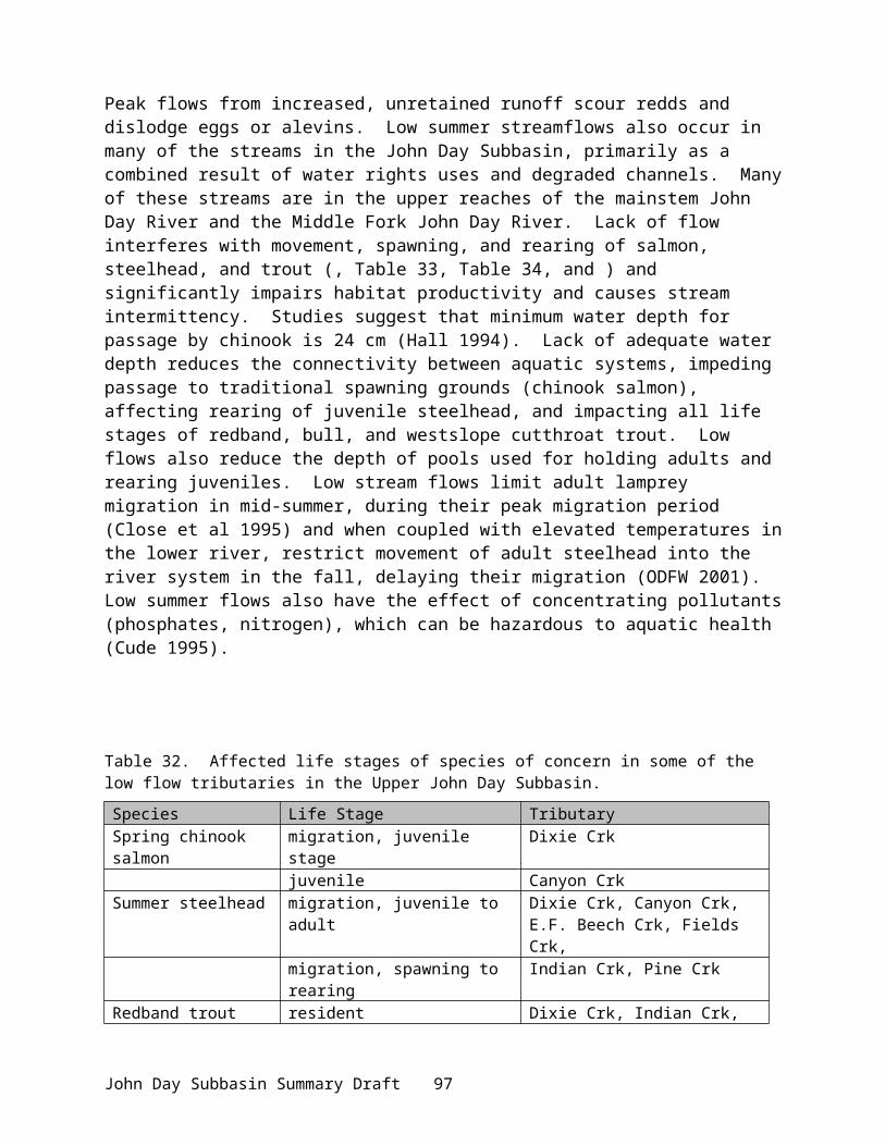
Existing Goals, Objectives and Strategies
The John Day Subbasin has diverse populations of fish and wildlife and unique areas of habitat that are of economic and ecological significance to the people of the State of Oregon and the Northwest, and of special cultural significance to members of the Warm Springs and Umatilla Tribes. The overall goal for the John Day Subbasin is to restore the health and function of the ecosystem to ensure continued viability of these important populations.
Numerous federal, state, and local entities are charged with maintenance and protection of the natural resources of the John Day Subbasin.
FederalNational Marine Fisheries Service and Federal Caucus
The goal of the NMFS with respect to the John Day Subbasin is to achieve the recovery of the salmon resource. This requires the development of watershed-wide properly functioning habitat conditions and a population level that is viable according to standards and criteria identified by NMFS in two key documents [Matrix of Pathways and Indicators (1996); Viable Salmonid Populations (2000)]. Actions which contribute to these objectives include moisture retention on crop lands, development of riparian vegetation, restoration of streamflow and appropriate hydrologic peak flow conditions, passage improvements and screening, and many other activities. By virtue of Section 7 responsibilities, any federal action requires consultation with NMFS. The recovery planning framework and effort will build upon existing conservation measures and develop additional critical information useful to fish and wildlife managers.
The federal Basinwide Strategy for salmon recovery developed by the federal caucus identifies immediate and long-term actions in the hydropower, hatchery, harvest, and habitat arenas. Importantly for this summary, it commits federal assistance to local efforts in these areas and is quite specific to the John Day watershed. These goals are outlined below.
Habitat GoalThe habitat goals of the Basinwide Salmon Recovery Strategy are: the existence of high quality habitats that are protected, degraded habitats that are restored and connected to other functioning habitats, and a system where further degradation of tributary and estuary habitat and water quality is prevented.
Near-term (5- 10 year) objectives for tributary habitat within the John Day Subbasin include:Objective 1. Restore and increase tributary flows to improve fish spawning, rearing, and
migration.Objective 2. Screen diversions, combine diversions, and rescreen existing diversions to comply
with NMFS criteria to reduce overall mortality. Objective 3. Reduce passage obstructions to provide immediate benefit to migration, spawning,
and rearing. Strategy 1. Federal agencies, state, and other to address all flow, passage, and screening
problems over the next 10 years in the John Day Subbasin. Action 1.1. USBR to implement actions in the Upper John Day Subbasin in 2001 Action 1.2. BPA to expand on measures under the NWPPC program to complement
USBR’s actions.
John Day Subbasin Summary Draft 101
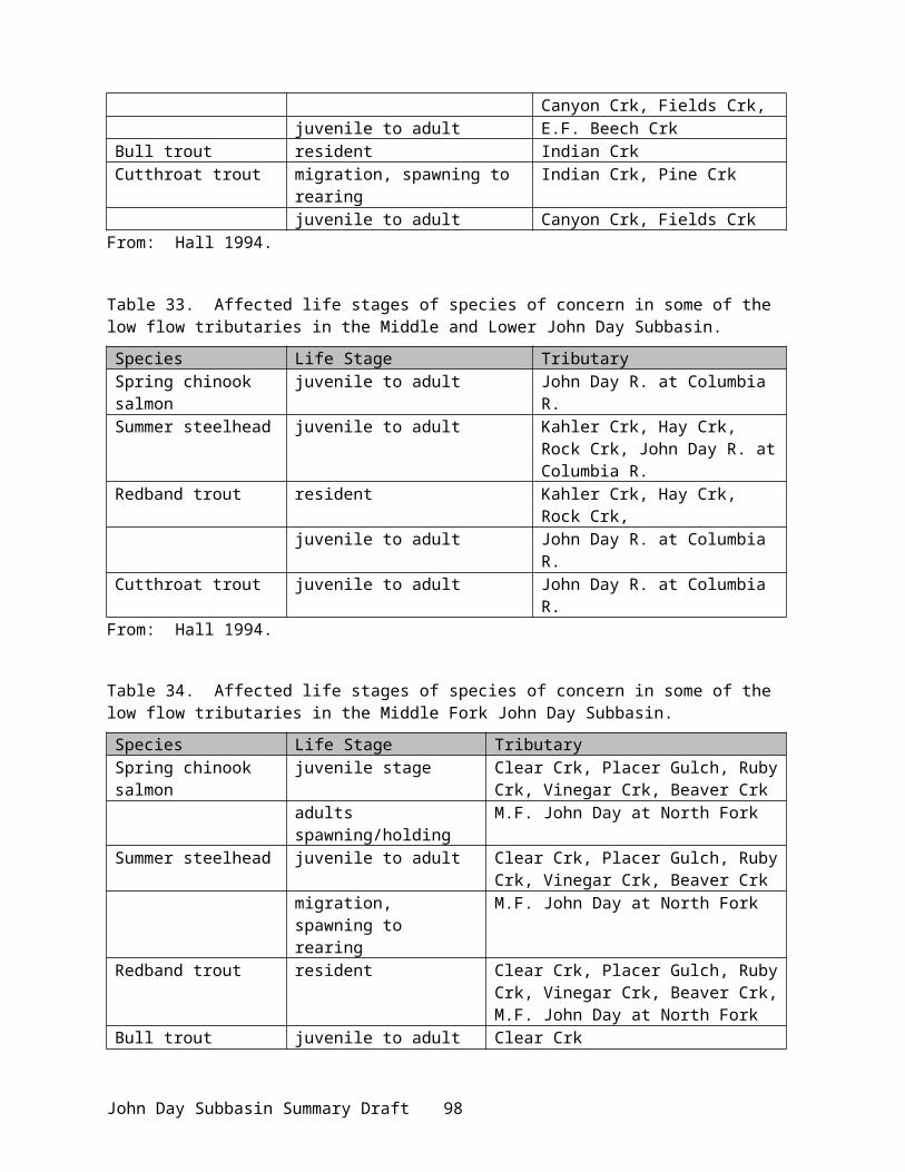
Action 1.3. NMFS to provide USBR with passage and screening criteria and methodologies for determining instream flows that satisfy ESA requirements.
Strategy 2. BPA funds protection of currently productive non-federal habitat, especially if at risk of being degraded.
Action 2.1. BPA and NMFS will develop criteria and priorities by June 2001.Action 2.2. Protect habitats through conservation easements, acquisitions, or other
means.Action 2.3. BPA works with non-profit land conservation organizations and others
to achieve habitat protection objectives.Strategy 3. Increase tributary flows through innovation actions.
Action 3.1. Establish a water brokerage as a transactional strategy for securing flows.
Action 3.2. Develop a methodology acceptable to NMFS for ascertaining instream flows that meet ESA requirements.
Strategy 4. Action Agencies to coordinate efforts and support off-site habitat enhancement measures undertaken by others
Action 4.1. Support development of state/tribal 303(d) lists and TMDLs by sharing water quality and biological monitoring information.
Action 4.2. Participate in TMDL coordination or consultation meetingsAction 4.3. Build on and use existing data management structures to improve data
sharing.Action 4.4. Share technical expertise and training with federal, state, tribal, regional,
and local entities.Action 4.5. Leverage funding resources through cooperative projects, agreements,
and policy development The program for tributary habitat is premised on the idea that securing the health of these habitats will boost productivity of listed stocks.
Hatchery GoalThe overarching goal for hatchery reform is reduced genetic, ecological, and management effects of artificial production that are adverse on the natural population. Although no hatchery programs exist within the John Day Subbasin, hatchery fish do. Objectives that are relevant to the John Day Subbasin include: Objective 1. Manage the number of hatchery-produced fish that escape to spawn naturally. Objective 2. Employ hatchery practices that reduce unwanted straying of hatchery fish into the
John Day Subbasin (i.e. appropriate acclimation in target streams such as the Umatilla, Deschutes, Snake, Yakima). For naturally spawning populations in critical ESU habitats, non-ESU hatchery-origin fish do not exceed 5%; ESU hatchery fish do not exceed 5%-30%.
Objective 3. Mark hatchery-produced fish to distinguish natural from hatchery fish on spawning grounds and in fisheries.
Objective 4. Design and conduct fishery programs so fish can be harvested without undue impacts on weaker stocks.
Research Monitoring and Evaluation GoalIdentified trends in abundance and productivity in populations of listed anadromous salmonids.
John Day Subbasin Summary Draft 102

Objective 1. Conduct population status monitoring to determine juvenile and adult distribution, population status, and trends.
Objective 2. Monitor the status of environmental attributes potentially affecting salmonid populations, their trends, and associations with salmonid population status.
Objective 3. Monitor the effectiveness of intended management actions on aquatic systems, and the response of salmonid populations to those actions.
Objective 4. Assess quality of available regional databases, in terms of accuracy and completeness, which represent habitat quality throughout the basin.
Objective 5. Monitor compliance of management actions toward proper implementation and maintenance.
Strategy 1. Conduct Tier 1 sampling to monitor broad-scale population status and habitat conditions.
Strategy 2. Conduct Tier 2 monitoring to obtain detailed population assessments and assessments of relationships between environmental characteristics and salmonid population trends.
Strategy 3. Conduct Tier 3 monitoring to establish mechanistic links between management actions and fish population response.
USFS and BLM (PACFISH)The Middle Fork John Day and South Fork John Day have been identified as high priority watersheds for near term fish habitat restoration by the federal land managers (NMFS 2000).
Fish and Fish Habitat Goals1. Restored water quality that provides for stable and productive riparian and aquatic
ecosystems.2. Restored stream channel integrity, channel processes, and sediment regimes under which
riparian and aquatic ecosystems developed.3. Restored instream flows supporting healthy riparian and aquatic habitats, stable and
effectively functioning stream channels, and rerouted flood discharges.4. Restored natural timing and variability of the water table elevation in meadows and
wetlands.5. Restored diversity and productivity of native and desired non-native plant communities in
riparian zones.6. Restored riparian vegetation a) providing large woody debris characteristic of natural
aquatic and riparian ecosystems, b) providing adequate summer and winter thermal regulation within the riparian and aquatic zones, c) achieving rates of surface erosion, bank erosion, and channel migration characteristic of those under which the communities developed.
7. Restored riparian and aquatic habitats necessary to foster the unique genetic fish stocks that evolved within the specific geo-climatic region.
8. Restored habitat to support populations of well-distributed native and desire non-native plant, vertebrate, and invertebrate populations that contribute to the viability of riparian-dependent communities.
Fish and Fish Habitat Objectives (Riparian Management Objectives - RMO)
Objective 1. Establish Pool Frequencies (#pools/mi) dependent on width of wetted streamWidth 10 20 25 50 75 100 125 150 200# 96 56 47 26 23 18 14 12 9
John Day Subbasin Summary Draft 103

pools
Objective 2. Comply with state water quality standards in all systems (max < 68°F)Objective 3. Establish large woody debris in all forested systems (> 20 pieces/mi, > 12 in
diameter, > 35 ft length).Objective 4. Ensure > 80% bank stability in non-forested systemsObjective 5. Reduce bank angles (undercuts) in non-forested systems (> 75% of banks with <
90% angle).Objective 6. Establish appropriate width/depth ratios in all systems (< 10, mean wetted width
divided by mean depth).
General Riparian Area ManagementObjective 1. Identify and cooperate with federal, Tribal, and state and local governments to
secure instream flows needed to maintain riparian resources, channel conditions, and aquatic habitat
Objective 2. Fell trees in Riparian Habitat Conservation Areas when they pose a safety risk. Keep felled trees on site when needed to meet woody debris objectives.
Objective 3. Apply herbicides, pesticides, and other toxicants/chemicals in a manner to avoid impacts that are inconsistent with attainment of RMOs.
Objective 4. Locate water drafting sites to minimize adverse effects on stream channel stability, sedimentation, and in-stream flows.
Watershed and Habitat RestorationObjective 1. Design and implement watershed restoration projects in a manner that promotes the
long-term ecological integrity of ecosystems, conserve the genetic integrity of native species, and contributes to attainment of RMOs.
Objective 2. Cooperate with federal, state, and tribal agencies, and private landowners to develop watershed-based CRMPs or other cooperative agreements to meet RMOs.
Fisheries and Wildlife RestorationObjective 1. Design and implement fish and wildlife habitat restoration and enhancement activities in a
manner that contributes to attainment of the RMOs. Objective 2. Design, construct, and operate fish and wildlife interpretive and other use-
enhancement facilities in a manner that is consistent with attainment of RMOs. Objective 3. Cooperate with federal, state, and tribal wildlife management agencies to identify
and eliminate wild ungulate impacts that are inconsistent with attainment of RMOs. Objective 4. Cooperate with federal, state, and tribal fish management agencies to identify and
eliminate impacts associated with habitat manipulation, fish stocking, fish harvest, and poaching that threaten the continued existence and distribution of native fish stocks inhabiting federal lands
John Day Subbasin Summary Draft 104

U.S. Bureau of ReclamationThe Stream Restoration/Water Optimization Program identified goals, objectives, and strategies for major subbasins within the John Day Subbasin as part of the Upper John Day Water Optimization Study. The overall goal of USBR is the provision of stewardship that ensures and encourages resource protection, conservation, and multiple use; and, fish, wildlife, and other natural resources that are protected as well as protected cultural resources, public health and safety, public access, and recreational opportunities.
Fish and Fish Habitat Goals (South and Middle Fork Restoration Plans)1. Increased anadromous and cold-water fish populations and their habitats.2. Restored and protected streambanks and reduced upland soil erosion.3. Sustained management of soil, water, plant, and animal resources for the benefit of the local
and regional economy.Objective. 1 Increase 80% exceedence flows in August and September.
Strategy 1. Increase flows in August and September by increasing tributary flows and changing headwaters of intermittent streams to perennial streams.
Objective 2. Moderate temperatures – reduce peak daily summer water temperatures to < 65 – 68°F.
Strategy 2.1. Improve quality and quantity of riparian habitat to achieve 80% coverage of the linear length of streams; 50% of vegetation shall be > 8 ft. in height.
Objective 3 Improve instream habitatStrategy 3.1. Increase hiding and rearing coverStrategy 3.2 Increase abundance and diversity of food resources for salmonids.Strategy3.3. Improve habitat diversity (increased pool-to-riffle ratios, woody debris,
boulders, sinuosity).Objective. 4: Improve fish passage.Objective. 5: Enhance soil stability
Strategy5.1. reduce watershed soil erosion by reducing sediment delivery from unimproved roads and accompanying ditches.
Strategy 5.2. promote compliance with range utilization standards.Strategy 5.3. improve streambank stability by planting native deciduous and coniferous
species in riparian zones.Strategy 5.4. use structural and other means as necessary to reduce or eliminate sediment
delivery from erosive and incised gullies.Strategy 5.5. promote improved range conditions through ranch plans.
Tribal (CRITFC 1995)Fish and Habitat Goals
1. Restored anadromous fish in rivers and streams that support the historical, cultural, and economic practices of the tribes.
2. Natural production and healthy river systems. 3. Protected Tribal sovereignty and treaty rights. 4. Reclaimed anadromous fish resource and environment on which the resource depends for
future generations.
Fish and Habitat ObjectivesObjective. 1. Improve in-stream flows in the John Day Subbasin.
John Day Subbasin Summary Draft 105

Strategy 1.1. Re-evaluate headwater storage potential in upper Middle Fork John Day River for enhancement of instream flows during critical low flow periods.
Strategy 1.2. Purchase, exchange, lease, or seasonally rent water rights for selected fish habitat during critical low flow periods.
Strategy 1.3. Implement more efficient irrigation methods and water conservation practices benefiting landowners and instream flows.
Objective. 2. Improve watershed management. Strategy 2.1. Increase shade cover to reduce stream temperatures (increased downstream
extent of temperatures < 60° F).Strategy 2.2 Reduce sediment from agricultural practices and unimproved roads.Strategy 2.3. Reduce nitrate, phosphates, bacteria and other contaminants related to
agricultural practices.Note: Priorities are the Upper South Fork John Day River and tributaries, Middle Fork John Day, upper mainstem John Day, Camas Creek.
Objective. 3. Implement and improve riparian restoration.Strategy 3.1. Implement Upper Grand Ronde Anadromous Fish Habitat (UGR) Plan on
state, federal, and tribal land.Strategy 3.2. Implement Best Management Practices (BMP), including stream buffers, to
benefit fish on private lands.Strategy 3.3 Acquire, lease, or implement management agreement to restore natural
floodplain habitat and function.Note: Priorities are the Upper South Fork John Day and tributaries, Middle Fork John Day,
upper mainstem John Day and Camas Creek.Objective 4. Improve range management
Strategy 4.1. Revise and implement BMPs to be consistent with UGR Plan Standards and Guidelines (S&Gs).
Strategy 4.2. Restrict and remove livestock in substandard areas.Strategy 4.3. Acquire, lease, develop projects in priority areas.
Objective 5. Improve forest management.Strategy 5.1. Upgrade, monitor, enforce Forest Practices Act consistent with UGR Plan
S&Gs on private lands.Strategy 5.2. Implement UGR Plan S&Gs on state, federal, and tribal lands.Strategy 5.3. Identify and implement active restoration projects.Strategy 5.4. Institute or continue protection of “good” habitat areas such as North Fork,
upper mainstem John Day River and tributaries, and Middle Fork tributaries in theVinegar Hill area.
Objective 6. Reduce mining impacts.Strategy 6.1. Mitigate for impacts of mining tailings in the North Fork John Day River
system.Objective 7. Improve or implement laws, codes, enforcement, and revision.
Strategy 7.1. Ensure ODEQ and EPA complete TMDL for stream temperatures, sediment, and other pollutants, as per the Clean Water Act.
Strategy 7.2. Enforce Oregon fish screening statutes.Strategy 7.3. Enforce Oregon Forest Practices Act to be consistent with UGR Plan.Strategy 7.4. Upgrade Forest Service Land and Resource Management Plans consistent with
UGR Plan to be in compliance with National Forest management.
John Day Subbasin Summary Draft 106
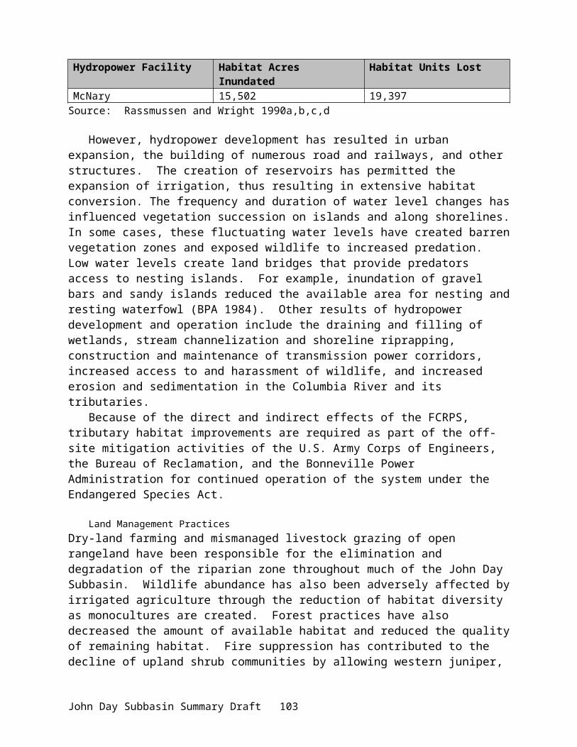
Strategy 7.5. Revise mining laws to be consistent with production of high quality water and fish habitat.
Tribal and StateUmatilla and Warm Springs Tribes and Oregon Department of Fish and Wildlife
The vision of the Oregon Department of Fish and Wildlife is that “Oregon’s fish and wildlife are thriving in healthy habitats due to cooperative efforts and support by all Oregonians” (ODFW 2000). The vision for the John Day Subbasin among state and tribal resource managers is improved basin habitat for the enhancement and productivity of wild spring chinook salmon, summer steelhead, native resident trout, and numerous wildlife species (ODFW et al. 1990). The following objectives and strategies were developed cooperatively by ODFW and the Warm Springs and Umatilla Tribes in 1990 as part of the System Planning effort for NWPPC (i.e., John Day Subbasin Plan).
Habitat ObjectivesObjective 1: Protect existing anadromous fish habitat by preventing further watershed
degradation in the form of water quality, quantity, and instream habitat. Objective 2: Restore optimum habitat (temperature, flows) for all life history stages of
anadromous salmonids.Objective 3: Protect, restore, and maintain suitable habitat conditions for all bull trout life
history stages.Objective 4. Protect and maintain remaining high quality riparian and upland habitats.Objective 5. Maintain or increase wildlife species diversity.Objective 6: Pursue habitat protection through local, state, and federal agency coordination.
Habitat StrategiesStrategy 1. Grazing: Develop livestock control measures to include limited grazing periods,
reduced stocking rates, temporary or permanent stream corridor fencing, and management of riparian pasture systems.
Strategy 2. Mining: Require mining and dredging operations to meet county, state, and federal regulations. Ensure that the Department of Environmental Quality, Environmental Protection Agency, and Oregon Division of State Lands jointly develop guidelines, standards, and enforcement procedures for protection of streambed conditions under provisions of the 1987 amendments to the Clean Water Act, Title III – Standards and Enforcement, Sections 301-310, and 404. Prevent mining activities in or near critical fish habitat.
Strategy 3. Road Building: Enforce Forest Service Practices Rules requiring adequate maintenance or closure and rehabilitation of roads. Social, economic, wildlife, fisheries, and recreation factors must be considered and positive road management plans developed to close unnecessary roads and return them into resource production where possible. Examine alternative road construction sites in areas classified as having high erosion and slope failure potential.
Strategy 4. Timber Harvest: Develop a system for classifying and mapping forest lands susceptible to erosion, including slope failures, streamside landslides, gully erosion, and surface erosion. Such a system should take into account the potential for damage to downstream resources in addition to the potential for on-site erosion.
John Day Subbasin Summary Draft 107
Strategy 5. Timber Harvest: Require the USFS, BLM, and ODF to increase monitoring of timber harvest activities for compliance with rules, guidelines, and recommendations for habitat protection.
Strategy 6. Pesticide and Herbicide Use: Encourage that chemical treatments from federal, state, and private individuals for plant and insect control adjacent to waters in the John Day River Subbasin will not endanger fish life and aquatic organisms or damage watershed and riparian systems.
Strategy 7. Water Quality and Quantity: Require the EPA, ODEQ, BLM, and USFS to establish monitoring programs required by the Clean Water Act (Sections 301-310), the National Forest Management Act, and the National Environmental Protection Act (NEPA).
Strategy 8. Encourage the ODEQ, EPA, and DSL to enforce guidelines, standards, and procedures for protection of streambed conditions under provisions of the Clean Water Act (1987 amended)
Strategy 9. Continue landowner involvement and cooperation in protecting, restoring, and enhancing riparian systems and watersheds.
Strategy 10. Encourage the DSL to develop procedures and provide manpower to monitor compliance with fill and removal permit conditions
Strategy 11. Develop acceptable methods of erosion control for necessary bank protection, through agency and landowner cooperation.
Strategy 12. Apply for instream water rights or recommend additional sites for adoption of minimum streamflow by the Water Resources Commission.
Strategy 13. Require all diversion inlets be properly screened and maintained as required by the Fish Screen Law (1987) and ORS 509.615.
Strategy 14. Monitor irrigators to ensure all diversion structures minimally provide adult and juvenile passage as required by state law
Strategy 15. Obtain funding for landowners through state and federal agencies to implement more efficient irrigation methods and develop water conservation practices benefiting landowners and instream flows.
Strategy 16. Promote, purchase, lease, exchange, or seasonally rent water rights for selected fish habitat during critical low flow periods
Strategy 17. Support purchase, lease, or easement of habitat areas from willing landowners.Strategy 18. Develop a comprehensive plan for reintroduction, regulation, and management
of beaver in suitable sites in the John Day Subbasin for the specific purpose of using beaver to restore streamflows, improve fish habitat, and improve watersheds
Strategy 19. Support and expand existing watershed programsStrategy 20. Develop a system of riparian natural areas associated with critical fish habitat
throughout the basinStrategy 21. Protect, enhance, and restore wildlife habitat in the subbasin.
Action 21.1. Determine and monitor abundance and distribution of wildlife species to identify and prioritize wildlife habitat restoration needs in the subbasin.
Action 21.2 Conduct periodic comprehensive habitat and biological surveys to identify and prioritize wildlife habitat restoration needs in the subbasin.
Action 21.3. Implement wildlife habitat restoration projects in the subbasin. Action 21.4. Acquire or lease lands with priority habitats to permanently protect
wildlife habitats in the subbasin.
John Day Subbasin Summary Draft 108
Action 21.5. More actively manage lands set aside for wildlife, such as CRP and CREP, to increase species diversity on those lands.
Action 21.6. Decommission unnecessary roads to reduce harassment of wildlife and encourage more uniform use of available wildlife habitat
Action 21.7. Manage habitat to meet state management guidelines for upland birds and game mammals.
Strategy 22. Protect federal and state threatened, endangered, and sensitive wildlife species.Action 22.1. Increase enforcement of laws pertaining to wildlife. Action 22.2. Provide protection for federal and state threatened, endangered, and
sensitive wildlife species in all resource management plans. Action 22.3. Enforce state and local land use regulations designed to protect
wildlife habitats.
Fish Goals Fish managers have agreed to the following fisheries goal and objectives through the U.S. v. Oregon and NWPPC planning process. The John Day River will be managed for production of wild anadromous fish and increased production from the basin will be attained primarily by protecting high quality habitat and by improving degraded habitat. Goal: Productive, healthy, and sustainable wild populations of anadromous spring chinook salmon and summer steelhead, and resident trout populations and protected habitat for their continued viability. Provision of warm-water fisheries that are not in conflict with indigenous fish needs.
Fish Objectives and StrategiesObjectives for Spring Chinook Salmon and Summer Steelhead
Objective 1. Develop an average annual return of approximately 7,000 spring chinook salmon to the mouth of the John Day River to provide approximately 5,950 fish to meet escapement needs for natural production.
Objective 2. Provide approximately 1,050 spring chinook salmon for sport and tribal harvest. Objective 3. Develop an average annual return of approximately 45,000 summer steelhead to the
mouth of the John Day River to provide approximately 33,750 steelhead to meet escapement needs for natural production.
Objective 4. Provide approximately 11,250 summer steelhead for sport and tribal harvest. Note: Spawning escapement goals are based on smolt production estimates (habitat carrying capacity) as specified in U.S. v Oregon.
Strategies for Spring Chinook SalmonStrategy 1. Improve habitat, enhance streamflows, and improve screens at water diversions.
Action 1.1. Improve habitat on the mainstem John Day River and selected tributaries from John Day (RM 248) to Call Creek (RM 278). Stabilize banks through fencing, controlled livestock use, planting and rock or juniper riprap, boulder placement, deflectors, weirs, and pool excavation. These actions will decrease erosion, increase flow, restore riparian cover for stream temperature control, and improve pool-to-riffle rations thus improving juvenile rearing and pre-spawner survival.
Action 1.2. Improve habitat on the Middle Fork John Day River and selected tributaries from Mosquito Creek (RM 39) to Summit Creek (RM 72).
John Day Subbasin Summary Draft 109

Stabilize banks and exchange or purchase land to create natural riparian areas.
Action 1.3. Improve habitat on the North Fork John Day from Dale (RM 60) to North Fork Campground (RM 102), including North Fork tributaries of Desolation, Camas, Big Wall, Potamus, Mallory, Ditch, Deer, Rudio, Cottonwood, Granite, and Bull Run creeks.
Action 1.4. Enhance streamflows for optimum fish production. Investigate and implement the following projects: ▪ improve irrigation efficiency. ▪ develop a water conservation program with OWRD and irrigators. ▪ enforce established minimum streamflows by the OWRD. . ▪ apply for and obtain instream water rights. . ▪ improve seasonal distribution of water through watershed improvement, riparian storage, and beaver management. .
Action 1.5. Maintain and improve proper screening of water diversionsStrategy 2. Increase law enforcement activities and adopt trout angling regulations, as
needed, to protect adult spring chinook salmon. Action 2.1. Increase law enforcement on the North Fork John Day and Granite and
Clear creeksAction 2.2. Increase law enforcement activities on the Middle Fork John Day River.
Strategy 3. Implement monitoring and evaluation and associated harvest activities.Action 3.1. Develop run size estimate models for run size monitoring based on
previous years escapement and spawning ground information to make sound harvest allocation decisions
Action 3.2. Provide for a regulated tribal and sport harvest of spring chinook salmon in the John Day River. Co-managers determine harvest quotas and develop a sport and tribal harvest program to include:
▪ location and timing of sport and tribal harvest▪ apportionment of harvest by individual tributary▪ method of harvest
▪ reporting of harvest
Strategies for Summer SteelheadStrategy 1. Improve habitat, provide adult passage, and enhance streamflows.
Action 1.1. Improve habitat on selected tributaries (Table 47). Actions to include bank stabilization through various techniques and practices.
Action 1.2. Improve screening on selected tributaries (Table 47) involving the statewide screening program.
John Day Subbasin Summary Draft 110
Table 47. River sections and streams needing improved habitat and screening for summer steelhead production.
River Section TributariesNorth Fork Clear, Desolation, Camas, Fivemile, Owens, Snipe, Hidaway, Cable,
Butcherknife, Frazier, Rancheria, Bear Wallow, Lane, Bowman, Salsbury, Big Wall, Little Wall, Three Trough, Skookum, Alder, Swale, Porter, Stony, East Fork Meadowbrook, Wilson, Cottonwood, Rudio, Gilmore, Potamus, Mallory, Ditch, Deer, Trail, Beaver, Granite, Boulder, Bull Run, Corral, Boundary, Deep, Olive, Crane, North Trail, South Trail, Middle Trail, Davis creeks
Middle Fork Camp, Long, Davis, Vincent, Caribou, Clear, Beaver, Slide, Butte, Placer Gulch, Bridge, Summit, Idaho, Squaw creeks
Upper Mainstem
Cottonwood, Mountain, Rock, Badger, Beech, East Fork Beech, McClellan, Tinker, Canyon, East Fork Canyon, Middle Fork Canyon, Reynolds, Deardorff, Fields, Riley, Bear, Hall, Pine, Indian, Grub, Dixie, Roberts creeks
South Fork Upper Murderers, Tex, Deer, Sunflower, Pine, Brisbois, Utley, Rosebud, Lewis, Lonesome, Grasshopper, Flat, Alder, Corral, Vestor and Venator creeks and mainstem South Fork
Lower John Day
Rock, Hay, Ferry Canyon, Indian Springs Canyon, Lamberson Canyon, Robinson Canyon, Jackknife, Parrish, Alder, Thirtymile, East Fork Thirtymile, Trial Fork, Pinehollow, Butte, Pine, Cherry, Bridge, Bear, Horseshoe creeks
Action 1.2. Provide adult summer steelhead passage at selected tributaries. ▪ Provide passage at Fivemile and Thirtymile creeks.
Strategy 2. Implement monitoring and evaluation and associated harvest activities.Action 2.1. Develop run size estimate models for run size monitoring based on
previous years escapement and spawning ground information to make sound harvest allocation decisions.
Action 2.2. Provide for a regulated tribal and sport harvest of summer steelhead in the John Day River. Co-managers determine harvest quotas and develop a sport and tribal harvest program.
Action 2.3. Monitor for hatchery strays into the system; identify origin of hatchery fish.
Action 2.4. Conduct a fishery for marked steelhead only; catch and release of wild fish.
Action 2.5 Monitor counts of wild a-run steelhead at Bonneville Dam as a method to assess escapement of wild steelhead into the John Day River.
Bull Trout Recovery Team (State, Federal, Tribal)The vision for bull trout is a stable and long-term persistence where populations are no longer threatened by extinction.Objective 1: Maintain distribution of bull trout in core areas and re-establish bull trout in
previously occupied habitats in the upper mainstem John Day River, Middle Fork John Day River, North fork John Day River, and all associated tributaries.
Strategy 1.1. Propose specific reintroductions, monitoring, and criteria for evaluating results that follow state and federal guidelines for public process, donor stocks, disease factors, impacts on other native species, and genetic concerns; consider Hidaway Creek for bull trout reintroduction.
John Day Subbasin Summary Draft 111
Strategy 1.2. Proceed with introductions after obtaining approval and funding. Strategy 1.3. Develop and conduct research and monitoring studies to improve information
concerning the distribution and status of bull troutAction 1.3.1. Design and implement standardized, statistically sound bull trout
population monitoring programs for each local population. Document historic distribution
Action 1.3.2. Conduct regular surveys in potential habitat where bull trout status in unknown or recolonization is anticipated.
Action 1.3.3. Develop and maintain a centralized database repository for all bull trout distribution and monitoring data.
Strategy 1.4. Identify evaluations needed to improve understanding of relations among genetic characteristics, phenotypic traits, and local populations of bull trout.
Action 1.4.1. Determine life history requirements of local resident and migratory bull trout populations. Focus on forms in the John Day Basin.
Action 1.4.2. Determine mechanism by which migratory life forms undergo transition to resident forms
.Action 1.4.3. Determine consequences of genetic fragmentation/isolation due to human-made barriers
Action 1.4.4. Assess severity of threat due to hybridization with brook trout. Action 1.4.5. Determine movement and seasonality of use of different habitat
types of adult and sub-adult migratory bull trout in the upper mainstem John Day, North Fork John Day, and Middle Fork John Day
Action 1.4.6. Evaluate food web interactions in drainages most affected by introduced fish.
Objective. 2. Maintain stable or increasing trends in bull trout abundance in the John Day Recovery Unit by increasing abundance within the 3 local populations.
Strategy 2.1 Design and implement a standardized monitoring program to assess the effectiveness of recovery efforts affecting bull trout and their habitats.
Action 2.1.1. Evaluate effectiveness of different active and passive habitat restoration techniques in restoring watershed function and local bull trout populations.
Strategy 2.2. Conduct research evaluating relations among bull trout, trout habitat, and recovery tasks.
Action 2.2.1. Determine suitability of temperature regimes in currently occupied and potentially restorable bull trout drainages. Prioritize and coordinate temperature monitoring activities amongst streams and between agencies. Establish mechanisms for sharing of water temperature data.
Action 2.2.2. Determine range of temperature tolerances for bull trout life stags in different habitats and how bull trout use habitat relative to changing temperatures; use results of ongoing temperature studies to address the adequacy of existing state rules.
Strategy 2.3. Evaluate effects of diseases and parasites on bull trout and develop and implement appropriate tasks to minimize negative effects.
John Day Subbasin Summary Draft 112
Action 2.3.1. Research effects of whirling disease on bull trout; monitor for presence of whirling disease in important bull trout spawning and rearing areas.
Action 2.3.2. Implement methods and practices to reduce fisheries and habitat management activities that increase risk of disease transmission.
Action 2.3.3. Maintain fish health screening and transplant protocols to reduce risk of disease transmission.
Action 2.3.4. If necessary, prevent, control, and eradicate diseases that may impact bull trout.
Strategy 2.4. Implement tasks to control nonnative fishes where found to be feasible and appropriate.
Action 2.4.1. Evaluate presence/absence of introduced fishes in bull trout habitat and determine site specific biological, economic, and social impacts (e.g.,brook trout in Desolation Creek, North Fork, and Upper mainstem).
Action 2.4.2. Implement nonnative species removal efforts wherever feasible and biologically supportable (Desolation Creek).
Strategy 2.5. Evaluate potential effects of introduced fishes and associated fisheries on bull trout recovery and implement tasks to minimize negative effects on bull trout
Action 2.5.1. Determine site-specific level of competition and hybridization with introduced sport fish and assess impacts of those interactions, especially rainbow trout, brook trout, and smallmouth bass.
Action 2.5.2. Evaluate site-specific impacts of predation on different life stages of bull trout.
Objective 3: Restore and maintain suitable habitat conditions for all bull trout life history stages and strategies.
Strategy 3.1. Maintain areas with adequate water quality and eliminate pollution sources in areas with poor water quality in bull trout core habitat or potential core habitat.
Action 3.1.1. Stabilize roads, crossings, and other sources of sediments delivery; obliterate and restore vegetation on unneeded roads (Galena and Upper Middle Fork areas)
Action 3.1.2. Control industrial, agricultural, and sewage effluent runoff (e.g.,effluent from some mine shafts in Granite/Clear Creek system in the Upper North Fork John Day River).
Action 3.1.3. Remedy significant sources of thermal effluent (e.g.,irrigation return flows).
Action 3.1.4. Assess and attempt to mitigate effects on bull trout from nonpoint sources of pollution (e.g.,grazing effects)
Strategy 3.2. Identify areas and structures that are barriers or sites of entrainment for bull trout and implement tasks to provide passage and eliminate entrainment
Action 3.2.1. Screen water diversions and irrigation ditches (e.g.,problem with old fish screen on Indian Creek (upper mainstem JD) at the Strawberry Wilderness Area boundary)
Action 3.2.2. Install appropriate fish passage structures around diversions and/or remove related migration barriers. Ensure all diversions are “fish friendly” including combining diversions, converting to pump/infiltration gallery, adjustable headgates, measuring devices, effective ditches (low
John Day Subbasin Summary Draft 113

flow loss via seepage or breaching). Include a maintenance and monitoring component
Action 3.2.3. Restore connectivity and opportunities for migration by securing instream flows and/or water rights (e.g.,Pete Mann ditch); reduce winter tock water flows.
Strategy 3.3. Identify where stream channel and riparian area contributions to bull trout habitats are impaired and implement tasks to restore their appropriate functions.
Action 3.3.1. Revegetate to restore shade and canopy, riparian cover, and native vegetation in Cable, Oriental and Hidaway Creeks within the Tower Fire area; South Fork Desolation Creek, and Big Creek within the Summit Fire Area; migratory habitat on Federal and private lands of the Middle Fork and private checkerboard lands in upper mainstem JD; private ranchlands along in upper mainstem JD between headwaters and town of John Day.
Action 3.3.2. Reduce grazing impacts with current, proven technology (e.g.,fencing, changes in timing and use of riparian pastures, off site watering and salting)
Action 3.3.3. Conduct stream channel restoration activities where warranted and cost-effective. Continue re-distribution of dredge tailing piles in parts of the North Fork John Day River and the Clear Creek system to restore a more natural stream channel morphology and flood plain access for the stream. Restore stream channel to eliminate head cuts in Desolation Meadow (North Fork Desolation Creek) and Owens Creek.
Action 3.3.4. Increase or improve instream habitat by restoring recruitment of large woody debris or other means.
Strategy 3.4 Identify uncertain bull trout habitat areas and factors affecting them; implement tasks to alleviate uncertainty and address factors negatively affecting habitats.
Action 3.4.1. Determine, document, and assess historic and present conditions in each habitat type by watershed; conduct spawning ground surveys to identify existing spawning habitat for bull trout populations in Desolation Creek and tributaries, and upper Clear Creek and tributaries.
Action 3.4.2. Identify site-specific threats that may be limiting bull trout in watersheds not already evaluated.
Strategy 3.5. Use partnerships and collaborative processes to protect, maintain, and restore functioning core habitat areas for bull trout.
Action 3.5.1. Provide long-term habitat protection through purchase, conservation easements, management plans, land exchanges. Potential candidates include: Lower Desolation Creek, privately-owned Crown Pacific lands of the Upper John Day, private parcels in the Middle Fork above Big Creek
Action 3.5.2. Develop educational materials on bull trout and their habitat needs (e.g.,watershed function and form, riparian and side channel restoration, large wood placement)
Action 3.5.3. Review implementation compliance and effectiveness (audits) of existing regulatory standards towards maintaining bull trout habitat components (e.g.,Clean Water Act
Strategy 3.6. Identify where conditions outside of riparian areas (uplands) are negatively affecting bull trout habitats and implement tasks to restore appropriate functions.
John Day Subbasin Summary Draft 114

Action 3.6.1. Integrate watershed analyses and restoration activities on public lands. Action 3.6.2. Assess current and historic effects of upland management on changes to
the hydrograph (timing, magnitude of peak flows); areas to include private lands and ranches in Upper John Day, effects from Malheur NF heavy timber harvest and road-building activities in the Middle Fork subbasin.
Action 3.6.3. Assess current risk of catastrophic fire to bull trout populations.Action 3.6.4. Take corrective action to reduce risk of catastrophic fire to bull trout
populations.Action 3.6.5. Plant site appropriate vegetation in the Tower, Summit, and Bull fire
areas, focusing on areas far from existing seeding sources and requiring generations for natural recovery.
Objective 4: Conserve genetically diverse bull trout populations within the John Day RU.Strategy 4.1. Develop and implement tasks to characterize, conserve, and monitor genetic
diversity and gene flow among local populations of bull trout. Action 4.1.1. Document genetic baselines and monitor for each local population. Action 4.1.2. Implement tasks that maintain existing gene flow among bull trout and
provide opportunities for volitional gene flow where feasible and appropriate.
StateOregon Revised Statutes are laws passed by the legislative bodies (House and Senate) of Oregon, giving guidance to ODFW for management of fish and wildlife resources. ORS 496.012 refers specifically to wildlife, but fish are included as part of wildlife.
Oregon Revised Statute - ORS 496.012Goals:1. Species of wildlife maintained at optimum levels.2. Lands and waters of this state that are developed and managed to enhance the production and
public enjoyment of wildlife.3. Utilization of wildlife that is orderly and equitable.4. Public access to lands and waters of the state, and the wildlife resources thereon, that are
developed and maintained.5. Wildlife populations and public enjoyment of wildlife are regulated compatibly with primary
uses of the lands and waters of the state. 6. Provision of optimal recreational benefits
Oregon Department of Fish and WildlifeWildlife GoalsOregon Wildlife Diversity Plan (ODFW 1993)Maintained wildlife diversity in Oregon that is protected and enhanced, including
populations and habitats of native non-game wildlife at self-sustaining levels throughout natural geographic ranges.
Objective 1. Protect and enhance populations of all existing native non-game species at self-sustaining levels throughout their natural geographic ranges by supporting the maintenance, improvement or expansion of habitats and by conducting other conservation actions.
John Day Subbasin Summary Draft 115

Strategy 1.1. Maintain existing funding sources and develop new sources of public, long-term funding required to conserve the wildlife diversity of Oregon.
Strategy 1.2. Identify and assist in the preservation, restoration and enhancement of habitats needed to maintain Oregon’s wildlife diversity and non-consumptive recreational opportunities.
Strategy 1.3. Monitor the status of non-game populations on a continuous basis as needed for appraising the need for management actions, the results of actions, and for evaluating habitat and other environmental changes.
Objective 2. Restore and maintain self-sustaining populations of non-game species extirpated from the state or regions within the state, consistent with habitat availability, public acceptance, and other uses of the lands and waters of the state.
Strategy 2.1 Identify, establish standards and implement management measures required for restoring threatened and endangered species, preventing sensitive species from having to be listed as threatened or endangered, and maintaining or enhancing other species requiring special attention.
Strategy 2.2 Reintroduce species or populations where they have been extirpated as may be feasible.
Objective 3. Provide recreational, educational, aesthetic, scientific, economic and cultural benefits derived from Oregon’s diversity of wildlife.
Strategy 3.1 Develop broad public awareness and understanding of the wildlife benefits and conservation needs in Oregon.
Strategy 3.2 Increase or enhance opportunities for the public to enjoy and learn about wildlife in their natural habitats.
Strategy 3.3 Seek outside opportunities, resources and authorities and cooperate with other agencies, private conservation organizations, scientific and educational institutions, industry and the general public in meeting Program Objectives.
Strategy 3.4 Maintain and enhance intra-agency coordination through dissemination of Program information, development of shared databases and coordination of activities that affect other Department divisions and programs; identify activities within other programs which affect the Wildlife Diversity program, and develop mutual goals.
Objective 4. Address conflicts between non-game wildlife and people to minimize adverse economic, social, and biological impacts.
Strategy 4.1 Assist with non-game property damage and nuisance problems without compromising wildlife objectives, using education and self-help in place of landowner assistance wherever possible.
Strategy 4.2 Administer the Wildlife Rehabilitation Program.Strategy 4.3 Administer the Scientific Taking Permits Program.Strategy 4.4 Administer Wildlife Holding and other miscellaneous permits.Strategy 4.5 Provide biological input to the Falconry Program for the establishment of raptor-
capture regulations. Strategy 4.6 Update the Wildlife Diversity Plan every five years.
Oregon Black Bear Management Plan (ODFW 1987)
John Day Subbasin Summary Draft 116

Black bear populations in Oregon are protected and enhanced, providing optimum recreational benefits to the public and compatible with habitat capability and primary land uses.Objective 1. Determine black bear population characteristics.
Strategy 1.1 Implement or cooperate in research to learn more about black bear ecology in Oregon, develop accurate populations estimates and provide a measurement of population trend.
Objective 2. Determine black bear harvest levels.Strategy 2.1 Obtain improved harvest information through use of combination report
card/tooth envelope.Strategy 2.2 Monitor black bear harvest and implement harvest restrictions if necessary.Strategy 2.3 Develop an educational program to alert black bear hunters of the need for
improved black bear population information.Strategy 2.4 If necessary, initiate mandatory check of harvested black bear.
Objective 3. Continue current practice of allowing private and public landowners to take damage causing black bear without a permit.
Strategy 3.1 The Department will not seek any changes in current statutes.Strategy 3.2 Continue to work with other agencies and private landowners in solving black
bear depredation problems.Strategy 3.3 Explore the possibility of using sport hunters for damage control.
Oregon’s Cougar Management Plan (ODFW 1993a)1. Cougars are valued by many Oregonians and recognized as an important part of Oregon’s
wildlife fauna.2. Cougar populations are healthy within the state and into the future.3. Healthy populations of cougar are managed with a recognition of the desires of the public and
the statutory obligations of the Department.
Objective 1. Continue to gather information on which to base cougar management.Strategy 1.1 Continue to authorize controlled cougar hunting seasons conducted in a manner
that meets the statutory mandates to maintain the species and provide consumptive and non-consumptive recreational opportunities.
Strategy 1.2 Continue to study cougar population characteristics as well as the impact of hunting on cougar populations.
Strategy 1.3 Continue to update and apply population modeling to track the overall cougar population status.
Strategy 1.4 Continue mandatory check of all hunter-harvested cougar and evaluate the information collected on population characteristics for use in setting harvest seasons.
Strategy 1.5 Continue development of a tooth aging (cementum annuli) technique.
Objective 2. Continue to enforce cougar harvest regulations.Strategy 2.1 Continue to work with OSP to monitor the level of illegal cougar hunting
activity.Strategy 2.2 Implement appropriate enforcement actions and make the necessary changes in
regulations to reduce illegal cougar hunting.
John Day Subbasin Summary Draft 117

Strategy 2.3 Continue to inspect taxidermist facilities and records to discourage and document the processing of cougar hides lacking Department seals.
Objective 3. Document and attempt to eliminate potential future human-cougar conflicts.Strategy 3.1 Provide information to the public about cougar distribution, management needs,
behavior, etc.Strategy 3.2 Attempt to solve human-cougar conflicts by non-lethal methods.Strategy 3.3 Consider additional hunting seasons or increased hunter numbers in areas where
human-cougar conflicts develop.Strategy 3.4 Manage for lower cougar population densities in areas of high human
occupancy.
Objective 4. Manage cougar populations through controlled hunting seasons.Strategy 4.1 Base regulation modifications on population trends, as annual fluctuations in the
weather can greatly influence recreational cougar harvest. Strategy 4.2 Continue to regulate cougar hunting through controlled permit seasons.
Objective 5. Continue to allow private and public landowners to take damage-causing cougar without a permit.
Strategy 5.1 No changes will be sought to existing damage control statutes.Strategy 5.2 Continue to work with landowners to encourage reporting of potential damage
before it occurs, with the goal of solving complaints by other than lethal means.Strategy 5.3 Continue to emphasize that damage must occur before landowners or agents of
the Department may remove an offending animal. Strategy 5.4 Encourage improved livestock husbandry practices as a means of reducing
cougar damage on domestic livestock. Strategy 5.5 Continue to work with other agencies to solve cougar depredation problems.
Objective 6. Manage deer and elk populations to maintain the primary prey source for cougar.Strategy 6.1 Work with landowners and public land managers to maintain satisfactory deer,
elk and cougar habitat. Strategy 6.2 Evaluate the effects of human activities and human disturbance on cougar.Strategy 6.3 Take action to correct problems in areas where human access is detrimental to
the welfare of cougar or their prey base.
Mule Deer Management Plan (ODFW 1990)1. Enhanced deer numbers in areas that are currently below management objectives2. Population levels that are maintained where management objectives are currently met3. Population levels that are reduced in the areas where deer numbers exceed population
management objectives. Population objectives were set by Oregon Department of Fish and Wildlife Commission action in 1982 and are to be considered maximums.
Objective 1. Set management objectives for buck ratio, population and fawn:doe ratio benchmark for each hunt unit and adjust as necessary.
Strategy 1.1 Antlerless harvest will be used to reduce populations, which exceed management objectives over a two or three year period.
John Day Subbasin Summary Draft 118

Strategy 1.2 Harvest tag numbers are adjusted to meet or exceed objectives within 2-3 bucks/100 does.
Strategy 1.3 Population trends will be measured with trend counts, number of deer damage incidents, and harvest data.
Strategy 1.4 Update Mule Deer Plan every five years.
Objective 2. Hunter opportunity will not be maintained at the expense of meeting population and buck ratio management objectives.
Oregon’s Elk Management Plan (ODFW 1992)Elk populations in Oregon that are protected and enhanced elk populations, providing
optimum recreational benefits to the public and compatible with habitat capability and primary land uses.
Objective 1. Maximize recruitment into elk populations and maintain bull ratios at Management Objective levels. Establish Management Objectives for population size in all herds, and maintain populations at or near those objectives.
Strategy 1.1 Maintain bull ratios at management objectives.Strategy 1.2 Protect Oregon’s wild elk from diseases, genetic degradation, and increased
poaching which could result from transport and uncontrolled introduction of cervid species.
Strategy 1.3 Determine causes of calf elk mortality.Strategy 1.4 Monitor elk populations for significant disease outbreaks, and take action when
and were possible to alleviate the problem. Strategy 1.5 Improve data collection procedures to attain necessary information at 80%
confidence level with a 20% bound on error. Strategy 1.6 Establish population models for aiding in herd or unit management decisions.Strategy 1.7 Adequately inventory elk populations in all units with significant number of elk.
Objective 2. Maintain, enhance and restore elk habitat.Strategy 2.1 Ensure both adequate quantity and quality of forage to achieve elk population
management objectives in each management unit. Strategy 2.2 Ensure habitat conditions necessary to meet population management objectives
are met on critical elk ranges. Strategy 2.3 Prevent elk damage to private land where little or no natural winter range
remains. Strategy 2.4 Maintain public rangeland in a condition that will allow elk populations to meet
and sustain management objectives in each unit. Strategy 2.5 Reduce wildlife damage to private land.
Objective 3. Enhance consumptive and non-consumptive recreational uses of Oregon’s elk resource.
Strategy 3.1 Develop a policy that outlines direction for addressing the issues of tag allocation to private landowners and public access to private lands in exchange for compensation to private landowners.
Strategy 3.2 Increase bull age structure and reduce illegal kill of bulls while maintaining recreational management objectives.
John Day Subbasin Summary Draft 119

Strategy 3.3 Maintain levels of hunter recreation in all units.Strategy 3.4 Identify, better publicize, and increase the number of elk viewing opportunities
in Oregon.
Oregon’s Bighorn Sheep Management Plan (ODFW 1992)Bighorn sheep populations that are restored into as much suitable unoccupied habitat as possible.
Objective 1. Maintain geographical separation of California and Rocky Mountain subspecies.Strategy 1.1 California bighorn will be used in all sites in central and southeast Oregon, as
well as the Burnt, Deschutes, and John Day river drainages. Strategy 1.2 Coordinate transplant activities with adjacent states.Strategy 1.3 Continue to use in-state sources of transplant stock while seeking transplant
stock from out of state. Strategy 1.4 Historic areas of bighorn sheep range containing suitable habitat will be
identified and factors restricting reintroduction will be clearly explained for public review.
Objective 2. Maintain healthy bighorn sheep populations.Strategy 2.1 Bighorn sheep will not be introduced into locations where they may be
reasonably expected to come into contact with domestic or exotic sheep. Strategy 2.2 Work with land management agencies and private individuals to minimize
contact between established bighorn sheep herds and domestic or exotic sheep. Strategy 2.3 Work with land management agencies to locate domestic sheep grazing
allotments away from identified present and proposed bighorn sheep ranges. Strategy 2.4 Maintain sufficient herd observations to ensure timely detection of disease and
parasite problems. Strategy 2.5 Promote and support aggressive research aimed at reducing bighorn vulnerability
to diseases and parasites. Strategy 2.6 Bighorn individuals that have known contact with domestic or exotic sheep will
be captured, quarantined, and tested for disease. If capture is impossible, the bighorn will be destroyed before it has a chance to return to a herd and possibly transmit disease organisms to others in the herd.
Strategy 2.7 Bighorns of questionable health status will not be released in Oregon.
Objective 3. Improve bighorn sheep habitat as needed and as funding becomes available.Strategy 3.1 Monitor range condition and use along with population characteristics.
Objective 4. Provide recreational ram harvest opportunities when bighorn sheep population levels reach 60 to 90 animals.
Strategy 4.1 To reduce possibility of black-market activity, all hunter-harvested horns will be permanently marked by the Department.
Strategy 4.2 Do not transplant bighorns on those areas where some reasonable amount of public access is not possible.
Strategy 4.3 Consider land purchase in order to put such land into public ownership.
Objective 5. Conduct annual herd composition, lamb production, summer lamb survival, habitat use and condition, and general herd health surveys.
John Day Subbasin Summary Draft 120

Strategy 5.1 Maintain sufficient herd observations so as to ensure timely detection of disease and parasite problems. This will include mid- to late-summer, early winter, and later winter herd surveys.
Strategy 5.2 Initiate needed sampling and collections when problems are reported to verify the extent of the problem. Utilize the best veterinary assistance.
Strategy 5.3 Promote and support an aggressive research program aimed at reducing bighorn vulnerability to disease and parasites.
Strategy 5.4 Continue to test bighorns for presence of diseases of importance to both bighorn sheep and livestock.
Strategy 5.5 Monitor range condition and use along with population characteristics.Strategy 5.6 Conduct population modeling of all herds.Strategy 5.7 Determine herd carrying capacity after consultation with the land manager.Strategy 5.8 Investigate lamb production and survival as an indication of a population at
carrying capacity.
Oregon Migratory Game Bird Program Strategic Management Plan (ODFW 1993)Populations and habitats of native migratory game birds and associated species that are protected and enhanced at prescribed levels throughout natural geographic ranges in Oregon and the Pacific Flyway, contributing to Oregon’s wildlife diversity and the uses of those resources.
Objective 1. Integrate state, federal, and local programs to coordinate biological surveys, research, and habitat development to obtain improved population information and secure habitats for the benefit of migratory game birds and other associated species.
Strategy 1.1 Establish an Oregon Migratory Game Bird Committee to provide management recommendations on all facets of the migratory game bird program, migratory game birds and associated species.
Strategy 1.2 Use population and management objectives identified in Pacific Flyway Management Plans and Programs.
Strategy 1.3 Develop a statewide migratory game bird habitat acquisition, development, and enhancement plan based on flyway management plans, ODFW Regional recommendations, and other state, federal, and local agency programs.
Strategy 1.4 Implement a statewide migratory game bird biological monitoring program, including banding, breeding, production, migration, and wintering area surveys based on population information needs of the flyway and state.
Strategy 1.5 Develop a statewide program for the collection of harvest statistics. Strategy 1.6 Prepare a priority plan for research needs based on flyway management
programsStrategy 1.7 Annually prepare and review work plans for wildlife areas that are consistent
with policies and strategies of this plan. Strategy 1.8 Develop a migratory game bird disease contingency plan to address
responsibilities and procedure to be taken in the case of disease outbreaks in the state. It will also address policies concerning “park ducks”, captive-reared, and exotic game bird releases in Oregon.
Objective 2. Assist in the development and implementation of the migratory game bird management program through information exchange and training.
John Day Subbasin Summary Draft 121

Strategy 2.1 Provide training for appropriate personnel on biological survey methodology, banding techniques, waterfowl identification, habitat development, disease problems, etc.
Objective 3. Provide recreational, aesthetic, educational, and cultural benefits from migratory game birds, other associated wildlife species, and their habitats.
Strategy 3.1 Provide migratory game bird harvest opportunity.Strategy 3.2 Regulate harvest and other uses of migratory game birds at levels compatible
with maintaining prescribed population levels. Strategy 3.3 Eliminate impacts to endangered or threatened species.Strategy 3.4 Reduce impacts to protected or sensitive species.Strategy 3.5 Provide a variety of recreational opportunities and access, including viewing
opportunities, throughout the state. Strategy 3.6 Provide assistance in resolving migratory game bird damage complaints.Strategy 3.7 Develop opportunities for private, public, tribal, and industry participation in
migratory game bird programs including, but not limited to, conservation, educational, and scientific activities.
Strategy 3.8 Disseminate information to interested parties through periodic program activity reports, media releases, hunter education training, and other appropriate means.
Objective 4. Seek sufficient funds to accomplish programs consistent with the objectives outlined in the plan and allocate funds to programs based on management priorities.
Strategy 4.1 Use funds obtained through the sale of waterfowl stamps and art to fund all aspects of the waterfowl management program as allowable under ORS 497.151.
Strategy 4.2 Develop annual priorities and seek funding through the Federal Aid in Wildlife Restoration Act.
Strategy 4.3 Solicit funds from “Partners in Wildlife” as appropriate.Strategy 4.4 Seek funds from a variety of conservation groups such as Ducks Unlimited and
the Oregon Duck Hunter’s Association.Strategy 4.5 Solicit funds from the Access and Habitat Board as appropriate and based on
criteria developed by the Board and the Fish and Wildlife Commission. Strategy 4.6 Pursue funds from other new and traditional sources, such as corporate
sponsors and private grants.
John Day Subbasin Summary Draft 122
Oregon State PoliceGoalProtection of the people, property, and natural resources of the state that is developed,
promoted, and maintained. Full protection of wild John Day River steelhead and chinook salmon during upstream migration and spawning and complete protection of their habitats. An educated public that understands and accepts the need for resource protection.Objective 1: Achieve 100% compliance with angling regulations on an annual basis.Objective 2: Coordinate with natural resource agencies to improve resource protection and
violation responses on a year-round basis.Objective 3: Educate the public on natural resource laws and regulations.
Strategy 1. Monitor anglers for illegal harvest and licensing requirements, using jet boat, foot, drift boat and raft patrols during periods of highest vulnerability. Use horses for wilderness patrols.
Strategy 2. Be alert to natural resource conditions at all times during compliance patrols.Strategy 3. Use all opportunities to educate the public on natural resource laws and
regulations, particularly anglers, miners, ranchers, and other resource users.Strategy 4. Attend Watershed Council and Local advisory committee meetings.Strategy 5. Partner with ODFW to develop CEPs and Action Plans; conduct public hearing
for input.Strategy 6. Investigate natural resource offenses in cooperation with other State and Federal
agencies.Strategy 7. Use volunteers to observe angling violations in areas with large angling pressure.
Oregon Department of ForestryGoal
A healthy forest environment that is protected, managed, and promoted, and that enhances Oregon’s livability and economy for today and tomorrow.
Oregon Department of Environmental QualityGoal
Air, land, and water in Oregon that is restored, maintained, and enhanced.
Oregon Parks and Recreation DepartmentGoal
Outstanding natural, scenic, cultural, historic, and recreational sites that are provided and protected for the enjoyment and education of present and future generations.
Department of Land Conservation and DevelopmentGoal
An established framework for all land use decisions and actions that helps to preserve and maintain all agricultural lands, conserve forest lands, provide for recreational opportunities and agriculture, protect natural resources, conserve scenic and historic areas and open spaces, maintain and improve air, water, and land resource quality, and protect life and property from natural disasters and hazards.
Oregon Water Resources DepartmentGoal
A public that is served through the practice and promotion of wise, long-term water management.
John Day Subbasin Summary Draft 123

Oregon Division of State LandsGoal
State trust lands that are managed and protected for the maximum long-term benefit of the public schools, consistent with sound stewardship, conservation and business management principles; and, non-trust lands that are managed for the greatest benefit of all the people of the state.
CountyWatershed Councils and County Soil and Water Conservation Service DistrictsGoals
1. A healthy watershed and long-term economic stability for individuals and communities that rely on the watershed’s natural resources.
2. Efficient conservation of water and soil through on-the-ground treatments3. Enhanced fish, wildlife, and habitat resources.4. An educated public regarding natural resources and conservation5. A cooperative relationship between government agencies and landowners.Objective 1. Establish and encourage practices that reduce soil erosion and improve water
quality; reduce soil erosion by 50%.Strategy 1.1 Review and approve conservation plans.Strategy 1.2 Participate in the Conservation Reserve Program (CRP).Strategy 1.3. Participate in the EQIP program with the NRCS and serve on local action
groups and basin work groups.
Objective 2. Increase desirable plant diversity and reduce undesirable plant species by 2002.Strategy 1.5. Partner with the weed district, distribute weed information, and involve Weed
district in watershed projects.Strategy 1.6. Promote Coordinated Resource Management Planning (CRMP).
Objective 3. Restore and enhance riparian vegetation.
Objective 4 Enhance and restore watersheds in conjunction with SB1010 and the Oregon Plan, reducing nitrogen levels in aquifer and soil movement to sustainable standards.
Strategy 2.1. Conduct watershed enhancement and restoration projects.
Objective. 5: Partner on development of Agricultural Water Quality Management Plan in Lower John Day areas; develop plans that meet SB1010 and Oregon Plan criteria.
Objective 6: Involve schools in active soil and water conservation activities by June 2001
Grant SWCDThe purpose of the Grant SWCD is to conserve, protect, and develop the soil, water, and related natural resources within Grant County for the economic and environmental benefits of the people
John Day Subbasin Summary Draft 124

as authorized by the Oregon Legislative Assembly in ORS 568.225. In addition to the above goals and objectives that Grant SWCD shares in common with other SWCDs:
Goal1. Healthy economy and desirable quality of life in Grant County.2. Productive, healthy watersheds on private lands in the Upper John Day Basin.3. Habitat quality for sustainable populations of resident and anadromous fish species and native wildlife species.Objective 1. Continue to assist landowner cooperators in meeting local, state and Federal
natural resource goals.Strategy 1. Maintain well-qualified technical and planning staff.Strategy 2. Maintain partnerships to fund program implementation.
Objective 2. Continue to promote efficient management and ranch planning for resource conservation and economic viability.
Strategy 1. Maintain well-qualified planning staff and/or partners.Strategy 2. Maintain partnerships to fund program implementation.
Objective. 3. Continue to address fish passage issues related to irrigation diversions.Strategy 1. Design and install fish friendly diversion structures or infiltration galleries.Strategy 2. Maintain partnerships to fund project implementation.
Objective 4. Continue to address irrigation tailwater returns.Strategy 1. Design and install collection systems, which return cleaner, cooler water
to streams and rivers.Strategy 2. Maintain partnerships to fund project implementation.
Objective 5. Continue to address water conservation and efficient use of irrigation water.Strategy 1. Design and install pump stations, sprinkler systems or gated pipe systems
where feasible and desirable.Strategy 2. Maintain partnerships to fund project implementation.
Objective 6. Continue to address riparian ecosystem restoration and enhancementStrategy 1. Install practices including juniper riprap, rock riprap or juniper pile debris
catchers to reduce erosive water velocities to levels, which allow vegetative recruitment.
Strategy 2. Install riparian buffers to filter sediments and nutrients from stream.Strategy 3. Install riparian corridor fence projects where desirable.Strategy 4 Assist landmanagers with grazing management planning and ranch
management planning.Strategy 5. Control noxious weed populations in riparian area.Strategy 6. Maintain partnerships to fund project implementation.
Objective 7. Continue to address upland restoration and enhancement.Strategy 1. Control invasion of western juniper.
Strategy 2. Assist land managers with grazing management planning and ranch management planning.
Strategy 3. Promote range seedings – Maintain range drill and Rome Plow for use by landmanagers.
Strategy 4. Control noxious weed populations on rangelands and forestlands.Strategy 5. Maintain partnerships to fund project implementation.
John Day Subbasin Summary Draft 125

Grant CountyThe natural resource goal of the Counties is to have maintained, conserved, improved, and restored, riparian areas as healthy and productive ecosystems in concert with land and resource management activities customarily conducted in the county. As part of the Comprehensive Plan, the counties will:Objective 1. Make continuing and substantial progress toward improving the quality and
quantity of the County’s water resources. Objective 2. Encourage the development and maintenance of quality water for public water
supplies, agricultural, municipal, wildlife, fish and aquatic life, domestic, industrial, and other beneficial uses.
Objective 3. Minimize negative impacts to fish and wildlife. Objective 4. Provide management practices to minimize erosion and hazards to improve water
quality for both instream and out-of-stream uses. Objective 5. Utilize the water resources of Grant County in an efficient manner. Objective 6. Establish a Grant County Riparian Action Program to coordinate all programs and
provide funding.
OtherNorthwest Power Planning CouncilWildlife Goals
The overall mitigation goal for the Columbia River Basin is sustained levels of habitat and species productivity to fully mitigate for all wildlife and wildlife habitat losses caused by development and operation of the hydropower system (NWPPC 1995). This goal applies to the Columbia Plateau EcoProvince, including the John Day Subbasin. The wildlife species of particular interest are the Habitat Evaluation Procedures (HEP) target species that were selected to represent the cover types within the subbasin during the wildlife loss assessments conducted in the late 1980s. Target species applicable to the John Day Subbasin include the lesser scaup, great blue heron, Canada goose, spotted sandpipe, yellow warbler, black-capped chickadee, western meadow lark, California quail, mallard, and mink (NWPPC 1994, Table 11-4). Priority habitats were also identified during the loss assessments. For the John Day Subbasin, riparian/riverine, shrubsteppe, and wetland habitats are high priority, island habitat is medium priority, and agricultural lands are low priority (NWPPC 1994, Table 11-2).
Fisheries GoalsThe overall mitigation goal for the salmon and steelhead is for doubled populations of anadromous fish without loss of biological diversity. This goal would support commercial, sport and tribal harvest. In the longer-term, the vision for the program is for salmon and steelhead populations that are affected by hydropower operations to be rebuilt beyond the original doubling goal to the extent that they are protected, mitigated, and enhanced (NWPPC 1994).
Research, Monitoring and Evaluation Activities
Fish Research, Monitoring and Evaluation (Table 48)
Upstream Migration of Pacific Lampreys in the John Day River (USGS)Identification of the biological and ecological factors that may limit lamprey production is critical to subbasin population assessment and recovery efforts. Project goal is to provide
John Day Subbasin Summary Draft 126
information to regional fishery managers regarding behavior, timing, and habitat preferences of Pacific lamprey, using radio telemetry. Knowledge of life history strategies and habitat needs will help managers develop strategies that assure long-term population viability of Pacific lampreys in the John Day Subbasin.
Pacific Lamprey Research and Restoration (CTUIR)The goal is to identify Pacific lamprey enhancement opportunities and implement projects which will bring back populations in basin tributaries. Historic and current populations and distribution will be documented to identify losses. Analysis of limiting factors will be conducted on representative populations to identify problems.
John Day Spring Chinook Salmon Escapement and Productivity Monitoring (ODFW)This project meets the need to determine annual spawner escapement and age structure for John Day spring chinook salmon for estimating progeny-parent production for each brood year. Recommendations to date are: 1) continue escapement surveys to provide the most accurate assessment of size and composition of spawning population, and 2) manage John Day River spring chinook salmon for wild fish only.
Bull Trout Life History Project (ODFW)This research project determines the status, life history, genetics, habitat needs, and limiting factors for bull trout populations in the John Day Subbasin. Project goal is to collect the necessary life history and population distribution data to develop an efficient rehabilitation plan to enhance or maintain these populations.
Westslope Cutthroat Habitat Associations and Movement Patterns Study (OSU and ODFW)The overall objective of this study is to gain a better understanding of westslope cutthroat trout habitat associations at spatial and temporal scales relevant to their complex migratory life histories.
Summer Steelhead Index SurveysSummer steelhead redd counts have been conducted within the basin since 1959 on various tributaries. The number of miles surveyed has varied from year to year depending on the number of personnel, but for the last 10 years has averaged about 96 miles.
Oregon State University ResearchOn-going research in the John Day Basin through Oregon State University will provide guidelines for restoring stream systems.Table 48. List of fisheries RME projects and objectives in the John Day Subbasin.
Project Agency Objectives Target Species
Funding Source
Upstream migration of adult lamprey
USGS 1. Establish adult Pacific lamprey upstream migration behavior and timing2. Describe overwintering and spawning habitat
Pacific lamprey
BPA
Pacific lamprey research and restoration
CTUIR 1. Document current presence and distribution of lamprey in the John Day Subbasin.2. Collect habitat information relevant to lamprey production.3.
Pacific lamprey
BPA
Spring ODFW 1. Estimate total annual number of spring Spring BPA
John Day Subbasin Summary Draft 127

chinook salmon escapement and productivity monitoring
chinook salmon redds and natural spawners in the John Day Subbasin.2. Determine sex ratio, age composition, length-age relationships, and proportion of hatchery strays in naturally spawning populations3. Determine adequacy of historic spring chinook salmon index surveys for estimating spawner escapement.4. Estimate smolt-to-adult survival rates.
chinook salmon
Bull trout life history project
ODFW 1. Determine status, life history, genetic, habitat needs, and limiting factors for bull trout populations in the John Day Subbasin.
Bull trout BPA
Westslope Cutthroat trout
OSU/ ODFW
1.Examine the change in westslope cutthroat trout habitat associations throughout the year and within the context of the basin.2. Assess the influence of large-scale spatial and temporal distribution of habitat patches on movement patterns of adult westslope cutthroat trout.
Westslope Cutthroat trout
OSU / ODFW
Summer steelhead index surveys
ODFW 1. Estimate spawning escapement in the John Day Subbasin2. Determine number of hatchery strays
Summer steelhead
ODFW
Strategies for riparian recovery: plant succession and salmon
OSU 1. Determine contribution of terrestrial input by riparian stands at different successional stages to the stream.2. Determine trout stomach fullness and contribution of terres. invertebrates to diet.3. Determine fish condition in streams bordered by riparian vegetation4. Determine vegetative composition and density; measure physical habitat
Trout OSU
John Day Subbasin Summary Draft 128

Habitat Research Monitoring and Evaluation (Table 49)Monitoring of Fine Sediments (CRITFC)
This monitoring project monitors surface fine sediment levels and overwinter intrusion of fine sediment in spring chinook salmon spawning habitat in the North Fork John Day River for 5 years. Objectives are to provide data to assess trends in substrate conditions in monitored reaches and.
North Fork John Day Subbasin Anadromous Fish Habitat Enhancement (CTUIR)Habitat enhancement work on the North Fork John Day River is monitored for effectiveness.
Federal Agency Monitoring ActivitiesThe USFS, BLM, and USBR conduct monitoring activities associated with their land and water management activities. For example, the Fish Ecology Unit (USFS) is involved in effectiveness monitoring of the Grazing Monitoring Plan (PACFISH). A current monitoring project involving the John Day Subbasin is the Effectiveness Monitoring Pilot Project for Stream and Riparian Areas in Grazed Watersheds. The USBR and BPA contracts with the Warm Springs Tribes – John Day Basin Office to conduct other monitoring and evaluation programs including baseline information gathering and specific project evaluations.
Table 49. List of habitat RME projects and objectives in the John Day Subbasin.
Project Agency Objectives Area FundingMonitoring of fine sediments
CRITFC 1. Provide data to assess trends in substrate conditions in monitored reaches.2. Determine whether trends are consistent with efforts to improve salmon habitat conditions
North ForkGranite Crk
BPA
NF John Day Anadromous Fish Enhancement
CTUIR 1. Monitor habitat enhancement projects with stream channel transect ,photo documentation, physical surveys, temperature measurements, and fish population inventories
North Fork BPA
Proper functioning condition
BLM 1. Monitor water quality, special status plants, noxious weeds, and grazing on BLM lands
BLM lands in John Day Subbasin
BLM
Effectiveness Monitoring for Grazing-pilot
USFS 1. Develop an effectiveness monitoring program for grazing activities on aquatic and riparian resources.
USFS lands in John Day Subbasin
USFS
Water quantity monitoring
USGS / OWRD
1. Monitor water flow and temperature at gauging stations John Day Subbasin
Federal / State
Evaluate restoration of Northeast Oregon streams
OSU 1. Evaluate 2 types of restoration projects (passive and active) in treated and untreated streams.2. Evaluate riparian condition, channel structure, fish species richness, salmonid densities.
14 drainages OSU
Comprehensive monitoring program
WSCs and SWCDs
1. Monitor projects to determine effectiveness John Day Subbasin
OWEB
Natural Resource Inventory
USDA John Day Subbasin
USDA
Groundwater + live stream monitoring
ODEQ John Day Subbasin
ODEQ
Water quality monitoring
ODFW John Day Subbasin
ODFW
John Day Subbasin Summary Draft 129

Bureau of Land ManagementBLM monitors water quality, special status plants, noxious weeds, and grazing on BLM lands. Noxious weed populations are monitored as prescribed under the Integrated Weed Management Program (USDI-BLM 1994). Water quality (temperature) is monitored at various sites within the basin with continuous recording devices to determine if actions taken affect water temperature. Riparian area trends are also used as an indirect indicator of water quality. Riparian areas are monitored along the mainstem (down to RM 15), South Fork, North Fork and Middle Fork John Day rivers. Populations of special status plants are monitored to assess stability and health. Step-wise evaluation protocols for grazing projects include documentation of activities through the Rangeland Improvement Project Systems (RIPS) database, effectiveness monitoring using a wide variety of monitoring techniques, and validation monitoring.
USGS and OWRDWater quantity (flow) is monitored at various USGS and OWRD gauging stations in the river subbasin. Some stations provide continuous water and temperature data.
Watershed Councils and SWCDsBridge Creek Watershed Council is monitoring upland projects using photographs. The North Fork Watershed Council and Monument High School work cooperatively to monitor macroinvertebrates and physical/chemical parameters throughout the North Fork John Day Watershed. Data is collected and stored under DEQ parameters and meets Data Acceptance Criteria.
Fish and Wildlife Needs
For full restoration, the needs for fish and wildlife and their habitats in the John Day Subbasin are many. These needs are similar to those in other subbasins, which have suffered similar degradation of natural resources and have similar limiting factors. Overarching themes emerge from the identified needs that complement statewide and basinwide efforts for restoration. Resource needs are presented within those themes. A critical component of “resource needs” is the research, monitoring, evaluation, coordination, and enforcement that is necessary for us as stewards of the resource to understand, manage, enhance, and protect it more effectively.
Above all, the most critical need in the John Day Subbasin is associated with habitat, either in protecting currently productive habitat or restoring degraded habitat. Addressing this need and the limiting factors associated with poor habitat conditions would provide the greatest long-term benefit for both fish and wildlife within the subbasin. Outside the basin, it is expected that needs addressing mainstem passage and ocean/estuary survival will complement in-basin restoration efforts. Specific needs for restoring, protecting, managing, and monitoring fish, wildlife, and their habitats are listed below within the framework of themes.
Restoration, Protection, and EnhancementHabitat restoration, protection, and enhancement have been identified throughout this document as critical factors in fish and wildlife population health. Embedded in the list of Needs are implied and specific needs to achieve restored and protected habitats.
John Day Subbasin Summary Draft 130

Habitat1. Need to restore and protect riparian habitat and structure, channel function and form, flows, and water quality for primarily bull trout, spring chinook salmon and summer steelhead; habitat and water quality improvements needed for other resident trout species as well. 2. Need to restore, protect, and create riparian, wetland, and floodplain areas within the subbasin and establish connectivity; need to especially restore floodplains in areas degraded by dredge mining. 3. Need to restore in-stream habitat to natural conditions and protect as much as possible to provide suitable holding, spawning, and rearing areas for anadromous and resident fish. 4. Need to ensure adequate controls are placed on mining, grazing, logging, and pollution to protect riparian and instream habitat. 5. Need to inventory and eliminate passage barriers within the basin to facilitate movement of adult and juvenile salmonids, create suitable flow conditions, and restore inundated habitat. 6. Need to appropriately screen all irrigation diversions in the subbasin to prevent fish loss and replace outdated screens that may cause fish loss. 7. Need to protect and restore aspen and cottonwood sites where they currently exist in riparian
areas to restore roosting habitat for wintering bald eagles and great blue herons.8. Need to maintain, enhance, and protect big game winter range and critical upland habitats. 9. Need to acquire lands when opportunities arise for improved habitat protection, restoration, and connectivity and for mitigation of lost wildlife habitat (land purchases, land trusts, conservation easements, landowner cooperative agreements, exchanges). 10. Need to continue control programs for noxious weeds to restore natural habitat conditions and communities for wildlife species. 11. Need to reduce road densities and their associated impacts to watershed functions (changes in hydrograph, increased sediment, and increased water temperature). 12. Need to support planned road closures on public land and encourage closure of other
roads.13. Need to restore and augment streamflows at critical times; examples include (but not limited to) Water Right Instream Leases and Transfers, water rights purchases, improved irrigation efficiency). 14. Need to reduce stream temperatures.15. Need additional gauging stations in John Day Subbasin to monitor improvement in flows and temperatures as habitat improvement projects are completed. 16. Need to upgrade existing gauging stations to improve access to real-time streamflow and water temperature data. 17. Need to increase the number of tools associated with irrigation water management, including headgates and flow measuring devices on both private and public lands. 18. Need to start a CRMP for Grant County to develop a habitat management plan for noxious weeds, big game standards, and land use codes. 19. Need to assist landowners with land holdings and easements. 20. Need to address and mitigate hydropower impacts on loss of wildlife and wildlife habitat within the basin, based on species-specific habitat units. 21. Need to support timely updates and resource inventories related to local land use plans to
further prevent degradation of floodplains, wetlands, riparian and other sensitive areas.
John Day Subbasin Summary Draft 131

Fish1. Need to reintroduce bull trout into historic habitats if appropriate and feasible.
Wildife1. Need to reintroduce sharp tailed grouse and big horn sheep into appropriate habitat areas to help restore their populations.2. Need to introduce and track Mountain quail on the South Fork John Day to help restore populations.
Research, Monitoring and EvaluationRigorous designs for research, standard monitoring protocols, integration of sampling efforts and information, and strong collaboration among entities is necessary for an effective, comprehensive RME program in the John Day Subbasin. RME is necessary to identify and resolve key uncertainties in the subbasin and identify effective actions. It is also necessary for the long-term to assess trends and acknowledge success in restoration efforts, particularly at the watershed level. Categorically, there are RME needs in all facets of natural resource restoration, enhancement, and protection.
Habitat1. Need to conduct compliance and effectiveness monitoring on federal land use activities.2. Need monitoring for ongoing and completed habitat improvement projects to assess effectiveness of projects in improving habitat and in enhancing production of salmonid species. 3. Need to monitor water quantity and water quality improvements.4. Need to improve monitoring and enforcement of consumptive water rights throughout the basin and determine water availability. 5. Need to conduct a thorough inventory of water diversion locations and condition throughout the subbasin and need the equipment to do so. 6. Need a water yield analysis at basin and reach level to determine if flood irrigation benefits ground water storage; conduct a control and treatment study. 7. Need to understand hydrology and water use dynamics of the subbasin and their relationships to fish needs; knowledge would provide for more efficient and effective use of water. 8. Need to understand ecosystem function within the subbasin, especially in riparian areas. 9. Need to monitor trends in sedimentation levels in critical habitat areas. 10. Need to determine impacts from logging operations on watersheds and riparian areas, and how those operations affect anadromous fish production. 11. Need to determine nature and extent of upland noxious weed invasions. 12. Need to understand how ecosystems function in riparian areas to better address restoration and protection. 13. Need to assess wetland locations and status throughout the subbasin. 14. Need to expand longitudinal temperature profiles to better monitor temperature
changes.15. Need to evaluate habitat improvement needs and approaches in critical drainages to improve passage for spring chinook salmon and summer steelhead. 16. Need to evaluate new screen designs (and obtain NMFS approval on designs) for incorporation into diversion systems where appropriate. 17. Need to inventory the aquatic habitat to assess status of other aquatic organisms. 18. Need to evaluate habitat for neotropical birds.
John Day Subbasin Summary Draft 132

FishSummer Steelhead
1. Need genetic profiling to define steelhead sub-populations within the subbasin.2. Need to revalidate spawning information using improved technology (GIS) and
subsequently reassess escapement goals and spawner/recruitment goals based on improved spawning ground data. This would provide improved population status information.
3. Need to validate index areas for summer steelhead to ensure they are appropriate measures of productivity
4. Need to calculate returns per spawner from index surveys to determine if this relationship is improving as smolt passage facilities are modified at Columbia River dams.
5. Need to revalidate harvest rates as required per the Fish Management Evaluation Plan, and management goals and objectives.
6. Need to determine life history and movement patterns of steelhead within the John Day Subbasin, including assessment of adult holding areas, juvenile rearing areas, and juvenile migration patterns.
7. Need to monitor adult movement to determine if and where passage impediments exist within the basin for summer steelhead.
8. Need a sampling facility on the Lower John Day River near Tumwater Falls to determine escapement, hatchery and wild adult ratio, and to implant and recover tags for in-basin monitoring.
9. Need to determine the number of adults and smolts needed to fully seed current and future (post improvement) summer steelhead habitat.
10. Need to determine smolt-to-adult survival and survival factors throughout the entire life cycle of summer steelhead, including separating freshwater from ocean survival.
11. Need to determine extent of hatchery straying into the subbasin to control potentially adverse genetic effects on the natural population.
12. Need to monitor harvest of hatchery strays.13. Need to determine extent of summer steelhead distribution within the subbasin at various
life history stages. 14. Need to monitor summer steelhead by examining drainage escapements and population
trends.15. Need to determine extent of interaction between redband trout and steelhead, including overlap in
distribution.
Spring Chinook Salmon1. Need to revalidate spawning information using improved technology (GIS) and
subsequently reassess escapement goals, spawner/recruitment goals based on improved spawning ground data.
2. Need to determine smolt-to-adult survival, survival factors, spawning escapement, and life history characteristics.
3. Need to calculate returns per spawner from index surveys to determine if this relationship is improving as smolt passage facilities are modified at Columbia River dams.
4. Need to monitor spring chinook by examining population trends and develop modeling and monitoring “tools” to determine out-of-basin impacts to John Day River spring chinook.
5. Need to monitor migration patterns to determine passage barriers within the basin for adult spring chinook salmon.
John Day Subbasin Summary Draft 133

6. Need to review historic data to determine relationship between redd scour and gravel stability in key habitat areas with juvenile survival (egg-to-smolt survival).
7. Need to determine the number of adults and smolts needed to fully seed current and future (post improvements) spring chinook habitat.
8. Need to determine life history and movement patterns of spring chinook salmon within the John Day Subbasin, including assessment of adult holding areas, juvenile rearing areas, and juvenile migration patterns.
Fall Chinook Salmon1. Need life history and population information on remnant population of fall chinook salmon
in the Lower John Day River. 2. Need to determine extent and distribution of fall chinook spawning and rearing.
Bull Trout 1. Need life history and distribution information on known bull trout populations within the
Middle Fork and North Fork John Day rivers, including seasonal use patterns and associated habitat parameters.
2. Need to determine degree of interchange between bull trout populations in Middle Fork tributaries and between the Middle Fork and North Fork rivers.
3. Need to estimate abundance and monitor known populations to establish trends and measure population response to restoration.
4. Need to determine the extent and magnitude of nonnative species interaction and hybridization to better define treatment options.
5. Need continued presence/absence surveys to locate remnant bull trout populations.6. Need analyses of potential for reintroduction of bull trout populations into historic habitat
(Middle Fork).
Westslope Cutthroat Trout1. Need life history, population, and distribution information on westslope cutthroat trout
within the John Day Subbasin. 2. Need to determine connectivity between populations and associations with habitat.3. Need to determine hybridization aspects and if westslope cutthroat are native to the
subbasin.
Redband Trout1. Need to determine habitat relationships and density. 2. Need to determine occurrence and extent of isolation among sub-populations.
Pacific Lamprey1. Need life history, distribution, and homing behavior information on Pacific lamprey within
the John Day Subbasin. 2. Need to estimate adult migrant abundance and juvenile abundance in John Day River
watersheds.3. Need to determine habitat requirements and limiting factors for lamprey production in the
John Day Subbasin.4. Need to assess the rehabilitation potential of and process for Pacific lamprey in the subbasin.
Exotic Species
John Day Subbasin Summary Draft 134
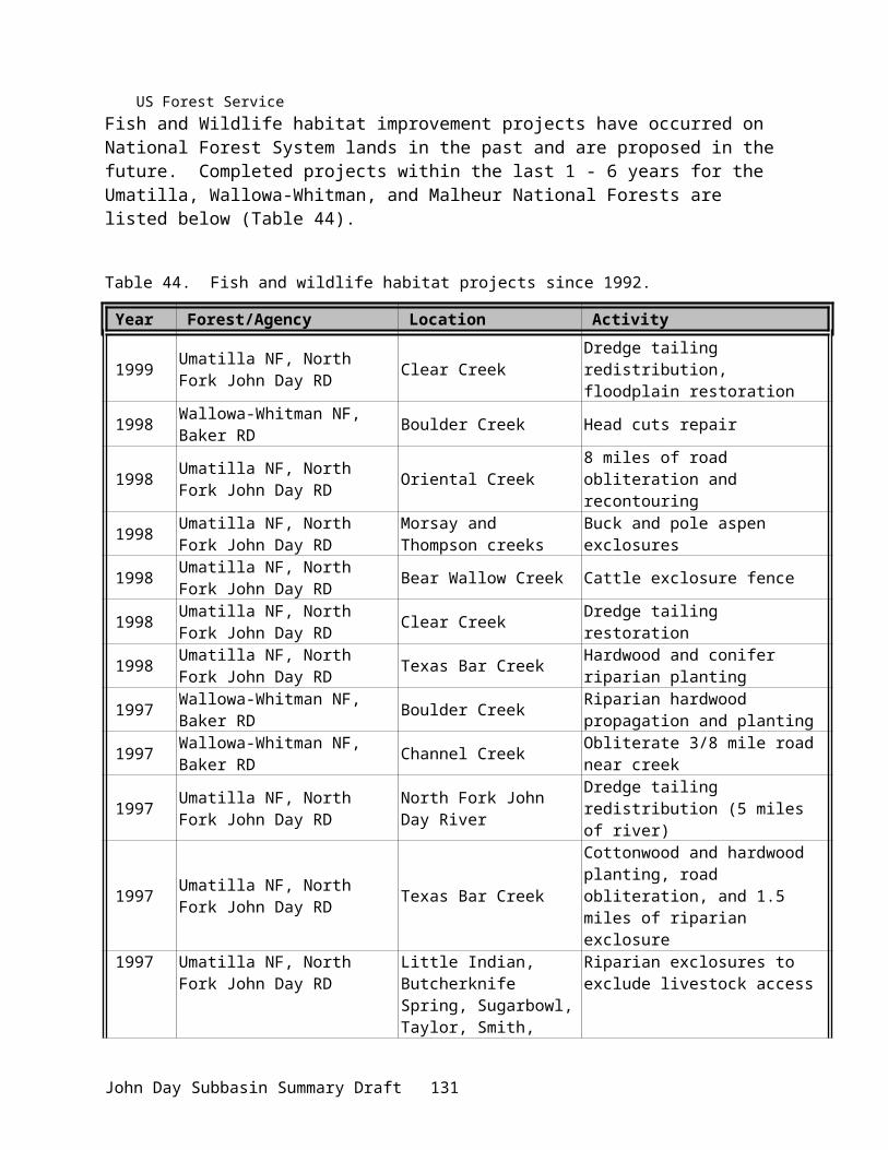
1. Need to determine distribution of smallmouth bass and their predatory effects on salmonids.2. Need to assess overall predation on salmonids by exotic species (e.g.,brook trout).
Wildlife1. Need to assess population status and habitat for sage grouse and reintroduce sage grouse
into suitable habitat areas. 2. Need inventory of herptiles, small mammals in the subbasin.3. Need to assess predator impacts on big game and gain insight into predator/prey dynamics. 4. Need to assess impact of ravens, cowbirds, and magpies on species at risk. 5. Need to obtain digital aerial photos to track habitat changes through time. 6. Need to assess impact of wild horses and burros on forage and riparian habitat within
federally managed lands. 7. Need to assess status and distribution of feral animals, particularly pigs, and develop
appropriate management strategies. 8. Need to evaluate re-colonization of white tail deer in habitat improvement areas. 9. Need a telemetry study on elk movement and distribution near Ritter to assist in population
control.10. Need to assess the impacts of shed antler collecting on deer and elk herds, and consider
management strategies, which minimize detrimental impacts to animals.
Coordination and Enforcement 1. Need to ensure consistency in data collection and reporting procedures from all entities in
the subbasin. 2. Need feedback on projects being done by others on federal lands. 3. Need a data repository. 4. Need to continue and enhance the cooperative/shared approach in research, monitoring and
evaluation between tribal, federal, state, and local entities to facilitate restoration and enhancement measures.
5. Need to improve enforcement of laws and codes related to protection of fish and wildlife and their habitats, including increased efforts for in and out-of-season poaching and in road closure areas.
6. Need to improve enforcement of road closures.7. Need to better educate the public on natural resource laws and educate others with resource
protection obligations on how to enforce compliance.8. Need to continue to identify ways of streamlining agency policies aimed at improving
habitat restoration efforts.
John Day Subbasin Summary Draft 135

REFERENCES
Adams, R.M., R.P. Berrens, A. Cerda, P.C. Klingeman, and H.W. Li. 1993. Economic and natural science information in riverine management: case of the John Day River. Rivers 4(3): 213-226.
Allen, S. 1993. Murderers Creek Wildlife Area Long Range Management Plan, Oregon Department of Fish and Wildlife.
Asher, J. 1993. Noxious weeds in Eastern Oregon. USDI, BLM, Oregon State Office, Portland, OR.
Bailey. 1936. Black Bear Populations.
Bayer, J. 2000. Personal communication, Jenifer Bayer, USGS, Columbia River Research Lab.Beamesderfer, R.C.P., H.A. Schaller, M.P. Zimmerman, C.E. Petrosky, O.P. Langness and L.
LaVoy. 1997. Spawner - recruit data for spring and summer chinook salmon populations in Idaho, Oregon, and Washington. July 1997 Draft Documentation for PATH - Plan for Analyzing and Testing Hypotheses, Retrospective Analysis.
Beschta, R.L., W.S. Platts, and J.B. Kauffman. 1991. Field review of fish habitat improvement projects in the Grand Ronde and John Day river basins of eastern Oregon. BPA Report, Project No. 91-069. Bonneville Power Administration, Division of Fish and Wildlife, Portland, OR.
BPA (Bonneville Power Administration). 1984. Status review of wildlife mitigation at Columbia Basin hydroelectric projects Oregon facilities. BPA, Portland, Oregon
BPA (Bonneville Power Administration). 1993. Oregon Trust Agreement Planning Project: Potential mitigation to the impacts on Oregon wildlife resources associated with relevant mainstem Columbia River and Willamette River hydroelectric projects. BPA, O.S. Dept. of Energy, Portland, Oregon. DOE/BP-299-1. 53pp.
Buchanan, D.V. M.L. Hanson, and R.M. Hooton. 1997. Status of Oregon’s Bull Trout. Oregon Department of Fish and Wildlife, Portland, OR.
CBPLTWG (Columbia Basin Pacific Lamprey Technical Work Group). 1999. Planning of Columbia Basin Pacific lamprey projects and needs. A report to the Northwest Power Planning Council and Bonneville Power Administration, July 1999.
Chilcote, M.W. 2001. Conservation assessment of steelhead populations in Oregon. Oregon Department of Fish and Wildlife, Portland, OR.
Childs, A. 1997. CTUIR Wildlife Mitigation Plan for the John Day and McNary dams.
Close, D.A., M.S. Fitzpatrick, H.W. Li, B. Parker, and G. James. 1995. Status report of the Pacific Lamprey (Lampetra tridentate). Bonneville Power Administration. Project Number 94-026.
Close, D.A., A.D. Jackson, D.R. Hatch, and B.L. Parker. 1999. Pacific Lamprey Research and Restoration. Annual Report 1998. Prepared for the Bonneville Power Administration, Portland, OR.
Cockle, R. 2001. Are abandoned mines polluting water? The Oregonian, January 26, 2001.
John Day Subbasin Summary Draft 136
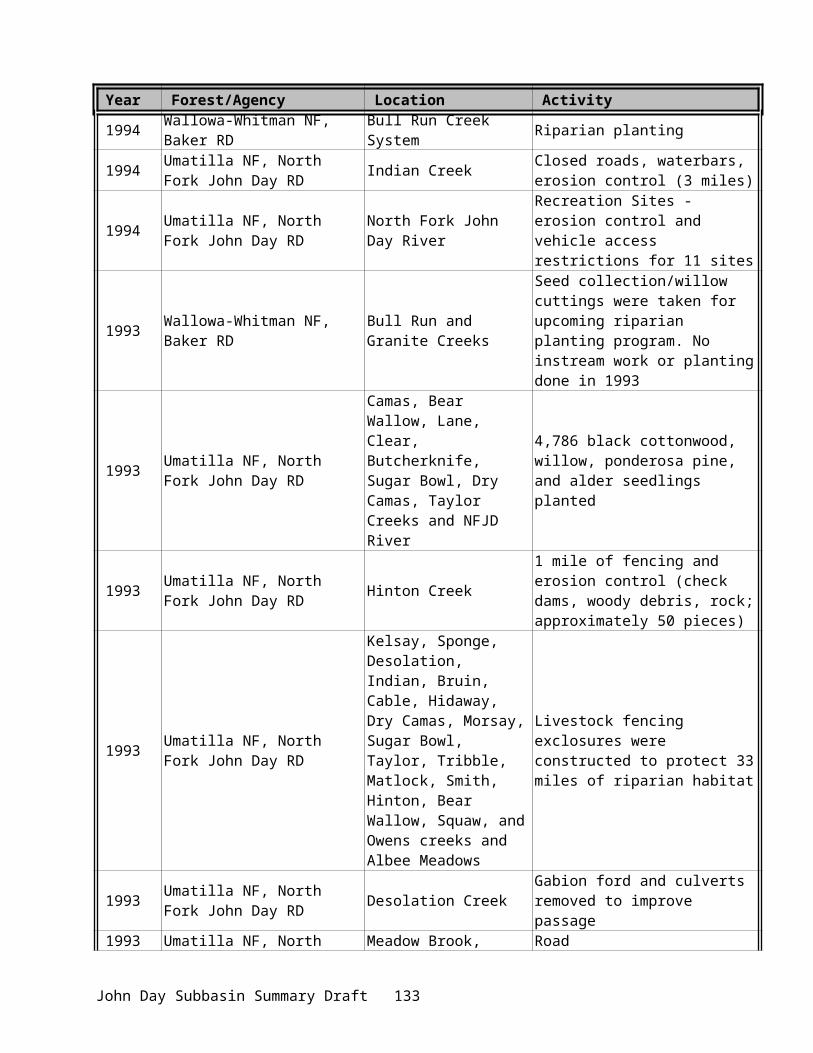
CRITFC (Columbia River Intertribal Fish Commission). 1995. Wy-Kan-Ush-Mi Wa-Kish-Wit (Spirit of the Salmon), the Columbia River Anadromous Fish Restoration Plan of the Nez Perce, Umatilla, Warm Springs, and Yakama Tribes.
CTUIR. (Confederated Tribes of the Umatilla Indian Reservation). 1984. John Day River Basin – Recommended Salmon and Steelhead Habitat Improvement Measures. Prepared for the Bonneville Power Administration, Portland, OR.
CTUIR (Confederated Tribes of the Umatilla Indian Reservation). 1991. Unpublished data provided by M.D. Purser and C.A. Scheeler, Pendleton, Oregon.
CTUIR (Confederated Tribes of the Umatilla Indian Reservation). 1996. CTUIR Columbia Basin Policy.
Cude, C. 1995. Oregon Water Quality Index Report for the John Day Basin – Water Years 1986–1995. Oregon Department of Environmental Quality, Laboratory Division.
Federal Caucus. 2000. Conservation of Columbia Basin Salmon – A Coordinated Federal Strategy for the Recovery of the Columbia-Snake River Basin Salmon. Final Basinwide Salmon Recovery Strategy. December 21, 2000.
Hall, B. 1994. John Day Basin: Priorities for Maintaining Streamflows to Protect and Restore Habitat for Important Fish Populations. Oregon Water Trust. Report to the Oregon Department of Fish and Wildlife, Habitat Division, Portland, OR.
Hattan, G. and B. Smith. 1987. Completion Report, Eastern Oregon Elk Herd Delineation Project #W-82-R. Elk Herd Delineation, Desolation Wildlife Management Unit. Oregon Department of Fish and Wildlife, Portland, OR. 18pp.
Hemmingson, A. In preparation. Bull trout life history studies in the John Day Subbasin. Annual report of the Oregon Department of Fish and Wildlife for the Bonneville Power Administration, Portland, OR.
ICBEMP (Interior Columbia Basin Ecosystem Management Project). 2000. Science Findings. March 2000.
Isaac, F.B., R.G. Anthony, M. Vander Heyden, C.D. Miller, and W. Weatherford.1993. Habits of Bald Eagles Wintering Along the upper John Day River, Oregon. Final Rep., 1 Dec 1993. Oreg. Coop. Wildl. Res. Unit, Oreg. State Univ., Corvallis.
Jackson et al. 1998. Pacific lamprey research and restoration. Annual report 1996 to the Bonneville Power Administration, Portland, OR. DOE/BP-9402600.
Johasson, C.B., V.D. Albaladejo, and R.C. Carmichael. 1998. Fish research project Oregon. John Day basin spring chinook salmon escapement and productivity monitoring annual progress report. Annual progress report (Contract 98-016-00) submitted to Bonneville Power Administration, Portland, OR.
Lane, R. Personnal communication, Feb 8, 2001. Bureau of Land Management, Prineville District Office, OR.
Li, H.W., T.N. Pearsons, C.K. Tait, J.L. Li, and R. Gaither. 1992. Approaches to evaluate habitat improvement programs in streams in the John Day Basin. Completion Report to the Research Section of the Oregon Department of Fish and Wildlife, Hwy 34, Corvallis, OR.
John Day Subbasin Summary Draft 137
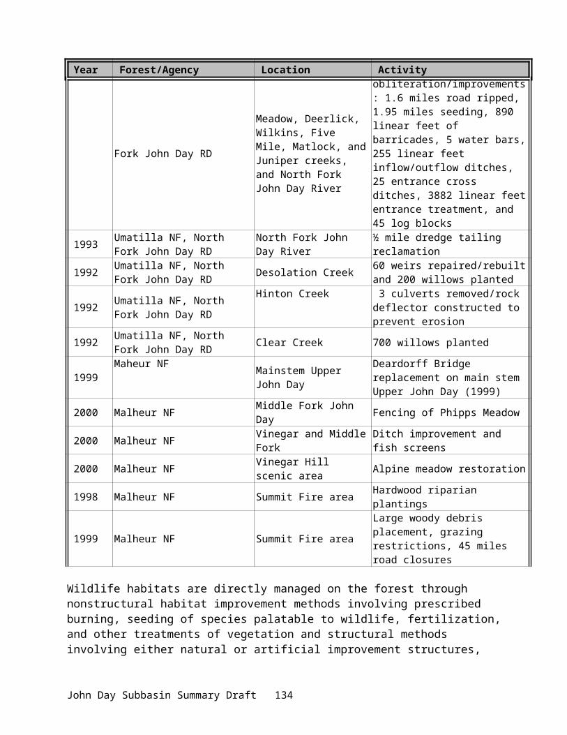
Li, H.W., G.A. Lamberti, T.N. Pearsons, C.K. Tait, J.L. Li, and J.C. Buckhouse. 1994. Cumulative effects of riparian disturbance in small streams of the John Day Basin, Oregon. Transactions of the American Fisheries Society 123: 627-640.
Li, H.W., R.L. Beschta, J.B. Kauffman, J.L. Li, B.A. McIntosh, P.A. McDowell. 2000. Hydrologic, geomorphic, and ecological connectivity in Columbia River watersheds. implications for endangered salmonids. Completion Report to the EPA Star Program, R82-4774-010, 112 pg.
Lindsay, R.B., W.J. Knox, M.W. Flesher, B.J. Smith, E.A. Olsen, and L.S. Lutz. 1986. Study of wild spring chinook salmon in the John Day River system. Final Report of Oregon Department of Fish and Wildlife to Bonneville Power Administration (Contract DE-A179-83BP39796), Portland, OR.
Marmorek, D.R., and 21 others. 1996. Plan for Analyzing and Testing Hypotheses (PATH): Final report on retrospective analyses for fiscal year 1996. ESSA Technologies Ltd., Vancouver, B.C.
Melland, J. 1985.
Mitchell, J.W. 1975. Rock Creek Watershed Project, Gilliam and Morrow Counties, Oregon. Final Environmental Impact Statement, U.S. Department of Agriculture, Portland, OR.
Morris, J. Personnal communication, January 2001. Bureau of Land Management, John Day Office, John Day, OR.
NMFS (National Marine Fisheries Service). 2000. Federal Columbia River Power System Biological Opinion. December 21, 2000.
NWPPC (Northwest Power Planning Council). 1994. Columbia River Basin Fish and Wildlife Program. Portland, OR.
NWPPC (Northwest Power Planning Council). 1996. Return to the River: Restoration of Salmonid Fishes in the Columbia River Ecosystem.
ODFW (Oregon Department of Fish and Wildlife), CTUIR (Confederated Tribes of the Umatilla Indian Reservation) and CTWSRO (Confederated Tribes of the Warm Springs Reservation of Oregon). 1990. John Day River Subbasin Salmon and Steelhead Production Plan, Portland, Oregon.
ODFW (Oregon Department of Fish and Wildlife). 1990. Oregon’s Mule Deer Plan. Portland, OR.
ODFW (Oregon Department of Fish and Wildlife). 1992a. Oregon’s Bighorn Sheep Management Plan, Portland, OR.
ODFW (Oregon Department of Fish and Wildlife). 1992b. Oregon’s Elk Management Plan, Portland, OR.
ODFW (Oregon Department of Fish and Wildlife). 1992c. Personal communication from Errol Claire, District Fish Biologist, John Day, Oregon.
ODFW (Oregon Department of Fish and Wildlife). 1993a. Oregon’s Cougar Management Plan 1993-1998. Portland, OR.
John Day Subbasin Summary Draft 138

ODFW (Oregon Department of Fish and Wildlife). 1993b. Oregon’s Black Bear Management Plan, 1993-1998. Portland, OR.
ODFW (Oregon Department of Fish and Wildlife). 1997a. Assessing Oregon Trust Agreement Planning Project Using Gap Analysis. In fulfillment of Project Number 95-65. Project Cooperators: USFWS, CTUIR, CTWSRO, Oregon Natural Heritage Program. Prepared for Bonneville Power Administration, Portland, OR. Contract Number DE-BI179-92BP90299.
ODFW (Oregon Department of Fish and Wildlife). 1997b. Oregon Guidelines for Timing of In-Water Work to Protect Fish and Wildlife Resources. Portland, OR.
ODFW (Oregon Department of Fish and Wildlife). 1998. Game Bird Statistics, 1998. Portland, OR. 69
ODFW (Oregon Department of Fish and Wildlife). 2001. Draft Fisheries Management and Evaluation Plan. Mid-Columbia Steelhead, John Day River Steelhead Fishery. Portland, OR.
ONHP (Oregon National Heritage Program). 1995. Rare, Threatened, and Endangered Plants and Animals of Oregon. Oregon National Heritage Program, Portland, OR. 84pp.
OWRD (Oregon Water Resources Department). 1991. Stream Restoration Program for the Middle Fork Subbasin of the John Day River.
OSP (Oregon State Police). 2000. Action Plan: John Day River Steelhead. October 23, 2000.
OWRD (Oregon Water Resources Department). 1993. Stream Restoration Program for the North Fork Subbasin of the John Day River. Final Draft Report.
OWRD (Oregon Water Resources Department). 2000. Data from John Day Office, provided by Kyle Sullivan.
Puchy, C. A.; and Marshall, D. 1993. Oregon Wildlife Diversity Plan, 2nd edition. Oregon Department of Fish and Wildlife, Portland, OR.
Quigley, Haynes, and Graham. 1996. An Integrated Scientific Assessment for Ecosystem Management in the Interior Columbia Basin and Portions of the Klamath and Great Basins.
Quigley, T.M. and S.J. Arbelbide. 1997. An Assessment of Ecosystem Components in the Interior Columbia Basin and Portions of the Klamath and Great Basins: Vol I-IV. General Technical Report PNW-GTR-405. Portland, OR.
Rassmusen and Wright. 1990a. Wildlife impact assessment, Bonneville Project, Oregon and Washington. Prepared by USFWS for U.S. Department of Energy, BPA, Portland, OR. 37pp.
Rassmusen and Wright. 1990b. Wildlife impact assessment, John Day Project, Oregon and Washington. Prepared by USFWS for U.S. Department of Energy, BPA, Portland, OR. 27pp.
Rassmusen and Wright. 1990c. Wildlife impact assessment, The Dalles Project, Oregon and Washington. Prepared by USFWS for U.S. Department of Energy, BPA, Portland, OR. 27pp.
John Day Subbasin Summary Draft 139

Rassmusen and Wright. 1990d. Wildlife impact assessment, McNary Project, Oregon and Washington. Prepared by USFWS for U.S. Department of Energy, BPA, Portland, OR. 28pp.
Rhodes, J.J., D.A. McCullough, and F.A. Espinosa, Jr. 1994. A coarse screening process for evaluation of the effects of land management activities on salmon spawning and raring habitat in ESA consultations. Columbia River Inter-Tribal Fish Commission, Technical Report 94-4. 127 pp/
Rhodes, J.J., M.J. Greene, and M.D. Purser. 2000. Monitoring fine sediment: Grand Ronde and John Day rivers. Annual Report for 1999 for the Bonneville Power Administration, Portland, OR.
Rose, A.F. 1991. Rock Creek Watershed Project. Oregon Department of Agriculture, Salem Or, and Gilliam, Morrow, and Wheeler counties.
Schaller, H.A., C.E. Petrosky, and O.P. Langness. 1999. Contrasting patterns of productivity and survival rates for stream-type chinook salmon (Oncorhynchus tshawytscha) populations of the Snake and Columbia River. Canadian Journal of Fisheries and Aquatic Sciences 56:1031-1045.
Shrader, T and M. Gray. 1999. Biology and management of John Day River smallmouth bass. ODFW information report, No. 99-1.
Spruell, P. and F.W. Allendorf. 1997. Nuclear DNA analysis of Oregon Bull Trout, Report 97/5. Oregon Department of Fish and Wildlife, Portland, OR.
Spruell, P. and others. 1999. Progress report on O. mykiss and O. clarki genetics studies in the Mt. Hood area. Report to K. Kostow, Oregon Department of Fish and Wildlife, Portland, OR.
Tait, C.K., J.L. Li, G.A. Lamberti, T.N. Pearsons, and H.W. Li. 1994. Influences of riparian cover on benthic community structure in high desert streams. Journal of the North American Benthological Society 13(1):45-65.
Torgersen, C.E., D. Price, H.W. Li, and B.A. McIntosh. 1999. Multiscale thermal refugia and stream habitat associations of chinook salmon in northeastern Oregon. Ecological Applications 9:301-319.
USDA (U.S. Department of Agriculture). 1975. Watershed Work Plan, Rock Creek Watershed, Gilliam and Morrow Counties, Oregon.
USDA (U.S. Department of Agriculture, Forest Service). 1990. Land and Resource Management Plan, Ochoco National Forest. Pacific Northwest Region.
USDA (U.S. Department of Agriculture, Forest Service). 1990. Land and Resource Management Plan, Malheur National Forest. Pacific Northwest Region.
USDA (U.S. Department of Agriculture, Forest Service). 1990. Land and Resource Management Plan, Wallowa-Whitman National Forest. Pacific Northwest Region.
USDA (U.S. Department of Agriculture, Forest Service ). 1990. Final Environmental Impact Statement, Land and Resource Management Plan, Umatilla National Forest. Pacific Northwest Region.
John Day Subbasin Summary Draft 140

USDA (U.S. Department of Agriculature, Forest Service). 1995. Inland Native Fish Strategy Environmental Assessment Decision Notice and Finding of No Significant Impact: Interim Strategies for Managing Fish-producing Watersheds in Eastern Oregon and Washington, Idaho, Western Montana, and Portions of Nevada (INFISH).
USDA (U.S Department of Agriculture, Forest Service) and USDI (U.S. Department of the Interior, Bureau of Land Management). 1994. Environmental Assessment for the Implementation of Interim Strategies for Managing Anadromous Fish-producing Watersheds in Eastern Oregon and Washington, Idaho, and portions of California (PACFISH).
USDA (U.S. Department of Agriculture, Forest Service) and USDI (U.S. Department of the Interior, Bureau of Land Management). 2000. Columbia Basin Supplemental Draft Environmental Impact Statement, Vol. 1, pp. 85-89. General technical report PNW-GTR 485, Draft March 2000.
USDI (U.S. Department of Interior, Bureau of Land Management). 1985. Draft Two Rivers Resource Management Plan, Environmental Impact Statement.
USDI (U.S. Department of Interior, Bureau of Land Management). 1998. The Northeast Oregon Assembled Land Exchange (NOALE) and Final Environmental Impact Statement. Prineville District Office, Prineville, OR.
USDI (U.S. Department of Interior, Bureau of Land Management). 2000. John Day River Proposed Management Plan, Two Rivers and John Day Resource Management Plan Amendments and Final Environmental Impact Statement. Vol. 1, Executive Summary and Chapters 1-5. Prineville District, BLM, Prineville, OR.
USBR (U.S. Bureau of Reclamation). 1990. Upper John Day River Basin Master Water Plan Working Paper. Upper John Day Water Optimization, Oregon. June 1990.
USBR (U.S. Bureau of Reclamation). 1992a. Stream Restoration Program for the Upper Main Stem of the John Day River. Upper John Day Water Optimization Study, Oregon. Prepared for the John Day Basin Council, March 1992.
USBR (U.S. Bureau of Reclamation). 1992b. Stream Restoration Program for the South Fork of the John Day River. Upper John Day Water Optimization Study, Oregon. Prepared the John Day Basin Council, April 1992.
USBR (U.S. Bureau of Reclamation). 1992c. Stream Restoration Program for Upper South Fork of the John Day River. Upper John Day Water Optimization Study, Oregon. Prepared for the John Day Basin Council, November 1992.
USBR (U.S. Bureau of Reclamation). 1993. Stream Restoration Program for the Rock Creek Tributary of the John Day River. Upper John Day Water Optimization Study, Oregon. Prepared for the John Day Basin Council, January 1993.
USBR (U.S. Bureau of Reclamation). 2000. Columbia River Fish and Wildlife Program, Tributary Enhancement Water Conservation Demonstration Projects, Completion Report, Lemhi River Basin, Idaho, Wallowa River Basin, Oregon, John Day River Basin, Oregon.
Vandemoer, K. 2001. Personal communication, Kate Vandemoer, National Marine Fisheries Service, February 2001.
John Day Subbasin Summary Draft 141
Wilson, W.H., J.R. Ruzychi, B.C. Jonasson, and R.W. Carmichael. 2000. John Day basin spring chinook salmon escapement and productivity monitoring. Annual progress report to Bonneville Power Administration, Portland, OR. Contract No. 98BI11646.
Wisdom, M.J. et al. 1998. Source Habitats for Terrestrial Vertebrates of Focus on the Interior Columbia Basin: Broad-scale Trends and Management Implications.
Wissmar, R.C., J.E. Smith, B.A. McIntosh, H.W. Li, G.H. Reeves, and J.R. Sedell. 1994. A history of resource use and disturbance in riverine basins of eastern Oregon and Washington (early 1800s-1900s). Northwest Science 68:1-35
Wheeler, C.L. 1968. An Engineering Report on the Rock Creek Watershed. Gilliam and Morrow counties.
Whitson, T.D. et.al. 1996. Weeds of the West. Western Society of Weed Science, Newark, California.. 630 pp.
Zimmerman, M.P. 1999. Food habits of smallmouth bass, walleyes, and northern pikeminnow in the lower Columbia River basin during outmigration of juvenile anadromous salmonids. Transactions of the American Fisheries Society. 128:1036-1054. Bethesda, Maryland.
John Day Subbasin Summary Draft 142

SUBBASIN SUMMARY RECOMMENDATIONS
FY 2002 Projects Proposals ReviewThe following subbasin proposals were reviewed by the John Day River Subbasin Team and the Province Budget Work Group for Bonneville Power Administration project funding for the next three years. Tables 50 and 51 summarize how each project relates to resource needs, management goals, objectives and strategies and other activities in the subbasin.
Projects and Budgets
Continuation of Ongoing Projects Project: 198402100 – Protect and Enhance Anadromous Fish Habitat in the John Day Subbasin
Sponsor: ODFW
Short Description:Project develops and implements riparian fencing and instream structure projects to protect, enhance and restore riparian and instream habitat to improve anadromous salmonid production.
Abbreviated Abstract:This program provides long-term protection, maintenance and restoration of fish habitat on private lands in the John Day Subbasin through landowner agreements, fencing, instream structures, riparian plantings, critical stream bank stabilization and passage structures. Program provides coordination of activities to implement new projects, repair damaged and aging fences and habitat structures, monitor and report results, administrate and market the program, serve as a resource for landowners and watershed councils to operate effective riparian/watershed projects and to coordinate with other agencies. All work performed contributes to the 1994 Columbia Fish and Wildlife Program (FWP) goal of improving spawning and rearing habitat to increase overall fish runs in the Columbia River.
Relationship to Other Projects:Project ID Title Nature of Relationship199605300 Upper Clear Cr. Dredge Tailings
Restoration Share equipment and personnel between public and private lands.
199801800 John Day Watershed Restoration. Share storage, equipment, designs and personnel.
198402500 Grande Ronde Habitat Enhancement. Share equipment and personnel.198710002 Umatilla Habitat Improvement. Share equipment and personnel.20131 Enhance North Fork John Day Fish
HabitatShare designs, landownership regimes and data.
299 Oregon Fish Screening Project. Share Offices, shop, storage yard, equipment and personnel.
199801600 Monitor Natural Escapement & Productivity of John Day Spring Chinook.
Share storage, equipment, personnel and provide access to private lands.
20102 Research/Evaluate Restoration of Provide restoration summary and
John Day Subbasin Summary Draft 143

Project ID Title Nature of RelationshipNortheast Oregon Streams. access to private lands.
20064 Pacific Lamprey Migration in the John Day River.
Provide restoration summary and access to private lands.
93033800 North Fork John Day Area Riparian Fencing
Share designs, equipment and personnel between public and private lands.
Relationship to Existing Goals, Objectives and Strategies:Low summer stream flows and the associated high water temperatures adversely affect salmonids throughout much of the John Day sub basin. Degradation of riparian areas and their effective hydrologic function has contributed significantly to these flow/temperature problems (ODFW, CTUIR, CTWSIR 1990). In 1984 the Confederated Tribes of the Umatilla Indian Reservation (CTUIR 1984) identified 542 miles of degraded stream habitat on private lands within the John Day sub basin in need of habitat restoration. After seventeen years of intensive efforts by this program 77 miles have been treated.
Hatchery supplementation has been dismissed as an option for increasing salmon and steelhead numbers in the sub-basin (Stuart et al. 1987). Habitat improvement, fish passage improvement and irrigation system improvement are presently the only option for increasing populations (Lindsay et.al. 1985).
Encouraging recovery of riparian vegetation, improving stream bank stability and instream habitat diversity will result in an overall increase in water quality and quantity within the John Day sub basin. These habitat improvements will result in an increase in salmonid natural production carrying capacity within the system (Meehan 1991, Rhoades et al. 1994). Removal or modification of fish passage barriers will also improve adult and juvenile salmonid access to preferred habitats.
By protecting riparian areas from intensive land uses (15 years minimum), attributes will become more pronounced through time by allowing plants inside the fenced areas to succeed toward climax communities. Fenced areas will continue to produce these attributes until fence maintenance ceases. Landowners must be shown what benefits have occurred so maintenance will continue after protective leases expire. Landowners have constructed their own riparian protection fences or assumed maintenance duties on project fences in several locations.
The Oregon Department of Environmental Quality lists 107 John Day basin stream reaches as exceeding their standard for temperature. (303d list)
The National Marine Fisheries Service has named the John Day River as one of their highest priority streams for Columbia River steelhead recovery through habitat enhancement (FCRPS BiOp. 2000)
The project establishes long term riparian and tributary passage improvement on private lands through riparian leases, cooperative agreements and easements of 15 years in length. Individual projects contribute to ecosystem and basin wide watershed restoration and management efforts underway by state, federal and tribal agencies. Planning for project implementation includes the participation of private landowners, state and federal agencies, tribes and watershed councils as called for in measure 7.7 of the FWP, (NWPPC 1994). The project goal is to rehabilitate and improve anadromous fish spawning and rearing habitat as outlined in program measure 7.6 of the FWP. Fish passage is established or improved as outlined in measure 7.10 of the FWP. Individual projects also incorporate Best Management Practices as outlined in measure 7.8 of the FWP.
John Day Subbasin Summary Draft 144

Review Comments:None
Budget:FY 02 FY 03 FY 04 FY 05 FY 06448,500Category: High Priority
470,000Category: High Priority
485,000Category: High Priority
500,000Category: High Priority
525,000Category: High Priority
Project: 199306600 – Oregon Fish Screening Project
Sponsor: ODFW
Short Description:Protect wild anadromous and resident fish species by installing 20 replacement fish screening devices in irrigation diversion located in critical spawning and rearing areas in the John Day basin and 1 unscreened and 5 replacements in the Walla Walla.
Abbreviated Abstract:The project provides immediate and long-term protection for anadromous and resident fish species in the John Day, Umatilla, and Walla Walla basins by installing and replacing out of date fish protection and passage devices on private irrigation diversions and dam structures. It directly follows Columbia Basin Fish and Wildlife Program (FWP) Measure 7.10-Provide Passage and Protective Screens on Tributaries, particularly measures 7.10A2 and A.3, which mandates: a. Screening and passage criteria based on NMFS standards; b. The use of existing expertise of federal, state and private entities to accelerate implementation of fish screening and passage measures; and c. The maintenance of prioritized list of tributary screening and passage facility improvements – which will include both the construction of new facilities, upgrading, and maintenance of existing screen systems. The expected outcome over the next five (5) years will be ongoing construction and installation to replace existing out of date screen systems remaining in the basins.
John Day Subbasin Summary Draft 145

Relationship to Other Projects:Project ID Title Nature of Relationship198402100 John Day River Fish Habitat Increased fish production from habitat
improvements compliments the need for continued screening efforts.
199801600 Natural Escapement – John Day River
Operate trapboxes for pit tagging, migration timing, screen effectiveness, repair of equipment, and use of personnel.
199405400 Oregon Bull / Cutthroat Trout Research
Assist with fish trapping, equipment construction and repair, and use of personnel.
20003100 North Fork John Day Habitat Project
Increased fish production from habitat improvements compliments the need for continued screening efforts.
199801700 Eliminate Gravel Push-up Dams on Lower North Fork John Day
Design and build screening devices for sump intakes.
199801800 John Day Watershed Restoration Blast and paint diversion components and advice on screening and passage projects.
198343600 Umatilla Passage Facilities O & M
Major maintenance ie: rewrap, blast and paint, existing screens.
199303800 North Fork Fish Habitat – USFS Increased fish production from habitat improvements compliments the need for continued screening efforts.
199401500 Idaho Fish Screening Exchange of designs and technology related to screening devices.
199105700 Washington Fish Screening Exchange of designs and technology related to screening devices.
Relationship to Existing Goals, Objectives and Strategies:This project is necessary to insure the replacement of fish screening devices and fishways to meet current NMFS design criteria for the protection of all salmonid life stages. The mission of the fish passage program in Northeast Oregon is to protect and enhance fish populations by assisting private landowners, public landowners, irrigation districts, and others by maintaining fishways and fish screening devices. These facilities reduce or eliminate fish loss associated with irrigation withdrawals, and as a result ensure fish populations are maintained for enjoyment by present and future generations. Assistance is provided through state and federally funded programs and can range from simple technical advice to complete construction and maintenance of facilities.
The habitat goals of the Basinwide Salmon Recovery Strategy as stated in the John Day Subbasin Summary are: the existence of high quality habitats that are protected, degraded habitats that are restored and connected to other functioning habitats, and a system where further degradation of tributary and estuary habitat and water quality is prevented.
Near-term (5- 10 year) objectives for tributary habitat within the John Day Subbasin include:Objective 1. Restore and increase tributary flows to improve fish spawning, rearing, and
migration.Objective 2. Screen diversions, combine diversions, and rescreen existing diversions to comply
with NMFS criteria to reduce overall mortality. Objective 3. Reduce passage obstructions to provide immediate benefit to migration, spawning,
and rearing.
John Day Subbasin Summary Draft 146
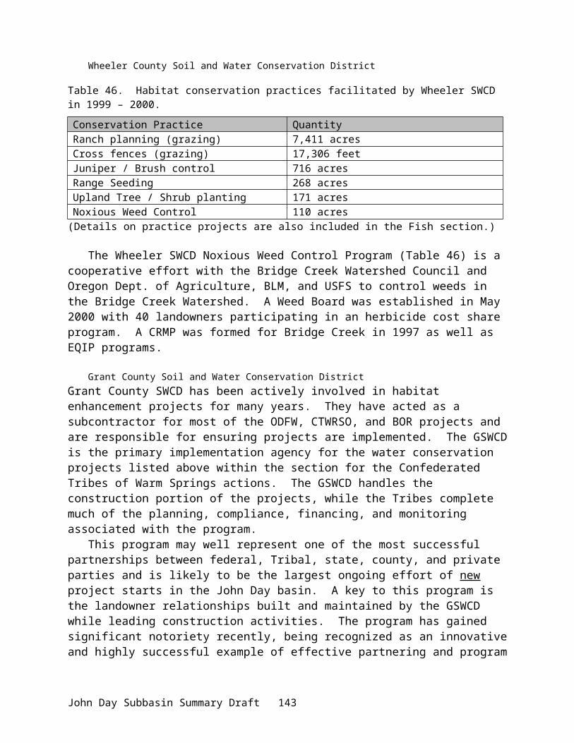
Strategy 1. Federal agencies, state, and other to address all flow, passage, and screening problems over the next 10 years in the John Day Subbasin.
Action 1.1. USBR to implement actions in the Upper John Day Subbasin in 2001 Action 1.2. BPA to expand on measures under the NWPPC program to complement
USBR’s actions.Action 1.3. NMFS to provide USBR with passage and screening criteria and
methodologies for determining instream flows that satisfy ESA requirements. (John Subbasin summary pp. 93)
Tribal and State - Umatilla and Warm Springs Tribes and Oregon Department of Fish and
WildlifeThe vision of the Oregon Department of Fish and Wildlife is that “Oregon’s fish and
wildlife are thriving in healthy habitats due to cooperative efforts and support by all Oregonians” (ODFW 2000). The vision for the John Day Subbasin among state and tribal resource managers is improved basin habitat for the enhancement and productivity of wild spring chinook salmon, summer steelhead, native resident trout, and numerous wildlife species (ODFW et al. 1990). The following objectives and strategies were developed cooperatively by ODFW and the Warm Springs and Umatilla Tribes in 1990 as part of the System Planning effort for NWPPC (i.e., John Day Subbasin Plan).
Habitat ObjectivesObjective 1: Protect existing anadromous fish habitat by preventing further watershed
degradation in the form of water quality, quantity, and instream habitat. Objective 2: Restore optimum habitat (temperature, flows) for all life history stages of
anadromous salmonids.Objective 3: Protect, restore, and maintain suitable habitat conditions for all bull trout life history
stages.
Habitat StrategiesStrategy 13. Require all diversion inlets be properly screened and maintained as required by
the Fish Screen Law (1987) and ORS 509.615. Strategy 14. Monitor irrigators to ensure all diversion structures minimally provide adult and
juvenile passage as required by state lawStrategy 15. Obtain funding for landowners through state and federal agencies to implement
more efficient irrigation methods and develop water conservation practices benefiting landowners and instream flows.
Strategy 19. Support and expand existing watershed programsStrategy 20. Develop a system of riparian natural areas associated with critical fish habitat
throughout the basin. (John Day Subbasin Summary pp. 98-99)
Water appropriation in the John Day Subbasin varies by season. The average proportion of consumptive use to natural flow is 2% in winter, 15% in spring, 73% in summer, and 14% in fall (OWRD 2000). At times, appropriation is more than natural flows, most notably in summer. (John Day Subbasin Summary pp. 23)
During irrigation season, stream flows decline at a very rapid rate throughout the John Day basin. Due to the geographic location the John Day basin is classified as a dry climate with very little rainfall and limited higher elevation water storage capabilities. Heavy irrigation practices, high
John Day Subbasin Summary Draft 147
evaporation rates, and high water temperatures have adversely affected salmonids throughout much of the John Day subbasin.
In the John Day system, hatchery supplementation has been dismissed as an option for increasing salmon and steelhead populations. Habitat improvement, fish screening, and passage are presently the only option for increasing populations.
In the John Day, Umatilla, and Walla Walla basins, the ODFW, local watershed councils, and other private, state, and federal entities have aggressively implemented riparian recovery projects. These projects have improved vegetation, improved stream bank stability, instream habitat diversity, and better water quality and quantity. These habitat improvements have increased salmonid natural production. All of the proposed fish screen implementation projects are located in the same priority location as these improved habitat projects. It is essential to the survival of the salmonids to provide protection from irrigation diversions for these fish during migration and while inhabiting their spawning and rearing areas.
The program operates with 364 fish screening devices and supports maintenance on twelve fishways. This program includes 13 permanent and 15 seasonal positions stationed at program facilities located in John Day, with satellite operations and personnel in Enterprise and Pendleton.
Review Comments:None
Budget:FY 02 FY 03 FY 04 FY 05 FY 06660,870Category: High Priority
680,696Category: High Priority
701,117Category: High Priority
722,150Category: High Priority
743,815Category: High Priority
Project: 199703400 – Monitoring Fine Sediment in Grande Ronde and John Day Rivers
Short Description:Monitor surface fine sediment and overwinter sedimentation in cleaned gravel in spring chinook spawning habitats in monitored river reaches, analyze potential trends and relationships in data, and relate to salmon survival.
Abbreviated Abstract:For five years, the project will annually measure surface fines and overwinter sedimentation during the incubation period in spawning gravels in the John Day and Grande Ronde Rivers. This will allow assessment of the following: 1) whether there is a trend in substrate conditions in spawning habitat in monitored reaches, and if so, whether it is consistent with efforts to reduce sedimentation and improve habitat conditions; 2) whether there is a relationship between the magnitudes of surface fine sediment and fine sediment intrusion into cleaned spawning gravels; 3) whether substrate conditions and trends are consistent with the quantitative substrate objectives of NPPC (1994), NMFS (1995), and CRITFC (1995).
Project data will be used to test the following hypotheses: 1) The fine sediment substrate goals in recovery plans (NPPC; CRITFC, 1995) and biological opinions (NMFS, 1995) are being
John Day Subbasin Summary Draft 148
met; 2) the aggregate effectiveness of land management is adequate to meet fine sediment/substrate goals, prevent degradation of substrate conditions, and allow improvement in substrate conditions; 3) overwinter sedimentation in salmon redds is not occurring at magnitudes that reduce salmon survival; 4) overwinter sedimentation is not related to the level of surface fine sediment; 5) watersheds with differing magnitudes of land disturbance (e.g., roads), do not have significantly different levels of surface fine sediment or of overwinter sedimentation in clean gravels. The project quantifies the magnitude of overwinter sedimentation in cleaned gravels to estimate salmon survival from egg to emergence. Work occurs in the Columbia Plateau province (NFJD) and Blue Mountain Province (Grande Ronde) (this form does not account for multi-province/multi-subbasin projects.) The project is in its third annual monitoring cycle.
Relationship to Other Projects:Project ID
Title Nature of Relationship
None Other projects are not directly dependent on the funding of this project, but the project results can be used to ascertain the need for additional restoration measures and complement subbasin and watershed planning efforts.
Relationship to Existing Goals, Objectives and Strategies:The project will monitor trends in surface fine sediments and overwinter sedimentation and examine potential relationships between them as specifically recommended for the GRR in watershed assessments (Anderson et al., 1992; NMFS, 1993). The Confederated Tribes of the Umatilla Indian Reservation (CTUIR) have endorsed implementation of Anderson et al. (1992) as a keystone of the CTUIR’s policy on salmon habitat (CTUIR, 1995).
The project will measure baseline substrate conditions and trends as recommended in NMFS (1995) and (CRITFC, 1995). NMFS (1995) noted that measurement of important habitat components, such as substrate, is a critical aspect of the recommended effectiveness monitoring (NMFS, 1995). By measuring substrate conditions, the project will determine if current substrate goals set in watershed-scale and regional plans are being met in monitored reaches. (CRITFC, 1995) and NMFS (1995) set a substrate standard of <20% surface fine sediment in spawning habitats. The NPPC's Fish and Wildlife program sets a goal of <20% fine sediments in salmon redds in measure 7.6D (NPPC, 1994). The proposed project will monitor overwinter intrusion in cleaned gravels in areas excavated to mimic salmon redds to estimate whether the NPPC's substrate goal is being met in monitored reaches. The project will also supply trend data to determine progress towards NPPC substrate objectives as recommended in NPPC Fish and Wildlife Program measures 3.3D.1 and 7.6C.2. Collection of trend data on key habitat variables, such as substrate, have repeatedly been recommended in regional efforts to restore salmon habitat (CRITFC, 1995; NMFS, 1995) and cited as lacking in the GRR (NMFS, 1993).
The project will also provide data on habitat conditions, using peer-reviewed methods (e.g., Lisle and Eads, 1991), as recommended in NPPC Fish and Wildlife measure 7.6C. The trend data should indicate of whether watershed efforts have been adequate to lead to improved substrate conditions within monitored reaches, which should be useful to watershed councils, the Grande Ronde Model Watershed, and other entities interested in improving salmon habitat.
John Day Subbasin Summary Draft 149

The habitat improvement approach of Federal Caucus (2000), intrinsically requires monitoring of key habitat variables affecting anadromous fish survival, such as fine sediment, to determine if habitat conditions are actually improving. This project specifically addresses the provision of the Reasonable and Prudent Alternatives (RPA) in the USFWS and NMFS Biological Opinion (BO) for tributary habitat (Section 9.6.5 Research, Monitoring, and Evaluation Plan), because the BO states that research, monitoring, and evaluation must address environmental status monitoring, including the provision of "...baseline information against which the effectiveness of management actions can be assessed." The BO also states that research, monitoring, and evaluation must address effectiveness monitoring to assess whether intended effects occur in aquatic systems. This project provides information on both baseline conditions and trends in substrate conditions in salmon spawning and rearing habitat, which provides an indication of the cumulative effect of watershed conditions and actions on anadromous fish habitat and survival.
Review Comments:None
Budget:FY 02 FY 03 FY 04 FY 0563,634Category: High Priority
66,815Category: High Priority
70,155Category: High Priority
60,488Category: High Priority
Project: 199801600 – Monitor Natural Escapement & Productivity of John Day Spring Chinook
Sponsor: ODFW
Short Description:Monitor natural escapement and productivity of John Day River Basin spring chinook and summer steelhead. Estimate SAR, egg-to-smolt survival, smolt abundance, and adult and parr distribution for chinook and SAR and spawner escapement for steelhead.
Abbreviated Abstract:The John Day subbasin supports one of the last remaining intact wild populations of spring chinook salmon in the Columbia River Basin. This population, however, remains depressed relative to historic levels. Between the completion of the life history and natural escapement study in 1984 (Lindsay et al. 1986) and the start of this project in 1998, spring chinook spawning surveys have not provided adequate information to assess age structure, progeny-to-parent production values, SAR, or natural spawning scapement. Columbia Basin managers have identified the John Day subbasin spring chinook population as an index population for assessing the effects of alternative future management actions on salmon stocks in the Columbia Basin (Schaller et al. 1999). We believe the John Day spring chinook are the most important lower river index stock and assessment of the recovery of other populations will rely heavily on this population as comparative control. Numerous habitat protection and rehabilitation projects have also been implemented in the basin to improve freshwater production and survival (NWPPC
John Day Subbasin Summary Draft 150

2001). To meet the data needs as an index stock, to assess the long-term effectiveness of habitat projects, and to differentiate freshwater and ocean survival, sufficient annual estimates of spawner escapement, age structure, SAR, egg-to-smolt survival, and freshwater habitat use are essential. We have begun to meet this need through spawning ground surveys initiated in 1998 and smolt PIT tagging efforts initiated in 1999. Additional measures proposed to meet these goals include an estimate of smolt abundance and SAR rates, and an updated measure of the freshwater distribution of critical life stages.
Relationship to Other Projects:Project ID Title Nature of Relationship199602000 Comparative Survival Study Proposes the use of SAR rates from John Day
River, wild stock for comparisons to Snake River stocks.
25088 Salmonid Population and Habitat Monitoring in the Oregon Portion of the Columbia Plateau
Our current proposed work will cost-share and support (become a component of) this proposed population and habitat monitoring project (if approved). Our proposal will also be dependent upon sampling guidelines established by this proposed project.
Numerous completed and ongoing BPA-funded habitat projects
GIS database of life-stage distribution supports evaluations of habitat improvement projects in the basin. Provide data to assess long-term trends in survival and productivity.
Relationship to Existing Goals, Objectives and Strategies:This proposal supports the research, monitoring, and evaluation program outlined by the NMFS 2000 FCRPS BiOp by providing population status and project effectiveness monitoring. Foremost, is that the John Day River Basin is a priority watershed in the 2000 BiOp and information derived from this project will quantify the current status and future trends in fish populations in this important basin. Further, NMFS has specifically identified the Upper John Day as a priority subbasin to receive immediate attention for habitat and species recovery for the Mid-Columbia steelhead ESU. The John Day River, together with its anadromous fish populations is also an important reference subbasin for comparisons to other anadromous stocks in more highly impacted subbasins within the Columbia River Basin (Schaller et al. 1999).
This proposal addresses several action items under the NMFS 2000 FCRPS Biological Opinion. Relationships to specific actions as outlined by the NMFS 2000 FCRPS BiOp follow.
Action 150 (Habitat Protection) is supported through this proposal by identifying spring chinook salmon use of currently productive non-Federal habitat.
Action 174 (Reform of Artificial Propagation) is supported by developing estimates of the abundance and distribution of hatchery fish in natural production areas through counts of adult salmon spawners.
Action 180 (Population Status and Environmental Status Monitoring) is fundamentally supported by ODFW’s proposed monitoring program. ODFW’s monitoring program contains all of the essential elements of NMFS framework for monitoring.
John Day Subbasin Summary Draft 151

Action 183 (Habitat Tier 3 studies) is partially supported by the proposed monitoring program by estimating spring chinook salmon, egg-to-smolt survival as a measure of ongoing habitat management actions.
Action 184 (Hatchery Reform Monitoring) is partially supported by the proposed monitoring program by estimating the distribution and abundance of adult hatchery fish on spawning grounds.
Action 188 (Contrasting productivity and hydrosystem effects) is fundamentally supported by this proposal by our SAR estimates of wild salmonid stocks from the John Day subbasin. Within this action, the John Day River is specifically mentioned as an important reference basin for comparisons to Snake River stocks.
Action 50, 192 (Adult PIT tag detection). Our project relies on the detection of returning adults at these mainstem facilities to estimate SAR.
This proposed work would provide information as directed under two measures of the Columbia Basin Fish and Wildlife Program by monitoring key indicator populations to provide detailed stock status information. In addition, this proposed work would collect information relating to the population status and life history of wild and naturally spawning populations.
This proposed work is consistent with the monitoring needs specified by the NWPPC 2000 Columbia Basin Fish and Wildlife Program as outlined in the draft, John Day sub-basin summary including: 1.) Validating anadromous fish spawning surveys; 2.) Determining life history and habitat-use patterns of juvenile salmonids; 3.) Estimating egg-to-smolt survival, smolt-to-adult survival, and spawner escapement for spring chinook and summer steelhead; and 4.) Determining the extent of hatchery straying into the basin (NWPPC 2001).
Review Comments:Objectives 1 and 2 (i.e., from smolt monitoring) from project proposal 25088 have been added to this proposal The collections of habitat and juvenile monitoring information (Objective 1) is included in other proposals. Although this project is coordinated with 25010 additional coordination needs to occur with 25069, 25064, and 25088 (Priority area designations...).
Budget:FY 02 FY 03 FY 04 FY 05 FY 0633,516Category: High Priority
328,772Category: High Priority
330,710Category: High Priority
347,246Category: High Priority
364,608Category: High Priority
John Day Subbasin Summary Draft 152

Project: 199801700 – Eliminate Gravel Push-up Dams in Lower North Fork John Day
Sponsor: North Fork John Day Watershed Council
Short Description:Eliminate gravel push-up dams in the lower North Fork John Day River. Replace with permanent pumping stations resulting in removal of passage impediments and elimination of annual instream modification.
Abbreviated Abstract:The goal of this project (#9801700) is the eventual elimination of gravel push-up dams on the lower North Fork John Day. Elimination of push-up dams will remove impediments to anadromous (Spring Chinook, Summer Steelhead) fish migration, improve water quality and habitat for both anadromous and resident fish, reduce sediment load from construction and washouts, and reduce surface area of pools during annual periods of highest temperatures and solar radiation. Installation of permanent pumping stations and infiltration galleries have been successful on both a scientific and aesthetic level. Water quality will be monitored continuously throughout each phase of the project with turbidity and temperature as the primary criteria. Monitoring of water quality will continue indefinitely. Monitoring efforts are coordinated with Bureau of Land Management, Oregon Department of Fish & Wildlife, and The Confederated Tribes of the Warm Springs John Day Basin Office.
Relationship to Other Projects:Project ID Title Nature of Relationship19980160 John Day Basin Spring Chinook
Salmon Escapement & Productivity Monitoring Research Project
Coordinator participates in spawning surveys and collected data is shared.
199306600 Northeast Oregon Screening & Passage Screen Shop
ODFW fabricates screening devices and provides technical assistance with design, installation, and consultation.
198402100 Protect and Enhance John Day River Fish Habitat
Improved passage and water quality in lower North Fork John Day is directly beneficial to Middle Fork John Day fishery.
Relationship to Existing Goals, Objectives and Strategies:The removal of push-up dams and replacement with infiltration galleries has been a successful program on both the upper and lower sections of the John Day River. The Monument SWCD Workplan outlines “improving water quality in the North Fork of the John Day River Basin" as its number one goal for 2001-2002. Goal # 10 specifically states, "develop and plan projects which address . . .push-up dams for irrigation withdrawals . . .Re-establish riparian vegetation in critical areas."
This project is specific in both in geographic area and objectives. Results can be efficiently monitored, recorded, stored, and publicized. The project has broad-based and diverse support locally and regionally from both private and public interests, including private landowners, agencies, and Tribes (Warm Springs and Umatilla). This project utilizes
John Day Subbasin Summary Draft 153

Coordinated Habitat Planning as outlined in section 7 of the Fish and Wildlife Program. There is broad-based collaboration between public and private interests and the project is part of a locally adopted watershed action plan (7.6--F&WP). The elimination of push-up dams directly addresses sediment and water quality which are listed as Habitat Objectives under the Fish and Wildlife Program (7.6D).
Wy Kan Ush Mi Wa Kish Wit--Volume II Subbasin Plans: Recommended Habitat Enhancement Action for John Day Subbasin: II. Instream Flow & Passage A. Instream Flows Enhancement . . .Implement more efficient irrigation methods and water conservation practices benefiting landowners and instream flows. III A. Watershed Management . . . Reduce sediment from agricultural practices . . . (page 40).
When addressing significant water quality parameters in the Snake River Basin (a basin with many climatic and geographical similarities to the John Day Basin) the Oregon Plan Supplement on Steelhead states: "Temperature is the most significant parameter . . .Sediment is also of significant concern . . . Other parameters of concern include . . . flow modification" (page 7).
Review Comments:No review comments.
Budget:FY 02 FY 03 FY 04 FY 05 FY 06128,000Category: High Priority
120,000Category: High Priority
120,000Category: High Priority
120,000Category: High Priority
4,000Category: High Priority
Project: 199801800 – John Day Watershed Restoration
Sponsor: CTWSRO
Short Description:Implement protection and restoration actions to improve water quality, water quantity, and fish habitat, eliminate passage barriers for anadromous and resident fish.
Abbreviated Abstract:This proposal represents a continuation and expansion of the ongoing Watershed Restoration Program within the John Day basin. The proposed projects are intended to increase in-season river flows; improve water quality and quantity, aquatic habitat, and fish production; reduce bank instability, sedimentation, bedload movement, and summer water temperatures thereby improving water quality, reducing or eliminating migratory delays from passage impediments, and improving riparian condition. The proposal also includes implementing an annual monitoring program to evaluate each of these projects.
John Day Subbasin Summary Draft 154

Relationship to Other Projects:Project ID Title Nature of Relationship198402100 Protect and Enhance John Day River
Fish HabitatMany CTWSRO projects are located within ODFW project areas, supporting potentially significant cumulative beneficial effects.
199306600 Oregon Fish Screening Project CTWSRO projects either reduce the need for fish screens or enhance their effectiveness.
Various CTWSRO cooperates with Bureau of Reclamation, ODFW, NRCS and others on many BPA and non-BPA funded projects.
Relationship to Existing Goals, Objectives and Strategies:2000 Federal Columbia River Power System (FCRPS) Biological Opinion.
The BiOp http://www.nwr.noaa.gov/1hydrop/hydroweb/docs/final/2000biop.html) recommends that the upper John Day be treated as a high priority subbasin. While the BiOp listed goals and objectives, which are essentially consistent with the John Day Subbasin Summary, it also specifically identified actions to be undertaken by the three federal “action” agencies. Pertinent recommendations and actions (RPAs) are listed below, with our response as to how the John Day Watershed Restoration Program assists BPA and the federal agencies in meeting these actions.
i) Issue: Water quantity - increase tributary water flow to improve fish spawning, rearing, and migration.Program Response: Upgrades to irrigation systems increase efficiency and increase instream flows; and juniper removals from strategic drainages may release water that is currently sequestered.
ii) Issue: Water quality - comply with water quality standards, first in spawning and rearing areas, then in migratory corridors.Program Response: The above-mentioned measures to increase flow will also improve water quality. Return flow cooling projects will lower irrigation return flow temperatures. Ceasing stream bank/bed construction will facilitate riparian recovery and indirectly improve elements of water quality such as temperature.
iii) Issue: Passage and diversion improvements – address in-stream obstructions and diversions that interfere with or harm listed species.Program Response: Pumping stations and infiltration galleries completely eliminate passage obstructions. Permanent diversions are erected only temporarily and include fish passages.
iv) Issue: Watershed health – manage both riparian and upland habitat, consistent with the needs of the species.Program Response: Ceasing streambank/bed construction, as mentioned above, will reduce impact and facilitate riparian recovery. Decreasing temperatures in return flows will create thermal refugia and improve water quality and habitat suitability. Juniper removal may release
John Day Subbasin Summary Draft 155

water previously unavailable and improve forage condition by eliminating competition for native and desirable vegetation.
In addition, Reasonable and Prudent Actions (RPAs) of high priority were outlined for areas within the Columbia River Basin. The following RPAs, as outlined in Section 9.6.2.1, are addressed by the proposed projects:
i) Action 149 – BOR shall initiate programs in three priority subbasins (identified in the conceptual Recovery plan) per year over 5 years, in coordination with NMFS, FWS, the states and others, to address all flow, passage, and screening problems in each subbasin over 10 years. The Corps shall implement demonstration projects to improve habitat in subbasins where water-diversion-related problems could cause take of listed species.Program Response: All proposed projects address impaired flow and passage conditions identified in the John Day subbasin.
ii) Action 150 – In subbasins with listed salmon and steelhead, BPA shall fund protection of currently productive non-federal habitat, especially if at risk of being degraded.Program Response: All proposed projects are within habitats of steelhead, which are a federally listed species. Those habitats are at risk from degradation due to ongoing operation and maintenance activities associated with diversions.
iii) Action 151 - BPA shall, in coordination with NMFS, experiment with innovative ways to increase tributary flows by, for example, establishing a water brokerage. BPA will begin these experiments as soon as possible and submit a report evaluating the efficacy at the end of 5 years.Program Response: The intent of our irrigation efficiency projects is to make water available for instream flows. This water could be available under a brokered lease agreement.
iv) Action 152 – The Action Agencies shall coordinate their efforts and support offsite habitat enhancement measures undertaken by other Federal agencies, states, Tribes, and local governments…Program Response: All proposed projects are off-site habitat measures and are coordinated with two of the action agencies and the state of Oregon.
v) Action 153 - fund long-term protection for 100 miles of riparian buffers per yearProgram Response: All projects towards, or indirectly benefit, improvements in riparian areas.
Columbia Basin Fish and Wildlife Program (Northwest Power Planning Council).
The CBFWP has established objectives for salmonid recovery, which are addressed by the proposed projects, and are described in detail under the following sections:
4.1 “…Double salmon and steelhead runs without loss of biological diversity”4.1A “Salmon and steelhead rebuilding principles”
7.1D “Wild and Naturally Spawning Population Policy”7.6 “Habitat goal, Policies and Objectives”
7.6C “Coordinated Habitat Planning”7.6D “Habitat Objectives”
John Day Subbasin Summary Draft 156
7.7 “Cooperative habitat protection and improvement with private landowners”7.8 “Implement state, federal and tribal habitat improvements”
7.8H “Water Conservation”7.10 “Provide passage and protective screens on tributaries”10.1 “Resident fish goal”10.2B “Comprehensive watershed enhancement”10.2C “Diversion Screening and Passage”
Specific actions that relate to the proposed projects include:
i) Section 2.2A. “Support Native Species in Native Habitat: the Program preference is to support and rebuild native species in native habitats, especially weak stocks.” Program Response: John Day spring chinook are classified as a wild stock that is depressed but stable, with a recommended enhancement strategy focusing on natural production. All John Day summer steelhead are wild and classified as a threatened species within the Middle Columbia ESU. Improving natural production is recommended as the key restoration strategy for steelhead (John Day Subbasin Summary 2001).
ii) Section 2.2.C.1 (the NWPPC) “…expects that costs will be shared among parties to implement measures in the Program, in particular, for projects that mitigate the effects of non-hydropower caused problems.” Program Response: The Oregon Water Resources Department, John Day Basin Office of the CTWSRO, Oregon Department of Fish and Wildlife, and Bureau of Reclamation all contribute cost-share funding to fund projects considered under this proposal. In addition, private landowners contribute all operation and maintenance costs associated with the projects.
iii) Chapter 5.4D.8. “[e]valuate the potential for water conservation, water efficiency or other measures in [BOR] programs with the most potential to benefit anadromous fish and with the least impact on third parties.” Program Response: The BOR has sponsored and assisted in the preparation of the water optimization and stream restoration plans. The BOR also funded the initial demonstration projects, and currently cost-shares a portion of the construction and planning for current projects and funds all of the monitoring and project evaluations. Monitoring of the initial demonstration projects has identified the positive benefits of these actions. The proposed projects are the continuation of successful irrigation improvement projects and continually broaden the nature and scope of the projects with new technology.
iv) Section 7.6.B.3. “Give highest priority to habitat protection and improvement in areas of the Columbia Basin where low or medium habitat productivity or low pre-spawning survival for identified weak populations are limiting factors. Give priority to habitat projects that have been integrated into broader watershed improvement efforts and that promote cooperative agreements with private landowners.” Program Response: As established within this document and a number of other program plans (John Day Subbasin Summary, CBFWA Program, Spirit of the Salmon), habitat productivity has been identified the primary limiting factor for salmon production in the John Day. The proposed projects have been incorporated into broader watershed assessments and restoration efforts, and rely exclusively on cooperation with private landowners. A strong public relations effort has
John Day Subbasin Summary Draft 157
been implemented by the Tribes and GSWCD, and has resulted in overwhelming interest and support for the program.
v) Section 10.2.C.2 states “….provide funding for state and tribal fish screen programs to implement all priority screening projects. Innovative solutions that accomplish the same purpose as fish screening, i.e., conversion to electric pumping, conversions from surface ground water, consolidations of diversions, etc., shall all be encouraged.” In so doing, “funding shall be sufficient to: develop preliminary designs, see that necessary permit processes are carried out; make certain private landowner and public concerns are addressed; review detailed designs to ensure that biological and engineering criteria are met; monitor construction phases; establish written operating criteria; monitor operation and maintenance phases in compliance with criteria and recommend corrective actions if necessary; and conduct project evaluations.” Program Response: All irrigation improvement projects proposed under this plan are supported by this research direction, and generally follow the pattern described above in planning, implementation, and evaluation activities.
2000 Framework Amendments
The fourth version of the Columbia Basin Fish and Wildlife Program was drafted in November of 2000. This new plan is a departure from previous versions in that the implementation will be established within subbasin plans that are amended into the NWPPC plan. These habitat-based subbasin plans are guided by the following scientific principles (Section III.C.2):· Maintain and restore healthy ecosystem and watersheds, which preserve functional links among ecosystem elements to ensure the continued persistence, health and diversity of all species including game fish species, non-game fish species, and other organisms.· Protect and expand habitat and ecosystem functions as the means to significantly increase the abundance, productivity, and life history diversity of resident fish at least to extent they have been affected by the development and operation of the hydrosystem.· Develop and implement habitat acquisition and enhancement projects to fully mitigate for identified losses.· Coordinate mitigation activities throughout the basin and with fish mitigation and restoration efforts specifically by coordinating habitat restoration and acquisition with aquatic habitats to promote connectivity of terrestrial and aquatic areas.· Monitor and evaluate habitat and species responses to mitigation actions.
The plan encourages projects that “restore entire ecosystems, not just single species” (Section III.D.7). Plans at this level will guide Bonneville funding of fish and wildlife activities.” This allows for specific restoration and research to be tailored to the region of implementation and under the direction of experienced professionals currently working in those regions and, in the case of the John Day Basin Office CTWSRO, with an established set of cooperating agencies and public already in place.
John Day Subbasin Summary Draft 158

John Day Subbasin Summary (various agencies)
The John Day Subbasin Summary outlines key limiting factors for fish and wildlife resources within the John Day Subbasin (Knapp et al. 2001). The following strategies were established within Subbasin Summary as objectives to guide restoration efforts: 1. Protect existing anadromous habitat by preventing further watershed degradation in the form of water quality, quantity, and instream habitat.2. Restore optimum habitat (temperature, flows) for all life history stages of anadromous salmonids.3. Protect, restore, and maintain suitable habitat conditions for all bull trout life history stages.
In addition, Restoration, Protection, and Enhancement and Research, Monitoring and Evaluation needs were defined. The proposed projects specifically address the following needs:
i) RP&E Habitat Need #1: Need to restore and protect riparian habitat and structure, channel function and form, flows, and water quality for primarily bull trout, spring chinook salmon and summer steelhead; habitat and water quality improvements needed for other resident trout species as well. Program Response: This need encapsulates the desired future condition as envisioned by the John Day Watershed Restoration Program. Off-site watering developments will create alternate water sources for cattle that otherwise would need river access, reducing the impact on the riparian area from cattle. Removing temporary diversions and repeated machine and scouring activity within and along a river will allow for riparian recovery and natural flow conditions. Return-flow cooling projects contribute cooler waters to the river, improving water quality.
ii) RP&E Habitat Need #5: Need to eliminate passage barriers within the basin to facilitate movement of adult and juvenile salmonids, create suitable flow conditions, and restore inundated habitatProgram Response: Temporary push-up diversions remain instream until high flows destroy them, and then are rebuilt when irrigation starts. Permanent lay-flat diversions include fish passages and are erected only during the hours when irrigation water is diverted. Pump stations and infiltration galleries completely eliminate instream structures. By eliminating or reducing the material within the stream, water can flow with fewer impediments. By eliminating the need for repeated construction within and along the stream, riparian vegetation can recover and instream materials will not be disturbed.
iii) RP&E Habitat Need #14: Need to reduce stream temperatures.Program Response: Return flow cooling projects collect irrigation returns into buried perforated pipes that facilitate conduction between the water and soil, cooling the water as it flows back to the river by as much as 16°F. Stream temperature standards can be reached in compromised areas by using a return-flow cooling system (Robertson and Delano 1998).
iv) C&E Need #4: Need to continue to enhance the cooperative/shared approach in research, monitoring and evaluation between tribal, federal, state, and local entities to facilitate restoration and enhancement measures.
John Day Subbasin Summary Draft 159

Program Response: All project sites are monitored cooperatively between the GSWCD and JDBO (CTWSRO). In addition, when applications are made to fish populations, data is shared between other researchers, including ODFW.
v) NMFS RP&E Habitat Goal #1: Restore and increase tributary flows to improve fish spawning, rearing, and migration.Program Response: by removing dense stands of juniper that have invaded drainages, streams, and springs, significant quantities of water may be released to supply instream flows. In addition, moisture will be released for understory plants better adapted to control erosion, and which provide better wildlife forage and habitat.
Upper John Day Water Optimization Plan (Bureau of Reclamation)The Water Optimization Study was a comprehensive assessment, completed by the Bureau of Reclamation in 1990, which reviewed most of the ongoing agency watershed restoration programs, rated those programs as to their benefits, and identified gaps in both agency programs and project efforts. Further, that study recommended a complement of projects and programs that would best provide the highest benefit to fish and wildlife in an effective, feasible, and efficient manner.
Wy-Kan-Ush-Mi Wa-Kish-Wit, Spirit of the Salmon (Nez Perce, Umatilla, Warm Springs and Yakama Tribes)Specifically, the Spirit of the Salmon plan recommended habitat enhancement actions for the John Day subbasin regarding instream flow and passage. The implementation section of the plan recommends activities to “[i]mplement more efficient irrigation methods and water conservation practices benefiting landowners and instream flows.” The proposed projects deal directly with improving irrigation methods in ways that benefit all interests.
Integrated System Plan for Salmon and Steelhead Production in the Columbia River Basin (Columbia Basin Fish and Wildlife Authority) The Integrated System Plan (CBFWA 1991) identifies the following goals & policies:i) Area above Bonneville Dam is accorded priority:Response: The John Day basin is above Bonneville Dam.
ii) Genetic risks must be assessed:Response: The John Day supports one of the largest remaining, completely wild populations of anadromous fish in the Columbia River basin. The projects are intended to increase productivity of wild stocks.
iii) Harvest management must support rebuilding:Response: No sport fishing for spring chinook salmon has been permitted in the basin since 1978 (Anonymous 1991) and subsistence fishing has been estimated at between approximately 2% and 20% and do not appear to impact John Day River stocks (Lindsay et al 1985). Although sport fishing for summer steelhead is currently allowed, a “no-kill” regulation is in effect. Catch and release mortality on summer steelhead is assumed to be negligible.
iv) System integration will be necessary to assure consistency:
John Day Subbasin Summary Draft 160

Response: All projects have been integrated in the watershed assessments and stream restoration plans. Computer modeling has identified the most complementary combination of projects with the greatest benefit to stream flow and temperatures. Additional collaboration with other agencies and publics occurs during planning and in the field during project construction. Monitoring has been coordinated through county committees, formally through agreements among the agencies, and informally through regular agency contact.
v) Adaptive management should guide action and improve knowledge:Response: Proposed actions build upon previous project activities and monitoring information gathered from these projects. These projects are a result of identified gaps in previous agency programs and respond to critiques of past restoration actions.
The Integrated System Plan further identifies the following recommended actions specific to the John Day: “Enhance streamflows through improvement of irrigation efficiency, water conservation, enforcement of established minimum streamflows, instream water rights, and watershed improvement, riparian storage, and beaver management.”
Review Comments:No review comments.
Budget:FY 02 FY 03 FY 04 FY 05 FY 06566,824Category: High Priority
616,926Category: High Priority
558,276Category: High Priority
732,290Category: High Priority
660,305Category: High Priority
Project: 199802200 – Pine Creek Ranch
Sponsor: CTWSRO
Short Description:Continue Construction & Implementation, Operations & Maintenance, Monitoring and Evaluation for Pine Creek Ranch.
Abbreviated Abstract:The Confederated Tribes of the Warm Springs Reservation of Oregon are submitting this proposal under the Northwest Power Planning and Conservation Act, Public Law 96-501. The NPPC’s fish and wildlife program and the Pine Creek Ranch MOA between BPA and CTWSRO requires BPA to provide funding for as long as the hydropower system operates.
This proposal requests funding to 1) continue Construction and Implementation, 2) ongoing Operation and Maintenance, and 3) ongoing Monitoring and Evaluation.
The goal of the Confederated Tribes is to restore the ecosystem functions and habitat values of Pine Creek Ranch and the Pine Creek watershed through protection and restoration of its many rich and diverse resources. This will be accomplished primarily using passive restoration techniques that will focus on the cessation of activities that are causing degradation or preventing recovery of the watershed.
John Day Subbasin Summary Draft 161
Relationship to Other Projects:Project ID Title Nature of Relationship199705900 Securing Wildlife Mitigation
Sites – OregonUmbrella project; explains intent for mitigation planning, coordination, and implementation by Oregon wildlife managers within Oregon. Identifies priority projects with specific budgets that will help meet mitigation objectives.
9565 Assessing Oregon Trust Agreement Using GAP Analysis
A mitigation planning tool used to analyze and rank potential mitigation projects within the basin.
9284 Oregon Trust Agreement Planning Project
A mitigation planning tool that includes methods for assembling a trust agreement and a list of potential mitigation projects.
25004 Acquisition of Wagner Ranch
Wagner Ranch is adjacent to, and if acquired will be managed in conjunction with, Pine Creek Ranch as a mitigation project.
Relationship to Existing Goals, Objectives and Strategies:The rationale for completing the Pine Creek Ranch acquisition and its relationship to regional programs were addressed in the initial acquisition proposal. Ongoing funding from BPA is incorporated into the MOA between BPA and CTWSRO. This funding protects BPA’s investment in the property from further degradation and may result in habitat enhancements, providing BPA with additional habitat unit mitigation credits.
The Construction & Implementation, Operation & Maintenance, and Monitoring & Evaluation funds requested in this proposal are further relevant to Regional Programs as follows:
The National Marine Fisheries Service’s 2000 FCRPS Biological Opinion on the federal Columbia River hydropower system recognizes the importance of the John Day subbasin to fish and wildlife restoration efforts (NMFS 2000).
The Draft John Day River Subbasin summary (Knapp et al. 2001) identifies habitat protection and / or restoration as the most critical need in the sub-basin, which if addressed “would provide the greatest long-term benefit for both fish and wildlife within the subbasin”. The sub-basin summary also acknowledges the importance of addressing mainstem passage and ocean/estuary survival to complement in-basin habitat restoration efforts.
Fish managers have agreed to the following fisheries goal and objectives through the U.S. v. Oregon and NWPPC planning process. The John Day River will be managed for production of wild anadromous fish and increased production from the basin will be attained primarily by protecting high quality habitat and by improving degraded habitat.
Goal: Productive, healthy, and sustainable wild populations of anadromous spring chinook salmon and summer steelhead, and resident trout populations and protected habitat for their continued viability.
Pine Creek Ranch will contribute to achieving Objectives 3 and 4 through local implementation of:
Strategy 1. Improve habitat, provide adult passage, and enhance stream flows.
John Day Subbasin Summary Draft 162

Action 1.1: Improve habitat on selected tributaries. Pine Creek was identified as a tributary for habitat improvement in the draft NWPPC sub-basin summary (2001).
No actions were identified to improve stream flow, however, Pine Creek’s stream flow should improve through returning irrigation water rights to instream flow and watershed recovery.
Additionally, the area in question has been identified through GAP analysis to be an important corridor that provides connectivity for a variety of key wildlife species and habitats (ODFW 1997). The project provides linkages to several BLM parcels considered for wilderness status and federal lands managed by the National Park Service. The lower John Day Basin from Service Creek (Rm 157) to Tumwater Falls (Rm 10) is included in the federal and Oregon wild and scenic waterways system. The portion of the project that fronts the mainstem John Day will provide a linkage to federally owned upstream and downstream areas. Because of this, the site has been identified as a high priority wildlife mitigation site by the Oregon Wildlife Coalition (ODFW 1997)
Review Comments:This project allows for the protection of a unique run of summer steelhead that are listed as threatened.
Budget:FY 02 FY 03 FY 04 FY 05 FY 06172,000Category: High Priority
117,250Category: High Priority
122,500Category: High Priority
128,000Category: High Priority
134,000Category: High Priority
Project: 199901000 – Mitigate Effects of Runoff & Erosion on Salmonid Habitat in Pine Hollow and Jackknife
Sponsor: Sherman SWCD
Short Description:Implement practices to reduce erosion and flooding, allowing natural recovery of riparian vegetation and channel type in Pine Hollow and Jackknife Canyons. Future phases will focus on replanting or protecting critical areas in the stream corridor.
Abbreviated Abstract:Pine Hollow Watershed provides twenty miles of potential steelhead habitat, which has been degraded by high peak flows, low summer water levels, and high peak temperatures. Riparian soil and vegetation have been removed in certain places by flood events and by maintenance activities on a natural gas pipeline through the lower six miles of the canyon. Jackknife Canyon provides from three to ten miles of habitat, currently limited by low baseflows and lack of riparian vegetation. PFC assessment is complete in both Pine Hollow and Jackknife. The goal of this project is to encourage the recovery of the streams by slowing runoff during peak flow events, allowing the slow, safe release of water during the summer and allowing recovery of riparian vegetation. Where necessary, the project would replant woody riparian species in
John Day Subbasin Summary Draft 163
critical areas. These actions will improve spawning and rearing habitat by increasing flow during critical months, reducing damage to riparian vegetation, reducing summer water temperatures, and allowing recovery of channel morphology. Deer, elk, and upland birds will also benefit by enhanced water sources in the uplands. Specific projects include development of grazing management plans, riparian pastures, exclosures, cross fencing, water/sediment control structures, and native grass and tree plantings. The method emphasizes the top-down approach to watershed recovery – begin at the ridge top, and work toward the stream. This method has repeatedly been shown to be cost effective. Upland work in Pine Hollow will continue at reduced amounts through 2006. Jackknife upland phase will run from 2001 to 2006, and the riparian phase is expected to run until at least 2008. Monitoring will consist of extensive photopoints, spawning surveys, continuous temperature readings, and physical stream surveys. This will continue for ten years past the end of the last upland phase.
Relationship to Other Projects:Project ID Title Nature of Relationship25006 Provide Coordination and
Technical Assistance to Watershed Councils and Individuals in Sherman County, Oregon
This project requires the additional technical assistance provided by related grant application.
Relationship to Existing Goals, Objectives and Strategies:Sherman County SWCD partners with Pine Hollow/Jackknife Watershed Council to produce an overall change in land use patterns across the private lands in Pine Hollow and Jackknife Canyons. Watershed councils are locally led groups made up of resource users, residents, and agency personnel with an interest or responsibility in a particular watershed. Sherman County Soil and Water Conservation District Long Range Plan (July 1998) calls for the SWCD to utilize an ecosystem approach to watershed enhancement and protection by (among other actions) helping establish and support local watershed councils, and encouraging local participation in watershed planning and restoration activities (p 4).
At the level of the individual management unit or property, all conservation practices implemented on private lands should ideally be part of a resource management system. A resource management system plan describes the management of the property or management unit, how the particular practices fit into the overall management, what the benefits of the proposed practices are to the health of the natural resources on the property and watershed, and how any negative effects will be mitigated. The SWCD/NRCS 9-Step Planning process provides this context and integrates NEPA, ESA consultation and State or Federal permitting into the planning process. NRCS is currently completing Section 7 consultation on the 9-Step Planning Process as applied in Sherman, Wasco and Gilliam Counties. This process is due to complete by the end of September, 2001.
Sherman SWCD's 2001 Annual Plan of Work (November 2000) specifically states that the SWCD will dedicate 40 staff days to Resource Management System planning in Pine Hollow and Jackknife, 34 staff days to design, layout and inspection of conservation practices, and 25 staff days to monitoring. The Annual Plan of Work specifies that the Pine Hollow Planning Contractor will provide 58 days worth of support, and NRCS will provide 23 staff days. The expected loss of the Planning Contractor and NRCS technician will translate into a total shortfall of 81 staff days. This proposal therefore relies on the related proposal for planning and technical support.
John Day Subbasin Summary Draft 164

The Pine Hollow Action Plan (1999) calls for addressing range and cropland issues in the uplands first, with a gradual shift in focus toward the riparian area after 2001.
Most of the major fish and wildlife plans written for the Columbia Basin and State of Oregon in recent years call for support of farm and ranch planning and conservation on private lands.
This proposal will support the habitat goals outlined in section 7.6 of the 1994 Fish & Wildlife Program. By working with watershed councils and private landowners, it makes possible implementation of section 7.7, which calls for cooperative actions with private landowners. Section 9.1 states that "In developing mitigation strategies, the Council believes the region should give special consideration to small, family-owned businesses and farms." The proposal will also improve habitat conditions for resident redband trout and other species, as well as terrestrial wildlife, as called for in sections 10 and 11. The following table gives a sample of the F&W measures supported by this proposal.
Table : Measures in the Northwest Power Planning Council’s Fish and Wildlife Program satisfied by funding this program: Section.sub Comments2.2A Native habitat exists and is utilized in Pine Hollow, but is degraded.4.1A Project will rebuild a native steelhead run consistent with the principles listed in this section.7.0B.1 Project will help implement an acknowledged local watershed plan.7.1B Project will save a genetically distinct, wild steelhead run.7.1D Project will gather data including redd counts, habitat range, and habitat information, such as
temperature and flow rate.7.6 Project aimed at improving habitat based on integrated watershed approach.7.6A Project coordinates human activities on a watershed scale; improves productivity of steelhead
habitat critical to recovery of a weak stock.7.6B.1, 3, 4 Project aimed at improvement of poor condition habitat for a weak run; project integrated
into a broader watershed effort promoting cooperative agreements with private landowners and several state and federal agencies; project follows a model (Buck Hollow) which achieves high level of results per dollar of funding.
7.6C Project coordinates assessment, planning and monitoring efforts of BLM, ODFW, SWCD, landowners and others.
7.6D Project objectives are consistent with objectives expressed in 7.6D - specifically, sediment, bank stability, water quality, quantity & timing, pools, riparian vegetation, stream morphology, grazing, and roads.
7.7 Project emphasizes integration of volunteer planning and implementation with state, federal and local government technical assistance and planning.
7.8A Project implements some habitat restoration on BLM land, and integrates their efforts on cooperating private lands; project involves NRCS implementing soil erosion control in uplands.
7.8B Project will implement BMP’s for soil and stream/riparian protection; project will establish data on success of these measures in restoring steelhead run.
7.8H Project emphasizes water conservation through sediment basins, terraces and spring development.
7.8J Project will emphasize increased in-stream flows through slow release from water/sediment basins, improved vegetative cover, enhanced riparian vegetation; project will document changes in in-stream flow.
10.2B Pine Hollow contains redband trout; project will improve degraded habitat for redband trout,
John Day Subbasin Summary Draft 165

Section.sub Commentsas well as other resident fish species through comprehensive watershed plan.
11.1 Project will provide riparian and upland habitat for wildlife species impacted by hydroelectric dams.
11.2E Project improves habitat for bald eagle, peregrine falcon, black-capped chickadee, sharp-tailed grouse, sage grouse, elk, antelope and mule deer, as well as others.
Action 154 on page 9-136 of NMFS' FCRPS Biological Opinion (December 21, 2000) calls for BPA to help fund development of watershed plans and technical assistance for implementation of said plans working with State and local governments in areas with significant non-Federal lands. This project provides for implementation of watershed plans on the private lands as well as associated grazing allotments.
This proposal provides a means for BPA to support the Oregon Plan for Salmon and Watersheds. Strategy 2 of Oregon Watershed Enhancement Board's (OWEB) Strategy for Achieving Healthy Watersheds in Oregon calls for OWEB to target funds toward development of watershed-level assessments and action plans and further to support collaboration between watershed councils and SWCDs for shared restoration priorities. Strategies 7 and 8 further emphasize the importance of watershed councils and soil and water conservation districts in setting local priorities and promoting local investment in watershed restoration.
Wy-Kan-Ush-Mi Wa-Kish-Wit , Spirit of the Salmon. (CRITFC 1995) lists the following objectives and strategies in the John Day Subbasin, directly related to farm and ranch planning:
Strategy 2.2. Reduce sediment from agricultural practices and unimproved roads.Strategy 2.3. Reduce nitrate, phosphates, bacteria and other contaminants related to
agricultural practices.Strategy 3.2. Implement Best Management Practices (BMP), including stream buffers, to
benefit fish on private lands.Objective 4. Improve range management.
The John Day Subbasin Plan incorporates the goals of watershed councils and SWCDs with a basinwide summary. The following goals, objectives and strategies are relevant to this proposal:
1. A healthy watershed and long-term economic stability for individuals and communities that rely on the watershed’s natural resources.
1. Efficient conservation of water and soil through on-the-ground treatments.3. Enhanced fish, wildlife, and habitat resources.4. An educated public regarding natural resources and conservation.5. A cooperative relationship between government agencies and landowners.Objective. 1 Establish and encourage practices that reduce soil erosion and improve
water quality; reduce soil erosion by 50%.Objective 2. Increase desirable plant diversity and reduce undesirable plant species by
2002.Strategy. Promote Coordinated Resource Management Planning (CRMP).
Objective 3. Restore and enhance riparian vegetation.Objective 4 Enhance and restore watersheds in conjunction with SB1010 and the Oregon
Plan, reducing nitrogen levels in aquifer and soil movement to sustainable standards.
Strategy. Conduct watershed enhancement and restoration projects.
John Day Subbasin Summary Draft 166

In addition, this proposal will implement the following ODFW strategies and actions, excerpted from the John Day Subbasin Summary:
Strategy 1. Grazing: Develop livestock control measures to include limited grazing periods, reduced stocking rates, temporary or permanent stream corridor fencing, and management of riparian pasture systems.
Strategy 9. Continue landowner involvement and cooperation in protecting, restoring, and enhancing riparian systems and watersheds.
Strategy 18. Support and expand existing watershed programs.
Review Comments:No review comments.
Budget:FY 02 FY 03 FY 04 FY 05 FY 0621,980Category: High Priority
40,300Category: High Priority
40,300Category: High Priority
40,300Category: High Priority
40,300Category: High Priority
Project: 199908800 – Columbia Plateau Water Right Acquisition Program
Sponsor: OWT
Short Description:Acquire existing water rights on a voluntary basis through purchase, gift and water conservation projects, and transfer toinstream water rights under Oregon state law; target acquisitions to maximize fulfillment of habitat objectives for instream flows.
Abbreviated Abstract:The Oregon Water Trust is requesting continued BPA support for the Columbia Plateau Water Right Acquisition Program, an ongoing province-wide project with specific acquisition goals in the Deschutes, John Day, Umatilla and Walla Walla subbasins. The funding will help pay for water right acquisitions on targeted streams in the four subbasins, and help support staff work needed to acquire and protect senior instream water rights.
The Columbia Plateau Water Right Acquisition Program is a three-year project. OWT is requesting $647,500 in multi-year funding (FY 2002 – 2004). We are requesting approximately two thirds of the total program costs from BPA; another $354,500 will be raised from other sources to support this $1,002,000 program over the next three years.
We are requesting $204,000 in funding for FY 02; $217,000 for FY 03; and $226,500 for FY 04. The first year of this project is part OWT’s ongoing Project 199908800 (FY 2000-2002) that originally provided $169,930 in FY 02 funding for water right acquisitions in subbasins of the Columbia Plateau (i.e., OWT’s FY 02 original total funding of $203,000 less $33,070 that is now included in our Columbia Gorge Province Fifteenmile subbasin project).
This project focuses on acquiring senior consumptive water rights for conversion to instream use along small streams and tributaries that provide prime spawning and rearing habitat for anadromous fish, as well as habitat for resident fish. The fundamental need for water right
John Day Subbasin Summary Draft 167

acquisitions has been recognized by the Northwest Power Planning Council as a part of the Final 2000 Columbia River Basin Fish and Wildlife Program (November 14, 2000). The FWP notes that “Experience implementing this program has shown great advantages in being able to move quickly and flexibly to acquire interests in land and water rights for the purpose of protecting or enhancing fish and wildlife habitat,” FWP page 66. OWT, as a private nonprofit entity that uses a voluntary, market-based approach to acquiring water rights from willing sellers, is ideally suited to carry out an ongoing water right acquisition program. OWT water right acquisitions are targeted to enhance instream flows and complement other watershed and habitat restoration projects.
The necessity of water right acquisitions as a component of aquatic habitat restoration has also been recognized by the National Marine Fisheries Service as a part of the Federal Columbia River Power System Biological Opinion (December 21, 2000). The Bi Op Section 9.6.2.1, Actions Related to Tributary Habitat, provides that tributary habitat efforts shall have the following objectives: “Water quantity – increase tributary water flow to improve fish spawning, rearing, and migration.” Action 151 specifies that “BPA shall, in coordination with NMFS, experiment with innovative ways to increase tributary flows, by for example, establishing a water brokerage.” While a land and water trust fund may eventually be established and provide future funding for water right acquisitions, this project is needed to assure that OWT’s water right acquisition work continues without interruption throughout the Columbia Plateau Province.
The goal of this three year project is to acquire a total of 11.2 cfs (cubic feet per second) of flow on priority tributary stream systems within the project subbasins. The annual project budgets anticipate acquiring 3.6 cfs in FY 02; 3.7 cfs in FY 03; and 3.9 cfs in FY 04. Based on our experience to date, including deals completed through FY 00 and deals projected to be completed in FY 01, we have set acquisition objectives as follows: Deschutes subbasin 2.0 cfs; John Day subbasin 2.0 cfs; Umatilla subbasin 1.0 cfs; Walla Walla subbasin 4.2 cfs; and newly prioritized stream systems with the province 2.0 cfs.
OWT uses a science-based methodology and works in consultation with OWRD and ODFW to target stream systems and reaches where streamflow is a limiting factor and where irrigation withdrawals impact fish production and survival. The outcome of this project, represented by successfully negotiated acquisitions and transfers to instream use, will be “wet water” that will directly benefit fish species in targeted Oregon tributaries to the Columbia River in the Deschutes, John Day, Umatilla and Walla Walla subbasins.
Relationship to Other Projects:There are a number of ongoing projects in each subbasin that will benefit from increased instream flows. Water right acquisitions for instream flow complement several other types of habitat restoration measures. Complementary projects previously funded by BPA in the Deschutes Subbasin include 9003-9006 that provided for consolidation of irrigation diversions and elimination of push up dams, and 9303000 – Buck Hollow Watershed Enhancement Project. Complementary projects in the John Day Subbasin include 200003100 – Enhance North fork John Day River Subbasin anadromous Fish Habitat; 198402100 – Protect and Enhance Anadromous Fish Habitat in the John Day Subbasin; 199306600 – Oregon Fish Screening Project; 199801800; 199801800 – John Day Watershed Restoration. Complementary projects in the Umatilla Subbasin include 198710001 – Enhance Umatilla River Basin Anadromous Fish Habitat; 198710002 – Project and Enhance Anadromous Fish Habitat in the Umatilla River Subbasin; 198802200 – Umatilla River Fish Passage Operations; and 198343600 – Umatilla Basin Fish Facilities Operation and Maintenance. Complementary
John Day Subbasin Summary Draft 168

projects in the Walla Walla Subbasin include 199604601 – Walla Walla Basin Fish Habitat Enhancement; 199601100 – Walla Walla River Juvenile and Adult Passage Improvements; 200003300 – Walla Walla River Fish Passage Operation. In general OWT seeks to create instream water rights in watersheds and along stream systems where other restoration efforts are underway, and implements water right acquisitions as a part of an overall restoration strategy.
Relationship to Existing Goals, Objectives and Strategies:To meet the overall goal of rebuilding salmon and steelhead populations without loss of biological diversity, the Northwest Power Planning Council (NPPC) Fish and Wildlife Program (FWP) enumerates many factors that are to be addressed through program measures. One factor is freshwater habitat loss, which is directly and indirectly affected by water quantity and quality. The FWP recognizes the importance of water quantity and quality as components of watershed habitat objectives (FWP 7.6D), and specifies water right acquisitions as one program measure to accomplish these objectives: "To protect salmon and steelhead in the Columbia River and its tributaries: . . . acquire water rights on a voluntary basis by purchase, gift, or through state or federal funding of water conservation or efficiency improvements that produce water savings." (FWP 7.8G.1). Through water right acquisitions, it is possible to create instream flows that can be protected from removal by junior irrigators throughout the protected reach of the stream. Water right acquisitions provide off-site mitigation for losses to salmon and steelhead in the Columbia Basin.
The issue of inadequate instream flow is also addressed in Return to the River, an analysis of restoration of salmonids in the Columbia River system by the Independent Science Group which states that re-establishment of instream flows in key reaches is an urgent priority for restoration efforts (page 354). Wy-Kan-Ush-Mi Wa-Kish-Wit, The Columbia River Anadromous Fish Restoration Plan of the Nez-Perce, Umatilla, Warm Springs and Yakama Tribes discusses the issue of inadequate streamflows and recommends establishing instream flows to meet the desired range of habitat conditions (Volume I, pages B-11 and B-12).
Finally, the issue of inadequate streamflows and the need for voluntary, market-based acquisitions of water rights is emphasized in the Subbasin Summaries, and the problem and solution are mentioned in numerous references. The fundamental need to increase streamflows is recognized in each of the subbasin planning documents as well as a number of watershed assessments and action plans. Voluntary, market-based acquisitions of water rights is listed in many of these plans as an important measure for achieving these objectives.
John Day Subbasin Summary Draft 169

Review Comments:None
Budget:FY 02 FY 03 FY 04204,000Category: High Priority
217,000Category: High Priority
226,500Category: High Priority
Project: 200001500 – Oxbow Ranch Management and Implementation
Sponsor: CTWSRO
Short Description:Implement protection and restoration actions to improve water quality, water quantity, and fish habitat for anadromous and resident fish; monitor effectiveness of implementation actions.
Abbreviated Abstract:In late 1999, the Confederated Tribes of Warm Springs proposed the purchase of 1,022 acres of land and water rights on the Middle Fork John Day. The project was approved by the Northwest Power Planning Council for funding during fiscal years 2000 and 2001. Although funds were received in both fiscal years, the Bonneville Power Administration was unable to conclude the acquisition until late fiscal year 2001 and much of the management funds were used to pay for the increased property price. Consequently, in FY2002, the Tribes are proposing to restore the management funds to their original levels and complete actions identified in the original work plan. In addition, we are proposing continuation of ongoing management, maintenance, and monitoring of the property consistent with the Tribal—BPA Memorandum of Understanding. The BPA has agreed, within the MOU, to support this funding request.
Relationship to Other Projects:Project ID Title Nature of Relationship199801800 John Day Watershed Restoration
ProgramProvides technical support for water conservation, riparian restoration and project monitoring.
198402100 Protect and Enhance Anadromous Fish Habitat in the John Day Subbasin
Provides maintenance support for riparian corridor fences on property.
200005200 Upstream migration of Pacific Lampreys in the John Day River: Behavior, Timing, and Habitat Preferences
Provides monitoring of lamprey populations on property.
199801600 Monitor Natural Escapement & Productivity of John Day Basin Spring Chinook
Assists with monitoring of spring chinook populations on property.
John Day Subbasin Summary Draft 170

Relationship to Existing Goals, Objectives and Strategies:The rationale for completing the Oxbow Ranch acquisition and its relationship to regional programs were addressed in the initial acquisition proposal. The two major components of the current proposal (this narrative)--ongoing property management and additional property enhancement actions--are related to various parts of the regional Fish and Wildlife Program.
First, BPA generally supports the operation and maintenance of properties where they have funded the initial acquisition. This continuing responsibility is recognized in the NPPC’s program and has been incorporated into the Oxbow Ranch Mitigation Project Memorandum of Understanding. Further, the operation and maintenance actions proposed within this narrative were precipitated by the MOU in the form of agreements between the Tribes and BPA. These actions are to be completed as funds are made available through the NPPC’s program. The actions are intended to protect BPA’s investment in the property thereby ensuring that existing habitat units are protected from further degradation and additional habitat units are provided through enhancement where possible.
In addition, the enhancement activities recommended under this proposal are either required by federal or state law (e.g., headgates) or encouraged under regional plans and programs, such as the John Day Subbasin Summary (Knapp et al. 2001), which incorporates many of the goals, objectives, and strategies from the regional plans. While insufficient space exists in this narrative to list all of the many applicable objectives, strategies, recommended actions, and identified needs from the plans and Subbasin Summary, we have summarized below, a number of the guidance documents that we used in recommending enhancement actions for the Oxbow Ranch.
1. NPPC Columbia River Basin Fish and Wildlife Programa. Measure: (7.8G.2) “Provide funding for the acquisition and management of critical
water rights for rebuilding and maintaining Columbia River salmon and steelhead populations.”
b. Response: We are proposing installation of headgates, remediation of tailings piles, and enhancement of riparian vegetation as components of maintaining and enhancing current property water rights, and therefore instream flows.
2. 2000 FCRPS Biological Opinion: (http://www.nwr.noaa.gov/1hydrop/hydroweb/docs/final/2000biop.html). The BiOp recommends that the upper John Day be treated as a high priority subbasin. While the BiOp lists goals and objectives, which are essentially consistent with the John Day Subbasin Summary, it also specifically identifies tasks to be undertaken by the three federal “action” agencies. Pertinent actions (RPAs) are listed below with our response as to how the Oxbow Management and Implementation Project assists BPA and the federal agencies in meeting these requirements.
a. Action 149: BOR shall initiate programs in three priority subbasins (identified in the conceptual Recovery plan) per year over 5 years, in coordination with NMFS, FWS, the states and others, to address all flow, passage, and screening problems in each subbasin over 10 years…Under the NWPPC program, BPA addresses passage, screening, and flow problems, where they are not the responsibility of others. BPA expects to expand on these measures in coordination with the NWPPC process to complement BOR actions described in the action above.
John Day Subbasin Summary Draft 171

i. One of the three priority subbasins identified in the Conceptual Recovery Plan is the upper John Day. The Oxbow project addresses passage, screening, and flow issues through tasks related to installing headgates (to close off the ditches) to convert some or all of the water rights to instream flows, eliminate push-ups dams (by physical removal of the dam) to provide passage, and remediating tailings to restore riparian and floodplain function to enhance instream flows.
b. Action 150: In subbasins with listed salmon and steelhead, BPA shall fund protection of currently productive non-federal habitat, especially if at risk of being degraded…
i. The property provides important spawning and rearing habitat for listed steelhead. Maintenance actions proposed under this project respond to the need to continue protection of critical habitats to prevent further degradation and loss of habitat units.
c. Action 151: BPA shall, in coordination with NMFS, experiment with innovative ways to increase tributary flows by, for example, establishing a water brokerage.
i. The project supports action 151 by converting all or some of the property water rights (5.5 cfs) to instream flows, which enhances tributary flows. Although this may not be the “innovative” approach intended under action 151, we assert that it still supports the requirement to move towards enhanced instream flows.
d. Action 152: The Action Agencies shall coordinate their efforts and support offsite habitat enhancement measures undertaken by other Federal agencies, states, Tribes, and local governments by the following: (See RPA)
i. Ongoing property management is organized by the Tribes, in cooperation with the ODFW and others, to improve offsite habitat conditions. BOR also funds part of the Tribal base program, which supports management activities on the Oxbow Ranch.
e. Action 153 – BPA shall…negotiate and fund long-term protection for 100 miles of riparian buffers per year…
i. The Oxbow Ranch Project provides long-term protection for over six miles of riparian corridor, which assists BPA with meeting Action 153. Tailings remediation will further improve the condition of currently degraded riparian areas.
3. John Day Subbasin Summary: The overall goal for the subbasin is to “restore the health and function of the ecosystem to ensure continued viability of [its] important populations”.
John Day Subbasin Summary Draft 172

a. Need to restore, protect, and create riparian, wetland, and floodplain areas within the subbasin and establish connectivity; need to especially restore floodplains in areas degraded by dredge mining.
b. Need to restore and protect riparian habitat and structure, channel function and form, flows, and water quality for primarily bull trout, spring Chinook salmon and summer steelhead; habitat and water quality improvements needed for other resident trout species as well.
c. Need to restore in-stream habitat to natural conditions and protect as much as possible to provide suitable holding, spawning, and raring areas for anadromous and resident fish.
d. Need to protect and restore…cottonwood sites where they currently exist in riparian areas to restore roosting habitat for wintering bald eagles and great blue herons.
e. Need to increase the number of tools associated with irrigation water management, including headgates and flow measuring devices on both private and public lands.
f. Need to determine nature and extent of upland noxious weed invasions.
g. Action: Improve habitat on the Middle Fork John Day River and selected tributaries from Mosquito Creek (RM 39) to Summit Creek (RM 72). Stabilize banks and exchange or purchase land to create natural riparian areas.
h. Strategy: Reduce mining impacts by mitigating for impacts of mine tailings…
Review CommentsThe NEPA biologist for BPA indicated that if excavation activities occur below the waterline mercury and/or associated contaminants could be released. The project sponsors have modified the means of excavation so that areas below the waterline are not disturbed. As a result, BPA supports the continuation of this project and the excavation activities.
Budget:FY 02 FY 03 FY 04 FY 05 FY 06306,898Category: Recommended Action
110,715Category: Crediting Resolution
117,385Category: Recommended Action
136,628Category: Recommended Action
126,800Category: Recommended Action
John Day Subbasin Summary Draft 173

Project: 200003100 – North Fork John Day River Subbasin Anadromous Fish Habitat Enhancement Project
Sponsor: CTUIR
Short Description:Protect and restore habitat critical to the recovery of wild salmonid populations in the North Fork John Day River Basin and promoting natural ecological function and improved water quality and quantities.
Abbreviated Abstract:The project goal is to protect and enhance habitat for improved natural production of indigenous, wild spring Chinook salmon and summer steelhead on private and public lands in the upper North Fork of the John Day River Basin. Project objectives include: (1) identifying habitat impacts, seeking public solutions to detrimental land use practices and integrating headwater protection strategies on public lands, (2) implementing habitat enhancements on private lands, and (3) collecting baseline data and conducting post-project monitoring of habitat improvements.
This project is consistent with Northwest Power Planning Council (NPPC) Measure Numbers 7.6, 7.7 and 7.8. The project entails coordinated, cooperative efforts to protect and improve anadromous fisheries habitat on a comprehensive watershed management basis. Improved habitat quality will provide increased juvenile and adult freshwater survival and result in greater offspring out-migration.
Habitat limiting factors have been identified by the tribes and agencies in various documents over the past 15 years. This information will be relied upon to assist the project with prioritization of habitat needs. The Confederated Tribes of the Umatilla Indian Reservation (CTUIR) will implement passive, natural recovery processes in combination with intensive native revegetation efforts to restore anadromous fish habitat on private lands in the upper North Fork of the John Day River Subbasin. Passage barriers may be remediated, banks may be stabilized and instream structural work may be initiated within the project area. The CTUIR will integrate protection of public owned headwater sanctuaries with private land restoration efforts. This will be achieved through coordination with the Umatilla National Forest and private landowners in the upper watershed.
Short-term (three to five years) project effects shall include native plant community recovery, increased stream bank stability, and increased stream channel shading. Long-term (25 to 100 years) project effects shall include changes in hydrological features, vegetation succession, channel narrowing, cooler stream temperatures, reduced sediment input, increased wood recruitment, greater riparian and in-stream habitat diversity, and increased bird, mammal, macroinvertebrate and salmonid populations.
Pre and post-project monitoring shall include: (1) stream channel transect measurements, (2) summer (with foliage) and fall (without foliage) photo documentation, (3) modified Hankin and Reeves physical surveys, (4) summer and fall macroinvertebrate sampling, (5) biological sampling, and (6) stream temperature monitoring. Project success will be evaluated by changes in: (1) channel width to depth ratios, (2) vegetative response, (3) riparian solar input, (4) pool to riffle ratios, (5) macroinvertebrate and salmonid abundance and diversity, and (6) stream temperatures.
John Day Subbasin Summary Draft 174
Relationship to Other Projects:Project ID Title Nature of Relationship198710001 Umatilla River Basin Habitat
EnhancementReduced costs, projects shared personnel, vehicles, equipment and information transfer.
199608300 Grande Ronde Subbasin Watershed Restoration
Reduced costs, shared personnel, vehicles and equipment.
197900400 Study of Wild Spring Chinook Salmon in the John Day River System
This project recommends priority areas for habitat enhancement. It serves as a guideline for some of our projects and the habitat enhancement project serves as an implementation tool.
19980160 John Day Basin Spring Chinook Salmon Escapement and Productivity Monitoring
This project serves as a monitoring and evaluation tool to be used in association with enhancement prioritization and effectiveness.
199405400 Bull Trout Life History Project Helps us to identify priority areas and projects that may benefit bull trout.
198402100 Protect and Enhance Anadromous Fish in the John Day Subbasin
This project basically works complementary to the CTUIR North Fork Project, concentrating their efforts in other parts of the drainage. We coordinate on a regular basis to assure that the projects are consistent with and support each other.
199306600 Northeast Oregon Screening and Fish Passage Project
We coordinate with this project when we identify potential screening and passage opportunities, and we have projects that are in the immediate vicinity of their operations.
198201000 Restore and Enhance Salmon in the Umatilla Basin
As part of this study they identified, evaluated, prioritized and recommended site-specific solutions to major problems impacting the salmon resource.
199402600 Pacific Lamprey Population Studies Findings will be used to help prioritize habitat rehabilitation projects.
199801800 John Day Watershed Restoration Project (Warm Springs Tribe)
This project uses conservation easements, riparian fencing, instream work and land acquisition as methods to improve habitat. This project is complementary to this North Fork CTUIR project and is concentrated in another part of the John Day Subbasin.
199703400 Monitor Fine Sediment and Sedimentation in John Day and Grande Ronde Rivers
This project helps identify priority work defined by sediment monitoring.
199303800 North Fork John Day Fish Habitat Enhancement
This project is the Forest Service (public lands) complement to the CTUIR project. We coordinate sampling, monitoring and project development
John Day Subbasin Summary Draft 175

Project ID Title Nature of Relationship1982002900 John Day River Habitat
ImprovementWork completed on this project is an adjacent extension of work being done on this CTUIR project.
198339400 Clear / Granite Creeks Habitat Improvement
This project improved spawning in a North Fork tributary.
19833950 North Fork John Day Habitat Improvement
This project was completed in the North Fork John Day on National Forest lands and complements the CTUIR project.
198400800 North Fork John Day Habitat Improvement
This project was complementary to the CTUIR project.
19930700 Grande Ronde, Imnaha and John Day Telemetry Tracking
Guides rehabilitation priorities by identifying the role of temperature in spring chinook distribution.
199605300 North Fork John Day Dredge-Tailings Restoration
Similar work results working on dredge tailings in the North Fork John Day subbasin.
19980170 Eliminate Gravel Push-up Dams on Lower North Fork John Day
Complements the CTUIR project by doing passage and habitat improvements in another part of the drainage.
199106900 Fish Habitat Project Field Reviews and Evaluations
Provided guidance on the types of habitat enhancement that are most effective.
Relationship to Existing Goals, Objectives and Strategies:The project is consistent with current Columbia River Basin comprehensive watershed management approaches and Sections 7.6 – 7.8 of the NWPPC’s 1994 Columbia River Basin Fish and Wildlife Program. This project will further the goals set forth in the 1994 FWP by:
(1) protecting existing high quality habitat through local coordination and cooperation,
(2) promoting watershed and resource management and protection through public outreach and educational efforts,
(3) prioritizing actions that maximize the desired result per dollar spent,
(4) coordinating data collection, analysis and reporting, and adaptive management to monitor progress in achieving compliance with the Council’s habitat objectives,
(5) managing riparian and floodplain areas to promote the protection and re-establishment of natural ecological functions and, thereby, protect and improve salmon and steelhead habitat,
(6) developing and maintaining local and regional watershed approaches on Tribal ceded lands,
(7) encouraging land management activities that maintain the quantity and quality of existing salmon and steelhead habitat,
John Day Subbasin Summary Draft 176
(8) initiating recovery actions where water quality or land management objectives for fish habitat are not being met,
(9) improving livestock management by developing, updating and implementing livestock management plans,
(10) implementing riparian easements of sufficient width to improve and maintain salmon and steelhead production in privately owned riparian areas and adjacent lands, and
(11) seeking cost-share and encouraging the investment of volunteers.
This project is also consistent with the 2000 Columbia Basin Fish and Wildlife Program (Chapter III Basinwide Provisions, Biological Objectives, Habitat Strategies and Research, Monitoring and Evaluation, and Chapter V, Subbasin Planning. This habitat enhancement project concentrates on restorable habitat, projects that will extend intact habitat and connectivity of quality habitat. By following this strategy we will be working on the ecosystem as whole while maintaining measurable products. Monitoring and evaluation are accomplished utilizing established guidelines and protocols for habitat rehabilitation projects. This project is closely tied to other habitat programs within the John Day subbasin, so that results and future action priorities are consistent with subbasin goals.
Locations and implementation strategies identified for work under this proposal are included as recommendations in the draft John Day Subbasin Summary. This project specifically addresses concerns identified in the following sections of the report: Subbasin Description, Limiting Factors, and Existing Goals and Objectives. These concerns are addressed again within the summary as Fish and Wildlife Needs. This project addresses the following concerns and needs: (1) Need to reduce stream temperatures and address 303d listings in the for the North Fork John
Day Drainage. (2) Need to restore and protect riparian habitat structure, channel function, flows, and water
quality. (3) Need to restore, protect and create riparian, wetland, and floodplain areas and connectivity.(4) Need to eliminate passage barriers.(5) Need to acquire lands for habitat protection and enhancement.(6) Need to control noxious weeds and restore natural vegetative communities.(7) Need to monitor and coordinate monitoring efforts throughout the basin and in project areas.(8) Need to assist landowners with land holdings and conservation easements.(9) Need to reduce and monitor sediment and bed load levels.(10) Need to determine extent and distribution of anadromous spawning and rearing. (11) Need to restore and augment instream flows.(12) Need to improve grazing practices.(13) Concern for improving instream habitat for anadromous fish.(14) Concern to increase wildlife habitat quality and quantity.(15) Concern to increase wildlife habitat quantity and diversity within the riparian areas.(16) Concern to address stream channelization(17) Concern to increase high quality instream habitat.(18) Concern to restore the natural hydrograph.(19) Concern to increase tributary capacity to spawn incubate and rear anadromous fish.
John Day Subbasin Summary Draft 177

(20) Concern to increase pool to riffle ratios and increase large woody debris.(21) Concern to support conservation easements.(22) Concern to provide educational opportunities.(23) Concern for coordination with other agencies.
Review Comments:None
Budget:FY 02 FY 03 FY 04 FY 05 FY 06293,894Category: High Priority
306,325Category: High Priority
319,388Category: High Priority
332,132Category: High Priority
345,499Category: High Priority
Project: 200005200 – Upstream Migration of Pacific Lampreys in the John Day River: Behavior, Timing and Habitat Preferences
Sponsor: USGS / CRRL
Short Description:Using radio telemetry, we will determine behavior (timing and movement patterns) of upstream migrating Pacific lampreys in the John Day River Basin. Overwintering and spawning habitats of Pacific lampreys in the John Day River Basin will be characterized.
Abbreviated Abstract:Historic accounts and recent observations of Pacific lampreys (Lampetra tridentata) at mainstem Columbia River dams indicate the number of Pacific lampreys migrating upriver has decreased dramatically over the last 60 years. Consequently, state, federal, and tribal governments have recently expressed concern for this species. Little is known about the biological and ecological characteristics of habitats suitable for upstream migrating Pacific lampreys. However, knowledge of the factors limiting survival and reproduction of Pacific lampreys must be known to successfully rehabilitate depressed populations. The first year of this project yielded the first data on migration behavior and timing of Pacific lampreys in a tributary of the Columbia River Basin. Due to money and time constraints, only limited information on overwintering and spawning habitat were collected. Further research is necessary to confirm observed patterns of behavior, examine behavior throughout the period of upstream migration (including the early part of the run that we were unable to sample), examine spawning behavior, and conduct a more rigorous examination of habitat use. We propose to complete this Innovative Project as originally proposed, which would include multiple years of data collection, allowing radio tracking to continue through the spawning season, and more rigorously examining habitat use. In the first year, we have tested methods and gained information that will allow us to refine our objectives and approach in the future. Knowledge of behavior of Pacific lampreys in tributaries to the CRB will provide baseline information to examine possible effects of delays to migration, such as might be caused by mainstem passage constraints. Knowledge of behavior, timing, and the resulting quantification of habitat use will provide a means to assess the suitability of
John Day Subbasin Summary Draft 178

overwintering and spawning habitats and allow the establishment of goals for recovery projects. Documentation of the life history strategy of Pacific lampreys in streams and rivers tributary to the Columbia River will help identify factors limiting lamprey populations.
Relationship to Other Projects:Project ID Title Nature of Relationship199402600 Pacific Lamprey Research and
RestorationProposed work will complement Project 199402600 by providing tools to use in the implementation and evaluation of restoration of lamprey populations in the Umatilla River.
Relationship to Existing Goals, Objectives and Strategies:Although the Pacific lamprey has received “sensitive” status in the state of Oregon (ODFW website: http://www.dfw.state.or.us), little is known about the life history and habitat requirements of this species. Findings from this project would be provided directly to regional tribal and state fisheries managers enabling them to take management actions necessary to assess lamprey populations and quantify habitat needs in the John Day River and throughout the Columbia River Basin. In particular, findings from this proposed work would assist in implementation and evaluation of the restoration aspect of Project #9402600 Pacific Lamprey Research and Restoration.
This project addresses NPPC Program Measure Numbers 7.5F, 7.5F.1, and from the report proceeding from 7.5F.1: Status report of the Pacific lamprey (Lampetra tridentata) in the Columbia River Basin (BPA Project Number 94-026), Section III - Recommended Research, Subsections A, B, and C (abundance studies, current distribution, and other habitat limiting factors, respectively).
This project addresses recommended actions defined in Wy-Kan-Ush-Mi Wa-Kish-Wit, 1995, Volume II and recommended actions under Status Report of the Pacific lamprey (Lampetra tridentata) in the Columbia River Basin. Report (Contract 95BI39067) to Bonneville Power Administration, Portland, Oregon, 1995; recommended actions under Pacific Lamprey Research and Restoration Annual Report 1996, Annual Report 1997, and Annual Report 1998. Pacific lampreys are of significant cultural value to the Warm Springs and Umatilla Tribes.
This specific topic was identified as a high priority by the Columbia Basin Pacific Lamprey Technical Workgroup in 1998 and 2000 (referenced in the 1999 planning document prepared by this group (titled “Planning of Columbia Basin Pacific Lamprey Projects and Needs: A Report to the Northwest Power Planning Council and the Bonneville Power Administration, 1999”).
As part of the FY2000 review process, the ISRP classified this project as meeting two criteria, “systemwide significance” and “unimplemented program area,” required to receive Innovative Funding in that review cycle.The John Day River Subbasin Summary (Knapp et al. 2001) identifies the need for information on life history, distribution, homing behavior, habitat requirements, and factors limiting Pacific lampreys in this basin. Other than passage through hydroelectric facilities on the mainstem Columbia River, limiting factors for Pacific lampreys have not been investigated. This proposed project would directly address these needs.
John Day Subbasin Summary Draft 179
Review Comments:This has been identified by the Technical Lamprey Workgroup as required work.
Budget:FY 02 FY 03 FY 04271,956Category: High Priority
271,000Category: High Priority
204,000Category: High Priority
New Projects
Project: 25003 – Forrest Ranch Acquisition
Sponsor: CTWSRO
Short Description:Acquire approximately 4,295 acres of land, 12.2 miles of streams, 25.2 cfs of senior water rights, and structures on the Middle Fork and upper mainstem John Day Rivers known as the Forrest Ranch.
Abbreviated Abstract:Acquire approximately 820 acres of land, 8.6 cfs of water rights, and 6.0 miles of river habitat on the upper Middle Fork John Day River and 3,503 acres of land, 16.6 cfs of water rights, and 6.2 miles of river habitat on the upper mainstem John Day River known as the Forrest Ranch, which is currently in private ownership.
The Middle Fork tract has been the highest priority restoration project in the John Day basin since 1971 and contains the highest density of spawning spring chinook salmon in the entire basin and critical spawning habitat for summer steelhead, a federally listed species. The John Day tract represents over 1.5 miles of mainstem habitat, one of the last remaining “gaps” in the riparian fencing program above Prairie City, and currently is the downstream distribution of any significant spawning and rearing for spring Chinook and summer steelhead. Due to historic degradation of rearing area, both parcels remain critical limiting factors for anadromous fish production.
John Day Subbasin Summary Draft 180
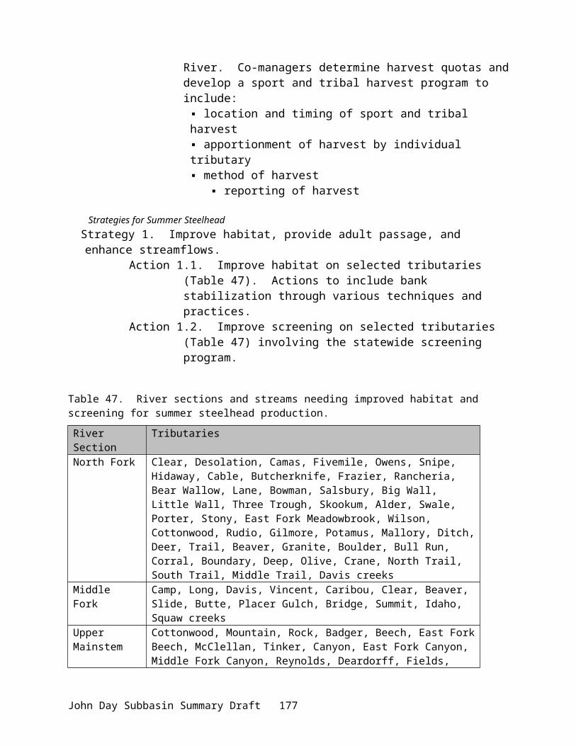
Relationship to Other Projects:Project ID Title Nature of Relationship198402100 Protect and Enhance John Day
River Fish HabitatMany CTWSRO projects are located within ODFW project areas, supporting potentially significant cumulative beneficial effects.
199306600 Oregon Fish Screening Project CTWSRO projects either reduce the need for fish screens or enhance their effectiveness.
Relationship to Existing Goals, Objectives and Strategies:1. NPPC Columbia River Basin Fish and Wildlife Program
a. Measure: (7.8G.2) “Provide funding for the acquisition and management of critical water rights for rebuilding and maintaining Columbia River salmon and steelhead populations.”
b. Response: The property contains significant water rights that can be used to meet instream flow targets within some of the most critical spawning and rearing habitats in the John Day basin.
2. 2000 FCRPS Biological Opinion: (http://www.nwr.noaa.gov/1hydrop/hydroweb/docs/final/2000biop.html). The BiOp recommends that the upper John Day be treated as a high priority subbasin. While the BiOp listed goals and objectives, which are essentially consistent with the John Day Subbasin Summary, it also specifically identified actions to be undertaken by the three federal “action” agencies. Pertinent actions (RPAs) are listed below, with our response as to how the Oxbow Management and Implementation Project assists BPA and the federal agencies in meeting these actions.
a. Action 149 – BOR shall initiate programs in three priority subbasins (identified in the conceptual Recovery plan) per year over 5 years, in coordination with NMFS, FWS, the states and others, to address all flow, passage, and screening problems in each subbasin over 10 years…Under the NWPPC program, BPA addresses passage, screening, and flow problems, where they are not the responsibility of others. BPA expects to expand on these measures in coordination with the NWPPC process to complement BOA actions described in the action above.
i. One of the three priority subbasins identified in the Conceptual Recovery Plan is the upper John Day. This project addresses passage, screening, and flow issues by acquiring critical water rights, removal of push-up dams and excluding grazing from key riparian corridors (under the interim conservation agreement), and other watershed conservation measures.
b. Action 150 – In subbasins with listed salmon and steelhead, BPA shall fund protection of currently productive non-federal habitat, especially if at risk of being degraded…
i. The property provides spawning and rearing habitat for listed steelhead. Maintenance actions proposed under this project respond to the need to continue protection of critical habitats to prevent further degradation and loss of habitat units.
John Day Subbasin Summary Draft 181

c. Action 151: BPA shall, in coordination with NMFS, experiment with innovative ways to increase tributary flows by, for example, establishing a water brokerage.
i. The project supports action 151 by converting all or some of the property water rights to instream flows, which enhances tributary flows. Although this may not be the “innovative” approach intended under action 151, we assert that it still supports the requirement to move towards enhanced instream flows.
d. Action 152: The Action Agencies shall coordinate their efforts and support offsite habitat enhancement measures undertaken by other Federal agencies, states, Tribes, and local governments by the following: (See RPA)
i. Ongoing property management is organized by the Tribes, in cooperation with the ODFW and others, to improve offsite habitat conditions. BOR also funds part of the Tribal base program, which supports management activities on the Forrest Ranch.
e. Action 153 – BPA shall…negotiate and fund long-term protection for 100 miles of riparian buffers per year…
i. The Project provides long-term protection for over twelve miles of riparian corridor, which assists BPA with meeting Action 153.
3. John Day Subbasin Summary: The overall goal for the subbasin is to “restore the health and function of the ecosystem to ensure continued viability of [its] important populations.”
a. Need to restore, protect, and create riparian, wetland, and floodplain areas within the subbasin and establish connectivity; need to especially restore floodplains in areas degraded by dredge mining.
b. Need to restore and protect riparian habitat and structure, channel function and form, flows, and water quality for primarily bull trout, spring chinook salmon and summer steelhead; habitat and water quality improvements needed for other resident trout species as well.
c. Need to restore in-stream habitat to natural conditions and protect as much as possible to provide suitable holding, spawning, and raring areas for anadromous and resident fish.
d. Need to protect and restore…cottonwood sites where they currently exist in riparian areas to restore roosting habitat for wintering bald eagles and great blue herons.
e. Need to increase the number of tools associated with irrigation water management, including headgates and flow measuring devices on both private and public lands.
f. Need to determine nature and extent of upland noxious weed invasions.g. Action: Improve habitat on the Middle Fork John Day River and selected
tributaries from Mosquito Creek (RM 39) to Summit Creek (RM 72). Stabilize banks and exchange or purchase land to create natural riparian areas.
h. Strategy: Reduce mining impacts by mitigating for impacts of mine tailings…
Tribal Restoration Plan: The Tribal Restoration Plan (Wy-Kan-Ush-Mi Wa-Kish-Wit,CRITFC 1995) does not recommend specific objectives for the basin, but rather describes benefits from implementing specific actions, while identifying other “needs” in the basin. However, a described benefit, which we view as a numeric objective, is to achieve a run size of 7,000 ChS
John Day Subbasin Summary Draft 182

(1,050 harvest) and run size of 45,000 StS (11,250 harvest) to the John Day basin. These run size objectives are supported by the John Day River subbasin plan (ODFW et. al. 1990), for which the Tribes were a coauthor.
NPPC Subbasin Plan: The John Day subbasin plan (IBID) further identifies habitat protection objectives as: “Protect existing anadromous fish habitat by preventing further watershed degradation and the resulting changes in water quality, quantity, and instream habitat. Provide optimum habitat for all life history stages of anadromous salmonids.” In addition, the subbasin plan recommends a strategy, with specific actions, to meet this objective. This strategy includes ‘protecting and preventing further loss of riparian systems, instream habitat, water quality and quantity’ by various methods including the acquisition of land and water rights.
Middle Fork Stream Restoration Plan: The stream restoration plan for the Middle Fork (OWRD 1991), for which the Tribes were a cosponsor, describes general goals and specific objectives and strategies within reaches of the Middle Fork. These objectives include:1) Increase 80 percent exceedence flows from the present 4 cfs to 35 cfs above Camp Creek.2) Reduce peak daily summer water temperatures so that they do not exceed 65--68ºF.3) Increase mean monthly winter temperatures by 2 to 4ºF.4) Improve quality and quantity of riparian and instream habitat (increase hiding and rearing
cover, abundance and diversity of food resources, pool/riffle rations, large wood debris, number of boulders, sinuosity) and improve fish passage.
5) Reduce watershed soil erosion, improve streambank stability and meet or exceed water quality standards for total dissolved solids (500 mg/L).
Specific actions were also recommended under this assessment/plan which include:a. Lease/purchase of water rights on top priority streams – Middle Fork (6 cfs), Vinegar
Creek (3.6 cfs)…Placer Gulch, Davis Creek (1.36 cfs) [and] Vincent Creek (2.14 cfs)… b. Corridor fencing, controlled livestock use…on private lands on top priority streams---
Middle Fork (20 miles)…Davis (3 miles)…Vincent, Caribou Creeks…c. Purchase up to 17 miles of property on the Middle Fork.
The plan further recommends additional actions, such as riparian plantings and diversion improvements, which are directly applicable to the property, without listing the property specifically.
Mainstem Stream Restoration Plan: The Upper Mainstem Stream Restoration Plan (BOR 1992) recommended similar goals, objectives, and strategies for the mainstem as were established for the Middle Fork. Additional objectives were set such as:a. Increase 80 percent exceedence flows at John Day in August and September from the
present 17 cfs in August and 24 cfs in September to 30 cfs.b. …Improve quality and quantity of riparian habitat to achieve 80 percent coverage of
lineal length of streams with at least half of the vegetation in excess of 8 feet in height where site potential exists.
c. Enhance the local economy…Tribal ceremonial, subsistence, and [the] commercial fishery.
Specific actions were also recommended under this plan that included:
John Day Subbasin Summary Draft 183

a. Lease and purchase of 1,500 acres of late-season rights above John Day. Focus on Strawberry Creek.
Creation of Self-Sustaining Habitats: Historic photos (stills and aerials) taken prior to the 1940’s era of land clearing and channelization display a remarkable riparian community, which is assumed to have provided high quality fish and wildlife habitats. Further, interviews with local residents recalling the condition of the river channel and riparian, and salmon densities support the hypotheses that these habitats provided all the conditions for self-sustaining populations of fish and wildlife. Our proposal is to return these reaches to a natural condition or as close to natural condition as possible, which would provide for those habitats to be again self-sustaining in perpetuity.
The Middle Fork, which although cleared along its entire length of riparian trees and shrubs, was never channelized and still provides the highest quality spawning habitat in the entire John Day basin. Almost the entire length of the river property is composed of gentle glide/riffles over appropriately sized gravels. The feature most noticeably absent from this reach, is the complete lack of any riparian shrubs and almost total annual utilization of riparian grasses by cattle (Photo 3). In fact, along over four miles of river, there currently exists less than thirty shrubs or trees over four feet high (estimated).
However, even with over six months of current use (May—November) by over 120 cow-calf pairs, the stream banks are in a remarkably intact condition. We assert that this is an indication of:1) the current productivity of the near-bank corridor (well-sodded banks); and 2) the lack of scouring, destabilizing flows due to the property’s close proximity to the
headwaters of the Middle Fork. Additionally, in the early 1980’s, a short (<1 mile) reach of the river was fenced and
excluded from grazing. Photopoints taken annually within this project area display a striking improvement in bank condition, riparian vegetation, and channel structure.
For these reasons, we believe that the restoration potential of this tract is probably the highest of any single private property in the basin and that these habitats can be recovered without any significant additional restoration efforts.
The mainstem tract is somewhat more problematic regarding the ability of restored habitats to be self-sustaining. While historic photographs and resident interviews bear witness to the mainstem being highly conducive to supporting productive fish and wildlife populations, the addition of dredging and diking on the mainstem indicates a potential need for further restoration work (other than simple removal of grazing) to provide conditions of self-sustaining habitats. However, what is encouraging is that recovery of riparian communities on adjacent properties, without any further instream project work, has led to direct improvements in channel condition and gravel recruitment. The result has been the creation of highly productive spawning habitats without drastic channel modification projects.
This proposal is for the acquisition of the property and removal of livestock from riparian areas and other critical habitats only, and does not propose breaching of dikes or creation of in-channel features to restore the river hydrology. It is likely that self-sustaining habitats can be created through implementation of the proposed project only, albeit at a possibly slower rate of recovery, however, we are proposing that additional activities (such as dike breaching) be identified and analyzed through the property management plan to ensure that long-term sustainability can be achieved.
John Day Subbasin Summary Draft 184

Addressing the immediate risks to existing habitats and species and capturing the highest priority in the basin is not dependent upon self-sustaining habitats being created. However, acquiring the property is a prerequisite to creating self-sustaining habitats on the Forrest ranch.
Survival and Quantitative Biological Objectives: Survival and potential production increases were estimated under the 1985 Spring Chinook Study (Lindsay et. al. 1985) and the watershed restoration plans (BOR 1992 and OWRD 1991). Benefits to the watershed and species survival were also further assessed under modeling completed for the water optimization study and stream restoration plan (BOR 1990 and OWRD 1991). Measurable, quantitative biological objectives related to cfs of streamflow, acres of riparian and upland habitats, miles of stream channel, and production of species have been established. These are detailed and discussed below, under Objectives.
Benefits to ESA Listed Species: Improvements in ChS habitat provide immediate direct benefits to StS and BuT, federally listed threatened species, as rearing habitats generally overlap on both parcels. Restoration of spawning, rearing, and migratory habitats will benefit all species and are measurable in terms of direct benefits to survival at each life history stage. While the focus is on aquatic species, other listed terrestrial species are anticipated to also benefit from improvements in upland and riparian habitats (e.g., maintenance of bald eagle roost sites).
Habitat Expansion: The project benefits multiple species by improving and expanding core, critical habitat areas and by connecting existing high quality habitats. Downstream habitats are generally suitable for spawning and rearing but may be unoccupied or underseeded due to the upstream limitations created by conditions on the property. Critical spawning and rearing habitats on the mainstem Middle Fork are either owned or managed by the U.S. Forest Service or four private landowners (Figure 6). Of those habitats, a private landowner owns 1.5 miles involved in the Tribal restoration program, 4.4 miles by The Nature Conservancy, 4.1 miles by the Tribes, 4.0 miles by John Forrest, and 3.2 miles by JoAnn Vidondo. The USFS lands, which are the remainder of the critical mainstem habitats, have not been grazed for 11 years and seem to be recovering from historically poor grazing management. The properties owned by the Nature Conservancy and Tribes are managed for the primary benefit of fish and wildlife.
The Vidondo property, which has the second highest spawning density in the Middle Fork, is immediately upstream of the Forrest property and is adjacent to USFS. While spawning densities are relatively high on the Vidondo reach, rearing densities are low due to the complete lack of riparian vegetation and resultant high water temperatures. The Nature Conservancy has pursued an acquisition of the Vidondo property and the North Fork Watershed Council is conducting a restoration project on part of the same property. The Forrest property connects the USFS habitats above the Vidondo property with USFS, Tribal, and TNC conservation properties below.
Properties below the Forrest Ranch, as well as tributaries above, below, and throughout the parcel, contain core areas for rearing. Restoration of the Forrest property, which is currently rearing habitat limited, would not only connect existing core rearing habitats, but also expand and improve them as well.
Of the 25.7 miles of mainstem habitat above John Day, 4.2 miles are lacking a corridor fence or exclusion from grazing (Figure 5). The Forrest parcel represents over 1.7 miles of the remaining “gap” in the river corridor and is probably the most significant due to its being the
John Day Subbasin Summary Draft 185

downstream limitation of spawning and rearing and its proximity to high quality habitat above and below the property.
303(d) Listed Waterbodies: All mainstem stream reaches and the key tributaries on the property are included on the State of Oregon list of water quality impaired stream. Based on our monitoring activities we estimate improvements in water quality from an overall reduction in temperature, nutrients, and other contaminants and an increase in dissolved oxygen. This would result from the restoration of aquatic habitats and wetland/riparian areas but may not be sufficient to bring the entire stream reach below threshold State values.
We anticipate, that through a combination of riparian and wetland restorations, water temperatures should decrease from cool-water tributary and off-channel contributions and the cool water should be maintained through the reach by productive riparian areas.
Monitoring: Project and basin level monitoring programs are conducted by the ODFW and JDBO as part of our ongoing watershed restoration programs and receive support from BPA, BOR, and others. The JDBO commits to an annual monitoring program as part of our annual work plan, carrying out activities in cooperation with the ODFW, OSU, and others. The ODFW and OSU specifically, and others generally, have already committed to assisting with monitoring efforts (including preparation and analysis of a monitoring plan) and with carrying out or continuing their own monitoring. All of this work will be done on a cooperative basis and will be organized towards collecting information which describes baseline conditions, tracks trends in recovery, and evaluates the objectives we have established for interim property management and those that will be developed under the property management plan. Specific tasks related to the monitoring program are described in the proposal Objectives section.
Review Comments:The purchase of this property was funded through the High Priority Process.
Budget:FY 02 FY 03 FY 04 FY 05 FY 064,207,659Category: Crediting Resolution
155,715Category: Crediting Resolution
146,635Category: Crediting Resolution
148,091Category: Crediting Resolution
124,435Category: Crediting Resolution
Project: 25004 – Acquisition of Wagner Ranch
Sponsor: CTWSRO
Short Description:Acquire Wagner Ranch to provide a contiguous corridor of fish and wildlife habitat along the lower John Day River.
Abbreviated Abstract:The Wagner Ranch is a 9,253-acre property located nine miles south of Clarno, Oregon. The Ranch is one of the last remaining pieces to be acquired for contiguous protection of riparian
John Day Subbasin Summary Draft 186
habitat along the lower John Day River. The Wagner Ranch abuts the Pine Creek Ranch, which is owned by the CTWSRO and was purchased for conservation purposes under the Northwest Power Planning Council’s Columbia River Fish and Wildlife Program. Management of Wagner Ranch will compliment management actions on Pine Creek Ranch.
The project will benefit a rich and diverse group of fish, wildlife, and plant species. Wagner Ranch potentially supplies habitats for at least 36 animal and plant species that are listed as sensitive, threatened or endangered. Target wildlife species identified in the Columbia River hydropower loss assessments that would benefit from this project include mink, great blue heron, Canada goose, mallard, yellow warbler, spotted sandpiper, bald eagle and osprey. The property also provides important habitat for deer, elk and has the potential for bighorn sheep reintroduction. Fish species that would benefit from this project are spring Chinook salmon, summer steelhead and Pacific lamprey. The Wagner Ranch has 10 miles of mainstem frontage, 215 primary water right acres and a 4,349-acre BLM grazing allotment attached to the property. Wagner Ranch was put under option through the purchase of Pine Creek Ranch, the option will expire in September 2001.
Relationship to Other Projects:Project ID Title Nature of Relationship199800001 Pine Creek Ranch Wagner Ranch abuts Pine Creek
Ranch and is under option from the Pine Creek Ranch acquisition.
Relationship to Existing Goals, Objectives and Strategies:Acquisition of Wagner Ranch would produce largely self-sustaining habitats of nearly 10,000 acres for both fish and wildlife resources. Protection of the riparian habitat along ten miles of the main-stem John Day River (6 miles of private and 4 miles of BLM) will connect a vital riparian corridor to federal lands now designated as a wilderness study area. This proposal has immediate benefits to an estimated 36 different sensitive, candidate or listed species and will further compliment restoration actions currently underway on Pine Creek Ranch.
The stated objective for the John Day basin is to “Protect existing anadromous fish habitat by preventing further watershed degradation and resulting changes in quality, quantity and instream habitat” (NWPPC 1990). This objective has also been incorporated into the tribal restoration plan Wy-Kan-Ush-Mi Wa-Kish-Wit (CRITFC 1995). While populations in the upper portion of the basin are in moderately good condition, populations in the lower mainstem area are in poor shape and declining (USDA 1996). Since one of the primary objectives of this project is to protect and enhance anadromous fish habitat and migration corridors, it should substantively help in reducing the continued decline of these wild fish runs in the John Day basin. This project addresses measures 7.6B.3, 7.6C.5 and 7.8A.2 of the NPPC Fish and Wildlife program.
Additionally, the area in question has been identified through GAP analysis to be an important corridor that provides connectivity for a variety of key wildlife species and habitats (ODFW 1997). The project provides linkages to several BLM parcels considered for wilderness status and federal lands managed by the National Park Service. The lower John Day River Basin from Service Creek (Rm 157) to Tumwater Falls (Rm 10) is included in the federal and Oregon wild and scenic waterways system. The portion of the project that fronts the main-stem John Day (Rm 123.5 to Rm 132) will provide a linkage to federally owned upstream and downstream areas. Wagner Ranch has been identified as a high priority wildlife mitigation site by the Oregon Wildlife Coalition (ODFW 1997).
John Day Subbasin Summary Draft 187

Review Comments:Purchase of this property will provide opportunities for riparian improvements along 10.2 contiguous miles of mainstem river frontage (area serves as a migration corridor for chinook). Grazing rights would be included in the purchase. The property purchase was funded through the High Priority Process.
Budget:FY 02 FY 03 FY 04 FY 05 FY 062,669,717Category: Crediting Resolution
35,000Category: Crediting Resolution
33,000Category: Crediting Resolution
33,000Category: Crediting Resolution
33,000Category: Crediting Resolution
Project: 25006 – Provide Coordination and Technical Assistance to Watershed Councils and Individuals in Sherman County, Oregon
Sponsor: Sherman SWCD
Short Description:One watershed council coordinator and two planner/designers will provide support to five watershed councils in Sherman County. All future conservation projects will be based on watershed plans and individual ranch plans developed by these positions.
Abbreviated Abstract:Sherman County is a primarily agricultural county between the Lower John Day and Lower Deschutes Rivers. 95% of the county is private land. Five watershed councils operate in Sherman County with staff assistance from Sherman County Soil and Water Conservation District (SWCD). All five watershed councils would like to implement conservation projects. Well-designed projects on private agricultural land must be based on overall farm or ranch plans. SWCD and NRCS policy is that all conservation practices to receive financial assistance should ideally be based on a farm or ranch plan. Furthermore, any project to be cost-shared by federal programs must go through NEPA review. The NRCS/SWCD 9-Step Planning Process integrates planning and NEPA review into one process. Sherman SWCD currently has a significant planning/NEPA backlog.
This grant would provide sufficient funding (when combined with existing SWCD funds) for one watershed coordinator and two planner/designers. The watershed coordinator will provide for professional relationships between agency partners and local watershed councils. The funded planners will produce 60-100 resource management plans with associated NEPA documentation over the course of five years. These management plans will likely be implemented over the next seven to ten years with cost-share funding from OWEB, USDA, BPA, DEQ or other sources.
John Day Subbasin Summary Draft 188

John Day Subbasin Summary Draft 189
Relationship to Other Projects:Project ID Title Nature of Relationship1999010 Pine Hollow / Jackknife Watershed
ProjectOngoing progress will rely on coordination and technical assistance from SWCD personnel. In the past, Sherman SWCD has contracted for range planning, using BPA and OWEB funds. The contractor is not available for these services any longer.
25050 Provide Incentives to Convert to Direct Seed / No-till Farming in Sherman County, Oregon
Sherman SWCD is requesting funding to assist farmers in converting to direct seed in order to reduce sediment and improve watershed hydrology. All cooperating farmers will require planning assistance.
Relationship to Existing Goals, Objectives and Strategies:Sherman County SWCD partners with locally-led watershed councils to attempt to produce an overall change in land use patterns across the private lands between the Lower John Day and Lower Deschutes Rivers. Sherman County Soil and Water Conservation District Long Range Plan (July 1998) calls for the SWCD to utilize an ecosystem approach to watershed enhancement and protection by (among other actions) helping establish and support local watershed councils, and encouraging local participation in watershed planning and restoration activities (p4). Watershed councils are locally led groups made up of resource users, residents, and agency personnel with an interest or responsibility in a particular watershed. Five watershed councils are organized in Sherman County, and cover 90% of the county. The purpose of these councils is to ensure that all conservation projects applied in the county are considered in the context of the overall watershed.
At the level of the individual management unit or property, all conservation practices implemented on private lands should ideally be part of a resource management system. A resource management system plan describes the management of the property or management unit, how the particular practices fit into the overall management, what the benefits of the proposed practices are to the health of the natural resources on the property and watershed, and how any negative effects will be mitigated. The SWCD/NRCS 9-Step Planning process provides this context and integrates NEPA, ESA consultation and State or Federal permitting into the planning process. NRCS is currently completing Section 7 consultation on the 9-Step Planning Process as applied in Sherman, Wasco and Gilliam Counties. This process is due to complete by the end of September, 2001.
Sherman SWCD's 2001 Annual Plan of Work (November 2000) specifically states that the SWCD will dedicate 62 staff days to Resource Management System planning, 66 staff days to design, layout and inspection of conservation practices, and 56 staff days to monitoring on behalf of the various watershed councils. The Annual Plan of Work also specifies that the Pine Hollow Planning Contractor will provide 66 days worth of support, and NRCS will provide 702 staff days. With the expected loss of the Planning Contractor and NRCS technician, this will translate into a total shortfall of 264 staff days - slightly more than one full-time equivalent. The Pine Hollow Action Plan (1999) calls for addressing range and cropland issues in the uplands first, with a gradual shift in focus toward the riparian area after 2001.
John Day Subbasin Summary Draft 190
The Fulton and Gordon Canyons Action Plan (1997) calls for addressing crop and rangeland needs with funding from the USDA, Oregon Watershed Enhancement Board, and other sources. USDA requires farm planning to be complete prior to implementation of practices. OWEB strongly encourages planning be completed prior to implementation of projects. Most of the major fish and wildlife plans written for the Columbia Basin and State of Oregon in recent years call for support of farm and ranch planning and conservation on private lands.
Return to the River (ISRP, September 1996) states that significant modification of land use patterns and practices, especially grazing and cropland, will be necessary for restoration at appropriate ecological scale (p354). "Restoration and enhancement of habitat forming processes…produce (sic - reduce?) flood peaks and to stabilize baseflows, elimination of pollution loads (sediments, toxic compounds) and protection of riparian vegetation from logging and grazing are keys elements of the normative river" (p355).
This proposal will support the habitat goals outlined in Section 7.6 of the 1994 Fish & Wildlife Program. By working with watershed councils and private landowners, it makes possible implementation of Section 7.7, which calls for cooperative actions with private landowners. Section 9.1 states that "In developing mitigation strategies, the Council believes the region should give special consideration to small, family-owned businesses and farms." The proposal will also improve habitat conditions for resident redband trout and other species, as well as terrestrial wildlife, as called for in Sections 10 and 11.
Action 154 on page 9-136 of NMFS' FCRPS Biological Opinion (December 21, 2000) calls for BPA to help fund development of watershed plans and technical assistance for implementation of said plans working with State and local governments in areas with significant non-Federal lands. Sherman SWCD planner/designers provide a highly effective way for BPA to provide technical assistance for implementation of watershed plans on the private lands as well as associated grazing allotments.
This proposal provides a means for BPA to support the Oregon Plan for Salmon and Watersheds. Strategy 2 of Oregon Watershed Enhancement Board's (OWEB) Strategy for Achieving Healthy Watersheds in Oregon calls for OWEB to target funds toward development of watershed-level assessments and action plans and further to support collaboration between watershed councils and SWCDs for shared restoration priorities. Strategies 7 and 8 further emphasize the importance of watershed councils and soil and water conservation districts in setting local priorities and promoting local investment in watershed restoration.
Wy-Kan-Ush-Mi Wa-Kish-Wit , Spirit of the Salmon. (CRITFC 1995) lists the following objectives and strategies, which are directly related to farm and ranch planning:
In the Deschutes Subbasin:Objective 1. Maximize the protection and enhancement of aquatic and riparian habitat on all land bordering the Deschutes River and its tributaries to result in a net increase in habitat quantity and quality over time.Objective 2. Maintain or improve watershed conditions for the sustained, long-term production of fisheries and high quality water.
In the John Day Subbasin:Strategy 2.2 Reduce sediment from agricultural practices and unimproved roads.Strategy 2.3. Reduce nitrate, phosphates, bacteria and other contaminants related to agricultural practices.
John Day Subbasin Summary Draft 191

Strategy 3.2. Implement Best Management Practices (BMP), including stream buffers, to benefit fish on private lands.Objective 4. Improve range management
The John Day Subbasin Plan incorporates the goals of watershed councils and SWCDs with a basinwide summary. The following goals, objectives and strategies are relevant to this proposal:
1. A healthy watershed and long-term economic stability for individuals and communities that rely on the watershed’s natural resources.
2. Efficient conservation of water and soil through on-the-ground treatments.3. Enhanced fish, wildlife, and habitat resources.4. An educated public regarding natural resources and conservation.5. A cooperative relationship between government agencies and landowners.
Objective. 1 Establish and encourage practices that reduce soil erosion and improve water quality; reduce soil erosion by 50%.
Objective 2. Increase desirable plant diversity and reduce undesirable plant species by 2002.Strategy. Promote Coordinated Resource Management Planning (CRMP).
Objective 3. Restore and enhance riparian vegetation.Objective 4. Enhance and restore watersheds in conjunction with SB1010 and the Oregon Plan,
reducing nitrogen levels in aquifer and soil movement to sustainable standards.Strategy. Conduct watershed enhancement and restoration projects.
In addition, this proposal will implement the following ODFW strategies and actions, excerpted from the John Day Subbasin Summary:
Strategy 1. Grazing: Develop livestock control measures to include limited grazing periods, reduced stocking rates, temporary or permanent stream corridor fencing, and management of riparian pasture systems.
Strategy 9. Continue landowner involvement and cooperation in protecting, restoring, and enhancing riparian systems and watersheds.
Strategy 18. Support and expand existing watershed programs
Bull Trout Action 3.3.2. Reduce grazing impacts with current, proven technology (e.g. fencing, changes in timing and use of riparian pastures, off site watering and salting) The Deschutes Subbasin Plan incorporates the goals of all soil and water conservation districts and watershed councils in a quick summary:
County Soil and Water Conservation DistrictsGoal:Promote and protect the natural resources of the counties and the areas included in their watershed drainages.
Local watershed councilsGoals:1. Promote stewardship of the watersheds through cooperative and voluntary efforts.2. Protect and enhance the natural resources in the watersheds.
The Deschutes Subbasin Summary also references ODFW's Lower Deschutes River Subbasin Management Plan (ODFW 1997b). This proposal will implement Strategy 9.3 from that
John Day Subbasin Summary Draft 192
document: Encourage private landowners, federal land managers, NRCS, and SWCD to resolve sediment runoff problems associated with crop and range lands.
Review Comments:This proposal requests staffing to coordinate and perform activities that are performed by watershed councils. Reviewers suggest these activities should be funded through the USDA.
Budget:FY 02 FY 03 FY 04 FY 05 FY 0695,670Category: Recommended Action
65,770Category: Recommended Action
68,337Category: Recommended Action
71,006Category: Recommended Action
77,582Category: Recommended Action
Project: 25028 – John Day Upland Restoration
Sponsor: CTWSRO
Short Description:Expand restoration program to encompass uplands. Monitor wildlife species indicative of both riparian and upland health, aggressively control detrimental weed species that reduce upland productivity, alter hydrologic regimes, and increase erosion.
Abbreviated Abstract:This proposal seeks to evaluate upland habitat condition and wildlife production issues as they relate to watershed recovery within the basin. Specifically, these projects assess the reintroduction potential for sage grouse, sharp-tailed grouse and bighorn sheep, evaluate re-colonization of white-tailed deer in riparian habitat improvement project areas, and enhance upland habitats through juniper removal and noxious weed control.
Relationship to Other Projects:Project ID Title Nature of Relationship199801800 John Day Watershed Restoration
ProgramSupports more aggressive juniper program in concert with the program described within the JDWR program.
Relationship to Existing Goals, Objectives and Strategies:The John Day is one of former President Clinton’s and Oregon Department of Environmental Quality’s priority subbasins under executive order. Water quality and habitat are both addressed by the criteria that lead to such listing of the John Day River system. Habitat problems stem from historical mining and dredging, poor grazing management, timber harvest, road building, and irrigation diversions. However, effects from these activities are clearly mitigable given the demonstrated successes of the ongoing programs within the basin. NMFS has assigned priority
John Day Subbasin Summary Draft 193

status to the upper John Day subbasin due to its potential productive capacity and amount of quality habitat on federal lands (Knapp et al. 2001).
National Marine Fisheries Service’s 2000 Biological Opinion on operation of the Federal Hydropower System. In December 21, 2000, the National Marine Fisheries Service issued a Biological Opinion for operation of the Federal Columbia River Power System http://www.nwr.noaa.gov/1hydrop/hydroweb/docs/final/2000biop.html). The document lists the upper John Day Basin as a high priority subbasin. As determined by the BiOp, projects addressing certain priority issues must be funded and monitored for improvements. Specific issues requiring management and research focus were identified. The following objectives are addressed by our proposed projects:
i) “Water quantity - increase tributary water flow to improve fish spawning, rearing, and migration.”
Program Response: The anticipated effects of juniper removal include increased flows from the uplands resulting in enhanced instream flow.
i) “Water quality - comply with water quality standards, first in spawning and rearing areas, then in migratory corridors.”
Program Response: The anticipated effects of juniper removal include enhanced native vegetation growth, which is more efficient at erosion control.
ii) “Watershed health – manage both riparian and upland habitat, consistent with the needs of the species.”
Program Response: This proposal addresses upland habitat needs, and evaluates relationships between upland and riparian health.
In addition, Reasonable and Prudent Actions (RPAs) of high priority were outlined for areas within the Columbia River Basin. The following RPAs, as outlined in Section 9.6.2.1, are addressed by the proposed projects:
i) Action 150 – “fund protection of currently productive non-federal habitat, especially if at risk of being degraded.”
Program Response: Noxious weed invasion in upland habitats, dense juniper woodlands encroaching upon many drainages, and depressed populations of native upland species suggest that habitat is at risk for further degradation. However, restoration and select reintroduction efforts have yielded beneficial results, providing support for continued activities in this area.
ii) Action 152 – “The Action Agencies shall coordinate their efforts and support offsite habitat enhancement measures undertaken by other Federal agencies, states, Tribes, and local governments ….”
Program Response: The proposed activities directly follow needs specified in the John Day Subbasin Summary, which was created by an interagency team. Activities such as the white-tailed deer telemetry work will be cost-shared with Oregon Fish and Wildlife. Local juniper and weed control cooperators will be involved as well.
John Day Subbasin Summary Draft 194

Columbia Basin Fish and Wildlife Program (Northwest Power Planning Council)The Northwest Power Planning Council, whose responsibility it is “to mitigate the impact of hydropower on dams on all fish and wildlife in the Columbia River Basin, including endangered species, through a program of enhancement and protection”, has established the Columbia Basin Fish and Wildlife Program (CBFWP). The proposed projects address recommendations specified within this program.
i) The CBFWP has established objectives for salmonid recovery which include habitat goals and policies (7.6), coordinated habitat planning (7.6C), habitat objectives (7.6D), cooperative habitat protection and improvement with private landowners (7.7, 10.2B), implementation of state, federal and tribal habitat improvements (7.8).
Program Response: The combination of these objectives related specifically to salmonid will be addressed by the proposed juniper program. It is anticipated proposed juniper removal projects will release water supplies from the uplands, decrease erosion, and improve water quality for salmonids within the watershed. Habitat improvement will be addressed by juniper and weed treatments, and will be evaluated by upland wildlife status assessments.
ii) Section 2.2A recommends that programs should “support native species in native habitat: the program preference is to support and rebuild native species in native habitats, especially weak stocks.”
Program Response: Sharp-tailed grouse, sage grouse, bighorn sheep, white-tailed deer, and native grassland communities are all threatened by unremmediated historical, and some current land use practices.
iii) Section 2.2.C.1 (“Share Costs”) shows that the NWPPC “expects that costs will be shared among parties to implement measures in the Program, in particular, for projects that mitigate the effects of non-hydropower caused problems.”
Program Response: The John Day Basin Office of the CTWSRO and Oregon Department of Fish and Wildlife will contribute to cost-share agreements to cover portions of this proposal. Private landowners will contribute to cost-share agreements for juniper removal efforts, and access to study sites on private lands.
iv) Section 4.1.A.5. directs priorities to “activities that address critical uncertainties and/or test important hypotheses”.
Program Response: All of the proposed projects address issues that have confronted wildlife professionals within the basin during restoration planning processes and data evaluation activities. An interagency team has specified these data gaps within the John Day Subbasin Summary. In the interest of directing management were most needed, it is essential to address these data gaps and update goals and objectives as new information fills those gaps.
v) Section 7.6.C.2 states “Institute a comprehensive program to monitor progress in achieving compliance with the Council’s habitat objectives”.
John Day Subbasin Summary Draft 195
Program Response: The proposed objectives respond directly to habitat needs through juniper removal to increase water quality, weed control to improve upland productivity, and monitoring wildlife species to assess past restoration efforts.
2000 CBFWP Framework AmendmentsThe fourth version of the Columbia Basin Fish and Wildlife Program was drafted in November of 2000. This new plan is departure from previous versions in that the implementation will be established within subbasin plans that are amended into the NWPPC plan. These habitat-based subbasin plans are directed to address the following Biological Objectives (Section III.C.2):
i) “Maintain and restore healthy ecosystem and watersheds, which preserve functional links among ecosystem elements to ensure the continued persistence, health and diversity of all species including game fish species, non-game fish species, and other organisms.”
Program Response: This proposal seeks to address upland vegetation integrity and wildlife status in relation to water quality and riparian habitat improvements.
ii) “Coordinate mitigation activities throughout the basin with fish mitigation and restoration efforts specifically by coordinating habitat restoration and acquisition with aquatic habitats to promote connectivity of terrestrial and aquatic areas.”
Program Response: By specifically monitoring white-tailed deer movements in relation to watershed restoration projects, the connection between terrestrial and aquatic habitats will be directly related. The juniper removal program is based on the interrelationship of upland integrity and watershed health, as vegetation health on the uplands affects erosion and therefore water quality in the rivers. Upland wildlife species rely on the quality of riparian areas for seasonal food and shelter, and water annually.
iii) “Monitor and evaluate habitat and species responses to mitigation actions.”Program Response: It is anticipated that an evaluation of whitetail deer movement will reveal responses to the on-going watershed restoration programs within the basin. The juniper and weed control programs will be monitored to document effects of those actions as well.
As stated by the plan, “If the vision for the basin is to be realized, it will be through successful selection and implementation of subbasin-level goals, objectives, and strategies. Plans at this level will guide Bonneville funding of fish and wildlife activities.” This allows for specific restoration and research to be tailored to the region of implementation and under the direction of experienced professionals currently working in those regions and, in the case of the John Day Basin Office CTWSRO, with an established set of cooperating agencies and public already in place.
John Day Subbasin Summary (various agencies)
The John Day Subbasin Summary describes specific limitations to healthy wildlife populations within the John Day Subbasin. These limitations include land management practices and human disturbance from which stems habitat loss, noxious weed invasion, alteration in nutrient cycles
John Day Subbasin Summary Draft 196

and food webs, and increased land prices that make land preservation more economically prohibitive (Knapp et al. 2001). Together with ODFW and the Umatilla Tribes, The CTWSRO established the following Restoration Objectives relating to riparian and upland ecosystem health:
i) Protect and maintain remaining high quality riparian and upland habitats.Program Response: Juniper removal is expected to release natural water flows back to the river systems, and remove the threat of replacing riparian vegetation with dry juniper woodlands. Juniper removal and weed control are expected to allow preferred upland vegetation to regenerate and control erosion more effectively.
ii) Maintain or increase wildlife species diversity.Program Response: Juniper and weed control will reduce domination by noxious species, and allow regeneration of a diversity of native vegetation. Research within this proposal will expand restoration efforts to include four different upland species, which has been beyond the salmonid focus of other programs.
iii) Pursue habitat protection through local, state, and federal agency coordination.Program Response: Habitat assessments within this proposal are anticipated to define certain areas that are currently supporting or have the potential to support sensitive wildlife species.
To fulfill these objectives, the following Tribal and State habitat restoration strategies (RS) were established:
RS #9: Continue landowner involvement and cooperation in protecting, restoring, and enhancing riparian systems and watersheds.
Program Response: Landowners will be consulted when private lands support suitable study sites, and for cost-share agreements for juniper and weed control projects.
RS #19: Support and expand existing watershed programs.Program Response: This project supports the existing John Day Watershed Restoration Program by proposing projects that would increase water supplies, decrease erosion, and evaluate the effect of watershed restoration activities on wildlife.
RS #21: Protect, enhance, and restore wildlife habitat in the subbasin.Action 21.1: Determine and monitor abundance and distribution of wildlife species to
identify and prioritize wildlife habitat restoration needs in the subbasin.Program Response: Inventories of white-tailed deer, bighorn sheep, and sage grouse will be conducted to determine population status.
Action 21.2: Conduct periodic comprehensive habitat and biological surveys to identify and prioritize wildlife habitat restoration needs in the subbasin.
Program Response: Habitat suitability analyses will be conducted for specific wildlife species within the basin.
John Day Subbasin Summary Draft 197

Action 21.3: Implement wildlife habitat restoration projects in the subbasin.Program Response: Where potential but compromised habitat is located for reintroduction of selected wildlife species, restoration efforts will be proposed. Juniper and weed control projects will contribute towards habitat restoration.
Action 21.7: Manage habitat to meet state management guidelines for upland birds and game mammals (Action 21.7).
Program Response: Sage grouse, sharp-tailed grouse, bighorn sheep are all typical upland species, and are targeted for habitat suitability analyses. Juniper and weed control projects will improve upland habitats.
RS #22: Protect federal and state threatened, endangered, and sensitive species.Program Response: The Columbian white-tailed deer is a listed endangered species in Oregon.
Finally, specific research needs were listed for the wildlife species of particular interest and vulnerability within the John Day Basin. These research needs also address upland and riparian habitat issues.
Habitat Restoration, Protection, and Enhancement Needs:#1. Need to Restore and protect riparian habitat and structure, channel function form,
flows, and water quality for primarily bull trout, spring chinook salmon and summer steelhead; habitat and water quality improvements needed for other resident trout species as well.
Program Response: Proposed Objective 5; Objective 6.
#8. Need to maintain, enhance, and protect big game winter range and critical upland habitats.
Program Response: Proposed Objective 6
#10. Need to continue control programs for noxious weeds to restore natural habitat conditions and communities for wildlife species.
Program Response: Proposed Objective 6.
John Day Subbasin Summary Draft 198

Habitat Research, Monitoring and Evaluation Needs:#1. Need to conduct compliance and effectiveness monitoring on federal land use
activates.Program Response: Proposed Objective 7.
Wildlife Restoration, Protection, and Enhancement Needs:#1. Need to reintroduce sharp tailed grouse and bighorn sheep into appropriate habitat
areas to help restore their populations.Program Response: Proposed Objective 1.
Wildlife Research, Monitoring and Evaluation Needs:#1. Need to assess population status and habitat for sage grouse and reintroduce sage
grouse into suitable habitat areas.Program Response: Proposed Objective 1.
#8. Need to evaluate re-colonization of white tail deer in habitat improvement areas.Program Response: Proposed Objective 4.
The proposed objectives for the John Day Watershed Restoration Program follow directly from the above stated needs.
John Day River Basin Master Water Plan Working PaperIn 1988 the John Day Basin Council enlisted the help of the BOR to provide technical assistance in preparing a watershed improvement plan. The goal was to create a list, using scientifically credible assessment methods, of feasible projects, with positive effects on water quality and quantity and riparian habitat. In 1990, the planning efforts of the Tribes, agencies, and public culminated in the Upper John Day River Basin Master Water Plan Working Paper (BOR 1990). The Working Paper identified critical gaps and areas for improvement in ongoing agency programs and outlined projects that addressed these deficiencies. In subsequent years, individual stream restoration plans were prepared for the major watersheds in the upper and middle subbasin. These documents detail a comprehensive restoration program involving multiple agencies that targets all components of the watershed. The implementation strategy involves numerous measures, which used in combination, will result in beneficial effects to the watershed. Measures applicable to this proposal include juniper removal and mitigation of logging practices.
Review Comments:Currently, no T&E species are present. However, this project would address winter range conditions on private lands that are contributing to the decline of grassland bird species. In addition, deer and elk populations are dependent on these lands. Sharp-tailed grouse could be reintroduced pending habitat conservation and improvement.
John Day Subbasin Summary Draft 199

Budget:FY 02 FY 03 FY 04399,595Category: Recommended Action
401,353Category: Recommended Action
401,353Category: Recommended Action
Project: 25050 – Provide Incentives to Convert to Direct Seed/No-till Farming in Sherman County, Oregon
Sponsor: Sherman SWCD
Short Description:Sherman Co. SWCD will provide incentive for two of three crop years for farmers to convert to no-till/direct seed farming. Conservation Plans will be written by SWCD or NRCS personnel. No-till provides improvement in watershed hydrology & sedimentation.
Abbreviated Abstract:Sherman Co. SWCD will provide incentives for farmers to convert to no-till/direct seed farming. SWCD or NRCS personnel will complete conservation plans on no-till/direct seeded acres. Cooperators will be required to no-till/direct seed two out of three consecutive years, and will receive $20/acre each year they did so. Conversion to no-till/direct seeding from conventional farming is the single most effective means of restoring watershed hydrology and reducing sedimentation in non-irrigated croplands.
Relationship to Other Projects:Project ID Title Nature of Relationship25006 Provide Coordination and
Technical Assistance to Watershed Councils and Individuals in Sherman County, Oregon
This no-till / direct seed project will require planning assistance to landowners, which could be provided by SWCD planners funded through project # 25006.
Relationship to Existing Goals, Objectives and Strategies:“Return to the River” (ISRP, September 1996) states that significant modification of land use patterns and practices, especially cropland, will be necessary for restoration at appropriate ecological scale (p354). "Restoration and enhancement of habitat forming processes…produce [sic - reduce?] flood peaks and to stabilize baseflows, elimination of pollution loads (sediments, toxic compounds) and protection of riparian vegetation… are keys elements of the normative river." (p355)
This proposal will support the habitat goals outlined in section 7.6 of the 1994 Fish & Wildlife Program. By working with watershed councils and private landowners, it makes possible implementation of section 7.7, which calls for cooperative actions with private landowners. Section 9.1 states that "In developing mitigation strategies, the Council believes the
John Day Subbasin Summary Draft 200

region should give special consideration to small, family-owned businesses and farms." The proposal will also improve habitat conditions for resident redband trout and other species, as well as terrestrial wildlife, as called for in sections 10 and 11.
Section 9.6.2.1 Actions Related to Tributary Habitat of the NMFS Biological Opinion mentions water quantity, water quality and watershed health as objectives for which to manage.
"When related to the basic habitat needs of listed anadromous fish, tributary habitat efforts have the following objectives:Water quantity—increase tributary water flow to improve fish spawning, rearing, and migration.Water quality—comply with water quality standards, first in spawning and rearing areas, then in migratory corridors…Watershed health—manage both riparian and upland habitat, consistent with the needs of the species…" (NMFS Bi-op, p9-133)Summer water quantity in Sherman County is limited by watershed hydrology, rather than irrigation use, as there are only a few water rights in the whole county. Thus, this proposal provides the best way for BPA to comply with Action 151 (p9-134) of section 9.6.2 of the biological opinion, as well as address water quality and watershed health in the lower reaches of the Deschutes and John Day Rivers.
“Wy-Kan-Ush-Mi Wa-Kish-Wit , Spirit of the Salmon” (CRITFC 1995) lists the following objectives and strategies, which can most effectively be met by conversion to no-till:
In the Deschutes Subbasin:Objective 2. Maintain or improve watershed conditions for the sustained, long-term
production of fisheries and high quality water.In the John Day Subbasin:
Strategy 2.2 Reduce sediment from agricultural practices and unimproved roads.Strategy 2.3. Reduce nitrate, phosphates, bacteria and other contaminants related to
agricultural practices.Strategy 3.2. Implement Best Management Practices (BMP)… to benefit fish on private
lands.The John Day Subbasin Summary incorporates the goals of watershed councils and
SWCDs with a basinwide summary. The following goals, objectives and strategies are improved, either directly or indirectly by conversion to no-till/direct seeding:
1. A healthy watershed and long-term economic stability for individuals and communities that rely on the watershed’s natural resources.
2. Efficient conservation of water and soil through on-the-ground treatments.3. Enhanced fish, wildlife, and habitat resources.
Objective. 1 Establish and encourage practices that reduce soil erosion and improve water quality; reduce soil erosion by 50%.
Objective 3 Restore and enhance riparian vegetation.Objective 4 Enhance and restore watersheds in conjunction with SB1010 and the
Oregon Plan, reducing nitrogen levels in aquifer and soil movement to sustainable standards.
Strategy. Conduct watershed enhancement and restoration projects.
In addition, this proposal will implement the following ODFW strategies and actions, excerpted from the John Day Subbasin Summary:
John Day Subbasin Summary Draft 201

Strategy 9. Continue landowner involvement and cooperation in protecting, restoring, and enhancing riparian systems and watersheds. Strategy 18. Support and expand existing watershed programs
The Deschutes Subbasin Plan incorporates the goals of all soil and water conservation districts and watershed councils in a quick summary:
County Soil and Water Conservation DistrictsGoal: Promote and protect the natural resources of the counties and the areas included in their watershed drainages.
Local watershed councilsGoals:
1. Promote stewardship of the watersheds through cooperative and voluntary efforts.2. Protect and enhance the natural resources in the watersheds.
The Deschutes Subbasin Summary also references ODFW's “Lower Deschutes River Subbasin Management Plan” (ODFW 1997). This proposal will implement Strategy 7.4, Strategy 9.3 and Strategy 9.4 from that document:
Strategy 7.4: Work with NRCS and SWCD to implement farm conservation plans designed to reduce erosion.
Strategy 9.3: Encourage private landowners, federal land managers, NRCS, and SWCD to resolve sediment runoff problems associated with crop and range lands. Strategy 9.4: Encourage private landowners, NRCS, and SWCD to resolve agricultural chemical, fertilizer, silt, sediment, and animal waste runoff problems associated with crop and range lands or confined animal feeding operations.
Review Comments:Due to the reviewers recommendation that an FTE should be funded through the USDA (Project 25006), Objective 1 (P&D phase) could be jeopardized without the recommended USDA funding.
Budget:FY 02 FY 03 FY 04164,440Category: Recommended Action
158,440Category: Recommended Action
158,440Category: Recommended Action
Project: 25051 – Columbia Plateau Natural Resources Collaborative (CPNRC)
Sponsor: NRCS
Short Description:Establish collaborative process to provide assistance to local watershed groups on subbasin planning, ESA/CWA integration, and implementation funding to facilitate conservation application to restore salmon and water quality on private lands.
John Day Subbasin Summary Draft 202
Abbreviated Abstract:The Columbia Plateau Natural Resources Collaborative (CPNRC) is a cooperative effort among natural resource agencies to provide technical and planning assistance to farmers and ranchers through local conservation partnerships (SWCDs, watershed councils, RC&Ds, Tribes and others). The goal is to accelerate the implementation of conservation on private lands to restore anadromous salmonids and to improve water quality. The purpose of the CPNRC is to help local partnerships navigate the maze of planning, regulatory, and technical issues on private lands to understand and address these issues in a more efficient, effective manner. The CPNRC will provide the local partnerships with specialized technical assistance (geomorphology, hydrology, biology, engineering, etc.) and assist them with streamlining regulatory programs and leveraging funding programs by using a single planning process. Using an established, local delivery system for working with farmers and ranchers in a voluntary, non-regulatory fashion, the local conservation partnership will be able to accelerate existing efforts to increase conservation applied on private lands.
There are two components to the CPNRC: (1) an interdisciplinary planning component and (2) a field office implementation component.
First, this project would provide key positions for forming an interdisciplinary team (IT) to provide assistance on subbasin assessments, planning and implementation. These positions would be co-located as a team and dedicated to work on the subbasin assessment and planning in collaboration with Tribes, SWCDs, watershed councils and others. Requested funding would cover the salary and benefits for 2.5 FTEs, equipment, travel, and supplies. NRCS would furnish in-kind 1.5 FTEs to interdisciplinary team. NRCS will provide office space and administrative support for the team. Additional specialized technical support will be provided in-kind, as needed, from existing NRCS state office or basin team staff. Preliminary discussions with BLM, USBOR, BPA and other state and federal agencies indicate a willingness to contribute additional staff resources to the interdisciplinary team. It is anticipated as other agencies’ involvement grows, the IT team would also be able to provide assistance to additional provinces.
Second, this project would provide funding for field staff (FS) with SWCDs and NRCS to market, plan, design and implement conservation with private landowners. Requested funding will cover the salary and benefits for ten additional FTEs, equipment, travel, and supplies. The NRCS Resource and Conservation Development program coordinators (two existing positions in Pendleton and The Dalles) will provide (at least 0.25 FTE) in-kind support to locate, obtain, and administer grants for local watershed efforts. NRCS will provide office space, training and supervision in-kind for the added positions.
Relationship to Other Projects:Project ID Title Nature of Relationship
Implementation of USDA NRCS Farm Bill Programs (EQIP, WHIP, WRP, FIP) in Subbasins
Total implementation since 1996 of these programs awarded 302 contracts for $4.9 million for private lands conservation.
Implementation of USDA FSA CRP, Continuous CRP and CREP in these Subbasins
Total implementation since 1986 for CRP programs has resulted in 1,900 contracts on 425,000 acres; however, only 3,200 acres were for CREP or continuous CRP (both are for riparian buffers initiatives).
The Oregon Plan for Salmon and Watersheds
This proposal specifically addresses the Oregon Plan’s four essential elements:
John Day Subbasin Summary Draft 203

Project ID Title Nature of Relationshipcommunity based action, government coordination, monitoring and corrective actions.
B.O. RPA 149 Columbia Plateau Natural Resources Collaborative (CPNRC) will work with BOR interdisciplinary team implementing action 149 and with BOR field liaisons. USDA Service Centers may be used to co-locate BOR staff with USDA and SWCD staff.
B.O. RPA 150 CPNRC will provide guidance to NRCS / SWCD field staff on BPA and NMFS criteria for protecting non-Federal habitat. Local partnership will market, plan and implement conservation management systems to accelerate implementation on non-Federal lands.
B.O. RPA 151 CPNRC will provide assistance and training to NRCS / SWCD field staff on BPA water broker program. NRCS / SWCD will assist private landowners in implementing irrigation water management to conserve water.
B.O. RPA 152 CPNRC will provide for direct integration and coordination of staff, programs and policies. Team will provide guidance on subbasin planning, ESA /CWA consultations, sharing of technical expertise and data, and leveraging of funding.
B.O. RPA 153 CPNRC will work on integrating, modifying and promoting state and federal programs such as CREP to improve watershed health.
B.O. RPA 154 Team will function as clearinghouse for local partnership to obtain information and guidance on programs, funding, data and technical support for subbasin and watershed planning and implementation.
Deschutes Subbasin summary Fulfills objectives to build partnerships and accelerate planning.
John Day Subbasin Summary Supports objectives to collaborate on data, expertise, training and funding.
Columbia River Salmon Recovery Strategy (All H Paper)
Supports the biological objectives to halt declining population trends within 5 to 10 years.
Relationship to Existing Goals, Objectives and Strategies:The purpose of the Columbia Plateau Natural Resources Collaborative is to improve the quality and quantity of conservation/restoration plans applied on private lands to improve fish and wildlife habitat, water conservation and water quality.
John Day Subbasin Summary Draft 204

This proposal will allow for meaningful coordination of agency programs based on community need. It would allow for programs to be adapted and leveraged to maximize efficiency, flexibility and the acceptance of the local community. It also will provide for coordinated performance monitoring of the total effort accomplished by all groups. In addition, the expertise and tools provided through an interdisciplinary team will assist local groups design and carry out effectiveness monitoring programs that will add to our understanding of ecosystem management and the need for adaptive management. Staff added at the field level will accelerate the voluntary farm and ranch planning that must occur to protect and restore watersheds and habitats.
This approach to accelerate efforts within these four subbasins is supported and called for in several initiatives:
The Oregon Plan:This plan for salmon and watersheds emphasizes four essential elements: (1) coordinated
agency programs, (2) community based actions, (3) monitoring, and (4) adaptive management.
Subbasin Summaries Goals, Objectives and Strategies:Deschutes Subbasin:
1. Build partnerships to accelerate planning and implementation.2. Form resource assessment teams to provide specialized technical assistance.3. Coordinate efforts to implement on-the-ground actions.4. Obtain necessary technical, educational and financial resources.5. Strengthen cooperative efforts with producers, government agencies, and the public.
John Day Subbasin:1. Use partnerships and collaborative process to protect, maintain and restore habitat.2. Support measures to collaborate on TMDLs, data sharing, expertise, training and leveraging
funding.3. Need to enhance the cooperative/shared approach in research, monitoring and evaluation
between tribal, federal, state and local entities.4. Need to continue to identify ways of streamlining agency policies aimed at improving habitat
restoration efforts.
Biological Opinion:Columbia River Salmon Recovery Strategy (All H Paper):Action 152 calls for agencies to coordinate their efforts and support offsite habitat enhancement measures undertaken by local, state and federal agencies and tribes. Specific tasks include coordinating TMDLs with recovery efforts; sharing data, expertise and training; and leveraging funding resources with local entities.Action 154 requires BPA to work with the NWPPC to develop subbasin assessments and plans by matching other funds, funding technical support, and coordinating plans across federal and non-federal ownerships and programs.Actions 149, 150, 151, and 153 deal with more specific actions to address screening and passage problems, protection of productive habitat, securing tributary flows, and leveraging USDA farm bill programs including CREP.
John Day Subbasin Summary Draft 205

This concept of Natural Resources Collaborative provides a framework to allow these actions to happen in coherent, comprehensive fashion rather than in a fragmented, decentralized fashion that confuses and frustrates local entities often discouraging implementation.
Columbia River Basin Salmon Recovery Strategy (All H Paper):Habitat Element 1(C) Support Subbasin and Watershed Assessment and Planning calls for:
Common assessment and planning protocols. A locally-led implementation process with technical assistance from local, state, federal, and
tribal agencies. Integration of efforts on both public and private lands. Securing and coordinating funding and technical assistance for non federal landowners. Making CWA and ESA clearance more efficient for landowners. Creating systems for providing data, information, technology, and expertise.
NWPPC 2000 Fish and Wildlife Program:“The Council believes that subbasin plans must be developed within an open public process that provides ample opportunity for participation by a wide range of state, federal, tribal, and local managers, experts, landowners, local governments, and stakeholders (2000 FWP, Section V,A,6, page 56)”.
NWPPC 1994 Fish and Wildlife Program:The Council specifically recognized the need for a coordinated, watershed approach to species recovery that builds on the energy and initiatives of local communities. The Council stated “that implementation of habitat and production measures will continue to suffer from inadequate information, disjointed policies, uncertainty and delay” unless the region works together “to overcome these obstacles and allow recovery to proceed expeditiously (1994 FWP, Section 7, page 7-1). Further the Council stated “a long-term commitment from all local, state and regional entities interested in each subbasin will be necessary (1994 FWP, Section 7.7, page 7-39).”
Regional Watershed Roundtables(Clean Water Action Plan):Three Roundtables were held in the Pacific Northwest to determine the issues and needs
facing local watershed councils, SWCDs, tribes, private landowners and other stakeholders dealing with salmon and watershed.
Issues brought out at these sessions include: Issues are complex with competing interests Laws, regulations, and decision making is fragmented between agencies. Tangle of uncoordinated state and federal programs and regulations. Ineffective use of available funds and duplicative programs. Lack of data and expertise at local level to make sound decisions. Lack of unifying structure between agencies and local groups to deal with these issues. Lack of trust at all levels..
Some of the solutions they suggested included: Create framework for federal agency personnel to become involved in local community
groups. Create multidisciplinary resource teams to be available to watershed groups.
John Day Subbasin Summary Draft 206

Agencies need to develop methods to deliver a unified message to grass roots watershed groups and landowners.
Build linkages between agencies and local watershed planning groups. Provide funding cooperation among agencies and local watershed groups. Streamline permitting processes. Develop a federal/state streamlined approach for grants.
U.S. Army Corp of Engineers Listening Session on Water Resource Needs:This session held by the USACE with other agencies, the public and watershed stakeholders identified 62 challenges to water resources. Three of the top nine challenges dealt with the need for better coordination and collaboration between agencies to provide skills, funding, streamlined permitting, and accountability to local communities.
Clean Water Action Plan:“Key Action: To support local organizations and citizens in locally based watershed
protection efforts, and to encourage the organization of such groups nationwide, EPA, USDA, DOI, NOAA, and other federal agencies will increase information and technical assistance available to these groups.”
Columbia River Intertribal Fisheries Commission’s “Tribal Approach to Salmon Recovery”:“Partnerships are the key to success in watershed restoration. .... it may require tribes,
landowners, watershed councils, states, local governments, federal agencies, and citizen groups working together to restore watershed functions and healthy fish and wildlife.”
Wy-Kan-Ush-Mi Wa-Kish-Wit, The Columbia River Anadromous Fish Restoration Plan of the Nez Perce, Umatilla, Warm Springs, and Yakama Tribes
Recommended Institutional Changes: “Employ voluntary, multi-stakeholder collaborative approaches to protect, restore and monitor natural resources and to resolve natural resource conflicts. These approaches should be open and inclusive, based on existing laws, and conducted within a framework of natural systems--watershed, ecosystems, bio-regions or other defining land-forms--using the best available science. This recommendation is patterned after successful approaches used all across the country. It is intended to provide impetus for stakeholders and communities to work together in searching for common goals, resolving conflicts, becoming aware of and using best available science, meeting legal requirements for protecting the environment, monitoring natural resources and redeeming collective responsibility for conditions and trends of resources.”
1996 USDA Farm Bill:The 1996 Farm Bill recognized the need for an assessment of problems and prioritization
scheme at the local level to guide the implementation of conservation programs (EQIP, WHIP, WRP, CRP, etc.). To accomplish this, the 1996 Farm Bill defined a “local work group” who represent local, state and federal agencies including Tribes to guide implementation of conservation programs. This was done in recognition that past programs did not focus on solving problems on an ecosystem or watershed basis and did not take advantage of opportunities to leverage farm bill programs with other incentive programs.
Western Water Policy Review Advisory Commission Report:
John Day Subbasin Summary Draft 207

This report states failure of state and federal agencies to coordinate is a major factor limiting natural resource management and environmental protection efforts. The commission favors working at the local watershed scale where the people and resources come together to identify problems and integrate actions.
Review Comments:This proposal requests staffing for coordination for subbasin planning/assessments for the John Day Subbasin, activities that are already performed by watershed councils. Reviewers suggest these activities should be funded through the USDA.
Budget:FY 02 FY 03 FY 04 FY 05 FY 06823,200Category: Recommended Action
1,120,200Category: Recommended Action
1,120,200Category: Recommended Action
1,120,200Category: Recommended Action
912,900Category: Recommended Action
Project: 25061 – John Day Fish Passage Barrier Inventory
Sponsor: OWEB
Short Description:This project provides staff to conduct a basin-wide inventory of potential barriers to fish passage. The project will develop a joint prioritization approach to barrier elimination based on biological importance.
Abbreviated Abstract:This project will develop as complete an inventory of barriers to fish passage in the John Day basin as possible. The inventory will include all forms of barriers and will integrate existing databases and information. The primary purpose of the project is to develop a prioritized approach to removing fish passage barriers.
Relationship to Other Projects:Project ID Title Nature of Relationship9801800 John Day Watershed Restoration
ProjectThis project will provide priorities for the ongoing project.
Relationship to Existing Goals, Objectives and Strategies:This project provides the framework for prioritization that will guide implementation. The need for a complete inventory and biologically based prioritization approach will provide a clearer understanding of the significance of the issue in the basin and the potential future costs to remedy the problems. The significance has been recognized in the federal caucus report, Wy-Kan-Ush-Mi Wa-Kish-Wit, and the subbasin summary. Local conservation interests have been actively eliminating barriers at known problem sites.
John Day Subbasin Summary Draft 208

Review Comments:Reviewers indicate that an inventory of fish passage barriers is not warranted since barriers to fish passage have already been identified and that implementation is ongoing. In addition, there has been no coordination with the management agencies.
Budget:FY 02 FY 03152,450Category: Do Not Fund
114,338Category: Do Not Fund
Project: 25067 – Manage Water Distribution in the John Day Basin
Sponsor: OWRD
Short Description:Implement needed water measurement and monitoring improvements and increase water management as flow restoration projects and actions are implemented in the John Day Basin.
Abbreviated Abstract:The project will provide enhanced water measurement and management capabilities which are essential to the success of other proposed projects to acquire instream water rights for the purpose of maintaining streamflows in the John Day River. Historically, fish have been impacted by low streamflows resulting from irrigation water use in the basin.
Several organizations including the Bonneville Power Administration, Bureau of Reclamation, Oregon Water Trust, and Confederated Tribes of the Warm Springs and Umatilla Indian Reservations have or are considering, among other options, acquisition of water rights and transfer or lease of the rights instream. These acquisitions will establish legal protection for streamflows in the John Day River. However, the success of any such project to dedicate flows instream in the basin will depend on the OWRD’s ability to measure and distribute water consistent with the water rights in the basin and to protect the flows instream.
Oregon’s water law can accommodate efforts to increase flows in the John Day Basin through leases and transfers to instream water rights and the allocation of conserved water. Protection of flows allocated to instream uses through these programs will depend on the adequacy of the water management resources available to OWRD and will require significant improvements in water measurement in the basin. The proposed project will provide both the water management and measurement resources needed.
John Day Subbasin Summary Draft 209

Relationship to Other Projects:Project ID Title Nature of Relationship20522 Multi-Year John Day
Anadromous Fish PlanThe project would support habitat improvement efforts by aiding in the improvement of streamflows in the John Day River.
199801700 Eliminate Gravel Push-Up Dams on the Lower North Fork John Day
The project would aid in improved water management consistent with the objectives of the dam removal efforts.
Relationship to Existing Goals, Objectives and Strategies:This project will work as a critical and necessary element of efforts to restore streamflows to the John Day River through transfers and leases of water rights instream and to establishment of instream water rights through allocations of conserved water. Several organizations including the Bonneville Power Administration, Bureau of Reclamation, Oregon Water Trust, and Confederated Tribes of the Warm Springs and Umatilla Indian Reservations have or are considering acquisition of water rights and transfer or lease of the rights instream. These efforts will establish legal protection for instream flows.
The John Day Subbasin Summary includes activities to restore and augment streamflows at critical times through the acquisition of existing water rights. (Restoration, Protection, and Enhancement – Habitat #13) In addition, the summary identifies the need for additional headgates and measuring devices on both public and private lands. (Restoration, Protection, and Enhancement – Habitat #17) Additional capabilities are essential for OWRD to perform the management activities needed to ensure water distribution is performed consistent with the water rights of record, including instream water rights established through leases, transfers, and allocations of conserved water.
The 2000 Columbia River Fish and Wildlife Program includes recommendations that BPA establish a fund to provide an expeditious method for acquiring water rights and to give preference to proposed acquisitions which would address risks to listed species. The 2000 FCRPS Biological Opinion includes several actions, the success of which will depend on the availability of sufficient resources to manage water and water use. Action 149 commits the Bureau of Reclamation to implementation of restoration actions in the John Day River Basin. Action 151 commits BPA to experiment with ways to increase tributary flows using methods such as establishment of a water brokerage.
The Grant County Soil and Water Conservation District is working to improve water measurement and management capabilities in the basin. Through this program, significant improvements in water measurement have been achieved. OWRD cooperates and provides technical advice in the water measurement program. OWRD would coordinate the activities associated with installation of headgates and measuring devices under this proposal with those of the SWCD and would pursue installation at diversions not addressed by the SWCD at which improved water management and measurement is essential to the distribution and regulation of water.
OWRD also is working closely with the involved agencies to assist in other flow restoration efforts. These activities have represented a significant increase in workload. Continued efforts to secure instream water rights and to restore streamflows will further increase the demands on OWRD’s resources. In the absence of sufficient resources, OWRD will not be
John Day Subbasin Summary Draft 210

able to ensure the success of the other organizations’ efforts to secure water for instream purposes.
Review Comments:This proposal would provide the monitoring component that allows for the detection of noncompliance water withdrawal activities. Reviewers believe the financial responsibility for this work is that of the Oregon Water Resource Department and question the appropriateness of funding these activities.
Budget:FY 02 FY 03 FY 04 FY 05 FY 06251,261Category: High Priority (Headgate Installation)
177,785Category: High Priority (Headgate Installation)
273,977Category: High Priority (Headgate Installation)
179,429Category: High Priority (Headgate Installation)
190,376Category: High Priority (Headgate Installation)
Project: 25069 – John Day Salmonid Recovery Monitoring Program
Sponsor: CTWSRO
Short Description:Update salmonid reproduction goals, compile data to develop predictive models to guide future restoration efforts, compile data that presents historical riparian condition, investigate missing bull trout status information.
Abbreviated Abstract:The Confederated Tribes of Warm Springs implement a watershed restoration program in the John Day basin that is supported by the Bonneville Power Administration, Bureau of Reclamation, and Oregon Watershed Enhancement Board. Under this program, the Tribes, through their John Day Basin Office, conduct annual watershed conservation and restoration projects. The program also conducts monitoring as related to these projects.
This proposal seeks to expand the monitoring program to address needs expressed within the John Day Subbasin Summary.
Relationship to Other Projects:Project ID Title Nature of Relationship198402100 Protect and Enhance John Day
River Fish HabitatConcurrent CTWSRO-ODFW project areas, support potentially significant cumulative beneficial effects.
19980160 John Day Basin Spring Chinook Salmon Escapement and Production Monitoring
Data gaps will be addressed and all will be compiled into the predictive Chinook and steelhead distribution model.
197900400 Study of wild Spring Chinook Data gaps will be addressed and all
John Day Subbasin Summary Draft 211
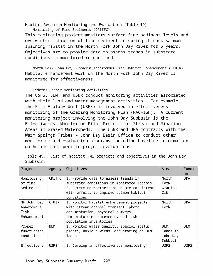
Project ID Title Nature of RelationshipSalmon in the John Day River System
will be compiled into the predictive Chinook and steelhead distribution model.
199405400 Bull Trout Life History Project – NE Oregon
Program has not been able to address migratory improvement and genetic exchange between tributaries on the Middle Fork John Day River.
Relationship to Existing Goals, Objectives and Strategies:2000 Federal Columbia River Power System (FCRPS) Biological Opinion.
Action 149 of the Reasonable and Prudent Alternative Actions for the Columbia Plateau states:“The Federal agencies have identified priority subbasins where addressing flow, passage and screening problems could produce short-term benefits. This action initiates work in three such subbasins per year, beginning in the first year with the Lemhi, Upper John Day and Methow subbasins.”
Program Relevance: This proposal seeks to identify flow and production issues in the Upper John Day subbasin through three of its monitoring and research elements, which include:1. The assessment of adult and juvenile anadromous fish migration patterns as related to
potential passage barriers;2. The establishment of monitoring stations to evaluate flow and quality conditions in and
around anadromous spawning and rearing habitat and;3. The study of flood irrigation effects on tributary streamflows and temperatures.
Section 9.6.2.1 (Actions Related to Tributary Habitat) lists Reasonable and Prudent Alternative Actions for the Columbia Plateau Subbasin. This section sets objectives to meet the basic habitat needs of anadromous fish initiated by tributary efforts. They include: Water Quantity—increase tributary water flow to improve fish spawning, rearing and
migration.o Proposal Relevance : Increases in tributary water flow can only be ascertained by
directly monitoring streamflows, which is an element of this proposal. The flood irrigation study element seeks to optimize groundwater recharge for the purpose of increasing tributary flow during the late season.
Water Quality—comply with water quality standards, first in spawning and rearing areas, then in migratory corridors.
o Proposal Relevance: Six proposed monitoring stations will collect streamflow, temperature, dissolved oxygen, conductivity, pH and turbidity information from anadromous fish spawning and rearing areas.
Passage and Diversion Improvements—address in-stream obstructions and diversions that interfere with or harm listed species.
John Day Subbasin Summary Draft 212

o Proposal Relevance : Differences in anadromous fish movement patterns during various times of the year, as ascertained by our proposed element, will be evaluated to identify such obstructions.
Watershed Health—manage both riparian and upland habitat, consistent with the needs of the species.
o Proposal Relevance : A proposed element seeks to compile historic aerial photographs to evaluate the spatial extent and distribution of historic riparian areas. This information will be used to establish baseline conditions for all riparian management purposes.
Section 9.6.5 (Research, Monitoring, and Evaluation Plan) identifies five areas that research, monitoring and evaluation must address. They are: Population status monitoring. This consists of determining what areas are occupied by
juvenile salmonids and spawning adults, assessing the status of the population (i.e., abundance, trend, distribution, and variation), and reviewing status changes through time. Population status monitoring will also provide a baseline against which management actions can be assessed.
o Proposal Relevance : Three proposal elements seek to compile salmonid spawning ground data, assess migration patterns and develop a predictive model for steelhead; collectively, they specifically address this monitoring area.
Environmental status monitoring. This consists of assessing environmental influences, including non-native species, potentially affecting salmonid populations, and determining whether they change through time, if associations occur between environmental attributes and salmonid population status, and whether these associations suggest that particular management actions should be studied further. Environmental status monitoring will also provide baseline information against which the effectiveness of management actions can be assessed.
o Proposal Relevance : The monitoring of streamflows, pH, dissolved oxygen, turbidity, conductivity and temperature, the evaluation of historic riparian conditions, the study of redd scouring and effects of flood irrigation as well as the obstructions determined by the assessment of salmonid migration patterns are all environmental influences which directly affect anadromous fish populations. These proposed elements will monitor if and how the influences change over time.
Effectiveness monitoring. This consists of assessing whether management actions have the intended effects on the aquatic system and the response of salmonid populations to those effects.
o Proposal Relevance : All of the monitoring elements of our proposal described in the previous area are also completely relevant to effectiveness monitoring.
Quality of regional databases. This consists of assessing the accuracy and comprehensiveness of currently available databases that represent habitat quality throughout the basin. This will play an important role in prioritizing what habitat actions should be implemented in which locations.
John Day Subbasin Summary Draft 213

o Program Relevance : Historic steelhead and spring chinook salmon spawning ground count data, and historic aerial photographs depicting riparian conditions are proposed to be reviewed and entered into a computer database. The proposed migration assessment will be used to identify and prioritize passage barriers to facilitate their removal.
Compliance Monitoring. This consists of assessing whether management actions have been properly implemented and maintained.
o Proposal Relevance : With the possible exception of the flood irrigation effects study, the monitoring elements of our proposal described to address the areas of Environmental Status Monitoring and Effectiveness Monitoring are also applicable to the this area.
Columbia Basin Fish and Wildlife Program (Northwest Power Planning Council).Section 7.6.B. (“Habitat Policies”), proposes to “give highest priority to habitat protection and improvement in areas of the Columbia Basin where low or medium habitat productivity or low pre-spawning survival for identified weak populations are limiting factors. Give priority to habitat projects that have been integrated into broader watershed improvement efforts and that promote cooperative agreements with private landowners” (7.6.B.3). Section 7.6.D (“Habitat Objectives”), identifies standards and goals for Water Quality parameters. The action for sediment loads is:
“to limit the percentage of fine sediments (less than 6.4 millimeters) in salmon and steelhead redds to no more than 20 percent.”Program Response: Six proposed monitoring stations will be equipped with turbidity probes.
The water temperature objective attempts: “to maintain temperatures in historically usable spawning and rearing habitat at less than 60 degrees Fahrenheit. Under all circumstances, do not exceed 68 degrees Fahrenheit throughout each watershed.” Program Response: Temperature will be obtained at six of the monitoring stations.
The water quantity and timing objective states that:“Flow needs should be based on in-stream flow evaluation that considers channel morphology, sediment routing, floodplain function, water temperature and salmon and steelhead passage, rearing and spawning.”Program Response: All monitoring stations will have the ability to measure changes in water levels; this information will be translated into streamflows.
A need to monitor and understand the conditions that promote or curtail these impacts is apparent. The proposed monitoring projects will examine missing information to complete the picture of fish and hydrology within the basin, and apply that information to current restoration projects.
2000 NWPPC FWP Framework AmendmentsThe fourth version of the Columbia Basin Fish and Wildlife Program was drafted in November of 2000. This new plan contains the same objectives, however, it departures from previous
John Day Subbasin Summary Draft 214

versions in that the implementation will be established within subbasin plans that are amended into the NWPPC plan.
John Day Subbasin Summary (Knapp et al 2001)Specific research needs were listed for the salmonids of particular interest and vulnerability within the John Day Basin. The following Research, Monitoring and Evaluation needs are addressed within this proposal:
Habitat Needs:No. 2 Need monitoring for ongoing and completed habitat improvement projects to assess
effectiveness of projects in improving habitat and in enhancing production of salmonid species.
No. 3 Need to monitor water quantity and water quality improvements.No. 4 Need to improve monitoring and enforcement of consumptive water rights throughout the
basin to determine water availability.No. 6 Need a water yield analysis at basin and reach level to determine if flood irrigation
benefits ground water storage; conduct a control and treatment study.No. 7 Need to understand hydrology and water use dynamics of the subbasin and their
relationships to fish needs; knowledge would provide for more efficient and effective use of water.
No. 9 Need to monitor trends in sedimentation levels in critical habitat areas.No. 15 Need to evaluate habitat improvement needs and approaches in critical drainages to
improve passage for spring chinook salmon and summer steelhead.
Summer Steelhead Needs:No. 4 Need to calculate returns per spawner from index surveys to determine if this relationship
is improving as smolt passage facilities are modified at Columbia River dams.
Spring Chinook Salmon Needs:No. 4 Need to monitor spring chinook by examining population trends and develop modeling
and monitoring “tools” to determine out-of-basin impacts to John Day River spring chinook.
No. 5 Need to monitor migration patterns to determine passage barriers within the basin for adult spring chinook salmon.
No. 6 Need to review historic data to determine relationship between redd scour and gravel stability in key habitat areas with juvenile survival (egg-to-smolt survival).
Program Relevance: Habitat needs Nos. 2, 3, 4 and 9 will be addressed by the installation of the proposed monitoring stations; nos. 6 and 7 will be evaluated by the proposed flood irrigation study. Summer steelhead needs nos. 2, 3, 4 and spring chinook salmon needs no. 1 will be examined by the compilation of historic spawning ground counts. The determination of scouring effects will address spring chinook need no. 6.
Wy-Kan-Ush-Mi Wa-Kish-Wit, Spirit of the Salmon (Nez Perce, Umatilla, Warm Springs and Yakama Tribes)The Spirit of the Salmon plan recommends habitat enhancement actions for the John Day subbasin, specifically regarding instream flow and passage. The implementation section of the
John Day Subbasin Summary Draft 215
plan recommends activities to “[i]mplement more efficient irrigation methods and water conservation practices benefiting landowners and instream flows.” Restoration efforts aimed at meeting this recommendation need to be monitored to evaluate the effects and determine whether they are meeting the defined objectives. Furthermore, the flood irrigation study conducted under this proposal seeks to better define “efficient irrigation methods and conservation practices” not only in terms of water use for crop yield, but, water use for improved salmon and steelhead in-stream habitat.
Review Comments:This project will expand monitoring activities in the John Day Subbasin. There appears to be overlap of Objective 4 (water quality monitoring) with Project Number 25010. Objective 4 should not be considered for funding since data from Project 25010 could be used by the sponsors. This project needs to coordinate with Projects 25010, 199801600, and 25088 (Priority area designations...) to avoid duplicative activities.
Budget:FY 02 FY 03 FY 04164,133Category: Recommended Action; Do Not Fund (objective #4)
59,150Category: Recommended Action; Do Not Fund (objective #4)
56,857Category: Recommended Action; Do Not Fund (objective #4)
Project: 25073 – Wheeler SWCD Riparian Buffer Planning and Implementation
Sponsor: Wheeler SWCD
Short Description:This project will implement a riparian buffer program using cost share funding from USDA, State of Oregon and private landowners.
Abbreviated Abstract:Wheeler SWCD is the lead agency in the implementation of watershed enhancement projects within Wheeler County focused on improving riparian zone habitat and overall watershed health. These projects encompass 211,500 acres of the 1,092,408 acres within the District. Working in close partnership with NRCS, the SWCD’s strength is its ability to develop and implement voluntary, scientifically and economically sound resource management plans for private landowners. This project also satisfies the four essential elements of The Oregon Plan: 1) coordination of effort by all parties, 2) development of action plans with relevance and ownership at the local level, 3) monitoring progress, and 4) making appropriate corrective changes in the future.
Wheeler SWCD proposes implementation of riparian buffer systems in the Lower John Day subbasin to address limiting factors for the Parrish, Alder, Thirtymile, Butte, Pine, Cherry, Bridge, Bear and Horseshoe Creek watersheds identified in the 3-2-01 Draft John Day Subbasin Summary. A 1.0 FTE position will be dedicated to provide the technical planning support
John Day Subbasin Summary Draft 216

needed to implement at least 60 riparian buffer system contracts on approximately 1135 acres covering an estimated 78 miles of anadromous fish streams. Buffer widths will average 60 feet on each side of the planned stream reaches. Buffer management practice implementation will include prescribed plantings, fencing, and related practices. The actual cost of land leasing, as well as implementing and maintaining the conservation practices will be covered by existing USDA programs including the Conservation Reserve and Conservation Reserve Enhancement Programs. Land leases will be for a 10-15 year period. This program meets a critical need in the above-mentioned watersheds, where limited technical staff to conduct assessments and develop plans has delayed habitat restoration. Currently seven landowners have expressed interest in CREP riparian buffers, but are waiting for reach assessment and conservation plan development. The majority of the proposed practices will be implemented in the Bridge, Bear, Butte, Pine and Alder Creek subbasins, with some additional work in contiguous subbasins and the mainstem John Day River. Additionally, this person will provide input and assistance to the subbasin assessment and planning process.
Relationship to Other Projects:Project ID Title Nature of Relationship199802200 Pine Creek Ranch This project will be implementing
riparian buffers along much of Pine Creek (approximately 10 miles).
25004 Acquisition of Wagner Ranch Possible riparian buffer implementation along six miles of the John Day River.
B.O. RPA 153 This proposal focuses on accelerating the protection of riparian areas on private lands by utilizing the Conservation Reserve Enhancement Program (CREP) and Continuous Conservation Reserve Program.
B.O. RPA 154 Through this proposal, staff assistance will be provided to the Subbasin Assessment and Planning process to coordinate local input needs.
Relationship to Existing Goals, Objectives and Strategies:This project is the most effective and expedient way of improving and expanding the riparian habitat restoration and protection work already undertaken in these subbasins. This project to develop and implement CRP/CREP riparian buffer plans directly addresses resource concerns identified in the John Day Subbasin Summary, currently under review by the Northwest Power Planning Council. Specifically, the riparian habitat restoration projects should result in higher summer stream flow and reduced water temperature in the planned reaches. This will be consistent with the tribal (CRITFC) fish strategies actions 1.2, 2.12, and 3.2 identified in the subbasin summary.
Buffers remove sediment and nutrients, stabilize stream banks, improve fish habitat, provide food sources, nesting cover and shelter for wildlife. More details on buffers and their effects can be found in a fact sheet at the Conservation Technology Information Center (CTIC)
John Day Subbasin Summary Draft 217

website: www.ctic.purdue.edu/Core4/news/annc/Bufferfact.html or at the Natural Resources Conservation Service (NRCS) web site: www.nhq.nrcs.usda.gov/CCS/Buffers.html.
The Oregon Plan calls for “community based actions” to conserve and restore habitat facilitated by “government coordination: to provide consistent and effective programs. For habitat, the Oregon Plan emphasizes the need to protect and restore riparian areas. Implementation of the Conservation Reserve Enhancement Plan (CREP) has been a major objective of the State of Oregon and is the emphasis of this proposal.
The 2000 Federal Columbia River Power System (FCRPS) biological opinion identifies two reasonable and prudent alternatives (RPAs) this proposal addresses. RPA 152 requests the action agencies to coordinate their efforts and support for offsite habitat enhancement measures undertaken by other Federal agencies, states, Tribes and local governments. RPA 153 specifically requests BPA to work to leverage agricultural incentive programs such as the CREP to protect 100 miles of riparian buffers per year. This project will implement riparian buffers on at least 105 miles of streams.
This project to implement riparian buffer systems supports the NWPPC Fish and Wildlife Program Habitat Goals, Policies and Objectives described in Section 7.6, particularly 7.6B.1 helping private parties be proactive, 7.6B.3 integration of habitat work in broader watershed improvement efforts. Section 7.6B.4 provides for higher priority for actions that maximize effect for the dollar, given that this proposal seeks only funding to make technical assistance available, with other entities picking up the implementation and lease costs, it shows outstanding leveraging of funds. The project supports the provisions of 7.6C for Coordinated Habitat Planning. Establishment of Riparian Buffers clearly supports actions identified in section 7.6D to reduce sediment, improve bank stability, and water quality. Tree establishment in riparian buffers will help stabilize banks, and provide shade, reducing heating rates on hot summer days. Direct planning with private landowners supports the concepts discussed in Section 7.7.
The Tribes' Anadromous Fish Restoration Plan, Wy-Kan-Ush-Mi Wa-Kish-Wit, p.35 identifies 7 actions of which 2 are directly addressed by establishing riparian buffers: Action 6. Protect and enhance aquatic and riparian habitat; Action 9. Increase stream bank cover, decrease water temperatures during the summer and increase stream flow.
Review Comments:No review comments.
Budget:FY 02 FY 03 FY 0475,086Category: Recommended Action
77,337Category: Recommended Action
79,657Category: Recommended Action
John Day Subbasin Summary Draft 218
Project: 25080 – Gilliam SWCD Riparian Buffers
Sponsor: Gilliam SWCD
Short Description:Plan and implement riparian buffer program using USDA, Oregon and private landowner cost-share
Abbreviated Abstract:Gilliam Soil & Water Conservation District is the lead agency in the implementation of three full-scale watershed enhancement projects focused on improving riparian zone habitat and overall watershed health. These projects encompass 290,000 acres of the 773,000 acres within the District. Working in close partnership with NRCS, the SWCD’s strength is its ability to develop and implement voluntary, scientifically and economically sound resource management plans for private landowners.
Gilliam SWCD proposes to implement riparian buffer systems in the Lower John Day subbasin and address limiting factors for the Rock Creek, Hay Canyon, and Thirtymile watersheds identified in the 3-2-01 Draft John Day Subbasin Summary. A 1.0 FTE position will be dedicated to provide the technical planning support needed to implement at least 46 riparian buffer system contracts on approximately 1,458 acres covering an estimated 94 miles of anadromous fish stream reaches in Gilliam County. In addition to the planning and implementation of riparian buffer systems, this position will provide input and assistance to the subbasin assessment and planning process.
Buffer widths will average 128 feet, and range between 55 and 150 feet on each side of the planned stream reaches. Buffer management practice implementation will include prescribed plantings, fencing, and related practices. The actual cost of land leasing, as well as implementing and maintaining the conservation practices will be covered by existing USDA programs including the Conservation Reserve and Conservation Reserve Enhancement Programs. Land leases will be for a 10-15 year period.
This program meets a critical need in the Rock Creek and Hay Canyon and Thirtymile watersheds, where habitat restoration has been delayed by limited technical staff required to conduct assessments and develop plans. Seven landowners are currently signed up for CREP riparian buffers, but are waiting for reach assessment and conservation plan development. Landowners on 14 other stream reaches have expressed interest in entering into riparian buffer contracts. In addition to these identified stream reaches, the project would provide capacity to service landowner requests for planning and implementation assistance on 25 additional stream reaches within the District. The majority of the proposed practices will be implemented in the Rock Creek and Hay Canyon and Thirtymile subbasins, with some additional work in contiguous subbasins.
Relationship to Other Projects:Rock Creek watershed has been the focus of a multi-county coordinated resource planning effort since the 1970’s. The Lonerock/Lost Valley Working Group, composed of landowners in the upper Rock Creek and Thirtymile watersheds, organized in 1998 to address natural resource management issues in the area. The group initiated a process that resulted in the designation of
John Day Subbasin Summary Draft 219

the upper Rock Creek and Thirtymile watersheds as a Geographic Priority Area (GPA) by the Natural Resources Conservation Service (NRCS) in 1999. The GPA designation provides landowners with access to NRCS technical planning & engineering assistance, as well as $250,000 in USDA Environmental Quality Incentives Program (EQIP) financial assistance. The result is the focused planning and implementation of conservation practices designed to improve riparian zone and overall watershed health in these subbasins. Conservation practices funded and being implemented in the Lonerock/Lost Valley GPA include rangeland seedings, off-channel livestock water development, pasture cross-fencing, planned rotational grazing, perennial weed control and other rangeland enhancement practices.
Agricultural conservation practices have been applied in the Hay Canyon watershed for at least the past five decades. Earlier practices such as conservation tillage and gradient terraces were not always as effective at controlling soil erosion as those presently used, but landowners have demonstrated a continuing commitment to use the best management practices available in their farm and ranch operations. The Hay Canyon Working Group organized in 1999 and submitted an application in 2001 to designate the Hay Canyon watershed a GPA—which is currently pending state and federal approval. A watershed assessment of Hay Canyon is scheduled to begin in 2001, with EQIP conservation practice implementation to begin in 2002. The Hay Canyon GPA project will include off-channel livestock water development, pasture cross-fencing, wildlife & rangeland seedings, level terrace and sediment dam construction, as well as conversion of wheat/summer fallow conventional tillage systems to conservation tillage and direct-seed systems. An additional 46,000 feet of level terraces were recently installed by a Hay Canyon watershed landowner with an Oregon Watershed Enhancement Board grant. These combined practices should reduce sheet, rill & gully erosion through increased water infiltration. The end result will be a significant reduction of sediment delivery to subbasin drainages and streams.
Both working groups include representatives of the Bureau of Land Management, Prineville District and the Oregon Dept. of Fish and Wildlife.
The proposed project continues and expands existing and ongoing conservation work in the subbasin Geographic Priority Areas. While the GPA planning efforts have focused on resource conservation practices in portions of the entire watershed, this proposed project provides a greater emphasis on riparian habitat restoration.
Adding one planner dedicated to CREP/Continuous CRP Riparian buffers in the Gilliam SWCD portion of the Lower John Day area will help take advantage of a significant funding resources to implement at least 21 new buffer systems covering 43 miles of stream and accelerate riparian protection and restoration on 636 acres. This proposal allows Gilliam SWCD to significantly accelerate riparian habitat improvement and restoration by leveraging USDA and OWEB funding.
The Conservation Partnership in Oregon is a unique coalition of local, tribal, state, and federal groups that mobilizes staff and program funding to help people and communities address natural resource conservation issues. The Partnership, working side by side with landowners and land users, has made great strides in conserving natural resources since the 1939 Oregon Legislature passed enabling legislation to create Conservation Districts. Guiding this assistance are Conservation District Boards of local leaders who know the people in their communities and who are familiar with conservation needs in the district. The Conservation Partnership blends individual member resources to offer technical and financial assistance in planning and applying natural resource conservation practices and systems. It also works together in other areas, such as
John Day Subbasin Summary Draft 220
resource inventories, conservation education, and conservation technology. This is a proven process that is trusted and relied upon by farmers and ranchers to get conservation on the ground
Relationship to Existing Goals, Objectives and Strategies:This project is the most effective and expedient way of improving and expanding the riparian habitat restoration and protection work already undertaken in these subbasins. This project to develop and implement CRP/CREP riparian buffer plans directly addresses resource concerns identified in the John Day Subbasin Summary, currently under review by the Northwest Power Planning Council. Specifically, the riparian habitat restorations projects should result in higher summer stream flow and reduced water temperature in the planned reaches, consistent with the Tribal (CRITFC) Fish Strategies Actions 1.2, 2.12 and 3.2 identified in the Subbasin Summary.
Buffers remove sediment and nutrients, stabilize stream banks, improve fish habitat, provide food sources, nesting cover and shelter for wildlife. More details on buffers and their effects can be found in a fact sheet at the Conservation Technology Information Center (CTIC) website: www.ctic.purdue.edu/Core4/news/annc/Bufferfact.html or at the Natural Resources Conservation Service (NRCS) web site: www.nhq.nrcs.usda.gov/CCS/Buffers.html.
The Oregon Plan calls for “community based actions” to conserve and restore habitat facilitated by “government coordination: to provide consistent and effective programs. For habitat, the Oregon Plan emphasizes the need to protect and restore riparian areas. Implementation of the Conservation Reserve Enhancement Plan (CREP) has been a major objective of the State of Oregon and is the emphasize of this proposal.
The 2000 Federal Columbia River Power System (FCRPS) biological opinion identifies two reasonable and prudent alternatives (RPAs) this proposal address. RPA 152 requests the action agencies to coordinate their efforts and support for offsite habitat enhancement measures undertaken by other Federal agencies, states, Tribes and local governments. RPA 153 specifically requests BPA to work of leverage agricultural incentive programs such as the CREP to protect 100 miles of riparian buffers per year. This project will implement riparian buffers on at least 45 miles of streams.
This project to implement riparian buffer systems supports the NWPPC Fish and Wildlife Program Habitat Goal, Policies and Objectives described in Section 7.6, particularly 7.6B.1 helping private parties be proactive, 7.6B.3 integration of habitat work in broader watershed improvement efforts. Section 7.6B.4 provides for higher priority for actions that maximize effect for the dollar, given that this proposal seeks only funding to make technical assistance available, with other entities picking up the implementation and lease costs, it shows outstanding leveraging of funds. The project supports the provisions of 7.6C for Coordinated Habitat Planning. Establishment of Riparian Buffers clearly supports actions identified in section 7.6D to reduce sediment, improve bank stability, and water quality. Tree establishment in riparian buffers will help stabilize banks, and provide shade, reducing heating rates on hot summer days. Direct planning with private landowners supports the concepts discussed in Section 7.7.
The Tribes' Anadromous Fish Restoration Plan, Wy-Kan-Ush-Mi Wa-Kish-Wit, p.35 identifies 7 actions of which 2 are directly addressed by establishing riparian buffers: Action 6. Protect and enhance aquatic and riparian habitat; Action 9. Increase stream bank cover, decrease water temperatures during the summer and increase stream flow.
John Day Subbasin Summary Draft 221

Review Comments:Managers question the appropriateness of allocating F&W Program money to administer USDA projects. Reviewers suggest that the USDA should fund the FTE.
Budget:FY 02 FY 03 FY 0475,086Category: Recommended Action
77,337Category: Recommended Action
79,657Category: Recommended Action
Project: 25084 – Develop GIS Layers for Generation of Specific Natural Resource GIS Maps and Analysis
Sponsor: ODFW
Short Description:Develop data sets for use in comparative analysis of multiple factors affecting fish and wildlife values in the four subbasins. This data can help integrate basin wide natural resource planning and decision making.
Abbreviated Abstract:Conservation of fish and wildlife resources at the subbasin and watershed level is problematic since there are few resources that display comparative fish and wildlife values. Development of key GIS products could help decision-makers understand fish and wildlife values and the trade-offs and risks to those values when making land management decisions. GIS products could also help decision-makers assess fish and wildlife values for land acquisition or project development. Use of desired products could help integrate decisions by governmental and non-governmental (NGO) entities resulting in more collaborative and comprehensive decisions for conservation of fish and wildlife resources.
The focus of this project is to obtain existing or develop new data sets for use in generation of comparative maps including: historic and current fish and wildlife distribution, county sensitive wildlife sites, county planning wildlife overlay zones, comparative maps of historic and current vegetation types and/or seral stages, water quality conditions, historic and current wildfire frequencies and intensities, distribution of noxious weeds and potential for spread, fish barriers, and irrigation diversions in the Deschutes, John Day, Umatilla and Walla Walla subbasins. Obtained or developed data sets and generated maps could be used to quantify and display relative fish and wildlife values at the subbasin and watershed levels. These products could help land managers make effective decisions for the conservation of fish and wildlife resources. Appropriate use is at the city, county, state, federal, and tribal level of jurisdiction. Obtained or developed data sets and generated maps could also be used to assess relative values of future land acquisitions and fish and wildlife project proposals. These data sets and maps could help integrate basin wide natural resource land use planning and decision making. Examples include:
John Day Subbasin Summary Draft 222
BPA Habitat Acquisition and Improvement Projects, Fish Passage Barriers and Points of Irrigation Diversions, State Goal 5 Planning, SB 1010 Water Quality Management Plans, Transportation Corridor Planning, Oregon Watershed Enhancement Board Watershed Restoration Prioritization, Inter-Jurisdictional Strategy to Control Noxious Weeds.
Maps and data sets could be housed with Central Oregon Community College (COCC), Blue Mountain Community College (BMCC), and/or the new OSU Branch campus (OSU) for public use and access. Products will be available via ODFW and the State Service Center web sites.
Relationship to Other Projects:Project ID Title Nature of Relationship
Status Review of Wildlife Mitigation at Columbia Basin Hydroelectric Projects, Col. Mainstem and Lower Snake Facilities (BPA 1984)
Reviewed past, present and proposed future wildlife planning and mitigation programs at BPA’s hydrofacilities. Called for quantitative and qualitative assessment of wildlife losses attributable to dams and implementation of mitigation plans.
Wildlife Impact Assessment: Bonneville, McNary, The Dalles, and John Day Projects (Rasmussen and Wright 1990)
Evaluated pre- and post-dam construction / inundation habitat conditions and estimated wildlife losses using the HEP methodology.
199208400 Oregon Trust Agreement planning (OTAP) Project (BPA 1993)
Identified and evaluated potential wildlife mitigation sites within Oregon.
9565 Assessing OTAP Project using GAP Analysis (ODFW 1997)
Refinement of OTAP Project. Identified and evaluated potential wildlife mitigation sites in Oregon using GAP Analysis techniques.
199705900 FY 1999, FY 2000, FY 2001 Securing Wildlife Mitigation Sites – Oregon
OWC’s programmatic project proposal that included a list of priority acquisition projects within Oregon.
Special Status Wildlife Species Surveys and Priority Habitat Assessment in the Deschutes River Subbasin
New FY Columbia Plateau project proposal submitted by ODFW which will establish permanent sampling stations and transects for target species, conduct species surveys, and assess habitat for maintaining species viability through time.
John Day Subbasin Summary Draft 223

Relationship to Existing Goals, Objectives and Strategies:Development of proposed GIS products is a visual, qualitative, and quantitative form of the recently completed BPA subbasin plans for the Oregon Columbia Plateau. Developed information could be used to qualitatively and quantitatively assess relative significance of proposed land acquisitions/easements or other habitat protection and restoration projects within these subbasins for conservation of fish and wildlife resources. It could also be used to help identify, quantify and display the trade-offs and risks to fish and wildlife resources associated with land use decisions by city, county, state, federal, tribal government units and NGO’s such as the Deschutes Basin Land Trust. Key benefits will include:
Support fish and wildlife habitat conservation through prioritization of projects and land acquisition/restoration,
Support land use planning and decision making for conservation of fish and wildlife resources,
Depict current landscapes, detect their change, and assess potential landscape change, Rapid identification of existing land use zoning for fish and wildlife conservation, existing
BPA habitat improvement projects, and significant fish and wildlife habitat.
This project is needed to help meet the fish and wildlife goals and objectives within the Columbia Plateau EcoProvince. Project results will be applied through on-the-ground management actions that in turn will help restore the health and function of the ecosystem to ensure continued viability of important anadromous fish, resident fish and wildlife populations.
SPECIFICS:
Oregon Plan Linkage: (http://www.oregon-plan.org)This proposal addresses several of the requirements for ODFW in the Oregon Plan. It directly addresses measure IB2 and IB2S (Inventory and monitoring of Salmon and Steelhead Habitat and Distribution). The project will contribute to IB4 (Inventory of Artificial Barriers) and IB5 (Inventory of Water Diversions). It will provide information to ODFW staff so we can provide technical assistance to regulatory agencies for habitat protection (measure IVA1).
Relevance to Fish and Wildlife Program:This project fits into NWPPC’s Draft Columbia Basin Fish and Wildlife Program (NWPPC 2000) under the Habitat Strategies section in D3. The primary strategy is to identify the current conditions and biological potential and then protect or restore that potential. This project addresses the need to identify current conditions and provide analysis and recommendations for restoration and protection of fish, wildlife and their habitat. Project results will be used to implement upland and riparian/riverine habitat protection and restoration projects that will have direct benefits to anadromous fish, resident fish, and wildlife. Increases in habitat values for wildlife addresses the NWPPC’s primary wildlife strategy to complete the current mitigation program for construction and inundation losses as described in their FWP. NWPPC strategies and guidelines related to the determination of habitat credit through use of Habitat Evaluation Procedures, allocation of Habitat Units, and protection of habitat through fee-title would also addressed through on-the-ground efforts based on results of this initial species survey and habitat assessment project. Increases in
John Day Subbasin Summary Draft 224

habitat values for wildlife will provide mitigation credits to BPA for losses to wildlife and wildlife habitat resulting from The Dalles, John Day and McNary Dams. NWPPC 2000 FWP Table 11-4 losses will be addressed, specifically for the following target species: Mallard (nesting), western meadowlark, Canada goose, spotted sandpiper, yellow warbler, great blue heron, downy woodpecker, black-capped chickadee, mink, and California quail great blue heron, yellow which are associated with the priority riparian/riverine, shrub-steppe, wetlands, and island habitats.
Relationship to NMFS 2000 FCRPS Biological Opinion:This project will provide information for agencies to use to evaluate whether projects and practices recommended under the BiOP are working as intended to restore and enhance habitat for listed species. Additionally it can provide the means to set priorities and determine where the most benefit will be realized for a given action. This project addresses the “Reasonable and Prudent Alternative” in the 2000 FCRPS BiOp under section 9.6 “Measures to Avoid Jeopardy”. Specifically, it addresses the need for information and data to study the actions and projects being implemented to determine whether they are being effective in providing the restoration and enhancement of habitat required to implement the “Reasonable and Prudent Alternative” (Section 9.6.5). Habitat protection and restoration projects resulting from the project will address Actions 149, 150, and 183.
Supports County Land Use Planning SB 100 including Conservation and Protection of Goal 5 Resources: (http://www.lcd.state.or.us/goalsrul.html)
Goal 5 resources are Open Spaces, Scenic and Historic Areas, and Natural Resources including fish and wildlife and their habitats. OAR 660-015-0000(5) states: “The following resources shall be inventoried:
a. Riparian corridors, including water and riparian areas and fish habitat;b. Wetlands;c. Wildlife habitat;d. Federal Wild and Scenic Rivers;e. State Scenic Waterways;f. Groundwater Resources;g. Natural areas.
OAR 660-015-0000(5) also provides the following guidelines for use during implementation:4. Fish and wildlife areas and habitats should be protected and managed in accordance with the
Oregon Wildlife Commission’s fish and wildlife management plans.5. Stream flow and water levels should be protected and managed at a level adequate for fish,
wildlife, pollution abatement, recreation, aesthetics and agriculture.6. Significant natural areas that are historically, ecologically or scientifically unique,
outstanding or important, including those identified by the State Natural Area Preserves Advisory Committee, should be inventoried and evaluated. Plans should provide for the preservation of natural areas consistent with an inventory of scientific, educational, ecological, and recreational needs for significant natural areas.
Many of the above fish and wildlife resources have been inventoried and mapped, but most are hand-drawn hard copy maps housed in County Planning offices, making them difficult to use to
John Day Subbasin Summary Draft 225
assess trade-offs associated with county zoning variances, secondary lands issues, fish distribution and water quality issues, etc.
Supports SB 1010, the Voluntary State Clean Water Act and Water Quality Limited Streams: The Agricultural Water Quality Management Act, approved by the 1993 State Legislature as Senate Bill 1010 (ORS 568.900 - 568.933), requires the Oregon Department of Agriculture to help reduce water pollution from agricultural sources and to improve overall conditions in a watershed. (http://www.oda.state.or.us/Natural_Resources/wqual_ov.htm)
DEQ is required by the federal Clean Water Act to maintain a list of steam segments that do not meet water quality standards. This list is called the 303(d) List because of the section of the Clean Water Act that makes the requirement. The U.S. Environmental Protection Agency has approved DEQ's 1998 list. (http://waterquality.deq.state.or.us/wq/303dlist/303dpage.htm)
GIS produced information could readily be used by watershed councils and the Natural Resource Conservation Service when developing water quality conservation strategies for individual and corporate landowners.
Oregon Department of Transportation 20 year Corridor Planning and Salmon Recovery: 1992's groundbreaking policies in the Oregon Transportation Plan began balancing
highways with other means of transportation, and transportation with other resources and community values. This comprehensive approach to transportation planning is known as Corridor Planning. (http://www.odot.state.or.us/tdb/planning/corridor/index.html)
In December 1995, Governor Kitzhaber directed State agencies to develop the Oregon Plan: Salmon Restoration Initiative, which commits State agencies to restore historical salmon runs. Following the commitments and directives above, several sections within ODOT, including Maintenance, Operations, Environment, and Transportation Inventory and Mapping, have identified a need for: An inventory of selected environmental resources and sensitive areas, and A set of maps that describes those resources and sensitive areas and the restrictions to
maintenance activities that will minimize impact to these resources. (http://www.odot.state.or.us/eshtm/odot_salmon.htm)
GIS products could help decision makers balance transportation needs with other community values such as wildlife migration corridors, big game winter ranges, or listed fish species.
Supports the Oregon Watershed Enhancement Board (OWEB) and Local Watershed Councils: (http://www.oweb.state.or.us/publications/stratplan2001/index.shtml)
The day is coming when preference for funding watershed restoration work will be given to projects that implement locally established priorities based on an assessment of local watershed conditions. Indeed, OWEB has already started to move in that direction. The Board is now developing a small grant program that will make watershed improvement funds more easily available to landowners for activities that are prioritized by councils and soil and
John Day Subbasin Summary Draft 226

water conservation districts (SWCDs) as most effectively addressing local watershed conditions.
In the year 2001 and beyond, OWEB plans to take the following steps to foster local priorities that support a statewide restoration strategy.
• OWEB will target funds to complete watershed assessments in priority basins and encourage development of local restoration plans from assessment information.
• OWEB will launch an enhanced small grant program designed to foster coordination between watershed councils and SWCDs, and to target funds to locally sponsored priorities.
• OWEB will initiate a process for linking local priorities to development of regional investment goals so that public funds are most effectively invested.
• In addition, OWEB recognizes the need for local collaboration among watershed councils and SWCDs in the development of shared restoration priorities, and will work to create mechanisms that address this need.
GIS products could play a pivotal role in identifying priority watersheds and obtaining funds for restoration work.
Support Control of Noxious Weeds in Priority Watersheds: The spread of noxious weeds has been described as a “biological emergency,” a “biological wildfire raging out of control,” or “an explosion in slow motion.” In any terms, noxious weeds pose a serious economic and environmental threat. Oregon loses more than $83 million annually to just 21 of the 99 state-listed noxious weeds. These invasive, non-native plants choke out crops, destroy range and pasture lands, clog waterways, affect human and animal health, and threaten native plant communities. (http://www.oda.state.or.us/Plant/Weed_Control/plan/contents.html)
Noxious weeds are reducing the value of native plant and animal communities in several ways, including: (1) decline in quality of wildlife and aquatic habitats; (2) reduction of forage for grazing animals; (3) potential increases in water runoff, sediment delivery, and soil erosion; (4) potential declines in water quality; (5) reduction in biological diversity; (6) negative impacts on or declines in native plant resources important to American Indians, and (7) increase in the economic burden of maintaining the quality of recreation and wilderness areas. (Venetia Gempler, BLM)
GIS products could help decision-makers develop inter-jurisdictional strategies to tackle the daunting problem of watershed degradation as a result of noxious weed spread.
Supports Mitigation planning and Implementation by the Oregon Wildlife This project is consistent with the habitat protection and restoration efforts being undertaken by the Oregon’s wildlife managers (i.e., the Oregon Wildlife Coalition, or OWC). Development of natural resource information GIS data would be used by the OWC to identify and select priority project needs, thus helping the Oregon managers plan and implement projects that will mitigate for impacts to fish and wildlife caused by the development and operation of the federal hydropower system.
How proposal relates to other restoration and management needs:
John Day Subbasin Summary Draft 227
Provides the base information for evaluating whether the restoration and protection activities being performed to improve populations of listed species are successful. Additionally, provides information for setting management goals, establishing priorities, and evaluating alternative management strategies
Review Comments:This project should be coordinated with the project 25098 and funded through the NWPPC's EDT process.
Budget:FY 02 FY 03 FY 04111,000Category: Recommended Action
80,000Category: Recommended Action
80,000Category: Recommended Action
Project: 25085 – Eradication of Brook Trout from Winom Creek to Enhance Bull Trout Habitat
Sponsor: USFS
Short Description:Removal of brook trout from Winom Creek above a natural barrier to reduce hybidization and competition with a resident bull trout population and increase available bull trout habitat.
Abbreviated Abstract:One of the major threats to bull trout populations is hybridization and competition with non-native brook trout. The purpose of this project will be to eradicate introduced brook trout from a stretch of Winom Creek located above a natural barrier that historically contained bull trout and may still support a small remnant population. Removal of brook trout will be accomplished through mechanical means including: electroshocking, seining, angling, and by hand using snorkeling equipment. Any remnant bull trout population will then be monitored for its response to the removal of brook trout using snorkel observations.
John Day Subbasin Summary Draft 228

Relationship to Other Projects:Project ID Title Nature of Relationship199405400 Bull Trout Life History Project This project will provide information
on the distribution and resiliency of bull trout for the life history project
20003100 North Fork John Day Habitat Project
Habitat improvements will contribute to the continuing health of resident bull trout. Reestablishing the population of bull trout will also contribute to the continuing health of resident populations of bull trout by contributing genetic material.
199303800 North Fork John Day Fish Habitat Enhancement
Habitat improvements will contribute to the continuing health of resident bull trout. Reestablishing the population of bull trout will also contribute to the continuing health of resident populations of bull trout by contributing genetic material.
198400800 North Fork John Day Habitat Improvement
Habitat improvements will contribute to the continuing health of resident bull trout. Reestablishing the population of bull trout will also contribute to the continuing health of resident populations of bull trout by contributing genetic material.
199605300 North Fork John Day Dredge-Tailings Restoration
Habitat improvements will contribute to the continuing health of resident bull trout. Reestablishing the population of bull trout will also contribute to the continuing health of resident populations of bull trout by contributing genetic material.
19833950 North Fork John Day Habitat Improvement
Habitat improvements will contribute to the continuing health of resident bull trout. Reestablishing the population of bull trout will also contribute to the continuing health of resident populations of bull trout by contributing genetic material.
Relationship to Existing Goals, Objectives and Strategies:One of the major threats to isolated bull trout populations is the hybridization with non-native brook trout. Because this population is situated above a natural barrier continued non-action would lead to the eventual loss of this unique population of bull trout through hybridization and out-competition, assuming bull trout still exist above this barrier. Though this population is genetically isolated from those bull trout below the barrier this population may still genetically contribute to the fluvial population of bull trout found in the mainstem as it is possible for fish to
John Day Subbasin Summary Draft 229

move downstream over the barrier. Loss of this contribution would lead to an overall loss in genetic diversity in the remaining populations of bull trout.
This project is consistent with several objectives and strategies as described in the John Day subbasin summary. Specifically, one of the projects main goals is to increase the bull trout population in the historic habitat located in Winom Creek. This goal is consistent with the Bureau of Reclamation’s Fish and Fish Habitat Goal -- to increase cold-water fish populations and their habitats, the John Day subbasin summary’s Needs for Fish and Wildlife – reintroduction of bull trout into historic habitats if appropriate and feasible, and the Bull Trout Recovery Team’s objectives 1) to maintain distribution in core areas and re-establish bull trout in previously occupied habitats, 2) Maintain stable or increasing abundance in the John Day Recovery Unit by increasing abundance in local populations, and 4) conserving genetically diverse bull trout populations within the John Day Recovery Unit.
By removing brook trout from previously occupied habitat this project is also consistent with Tribal and State habitat objective #3 – to protect, restore, and maintain suitable habitat conditions for all bull trout life history stages and the Bull Trout Recovery Team’s objective #4 – to conserve genetically diverse bull trout populations within the John Day Recovery Unit.
Methodology used to conduct the removal of brook trout and to monitor the effectiveness of the methods and response of the bull trout population are also consistent with the John Day Subbasin Summary – Research, Monitoring and Evaluation Activities – Bull Trout 1) collect life history and distribution information on known bull trout populations, 3) estimate abundance and monitor known populations to establish trends and monitor response to restoration, and 4) determine the extent and magnitude of nonnative species interactions and hybridization to better define treatment options.Public awareness information that will be posted at campgrounds on Winom Creek to inform the public of bull trout and brook trout interactions to prevent reintroduction of brook trout into Winom Creek will also be consistent with the USFS and BLM’s Fisheries and Wildlife Restoration objective #2 – to design, construct, and operate fish and wildlife interpretive and other user enhancement facilities.
Review Comments:The USFWS have identified brook trout/bull trout interactions as a region-wide concern. ODFW managers indicate the bull trout population is limited by the presence of brook trout. The USFWS and ODFW suggested that the eradication of brook trout from this area will be essential for the recovery of bull trout. Recovery plans are recommending/implementing eradication of brook trout as a component of bull trout recovery.
Budget:FY 02 FY 03 FY 04 FY 05 FY 0650,000Category: High Priority
50,000Category: High Priority
50,000Category: High Priority
50,000Category: High Priority
50,000Category: High Priority
John Day Subbasin Summary Draft 230

Project: 25086 – Purchase Perpetual Conservation Easement on Holliday Ranch and Crown Ranch Riparian Corridors and Uplands
Sponsor: ODFW
Short Description:Fence 17.7 miles of mainstem John Day River and tributaries, and protect 15,532 acres of uplands two miles east of John Day, Oregon under perpetual conservation easement to improve habitat and protect steelhead spawning grounds and big game winter range.
Abbreviated Abstract:The Holliday Ranch (Ranch), located within the John Day River Basin (Figure 1) two miles east of John Day, Oregon on Highway 26, proposes to purchase the neighboring Crown Ranch and sell a perpetual conservation easement on both properties to the Bonneville Power Administration. The conservation easement would be administered through a contract with the Grant Soil and Water Conservation District. Such easement would allow an existing riparian fence corridor, currently under 15-year lease, on 4.4 miles of mainstem John Day River to be converted to perpetual easement. An additional mile of fence would be constructed on both sides of the mainstem and 9.5 miles of tributaries, including Pine Creek, Indian Creek, Dog Creek, Grub Creek and Castle Creek. The mainstem corridor would be measured 300 feet from the center, the tributaries measured 150 feet from centerline. SWCD shall oversee design, contracting, and construction of the fence. The Ranch, inheritors, or assignees shall maintain the fence in perpetuity.
At this time, there is some uncertainty about the availability of long-term leases on the Carter Ranch, since the current owner, Mrs. Donna Carter has placed her property up for sale. A new owner may be unwilling to either re-up the expiring short-term leases or unwilling to place them in long-term conservation easements. The Holliday family intends to purchase the Carter Ranch and has stated that they are willing to convert the existing short-term leases on the Carter property into long-term easements and are willing to negotiate easements on all remaining riparian habitat encompassing the mainstem John Day River and several smaller tributaries. They are also willing to sell development rights on all upland parcels. Additionally, the Hollidays would convert the existing riparian leases on the properties that they currently own to long-term easements and will negotiate easements on their remaining riparian areas. The Conservation Easement shall protect all uplands on both ranches outside of the riparian corridors from development, subdivision, and all prohibited and non-permitted uses as set forth in the easement. They have agreed that any such agreements will be based on an appraisal of the fair market value of the easements. Recent appraisals from properties in the John Day area show riparian properties are valued between $1,700/acre and $525/acre. The Holliday appraisal has not been made available to state or federal agencies; however, the landowner has stated by fax it is his opinion that the “values for the conservation easements will be in the range of $4.5 million to $5.6 million”, and that this value will be roughly constant whether they include uplands and riparian or simply riparian. These figures have not yet been reviewed by a federal appraiser, but an approximate simple mean has been used for the purpose of this proposal because they are the only numbers currently available
John Day Subbasin Summary Draft 231

Steelhead trout and bull trout, both federally-listed threatened species, spring chinook salmon, westslope cutthroat trout, redband trout, several species of neo-tropical birds, Rocky Mountain elk, mule deer, antelope, bald eagle, mallard and California quail are some of the species that would benefit from this proposal.
Relationship to Other Projects:Project ID Title Nature of Relationship
Status Review of Wildlife Mitigation at Columbia Basin Hydroelectric Projects, Col. Mainstem and Lower Snake Facilities (BPA 1984)
Reviewed past, present and proposed future wildlife planning and mitigation programs at BPA’s hydrofacilities. Called for quantitative and qualitative assessment of wildlife losses attributable to dams and implementation of mitigation plans.
Wildlife Impact Assessment: John Day Project (Rasmussen and Wright 1990)
Evaluated pre- and post-dam construction / inundation habitat conditions and estimated wildlife losses using the HEP methodology.
199208400 Oregon Trust Agreement planning (OTAP) Project (BPA 1993)
Identified and evaluated potential wildlife mitigation sites within Oregon.
9565 Assessing OTAP Project Using GAP Analysis
Refinement of OTAP Project. Identified and evaluated potential wildlife mitigation sites in Oregon using GAP analysis techniques.
19842100 Protect and Enhance Anadromous fish Habitat in the John Day Basin
Existing 4.4 miles of riparian corridor fence on Holliday Ranch constructed in 1988 (15-year lease).
198402100 ODFW Habitat Improvement projects on John Day River
ODFW habitat improvement project funded by BPA.
19980160 The John Day Basin Spring Chinook Salmon Escapement and Productivity Monitoring Project
This project is evaluating and monitoring spawner to spawner survival rates. These survival rates could be used to document the effectiveness of habitat improvements.
199801800 Confederated Tribes of the Warm Springs Reservation of Oregon John Day Watershed Restoration Project
The primary purpose of this project is to make more efficient use of irrigation water, improve passage at existing irrigation diversions, and to acquire critical salmonid habitat or to sign conservation easements on critical habitat.
199800001 Pine Creek Ranch Ongoing CTWSRO project in the John Day River subbasin. Property acquired and managed for fish and wildlife. Complements Holliday project proposal.
John Day Subbasin Summary Draft 232

Project ID Title Nature of Relationship20134 Acquire Middle Fork – Oxbow
PropertyOngoing land acquisition and enhancement project in John Day River subbasin. Complemented by Holliday proposal.
25004 Acquisition of Wagner Ranch FY 02 proposal submitted by CTWSRO for Col. Plat, solicitation. Proposed property acquisition in the John Day River subbasin. Complemented by the Holliday proposal.
25003 Acquisition of the Forrest Ranch FY 02 proposal submitted by CTWSRO for Col. Plat, solicitation. Proposed property acquisition in the John Day River subbasin. Complemented by the Holliday proposal.
Relationship to Existing Goals, Objectives and Strategies:Low summer stream flows and the associated high water temperatures adversely affect salmonids throughout much of the John Day sub basin. Degradation of riparian areas and their effective hydrologic function has contributed significantly to these flow/temperature problems (ODFW 1990, CTUIR 1984). In 1984 the Confederated Tribes of the Umatilla Indian Reservation (CTUIR 1984) identified 542 miles of degraded stream habitat on private lands within the John Day sub-basin in need of habitat restoration. After 17 years of intensive efforts by this program, 77 miles of stream have been treated.
Hatchery supplementation has been dismissed as an option for increasing salmon and steelhead numbers in the sub-basin (Stuart et al. 1987). Habitat improvement, fish passage improvement and irrigation system improvements are considered to be the best option for increasing populations (Lindsay et al. 1985) and is supported by goals, strategies, and action items in the Subbasin Summary (Knapp et al.2001).
The recent Federal Columbia River Power System (FCRPS) Biological Opinion and the Basinwide Salmon Recovery Strategy (All-H Paper) contain actions and strategies that are specific to the John Day Subbasin for habitat restoration and protection as the John Day Subbasin was targeted as a priority subbasin.
Passed into law in 1997 by Executive Order, the Oregon Plan for Salmon and Watersheds (www.oregon-plan.org) and the Steelhead Supplement to the Oregon Plan outlines a statewide approach to ESA concerns based on watershed restoration and ecosystem management to protect and improve salmon and steelhead habitat in Oregon. Recent legislation directs action toward habitat restoration and watershed improvements (Senate Bill 1010). Under this legislative plan, agricultural water quality issues are identified and addressed through a committee process. Landowners aid in creating individualized farm plans designed to improve water quality throughout the area. Efforts will reduce water pollution from agricultural sources and protect beneficial uses of watersheds. Watershed councils and SWCDs follow SB1010 directives. The proposed project will assist the ranch with these directives and complement efforts of other landowners toward meeting goals identified in the Oregon Plan and for meeting water quality standards as specified in a draft Water Quality Management Plan (SB 1010 Plan) for the Upper John Day River.
John Day Subbasin Summary Draft 233

The Oregon Department of Environmental Quality and the Natural Resource Conservation Service initiated a process to develop a Unified Watershed Assessment (UWA) as part of the federal Clean Water Action Plan (CWAP) put forth by the USDA and EPA. Using existing assessment information, public input, and Tribal, Federal, and State participation, the 1998 Unified Watershed Assessment and Restoration Priorities for Oregon assessed the condition of water resources and prioritized watersheds for restoration. (www.deq.state.or.us). The Assessment is intended to identify potential opportunities to link the Oregon Plan, Tribal restoration plans, Federal plans, and other collaborative watershed assessment and restoration efforts. Sub-basins that contain core and fringe populations of salmon with high genetic integrity (including the John Day Subbasin) were identified as presenting key opportunities for restoring fisheries and water quality.
US. v Oregon is a federal court case addressing treaty fishing rights in the Columbia River Basin. Under U.S. v Oregon, a management plan for upper Columbia River fish runs was established by United States entities, the states of Oregon and Washington, and the Warm Springs, Yakama, Nez Perce, and Umatilla Tribes. The goal of the Columbia River Fish Management Plan (CRFMP) is to rebuild weak runs to full productivity and fairly share the harvest of upper river runs. Production information by subbasin was determined to be a necessary part of developing and revising the Plan. Production factors developed for the John Day Subbasin through US. v Oregon determine basin-specific escapement levels and harvest rates for tribal and non-tribal fisheries. The proposed project will assist in meeting those goals by increasing salmonid production within the John Day River subbasin.
Loss of winter range due to development and invasion of noxious weeds throughout the Columbia Basin is a major limiting factor for big game populations. Past grazing practices have resulted in conversion of native ranges with various deciduous species, to grass ranges consisting of introduced grasses or low-value grasses with species of noxious weeds. Deer, elk, and antelope are becoming more dependent on private agricultural cropland and pastures as winter range is physically lost and non-native weed species spreads throughout the historical winter range of the subbasin (Knapp 2001). This project will protect critical deer and elk winter range from further development.
Another threat to healthy big game populations is the increasing value of lands and increased pressure to develop these lands for homes and higher density residential areas. Ranchers are faced with ever increasing production costs that make it more difficult to generate enough income to keep ranches intact. This project will allow the ranch to reduce the cost of acquiring additional acres and will protect those acres plus all the original ranch acres from development pressures. This would total approximately 15,000 acres.
This project will help meet the following objectives, strategies and actions identified in the Subbasin Summary (Knapp et al. 2001): NMFS Strategy 2, Action 2.2; CRITFC Objective 2, 3, and 4; ODFW Fish Habitat objectives 1, 2, 3, and 4; ODFW Wildlife Diversity Objective 1; and ODFW Elk Management Objective 2. This project also addresses NWPPC high priority wildlife goals for protection and/or enhancement of riparian/riverine habitats. It will be the first long-term conservation easement signed for a privately owned, working cattle ranch in the John Day River subbasin (perhaps within the Columbia Basin).
Review Comments:Conversion of a USFS grazing allotment to nonuse is now included in the proposal and the estimated cost of conversion is not known at this time. Although this will not affect the FY2002 budget the outyear budgets may increase.
John Day Subbasin Summary Draft 234
Budget:FY 02 FY 03 FY 04 FY 05 FY 065,459,520Category: Crediting Resolution
12,900Category: Crediting Resolution
12.900Category: Crediting Resolution
12,900Category: Crediting Resolution
12,900Category: Crediting Resolution
Project: 25087 – Desolation Creek Rehabilitation and Meadow Restoration
Sponsor: USFS
Short Description:To recover or reconstruct stream channel and rehabilitate Desolation Meadow on the North Fork of Desolation Creek.
Abbreviated Abstract:Approximately three miles of North Fork Desolation Creek runs through a complex of meadows at 5,500 feet of elevation in the Blue Mountains of Northeast Oregon. The meadows have been used and modified over the years for a variety of purposes. Currently the channel within Desolation Meadow is severely down cut, as much as six feet in places. The creek channel has cut across meanders and is actively eroding its banks. Large blocks of sand/silt material have fallen into the stream, adding large amounts of sediment to the system. The purpose of this project will be to recover or reconstruct the stream to a stable condition in addition to rehabilitating the surrounding meadow.
Relationship to Other Projects:Project ID Title Nature of Relationship20003100 North Fork John Day Habitat
ProjectWhat all of these projects have in common is that the main goal is to improve water quality and quantity and quality of spawning and rearing habitat available for salmon, steelhead, or bull trout through riparian restoration or in-channel work.
199303800 North fork John Day Fish Habitat Enhancement
What all of these projects have in common is that the main goal is to improve water quality and quantity and quality of spawning and rearing habitat available for salmon, steelhead, or bull trout through riparian restoration or in-channel work.
19833950 North Fork John Day Habitat Improvement
What all of these projects have in common is that the main goal is to improve water quality and quantity and quality of spawning and rearing habitat available for salmon, steelhead, or bull
John Day Subbasin Summary Draft 235

Project ID Title Nature of Relationshiptrout through riparian restoration or in-channel work.
198400800 North Fork John Day Habitat Improvement
What all of these projects have in common is that the main goal is to improve water quality and quantity and quality of spawning and rearing habitat available for salmon, steelhead, or bull trout through riparian restoration or in-channel work.
199605300 North Fork John Day Dredge-Tailings Restoration
What all of these projects have in common is that the main goal is to improve water quality and quantity and quality of spawning and rearing habitat available for salmon, steelhead, or bull trout through riparian restoration or in-channel work.
198402100 Protect and Enhance Anadromous Fish Habitat in the John Day Subbasin
What all of these projects have in common is that the main goal is to improve water quality and quantity and quality of spawning and rearing habitat available for salmon, steelhead, or bull trout through riparian restoration or in-channel work.
198402200 Mainstem and Upper John Day Habitat Improvement
What all of these projects have in common is that the main goal is to improve water quality and quantity and quality of spawning and rearing habitat available for salmon, steelhead, or bull trout through riparian restoration or in-channel work.
198507100 South Fork John Day and Mainstem Habitat Improvement
What all of these projects have in common is that the main goal is to improve water quality and quantity and quality of spawning and rearing habitat available for salmon, steelhead, or bull trout through riparian restoration or in-channel work.
19980170 Eliminate Gravel Push-Up Dams on Lower North Fork John Day
What all of these projects have in common is that the main goal is to improve water quality and quantity and quality of spawning and rearing habitat available for salmon, steelhead, or bull trout through riparian restoration or in-channel work.
Relationship to Existing Goals, Objectives and Strategies:Currently the channel within Desolation Meadow is severely down cut, as much as six feet in places. The creek channel, which now resembles an entrenched F4 type, has cut across meanders
John Day Subbasin Summary Draft 236

and is actively eroding its banks. Large blocks of sand/silt material have fallen into the stream, adding large amounts of sediment to the system.
The water table in the meadow has also dropped, changing vegetative composition and reducing stream shade. Two federally listed fish species, bull trout and steelhead, and two sensitive fish species, west slope cutthroat trout and spring Chinook salmon, are known to inhabit the Desolation Creek system, although only steelhead are known to occupy the North Fork of Desolation Creek.
This project is consistent with several goals and objectives as described in the John Day subbasin summary. Specifically, this project is consistent with the USFS and BLM’s Fish and Fish Habitat Goals to restore water quality, restore stream channel integrity, channel processes, and sediment regimes, and restore natural timing and variability of the water table elevation in meadows and wetlands. This project also is consistent with Fish and Habitat Objectives (RMO’s) 1, 2, 4-6, Watershed and Habitat Restoration objective 1, and Fisheries and Wildlife Restoration objective 1. Other agencies and groups goals that this project is consistent with include: Tribal (CRITFC) objective 3, Tribal and State habitat objective1- 3 – to protect, restore, and maintain suitable habitat conditions for all bull trout life history stages, the Bull Trout Recovery Team’s objectives 1-3, Fish Goals from US vs Oregon and NWPPC planning process objectives 1-4 to increase runs of chinook and steelhead by improving habitat in Desolation Creek, and the John Day subbasin summary’s Fish and Wildlife Needs Restoration, Protection, and Enhancement Habitat objectives 1-3.
Review Comments:Difficult to review and recommend for funding due to an incomplete proposal.
Budget:FY 02 FY 03 FY 04 FY 05 FY 0640,000Category: Do not Fund
120,000 30,000 15,000 10,000
Project: 25088 – Salmonid Population and Habitat Monitoring in the Oregon Portion of the Columbia Plateau
Sponsor: ODFW
Short Description:Implement fish population and habitat monitoring (EMAP), steelhead life history monitoring, habitat prioritization, and fish/wildlife/habitat protection in the Oregon portion of the Columbia Plateau.
Abbreviated Abstract:A coordinated approach to the monitoring and evaluation of status and trends in anadromous and resident salmonid populations and their habitats is needed to support restoration efforts in the Columbia Plateau. Currently, independent research projects and some monitoring activities are
John Day Subbasin Summary Draft 237

conducted by various state and federal agencies, tribes, and to some extent by watershed councils or landowners, but there is no overall framework for coordination of efforts or for interpretation and synthesis of results. We propose that the structure and methods employed by the Oregon Plan for Salmon and Watersheds Monitoring Program (Nicholas, 1997a; 1997b; 1999) be extended to Oregon’s portion of the Columbia Plateau (Deschutes, John Day, Umatilla, Walla Walla Subbasins). This approach, successfully implemented in Oregon’s coastal watersheds, applies a rigorous sampling design to answer key monitoring questions, provides integration of sampling efforts, and has greatly improved coordination among state, federal, and tribal governments, along with local watershed groups. ODFW will also estimate smolt-to-adult survival rates for summer steelhead in the John Day subbasin and determine the impact that hatchery origin steelhead spawning naturally with wild origin steelhead may have on natural production in the Deschutes subbasin. ODFW will designate priority watersheds for enhanced protection and accelerated restoration of salmonid habitats based on methods developed for coastal watersheds. ODFW will implement a new staff position to work full-time with others within and outside of ODFW to develop, implement, and evaluate programs to protect and restore fish and wildlife in the Columbia Basin. Oregon State Police will enhance law enforcement and habitat protection activities in the region by deploying new officers in the field. The proposed project is high priority based on the high level of emphasis the NWPPC Fish and Wildlife Program and Subbasin Summaries, NMFS, and the Oregon Plan for Salmon and Watersheds have placed on monitoring and evaluation, habitat prioritization, and law enforcement to provide the real-time data to guide restoration and adaptive management in the region.
Relationship to Other Projects:Project ID Title Nature of Relationship
RPA Action 150 By identifying currently productive non-Federal habitat for enhanced protection through ODFW’s Priority Watershed process.
RPA Actions 174 and 184 By developing estimates of the abundance and distribution of hatchery fish in natural production areas through counts of adult salmon spawners.
RPA Action 180 By determining the status and trends in fish populations and their habitats.
RPA Action 188 By our SAR estimates of wild salmonid stocks from the John Day subbasin.
NMFS’ 2000 FCRPS Biological Opinion
John Day subbasin is a priority subbasin, program supports habitat protection and restoration.
9801600 Monitor Natural Escapement & Productivity of John Day Basin Spring Chinook
This project will be dependent upon our proposed work for an improved, statistically-based sampling design to better monitor spawner distribution of spring Chinook.
Numerous completed and ongoing habitat projects
GIS database of juvenile rearing and redd distributions supports evaluations of various habitat improvement projects in the basin.
John Day Subbasin Summary Draft 238

Project ID Title Nature of Relationship199901100 Assess Fish Habitat & Salmonids
in the Walla Walla Watershed in Washington
Conducts bull trout spawning ground surveys in the Washington portion of the subbasin. Assesses the abundance and distribution of salmonids in Washington.
200003900 Walla Walla River Basin Monitoring and Evaluation Project
This projects conducts spawning ground surveys in areas where spring Chinook spawn. This overlaps in time and location with bull trout spawning areas. Information is shared between projects.
199000501 Umatilla River Basin Natural Production Monitoring and Evaluation Project
Bull trout collected at a rotary screw trout trap operated by this project will be radio tagged if logistically feasible. Project staff assist with bull trout spawning ground surveys.
198805304 Hood River Production Program ODFW M&E
Share office space, office machines, sampling equipment, tools.
199304000 Fifteenmile Creek habitat Restoration Project
Share office space, office machines, sampling equipment, tools.
199900600 Restoration of Riparian Habitat in Bakeoven / Deep Creeks
Steelhead escapement, production estimates can be used to evaluate success of restoration activities. Life history information collected can be used to guide restoration activities.
9303000 Buck Hollow Watershed Enhancement
Steelhead escapement, production estimates can be used to evaluate success of restoration activities. Life history information collected can be used to guide restoration activities.
9405400 Bull Trout Life History, Genetics, Habitat Needs and Limiting Factors in Central and NE Oregon. Ongoing since 1994.
Will share equipment and coordinate activities.
Relationship to Existing Goals, Objectives and Strategies:The program described in this proposal is consistent with and supports the monitoring needs specified by the amended NWPPC’s Columbia Basin Fish and Wildlife Program and Subbasin Summaries, NMFS 2000 FCRPS Biological Opinion, and the Oregon Plan for Salmon and Watersheds. The Fish and Wildlife Program (Chapter 9) calls for monitoring and evaluation of biological and environmental conditions at the scale of provinces and subbasins. The four subbasin summaries this proposal addresses (Deschutes, John Day, Umatilla, Walla Walla) all call for a framework for the coordination and integration of monitoring efforts, increased monitoring of the status trends in anadromous and resident fish populations and habitats, a process to prioritize how and where restoration and protection efforts are focused, and an increased law enforcement presence to ensure compliance with laws pertaining to fish, wildlife, and habitat in their respective “Fish and Wildlife Needs” sections. The proposed monitoring program will provide a framework for improved coordination and integration of monitoring
John Day Subbasin Summary Draft 239
efforts. ODFW will monitor and evaluate the status and trends in fish populations (abundance and distribution) and habitat (quantity and quality) at the Province (Oregon Portion) and Subbasin scales. The purpose of the monitoring and evaluation program is to assure that the effects of actions taken under subbasin plans are measured, that these measurements are analyzed so that we have better knowledge of the effects of the action, and that this improved knowledge is used to choose future actions.ODFW will implement a watershed prioritization process to delineate priority watersheds for increased habitat protection and/or accelerated habitat restoration. Oregon State Police will assign a new law enforcement officer to each of the 4 subbasins.
This proposal addresses several action items under the NMFS 2000 FCRPS Biological Opinion. In Section 9.6.5 Research, Monitoring, and Evaluation Plan, the Reasonable and Prudent Alternatives (RPA) require that a comprehensive monitoring and evaluation program be developed to determine the effectiveness of the suite of actions called for under the RPA. The RPA proposes that research, monitoring, and evaluation must address five areas: population status monitoring, environmental status monitoring, effectiveness monitoring, quality of regional databases, and compliance monitoring. The monitoring program described in this proposal will address population status monitoring and the habitat component of environmental status monitoring. Action 150 (Habitat Protection) is supported through this proposal by identifying currently productive non-Federal habitat for enhanced protection through ODFW’s Priority Watershed process. Action 174 (Reform of Artificial Propagation) is supported by developing estimates of the abundance and distribution of hatchery fish in natural production areas through counts of adult salmon spawners. Action 180 (Population Status and Environmental Status Monitoring) is fundamentally supported by ODFW’s proposed monitoring program. ODFW’s monitoring program contains all of the essential elements of NMFS framework for monitoring. Action 184 (Hatchery Reform Monitoring) is partially supported by the proposed monitoring program by estimating the distribution and abundance of adult hatchery fish on spawning grounds. Action 188 (Contrasting productivity and hydrosystem effects) is supported by this proposal with smolt-to-adult survival rate estimates of wild salmonid stocks from the John Day subbasin. Within this action, the John Day River is specifically mentioned as an important reference basin for comparisons to Snake River stocks. Finally, the 2000 BiOp identifies the John Day River Basin as a priority watershed to receive immediate attention for habitat and species recovery efforts in the Mid-Columbia steelhead ESU. Information derived from this project will quantify the current status and future trends in fish populations and their associated habitats in this important basin. The John Day River is also an important reference subbasin for comparisons to other more highly impacted subbasins in the Columbia River Basin.
Under the Oregon Plan (Coastal Salmon Restoration Initiative, Steelhead Supplement, Executive Order No. EO 99-01) monitoring is one of the four essential elements to implement the Plan. ODFW’s monitoring proposal for the Columbia Plateau Province Project Selection is consistent and complimentary to the program ODFW has implemented in coastal watersheds. This proposal also supports the implementation of the Oregon Plan statewide for all salmonids at-risk throughout the state. In addition, the Oregon Department of Environmental Quality is proposing water quality and biotic condition monitoring to BPA in a separate proposal that will integrate with ODFW’s Fish and Habitat Monitoring in a similar manner as on-going cooperative monitoring in coastal watersheds.
Review Comments:
John Day Subbasin Summary Draft 240

This project needs to coordinate with Projects 25010, 199801600, 25069, and 25088 (Priority area designations...) to avoid duplicative activities.
John Day Subbasin Summary Draft 241

Budget:FY 02 FY 03 FY 04 FY 05 FY 062,037,569Category:
1,970,385Category:
1,823,037Category:
1,764,140Category:
1,836,949Category:
Research, Monitoring and Evaluation ActivitiesThe on-the-ground BPA-funded projects include a number of monitoring, evaluation, and research activities. Specific monitoring strategies, including pre- and post-treatment sampling, have been designed for each completed and ongoing project. Monitoring includes project-specific and watershed level parameters. These activities are combined with watershed level, long-term, time-series indices for habitat and populations in order to evaluate direct and indirect effects of projects. Specific monitoring activities include:
25050 - Annually visit and inspect each crop field on which incentive is received and confirm that fields were not tilled and standing stubble exists after seeding. Measure infiltration in fields by placement of an infiltration ring and recording rate of infiltration on one field per contract.
25067 - Monitor water use at headgates and measuring devices to manage water use in the John Day Basin and to protect water allocated instream. The project is primarily an implementation project to ensure that other organizations' streamflow augmentation projects, including acquisition of water rights for transfer or lease instream and allocations of conserved water instream, yield increased flows in the John Day River by providing OWRD with the necessary management capabilities. Water use monitoring will yield data that will be provided through the agency web site.
CTWSRO 25069 - This project updates salmonid reproduction goals, compiles data to develop predictive models to guide future restoration efforts, compiles data that presents historical riparian condition, and investigates missing bull trout status information.Objective Task Duration in FYs1. Collect historic riparian information.
a. Analyze data. 0.01
2. Review steelhead trout and chinook salmon life histories.
a. Summarize data. 0.01
b. Prepare final report 0.043. Assess redd scouring a. Monitor scour chain stations
and flows0.06
4. Assess redd scouring. a. Relate flows to scour chain data and compose report.
0.01
5. Monitor Water Quantity and Quality Conditions.
a. Train operators. 0.02
b. Conduct monthly inspections and flow measurements.
3
c. Validate data. 0.01
John Day Subbasin Summary Draft 242

Objective Task Duration in FYs d. Create rating table. 0.026. Conduct Flood Irrigation study. a. Monitor flow, rain, and
withdrawals.0.03
b. Download temperature information seasonally (In-kind)
0.01
c. Validate data. 0.01 d. Compile data into report. 0.027. Provide for administrative costs. a. Provide fringe benefits for
involved personnel.1
b. Provide for indirect costs of above tasks
Wagner Ranch 25004 - AcquireWagner Ranch to provide a contiguous corridor of fish and wildlife habitat along the lower John Day River
1. Monitor progress a) establish and record photopoints ongoing 1,000 b) complete a HEP 1 5,000 x2. Evaluate and report progress
a) analyze and report condition improvements
ongoing 2,000
Wheeler and Gilliam SWCDs 25073 - Implements 106 new CREP / CCRP riparian buffer system agreements with participating landowners on 172 miles of stream to improve 2,593 acres during the three year duration. This project will implement a riparian buffer program using cost share funding from USDA, State of Oregon and private landowners within Wheeler and Gilliam Countys Monitoring is the programmatic responsibility of the Farm Service Agency.
Grant SWCD - Monitor enhancement benefits from conservation easement applied to 15,000+ upland acres and riparian corridors within 11 miles of mainstem John Day River and tributaries in the upper John Day Basin utilizing12 thermographs, photopoints, baseline HEP and five-year HEP surveys, and aerial patrol of riparian corridors and USFS grazing allotment placed in non-use through permittee’s ten year permit. The two combined ranches will be protected in perpetuity from development and cattle grazing in riparian corridors.
CRITFC - Monitor surface fine sediment and overwinter sedimentation in cleaned gravel in spring chinook spawning habitats in monitored river reaches, analyze potential trends and relationships in data, and relate to salmon survival.
Needed Future ActionsThe recommended actions outlined above address many of the identified fish and wildlife needs. However, implementation of the proposed projects will not fully restore fish and wildlife populations and their habitats within the John Day subbasin. Many of the needs within the subbasin are ongoing, thus continued action will be necessary to fully satisfy subbasin goals and objectives and to address the identified limiting factors.
John Day Subbasin Summary Draft 243
The most critical needed future action is continued protection and restoration of terrestrial and aquatic habitats for the benefit of a variety of ESA and non-ESA fish and wildlife species. There is a need to develop a process for evaluating and selecting priority habitat projects. There is a need to develop mechanisms to effectively and efficiently secure and fund these habitat projects. There is a need to develop new partnerships with private landowners, local governments, and other interested parties within the John Day subbasin to accomplish habitat protection and restoration actions through conservation easement, fee-title purchase, long-term and lease and cooperative management agreement. There is a need for BPA to provide funding for such projects to mitigate for the effects of the Columbia Basin Federal Hydropower System on John Day subbasin fish and wildlife. There is a need to assess and mitigate hydrosystem operational impacts to fish and wildlife and their habitats. There is a need to improve water quality and water quantity, fish passage and fish screening, and control noxious non-native vegetation. There is continued need for purchase of instream water rights to restore flows for fish passage and reduce water temperatures.
There is a need to reintroduce fish and wildlife species that have been extirpated from the subbasin and augment populations of species that are in decline or in peril of becoming extirpated. Bull trout need to be reintroduced into historic habitats where appropriate and feasible. Sharp-tailed grouse and bighorn sheep need to be reintroduced into appropriate habitats and Mountain quail need to be introduced and monitored on the South Fork John Day
There is a need for research, monitoring and evaluation in all facets of natural resource restoration enhancement and protection. Ongoing RME is important for ensuring work plan compliance and effectiveness. Ongoing RME is necessary to assess trends and acknowledge success in restoration efforts, particularly at the watershed level. RME is needed to help demonstrate species response to habitat protection and restoration actions. There is a continuing need to document life history, distribution and habitat needs of high-priority fish and wildlife species and the effect of exotic species on native fish, wildlife and plants. There is a need for on-going inventories of limiting factors to help plan and prioritize future actions. For example, inventories of upland habitat conditions, fish and wildlife population distributions, spread of invasive weeds, and location and status of wetland areas will be used to adapt management actions. There is a need for consistency in data collection and a shared repository where data can be accessed by all subbasin entities. Continuation and enhancement of the cooperative approach in RME will facilitate restoration and enhancement measures.
There is a need to improve compliance with natural resource laws, codes and ethics through improved enforcement efforts and public education.
Actions By Others
The following actions by non-BPA entities are needed to complement BPA’s efforts and help restore fish and wildlife populations and their habitats within the John Day subbasin:
Formation of additional partnerships with state, federal, county and local entities; tribes; and private landowners to partner with BPA.
Increased willingness by private and public landowners to enter into conservation easement agreements, fee-title acquisitions, long-term leases, and cooperative management agreements.
John Day Subbasin Summary Draft 244
Increased effort to control the spread of non-native, invasive vegetation.
Development of interagency, cooperative initiatives to prevent the introduction and spread of terrestrial and aquatic nuisance species.
Increased effort to decrease road densities and implement closures of existing roads on public lands.
Continued conversion of livestock grazing allotments to permanent non-use or retired status.
Increased protection of water resources to eliminate point sources of pollution, adhere to allowable water right, re-allocate existing water rights as some streams are over-allocated.
Increased private lands enrolled into USDA programs (e.g., CREP, WRP).
Improvements to irrigation systems to result in water conservation.
Improvements to livestock grazing practices to reduce impacts to terrestrial and aquatic habitats to reduce sedimentation, improve riparian vegetation, improve channel form, and improve water quality.
Improvements to upland land management practices (e.g., forest management, agriculture) to improve soil stabilization, moderate runoff, restore hydrologic table, remove herbicides and insecticides from systems.
Fostering of support for and implementation of conservation measures on private lands.
Development of more off-stream water sources for livestock in areas with critical fish habitat.
Mitigation of impacts associated with transportation corridors.
John Day Subbasin Summary Draft 245

Table 50. John Day Subbasin Summary FY 2002 – 2004 BPA Funding Proposal Matrix – Continuation of Ongoing Projects.
Project Proposal ID
1984
0210
0
1993
0660
0
1997
0340
0
1998
0160
0
1998
0170
0
1998
0180
0
1998
0220
0
1999
0100
0
1999
0880
0
2000
0150
0
2000
0310
0
2000
0520
0
Provincial Team Funding Recommendation
Hig
h Pr
iori
ty
Hig
h Pr
iori
ty
Hig
h Pr
iori
ty
Hig
h Pr
iori
ty
Hig
h Pr
iori
ty
Hig
h Pr
iori
ty
Hig
h Pr
iori
ty
Hig
h Pr
iori
ty
Hig
h Pr
iori
ty
Rec
omA
ctio
n
Hig
h Pr
iori
ty
Hig
h Pr
iori
ty
Basinwide Salmon Recovery Strategy-HabitatObjective 1: Restore and increase tributary flows to improve fish spawning, rearing and migration.
+ +
Objective 2: Screen diversions, combine diversions and re-screen existing diversions to comply with NMFS criteria to reduce overall mortality. +Objective 3: Reduce passage obstructions to provide immediate benefit to migration, spawning and rearing.
+ + +
Basinwide Salmon Recovery Strategy-HatcheriesObjective 1: Manage the number of hatchery-produced fish that escape to spawn naturally.Objective 2: Employ hatchery practices that reduce unwanted straying of hatchery fish into the John Day subbasin.Objective 3: Mark hatchery-produced fish to distinguish natural from hatchery fish on spawning grounds and in fisheries.Objective 4: Design and conduct fishery programs so fish can be harvested without undue impacts on weaker stocks.
Basinwide Salmon Recovery Strategy-RM&EObjective 1: Conduct Population status monitoring to determine juvenile and adult distribution, population status and trends.
+
Objective 2: Monitor the status of environmental attributes potentially affecting salmonid populations, their trends, and associations with salmonid population status.
+ + + + +
John Day Subbasin Summary Draft 246
Project Proposal ID
1984
0210
0
1993
0660
0
1997
0340
0
1998
0160
0
1998
0170
0
1998
0180
0
1998
0220
0
1999
0100
0
1999
0880
0
2000
0150
0
2000
0310
0
2000
0520
0
Provincial Team Funding Recommendation
Hig
h Pr
iori
ty
Hig
h Pr
iori
ty
Hig
h Pr
iori
ty
Hig
h Pr
iori
ty
Hig
h Pr
iori
ty
Hig
h Pr
iori
ty
Hig
h Pr
iori
ty
Hig
h Pr
iori
ty
Hig
h Pr
iori
ty
Rec
omA
ctio
n
Hig
h Pr
iori
ty
Hig
h Pr
iori
ty
Objective 3: Monitor the effectiveness of intended management actions on aquatic systems, and the response of salmonid populations to those actions. + + + + +Objective 4: Assess quality of available regional databases, in terms of accuracy and completeness, which represent habitat quality throughout the basin.Objective 5: Monitor compliance of management actions toward proper implementation and maintenance.
USFS and BLM (PACFISH) Riparian Management Objectives (RMO)Objective 1: Establish pool frequencies dependent on width of wetted stream.Objective 2: Comply with state water quality standards in all systems (max <68F).
+
Objective 3: Establish large woody debris in all forested systems (>20pieces/mi, >12 in diameter, >35 ft length).Objective 4: Ensure >80% bank stability in non-forested systems.Objective 5: Reduce bank angles (undercuts in non-forested systems (>75% of banks with <90% angle).Objective 6: Establish appropriate width/depth ratios in all systems (<10, mean wetted width divided by mean depth).
+
PACFISH General Riparian Area ManagementObjective 1: Identify and cooperate with federal, tribal, and state and local governments to secure instream flows needed to maintain riparian resources, channel conditions, and aquatic habitat.
+ + + +
Objective 2: Fell trees in Riparian Habitat Conservation Areas when they pose a safety risk. Keep felled trees on site when needed to meet woody debris objectives.Objective 3: Apply herbicides, pesticides and other toxicants/chemicals in a manner to avoid impacts that are inconsistent with attainment of RMOs.
John Day Subbasin Summary Draft 247

Project Proposal ID
1984
0210
0
1993
0660
0
1997
0340
0
1998
0160
0
1998
0170
0
1998
0180
0
1998
0220
0
1999
0100
0
1999
0880
0
2000
0150
0
2000
0310
0
2000
0520
0
Provincial Team Funding Recommendation
Hig
h Pr
iori
ty
Hig
h Pr
iori
ty
Hig
h Pr
iori
ty
Hig
h Pr
iori
ty
Hig
h Pr
iori
ty
Hig
h Pr
iori
ty
Hig
h Pr
iori
ty
Hig
h Pr
iori
ty
Hig
h Pr
iori
ty
Rec
omA
ctio
n
Hig
h Pr
iori
ty
Hig
h Pr
iori
ty
Objective 4: Locate water drafting sites to minimize adverse effects on stream channel stability, sedimentation and instream flows.
PACFISH Watershed and Habitat RestorationObjective 1: Design and implement watershed restoration projects in a manner that promotes the long-term ecological integrity of ecosystems, conserves the integrity of native species and contributes to the attainment of RMOs.
+ + + + +
Objective 2: Cooperate with federal, state and tribal agencies, and private landowners to develop watershed-based CRMPs or other cooperative agreements to meet RMOs.
PACFISH Fisheries and Wildlife RestorationObjective 1: Design and implement fish and wildlife habitat restoration and enhancement activities in a manner that contributes to attainment of RMOs. + + + + + +Objective 2: Design, construct and operate fish and wildlife interpretive and other use-enhancement facilities in a manner that is consistent with attainment of RMOs.Objective 3: Cooperate with federal, state and tribal wildlife management agencies to identify and eliminate wild ungulate impacts that are inconsistent with attainment of the RMOs.Objective 4: Cooperate with federal, state and tribal fish management agencies to identify and eliminate impacts associated with habitat manipulation, fish stocking, fish harvest and poaching that threaten the continued existence and distribution of native fish stocks inhabiting federal lands.
US Bureau of Reclamation South and Middle Fork Restoration PlansObjective 1: Increase 80% exceedence flows in August and September.Objective 2: Moderate temperatures – reduce peak daily summer water +
John Day Subbasin Summary Draft 248

Project Proposal ID
1984
0210
0
1993
0660
0
1997
0340
0
1998
0160
0
1998
0170
0
1998
0180
0
1998
0220
0
1999
0100
0
1999
0880
0
2000
0150
0
2000
0310
0
2000
0520
0
Provincial Team Funding Recommendation
Hig
h Pr
iori
ty
Hig
h Pr
iori
ty
Hig
h Pr
iori
ty
Hig
h Pr
iori
ty
Hig
h Pr
iori
ty
Hig
h Pr
iori
ty
Hig
h Pr
iori
ty
Hig
h Pr
iori
ty
Hig
h Pr
iori
ty
Rec
omA
ctio
n
Hig
h Pr
iori
ty
Hig
h Pr
iori
ty
temperatures to <65 - 68F.Objective 3: Improve instream habitat. +Objective 4: Improve fish passage. +Objective 5: Enhance soil stability. +
Tribal (CRITFC 1995) – Fish and HabitatObjective 1: Improve instream flows in the John Day subbasin. + +Objective 2: Improve watershed management.Objective 3: Implement and improve riparian restoration. + + + + + +Objective 4: Improve range management.Objective 5: Improve forest management.Objective 6: reduce mining impacts.Objective 7: Improve or implement laws, codes, enforcement and revision.
CTUIR, CTWSRO & ODFW – HabitatObjective 1: Protect existing anadromous fish habitat by preventing further watershed degradation in the form of water quality, quantity and instream habitat. + + + + + + + +Objective 2. Restore optimum habitat (temperature, flows) for all life history stages of anadromous salmonids.
+ + + + + + +
Objective 3: Protect, restore and maintain suitable habitat for all bull trout life history stages.
+ + + + + + +
Objective 5: Maintain or increase wildlife species diversity.Objective 6: Pursue habitat protection through local, state and federal agency coordination.
+ + +
CTUIR, CTWSRO & ODFW – FishObjective 1: Develop an average annual return of approximately 7,000 spring
John Day Subbasin Summary Draft 249

Project Proposal ID
1984
0210
0
1993
0660
0
1997
0340
0
1998
0160
0
1998
0170
0
1998
0180
0
1998
0220
0
1999
0100
0
1999
0880
0
2000
0150
0
2000
0310
0
2000
0520
0
Provincial Team Funding Recommendation
Hig
h Pr
iori
ty
Hig
h Pr
iori
ty
Hig
h Pr
iori
ty
Hig
h Pr
iori
ty
Hig
h Pr
iori
ty
Hig
h Pr
iori
ty
Hig
h Pr
iori
ty
Hig
h Pr
iori
ty
Hig
h Pr
iori
ty
Rec
omA
ctio
n
Hig
h Pr
iori
ty
Hig
h Pr
iori
ty
chinook salmon to the mouth of the John Day River to provide approximately 5,950 fish to meet escapement needs for natural production.
+ + + + + + + + +
Objective 2: Provide approximately 1,050 spring chinook salmon for sport and tribal harvest.
+ + + + + + + + +
Objective 3: Develop an average annual return of approximately 45,000 summer steelhead to the mouth of the John Day River to provide approximately 33,750 steelhead to meet escapement needs for natural production.
+ + + + + + + + + + +
Objective 4: Provide approximately 11,250 summer steelhead for sport and tribal harvest.
+ + + + + + + + + + +
Bull Trout Recovery Team (State, Federal, Tribal)Objective 1: Maintain distribution of bull trout in core areas and re-establish bull trout in previously occupied habitats in the upper mainstem John Day River, Middle Fork John Day River, North Fork John Day River, and all associated tributaries.Objective 2: Maintain stable or increasing trends in bull trout abundance in the John Day Recovery Unit by increasing abundance within the 3 local populations.Objective 3: Restore and maintain suitable habitat conditions for all bull trout life history stages and strategies.
+ + + + + +
Objective 4: Conserve genetically diverse bull trout populations within the John Day RU.
Oregon Department of Fish and Wildlife – Wildlife Diversity PlanObjective 1: Protect and enhance populations of all existing native non-game species at self-sustaining levels throughout their natural geographic ranges by supporting the maintenance, improvement or expansion of habitats and by conducting other conservation actions.
+ + + + + +
Objective 2: Restore and maintain self-sustaining populations of non-game
John Day Subbasin Summary Draft 250

Project Proposal ID
1984
0210
0
1993
0660
0
1997
0340
0
1998
0160
0
1998
0170
0
1998
0180
0
1998
0220
0
1999
0100
0
1999
0880
0
2000
0150
0
2000
0310
0
2000
0520
0
Provincial Team Funding Recommendation
Hig
h Pr
iori
ty
Hig
h Pr
iori
ty
Hig
h Pr
iori
ty
Hig
h Pr
iori
ty
Hig
h Pr
iori
ty
Hig
h Pr
iori
ty
Hig
h Pr
iori
ty
Hig
h Pr
iori
ty
Hig
h Pr
iori
ty
Rec
omA
ctio
n
Hig
h Pr
iori
ty
Hig
h Pr
iori
ty
species extirpated from the state or regions within the state, consistent with habitat availability, public acceptance, and other uses of the lands and waters of the state.Objective 3: Provide recreational, educational, aesthetic, scientific, economic and cultural benefits derived from Oregon’s diversity of wildlife.Objective 4: Address conflicts between non-game wildlife and people to minimize adverse economic, social and biological impacts.
ODFW - Black Bear Management PlanObjective 1: Determine black bear population characteristics.Objective 2: Determine black bear harvest levels.Objective 3: Continue current practice of allowing private and public landowners to take damage-causing black bears without a permit.
ODFW - Cougar Management PlanObjective 1: Continue to gather information on which to base cougar management.Objective 2: Continue to enforce cougar harvest regulations.Objective 3: Document and attempt to eliminate potential future human-cougar conflictsObjective 4: Manage cougar populations through controlled hunting seasons.Objective 5: Continue to allow private and public landowners to take damage-causing cougars without a permit.Objective 6: Manage deer and elk populations to maintain the primary prey source for cougar.
ODFW - Mule Deer Management Plan
John Day Subbasin Summary Draft 251
Project Proposal ID
1984
0210
0
1993
0660
0
1997
0340
0
1998
0160
0
1998
0170
0
1998
0180
0
1998
0220
0
1999
0100
0
1999
0880
0
2000
0150
0
2000
0310
0
2000
0520
0
Provincial Team Funding Recommendation
Hig
h Pr
iori
ty
Hig
h Pr
iori
ty
Hig
h Pr
iori
ty
Hig
h Pr
iori
ty
Hig
h Pr
iori
ty
Hig
h Pr
iori
ty
Hig
h Pr
iori
ty
Hig
h Pr
iori
ty
Hig
h Pr
iori
ty
Rec
omA
ctio
n
Hig
h Pr
iori
ty
Hig
h Pr
iori
ty
Objective 1: Set management objectives for buck ratio, population, and fawn:doe ratio benchmark for each hunt unit and adjust as necessary.Objective 2: Hunter opportunity will not be maintained at the expense of meeting population and buck ratio management objectives.
ODFW – Elk Management PlanObjective 1: Maximize recruitment into elk populations and maintain bull ratios at Management OBJECTIVE LEVELS. Establish Management Objectives for population size in all herds, and maintain populations at or near these objectives.Objective 2: Maintain, enhance and restore elk habitat.Objective 3: Enhance consumptive and non-consumptive recreational uses of Oregon’s elk resource
ODFW – Bighorn Sheep Management PlanObjective 1: Maintain geographical separation of California and Rocky Mountain subspecies.Objective 2: Maintain healthy bighorn sheep populations.Objective 3: Improve bighorn sheep habitat as needed and as funding becomes available.Objective 4: Provide recreational ram harvest opportunities when bighorn sheep population levels reach 60 to 90 animals.Objective 5: Conduct annual herd composition, lamb production, summer lamb survival, habitat use and condition, and general herd health surveys.
ODFW – Migratory Game Bird program Strategic Management PlanObjective 1: Integrate federal, state, and local programs to coordinate biological surveys, research, and habitat development to obtain improved population information and secure habitats for the benefit of migratory game birds and other + + +
John Day Subbasin Summary Draft 252

Project Proposal ID
1984
0210
0
1993
0660
0
1997
0340
0
1998
0160
0
1998
0170
0
1998
0180
0
1998
0220
0
1999
0100
0
1999
0880
0
2000
0150
0
2000
0310
0
2000
0520
0
Provincial Team Funding Recommendation
Hig
h Pr
iori
ty
Hig
h Pr
iori
ty
Hig
h Pr
iori
ty
Hig
h Pr
iori
ty
Hig
h Pr
iori
ty
Hig
h Pr
iori
ty
Hig
h Pr
iori
ty
Hig
h Pr
iori
ty
Hig
h Pr
iori
ty
Rec
omA
ctio
n
Hig
h Pr
iori
ty
Hig
h Pr
iori
ty
associated species.Objective 2: Assist in the development and implementation of the migratory game bird management program through information exchange and training.Objective 3: Provide recreational, aesthetic, educational and cultural benefits from migratory game birds, other associated wildlife species, and their habitats.Objective 4: Seek sufficient funds to accomplish programs consistent with the objectives outlined in the plan and allocate funds to programs based on management priorities.
Oregon State PoliceObjective 1:Achieve 100% compliance with angling regulations on an annual basis.Objective 2: Coordinate with natural resource agencies to improve resource protection and violation responses on a year-round basis.Objective 3: Educate the public on natural resource laws and regulations.
Watershed Councils and County SWCDsObjective 1: Establish and encourage practices that reduce soil erosion and improve water quality; reduce soil erosion by 50%.
+
Objective 2: Increase desirable plant diversity and reduce undesirable plant species by 2002.Objective 3: Restore and enhance riparian vegetation. + + + +Objective 4. Enhance and restore watersheds in conjunction with SB 1010 and the Oregon Plan, reducing nitrogen levels in aquifer and soil movement to sustainable standards.
+ + +
Objective 5: Partner on development of AWQMP in Lower John Day areas; develop plans that meet SB1010 and Oregon Plan criteria.Objective 6: Involve schools in active soil and water conservation activities by
John Day Subbasin Summary Draft 253

Project Proposal ID
1984
0210
0
1993
0660
0
1997
0340
0
1998
0160
0
1998
0170
0
1998
0180
0
1998
0220
0
1999
0100
0
1999
0880
0
2000
0150
0
2000
0310
0
2000
0520
0
Provincial Team Funding Recommendation
Hig
h Pr
iori
ty
Hig
h Pr
iori
ty
Hig
h Pr
iori
ty
Hig
h Pr
iori
ty
Hig
h Pr
iori
ty
Hig
h Pr
iori
ty
Hig
h Pr
iori
ty
Hig
h Pr
iori
ty
Hig
h Pr
iori
ty
Rec
omA
ctio
n
Hig
h Pr
iori
ty
Hig
h Pr
iori
ty
June 2001.
Grant SWCDObjective 1: Continue to assist landowner cooperators in meeting local, state and federal natural resource goals.Objective 2: Continue to promote efficient management and ranch planning for resource conservation and economic viability.Objective 3: Continue to address fish passage issues related to irrigation diversions.
+
Objective 5: Continue to address water conservation and efficient use of irrigation water.Objective 6: Continue to address riparian ecosystem restoration and enhancement.Objective 7: Continue to address upland restoration and enhancement.
Grant CountyObjective 1: Make continuing and substantial progress toward improving the quality and quantity of the County’s water resources.Objective 2: Encourage the development and maintenance of quality water for public water supplies, agricultural, municipal, wildlife, fish and aquatic life, domestic, industrial and other beneficial uses.Objective 3: Minimize negative impacts to fish and wildlife.Objective 4: Provide management practices to minimize erosion and hazards to improve water quality for both instream and out-of-stream uses.Objective 5: Utilize the water resources of Grant County in an efficient manner.Objective 6: Establish a Grant County Riparian Action Program to coordinate all programs and provide funding.
John Day Subbasin Summary Draft 254

Project Proposal ID
1984
0210
0
1993
0660
0
1997
0340
0
1998
0160
0
1998
0170
0
1998
0180
0
1998
0220
0
1999
0100
0
1999
0880
0
2000
0150
0
2000
0310
0
2000
0520
0
Provincial Team Funding Recommendation
Hig
h Pr
iori
ty
Hig
h Pr
iori
ty
Hig
h Pr
iori
ty
Hig
h Pr
iori
ty
Hig
h Pr
iori
ty
Hig
h Pr
iori
ty
Hig
h Pr
iori
ty
Hig
h Pr
iori
ty
Hig
h Pr
iori
ty
Rec
omA
ctio
n
Hig
h Pr
iori
ty
Hig
h Pr
iori
ty
These Projects are referenced by ID above:198402100 – Protect and Enhance Anadromous fish Habitat in the John Day Subbasin199306600 – Oregon fish Screening Project199703400 – Monitoring Fine Sediment in the Grande Ronde and John Day Rivers199801600 – Monitor Natural Escapement and Productivity of John Day Basin Spring Chinook199801700 – Eliminate Gravel Push-up Dams in Lower North Fork John Day199801800 – John Day Watershed Restoration199802200 – Pine Creek Ranch199901000 – Mitigate Effects of Runoff & Erosion on Salmonid Habitat in Pine Hollow and Jackknife199908800 – Columbia Plateau Water Right Acquisition Program200001500 – Oxbow Ranch Management and Implementation200003100 – North Fork John Day River Subbasin Anadromous Fish Habitat Enhancement Project200005200 – Upstream Migration of Pacific Lampreys in the John Day River: Behavior, Timing, and Habitat PreferencesNote: + = potential or anticipated effect on subbasin objective
John Day Subbasin Summary Draft 255
Table 51. John Day Subbasin Summary FY 2002 – 2004 BPA Funding Proposal Matrix – New Project Proposals.
Project Proposal ID 2500
3
2500
4
2500
6
2502
8
2505
0
2505
1
2506
1
2506
7
2506
9
2507
3
2508
0
2508
4
2508
5
2508
6
2508
7
2508
8
Provincial Team Funding Recommendation
Hig
h Pr
iori
ty
Hig
h Pr
iori
ty
Rec
om.
Rec
om.
Rec
om.
Rec
om.
Do
Not
Fun
d
Hig
h Pr
iori
ty
Rec
om.
Rec
om.
Rec
om.
Rec
om.
Hig
h Pr
iori
ty
Hig
h Pr
iori
ty
Do
Not
Fun
d
Basinwide Salmon Recovery Strategy-HabitatObjective 1: Restore and increase tributary flows to improve fish spawning, rearing and migration. + +Objective 2: Screen diversions, combine diversions and re-screen existing diversions to comply with NMFS criteria to reduce overall mortality.Objective 3: Reduce passage obstructions to provide immediate benefit to migration, spawning and rearing.
Basinwide Salmon Recovery Strategy-HatcheriesObjective 1: Manage the number of hatchery-produced fish that escape to spawn naturally.Objective 2: Employ hatchery practices that reduce unwanted straying of hatchery fish into the John Day subbasin.Objective 3: Mark hatchery-produced fish to distinguish natural from hatchery fish on spawning grounds and in fisheries.Objective 4: Design and conduct fishery programs so fish can be harvested without undue impacts on weaker stocks.
Basinwide Salmon Recovery Strategy-RM&EObjective 1: Conduct Population status monitoring to determine juvenile and adult distribution, population status and trends. +Objective 2: Monitor the status of environmental attributes potentially affecting salmonid populations, their trends, and associations with salmonid population status. + + + + +Objective 3: Monitor the effectiveness of intended management actions on aquatic systems, and the response of salmonid populations to those actions. + + + + +
John Day Subbasin Summary Draft 256

Project Proposal ID 2500
3
2500
4
2500
6
2502
8
2505
0
2505
1
2506
1
2506
7
2506
9
2507
3
2508
0
2508
4
2508
5
2508
6
2508
7
2508
8
Provincial Team Funding Recommendation
Hig
h Pr
iori
ty
Hig
h Pr
iori
ty
Rec
om.
Rec
om.
Rec
om.
Rec
om.
Do
Not
Fun
d
Hig
h Pr
iori
ty
Rec
om.
Rec
om.
Rec
om.
Rec
om.
Hig
h Pr
iori
ty
Hig
h Pr
iori
ty
Do
Not
Fun
d
Objective 4: Assess quality of available regional databases, in terms of accuracy and completeness, which represent habitat quality throughout the basin.
+ +
Objective 5: Monitor compliance of management actions toward proper implementation and maintenance. +
USFS and BLM (PACFISH) Riparian Management Objectives (RMO)Objective 1: Establish pool frequencies dependent on width of wetted stream.Objective 2: Comply with state water quality standards in all systems (max <68F).Objective 3: Establish large woody debris in all forested systems (>20pieces/mi, >12 in diameter, >35 ft length).Objective 4: Ensure >80% bank stability in non-forested systems.Objective 5: Reduce bank angles (undercuts in non-forested systems (>75% of banks with <90% angle).Objective 6: Establish appropriate width/depth ratios in all systems (<10, mean wetted width divided by mean depth).
PACFISH General Riparian Area ManagementObjective 1: Identify and cooperate with federal, tribal, and state and local governments to secure instream flows needed to maintain riparian resources, channel conditions, and aquatic habitat.
+ +
Objective 2: Fell trees in Riparian Habitat Conservation Areas when they pose a safety risk. Keep felled trees on site when needed to meet woody debris objectives.Objective 3: Apply herbicides, pesticides and other toxicants/chemicals in a manner to avoid impacts that are inconsistent with attainment of RMOs.
John Day Subbasin Summary Draft 257
Project Proposal ID 2500
3
2500
4
2500
6
2502
8
2505
0
2505
1
2506
1
2506
7
2506
9
2507
3
2508
0
2508
4
2508
5
2508
6
2508
7
2508
8
Provincial Team Funding Recommendation
Hig
h Pr
iori
ty
Hig
h Pr
iori
ty
Rec
om.
Rec
om.
Rec
om.
Rec
om.
Do
Not
Fun
d
Hig
h Pr
iori
ty
Rec
om.
Rec
om.
Rec
om.
Rec
om.
Hig
h Pr
iori
ty
Hig
h Pr
iori
ty
Do
Not
Fun
d
Objective 4: Locate water drafting sites to minimize adverse effects on stream channel stability, sedimentation and instream flows.
PACFISH Watershed and Habitat RestorationObjective 1: Design and implement watershed restoration projects in a manner that promotes the long-term ecological integrity of ecosystems, conserves the integrity of native species and contributes to the attainment of RMOs.
+ + + +
Objective 2: Cooperate with federal, state and tribal agencies, and private landowners to develop watershed-based CRMPs or other cooperative agreements to meet RMOs. +
PACFISH Fisheries and Wildlife RestorationObjective 1: Design and implement fish and wildlife habitat restoration and enhancement activities in a manner that contributes to attainment of RMOs.
+ + + + +
Objective 2: Design, construct and operate fish and wildlife interpretive and other use-enhancement facilities in a manner that is consistent with attainment of RMOs.Objective 3: Cooperate with federal, state and tribal wildlife management agencies to identify and eliminate wild ungulate impacts that are inconsistent with attainment of the RMOs.Objective 4: Cooperate with federal, state and tribal fish management agencies to identify and eliminate impacts associated with habitat manipulation, fish stocking, fish harvest and poaching that threaten the continued existence and distribution of native fish stocks inhabiting federal lands.
+ + + + + +
US Bureau of Reclamation South and Middle Fork Restoration Plans
John Day Subbasin Summary Draft 258
Project Proposal ID 2500
3
2500
4
2500
6
2502
8
2505
0
2505
1
2506
1
2506
7
2506
9
2507
3
2508
0
2508
4
2508
5
2508
6
2508
7
2508
8
Provincial Team Funding Recommendation
Hig
h Pr
iori
ty
Hig
h Pr
iori
ty
Rec
om.
Rec
om.
Rec
om.
Rec
om.
Do
Not
Fun
d
Hig
h Pr
iori
ty
Rec
om.
Rec
om.
Rec
om.
Rec
om.
Hig
h Pr
iori
ty
Hig
h Pr
iori
ty
Do
Not
Fun
d
Objective 1: Increase 80% exceedence flows in August and September.Objective 2: Moderate temperatures – reduce peak daily summer water temperatures to <65 - 68F.Objective 3: Improve instream habitat.Objective 4: Improve fish passage.Objective 5: Enhance soil stability.
Tribal (CRITFC 1995) – Fish and HabitatObjective 1: Improve instream flows in the John Day subbasin. +Objective 2: Improve watershed management. + + +Objective 3: Implement and improve riparian restoration. + + + + + +Objective 4: Improve range management. + + +Objective 5: Improve forest management.Objective 6: reduce mining impacts. +Objective 7: Improve or implement laws, codes, enforcement and revision.
CTUIR, CTWSRO & ODFW – HabitatObjective 1: Protect existing anadromous fish habitat by preventing further watershed degradation in the form of water quality, quantity and instream habitat. + + + +Objective 2. Restore optimum habitat (temperature, flows) for all life history stages of anadromous salmonids. + + + +Objective 3: Protect, restore and maintain suitable habitat for all bull trout life history stages. + + + + +Objective 5: Maintain or increase wildlife species diversity. +Objective 6: Pursue habitat protection through local, state and federal agency coordination. + + + + +
John Day Subbasin Summary Draft 259
Project Proposal ID 2500
3
2500
4
2500
6
2502
8
2505
0
2505
1
2506
1
2506
7
2506
9
2507
3
2508
0
2508
4
2508
5
2508
6
2508
7
2508
8
Provincial Team Funding Recommendation
Hig
h Pr
iori
ty
Hig
h Pr
iori
ty
Rec
om.
Rec
om.
Rec
om.
Rec
om.
Do
Not
Fun
d
Hig
h Pr
iori
ty
Rec
om.
Rec
om.
Rec
om.
Rec
om.
Hig
h Pr
iori
ty
Hig
h Pr
iori
ty
Do
Not
Fun
d
CTUIR, CTWSRO & ODFW – FishObjective 1: Develop an average annual return of approximately 7,000 spring chinook salmon to the mouth of the John Day River to provide approximately 5,950 fish to meet escapement needs for natural production. + + + + + + + + + + +Objective 2: Provide approximately 1,050 spring chinook salmon for sport and tribal harvest.
+ + + + + + + + + + +
Objective 3: Develop an average annual return of approximately 45,000 summer steelhead to the mouth of the John Day River to provide approximately 33,750 steelhead to meet escapement needs for natural production.
+ + + + + + + + + + + + + +
Objective 4: Provide approximately 11,250 summer steelhead for sport and tribal harvest.
+ + + + + + + + + + + + + +
Bull Trout Recovery Team (State, Federal, Tribal)Objective1: Maintain distribution of bull trout in core areas and re-establish bull trout in previously occupied habitats in the upper mainstem John Day River, Middle Fork John Day River, North Fork John Day River, and all associated tributaries. +Objective 2: Maintain stable or increasing trends in bull trout abundance in the John Day Recovery Unit by increasing abundance within the 3 local populations.
+
Objective 3: Restore and maintain suitable habitat conditions for all bull trout life history stages and strategies. + +
+ + +
Objective 4: Conserve genetically diverse bull trout populations within the John Day RU.
+
Oregon Department of Fish and Wildlife – Wildlife Diversity PlanObjective 1: Protect and enhance populations of all existing native non-
John Day Subbasin Summary Draft 260
Project Proposal ID 2500
3
2500
4
2500
6
2502
8
2505
0
2505
1
2506
1
2506
7
2506
9
2507
3
2508
0
2508
4
2508
5
2508
6
2508
7
2508
8
Provincial Team Funding Recommendation
Hig
h Pr
iori
ty
Hig
h Pr
iori
ty
Rec
om.
Rec
om.
Rec
om.
Rec
om.
Do
Not
Fun
d
Hig
h Pr
iori
ty
Rec
om.
Rec
om.
Rec
om.
Rec
om.
Hig
h Pr
iori
ty
Hig
h Pr
iori
ty
Do
Not
Fun
d
game species at self-sustaining levels throughout their natural geographic ranges by supporting the maintenance, improvement or expansion of habitats and by conducting other conservation actions. + + + + + + + +Objective 2: Restore and maintain self-sustaining populations of non-game species extirpated from the state or regions within the state, consistent with habitat availability, public acceptance, and other uses of the lands and waters of the state. +Objective 3: Provide recreational, educational, aesthetic, scientific, economic and cultural benefits derived from Oregon’s diversity of wildlife.Objective 4: Address conflicts between non-game wildlife and people to minimize adverse economic, social and biological impacts.
ODFW - Black Bear Management PlanObjective 1: Determine black bear population characteristics.Objective 2: Determine black bear harvest levels.Objective 3: Continue current practice of allowing private and public landowners to take damage-causing black bears without a permit.
ODFW - Cougar Management PlanObjective 1: Continue to gather information on which to base cougar management.Objective 2: Continue to enforce cougar harvest regulations.Objective 3: Document and attempt to eliminate potential future human-cougar conflictsObjective 4: Manage cougar populations through controlled hunting seasons.Objective 5: Continue to allow private and public landowners to take damage-causing cougars without a permit.
John Day Subbasin Summary Draft 261

Project Proposal ID 2500
3
2500
4
2500
6
2502
8
2505
0
2505
1
2506
1
2506
7
2506
9
2507
3
2508
0
2508
4
2508
5
2508
6
2508
7
2508
8
Provincial Team Funding Recommendation
Hig
h Pr
iori
ty
Hig
h Pr
iori
ty
Rec
om.
Rec
om.
Rec
om.
Rec
om.
Do
Not
Fun
d
Hig
h Pr
iori
ty
Rec
om.
Rec
om.
Rec
om.
Rec
om.
Hig
h Pr
iori
ty
Hig
h Pr
iori
ty
Do
Not
Fun
d
Objective 6: Manage deer and elk populations to maintain the primary prey source for cougar.
ODFW - Mule Deer Management PlanObjective 1: Set management objectives for buck ratio, population, and fawn:doe ratio benchmark for each hunt unit and adjust as necessary.Objective 2: Hunter opportunity will not be maintained at the expense of meeting population and buck ratio management objectives.
ODFW – Elk Management PlanObjective 1: Maximize recruitment into elk populations and maintain bull ratios at Management Objective levels. Establish Management Objectives for population size in all herds, and maintain populations at or near these objectives.Objective 2: Maintain, enhance and restore elk habitat + + + +Objective 3: Enhance consumptive and non-consumptive recreational uses of Oregon’s elk resource
ODFW – Bighorn Sheep Management PlanObjective 1: Maintain geographical separation of California and Rocky Mountain subspecies.Objective 2: Maintain healthy bighorn sheep populations.Objective 3: Improve bighorn sheep habitat as needed and as funding becomes available.Objective 4: Provide recreational ram harvest opportunities when bighorn sheep population levels reach 60 to 90 animals.Objective 5: Conduct annual herd composition, lamb production, summer lamb survival, habitat use and condition, and general herd health surveys.
John Day Subbasin Summary Draft 262

Project Proposal ID 2500
3
2500
4
2500
6
2502
8
2505
0
2505
1
2506
1
2506
7
2506
9
2507
3
2508
0
2508
4
2508
5
2508
6
2508
7
2508
8
Provincial Team Funding Recommendation
Hig
h Pr
iori
ty
Hig
h Pr
iori
ty
Rec
om.
Rec
om.
Rec
om.
Rec
om.
Do
Not
Fun
d
Hig
h Pr
iori
ty
Rec
om.
Rec
om.
Rec
om.
Rec
om.
Hig
h Pr
iori
ty
Hig
h Pr
iori
ty
Do
Not
Fun
d
ODFW – Migratory Game Bird program Strategic Management PlanObjective 1: Integrate federal, state, and local programs to coordinate biological surveys, research, and habitat development to obtain improved population information and secure habitats for the benefit of migratory game birds and other associated species. + + + + +Objective 2: Assist in the development and implementation of the migratory game bird management program through information exchange and training.Objective 3: Provide recreational, aesthetic, educational and cultural benefits from migratory game birds, other associated wildlife species, and their habitats.Objective 4: Seek sufficient funds to accomplish programs consistent with the objectives outlined in the plan and allocate funds to programs based on management priorities.
Oregon State PoliceObjective 1:Achieve 100% compliance with angling regulations on an annual basis.Objective 2: Coordinate with natural resource agencies to improve resource protection and violation responses on a year-round basis. +Objective 3: Educate the public on natural resource laws and regulations.
Watershed Councils and County SWCDsObjective 1: Establish and encourage practices that reduce soil erosion and improve water quality; reduce soil erosion by 50%. + + +Objective 2: Increase desirable plant diversity and reduce undesirable plant species by 2002Objective 3: Restore and enhance riparian vegetation. + + +
John Day Subbasin Summary Draft 263

Project Proposal ID 2500
3
2500
4
2500
6
2502
8
2505
0
2505
1
2506
1
2506
7
2506
9
2507
3
2508
0
2508
4
2508
5
2508
6
2508
7
2508
8
Provincial Team Funding Recommendation
Hig
h Pr
iori
ty
Hig
h Pr
iori
ty
Rec
om.
Rec
om.
Rec
om.
Rec
om.
Do
Not
Fun
d
Hig
h Pr
iori
ty
Rec
om.
Rec
om.
Rec
om.
Rec
om.
Hig
h Pr
iori
ty
Hig
h Pr
iori
ty
Do
Not
Fun
d
Objective 4. Enhance and restore watersheds in conjunction with SB 1010 and the Oregon Plan, reducing nitrogen levels in aquifer and soil movement to sustainable standards. + + + + + +Objective 5: Partner on development of AWQMP in Lower John Day areas; develop plans that meet SB1010 and Oregon Plan criteria.Objective 6: Involve schools in active soil and water conservation activities by June 2001.
Grant SWCDObjective 1: Continue to assist landowner cooperators in meeting local, state and federal natural resource goals. +Objective 2: Continue to promote efficient management and ranch planning for resource conservation and economic viability. +Objective 3: Continue to address fish passage issues related to irrigation diversions.Objective 5: Continue to address water conservation and efficient use of irrigation water.Objective 6: Continue to address riparian ecosystem restoration and enhancement.Objective 7: Continue to address upland restoration and enhancement.
Grant CountyObjective 1: Make continuing and substantial progress toward improving the quality and quantity of the County’s water resources.Objective 2: Encourage the development and maintenance of quality water for public water supplies, agricultural, municipal, wildlife, fish and aquatic life, domestic, industrial and other beneficial uses.Objective 3: Minimize negative impacts to fish and wildlife.
John Day Subbasin Summary Draft 264

Project Proposal ID 2500
3
2500
4
2500
6
2502
8
2505
0
2505
1
2506
1
2506
7
2506
9
2507
3
2508
0
2508
4
2508
5
2508
6
2508
7
2508
8
Provincial Team Funding Recommendation
Hig
h Pr
iori
ty
Hig
h Pr
iori
ty
Rec
om.
Rec
om.
Rec
om.
Rec
om.
Do
Not
Fun
d
Hig
h Pr
iori
ty
Rec
om.
Rec
om.
Rec
om.
Rec
om.
Hig
h Pr
iori
ty
Hig
h Pr
iori
ty
Do
Not
Fun
d
Objective 4: Provide management practices to minimize erosion and hazards to improve water quality for both instream and out0of-stream uses.Objective 5: Utilize the water resources of Grant County in an efficient manner.Objective 6: Establish a Grant County Riparian Action Program to coordinate all programs and provide funding.These Projects are referenced by ID above:25003 – Forrest Ranch Acquisition25004 – Acquisition of Wagner Ranch25006 – Provide Coordination and Technical Assistance to Watershed Councils and Individuals in Sherman County, Oregon25028 – John Day Upland Restoration25050 – Provide Incentives to Convert to Direct Seed / No Till Farming in Sherman County, Oregon25051 – Columbia Plateau Natural Resources Collaborative25061 – John Day Fish Passage Barrier Inventory25067 – Manage Water Distribution in the John Day Basin25069 – John Day Salmonid Recovery Monitoring Program25073 – Wheeler SWCD Riparian Buffer Planning and Implementation25080 – Gilliam SWCD Riparian Buffers25084 – Develop GIS Layers for Generation of Specific Natural Resource GIS Maps and Analysis25085 – Eradication of Brook Trout from Winom Creek to Enhance Bull Trout Habitat25086 – Purchase Perpetual Conservation Easement on Holliday Ranch and Crown Ranch Riparian Corridors and Uplands25087 – Desolation Creek Rehabilitation and Meadow Restoration25088 – Salmonid Population and Habitat Monitoring in the Oregon Portion of the Columbia Plateau
John Day Subbasin Summary Draft 265

Appendix Tables
Appendix Table 1. Stream flow gauging stations in the John Day Subbasin.
Stream Name Location CountyLower John Day RiverIves Canyon Near Spray WheelerBig Service Creek Near Service Creek WheelerDonnely Crk Tributary Near Service Creek WheelerJohn Day River Service Creek WheelerCarrol Creek Near Mitchell WheelerJohn Day River Tributary Near Clarno WascoRock Creek Tributary Near Hardman MorrowLone Rock Creek Near Lonerock GilliamRock Creek Near Condon GilliamWest Fork Dry Creek Near Gooseberry MorrowJuniper Canyon Tributary Near Mikkalo GilliamJohn Day River At McDonald Ferry ShermanGrass Valley Canyon Near Grass Valley ShermanGordon Hollow At DeMoss Springs ShermanBuck Canyon Near Kondike ShermanUpper John Day RiverJohn Day River Near Prairie City GrantJohn Day River at Blue Mountain Hot Springs
Near Prairie City Grant
Strawberry Creek above Slide Creek Near Prairie City GrantStrawberry Creek Near Prairie City GrantJohn Day River At Prairie City GrantJohn Day River At Prairie City & Pac. Pwr GrantJohn Day River Near John Day GrantEast Fork Canyon Creek Near Canyon City GrantVance Creek Near Canyon City GrantBeech Creek Near Fox GrantFields Creek Near Mount Vernon GrantJohn Day River Near Dayville GrantVenator Creek Near Silvies GrantJackass Creek Near Dayville GrantSouth Fork John Day River Near Dayville GrantSouth Fork John Day River Near Dayville GrantJohn Day River at Picture Gorge Near Dayville GrantMountain Creek Near Mitchell WheelerWhiskey Creek Near Mitchell WheelerMiddle Fork John Day RiverBridge Creek Near Prairie City GrantCottonwood Creek Near Galena GrantGranite Creek Near Dale GrantMiddle Fork John Day River Near Ritter Grant
John Day Subbasin Summary Draft 266

Stream Name Location CountyPaul Creek Near Long Creek GrantNorth Fork John Day RiverBruin Creek Near Dale GrantDesolation Creek Near Dale GrantNorth Fork John Day River Near Dale GrantLine Creek Near Lehman Springs UmatillaCamas Creek Near Lehman Springs UmatillaCamas Creek Near Ukiah UmatillaCable Creek Near Ukiah UmatillaSnipe Creek Near Ukiah UmatillaGranite Creek below Barnes Creek Near Dale GrantFox Creek at Gorge Near Fox GrantEast Fork Cottonwood Creek Tributary Near Hamilton GrantNorth Fork John Day River At Monument Grant
Source: USGS
Appendix Table 2. List of wildlife species found in the John Day Subbasin (Source: ONHP).
MammalsPreble’s shrew Yellow-bellied marmot Norway ratVagrant shrew Townsend’s ground squirrel House mouseDusky shrew Washington ground squirrel Western jumping mouseWater shrew Belding’s ground squirrel Common procupineMerriam’s shrew Columbian ground squirrel NutriaCoast mole California ground squirrel CoyoteLittle brown myotis Golden-mantled ground squirrel Red foxYuma bat Red squirrel Black bearLong-eared bat Douglas’ squirrel Common raccoonFringed bat Northern flying squirrel American martenLong-legged bat Northern pocket gopher FisherCalifornia myotis Great basin pocket mouse ErmineWestern small-footed bat Ord’s kangaroo rat Long-tailed weaselSilver-haired bat American beaver MinkWestern pipistrelle Western harvest mouse WolverineBig brown bat Deer mouse American badgerHoary bat Canyon mouse Western spotted skunkSpotted bat Pinon mouse Striped skunkTownsend’s big-eared bat Northern grasshopper mouse Northern river otterPallid bat Desert woodrat Mountain lionAmerican pika Bushy-tailed woodrat Canada lynxNuttall’s cottontail Southern red-backed vole BobcatSnowshoe hare Heather vole ElkWhite-tailed jack rabbit Montane vole Black-tailed deerBlack-tailed jack rabbit Long-tailed vole White-tailed deerPygmy rabbit Water vole PronghornLeast chipmunk Sagebrush vole Bighorn sheepYellow-pine chipmunk Muskrat
John Day Subbasin Summary Draft 267

BirdsPied-billed grebe Burrowing owl Mountain bluebirdDouble-crested cormorant Barred owl Townsend’s solitaireAmerican bittern Great gray owl VeeryGreat blue heron boreal owl Swainson’s thrushBlack-crowned night-heron
Northrn saw-whet owl Hermit thrush
Canada goose Common nighthawk American robinWood duck Common poorwill Varied thrushGreen-winged teal Vaux’s swift Gray catbirdMallard White-throated swift Sage thrasherNorthern pintail Black-chinned hummingbird Cedar waxwingBlue-winged teal Calliope hummingbird Loggerhead shrikeCinnamon teal Rufous hummingbird European starling Northern shoveler Belted kingfisher Solitary vireoGadwall Lewis’ woodpecker Warbling vireoAmerican wigeon Williamson’s sapsucker Red-eyed vireoCavasback Red-naped sapsucker Orange-crowned warblerRedhead Downy woodpecker Nashville warblerLesser scaup Hairy woodpecker Yellow warblerHooded merganser White-headed woodpecker Black-throated gray warblerRuddy duck Three-toed woodpecker Townsend’s warblerTurkey vulture Black-backed woodpecker American redstartOsprey Northern flicker Macgillivray’s warblerBald eagle Pileated woodpecker Common yellowthroatNorthern harrier Olive-sided flycatcher Wilson’s warblerSharp-shinned hawk Western wood-pewee Yellow-breasted chatCooper’s hawk Willow flycatcher Western tanagerNorthern Goshawk Least flycatcher Black-headed grosbeakSwainson’s hawk Hammond’s flycatcher Lazuli buntingRed-tailed hawk Dusky flycatcher Green-tailed towheeFerruginous hawk Gray flycatcher Spotted towheeGolden eagle Cordilleran flycatcher Chipping sparrowAmerican kestrel Say’s phoebe Brewer’s sparrowPrairie falcon Ash-throated flycatcher Vesper sparrowGray partridge Western kingbird Lark sparrowChukar Eastern kingbird Sage sparrowRing-necked pheasant Horned lark Savannah sparrowBlue grouse Tree swallow Grasshopper sparrowRuffed grouse Violet-green swallow Fox sparrowWild turkey Northern rough-winged swallow Song sparrowCalifornia quail Bank swallow Lincoln’s sparrowMountain quail Cliff swallow White-crowned sparrowVirginia rail Barn swallow Dark-eyed juncoSora Gray jay BobolinkAmerican coot Steller’s jay Red-winged blackbirdSandhill crane Clark’s nutcracker Tricolored blackbirdKilldeer Black-capped chickadee Western meadowlarkWillet Mountain chickadee Yellow-headed blackbird
John Day Subbasin Summary Draft 268

BirdsSpotted sandpiper Chestnut-backed chickadee Brewer’s blackbirdUpland sandpiper Bushtit Brown-headed cowbirdLong-billed curlew Red-breasted nuthatch Baltimore orioleCommon snipe White-breasted nuthatch Pine grosbeakWilson’s phalarope Pygmy nuthatch Cassin’s finchRing-billed gull Brown creeper House finchCalifornia gull Rock wren Red crossbillCaspian tern Canyon wren Pine siskinBlack tern Bewick’s wren Lesser goldfinchRock dove House wren American goldfinchMourning dove Winter wren Evening grosbeakBarn owl Marsh wren House sparrowFlammulated owl American dipperWestern screech-owl Golden-crowned kingletGreat horned owl Ruby-crowned kingletNorthern pygmy-owl Western bluebird
HerptilesLong-toed salamander Western pond turtle RacerTailed frog Southern alligator lizard Night snakeWestern toad Short-horned lizard Striped whipsnakePacific treefrog Sagebrush lizard Gopher snakeGreat basin spadefoot Western fence lizard Western terrestrial garter snakeBullfrog Side-blotched lizard Common garter snakeNorthern leopard frog Western skink Western rattlesnakeColumbia spotted frog Western whiptailPainted turtle Rubber boa
Appendix Table 3. Federally listed and proposed endangered and threatened species, candidate species, and species of concern that may occur within the John Day River basin.
Common Name Scientific Name DesignationMammals
Canada lynx Lynx canadensis Listed speciesWashington ground squirrel Spermophilus washingtoni Candidate speciesPygmy rabbit Brachylagus idahoensis Species of concernPale western big-eared bat Corynorhinus townsendii
pallescensSpecies of concern
Spotted bat Euderma maculatum Species of concernCalifornia wolverine Gulo gulo luteus Species of concernPacific fisher Martes pennanti pacifica Species of concernSmall-footed myotis Myotis ciliolabrum Species of concernLong-eared myotis Myotis evotis Species of concernFringed myotis Myotis thysanodes Species of concernLong-legged myotis Myotis volans Species of concernYuma myotis Myotis yumanensis Species of concernCalifornia bighorn Ovis Canadensis californiana Species of concernPreble’s shrew Sorex preblei Species of concern
John Day Subbasin Summary Draft 269
Common Name Scientific Name DesignationBirds
Bald eagle Haliaeetus leucocephalus Listed speciesNorthern goshawk Accipiter gentilis Species of concernTricolored blackbird Agelaius tricolor Species of concernWestern burrowing owl Athene cunicularia hypugea Species of concernFerruginous hawk Buteo regalis Species of concernBlack tern Chlidonias niger Species of concernOlive-sided flycatcher Contopus cooperi Species of concern
FishSteelhead (Middle Columbia) Oncorhynchus mykiss Listed speciesBull trout (Columbia River) Salvelinus confluentus Listed speciesPacific lamprey Lampetra tridentata Species of concernWestslope cutthroat trout Oncorhynchus clarkii lewisi Species of concernInterior redband trout Oncorhynchus mykiss gibbsi Species of concern
Amphibians and ReptilesNorthern sagebrush lizard Sceloporus graciosus graciosus Species of concern
InvertebratesCalifornia floater (mussel) Anodonta californiensis Species of concernBlue Mountains cryptochian caddisfly
Cryptochia neosa Species of concern
Great Columbia River spire snail
Fluminicola columbianus Species of concern
Minor Pacific sideband (snail) Monadenia fidelis minor Species of concern
John Day Subbasin Summary Draft 270
Appendix Figures
Appendix Figure 1. Map of North Fork John Day drainage. (OWRD map).
John Day Subbasin Summary Draft 271
Appendix Figure 2. Map of Middle Fork drainage area in the John Day Subbasin. (OWRD map).
John Day Subbasin Summary Draft 272

Appendix Figure 3. Map of Upper John Day drainage area, including South Fork John Day River. (OWRD map).
John Day Subbasin Summary Draft 273

Appendix Figure 4. Partial map of Lower John Day and Upper John Day drainage areas. (OWRD map).
John Day Subbasin Summary Draft 274

Appendix Figure 5. Partial map of Lower John Day and North Fork John Day drainage areas. (OWRD map).
John Day Subbasin Summary Draft 275
Appendix Figure 6. Map of the Lower John Day River drainage basin, Oregon. (OWRD map).
John Day Subbasin Summary Draft 276
Appendix Figure 7. Topographic map of lower John Day River area.
John Day Subbasin Summary Draft 277

Appendix Figure 8. Topographic map of lower John Day River area near Condon.
John Day Subbasin Summary Draft 278

Appendix Figure 9. Topographic map of Lower John Day River area near Clarno.
John Day Subbasin Summary Draft 279
Appendix Figure 10. Topographic map of South Fork area of John Day Subbasin.
John Day Subbasin Summary Draft 280

Appendix Figure 11. Topographic map of Upper John Day Subbasin around John Day.
John Day Subbasin Summary Draft 281

Appendix Figure 12. Topographic map of North Fork John Day subbasin around Ukiah.
John Day Subbasin Summary Draft 282

No. Fork John Day River
John DayPrairie City
Mitchell
Condon
Lonerock
Fossil
Rock Creek
So. For k John Day R
iver
John Day River
Gras
s Vall
ey C
anyo
n
Bridge C r.
Mountain Cr.
Cottonw
ood Cr.
Mid. Fork Jo h n Day RiverDesolat ion Cr.
Camas Cr.
Jo hn Da
y River
Big Wall Cr.
Columbia River
(/395
.-, 84(/97
%g41
%g41
(/395
(/26(/26
(/207
(/19
Soilsalluviumargillite and slatecalc-alkaline intrusivecalc-alkaline meta-volcaniccalc-alkaline volcanoclasticcarbonatefelsic pyroclasticfelsic volcanic flowglacial driftinterlayered meta-sedimentarylake sediment and playalandslidemafic intrusivemafic meta-volcanicmafic volcanic flowmixed eugeosynclinalopen watersandstoneshale and mudstonetuffultramafic 5 0 5 10 Miles
N
EW
S
Data Source: USGS, 1995.
Legend
John Day SubbasinLithology
Appendix Figure 13. Map of soil types in the John Day Subbasin.
John Day Subbasin Summary Draft 283

Appendix Figure 14. Map of water quality limited (303 (d)) streams in the John Day Subbasin where spring chinook salmon and summer steelhead are distributed.
John Day Subbasin Summary Draft 284
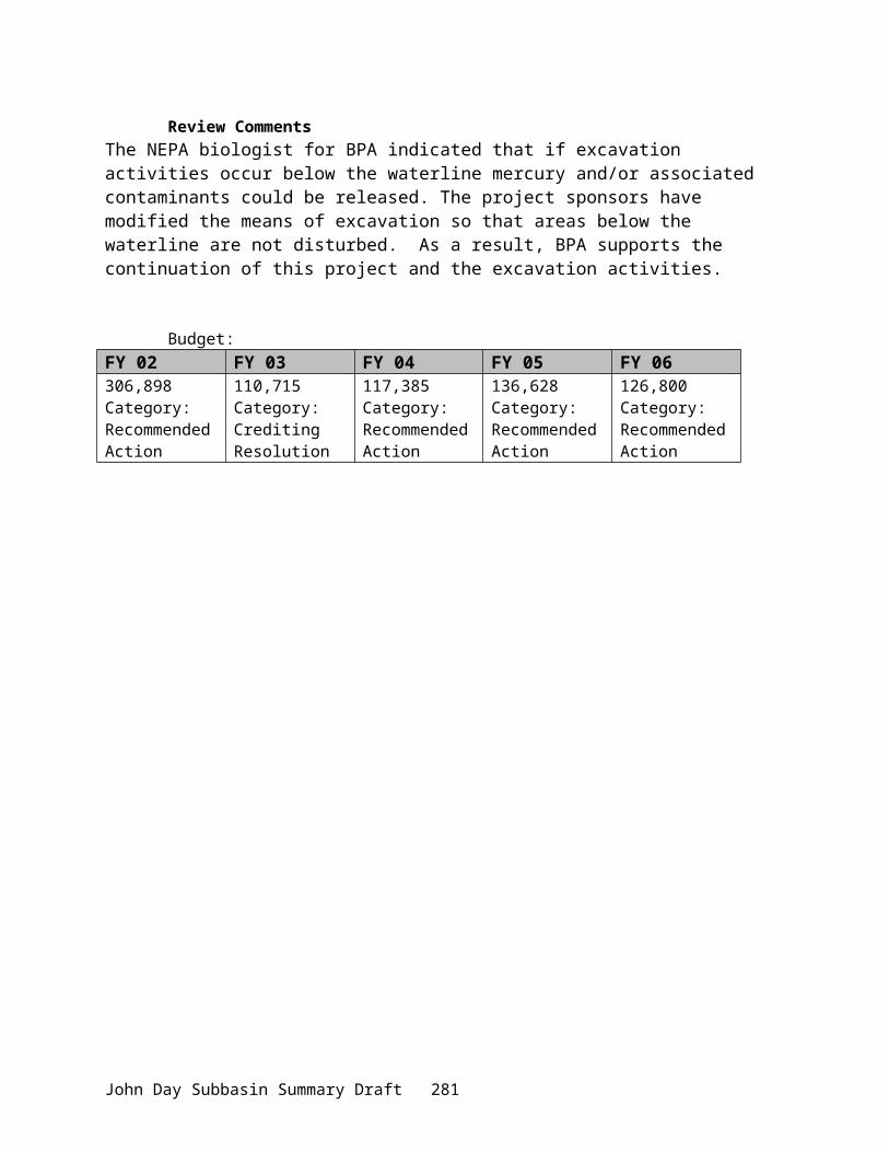
No. Fork John Day River
John DayPrairie City
Mitchell
Condon
Lonerock
Fossil
Rock Creek
So. For k J ohn Day River
John Day River
Gras
s Vall
ey Ca
nyon
Bridge C
r.
Mountain Cr.
Cotton w
ood Cr.
Mid. Fork John Day RiverDesolat io n Cr.
Camas Cr.
John Day
River
Big Wa ll Cr.
Columbia River
(/395
.-,84(/97
%g41
%g41
(/395
(/26(/26
(/207
(/19
Vegetation typesBalsam Fir-Mtn Hem-Upper Slope Types, LargeBalsam Fir-Mtn Hem-Upper Slope Types, SmallDeforested BurnsDouglas Fir, Large Second GrowthDouglas Fir, Old GrowthDouglas Fir, Seedling-Sapling-PoleDouglas Fir, Small Second GrowthHardwood, Alder-Ash-MapleJuniperLodgepole PineNon-ForestNon-restocked CutoverPine Mix, LargePine Mix, SmallPonderosa Pine, LargePonderosa Pine, Seedling-Sapling-PolePonderosa Pine, SmallPure Ponderosa Pine, LargeSubalpine and Non-commercialWater
Data Source: USFS, 1996.
Legend
5 0 5 10 15 20 Miles
N
EW
S
John Day SubbasinVegetation
Appendix Figure 15. Map of vegetation types in the John Day Subbasin.
John Day Subbasin Summary Draft 285
Appendix Figure 16. Map of land cover and land use in the John Day Subbasin.
John Day Subbasin Summary Draft 286

(/19
(/207
(/26(/26
(/395
%g41
%g41
(/97
.-,84
(/395
Columbia River
Big W all Cr.
John Da
y River
Camas Cr.
Desolat i on Cr.
Mid. Fork Jo h n Day River
Cotton w
oo d Cr.
Mountain Cr.B
ridge Cr.
Gra
ss V
all
e y C
anyo
n
John Day River
So. F ork J ohn Day R
iver
Rock C reek
Fossil
Lonerock
Condon
MitchellPrairie City
John Day
No. Fork John Day River
Warm SpringsTribal Lands
Umatilla National Forest
MalheurNational Forest
OwnershipBureau of Land ManagementForest ServiceTribal LandsParks ServicePrivate LandsState Lands
5 0 5 10 Miles N
EW
S
Legend
Data Source: BLM, 2000.
( 8.90%)(29.64%)( 0.50%)( 0.20%)(60.30%)( 0.46%)
% of Subbasin
John Day SubbasinOwnership
Appendix Figure 17. Map of land ownership in the John Day Subbasin.
John Day Subbasin Summary Draft 287

Appendix Figure 18. Map of historic wildlife habitat types in the John Day Subbasin.
John Day Subbasin Summary Draft 288

Appendix Figure 19. Map of current wildlife habitat types in the John Day Subbasin.
John Day Subbasin Summary Draft 289

No. Fork John Day River
(/19
(/207
(/26(/26
(/395
%g41
%g41
(/97.-,84
(/395
Columbia River
Big W all Cr.
John Da
y River
Camas Cr.
Desolat ion Cr.
Mid. Fork Joh n Day RiverCottonw
ood Cr.
Mountain Cr.B
ridge Cr.
Grass
Vall
e y C
anyo
n
John Day River
So. Fork J ohn Day R
iver
Rock Creek
Fossil
Lonerock
Condon
MitchellPrairie City
John Day
Restoration PrioritiesLowestModerateHighHighest
Legend
N
EW
S
5 0 5 10 Miles
Data Source: ODFW, 2000.
John Day SubbasinStreamflow Restoration Priorities
Appendix Figure 20. Map of streamflow restoration priorities in the John Day Subbasin.h:\work\province\plateau\010803DPWPFinal\010803JohnDayDraft.doc
John Day Subbasin Summary Draft 290