bahía de ponce and approaches - quick links · bookletchart bahía de ponce and approaches . noaa...
TRANSCRIPT
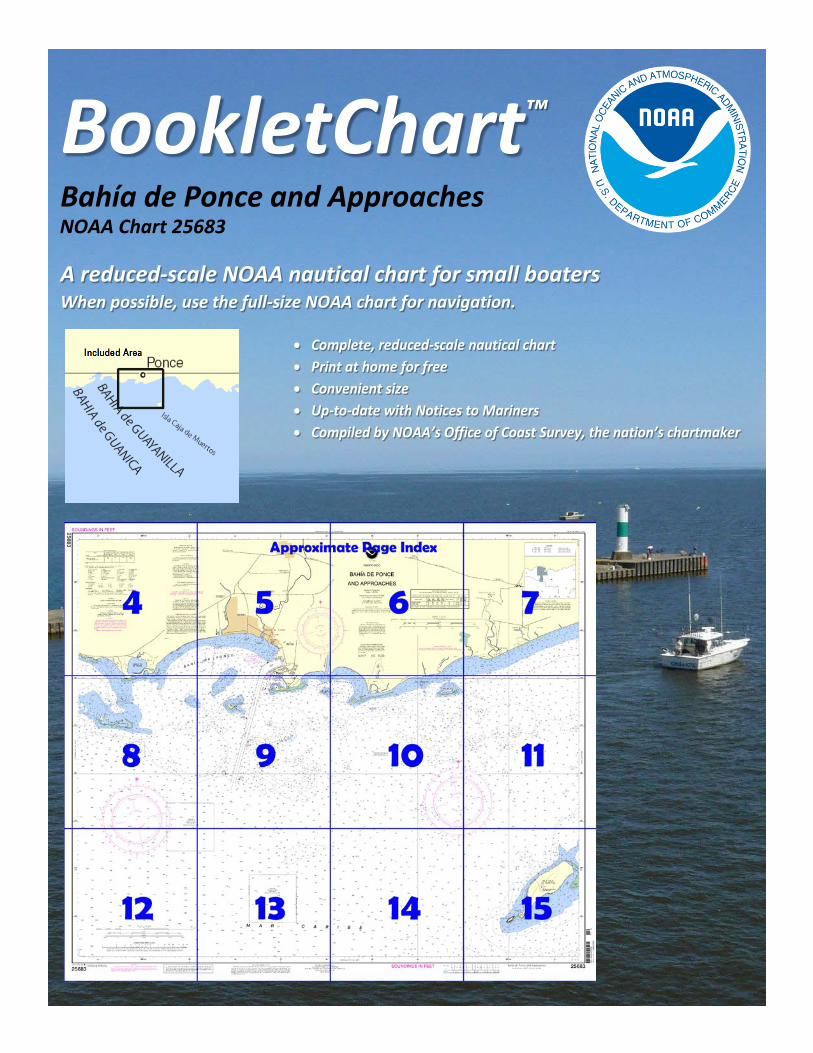
BookletChart™ Bahía de Ponce and Approaches NOAA Chart 25683
A reduced-scale NOAA nautical chart for small boaters When possible, use the full-size NOAA chart for navigation.
2
Published by the National Oceanic and Atmospheric Administration
National Ocean Service Office of Coast Survey
www.NauticalCharts.NOAA.gov 888-990-NOAA
What are Nautical Charts?
Nautical charts are a fundamental tool of marine navigation. They show water depths, obstructions, buoys, other aids to navigation, and much more. The information is shown in a way that promotes safe and efficient navigation. Chart carriage is mandatory on the commercial ships that carry America’s commerce. They are also used on every Navy and Coast Guard ship, fishing and passenger vessels, and are widely carried by recreational boaters.
What is a BookletChart?
This BookletChart is made to help recreational boaters locate themselves on the water. It has been reduced in scale for convenience, but otherwise contains all the information of the full-scale nautical chart. The bar scales have also been reduced, and are accurate when used to measure distances in this BookletChart. See the Note at the bottom of page 5 for the reduction in scale applied to this chart.
Whenever possible, use the official, full scale NOAA nautical chart for navigation. Nautical chart sales agents are listed on the Internet at http://www.NauticalCharts.NOAA.gov.
This BookletChart does NOT fulfill chart carriage requirements for regulated commercial vessels under Titles 33 and 44 of the Code of Federal Regulations.
Notice to Mariners Correction Status
This BookletChart has been updated for chart corrections published in the U.S. Coast Guard Local Notice to Mariners, the National Geospatial Intelligence Agency Weekly Notice to Mariners, and, where applicable, the Canadian Coast Guard Notice to Mariners. Additional chart corrections have been made by NOAA in advance of their publication in a Notice to Mariners. The last Notices to Mariners applied to this chart are listed in the Note at the bottom of page 7. Coast Pilot excerpts are not being corrected.
For latest Coast Pilot excerpt visit the Office of Coast Survey website at http://www.nauticalcharts.noaa.gov/nsd/searchbychart.php?chart=25683.
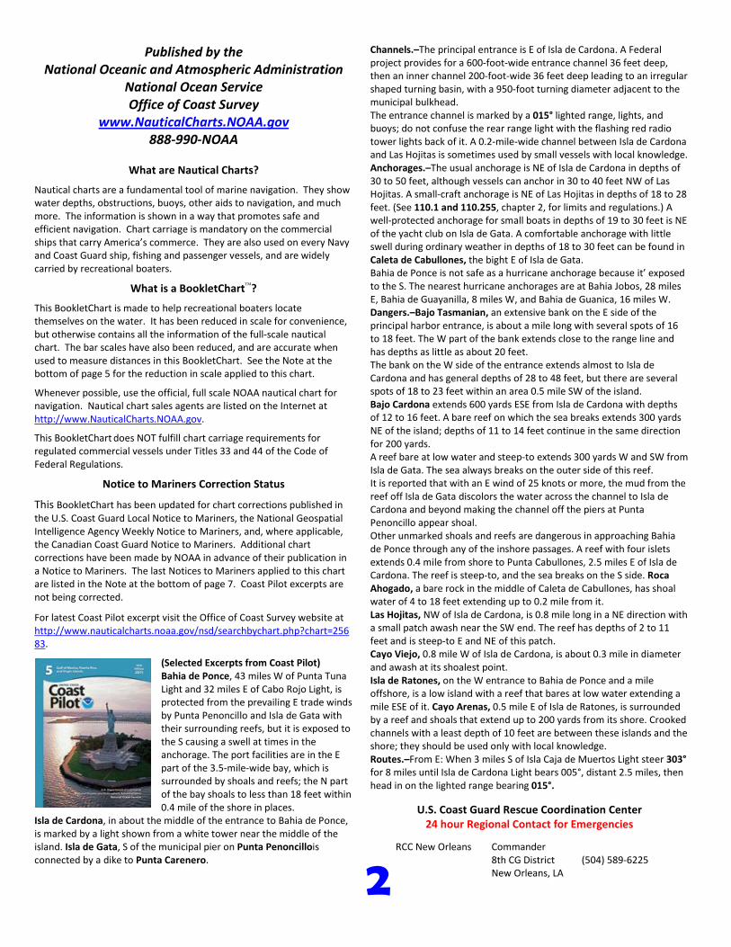
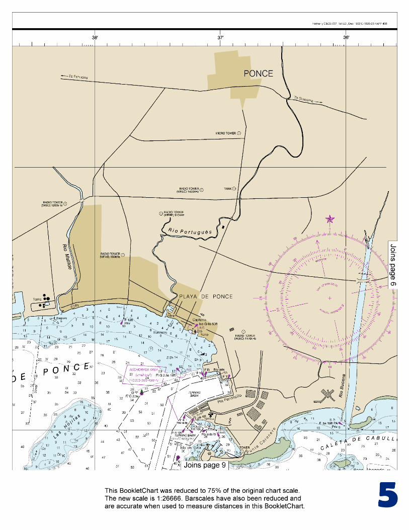
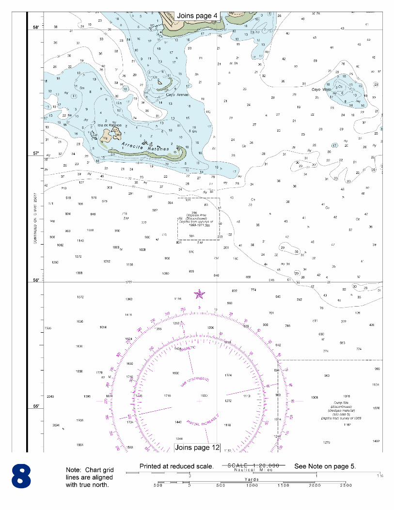
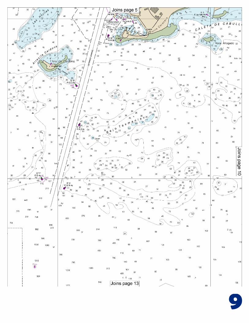
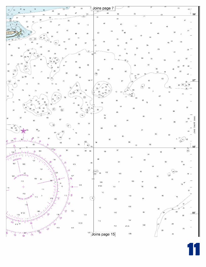
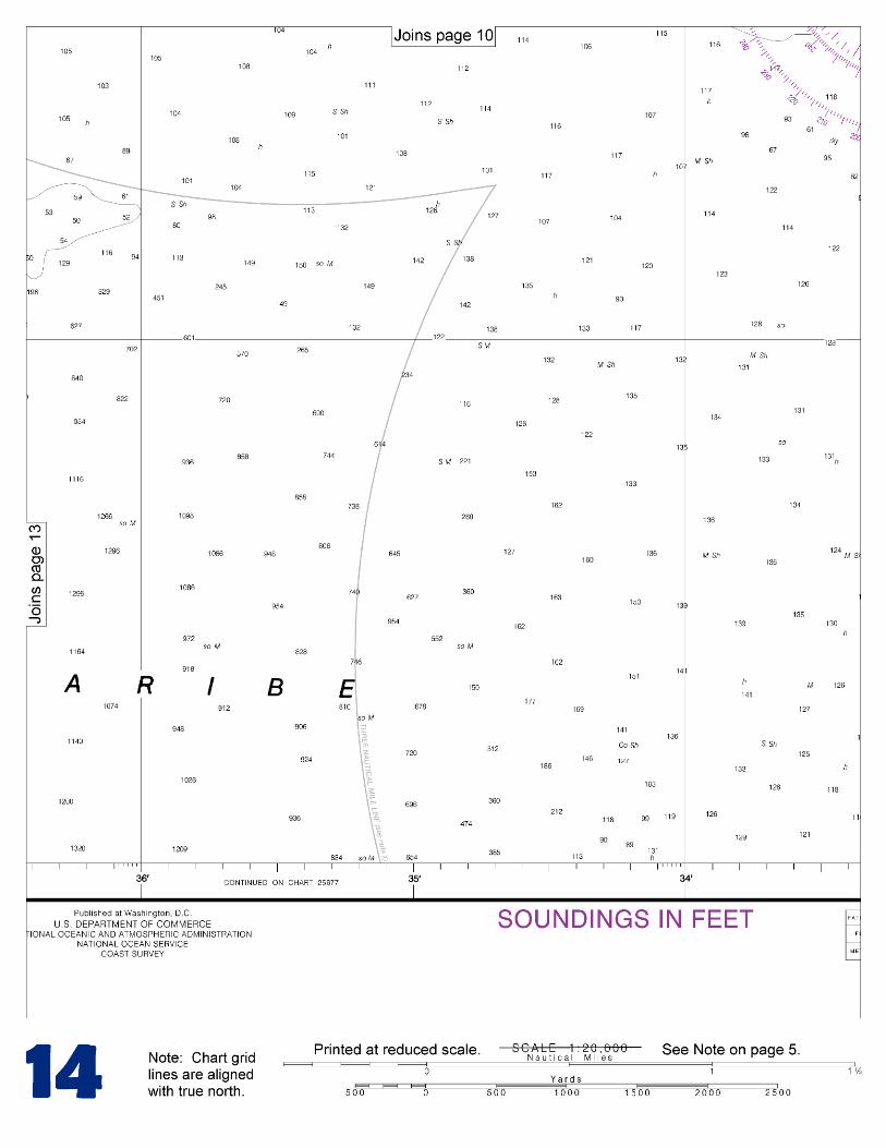
(Selected Excerpts from Coast Pilot) Bahia de Ponce, 43 miles W of Punta Tuna Light and 32 miles E of Cabo Rojo Light, is protected from the prevailing E trade winds by Punta Penoncillo and Isla de Gata with their surrounding reefs, but it is exposed to the S causing a swell at times in the anchorage. The port facilities are in the E part of the 3.5-mile-wide bay, which is surrounded by shoals and reefs; the N part of the bay shoals to less than 18 feet within 0.4 mile of the shore in places.
Isla de Cardona, in about the middle of the entrance to Bahia de Ponce, is marked by a light shown from a white tower near the middle of the island. Isla de Gata, S of the municipal pier on Punta Penoncillois connected by a dike to Punta Carenero.
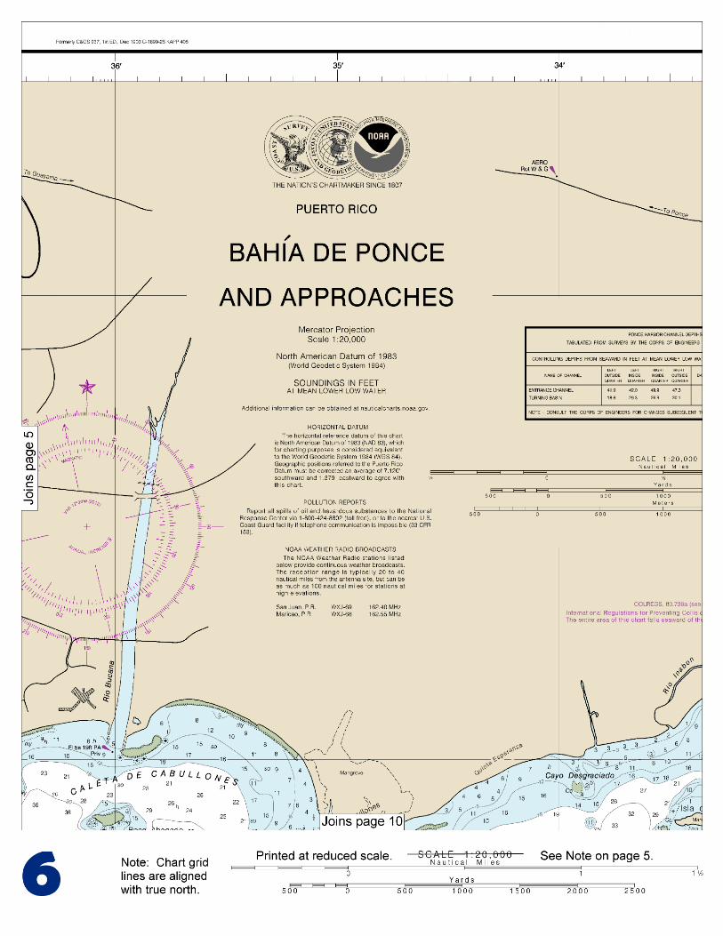
Channels.–The principal entrance is E of Isla de Cardona. A Federal project provides for a 600-foot-wide entrance channel 36 feet deep, then an inner channel 200-foot-wide 36 feet deep leading to an irregular shaped turning basin, with a 950-foot turning diameter adjacent to the municipal bulkhead. The entrance channel is marked by a 015° lighted range, lights, and buoys; do not confuse the rear range light with the flashing red radio tower lights back of it. A 0.2-mile-wide channel between Isla de Cardona and Las Hojitas is sometimes used by small vessels with local knowledge. Anchorages.–The usual anchorage is NE of Isla de Cardona in depths of 30 to 50 feet, although vessels can anchor in 30 to 40 feet NW of Las Hojitas. A small-craft anchorage is NE of Las Hojitas in depths of 18 to 28 feet. (See 110.1 and 110.255, chapter 2, for limits and regulations.) A well-protected anchorage for small boats in depths of 19 to 30 feet is NE of the yacht club on Isla de Gata. A comfortable anchorage with little swell during ordinary weather in depths of 18 to 30 feet can be found in Caleta de Cabullones, the bight E of Isla de Gata. Bahia de Ponce is not safe as a hurricane anchorage because it’ exposed to the S. The nearest hurricane anchorages are at Bahia Jobos, 28 miles E, Bahia de Guayanilla, 8 miles W, and Bahia de Guanica, 16 miles W. Dangers.–Bajo Tasmanian, an extensive bank on the E side of the principal harbor entrance, is about a mile long with several spots of 16 to 18 feet. The W part of the bank extends close to the range line and has depths as little as about 20 feet. The bank on the W side of the entrance extends almost to Isla de Cardona and has general depths of 28 to 48 feet, but there are several spots of 18 to 23 feet within an area 0.5 mile SW of the island. Bajo Cardona extends 600 yards ESE from Isla de Cardona with depths of 12 to 16 feet. A bare reef on which the sea breaks extends 300 yards NE of the island; depths of 11 to 14 feet continue in the same direction for 200 yards. A reef bare at low water and steep-to extends 300 yards W and SW from Isla de Gata. The sea always breaks on the outer side of this reef. It is reported that with an E wind of 25 knots or more, the mud from the reef off Isla de Gata discolors the water across the channel to Isla de Cardona and beyond making the channel off the piers at Punta Penoncillo appear shoal. Other unmarked shoals and reefs are dangerous in approaching Bahia de Ponce through any of the inshore passages. A reef with four islets extends 0.4 mile from shore to Punta Cabullones, 2.5 miles E of Isla de Cardona. The reef is steep-to, and the sea breaks on the S side. Roca Ahogado, a bare rock in the middle of Caleta de Cabullones, has shoal water of 4 to 18 feet extending up to 0.2 mile from it. Las Hojitas, NW of Isla de Cardona, is 0.8 mile long in a NE direction with a small patch awash near the SW end. The reef has depths of 2 to 11 feet and is steep-to E and NE of this patch. Cayo Viejo, 0.8 mile W of Isla de Cardona, is about 0.3 mile in diameter and awash at its shoalest point. Isla de Ratones, on the W entrance to Bahia de Ponce and a mile offshore, is a low island with a reef that bares at low water extending a mile ESE of it. Cayo Arenas, 0.5 mile E of Isla de Ratones, is surrounded by a reef and shoals that extend up to 200 yards from its shore. Crooked channels with a least depth of 10 feet are between these islands and the shore; they should be used only with local knowledge. Routes.–From E: When 3 miles S of Isla Caja de Muertos Light steer 303° for 8 miles until Isla de Cardona Light bears 005°, distant 2.5 miles, then head in on the lighted range bearing 015°.
U.S. Coast Guard Rescue Coordination Center 24 hour Regional Contact for Emergencies
RCC New Orleans Commander 8th CG District (504) 589-6225 New Orleans, LA

G
NOAA’s navigation managers serve as ambassadors to the maritime community. They help identify navigational challenges facing professional and recreational mariners, and provide NOAA resources and information for safe navigation. For additional information, please visit nauticalcharts.noaa.gov/service/navmanagers
To make suggestions or ask questions online, go to nauticalcharts.noaa.gov/inquiry. To report a chart discrepancy, please use ocsdata.ncd.noaa.gov/idrs/discrepancy.aspx.
Lateral System As Seen Entering From Seaward on navigable waters except Western Rivers
PORT SIDE
ODD NUMBERED AIDS
GREEN LIGHT ONLY
FLASHING (2)
PREFERRED CHANNEL
NO NUMBERS – MAY BE LETTERED
PREFERRED CHANNEL TO
STARBOARD
TOPMOST BAND GREEN
PREFERRED CHANNEL
NO NUMBERS – MAY BE LETTERED
PREFERRED CHANNEL
TO PORT
TOPMOST BAND RED
STARBOARD SIDE
EVEN NUMBERED AIDS
RED LIGHT ONLY
FLASHING (2)
FLASHING FLASHING
OCCULTING GREEN LIGHT ONLY RED LIGHT ONLY OCCULTING QUICK FLASHING QUICK FLASHING
ISO COMPOSITE GROUP FLASHING (2+1) COMPOSITE GROUP FLASHING (2+1) ISO
"1"
Fl G 6s
G "9"
Fl G 4s
GR "A"
Fl (2+1) G 6s
RG "B"
Fl (2+1) R 6s
"2"
Fl R 6s
8
R "8"
Fl R 4s
LIGHT
G
C "1"
LIGHTED BUOY
G
"5"
GR
"U"
GR
C "S"
RG
N "C"
RG
"G"
LIGHT
6
R
N "6"
LIGHTED BUOY
R
"2
"
CAN DAYBEACON
CAN NUN NUN
DAYBEACON
For more information on aids to navigation, including those on Western Rivers, please consult the latest USCG Light List for your area.
These volumes are available online at http://www.navcen.uscg.gov
Navigation Managers Area of Responsibility
Northeast
Lt. Meghan McGovern
Northwest and
Pacific Islands
Crescent Moegling
Great Lakes Region
Tom Loeper
Chesapeake and
Delaware Bay
Steve Soherr
California
Jeff Ferguson
[email protected] Mid-Atlantic
Lt. Ryan Wartick
Alaska
Lt. Timothy M. Smith
Western Gulf Coast
Alan Bunn
Central Gulf Coast
Tim Osborn
[email protected] South Florida
Puerto Rico
U.S. Virgin Islands
Michael Henderson
Southeast
Kyle Ward
2
2 C U 5
1


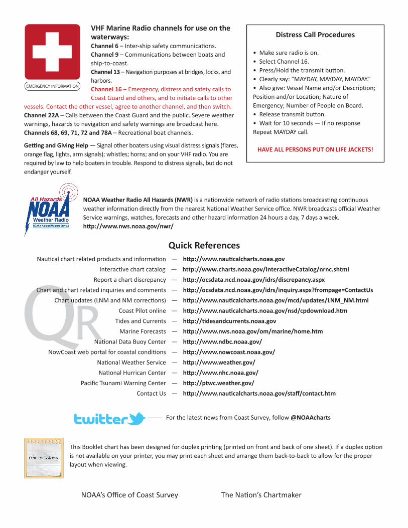
VHF Marine Radio channels for use on the waterways:Channel 6 – Inter-ship safety communications.Channel 9 – Communications between boats and ship-to-coast.Channel 13 – Navigation purposes at bridges, locks, and harbors.Channel 16 – Emergency, distress and safety calls to Coast Guard and others, and to initiate calls to other
vessels. Contact the other vessel, agree to another channel, and then switch.Channel 22A – Calls between the Coast Guard and the public. Severe weather warnings, hazards to navigation and safety warnings are broadcast here.Channels 68, 69, 71, 72 and 78A – Recreational boat channels.
Getting and Giving Help — Signal other boaters using visual distress signals (flares, orange flag, lights, arm signals); whistles; horns; and on your VHF radio. You are required by law to help boaters in trouble. Respond to distress signals, but do not endanger yourself.
EMERGENCY INFORMATION
Distress Call Procedures
• Make sure radio is on.• Select Channel 16.• Press/Hold the transmit button.• Clearly say: “MAYDAY, MAYDAY, MAYDAY.”• Also give: Vessel Name and/or Description;Position and/or Location; Nature of Emergency; Number of People on Board.• Release transmit button.• Wait for 10 seconds — If no responseRepeat MAYDAY call.
HAVE ALL PERSONS PUT ON LIFE JACKETS!
This Booklet chart has been designed for duplex printing (printed on front and back of one sheet). If a duplex option is not available on your printer, you may print each sheet and arrange them back-to-back to allow for the proper layout when viewing.
QR
Quick ReferencesNautical chart related products and information - http://www.nauticalcharts.noaa.gov
Interactive chart catalog - http://www.charts.noaa.gov/InteractiveCatalog/nrnc.shtmlReport a chart discrepancy - http://ocsdata.ncd.noaa.gov/idrs/discrepancy.aspx
Chart and chart related inquiries and comments - http://ocsdata.ncd.noaa.gov/idrs/inquiry.aspx?frompage=ContactUs
Chart updates (LNM and NM corrections) - http://www.nauticalcharts.noaa.gov/mcd/updates/LNM_NM.html
Coast Pilot online - http://www.nauticalcharts.noaa.gov/nsd/cpdownload.htm
Tides and Currents - http://tidesandcurrents.noaa.gov
Marine Forecasts - http://www.nws.noaa.gov/om/marine/home.htm
National Data Buoy Center - http://www.ndbc.noaa.gov/
NowCoast web portal for coastal conditions - http://www.nowcoast.noaa.gov/
National Weather Service - http://www.weather.gov/
National Hurrican Center - http://www.nhc.noaa.gov/
Pacific Tsunami Warning Center - http://ptwc.weather.gov/
Contact Us - http://www.nauticalcharts.noaa.gov/staff/contact.htm
NOAA’s Office of Coast Survey The Nation’s Chartmaker
For the latest news from Coast Survey, follow @NOAAcharts
NOAA Weather Radio All Hazards (NWR) is a nationwide network of radio stations broadcasting continuous weather information directly from the nearest National Weather Service office. NWR broadcasts official Weather Service warnings, watches, forecasts and other hazard information 24 hours a day, 7 days a week. http://www.nws.noaa.gov/nwr/