barnet’s local plan (development management policies)
TRANSCRIPT

Development Management Policies Adoption Version
Development Plan Document
Adoption Version
September 2012
Barnet’s Local Plan (Development Management Policies)
Local Plan

Development Management Policies Adoption Version
Contents 1. Introduction .............................................................................................................1
Development Management ................................................................................................................... 2
Policy content ........................................................................................................................................ 2
Brent Cross Cricklewood....................................................................................................................... 2
Evidence Base and sustainability appraisal .......................................................................................... 3
Relationship with the Core Strategy...................................................................................................... 3
Monitoring.............................................................................................................................................. 3
Implementation...................................................................................................................................... 4
2. Protecting Barnet’s character and amenity ..........................................................5
High Quality Design............................................................................................................................... 5
Character............................................................................................................................................... 6
Character in town centres ..................................................................................................................... 9
Advertising............................................................................................................................................. 9
Security in design .................................................................................................................................. 9
Amenity.................................................................................................................................................. 9
Conversions ........................................................................................................................................ 10
Gardens............................................................................................................................................... 10
Landscaping and trees ........................................................................................................................ 10
3. Development standards........................................................................................13
By Design ............................................................................................................................................ 13
Lifetime Homes ................................................................................................................................... 13
Code for Sustainable Homes .............................................................................................................. 14
BREEAM ............................................................................................................................................. 14
Wheelchair accessibility ...................................................................................................................... 14
Minimum floor space ........................................................................................................................... 14
Outdoor Amenity Space ...................................................................................................................... 14
Secured by Design .............................................................................................................................. 15
Play space........................................................................................................................................... 15
Other standards................................................................................................................................... 15
4. Accessibility and Inclusive Design ......................................................................18
5. Environmental Considerations.............................................................................20
Decentralised Energy .......................................................................................................................... 21
Retro fitting .......................................................................................................................................... 21
Air Quality ............................................................................................................................................ 21
Noise ................................................................................................................................................... 22
Contaminated land .............................................................................................................................. 22
Notifiable Installations ......................................................................................................................... 23

Development Management Policies Adoption Version
Surface Water Run off and Drainage .................................................................................................. 23
Watercourse restoration ...................................................................................................................... 23
6. Tall Buildings.........................................................................................................26
7. Heritage and Conservation...................................................................................28
Conservation areas ............................................................................................................................. 30
Listed and Locally Listed Buildings ..................................................................................................... 30
Archaeological heritage....................................................................................................................... 31
8. Protecting housing in Barnet ...............................................................................33
9. Ensuring a variety of sizes of new homes to meet housing need.....................34
10. Specialist housing – Houses in Multiple Occupation, Hostels, Student Accommodation and Housing Choice for Older People ....................................36
Extending housing choice for older people ......................................................................................... 36
Houses in Multiple Occupation (HMO)................................................................................................ 37
Student Accommodation ..................................................................................................................... 37
11. Affordable housing contributions........................................................................39
12. Development principles for Barnet’s town centres ............................................41
Town Centre Uses............................................................................................................................... 42
Out of town centre retail ...................................................................................................................... 43
Mixed Use............................................................................................................................................ 43
Small Shops ........................................................................................................................................ 44
Town centre boundaries...................................................................................................................... 44
Retail frontages ................................................................................................................................... 44
Evening Uses ...................................................................................................................................... 46
13. Maintaining the local centres and parades .........................................................49
14. Community and education uses ..........................................................................50
15. New and existing employment space ..................................................................53
Existing Employment Space ............................................................................................................... 53
16. Green belt and open spaces.................................................................................57
Green Belt / Metropolitan Open Land ................................................................................................. 58
Open Spaces....................................................................................................................................... 58
17. Biodiversity............................................................................................................61
18. Travel Impact and Parking Standards .................................................................65
Road Safety......................................................................................................................................... 66
Road Hierarchy ................................................................................................................................... 66
Development, Location and Accessibility............................................................................................ 66
Transport Assessment ........................................................................................................................ 66
Travel Planning ................................................................................................................................... 66
Local Infrastructure Needs .................................................................................................................. 67
Parking Management .......................................................................................................................... 67

Development Management Policies Adoption Version
19. Telecommunications.............................................................................................71
20. Appendix 1: Archaeological Map for the Proposals Map...................................73
21. Appendix 2: Development Management Monitoring Indicators ........................74
22. Appendix 3: Core Strategy and Development Policies DPDs and Replacement of Saved UDP Policies (2006) ...............................................................................76
23. Appendix 4: Primary and Secondary shopping frontages.................................80
24. Appendix 5: Town Centre Maps ...........................................................................86
25. Appendix 6: Local frontages ..............................................................................101
26. Appendix 7: Locally Significant Industrial Sites and Business Locations Maps..............................................................................................................................104

Development Management Policies Adoption Version
Foreword People choose to live in Barnet because of its clean and green environment, excellent schools, and low levels of crime, good radial transport, public spaces and high quality housing. This Development Management Policies document will help to further implement the Core Strategy (the guide for planning, regeneration and redevelopment to enhance Barnet as an excellent suburb) for day to day planning decisions.
Our philosophy is to ensure protection and enhancement of what is good, consolidation of building work in the pipeline and ensure the provision of supporting infrastructure. We will plan and control further re-development and manage change, throughout the borough for the benefit of residents.
The policies in the Development Management Policies document will shape our suburb in the future, help create attractive new buildings and neighbourhoods by providing us with the policy framework to restrict inappropriate increases in urbanisation.
Councillor Richard Cornelius Leader of Barnet Council
Development Management Policies Adoption Version
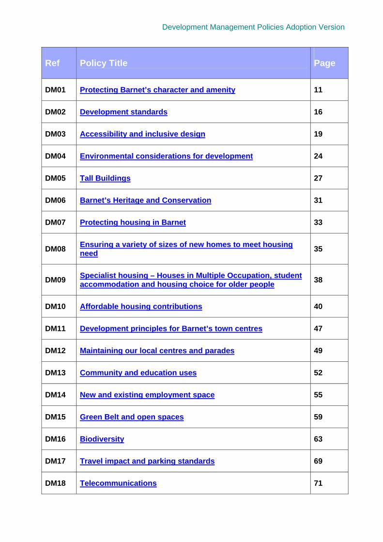
Ref
Policy Title
Page
DM01 Protecting Barnet’s character and amenity 11
DM02 Development standards 16
DM03 Accessibility and inclusive design 19
DM04 Environmental considerations for development 24
DM05 Tall Buildings 27
DM06 Barnet’s Heritage and Conservation 31
DM07 Protecting housing in Barnet 33
DM08 Ensuring a variety of sizes of new homes to meet housing need
35
DM09 Specialist housing – Houses in Multiple Occupation, student accommodation and housing choice for older people
38
DM10 Affordable housing contributions 40
DM11 Development principles for Barnet’s town centres 47
DM12 Maintaining our local centres and parades 49
DM13 Community and education uses 52
DM14 New and existing employment space 55
DM15 Green Belt and open spaces 59
DM16 Biodiversity 63
DM17 Travel impact and parking standards 69
DM18 Telecommunications 71
Development Management Policies Adoption Version
Local Plan
September 2012
Page 1
1. Introduction 1.1.1 The Local Plan replaces the Unitary Development Plan (UDP) (adopted May 2006). It
embodies spatial planning – the practice of ‘place shaping’ to deliver positive social, economic and environmental outcomes and provide the overarching local policy framework for delivering sustainable development in Barnet. The Local Plan is described as a ‘folder’ of separate documents, the most important of which is the Core Strategy. This contains the ‘vision’ for the Local Plan and the most fundamental, cross-cutting objectives and policies that the local authority and its partners seek to deliver.
1.1.2 Barnet’s Local Plan primarily consists of a suite of Development Plan Documents (DPD’s), the Proposals Map and Supplementary Planning Documents (SPDs)
the Core Strategy DPD
the Site Allocations DPD which identifies future sites for development
the Development Management Policies DPD which sets out the policy framework for decision making on planning applications
the Mill Hill East Area Action Plan DPD (adopted January 2009)
the Colindale Area Action Plan DPD (adopted March 2010)
the emerging North London Waste Plan DPD (submission early 2012)
a suite of ‘supplementary planning documents’ and ‘design guidance notes’ which provide more detailed guidance on determining planning applications and S106 requirements
the Local Development Scheme for Barnet which sets out the timetable for the above documents
the Statement of Community Involvement which sets out the principles on how Barnet will consult with the community
the Annual Monitoring Report which assesses the performance of the Local Plan and identifies significant trends affecting Barnet
1.1.3 Government policy towards spatial planning is contained in the National Planning Policy Framework (NPPF). The NPPF sets out the Government’s planning policies for England and how these are expected to be applied. The NPPF must be taken into account in the preparation of Local Plans and is a material consideration in planning decisions. At the heart of the NPPF is the presumption in favour of sustainable development. This presumption is reflected locally in Core Strategy Policy CS NPPF which sets out how we will take a positive approach in considering development proposals. If a local interpretation of national planning policy is proposed, then this must be justified.
1.1.4 In December 2010 the Coalition Government introduced the Localism Bill as part of its objective to shift power back into the hands of individuals, communities and local authorities and give local people a real share in growth. The main features of the Bill are :
introduction of new freedoms and flexibilities for local government
introduction of new rights and powers for communities and individuals
reform to make the planning system more democratic and more effective
reform to ensure that decisions about housing are taken locally.
1.1.5 The Localism Bill introduces Neighbourhood Development Plans (NDPs) known as Neighbourhood Plans, and the potential for planning permission to be granted through Neighbourhood Development Orders (NDOs) and Community Right to Build Orders

Development Management Policies Adoption Version
Local Plan
September 2012
Page 2
(CRBOs). Table 1 in the Core Strategy explains how the introduction of Neighbourhood Plans will operate at a local level.
1.2 Development Management 1.2.1 The Local Plan Development Management Policies (DMP) DPD sets out the borough-
wide planning policies that implement the Core Strategy and will be used for day to day decision making by the Planning Service and for planning committee determinations. The DMP DPD sets out the policy basis for delivering the long-term spatial vision and strategic place-shaping objectives in Barnet which are set out in the Core Strategy.
1.2.2 Development management is a shift in approach from the former development control and involves seeking balanced planning decisions that support positive and sustainable development but resist inappropriate or harmful schemes. It aims to solve problems rather than create compromise that pleases no one. In many respects Barnet is already delivering this approach through the Three Strands Approach of protection, enhancement and consolidated growth.
1.3 Policy content 1.3.1 In line with the Government’s NPPF in paragraph 154, only policies that are clear on
what development will or will not be permitted and where should be included in the Local Plan. As stated in NPPF paragraph 17 they should provide a practical framework within which decisions on planning applications can be made with a high degree of predictability and efficiency. Repetition of national and London Plan policy is avoided. More use of national policy and London Plan policy for decision making is now expected rather than developing local policy to cover all possible scenarios. To facilitate this, boxes containing some of the relevant national and London Plan policy are included for each policy.
1.3.2 National planning policy is set out in the National Planning Policy Framework. The NPPF must be taken into account in the preparation of Local Plans and is a material consideration in planning decisions. The London Plan sets out at a regional level an integrated social, economic and environmental strategic framework for London’s future development. Development Management policies will be required to conform with these national and regional documents.
1.3.3 Policies are longer in length than those in the UDP to deal with a wider policy remit. They are more detailed in places and specific to reflect the distinctive character and issues of Barnet as a high quality, successful London borough. Each policy is preceded by a background section which explains how the policy will be applied.
1.4 Brent Cross Cricklewood 1.4.1 A hybrid planning application to establish a masterplan and framework for the
comprehensive regeneration of the Brent Cross Cricklewood Area in accordance with relevant development plan policies was submitted by a partnership of key landowners and developers (BXC Development Partners) in March 2008. This followed and resulted in extensive pre and post application consultation with the council, the GLA, Transport for London, the Highways Agency, the Environment Agency and other agencies and stakeholders including the local community. In November 2009 the council resolved to approve the hybrid application subject to completion of a Section 106 Agreement. On 28 October 2010 the Section 106 Agreement was completed and the hybrid planning permission for the BXC development was granted.
1.4.2 In December 2005 together with the Mayor for London we adopted the Cricklewood, Brent Cross and West Hendon Regeneration Area Development Framework as Supplementary Planning Guidance. The Development Framework was prepared in parallel with the development of UDP policies on Brent Cross – Cricklewood. This

Development Management Policies Adoption Version
Local Plan
September 2012
Page 3
suite of UDP policies were saved by the Direction issued by the Secretary of State on 13 May 2009.
1.4.3 In view of the progress that has been made towards the implementation of the saved UDP policies on Brent Cross – Cricklewood we consider that it is inappropriate to replace them. In order to provide a policy framework to secure the future comprehensive redevelopment of Brent Cross Cricklewood these ‘saved’ policies will continue to operate until it is considered appropriate to replace them. It is intended that the Development Management policies in this DPD will not apply to the development of the Brent Cross Cricklewood Regeneration Scheme unless and until the Core Strategy or this DPD is reviewed (or a further local development document is adopted which has the effect of applying any such DM policies to that scheme) in accordance with the monitoring and review process outlined in the Core Strategy at Policy CS 2 and at section 20.13. Any other planning applications not directly related to the comprehensive redevelopment of Brent Cross Cricklewood Regeneration area will be considered against relevant policies in this DPD and any other material planning considerations.
1.5 Evidence Base and sustainability appraisal 1.5.1 Evidence supports the Local Plan documents by ensuring they are justified. Studies
have been produced on the following: open spaces, the borough’s housing needs, the character of the borough, including an assessment of tall buildings, employment land, the town centres and affordable housing. This is not the limit of the evidence with further studies identified in the Core Strategy.
1.5.2 The preparation work on the DMP DPD included a sustainability appraisal to assess its environmental, social and economic impacts. This helps ensure that any harmful impacts of the policies are identified and suggests ways that they can be minimised. In line with guidance and the iterative nature of the process, the report draws on and repeats information contained in the Core Strategy sustainability appraisal and the Scoping Report.
1.5.3 Preparation work also included an assessment of the DMP policies to see whether they are likely to have any significant effect on sites of European importance for habitats or species.
1.6 Relationship with the Core Strategy 1.6.1 As highlighted above the DMP DPD delivers the approach set out in the Core
Strategy. The DMP policies will be used for day to day decision making by the Planning Service and provide additional detail and guidance on how the council will make decisions on applications for planning permission. Throughout the DMP DPD cross references are made to the policies in the Core Strategy. This enables both documents to be read in conjunction when considering a planning application.
1.6.2 The table in Appendix 3 shows how individual policies in this document relate to the policies in the Core Strategy and which policies they replace in the UDP. Also the policies in the DMP DPD are structured in a similar manner to those in the Core Strategy.
1.7 Monitoring 1.7.1 The DMP DPD is not a static document. Monitoring mechanisms make it a living
document that is capable of being changed in part or in full over the plan period. We will monitor the effectiveness of the DMP DPD in delivering its objectives by assessing its performance against a series of indicators. Specific indicators are set out for each policy in the DMP DPD. These are set out in Appendix 2. Each year we publish an Annual Monitoring Report. This will:

Development Management Policies Adoption Version
Local Plan
September 2012
Page 4
assess the performance of the DMP DPD and other Local Plan documents following their adoption
identify the need to reassess or review any policies or approaches
make sure the context and assumptions behind our approach are still relevant; and
identify trends in the wider social, economic and environmental issues facing Barnet.
1.8 Implementation 1.8.1 The Core Strategy sets the most fundamental cross-cutting objectives and policies
that the council and its partners will seek to deliver. Core Strategy policy CS 15 states that the council will use planning obligations where appropriate alongside other suitable funding mechanisms to support the delivery of infrastructure, facilities and services to meet needs generated by development and mitigate the impact of development.
1.8.2 The council will use planning obligations in appropriate circumstances and in accordance with the NPPF (paragraphs 203 to 205), to influence the nature of a development or mitigate or compensate for its potential affects. Where existing and planned provision of infrastructure, facilities and services are inadequate to meet the needs generated by a proposal, we will negotiate planning obligations to secure measures to meet those needs.
1.8.3 Planning obligations can help to contribute to the success of a development and achieve our aims for a site, its local area and the borough as a whole. They can enhance the quality of a development and enable proposals to go ahead that would otherwise be refused. Planning obligations will only be sought where it is not possible to deal with the matter through the imposition of a condition on a planning permission. The items sought through a planning obligation will vary depending on the development scheme and its location. Barnet’s main considerations for planning obligations are set out in the Core Strategy.
1.8.4 In considering planning obligations, we will take into account the range of benefits a development provides. The extent to which a development is publicly funded will also be taken into account and policy applied flexibly in such cases. Pooled contributions will be used when the combined impact of a number of schemes creates the need for infrastructure or works, although such pooling will only take place within the restrictions of the Community Infrastructure Levy Regulations 2010.
1.8.5 We will develop a Barnet Community Infrastructure Levy (CIL) as this represents the most appropriate way to support delivery of the aims of the Local Plan. Such an approach will replace our current approach of using standard formulae to calculate contributions towards providing school places, libraries and healthcare across all developments. Set out in the April 2010 Regulations, new restrictions on the use of planning obligations have been introduced in order for the two mechanisms (planning obligations and CIL) to complement each other. Existing Planning Obligations guidance must be replaced with a new ‘charging schedule’ by July 2014.
1.8.6 Revisions to the Planning Obligations SPD will be implemented concurrently with the adoption of a CIL for Barnet. Until the council’s SPD on Planning Obligations is revised, additional detail on our approach and the processes for consideration and flexibility regarding planning obligations is set out in the Interim Guidance Note on Section 106 which has been brought forward in response to the recession.

Development Management Policies Adoption Version
Local Plan
September 2012
Page 5
2. Protecting Barnet’s character and amenity
2.1.1 Core Strategy Policy CS5: Protecting and Enhancing Barnet’s Character to Create High Quality Places highlights that development in Barnet should respect the local context and distinctive local character, creating places and buildings of high quality design. As part of this, development should enhance all areas that make Barnet such an interesting, diverse and attractive place to live. This policy applies to all development in the borough.
Table 2.1: National and London Plan character and amenity guidance
2.2 High Quality Design 2.2.1 The council will not accept designs for new development that are inappropriate to their
context or do not take opportunities to improve the character and quality of an area. High quality design solutions help to make new places in the borough which can add to and complement the existing suburban character. Contemporary design may be appropriate provided it has regard to the local context.
2.2.2 Using this policy combined with Policy DM02: Development Standards, which sets out the particular standards important for Barnet, will ensure development makes a positive contribution to the borough.
The National Planning Policy Framework states that the planning system ought to “take account of the different roles and character of different areas” and “always seek to secure high quality design and a good standard of amenity for all existing and future occupants of land and buildings” (NPPF: Core planning principles: paragraph 17) National policy states that “It is important to plan positively for the achievement of high quality and inclusive design for all development, including individual buildings, public and private spaces and wider area development schemes.” (NPPF: Paragraph 57) The National Planning Policy Framework (paragraphs 59 and 60) states the following on design; that “…policies should avoid unnecessary prescription or detail and should concentrate on guiding the overall scale, density, massing, height, landscape, layout, materials and access of new development in relation to neighbouring buildings and the local area more generally.” “Planning policies and decisions should not attempt to impose architectural styles or particular tastes and they should not stifle innovation, originality or initiative through unsubstantiated requirements to conform to certain development forms or styles. It is, however, proper to seek to promote or reinforce local distinctiveness.” London Plan policy 7.6 sets out the approach towards architecture stating that it “should make a positive contribution to a coherent public realm, streetscape and wider cityscape." The supporting text says that it “should make a positive contribution to the landscape and relate well to the form, proportion, scale and character of streets…”

Development Management Policies Adoption Version
Local Plan
September 2012
Page 6
2.2.3 Climate change is one of the greatest challenges the world is facing and a key priority for Barnet’s future is to reduce the borough’s carbon footprint where possible particularly in new development. Reducing carbon dioxide (CO2) emissions and adapting to future climate change are the priorities.
2.2.4 Mitigating the emissions which cause climate change through reducing energy use is important to protect against the impacts of climate change which in the long term could affect the boroughs character and amenity. New development should provide the opportunity to meet the highest standards of energy efficiency and minimise carbon emissions. Adapting to climate change means that we are better prepared for the following possibilities; increased frequency and severity of flooding, water shortages, hotter summers, rising energy costs and increased risk of damage to homes and infrastructure.
2.3 Character 2.3.1 The Characterisation Study (September 2010) provides a detailed assessment and
understanding of the characteristics of Barnet’s built environment. It identifies the different architectural typologies and character areas in the borough and the pressures they face.
2.3.2 The ‘suburbs’ cover a large proportion of the built environment in the borough (see figure 1). The Characterisation Study identifies differences between traditional and more modern building styles found in recent conversions and replacement buildings. The existing traditional housing stock is almost always vertically orientated with window bays and pitched roofs. More modern developments are usually more horizontal in form often with balconies and flat roofs, larger bulk and building footprint. When built in close proximity to each other these building styles can clash diminishing the uniformity, rhythm and pattern of suburban character. Owing to this impact on character loss of houses in roads predominantly characterised by the same typology of houses will not normally be appropriate. Further guidance on loss of houses will be set out in the Residential Design Guidance SPD.

Development Management Policies Adoption Version
Local Plan
September 2012
Page 7
Figure 1 – Map of Barnet showing the spread of residential typologies
2.3.3 The suburban type of housing is the commonest typology (see typologies C & D in figure 1 above) in the borough dominated by housing built during the inter war period. Suburban housing is typically two storey detached and semi detached property with front and rear gardens sometimes with a grass verge (see paragraph 2.3.5 for layout). The other housing typologies in Barnet are detached, suburban terraced, urban terraced, flats and linear-rural detached. Barnet’s urban terraces include some of the borough’s most dense residential housing; they were predominantly built during the Victorian and Edwardian periods. Terraced streets have a strong coherent appearance due to the consistent and rhythmic architectural style and consistent street profile, usually with on-street parking.

Development Management Policies Adoption Version
Local Plan
September 2012
Page 8
2.3.4 Flatted development, detached, and linear-rural detached are the least common housing types in Barnet. The lowest density linear-rural detached and detached housing is generally found on the edge of the green belt.
2.3.5 The diagram below (taken from the Characterisation Study) shows the layout of a typical suburban street typology in Barnet. This type of housing, predominantly detached and semi detached with front and rear gardens, predominates in Barnet.
Figure 2 – Plan of Barnet Suburban Typology
2.3.6 Suburban terraces are lower density than their urban counterparts with a more varied architectural style. These terraces sometimes have off street parking and a grass verge. This pattern of development and street layout is replicated across the borough and the layout of new development should take this into account.
2.3.7 Protecting character helps to maintain Barnet’s heritage. Policy DM01: Protecting Barnet’s character and amenity states that development proposals should preserve or enhance local character and respect the appearance, scale, mass, height and pattern of surrounding buildings, spaces and streets. In order to protect character Policy DM01: Protecting Barnet’s character and amenity requires development to demonstrate a good understanding of the local characteristics of an area. Proposals which are out of keeping with the character of an area will be refused.
2.3.8 Character can be eroded through small incremental changes to houses such as replacement windows, doors, roofing materials, loss of gardens and trees, as well as larger scale changes such as loft conversions and extensions. This type of suburban development can cumulatively have a considerable impact on the existing character of the borough. Residents can exercise their permitted development rights to make certain small scale alterations to their houses and the council can manage development that requires consent through considered design advice.
2.3.9 Whilst the policy intention is to protect local character, it should not be used to restrict well designed and sympathetic development which meets other objectives in the Core Strategy, Development Management Policies DPD, the council’s suite of Design Guidance Notes and Supplementary Planning Documents. The Characterisation Study should be referred to for a more detailed description of the typologies and used as a tool to help judge the effect of a development on character. The Supplementary Planning Document (SPD) on Residential Design Guidance will provide more specific

Development Management Policies Adoption Version
Local Plan
September 2012
Page 9
requirements on development that is suitable for Barnet’s distinctive suburban character.
2.4 Character in town centres 2.4.1 Some of Barnet’s town centres such as Golders Green, Finchley Church End and
Chipping Barnet are designated as conservation areas yet face increasing pressure from development. The design of new buildings and shopfronts can have a significant impact on the appearance and character of a shopping area, particularly where fascias and adverts are changed without careful thought. New or altered shopfronts should be designed to respect the building of which they are part as well as any adjoining shopfronts and the general street scene. The council will resist the loss of traditional features and historic shopfronts which contribute positively to the appearance of a building or an area. Updated design guidance on Shopfronts is available to provide more in depth design guidance.
2.5 Advertising 2.5.1 Advertising can look unattractive if poorly sited and designed. The amenity impacts
and safety implications of all advertisements will be carefully considered. Permission will not be given for proposals which detract from the character of a building or street. Design guidance on Advertising and Signs is available on the council’s website. This also identifies the ‘Areas of Special Advertisement Control’ in the borough that were designated in 1993.
2.6 Security in design 2.6.1 A well-designed environment can help to reduce the real and perceived risk of crime.
The design and layout of buildings, open spaces, roads and footpaths can influence opportunities to commit crime and also affect people’s sense of safety and security. Appropriate design and layout of landscaping, planting and lighting can reduce crime and the fear of crime. Development proposals should be designed to provide safety within the development site and in nearby and adjacent areas. The guidance set out in Secured by Design, the standard produced by the Metropolitan Police is identified under Policy DM02: Development Standards.
2.6.2 Visual interest on a street can be created by entrances, windows and shopfronts which helps contribute to a sense of security. Blank facades on a street create a dead frontage with no interest and can be part of a building, boundary wall or fence or roller shutter to a shopfront. In particular larger windows or shopfronts can make a more positive contribution to the vibrancy of frontages. This is most important in town centres, local centres or on major roads where active frontages should be incorporated at street level to contribute to the vibrancy of a street.
2.7 Amenity 2.7.1 Schemes which significantly harm the amenity of neighbouring occupiers will be
refused planning permission. Protecting amenity helps to protect the well being of the boroughs residents. It is important to ensure that developments do not significantly overshadow neighbouring buildings, block daylight, reduce sunlight, or result in a loss of privacy or outlook.
2.7.2 Further detail on day lighting, sun lighting, privacy and outlook will be contained in the Sustainable Design and Construction SPD.
2.7.3 Lighting can also affect amenity by creating light spillage and increasing glare. Proposals involving new lighting should demonstrate they will not significantly impact on residential amenity. Proposals should seek to minimise any adverse impact of lighting schemes through design or technological solutions or by controlling the hours of use. Solutions may include lighting that controls the distribution of light and minimises glare. Design solutions could include screening, shielding, reducing lantern

Development Management Policies Adoption Version
Local Plan
September 2012
Page 10
mounting heights and minimising glare. The visual impact of light fittings should also be considered. Further details are set out in the Sustainable Design and Construction SPD.
2.7.4 Noise can reduce the quality of life of people living or working in the borough. Planning controls can help to minimise noise disturbance in new developments with planning conditions used to control the operating hours of a particular source of noise. Planning conditions can also be used to reduce the effects of noise on nearby noise sensitive residential uses, for example by screening with natural barriers or through considered placement of buildings. Policy DM04: Environmental Considerations sets out policy on noise and further details are set out in the Sustainable Design and Construction SPD.
2.8 Conversions 2.8.1 The conversion of existing dwellings into flats can have a cumulative effect that is
damaging to the quality of the environment and detracts from the character of established residential areas. Conversions may be appropriate in certain types of property or street particularly where they are highly accessible. However, even in such locations they can harm the character of areas by changing external appearance and increasing activity. Such activity can often involve more people movements, increased car movements and parking stress, more rubbish to be collected and more deliveries.
2.8.2 Where conversions are acceptable any external alterations should seek to minimise their impact on the external appearance of the property and local character. Conversions must also be able to satisfactorily address all other relevant policies in the DPD including the need to consider the dwelling size priorities set out in Policy DM08 and the approach to parking management set out in Policy DM17. Further guidance on conversions will be set out in the Residential Design Guidance SPD.
2.9 Gardens 2.9.1 Gardens make a significant contribution to local character. They provide the natural
element of residential character contributing towards biodiversity, tranquillity, sense of space and enhancement of the setting of buildings. Development that impacts the character created by gardens can include large extensions and infill development. Development which is considered to be detrimental to local character will be refused. Further guidance on development in gardens will be set out in the Residential Design Guidance SPD.
2.9.2 Gardens also provide outdoor amenity value for residents. Further detail is contained in section 3.8 and minimum outdoor amenity space standards are set out in the Sustainable Design and Construction SPD.
2.10 Landscaping and trees 2.10.1 High quality landscape design can help to create spaces that provide attractive
settings for both new and existing buildings, contributing to the integration of a development into the established character of an area. Hard and soft landscaping proposals should make a positive contribution to the character and appearance of the site and the surrounding area.
2.10.2 Landscaping should be included as an integral part of any development proposal at an early stage and landscaping schemes should be approved before work on site commences. Careful consideration should be given to the existing character of a site, its topography and how any features such as planting, trees, surface treatments, furniture, lighting, walls, fences and other structures are to be appropriately used. More detailed advice about the use of landscaping is provided in both the Sustainable Design and Construction SPD and the Green Infrastructure SPD. The Sustainable Design and Construction SPD also sets out the minimum outdoor amenity space

Development Management Policies Adoption Version
Local Plan
September 2012
Page 11
standards. Further advice is set out in a Design Guidance Note on Walls, Fences and Gates.
2.10.3 The council will seek to retain existing wildlife habitats such as trees, shrubs, ponds and hedges wherever possible. Where trees are located on or adjacent to a site the council will require the submission of a tree survey with planning applications indicating the location, species, size and condition of trees. Trees should be retained wherever possible and any removal will need to be justified in the survey. Where removal of trees and other habitat can be justified appropriate replacement should consider both habitat creation and amenity value.
2.10.4 The proper management of well-landscaped areas is vital to ensure their survival and to preserve their attractiveness. Management should also be sympathetic to wildlife adjacent to water courses and should promote ecological interests. Where appropriate, the council will seek to ensure the protection of good quality landscaping through the use of conditions and legal agreements. During building operations we will expect that adequate precautions will be taken to ensure that existing trees and other landscape features are not damaged.
2.10.5 Trees make an important contribution to the character and appearance of the borough. Trees which are healthy and are of high amenity value can be protected by the making of a Tree Preservation Order (TPO) under the Town and Country Planning Act 1990. Tree Preservation Orders can help to protect trees from inappropriate treatment and prevent their removal, as permission must first be sought from the council to carry out most types of tree surgery. Appropriate protection of TPO trees and those identified for retention will be expected in line with good practice during construction of a development.
2.10.6 If a tree is dead, dying or dangerous then it may be acceptable to remove the tree but they should be replaced by suitable species of appropriate size. Further detail on this is provided in the Green Infrastructure SPD.
2.10.7 Changes to front gardens such as paving over lawns or established planting can cumulatively affect the wider character of an area, often in a harmful way. However, depending on its scale and detailing, paving over front gardens does not always require planning permission. The council expects changes to front gardens to consider the wider impact on character and also reduce surface water run-off. Design Guidance Note 3 – The Construction of Hardstandings and Vehicular Crossovers advises how to design a front garden with a hardstanding.
Policy DM01: Protecting Barnet’s character and amenity a. All development should represent high quality design which demonstrates high
levels of environmental awareness and contributes to climate change mitigation and adaptation.
b. Development proposals should be based on an understanding of local
characteristics. Proposals should preserve or enhance local character and respect the appearance, scale, mass, height and pattern of surrounding buildings, spaces and streets.
c. Development proposals should ensure attractive, safe and, where appropriate,
vibrant streets which provide visual interest, particularly at street level and avoid blank walls.
d. Development proposals should create safe and secure environments and reduce
opportunities for crime and minimise the fear of crime.

Development Management Policies Adoption Version
Local Plan
September 2012
Page 12
e. Development proposals should be designed to allow for adequate daylight,
sunlight, privacy and outlook for adjoining and potential occupiers and users. f. Development proposals for lighting schemes should not have a demonstrably
harmful impact on residential amenity or biodiversity. g. Development proposals should retain outdoor amenity space having regard to its
character. h. Conversion of dwellings into flats in roads characterised by houses will not
normally be appropriate i. Loss of houses in roads characterised by houses will not normally be appropriate j. Development proposals will be required to include hard and soft landscaping that:
i. Is well laid out in terms of access, car parking and landscaping ii. Considers the impact of hardstandings on character iii. Achieve a suitable visual setting for the building iv. Provide an appropriate level of new habitat including tree and shrub planting v. Make a positive contribution to the surrounding area vi. Contributes to biodiversity including the retention of existing wildlife habitat and
trees vii. Adequately protects existing trees and their root systems
k. Trees should be safeguarded. When protected trees are to be felled the council
will require replanting with suitable size and species of tree where appropriate.
Useful References Barnet Characterisation Study, 2010 By Design : Urban Design in the
Planning System, CABE, 2000 Circular 03/2007 Town And Country
Planning (Control Of Advertisements) (England) Regulations
Design Guidance Note 1 - Advertising and Signs,1993
Design Guidance Note 3 – The Construction of Hardstandings and Vehicular Crossovers, 2010
Design Guidance Note 5 - Extensions to
Houses, 2010 Design Guidance Note 7 - Residential
Conversions, 1994 Design Guidance Note 9 – Walls,
Fences and Gates, 1994 Design Guidance Note 10 – Shopfronts,
1996 London Plan, 2011 National Planning Policy Framework Sustainable Design and Construction
SPD

Development Management Policies Adoption Version
Local Plan
September 2012
Page 13
3. Development standards 3.1.1 Core Strategy Policy CS1: Barnet’s Place Shaping Strategy – the Three Strands
Approach seeks the highest standards of urban design. Poorly designed, unattractive and unsympathetic development can have a greater impact than just looking out of place. It can have an impact on the quality of life with links made with poor physical health and mental health. For example development which has inadequate internal space or amenity space, which does not respond to the surrounding character or turns its back on the street creates a low quality environment for everyone.
3.1.2 The development standards set out in Policy DM02: Development Standards are regarded as key for Barnet to deliver the highest standards of urban design. These development standards will be supported by a suite of Supplementary Planning Documents which will be identified where relevant.
Table 3.1 National and London Plan guidance on standards
3.2 By Design 3.2.1 The document produced by CABE in 2000, ‘By Design’ sets out good practice
principles which will be used to assess applications for developments of all sizes, in particular major development applications. The council will take into account the principles set out in By Design, to ensure development makes a positive contribution to the borough. The Residential Design Guidance SPD expands on the principles in relation to the suburban residential typologies in Barnet.
3.3 Lifetime Homes 3.3.1 The council supports Lifetime Homes standards, creating lifetime neighbourhoods and
wheelchair accessible development. Lifetime Homes standards include 16 design
The National Planning Policy Framework states that Local plans should develop robust and comprehensive policies that set out the quality of development that will be expected for the area. Such policies should be based on stated objectives for the future of the area and an understanding and evaluation of its defining characteristics. (NPPF: Paragraph 58) The NPPF further states that “Local planning authorities should set out their policy on local standards in the Local Plan, including requirements for affordable housing.” (NPPF: Paragraph 174) All new housing should be built to lifetime homes standard and 10% should be wheelchair accessible (Policy 3.8 London Plan). All new development should meet minimum dwelling space size standards (Policy 3.5 in the London Plan). The Mayor’s Supplementary Planning Guidance (SPG) on Providing for Children and Young People’s Play and Recreation sets out accessibility benchmarks using maximum walking distances for children (100m for the under 5’s, 400m for 5-11 year olds and 800m for ages12+).

Development Management Policies Adoption Version
Local Plan
September 2012
Page 14
criteria which can be applied to new homes at minimal cost to ensure that homes support the changing needs of individuals and families at different stages of their lives. All development will be expected to comply with Lifetime Homes. Lifetime neighbourhoods are where transport, shops, green spaces and other facilities, toilets, and benches, are consciously planned with people of all ages and conditions in mind. The Sustainable Design and Construction SPD sets out the application of Lifetime Homes standards in Barnet.
3.4 Code for Sustainable Homes 3.4.1 The Code is intended as a single national standard which measures the sustainability
of a home against design categories, rating the ‘whole home’ as a complete package. The Code helps to provide a route map for future Building Regulations requirements, and to this end represents a means to enable developers to prepare for new Building Regulations when they are implemented. It contains a rating system from Code Level 1 to 6.
3.4.2 The council will apply the Code for Sustainable Homes assessment to monitor the delivery of more environmentally aware residential development and achieve the Mayor's policy on climate change. Further detail is set out in the Sustainable Design and Construction SPD.
3.5 BREEAM 3.5.1 The Building Research Establishment Environmental Assessment Method (BREEAM)
is widely used to assess non residential development for its environmental accreditation. BREEAM (Offices), BREEAM (Retail) are both examples of the different types of building that this environmental assessment method can assess. They are nationally and internationally recognised and managed by the Building Research Establishment (BRE). The Sustainable Design and Construction SPD sets out further detail on how we will apply this standard to non residential development.
3.6 Wheelchair accessibility 3.6.1 Wheelchair users should have access to a full range of housing types. The council will
expect 10% of new homes to be either fully wheelchair accessible or be easily adapted to meet them. In particular the specialist housing types covered under policy DM09: ‘Specialist Housing’ should consider access. The Sustainable Design and Construction SPD sets out further detail on wheelchair accessible homes.
3.7 Minimum floor space 3.7.1 The council will apply the space standards that are set out in the London Plan. These
set a minimum gross internal floor area for new homes, relative to the number of occupants. Further detail on the London Plan minimum space standards will be set out in the Sustainable Design and Construction SPD. There may be exceptions, for example in some regeneration areas or in core town centre developments where other amenity benefits are secured. The council will consider these on a case by case basis.
3.8 Outdoor Amenity Space 3.8.1 The provision of outdoor amenity space is an important consideration for residential
development. Residential units with insufficient garden outdoor amenity space are unlikely to provide good living conditions for future occupiers. As set out in paragraph 2.9.1 one of the key qualities of Barnet’s suburban character is its significant amount of garden space.
3.8.2 The role and function of amenity space as well as its location in relation to dwellings has a bearing on provision. A front garden area is a semi private space where greater overlooking is acceptable and desirable, which may be used for bin storage and as a front setting. A back garden is a more private space which has restricted access and

Development Management Policies Adoption Version
Local Plan
September 2012
Page 15
will be used accordingly. Confusing the use of space may compromise and limit the potential use of garden space and may result in low quality amenity space. Not all outdoor amenity space will be considered useable and able to contribute to amenity provision.
3.8.3 Guidance on the standards, for outdoor amenity space will be set out in the Sustainable Design and Construction SPD. Any garden development which compromises these minimum standards will not be permitted. In town centres and for some higher density schemes including tall buildings it may not be feasible for development to provide individual private garden space. In these instances the development should make a financial contribution to the nearest appropriate green space to compensate for the lack of private garden space. The provision of shared communal gardens in flatted developments may allow suburban character to be maintained outside town centres. It also prevents the subdivision of open amenity space and thereby contributes to a better appearance.
3.9 Secured by Design 3.9.1 The principles set out in the national Police initiative, ‘Secured by Design’ should be
considered in development proposals. Where appropriate, issues of safety will be referred to the relevant Metropolitan Police Authority design advisors. The council will require legal agreements to ensure improvements in safety. Further guidance is provided in the Residential Design Guidance SPD.
3.10 Play space 3.10.1 The Core Strategy identifies the locations of Barnet’s play areas (Map 11). There are
49 sites that provide formal play space. Less than half of the parks in Barnet have play areas and, only 46% of Barnet residents are within 600m of a formal equipped play area. In the future the need for play space will increase as Barnet’s population is getting younger.
3.10.2 Both residential development in areas of play space deficiency and residential development in areas with sufficient play space will be expected to make a contribution either on site or financially for play space. In areas where a deficiency in play space is identified, residential developments will be required to provide facilities on site and provide appropriate contributions to maintain them, or where appropriate provide a financial contribution to improve the nearest appropriate play area. Residential development in areas with sufficient play space will still be required to make a financial contribution to the nearest appropriate existing play facility or provide new facilities on site. The Mayor of London’s SPG: Providing for Children and Young People’s Play and Informal Recreation requires that provision for children under five is provided on site (within 100m) to ensure they can access play space. Improvements to existing facilities are necessary, given the priority for family housing in the borough.
3.10.3 Aspects in relation to policies DM01: Protecting Barnet’s character and amenity, DM03: Accessibility and Inclusive Design and DM04: Environmental Considerations will also need to be considered such as safety and disturbance.
3.11 Other standards and assessments 3.11.1 European Community (EC) Directive 97/11/EC) requires the environmental impact
assessment (EIA) of major projects. The effect of the Directive is to require environmental impact assessment to be carried out, before development consent is granted, for certain types1 of major project which are judged likely to have significant environmental effects. EIA is an important procedure for ensuring that the likely effects of new development on the environment are fully understood and taken into account
1 Further detail is set out in the Sustainable Design and Construction SPD

Development Management Policies Adoption Version
Local Plan
September 2012
Page 16
before the development is allowed to go ahead. It also sets out the actions required to mitigate any harmful effects (Circular 02/99).
3.11.2 Building for Life was established by CABE in association with the Home Builders Federation as the national standard for well designed homes and neighbourhoods. It promotes design excellence and celebrates best practice in the house building industry. Housing developments are assessed against the criteria to measure the quality of their design.
3.11.3 A Health Impact Assessment (HIA) is a means of assessing the health impacts of policies, plans and projects, particularly on disadvantaged groups. Created by the World Health Organisation many countries have now adopted this approach. The impact of development on health can be assessed to ensure that impacts such as road safety, pollution and flooding are considered. The Watch Out for Health checklist for assessing the health impacts of planning proposals is recommended for use during the evaluation of a scheme, particularly very large and comprehensive schemes.
3.11.4 Many aspects of HIA which help improve a developments positive contribution to health are already established as standards such as the provision of play space, minimum floor space standards and outdoor amenity space.
Policy DM02: Development standards Where appropriate, development will be expected to demonstrate compliance with the following national and Londonwide standards supported by the guidance set out in the council’s suite of Supplementary Planning Documents:
1. By Design, the CABE urban design principles 2. Lifetime homes, the 16 design criteria required by the London Plan policy 3.8 3. Code for Sustainable Homes, the national standard for sustainable homes 4. BREEAM, the environmental assessment method for non residential
development 5. Wheelchair accessibility, the London Plan policy 3.8 6. Minimum floor space, the London Plan policy 3.5 7. Outdoor amenity space, the Sustainable Design and Construction SPD 8. Secured by Design, the national Police initiative 9. Play space, the London Plan policy 3.6
Useful References BREEAM (BRE Environmental
Assessment Method) www.breeam.org/
Building for Life Standards, see www.buildingforlife.org/
By Design : Urban Design in the Planning System, CABE, 2000
Circular 02/99: Environmental Impact Assessment, ODPM, 1999
Code for Sustainable Homes: A step change in sustainable home building practice; CLG. December 2006
Design and Access Statement Guidance
Design for Play: A Guide to Successful
Play Spaces, DCFS, 2008 London Housing Design Guide, GLA.
2010 National Planning Policy Framework Principles of Inclusive Design (They
Include You) - CABE, 2006 Providing for Children and Young
People's Play and Informal Recreation SPG, GLA, 2008
Secured by Design www.securedbydesign.com/
Sustainable Design and Construction SPD

Development Management Policies Adoption Version
Local Plan
September 2012
Page 17
Note 2007 http://www.barnet.gov.uk/design-access-guidance-oct07.pdf
Design and access statements: how to write, read and use them, CABE, 2006
Watch Out for Health; NHS London Healthy Urban Development Unit; 2009

Development Management Policies Adoption Version
Local Plan
September 2012
Page 18
4. Accessibility and Inclusive Design 4.1.1 Core Strategy policy CS5: Protecting and enhancing Barnet’s character to create high
quality places sets out the key principles of inclusive design. Inclusive design is fundamental to improving the quality of life for all Barnet’s residents particularly the disabled and older people. As a process it is intended to make the built environment safe, accessible and convenient to help ensure that people can access the jobs, opportunities and facilities that they need.
Table 4.1 National and London Plan guidance on inclusive design
4.1.2 To help ensure an accessible environment the London Plan policy 7.2 sets out the four principles of inclusive design; safety, convenience, flexibility and realism. These are set out in full in Policy DM03: Accessibility and Inclusive Design below and should be demonstrated in an applicant’s design and access statement. Further guidance includes:
Accessible London: Achieving an Inclusive Environment; Supplementary Planning Guidance published by the GLA,
Inclusive Mobility, published by the Department for Transport and
Principles of Inclusive Design (They Include You) published by CABE.
4.1.3 Good design should reflect the diversity of people who use it and not impose barriers of any kind. People with disabilities in our community should be able to access the places everyone else takes for granted. Development proposals should ensure that the needs of people with all types of mobility difficulties, both physical and sensory, are taken into account when considering the design of development proposals. This includes extensions to all buildings particularly those used by the general public such as shops and community facilities.
4.1.4 Policy DM02: Development Standards sets out the need to comply with the Mayor’s wheelchair accessibility requirement for housing. Large scale redevelopment which affects or creates new streets, footpaths and public transport infrastructure should also consider Inclusive Mobility standards and the need for shared space in new development.
4.1.5 Inclusive Mobility published by the Department for Transport, sets out design guidance for the wider pedestrian environment, public transport and associated infrastructure to respond to the needs of disabled people. Many other people will also benefit from an accessible environment, including those travelling with small children, or carrying luggage or heavy shopping. The wider pedestrian environment also includes improving access to public transport.
The NPPF definition of inclusive design is: “Designing the built environment, including buildings and their surrounding spaces, to ensure that they can be accessed and used by everyone.” National policy states that “It is important to plan positively for the achievement of high quality and inclusive design for all development, including individual buildings, public and private spaces and wider area development schemes.” (NPPF: Paragraph 57) The London Plan in policy 7.2 sets out that “Boroughs should develop detailed policies and proposals that ensure the physical environment can meet the highest standards of accessibility and inclusion and that the principles of inclusive design are adopted at the earliest stages of the development …” It sets out four principles of inclusive design for developments to demonstrate.

Development Management Policies Adoption Version
Local Plan
September 2012
Page 19
4.1.6 Policy DM02: Development Standards also set the requirement to meet the Lifetime Homes standards. At the same time we aim to support the creation of lifetime neighbourhoods which support the changing needs of people from childhood to the end of life, and seek to enable people to live in their home for as much of their life as possible.
DM03: Accessibility and inclusive design Development proposals should meet the highest standards of accessible and inclusive design by demonstrating that they meet the following principles:
i. can be used safely, easily and with dignity by all regardless of disability, age, gender, ethnicity or economic circumstances
ii. are convenient and welcoming with no disabling barriers, so everyone can use them independently without undue effort, separation or special treatment
iii. are flexible and responsive taking account of what different people say they need and want, so people can use them in different ways
iv. are realistic, offering more than one solution to help balance everyone’s needs, recognising that one solution may not work for all.
Useful References Accessible London: achieving an
inclusive environment, SPG, GLA, 2004 By Design : Urban Design in the
Planning System, CABE, 2000 Inclusive Mobility, Department for
Transport, 2005
National Planning Policy Framework Planning and Access for Disabled
People: A Good Practice Guide, ODPM, 2005
Principles of Inclusive Design (They Include You) - CABE, 2006

Development Management Policies Adoption Version
Local Plan
September 2012
Page 20
5. Environmental Considerations 5.1.1 Core Strategy Policy CS9: Ensuring the efficient use of natural resources highlights
that reducing carbon dioxide (CO2) emissions, adapting to future climate change, ensuring resource use is kept within acceptable levels, promoting biodiversity and improving quality of life are all key objectives for Barnet.
Table 5.1 National and London Plan environmental guidance
5.1.2 New development should provide the opportunity to meet the highest standards of energy efficiency and minimise carbon emissions. A development’s design can influence the amount of energy required to heat or cool a building. Glazing, solar control, shading mechanisms and insulation can all help to minimise energy requirements for heating and cooling. This policy is supported by the Sustainable Design and Construction SPD.
The National Planning Policy Framework sets out that “The planning system should contribute to and enhance the natural and local environment by:
preventing both new and existing development from contributing to or being put at unacceptable risk from, or being adversely affected by unacceptable levels of soil, air, water or noise pollution or land instability; …” (NPPF: Paragraph 109)
The National Planning Policy Framework sets out that “Local Plans should apply a sequential, risk-based approach to the location of development to avoid where possible flood risk to people and property and manage any residual risk, taking account of the impacts of climate change,…” (NPPF: paragraph 156) The Code for Sustainable Homes sets sustainability standards for new housing. The energy and water efficiency targets are stepped in line with improvements in Building Regulations to meet zero carbon in 2016 as set out in the Government's Building A Greener Future: Policy Statement. The London Plan in Policy 5.3: Sustainable Design and Construction requires developments to demonstrate compliance with the Mayor’s Sustainable Design and Construction Supplementary Planning Guidance (SPG), including how to avoid internal overheating and contributions to the urban heat island effect. London Plan policy 5.4 sets out the Mayor’s approach to retrofitting and encourages boroughs to identify opportunities and proposals for reducing carbon dioxide emissions from the existing building stock. Details of how a development meets Sustainable Design and Construction standards are required to be set out in the Design and Access statement (London Plan policy 5.3). This should include taking account of the Mayor’s energy hierarchy (London Plan policy 5.2). The Mayor’s drainage hierarchy (London Plan policy 5.13) identifies storage on site as the priority through to the discharge to the combined sewer as the least favourable choice for dealing with rainwater on a site. The aim is to achieve greenfield run-off rates.

Development Management Policies Adoption Version
Local Plan
September 2012
Page 21
5.1.3 All new development should apply the energy hierarchy set out in the London Plan. First development should use less energy: be lean. Second it should supply energy efficiently: be clean. Finally it should use renewable energy: be green. Major development proposals are expected to include a detailed energy assessment and to comply with the hierarchy.
5.1.4 The council will apply the Code for Sustainable Homes assessment to monitor the delivery of more environmentally aware residential development and achieve the Mayor's policy on climate change. For non-residential buildings we will use BREEAM (Buildings Research Establishment Environmental Assessment Method) or any future replacement criteria adopted at national standards level. Further details are set out in the Sustainable Design and Construction SPD.
5.2 Decentralised Energy 5.2.1 The council will prioritise the development of decentralised energy networks. A
Decentralised Energy (DE) system produces heat and electricity at or near the point of consumption. When power is generated locally, heat that would normally be wasted can be used – by offices, homes and schools.
5.2.2 A high level heat mapping study has identified clusters of buildings and areas of development with the best potential for delivering future district heating networks in the borough. Brent Cross / Cricklewood and Colindale are identified as high priority areas given the scale of regeneration taking place. Chipping Barnet, Mill Hill East, North Finchley and Whetstone are identified as lower priority areas in the study.
5.2.3 In line with the London Plan major development2 will be expected to connect to an existing DE network where it is appropriate, as this is the most resource efficient option. Equally where a new DE scheme is proposed then a new development will be expected to connect where feasible. Where this is not feasible developments should ensure that they incorporate the ability to connect in the future. Major development proposals in areas identified as feasible for DE in the heat mapping study but where no firm plans exist will require a feasibility study or financial contribution towards a proposed study to implement a new network or extend an existing network. Pooled funding through legal agreements or the Community Infrastructure Levy (CIL) will be put forward in appropriate circumstances.
5.3 Retro fitting 5.3.1 In the London Plan policy 5.4 highlights the opportunity that retrofitting existing
buildings can make to reducing CO2 emissions. Barnet’s housing stock has a relatively high level of carbon emissions compared to the London average. Nearly two thirds of Barnet’s housing stock was built before 1944 (compared to a national figure of 40%). Thus there is considerable potential to reduce emissions if this older housing stock can have energy efficiency measures fitted and renewable energy technologies installed and/or be linked to decentralised energy schemes as part of new or refurbished developments. Water efficiency measures can also be retrofitted.
5.4 Air Quality 5.4.1 Air pollution is the result of emissions, such as carbon monoxide, nitrogen oxides and
sulphur dioxide, being released into the atmosphere. The impact of dust, fumes and odour on air quality also need to be considered. The main sources of emissions are transport, combustion and industrial processes. Air pollution has been linked to health problems such as asthma and other respiratory diseases, and damage to the surrounding environment.
2 Major developments are defined as 10 or more dwellings or for all other uses where floorspace will be more than 1,000 sq metres. See the Core Strategy glossary for more detail.

Development Management Policies Adoption Version
Local Plan
September 2012
Page 22
5.4.2 New development should not reduce air quality and where there are any potential issues the council will require an air quality assessment. Appropriate design measures such as tree planting can protect users of the buildings and surrounding public spaces from existing poor air quality. The council is particularly concerned to protect schools, older people’s accommodation and family housing. Further guidance on air quality assessments, location, siting and design, choice of building systems and the management of construction emissions is provided in the Sustainable Design and Construction SPD.
5.4.3 Air pollution in Barnet is monitored by measuring the amount of nitrogen dioxide, carbon monoxide and particulate matter (PM10) in the atmosphere. The council has continuous air quality monitoring stations at Chalgrove School and Tally Ho and maintains a network of diffusion tubes across the borough. These monitor levels of fine particles and nitrogen dioxide informing the Air Quality Action Plan for Barnet and the ongoing review and assessment of air quality in the borough.
5.5 Noise 5.5.1 Noise can undermine quality of life and affect natural habitats. This includes persistent
and intermittent noises, from service plant on buildings, road traffic, sound systems, construction and domestic noise. Noise considerations are especially important when planning housing, day centres, schools and libraries and in areas of high population density. The separation of noise sensitive development such as residential, health and educational uses from noise generating sources can reduce the effects of noise on those uses. Noise generating sources within the borough include transport routes, commerce, sport, recreation and other leisure time activities. Proposals for noise sensitive development where it is affected by noise generating sources will not be permitted unless satisfactory mitigation measures can be demonstrated.
5.5.2 The layout of buildings can be designed or modified to reduce the effects of noise disturbance through the use of measures such as screening with natural barriers or other buildings. Further mitigating measures are set out in the Sustainable Design and Construction SPD. Planning conditions can be used to control the operating hours of a particular noise generating development, or to influence the layout and design of buildings, in order to reduce the effects on noise sensitive uses. The four noise exposure categories set out in the Sustainable Design and Construction SPD will be used to assess residential accommodation which is near to a source of noise.
5.6 Contaminated land 5.6.1 For potentially contaminated land, the developer will be required to carry out a
Preliminary Risk Assessment which will help determine the potential for contamination at a development site. Where necessary a full site investigation, considering both the possible risk to future users of the site and hazards to ground and surface water quality. Before development can start, planning conditions may require that appropriate remedial measures are agreed with the planning authority and carried out in line with current guidelines, having regard to relevant legislation (Part 2A of the Environmental Protection Act and Contaminated Land Regulations). The developer will be required to provide a report verifying that the works have been carried out as agreed. This will normally be achieved by setting conditions on planning permissions.
5.6.2 In line with the objectives of the Thames Water River Basin Management Plan the council aims to prevent any development which could lead to a deterioration in the quality of water and work towards improvements. Plans for the remediation of contaminated land or development which could impact water quality will be carefully assessed.

Development Management Policies Adoption Version
Local Plan
September 2012
Page 23
5.7 Notifiable Installations 5.7.1 There are two Notifiable Installations within Barnet, the Barnet holder station in New
Barnet and the Mill Hill holder station. The facilities are identified because of the large quantities of hazardous substance stored, used or transported. Where development is proposed near these installations, the council will seek the advice of the Health and Safety Executive (HSE) on the potential risk to health and safety of people occupying the proposed development. It will be necessary to keep sensitive development, such as housing, schools or hospitals, at a safe distance from Notifiable Installations.
5.8 Surface Water Run off and Drainage 5.8.1 Reducing or slowing the amount of rainfall (run off) entering the drainage network is
important to help reduce flood risk both in Barnet and further downstream. The borough has 14kms of streams and brooks. The North London Strategic Flood Risk Assessment identified fluvial flooding from Dollis Brook, Silk Stream, Pymmes Brook and their associated tributaries as the primary source of flood risk in the borough. Surface water flooding in Barnet presents a low to moderate risk, and sewer flooding as low risk. Groundwater flooding was also found to be a relatively low risk due to the impermeable geology (primarily London Clay) and depth of the groundwater table.
5.8.2 In line with national policy a sequential risk-based approach to determining the suitability of land for development in flood risk areas will be applied. Flood risk assessments will be expected on all applicable sites to inform the sequential approach. Sustainable Urban Drainage techniques such as porous paving should be used where possible to reduce flood risk and the Mayor's drainage hierarchy applied. The principle of the Mayors drainage hierarchy is for a greenfield rate of run off to be maintained. A greenfield run-off rate is one that reflects the natural rate of water runoff from a site before development. Further detail is provided in the Sustainable Design and Construction SPD.
5.8.3 The Surface Water Management Plan (SWMP) for Barnet, Brent and Harrow is designed to fulfil the requirements of the Flood Risk regulations 2009 and to identify areas more at risk from surface water flooding. Proposals which create impact in these areas identified at risk will need to demonstrate through hydrological investigations and modelling how they will reduce that risk. Where they require permission, front garden alterations for parking or basement developments are examples which can impact local run off. Further guidance on basement development is set out in Design Guidance Note 5 – Extensions to Houses which seeks to ensure that such development does not harm the established architectural character of buildings and surrounding areas.
5.9 Watercourse restoration
5.9.1 Wherever possible, rivers and watercourses should be restored to a more natural state in order to improve biodiversity in the borough and help reduce the speed of run off. London’s rivers have been hugely altered from their natural state. Creating a buffer between the water course and the built edge of the development (<10m width is recommended but site constraints must be considered), and removing hard structures such as revetments and toe-boards and their replacement with softer engineering features will help reverse this trend. The River Restoration Action Plan and associated website (www.therrc.co.uk) sets out details of opportunities to restore sections of the River Brent.
5.9.2 At the same time introducing a buffer can provide the opportunity to improve public access to green spaces in the borough. This also contributes to the development of the boroughs green infrastructure and providing attractive links between green spaces.

Development Management Policies Adoption Version
Local Plan
September 2012
Page 24
Policy DM04: Environmental Considerations a. All major development will be required to demonstrate through an Energy
Statement compliance with the Mayor’s targets for reductions in carbon dioxide emissions within the framework of the Mayor’s energy hierarchy.
b. Where Decentralised Energy (DE) is feasible or planned, major development will
either provide: i.suitable connection ii. the ability to connect in future iii.a feasibility study iv.a financial contribution to a proposed feasibility study.
c. i. Where there is a localised source of air pollution, buildings should be designed
and sited to reduce exposure to air pollutants. ii. Development proposals will ensure that development is not contributing to poor
air quality and provide air quality assessments where appropriate. d. Proposals to locate development that is likely to generate unacceptable noise levels
close to noise sensitive uses will not normally be permitted. Proposals to locate noise sensitive development in areas with existing high levels of noise will not normally be permitted. Mitigation of noise impacts through design, layout, and insulation will be expected where appropriate.
e. Proposals on land which may be contaminated should be accompanied by an
investigation to establish the level of contamination in the soil and/or groundwater/surface waters and identify appropriate mitigation. Development which could adversely affect the quality of groundwater will not be permitted.
f. Proposals for Notifiable Installations or developments near to existing Notifiable
Installations will only be permitted provided that: i. There is no unacceptable risk to an individual’s health and safety; and ii. There will be no significant threat to environmental quality.
g. Development should demonstrate compliance with the London Plan water hierarchy
for run off especially in areas identified as prone to flooding from surface water run off. All new development in areas at risk from fluvial flooding must demonstrate application of the sequential approach set out in the NPPF (paragraphs 100 to 104) and provide information on the known flood risk potential of the application site.
h. Development proposals will wherever possible be expected to naturalise a water
course, ensure an adequate buffer zone is created and enable public accessibility. Where appropriate, contributions towards river restoration and de-culverting will be expected.
Useful References Air Quality Action Plan, LB Barnet Circular 01/2006 Environmental
Manual of River Restoration Techniques,
River Restoration Centre, 2002

Development Management Policies Adoption Version
Local Plan
September 2012
Page 25
Protection Act 1990 - Part 2A. Contaminated Land, DEFRA, 2006
Code for Sustainable Homes – Technical Guide, CLG, 2010
Design Guidance Note 5 – Extensions to Houses, 2010
Framework for assessing the sustainability of soil and groundwater remediation, UK Sustainable Remediation Forum (SuRF-UK), 2010
London Heat Map for Barnet, May 2010 London Plan, 2011
Model Procedures for the Management of Land Contamination (CLR 11), Environment Agency, 2004
National Planning Policy Framework Sounder City – The Mayor’s Noise
Strategy, 2004 Sustainable Design and Construction
SPD Sustainable Design and Construction
SPG, GLA, 2006 Thames River Basin Management Plan;
Environment Agency; 2009

Development Management Policies Adoption Version
Local Plan
September 2012
Page 26
6. Tall Buildings 6.1.1 Core Strategy policy CS5: Protecting and Enhancing Barnet’s Character to create high
quality places defines what a tall building is in Barnet and the strategic locations where they may be appropriate. Policy DM05: Tall Buildings sets out the criteria in addition to other DM policies for assessing proposals for tall buildings.
Table 6.1 National and London Plan tall buildings guidance
6.1.2 Tall buildings can make a positive contribution to a place but they can also harm the qualities that people value. Due to their potential impact applicants with tall buildings proposals will need to provide evidence of how they have considered the criteria in the policy as well as the CABE/ English Heritage guidance on tall buildings.
6.1.3 The London Plan, July 2011 in paragraph 7.25 defines a tall building as one that is substantially taller than its surroundings, or significantly changes the skyline. Barnet’s Core Strategy defines a tall building as being eight storeys (equivalent to 26 metres above ground level) or more and identifies locations where proposals may be appropriate.
6.1.4 Key issues include the impact of tall buildings on the immediate street and how the design integrates with the wider urban fabric. The council will consider whether the design has a harmonious relationship with the rest of the street, the continuity of frontages and street level entrances. Applicants should use the Characterisation Study as a starting point for a 360o appraisal of the impact of the design of tall and medium rise buildings on their surrounding area. Varying heights, proportion, silhouette and facing materials at the design stage may all help contribute to assessing how to lessen negative impacts. The level of detail the applicant needs to provide will depend on the impact. Setting as well as the height can contribute to impact.
6.1.5 Map 8 in the Core Strategy shows locally important views. (Local Viewing Corridors) Obstructing or harmfully impacting on these views will not be acceptable. The views will be identified on the Proposals Map. Impacting on a Local Viewing Corridor may not necessarily be an issue as some proposals can assist in land-marking an important location within the view provided they don’t impede or block its main subject.
6.1.6 A view does not have to be one of the designated Local Viewing Corridors. A tall building can affect an existing street view or a view from an open space. Particular care should be taken with tall buildings located on the ridges and higher ground in Barnet as these can affect the skyline. In these situations more distant views should be identified and the effect of the building on them considered.
6.1.7 The presence of an existing tall building does not necessarily mean that its replacement or another tall building in the same area will be acceptable.
The National Planning Policy Framework states that “Planning policies and decisions should not attempt to impose architectural styles or particular tastes and they should not stifle innovation, originality or initiative through unsubstantiated requirements to conform to certain development forms or styles. It is, however, proper to seek to promote or reinforce local distinctiveness.” (NPPF: Paragraph 60) Policy 7.7 in the London Plan sets out the approach to tall buildings in London requiring that appropriate locations are identified in Local Plan’s. The policy sets out design criteria that tall buildings should comply with.

Development Management Policies Adoption Version
Local Plan
September 2012
Page 27
Redevelopment of existing tall buildings will need to consider the potential to improve on the impact of the existing building. The massing and configuration of buildings can have a significant localised effect on the climatic conditions, funnelling wind or creating sun-traps. Good design can be used to minimise these effects to benefit in particular users of the public realm. Consideration of the potential microclimatic effects will need to be demonstrated and further detail on this is set out in the Sustainable Design and Construction SPD.
DM05: Tall Buildings Tall buildings outside the strategic locations identified in the Core Strategy will not be considered acceptable. Proposals for tall buildings will need to demonstrate:
i. an active street frontage where appropriate ii. successful integration into the existing urban fabric iii. a regard to topography and no adverse impact on Local Viewing
Corridors, local views and the skyline iv. not cause harm to heritage assets and their setting v. that the potential microclimatic effect does not adversely affect existing
levels of comfort in the public realm Proposals for redevelopment or refurbishment of existing tall buildings will be required to make a positive contribution to the townscape
Useful References Barnet Characterisation Study, 2010 Barnet Tall Buildings Study, 2010 Guidance on Tall Buildings - English
Heritage and CABE, 2007
London Plan, 2011 National Planning Policy Framework

Development Management Policies Adoption Version
Local Plan
September 2012
Page 28
7. Heritage and Conservation 7.1.1 Core Strategy policy CS5: Protecting and Enhancing Barnet’s character to create high
quality spaces, aims to protect and enhance Barnet’s heritage and highlights that Barnet has a rich historic environment. There are sixteen Conservation Areas in the borough. Conservation Areas are designated because of their special architectural or historic interest the character and appearance of which it is desirable to preserve and enhance. We are appraising the qualities of our conservation areas in a rolling programme which will produce separate Character Appraisals for each conservation area.
7.1.2 There are nearly forty sites of archaeological importance containing prehistoric, Roman and medieval remains. There are over 2,200 Listed Buildings, two Scheduled Ancient Monuments, four registered Historic Parks and Gardens and a Registered Historic Battlefield. We also have a Local List (established 1986) which identifies buildings of local historic or architectural importance.
Table 7.1 National policy for heritage and conservation
7.1.3 Policy for the historic environment in Barnet covers all assets with historic value in the
borough, not just conservation areas and listed buildings. This policy should be considered when appraising any development which may impact on a heritage asset.
7.1.4 The NPPF (paragraph 132) sets out the principle that the significance of a heritage asset helps to determine the level of protection afforded to it. The value of heritage
The National Planning Policy Framework defines a heritage asset as: “A building, monument, site, place, area or landscape identified as having a degree of significance meriting consideration in planning decisions, because of its heritage interest. Heritage asset includes designated heritage assets and assets identified by the local planning authority (including local listing).” The National Planning Policy Framework states in paragraph 132 that “When considering the impact of a proposed development on the significance of a designated heritage asset, great weight should be given to the asset’s conservation. The more important the asset, the greater the weight should be. Significance can be harmed or lost through alteration or destruction of the heritage asset or development within its setting. As heritage assets are irreplaceable, any harm or loss should require clear and convincing justification.” “Where a proposed development will lead to substantial harm to or total loss of significance of a designated heritage asset, local planning authorities should refuse consent, unless it can be demonstrated that the substantial harm or loss is necessary to achieve substantial public benefits that outweigh that harm or loss…”(NPPF: Paragraph 133) Where a development proposal will lead to less than substantial harm to the significance of a designated heritage asset, this harm should be weighed against the public benefits of the proposal, including securing its optimum viable use. (NPPF: Paragraph 134) Statutory listed buildings are buildings, objects or structures protected by the legislation in the Planning (Listed Buildings and Conservation Areas) Act 1990
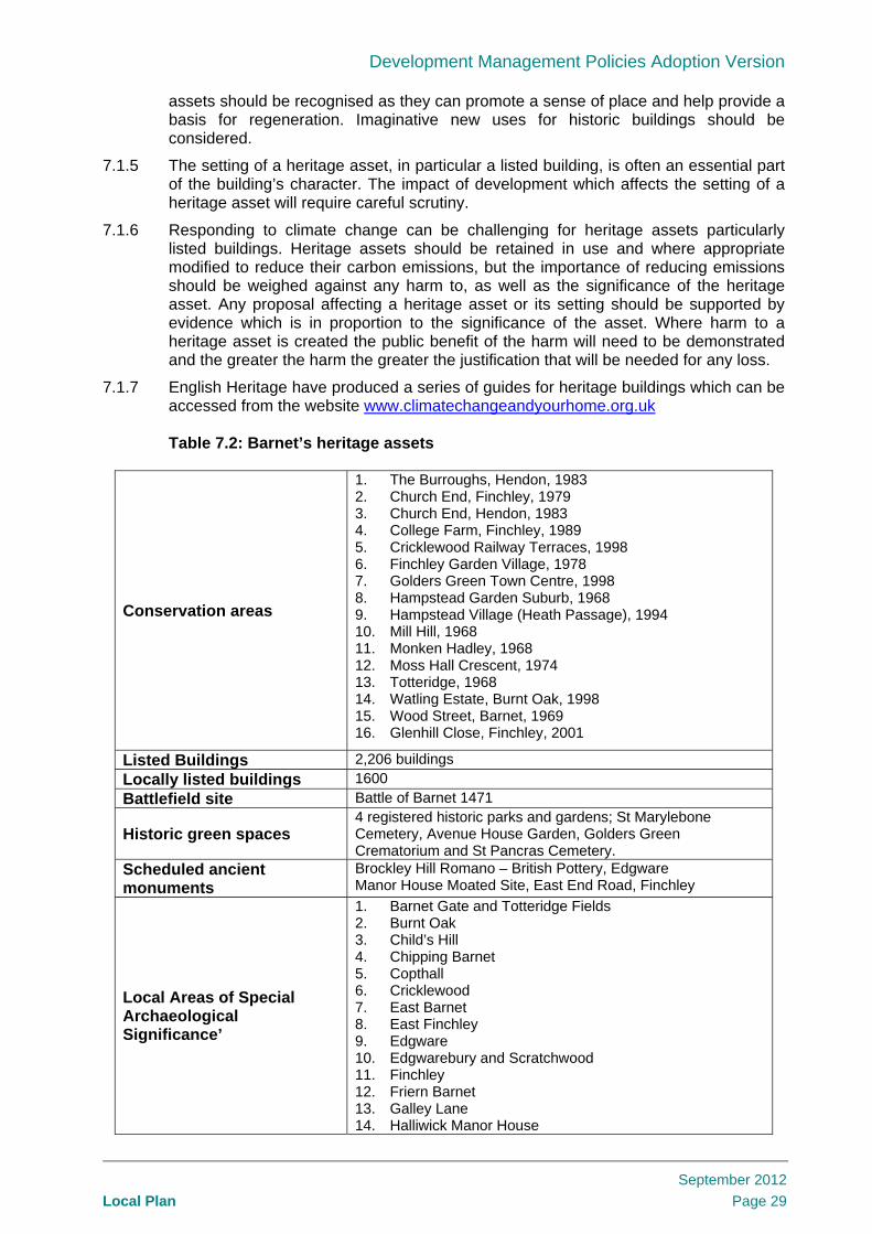
Development Management Policies Adoption Version
Local Plan
September 2012
Page 29
assets should be recognised as they can promote a sense of place and help provide a basis for regeneration. Imaginative new uses for historic buildings should be considered.
7.1.5 The setting of a heritage asset, in particular a listed building, is often an essential part of the building’s character. The impact of development which affects the setting of a heritage asset will require careful scrutiny.
7.1.6 Responding to climate change can be challenging for heritage assets particularly listed buildings. Heritage assets should be retained in use and where appropriate modified to reduce their carbon emissions, but the importance of reducing emissions should be weighed against any harm to, as well as the significance of the heritage asset. Any proposal affecting a heritage asset or its setting should be supported by evidence which is in proportion to the significance of the asset. Where harm to a heritage asset is created the public benefit of the harm will need to be demonstrated and the greater the harm the greater the justification that will be needed for any loss.
7.1.7 English Heritage have produced a series of guides for heritage buildings which can be accessed from the website www.climatechangeandyourhome.org.uk
Table 7.2: Barnet’s heritage assets
Conservation areas
1. The Burroughs, Hendon, 1983 2. Church End, Finchley, 1979 3. Church End, Hendon, 1983 4. College Farm, Finchley, 1989 5. Cricklewood Railway Terraces, 1998 6. Finchley Garden Village, 1978 7. Golders Green Town Centre, 1998 8. Hampstead Garden Suburb, 1968 9. Hampstead Village (Heath Passage), 1994 10. Mill Hill, 1968 11. Monken Hadley, 1968 12. Moss Hall Crescent, 1974 13. Totteridge, 1968 14. Watling Estate, Burnt Oak, 1998 15. Wood Street, Barnet, 1969 16. Glenhill Close, Finchley, 2001
Listed Buildings 2,206 buildings
Locally listed buildings 1600
Battlefield site Battle of Barnet 1471
Historic green spaces 4 registered historic parks and gardens; St Marylebone Cemetery, Avenue House Garden, Golders Green Crematorium and St Pancras Cemetery.
Scheduled ancient monuments
Brockley Hill Romano – British Pottery, Edgware Manor House Moated Site, East End Road, Finchley
Local Areas of Special Archaeological Significance’
1. Barnet Gate and Totteridge Fields 2. Burnt Oak 3. Child’s Hill 4. Chipping Barnet 5. Copthall 6. Cricklewood 7. East Barnet 8. East Finchley 9. Edgware 10. Edgwarebury and Scratchwood 11. Finchley 12. Friern Barnet 13. Galley Lane 14. Halliwick Manor House

Development Management Policies Adoption Version
Local Plan
September 2012
Page 30
15. Hendon 16. Mill Hill 17. Monken Hadley Common 18. Totteridge and Whetstone 19. Watling Street.
7.2 Conservation areas 7.2.1 Conservation Areas are defined as areas of special architectural or historic interest,
the character or appearance of which it is desirable to preserve or enhance. Within Barnet, sixteen Conservation Areas have been designated as set out in table 7.2.
7.2.2 If a site lies within a Conservation Area or is located nearby, planning permission will not be granted where development proposals neither preserves nor enhances the character or appearance of that area. Proposals will need to consider the council’s conservation area character appraisals and suite of Supplementary Planning Documents.
7.2.3 Opportunities to amend the boundaries of conservation areas can be considered as part of Barnet’s rolling programme of conservation area character appraisals. Article 4 Directions will be used, where appropriate, to protect or enhance the character and appearance of a Conservation Area.
7.2.4 There is a presumption in favour of retaining all locally listed buildings as well as any building which makes a positive contribution to the character or appearance of a conservation area. The council will need to be satisfied that all efforts have been made to continue the present use or to find compatible alternative uses before considering demolition as a viable option. In line with the NPPF (paragraph 130), a deteriorated condition as a result of deliberate neglect of or damage to a heritage asset will not be a factor considered in any decision. Proposals for demolition will need to address the following:
the condition of the existing building particularly if this makes its continued use unviable; and
the merits of the alternative proposals for the site
Alterations or extensions to locally listed buildings should respect their architectural or historic character, taking into account scale, design, materials and detailing.
7.3 Listed and Locally Listed Buildings 7.3.1 Statutory Listed Buildings are of national importance and are classified as follows:
GRADE I – Buildings of exceptional interest;
GRADE II* – Particularly important buildings of more than special interest;
GRADE II – Buildings of special interest which warrant every effort to preserve them
Locally Listed Buildings are buildings of local interest which significantly contribute to the Borough’s heritage and character.
7.3.2 Whatever the grading of a Listed Building, any work of demolition or alteration affecting its special architectural or historic character will require Listed Building Consent before it can be carried out. Consent is required to alter the interiors of Listed Buildings as well as the exterior. Whilst listing does not prevent changes to a building, the local planning authority is required to have special regard to the desirability of preserving the building or its setting, or any feature of special architectural or historic interest.
7.3.3 There is a presumption in favour of the conservation of Listed Buildings with an emphasis on the retention of Listed Buildings in active use and generally the best use is often the original use for which it was designed. The same presumption will apply to locally listed buildings and for alterations and other external works which might harm

Development Management Policies Adoption Version
Local Plan
September 2012
Page 31
the architectural and historic character and setting of such buildings. Where listed buildings or other heritage assets are part of a regeneration proposal they can be used to link a scheme with an area’s past and to create a sense of place. In some cases a heritage asset can be used as a catalyst for regeneration
7.4 Archaeological heritage 7.4.1 The borough’s archaeological heritage is a valuable educational and community
resource which is vulnerable to modern development and land use. Archaeological remains above and below ground level, and ancient monuments, are important surviving evidence of the borough’s past, and once removed they are lost forever.
7.4.2 There are two Scheduled Ancient Monuments in the borough. These are set out in Table 7.2. Scheduled monument consent must be obtained from the Secretary of State for Culture, Media and Sport with applications made to English Heritage before any alterations are made to them.
7.4.3 With assistance from English Heritage (via the Greater London Archaeology Advisory Service – GLAAS), the Museum of London and the Hendon and District Archaeological Society (HADAS), we have identified five prehistoric, four Roman and thirty medieval sites containing archaeological remains of more than local importance. These have been grouped into nineteen ‘Local Areas of Special Archaeological Significance’, which are identified in table 7.2. Development proposals in these areas will need to provide detail in consultation with GLAAS of how they will investigate, catalogue and where possible preserve the remains in situ or in a museum as part of any application. It may also be appropriate for HADAS to be consulted.
7.4.4 The council will seek to preserve nationally important archaeological remains and their settings, including Scheduled Ancient Monuments, from harmful development and will not approve development proposals which will have an adverse effect on such remains. Development which will affect remains within Areas of Special Archaeological Significance, and other archaeological remains, may also be refused.
7.4.5 Discovery is an important basis of archaeology. When researching the development potential of a site, developers should, in all cases, assess whether the site is known or is likely to contain archaeological remains. Where there is good reason to believe that there are remains of archaeological importance on a site, we will consider directing applicants to supply further details of proposed developments, including the results of an archaeological desk-based assessment and field evaluation.
7.4.6 Where important archaeological remains are found the council will seek to resist development which adversely affects the process of preserving the remains on site. Where this is not possible mitigation which may include excavation, analysis of remains and public dissemination of results will be expected by an archaeological organisation with approval from the GLAAS and the council before development commences. If permitted, the loss through development of any archaeological remains will need to be recorded in line with paragraph 141 in the NPPF. Planning Conditions or a Legal Agreement will be used to secure this.
Policy DM06: Barnet’s Heritage and Conservation
a. All heritage assets will be protected in line with their significance. All development will have regard to the local historic context.
b. Development proposals must preserve or enhance the character and appearance of 16 Conservation Areas in Barnet.
c. Proposals involving or affecting Barnet’s heritage assets set out in table 5.1

Development Management Policies Adoption Version
Local Plan
September 2012
Page 32
should demonstrate the following: the significance of the heritage asset the impact of the proposal on the significance of the heritage asset the impact of the proposal on the setting of the heritage asset how the significance and/or setting of a heritage asset can be better revealed the opportunities to mitigate or adapt to climate change how the benefits outweigh any harm caused to the heritage asset
d. There will be a presumption in favour of retaining all 1,600 locally listed buildings in Barnet and any buildings which makes a positive contribution to the character or appearance of the 16 conservation areas.
e. Archaeological remains will be protected in particular in the 19 identified Local Areas of Special Archaeological Significance and elsewhere in Barnet. Any development that may affect archaeological remains will need to demonstrate the likely impact upon the remains and the proposed mitigation to reduce that impact.
Useful References Barnet Characterisation Study, 2010 Barnet Conservation Area Character
Appraisals Design Guidance Note 1 – Advertising
and Signs,1993 Design Guidance Note 3 – Construction
of Hardstandings and Vehicular Crossovers, 2010
Design Guidance Note 5 – Extensions to Houses, 2010
Design Guidance Note 10 – Shopfronts, 2011
Energy Conservation in Traditional
Buildings, English Heritage, 2008 www.climatechangeandyourhome.org.uk
Flooding and Historic Buildings, English Heritage, 2010
Hampstead Garden Suburb Design Guidance, 2010
National Planning Policy Framework PPS5: Planning for the Historic
Environment – Practice Guide, 2010

Development Management Policies Adoption Version
Local Plan
September 2012
Page 33
8. Protecting housing in Barnet 8.1.1 As set out in Barnet’s Housing Strategy and Core Strategy Policy CS4: Providing
Quality Homes and Housing Choice in Barnet, our aim is to maximise housing choice alongside adequate supply.
8.1.2 Given the high demand for housing in the borough the loss of residential uses will not normally be acceptable. The loss from the current dwelling stock of residential units of a type which are in short supply or serving a special housing need, including Houses in Multiple Occupation (HMOs) or other low cost or affordable housing, will normally be resisted.
8.1.3 There may be specific circumstances where the loss of residential uses may be acceptable. Changes of use may be permitted where a clear local need can be demonstrated to provide the following local facilities; health facilities, a children’s nursery or educational use. Any proposal should be of a small scale and will be considered on its merits having regard to the impact on the amenity of residents, car parking and traffic. In line with policy CS10: Enabling Inclusive and Integrated Community Facilities and Uses the co-location of facilities will be supported in the right locations. Policy DM13: Community, Health and Education uses sets out our approach to access to community facilities.
8.1.4 Proposals for the demolition and net replacement of affordable housing will only be considered acceptable where it accords with the London Plan. This is normally where there are large scale identified regeneration plans involving demolition and net replacement of existing housing units. Replacement housing should meet the priorities set out in policy DM09: Specialist Housing.
Policy DM07: Protecting housing in Barnet Loss of residential accommodation will not be permitted unless:
a. the proposed use is for a local facility (children’s nursery, educational or health use) provided that it is not detrimental to residential amenity and;
b. where need can be demonstrated and; c. the demand for the proposed use cannot adequately be met elsewhere and is
in line with other policies or;
d. the location is no longer environmentally suitable and viable for residential use or;
e. it involves identified regeneration areas with large scale demolition of housing and estates which provides for the net replacement of the total residential units
Useful References Annual Monitoring Reports
London Plan, 2011

Development Management Policies Adoption Version
Local Plan
September 2012
Page 34
9. Ensuring a variety of sizes of new homes to meet housing need
9.1.1 As set out in Core Strategy Policy CS4: Providing Quality Homes and Housing Choice in Barnet, the aim is to maximise housing choice providing a range of sizes and types of accommodation that can meet aspirations and increase access to affordable and decent new homes.
9.1.2 Barnet’s growing and increasingly diverse population has a range of needs that requires a variety of sizes of accommodation. According to Office for National Statistics projections, Barnet is now the most populous borough in London with an estimated population of 345,800 residents in 2010. It is estimated that 7.5% of the population are new to Barnet each year through birth or in-migration. Natural increase (the difference between the number of births and deaths) is the most significant contributor to Barnet’s growth. Barnet’s population will change our existing communities, attracting a much younger and more diverse population. Over the next ten years there will be a marked increase in the number of children aged between 5-14 years old and number of people over the age of 65.
Table 9.1 National and London Plan guidance on the size of new homes
9.1.3 Three housing types cover tenure in Barnet:
Social rented housing – for those households unable to afford any more than social rents;
Intermediate housing – for those households able to afford more than social rents, but unable to afford to buy owner-occupied housing or to rent privately at the market rent threshold; and
Market housing – for those households able to afford to buy or pay market rents.
9.1.4 The projections for Barnet’s housing needs have been based on the North London Strategic Housing Market Assessment (SHMA). The SHMA estimates Barnet’s housing requirements by dwelling size and tenure (rented or owner-occupied) for the next five years. It does this by estimating recent and future household formation, in-migration, out-migration and projected household dissolution. The SHMA has highlighted that Barnet needs more family sized accommodation.
9.1.5 Maintaining and increasing the supply of family housing is a priority in Barnet. Since 2004 we know that delivery has been dominated by smaller flatted homes. Continuous research into the type of accommodation that is being built in Barnet is recorded in the Annual Monitoring Report (AMR). The AMR for 2009/10 highlights that flats have made up the majority (80%) of new housing in the past five years. Less than 10% of
The National Planning Policy Framework sets out that “local planning authorities should plan for a mix of housing based on current and future demographic trends, market trends and the needs of different groups in the community (such as, but not limited to, families with children, older people, people with disabilities, service families and people wishing to build their own homes)” (NPPF: paragraph 50) The London Plan Policy 3.8: Housing Choice requires that: “new developments offer a range of housing choices, in terms of the mix of housing sizes and types, taking account of the housing requirements of different groups"

Development Management Policies Adoption Version
Local Plan
September 2012
Page 35
new flats have 3 or more bedrooms. The dominant unit size in new build development has 2 bedrooms (50%) and under 20% of new build development has 3 bedrooms.
9.1.6 Within the context of Core Strategy Policy CS4: Providing Quality Homes and Housing Choice in Barnet, the policy seeks to provide choice for households by building the right homes that are suitable for the next generation. The policy is based on high and medium priorities for unit size of new social rented, intermediate and market housing as identified in the Core Strategy. This policy can be applied flexibly. It may not be appropriate to meet the dwelling size priorities in the town centres and local centres.
9.1.7 For intermediate affordable housing whilst the aspiration is for family-sized homes the practical and financial reality is that for products such as shared ownership/low cost home ownership the size of housing may be unaffordable. Therefore smaller 1 and 2 bedroom intermediate tenure homes will also be supported.
Policy DM08: Ensuring a variety of sizes of new homes to meet housing need
Development should provide where appropriate a mix of dwelling types and sizes in order to provide choice for a growing and diverse population for all households in the borough. Our dwelling size priorities are:
i. For social rented housing – homes with 3 bedrooms are the highest priority
ii. For intermediate affordable housing – homes with 3/4 bedrooms are the highest priority
iii. For market housing – homes with 4 bedrooms are the highest priority, homes with 3 bedroom are a medium priority
Useful References Annual Monitoring Reports National Planning Policy Framework
Annual Monitoring Reports North London Strategic Housing Market
Assessment; 2011

Development Management Policies Adoption Version
Local Plan
September 2012
Page 36
10. Specialist housing – Houses in Multiple Occupation, Hostels, Student Accommodation and Housing Choice for Older People
10.1.1 The Core Strategy in Policy CS4: Providing quality homes and housing choice in Barnet, seeks to provide supported housing to maximise the independence of vulnerable residents including young people, people with disabilities, older people, homeless people and other vulnerable adults.
10.1.2 Non self-contained housing (homes that share facilities) includes hostels, student accommodation, residential care homes and Houses in Multiple Occupation. Annex 4 in the London Plan sets out that 127 units of non self contained housing are expected to come forward per annum as part of Barnet’s housing target up to 2020/2021.. Table 10.1 National guidance on the specialist housing
10.2 Extending housing choice for older people 10.2.1 According to the Core Strategy 31% of older people in Barnet live alone and this
proportion is expected to increase. Older people in Barnet are more likely to be owner occupiers without a mortgage and to under-occupy their properties. Three-quarters of older owner-occupiers live in three or four bedroom properties. National research reveals that the majority of older people would prefer to either remain living in their home, or would prefer accommodation which is part of the ordinary housing stock but is designed to meet their needs. Therefore adapting the existing housing stock to extend the housing choice for older people will be encouraged particularly where it can release family sized accommodation. This will help to deliver mixed communities in lifetime neighbourhoods as identified in the Core Strategy.
10.2.2 Housing proposals for the elderly include the following types of accommodation
care homes;
extra care housing;
sheltered housing;
10.2.3 Proposals are expected to clearly demonstrate need and how they are contributing to the delivery of council strategies and priorities. The Core Strategy highlights an over-
The Town and Country Planning (Use Class Order) [as amended April 2010] classifies the range of different uses for buildings and land for planning purposes. There are 14 classes of use. Class C4 cover specialist housing: C4 – Houses in multiple occupation (HMO) where less than 6 unrelated people live and share facilities in a self contained house Sui generis – An HMO property where more than 6 unrelated people live and share facilities or a hostel or student housing Circular 08/2010: Changes for planning regulations for dwelling houses and houses in multiple occupation make possible a change of use from a dwelling house (Class C3) to a house in multiple occupation (Class C4) and from a house in multiple occupation to a dwelling house under permitted development rights and planning applications are not needed.

Development Management Policies Adoption Version
Local Plan
September 2012
Page 37
supply of residential care homes in Barnet and recommends remodelling these homes for example as sheltered housing plus to address the higher support needs of tenants. Loss of extra care housing will not normally be acceptable and compliance with Policy DM13: Community, Health and Education uses will be expected to be demonstrated where community facilities may be lost.
10.2.4 Ensuring that the supply of specialist housing for older people meets their needs is the priority. The London Plan expects boroughs to “…undertake assessment of the short and longer term supported housing needs of vulnerable and disadvantaged groups…” The assessment’s primary purpose is to ensure that sufficient supply is being provided to meet Barnet’s older population’s needs. The London Plan also supports “…close integration between planning and other borough strategies…” - the Core Strategy emphasises this approach. Patterns of care are changing and Barnet is prioritising increasing investment in community care to help people to remain in their own homes.
10.2.5 Creating an oversupply of specific types of accommodation will be resisted and any applications for accommodation which contributes to an oversupply will need to provide robust evidence in support of their proposals. The council will monitor demand and supply on an annual basis and each case will be assessed on its merits.
10.2.6 Any new extra care housing and care homes for older people should be within reasonable walking distance, defined as 500m, of a local parade of shops/ local centre or town centre. Providing communal space, both for visitors and staff, on site supports the provision of high quality care for older people, and facilitates visits from friends and family that they value highly. Ensuring adequate facilities for staff will help support them in providing a service.
10.3 Houses in Multiple Occupation (HMO) 10.3.1 There are two planning use classes for HMO. A Use Class C4 HMO is one that is not
used by more than six people. A HMO larger than this is classed as a sui generis use. It is permitted to change a Class C4 HMO property to a Class C3 dwelling house without planning permission. Equally it is now permitted to change from a Class C3 dwelling house to Class C4 HMO property without planning permission. Converting dwellings to HMO, when classed as sui generis will require planning permission. Likewise a conversion from a HMO to flats will require planning permission.
10.3.2 HMO are an important source of low cost, private sector housing for students, those on low incomes and those seeking temporary accommodation. For this reason the conversion of HMO dwellings to self contained flats will be resisted (as planning permission is required) as this would be likely to reduce choice and affordability. Applicants for such conversions will be expected to demonstrate the absence of need for this type of accommodation.
10.3.3 Hostels can include accommodation for the homeless and short-stay accommodation for tourists. It is important to ensure that any new homeless accommodation helps to meet local need, and is not all taken by homeless people referred from other boroughs. Where temporary accommodation for the homeless is proposed, the council will seek to enter into a legal agreement with the developer to ensure that 100% of the accommodation is allocated solely to households referred by the council. Other types of short stay accommodation such as hostels for tourists will be expected to locate in the town centres.
10.4 Student Accommodation 10.4.1 The 2006 Housing Needs Survey estimated that Barnet’s student population makes
up 1.9% of households in the Borough. Over 75% of student households live in a flat/maisonette and nearly 70% of student households are in the Hendon area.
10.4.2 Locations outside the town centres are less appropriate for student accommodation as students generally need access to public transport. Developers intending to build new

Development Management Policies Adoption Version
Local Plan
September 2012
Page 38
student housing should demonstrate need which links with local educational establishments to ensure that supply meets local needs, rather than wider regional demand.
10.4.3 Barnet’s higher and further educational establishments are located predominantly in the west of the borough. Middlesex University has aspirations to expand and consolidate its operations on the Hendon campus and provide new and improved student accommodation as part of a new 1,000 bed student village at Colindale.
Policy DM09: Specialist housing – Houses in Multiple Occupation, student accommodation and housing choice for older people a: Houses in Multiple Occupation (HMO) The council will seek to retain existing HMO provided that they meet an identified housing need. Proposals for new HMO will be encouraged provided that they meet an identified need, can demonstrate that they will not have a harmful impact on the character and amenities of the surrounding area, are easily accessible by public transport, cycling and walking and meet the relevant housing standards for HMO. b: Student Accommodation The council expects proposals for student accommodation to demonstrate that they support educational establishments within Barnet and meet an identified local need. Provision for students should be located in accessible locations. c: Housing Choice for Older People Housing proposals for older people should:
i. help to meet an identified need; ii. demonstrate that they will not have a harmful impact on the character and
amenities of the surrounding area; and iii. be within walking distance of local shops and easily accessible by public
transport; and iv. provide adequate communal facilities including accommodation for essential
staff on site.
Useful References Barnet Housing Needs Survey, 2006 Circular 08/10 Changes to Planning
Regulations for Dwellinghouses and Houses in Multiple Occupation, CLG, 2010
Do you need Planning Permission ?
Planning Portal www.planningportal.gov.uk/permission/commonprojects/changeofuse

Development Management Policies Adoption Version
Local Plan
September 2012
Page 39
11. Affordable housing contributions 11.1.1 This policy sets out how the Core Strategy Policy CS4: Providing Quality Homes and
Housing Choice in Barnet will implement the borough-wide target for 40% of all new homes to be affordable. In Barnet, the aim is to maximise housing choice whilst ensuring an adequate supply providing a range of sizes and types of accommodation that can meet aspirations and increase access to affordable and decent new homes.
Table 11.1 National and London Plan guidance on affordable housing
11.1.2 The threshold for requiring affordable housing is 10 or more housing units. The maximum reasonable amount of affordable housing that will be required on site will be considered on a site by site basis and subject to viability. Delivery of more than 40% affordable housing will also be sought where viable. The affordable housing threshold will also be triggered by redevelopment on sites larger than 0.4 hectares (including conversions). Affordable housing calculations should be made in terms of habitable rooms or floorspace. Calculations should be made in relation to gross development based on the total number of units in the final development.
11.1.3 In line with the Core Strategy the tenure mix of affordable housing which will be sought is 60% social rented and 40% intermediate. To reflect the emerging affordable rented housing market and retain flexibility for developments a proportion of the 60% social rented and 40% intermediate housing may be replaced by affordable rented housing. The proportions will be determined on a case by case basis to reflect local market rents. Further detail will be provided in the Affordable Housing Supplementary Planning Document.
11.1.4 Exceptional circumstances which may justify a reduction in the affordable housing contribution or details of payments in lieu are set out in Affordable Housing Supplementary Planning Document. Only genuine unforeseen costs will be considered. The SPD also sets out details regarding payments in lieu and the methodology for calculating these.
Affordable housing is defined by the National Planning Policy Framework. "Affordable housing: social rented, affordable rented and intermediate housing, provided to eligible households whose needs are not met by the market.” The National Planning Policy Framework states that local planning authorities should: “where they have identified that affordable housing is needed, set policies for meeting this need on site, unless off-site provision or a financial contribution of broadly equivalent value can be robustly justified (for example to improve or make more effective use of the existing housing stock) and the agreed approach contributes to the objective of creating mixed and balanced communities. Such policies should be sufficiently flexible to take account of changing market conditions over time.” (NPPF: paragraph 50) The Mayor’s London Plan sets a London wide target for affordable housing and states that “Boroughs should set an overall target in LDFs for the amount of affordable housing provision needed over the plan period in their areas” (policy 3.11). It also indicates more tenure mix flexibility of 60:40 split between social rent and intermediate.

Development Management Policies Adoption Version
Local Plan
September 2012
Page 40
Policy DM10: Affordable housing contributions Having regard to the borough-wide target that 40% of housing provision should be affordable, the maximum reasonable amount of affordable housing will be required on site, subject to viability, from all new sites providing 10 or more units gross or covering an area of 0.4 hectares or more.
Useful References Affordable Housing Viability Study, 2010 London Plan, 2011
National Planning Policy Framework

Development Management Policies Adoption Version
Local Plan
September 2012
Page 41
12. Development principles for Barnet’s town centres
12.1.1 Policy CS6: Promoting Barnet’s Town Centres in the Core Strategy sets out that the town centres are a crucial indicator of the overall economic health and suburban success of the borough. The Development Management Policies DPD will provide the detailed policy framework within which Barnet’s suburban town centres can be managed to maintain their vitality and viability.
12.1.2 The following town centres are the focus of this policy:
Brent Street
Burnt Oak
Cricklewood
Chipping Barnet
Colindale, the Hyde
Edgware
East Finchley
Finchley Church End
Golders Green
Hendon
Mill Hill
New Barnet
North Finchley
Temple Fortune
Whetstone
12.1.3 The Core Strategy identifies key town centres for placemaking and economic focus at Edgware, Finchley Church End, North Finchley and Chipping Barnet. For all town centres it promotes competitive town centre environments that provide consumer choice. This will ensure successful Barnet centres are maintained in a period of consolidated growth helping to maintain successful London suburbs.
12.1.4 A new town centre will be created as part of the regeneration of Brent Cross/Cricklewood. This aims to turn the existing traditional out of town shopping centre into a metropolitan town centre with a new high street which spans across the A406 North Circular Road, linking to a new railway station.

Development Management Policies Adoption Version
Local Plan
September 2012
Page 42
Table 12.1 National and London Plan guidance on town centres
12.2 Town Centre Uses 12.2.1 Appropriate town centre uses expected to locate within the town centre boundary
include retail, leisure, entertainment facilities, more intensive sport and recreation uses, offices and arts, culture and tourism development. An example of a more intensive sport and recreation use could be a health and fitness centre or cinema. These are uses which will be more acceptable when located in the town centre because of the transport impact that they create from their use. They also help contribute to the continued success of the rest of the town centre.
12.2.2 The council will consider hotels and hostels as tourism related development and expect them to locate in a town centre with good public transport links with central London. There are fourteen district and one major town centre in Barnet, of which twelve have tube or rail links with central London. Due to the potential impact on
The London Plan and the National Planning Policy Framework both require town centre boundaries and primary and secondary frontages to be defined, and a sequential approach to approving sites for main town centre uses. Existing centre sites should be used where possible, then edge of centre and out of centre locations considered in that order. The NPPF defines edge of centre as 300 metres from the primary shopping area for retail uses. For all other main town centre uses, a location up to 300 metres of the town centre boundary and up to 500 metres for an office use provided the town centre contains a public transport interchange. The National Planning Policy Framework defines main town centre uses as “Retail development (including warehouse clubs and factory outlet centres); leisure, entertainment facilities the more intensive sport and recreation uses (including cinemas, restaurants, drive-through restaurants, bars and pubs, night-clubs, casinos, health and fitness centres, indoor bowling centres, and bingo halls); offices; and arts, culture and tourism development (including theatres, museums, galleries and concert halls, hotels and conference facilities).” The NPPF (paragraph 26) requires an impact assessment for retail, leisure and office development outside a town centre. The Use Class Order [as amended April 2010] classifies the range of different uses for buildings and land for planning purposes. There are 14 classes of use. Classes A1 – A5 cover typical high street uses:
A1 – retail shops for selling goods to the public
A2 – financial and other professional services
A3 – restaurants and cafes
A4 – pubs and bars
A5 – take aways
Sui Generis – for example launderettes, taxi businesses, amusement arcades, theatres and nightclubs

Development Management Policies Adoption Version
Local Plan
September 2012
Page 43
residential amenity the development of hotels or hostels just outside the town centre boundary will not be acceptable.
12.3 Out of town centre retail 12.3.1 All out of town retail development will be required to consider the sequential approach
as set out in national policy (NPPF: paragraph 24). In Barnet extensions which exceed 200m2 gross will also need to comply with the sequential approach. The council also expects this approach to be applied to the amalgamation of existing retail units in local centres or parades which result in a single unit exceeding 200m2 gross. There are fourteen local centres in the borough which generally provide for day to day needs with small independent shops. The objective of this approach is to both protect these local centres and maintain the vitality and viability of existing district town centres which are more appropriate locations for larger units.
12.3.2 An impact assessment will be required for any significant new retail development in the borough. This requirement will apply to any development outside the 14 district town centres and one major town centre in the borough. Any large retail proposal could impact on these centres. This is in line with paragraph 26 in the NPPF. The threshold for a significant new retail development will be defined as that above 500 m2 or a net addition of this amount to an existing unit.
12.3.3 The proposals for Brent Cross/Cricklewood will create a new town centre as part of the regeneration and the adopted Area Action Plan for Colindale identifies the development of a new community neighbourhood centre in Colindale. Neither will be required to demonstrate compliance with the tests set out in the NPPF unless they either exceed the floorspace set out in the AAP or the approved hybrid planning permission for Brent Cross/Cricklewood.
12.4 Mixed Use 12.4.1 In Barnet’s town centres, some of the opportunities to provide a wider mix of uses
come from the existing employment spaces. Through regeneration or re-use they can continue to provide employment space whilst also providing new residential and community or leisure floorspace, with retail where appropriate. Employment is critical to a town centres vitality, and the council needs to ensure that viable employment activity is retained and growth enabled.
12.4.2 Policy DM14: New and Existing Employment Space sets out the approach for releasing existing employment sites to other uses. The amount of employment space re-provided as part of the redevelopment will be considered on a case by case basis unless otherwise indicated in a Town Centre Framework or Site Allocations DPD. The provision of community space will be a consideration when assessing the amount of reprovision. Retail units will be required where the employment site is part of the existing retail frontage or where it could be extended to increase the retail frontage.
12.4.3 The council will support community uses in the town centres, as these are the most accessible locations. The definition of community uses covers a wide range of uses that can be relocated to or enhanced within the town centres provided that this does not reduce service coverage in other parts of the borough. Policy DM13: Community, Health and Education Uses provides further detail on community uses. This approach will deliver community uses and support the wider vitality and viability of the town centre provided that an active street frontage is maintained, to enable this. For example health care facilities could be provided in areas of secondary retail frontage.
12.4.4 Residential accommodation in town centres can help contribute to vitality and viability by increasing trade for business and enhancing levels of natural surveillance and activity throughout the day and evening. Town centre homes also offer their occupiers ready access to town centre-based services, goods and facilities and public transport, thereby reducing the need to travel by car. However care should be taken to ensure that the primary retail function is not impacted by residential uses. An example of this

Development Management Policies Adoption Version
Local Plan
September 2012
Page 44
is where residential access is required to the rear of shops and conflict with space for servicing the retail function should be avoided.
12.4.5 For town centre residential accommodation the standards applied elsewhere in the borough (for example, in relation to car parking and amenity space) may be relaxed in line with policy DM17: Travel Impact and Parking Standards and will be considered on a case by case basis. Affordable housing will be expected to be provided in line with policy DM10: Affordable Housing Contributions.
12.5 Small Shops 12.5.1 Ensuring that there is adequate provision for small shops is important particularly
where large scale retail redevelopment occurs. Comprehensive retail redevelopment should provide a mix of retail floorspace including small units. Planning controls on maximum shop unit size and frontage will be applied in town centres to ensure diversity, viability and mix of interest and to avoid ‘clone town’ dominance by large retail stores that could ultimately diminish vitality of Barnet’s town centres.
12.6 Town centre boundaries 12.6.1 Barnet has the most town centres of any borough in London. Town centre boundaries
include the main town centre uses (retail, leisure, entertainment facilities, more intensive sport and recreation uses, offices and arts, culture and tourism development). Boundaries are identified for the 14 district centres and one major town centre. The boundaries clearly delineate town and hinterland residential suburb and enable a clear definition of an edge of centre site. An edge of centre site is locally defined as being within 150 metres of the town centre boundary.
12.6.2 Many of the town centres in Barnet have developed a linear shape along the principal radial roads that emanate from central London. The national standard for edge of centre sites of 300 metres applies to a more traditional compact town centre which is focused on the nuclei where these radial roads meet. In Barnet the immediate hinterland of all the town centres is residential and the approach is aimed at protecting these areas from inappropriate extensions of the town centre. The approach will be applied flexibly as not all town centres are of this form and the council will use the primary centre frontage as the point from which edge of centre locations are assessed.
12.6.3 Appropriate uses for edge of centre sites are offices and community/leisure uses. They should be suitably integrated into the existing town centre and allow easy movement in order to support existing town centre uses. Proposals for edge of centre development should consider:
ensuring the design and siting of the development promote visual continuity with the existing street scene;
making provision for improved pedestrian links between the development and existing facilities; and
designing the site layout to give efficient access for all modes of transport.
12.7 Retail frontages 12.7.1 Protecting retail vitality and viability in the frontages is the priority in order for Barnet’s
town centres to retain their main retail function. The primary frontage in a town is the strip of most popular, central shops. The secondary frontage includes the other shops and restaurants that border these. Protecting shops in these frontages seeks to maintain the vitality and viability of the district town centres in Barnet.

Development Management Policies Adoption Version
Local Plan
September 2012
Page 45
12.7.2 The percentage of town centre frontages (primary/secondary) used for retail has been reviewed. The evidence set out in the Background Report: District Centre Frontages3
identifies that the primary frontage retail uses have broadly been maintained.
12.7.3 The secondary frontages present slightly more mixed results. In three town centres the secondary frontages have proportionally more Class A1 use than the primary frontage. Elsewhere the other town centres continue to mirror the established policy approach of secondary frontages being less dominated by retail uses with more restaurants/cafes and financial uses. This reflects the lower footfall found in edge of town centre locations and justifies designation as secondary frontage.
12.7.4 The results of the survey on frontages provide justification to maintain the percentage split for Class A1 uses as set out in policy DM11: Development principles in the town centres. Rather than identify individual percentage figures for each town centre retail uses will be removed, de-designated or re-designated from frontages where appropriate. Appendix 4 sets out the details for each town centre. The local centres policy DM12: Maintaining local centres and parades will apply in any de-designated frontages.
12.7.5 The council will continue to undertake periodic shopping surveys of the retail frontages in each of the defined town centres and report the results in the Annual Monitoring Report. In calculating the proportion of retail and non-retail uses, vacant properties will be included within the retail use category, irrespective of their most recent use. Change of use from Class A5 (Hot Food Takeaways), through classes A4 (Drinking Establishments), A3 (Restaurants and Cafes), A2 (Financial and Professional Services Class) to Class A1 is permitted development, and most vacant town centre properties will therefore benefit from an assumed Class A1 use.
12.7.6 Where the percentage of Class A1 use in a town centre frontage exceeds the thresholds set out in policy DM11 applications for a change of use to A2, A3, A4 & A5 will be permitted dependent on effective marketing. Effective marketing is where the unit is actively marketed continuously for at least 12 months at an appropriate price for both rent and sale which can be agreed in advance with the council (at pre-application if appropriate) prior to the application being made and where no interest is expressed in it for retail or similar use. Provided sufficient evidence can demonstrate this and the existing percentage of Class A1 units plus vacant units exceeds the threshold then change of use to other retail uses classes (A2, A3, A4 and A5) will be permitted.
12.7.7 Preventing an over concentration of similar non class A1 uses is important to maintaining the vitality and viability of a town centre. Where a proposed use would create three or more adjacent non retail uses of any class then this will be resisted. The planning system is confined to managing uses within the constraints of the use class system. It cannot control one type of Class A1 use over another. However it can limit changes from Class A1 to other non retail uses such as Class A2, A3, A4 and A5.
12.7.8 Any significant new retail development in a town centre should be in line with policy DM01: Protecting Barnet’s Character and Amenity. The level of significance will depend on the context and the centre within which a proposal is proposed to be located.
12.7.9 New retail developments should be designed to ensure that they are not inward looking or self-contained, but contribute to the vitality and viability of the whole town centre, by creating or maintaining a street frontage building line and providing convenient linkages for pedestrians to access other town centre premises and spaces.
3 The Background Report: District Centre Frontages sets out the results of the latest town centre survey of the district centres in the borough. Barnet’s town centre retail frontages were also surveyed in 2006 and updated in 2008

Development Management Policies Adoption Version
Local Plan
September 2012
Page 46
12.8 Evening Uses 12.8.1 The Core Strategy supports a healthy evening economy. Non-retail uses, where an
active street frontage can be maintained, can help maintain the viability and vitality of some of the town centres. Uses including those in the evening economy can make a contribution providing appropriate planning conditions or licensing limits any harmful impacts on nearby residential amenity. As a minimum an active street frontage entails that the ground floor interior is visible from the street and is the principal means of access.
12.8.2 Evening economy uses cover a range of leisure activities such as bars, restaurants, cinemas, theatres and arts venues. They can all contribute positively to the vitality and vibrancy of town centres. They can improve levels of safety and perceptions of personal safety by providing informal surveillance for passers-by. However, if not properly managed they can result in adverse effect on local residents due to noise, odours, litter and potentially anti-social behaviour. Residential amenity will be a key consideration in any application for an evening use.
12.8.3 Where appropriate planning conditions or legal agreements will be used to manage hours of operation, noise and fumes from machinery, storage and disposal of refuse, the areas used by customers and any other issues that may need to control the impact of evening uses in order to protect amenity.
12.8.4 Licensable activities will need to comply with Barnet’s Licensing Policy which sets out the council’s approach to the control of these activities, for example in particular the cumulative impact of a significant number of licensed premises concentrated in one area.
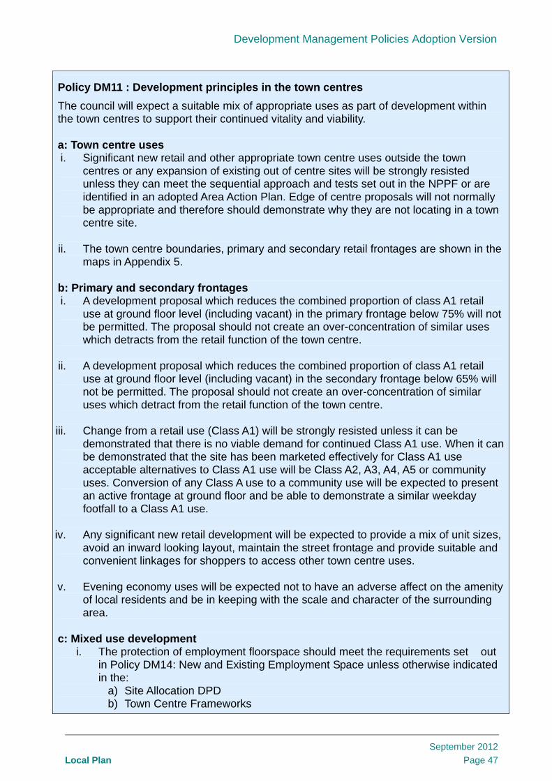
Development Management Policies Adoption Version
Local Plan
September 2012
Page 47
Policy DM11 : Development principles in the town centres
The council will expect a suitable mix of appropriate uses as part of development within the town centres to support their continued vitality and viability. a: Town centre uses i. Significant new retail and other appropriate town centre uses outside the town
centres or any expansion of existing out of centre sites will be strongly resisted unless they can meet the sequential approach and tests set out in the NPPF or are identified in an adopted Area Action Plan. Edge of centre proposals will not normally be appropriate and therefore should demonstrate why they are not locating in a town centre site.
ii. The town centre boundaries, primary and secondary retail frontages are shown in the
maps in Appendix 5. b: Primary and secondary frontages i. A development proposal which reduces the combined proportion of class A1 retail
use at ground floor level (including vacant) in the primary frontage below 75% will not be permitted. The proposal should not create an over-concentration of similar uses which detracts from the retail function of the town centre.
ii. A development proposal which reduces the combined proportion of class A1 retail
use at ground floor level (including vacant) in the secondary frontage below 65% will not be permitted. The proposal should not create an over-concentration of similar uses which detract from the retail function of the town centre.
iii. Change from a retail use (Class A1) will be strongly resisted unless it can be
demonstrated that there is no viable demand for continued Class A1 use. When it can be demonstrated that the site has been marketed effectively for Class A1 use acceptable alternatives to Class A1 use will be Class A2, A3, A4, A5 or community uses. Conversion of any Class A use to a community use will be expected to present an active frontage at ground floor and be able to demonstrate a similar weekday footfall to a Class A1 use.
iv. Any significant new retail development will be expected to provide a mix of unit sizes,
avoid an inward looking layout, maintain the street frontage and provide suitable and convenient linkages for shoppers to access other town centre uses.
v. Evening economy uses will be expected not to have an adverse affect on the amenity
of local residents and be in keeping with the scale and character of the surrounding area.
c: Mixed use development
i. The protection of employment floorspace should meet the requirements set out in Policy DM14: New and Existing Employment Space unless otherwise indicated in the:
a) Site Allocation DPD b) Town Centre Frameworks

Development Management Policies Adoption Version
Local Plan
September 2012
Page 48
c) Areas identified as a Locally Significant Industrial Site, Industrial Business Park or Business Locations.
ii. Appropriate mixed use re-development will be expected to provide re-provision of
employment use, residential and community use.
iii. The council will consider the location of new and the relocation of existing community, leisure and cultural uses (including arts) to the town centres only where they maintain active frontages.
Useful References Barnet Licensing Policy, 2005 Circular 03/05: Changes of Use of
Buildings and Land - Town and Country Planning (Use Classes) Order 1987, ODPM, 2005
Colindale Area Action Plan, 2010 District Centre Frontages Background
Report, 2011 London Plan, 2011 Mil Hill East Area Action Plan, 2009
National Planning Policy Framework Outline planning permission for Brent
Cross Cricklewood, C17559/08 Planning for Town Centres: Practice
Guidance on Need, Impact and the Sequential Approach, CLG, 2009
Town Centre Floorspace Needs Assessment, 2009
Town Centre Floorspace Needs Assessment, Update 2010

Development Management Policies Adoption Version
Local Plan
September 2012
Page 49
13. Maintaining the local centres and parades
13.1.1 Core Strategy Policy CS6: Promoting Barnet’s town centres sets out that the variety of town centres in the borough all have different roles and functions to play. The local centres and parades are particularly important for those less mobile including older people, people who are mobility impaired, parents with young children and people without access to a car.
Table 13.1 National guidance relevant to town centres
13.1.2 Neighbourhood and local centres are both recognised as local centres. Both occupy the same position in the London Plan town centre hierarchy. The council has identified frontages in Neighbourhood and local centres in order to protect them and manage change. The retail frontages of the following local centres are defined in appendix 4:
Friern Barnet
East Barnet Village
Market Place
Childs Hill
West Hendon
Golders Green Road
Hampden Square
Holders Hill Circus
Great North Road
Colney Hatch Lane
Apex Corner
Hale Lane
Deansbrook Road
New Southgate
Grahame Park
The Core Strategy identifies the five centres Friern Barnet, East Barnet Village, Market Place, Childs Hill and West Hendon as local centres alongside the 14 district town centres and one major town centre.
13.1.3 Protecting retail uses (Class A1) from change in local centres is the priority. Loss of Class A1 will generally be resisted. As well as providing for local needs shops in the local centres and parades can provide specialist uses which may not be found in the larger town centres. Sufficient evidence demonstrating lack of demand for Class A1 use will need to be demonstrated before other town centre uses including community uses. Not all uses will be appropriate as an active frontage will need to be maintained to ensure the continuity of the frontage and vibrancy in the local centre or parade. For individual shops and smaller parades, proposals will need to demonstrate that adequate provision of local shops and services is maintained.
13.1.4 For a change of use from Class A1 to A2, A3, A4 & A5 or a use which meets an identified local need (e.g. community facility) a unit will have to have been effectively marketed. Effective marketing is where a unit is actively marketed continuously for at least 12 months at an appropriate price for both rent and sale which can be agreed in
The National Planning Policy Framework states that “To deliver the social, recreational and cultural facilities and services the community needs, planning policies and decisions should: ●plan positively for the provision and use of shared space, community facilities (such as local shops, meeting places, sports venues, cultural buildings, public houses and places of worship) and other local services to enhance the sustainability of communities and residential environments” (NPPF: paragraph 70)

Development Management Policies Adoption Version
Local Plan
September 2012
Page 49
advance with the council (at pre-application if appropriate) prior to the application being made and have had no interest expressed in the unit for retail or similar use.
13.1.5 Preventing an over concentration of similar non Class A1 uses is important to maintaining the vitality and viability of the local centre or parade. Where a proposed use would create three or more adjacent non retail uses of any class system then this will be resisted.
13.1.6 Where local need (e.g. for a community facility) can be justified non A use class will be permitted. This can include community uses, B1 office or residential. The impact on the continuity of activity in the frontage will need to be considered. Maintaining an active frontage onto the street such as windows, entrances, receptions and waiting rooms which look out onto the street will be important. This allows overlooking of public areas adding to security and helping maintain the vitality of a centre or parade.
13.1.7 The requirements that are set out in Policy DM01: Protecting Barnet’s Character and Amenity, Policy DM02: Development Standards, Policy DM13: Community, Health and Education uses and Policy DM14: New and Existing Employment Space will all be expected to be considered where appropriate.
Policy DM12: Maintaining local centres and parades The council will protect all retail uses (Class A1) in the existing local centres, parades and isolated shops unless it can be demonstrated that:
i. there will be no significant reduction of shopping facilities as a result; and ii. that alternative shopping facilities that are similarly accessible by walking, cycling or public transport exist to meet the needs of the area; and iii. the proposed use is within Class A2, A3, A4, A5 or meets an identified local need; and iv. there is no demand for continued Class A1 use, and that the site has been marketed effectively for such use.
A proposal that either creates an over concentration of Class A2, A3, A4 and A5 uses or has a significant adverse effect on the amenity of existing residents will be refused. Community uses will be expected to present an active frontage at ground floor and be able to demonstrate a similar weekday footfall to a Class A1 use. Proposals for residential use should not cause a break in a frontage.
Useful References
National Planning Policy Framework
Local Centre Frontages Background
Report, 2011

Development Management Policies Adoption Version
Local Plan
September 2012
Page 50
14. Community and education uses 14.1.1 Core Strategy policy CS10: Enabling Inclusive and Integrated Community Facilities
and Uses, aims to ensure that we provide the right community facilities for Barnet’s communities. The council plan to protect existing community and education uses across the borough, and ensure that new facilities are in accessible locations. Community facilities provide for the health, welfare, social, educational, spiritual, recreational, leisure and cultural needs of the community.
Table 14.1 National and London Plan guidance for community and education uses
14.1.2 Community and education uses include health centres, dentists, schools & further education, space for the arts, museums, libraries, community halls and other public meeting venues, theatres, cinemas, indoor and outdoor sports facilities, places of worship and some policing facilities.
14.1.3 The council recognise that there is a need for a range of community and religious facilities in Barnet to support the requirements of different ethnic, religious, social and interest groups in the borough. Barnet’s projected population for the next ten years will increase and change our existing communities, attracting a much younger and more diverse population. There will be a marked increase in the number of children aged between 5-14 years old and number of people over the age of 65. It is therefore important that the Policy DM13: Community and education uses can respond flexibly to these changes.
14.1.4 Protecting all community and education uses without exception could reduce the possibilities of developers or community use promoters coming forward with proposals to mix and/or intensify community uses or relocate them to more accessible locations.
14.1.5 Community and education uses should be easily accessible to users. We will encourage new uses to locate in town centres and local centres as these locations are well served by public transport. Where local facilities are being provided which serve a local catchment, proximity to the bus network will be considered over and above the tube and train network.
The National Planning Policy Framework, Core planning principles states that planning should “take account of and support local strategies to improve health, social and cultural wellbeing for all, and deliver sufficient community and cultural facilities and services to meet local needs.” (NPPF: paragraph 17) The NPPF further states that “To deliver the social, recreational and cultural facilities and services the community needs, planning policies and decisions should:
● plan positively for the provision and use of shared space, community facilities (such as local shops, meeting places, sports venues, cultural buildings, public houses and places of worship) and other local services to enhance the sustainability of communities and residential environments” (paragraph 70) The London Plan advises in Policy 3.16: “Protection and enhancement of social infrastructure” that DPDs should assess the need for social infrastructure and community facilities in their area, and ensure that they are met wherever possible. New facilities should be provided within easy reach of walking and public transport of their target population. Net loss must be resisted and increased provision sought.

Development Management Policies Adoption Version
Local Plan
September 2012
Page 51
14.1.6 Special care will be needed in locating facilities which generate a large demand for travel at particular times such as schools, religious buildings, cinemas and sports facilities. Ensuring there is no significant impact on the free flow of traffic is important and assessing transport impact in line with Policy DM17: Travel Impact and Parking Standards will be expected.
14.1.7 Community and educational uses may be appropriate in residential areas. Where they do not have a demonstrably harmful impact on the amenities of nearby residential properties and other uses in terms of noise and traffic generation, or on the character of the surrounding area. In town centre retail frontages and local centres community uses (other than educational uses) should comply with policies DM11: Development Principles for Barnet’s Town Centres and DM12: Maintaining our Local Centres and Parades.
14.1.8 The following factors should be evidenced when considering the loss of any community or educational use:
Does the facility meet the needs of a specific section of the community e.g. older people or religious/faith community?
Can these needs be met by another local community facility or proposed facility (replacement)?
Could improving the facility strengthen the demand for its use?
Could it be used for another community use?
How accessible is the building to public transport, walking and cycling and other local services such as shops and could this access be improved?
Is there an overriding community need for another use?
Has effective marketing been carried out? Effective marketing is continuous active marketing for a period of 12 months at an appropriate level both for rent and sale which can be agreed in advance with the council (at pre-application if appropriate) with no interest expressed in its existing use or other community facility uses.
14.1.9 Redevelopment of a community or educational facility will be permitted where the above factors are appropriately addressed and the criteria set out in the policy are met. It needs to be clear that the existing community’s needs would still be met. Introducing a wider mix of uses on a community site or intensifying a community use or function is supported in the Core Strategy, provided accessibility and the impact on residential amenity is addressed. If there are improvements to existing community or education uses they should consider how improvements to local public transport can be made to improve access.
14.1.10 Adapting a building or land for another community use would be preferable to its loss to another use. This could also be part of a mixed use redevelopment which re-provides adequate facilities on site. Alternatively improvements can be provided at another location and secured via a legal agreement.
14.1.11 Educational uses have been highlighted by the Secretary of State for Communities and Local Government as a priority. National policy states that “Local planning authorities should: give great weight to the need to create, expand or alter schools; and work with schools promoters to identify and resolve key planning issues before applications are submitted.” (NPPF: paragraph 72)

Development Management Policies Adoption Version
Local Plan
September 2012
Page 52
Useful References Community Buildings Needs
Assessment, 2011 London Plan, 2011
National Planning Policy Framework Planning for Schools Development,
CLG, 2010
Policy DM13: Community and education uses a: Loss of community / educational use Loss of community / educational use will only be acceptable in exceptional circumstances where:
i. New community or education use of at least equivalent quality or quantity are provided on the site or at a suitable alternative location; or ii. There is no demand for continued community or education use, and that the site has been marketed effectively for such use.
b: New community or educational use New community or educational uses should be located where they are accessible by public transport, walking and cycling, preferably in town centres or local centres. New community or educational uses should ensure that there is no significant impact on the free flow of traffic and road safety. New community or educational uses will be expected to protect the amenity of residential properties.

Development Management Policies Adoption Version
Local Plan
September 2012
Page 53
15. New and existing employment space 15.1.1 Policy CS8: Promoting a Strong Prosperous and Enterprising Barnet sets out that the
council will support the Borough’s economy by protecting viable employment premises which meet the needs of modern business and encourage improvements to the quality of existing employment spaces including mixed use floorspace in the town centres.
Table 15.1 National and London Plan guidance relevant to new and existing employment space
15.2 Existing Employment Space 15.2.1 In 2009 a qualitative appraisal was undertaken to assess employment estates
(clusters of sites or areas) for quality and viability and identify those that can be released for alternative uses. Further detail of this assessment is contained in the Employment Land Review.
15.2.2 Industrial sites and business locations that have been assessed as high quality and viable are protected and identified as Locally Significant Industrial Sites, (suitable for Class B2 and B8 uses) an Industrial Business Park and various Business Locations (suitable for Class B1 uses). These sites are identified on the Proposals Map. They are also listed and mapped in Appendix 7. The following are newly protected locations; Regents Park Road employment cluster, Squires Lane, Redrose Trading Centre and Oakleigh Road South. These sites are recommended for safeguarding in
The National Planning Policy Framework sets out that local planning authorities should use an evidence base to assess “the existing and future supply of land available for economic development and its sufficiency and suitability to meet the identified needs.” (NPPF: paragraph 161) The NPPF states in paragraph 22 that “Planning policies should avoid the long term protection of sites allocated for employment use where there is no reasonable prospect of a site being used for that purpose. Land allocations should be regularly reviewed.” NPPF: paragraph 24 sets a sequential approach for main town centre uses including offices. The London Plan seeks to provide in Policy 4.1: Developing London’s Economy a range of workspaces and office premises of different types, sizes and costs. It promotes the renovation and renewal of existing stock in Policy 4.2: Offices and mixed use redevelopment in Policy 4.4: Managing Industrial Land and Premises. It allows boroughs to identify and manage Locally Significant Industrial Sites. It indicates the likely level of release of industrial land for other uses; Barnet is identified as suitable for limited transfer. The Town and Country Planning (Use Class Order) [as amended April 2010] classifies the range of different uses for buildings and land for planning purposes. There are 14 classes of use. Classes B1, B2 and B8 cover typical employment uses:
B1 – office high tech/research and light industry B2 – industrial B8 - warehousing

Development Management Policies Adoption Version
Local Plan
September 2012
Page 54
the Employment Land Review. In these locations a site may not be redeveloped for a non employment use (non B Class use) under any circumstances. This is to ensure that viable employment locations are maintained in the borough.
15.2.3 All proposals for redevelopment of employment uses to another employment use should consider their impact on local employment. Redevelopment should demonstrate it’s contribution to local employment. The council expects proposals to provide a more intensive employment use by demonstrating the level of employment. Proposals which cannot do this will be resisted. In particular this applies to conversion of Class B1 and B2 space to B8 and applies to sites identified as Locally Significant Industrial Sites, the Industrial Business Park and various Business Locations but also locations outside these areas.
15.2.4 Outside Locally Significant Industrial Sites, the Industrial Business Park and the Business Locations, all employment spaces will be protected where viable to enhance Barnet’s local economy and support enterprise potential. Employment spaces are defined as Class B1, B2 and B8 under the Use Classes Order. Effective marketing is where a site has been continuously actively marketed both for sale and rent for a period of 12 months at an appropriate price which can be agreed in advance with the council (at pre-application if appropriate) for re-use or redevelopment for employment use and no interest has been expressed. Once this can be satisfied then partial loss for residential and employment use may be permitted. The impact on local employment will be considered and re-provision, preferably of small business units will be favoured which can secure an equivalent amount of floorspace and level of employment. A financial contribution will be required for employment training where this cannot be delivered satisfactorily on site. Further details are set out in the SPD on Contributions to Enterprise, Employment and Training.
15.2.5 In addition to demonstrating a lack of viability in the short, medium and long term, proposals to redevelop employment spaces need to demonstrate why a site is no longer suitable. The following factors should be evidenced:
Is the building purpose built for employment or has it been adapted?
Does the size of the building make it suitable for small or medium enterprises (SME’s)?
Is the site or building part of a wider employment area and would the loss affect the continued operation of neighbouring uses?
How accessible is the site by road and public transport?
Is the site suitable for another employment use such as office space?
Is the existing building obsolete/not fit-for-purpose to meet modern day commercial requirements
15.2.6 Where proposals to redevelop existing employment space in town centres and edge of centre sites can demonstrate that existing uses are no longer viable and suitable then the new development will be expected to re-provide mixed use floorspace with some employment, residential and community use.
15.2.7 The impact on local employment in the town centre is a consideration and re-provision will be favoured which can re-provide an equivalent amount of floorspace and level of employment to ensure that viable employment activity is retained and growth enabled in the town centres.
15.3 New Employment Space 15.3.1 New office space should be located in the town centres before edge of centre or other
sites as these are more accessible by public transport and will help contribute to the continued vitality of the rest of the town centre. Edge of centre proposals will need to demonstrate that there are no town centre sites available.

Development Management Policies Adoption Version
Local Plan
September 2012
Page 55
15.3.2 New employment uses, in particular industrial uses, must demonstrate that they are making the right provision for deliveries and servicing. Access for uses that are expected to contribute to traffic congestion such as warehouses will be required to locate close to tier one (strategic routes) and tier two (distributor routes) roads. These tiers are strategic roads which cater for through traffic across boroughs and beyond.
15.3.3 Brent Cross Cricklewood is expected to deliver a large amount of new office floorspace as part of the redevelopment of the regional shopping centre and surrounding land. As part of the regeneration identified in the approved hybrid planning application there will be a loss of industrial floorspace which is treated separately from policy DM14: New and Existing Employment Space.
Policy DM14: New and existing employment space
a: Existing employment space
i. Proposals which result in a redevelopment or change of use of a Locally Significant Industrial Site, Industrial Business Park or Business Location as shown on the Proposals Map to a non B Class use will not be permitted.
ii. Outside these locations loss of a B Class use will only be permitted where it can be demonstrated to the council’s satisfaction that a site is no longer suitable and viable for its existing or alternative business use in the short, medium and long term and a suitable period of effective marketing has been undertaken. Where this can be demonstrated the priority for re-use will be a mixture of small business units with residential use.
iii. Office space (Class B1) should be retained in town centres and edge of centre locations. Loss of office space (Class B1) will only be permitted in town centres and edge of centre locations where it can be demonstrated to the council’s satisfaction that a site is no longer suitable and viable for its existing or alternative business use in the short, medium and long term and a suitable period of active marketing has been undertaken. Where this can be demonstrated the proposal will be expected to provide appropriate mixed use re-development which provides some re-provision of employment use, residential and community use.
iv. Proposals to redevelop or reuse an existing employment space which reduces the levels of employment use and impacts negatively on the local economy will be resisted.
v. Where appropriate, loss of employment space will be expected to provide mitigation in the form of contributions to employment training.
b: New employment space
i. All proposals for new office space should follow a sequential approach which
considers town centre sites before edge of centre sites.
ii. New industrial/warehousing space will be expected to locate in Locally Significant Industrial sites. Warehousing uses or uses which generate high levels of movement should be located in close proximity to tier one and two roads as set out in Policy DM17 Travel Impact and Parking Standards and minimise impact on residential areas.

Development Management Policies Adoption Version
Local Plan
September 2012
Page 56
iii. Proposals for new employment space will be expected to provide on site servicing for the intended use and include space for waiting for goods vehicles.
Useful References
Employment Land Review, 2009 London Plan, 2011
National Planning Policy Framework Outer London Commission – Interim
Conclusions, 2009

Development Management Policies Adoption Version
Local Plan
September 2012
Page 57
16. Green belt and open spaces 16.1.1 Core Strategy policy CS7: Protecting and Enhancing Barnet’s Open Spaces, aims to
protect and improve the provision of open space and protect and enhance biodiversity. Open space can be either publicly accessible or private. They are valued for many reasons including leisure and sporting use, health benefits, heritage value, biodiversity and their role in controlling urban sprawl.
16.1.2 Policy aims to both protect and enhance access to these spaces as vital green and open features of Barnet’s leafy suburbs. Providing more public access to a variety of spaces also helps to deliver the green and social infrastructure required for a growing Barnet.
Table 16.1 National and London Plan guidance for open spaces
The National Planning Policy Framework states that “The fundamental aim of Green Belt policy is to prevent urban sprawl by keeping land permanently open; the essential characteristics of Green Belts are their openness and their permanence.” (NPPF: paragraph 79) National policy further states that “Green Belt serves five purposes: ● to check the unrestricted sprawl of large built-up areas; ● to prevent neighbouring towns merging into one another; ● to assist in safeguarding the countryside from encroachment; ● to preserve the setting and special character of historic towns; and ● to assist in urban regeneration, by encouraging the recycling of derelict and other urban land.” (NPPF: paragraph 80) There are a few limited types of development that are appropriate for the Green Belt including that associated with agricultural use, essential facilities for outdoor sport and recreation and limited extension, alteration or replacement of existing buildings. Inappropriate development would have to demonstrate very special circumstances. The NPPF in paragraph 73 requires local authorities to identify specific needs and deficits or surpluses of open space, sports and recreational facilities. It states that open space standards should be set locally. It states at paragraph 74 that “Existing open space, sports and recreational buildings and land, including playing fields, should not be built on unless: ● an assessment has been undertaken which has clearly shown the open space, buildings or land to be surplus to requirements; or ● the loss resulting from the proposed development would be replaced by equivalent or better provision in terms of quantity and quality in a suitable location; or ● the development is for alternative sports and recreational provision, the needs for which clearly outweigh the loss.” The London Plan aims to protect Metropolitan Open Land (Policy 7.17) at the same level as Green Belt. It requires that deficiencies in public open space are addressed (Policy 7.18).

Development Management Policies Adoption Version
Local Plan
September 2012
Page 58
16.2 Green Belt / Metropolitan Open Land 16.2.1 Over one third of Barnet’s total land area is designated as either Green Belt (28%) or
Metropolitan Open Land (MOL) (8%). The fundamental aim of Green Belt policy is to prevent urban sprawl by keeping land permanently open.
16.2.2 Appropriate development in Green Belt or MOL include limited extensions to dwellings, replacement dwellings, development for agriculture, horticulture, woodland, nature conservation, wildlife and essential facilities for outdoor sport and recreation and uses which complement and improve access to, and which preserve the openness and do not conflict with the objectives of the Green Belt or MOL. Potentially acceptable Green Belt development such as golf courses and cemeteries can have a considerable impact on the local character, appearance, accessibility and nature conservation value of the countryside. In line with Policy DM01: Protecting Barnet’s Character and Amenity and Policy DM15: Green Belt and Open Spaces they should demonstrate their harmony with the surrounding countryside and impact on biodiversity.
16.2.3 The extension of buildings, provided they are of limited size, may be acceptable. They may also be necessary to maintain the viability of existing uses in the Green Belt/MOL. Extensions which lead to over-development or over-intensification of the use of the site will be refused.
16.2.4 Replacement dwellings need not be inappropriate provided the replacement dwelling is not materially larger than the dwelling it replaces, and the open character of the Green Belt and MOL is maintained. Equally any proposals for the change of use of buildings, or the creation of new curtilage, will be assessed against the openness of the Green Belt and MOL, and the characteristic form of the existing buildings.
16.2.5 Development adjacent to Green Belt/MOL should respect the character of its surroundings and the visual amenity of these areas. The council will resist proposals which would have a detrimental effect on visual amenity, or the openness, purposes and objectives of these designated areas.
16.3 Open Spaces 16.3.1 People need a variety of open spaces close to where they live. Open space can
provide the opportunity for relaxation, play, socialising and sporting activity which contributes to healthy lifestyles.
16.3.2 The open spaces other than Green Belt and Metropolitan Open Land protected by this policy are defined as follows:
public open space (as defined by the Public Open Space Hierarchy in the London Plan – Table 7.2)
outdoors sports (including playing fields, sports pitches and golf courses),
allotments and cemeteries
Many areas of Green Belt/MOL and open space are also identified and protected as Sites of Importance for Nature Conservation which are set out in table 17.2.
16.3.3 Development on open space will be acceptable in exceptional circumstances. It may be acceptable if it is small scale and ancillary to the use of the open space, compliments its functions and does not harm its open character. In line with Policy DM16: Biodiversity any potentially acceptable development on open space will need to evaluate the impact on biodiversity, protected species and habitat or species identified in the London Biodiversity Action Plan or other biodiversity interest.

Development Management Policies Adoption Version
Local Plan
September 2012
Page 59
16.3.4 Development on open space is also acceptable where replacement open space is provided. This will only be permitted where it results in no net loss of equivalent open space or a better quality of provision. Replacement open space should be the same or better quality than that which is proposed to be lost and be provided in the local catchment area to ensure that it does not create further deficiency in public access to open space. The Barnet ‘Open Space, Sport and Recreational Facilities Needs Assessment’ can be used to assess a better quality of provision.
16.3.5 The Barnet ‘Open Space, Sport and Recreational Facilities Needs Assessment’ provides evidence on the existing open space network and its intrinsic values. It provides a basis for improving the quality and potential uses of open spaces to cater for increasing future demand arising from growth and the changing needs of the community.
16.3.6 The success and value of an open space network is dependent on three principal factors: the quantity, quality and accessibility of open spaces. These three factors are used to assess the level of need in Barnet. The Assessment applies these factors to the existing open spaces in the borough to create a standard for Barnet. Where a development is in an area of deficiency for publicly accessible open space new open space should be provided in line with these standards:
Parks (1.63 hectares per 1,000 residents)
Children’s play (0.09 hectares per 1,000 residents)
Sports pitches (0.75 hectares per 1,000 residents)
Natural green spaces (2.05 hectares per 1,000 residents).
16.3.7 Map 10 in the Core Strategy highlights those parts of the borough that are deficient in public open space. In such locations the council will expect contributions from development in order to overcome that deficiency.
16.3.8 Policy DM02: Development Standards sets out the requirements for the provision of children’s playspace. A higher standard than 0.09 hectares may be required for larger developments. This is because larger developments may need to provide facilities on site for younger children in line with the Mayor of London’s SPG: Providing for Children and Young People’s Play and Informal Recreation.
16.3.9 In line with Policy DM06: Barnet’s Heritage and Conservation the historic significance of any open space should also be considered if it is affected by a development. The London Parks and Gardens Trust lists all those parks and gardens with historic value in the borough.
Policy DM15: Green Belt and Open Spaces
a: Green Belt / Metropolitan Open Land
1. Development proposals in Green Belt are required to comply with the NPPF (paragraphs 79 to 92). In line with the London Plan the same level of protection given to Green Belt land will be given to Metropolitan Open Land (MOL).
2. Except in very special circumstances, the council will refuse any development in the Green Belt or MOL which is not compatible with their purposes and objectives and does not maintain their openness.
3. The construction of new buildings within the Green Belt or Metropolitan Open Land, unless there are very special circumstances, will be inappropriate, except for the following purposes:
i. Agriculture, horticulture and woodland;
ii. Nature conservation and wildlife use; or

Development Management Policies Adoption Version
Local Plan
September 2012
Page 60
iii. Essential facilities for appropriate uses will only be acceptable where they do nothave an adverse impact on the openness of Green Belt or MOL.
4. Extensions to buildings in Green Belt or MOL will only be acceptable where they do not result in a disproportionate addition over and above the size of the original building or an over intensification of the use of the site.
5. The replacement or re-use of buildings will not be permitted where they would have an adverse impact on the openness of the area or the purposes of including land in Green Belt or MOL.
6. Development adjacent to Green Belt/MOL should not have a detrimental impact on visual amenity and respect the character of its surroundings.
b: Open Spaces
1. Open space will be protected from development. In exceptional circumstances loss of open space will be permitted where the following can be satisfied:
i.The development proposal is a small scale ancillary use which supports the use of the open space or
ii.Equivalent or better quality open space provision can be made.
Any exception will need to ensure that it does not create further public open space deficiency and has no significant impact on biodiversity.
2. In areas which are identified as deficient in public open space, where the development site is appropriate or the opportunity arises the council will expect on site provision in line with the standards set out in the supporting text [para 16.3.6].
Useful References Barnet Play Strategy 2007-2011 (2007) London Parks and Gardens Trust –
inventory of historic green spaces National Planning Policy Framework Open Space, Sport and Recreational
Facilities Needs Assessment, 2009
Operational Plan for Management of
Barnet’s Green Spaces 2007-2011 (2007)
Providing for Children and Young People's Play and Informal Recreation SPG, GLA, 2008

Development Management Policies Adoption Version
Local Plan
September 2012
Page 61
17. Biodiversity 17.1.1 Core Strategy policy CS7: Protecting and Enhancing Barnet’s Open Spaces, aims to
protect and enhance biodiversity across the borough. The network of green spaces, places and features that thread through and surround urban areas and connect town to country are known as Green Infrastructure. Barnet’s Green Infrastructure includes: Green Belt and MOL, parks and gardens, natural and semi-natural green spaces, trees, hedgerows and green corridors, playing pitches and outdoor sports facilities, amenity green space, landscape, children’s play facilities, allotments, community gardens and urban farms, cemeteries and churchyards, rivers, streams (including the Blue Ribbon Network) and open water areas as well as green roofs and walls. Table 17.1 National and London Plan guidance for biodiversity
17.1.2 Development proposals should consider their impact on areas designated for nature conservation, protected species and habitat/species identified in the London Biodiversity Action Plan. The protection of biodiversity in the wider environment is also relevant where of interest.
17.1.3 Many individual wildlife species receive statutory protection under a range of legislative provisions. In Barnet, the main specially-protected species that are likely to be encountered are bats, great crested newts, grass snakes, the common lizard and slow worms.
17.1.4 The London Biodiversity Action Plan identifies the important habitats and species and sets out targets for improvements in both quality and quantity. It also sets out priority species which are the nationally rare species of conservation concern found in London. These are categorised under birds, fungi, invertebrates, vertebrates and plants. Where appropriate the council will protect these species and the habitat which supports them.
The National Planning Policy Framework sets out that “The planning system should contribute to and enhance the natural and local environment by: ● protecting and enhancing valued landscapes, geological conservation interests and soils; ● recognising the wider benefits of ecosystem services; ● minimising impacts on biodiversity and providing net gains in biodiversity where possible, contributing to the Government’s commitment to halt the overall decline in biodiversity, including by establishing coherent ecological networks that are more resilient to current and future pressures…” (NPPF: paragraph 109) National policy further states that “When determining planning applications, local planning authorities should aim to conserve and enhance biodiversity by applying the following principles: ● if significant harm resulting from a development cannot be avoided (through locating on an alternative site with less harmful impacts), adequately mitigated, or, as a last resort, compensated for, then planning permission should be refused…” (NPPF: paragraph 118) In line with this the London Plan Policy 7.19E states that when the Council is considering proposals that would affect a site and/or species of importance, it should apply the following hierarchy: 1 avoid adverse impact to the biodiversity interest 2 minimize impact and seek mitigation 3 only in exceptional cases where the benefits of the proposal clearly outweigh the biodiversity impacts seek appropriate compensation.

Development Management Policies Adoption Version
Local Plan
September 2012
Page 62
17.1.5 In line with Policy DM01: Protecting Barnet’s Character and Amenity development proposals should retain existing wildlife habitat, including trees and hedges for amenity value. These features can also provide biodiversity interest and where appropriate a survey will be required to determine the significance of that interest. In line with the NPPF: paragraph 113 the level of biodiversity interest identified determines the weight given to retaining biodiversity in the wider environment.
17.1.6 In line with the London Plan proposals which may affect a site of importance for nature conservation (SINC) should avoid adverse impact on the nature conservation value of the site, or if this is not possible minimise such impact and seek mitigation of any residual impacts. The significance of the impacts should be set out in a report supported by survey work. In exceptional circumstances, where development is to be permitted because of reasons which are judged to outweigh significant harm to nature conservation, appropriate compensation should be made.
17.1.7 Nature conservation sites are identified in a hierarchy of importance and Table 17.2 identifies the sites designated in Barnet:
1. Sites of Special Scientific Interest (SSSIs) are of national importance;
2. Sites of Metropolitan Importance are of London-wide significance;
3. Borough Grade SINCs are significant in a Barnet-wide context (albeit that they are sub-divided, on the basis of their quality, into two grades);
4. Sites of Local Importance are of particular value to nearby local residents and schools because they are designated in areas deficient in wildlife sites;
Table 17.2 Sites of Importance for Nature Conservation in Barnet
Sites of Special Scientific Significance
Brent Reservoir (or the Welsh Harp)
Sites of Metropolitan Importance
Hampstead Heath Hadley Green Edgware Way Rough Rowley Green Common (Local Nature Reserve)
Mill Hill Substation Pastures Totteridge Fields and Highwood Hill Scratchwood (Local Nature Reserve) Arrandene Open Space & Featherstone Hill
Sites of Borough Importance-Grade I
Coppett’s Wood and Scrubland (Local Nature Reserve)
Glebe Lane Pastures The Folly Brook and Darlands Lake (Nature
Reserve) Glebelands (Local Nature Reserve) Monken Hadley Common The Upper Dollis Brook
Oak Hill Woods (Local Nature Reserve) Totteridge Croft Field (or Dell’s Down Acre) Big Wood and Little Wood (Local Nature
Reserve) Mill Hill Golf Course
Sites of Borough Importance- Grade II
Sulloniacis Pastures Edgwarebury Brook Deans Brook Mill Hill Old Railway (Nature Reserve) The Silk Stream and Burnt Oak Brook Moat Mount (Local Nature Reserve) and Mote
End Farm Bruno’s Field
Ashley Lane King George’s Field Totteridge Green Northern Line Railway Embankment, High
Barnet Lower Dollis Brook St Pancras and Islington Cemetery

Development Management Policies Adoption Version
Local Plan
September 2012
Page 63
Totteridge Common The Mill Field Copthall Railway Walk and Copthall Old
Common Drivers Hill Burtonhole Lane and Pasture
North Middlesex Golf Course Ponds New Southgate Cemetery Pymme’s Brook Rowley Lodge Field Arkley Lane and Pastures Arkley South Fields Turners Wood
Sites of Local Importance
Clay Lane Grahame Park Sunny Hill Park Barnet Countryside Centre Bell’s Hill Burial Ground Clitterhouse Playing Fields Avenue House Grounds East Finchley Cemetery The Mutton Brook Greenhill Gardens Friary Park
Oakleigh Park Rail Cutting Cherry Tree Wood College Farm Prince’s Park Lakeside Nature Reserve Hendon Park & Northern Line Rail Cutting Edgwarebury Park Woodridge School Nature Reserve Barfields Allotments Nature Park Belmont Open Space, Cockfosters Copthall South Fields
17.1.8 Barnet also contains parts of the Blue Ribbon Network in the form of tributaries to the River Thames; the River Brent and Silk Stream. Policy 7.28: Restoration of the Blue Ribbon Network in the London Plan aims to restore and enhance these features.
17.1.9 Where appropriate proposals will be expected to contribute to biodiversity and the wider agenda for a ‘Green Grid’ (green links and chains between open spaces). The Green Infrastructure SPD will provide further detail on Barnet’s strategic approach for the creation, protection and management of networks of green infrastructure.
17.1.10 Where new open spaces are provided or landscaping is included as part of development proposals Barnet will favour the provision of habitats for species identified in the London Biodiversity Action Plan.
17.1.11 Access to areas of nature conservation is important, in particular given the opportunities they provide children for education and play. The majority of the Borough is within 1km of Metropolitan or Borough Grade SINC and 500m of any nature conservation site. However the Open Spaces Assessment identified fifteen nature conservation sites that have poor accessibility in terms of walking, cycling, bus or rail. In these areas development will be expected to contribute to improving access where necessary and practical.
DM16: Biodiversity
a. When considering development proposals the council will seek the retention and enhancement, or the creation of biodiversity.
b. Where development will affect a Site of Importance for Nature Conservation and / or species of importance the council will expect the proposal to meet the requirements of London Plan Policy 7.19E.
c. Development adjacent to or within areas identified as part of the Green Grid Framework will be required to make a contribution to the enhancement of the Green Grid.
Useful References Circular 06/2005: Biodiversity and Geological
London Biodiversity Action Plan

Development Management Policies Adoption Version
Local Plan
September 2012
Page 64
Conservation – Statutory Obligations and their Impact within the Planning System, ODPM, 2005
London Plan, 2011 London Regional Landscape Framework,
Natural England, 2010 National Planning Policy Framework

Development Management Policies Adoption Version
Local Plan
September 2012
Page 65
18. Travel Impact and Parking Standards 18.1.1 Core Strategy Policy CS9: Providing Safe, Effective and Efficient Travel aims to
relieve pressure on Barnet's transport network and reduce the impact of travel whilst maintaining freedom and ability to move at will and facilitating planned growth. Policy DM17: Travel Impact and Parking Standards sets out the policies on ‘movement’ which are intended to contribute towards a safe, effective and efficient transport system. This system is available to all in Barnet to benefit from, and help ensure that new development is encouraged in locations that are accessible by an appropriate range of travel modes.
Table 18.1 National and London Plan guidance on transport impact and parking
The National Planning Policy Framework states in paragraph 29 that “Transport policies have an important role to play in facilitating sustainable development but also in contributing to wider sustainability and health objectives. Smarter use of technologies can reduce the need to travel. The transport system needs to be balanced in favour of sustainable transport modes, giving people a real choice about how they travel. However, the Government recognises that different policies and measures will be required in different communities and opportunities to maximise sustainable transport solutions will vary from urban to rural areas.”
The NPPF further states in paragraph 30 that “Encouragement should be given to solutions which support reductions in greenhouse gas emissions and reduce congestion. In preparing Local Plans, local planning authorities should therefore support a pattern of development which, where reasonable to do so, facilitates the use of sustainable modes of transport.”
Finally the NPPF states in paragraph 34 that “Plans and decisions should ensure developments that generate significant movement are located where the need to travel will be minimised and the use of sustainable transport modes can be maximised.”
Paragraph 39 sets out the NPPF approach on parking standards stating that: “If setting local parking standards for residential and non-residential development, local planning authorities should take into account:
● the accessibility of the development;
● the type, mix and use of development;
● the availability of and opportunities for public transport;
● local car ownership levels; and
● an overall need to reduce the use of high-emission vehicles.”
The London Plan in Policy 6.1: Strategic Approach emphasises integrating transport and development. These policies, together with other key DfT guidance documents, the Mayor’s Transport Strategy, the report of the Outer London Commission, and the recently produced Sub Regional Transport Plan for North London have all been considered.

Development Management Policies Adoption Version
Local Plan
September 2012
Page 66
18.2 Road Safety 18.2.1 In planning new developments, the needs of vulnerable road users (pedestrians and
cyclists) must be taken into account. The location of the development, access routes and the site layout need to be planned to ensure that all road users can travel to and from the site in safety. Where necessary, suitable facilities to assist vulnerable road users, such as crossings, cycleways and footpaths, should be provided, and where necessary the council will seek developer funding for their provision.
18.3 Road Hierarchy 18.3.1 Barnet’s road hierarchy is identified on the proposals map and is made up of three
tiers; tier one are strategic routes, tier two distributor roads and tier three are local distributor roads. Any uses fronting onto the higher tier routes (1 and 2) should carefully consider access arrangements as catering for through-traffic will normally have priority over adjacent land uses. Access on to any road should ensure that road function and the safety of road users is not compromised.
18.4 Development, Location and Accessibility 18.4.1 The overall assessment of accessibility will take into account factors such as the
proposed use, the size and nature of the development’s catchment area, the location and relative size of competing sites and the suitability of transport links between the development and its catchment area. The Council uses recognised tools, such as Public Transport Accessibility Levels (PTALs), to measure individual site accessibility. Measurement of walking and cycling accessibility will be assessed case-by-case, taking into account the distance people are prepared to walk for different types of journey.
18.5 Transport Assessment 18.5.1 The generation of additional traffic, especially at peak times, by new development
should be minimised. In many cases, some additional traffic cannot be avoided, but good location, design and management can reduce its amount and effect. In planning new development, its full impact on the whole transport system will need to be considered and where necessary, mitigation measures required in order to ensure that the additional travel generated by a proposed development can be accommodated. Transport Assessments should be provided in accordance with the thresholds set out in Department for Transport ”Guidance for Transport Assessment,, Appendix B – Indicative thresholds for Transport Assessments”. The thresholds and the need for an assessment are based on the size or scale of the land use, which are set out in line with the Use Class Order. In accordance with the guidance a Transport Statement is for development that has relatively small transport implications whilst a Transport Assessment is for development that has significant transport implications.
18.6 Travel Planning 18.6.1 Travel plans can be an effective way of encouraging more efficient use of the
transport system, including less car use. By drawing-up these plans, organisations such as businesses and educational establishments, can identify ways in which their employees, and in some cases customers, can be helped and encouraged to travel using methods other than the car. Travel plans need to be produced for all developments that exceed the relevant Transport for London thresholds and contain smart targets which are regularly monitored. In appropriate circumstances consideration should be given to providing funds for subsidising oyster cards or cycle purchase or membership of a car club. Travel plans should also be regularly reviewed. Arrangements for enforcement in the event that agreed objectives are not met are also required. In appropriate situations, through the use of legal agreements and

Development Management Policies Adoption Version
Local Plan
September 2012
Page 67
conditions, the council will require occupiers of new development to adopt and maintain Travel Plans.
18.7 Local Infrastructure Needs
18.7.1 The council will work closely with bus, coach, tube and train operators and other key stakeholders in seeking improvements to public transport services although locating developments in areas well served by public transport will lead to greater public transport use. Developers can assist by ensuring sites are designed to make public transport easy to use. Where appropriate, and in collaboration with public transport providers, the council will seek legal agreements to achieve improvements to public transport facilities and/or services.
18.7.2 A network of cycle routes is being developed in the borough, and developers may be able to encourage cycling by providing links to the network, and other complementary facilities.
18.7.3 The council recognise that a reduction in heavy goods and other large vehicle movements would be beneficial to road safety, air and noise quality, but the needs of business must be taken into account and so we will aim to balance the needs of commerce with that of protecting and enhancing the environment. The council will maintain and introduce controls to prevent the use of unsuitable routes by heavy goods and other large vehicle where suitable alternative routes are available. Developments that require regular deliveries of goods, materials and/or equipment should be located in close proximity to Tier 1 and 2 roads, to avoid the need for heavy goods vehicles to use lower tier roads, particularly through residential areas. Planning conditions may be applied to new developments to control heavy goods and other large vehicle movements, including controls on hours of operation. This will be through requiring developers to produce Construction Management and Delivery and Servicing Plans.
18.7.4 Policy CS15: Delivering the Core Strategy sets out that planning obligations and other suitable funding mechanisms will be used to secure infrastructure, facilities and services to meet the needs generated as part of the development. With regard to transport improvements contributions will be sought for transport infrastructure and service improvements to ensure that safety, efficiency and capacity on the transport network is maintained. This will also ensure that the impact of the development on the transport network is mitigated.
18.8 Parking Management 18.8.1 In the London Plan the Mayor expects to see an appropriate balance struck between
promoting new development and preventing excessive car parking provision that can undermine the use of other modes. The London Plan recognises that London is a diverse city that requires a flexible approach to identifying the appropriate levels of car parking. Generally minimum levels of car parking are advocated and Table 6.2 in the London Plan sets out the Mayor’s parking standards which must not be exceeded and which will apply to the borough.
18.8.2 Our approach to parking provision accepts the need for restraint, but intends to apply it with sensitivity to local circumstances. While all non-residential development should comply with the parking standards set out in the London Plan in deciding on residential parking requirements, we will continue to apply the standards set out in the adopted UDP 2006. This provides flexibility to consider the accessibility of individual locations, based on:
The level of public transport accessibility (PTAL);
Parking stress including the level of on-street parking control;
The population density and parking ownership of surrounding areas;
The location (i.e. is it in a town centre);

Development Management Policies Adoption Version
Local Plan
September 2012
Page 68
Ease of access by cycling and walking; and
Other relevant planning or highways considerations, such as to whether the proposal is a conversion of an existing use.
18.8.3 Appropriate parking for disabled people should always be provided for all development and provision should also be made for motorcycle parking. The parking requirements for the emergency services which have particular operational needs will need to be assessed on an individual basis. Uses which don’t have parking standards set out in the London Plan will be required to be assessed by the developer as part of the TA.
18.8.4 Some developments may have difficulty meeting parking requirements, particularly in town centres. In these situations the council will show flexibility in the assessment of parking requirements and where necessary in Controlled Parking Zones (CPZ) the council will restrict the occupiers from obtaining car parking permits through a legal agreement. This will help reduce parking congestion in town centres for other users.
18.8.5 Development proposals will need to demonstrate through a parking survey that sufficient on- street capacity is available to justify limited or no on site parking. A legal agreement will be required to restrict future occupiers from obtaining on street parking permits in a CPZ where there is insufficient parking capacity on-street. Also where development proposals are on the edge of a CPZ the streets in close proximity but outside the CPZ will need to be included in the survey to ensure parking stress is not increased in the surrounding area not covered by the CPZ. The scope of the parking surveys must be agreed in advance with the council.
18.8.6 Parking for bicycles and electric vehicle charging points will generally be provided in accordance with the London Plan for all new development or as agreed in a Travel Plan. Major residential, high density developments will provide secure on site spaces for each unit. Mixed use town centre development will provide secure off street space where possible as part of the development and on street spaces as part of public realm improvements. Showering and changing facilities for cyclists should be provided as part of all non-residential development.
18.8.7 Parking standards for Brent Cross – Cricklewood will be treated differently from those set out in Policy DM17 (see saved suite of policies on Brent Cross – Cricklewood in the Core Strategy).

Development Management Policies Adoption Version
Local Plan
September 2012
Page 69
Policy DM17: Travel impact and parking standards a: Road Safety
The council will ensure that the safety of all road users is taken into account when considering development proposals, and will refuse proposals that unacceptably increase conflicting movements on the road network or increase the risk to vulnerable users.
b: Road Hierarchy
The council will seek to ensure that roads within the borough are used appropriately according to their status in the defined road hierarchy. In taking into account the function of adjacent roads the council may refuse development proposals which would result in inappropriate road use, or adversely affect the operation of roads in an area
c: Development, Location and Accessibility
The council will expect major development proposals with the potential for significant trip generation to be in locations which are, or will be made, highly accessible by a range of transport modes.
d: Transport Assessment
In considering planning applications for new development, the council will require developers to submit a full Transport Assessment (as defined by Department for Transport threshold) where the proposed development is anticipated to have significant transport implications in order to ensure that these impacts are considered. This assessment should include an analysis of accessibility by all modes of transport.
e: Travel Planning For significant trip generating developments, (defined by Transport for London thresholds), the council will require the occupier to develop, implement and maintain a satisfactory Travel Plan (or plans) to minimise increases in road traffic and meet mode split targets. In order to ensure that they are delivering this the travel plan will need to contain measurable outputs so that they can be monitored.
f: Local Infrastructure Needs i. Developments should be located and designed to make the use of public
transport more attractive for all users by providing improved access to existing facilities, and if necessary the development of new routes and services, including improved and fully accessible interchange facilities.
ii. The council will expect development to provide safe and suitable access
arrangements for all road users to new developments. Where improvements or changes to the road network are necessary by virtue of an approved development, the council will secure a Legal Agreement from the developer.
iii. The council will require appropriate measures to control vehicle movements,
servicing and delivery arrangements. Where appropriate the council will require Construction Management and/or Delivery and Servicing Plans.
iv. Where appropriate, development will be required to improve cycle and

Development Management Policies Adoption Version
Local Plan
September 2012
Page 70
pedestrian facilities in the local catchment area by providing facilities on site and/or funding improvements off site
g: Parking management 1. The council will expect development to provide parking in accordance with the London
Plan standards, except in the case of residential development, where the maximum standards will be:
i. 2 to 1.5 spaces per unit for detached and semi detached houses and flats (4 or more bedrooms)
ii. 1.5 to 1 spaces per unit for terraced houses and flats (2 to 3 bedrooms); and iii. 1 to less than 1 space per unit for development consisting mainly of flats (1
bedroom)
2. Residential development may be acceptable: i. with limited or no parking outside a Controlled Parking Zone (CPZ) but only where
it can be demonstrated through a survey that there is sufficient on street parking capacity.
ii. with limited or no parking within a CPZ, where it can be demonstrated that there is insufficient capacity on street the applicant will be required to enter into a legal agreement to restrict future occupiers from obtaining on street parking permits. For proposals in close proximity to the edge of a CPZ a survey will also be required to demonstrate that there is sufficient on street parking capacity on streets outside the CPZ.
Useful References Guidance on Transport Assessment,
Department of Transport, 2007 Infrastructure Delivery Plan London Plan, 2011
Mayor’s Transport Strategy, 2010 National Planning Policy Framework Travel Planning for New Development in
London incorporating Deliveries and Servicing, TfL, 2011

Development Management Policies Adoption Version
Local Plan
September 2012
Page 71
19. Telecommunications
19.1.1 As set out in Core Strategy policy CS5: Protecting and Enhancing Barnet’s Character to Create High Quality Places, development in Barnet should respect the local context and distinctive local character, creating places and buildings of high quality design.
Table 19.1 National telecommunication guidance
19.1.2 The council will seek to ensure that the development of modern telecommunications equipment is sympathetic to Barnet’s suburban townscape and countryside. The aim is to ensure that telecommunications equipment is kept to a minimum through encouraging the sharing of existing facilities and/or proposed where this is technically possible. The visual impact of telecommunications equipment can be minimised through careful design, placement, colouring and landscaping. In addition, using available technologies to miniaturise and camouflage apparatus can also contribute to reducing any visual intrusion. This will help to protect the character of an area and the appearance of property.
19.1.3 The policy applies to planning applications or prior notification applications for the installation of satellite dishes, microwave antennae, radio masts, cabinet boxes and other types of telecommunications apparatus which require planning permission. When considering such applications the council will also have regard to the legal requirements placed upon telecommunications operators to provide an adequate service, and any technical and operational constraints that may be faced.
Policy DM18: Telecommunications Proposals for the installation of telecommunications equipment will be permitted where it can be demonstrated that:
i. There is no significant adverse effect on the external appearance of the building on which, or space in which, they are located;
ii. The special character and appearance of all heritage assets are preserved or enhanced;
iii. The possibility of sharing facilities, such as masts, cabinet boxes and satellite dishes, and erecting antennae on existing buildings or other structures has been fully explored and where practical becomes the preferred location;
iv. Technologies to miniaturise and camouflage any telecommunications apparatus have been explored;
v. They are appropriately designed, coloured and landscaped to take account of their setting; and
vi. There is no significant adverse impact on the visual amenities of neighbouring occupiers.
The National Planning Policy Framework states that “In preparing Local Plans, local planning authorities should support the expansion of electronic communications networks, including telecommunications and high speed broadband. They should aim to keep the numbers of radio and telecommunications masts and the sites for such installations to a minimum consistent with the efficient operation of the network. Existing masts, buildings and other structures should be used, unless the need for a new site has been justified. Where new sites are required, equipment should be sympathetically designed and camouflaged where appropriate.” (NPPF: Paragraph 43)
Development Management Policies Adoption Version
Local Plan
September 2012
Page 72
Useful References
National Planning Policy Framework

Development Management Policies Adoption Version
Local Plan
September 2012
Page 73
Appendix 1: Archaeological Map for the Proposals Map

Development Management Policies Adoption Version
Local Plan
September 2012
Page 74
Appendix 2: Development Management Monitoring Indicators
DEVELOPMENT MANAGEMENT MONITORING INDICATORS
Indicators and Key Targets
LBB COI – Core output indicator reported in Barnet’s AMR LP AMR – Reported in the London Plan AMR
LBB New – New indicator to be reported
DM01: Protecting Barnet’s character and amenity
Satisfaction with local area as a place to live
No decrease in satisfaction with local area as a place to live from baseline of 86% in the 2010/11 Residents Perception Study
DM02: Development standards
Total amount of new play space delivered (LBB New)
Residential units approved below minimum space standards (LBB New)
Delivery of new play space in accordance with Infrastructure Delivery Plan
To justify exceptions for new units approved below minimum space standards
DM03: Accessibility and inclusive design
Lifetime Homes approved (LP AMR)
Wheelchair Accessible homes approved (LP AMR)
All new homes meet ‘Lifetime Homes’ standard
10% of new homes to be wheelchair accessible or easily adaptable
DM04: Environmental considerations for development
Units connected to a decentralised energy network (LBB New)
Planning permissions granted contrary to EA advice on either flood defence or water quality grounds (LBB COI)
Delivery of Decentralised Energy Networks in Brent Cross – Cricklewood by 2021 and Colindale by 2016
No planning permissions granted contrary to EA advice
DM05: Tall Buildings
Number of redevelopments of existing tall buildings (LBB New)
Number of refurbishments of existing tall buildings (LB New)
Number of tall buildings refused:
In strategic locations identified in CS 5
In Other Locations
DM06: Barnet’s Heritage and Conservation
Number of Conservation Area Appraisals less than 5 years old (LBB New)
No Conservation Area Appraisal is more than 5 years old
DM07: Protecting housing in Barnet
Number of new community uses (including education) replacing residential uses (LBB New)
No net loss of housing except for where replaced by a new nursery, doctors surgery or educational use
DM08: Ensuring a variety of sizes of new homes to meet housing need
Refer to Policy CS4
Refer to Policy CS4
DM09: Specialist New accommodation for older All new housing for older people delivered

Development Management Policies Adoption Version
Local Plan
September 2012
Page 75
DEVELOPMENT MANAGEMENT MONITORING INDICATORS
Indicators and Key Targets
LBB COI – Core output indicator reported in Barnet’s AMR LP AMR – Reported in the London Plan AMR
LBB New – New indicator to be reported
housing people (LBB New)
within (500ms) walking distance of local shops
DM10: Affordable housing contributions
Refer to Policy CS4
Refer to Policy CS4
DM11: Development principles for Barnet’s town centres
Town centre trends (LBB New)
No reduction in % frontage where the proportion of A1 units in town centre primary frontages is above 75% (baseline year 2010 survey)
DM12: Maintaining our local centres and parades
Local centre trends (LBB New) No significant reduction in retail floorspace in local centres
DM13: Community and education uses
New primary schools provision Increase in primary school places (over 2011 baseline)
DM14: New and existing employment space
Maintain current floorspace in the Locally Significant Industrial sites, the Industrial Business Park and the Business Locations
Amount of new office space in town centres
No net loss in current floorspace in the Locally Significant Industrial sites, the Industrial Business Park and the Business Locations
No new office space outside the town centres / edge of centre
DM15: Green Belt and open spaces
Delivery of Green Infrastructure
Financial contributions per annum to Green Infrastructure projects
DM16: Biodiversity Area of land in SINCs (LBB New) No net loss in area designated as SINC
DM17: Travel impact and parking standards
Number of Travel Plans provided as part of major applications (LBB New)
Number of new CPZs and extensions to existing CPZs in relation to Regeneration and Development Areas (LBB New)
100% of significant trip generating applications to provide a Travel Plan
Increased coverage of CPZs in and around Regeneration and Development areas baseline of 30 CPZs in 2011)
DM18: Telecommunications
Applications for telecoms approved (LBB New)
Number of Telecoms appeals dismissed

Development Management Policies Adoption Version
Local Plan
September 2012
Page 76
Appendix 3: Core Strategy and Development Policies DPDs and Replacement of Saved UDP Policies (2006)4
UDP saved policies (2006)
Replaced by
Core Strategy
Policy
Replaced by
Development
Management Policy
GSD Sustainable Development CS1, CS13 DM01, DM04
GMixed Use Mixed Use CS1, CS6, CS9 DM11
GWaste – Waste Disposal CS14
GBEnv1 Character CS5 DM01
GBEnv2 Design CS1, CS5 DM01, DM02
GBEnv3 Safe Environment CS5, CS9, CS12 DM03
GBEnv4 Special Area CS5, CS7 DM06, DM15, DM16
GL1 Sport and Recreation CS7, CS10 DM13, DM15,
GL2 Tourist Facilities CS6 DM11
GRoadNet Road Network CS9 DM17
GParking Parking DM17
GCS1 Community Facilities CS10 DM13
GEMP1 Protecting Employment Sites CS8 DM14
GEMP2 Promoting Business Activities CS8
GEMP3 Maximising Job Creation CS8 DM11, DM12, DM14
GEMP4 Protecting Employment Land CS8 DM14
GTCR1 Retailing and Town Centres CS6 DM11, DM12
GTCR2 Range of retail services CS6 DM11, DM12
ENV5 – Aggregates Facilities DM01, DM04, DM17
ENV6 – Light Pollution DM01
Policy ENV7 – Air Pollution CS13 DM04
Policy ENV12 – Noise Generating Development CS13 DM04
Policy ENV13 – Minimising Noise Disturbance CS13 DM04
Policy ENV14 – Contaminated Land DM04
Policy ENV15 – Notifiable Installations DM04
Policy D1 – High Quality Design CS1, CS5 DM01, DM02
Policy D2 – Character CS5 DM01
Policy D3 – Spaces CS5 DM01, DM02
Policy D4 – Over-development CS5 DM01, DM02
Policy D5 – Outlook DM01, DM02
Policy D6 – Street Interest CS1, CS5, CS6 DM01, DM11
Policy D9 – Designing Out Crime CS12 DM02
Policy D10 – Improving Community Safety CS12 DM02
Policy D11 – Landscaping CS5, CS7 DM01, DM02, DM15
Policy D12 – Tree Preservation Orders CS7 DM01
Policy D13 – Tree Protection and Enhancement CS7 DM01
Policy D14 – Important Hedgerows CS7 DM16
Policy D15 – Other Hedgerows CS7 DM16
Policy D16 – Telecommunications DM18
Policy D17 – High Buildings – Acceptable Locations CS1, CS5 DM05
Policy D18 – High Buildings – Unacceptable Locations CS1, CS5 DM05
4 Excluding polices on Brent Cross – Cricklewood in Appendix A of the Core Strategy

Development Management Policies Adoption Version
Local Plan
September 2012
Page 77
Policy D21 – Hoardings DM01
Policy D22 – Design and Shopfronts DM01
Policy D23 – Traditional Shopfronts DM01
Policy D24 – New Shopfronts DM09
Policy HC1 – Conservation Areas – Preserving or Enhancing CS5 DM06
Policy HC2 – Conservation Areas – Outline Applications DM06
Policy HC5 – Areas of Special Character CS5 DM01
Policy HC6 – West Heath/Golders Hill Park Area
Policy HC7 – Development in West Heath/Golders Hill Park Area
Policy HC8 – The Bishop’s Avenue
Policy HC14 – Locally Listed Buildings – Demolition DM06
Policy HC15 – Locally Listed Buildings – Safeguarding DM06
Policy HC17 – Archaeological Remains CS5 DM06
Policy HC22 – Battlefield Site CS5 DM06
Policy O1 – Green Belt/Metropolitan Land CS7 DM15
Policy O2 - Green Belt/Metropolitan Land – New buildings and uses DM15
Policy O3 - Green Belt/Metropolitan Land – Extensions of buildings DM15
Policy O4 – Green Belt – Major developed sites
Policy O5 - Green Belt/Metropolitan Land – Replacement of existing dwellings DM15
Policy O6 - Green Belt/Metropolitan Land – Re-use of buildings DM15
Policy O7 - Green Belt/Metropolitan Land -adjacent land DM15
Policy O8 – Green Belt – Agricultural Land CS7
Policy O12 – Green Chains CS7 DM15
Policy O13 – Green Corridors CS7 DM15
Policy O17 – Ecological Impact Statement DM16
Policy O18 – Watling Chase Community Forest CS7
Policy L1 – Arts, Culture and Entertainment (ACE) – Loss of Facilities CS10 DM13
Policy L3 – Arts, Culture and Entertainment Facilities – Development Criteria DM11, DM13
Policy L5 – Arts, Culture and Entertainment Facilities – Planning Obligations CS15
Policy L6 – Designing in Art
Policy L7 – Tourist Facilities – Preferred Locations CS6 DM11
Policy L8 – Tourist Facilities – Retention CS6 DM11
Policy L10 – Hotels – Development Criteria DM11
Policy L11 – Public Open Space CS7 DM15
Policy L12 – Public Open Space – Areas of Deficiency CS7 DM15
Policy L13 – New Public Routes CS7
Policy L14 – Public Open Space – Improved Provision CS7
Policy L15 – Metropolitan Walks CS7
Policy L16 – Allotments CS7 DM15
Policy L19 – Sports Grounds and Playing Fields – New Provision CS7 DM15
Policy L20 – Floodlighting of Sports Facilities DM01
Policy L21 – Synthetic Sports Pitches CS7 DM15
Policy L22 – Golf Courses DM01, DM15
Policy L23 – Indoor Sports and Recreation Facilities – Protection CS10 DM13
Policy L24 – Indoor Sports and Recreation Facilities – New Provision CS10 DM13
Policy L25 – Indoor Sports and Recreation Facilities – Preferred Locations CS10 DM13, DM15
Policy L26 – Indoor/Outdoor Sports and Recreation Facilities CS7, CS10
Policy L27 – Indoor/Outdoor Sports and Recreation Facilities CS7, CS10
Policy M1 – Transport Accessibility CS9 DM17
Policy M2 – Transport Impact Assessments CS9 DM17
Policy M3 – Travel Plans CS9 DM17
Policy M4 – Pedestrians and Cyclists – Widening Opportunities CS9 DM17
Policy M5 – Pedestrians and Cyclists – Improved Facilities CS9 DM17
Policy M6 – Public Transport – Use CS9

Development Management Policies Adoption Version
Local Plan
September 2012
Page 78
Policy M7 – Public Transport – Improvements CS9
Policy M8 – Road Hierarchy DM17
Policy M9 – Road Improvement Schemes CS9, CS15
Policy M10 – Reducing Traffic Impact CS9 DM17
Policy M11 – Safety of Road Users CS9 DM17
Policy M12 – Safety of Road Network CS9 DM17
Policy M13 – Safe Access to New Development CS9 DM17
Policy M14 – Parking Standards DM17
Policy M15 – Rail Freight CS9
Policy M16 – Lorries – Controls on Movements CS9 DM17
Policy M17 – Lorries – Deliveries and Servicing CS9 DM11, DM17
Policy H1 – Housing – Allocated Sites CS3
Policy H2 – Housing – Other Sites CS3
Policy H3 – Loss of Residential Uses DM07
Policy H5 – Affordable Housing CS4 DM10
Policy H8 – Affordable Housing – Commuted Payments DM10
Policy H9 – Houses in Multiple Occupation CS4 DM09
Policy H10 – Accommodation for Homeless People CS4 DM09
Policy H11 – Accommodation for Homeless People – Planning Obligations DM09
Policy H12 – Special Needs Housing CS4, CS10 DM09
Policy H15 – Sites for Gypsies and Other Travelling People CS4
Policy H16 – Residential Development – Character CS5 DM01
Policy H17 – Residential Development – Privacy Standards DM01, DM02
Policy H18 – Residential Development – Amenity Space Standards DM01, DM02
Policy H20 – Residential Development – Public Recreational Space CS7 DM02, DM15
Policy H21 – Residential Density CS3
Policy H23 – Conversion of Residential Property DM01
Policy H24 – Conversion of Non-residential Uses CS8, CS6, CS10 DM01, DM11, DM14
Policy H26 – Conversion of Residential Property – Design DM02
Policy H27 – Extensions to Residential Property DM01
Policy CS1 – Community and Religious Facilities CS10 DM13
Policy CS2 – Community and Religious Facilities – Planning Obligations CS10, CS15
Policy CS3 – Community and Religious Facilities – Protection CS10 DM13
Policy CS4 – Educational Facilities CS10 DM13
Policy CS5 – Educational Facilities – Shared Use CS10 DM13
Policy CS6 – New School Sites CS10 DM13
Policy CS7 – Surplus Educational Land and Buildings CS10 DM13
Policy CS8 – Educational Needs CS10
Policy CS9 – Enlargement of School Facilities CS10 DM13
Policy CS10 – Health Care Facilities CS10, CS11 DM13
Policy CS11 – Health Care Facilities – Multiple Use CS10, CS11 DM13
Policy CS12 – Social Day Care Facilities CS10, CS11 DM13
Policy CS13 – Health and Social Care Facilities CS10, CS11
Policy CS14 – Surplus Health Care Facilities CS10, CS11 DM13
Policy CS15 – Cemeteries and Crematoria CS10 DM01, DM13
Policy CS16 – Utility Companies and Statutory Undertakers CS15
Policy GEMP1 – Protecting Employment Sites CS8 DM14
Policy EMP1 – Primary Industrial Sites and Business Parks CS8 DM14
Policy EMP2 – Employment Land – Protection CS8 DM14
Policy EMP3 – Employment Land – Consolidation CS8 DM14
Policy EMP4 – North London Business Park CS3
Policy EMP5 – Warehousing CS8 DM14
Policy EMP6 – Offices – New Development CS8 DM14
Policy EMP7 – Offices – Re-use CS8 DM14

Development Management Policies Adoption Version
Local Plan
September 2012
Page 79
Policy EMP8 – Small Businesses CS8 DM14
Policy EMP9 – New Residential Development
Policy EMP10 – Live Work Accommodation
Policy TCR1 – Sequential Approach CS6 DM11
Policy TCR2 – Town Centre Development Sites – Identified CS6
Policy TCR3 – Town Centre Development Sites – New
Policy TCR5 – Edge-of-Centre CS6 DM11
Policy TCR7 – Out-of-Centre Locations DM11
Policy TCR10 – Primary Retail Frontages DM11
Policy TCR11 – Secondary Retail Frontages DM11
Policy TCR12 – Evening Uses in Town Centres CS6 DM11
Policy TCR13 – Residential Development in Town Centres CS6 DM11
Policy TCR14 – Minicab Offices
Policy TCR15 – Car Showrooms
Policy TCR16 – New Markets
Policy TCR18 – Mixed Use Development CS1, CS6, CS9 DM11
Policy TCR17 – North Finchley Town Centre CS3, CS6
Policy TCR19 – Neighbourhood Centres, Shopping Parades and Local Shops CS6 DM12
Policy TCR21 – Town Centre Environmental Quality CS5, CS6 DM11
Policy TCR22 – Design of New Retail Development DM11
Policy IMP1 – Priorities for Planning Obligations CS15
Policy IMP2 – Use of Planning Obligations CS15

Development Management Policies Adoption Version
Local Plan
Appendix 4: Primary and secondary shopping frontages
Brent Street
Frontage Street Name Building Numbers
Bell Lane 6 to 24 (even)
Brent Street 61 to 131 (odd), 96 to 150 (even)
Primary Frontage
Sentinel Square 1 to 21 (all), units 1 to 4 (all)
Bell Lane 5 to 35 (odd)
78 to 94, 186 to 200 (even)
Brent Street 39, 43 to 49, 157 to169b (odd)
Church Road 9 to 17 (odd) 27 to 53 (odd) 71 to 95 (odd)
Sutton Parade 1 to 13 (all)
1 to 41 (odd)
Finchley Road Supermarket at Quadrant Service Station 6 to 24 (even)
Secondary Frontage
Parson Street 1 to 5 (odd)
Burnt Oak
Frontage Street Name Building Numbers
Burnt Oak Broadway
98 to 144 (even)Primary Frontage
Watling Avenue 6 to 100 (even), 1 to 97 (odd)
Burnt Oak Broadway
146 to 156 (even)
Secondary Frontage Silkstream
Parade 1 to 19 (all)
Chipping Barnet
Frontage Street Name Building Numbers
98 to 200 (even),
High Street 59 to 145 (odd)Primary
Frontages
The Spires 1 to 34 (all), kiosks 1 to 3 (all)

Development Management Policies Adoption Version
Local Plan
High Street /Great North Road
1 to 17, 31, 35a, 41 to 53, 51a, 149, 151, 153, 159, 161, 165, 175, 177, 189 to 193, 203 (odd) 10 to 24, 34 to 42, 48 to 96, 202 to 206, 212 to 240 (even)
Hadley Parade 1 to 5 (all)
St Albans Road 1, 2, 7, 10, 12Exchange Buildings
1 to 8 (all)
1 to 3 (odd)
Secondary Frontages
Union Street 2 to 10 (even)
Colindale, The Hyde
Frontage Street Name Building Numbers
Colin Parade 1 to 9 (all), 2a, 10a, 10bPrimary
Frontage Sheaveshill 1 to 13(all), 12a
Secondary Frontage
Varley parade 1 to 19 (all)
Cricklewood
Frontage Street Name Building Numbers
Cricklewood Broadway
152 to 192 (even)
1 to 13 (odd) , 1a, 2b, 2c, 10a, 12a,
Primary Frontage
Cricklewood Lane
2 to 20 (even)
Cricklewood Broadway
114 to 140 (even) 194 Secondary
Frontage Cricklewood Lane
26 to 56 (even)
Edgware
Frontage Street Name Building Numbers
102 to 248 (even),
Station Road 69 to 193 (odd) Primary Frontage
The Broadwalk 1 to 34 (all)
Edgware Road High Street
60 to 88, 90 to 114, 116 to 142 (even)
Boot Parade 1 to 10 (all)
Secondary Frontage
Edgwarebury Lane
1 to 23 (odd)

Development Management Policies Adoption Version
Local Plan
Promenade Mansions
1 to 17 (all)
288 to 298 (even) Hale Lane
289 to 317 (odd)
Manor Park Crescent
41 to 47 (odd)
The Quadrant 10 to 13 (all)
Cinema Parade 1 to 4 (all)
1 to 65(odd)
Station Road
8 to 34, 38 to 42 (even)
East Finchley
Frontage Street Name Building Numbers
54 to 134 (even), Great North Road/High Road 61, 69, 79 to 125 (odd)
Viceroy Parade 1 to 23 (all)Primary Frontage
Fortis Green 1 to 11 (odd)
High Road 20 to 50, 136 to 194 (even) 127 to 133 (odd) Secondary
Frontage East Finchley Station
Shops –all
Finchley Church End Frontage Street Name Building Numbers
6 to 96 (even)
Ballards Lane 1 to 87 (odd) Primary Frontage
Nether Street 407
89 to 191 (odd)
Ballards Lane 98 to 170 (even)
2 to 16 (even)
Long Lane 1 to 15 (odd)
Secondary Frontage
Regents Park Road
351to 381 (odd)

Development Management Policies Adoption Version
Local Plan
322 to 364 (even)
1 to 19 (odd)
Station Road 2 to 26 (even)
Golders Green
Frontage Street Name Building Numbers
Primary Frontage
Golders Green Road
10 to 90a (even), 23 to 103 (odd)
2 to 8, 92 to 154 (even)
Golders Green Road 1 to 21, 105 to 127 (odd)
612 to 642 (even)
Finchley Road 867 to 893, 897, 901 to 917 (odd)
North End Road 2 to 38 (even)
Station Forecourt (all)
Secondary Frontage
Hoop Lane 1 to 7 (odd), 2a
Hendon Central
Frontage Street Name Building Numbers
1 to 45 (odd), Vivian Avenue 2 to 68 (even)
Primary Frontage
Central Circus
6 to 19 (all)
Central Circus 1 to 5 (all), 11a
258 to 240 (even)
Hendon Way 379 to 421 (odd)
1 to 61 (odd)
Watford Way 2 to 44 (even)
2 to 12 (even)
Secondary Frontage
Queen’s Road, Queen’s Parade 3 to 7 (odd)
Mill Hill Frontage Street Name Building Numbers

Development Management Policies Adoption Version
Local Plan
Primary Frontage
The Broadway 5 to 127 (odd), 2 to 66 (even)
86 to 94 (even)
The Broadway 129 to 145 (odd) Secondary
Frontage
Station Road 7 to 12 (all)
New Barnet
Frontage Street Name Building Numbers
15 to 63 (odd)Primary Frontage
East Barnet Road18 to 98 (even)
Secondary Frontage
n/a There are no frontages suitable to designate secondary frontage.
North Finchley Frontage Street Name
Building Numbers
Lodge Lane 2 to 4 (even)
702 to 808 (even),
Primary Frontage
High Road 751 to 839 (odd)362 to 382 (even)
Ballards Lane 321 to 369 (odd)
Grand Arcade 1 to 19 (all)
810 to 884 (even)
High Road 841 to 877 (odd)
2 to 4 (even)
Nether Street 1 to 7 (odd)
Secondary Frontage
Woodhouse Road
1 to 11, 13 to 17 (odd),
Temple Fortune Frontage Street Name Building Numbers
Halleswelle Parade, Finchley Road
1 to 17 (all)
Temple Fortune Parade
11 to 40 (all)
Belmont Parade 1 to 8 (all)
Primary Frontage
Finchley Road 1095 to 1117, 1175 to 1201 (odd),

Development Management Policies Adoption Version
Local Plan
788 to 832 (even) 788a
Clifton Gardens 58
746 to 786, 856 (even) Finchley Road 1013 to 1093 (odd)
Ashbourne Parade, Finchley Road
1 to 14 (all)
Monksville Parade, Finchley Road
1 to 16 (all)
Bridge Lane 1 to 3 (odd)
Secondary Frontage
Temple Fortune Parade
4 to 10 (all)
Whetstone
Frontage Street Name Building Numbers
1261 to 1329 (odd) Primary Frontage
High Road 1288 to 1364 (even)
1257 to 1261 (odd) 1331 to 1379 (odd)
High Road 1250 to 1286 (even) 1368 to 1392 (even)
Secondary Frontage
Oakleigh Road North
1 – 17 (all)

Development Management Policies Adoption Version
Local Plan
September 2012
Page 86
Appendix 5: Town centre maps

Development Management Policies Adoption Version
Local Plan
September 2012
Page 87

Development Management Policies Adoption Version
Local Plan
September 2012
Page 88

Development Management Policies Adoption Version
Local Plan
September 2012
Page 89

Development Management Policies Adoption Version
Local Plan
September 2012
Page 90

Development Management Policies Adoption Version
Local Plan
September 2012
Page 91

Development Management Policies Adoption Version
Local Plan
September 2012
Page 92

Development Management Policies Adoption Version
Local Plan
September 2012
Page 93

Development Management Policies Adoption Version
Local Plan
September 2012
Page 94

Development Management Policies Adoption Version
Local Plan
September 2012
Page 95

Development Management Policies Adoption Version
Local Plan
September 2012
Page 96

Development Management Policies Adoption Version
Local Plan
September 2012
Page 97

Development Management Policies Adoption Version
Local Plan
September 2012
Page 98

Development Management Policies Adoption Version
Local Plan
September 2012
Page 99

Development Management Policies Adoption Version
Local Plan
September 2012
Page 100

Development Management Policies Adoption Version
Local Plan
September 2012
Page 101
Appendix 6: Local frontages
Apex Corner Street Name
Building Numbers
Watford Way 615 – 665
Apex Parade (Selvage Lane)
1 – 5 Frontage
Northway Circus Various
Childs Hill
Street Name Building Numbers
289 – 305 Cricklewood Lane 336 – 374
380 – 406 422 – 434 438 – 452
Finchley Road 663 – 675 679 – 687 707
Frontage
Hermitage Lane 2 – 4
Colney Hatch Lane Street Name
Building Numbers
67 – 103 121 – 133
Frontage Colney Hatch Lane 144 – 156 166, 192
Deansbrook Road Street Name
Building Numbers
Frontage Deansbrook Road 199 – 249
East Barnet Village
Street Name Building Numbers
1 - 15 Cat Hill
4
1 – 43, 53 Church Hill Road
2 – 30
Frontage
East Barnet Road 233 – 277

Development Management Policies Adoption Version
Local Plan
September 2012
Page 102
250 – 282
Friern Barnet
Street Name Building Numbers
Woodhouse Road 181 – 235
Halliwick Court Parade 1-12
Queens parade 20-33a Frontage
Lynwood Court 1-4
Golders Green Road Street Name
Building Numbers
Golders Green Road 221 – 243
Princess Parade (Golders Green Road)
1-11
Russell Parade (Golders Green Road)
1 – 20
Russell Gardens Park House
Frontage
Limes Avenue Michael Sobell House
Grahame Park Street Name
Building Numbers
Frontage The Concourse 1 – 21,
Great North Road Street Name
Building Numbers
Greenhill Parade 1 – 27
Western parade 1 – 14
Great North Road Various
Frontage
Station Road Various
Hale Lane Street Name
Building Numbers
Frontage Dean’s Lane 131 – 151
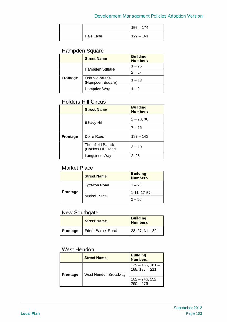
Development Management Policies Adoption Version
Local Plan
September 2012
Page 103
156 – 174
Hale Lane 129 – 161
Hampden Square Street Name
Building Numbers
1 – 25 Hampden Square
2 – 24
Onslow Parade (Hampden Square)
1 – 18 Frontage
Hampden Way 1 – 9
Holders Hill Circus Street Name
Building Numbers
2 – 20, 36 Bittacy Hill
7 – 15
Dollis Road 137 – 143
Thornfield Parade (Holders Hill Road
3 – 10
Frontage
Langstone Way 2, 28
Market Place
Street Name Building Numbers
Lyttelton Road 1 – 23
1-11, 17-57 Frontage Market Place
2 – 56
New Southgate
Street Name Building Numbers
Frontage Friern Barnet Road 23, 27, 31 – 39
West Hendon
Street Name Building Numbers
129 – 155, 161 – 165, 177 – 211 Frontage West Hendon Broadway 162 – 246, 252 260 – 276

Development Management Policies Adoption Version
Local Plan
September 2012
Page 104
Appendix 7: Locally Significant Industrial Sites, Industrial Business Parks and Business Locations Maps
Name of employment site Local Designation Size (ha)5 Map Number
Garrick Industrial Centre & Connaught Business Centre
Locally Significant Industrial Sites 2.3 0.5
1
Squire’s Lane & Regents Park Road employment cluster
Business Locations 0.5 0.7
2
Bunns Lane, Mill Hill Industrial Estate & Granard Business Centre
Locally Significant Industrial Sites 0.5 0.4 0.2
3
Brunswick Business Park Locally Significant Industrial Sites 1.8 4
Finchley Industrial Estate Locally Significant Industrial Sites 0.6 5
Grenville Place Locally Significant Industrial Sites 1.8 6
Hadley Manor Trading Estate Locally Significant Industrial Sites 0.4 7Lancaster Road Industrial Estate & Redrose Trading Centre
Locally Significant Industrial Sites 0.7 0.1
8
North London Business Park Industrial Business Park 2.6 9
Queens Road Industrial Estate Locally Significant Industrial Sites 0.4 10
Oakleigh Road South Locally Significant Industrial Sites 1.7 11
5 Size is the net employment land area in hectares which is an estimate of the area taken up by the buildings based on GIS calculations and visual site survey
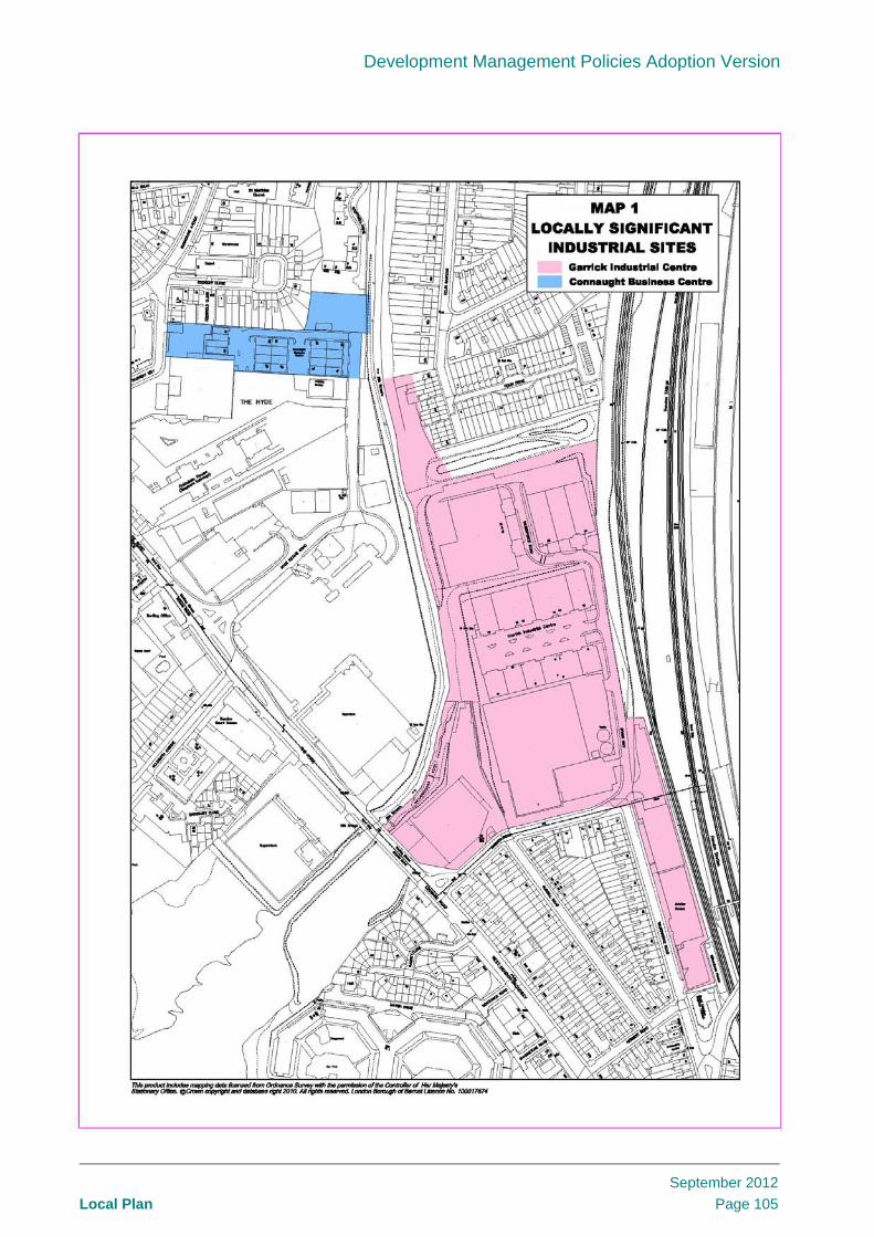
Development Management Policies Adoption Version
Local Plan
September 2012
Page 105

Development Management Policies Adoption Version
Local Plan
September 2012
Page 106

Development Management Policies Adoption Version
Local Plan
September 2012
Page 107

Development Management Policies Adoption Version
Local Plan
September 2012
Page 108

Development Management Policies Adoption Version
Local Plan
September 2012
Page 109

Development Management Policies Adoption Version
Local Plan
September 2012
Page 110

Development Management Policies Adoption Version
Local Plan
September 2012
Page 111

Development Management Policies Adoption Version
Local Plan
September 2012
Page 112

Development Management Policies Adoption Version
Local Plan
September 2012
Page 113
Map 9.

Development Management Policies Adoption Version
Local Plan
September 2012
Page 114

Development Management Policies Adoption Version
Local Plan
September 2012
Page 115
