celebrating 50 years of the geological society of jamaica ... · grenville draper. robert t. hill...
TRANSCRIPT

50 YEARS
Celebrating 50 years of the Geological Society of Jamaica – A distinguished past … critical for future development 1st to 4th of December 2005 Mona Visitor’s Lodge, University of the West Indies, Mona, Kingston, Jamaica Technical Sessions – 1st to 2nd December Field Trips – 3rd to 4th December Programme, abstracts and field guides Editor: Simon F. Mitchell, Geological Society of Jamaica, c/o Department of Geography and Geology, University of the West Indies, Mona, Kingston 7, Jamaica ISBN: 976-8038-05-5

The Geological Society of Jamaica - 50th Anniversary Conference
i
PROGRAMME
Wednesday November 30th 2005 5:30 p.m. Icebreaker and registration – Mona Visitor’s Lodge.
Thursday, December 1st 2005 7:30 – 8:30 a.m. Registration for conference and field trips. 8:30 – 9:00 a.m. OPENING CEREMONY (Welcome, Greetings)
SESSION A: ENVIRONMENTAL GEOLOGY (Chair: Franklyn McDonald) 9:00 – 9:20 a.m. A1. Debbie-Ann Gordon-Smith, Francine Taylor-Campbell, Kayan
Campbell and Anthony Greenaway. Nutrient Fluxes to Sections of Jamaica’s Coastal Zone.
9:20 – 9:40 a.m. A2. Lorraine Richards. The Environmental Impact of Gold Mining on the Main Ridge Prospect.
9:40 – 10:00 a.m. A3. Shanti Persaud and Parris Lyew-Ayee. Impact of the Bauxite Mining Industry on the Geology and Environment of Jamaica.
10:00 – 10:20 a.m. A4. M. Davies and S. Benyon. Post Mine Development Opportunities.
10:20 – 10:40 a.m. A5. Mitko Vutchkov and Gerald Lalor. Applications of the Nuclear Methods in Medical Geology.
10:40 – 11:00 a.m. COFFEE BREAK
SESSION B: HYDROGEOLOGY AND SEDIMENTOLOGY (Chair: Andrew Irvine) 11:00 – 11:20 a.m. B1. Basil P. Fernandez. Water resources of Jamaica – an overview
2005. 11:20 – 11:40 a.m. B2. Nahgeib Carl Miller. Economic Sediment Provenance,
Generation and Deposition of Fluvial Sediments in the Rio Minho, Clarendon, Jamaica.
11:40 – 12:00 a.m. B3. Christopher J. Schenk and Jean N. Weaver. Diagenesis of Eocene Turbidite Sandstones from the Scotland District, Barbados.
12:00 – 12:20 p.m. B4. Gavin C. Gunter. Oil and Gas Exploration in Jamaica. 12:20 – 12:40 p.m. B5. Ryan Ramsook and Simon F. Mitchell. Ichnology and
Sedimentology of a Deep-Water Paleocene Rift Basin, Eastern Jamaica.
12:40 – 1:00 p.m. B6. Trevor A. Jackson, R.K Pickerill, Stephen K. Donovan and P.W.Scott. The Volcaniclastic Turbidites of the Grand Bay Formation, Carriacou, Grenadines, Lesser Antilles.
1:00 – 1:20 p.m. B7. Shakira A. Khan and Simon F. Mitchell. Coastal erosion: the impact of storms on sandy beach systems.
1:20 – 2:40 p.m. LUNCH. History of the Geological Society of Jamaica Slide Show
SESSION C: GEOHERITAGE, INDUSTRIAL MINERALS AND ECONOMIC GEOLOGY (Chair: Arthur Geddes)
2:40 – 3:00 p.m. C1. Anthony R. D. Porter. Fort Augusta, Jamaica: Its Educational and Tourism Potential

The Geological Society of Jamaica - 50th Anniversary Conference
ii
3:00 – 3:20 p.m. C2. Grenville Draper. Robert T. Hill – Father of Texas Geology, Older Brother of Jamaican Geology
3:20 – 3:40 p.m. C3. Parris Lyew-Ayee Jr and Parris A. Lyew-Ayee. Digital Innovations in the Jamaican Bauxite Industry: Improvements in Exploration, Mining and Reclamation using Geographic Information Systems.
3:40 – 4:00 p.m. C4. Lawrence Henry. An Overview of Industrial Minerals in Jamaica.
4:00 – 4:20 p.m. COFFEE BREAK
4:20 – 4:40 p.m. C5. Craig Foreman. Skid Resistant Aggregate: Alternate Aggregates for Construction.
4:40 – 5:00 p.m. C6. Suresh Bhalai. Precious and Base Metal Potential of Jamaica. 5:00 – 5:20 p.m. C7. Ennika James. Industrial Uses for Jamaican Limestones. 5:20 – 5:40 p.m. C8. Coy Roache. The New Quarry Policy and Legislative
Amendments to realize better management of the Mining and Quarrying Sector.
5:40 – 6:00 p.m. C9. N. Mckenzie. Geochemical interpretation of Jamaican rocks displaying pozzolanic properties to be used in the manufacture of cement
Friday December 2nd 2005
PLENARY TALK 8:00 – 8:40 a.m. Grenville Draper. Tectonic evolution of the northern Caribbean
SESSION D: GEOCHEMISTRY AND GEOPHYSICS (Chair: Trevor Jackson) 8:40 – 9:00 a.m. D1. Robert G. Garrett, John Preston, Gerald C. Lalor and M. K.
Vutchkov. Variation in Geochemical Background Levels for Jamaican Soils.
9:00 – 9:20 a.m. D2. John Cleland, Wyatt Orsmond and Ken Evans. From Conception to Inception – A Site Investigation Journey.
9:20 - 9:40 a.m. D3. P. Allsworth-Jones, S. F. Mitchell, M. Vutchkov and Gerald C. Lalor. Analysis of pre-Columbian Jamaican ceramics.
9:40 - 10:00 a.m. D4. Robert G. Garrett, Anthony R. D. Porter, Patricia A. Hunt and Gerald C. Lalor. A Late-Miocene or Pliocene Geochemical Signature Preserved in Jamaican Soils.
10:00 - 10:20 a.m. D5. Shakia Sewell, Michael Coley and Anthony Greenaway. The impact of Goethite content and crystal morphology in Bauxites on Red Mud settling in the Bayer process.
10:20 - 10:40 a.m. D6. John F. Lewis, Michael R, Perfit, George Kamenov and Giuseppina Mattietti. Trace element and isotope geochemistry of the granitoid rocks of the Above Rocks and Terre Neuve (Haiti) plutons and the Nicaraguan Rise.
10:40 – 11:00 a.m. COFFEE BREAK

The Geological Society of Jamaica - 50th Anniversary Conference
iii
SESSION E: STRATIGRAPHY (Chair: Edward Robinson) 11:00 – 11:20 a.m. E1. Ennika James and Simon F. Mitchell. Microfacies Analysis of
the Wilmington Formation in Needham Town, St. Thomas, Jamaica. 11:20 – 11:40 a.m. E2. Ian C. Brown and Simon F. Mitchell. Stratigraphy and
Depositional History of the Sedimentary Succession in the Benbow Inlier, Jamaica.
11:40 – 12:00 a.m. E3. Sherene A. James and Simon F. Mitchell. Tectonostratigraphic Evolution of the Coastal Group of Eastern St. Thomas.
12:00 – 12:20 p.m. E4. Georgette Felicia D’Aguilar. The Larger Foraminiferal Genus Cushmania Silvestri in Eocene Rocks, Jamaica.
12:20 – 12:40 p.m. E5. Simon F. Mitchell. Geological Evolution of Jamaica. 12:40 – 1:00 p.m. E6. Thomas A. Stemann. Hopegate Formation Reefs and Uplift on
the North Coast of Jamaica.
1:00 - 2:10 p.m. LUNCH
SESSION F: NATURAL HAZARDS (Chair: Eleanor Jones) 2:10 – 2:30 p.m. F1. Lise Walter and Rafi Ahmad. Management of Urban Flooding
Hazards. 2:30 – 2:50 p.m. F2. Norman Harris. Landslide Hazard Mapping Process: A
Statistical Approach to Landslide Hazard Mapping for the Parish of St. Mary, Jamaica.
2:50 – 3:10 p.m. F3. Edward Robinson, Deborah-Ann C. Rowe and Shakira A. Khan. Geological Evidence for Palaeotsunami Events on the Coast of Jamaica.
3.10 – 3.30 p.m. F4. Barbara Carby and Christopher Gayle. Requirements for Future Success in Risk Management in Jamaica.
3.30 – 3.50 p.m. F5. Rafi Ahmad. Landslides and the making of Jamaica
3:50 – 4:00 p.m. COFFEE BREAK
SESSION G: TECTONICS AND SEISMOLOGY (Chair: Thomas Stemann) 4:00 – 4:20 p.m. G1. Margaret D. Wiggins-Grandison. Towards IBC Seismic Hazard
Maps for Jamaica. 4:20 – 4:40 p.m. G2. D. McNamara and J. Odum. Progress on a Nine Station Tsunami
and Earthquake Monitoring Network in the Caribbean. 4:40 – 5:00 p.m. G3. Pallov Pal and Grenville Draper. Micro-Boudinage in
Blueschists of Eastern Jamaica.
7.00. p.m. CONFERENCE BANQUET
Saturday December 3rd 2005 Fieldtrip 1: Geological evolution of eastern St. Thomas Fieldtrip 2: Urban Geology
Sunday December 4th 2005 Fieldtrip 3: Geo-heritage walking tour of Port Royal

The Geological Society of Jamaica - 50th Anniversary Conference
1
ABSTRACTS FOR ORAL PRESENTATIONS
SESSION A: ENVIRONMENTAL GEOLOGY
A1. Nutrient Fluxes to Sections of Jamaica’s Coastal Zone Debbie-Ann Gordon-Smith, Francine Taylor-Campbell, Kayan Campbell and Anthony Greenaway Department of Chemistry and Centre for Marine Sciences, University of the West Indies, Mona, Kingston 7, Jamaica
Nutrient fluxes to Jamaica’s coastal zone through three rivers (the Black River, St. Elizabeth; the Great River, St James-Hanover; and the Rio Bueno) and via groundwater (to Discovery Bay) were determined. The groundwater flow to Discovery Bay from the Dry Harbour limestone aquifer via submarine springs and seepage through sand and the nutrient concentrations in vent and seepage waters were measured over varying rainfall conditions. The total groundwater flow into Discovery Bay ranged from 13 to 67 × 103 m3 d-1. Submarine spring flow which accounted for about 70% of the total groundwater discharge during dry periods was not obviously affected by seasonal (rainfall-related) changes. After periods of heavy rainfall, the seepage rates increased ten-fold and accounted for about 80% of the total discharge. Subterranean mixing of freshwater and marine water resulted in brackish (salinity ≥ 11) spring and seepage water. Nitrogen and phosphorus concentrations in the bay correlated negatively with salinity. The groundwater concentrations of oxidised nitrogen and soluble reactive phosphorus, the major N and P species, were estimated from dilution curve data and ranged from 52 to 135 µM and 0.33 to 1.3 µM, respectively. These concentrations and fluxes will be compared with those for the three rivers which all have origins in the central limestone areas of the island but flow through lands used for diverse activities.
A2. The Environmental Impact of Gold Mining on the Main Ridge Prospect Lorraine Richards Mines and Geology Division, Ministry of Land and Environment, Hope Gardens, Kingston 6, Jamaica
The geology, mineralogy and geochemistry of a mineral deposit are important characteristics in locating, developing and extracting metals and minerals from an ore deposit. These characteristics also affect surrounding environments, because metals can be carried down stream from the deposit and into local ecosystems. The most common environmental concerns associated with metal mining operations are: • Physical disturbance to the landscape • Waste rock disposal • Development of metal bearing and acid soils and water, • Public safety Once a deposit is identified the mining process seeks to separate the mineral that contains metals from the others. Beneficiation is the next step in the mining process that includes milling or leaching, floatation and the creation of a waste product called tailings.
Gold extraction on the Main Ridge Prospect is via cyanide leaching, a process that uses dilute cyanide solutions to recover the gold. Cyanidation is the most commonly practiced method of gold extraction. Cyanide leaching facilitates the extraction of both large and small particles of gold and produces heavy metals, acids and highly toxic cyanide as waste. This method is economically feasible but has severe negative impacts on the environment. Tailing, generated by this process, contains such metals as Lead, Zinc, Copper and Cadmium and is stored in a tailings impoundment. The environmental impact of a tailing impoundment presents a great challenge especially in terms of erosion by wind and water and the control and the disposal of concentrated metals and other residual chemicals. Government regulatory controls and monthly water sampling helps to monitor and minimize potential environmental impacts.

The Geological Society of Jamaica - 50th Anniversary Conference
2
A3. Impact of the Bauxite Mining Industry on the Geology and Environment of Jamaica Shanti Persaud and Parris Lyew-Ayee Jamaica Bauxite Institute, Hope Gardens Complex, P.O. Box 355, Kingston 6, Jamaica
The mining of bauxite and the processing to alumina have two important large scale physical impacts – excavation of ore, creating ‘mined out pits’ and the need for the storage of the red mud waste. With the reserves typically found in karst limestone and the waste residue areas historically sited on the mined out topography, the physical changes on landscape are pronounced. The total surface area affected in the national context includes the hinterland and key watersheds. The impacts are discussed in the context of the social and environmental implications. The change in geomorphology lends the countryside to new settlements (with access facilitated by haul roads), agricultural projects and installation of native forest (?); whilst the residue areas are a potential source of groundwater contamination and create a new substrate surface. These altered land uses affect long-term planning on a more strategic level.
A4. Post Mine Development Opportunities M. Davies and S. Benyon Rinker Materials of Florida Inc., West Palm Beach, Florida, USA
Rinker Materials of Florida, Inc. (Rinker) is the largest building materials supplier in Florida and one of the largest in the U.S., producing approximately 95 million tons of aggregate nationwide and 43 million tons in Florida in 2004. Aggregate deposits in Florida are shallow sedimentary deposits, with typical thicknesses less than 70'; thus many acres are consumed to produce the required volumes of material. As properties are mined out, there is an opportunity to develop the property into a second use, especially in rapidly growing markets such as Florida. Uses may vary from commercial, residential, industrial, and recreational, or a combination of these. Rinker in the past ten years has taken on the challenge of post-mine development, and a few of our success stories will be shared. Also discussed will be the typical permitting process required to bring a site to post-mine use.
A5. Applications of the Nuclear Methods in Medical Geology Mitko Vutchkov and Gerald Lalor International Centre for Environmental and Nuclear Sciences, University of the West Indies, Mona, Kingston 7, Jamaica
“Whoever wishes to investigate medicine properly, … must also consider the qualities of the waters, for as they differ from one another in taste and weight…”. This quotation from the works of the Greek physician Hippocrates (460 - 377 BC) shows that the belief that health and “place” are causally related has an ancient origin. Medical Geology is an interdisciplinary science dealing with the relationship between natural environmental factors and ecosystem health. Understanding the role of rocks, soils, food, air and water in controlling the health of humans and animals requires the collaboration of medical professionals with geologists, chemists, veterinarians, biologists, GIS and other specialists.
Objectives: To study the effects of geology and the environment on human health using nuclear analytical methods.
Methods: Nuclear analytical techniques such as Neutron Activation Analysis (NAA) using Slowpoke-2 nuclear reactor and X-ray Fluorescence (XRF) spectroscopy can perform direct multi-element analysis of geological, biological and clinical materials without chemical treatment and destruction of the samples. These techniques have been extensively used in Jamaica for analysis of various environmental and health-related materials. The basic principles of NAA and XRF techniques are presented in the book chapter “Inorganic and Organic Geochemistry Techniques”, M. Vutchkov, G. Lalor and S. Macko, In: Essentials of Medical Geology: Impacts of the Natural Environment on Public Health, Ed. Olle Selinus, Academic Press, February 2005.
Results: Soil, food crops, animal and human tissues samples and fluids were collected from

The Geological Society of Jamaica - 50th Anniversary Conference
3
various locations in Jamaica using GPS and analyzed using NAA and XRF. The results obtained were used to develop geochemical maps of soils and health hazards associated with heavy metal exposure such as lead and cadmium.
Conclusion: Nuclear analytical techniques can be successfully applied to the understanding of environmental biogeochemistry and health.
SESSION B: HYDROGEOLOGY AND SEDIMENTOLOGY
B1. Water resources of Jamaica – an overview 2005 Basil P. Fernandez Managing Director, Water Resources Authority, Hope Gardens P.O Box 91, Kingston 7, Jamaica
Water is an important and critical natural resource in Jamaica. It supports all commercial activities, including irrigated farming, recreation and tourism, manufacturing and mining. Water is critical to life and is needed by every household for all domestic purposes, and to ensure health and sanitation. This multifaceted nature of the relationship between water and Jamaica’s economy and environment indicates that water drives development.
The estimates of ground and surface water for each of the 10 hydrologic basins and 26 watershed Management Units (WMUs) indicates a reliable surface water yield of 1,490 MCM/yr. and a safe groundwater yield of 3,725 MCM/yr – a total of 5,215 MCM/yr. The projected water demands up to 2025 indicate a total of 1,637 MCM/yr with agriculture being the major user, followed by the environment and domestic uses. Water use restrictions have occurred in several areas of the island resulting from the contamination of ground and surface waters resources. This contamination can reduce the availability of water resources and if it continues unabated could significantly affect the islands ability to meet its water demands and stymie development. Water management plans need to be implemented to ensure sufficient and high quality water resources and should include a transparent and equitable allocation framework. The upgrade of the Water Resources Master Plan now underway will address these and other issues to ensure sustainable water resources for the foreseeable future.
B2. Economic Sediment Provenance, Generation and Deposition of Fluvial Sediments in the Rio Minho, Clarendon, Jamaica Nahgeib Carl Miller Department of Geography and Geology, University of the West Indies, Mona, Kingston, Jamaica and Mines and Geology Division, Ministry of Land and Environment, Hope Gardens, Kingston 6, Jamaica
This study forms part of the sediment resource assessment of the Rio Minho and Yallahs River, which was dubbed the SEBRA Project. Samples of the deposited sediment along the Rio Minho were collected to analyse their grain-size distribution through dry sieving, their grain-type distribution and grain provenance through grain counting under transmitted light microscopy. It was determined that the economic sediments are dominated by minerals and lithics derived primarily from the Arthurs Seat Formation and the Summerfield Group. These formations crop out in sections of the Central Inlier (Clarendon, Jamaica) exhibiting high landslide susceptibility. Stream flow data for the Rio Minho was collected and analysed along with grain size distribution data using a bed-load transport model. This analysis indicates that the Rio Minho is capable of transporting 11.44 million metric tones of economic bed-load sediments during an extreme river flow event and 1.49 million metric tones during a small flow event.

The Geological Society of Jamaica - 50th Anniversary Conference
4
B3. Diagenesis of Eocene Turbidite Sandstones from the Scotland District, Barbados Christopher J. Schenk and Jean N. Weaver United States Geological Survey, MS 939, Box 25046, Denver, Colorado 80225, USA
Oil and gas are produced from shallow (<6000 feet) Eocene sandstone reservoirs in Woodbourne Field, south-central Barbados, which is situated on the crest of the Barbados accretionary prism. The Eocene sandstones are interpreted as turbidite fans and trench sediments deposited northward from the South American craton into the proto-Caribbean ocean by the ancestral Orinoco fluvial system. Relative eastward motion of the Caribbean Plate since the Eocene has thrust the turbidite sediments into a series of fault-bounded packages to progressively build the accretionary prism. The sandstones crop out at the crest of the prism in the Scotland District of Barbados. Sandstones were sampled to determine if reservoir quality is possible at depth. The Eocene sandstones are quartz arenites, sublithic arenites, subfeldspathic arenites, and quartz wackes. Sorting of the detrital grains ranges from moderately to poorly sorted, and grains range from subrounded to subangular. Porosity in thin section ranges up to 24 percent. Early phases of diagenesis include the formation of quartz overgrowths, poikilitic carbonate and sulphate cements, and partial replacement of framework grains by carbonate cement. Calcite cement occluded much of the primary sandstone porosity. Subsequent dissolution of calcite cement resulted in secondary porosity, but much of this porosity in this sample set may be an artefact of outcrop weathering. Fe-bearing carbonate cements are limited in distribution, and occur as thin, rusty orange cemented zones and as concretions. Partial compaction of detrital mudstone, fine-grained carbonate, and glauconite grains created pseudomatix, but compaction has only had a moderate effect on porosity loss possibly because of early cementation and overpressures. Partial dissolution of chert and feldspar framework grains is common, also creating a component of secondary porosity. The potential for significant porosity exists in the deep subsurface if cements and unstable framework grains are removed by dissolution.
B4. Oil and Gas Exploration in Jamaica Gavin C. Gunter Petroleum Corporation of Jamaica, 36 Trafalgar Road, Kingston 10, Jamaica
Exploration for oil and gas has taken place in two previous phases: a first phase (1955-73) involving solely private industry and the second involving (1974-82), primarily, the Petroleum Corporation of Jamaica. Eleven exploration wells have been drilled in Jamaica to date; nine onshore and two offshore. All except one of these wells have had shows of either oil or gas, however, no commercially viable quantities have been found. Jamaica is set to embark on another exploration round following an approximate 20-year respite. Advances in the understanding of the geology of the island coupled with tremendous improvements in exploration technology have resulted in renewed interest in the petroleum prospectivity of the island. Recent high oil prices also encourage risk-taking by exploration companies in frontier provinces, such as Jamaica, where there are no proven hydrocarbon reserves. This paper provides an overview of the petroleum setting of the island and some of the exploration tools that are likely to be employed in the Jamaican setting.
B5. Ichnology and Sedimentology of a Deep-Water Paleocene Rift Basin, Eastern Jamaica Ryan Ramsook and Simon F. Mitchell Department of Geography and Geology, University of the West Indies, Mona, Kingston 7 Jamaica. Email: [email protected]
The Paleocene siliciclastic turbidites of the Moore Town Formation, Blue Mountain Inlier, eastern Jamaica, host a diverse trace-fossil association. The depositional setting appears to have been a tectonically isolated, rifted basin into which turbidity currents deposited a variety of sediments. The Moore Town Formation comprises four sedimentary facies, three of which are characterized by diverse ichnofacies (from base to top): Facies I (alternating thinly bedded lignitic shales, siltstones and mudstones), Palaeodictyon-Amitoidea-Chondrites-Planolites-Cosmorhaphe; Facies II (alternating thinly bedded bioturbated siltstones,

The Geological Society of Jamaica - 50th Anniversary Conference
5
shales and fine grained sandstones with PCL), Helminthopsis-Cosmorhaphe-Spirorhaphe-Helminthorhaphe-Planolites-Thalassinoides-Taphrhelminthopsis; Facies III (poorly sorted, clast and matrix supported conglomerates); Facies IV (massive, thick calcareous, organic-rich, medium-grained sandstones and coarse-grained concretionary sandstones), Scolicia-Palaeophycus-Thalassinoides.
The trace-fossil associations are dominated by the Nerites Ichnofacies in the lower part of the formation (Facies I) and Cruziana Ichnofacies in the upper part (Facies II and IV), showing organism behaviours changing from suspension to deposit feeders. The three distinctive lithofacies and ichnofacies associations recognized and the stratigraphic disposition reflects a general shallowing upwards palaeoecological relationship; abyssal marine to mid/distal continental shelf to near-shore shelf, based on modern analogues of ocean slope and shelf zones. Further ichnological studies of the Moore Town Formation indicate that the benthic palaeocommunity was dominated by annelids or similar worm-like animals living predominantly within the sediments.
B6. The Volcaniclastic Turbidites of the Grand Bay Formation, Carriacou, Grenadines, Lesser Antilles Trevor A. Jackson1, R.K Pickerill2, Stephen K. Donovan3 and P.W.Scott4 1Department of Geography and Geology, University of the West Indies, Mona, Kingston 7, Jamaica 2Department of Geology, University of New Brunswick,Fredericton, New Brunswick, Canada E3B 5A3 3Department of Geology, Nationaal Natuurhistorisch Museum,Postbus 9517, NL-2300 RA Leiden, The Netherlands 4Camborne School of Mines, University of Exeter, Tremough, Cornwall,, England
The Middle Miocene Grand Bay Formation crops out on the eastern half of the island of Carriacou, Grenada Grenadines. The formation was deposited in water depths of between 150 to 200 m and is composed essentially of a sequence of bioclastic and volcanogenic turbidites. The dominant rock type in the Grand Bay Formation is fine-to coarse-grained sandstones in which the volcaniclastic sandstones are poorly sorted and immature, and contain volcanic clasts, clinopyroxene, amphibole, plagioclase feldspar and opaque crystals in an argillaceous matrix. Within the Grand Bay Formation are beds of accretionary lapilli representing air fall deposits that contain a mineralogy that is similar to the heavy minerals in the turbidites. It is postulated that the volcanogeneic turbidites in the Grand Bay Formation formed as a consequence of volcanic arc eruptions during the Middle Miocene. The mineral assemblage of the accretionary lapilli suggests that these eruptions were basaltic andesite or andesite in composition.
B7. Coastal erosion: the impact of storms on sandy beach systems Shakira A. Khan and Simon F. Mitchell Department of Geography and Geology, University of the West Indies, Mona, Kingston 7, Jamaica
Beaches play an important role in the economy of small island sates like Jamaica. As a tropical island we are all too familiar with the damage caused by the passage of hurricanes and tropical storms to lives and infrastructure. But what impacts do these storms have on beach systems and do they recover? Beach systems play a very important role since they act as buffers protecting landward infrastructure and development from the threat posed by rising sea levels and large waves generated at sea. A better understanding of the natural behaviour of beach systems is achieved through long term monitoring which provides a better understanding of the reaction of these systems to storms. A study of two beaches (the University Beach and Rocky Point Beach) in St. Thomas was initiated following Hurricane Ivan. The University Beach is a recreational beach and modified for recreational purposes. Rocky Point beach is a natural beach on an uninhabited stretch of coastline backed by swamps. Both beaches show significant responses to storm systems, but more particularly from large waves. Depending on wave direction these waves may either add sand to the beach system or cause extensive removal of sand. Where high-energy waves erode a beach profile, a ‘high-energy beach’ profile (steep beach face, coarse-grained sands/pebbles) is produced. Where sand is added, progradation of the beach occurs. Erosion and progradation may occur on either side of a promontory if the direction of approaching waves is right. Subsequent fair weather conditions result in the development of a ‘fair-weather’ (gentle beach face, fine grained sands) beach profile.

The Geological Society of Jamaica - 50th Anniversary Conference
6
SESSION C: GEOHERITAGE, INDUSTRIAL MINERALS AND ECONOMIC GEOLOGY
C1. Fort Augusta, Jamaica: Its Educational and Tourism Potential Anthony R. D. Porter Former Chief Geologist, Alcan Jamaica Co., 10 Orange Ave., Mandeville, Jamaica
Throughout history, military defences have been constructed at strategic locations along coastlines to guard important seaports, cities, towns, trade centres, and islands against invasion and naval attack. In 1655, the British on arrival in Jamaica met little resistance and easily captured the island from the Spanish. They quickly set about erecting a fortification at the entrance to the harbour, called Cagway Point, and later renamed Port Royal. For the further protection of the island, a suggestion was made in 1702 that a floating battery might be more suitable than a fortification at the end of a sandy spit, known as Mosquito-Point, not far from Passage Fort, where the British had landed in 1655. The need for a battery of guns at this location was again raised in 1738 by the island’s governing bodies. Construction, however, of the present fort at Mosquito-Point did not commence until 1753 and it took many years to complete. In 1756, this military fortification was renamed Fort Augusta. It is approximately 1200 feet long, about 600 feet across at the widest point, and covers at least 12 acres (5 hectares). More than 300,000 English bricks, 10,000 tons of cut white limestone from Port Henderson Hill (formerly called Salt-Pond-Hill), 24 tons of Bath stone, sand, lime, and other materials were used in its construction. The fort was designed and constructed to house ninety 24-pounder guns, and to support this substantial structure, palmetto and pigeon wood piles were driven 12 to 18 feet into the ground. On September 14th, 1763, a section of the fort and the officer’s barracks were destroyed when lightning struck a large powder magazine, and further damage was inflicted by a devastating hurricane on July 30, 1784. In the early nineteenth century there was a mutiny, but the fort remained a military installation until the early twentieth century. In the 1950s, Fort Augusta was repaired, and has been used ever since as a prison initially for male inmates, and then later as a correctional centre for women. Permission is required in order to gain entry. Fort Augusta is the most formidable place of arms ever constructed in Jamaica, but it is danger of being lost to future generations if remedial repairs are not undertaken in the very near future. Given its interesting history, fascinating military architecture including a ravelin, bastions, embrasures, crenels and merlons, imported building stones such as the oolitic-textured Bath limestone, and coastal location, this structure should be preserved and maintained for educational and tourism purposes. The various building stones and other features described in this paper were recorded on visits made by the author in 2003 and early 2004.
C2. Robert T. Hill – Father of Texas Geology, Older Brother of Jamaican Geology Grenville Draper Department of Earth Sciences, Florida International University, Miami, FL 33199, USA.. Email: [email protected]
Despite the importance of Robert T. Hills monograph “Geology and physical geography of Jamaica: study of a type of Antillean development”, not much is known about him in Jamaica. The Jamaican work was just one interlude in a long and prolific career. Hill is much more widely known for his work in Texas and is justifiably celebrated as the “father of Texas geology”. Hill was born in Nashville, Tennessee in 1859, and was orphaned at an early age. Later at age 16, he moved to Camanche, Texas, and worked in a variety of jobs including newspaper printing, survey work and as a cowboy, but also discovered his passion for geology. In 1882, he left Texas and worked his way through Cornell University. Hill was a model student and his abilities came to the notice of John Wesley Powell who offered him a job on the US Geological Survey. In the following years Hill worked for the USGS, the Texas Geological Survey and the University of Texas, and then went back to the USGS. In the waning years of the 19th century, he was seconded to work for Louis Agassiz at Harvard and conducted studies in Cuba and Panama as well as Jamaica (1897). In 1902, Hill resigned from the USGS for the last time and entered the private sector. In the Texas

The Geological Society of Jamaica - 50th Anniversary Conference
7
oil boom of the early 20th century, Hill’s knowledge and skills were highly sought after. After personal and health problems, he moved to southern California as a researcher and professor during the 1920’s. In 1931, he returned to Texas and supported himself as a feature writer for the Dallas Morning News, He remained at the paper until his death in 1941.
C3. Digital Innovations in the Jamaican Bauxite Industry: Improvements in Exploration, Mining and Reclamation using Geographic Information Systems Parris Lyew-Ayee Jr1 and Parris A. Lyew-Ayee2 1Mona Informatix Ltd, University of the West Indies, Mona, Kingston 7, Jamaica 2Jamaica Bauxite Institute, Hope Gardens, Kingston 6, Jamaica
The bauxite and alumina industry continues to be one of the principal foreign exchange earners for Jamaica, and maintains major ranking in the global aluminium market. The bauxite industry since the early 1950s has relied on the geological and technological base of the period for its development. This paper will unfold the use of GIS techniques and approaches underway, or being developed.
Geographic Information Systems (GIS) have been used globally by many different industries, government agencies, academic institutions and individuals for a myriad of applications ranging from environmental analyses to crime mapping and planning. Mining industries have also used GIS extensively in their exploration and modelling the amount and quality of their reserves. Locally, the Jamaican bauxite industry actively uses GIS in their land management and reserves exploration, using Global Positioning Satellites (GPS) and satellite imagery to identify mining areas, and assessing environmental impacts to adjoining settlements and reclamation issues. With advances in technology, much more information can be gleaned from existing data, and improvements can be carried out to increase the accuracy of models and efficiency of mining.
C4. An Overview of Industrial Minerals in Jamaica Lawrence Henry Mines and Geology Division, Ministry of Land and Environment, Hope Gardens, Kingston 6, Jamaica
Research into the Industrial Mineral resources particularly within the last 15 years has revealed that there are substantial deposits of high quality Industrial Minerals in Jamaica. This research has focused primarily on three areas with specific attention paid to the potential for value added products from industrial minerals, which if exploited can garner not only significant technological innovation for Jamaica’s mineral extraction industry but also significant revenue far in excess of what is commonly known.
Specifically, research has focused on industrial minerals such as whiting as a value added limestone for chemical and industrial purposes, high quality dolomitic limestone and dolomites for use in the chemical and metallic flux industries and skid resistant aggregates which are high quality aggregates for use in road construction. There is significant demand world wide for such high quality industrial minerals and the research at the Mines and Geology Division is geared towards providing potential investors with the requisite geological information to exploit international markets.
C5. Skid Resistant Aggregate: Alternate Aggregates for Construction Craig Foreman Mines and Geology Division, Ministry of Land and Environment, Hope Gardens, Kingston 6, Jamaica
The increasing demand for high quality construction aggregate to supply the needs of the various infrastructural development projects taking place in Jamaica and the Caribbean has necessitated the need for the identification of available high quality industrial mineral deposits for use as Skid Resistant Aggregates. This was even made more apparent with the importation of Skid Resistant Aggregates (Granite) from Nova Scotia for the resurfacing of the Norman Manley International Airport in the early 1990’s.
Initial research by the Industrial Minerals Unit of the Mines and Geology Division has identified thus far four deposits totalling over 1.5 billion tonnes located at various parts of the island that exceed geo-
The Geological Society of Jamaica - 50th Anniversary Conference
8
technical international standards for skid resistant aggregates. This presentation will look at not only the applicability, but also potential export markets for which Jamaica is uniquely positioned for this type of high value construction aggregate.
C6. Precious and Base Metal Potential of Jamaica Suresh Bhalai Mines and Geology Division, Ministry of Land and Environment, Hope Gardens, Kingston 6, Jamaica
Jamaica is world renown as a major producer of bauxite, but its metallic mineral potential is poorly tapped. Stream sediment surveys undertaken in the 1980’s in the Cretaceous Inliers and Lower Eocene Clastics identified seventeen ‘Priority 1’ areas of anomalous gold and base metals, with the concentration being towards the eastern and central regions of the island. Earlier studies complemented by this geochemical survey assisted in defining metallogenetic models of these occurrences; epithermal and porphyry-type occurrences are the more commonly found. This regional geochemical study provides an opportunity for exploration interests to focus on specific targets thereby reducing possible financial and discovery risks associated with regional surveys. Additionally, the chances of developing a mine are greatly enhanced. Geochemical testing and exploratory drilling on one Priority 1 anomaly at Main Ridge, Clarendon, led to the birth of the Pennants Mine in March 2001. This mine taps a low-sulphidation epithermal system, such deposits are characteristically known for their high gold/silver ratio. The Bennett Zone, in particular, boasted 75,500 metric tonnes at 20.4 grams/tonne gold with 95% recovery using simple cyanidation.
C7. Industrial Uses for Jamaican Limestones Ennika James Mines and Geology Division, Ministry of Land and Environment, Hope Gardens, Kingston 6, Jamaica
Limestones of various lithologies account for over 80% of Jamaica’s surface geology. This means there is over a billion cubic tonnes of limestone available for economic development. Lithologies range from micritic to sucrosic dolostones of the Troy Formation to biomicrites of the Swanswick to brilliant white chalky limestone of the Walderston/Browns Town Formation. Depending on their industrial grade, these limestones are used in industries such as construction and road fill (most limestones), metallurgical and chemical (Troy), pharmaceutical, whiting (fillers) and paint (Swanswick and Walderston/Browns Town Formations), and as cement raw material (Chapelton, Montpelier Formations and Coastal Group).
Analyses done by the Mines and Geology Division, Jamaica, and GET Ltd., Czech Republic, has revealed that the Walderston/Browns Town Formation at Biddiford, Trelawney, compares favourably with material used for white cement production in the U.S.A., Yugoslavia and Egypt. It is extremely pure, over 99% CaCO3 and the brightness is of medium to high grade. Likewise, The Montpelier Formation of Stewart Bay and White Bay, Trelawny, is of high quality and the formation may be used in the production of baked dolomite for water purification and Vienna Lime.
C8. The New Quarry Policy and Legislative Amendments to realize better management of the Mining and Quarrying Sector. Coy Roache Mines and Geology Division, Ministry of Land and Environment, Hope Gardens, Kingston 6, Jamaica
Much of the efforts of the Mines and Geology Division over the last three decades have been directed to the reduction of illicit quarrying. Although there has been significant success in stemming this illicit activity, there is less success at having compliance by licensed operators.
The reasons for non-compliance were evaluated and the conclusion drawn was that training of quarry operators and their support personnel would go a far way in achieving compliance. A quarry policy was written and the Quarries Control Act is being revised to provide for Certified Managers, fines for non-compliance with the conditions of licences, increase in penalties for illicit quarrying, and new penalties for aiding and abetting illicit quarrying.
The Mining Regulations were amended to better manage the restoration of mined out lands. The

The Geological Society of Jamaica - 50th Anniversary Conference
9
fines for not restoring mined out lands were substantially increased and an additional penalty introduced if lands are not restored with three years of being mined.
The total effort is to get a more efficient and professionally run quarry industry.
C9. Geochemical interpretation of Jamaican rocks displaying pozzolanic properties to be used in the manufacture of cement N. Mckenzie Department of Geography and Geology, University of the West Indies, Mona, Kingston 7, Jamaica and Caribbean Cement Company LTD, Rockfort, Kingston, Jamaica
The effect of pozzolan replacement for clinker in the cement industry is well known and has developed over the years among major cement producers. The Caribbean Cement Company Ltd (CCCL) a subsidiary of Trinidad Cement Company (TCL) has being using pozzolanic material purchased from Martinique since 2002 as a replacement for clinker in their blended cement product.
This study looks at two alternative sources locally for pozzolanic material as a means to reduce cost and to optimise cement late days strength (28 days).
The high correlation (r value) between pozzolan from Martinique and local material (volcanic tuff and andesite) is noted for the geochemistry and mineralogy. It is expected that over similar geologic environments, such as volcanics, the concentrated values would be similar and within the range of pozzolanic material used in cement production.
Experimental data indicates that rocks of the study area show similarity in weight percentage of SiO2, FeO3 and Al2O3 and that the pozzolan reactivity index is similar to natural pozzolan. The material can be used as a percentage substitute for clinker in cement production.
The results show that rocks of both study areas, when used as a mineral admixture, show progressive increases in strength with increasing percentages of replacement, up to the 25% level.
PLENARY SESSION
A plateau plugs the continental breach: evolution of the Caribbean and the Greater Antilles Grenville Draper Department of Earth Sciences, Florida International University, Miami, FL 33199, U.S.A.
Any tectonic model for the Caribbean must meet the constraints of several phenomena. These include the timing of the opening of the Atlantic, Gulf of Mexico and the Caribbean, the motion of the Americas with respect to the mantle, the distribution and age of arc rocks and accompanying HP/LT subduction metamorphic rocks, the age and paleomagnetism of the Caribbean Plateau and the timing of formation of several minor ocean basins in the Gulf-Caribbean region, among others. Consideration of these factors leads to the conclusion that the present Caribbean plate is derived from the Pacific. Initially the inter-American gap was occupied by an oblique, east dipping subduction zone that produced the primitive, bimodal arc rocks common in the Greater Antilles (GA). A subduction polarity reversal event around Aptian time switches the subduction direction. The subduction of the Proto Caribbean in a west dipping Benioff zone formed most of the Greater Antilles and was active from late Albian to middle Eocene. This subduction carried the Caribbean Plateau from the Pacific into the Atlantic realm. The formation of Jamaica may have been a little different from the other GA islands, as its blueschists lie under, rather than to the northeast, of its late Cretaceous island arc rocks. The Jamaican blueschists may be the only surviving trench terrane of the early Cretaceous, east dipping subduction zone.

The Geological Society of Jamaica - 50th Anniversary Conference
10
SESSION D: GEOCHEMISTRY AND GEOPHYSICS
D1. Variation in Geochemical Background Levels for Jamaican Soils Robert G. Garrett1, 2, John Preston1, Gerald C. Lalor1 and M.K. Vutchkov1 1International Centre for Environmental and Nuclear Sciences (ICENS), University of the West Indies, Mona Campus, Kingston 7, Jamaica 2Emeritus Scientist, Geological Survey of Canada, 601 Booth St., Ottawa, Ontario K1A 0E8, Canada
The geochemistry of the <150 µm fraction of Jamaican surface soils is highly variable. Mapping reveals that variation exists that can be related to underlying soil parent material and pedological development. Recent studies of the 1988 ICENS island-wide soil geochemical survey data have shown that the Fe/Na ratio is a useful indicator of soil development. Low ratios (<40) occur in relatively juvenile non Terra Rossa soils overlying Cretaceous Inliers and Paleocene-Eocene clastic sediments. Intermediate levels (40-320) occur in Terra Rossa soils developed on Eocene and younger limestones; and the highest levels (>320) occur where bauxitic soils are present. The table below demonstrates that means of U, Sm, As, Zn and Cd for soils subdivided by Fe/Na ratio are statistically (ANOVA) significantly different from one another.
Geometric Means (ppm) Soil Samples Fe/Na Ratio U Sm As Zn Cd
Non Terra Rossa 50 <40 2.37a,1 3.01a 6.15a 120a 0.23a Terra Rossa 94 40 - 320 4.55b 9.73b 18.6b 191b,2 4.9b Bauxitic 21 >320 8.38c 18.6c 43.7c 251c,2 18.6c Note 1: Letters indicate that means are significantly different at the 95% confidence level Note 2: The means for Zn in Terra Rossa and Bauxitic soils are not significantly different from each other at the 95% confidence level
The Fe/Na framework permits the soil trace element data to be divided into three groups and geochemical background defined for each group, where background is defined as a range of geochemical variation rather than an average value. Methods to estimate background have recently been evaluated and a statistically robust method has been applied to the Jamaican data. Background ranges are important if monitoring or regulatory programs are to be established to protect the environment. Out-of-background range levels may identify: either areas of trace element deficiency for crops or livestock forage, or areas where high levels may indicate potential risks to environmental or human health if the trace elements are in bioavailable forms. The table below presents proposed background ranges for U, Sm, As, Zn and Cd.
Range of Background (ppm in <150 µm fraction surface soil) Soil U Sm As Zn Cd
Non Terra Rossa 1.5 to 3.4 0.1 to 6.9 1.4 to 15 57 to 226 <0.05 to 0.7 Terra Rossa 1.5 to 12 0.2 to 46 2 to 73 53 to 492 <0.05 to 51 Bauxitic 3.5 to 23 0.2 to 50 22 to 63 114 to 588 0.5 to 69
The presentation will provide details of the development of the Fe/Na ratio as a framework for Jamaican soil geochemistry and the methods used to estimate background range, and provide a description of the geological and pedological processes leading to the observed background variation.
D2. From Conception to Inception – A Site Investigation Journey John Cleland1, Wyatt Orsmond2 and Ken Evans3 1RPS Planning Transport and Environment, 45 Timberbush, Bernard Street, Leith, Edinburgh EH6 6QH Email: [email protected] 2RPS-MCOS, West Pier Business Campus, Dun Laoghair, County Dublin, Ireland.

The Geological Society of Jamaica - 50th Anniversary Conference
11
Email: [email protected] 3Alcan Aluminium UK Limited, Pechiney House, The Grove, Slough, Berkshire SL1 1QF, United Kingdom. Email: [email protected]
To provide an insight into the mechanism by which a site is investigated from the site investigation design stages through contractor selection to commencement of works on-site. The presentation will include a discussion on the typical aims of a site investigation from a physical and chemistry standpoint and will consider these issues in respect of potential physical, political, regulatory and industrial constraints. The presentation will conclude with a discussion of the use of site investigation data in detailed design and will highlight the importance of preparing a detailed brief and keeping focussed in order that the final results meet the requirements of the study being undertaken. Although specific case studies are not presented, a number of examples encountered internationally will be cited to emphasise points being made.
D3. Analysis of pre-Columbian Jamaican ceramics P. Allsworth-Jones1, S.F. Mitchell2, M. Vutchkov3 and Gerald C. Lalor3 1Department of History and Archaeology, University of the West Indies, Mona, Kingston 7, Jamaica 2Department of Geography and Geology, University of the West Indies, Mona, Kingston 7, Jamaica 3International Centre for Environmental and Nuclear Sciences, University of the West Indies, Mona, Kingston 7, Jamaica
A pilot study aimed at investigating the characteristics of Jamaican pre-Columbian pottery in the Kingston area was carried out and published in 2001. 12 pottery samples from 6 sites were analysed using neutron activation analysis. The conclusion reached was that there probably was a single clay source for these samples. An opportunity to carry out a similar study on a much larger scale came when Dr James Lee donated his collection of pre-Columbian artefacts to UWI. Pottery from 9 of these sites, together with one recently excavated, has been analysed using the XRF technique, a total of 90 samples in all. The sites were selected so as to provide a fair geographical spread, including both caves and open air sites, and it was also the intention that it should be representative of the different cultural variants recognised in the island. The results were subjected to univariate, bivariate and multivariate analyses in order to understand the relationships of the concentrations of the fourteen elements analysed between sites. Bivariate plots for Rb versus K, Rb versus Sr and Si versus Rb show two major trends: one with relatively depleted Rb concentrations and one with relatively elevated Rb concentrations. The results are interpreted as representing pottery made from clays deposited in river basins and have a strong signal relating to the underlying geology. Analyses of pot sherds fall into three groups: north coast (low strontium), south coast (high strontium) and Kingston (relatively high rubidium) and suggest local manufacture of pottery. In contrast, two water jar fragments do not plot with sherds from the same site, suggesting that these were transported around the island.
D4. A Late-Miocene or Pliocene Geochemical Signature Preserved in Jamaican Soils Robert G. Garrett1, 2, Anthony R. D. Porter3, Patricia A. Hunt4 and Gerald C. Lalor1 1International Centre for Environmental and Nuclear Sciences (ICENS), University of the West Indies, Mona Campus, Kingston 7, Jamaica 2Emeritus Scientist, Geological Survey of Canada, 601 Booth St., Ottawa, Ontario K1A 0E8, Canada 3Former Chief Geologist, Alcan Jamaica Co., 10 Orange Ave., Mandeville, Jamaica 4Geological Survey of Canada, 601 Booth St., Ottawa, Ontario K1A 0E8, Canada
The presence of high-Cd phosphorite in the Kendal-Porus graben as thin veneers on Newport limestone beneath bauxite deposits was first reported by Eyles (1958), and subsequently confirmed by Porter and Sabiston (1989). The Hope phosphorites of Porter and Sabiston and material collected in 2003 have been analysed and studied with scanning electron microscopy, confirming and extending the list of elements occurring at anomalous levels (mg/kg), in particular, Zn (8840), Cd (6040), Ag (44), Cu (197), Be (503), U (166) and Y (108). The presence of fish teeth and bones in the phosphorites indicates a fossil guano origin. Their exact age has not been established, it is clear the deposits were laid down post early Miocene, before bauxite deposition and subsequent block faulting that likely occurred during the Pliocene. Island-wide soil (<150 µm) geochemical mapping by ICENS in 1988, and 1997 parish-scale

The Geological Society of Jamaica - 50th Anniversary Conference
12
mapping in Manchester, revealed anomalous Cd levels, up to 409 and 931 mg/kg, respectively. Soils collected in 2002 at the anomalous site in the Mile Gully district contained up to 978 mg/kg Cd. In 2003 a proximal traverse of 13 soil samples revealed a trace element signature (mg/kg) of high Zn (435-1037), Cd (142-771), Ag (2-21), Cu (65-81), Be (7-26), U (30-65) and Y (230-343), indicative that phosphorite similar to that observed at Hope was likely present. Lithiophorite, (Al,Li)MnO2(OH)2, was identified in the soil as a host for Cd by SEM and EDS-XRF. The SEM studies also indicate that the soils had a complex evolutionary history with a minimum of five periods of aluminous-goethite deposition. Although original phosphorite deposits likely have been destroyed their geochemical signature could be locally preserved in the soil. In the context of the island-wide survey data, the Mile Gully area samples are elevated in Cd, Zn, P and U, and depressed in Ba and K. On this basis a weighted sum was computed for the island-wide survey data to identify areas where the phosphorite signature is present. High weighted sums occur in a crescent around the west end of the central Jamaica limestone karst plateau and near Newmarket to the southwest. We propose that the high weighted sums indicate areas of lagoonal or shallow water marine karst that provided pinnacles, similar to those observed at Hope, where marine fish-eating birds could roost and defecate. Some of these paleo-environments were preserved by block faulting, e.g., the Kendal-Porus graben that was later infilled with material derived from the central Jamaican plateau, including bauxites developed in that karst environment. The Isthmus of Panama did not close until ≈3.5 Ma, and this facilitated ocean transfer between the Atlantic and Pacific. Upwelling nutrient rich waters along continental margins and ocean rises not only foster marine productivity but contain elevated levels of trace elements that become biomagnified up the food chain until the avian level where they partition into the excreta. Thus, we suggest the Zn, Cd, Ag, Cu, Be, U and Y signature in soils identifies a proto-Jamaican late-Miocene or Pliocene marine karst palaeoenvironment.
D5. The impact of Goethite content and crystal morphology in Bauxites on Red Mud settling in the Bayer process Shakia Sewell, Michael Coley and Anthony Greenaway Department of Chemistry, University of the West Indies, Mona, Kingston 7, Jamaica
The content and crystallographic properties of Goethite (α-FeOOH), an important iron oxide component of bauxite, were found to impact negatively on the separation of red mud residues from saturated sodium aluminate liquors produced during the Bayer Process. In this paper, red mud settling rates are rationalized by comparing the Goethite to Hematite ratio (G/H ratio) in the bauxite, and the percentage aluminium substitution in the goethite lattice and its influence on goethite crystal size and shape.
The G/H ratios of bauxites were determined by X-ray diffraction techniques, and by evaluating total iron oxide by X-ray fluorescence and Goethite amounts by thermal gravimetric analysis. Overall both methods gave comparable results. Bauxite samples showed increased settling rates with decreasing relative concentrations of goethite. Crystal size, determined by X-ray diffraction for the 110 reflection, showed little variation with the change in the quantity of aluminium substituted into the goethite lattice. The observed trend indicates that samples with low quantities of aluminium in the lattice settled at acceptable rates. The combined data for goethite crystal size, shape and quantity show that the greater the available surface area and the lower the quantity of goethite in the bauxite, the faster is the red mud settling rate under otherwise constant settling conditions.
D6. Trace element and isotope geochemistry of the granitoid rocks of the Above Rocks and Terre Neuve (Haiti) plutons and the Nicaraguan Rise John F. Lewis, Michael R, Perfit, George Kamenov and Giuseppina Mattietti John F. Lewis, The George Washington University, Washington, District of Columbia, USA Michael R, Perfit, University of Florida, Gainesville, Florida, USA George Kamenov, University of Florida, Gainesville, Florida, USA Giuseppina Mattietti, George Mason University, Fairfax, Virginia, USA
Trace element analyses for 47 elements and Pb isotope compositions have been determined by high precision ICP-MS methods for representative samples of granitoid rocks from the Above Rocks pluton in Jamaica, the Terre Neuve pluton, Haiti and single samples from the Pedro Banks, Miskito#1 and Toro Cay

The Geological Society of Jamaica - 50th Anniversary Conference
13
drill cores on the Nicaraguan Rise. The Above Rocks and Terre Neuve plutons are the best examples of the Late Cretaceous high-K oceanic arc plutons in the western Greater Antilles. The rocks forming both the plutons (mainly granodiorite, quartz-monzodiorite, monzodiorite, and quartz monzonite) show similar relatively high concentrations of the large-ion lithophile (LIL) elements K, Rb, Ba, Th and LREEs, LREEs are enriched (La is ~100x chondrite) relative to HREEs on chondrite-normalized plots. Multi-element plots show high LIL/HFSE ratios similar to other high-K plutons such as the Utuado and San Lorenzo plutons from Puerto Rico. Both the Above Rocks and Terre Neuve plutons show high concentrations of Ba (761-1699 ppm) a characteristic feature of the high-K intrusives of the Greater Antilles. Sr concentrations are also high but the Ba/Sr ratios in the Above Rocks exceed those of most Greater Antillean unaltered granitoid rocks. In a plot of Rb/Sr vs. Rb the Above Rocks shows the highest values in the Greater Antilles and follows the trend of the Sierra Nevada batholith. Although the Above Rocks and Terre Neuve have the highest concentrations of Th in the Greater Antilles, the values are considerably lower than those of continental margin granitoids with similar high potassium such as the Sierra Nevada. This is consistent with the absence of continental crust beneath the Nicaraguan Rise except for the most western part. All of the granitoids including the drill core samples from the Nicaraguan Rise have Pb isotope ratios that fall along a narrow array from 206Pb/204Pb of 19.05 to 19.45 within the field of previously analysed Late Cretaceous granitoid and volcanic rocks. The Pb isotope ratios and low initial 87Sr/86Sr ratios for the Above Rocks and Terre Neuve plutons are indicative of a common mantle source for all the Late Cretaceous granitoid magmas along the Nicararguan Rise. The data are consistent with a subduction zone to the north below the Nicaraguan Rise.
SESSION E: STRATIGRAPHY
E1. Microfacies Analysis of the Wilmington Formation in Needham Town, St. Thomas, Jamaica Ennika James and Simon F. Mitchell Department of Geography and Geology, University of the West Indies, Mona, Kingston, Jamaica
The Wilmington Formation (White Limestone Group) of St. Thomas represents a shallow-marine sequence that is faulted against (and possibly overlain by) deep-water pelagic limestones (Moneague Formation). In order to better understand the succession, representative samples were taken from the Wilmington Formation in Wilmington, St. Thomas and thin sections for microfacies analysis prepared. The results from this analysis show a progradation from a high energy open marine environment to a deeper water environment dominated by planktic foraminifers. The Wilmington Formation has diverse lithologies with facies ranging from planktic-foraminiferal sparse biomicrite to poorly-sorted biomoicrites with diverse and abundant faunal assemblages including Amphigestina, Helicostegina and miliolids. Microfacies analysis of this thin sections provides a better understanding of the Tertiary succession south of the Blue Mountain Inlier.
E2. Stratigraphy and Depositional History of the Sedimentary Succession in the Benbow Inlier, Jamaica Ian C. Brown and Simon F. Mitchell Department of Geography and Geology, University of the West Indies, Mona, Kingston, Jamaica
The Cretaceous succession in the Benbow Inlier, Jamaica, comprises a thick succession of volcaniclastics, limestones, lavas and shales, with a minimum thickness of 9 kilometres. The limestones which occur throughout the succession contain diagnostic rudist faunas that indicate an age range from the Lower Barremian through to Albian. The succession can be divided into several distinct units that probably have a regional Caribbean significance. The lower part of the Devil’s Racecourse Formation contains Island Arc Tholeiites (IAT) overlain by volcaniclastic sandstones. The succeeding succession of limestones probably rests unconformably upon the lower IAT lavas and volcaniclastics as demonstrated by rapid thinning of the volcanics from east to west. Three limestones are present within the middle Devil’s Racecourse Formation: the Lower Barremian

The Geological Society of Jamaica - 50th Anniversary Conference
14
Jubilee (=Copper) Limestone with the rudist Retha tulae Felix, the Upper Barremian Benbow Limestone with the rudist Amphitriscoelus primavus Skelton and Pantoja Alor, and an unnamed limestone with undetermined (?Lower Aptian) rudists. Above the Benbow Limestone, Calc-alkaline pillow lavas and volcaniclastics are present. The Barremian-Lower Aptian succession is overlain (possibly unconformably) by an Early to Middle Albian succession, although the boundary between the two is poorly exposed and usually faulted. At least four limestones are developed, interbedded with conglomerates and shales. The lower three limestones contain a diverse Lower Albian rudist assemblage including Coalcomana ramosa Bohem, Caprinuloidea perfecta Palmer, Caprinuloidea multitubifera Palmer, Toucasia sp. and Eoradiolites sp. The upper limestone contains a more advanced Middle/Upper Albian assemblage with Texicaprina vivari Palmer and Tepeyacia multicostata Chubb. The higher succession in the inlier has not be determined in detail.
E3. Tectonostratigraphic Evolution of the Coastal Group of Eastern St. Thomas Sherene James and Simon F. Mitchell Department of Geography and Geology, University of the West Indies, Mona, Kingston, Jamaica
The late Miocene change from a transtensional to transpressional stress regime along the sinistral, strike-slip, northern-boundary of the Caribbean Plate north of Jamaica profoundly affected the sedimentary architecture of the White Limestone and Coastal Groups. The Miocene to Recent succession can be divided into fiver mixed clastic-carbonate sedimentary packages separated by angular unconformities, major hiatuses and/or dramatic facies changes. The Miocene Montpelier-Pelleu Island Formation is represented by deep water chalks It is succeeded by the August Town Formation consisting of a series of shallow-water carbonates, shelf sandstone s and fan-delta conglomerates. The succession records the rapid uplift of eastern Jamaica associated with NE-SW directed transpression. The Upper Pliocene Buff Bay-Bowden Formations are represented by deep-water planktic-foraminifer-bearing marlstones with interbedded sediment-gravity flows containing reworked igneous pebbles, cobbles and boulders. The succession shows rapid subsidence which we relate to the propagation of the Plantain Garden Fault that separated the rapidly uplifting Blue Mountains Block (supplying detritus from the now-eroding Cretaceous-Paleocene island arc rocks) from the subsiding southern St. Thomas Belt. The Early Pleistocene Old Pera Formation is represented by shelf sandstones with HCS, gutter casts and abundant hermatypic corals. We attribute this phase of uplift to the development of a fault to the south of Jamaica that now forms the island-shelf break. The Late Pleistocene Port Morant and Falmouth Formations consist of a fan-delta successions and reefal limestones, respectively. These rest unconformably on the older successions and indicate an important episode of tectonic deformation. We suggest that the stratigraphy of the Costal Group in St. Thomas records the successive accreted the Blue Mountains Block and Southern St. Thomas Belt onto the Gonvae Microplate as stresses propagated to the south-west.
E4. The Larger Foraminiferal Genus Cushmania Silvestri in Eocene Rocks, Jamaica Georgette Felicia D’Aguilar Mines and Geology Division, Ministry of Land and Environment, Hope Gardens, Kingston 6, Jamaica
This study investigates morphological variations among populations of the conical foraminifer Cushmania Silvestri from four Eocene localities of Jamaica, using samples from type localities of Haiti and St. Bartholomew as a reference. Variations are interpreted to determine the possible presence of distinct species and to observe any relations to biostratigraphic and environmental factors.
Cone parameters were measured and statistical methods applied. Biostratigraphic analysis involved plotting relative stratigraphic positions of samples against mean cone parameters. Palaeoecological analysis was conducted by noting the presence or absence of seventeen foraminiferal genera in 372 samples, including well core samples. Statistical analysis revealed two populations in the Haiti sample, Cushmania puilboreauensis (megalospheric), and a population broadly similar to Cushmania codon, Woodring, 1924. C. codon is proposed as a distinct species. The Saint Bartholomew population defined by C. americana, was proposed as distinct from the other populations studied. Variations were observed between the Beckford Kraal

The Geological Society of Jamaica - 50th Anniversary Conference
15
population and that of Chapelton and Rio Sambre. The variation for Beckford Kraal was mainly interpreted as resulting from the dominance of specimens assigned to the group C. codon. There is an apparent age difference for this locality when compared with the Jamaican localities that are dominated by megalospheric C. puilboreauensis. No controls of environmental factors were noted for variations of the Beckford Kraal population. However, the Saint Bartholomew population was proposed as occupying an environment distinct from those of all other localities except Rio Sambre. Three forms are therefore proposed for the Cushmania populations – C. americana, C. puilboreauensis (megalospheric specimens) and C. codon. C. codon is proposed as occupying a shallow carbonate shelf-slope environment, C. puilboreauensis both a carbonate shelf-slope environment and an open-marine carbonate slope environment, while C. americana is proposed as representing an open-marine carbonate slope environment, all being shallow water.
E5. Geological Evolution of Jamaica Simon F. Mitchell Department of Geography and Geology, University of the West Indies, Mona, Kingston, Jamaica
The compilation of new biostratigraphic, stratigraphic, structural and geochemical evidence has allowed the development of a modified model for the geological evolution of Jamaica. This data is presented elsewhere in this conference and eslsewhere (papers by Brown, Hastie, Ramsook and S. James). Jamaica began as three separate blocks (Rio Grande, Yallahs and Cornwall-Middlesex blocks) in the Cretaceous that have different Cretaceous geological histories. They were amalgamated during the late Maastrichtian to early Paleogene when the Great Arc of the Caribbean collided with the Yucatán Block. The Rio Grande Block underwent NE-SW extension in the early Paleogene with the formation of the John Crow Rift, and the Yallahs block underwent later NE-SW extension with continued island-arc and extension-related volcanism. By the mid Paleogene a new set of block (Blue Mountain, Clarendon and Hanover) and trough/basin (Wagwater, North Coast, Montpelier-Newmarket, Negril-Sav-le-Mar, Walton) systems developed due to transtensional stress regimes related to the relative eastwards motion of the Caribbean Plate. Renewed tectonism began in the mid-Miocene (with a prominent late-Pleistocene event) with the onset of transpressional stresses and resulted in the uplift of Jamaica, karstification, erosion and the deposition of the rocks of the Coastal Group.
E6. Hopegate Formation Reefs and Uplift on the North Coast of Jamaica Thomas A. Stemann Department of Geography and Geology, The University of the West Indies, Mona, Kingston 7 Jamaica. Email: [email protected]
The north coast of Jamaica is marked by a series of distinctive coastal terraces. Most of these terraces are composed largely of reefal carbonates and thus they appear similar to other ‘raised’ reefs found throughout the Caribbean. Extensive new exposures in St. Ann and Trelawny Parishes in north central Jamaica provide an excellent opportunity to examine the development of these terraces and their relationship to Quaternary uplift and sea level change.
The Hopegate Formation is a reefal carbonate exposed in all but the lowest terrace in north central Jamaica. The unit is at least in part late Pliocene in age and therefore spans a period of rapid turnover in Caribbean reef corals. Late Pliocene coral faunas include a mixture of modern and extinct forms. The modern species, such as Acropora palmata, can be used as depth and paleoecologic indicators, while the extinct forms such as Stylophora and Caulastraea can be biostratigraphically important. Large new collections from the Hopegate include 72 coral species, all but one of which has previously been recorded from the Plio-Pleistocene of the Caribbean. The distribution of coralline facies and of biostratigraphically useful species suggests that the Hopegate terraces are largely erosional and not ‘raised reefs’ in the typical sense. Examination of depth ranges for the modern species found in situ in the Hopegate Formation suggests a complex history with varying rates of uplift through the Neogene and Quaternary in this region.

The Geological Society of Jamaica - 50th Anniversary Conference
16
SESSION F: NATURAL HAZARDS
F1. Management of Urban Flooding Hazards Lise Walter and Rafi Ahmad Department of Geography and Geology, The University of the West Indies, Mona, Kingston 7, Jamaica
Flooding in the urban tropics is an inevitable problem. In this paper, we compare urban flooding hazards located in two contrasting geographic and socio-economic settings, Western Spanish Town, Jamaica, and “nala” drainage systems in the city of Lucknow, India, being located on a dissected alluvial fan and the flood plain of a large river system respectively. Following significant rainfall events, both sites suffer inundation. Flood magnitude is linked not only to the amount of precipitation, but also to changes executed on the ground to inhibit runoff. It appears that present flood management policy is largely a reactive response mechanism. Proactive response, to a large extent, relies on an annual drain cleaning campaign. This may, or not, work as effectiveness depends upon the location of drains, their capacity, and the material they carry. It is not difficult to imagine that in a majority of areas otherwise clean drains gets blocked with garbage, vegetation debris and sediments within minutes of the first onset of runoff. Flood management on alluvial fans located at the mouths of small and steep water courses, such as those existing in Jamaica, require an approach markedly different than those for large river valleys. We present a model for flood management in the Western Spanish Town area based on the integration of geological, geomorphologic and hydrological data. Some of the physical parameters that influence flooding processes are quantified.
F2. Landslide Hazard Mapping Process: A Statistical Approach to Landslide Hazard Mapping for the Parish of St. Mary, Jamaica Norman Harris Mines and Geology Division, Ministry of Land and Environment, Hope Gardens, Kingston 6, Jamaica
Landslide hazard mapping in Jamaica currently follows the global trend of using spatial variability in geographical information to analyze landslides to produce hazard zonation maps. The PC-based GIS models and techniques currently practiced by many countries satisfy the demand for more reliable and accurate landslide information on a regional scale for planning and decision making on engineering projects, in regional planning, and in disaster management. Landslide hazard maps are now being developed by the Mines and Geology Division at a scale of 1:50,000 that can provide the type of accuracy and aerial coverage to identify the level of landslide hazards for a particular area. The parish of St. Mary is known to be vulnerable to landslide occurrences, resulting in significant losses to houses, agriculture and road infrastructure. Landslide hazard mapping was conducted using the Bivariate Statistical Method to analyse landslide data and to obtain correlations between landslide inventory and spatial geographical data for the parish. Five landslide zones were identified using this method based on statistical correlation. This approach is useful for the preparation of medium-scale landslide hazard maps as these are favoured for planning and decision making. The development of a GIS-based landslide hazard map is in keeping with the increase in demand by the public for a safer environment where land is coming under intense pressure for different types of development.
F3. Geological Evidence for Palaeotsunami Events on the Coast of Jamaica Edward Robinson, Deborah-Ann C. Rowe and Shakira A. Khan Marine Geology Unit, Department of Geography & Geology, University of the West Indies, Mona, Kingston 7, Jamaica (Email: [email protected])
Evidence for past giant wave events, in the form of boulder fields and coastal debris ridges, is recorded from six locations on the north, east and southwest coastlines. The sites occur on raised Pleistocene reef terraces, at heights of up to 10 m above sea level and face zones where deep water extends relatively close inshore. Most lack the protection afforded by modern reef development. Boulder lithologies closely resemble that of the platforms on which they rest, and they appear to have been torn from the front of the platforms and transported to their present locations by giant waves and/or storm surge. At Galina, boulders
The Geological Society of Jamaica - 50th Anniversary Conference
17
extend along one and a half kilometres of coastline, and range in weight from 0.1 to more than 100 tonnes. Most are concentrated on the terrace at between 80 and 160 m from the shoreline and are backed by a low vegetated ridge consisting of unsorted coral debris, sand and blocks. At the other localities, reconnaissance observations indicate similar spreads of size and distribution. The size ranges and the physical environments are also similar to boulders on Grand Cayman, which were restudied for this project. Estimation of the timing of boulder emplacement awaits results from radiocarbon dating. We concur with the conclusions drawn from studies of similar boulders elsewhere in the Caribbean, that such assemblages can be attributed to palaeotsunami events. Nevertheless, eyewitness accounts indicate that at least some of the smaller boulders at Galina and Manchioneal have been moved by surges and waves associated with recent hurricanes. The recognition that boulder fields attributed to past tsunami events are juxtaposed with the recent proliferation of coastal housing and hotel development, particularly along Jamaica’s southwestern coast, may have implications for guidelines for setbacks and property insurance.
F4. Requirements for Future Success in Risk Management in Jamaica Barbara Carby and Christopher Gayle Office of Disaster Preparedness and Emergency Management, South Camp Road, Kingston, Jamaica
Throughout Jamaica’s recent history there have been several occurrences which point to failures in the way risk management has been approached from a policy (government) level to the individual level. One can quickly point to examples such as the repeated destruction of the Yallahs Fording, the damage to sections of the North Coast highway earlier this year due to heavy rainfall and major flooding of communities such as Nightingale Grove and Kennedy Grove. A few of the numerous examples will be discussed. Indications are that if we continue to exhibit a poor approach to risk management then the negative consequences will increase. Factors such as highly active hurricane seasons, droughts, above normal rainy seasons, combined with continued if not increased rural urban migration and increasing growth of informal settlements need to be given serious attention. The increased investments in capital and economic development projects, combined with increased dependence on loans to fund such investment, places a responsibility on Government to integrate proper risk management practices into mainstream planning. The elements to consider in Risk Management include: (a) risk analysis, (b) risk reduction, (c) adverse event management, and (d) recovery. If these elements are approached properly then the outcomes should result in better decisions being made about critical development issues. This should ultimately lead to a reduction in the vulnerability of people, infrastructure and sectors within the country. This paper will examine some of the weaknesses in our approach to risk management by identifying existing gaps. We will also identify some of the critical requirements for successful risk management and make appropriate recommendations.
F5. Landslides and the making of Jamaica Rafi Ahmad Unit for Disaster Studies, Department of Geography and Geology, the University of the West Indies, Mona, Kingston 7, Jamaica
Among the natural factors affecting slope stability, geologic structure, lithology, transient groundwater tables, and tectonic setting are of prime importance. Landforms on Jamaica, as in much of the Caribbean, bear a strong Cenozoic tectonic imprint. Seismicity is closely related to the contemporary plate boundary regional setting. The island lies in the track of Atlantic hurricanes. A change from a transtensional to transpressional structural regime created geological and structural instabilities over large sections of Jamaica. Pliocene-Quaternary strike-slip faulting, vertical uplift, gravity induced mass wasting and sedimentation have shaped much of the present-day landscape. Landslide landforms are ubiquitous and major fault scarps are decorated by spectacular landslides. It is the inherent conditions related to the island’s geological and structural history and rock types that combine to produce a dynamic physical environment that tends to maintain slopes in a state of disequilibrium where pore water pressures and seismic shaking appear to be particularly effective in producing high rates of landslide activity. Weathering limited slopes are unable to sustain high relief under these conditions. Landslides are one of the principal

The Geological Society of Jamaica - 50th Anniversary Conference
18
dynamic process through which hillslopes appear to evolve in Jamaica.
SESSION G: TECTONICS AND SEISMOLOGY
G1. Towards IBC Seismic Hazard Maps for Jamaica Margaret D. Wiggins-Grandison Earthquake Unit, 2 Plymouth Crescent, Mona Campus, U.W.I., Kingston 7, Jamaica. Email: [email protected]
Traditionally seismic hazard is measured in terms of Peak Ground Acceleration (PGA) with a ninety percent probability of non-exceedence in any given 50-year interval, corresponding to a Return Period of 475 years. However, it was discovered that these static levels of ground shaking could not account for the types of damage observed following large earthquakes, since damage is related to the frequency or natural period of the ground and structures. Furthermore, 500 years is too short a time to reflect the return periods of the largest possible earthquakes, which occur in timescales on the order of thousands of years. The recently introduced International Building Code (IBC) in its anti-seismic provisions addresses these deficiencies by requiring that seismic hazard be expressed in terms of frequency dependent ground motion and 2000-year return periods. It specifies that seismic hazard should define levels of shaking corresponding to both short (0.2 second) and long (1.0 second) ambient ground periods, and similarly short (475-year) and long (2000-year) return periods, which correspond respectively to 10% and 2% Probability of Exceedence (PE) in any 50-year period.
The IBC is going to be adopted into law by way of the revised Jamaica Building Code. Hence it has become necessary to create a new generation of IBC compliant seismic hazard maps for Jamaica, which is the purpose of this presentation. A suite of four spectral seismic hazard maps for Jamaica, namely, short period conservative, short-period less conservative, long period conservative, and long-period less conservative, are being prepared. Details pertaining to the compilation, completeness and homogenization of the catalogue, the definition and characteristics of proposed seismic sources, attenuation formulae and sensitivity factors are presented along with a first draft of the maps.
G2. Progress on a Nine Station Tsunami and Earthquake Monitoring Network in the Caribbean D. McNamara and J. Odum United States Geological Survey, ..
The USGS will deploy nine seismic stations to monitor earthquake activity in the Caribbean region as a part of the Global Seismograph Network (GSN) by September of 2006. The new seismic network is part of a larger effort to monitor and mitigate tsunami hazard in the region. Destructive earthquakes and tsunamis are known to be a threat in various parts of the Caribbean. These natural hazards cause damage, not only from strong ground shaking and surface rupture, but also from liquefaction, extensive land sliding and tsunami waves. A critical component for the accurate assessment of earthquake hazards in the region is local and regional monitoring of seismic activity and deformation. Long-term monitoring of active faults provides critical information needed for response activities, local and regional planning and, ultimately, building resilient communities throughout the Caribbean. Installation of the new seismic network is a collaborative effort that will involve contributions from several participants from the United States Geological Survey (USGS), the Jamaican Seismic Network, the Puerto Rico Seismic Network (PRSN), Seismic Research Unit of the University of the West Indies, and several additional institutions in the Caribbean region. In this presentation we report on installation progress and model the capabilities of the proposed seismic network using three different measures of capability. The three measures of network capability are: 1) minimum Mw detection threshold; 2) response time of the automatic processing system and; 3) theoretical earthquake location errors. For the proposed network, we demonstrate that considerable improvement in network magnitude threshold; response time and earthquake location error can be achieved. We also demonstrate that the technique used in this analysis is valuable for quantifying seismic network capability improvements and a useful tool for network design planning.

The Geological Society of Jamaica - 50th Anniversary Conference
19
G3. Micro-Boudinage in Blueschists of Eastern Jamaica Pallov Pal and Grenville Draper Department of Earth Sciences, Florida International University, Miami, FL 33199, USA
The ?lower Cretaceous blueshist-greenschist grade Mt. Hibernia Schists in eastern Jamaica show well-developed examples of micro-boudinage in relict, originally igneous, augite grains. The rocks have been examined using conventional quantitative microscopy and a new, promising technique that successfully combines digital, microscopic images and GIS to make measurements easier and more accurate. Comparison of bulk strain estimated from elongated sphene aggregates, that appear as white streaks in the XZ and XY sections in hand specimens of the rock, with that of the boudinaged augites indicate that the boudin trains underestimate elongation by ~50% using Ramsay’s classic method. The more recently devised Strain Reversal (SR) method, which takes into account far-field matrix strain, also produces similar underestimates. Relict igneous augites are boudinaged with the inter-boudin gaps being successively filled by secondary grains of quartz, crossite and actinolite sometimes in a quasi-symmetrical, other times in an asymmetric manner. The infilling minerals in the boudin gaps indicate a crack and fill mechanism, taking place syn-metamorphically. It is suggested that the gaps opened as metamorphic fluid composition changed. Thus, the textures may provide a test of the mid-point fracture model of Ramberg’s classical study, and SR method. This analysis may further lead to methods of assessing strain rate and relative differential stress conditions during deformation of these rocks.
POSTER PRESENTATIONS
P1. Geosciences Contribution to Development and Economic Wealth Margaret Aratram Mines and Geology Division, Ministry of Land and Environment, Hope Gardens, Kingston 6, Jamaica
A photographic display representing 146 years: the history of geological assessment in Jamaica. Geological research the fundamental tool to support economic development and mitigation strategies. This presentation portrays the investigation and assessment of Jamaica’s natural resources (minerals, water, energy), the administration and management of mining and quarrying and mitigative services related to disasters by natural forces.
P2. Geotourism in Jamaica: Integrating Geological Heritage and Tourism Margaret Aratram Mines and Geology Division, Ministry of Land and Environment, Hope Gardens, Kingston 6, Jamaica
Geotourism is tourism that sustains or enhances the geological character of a place, its environment, culture and aesthetic heritage and the quality of the locale. A photographic display showcasing the natural (geological), cultural and heritage assets that make Jamaica unique as a tourist destination. The focus will be to build on the character of different sites, which can enrich the traveler’s experience.
P3. Geophysics in Modern Infrastructure Development and Environmental Assessment Lyndon Brown Department of Building and Construction, Faculty of the Built Environment, University of Technology, Kingston 6, Jamaica
The usual approach to subsurface geological investigation is to use invasive methods such as boreholes to study subsurface lithologies. To gain a comprehensive assessment of a site; a number of these boreholes will have to be done. An insight to the number of discrete samples or borings that are required for accurate site characterization can be obtained considering the detection probability. If the area of the site is ten-times the target ten boreholes will have to be done at equal spacing over the site to achieve a detection probability

The Geological Society of Jamaica - 50th Anniversary Conference
20
of ninety percent. A more economical approach is the use of geophysical approach to site investigation, which also gives a more definitive characterization of a site using minimal amount of boreholes to give ground-truth. Modern geophysical approaches are now being used in Europe, Asia, and North America to minimize drilling of borehole or invasive methods in subsurface investigations. Geophysical methods are commonly applied in these countries to environmental, geotechnical and groundwater investigations. Surface geophysical methods allows subsurface features to be located, mapped, and characterized by making measurements at the surface that respond to physical, electrical, or chemical property. These noninvasive measurements can be effectively used to provide reconnaissance to detailed geologic information, guide subsurface sampling and excavation, and provide continuous monitoring. These methods include electrical resistivity, seismic refraction, gravity surveys, and ground penetrating radar (GPR) along with other less popular methods such as electromagnetic induction. In many cases, direct sampling is not sufficient to accurately characterize site conditions. This is the primary reason for the application of surface geophysical methods. Since surface geophysical measurements can be made relatively quickly, this provides a means to significantly increase data density. In most cases, total site coverage is economically possible. Because of the greater sample density, anomalous conditions are more likely to be detected, resulting in an accurate characterization of the subsurface conditions. Modern application of geophysical investigation is rarely adapted in Jamaica for environmental assessment, and engineering infrastructure development investigations. The question can be asked why these methods are not used; is it the engineer choice or is the lack of ‘know-how’ in the use of these geophysical methods in site development? It is known that these equipments are not available locally, but at the relative cost in saving, this should be a priority for local engineering or government institutions involved in site development and assessment in acquiring these technologies as this would be economically beneficial in the long term. There are a number of projects that are presently underway in Jamaica that can show significant savings in site assessment if this technology was applied to these projects. An assessment of the relative cost of these geophysical techniques shows that this method can reduce site assessment cost to as much as fifty percent of the more commonly used invasive methods.

The Geological Society of Jamaica - 50th Anniversary Conference
21
Field Trip 1, Saturday 3rd December, 2005 – The Geology of Eastern St. Thomas – A Microcosm of Jamaican Geology Leaders: Simon F. Mitchell and Sherene A. James Department of Geography and Geology, University of the West Indies, Mona, Kingston 7, Jamaica
Introduction The geology of eastern Jamaica is important in understanding the geological evolution of the northern margin of the Caribbean Plate. This fieldtrip is based on extensive new data generated by a study of the Cretaceous-Paleogene succession by SFM and as a Ph.D. study of the Neogene succession by SAJ. The fieldtrip is designed to show the important features and new geology results for eastern Jamaica. Geological history of eastern St. Thomas Eastern St. Thomas (Fig. 1) is divided into two separate regions by the Plantain Garden River whose course follows the seismically active Plaintain Garden Fault. The Cretaceous succession north of the fault (Fig. 2) consists of the Bath-Dunrobin Formation and the Cross Pass Shales (Wadge et al., 1982). The Bath-Dunrobin Formation consists of basalt flows and minor intrusions that were erupted in water depths of about 4 km (Jackson et al., 1980). These contain trace element signatures (Jackson et al., 1980; Hastie et al., 2005) typical of basalts erupted from Mantle Plumes. These rocks are commonly called oceanic plateau basalts or large igneous provinces (LIPs). The Caribbean Plate contains a thick sequence of these rocks, known as the Caribbean Large Igneous Province (CLIP) with a major extrusion of basalts at 88-92 Ma (Kerr et al., 2003). Sedimentary rocks interbedded with the basalts in the Bath-Dunrobin sequence have yielded radiolarians of Turonian to Early Coniacian (88-92 Ma) age (Montgomery and Pessagno, 1999) indicating that these rocks are part of the CLIP. The Bath-Dunrobin basalts therefore have the same age and geochemical signature as the CLIP. The basalts are overlain by sedimentary rocks including the deep-water Bath Limestone and the Cross Pass Shales. The succession north of the Plantain Garden Fault has been strongly deformed and a series of faults duplicate the sedimentary successions forming duplex structures. Locally, Tertiary Limestones are included as slithers along some of the faults.
Cretaceous
Alluvium
Coastal Group
White Limestone
Yellow Limestone
Wagwater Group
JAMAICAHanover
Block
ClarendonBlock
BlueMountain
Block
Montpelier - Newmarket Trough
JohnCrow
Trough
Negril - Sav-la-Mar Belt
North Coast Belt Wagwater Trough
Central Inlier
Raised reefsW indsor gas seep
PlantainGardenFault
St. Thomasstudy area
Figure 1. Simplified geological map of Jamaica showing location of St. Thomas study area.
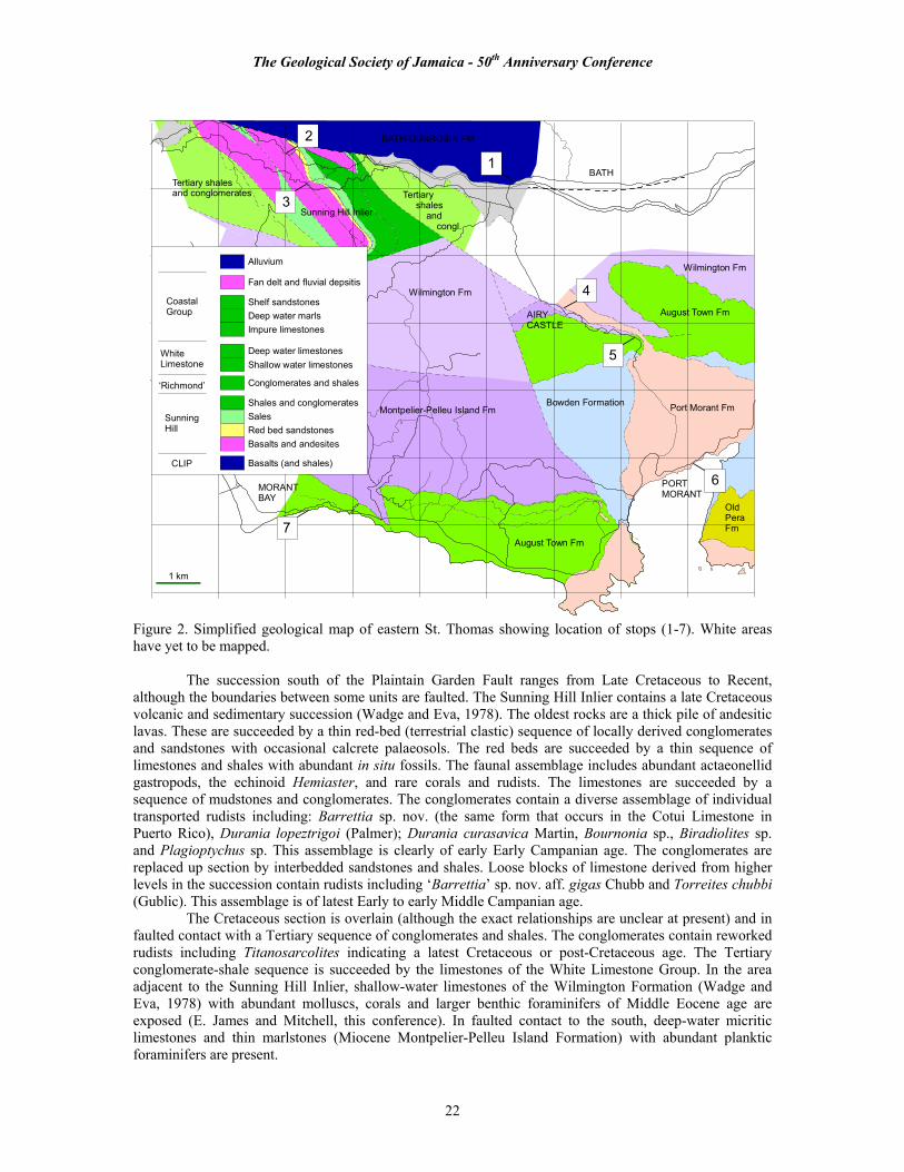
The Geological Society of Jamaica - 50th Anniversary Conference
22
1 km
Wilmington Fm
Montpelier-Pelleu Island Fm Port Morant Fm
August Town Fm
Bowden Formation
August Town Fm
Wilmington Fm
OldPeraFm
MORANTBAY
BATH1
BATH-DUNROBIN FM2
3
4
5
6
7
Sunning Hill Inlier
Tertiaryshales
andcongl.
Tertiary shalesand conglomerates
Alluvium
Fan delt and fluvial depsitis
Shelf sandstonesDeep water marlsImpure limestones
Deep water limestonesShallow water limestones
Conglomerates and shales
Shales and conglomeratesSalesRed bed sandstonesBasalts and andesites
Basalts (and shales)CLIP
SunningHill
‘Richmond’
WhiteLimestone
CoastalGroup
PORTMORANT
AIRYCASTLE
Figure 2. Simplified geological map of eastern St. Thomas showing location of stops (1-7). White areas have yet to be mapped. The succession south of the Plaintain Garden Fault ranges from Late Cretaceous to Recent, although the boundaries between some units are faulted. The Sunning Hill Inlier contains a late Cretaceous volcanic and sedimentary succession (Wadge and Eva, 1978). The oldest rocks are a thick pile of andesitic lavas. These are succeeded by a thin red-bed (terrestrial clastic) sequence of locally derived conglomerates and sandstones with occasional calcrete palaeosols. The red beds are succeeded by a thin sequence of limestones and shales with abundant in situ fossils. The faunal assemblage includes abundant actaeonellid gastropods, the echinoid Hemiaster, and rare corals and rudists. The limestones are succeeded by a sequence of mudstones and conglomerates. The conglomerates contain a diverse assemblage of individual transported rudists including: Barrettia sp. nov. (the same form that occurs in the Cotui Limestone in Puerto Rico), Durania lopeztrigoi (Palmer); Durania curasavica Martin, Bournonia sp., Biradiolites sp. and Plagioptychus sp. This assemblage is clearly of early Early Campanian age. The conglomerates are replaced up section by interbedded sandstones and shales. Loose blocks of limestone derived from higher levels in the succession contain rudists including ‘Barrettia’ sp. nov. aff. gigas Chubb and Torreites chubbi (Gublic). This assemblage is of latest Early to early Middle Campanian age. The Cretaceous section is overlain (although the exact relationships are unclear at present) and in faulted contact with a Tertiary sequence of conglomerates and shales. The conglomerates contain reworked rudists including Titanosarcolites indicating a latest Cretaceous or post-Cretaceous age. The Tertiary conglomerate-shale sequence is succeeded by the limestones of the White Limestone Group. In the area adjacent to the Sunning Hill Inlier, shallow-water limestones of the Wilmington Formation (Wadge and Eva, 1978) with abundant molluscs, corals and larger benthic foraminifers of Middle Eocene age are exposed (E. James and Mitchell, this conference). In faulted contact to the south, deep-water micritic limestones and thin marlstones (Miocene Montpelier-Pelleu Island Formation) with abundant planktic foraminifers are present.
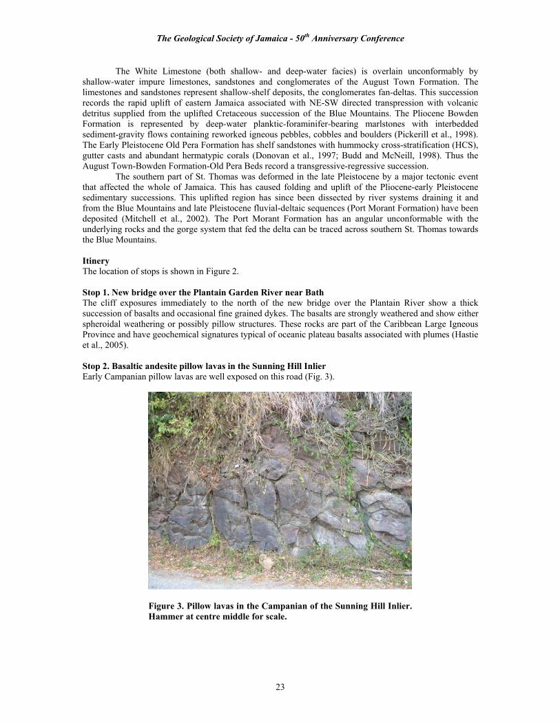
The Geological Society of Jamaica - 50th Anniversary Conference
23
The White Limestone (both shallow- and deep-water facies) is overlain unconformably by shallow-water impure limestones, sandstones and conglomerates of the August Town Formation. The limestones and sandstones represent shallow-shelf deposits, the conglomerates fan-deltas. This succession records the rapid uplift of eastern Jamaica associated with NE-SW directed transpression with volcanic detritus supplied from the uplifted Cretaceous succession of the Blue Mountains. The Pliocene Bowden Formation is represented by deep-water planktic-foraminifer-bearing marlstones with interbedded sediment-gravity flows containing reworked igneous pebbles, cobbles and boulders (Pickerill et al., 1998). The Early Pleistocene Old Pera Formation has shelf sandstones with hummocky cross-stratification (HCS), gutter casts and abundant hermatypic corals (Donovan et al., 1997; Budd and McNeill, 1998). Thus the August Town-Bowden Formation-Old Pera Beds record a transgressive-regressive succession. The southern part of St. Thomas was deformed in the late Pleistocene by a major tectonic event that affected the whole of Jamaica. This has caused folding and uplift of the Pliocene-early Pleistocene sedimentary successions. This uplifted region has since been dissected by river systems draining it and from the Blue Mountains and late Pleistocene fluvial-deltaic sequences (Port Morant Formation) have been deposited (Mitchell et al., 2002). The Port Morant Formation has an angular unconformable with the underlying rocks and the gorge system that fed the delta can be traced across southern St. Thomas towards the Blue Mountains. Itinery The location of stops is shown in Figure 2. Stop 1. New bridge over the Plantain Garden River near Bath The cliff exposures immediately to the north of the new bridge over the Plantain River show a thick succession of basalts and occasional fine grained dykes. The basalts are strongly weathered and show either spheroidal weathering or possibly pillow structures. These rocks are part of the Caribbean Large Igneous Province and have geochemical signatures typical of oceanic plateau basalts associated with plumes (Hastie et al., 2005). Stop 2. Basaltic andesite pillow lavas in the Sunning Hill Inlier Early Campanian pillow lavas are well exposed on this road (Fig. 3).
Figure 3. Pillow lavas in the Campanian of the Sunning Hill Inlier. Hammer at centre middle for scale.

The Geological Society of Jamaica - 50th Anniversary Conference
24
Stop 3. Cretaceous succession in the Sunning Hill Inlier. The track leading east at the top of the road shows the succession in the Createcous in the Sunning Hill Inlier. This begins in andesites, passes through the red bed sandstones and into the marine succession. A thin limestone (Fig. 4), with a basal transgressive sandstone, is present and contains abundant Cretaceous gastropods. The overlying shales and conglomerates yield reworked fossils including early Campanian rudists (Fig. 5).
Figure 4. Nodular limestones of early Campanian age in the Sunning Hill Inlier.
Figure 5. Barrettia sp. nov. From the transgressive conglomerate at the base of the limestones. Earlky Campanian, Sunning Hill Inlier. Scale bar is 10 mm.
Stop 4. White Limestone and Port Morant Fluvial Deposits – Airy Castle The main exposures on the road show the white limestones of the Wilmington Formation. This consists of carbonate grainstones and packstones with abundant corals, gastropods and foraminifers indicating deposition in shallow water. On the track that leads down towards the river, conglomerates with rounded pebbles are well-exposed. These represent the fill of the late Pleistocene incised river system that fed the Port Morant delta system. Stop 5. Road from Airy Castle to Port Morant The August Town Formation is well-exposed on this road at numerous points. It consists of medium bedded impure bioclastic limestones. The most obvious features are the grains of lithics and opaque iron-oxides that indicate a source region in the Blue Mountains was already being eroded by this time. This formation locally contains abundant mollusc and corals indicating deposition within a shallow marine environment.

The Geological Society of Jamaica - 50th Anniversary Conference
25
Stop 6. Port Morant Formation at Port Morant The road cut and beach have good cliff exposures in the Port Morant Formation. These sections consist of alternating layers of pebble to cobble conglomerates and sandstones. The conglomerates are erosionally based and in the sea cliff have relatively few sedimentary structures. The conglomerates in the road cut above the sea cliff have trough cross bedding and tabular cross bedding. The interbedded sandstones are unbedded and locally in the sea cliff have concretions preserving a marine stable isotopic signature. This suggests that these deposits were formed at about the marine-terrestrial boundary on the ancient fan delta. Stop 7. High part of the August Town Formation at 'Chef’s' Here, the August Town Formation consists of interbedded cemented sandstones and uncemented sandstones. The sandstones contain indistinct lamination suggesting deposition by storm processes. Fossils are common including the echinoids Leodia and Eucidaris, scaphopods, corals (Thysanus, Meandrina, Placocyathus) and disarticulated pectinids and the spherical benthic foraminiferan Sphaerogypsina. Trace fossils include Ophiomorpha, Planolites and Skolithos. The corals suggest a Pliocene age, and this is probably the oldest locality to have yielded the echinoid Leodia anywhere in the world. A shallow clastic shelf depositional environment is suggested. Halfway up the cliff exposure is a prominent erosional surface overlain by a boulder conglomerate. The beds below the erosion surface are strongly dipping towards the sea, whereas those above are horizontal. The boulders are bored by clionid sponges (Entobia isp.) and coated by red algae indicating a significant episode of hiatal deposition. The sediments above the conglomerate horizon consist of interbedded cemented and uncemented sandstones, similar to the succession below the unconformity, and containing abundant Thalassinoides burrows. The similarity in sediments below and above the unconformity suggests deposition in similar environments. However, the sediments above the unconformity are considered to be late Pleistocene, and are therefore much younger and have a different orientation (i.e., there is an angular unconformity). This unconformity is the representation of the Late Pleistocene tectonic event that affected Jamaica. References Budd, A.F. and McNeill, D.F. 1998. Zooxanthellate Scleractinian Corals from the Bowden Shell Bed, SE Jamaica.
Contributions to Tertiary and Quaternary Geology 35, 49-65. Donovan, S. K., Pickerill, R. K. and Mitchell, S. F. 1997. Field guide to the geology of east Port Morant Harbour,
parish of St. Thomas, SE Jamaica, April 5, 1997. Journal of the Geological Society of Jamaica, 32, 49-56. Hastie, A.R., Kerr, A.C., Mitchell, S.F. and Jackson, T.A. 2005. The tectonic evolution of the Caribbean Plate: insights
from volcanic rocks in Jamaica and the Virgin Islands. 17th Caribbean Geological Conference 2005, San Juan, PR., pp. 34-35.
Jackson, T.A. and Smith, T.E. 1980. Mesozoic and Cenozoic mafic magma types of Jamaica and their tectonic setting. In: 9a Conferencia Geologica Del Caribe Santo Domingo, Republica Dominicana, Memorias (9th Caribbean Geological Conference Santo Domingo, Dominican Republic, Transactions), 435-440.
Kerr, A.C., White, R.V., Thompson, P.M.E., Tarney, J. and Saunders, A.D. 2003. No Oceanic Plateau—No Caribbean Plate? The Seminal Role of an Oceanic Plateau in Caribbean Plate Evolution. In: Bartolini, C., Buffler, R.T. and Blickwede, J. (Eds), The Circum-Gulf of Mexico and the Caribbean: Hydrocarbon habitats, basin formation, and plate tectonics. AAPG Memoir 79, pp. 126– 168.
Mitchell, S.F., R.K. Pickerell, and T.A. Stemann, 2001. the Port Morant Formation (Upper Pleistocene, Jamaica): high resolution sedimentology and paleoenvironmental analysis of a mixed carbonate clastic lagoonal succession. Sedimentary Geology 144, 291-306.
Montgomery H. and E.A. Pessagno Jr., 1999. Cretaceous microfaunas of the Blue Mountains, Jamaica, and of the Northern and Central Complexes of Hispaniola. In: Mann P. (editor). Caribbean Basins, Sedimentary Basins of the World, 4, p. 237-246, Elsevier Science, Amsterdam.
Pickerill, R. K., Mitchell, S. F., Donovan, S. K. and Keighley, D. G. 1998. Sedimentology and palaeoenvironment of the Pliocene Bowden Formation, Southeast Jamaica. Contributions to Tertiary Geology, 34, 12-32.
Wadge G., T.A. Jackson, M.C. Isaacs and T.E. Smith, 1982. The ophiolitic Bath-Dunrobin Formation, Jamaica: significance for the Cretaceous plate margin evolution in the north-western Caribbean. Journal of the Geological Society of London, 139, 321-333.
The Geological Society of Jamaica - 50th Anniversary Conference
26
Field Trip 2, 3rd December, 2005 – Shaping of Kingston by its Urban Geology Leaders: Rafi Ahmad1 and Parris Lyew-Ayee Jr2 1Unit for Disaster studies, Department of Geography and Geology, University of the West Indies, Mona, Kingston 7, Jamaica [email protected] and http://www.mona.uwi.edu.jm/uds/ 2Mona Informatix Ltd, The University of the West Indies, Mona, Kingston 7, Jamaica [email protected], www.monainformatixltd.com 1. Introduction Kingston is Jamaica’s largest urban area and its leading commercial and industrial centre (Fig. 1). It was founded in 1693 on the Liguanea Plain by the English after the catastrophic earthquake of 7 June 1692 destroyed the previous port city of Port Royal on the Palisadoes. Major earthquake damage is ascribed to widespread liquefaction and earthquake-induced landslides. In the submerged area of Port Royal, archaeological excavations have revealed intact foundations and roadways. Tsunami waves were generated by submarine sediment flows which swept over the Palisadoes. Liquefaction and landslides were witnessed again during the Ms 6.5 Earthquake of 14 January 1907. Earthquakes and hurricanes are the major factors in the development of Kingston and have in many ways profoundly affected its social and economic order. Norman Manley International Airport is located on the Palisadoes. It has been proposed to develop Port Royal as a historical and cultural port of call for cruise ships. Kingston became the seat of administration in 1872 and became the capital city in 1962 when Jamaica was granted independence in 1962. It is administered by Kingston and St. Andrew Corporation (KSAC) (http://www.jnht.com/kingston/kingston.htm). The continued growth of Kingston and its satellite urban centres and improved understanding of the geology and natural hazards the city faces present a number of formidable challenges to the city administration and its inhabitants. Some of the major issues now confronting Kingston include: (1) rapid urban growth; (2) increasing pressure on limited domestic water supply; (3) poor road conditions, inadequate public transport, and ever worsening traffic congestion; (4) groundwater contamination and depletion of aquifers, waste disposal; (4) landslides in areas of new urban development; (5) water and sediment floods following every significant rainfall event; (6) coastal flooding from storm surge; and (7) the possibility of a damaging earthquake. City administrators and planners require urban geology information to properly assess and mitigate the risks to the citizenry, urban environment and infrastructure. Aims of this paper are to (1) summarize the urban geology of the Kingston area and the geological hazards that pose a significant risk to its inhabitants, infrastructure and urban environment; and (2) explain the characteristics of the various sites that will be visited during the field excursion. Figure 1 is a simplified map of geology and geomorphology of the study area. Field stops and locations are shown on Figure 2. The text and supporting Figures 3 to 11 will be used to illustrate how urban geology underpins Kingston’s future growth and prosperity. This subject has not received due attention. The literatures used in the preparation of this paper are included in the bibliography. The Municipality of Portmore is not included in this study. 2. Geolgical Kingston Geological influences on the development of Kingston are profound. The city is built on the undulating coastal lowlands of the Liguanea Plain and lower Rio Cobre facing the Caribbean Sea. Its surface geology comprises sediments of the Ligunea Gravel Fan, an inactive Quaternary fan delta formed by the Hope River (Figs. 1 and 2). The Liguanea Plain is an old alluvial fan which was formed by sedimentation from the Hope River before the river was diverted into its present channel. It incorporates a sequence of very poorly sorted gravels with sands and clays which is at least 100 m thick. The top 8 m of the exposed fan sediments appear to be old debris flow deposits characterized by very large rock blocks and boulders of andesite and conglomerate. Such exotic rock blocks are found stranded over much of the fan surface. The sources of these debris flows must have been pre-historic landslides which originated in the catchment of the Hope River and flowed west along the paleodrainage channels. The present-day fan surface is uneven and generally slopes south towards the Kingston Harbour at 5-150. It is speculated that this fan became inactive as a result of Late Quaternary fault displacements in the proximal part of the Liguanea Gravel Fan which resulted in the change of the course of the Hope River (Fig. 3). The present-day analogue of the Liguanea Fan is the fan delta of the Yallahs River in St. Thomas. Flanking the Liguanea Fan are the upland terrains of Port Royal Mountains underlain by Cretaceous
The Geological Society of Jamaica - 50th Anniversary Conference
27
granodiorite (local basement) with slivers of Cretaceous volcanics, and Stony Hill, Red Hills, Long Mountain and Dallas Mountain comprising Eocene limestone (Fig. 4). The Port Royal Mountains rise to elevations of 1950 m and are dissected by deep and fault controlled valleys (Fig.2). This rugged terrain is referred to as the Wagwater Belt and is composed of complexly-faulted slivers of Cretaceous granodiorite and volcanics, the Eocene coarse and fine clastic sediments of the Wagwater Group including purple conglomerates, sandstones, and an interlayered sequence of shales and sandstones (Figs. 1 and 4).
Sediments of the Liguanea fan constitute an aquifer. According to the Water Resources Authority of Jamaica, the ground water resources of the fan and its limestone aquifer have been and continue to be an important source of potable and industrial water for the parishes of Kingston and St.Andrew.
A number of economic minerals and rocks occur in this area. Lead-zinc-copper mineralization occurs at several sites within the Wagwater Belt. Notable among the industrial rocks and minerals are vast reserves of gypsum and limestone. Commercial extraction of lead and zinc was carried out at the Hope Mine, Papine district, St.Andrew in the 1850’s. Environmental pollution resulting from the lead mine tailings has been a focus of detailed investigation in recent times. Limestone is of a good quality and is mined in the Long Mountain and gypsum at Bito by the Caribbean Cement Company Ltd.
Active tectonic processes include landslides and earthquakes whose effects are controlled by the rock types and geological structure (Figs. 5 and 6). The present-day plate tectonic setting suggests that the Wagwater Fault Zone forms a transpressional bend in the North-central Caribbean plate boundary, transferring movement between large left-lateral strike-slip faults at its southern and northern ends. This plate tectonic interpretation is supported by the existence of two Neogene anticlines (Long Mountain and Dallas Mountain) in the southeast corner of the Liguanea Plain (Fig. 7). These anticlines trend parallel to the Wagwater Fault (Fig. 1). 3. Geomorphology Of Kingston Figure 1 shows that on a broad scale, the physiography of the Kingston area is conveniently described as three units: 1) the low relief coastal plains of Liguanea and the lower Rio Cobre, 2) the rolling hills and limestone plateaus north-northwest of Kingston and west of the Wagwater Belt, and 3) the deeply dissected mountains of the Wagwater Belt in St. Thomas parish, north, northeast, and east of Kingston. The bedrock is deeply weathered and overlain by residual soils. A majority of slopes are over 300 and are underlain by intensely jointed, faulted and weathered bedrock. Neotectonic uplift has enhanced chemical weathering and mass movements. This is an area of neotectonic landforms characterized by colluvium covered steep slopes and frequent slope movements (Figs. 4 and 5). The Liguanea Ridge attains a maximum elevation of some 600 m at Mt. Ivor in the Jacks Hill area. It is a faulted mountain front with the Wagwater Fault constituting range front fault. This fault has been active since the Paleocene and field evidence indicates that movements have continued into the Quaternary. The lithology of the Tertiary limestones is highly variable and includes chalky limestones, micrites, sandy marls, and brecciated limestones. Major faults in the limestone terrain are aligned northwest-southeast paralleling the Wagwater Fault trend. However, north and northeast trends are also known.
The present-day Hope River fan at Harbour View is underlain by the Harbour View Formation which is lithologically similar to the Liguanea Formation. The sediments that post-date the Liguanea and Harbour View Formations are: colluvium deposits along much of the mountain front in the Kingston area, and (ii) river terraces, colluvium fans and flood plain deposits associated with the Hope, Cane, Chalky, Bull Bay Rivers, their tributaries and other drainage lines on the Liguanea Fan. The formation of the island shelf is due to the erosion of the Jamaican landmass during post-Neogene uplifts. The most impressive offshore feature southeast of Kingston is the Yallahs Basin. It has an area of approximately 100.0 km2; an average depth of 1,350.0 m. It has been affected by submarine landslides and turbidity currents since it was filled. Two submarine fans, the Hope-Liguanea fan and Yallahs fan occur to the northeast and northwest of the Yallahs Basin. Cable breaks have been reported from the area of the submarine fans during the earthquakes of 1907 and 1993, and also during the passage of the hurricane Flora in 1963. The youngest feature on the shelf is the Palisadoes tombolo which has largely been built by the long shore drift of the coarse sediments supplied by the rivers in eastern Jamaica and also by an influx of sediment facilitated by storm surge activity. This area has experienced storm surge and liquefaction-related ground failures during each significant earthquake that has affected Jamaica.

The Geological Society of Jamaica - 50th Anniversary Conference
28
4. Geohazards Profile of Kingston The Kingston area comprising coastal plains, reclaimed land, alluvial fans, steep slopes and fault escarpments, is subject to multiple seismic, atmospheric, slope instability and, hydrologic hazards. The average annual rainfall varies from 1000 mm on the Liguanea Plain to more than 1500 mm on the mountain slopes. Hydro-geologic hazards commonly occurring in relatively small drainage basins of Kingston are classified into three types of events, debris flow/mud flow, turbidity flow, and flood. Each of this flow event may travel at a high speed, is characterized by different transportational and/or depositional processes of sediment, and is generally confined to a specific segment of the water course aka gully or river. Since each hazard requires different control works, it is important to distinguish between flow types and where they occur for the purposes of land use planning and flood protection.
Debris flow and mud flow are high-density flow types of landslides laden with rock blocks, boulders and gravel and are confined to the hilly sections and base of hill slopes in the Kingston area. These have caused death, injury and serious destruction of land and property. Debris control dams and dykes are required to control the damage.
A torrent of gravel, sand and mud, called a turbidity flow, is a common occurrence throughout Kingston after every significant rainfall event. These are responsible for much of the damage along gully courses and erosion of road surfaces. Sediments entrained in the flow choke the narrow culverts resulting in flooding. These flows may be controlled by constructing dykes and spurs. The overflows and ponding of muddy water without coarse sediments are designated as floods which are, indeed, a very common occurrence especially in the built up areas.
A recurring theme in all of the significant earthquakes that have affected Kingston since the 7 June 1692 Earthquake is that geological conditions strongly influence the damage (Fig. 6).The vulnerability of Kingston to damage from distant earthquakes was amply demonstrated by the M 5.4 (duration magnitude) earthquake of 13th January, 1993. According to Earthquake Unit, the epicentre of this shallow earthquake was located near the Silver Hill Peak in the parish of Portland. The effects of this earthquake were felt in area of approximately 500 km2. The results of approximately 10 seconds of ground shaking in eastern Jamaica, with MM intensities ranging between VII-VIII, resulted in two deaths and the economic losses estimated in excess of J$ 15M. This earthquake triggered some 40 landslides which blocked roads and damaged infrastructure including water pipelines.
In 1980, Dr. J. Shepherd and Dr. W. Aspinall calculated the return periods of significant earthquakes in Greater Kingston. According to these authors the return periods of the earthquakes of MMI VII ,VIII, IX, and X are respectively 38, 87, 137, and 237 years. Based on a study of earthquake risk in Jamaica, Dr. J. Shepherd has suggested in 1971 that “From the seismologist’s point of view the parishes of Kingston including Port Royal, and Lower St. Andrew were probably the worst possible locations to choose for the capital city of Jamaica". Figure 11 shows the peak ground acceleration in the Kingston area.
Floods and mass movements generally occur simultaneously as the two most frequent hazards affecting Greater Kingston. Hurricanes are fairly common, but most of the recurrent flood and landslide damage is due to rainfall from tropical storms and tropical depressions which are annual events. The steep weathering-limited slopes favour shallow landslides. A landslide inventory map prepared for the Landslide Susceptibility Mapping in Kingston records some 2,321 landslide landforms in the parishes of Kingston and St.Andrew. The natural vulnerability of Greater Kingston to rainfall -induced debris flows and mud flows have been accentuated by deforestation and vegetation alteration over much of its environment.
About 200-300 mm of rainfall in 24hrs would initiate shallow slides on slopes in excess of 250, which constitute about 85 percent of the hilly areas of Kingston. This amount of rain is expected to fall once in 2-5 years over the hilly suburbs of Kingston. In a majority of cases the old landslides are reactivated during subsequent rainfall events.
A cyclic pattern of destabilization of the slopes is quite common. Accelerated soil erosion in the watersheds is intimately linked to these shallow landslides. Riverine flooding is confined to the Hope, Cane, Chalky, and Bull Bay Rivers and their tributaries which create a flood hazard for the less affluent communities of Gordon Town, Papine, August Town, Harbour View, and Bull Bay etc. On the Liguanea Fan, the increasing impervious cover and the channeling of the gullies concomitant with urbanization have increased the overland flow, and hence, flash floods. Of the seven major gully systems on the fan, only one, Sandy Gully, has been designed to accommodate large floods up to a discharge of nearly 500 m3/sec; the rest of the gullies have discharge capabilities between 20-70 m3/sec.

The Geological Society of Jamaica - 50th Anniversary Conference
29
5. Explanation of Field Stops STOP 1: VTDI Centre, Gordon Town Road, Papine (Figs 3 and 4). The geomorphic features of the Hope River valley and the proximal part of the Liguanea fan will be examined at this locality. Late Quaternary fault scarps in the Hope River valley are displayed on the oblique air photo in Figure 3. Fault displacements in the proximal part of the Liguanea Gravel Fan resulted in the change of the course of the Hope River. Figure 4 displays the old landslide landforms and landslide deposits along the southern slopes of Liguanea Ridge.
In this area old landslides along the Wagwater Fault zone may be identified by examining the topographic features such as scarp, hummocky topography, and landslide deposits. During the last few years a number of houses have been built on these unstable slopes underlain by unconsolidated to poorly consolidated landslide debris derived from volcaniclastic sediments exposed on the Liguanea Ridge. A number of new slides may be observed along the road cut. The contact between the landslide deposits and the Liguanea Formation may be observed in the road cut. A landslide triggered by the 1907 Earthquake destroyed a section of the underground water pipeline along the main road. Most of the slopes in this area are prone to landslides. Modification and channelization of natural drainage has exacerbated the flooding problem at this locality. STOP 2: Lookout on the Skyline Drive (Figs 3 to 7). This stop offers an excellent view of the Hope River valley, Dallas Mountain, Long Mountain, Liguanea Plain, Kingston Harbour and Palisadoes. Urban geology and natural hazards in the area will be explained with reference to Figures 3 to 7.
The urban growth, especially upper-income housing, is increasingly taking place in the mountains of Liguanea historically subject to landslides and landslide disasters are known.
Landslide landform cover some 0.8 km2 (80 ha) of the southern slopes of the Liguanea Ridge between Papine and Jacks Hill. Landslides and their deposits cover some 16.89 % of the total slope area of 4.75 km2. Anthropogenic slope and vegetation conversion exacerbates the problem. In a majority of cases the old landslides are reactivated during subsequent rainfall events. A cyclic pattern of destabilization of the slopes is quite common. The site of an old landslide and the downslope deposit, both of which have been vegetated and to some extent stabilized, are often chosen for development. Large-scale rainfall inevitably will occur after such slope modification for urbanization and agriculture, and flows and slides will again destroy the slope along with any development on it; in the process transferring huge quantities of sediment to the valley bottom streams. The failed slopes become partially stabilized naturally over time with regrowth of vegetation. Given the scale of the problem, engineered slope stability measures are too expensive for the area. Such partially stabilized slopes are often re-utilized until another tropical storm arrives and the whole sequence is repeated. Maharaj (1993) has mapped 866 slope failures in an area of 15 km2 (59 slides/km2) in Upper St.Andrew where the urban spread of Greater Kingston is mostly concentrated. After the intense rains of May 1991, this figure increased to 950; 540 of which were reactivated old slides. The number of failures along a 46.6 km of road network was 481, about 10 slides/km of the road. Debris flows and slides constituted some 86% of the slides mapped. STOP 3: Intersection of Jacks Hill Road and Sunset Avenue. This stop offers an excellent view of the upper-income housing development currently taking place in the mountains of Liguanea. Landslide landforms in the area are shown on a landslide isopleth map (Fig. 5).
Following the precipitation associated with hurricanes Flora, 4-7 October 1963, and Gilda, 16-18 October 1973, hurricane Mitch in October 1998, and hurricane Ivan September 2004, widespread debris flows and mudflows occurred in this area of the Liguanea Ridge. The 1973 debris and mudflows caused extensive damage to houses and roads. During 17-19 October 1973, following heavy rainfall from Hurricane Gilda, slope failures occurred in the pre-historic landslide deposits along the southern slopes of Mt.Ivor. The area was apparently being developed at the time. Partial stabilization following vegetation regrowth was again followed by construction activities. On 14th November 1988, an engineered house in Jacks Hill and a section of the Jacks Hill Road including a culvert were destroyed by a deep-seated landslide following a brief spell of heavy rainfall and earthquake shaking. The road remained closed for more than six months. The house is located on old debris flow deposits that were probably triggered by the June 1692 Earthquake.

The Geological Society of Jamaica - 50th Anniversary Conference
30
STOP 4: Lunch Break, Barbican Round about, Loshusan Supermarket Parking Lot. A virtual landslide field trip for the Jacks Hill area will be available for viewing during the lunch break. STOP 5: Beverly Hills Via Karachi Avenue (Fig. 7). This stop offers an excellent view of the Port Royal Mountains, the Liguanea Ridge and the Liguanea Plain (Fig.9 Photo 1). Active tectonics of the Long Mountain- Mona Reservoir area and natural hazards risk to the Mona reservoir will be discussed (Fig. 7). The Long Mountain is a site for new housing development. STOP 6: General Penitentiary, F.G. Boulevard. Ground deformation following the earthquake of 1907 was particularly significant in the entire stretch of the land between Downtown Kingston (Railway Terminal) and Harbour Head along Kingston Harbour front where ground water table is shallow. Liquefaction, ground cracks and fissures occurred in the Liguanea Fan sediments (Fig. 9, Photo 3). It is likely that submarine slides have occurred in this area which has led to the lowering of ground surface and hence coastal flooding. This geomorphic change has been documented in all the contemporary historical accounts of 1907 earthquake as “submergence around the Kingston Harbour”. STOP 7: OLD PRISON QUARRY AND ROCKFORT. We will examine the effects of the M 5.4 Earthquake of 13 January 1993 in this area to assess the natural hazards risks to the infrastructure and industry. Two major rock falls/ rock slides occurred in the Old Prison Quarry in the highly fractured limestones. Landslides were observed along the highway. Ground cracks were observed along the driveway to the Rockfort Mineral Bath and water seepage was reported along these cracks. An abnormally high water discharge was reported in the Rockfort Natural Spring; water was seen springing up in several new areas within and around the bath. Ground cracks were observed on the road surface of highway A4 in the vicinity of the Cement Factory. Similar phenomenon was observed at this locality during the 7 June 1692 and 14 January 1907 Earthquakes. STOP 8: Harbour View, Caribbean Terrace. Harbour View is located on the alluvial fan of the Hope River (Figure 9; photos 2 and 4). This location is subject to multiple natural hazard risks including storm surge, tsunami, liquefaction, and riverine floods. The storm surge associated with the September 2004 hurricane Ivan destroyed a number of houses along the coastline (Fig. 8; photo 1). The Ms 6.5 Kingston Earthquake of 14 January 1907 caused liquefaction and submarine landslides in the coastal areas and triggered hundreds of landslides throughout eastern Jamaica including the Port Royal Mountains (Fig. 9; photo 4). A major submarine landslide occurred off the coast at Seven Miles that caused the breakage of several submarine cables. Submarine landslides were also reported in this area following the M5.4 earthquake of 13th January 1993 causing breakages to TCS-1 digital Cable System and Jamaica-Panama Analogue Cable System some 2km offshore from the Seven Miles Cable Station.
Following the May 1986 Flood rains the bridge on the Hope river was severely damaged which led to the closure of the road for an extended period of time. We will discuss the natural hazards risks to the Donald Quarrie School located along the coast lime (Fig. 8; photo 3). STOP 9: Harbour Head area opposite the Gypsum Pier on the Palisadoes. The origin of the Palisadoes tombolo, its natural hazard scenario and disasters will be discussed. The tombolo is about 13 km long and extends from the mainland at the eastern end of the Kingston Harbour to Port Royal (fig. 2). Tombolo refers to a " a bar of spit connecting an island to the mainland or to another island"; they occur where long shore drift carries material beyond a change in orientation of the coast or at river mouths; usually have a narrow proximal part and a broader distal end. This area is prone to multiple natural hazards including storm surge, latest being the storm surge associated with hurricane Ivan in 2004, tsunamis, high winds, heavy rainfall generated by hurricanes, seismically-induced earth movements, and liquefaction. Its physiography has from time to time been considerably affected both by earthquakes and hurricanes. Port Royal is located on the distal end of the Palisadoes tombolo which is thought to have been formed by long shore sediment deposition that joined a number of relict coral cays. Its narrow proximal part is in the Harbour View area in the east where it joins with the mainland. Port Royal was formerly on a cay and was joined to the Palisadoes in around 1661.

The Geological Society of Jamaica - 50th Anniversary Conference
31
During the earthquake of January 1907 liquefaction occurred at the base of the Palisadoes and was manifested as crater of sand and mud (Fig.9; photo 4). Following the first detailed survey of Palisadoes in 1940 by Steers, the presence of quicksand at a depth of 26-32 feet in the proximal part of the tombolo was reported. Seismic surveys and boring data suggest that solid limestone bedrock occurs at a depth of about 50m in the Port Royal area. The top 40- 50m of the section throughout the tombolo is made up of poorly consolidated sands, gravels and mud. STOP 10. Giddy house and Fort Charles area. During the earthquake of January 14, 1907 liquefaction occurred in the Port Royal area and was manifested as tilted structures (Giddy House), twisted rail lines, crater of sand and mud (Fig. 9; photo 2). During the excursion visits will be made to the sites where effects of liquefaction may still be seen. Figure 10, photo 1 shows the modifications to Port Royal coastline since the 7 June 1692 Port Royal Earthquake. STOP 11. Coastal section adjacent to the Old Naval Hospital. A submarine landslide triggered by the earthquake of June 6, 1692 destroyed the Buccaneer City of Port Royal. Figure 10, photo 2 is a cartoon showing this submarine landslide. BIBLIOGRAPHY Ahmad, R., Scatena, F.A. and Gupta, A. 1993. Morphology and sedimentation in Caribbean montane streams:
examples from Jamaica and Puerto Rico. Sedimentary Geology, 85, 157-169. Ahmad, R. 1995. Landslides in Jamaica- extent, significance and geologic zonation. In: Barker D., McGregor D.F.M.
(Eds), Environment and Development in the Caribbean: Geographical Perspectives. the Press, University of the West Indies, Barbados, pp 147-169
Ahmad, R. 1996. The Jamaica earthquake of January 13, 1993- geology and geotechnical aspects. Journal of the Geological Society of Jamaica, 30, 15-31.
Ahmad, R. 1999. Primer on earthquake hazards and disasters in Jamaica. Caribbean Geography 10, 123-136. Ahmad, R. and McCalpin, J.P. 1999. Landslide Susceptibility Maps for the Kingston Metropolitan Area, Jamaica with
notes on their use: Unit for Disaster Studies, Department of Geography and Geology, UWI, Mona, Publication No.5, http://www.oas.org/en/cdmp/document/kma/udspub5.htm.
Ahmad, R. 2001. Natural hazard maps in Jamaica. Caribbean Geography, 12, 90-107. Ahmad, R. and Robinson, E. 1994. Geological Evolution of the Liguanea Plain - the landslide connection. In:
Greenfield, M. and Robinson, R. (Eds), Proceedings of the First Conference, Faculty of Natural Sciences, The University of the West Indies, Mona, May 1994, pp. 22-23.
Gupta, A. and Ahmad, R. 1999. Urban steeplands in the tropics: an environment of accelerated erosion. GeoJournal, 143-150.
Gupta, A. and Ahmad, R. 2000. Geomorphology and urban tropics: building an interface between research and usage. Geomorphology 31, 133-149.

The Geological Society of Jamaica - 50th Anniversary Conference
32
Figure 1. Simplified geology and geomorphology of Kingston.
PORTMORE
PALISADOES
PORT ROYAL MOUNTAINS
STONY HILL

The Geological Society of Jamaica - 50th Anniversary Conference
33
Figure 2. Aerial photo mosaic of Kingston with field stops. Aerial photo courtesy of J.Tyndale Biscoe. Starting Point: UWI Mona 1. VTDI Centre, Gordon Town Road, Papine. 2. Lookout on the Skyline Drive. 3. Intersection of Jacks Hill Road and Sunset Avenue. 4. LUNCH BREAK, Barbican Roundabout, Loshusan Super Market Parking Lot. 5. Beverly Hills via Karachi Avenue. 6. General Penitentiary, F.G. Boulevard. 7. Rockfort Mineral Bath. 8. Caribbean Terrace. 9. Gypsum Pier, N.M. Highway. 10. Fort Charles and Giddy House, Port Royal. 11. Old Naval Hospital. End of Field Trip: Return to Mona.
11
10
9 8
7 6
5
1
2
MONA
G.T. Road
HavendaleNorbrook
Waterworks
Harbour View
4
3
Hope RiverHalf Way Tree
Cross Roads

The Geological Society of Jamaica - 50th Anniversary Conference
34
Figure 3. Oblique air photograph of the proximal end of the Liguanea Plain as viewed from the Lookout, Skyline Drive, Stop No. 2. Photo Courtesy of J. Tyndale Biscoe.
Skyline Drive
Hope River
UWI
FAULT SCARP
FAULTS
Zoo
Long MountainNational stadium
VTDI

The Geological Society of Jamaica - 50th Anniversary Conference
35
Figure 4. Geology and structure of Papine, Hope Pastures, and Skyline Drive areas. It appears that granodiorite (G) underlie the gravels and sands of the Liguanea Formation. The mountain front is fault controlled. Faults are shown as heavy solid lines. It appears that the change in the course of Hope River also occurred as a result of faulting in Holocene (see Figure 3). A zone of deep-seated landslides is associated with the faults. Landslide debris has created a number of debris fans at the base of the Liguanea Ridge all along the mountain front. The water courses act as debris chutes. Liguanea fan sediments are a significant source of groundwater. The area of the mountain front is a groundwater recharge zone.

The Geological Society of Jamaica - 50th Anniversary Conference
36
Figure 5. Landslide isopleth map of the Kingston area. The Liguanea Ridge and Jacks hill areas have a high concentration of landslide landforms.
FFiigguurree 66.. CCaarrttoooonn ttoo sshhooww tthhee lliikkeellyy bbeehhaavviioouurr ooff aa sseett ooff eeaarrtthhqquuaakkee wwaavveess aass tthheeyy ttrraavveell tthhrroouugghh ddiiffffeerreenntt ttyyppeess ooff ssuubbssttrraattee iinn tthhee KKiinnggssttoonn aarreeaa.. NNoottee tthhee aammpplliiffiiccaattiioonn ooff wwaavveess iinn wwaatteerr--ssaattuurraatteedd rreecceenntt sseeddiimmeennttss eennccoouunntteerreedd aatt tthhee llaanndd--wwaatteerr iinntteerrffaaccee ooff KKiinnggssttoonn HHaarrbboouurr,, PPoorrtt RRooyyaall,, wwaatteerr ssaattuurraatteedd llaannddffiillllss aalloonngg gguullllyy ccoouurrsseess aanndd sseeddiimmeenntt aapprroonn aatt tthhee ffaauulltteedd mmoouunnttaaiinn ffrroonntt..
HOW SUBSURFACE GEOLOGY CONTROLS EARTHQUAKE WAVES IN KINGSTON?
JJAACCKKSS HHIILLLL
HHooppee PPaassttuurreess
KKIINNGGSSTTOONN HHAARRBBOOUURR
LLIIGGUUAANNEEAA PPLLAAIINN
PPOORRTT RROOYYAALL
GGRRAANNOODDIIOORRIITTEE
FFAAUULLTT ZZOONNEE RREECCEENNTT SSEEDDIIMMEENNTTSS OOFF TTHHEE LLIIGGUUAANNEEAA FFAANN TTHHAATT WWEERREE DDEEPPOOSSIITTEEDD BBYY TTHHEE HHOOPPEE RRIIVVEERR WWHHEENN IITT FFLLOOWWEEDD WWEESSTT OOFF IITTSS PPRREESSEENNTT--DDAAYY CCOOUURRSSEE
WWAATTEERR--SSAATTUURRAATTEEDD SSEEDDIIMMEENNTTSS IINN GGUULLLLYY CCOOUURRSSEESS
LLAANNDDSSLLIIDDEE DDEEBBRRIISS FFAANNSS
LLiimmeessttoonnee
Jacks Hill, Liguanea Ridge

The Geological Society of Jamaica - 50th Anniversary Conference
37
Figure 7. Active tectonics at the Mona Reservoir, Long Mountain, Jamaica (Aerial photo from the UWI Cooperative Credit Union Calendar 2002). The Long Mountain is an anticlinal uplift feature aligned NW-SE. Inset shows the present-day left-lateral motion on the Jamaica plate boundary zone. Long Mountain is a heritage site since Taino artifacts have been found here and also the Long Mountain is home to many endemic flora and fauna. Faults: broken black lines. Landslides: red broken lines, arrow is the movement direction. Debris fans: red dotted line.
Site of new housing development Site of the
M5.4, 1993 earthquake damage
BEVERLY HILLS
Rubbly limestone, case hardened
RA
SCHOOL
Liguanea Alluvium: gravel, sand & silt
Mona Reservoir
Debris fans
W E
N

The Geological Society of Jamaica - 50th Anniversary Conference
38
Figure 8. Physical environment and natural hazards in the Harbour View area. Explanation of photographs, clockwise from upper left corner: 1. Effects of storm surge in the Caribbean Terrace in the aftermath of hurricane Ivan in September 2004. 2. Vertical aerial photograph of the Harbour View area (Source: Survey dept. of Jamaica). Harbour View is located on an alluvial fan. 3. Donald Quarrie School. 4. Pre-Harbour View oblique aerial photograph of the Hope River fan delta. (Source: J. Tyndale Biscoe).
Hope River
Site of Harbour View
LANDSLIDES 1907 EARTHQUAKE
Harbour View
school
Hope River
Liquefaction site 1907
Caribbean Terrace
1

The Geological Society of Jamaica - 50th Anniversary Conference
39
Figure 9. Sesimic hazards and disasters in the Kingston area. Clockwise from top left corner:
1. Trace of the Wagwater Fault zone in northeastern Kingston. Photo source: J. tyndale Biscoe. 2. Effects of liquefaction in Port Royal, Kingston earthquake of 14 January 1907. 3. Ground fissures and damage to the General penitentiary, Kingston earthquake of 14
January 1907. 4. Effects of liquefaction in the area of Hope River fan sediments and earthquake-induced
landslides in the surrounding hills, Kingston earthquake of 14 January 1907. Photos 2-4 are from the Popular Science monthly, May 1907.
UWI MONA CAMPUS
Port Royal Mountains
Mona Reservoir
Landslides
Sand boils
BULL
Hope River Delta
14 th January 1907 Earthquake Bull Bay
Liquefaction at Port Royal 1907
LIQUEFACTION Ground Fissures
Kingston waterfront
Giddy House
Twisted railway lines

The Geological Society of Jamaica - 50th Anniversary Conference
40
Figure 10. A submarine landslide destroyed Port Royal following the earthquake of June 7, 1692 and caused a tsunami. The shore line of Kingston Harbour and Palisadoes preserve signatures of previous tsunami and storm surge deposits. Detailed sampling and sedimentologic analyses of coastal flood deposits in this area might provide criteria to differentiate paleo-storm surge and tsunami deposits.
Source: Ahmad.
Source: http://nautarch.tamu.edu/portroyal/PRhist.htm

The Geological Society of Jamaica - 50th Anniversary Conference
41
Figure 11. Peak ground acceleration map of the Kingston area, Caribbean Disaster Mitigation Project.

The Geological Society of Jamaica - 50th Anniversary Conference
42
Field Trip 3: Sunday 4th December, 2005 – Geo heritage walking tour of Port Royal Leader: Anthony R. D. Porter Former Chief Geologist, Alcan Jamaica Co., 10 Orange Ave., Mandeville, Jamaica
Introduction Port Royal is arguably the most famous town in all the Caribbean. As noted by one writer this “small, fishing port of today belies its riotous and romantic past.” It is located at the western end of a 9-mile (almost 14 km) long sand and gravel spit that serves as a natural breakwater for Kingston harbour. In 1655 the westernmost end was a small, low-lying island (similar to present-day Lime Cay) known as Cagway Point or Point-Cagua. But the strategic value of this site was clearly overlooked by the early Spanish settlers. As a consequence, when the British forces entered the harbour and landed at Passage Fort in 1655 they were unopposed and easily overwhelmed the meagre Spanish forces that they encountered. Following their victory, the British lost no time in building strong fortifications to guard against the enemy. The first defensive breastwork was erected in 1656 with the outer wall resting on beach or coral rock at the waters edge. During the next few years, work continued on fortifying the building and in 1660 it was named Fort Charles. On June 7, 1692, a powerful earthquake shook the island with devastating consequences. At that time the town of Port Royal occupied an area of approximately 60 acres (24 hectares), but in the space of a few hours, much on the sand and gravel on which it was built slide into the sea reducing the surface area to 25 acres (10 hectares). At least two thousand persons were reported to have perished at Port Royal. Since then the deposition of sand and gravel, controlled largely by wind and wave action in tandem with long-shore drift, have left Fort Charles stranded some 1000 feet (300meters) inland and added some 95 acres (38 hectares) of new land to the western end of the spit (see Figure 1). Although badly shattered, the long and laborious task of rebuilding the town began and by 1699 Fort Charles had been repaired and restored. Many of the red bricks that constitute the wall, and all the light-brown to pale grey slabs of fossil-rich Purbeck Limestone, which still cover a large part of the floor, pre-date the earthquake. In January 1703 a disastrous fire swept through the town and reduced to ashes almost everything in its path except the fort. Some of the dark grey to black bricks that are still evident in the walls of many buildings at Port Royal may have been burnt during this or a subsequent fire and re-used. In 1720 the area of the fort was enlarged by the addition of a small triangular-shaped section at the northeast end. Although no major structural changes have been made since then there are signs of subsequent restoration work everywhere – ranging from a variety of red bricks and stone types on the floor, to the yellow-brown London stock bricks (over the entrance arch) that are from Victorian times and were first brought to Jamaica in the 1830s. Yet, despite the destructive forces of nature to which Fort Charles has been subjected repeatedly during its almost 350-year history, it still remains the first and oldest English fort in the island. Unlike Fort Charles, the original parish church was completely destroyed in 1692. The present St. Peter’s Church was re-built in 1725. The dark blue-grey and white imported marble floor tiles date back to this period, as do the cut white limestone blocks. In the churchyard is an engraved marble tombstone to Lewis Galdy, who survived the earthquake of 1692. It was originally located in a run-down burial ground at Green Bay and then removed to its present location at Port Royal in 1953. Not far away is the old Naval Dockyard, the wall of which is made of red bricks laid down in the Flemish bond style. In the late 1960s this area was the site of a major land-based archaeological investigation, which uncovered the foundations of the church and many private dwellings that perished in the earthquake of 1692. On the eastern side of the wall just north of St Peter’s Church is a plaque erected to the memory of Lucas Barrett, the first Director of the Jamaican Geological Survey from 1859 to 1862. In 1860, while exploring the upper reaches of the Back Rio Grande valley in Portland he found a fossil shell with certain remarkable features, which up to that time were unknown. This extraordinary fossil, first found in Jamaica, was named Barrettia in his honour in 1861. Unfortunately, in December of the following year at the young age of 25, he drowned while conducting an underwater examination of the coral reefs among the Cays on the south side of Port Royal.

The Geological Society of Jamaica - 50th Anniversary Conference
43
Figure 1. Geo-historical map of Port Royal, Jamaica
On the western side of town, and to the northwest of the church, is the Old Naval Hospital, the construction of which commenced in 1817 using cast iron for the framework, bricks for walls, sandstone (flagstone) for paving and plinths (the base of columns), and slate for roofing. Prior to this, another hospital had been built and was in use in 1743, but it was severely ruined in 1771, 1787, and 1812, hence the need to build a more sturdy structure. In 1820 land was acquired at the northern and southern ends thereby allowing for the enlargement of the hospital and its grounds. As a consequence, the red brick and cut white limestone wall with its distinctive piers on the landward side (east) and a section on the harbour side (northwest) date back to this time. Also on the harbour side are the remains of what was once a beautifully crafted sea wall built (probably between 1817 –1819) out of local cut white limestone (Oligocene to Miocene in age) blocks, and large (up to 7 feet or 2 metres in length), imported, coarse grained, pale honey-coloured, cross-bedded, dressed coping stones (belonging to the Millstone Grit series from England). In addition, there are two large black and white speckled Cornish granite slabs with prominent, rectangular whitish coloured crystals of microcline (a potash feldspar), and very thinly bedded flagstones. Slate, imported largely from Wales, is also to be found at this locality, where it was used chiefly for roofing purposes. But, an interesting and innovative use was as a damper stone, in which slate was laid horizontally just above ground level to act as a barrier to the upward movement of moisture and groundwater. About 200 meters offshore from the cast-iron hospital in a westerly direction is a beacon: it marks the submerged position of Fort James, which went down in 1692.

The Geological Society of Jamaica - 50th Anniversary Conference
44
Figure 2. Location of tour stops at Port Royal, Dec. 4, 2005
Another interesting building is the Royal Artillery Store: it is part of Victoria Battery, situated to the immediate south of Fort Charles. This outer fortification was built in 1888 and like Fort Charles it, too, is now stranded inland several hundred feet from the shoreline. At the time of its construction a light railway or trolley line (known as the ‘Permanent Way’) was built from a jetty at the western end of Port Royal to Rocky Point in the east – a distance of almost two miles (3 km). This method of transporting
The Geological Society of Jamaica - 50th Anniversary Conference
45
ammunition, heavy guns and other materials across the extensive sand and gravels deposits that had built up since 1692 was much easier than using horse-drawn carriages. In 1905 the Naval Base at Port Royal was closed and two years later (1907) another devastating earthquake rocked the town, causing the Royal Artillery Store to tilt. Since then it has been affectionately known as “the Giddy House” and it currently leans at an angle of 170 from the vertical. The Gun Pit close by was also damaged, as was the rail line. Itinerary for Figure 2. Stop1. Old Naval Hospital (9:00-10:00 am)
The tour begins and ends at this site. Restroom facilities are available on the ground floor. Please note the unstable condition of some structures, observe the safety precaution signs and DO NOT further damage or remove any of the building materials. The old Naval Hospital was completed in 1819. It is constructed of uniform, prefabricated cast-iron sections that were made in England and shipped to Jamaica. All the supporting columns are linked under the structure to the raft foundation on which it is built thereby providing great engineering strength. In the 1980s and 1990s it housed the Jamaican National Heritage Trust’s Archaeology Museum, which was open to the public. However, due to structural deterioration coupled with a lack of funds to carry out much needed renovation and restoration work, the building was considered unsafe thus forcing the Trust to close the Museum. In late 2004, the JNHT eventually closed its Archaeology Division and relocated the staff to its headquarters on Duke Street in Kingston. A red brick wall capped with blocks of white limestone encloses the hospital grounds on the eastern (landward) side. Note also the vertical columns, called piers, and the presence of slate used as a damper stone. In stark contrast, the wall on the western (seaward) side is built in part with local white limestone blocks laid down in four courses and in part with red bricks, both of which are capped with large pale brown to honey-coloured imported coping stones. These neatly dressed slabs of coarse-grained pebbly sandstone occur at the base of the Carboniferous Coal Measures in England and go by the name - Millstone Grit. Other notable features include: pitting due largely to the dissolution of calcium carbonate cement by carbonic acid; glassy to milky white grains of quartz varying in size and degree of angularity; a pinkish feldspar (some being microcline); and flakes of mica. Within the sea wall are two openings, floored by large rectangular (72 x 48 x 14 inches or 183 x 122 x 36 centimetres) dressed slabs of granite. Generally speaking, granite from Cornwall is southwest England is much coarser grained than is found in other parts of the United Kingdom and owing to its hardness and durability was widely used in the construction of docks and associated engineering works. Cornish granite formed about 300 million years ago during Carboniferous times (the Mississippian-Pennsylvanian periods of US authors). An x-ray diffractogram obtained for one of the phenocrysts (the large, rectangular-shaped white crystals) is consistent with microcline (a potash feldspar), and the very lustrous, flaky black mineral is biotite. Glassy-looking quartz is also clearly visible. Associated with the granite is a very fine-grained, thinly bedded (stratified), pale yellow-brown to greenish brown sandstone similar to that used to pave the ground floor and support the cast-iron columns of the hospital. This sandstone is from the Lower Coal Measures that outcrops in Yorkshire. The remains of purplish to greyish coloured broken roofing slate hanging precariously to wooden battens by copper nails on the ancillary buildings nearby reflects years of neglect. Most of the purple slate used as roofing tiles in Jamaica came from Penrhyn quarry in Wales. It dates back to Cambrian times and is approximately 500 million years old. Of more recent origin are the red bricks, a close inspection of which will reveal that some are fined grained and evenly textured, while others are coarse grained (with pea-sized fragments of local stones) and visually unattractive. From here proceed on foot to Fort Charles passing en route an interesting brick archway – the remains of the former Military Enclosure. It was restored in 1911. Stop 2. Fort Charles (10:15 – 10:45 am) The story of Port Royal begins at Fort Charles, as it was here in 1656 that the British set about erecting a small, modest defensive works to protect the entrance to the harbour. Today’s visit takes us back in time to near the end of the Jurassic Period (the age of the dinosaurs) about 140 million years ago, when a very fossiliferous limestone was forming in a marine environment that is now part of the British Isles. In the second half of the 17th century this material, known as Purbeck stone, was highly sought after in England for building purposes. Under normal circumstances this attractive shell-rich stone would probably

The Geological Society of Jamaica - 50th Anniversary Conference
46
Figure 3. The Giddy House (Photo by author in 1985).
not have found its way to Jamaica, but it is noted in the records of the Jamaican House of Assembly that in 1686 it was sent by the King to build the platforms in the forts at Port Royal. In 1692 Fort Charles was badly damaged by the ‘Great Earthquake’ but it survived unlike the others. Since then it has withstood disastrous fires and severe tropical storms that severely destroyed other parts of the town. Evidence of repairs is everywhere - from the chaotic mix of limestone, brick, marble and flagstones on the floor to bricks of different periods in the wall – and some of these will be examined in more detail. Of all the famous names in British Naval History, the greatest of them all that served, albeit briefly, at Fort Charles was Admiral Nelson – Britain’s greatest naval hero. A marble tablet mounted on the wall (at the south western end) bears this inscription “In this place dwelt Horatio Nelson: you who tread his footprints remember his glory.” The raised wooden platform facing the sea is still called Nelson’s Quarter Deck. From here proceed about 300 feet (~ 95 metres) due south to the next stop. Stop 3. Victoria Battery and the ‘Giddy House’ (10:45-11:00 am)
In the late 1880s further strengthening of the military defences at Port Royal was necessary because Fort Charles was now stranded inland and no longer capable of adequately defending the town. As a consequence, a new battery, named Victoria after the reigning monarch, was built south of the fort and close to the existing shoreline. It consisted of four large guns (two 9.2-inch and two 6-inch) housed in a series of concrete bunkers. The other bunkers are further to the west on land controlled by the Coast Guard. The one at this site was damaged in the 1907 earthquake. Also affected by the same event was the red brick Royal Artillery Store, dated 1888, which tilts at an angle of 17 degrees from the vertical. During seismic activity sandy deposits have a tendency to behave like liquids and structures sited on them are inclined to shift. This building, affectionately known as the ‘Giddy House’ because of feelings it invokes when walking across the floor, is a classic example of the process of liquefaction.
The artillery, construction materials and other stores items were transported across the sand and gravels by rail line. From here proceed about 700 feet (about 220 metres) southeast to the next stop Stop 4. The Beach (11:15-11:45 am) On reaching the coastline one can now appreciate the extent to which sand and gravel have been deposited on the eastern side of Port Royal, after it was reduced to an area of 25 acres (10 hectares) following the earthquake of 1692. Between then and now, a period of over 300 years, more than 95 acres (38 hectares) of new land area has been added. It is composed largely of silt-, sand- and gravel-sized particles eroded from the parishes of St Andrew and St Thomas and transported to the coast by the Hope, Cane and Yallahs Rivers. Particles that remain in the surf zone are then moved in a westerly direction by currents – (the process is often referred to as beach drifting or long-shore drift) – and deposited by wind
The Geological Society of Jamaica - 50th Anniversary Conference
47
and wave action. During this activity many of the particles are subjected to abrasion (mechanical wear due to rubbing, bumping, scraping and so on) and in the process become rounded and polished. A close examination of the rock particles at this locality will reveal the presence of the three major classes of rocks, namely igneous (represented mainly by various types of lava), sedimentary (such as white limestone) and metamorphic (like the marble from Serge Island). Note also the widespread occurrence of a green to light yellowish-green mineral called epidote. It is a complex calcium, iron, aluminium silicate and frequently occurs as a fracture infilling in non-carbonate rocks. An avid collector will no doubt find many other things of interest - both lithic and non-lithic in origin. From here return to Fort Charles and then proceed northeast to Stop 5. Stop 5. The Car Park (12:00 – 12:30 pm) One of the highlights of today’s tour is the blessing and unveiling of a new memorial plaque to Lucas Barrett, first Director of the Jamaica Geological Survey between 1859 and 1862. Unfortunately, Barrett died in December 1862 at the young age of 25 while diving among the Cays on the south side of Port Royal. But during his short career in Jamaica he made a major contribution to the discipline of palaeontology, and is best remembered for his discovery of a fossil shell that became extinct at the end of the Cretaceous Period 65 million years ago. This fossil mollusc is named Barrettia in his honour. He also collected many other fossils some of which are housed at the Museum of Natural History in London and some in the Geology Museum on the Mona Campus of the University of the West Indies, in Kingston. In 1962, on the centennial anniversary of his passing, the Geological Society of Jamaica erected a commemorative plaque at this site. The local white limestone that was chosen, however, has in recent times begun to deteriorate as a consequence of which we are assembled here today to witness the blessing and unveiling of a new memorial plaque made out of aluminium. Stop 6. St Peter’s Church (12:30 – 1:00pm) At the time of the earthquake on June 7, 1692, there was a Frenchman named Lewis Galdy living at Port Royal. His miraculous escape from death is inscribed on a marble tombstone in the churchyard. When St Peter’s Church was rebuilt in 1725\26 Galdy was one of the churchwardens. His tombstone was originally located in a run-down cemetery at Green Bay (across the harbour) but it was retrieved and brought to the present site in 1953. Among the many features of interest within the Church are: 1) the imported square, dark blue-grey and impure white, marble floor tiles that date back to 1725; 2) the superbly carved wooden organ loft; and 3) a marble wall monument to the memory of Lieutenant William Stapleton who died in 1754. On the outside of the building there are a few places where it has been necessary to replace fallen red bricks with concrete, but apart from this the original architecture remains virtually unchanged. This brings to a conclusion the formal part of the tour. Participants should return to Stop 1 (the old Naval Hospital grounds) for lunch and refreshments, after which the group will board buses for the journey back to Kingston.