chapter 9 land use element - city of kenosha
TRANSCRIPT

CHAPTER 9
LAND USE ELEMENT
INTRODUCTION
The Land Use Element is one (1) of the nine (9) elements of a comprehensive plan required by Section 66.1001 of the Wisconsin Statutes. Section 66.1001(2)(h) of the Statutes requires this element to compile goals, objectives, policies, programs, and maps to guide future development and redevelopment of public and private property. The Statutes also require this element to include:
➢ Information regarding the amount, type, and intensity or density of existing land uses ➢ Land use trends ➢ Potential land use conflicts➢ Projected land use needs in five (5) year increments to the plan design year (2035)➢ Maps showing existing and future land uses; productive agricultural soils; natural limitations to building
site development; floodplains, wetlands, and other environmentally sensitive lands; and boundaries of areas to which public utility and community services will be provided by the plan design year
As indicated in Chapter 8, general “community design” recommendations or tools are also discussed in this chapter.
In addition, the 14 general comprehensive planning goals of the State, which are related to each of the nine (9) comprehensive plan elements, set forth in Section 16.965 of the Statutes must be addressed as part of the multi-jurisdictional comprehensive planning process.1 The Land Use Element relates to each of the other comprehensive plan elements, and therefore relates to all 14 State comprehensive planning goals. State goals that are most directly related to the Land Use Element include:
➢ Promotion of the redevelopment of land with existing infrastructure and public services and the maintenance and rehabilitation of existing residential, commercial, and industrial structures.
➢ Protection of natural areas, including wetlands, wildlife habitats, lakes, woodlands, open spaces, and groundwater resources.
➢ Protection of economically productive areas, including farmland and forests.➢ Encouragement of land uses, densities and regulations that promote efficient development patterns and
relatively low municipal, State government, and utility costs. ➢ Providing adequate infrastructure and public services and an adequate supply of developable land to meet
existing and future market demand for residential, commercial, and industrial uses. ➢ Balancing property rights with community interests and goals.➢ Planning and development of land uses that create or preserve varied and unique urban and rural
communities.
Section 16.965 also requires the identification of “Smart Growth Areas” in local comprehensive plans. A “Smart Growth Area” is defined by the Statutes as “an area that will enable the development and redevelopment of lands with existing infrastructure and municipal, State, and utility services, where practicable, or that will encourage
1 Chapter 1 lists all 14 comprehensive planning goals included in Section 16.965 of the Statutes.

A Comprehensive Plan for the City of Kenosha: 2035 Chapter 9 Page 9 – 2
efficient development patterns that are both contiguous to existing development and at densities which have relatively low municipal, state governmental, and utility costs.”
Part 1 of this chapter includes an analysis of existing land use conditions and trends and describes potential “Smart Growth Areas.” Part 2, page 7, describes the framework for development of the plan, including the supporting maps required by the Statutes, and potential development techniques and tools. Part 3, page 18, presents the City of Kenosha Land Use Plan Map and describes the land use categories included on the map. Part 4, page 26, describes existing and potential conflicts among units of government related to land use. Part 5, page 27, sets forth goals, objectives, policies, and programs intended to guide the future development of public and private property in the City of Kenosha through the comprehensive plan design year of 2035. The Land Use Element, in particular the 2035 Land Use Plan Map, serves to support the goals and objectives set forth in other elements of the comprehensive plan, including the Agricultural, Natural, and Cultural Resources; Transportation; Housing; and Economic Development Elements. The 2035 Land Use Plan Map also serves as a visual representation and summary of the comprehensive plan.
PART 1: EXISTING LAND USE CONDITIONS AND TRENDS
Existing Land Uses Data regarding the amount, type, and intensity of land uses in the City of Kenosha in 2000 are set forth in Chapter 4 of this report. Major development projects that occurred between 2000 and 2007 are also identified in Chapter 4. In an effort to obtain the most current information available prior to developing the Land Use Element, the 2000 land use inventory was updated to 2007 as part of the comprehensive planning process. The 2007 land use inventory for the City of Kenosha is shown on Map 9-1, page 3, and is quantitatively summarized in Table 9-1, page 4. Figure 9-1, page 5, presents a comparison of the percentage of the City of Kenosha devoted to various types of land uses in 2007. City of Kenosha limits as of December 2007 were used to prepare the maps and acreage tables.
The 2007 generalized land use inventory differs somewhat from the detailed land use inventories conducted by SEWRPC in 2000 and prior years. The 2007 inventory is therefore not directly comparable to earlier SEWRPC land use inventories. The generalized 2007 inventory identifies entire parcels of about ten acres or less of recent residential development as residential if a house with largely open space was on the property, and identifies entire parcels as commercial or industrial if the majority of a parcel was recently developed with a commercial or industrial use. Agricultural use is shown on the inventory if a parcel was developed partially for urban use and partially for agricultural use. In prior inventories, areas devoted to landscaping and other open space on residential lots larger than approximately two acres and on commercial and industrial parcels were coded as “open lands.” Also, lands under development in 2007 are included in the future land use category. For example, lands platted for residential use that had the associated infrastructure (streets, sewer, or water) in place, but were not developed with homes, are included in the residential category.
Based on the 2007 generalized inventory, approximately 14,029 acres, or about 83 percent, of the City of Kenosha were in urban uses. Also, approximately 620 acres, or about four (4) percent, were encompassed in natural resource areas (woodlands, nonfarmed wetlands, and surface waters). About five (5) percent of the City of Kenosha, 912 acres, were in agricultural use with an additional 1,295 acres, or almost eight (8) percent, consisting of open lands.
Land Use TrendsSection 66.1001 of the Statutes requires an analysis of past land use trends in addition to the inventory of existing land uses. The following sections describe trends in land supply, land demand, and land price.
Land Supply and DemandChapter 4 includes a map and description of development trends in the City of Kenosha from 1830 to 2000. More detailed information on land use trends in the City of Kenosha from 1980 to 2000 is presented in Table 4-1 in Chapter 4. Between 1980 and 2000, all urban land uses, experienced an increase in acreage. Residential

A Comprehensive Plan for the City of Kenosha: 2035 Chapter 9 Page 9 – 3
MAP 9-1
GENERALIZED EXISTING LAND USES IN THE CITY OF KENOSHA: 2007
land uses experienced an increase of 994 acres, which was the second largest increase of all land use categories in the City between 1980 and 2000. Single-family residential accounted for 653 acres, or about 66 percent of the total residential land increase. The largest urban land use category increase was transportation, communications, and utilities. These land uses increased by 1,089 acres. Street and highway rights-of-way accounted for about 60 percent of the increase in this category between 1980 and 2000. The third largest increase in urban land use was commercial land uses. Commercial land use increased by 353 acres, due primarily to the development of the Green Bay Road, Highway 50, and I-94 corridors. Recreational land use increased by 221 acres (fourth largest increase), and governmental/institutional land use increased by 134 acres (fifth largest increase).
Between 1980 and 2000, nonurban land uses increased by about 2,385 acres, or by about 126 percent. All nonurban land use categories increased in acreage. Agricultural lands increased by 943 acres, or by about 137 percent, between 1980 and 2000. Woodlands increased by 59 acres, and wetlands increased by 211 acres between 1980 and 2000. Surface water and open lands also experienced an increase in acreage.

A Comprehensive Plan for the City of Kenosha: 2035 Chapter 9 Page 9 – 4
TABLE 9-1
LAND USES IN THE CITY OF KENOSHA: 2007
Land Use Categorya AcresPercent of Subtotal
(Urban or Nonurban)Percent of
Total
Urban
Residential
Single-Familyb 4,629 33.0 27.5
Two-Family 325 2.3 1.9
Multi-Family 680 4.8 4.0
SUBTOTAL 5634 40.1 33.4
Commercial 1,031 7.4 6.1
Industrial 1273 9.1 7.6
Transportation, Communications, and Utilities
Street Rights-of-Way 2,663 19.0 15.8
Railroad Rights-of-Way 159 1.1 0.9
Communications, Utilities, and Other Transportationc 1,011 7.2 6.0
SUBTOTAL 3,832 27.3 22.7
Governmental and Institutionald 1,111 7.9 6.6
Recreationale 1,148 8.2 6.8
URBAN SUBTOTAL 14,029 100.0 83.2
Nonurban
Natural Resource Areas
Woodlands 149 5.2 0.9
Nonfarmed Wetlands 364 12.8 2.1
Surface Water 107 3.8 0.6
SUBTOTAL 620 21.8 3.7
Agricultural 912 32.1 5.4
Farmed Wetlands 13 0.5 0.1
Extractive 0 0.0 0.0
Landfill 0 0.0 0.0
Open Landsf 1,295 45.6 7.7
NONURBAN SUBTOTAL 2,840 100.0 16.8
TOTAL 16,869 --- 100.0a Includes parking and lands under development in associated use.b Includes mobile homes, land under development for single-family residential uses, and farm residences. Other farm buildings are
included in the agricultural land use category.c “Other Transportation” includes bus depots, airports, truck terminals, and transportation facilities not classified as street or railroad
rights-of-way.d Includes public and private schools, government offices, police and fire stations, libraries, cemeteries, religious institutions, hospitals,
nursing homes, and similar facilities.e Includes only lands which are intensively used for recreational purposes.f Includes lands in rural areas that are not being farmed and other lands that have not been developed, including residual lands or
outlots attendant to existing urban development that are not expected to be developed. Source: SEWRPC.
These trends indicate a demand for additional land to accommodate urban land uses, especially for single-family residential and the transportation infrastructure that serves it, in the City of Kenosha. There is also a decreasing supply of land for agricultural use. This trend poses several challenges to the desire of County residents to preserve productive farmland while identifying an adequate amount of land to accommodate the projected

A Comprehensive Plan for the City of Kenosha: 2035 Chapter 9 Page 9 – 5
increase of about 15,386 additional households and 14,830 additional jobs expected in the City of Kenosha between 2000 and 2035.
FIGURE 9-1
LAND USES IN THE CITY OF KENOSHA: 2007
Land PriceEqualized value trends by real estate class in the City of Kenosha in 2003 and 2007 are set forth in Table 9-2, page 6. Residential properties in the City of Kenosha experienced the greatest increase in equalized value, with an increase of about 44 percent. Commercial and industrial properties also experienced increases over the same period. Commercial properties experienced an increase of about 34 percent and industrial properties experienced an increase of nine (9) percent. The City of Kenosha experienced an overall increase in equalized value of about 40 percent between 2003 and 2007, which was above the 39 percent increase State-wide over the same period.
Other lands, excluding agricultural land, also experienced increases in value between 2003 and 2007 by almost 139 percent. Although the equalized value of agricultural land has decreased, the sale price of agricultural land increased substantially in the County between 2000 and 2005. Between 2000 and 2005, the average agricultural land sale price2 for parcels 35 acres or greater in the County increased from $9,449 per acre to $11,316 per acre, or about 20 percent. The average agricultural land sale price increased 38 percent in Southeastern Wisconsin and 87 percent in the State of Wisconsin over the same time period.
2Data is derived from the Wisconsin Department of Revenue through real estate transfer returns. The transfer returns include information pertaining to the parties involved, size of the parcel, the predominant use of the land, and the sale price. The analysis of agricultural land prices includes only transactions between non-related parties of parcels greater than 35 acres of vacant land.

A Comprehensive Plan for the City of Kenosha: 2035 Chapter 9 Page 9 – 6
TABLE 9-2
EQUALIZED VALUE BY REAL ESTATE CLASS IN THE CITY OF KENOSHA: 2003 AND 2007
Real Estate Class
Statement of Equalized Values – 2003 Statement of Equalized Values – 2007Change in Equalized Value 2003 and 2007
Acres Land Improvements Total Acres Land Improvements Total Number Percent
Residential 4,678 $627,223,200 $2,710,466,700 $3,337,689,900 5,057 $914,871,500 $3,881,026,700 $4,795,898,200 $1,458,208,300 43.7
Commercial 3,355 216,185,700 895,276,500 1,111,462,200 3,364 289,878,900 1,200,722,300 1,490,601,200 379,139,000 34.1
Manufacturing 528 18,330,900 132,682,300 151,013,200 492 23,397,000 141,265,700 164,662,700 13,649,500 9.0
Agricultural 1,056 328,800 N/A 328,800 912 200,600 N/A 200,600 -128,200 -39.0
Undeveloped 0 N/A N/A N/A 0 N/A N/A N/A N/A N/A
Ag Foresta N/A N/A N/A N/A 0 N/A N/A N/A N/A N/A
Forest 0 N/A N/A N/A 0 N/A N/A N/A N/A N/A
Other 18 44,800 165,500 210,300 9 292,500 210,000 502,500 292,200 138.9
TOTAL 9,635 $862,113,400 $3,738,591,000 $4,600,704,400 9,834 $1,228,640,500 $5,223,224,700 $6,451,865,200 $1,851,160,800 40.2
a In 2005, the Department of Revenue added “Ag Forest” as a new Real Estate Class.
Source: Wisconsin Department of Revenue and SEWRPC.
Opportunities for Redevelopment and Smart Growth AreasThe greatest opportunities for redevelopment exist where there is available land served by existing infrastructure and existing community facilities located within a reasonable service area, typically in older and underutilized commercial or industrial buildings and parcels located in and adjacent to downtown and uptown areas of the City of Kenosha. Downtown redevelopment efforts in recent years are notable in the City of Kenosha. Several economic development programs that can help to facilitate downtown commercial district rehabilitation and redevelopment of abandoned industrial buildings and parcels are inventoried and recommended for further study and implementation in Chapter 13.
Additional opportunities for commercial, mixed use, multi-family, or light industrial redevelopment may occur on environmentally contaminated sites, with the environmental clean-up of such sites being accomplished prior to site redevelopment. Contaminated sites are identified on Map 13-3 and Table 13-13 in Chapter 13. The Department of Natural Resources (DNR) and Department of Commerce administer a number of brownfield redevelopment grant programs, as indicated in Chapter 13 and Appendix 13-1, that can assist communities and developers with redevelopment efforts.
The following areas are identified as potential “Smart Growth Areas” in the City of Kenosha:
➢ Sites identified as suitable for redevelopment.➢ Abandoned industrial buildings and parcels.➢ Underutilized parcels in and adjacent to downtown and uptown, including older shopping centers.➢ Aging commercial districts located on urban service area fringes. ➢ Undeveloped land within planned sewer service areas that is adjacent to existing development, provided
significant natural resources are protected and that such areas do not create a need for additional community facilities such as a new fire station, new emergency medical service facilities, or new libraries that are not designated on a comprehensive plan.

A Comprehensive Plan for the City of Kenosha: 2035 Chapter 9 Page 9 – 7
PART 2: PLAN FRAMEWORK AND DEVELOPMENT TECHNIQUES
Inclusion of City, Village, and Town Plans in the County PlanThe County 2035 Land Use Plan is shown on Map 9-2, page 7, to reference how the City of Kenosha 2035 Land Use Plan fits into the overall county map. The map sets forth the desired development pattern for the County over the comprehensive planning period. The Land Use Plan Map is designed to accommodate projected population, household, and employment growth; provide for the infrastructure and institutions required to serve residential, commercial, and industrial uses; to protect the County’s natural resources; and to maintain the agricultural base in those local governments that have placed a priority on preserving agricultural lands.
MAP 9-2
LAND USE PLAN MAP FOR KENOSHA COUNTY: 2035
Map 9-2 is a compilation of the Land Use Plan Map adopted or developed by each local government in the County. Land use categories used on adopted local land use plan maps were converted, where necessary, to the appropriate category shown on the County map. Appendix 9-1 provides a comparison of the land use categories shown on the City of Kenosha Land Use Plan Map to the corresponding categories on the County Land Use Plan Map.
The consistency requirement in Section 66.1001(3) of the Comprehensive Planning Law states that any County or local government that engages in official mapping, general or shoreland zoning, or subdivision regulation must

A Comprehensive Plan for the City of Kenosha: 2035 Chapter 9 Page 9 – 8
carry out those actions in a way that is consistent with “that local governmental unit’s3 comprehensive plan.” This requirement applies most directly to the Land Use Element and the Land Use Plan Map in local comprehensive plans. Outside areas included in boundary agreements, the County comprehensive plan incorporates the Land Use Plan Map of the unit of government that has zoning authority for the area in question, because the Statutes require the regulatory ordinances of a local government to be consistent with the local government’s comprehensive plan. Although subdivision and official mapping ordinances can also regulate the use of land, zoning is the primary regulatory tool used by local governments to determine and control land use.
During the life of the plan, the City of Kenosha may wish to include additional areas as part of environmental corridors and isolated natural resources areas over time, particularly abutting undeveloped and revegetated floodplains to be preserved as open space and areas established for floodplain, wetland, or other natural feature mitigation purposes. Lands proposed for development that have or may contain environmentally significant areas, such as primary environmental corridors or isolated wetlands, should be field verified to determine the precise boundaries of such features on the property prior to development.
Background Data and MapsChapters 2 through 6 provide background data and maps used to help design the City of Kenosha Land Use Plan Map. In addition to the detailed inventories included in these chapters, the Comprehensive Planning Law requires that the following maps be included in the Land Use Element:
➢ Productive Agricultural SoilsAgricultural lands identified by surrounding local governments for farmland protection are shown on the Kenosha County Land Use Plan Map (Map 9-2, page 7). Agricultural soil capability classes and agricultural soil land evaluation (LE) scores for soils in Kenosha County are shown on Maps 3-4 and 3-5, respectively, in Chapter 3. Soil capability classes and LE scores are determined by the USDA- Natural Resources Conservation Service. There is not any land identified by the City of Kenosha for farmland production.
➢ Environmentally Sensitive Areas Environmentally sensitive areas reflected on the land use plan map include primary environmental cor-ridors, secondary environmental corridors, isolated natural resource areas, natural areas, critical species habitat sites, critical aquatic habitat sites, surface water, wetlands, woodlands, 100-year floodplains, and a significant geological site. Recommendations for the protection and management of these resources are included in the Agricultural, Natural, and Cultural Resources Element (Chapter 8).
Environmentally sensitive lands are shown on Map 9-3, page 9. The wetlands reflected on Map 9-3, page 9, are generally those identified on the 2005 Wisconsin Wetland Inventory maps. In some cases, more detailed wetland boundaries, or new wetland areas, have been identified through field investigations and stakings. The wetland boundaries on Map 9-3, page 9, have been adjusted to reflect such recorded field stakings. Updated boundaries of natural areas and critical species habitat sited identified in 2008 as part of the update of the regional natural areas and critical species habitat plan are shown on Map 9-3, page 9.
➢ Potential Natural Limitations to Building Site DevelopmentSeveral natural resource features that may limit development were identified as part of the multi-jurisdic-tional plan. These features include environmental corridors, isolated natural resource areas, Lake Michigan bluffs, slopes of 12 percent or greater, wetlands, severe wet soils (hydric soils), severe structur-al soils, 100-year floodplains, and surface water. These features are shown on Map 9-4, page 10. Addi-tional constraints to development or special circumstances that must be carefully addressed when a parcel is developed are also included on Map 9-4, page 10, and include transitional landfills, former landfills, and solid waste disposal sites. All of these conditions or features affect the construction costs of urban development, and may limit the location of buildings, pavement, utilities, and private onsite waste treat-
3 Section 66.1001(1)(b) of the Statutes defines a “local governmental unit” as a city, village, town, county, or regional planning commission.

A Comprehensive Plan for the City of Kenosha: 2035 Chapter 9 Page 9 – 9
ment systems. In some cases, particularly in wetlands and floodplains, State regulations and County or City ordinances will also affect site development.
There are two active licensed landfills near the City of Kenosha, the Waste Management Pheasant Run landfill in the Town of Paris and the WE Energies boiler and coal fly ash landfill in the Village of Pleasant Prairie. The DNR also identifies 53 former landfills and solid waste disposal sites in Kenosha County in the State registry of waste disposal sites, which includes 2 “Inactive” landfills located in the City of Kenosha. A complete inventory of inactive and transitional landfills in Kenosha County, as identified by the DNR, is provided on Map 13-4 and Table 13-14 in Chapter 13. Former landfills and solid waste disposal sites are shown on Map 9-5, page 11, and listed in Table 9-3, page 12. The DNR may allow building on former landfills or solid waste disposal sites, subject to a case-by-case review of the proposed building and the condition of the landfill or solid waste disposal site. Although development of former landfills typically consists of recreational uses, such as ski or sledding hills, and other passive uses, the development of buildings and parking lots may be allowed, depending on site conditions. More information is available on the DNR website (www.dnr.wi.gov/org/aw/rr/rbrownfields/historic_fill.htm).
MAP 9-3
ENVIRONMENTALLY SENSITIVE AREAS IN KENOSHA COUNTY

A Comprehensive Plan for the City of Kenosha: 2035 Chapter 9 Page 9 – 10
MAP 9-4
POTENTIAL NATURAL LIMITATIONS TO BUILDING SITE DEVELOPMENT IN KENOSHA COUNTY
Although not a “natural” limitation to development, the Environmental Impact Statement prepared for the I-94 North-South construction project identified future noise levels within approximately 900 feet of the freeway as a concern. This Wisconsin Department of Transportation (WisDOT) determined that noise barriers would not be feasible along the freeway in Kenosha County, but recommended that the County and local governments consider requiring noise mitigation for future development along the freeway. High noise levels are of most concern when residential uses and hotels are proposed along the freeway. The City of Kenosha 2035 Land Use Map does not show any residential uses adjacent to I-94. Retail, of-fice, warehousing, manufacturing, and agricultural uses are less sensitive to highway traffic noise. Site design techniques, such as providing open space, parking areas, and/or berms between the freeway and buildings may decrease noise levels. Building design and materials, such as avoiding windows facing the freeway, the use of sound-absorbing insulation, or other sound abatement techniques for wall structure construction (such as wall separation techniques), can also be used to decrease noise levels. Considera-tion should also be given to requiring a landscaped buffer to provide visual screening between the free-way and urban development on adjacent parcels.

A Comprehensive Plan for the City of Kenosha: 2035 Chapter 9 Page 9 – 11
➢ Utilities and Community Services The Comprehensive Planning Law requires the Land Use Element to include maps showing boundaries of areas to which public utility and community services will be provided by the plan design year. Such maps are included in Chapters 5 and 12.
Development Techniques or ToolsAlthough land use patterns essentially establish the general character of an area, attention paid to detailed layout and design of developments is also crucial to preserve or achieve the appearance desired by communities. Various development techniques or tools are important to help further protect or achieve a community’s identity. These include, but are not limited to, neighborhood and special district planning, community design and sustainability concepts, and other design implementation tools.
MAP 9-5
FORMER LANDFILLS AND SOLID WASTE DISPOSAL SITES IN KENOSHA COUNTY: 2008

A Comprehensive Plan for the City of Kenosha: 2035 Chapter 9 Page 9 – 12
TABLE 9-3
FORMER LANDFILLS AND SOLID WASTE DISPOSAL SITES IN KENOSHA COUNTY: 2008
No. on Map 9-5
Name Location (Local Government) Size (acres)
1 Ashmus Belting, Inc. City of Kenosha ---a
2 Brat Stop Restaurant City of Kenosha 0.5
3 Carthage College City of Kenosha ---a
4 City of Kenosha (Parks Department) City of Kenosha 1.2
5 Gerald Kramer City of Kenosha 1.4
6 Kenosha County Trucking City of Kenosha ---a
7 N. S. Koos and Sons, Inc. City of Kenosha 1.4
8 Nardi Electric City of Kenosha 0.1
9 Ron's Rubbish City of Kenosha ---a
10 Tirabassi City of Kenosha 2.3
11 Town of Somers City of Kenosha 2.4
12 Unknown City of Kenosha ---a
13 C. Bryzek (Fish Dump) Village of Paddock Lake 0.3
14 Ace Construction Company Village of Pleasant Prairie 2.1
15 All-State Development Corporation Village of Pleasant Prairie 15.8
16 Chicago and Northwestern Transportation Village of Pleasant Prairie 1.5
17 City of Kenosha and Village of Pleasant Prairie Landfill Village of Pleasant Prairie 65.7
18 Daniel Dorece Village of Pleasant Prairie 0.1
19 Elizabeth Fraeterick (Wood) Village of Pleasant Prairie 2.3
20 Harry Crow Village of Pleasant Prairie 6.6
21 Harry Crow and Sonns, Inc. Village of Pleasant Prairie 0.8
22 Keno Drive-In Village of Pleasant Prairie 0.4
23 Kreger Brothers Village of Pleasant Prairie 0.2
24 Luckason Village of Pleasant Prairie 0.1
25 Town of Pleasant Prairie Village of Pleasant Prairie 4.1
26 Wisconsin Electric Power – Pleasant Prairie Village of Pleasant Prairie 139.3
27 Village of Silver Lake Landfill Village of Silver Lake 1.3
28 Village of Twin Lakes Landfill Village of Twin Lakes 10.5
29 Town of Brighton Landfill Town of Brighton ---a
30 Bristol Mushroom Farm Town of Bristol 16.8
31 Kenosha Bowman, Inc. Town of Bristol 0.2
32 Noel Elfering Town of Bristol 2.1
33 Robert Watring Town of Bristol 0.1
34 Town of Bristol Landfill Town of Bristol 10.7
35 Thomas Hancock Town of Paris 0.8
36 Waste Management of Wisconsin – Pheasant Run Town of Paris ---a
37 Waste Management of Wisconsin – Pheasant Run North Town of Paris 68.1
38 Waste Management of Wisconsin – Pheasant Run South Town of Paris 51.5
39 New Munster Deep Pit (DNR) Town of Randall 0.1
40 Nippersink Manor Resort Town of Randall 1.0
41 Town of Randall Landfill Town of Randall 10.8
42 Kenosha County Highway Department Town of Salem 0.8
43 Salvation Army Town of Salem 0.1
44 Town of Salem Landfill Town of Salem 17.0

A Comprehensive Plan for the City of Kenosha: 2035 Chapter 9 Page 9 – 13
No. on Map 9-5
Name Location (Local Government) Size (acres)
45 Wilmot Mountain, Inc. Town of Salem 1.5
46 Blackmon Trucking Town of Somers 0.7
47 No Name Dump (Private) Town of Somers 0.1
48 St. George's Cemetery Town of Somers 1.6
49 Town of Somers Landfill Town of Somers 5.9
50 Town of Somers Dump Town of Somers 0.4
51 Warren Hansche Town of Somers 0.8
52 Dan Peterson Property Town of Wheatland 3.0
53 Town of Wheatland Town of Wheatland 0.8
TOTAL = 53 SITES ---- 455.3a Data not available.
Source: Wisconsin Department of Natural Resources and SEWRPC.
Neighborhood and Special District PlanningWithin the context of community-level plans, detailed neighborhood development plans as illustrated in Figure 9-1, page 5, should be prepared for each residential neighborhood or special planning district where significant urban development or redevelopment is expected. Adopted neighborhood plans are described in Part 3, page 18. Future neighborhood plans should attempt to integrate green development standards, such as Leadership in Energy and Environmental Design standards for Neighborhood Development (LEED-ND), to help achieve sustainability, insofar as such standards are consistent with individual community plans, goals, objectives, policies, and programs. While such plans may also vary in format and level of detail, they should generally do the following to further refine and detail land use plans:
➢ Designate future collector and land-access (minor) street locations and alignments, pedestrian paths and bicycle ways, and, as appropriate, the configuration of individual blocks and lots.
➢ Further classify residential areas as to structure type and density, with the mix of housing structure types and lot sizes resulting in an overall density for the neighborhood consistent with that recommended in the plans.
➢ Identify specific sites for neighborhood parks, schools, and retail and service centers which are recom-mended on a general basis in the overall City of Kenosha Comprehensive Plan. Neighborhood commer-cial centers may contain compact mixed-use developments as described below.
➢ Identify environmentally significant areas to be preserved consistent with the comprehensive plan.➢ Indicate areas to be reserved for stormwater management and utility easements.
The neighborhood planning process should make full use of the many design concepts that can enhance the living environment and increase efficiency in the provision of urban services and facilities and in travel patterns. These design concepts include:
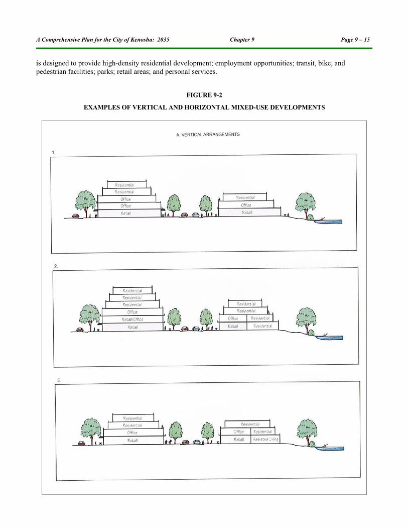
➢ Mixed-Use Development. This term refers to a development that contains a diversity of land uses that are compatible and complementary to each other. It typically consists of residential development in a mixed-use setting with compatible commercial and/or institutional uses that provide a desirable environment for a variety of housing types, including those for elderly and persons with disabilities (senior and assisted living facilities), seeking the benefits of proximity to places of employment as well as civic, cultural, commercial, health, and other urban amenities. Mixed uses, as illustrated in Figure 9-2, pages 15 and 16, can be horizontal or vertical arrangements, or a combination thereof. Horizontal mixed uses typically include residential structures intermixed with, or located adjacent to, buildings containing complementary commercial, institutional, or other civic uses. Vertical mixed uses may include residential living units on the ground/first floor level (convenient for elderly and persons with disabilities)

A Comprehensive Plan for the City of Kenosha: 2035 Chapter 9 Page 9 – 14
in the rear of compatible businesses (only permitted in the B-4 Mixed-Use District); or commercial uses located on the street level and residential uses located on upper levels, with offices potentially acting as a “transition” or buffer between retail activities and residential dwellings. General industrial uses should not be intermixed with residential or school uses. Suitable controls should be in place to ensure compatibility between different land uses.
➢ Traditional Neighborhood Development (TND). This term refers to very compact, pedestrian-oriented, mixed-use neighborhoods typically characterized by a grid like street system, with possibly alleyways, and street-oriented setbacks and building designs. The overall design, including the layout of “complete” streets with sidewalks and wheelchair accessibility, encourages walking and bicycling as alternatives to automobile transportation within the neighborhood. TND is suitable for areas that have access to public facilities, such as schools and civic buildings, which are in close proximity. TNDs are typically designed around a commercial center or other identifiable center (i.e. park or civic center) that functions as a neigh-borhood gathering place.
➢ Transit-Oriented Development (TOD). This term refers to compact, mixed-use development whose in-ternal design is intended to maximize access to a transit (bus or rail) stop located within or adjacent to the development, as illustrated in Figure 11-1 in Chapter 11. Within the development, commercial uses and medium- to higher-density residential uses are located near the transit stop. The layout of streets and sidewalks with curb cuts or ramps provides convenient walking and bicycling access and wheelchair ac-cess to the transit stop. Such development may be appropriate around existing or future commuter rail stations.
In addition to plans for developing neighborhoods, detailed plans should also be prepared for mature neighborhoods or special-purpose districts showing signs of land use instability or deterioration. Such plans should identify areas recommended for redevelopment to a different use, areas recommended for rehabilitation, any local street re-alignments or improvements, and other public utility and facility improvements. Special consideration should be given in such planning to overcoming contamination problems at, and reuse of, brownfields. Redevelopment plans should seek to preserve those historic, cultural, and natural features and features of the urban landscape which provide for neighborhood identity within the larger urban complex. Such plans should maximize opportunities for the provision of living arrangements and amenities that are unique to older communities in the City, such as “downtown” housing and urban waterfront development.
Community Design and Sustainability TechniquesOne of the goals of the comprehensive plan is to achieve communities that are aesthetically pleasing and efficient while promoting a sustainable land use pattern that meets the social, economic, physical, ecological, and quality-of-life needs of the County and all its communities, maintaining a sense of place in urban and rural areas.
Community DesignCommunity design includes beautification techniques, such as tree planting programs, Main Street redevelop-ment, neighborhood enhancements, and the aesthetic benefits of buffering and landscaping. A well-designed County will attract quality development, improve the visual character, and enhance important natural resources. Community design is an integral part of the planning process, and directly affects land use patterns, transportation planning, and neighborhood livability.
As the City of Kenosha’s population grows, community design concepts and methods should be addressed to accommodate new residential, commercial, utility, community facility, and industrial development. Development designs should be environmentally sensitive and complement adjacent land uses. New growth can be accommodated through compatible infill, higher density mixed-use development, and redevelopment areas. Mixed-use development, Traditional Neighborhood Development (TND), and Transit-Oriented Development (TOD) are types of development associated with high-density areas. Mixed-use development may help minimize street and utility requirements and promote alternative modes of transportation, particularly if such development
A Comprehensive Plan for the City of Kenosha: 2035 Chapter 9 Page 9 – 15
is designed to provide high-density residential development; employment opportunities; transit, bike, and pedestrian facilities; parks; retail areas; and personal services.
FIGURE 9-2
EXAMPLES OF VERTICAL AND HORIZONTAL MIXED-USE DEVELOPMENTS

A Comprehensive Plan for the City of Kenosha: 2035 Chapter 9 Page 9 – 16
FIGURE 9-2 (CONTINUED)
EXAMPLES OF VERTICAL AND HORIZONTAL MIXED-USE DEVELOPMENTS

A Comprehensive Plan for the City of Kenosha: 2035 Chapter 9 Page 9 – 17
Neighborhood planning and subdivision designs should also incorporate pedestrian/bike trails, pathways, and/or bikeways as means of transportation or recreational activity. It is also important that new development be designed so it is compatible with established development, and be set back and/or provide shoreline protection measures along Lake Michigan bluffs and shorelines to control erosion and provide bluff and shoreline stability. Commercial and office uses should be grouped in commercial nodes or located in suitable locations in mixed-use neighborhoods. Ideally, mixed-use development in redevelopment areas should promote the use and improvement of existing infrastructure, increase pedestrian activity and transit use, and provide needed goods and services for nearby residents. Industrial uses and business and industrial parks should be developed in areas served by existing infrastructure with convenient access to highway, rail, or air services. Major business parks should ideally be served by transit to serve employees and have pedestrian and bicycle access and facilities between transit (bus or rail) stops and employment centers.
The use of flexible zoning techniques is encouraged to accommodate a variety of housing options, such as infill development, live-work units, planned unit developments (PUDs), planned development districts (PDDs), TNDs, TODs, and cluster development. “Universal Design” and “Visitability” design concepts, which provide increased accessibility for persons with disabilities by providing homes with wider doors and hallways, step-free level en-trances and other surfaces, locating key rooms on ground or first floor levels, and other features, should also be considered during the review of proposed development projects. Building designs should minimize the apparent scale of structures and emphasize the sense of place for the streetscape. It is also recommended that a variation in lot and home sizes in the same neighborhood be provided within the framework of established minimum lot sizes and home sizes to avoid a repetitious facade on the homes in a subdivision or neighborhood, and also provide housing for a range of household incomes.
SustainabilityDevelopment and redevelopment projects are integral parts of a green economy with intentions for sustainability. “Sustainable development” is a pattern of resource use that meets the needs of the present without compromising the ability of future generations to meet their own needs. Sustainability or “green” development should be practiced throughout the City of Kenosha and at government facilities, with the intent of improving air and water quality and conserving energy. All types of development should consider incorporating energy-efficient techniques or renewable energy such as solar energy, wind energy, high-efficiency lighting, and geothermal energy. Residential “green-related” development programs, such as Energy Star Qualified Homes, Green Built Home, and LEED, described in Chapter 10, provide initiatives that certify new homes and remodeling projects that meet sustainable building and energy standards. LEED promotes a whole-building approach to sustainability by recognizing performance in sustainable site development, water savings, energy efficiency, materials selection, and indoor environmental quality.
New and existing development should include techniques and designs that protect and improve water quality. Some examples of water quality management and conservation practices include maximizing porous and permeable materials and permeable soils;4 vegetated buffers and infiltration zones; incorporating infiltration and retention areas such as rain gardens, green (vegetated) roofs, bioswales, bioinfiltration trenches and basins, and vegetated buffer or perimeter strips; and installing “gray water” systems, which allows certain water that has been used for hand washing, showering, and any other uses from sinks, showers, or washing machines to be reused for other purposes, especially landscape irrigation. Rain barrels, xericscaping, dual-flush toilets, low-flow showerheads and faucets, and energy-efficient washing machines, dishwashers, and water heaters should also be considered as water quality management practices.
Other Development Tools Basic important regulatory tools that can be used to help direct the design of development and redevelopment, as well as achieve or implement plan recommendations, include zoning, land division, and official mapping ordinances, which are discussed in Chapters 6 and 15.
4The use of permeable pavement should generally be avoided if chlorides (salt) are directly applied for deicing and anti-icing, or if the area of permeable pavement will receive runoff from paved areas to which chlorides are applied.

A Comprehensive Plan for the City of Kenosha: 2035 Chapter 9 Page 9 – 18
Form-based zoning is an emerging concept that is flexible and generally places more emphasis on physical building and site design attributes (“form”- i.e. mass, scale, layout) and less emphasis on the regulation of specific uses and certain measurable regulations than conventional zoning. The use of form-based zoning is most likely applicable where a diversity of uses is desired and to allow buildings to accommodate different uses over time. Alternatively, hybrid zoning is another emerging concept that attempts to achieve the same results as form-based zoning by meshing conventional zoning codes with design standards.
Conservation techniques that are applicable to natural and rural areas and help retain rural or “country” character are discussed in Chapter 8. These include conservation easements, cluster development, lot averaging, purchase of development rights, and transfer of development rights. Examples of conservation subdivision designs are provided in Figures 8-1 through 8-4 in Chapter 8.
PART 3: CITY OF KENOSHA LAND USE PLAN
The following section provides more detail on land use categories depicted on Map 9-6, page 20, Land Use Plan Map for the City of Kenosha 2035.
Map 9-6, page 9, shows the Land Use Plan Map for the City of Kenosha for the year 2035. The map includes areas within the City of Kenosha as of December 2008, areas adjacent to the City of Kenosha in the Town of Bristol included in the Bristol Neighborhood Plan, and areas in the Town of Somers where properties will be annexed into the City of Kenosha under the terms of a boundary agreement between the City of Kenosha and the Town. The Land Use Plan Map is a composite of the neighborhood plans adopted by the City of Kenosha. Planned land use categories were developed by City of Kenosha staff for portions of the City of Kenosha not included in a neighborhood plan, based on existing zoning, surrounding land uses, and local knowledge. Figure 9-3, page 19, presents a comparison of the percentage of the City of Kenosha devoted to various types of planned land uses in 2035.
The City of Kenosha has a long history of land use planning. The Kenosha City Plan was completed in 1925 by the firm Harland Bartholomew & Associates, one of the leading and most respected planning firms of the time. The plan was based on the “City Beautiful” movement, and “established the location and designation of major thoroughfares, street widths, building setbacks, and general land use locations. The concept of each elementary school having its own neighborhood playground came from the City plan, as did the notion that all residents should be within walking distance of a neighborhood park.”5
The City has actively continued its land use planning activities, most notably through participation in the preparation and update of a comprehensive plan for the Kenosha Urban Planning District in 1967 and 1995, respectively; and through the preparation of detailed neighborhood plans for much of the City.
Map 9-6, page 20, includes the neighborhood plans prepared for the following neighborhoods: Bristol, Columbus, CTH HH, Gateway, Green Bay Road/60th Street, Harborpark, Hillcrest, Kenosha Corridor Land Use Plan, Lincoln, McKinley-Roosevelt Railroad Corridor Area, Parkside South, Pike Creek, St. Peter’s, South Sheridan, Tirabassi, Washington Park, and Wilson. The location of these neighborhoods is shown on Map 9-7, page 21. Table 1-1 in Chapter 1 provides the dates each neighborhood plan was adopted by the City Plan Commission and Common Council.
5 Ray Forgianni, former City Planner, in the Forward to the Kenosha City Plan: 1925, 75th Anniversary Edition, published in 2000.

A Comprehensive Plan for the City of Kenosha: 2035 Chapter 9 Page 9 – 19
FIGURE 9-3
PLANNED LAND USES IN THE CITY OF KENOSHA PLANNING AREA BASED ON THECITY OF KENOSHA LAND USE PLAN MAP: 2035
The land use plan categories shown on the neighborhood plans were generalized into a standard set of land use categories in order to develop the City-wide Land Use Plan Map. The relationship between the land use plan categories shown on Map 9-6, page 20, and neighborhood plan land use categories are shown in Appendix 9-1. Appendix 9-1 also shows the relationship between the neighborhood and City Land Use Plan categories to the categories shown on the County Land Use Plan Map (Map 9-2, page 7). The number of acres in each land use plan category on the City Land Use Plan Map are shown on Table 9-4, page 22, for the area within existing City limits (as of December 2008) and adjacent areas included in the City planning area. The City’s planning area includes lands that are planned to be annexed by the City under the terms of intergovernmental agreements with the Towns of Bristol and Somers.
Map 9-6, page 20, includes primary and secondary environmental corridors and isolated natural resource areas as basic land use plan categories. Environmental corridors and isolated natural resource areas were not included on the neighborhood plans, except for the “Corridor” plan. Inclusion of such features on the City Land Use Plan Map is therefore an update to the neighborhood plans. Map 9-6, page 20, also includes wetlands in the City’s Lowland Resource Conservancy zoning district (C-2), which are wetlands whose boundaries have been staked based on field investigations. Wetlands zoned Lowland Resource Conservancy (C-1) by Kenosha County in those portions of the Town of Somers within the City’s planning area are also included on Map 9-6, page 20. Wetlands shown on both a neighborhood plan and on the 2005 Wisconsin Wetland Inventory (WWI) maps are also shown on the Land Use Plan Map. There are additional wetlands included on the 2005 WWI maps that are

A Comprehensive Plan for the City of Kenosha: 2035 Chapter 9 Page 9 – 20
not shown on the City’s Land Use Plan Map. Such wetlands will be placed in the C-2 zoning district by the City at the time they are identified and staked as part of a field investigation.
MAP 9-6
LAND USE PLAN MAP FOR THE CITY OF KENOSHA: 2035
The 100-year floodplain boundary is shown as an overlay on Map 9-6. Floodplains will be updated once the Map Modernization program currently underway by FEMA is completed. Shoreland zoning areas in the City planning area that were within a Town in 1980,6 and therefore subject to Kenosha County shoreland zoning regulations, are also shown as an overlay. Under Section 59.692(7) of the Wisconsin Statutes, County shoreland zoning regulations continue to apply in areas annexed by a City or Village after May 7, 1982, unless the City regulations are equally or more restrictive than the County shoreland zoning regulations. County shoreland zoning regulations continue to apply in shoreland areas annexed by the City of Kenosha.
Medium-Density ResidentialThe medium-density residential use category occupies 3,889 acres, or about 20 percent of the City of Kenosha, on the 2035 Land Use Plan Map. Medium-density residential uses are envisioned to occur in a variety of residential neighborhoods providing a full complement of basic neighborhood amenities including a school, park, and
6 Information on annexations between 1980 and May 7, 1982 is not available.

A Comprehensive Plan for the City of Kenosha: 2035 Chapter 9 Page 9 – 21
shopping area. The average density of medium-density residential areas should be one home per 7,000 to 39,999 square feet of area, predominantly allowing for attached and detached single family homes.
MAP 9-7
NEIGHBORHOOD PLANS ADOPTED BY THE CITY OF KENOSHA: 2009
Medium-High Density ResidentialThe medium-high density residential use category occupies 2,534 acres, or about 13 percent of the City of Kenosha 2035 Land Use Plan Map. Medium-high density residential uses areas are envisioned to occur in a variety of residential neighborhoods, providing a full compliment of basic neighborhood amenities including a school, park, and shopping area. The average density of medium-high density residential areas should be tween 3,000 to 6,999 square feet per dwelling unit, allowing for single and two family homes.
High-Density ResidentialHigh-density residential uses occupy 1,195 acres, or about six (6) percent of the City of Kenosha, on the 2035 Land Use Plan Map. High-density residential uses are envisioned to occur in a variety of residential neighborhoods providing a full complement of basic neighborhood amenities including a school, park, and shopping area. The average density in this category would be less than 6,000 square feet per dwelling unit, allowing for two-family homes and multi-family buildings.

A Comprehensive Plan for the City of Kenosha: 2035 Chapter 9 Page 9 – 22
TABLE 9-4
PLANNED LAND USES IN THE CITY OF KENOSHA PLANNING AREA BASED ONTHE CITY OF KENOSHA LAND USE PLAN MAP: 2035
Land Use Category AcresPercent of
Subtotal (Urban or Nonurban)
Percent of Total
Urban
Medium-Density Residentiala 3,889 21.1 19.6
Medium-High Density Residentialb 2,534 13.7 12.7
High-Density Residentialc 1,195 6.5 6.0
SUBTOTAL 7,621 41.3 38.4
Mixed Use 151 0.8 0.8
Commercial 1,507 8.5 7.9
Industrial 2,477 13.4 12.5
Governmental, Institutional, and Office 1,269 6.9 6.4
Park and Open Space 938 5.1 4.7
Street and Highway Rights-of-Wayd 3,101 16.8 15.6
Railroad Rights-of-Way 146 0.8 0.7
Transportation, Communications, and Utilities 1,184 6.4 6.0
URBAN SUBTOTAL 18,461 100.0 92.9
Nonurban
Primary Environmental Corridore 546 39.0 2.8
Secondary Environmental Corridore 186 13.3 0.9
Isolated Natural Resource Areae 317 22.6 1.6
Wetlands Outside Environmental Corridors and Isolated Natural Resource Areas 17 1.2 0.1
Surface Water 334 23.9 1.7
NONURBAN SUBTOTAL 1,400 100.0 7.1
TOTAL 19,861 --- 100.0
Overlay Categories AcresPercent of Subtotal
Percent of Total
100-Year Floodplain 1,147 --- ---
Shoreland Zoning 2,001 --- ---
Airport Affected Area 11,153 --- ---Note: This table is based on the categories developed for the City of Kenosha Land Use Plan Map (Map 9-6, page20). This table includes
areas within the City's extraterritorial area that will be annexed into the City based on intergovernmental agreements with adjacent com-munities.
a Attached and detached single-family residential with an average density of 7,000 to 39,999 square feet per dwelling unit.b Single- and two-family residential with an average density of 3,000 to 6,999 square feet per dwelling unit.c Two- and multi-family residential with an average density of less than 6,000 square feet per dwelling unit.d Reflects year 2008 existing street and highway rights-of-way, planned public street rights-of-way included on the City's Official Map,
and proposed rights-of-way for the I-94 corridor, including interchanges, to be constructed in 2009 and 2010. Otherwise, future street rights-of-way are included in the future land use categories.
e Does not include associated surface water areas.
Source: City of Kenosha and SEWRPC.
Mixed-Use The mixed-use category occupies 151 acres, or just under one (1) percent of the City of Kenosha, on the 2035 Land Use Plan Map, and would include a mix of residential and compatible commercial and/or institutional uses. Parcels designated for mixed use should be developed in accordance with a development or redevelopment plan approved by the City of Kenosha. Development in this category would typically be subject to planned unit

A Comprehensive Plan for the City of Kenosha: 2035 Chapter 9 Page 9 – 23
development (PUD), traditional neighborhood development (TND), transit-oriented development (TOD), or mixed use related regulations in the applicable Zoning Ordinance. Mixed-use areas generally include traditional downtown business districts, infill development sites, and areas adjacent to arterial streets, highways, and transit stops (bus or rail) within higher density areas.
Commercial Commercial uses occupy 1,577 acres, or about eight (8) percent of the City of Kenosha, on the 2035 Land Use Plan Map. This category includes retail stores; services, such as drycleaners, barber or beautician shops, banks, and restaurants; and offices and professional services of doctors, dentists, architects, engineers, attorneys, computer programmers, graphic artists, insurance agents, financial planners, and other similar recognized professions and consultation services. This category may also include downtown business districts, neighborhood and community shopping centers, highway and regional shopping areas, financial institutions, and medical facilities.
Governmental, Institutional and OfficeThe governmental, institutional and office category occupies 1,269 acres, or about six (6) percent of the City of Kenosha, on the 2035 Land Use Plan Map. This category includes a variety of business uses such as the offices and professional services of doctors, dentists, architects, engineers, attorneys, computer programmers, graphic artists, insurance agents, travel agents, financial planners, and other similar recognized professions and consulta-tion services. This category may also include corporate headquarters, financial institutions, and medical facilities.
Industrial The plan envisions that the areas devoted to industrial land uses would occupy 2,477 acres, or about 13 percent of the City of Kenosha. This category would accommodate manufacturing and other industrial uses, such as ware-houses and outdoor storage of commercial vehicles and building materials.
Park and Open SpaceThe park and open space land use category includes lands developed with facilities for public and private outdoor recreation and publicly-owned indoor recreational facilities. It includes both public parks and privately-owned recreational areas, such as an ice rink and golf courses as well as undeveloped open space. The plan envisions that the areas devoted to park and open space would occupy 938 acres, or about five (5) percent of the City of Kenosha, in 2035. This acreage does not include the natural resource areas which are encompassed in the natural resource related land use categories such as the environmental corridor, isolated natural resource area, “other conservancy lands to be preserved”, and wetland categories.
Street and Highway Right-of-WayAll existing street and highway rights-of-way (as of December 2008), future street rights-of-way shown on adopted neighborhood plans, and the proposed right-of-way for the I-94 freeway corridor, including interchanges, currently under development, are shown on Map 9-6, page 20, as a separate category. Chapter 11 provides additional information regarding planned transportation facilities in the City of Kenosha. There are 3,101 acres, or about 16 percent of the City of Kenosha, within street and highway rights-of-way.
Transportation, Communication, and UtilityThis category includes transportation facilities other than street rights-of-way, such as airports, park-ride lots, and railroad rights-of-way. It also includes parcels used for private and public utilities that provide residents and businesses with electric power, natural gas, communications, water, and sewage and solid waste management facilities and services. This category occupies 1,184 acres, or about six (6) percent of the City of Kenosha, on the 2035 Land Use Plan Map.
LandfillThere are no landfills identified on the City of Kenosha 2035 Land Use Map. Landfills have the potential to be reclaimed for other uses. A complete inventory of former, inactive, and transitional landfills in the City of
A Comprehensive Plan for the City of Kenosha: 2035 Chapter 9 Page 9 – 24
Kenosha, as identified by the DNR, is provided in Map 9-5, page 11, and Table 9-3, page 12, and Map 13-4 and Table 13-14 in Chapter 13.
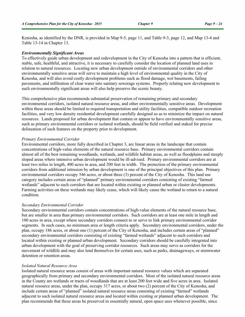
Environmentally Significant AreasTo effectively guide urban development and redevelopment in the City of Kenosha into a pattern that is efficient, stable, safe, healthful, and attractive, it is necessary to carefully consider the location of planned land uses in relation to natural resources. Locating new urban development outside of environmental corridors and other environmentally sensitive areas will serve to maintain a high level of environmental quality in the City of Kenosha, and will also avoid costly development problems such as flood damage, wet basements, failing pavements, and infiltration of clear water into sanitary sewerage systems. Properly relating new development to such environmentally significant areas will also help preserve the scenic beauty.
This comprehensive plan recommends substantial preservation of remaining primary and secondary environmental corridors, isolated natural resource areas, and other environmentally sensitive areas. Development within these areas should be limited to required transportation and utility facilities, compatible outdoor recreation facilities, and very low density residential development carefully designed so as to minimize the impact on natural resources. Lands proposed for urban development that contain or appear to have environmentally sensitive areas, such as primary environmental corridors or isolated wetlands, should be field verified and staked for precise delineation of such features on the property prior to development.
Primary Environmental Corridor Environmental corridors, more fully described in Chapter 3, are linear areas in the landscape that contain concentrations of high-value elements of the natural resource base. Primary environmental corridors contain almost all of the best remaining woodlands, wetlands, and wildlife habitat areas, as well as floodplains and steeply sloped areas where intensive urban development would be ill-advised. Primary environmental corridors are at least two miles in length, 400 acres in area, and 200 feet in width. The protection of the primary environmental corridors from additional intrusion by urban development is one of the principal objectives of this plan. Primary environmental corridors occupy 546 acres, or about three (3) percent of the City of Kenosha. This land use category includes certain areas of “planned” primary environmental corridors consisting of existing “farmed wetlands” adjacent to such corridors that are located within existing or planned urban or cluster developments. Farming activities on these wetlands may likely cease, which will likely cause the wetland to return to a natural condition.
Secondary Environmental CorridorSecondary environmental corridors contain concentrations of high-value elements of the natural resource base, but are smaller in area than primary environmental corridors. Such corridors are at least one mile in length and 100 acres in area, except where secondary corridors connect to or serve to link primary environmental corridor segments. In such cases, no minimum area or length criteria apply. Secondary environmental corridors, under the plan, occupy 186 acres, or about one (1) percent of the City of Kenosha, and includes certain areas of “planned” secondary environmental corridors consisting of existing “farmed wetlands” adjacent to such corridors and located within existing or planned urban development. Secondary corridors should be carefully integrated into urban development with the goal of preserving corridor resources. Such areas may serve as corridors for the movement of wildlife and may also lend themselves for certain uses, such as parks, drainageways, or stormwater detention or retention areas.
Isolated Natural Resource Area Isolated natural resource areas consist of areas with important natural resource values which are separated geographically from primary and secondary environmental corridors. Most of the isolated natural resource areas in the County are wetlands or tracts of woodlands that are at least 200 feet wide and five acres in area. Isolated natural resource areas, under the plan, occupy 317 acres, or about two (2) percent of the City of Kenosha, and include certain areas of “planned” isolated natural resource areas consisting of existing “farmed” wetlands adjacent to such isolated natural resource areas and located within existing or planned urban development. The plan recommends that these areas be preserved in essentially natural, open space uses whenever possible, since

A Comprehensive Plan for the City of Kenosha: 2035 Chapter 9 Page 9 – 25
these areas sometimes serve as the only available wildlife habitat in an area and provide natural diversity to the landscape. Isolated natural resource areas also lend themselves for certain uses such as parks, drainageways, or stormwater detention or retention areas.
Wetlands Outside Environmental Corridors and Isolated Natural Resource AreasThis category consists of primarily nonfarmed wetlands (wetlands with natural vegetation), typically less than five (5) acres in size, that are located outside environmental corridors and isolated natural resource areas. These areas contain soils that are poorly drained and support wetland vegetation during years of normal or high precipitation or periods of normal or high water table. This land use category also includes certain existing farmed wetlands that are located within parcels of existing or planned urban development (ranging from rural residential uses to in-dustrial uses), where farming activities may likely cease, and the wetland will revert to natural conditions. Wet-lands are regulated under State and Federal laws and City of Kenosha Ordinances. Development of wetlands, usually requiring them to be filled, is limited. Permits to allow development in wetlands generally require “mitig-ation,” which requires new wetlands to be created or existing degraded wetlands to be restored. Mitigation may be required on the same development site or in a different location. Wetlands under this land use category en-compass 17 acres, or less than one (1) percent of the City of Kenosha.
Development on Parcels Containing Environmentally Significant AreasWhere possible, this comprehensive plan recommends that urban development be located entirely outside of primary and secondary environmental corridors, isolated natural resource areas, and other environmentally significant areas. While calling for the preservation of primary environmental corridors, the plan recognizes that in some cases it may be necessary to allow very low density residential development on the upland portion of such lands. In addition to limited residential development, land uses such as transportation and utility facilities and certain recreational uses may also be accommodated within these environmentally significant areas without jeopardizing their overall integrity. Guidelines for the types of development that may be accommodated within various component natural resource features of environmental corridors are set forth in Table 8-1 in Chapter 8. Even though these guidelines are not exhaustive, with good judgment they may be extended to, and be used for the evaluation of, proposals for similar types of development not specifically listed.
Surface WaterThe surface water land use category includes lakes, ponds, and major rivers. Surface waters encompass 334 acres, or about two (2) percent of the City of Kenosha.
100-Year Floodplain (Overlay)Floodplains are identified as an overlay on the City of Kenosha Land Use Plan Map, and encompass 1,147 acres of the City of Kenosha. The floodplain overlay includes areas adjacent to rivers, streams, and lakes that are sub-ject to inundation by the 100-year recurrence interval flood event. Floodplains shown on Map 9-6, page 20, are based on the best information available at the time the map was prepared and include floodplains delineated as part of the Des Plaines and Pike River watershed studies; the Federal Emergency Management Agency (FEMA) 1981 Flood Insurance Study (FIS); the Lake Michigan floodplain elevation identified in a report titled “Revised Report on Great Lakes Open-Coast Flood Levels (Phase I),” prepared by the US Army Corps of Engineers in 1988, which updates elevations used for the 1981 FIS; and, in some cases, the floodplain delineations from the preliminary FEMA Map Modernization program underway as this comprehensive plan was being developed.
Since floodplains are continuously refined and amended, the City of Kenosha Department of City Development should be consulted for the most current floodplain delineations. A comprehensive update of floodplain mapping in Kenosha County is being conducted by FEMA, and is expected to be completed in 2010.
Land Use ProjectionsThe Comprehensive Planning Law requires the Land Use Element to include projections, in five-year increments, of future residential, agricultural, commercial, and industrial land uses. Due to the uncertainty in predicting the rate of future development, it was assumed for the purpose of fulfilling this requirement that the same amount of growth would occur in each five-year period. Table 9-5 sets forth the additional acreage in residential,
A Comprehensive Plan for the City of Kenosha: 2035 Chapter 9 Page 9 – 26
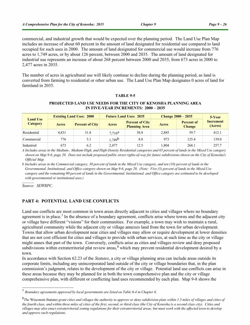
commercial, and industrial growth that would be expected over the planning period. The Land Use Plan Map includes an increase of about 60 percent in the amount of land designated for residential use compared to land occupied for such uses in 2000. The amount of land designated for commercial use would increase from 776 acres to 1,749 acres, or by about 126 percent, between 2000 and 2035. The amount of land designated for industrial use represents an increase of about 268 percent between 2000 and 2035, from 673 acres in 2000 to 2,477 acres in 2035.
The number of acres in agricultural use will likely continue to decline during the planning period, as land is converted from farming to residential or other urban use. The Land Use Plan Map designates 0 acres of land for farmland in 2035.
TABLE 9-5
PROJECTED LAND USE NEEDS FOR THE CITY OF KENOSHA PLANNING AREAIN FIVE-YEAR INCREMENTS: 2000 – 2035
Land Use Category
Existing Land Uses: 2000 Future Land Uses: 2035 Change 2000 – 2035 5-Year Increment
(Acres)Acres Percent of City AcresPercent of City Planning Area
AcresPercent of
Change
Residential 4,831 31.8 7,716a 38.8 2,885 59.7 412.1
Commercial 776 5.1 1,749b 8.8 973 125.4 139.0
Industrial 673 6.2 2,477 12.5 1,804 268.1 257.7A Includes areas in the Medium-, Medium-High, and High-Density Residential categories and 65 percent of lands in the Mixed Use category
shown on Map 9-6, page 20. Does not include proposed public street rights-of-way for future subdivisions shown on the City of Kenosha's Official Map.
b Includes areas in the Commercial category, 30 percent of lands in the Mixed Use category, and ten (10) percent of lands in the Governmental, Institutional, and Office category shown on Map 9-6, page 20. (Note: Five (5) percent of lands in the Mixed Use category and the remaining 90 percent of lands in the Governmental, Institutional, and Office category are estimated to be developed with governmental or institutional uses.)
Source: SEWRPC.
PART 4: POTENTIAL LAND USE CONFLICTS
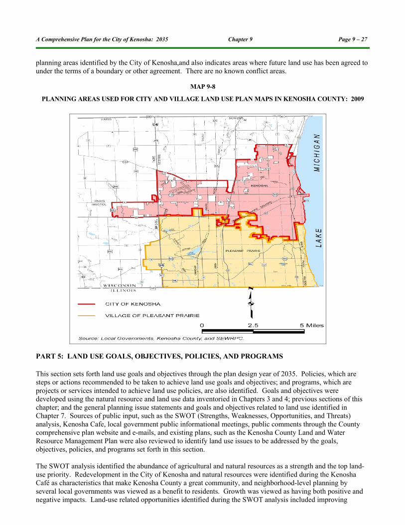
Land use conflicts are most common in town areas directly adjacent to cities and villages where no boundary agreement is in place.7 In the absence of a boundary agreement, conflicts arise where towns and the adjacent city or village have different “visions” for their communities. For example, a town may wish to maintain a rural, agricultural community while the adjacent city or village annexes land from the town for urban development. Towns that allow urban development near cities and villages may allow or require development at lower densities that are not cost efficient for cities and villages to provide with urban services, at such time as the city or village might annex that part of the town. Conversely, conflicts arise as cities and villages review and deny proposed subdivisions within extraterritorial plat review areas,8 which may prevent residential development desired by a town. In accordance with Section 62.23 of the Statutes, a city or village planning area can include areas outside its corporate limits, including any unincorporated land outside of the city or village boundaries that, in the plan commission’s judgment, relates to the development of the city or village. Potential land use conflicts can arise in these areas because they may be planned for in both the town comprehensive plan and the city or village comprehensive plan, with different or conflicting land uses recommended by each plan. Map 9-8 shows the
7 Boundary agreements approved by local governments are listed on Table 6-4 in Chapter 6.
8The Wisconsin Statutes grant cities and villages the authority to approve or deny subdivision plats within 1.5 miles of villages and cities of the fourth class, and within three miles of cities of the first, second, or third class (the City of Kenosha is a second class city). Cities and villages may also enact extraterritorial zoning regulations for their extraterritorial areas, but must work with the affected town to develop and approve such regulations.
A Comprehensive Plan for the City of Kenosha: 2035 Chapter 9 Page 9 – 27
planning areas identified by the City of Kenosha,and also indicates areas where future land use has been agreed to under the terms of a boundary or other agreement. There are no known conflict areas.
MAP 9-8
PLANNING AREAS USED FOR CITY AND VILLAGE LAND USE PLAN MAPS IN KENOSHA COUNTY: 2009
PART 5: LAND USE GOALS, OBJECTIVES, POLICIES, AND PROGRAMS
This section sets forth land use goals and objectives through the plan design year of 2035. Policies, which are steps or actions recommended to be taken to achieve land use goals and objectives; and programs, which are projects or services intended to achieve land use policies, are also identified. Goals and objectives were developed using the natural resource and land use data inventoried in Chapters 3 and 4; previous sections of this chapter; and the general planning issue statements and goals and objectives related to land use identified in Chapter 7. Sources of public input, such as the SWOT (Strengths, Weaknesses, Opportunities, and Threats) analysis, Kenosha Cafe, local government public informational meetings, public comments through the County comprehensive plan website and e-mails, and existing plans, such as the Kenosha County Land and Water Resource Management Plan were also reviewed to identify land use issues to be addressed by the goals, objectives, policies, and programs set forth in this section.
The SWOT analysis identified the abundance of agricultural and natural resources as a strength and the top land-use priority. Redevelopment in the City of Kenosha and natural resources were identified during the Kenosha Café as characteristics that make Kenosha County a great community, and neighborhood-level planning by several local governments was viewed as a benefit to residents. Growth was viewed as having both positive and negative impacts. Land-use related opportunities identified during the SWOT analysis included improving

A Comprehensive Plan for the City of Kenosha: 2035 Chapter 9 Page 9 – 28
blighted downtown areas and neighborhoods and planning for future growth, including new businesses and industries. Unplanned development, the loss of agricultural and natural resources, and the rate of development outpacing the ability to provide adequate public services were identified as threats during the SWOT analysis. Cluster zoning, green development, infill development, mixed use development, controlling growth, and preserving natural resources were identified as part of the vision for the future of the City of Kenosha developed as part of the Kenosha Cafe. Concerns about development negatively affecting farming and agricultural businesses were identified during local public informational meetings.
The Land Use Element is closely related to several of the other comprehensive planning elements. For example, natural resources identified for protection in the Agricultural, Natural, and Cultural Resources Element are important components of the Land Use Plan. The Land Use Plan Map must designate enough land for residential, commercial, and industrial uses to accommodate the projected increase in population, households, and jobs in the City of Kenosha in 2035. The Land Use Plan is also the foundation for the design of the transportation system and utility and community facilities systems. Because of this inter-relationship, the recommendations consisting of goals, objectives, policies, and programs are organized under the following issues, related to the other element chapters of this plan. The goals, objectives, policies, and programs that follow are intended for implementation by the City of Kenosha.
➢ Land Use Issue➢ Agriculture, Natural, and Cultural Resources Issue➢ Housing Issue➢ Transportation Issue➢ Utilities and Community Facilities Issue➢ Economic Development Issue➢ Intergovernmental Cooperation Issue
Overall Land Use IssueGoals:➢ Encourage a balanced and sustainable spatial distribution among various types of land uses to meet the
social, physical, and economic needs of residents. ➢ Accommodate the projected growth in population, households, and employment through the
comprehensive plan design year 2035.➢ Encourage sustainable development of land for business and residential use.
Objectives:➢ Encourage land uses that promote efficient development patterns and relatively low costs to all levels of
government.➢ Encourage development and redevelopment of land with access to existing infrastructure and public
services.➢ Encourage infill development.➢ Encourage an attractive and healthful physical and social environment with ample opportunities for high-
quality education, cultural activities, and outdoor recreation.Policies:➢ Provide a spatial distribution of various land uses on the land use plan map that will result in a
convenient, sustainable, and compatible arrangement of land uses.➢ Encourage land use development patterns that preserve and enhance the distinct character or “community
design” of local communities, including neighborhoods, and downtown areas.➢ Continue to develop local government land use plan maps that accommodate the projected growth in
population, households, and employment for the community through the comprehensive plan design year 2035.

A Comprehensive Plan for the City of Kenosha: 2035 Chapter 9 Page 9 – 29
➢ To the extent practicable, additional urban residential development should be located within neighborhoods or hamlets that contain necessary supporting local services, such as park, retail and service, and elementary school facilities.
➢ To the extent practicable, residential and employment-generating land uses should be located so as to provide opportunities for living close to work.
➢ Redevelopment of older, underutilized urban areas that are in need of revitalization and infilling of undeveloped land within existing urban service areas is preferred over new development on the outskirts of urban service areas.
➢ Encourage the use of conservation subdivision design concepts in rural- and suburban-density residential development to the extent practicable.
➢ Promote the use of mixed-use development, traditional neighborhood development (TND), transit-oriented development (TOD), planned unit development, and “green” development design concepts and other design guidelines, where applicable, to preserve or achieve the character desired by local communities for various areas, such as neighborhoods, hamlets, downtown areas, business parks, lakefronts, and other special planning areas.
➢ Consider requiring developers to provide noise mitigation measures for new residential and other noise-sensitive land uses along I-94. Mitigation measures may include site layout, the use of buffers, building design and materials, and other measures effective in reducing noise levels.
Programs:➢ Develop Land Use Plan and plan amendments for inclusion in the plan that can be implemented through
land use ordinances and identify and adopt needed amendments to such ordinances.➢ The City will continue to administer and enforce City zoning ordinances in accordance with the
recommendations of the adopted City comprehensive plan, and amend zoning ordinances and maps as necessary to implement the local comprehensive plan. Such zoning ordinance amendments may include the creation of new zoning districts in order to implement the County and local comprehensive plans, and establish design guidelines for site and building developments.
Agricultural, Natural, and Cultural Resources Issue Goals:➢ Preserve and protect agricultural lands outside planned urban (sewer) service areas that are best suited for
agricultural use. ➢ Encourage the protection, preservation, and appropriate use of natural resources, including Lake
Michigan.➢ Protect and enhance park and open space sites.➢ Preserve and enhance the historic and cultural resources and character of the City of Kenosha.
Objectives:➢ Encourage the preservation of open space as part of future development proposals.➢ Guide urban land uses to land that can sustain urban development.➢ Preserve primary environmental corridors, secondary environmental corridors, isolated natural resource
areas, nonfarmed wetlands, and other environmentally sensitive lands shown on Map 9-3, page 9, to reduce flood damage and soil erosion, protect water supplies and air quality, enhance wildlife populations, and continue to provide scientific, educational, and recreational opportunities.
➢ Encourage integrated water resource management of surface water, groundwater, and water dependent natural resources.
➢ Encourage the protection of Lake Michigan’s water quality and shoreline, including bluffs. ➢ Protect floodplains from incompatible land uses.

A Comprehensive Plan for the City of Kenosha: 2035 Chapter 9 Page 9 – 30
➢ Support the development of a comprehensive system of outdoor recreation sites and facilities, including trails, to allow residents adequate opportunities to participate in resource-oriented and nonresource-oriented outdoor recreation activities.
➢ Encourage development and redevelopment that is sensitive to the preservation of significant natural, historic, and cultural features, and is compatible with such uses.
➢ Encourage the preservation of historic or cultural structures and districts and archaeological sites.
Policies:➢ Encourage the protection of farmland identified for agricultural use on Map 9-2, page 7, (Kenosha County
Land Use Plan: 2035).➢ Encourage niche farming operations in Kenosha County, such as organic farms, orchards, and landscape
nurseries. ➢ Discourage urban land uses in areas identified as lands with natural limitations for building site
development on Map 9-4, page 10.➢ Do not allow urban land uses in primary and secondary environmental corridors and isolated natural
resource areas that do not comply with the guidelines summarized on Table 8-1 in Chapter 8.➢ One hundred-year recurrence interval floodplains should not be allocated to any development which
would cause or be subject to flood damage; and only authorized structures should be allowed to encroach upon and obstruct the flow of water in perennial stream channels and floodways.
➢ Implement local park and open space plans, including subsequent updates. ➢ Preserve historic structures and sites that have been listed on the National or State Registers of Historic
Places.➢ Encourage the preservation of local landmarks.➢ Encourage land use and development patterns that preserve land where archaeological features are
located.
Programs:➢ Incorporate the updated floodplain mapping from the DNR and FEMA into City Zoning map.➢ Consider amending the City of Kenosha General Zoning and Shoreland/Floodplain Zoning Ordinance to
address Lake Michigan bluff erosion more comprehensively and develop bluff setback requirements. ➢ Continue to preserve and maintain sites with significant historical or archaeological value, including local
landmarks.➢ Implement programs included in the Agricultural, Natural, and Cultural Resources Element (Chapter 8).➢ Incorporate parcels designated as natural areas and environmental corridors on the Land Use Plan Map
(Map 9-6, page 20), while protecting significant natural resources on such parcels.
Housing IssueGoal: ➢ Promote the provision of an adequate number of housing units and allocate sufficient land area for
housing demands to accommodate current and future populations.
Objective:➢ Promote a range of affordable housing choices for all income levels, age groups, and special needs
groups.Policies:➢ Encourage maintaining and enhancing the number and variety of housing units for elderly and persons
with disabilities.➢ Discourage building on poor soils or in other areas poorly suited for residential development.

A Comprehensive Plan for the City of Kenosha: 2035 Chapter 9 Page 9 – 31
Programs:➢ Encourage a full range of housing structure types and sizes, including single-family, two-family, and
multi-family dwelling units, in sewer service areas to provide affordable housing options for households of all income levels, ages, and special needs projected for Kenosha County in 2035.
➢ Encourage the development of nursing homes, community-based residential facilities, and other types of assisted living facilities for the elderly and persons with disabilities in appropriate locations.
➢ Implement programs included in the Housing Element (Chapter 10).➢ Promote reinvestment in established neighborhoods.
Transportation IssueGoal:➢ Provide and support a range of transportation opportunities that will effectively serve existing and
planned land uses.
Objectives:➢ Provide an integrated, efficient, and economical transportation system that interconnects and supports the
various land use activities in the City of Kenosha.➢ Encourage land use development patterns that reduce the need for new roads and major improvements to
existing roads.➢ Encourage land use development patterns, such as Transit-Oriented Development, that can be efficiently
served by public transportation and alternative transportation systems such as bicycle and pedestrian net-works.
Policies:➢ Ensure planned land uses are adequately served by street and highway networks.➢ Work to ensure consistency between regional, County, and local land use and transportation plans so that
the arterial street network, transit services, and bicycle and pedestrian facilities are appropriately sized and located to serve City of Kenosha residents.
➢ Discourage urban development in rural areas to minimize the need for new and widened streets and highways.
Programs:➢ Allocate a mix of residential land use categories, including urban density and multi-family/high density
residential uses, to the residential areas identified on Map 9-6 to develop a land use pattern that can be efficiently served by public transportation and alternative transportation systems.
➢ Allocate an appropriate mix of commercial and industrial land uses to the business areas identified in Map 9-6 to develop a land use pattern that can be efficiently served by public transportation and alternative transportation systems.
➢ The City and affected local governments should cooperatively identify study areas for integrated land use and transportation plans around I-94 interchanges and prepare plans for these areas to refine the land use development pattern set forth on Map 9-6.
➢ Continue to cooperate with SEWRPC to update the Kenosha County Jurisdictional Highway System Plan.➢ Promote efficient and safe vehicular access to land uses abutting street rights-of-way, consistent with
adopted access management plans and ordinances. ➢ The City of Kenosha will continue to develop neighborhood plans to provide proper guidance to
developers for connectivity of collector and land access streets between subdivisions.➢ Continue including facilities for walking and bicycling during the review and approval of all development
projects, including street and highway improvements, to provide an alternative to motor vehicle travel and to promote a healthy lifestyle.
➢ Review and adopt the I-94 Frontage Roads Access Management Vision Plan.

A Comprehensive Plan for the City of Kenosha: 2035 Chapter 9 Page 9 – 32
➢ Implement programs included in the Transportation Element (Chapter 11).➢ Support corridor enhancements to east-west thoroughfares between I-94 and the Lakefront, (e.g. 60th
Street, 52nd Street, etc.).
Utilities and Community Facilities IssueGoal:➢ Ensure provision of utilities and community facilities to efficiently and adequately serve City of Kenosha
residents, workers, and businesses.
Objective:➢ Encourage land uses and densities that promote efficient development patterns and relatively low
government and utility costs, including the establishment of “green” infrastructure, when possible.
Policies:➢ Ensure an adequate amount of land is allocated to utility uses, such as sewage treatment plants and
treatment lagoons and waters towers, on local land use plan maps to efficiently serve residents.➢ Ensure an adequate amount of land is allocated to institutional and governmental service uses, such as
governmental administration, safety, and assembly buildings; educational buildings and institutions; hospitals; and cemeteries on the Land Use Plan maps to efficiently serve residents.
➢ Promote the redevelopment of land with existing infrastructure and public services and the maintenance and rehabilitation of existing residential, commercial, and industrial structures.
➢ Support the development of land use patterns and water quality control programs to maintain or improve water quality and energy conservation and efficiency.
Programs: ➢ The City will continue to identify suitable sites for healthcare facilities, schools, telecommunications
facilities, libraries, and alternative energy sites, as appropriate, in cooperation with service providers.➢ Allocate an adequate amount of land on land use plan maps to allow for the necessary expansion of health
care facilities or construction of new health care facilities to meet the health care needs of County residents through 2035.
➢ Allocate an adequate amount of land on land use plan map to allow for the necessary expansion of schools or construction of new schools to meet the educational needs of City residents, in cooperation with school districts and other communities within the school district.
➢ Implement programs included in the Utilities and Community Facilities Element (Chapter 12).
Economic Development IssueGoals:➢ Provide for diversified, balanced, environmentally compatible business development that will offer a
variety of goods and services through conveniently located, well-designed business clusters while providing needed services for residents.
➢ Promote and identify adequate areas for business creation, retention, and expansion.
Objectives:➢ Direct commercial development by locating business and industrial land uses in clusters or in areas served
by State or County highways and arterial streets.➢ Encourage development and redevelopment of land with access to existing infrastructure and public
services while maintaining and rehabilitating existing residential, commercial, and industrial structures.➢ Promote an adequate amount of available and suitable land for businesses creation, retention, and
expansion to help retain existing businesses and attract new businesses.➢ Promote redevelopment of underutilized commercial and industrial land .

A Comprehensive Plan for the City of Kenosha: 2035 Chapter 9 Page 9 – 33
➢ Provide adequate land to accommodate the approximately 58,160 jobs projected to be located in the City of Kenosha in 2035.
Policies:➢ Promote commercial and industrial development in business/industrial parks and Tax Incremental
Finance (TIF) Districts.➢ Promote commercial redevelopment in the downtown and uptown areas of the City of Kenosha. ➢ Promote the remediation and reuse of environmentally contaminated sites for commercial and industrial
uses, where safe and feasible. ➢ Promote the development of new businesses, or business expansion, in areas with existing physical
infrastructure and community services, or in areas near or contiguous to existing service areas that can readily be served by extending infrastructure. An exception should be made for home-based businesses that do not require urban services.
➢ Encourage concentrated urban development within sewer service areas to minimize the conversion of farmland to urban uses.
Programs:➢ Allocate an adequate amount of land on the Land Use Plan Map (Map 9-6, page 20) to allow for the
construction and expansion of industrial and commercial sites, including industrial or commercial development or environmentally contaminated sites identified by the City of Kenosha as potential redevelopment sites.
➢ Encourage and support businesses that use “green” development techniques and focus on renewable, alternative, or sustainable energy resources.
➢ Implement programs included in the Economic Development Element (Chapter 13).➢ Promote redevelopment of environmentally contaminated sites or other sites identified by the City of
Kenosha for potential redevelopment.
Intergovernmental Cooperation IssueGoal: ➢ Encourage intergovernmental cooperation between all levels of government in land use planning.
Objective: ➢ Provide a structure for continuing dialog about land use planning and regulation and boundary issues
among the City of Kenosha and surrounding local governments.
Policy: ➢ Continue to share information on land use-related plans and ordinances among local governments.
Programs: ➢ Implement programs included in the Intergovernmental Cooperation Element (Chapter 14).➢ The City of Kenosha will provide inventory and additional planning maps produced for its comprehensive
plan to surrounding local governments, upon request.
* * * * *