characteristics of large snowfall events in the montane
TRANSCRIPT
WATER RESOURCES RESEARCH, VOL. 37, NO. 3, PAGES 675-688, MARCH 2001
Characteristics of large snowfall events in the montane western United States as examined using snowpack telemetry (SNOTEL) data
Mark C. Serreze, Martyn P. Clark, and Allan Frei Division of Cryospheric and Polar Processes, Cooperative Institute for Research in Environmental Sciences University of Colorado, Boulder
Abstract. Daily snow water equivalent records from the snowpack telemetry archive are used to assess spatiotemporal characteristics of large snowfall events over the montane western United States. The largest mean annual (leading) events are found in the Pacific Northwest and Sierra Nevada. The mean leading event lasting up to 72 hours typically accounts for 10-23% of the water equivalent of annual snowfall, with the largest contribution in the Arizona/New Mexico sector. For most of the West, snowfall events in the top quartile of station distributions are most common during midwinter, but those for the Rocky Mountain states and Utah are more common during late winter or spring. Colorado also shows a secondary peak in large events during November. Large midwinter snowfall events in the marine sectors, Idaho, and Arizona/New Mexico are spatially coherent in that when observed at one station, they tend to occur at surrounding stations. Large events are less spatially coherent for drier inland regions. When annual snowfall is anomalously positive, there tends to be an increase in the number of snow days as well as a shift in the distributions toward the larger event sizes. Opposite relationships are observed for negative annual snowfall anomalies. These findings are in accord with recent studies using lower elevation data, demonstrating that the probability of extreme precipitation events is altered during E1 Nino or La Nina conditions.
1. Introduction
Apart from the moist Pacific Northwest coast the climate of the western United States is characterized by desert to semi- arid conditions. The largest precipitation totals are found in high montan½ regions of limited areal extent. Between 50 and 70% of the annual precipitation in these areas falls as snow, with the bulk stored in the snowpack through the winter sea- son. Melt of the snowpack, in turn, provides most of the sur- face water in the western United States [Serreze e! at., 1999].
Water in the West is highly allocated between diverse user groups. Managers must balance the need to store as much water as possible in the W½st's large reservoir systems to guard against shortages associated with climate variability while also providing sufficient releases for hydropower generation, agri- culture, recreational use, and fish habitat. Reservoir space must also be maintained to protect downstream farms, homes, and businesses from flooding. Given the west's growing popu- lation, changes in institutional practices [Putwarty, 1995], and the potential for climate change, meeting future water needs will present an increasingly formidable management challenge. Of principal concern are possible shortages; the U.S. Bureau of Reclamation has indicated that if the west experienced a dry period such as occurred from 1931 to 1940, the water needs of the lower Colorado River Basin would not be met [et-Ashry and Gibbons, 1988].
Recognition of these issues has fostered a growing body of literature addressing snowpack and streamflow variability and their causes. Much of this research has focused on the E1 Nino
Copyright 2001 by the American Geophysical Union.
Paper number 2000WR900307. 0043-1397/01/2000WR900307509.00
Southern Oscillation (ENSO) [e.g., Cayan and Peterson, 1989; Redmond and Koch, 1991; Cayan and Webb, 1992; Cayan, 1996; Cayan et at., 1999; Clark et at., 2001]. This stems from recog- nition that the onset of E1 Nino or La Nina conditions can be
generally predicted several months in advance. While signals can vary widely both regionally and between individual E1Nino and La Nina events, E1 Nino conditions tend to be associated with below-normal precipitation and snowfall over the Pacific Northwest and above-normal precipitation and snowfall over the southwest, with generally opposing signals during La Nina conditions.
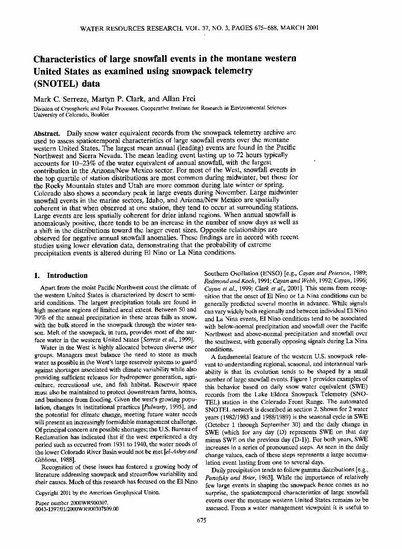
A fundamental feature of the western U.S. snowpack rele- vant to understanding regional, seasonal, and interannual vari- ability is that its evolution tends to be shaped by a small number of large snowfall events. Figure 1 provides examples of this behavior based on daily snow water equivalent (SWE) records from the Lake Eldora Snowpack Telemetry (SNO- TEL) station in the Colorado Front Range. The automated SNOTEL network is described in section 2. Shown for 2 water
years (1982/1983 and 1988/1989) is the seasonal cycle in SWE (October 1 through September 30) and the daily change in SWE (which for any day (D) represents SWE on that day minus SWE on the previous day (D-l)). For both years, SWE increases in a series of pronounced steps. As seen in the daily change values, each of these steps represents a large accumu- lation event lasting from one to several days.
Daily precipitation tends to follow gamma distributions [e.g., Panofsky and Brier, 1963]. While the importance of relatively few large events in shaping the snowpack hence comes as no surprise, the spatiotemporal characteristics of large snowfall events over the montane western United States remains to be
assessed. From a water management viewpoint it is useful to
675
676 SERREZE ET AL.: LARGE SNOWFALL EVENTS IN WESTERN UNITED STATES
400
300
200
1 oo
, ,[LA, KE, EL.,DO, RA, 8,2/8,3], ,
0 N D J F M A M J J A S
4O0
300
200
1 oo
,[LA, KE, EL, DO, RA, 8,8/8,9], ,
0 N D J F M A M J J A S
4O
2O
o
-20
-4O
4O
2O
-4O
0 N D J F M A M J J A S 0 N D J F M A M J J A S
Figure 1. (top) Snow water equivalent and (bottom) its daily change for the Lake Eldora snowpack telem- etry (SNOTEL) station (Colorado Front Range) for the 1982/1983 and 1988/1989 water years (October 1 through September 30). Results are based on snow pillow data.
get a better handle on the regional and interannual variability of large events and their seasonality, as it may be the presence or absence of only one or several such events that determines a snowpack excess or deficit. The general regional character- istics of precipitation and snowpack anomalies associated with ENSO have been well established. However, for potential ap- plications such as planning reservoir releases and forecasting avalanche risk, the utility of ENSO-based seasonal predictions could be enhanced if accompanied by knowledge of the like- lihood of particularly large snowfall events. Recent research indicates that the presence or absence of ENSO conditions can, indeed, alter the probability of extreme precipitation and streamflow events [Gershunov, 1998; Gershunov and Barnett, 1998; Cayan et al., 1999]. Higgins et al. [2000] show that for the West Coast, the largest fraction of extreme precipitation events occur during neutral winters just prior to the onset of E1 Nino. However, these studies have relied on precipitation records primarily restricted to lower elevations.
The present paper uses daily resolution SNOTEL data over the water years 1980/1981 to 1997/1998 to assess statistics of the water equivalent of large snowfall events. We also examine
the spatial coherence of large events and associations between anomalies in the water equivalent of annual snowfall and the probability of large events. In a previous study [Serreze et al., 1999], SNOTEL data were used to assess the mean seasonal cycle and interannual variability in SWE across the western United States. The present focus on event characteristics is intended to build upon this effort.
2. SNOTEL Network
Measurements of the seasonal snowpack began in the 1910s in California and became much more widespread in the late 1930s. These efforts evolved into the snow course network, maintained by the U.S. Department of Agriculture cooperative snow survey program and coordinated by the Natural Re- sources Conservation Service, with partners in Arizona, Colo- rado, Idaho, Montana, Nevada, New Mexico, South Dakota, Oregon, Utah, Washington, and Wyoming. The California De- partment of Water Resources has an independent program. The snow course network peaked in the 1970s at almost 2000 sites. SWE is measured manually at a number of locations
SERREZE ET AL.: LARGE SNOWFALL EVENTS IN WESTERN UNITED STATES 677
3OOO
ß 2000
••1ooo 5oo
,
o .
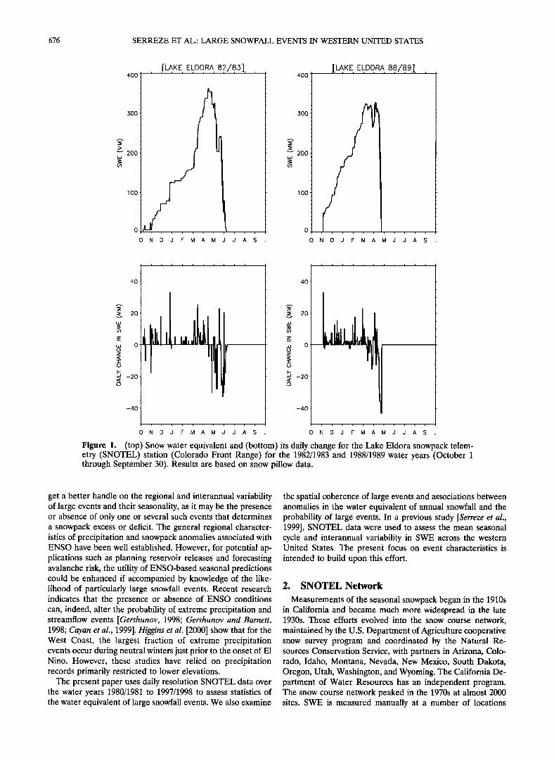
Figure 2. Distribution of SNOTEL stations (small squares), generalized topography (shading), and eight regions for focused analyses. The regions and the median elevation of the stations represented (in parenthe- ses) are (1) Pacific Northwest (1422 m), (2) Sierra Nevada (2439 m), Blue Mountains, Oregon (1646 m), (4) Idaho/western Montana (1905 m), (5) NW Wyoming (2479 m), (6) Utah (2774 m), (7) Colorado (3037 m), (8) Arizona/New Mexico (2418 m). Figure 2 is adapted from Serreze et al. [1999] (see that paper for additional information including the latitude/longitude boundaries of the regions and the number of station included).
along each course, generally on or about the beginning of each month from January through June (most frequently in April) [National Resources Conservation Service, 1988].
The newer automated SNOTEL network was designed to supplement, and to some extent replace, snow course records. SNOTEL sites were colocated with those snow course sites
which correlated well with streamflow [Schaefer and Johnson, 1992]. Emphasis was given to automating snow course sites to which access is particularly hazardous or costly. Daily SWE records are generally available from the early 1980s onward, but they are available back to the 1963/1964 season at some sites. Since the early 1980s, daily precipitation has been mea- sured, and in the late 1980s, minimum and maximum daily air temperature began to be reported. At present, there are over 600 SNOTEL sites across the western United States (Figure 2).
SWE is measured by "snow pillows," which record the weight of the overlying snowpack. Precipitation gauges have a 30.5-cm orifice and utilize an Alter wind shield to minimize
undercatch. Once daily, just after midnight, a system-wide poll is conducted, and each site transmits data for the previous day. Data capture is based on a meteor burst telemetry system which uses the reflection of radio signals by ionized meteor trails. Precipitation gauges and the snow pillows are reset on
October 1 of each year. Each site is powered by a battery pack charged from solar panels.
Few climate studies have used SNOTEL data; most have focused on the monthly snow course records. Besides Serreze et al. [1999], Mock [1996] used precipitation gauge data from SNOTEL sites along with other station records to examine seasonal aspects of western U.S. precipitation. McGinnis [1997] used daily positive SWE changes from the pillow data in conjunction with doubled CO2 circulation fields from a general circulation model in a downscaling approach to assess possible future changes in snowfall over the Colorado Plateau. The limited use of SNOTEL data in climate research reflects the
relatively short records that are available, concern as to how representative the point measurements are of surrounding snowpack conditions, and questions regarding data quality.
Serreze et al. [1999] compared April 1 SWE from the pillow records with April 1 SWE from 75 colocated snow courses. The April 1 SWE is commonly used by water managers as an indicator of seasonal snowmelt runoff. At 51 (68%) of the SNOTEL sites, SWE was within 15% of the snow course value At 21 (28%) of the SNOTEL sites, SWE was within 5% of the snow course value. Correlations between the two records of
April 1 SWE for individual years from 1980 through 1987
678 SERREZE ET AL.: LARGE SNOWFALL EVENTS IN WESTERN UNITED STATES
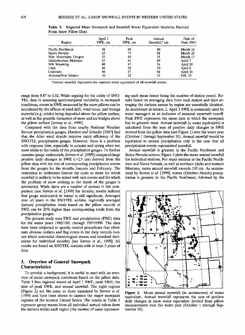
Table 1. Regional Mean Snowpack and Snowfall Water Equivalent Statistics Derived From Snow Pillow Data
April 1 Peak Annual Date of Region SWE, cm SWE, cm Snowfall, a cm Peak SWE
Pacific Northwest 58 69 90 Sierra Nevada 63 71 81
Blue Mountains, Oregon 33 40 51 Idaho/western Montana 55 61 69
NW Wyoming 40 47 54 Utah 44 50 59 Colorado 44 51 61
Arizona/New Mexico 10 21 31
March 16
March 25 March 17
April 7 April 19 April 6 April 14 Feb. 25
aAnnual snowfall represents the summed water equivalent of all snowfall events.
range from 0.87 to 0.92. While arguing for the utility of SNO- TEL data in assessing spatiotemporal variability in snowpack conditions, errors in SWE measured by the snow pillows can be introduced by the effects of wind drift, wind scour, and foreign material (e.g., sticks) being deposited above the pillow surface, as well as the possible formation of snow and ice bridges above the pillow surface [Serreze et al., 1999].
Compared with the data from nearby National Weather Service precipitation gauges, Doesken and Schaefer [1987] find that the Alter wind shields improve catch efficiency of the SNOTEL precipitation gauges. However, there is a problem with response time, especially in autumn and spring when wet snow sticks to the inside of the precipitation gauges. To further examine gauge undercatch, Serreze et al. [1999] compared large positive daily changes in SWE (>2.5 cm) derived from the pillow data with the size of corresponding precipitation events from the gauges for the months January and February. The restriction to midwinter limited the cases to those for which
snowfall is unlikely to be mixed with rain events and for which the problem of snow sticking to the inside of the gauges is minimized. While there are a number of caveats in this com-
parison (see Serreze et al. [1999] for details), results indicate that gauge undercatch in winter is still significant. Averaged over all years in the SNOTEL archive, regionally averaged January precipitation totals based on the pillow records of SWE can be 20% higher than corresponding totals from the precipitation gauges.
The present study uses SWE and precipitation (PRE) data for the water years 1980/1981 through 1997/1998. The data have been subjected to quality control procedures that elimi- nate obvious outliers and flag errors in the daily records (val- ues which contradict climatological means and standard devi- ations for individual months) [see Serreze et al., 1999]. All results are based on SNOTEL stations with at least 5 years of data.
3. Overview of General Snowpack Characteristics
To provide a background, it is useful to start with an over- view of mean snowpack conditions based on the pillow data. Table 1 lists regional means of April 1 SWE, peak SWE, the date of peak SWE, and annual snowfall. The eight regions (Figure 2) are the same as those examined by Serreze et al. [1999] and have been shown to capture the major snowpack regimes of the western United States. The results in Table 1 represent group means from all individual annual values from the stations within each region (the number of cases represent-
ing each mean hence being the number of station years). Re- sults based on averaging data from each station and then av- eraging the stations means by region are essentially identical. As mentioned in section 2, April 1 SWE is commonly used by water managers as an indicator of seasonal snowmelt runoff. Peak SWE represents the mean date at which the snowpack has its greatest mass. Annual snowfall (a water equivalent) is calculated from the sum of positive daily changes in SWE derived from the pillow data (see Figure 1) over the water year (October 1 through September 30). Annual snowfall would be equivalent to annual precipitation only in the case that all precipitation events represented snowfall.
Annual snowfall is greatest in the Pacific Northwest and Sierra Nevada sectors. Figure 3 plots the mean annual snowfall for individual stations. For many stations in the Pacific North- west and Sierra Nevada, as well as northern Idaho and western Montana, mean annual snowfall exceeds 100 cm. As summa-
rized by Serreze et al. [1999], winter (October-March) precip- itation is greatest in the Pacific Northwest, followed by the
, ,
x ' ß
x ,
Figure 3. Mean annual snowfall (in centimeters) of water equivalent. Annual snowfall represents the sum of positive daily changes in snow water equivalent derived from pillow measurements over the water year (October 1 through Sep- tember 30).
SERREZE ET AL.: LARGE SNOWFALL EVENTS IN WESTERN UNITED STATES 679
Sierra Nevada. The effects of the greater precipitation in the Pacific Northwest are not evident in terms of peak SWE and April 1 SWE (Table 1). This is due to the comparatively high mean temperatures characterizing the Pacific Northwest re- lated to both marine influences and the comparatively low elevation of the SNOTEL stations in that region (Figure 2). Especially, early and late in the snow season, less of the avail- able precipitation falls as snow, and growth of the snowpack tends to be interrupted by melt events. The effect of high mean temperatures is particularly pronounced in the Arizona/New Mexico region. Here winter precipitation is roughly equal to that for Colorado, but because of the marginal climatic condi- tions, comparatively little falls as snow. The temperature effect is also seen in the date of peak SWE. For example, peak SWE occurs 3 weeks later in the cold NW Wyoming region as com- pared with the warm Pacific Northwest. Our dates for peak SWE differ by up to 13 days from those reported by Serreze et al. [1999], who based theirs on the mean seasonal cycle rather than the date of peak SWE for individual years. We consider the present technique to provide a more accurate assessment.
A useful variable for understanding regional differences in the seasonal snowpack that will be referred to in the present paper is the ratio between snow water equivalent and precip- itation (SWE/PRE). Serreze et al. [1999] calculated regional ratios using monthly sums of precipitation based on the gauge data and SWE at the end of the month minus that at the
beginning of the month. Ratios were also calculated on the basis of total precipitation from October 1 to April 1 and the April 1 SWE. The ratios included an adjustment for estimated precipitation undercatch. Monthly ratios were only defined when the monthly change SWE was positive (see Serreze et al. [1999] for details). The SWE/PRE ratio is largely a reflection of how much of the available precipitation falls as snow versus how much of the snowpack is lost because of melt events.
Being largely a temperature proxy, the ratio tends to be smaller in all months for the coastal and southern regions (the Pacific Northwest and Arizona/New Mexico) as compared with the continental regions (e.g., NW Wyoming). As expected, interannual variability in April 1 SWE for all regions is signif- icantly correlated with total precipitation. However, in warmer regions (the Pacific Northwest and Arizona/New Mexico) the SWE/PRE ratio is a better indicator than total precipitation of the April 1 snowpack. For example, linear correlations be- tween April 1 SWE and October 1 through April 1 precipita- tion in the Pacific Northwest and Arizona/New Mexico are 0.60
and 0.70, respectively. By comparison, corresponding correla- tions between April 1 SWE and the October 1 to April 1 SWE/PRE ratio are 0.89 and 0.86, respectively.
4. Mean Characteristics of Large Events Characteristics of large snowfall events are examined in
terms of (1) the mean size of the seasoWs largest event (termed here the "leading event"), (2) the fraction of annual snowfall accounted for by the leading event and by those in the top quartile (largest 25%) of annual event distributions, and (3) the seasonality of large snowfall events. All results are based on the pillow data and hence refer to water equivalent. The simplest definition of an event is a positive daily (24 hour) change in SWE. Some of the results that follow here and in subsequent sections use 24-hour events. Our assessments of leading events in the present section, however, account for the fact that a single snowstorm may last for multiple days.
In theory, one ought to be able to define multiple-day events from consecutive runs of positive daily SWE changes, but in practice, it can be difficult to define the end of one event and the beginning of the next. To examine this problem, event lengths based on consecutive positive daily SWE changes were calculated for each station using the complete SNOTEL ar- chive. The event lengths were then summarized as histograms for each region expressing the percent of events lasting 1 day, 2 days, 3 days, etc. Results (not shown) reveal that from 75% (Pacific Northwest) to 89% (Arizona/New Mexico) of events are of 3-days duration or less. In turn, events of 7-days duration or less account for >90% of events for each region. However, a few events (ranging from 4% in the Pacific NW to <1% in Arizona-New Mexico) last 10 days or longer. Inspection of the data reveals that in most (but not all) cases, such long-lived events are best interpreted as multiple events, separated by days with small positive SWE changes of magnitude corre- sponding to the snow pillow resolution of 0.254 cm (0.1 inch- es).
These results suggest that a minimum threshold of positive daily SWE change could be used to separate individual events (e.g., a daily positive change in SWE exceeding the pillow resolution). However, a 3-day limit seems to capture the ma- jority of events and provides for internally consistent compar- isons between different regions. In consideration, we base the leading event size for each station and year on a 3-day limit. We start by inspecting the 24-hour SWE changes. If a day had a positive SWE change, then the changes on the previous and subsequent day were inspected. Consecutive positive changes over day (D-l), day(D), and day(D+l) were then added to- gether. This summing procedure was then performed for the next day with a positive change in SWE and so on until all days with positive changes were accounted for. This' resulted in totals representing consecutive positive changes in SWE of up to 3-days (72 hours) duration. By this processes of defining "running sums," one event can share days with other events (i.e., events may overlap). The total number of events is iden- tical to that which would be defined using just the 24-hour changes. The largest (leading) event for each year and station was extracted.
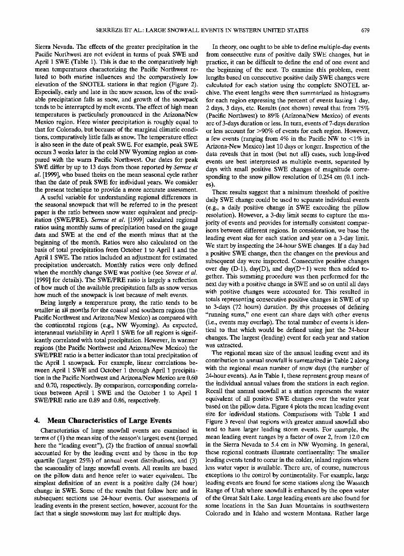
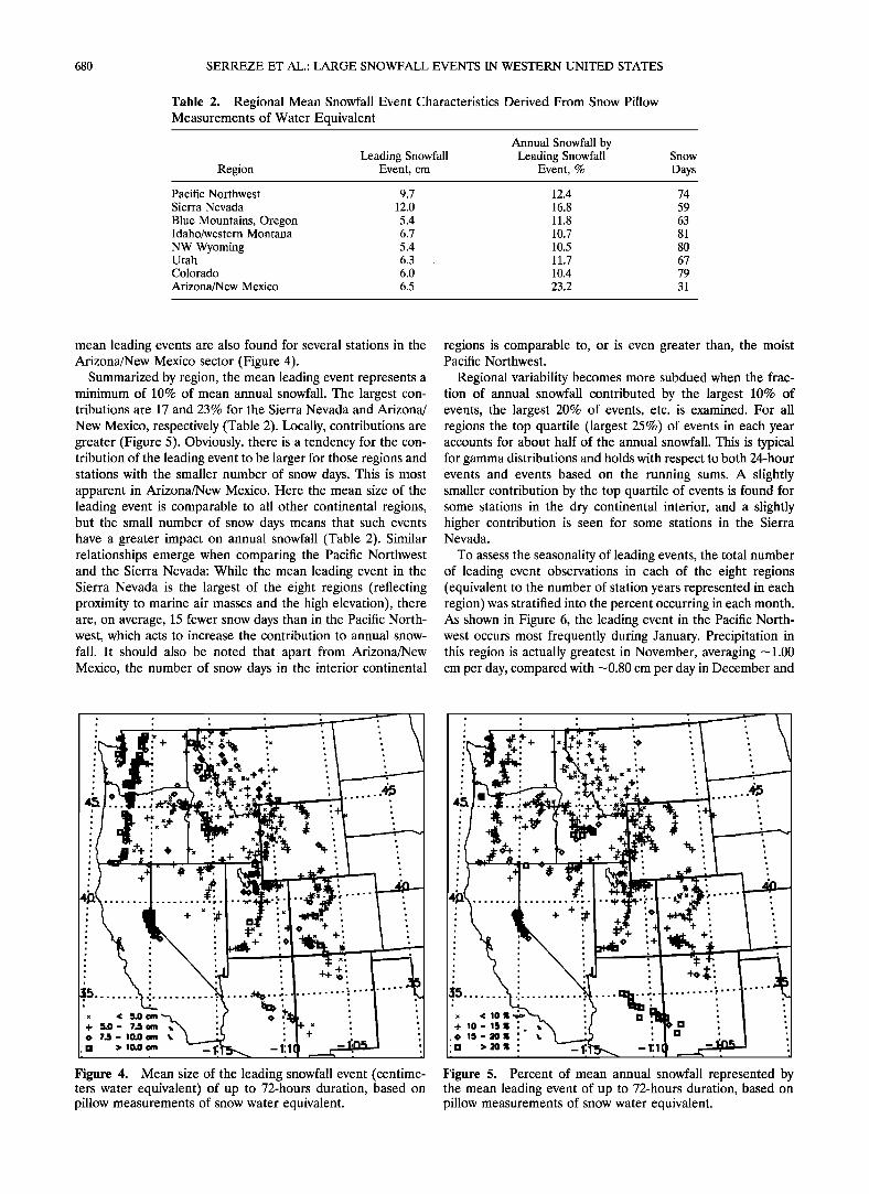
The regional mean size of the annual leading event and its contribution to annual snowfall is summarized in Table 2 along with the regional mean number of snow days (the number of 24-hour events). As in Table 1, these represent group means of the individual annual values from the stations in each region. Recall that annual snowfall at a station represents the water equivalent of all positive SWE changes over the water year based on the pillow data. Figure 4 plots the mean leading event size for individual stations. Comparisons with Table 1 and Figure 3 reveal that regions with greater annual snowfall also tend to have larger leading storm events. For example, the mean leading event ranges by a factor of over 2, from 12.0 cm in the Sierra Nevada to 5.4 cm in NW Wyoming. In general, these regional contrasts illustrate continentality: The smaller leading events tend to occur in the colder, inland regions where less water vapor is available. There are, of course, numerous exceptions to the control by continentality. For example, large leading events are found for some stations along the Wasatch Range of Utah where snowfall is enhanced by the open water of the Great Salt Lake. Large leading events are also found for some locations in the San Juan Mountains in southwestern
Colorado and in Idaho and western Montana. Rather large
680 SERREZE ET AL.: LARGE SNOWFALL EVENTS IN WESTERN UNITED STATES
Table 2. Regional Mean Snowfall Event Characteristics Derived From Snow Pillow Measurements of Water Equivalent
Annual Snowfall by Leading Snowfall Leading Snowfall
Region Event, cm Event, % Snow
Days
Pacific Northwest 9.7 12.4 74 Sierra Nevada 12.0 16.8 59
Blue Mountains, Oregon 5.4 11.8 63 Idaho/western Montana 6.7 10.7 81
NW Wyoming 5.4 10.5 80 Utah 6.3 11.7 67 Colorado 6.0 10.4 79
Arizona/New Mexico 6.5 23.2 31
mean leading events are also found for several stations in the Arizona/New Mexico sector (Figure 4).
Summarized by region, the mean leading event represents a minimum of 10% of mean annual snowfall. The largest con- tributions are 17 and 23% for the Sierra Nevada and Arizona/
New Mexico, respectively (Table 2). Locally, contributions are greater (Figure 5). Obviously, there is a tendency for the con- tribution of the leading event to be larger for those regions and stations with the smaller number of snow days. This is most apparent in Arizona/New Mexico. Here the mean size of the leading event is comparable to all other continental regions, but the small number of snow days means that such events have a greater impact on annual snowfall (Table 2). Similar relationships emerge when comparing the Pacific Northwest and the Sierra Nevada: While the mean leading event in the Sierra Nevada is the largest of the eight regions (reflecting proximity to marine air masses and the high elevation), there are, on average, 15 fewer snow days than in the Pacific North- west, which acts to increase the contribution to annual snow- fall. It should also be noted that apart from Arizona/New Mexico, the number of snow days in the interior continental
regions is comparable to, or is even greater than, the moist Pacific Northwest.
Regional variability becomes more subdued when the frac- tion of annual snowfall contributed by the largest 10% of events, the largest 20% of events, etc. is examined. For all regions the top quartile (largest 25%) of events in each year accounts for about half of the annual snowfall. This is typical for gamma distributions and holds with respect to both 24-hour events and events based on the running sums. A slightly smaller contribution by the top quartile of events is found for some stations in the dry continental interior, and a slightly higher contribution is seen for some stations in the Sierra Nevada.
To assess the seasonality of leading events, the total number of leading event observations in each of the eight regions (equivalent to the number of station years represented in each region) was stratified into the percent occurring in each month. As shown in Figure 6, the leading event in the Pacific North- west occurs most frequently during January. Precipitation in this region is actually greatest in November, averaging -1.00 cm per day, compared with -0.80 cm per day in December and
q-
•, < 5.Ocm + 5.0- 7.Scm .• ' • 7• - I0.0 cm ß ' [] > !o.o cm _
Figure 4. Mean size of the leading snowfall event (centime- ters water equivalent) of up to 72-hours duration, based on pillow measurements of snow water equivalent.
ß .
ß •
x < 10• ß
+ !0 - IS • '., ß ß
ß [] C, 15-20• ' ß ,
[] >•o• : -1
Figure 5. Percent of mean annual snowfall represented by the mean leading event of up to 72-hours duration, based on pillow measurements of snow water equivalent.
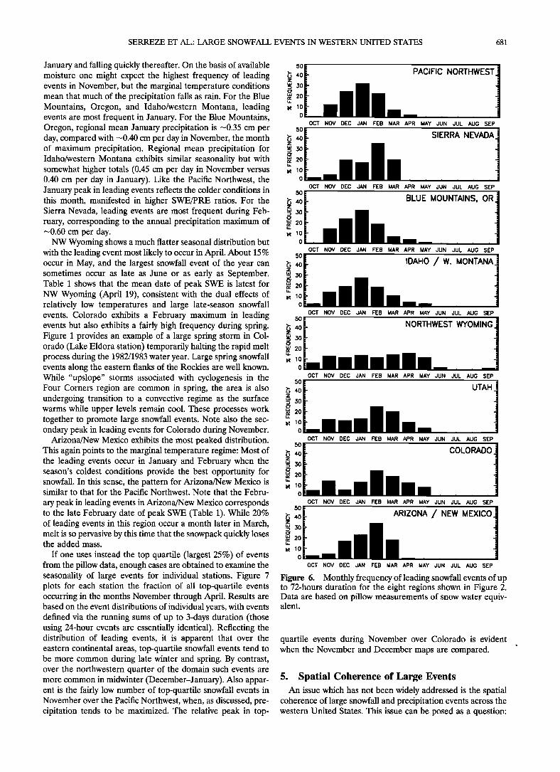
SERREZE ET AL.' LARGE SNOWFALL EVENTS IN WESTERN UNITED STATES 681
January and falling quickly thereafter. On the basis of available so moisture one might expect the highest frequency of leading •, 40 events in November, but the marginal temperature conditions • 3o mean that much of the precipitation falls as rain. For the Blue Mountains, Oregon, and Idaho/western Montana, leading • •0 events are most frequent in January. For the Blue Mountains, 0 Oregon, regional mean January precipitation is ---0.35 cm per so day, compared with ---0.40 cm per day in November, the month •, 40 of maximum precipitation. Regional mean precipitation for • 30
Idaho/western Montana exhibits similar seasonality but with somewhat higher totals (0.45 cm per day in November versus 0.40 cm per day in January). Like the Pacific Northwest, the o January peak in leading events reflects the colder conditions in this month, manifested in higher SWE/PRE ratios. For the •, 40 Sierra Nevada, leading events are most frequent during Feb- • 3o ruary, corresponding to the annual precipitation maximum of g 20 ---0.60 cm per day. • •o
NW Wyoming shows a much flatter seasonal distribution but 0 with the leading event most likely to occur in April. About 15 % so occur in May, and the largest snowfall event of the year can •, 40 sometimes occur as late as June or as early as September. • 30 Table 1 shows that the mean date of peak SWE is latest for NW Wyoming (April 19), consistent with the dual effects of • •o relatively low temperatures and large late-season snowfall o events. Colorado exhibits a February maximum in leading so events but also exhibits a fairly high frequency during spring. •o 40 Figure 1 provides an example of a large spring storm in Col- • 30 orado (Lake Eldora station) temporarily halting the rapid melt • 20 process during the 1982/1983 water year. Large spring snowfall events along the eastern flanks of the Rockies are well known. 0 While "upslope" storms associated with cyclogenesis in the Four Corners region are common in spring, the area is also •o 40 undergoing transition to a convective regime as the surface • 30
warms while upper levels remain cool. These processes work together to promote large snowfall events. Note also the sec- " ondary peak in leading events for Colorado during November. o
Arizona/New Mexico exhibits the most peaked distribution. This again points to the marginal temperature regime' Most of •, 40 the leading events occur in January and February when the • 30
season's coldest conditions provide the best opportunity for g 2o snowfall. In this sense, the pattern for Arizona/New Mexico is " similar to that for the Pacific Northwest. Note that the Febru- 0
ary peak in leading events in Arizona/New Mexico corresponds to the late February date of peak SWE (Table 1). While 20% o • 40 of leading events in this region occur a month later in March, ,.z, • 30
melt is so pervasive by this time that the snowpack quickly loses the added mass. "
• lo If one uses instead the top quartile (largest 25%) of events 0
from the pillow data, enough cases are obtained to examine the seasonality of large events for individual stations. Figure 7 plots for each station the fraction of all top-quartile events occurring in the months November through April. Results are based on the event distributions of individual years, with events defined via the running sums of up to 3-days duration (those using 24-hour events are essentially identical). Reflecting the distribution of leading events, it is apparent that over the eastern continental areas, top-quartile snowfall events tend to be more common during late winter and spring. By contrast, over the northwestern quarter of the domain such events are more common in midwinter (December-January). Also appar- ent is the fairly low number of top-quartile snowfall events in November over the Pacific Northwest, when, as discussed, pre- cipitation tends to be maximized. The relative peak in top-
PACIFIC NORTHWEST
OCT NOV DEC JAN FEB MAR APR MAY JUN JUL AUG SEP
SIERRA NEVADA
OCT NOV DEC JAN FEB MAR APR MAY JUN JUL AUG SEP
BLUE MOUNTAINS, OR
OCT NOV DEC JAN FEB MAR APR MAY JUN JUL AUG SEP
IDAHO /W. MONTANA
OCT NOV DEC JAN FEB MAR APR MAY JUN JUL AUG SEP
NORTHWEST WYOMING
OCT NOV DEC JAN FEB MAR APR MAY JUN JUL AUG SEP
UTAH
OCT NOV DEC JAN FEB MAR APR MAY JUN JUL AUG SEP
COLORADO
OCT NOV DEC JAN FEB MAR APR MAY JUN JUL AUG SEP
ARIZONA / NEW MEXICO
OCT NOV DEC JAN FEB MAR APR MAY JUN JUL AUG SEP
Figure 6. Monthly frequency of leading snowfall events of up to 72-hours duration for the eight regions shown in Figure 2. Data are based on pillow measurements of snow water equiv- alent.
quartile events during November over Colorado is evident when the November and December maps are compared.
5. Spatial Coherence of Large Events An issue which has not been widely addressed is the spatial
coherence of large snowfall and precipitation events across the western United States. This issue can be posed as a question:
682 SERREZE ET AL.: LARGE SNOWFALL EVENTS IN WESTERN UNITED STATES
< lO%
IO - 15 %
15-20%
>2O%
< lO%
IO - 15 %
15-20%
>20%
BE
< lO%
IO - 15 %
15-2o%
>20% -1.
FE
Figure 7. Monthly frequency of top-quartile snowfall events by station, based on pillow measurements of snow water equivalent.
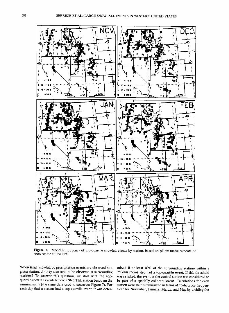
When large snowfall or precipitation events are observed at a given station, do they also tend to be observed at surrounding stations? To answer this question, we start with the top- quartile snowfall events for each SNOTEL station based on the running sums (the same data used to construct Figure 7). For each day that a station had a top-quartile event, it was deter-
mined if at least 40% of the surrounding stations within a 250-km radius also had a top-quartile event. If this threshold was satisfied, the event at the central station was considered to be part of a spatially coherent event. Calculations for each station were then summarized in terms of "coherence frequen- cies" for November, January, March, and May by dividing the
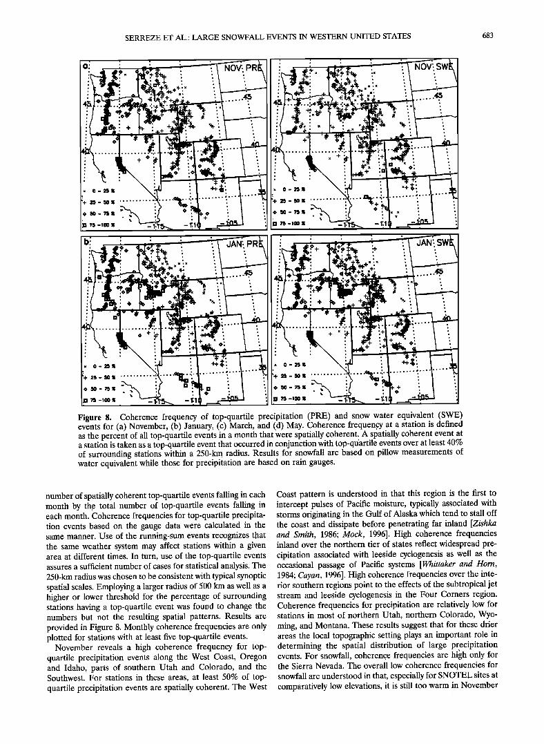
SERREZE ET AL.: LARGE SNOWFALL EVENTS IN WESTERN UNITED STATES 683
o:
0-25•
75 -100
•, 0 - 25•;
';+ 25 - 5O
75 -100
JAN;, ß
ß
x 0 - 25• ....
Figure 8. Coherence frequency of top-quartile precipitation (PRE) and snow water equivalent (SWE) events for (a) November, (b) January, (c) March, and (d) May. Coherence frequen,cy at a station is defined as the percent of all top-quartile events in a month that were spatially coherent. A spatially coherent event at a station is taken as a top-quartile event that occurred in conjunction with top-qt/artile events over at least 40% of surrounding stations within a 250-km radius. Results for snowfall are based on pillow measurements of water equivalent While those for precipitation are based on rain gauges.
number of spatially coherent top-quartile events falling in each month by the total number of top-quartile events falling in each month. Coherence frequencies for top-quartile precipita- tion events based on the gauge data were calculated in the same manner. Use of the running-sum events recognizes that the same weather system may affect stations within a given area at different times. In turn, use of the top-quartile events assures a sufficient number of cases for statistical analysis. The 250-km radius was chosen to be consistent with typical synoptic spatial scales. Employing a larger radius of 500 km as well as a higher or lower threshold for the percentage of surrounding stations having a top-quartile event was found to change the numbers but not the resulting spatial patterns. Results are provided in Figure 8. Monthly coherence frequencies are only plotted for stations with at least five top-quartile events.
November reveals a high coherence frequency for top- quartile precipitation events along the West Coast, Oregon and Idaho, parts of southern Utah and Colorado, and the Southwest. For stations in these areas, at least 50% of top-
quartile precipitation events are spatially coherent. The West
Coast pattern is understood in that this region is the first to intercept pulses of Pacific moisture, typically associated with storms originating in the Gulf of Alaska which tend to stall off the coast and dissipate before penetrating far inland [Zishka and Smith, 1986; Mock, 1996]. High coherence frequencies inland over the northern tier of states reflect widespread pre- cipitation associated with leeside cyclogenesis as well as the occasional passage of Pacific systems [Whittaker and Horn, 1984; Cayan, 1996]. High coherence frequencies over the inte- rior southern regions point to the effects of the subtropical jet stream and leeside cyclogenesis in the Four Corners region. Coherence frequencies for precipitation are relatively low for stations in most of northern Utah, northern Colorado, Wyo- ming, and Montana. These results suggest that for these drier areas the local topographic setting plays an important role in determining the spatial distribution of large pr•ecipitation events. For snowfall, coherence frequencies are high only for the Sierra Nevada. The overall low coherence frequencies for snowfall are understood in that, especially for SNOTEL sites at comparatively low elevations, it is still too warm in November

684 SERREZE ET AL.: LARGE SNOWFALL EVENTS IN WESTERN UNITED STATES
Figure 8. (continued)
for the precipitation to fall as snow. This is seen in terms of regional mean SWE/PRE ratios. For example, the SWE/PRE ratio for November averaged over the Pacific Northwest is 0.34, compared with 0.52 in January.
January is representative of results for midwinter (Decem- ber-February). In comparison with November, areas with high coherence frequencies for precipitation are those where snow- fall events also tend to be coherent. This is primarily explained by colder conditions during this month, allowing more of the available precipitation to fall as snow, especially at the lower- elevation SNOTEL stations. Where precipitation and snowfall both exhibit high coherence frequencies (regions 1-4 and 8 in Figure 2), regional mean temperatures are warmer than or close to fleezing in November but below freezing in December. Further evidence for the importance of temperature comes from the observation that in the Sierra Nevada, Blue Moun- tains, Oregon, and Idaho/western Montana, December precip- itation is actually less than that for November [Serreze e! al., 1999]. Note also that where midwinter snowfall events have a high coherence frequency, there is a general midwinter peak in the occurrence of top-quartile snowfall events (Figure 7). As for November, comparatively low coherence frequencies are found over Colorado, Utah, and Wyoming and for eastern stations in Montana. It appears that in these more moisture-
limited areas, the local topographic setting plays an important role in enhancing snowfall.
March shows a sharp decline in coherence frequencies for both top-quartile precipitation and snowfall events. High co- herence frequencies for precipitation are primarily found along the west coast and the southwest and in isolated areas such as the San Juan Mountains of Colorado and in central Idaho. In comparison with precipitation, top-quartile snowfall events are even less coherent. Note, in particular, the'low coherence frequencies over the Pacific Northwest as compared with January. In Figure 7 a large fraction of top-quartile snow- fall events over the eastern portion of the domain (e.g., NW Wyoming, Utah, and Colorado) are shown to occur in late winter and early spring. The low coherence frequencies for large snowfall events manifest both the low coherence fre- quency in precipitation events and the seasonal rise in temper- atures, dropping SWE/PRE ratios from midwinter peaks. For example, while the January SWE/PRE ratio averaged over the Pacific Northwest for January is 0.52, it falls to 0.17 in March.
May shows a further breakdown in coherence frequencies for precipitation. The area with high coherence frequencies over the Pacific Northwest seen in March disappears as the Pacific storm track migrates poleward. The Arizona/New Mex- ico pattern decays as the subtropical jet weakens. The generally
SERREZE ET AL.: LARGE SNOWFALL EVENTS IN WESTERN UNITED STATES 685
low coherence frequencies for inland regions is in accord with the springtime transition to a more convective precipitation regime. Nevertheless, isolated areas of coherent precipitation are found in Idaho, Utah, and Colorado. While there are relatively few top-quartile snowfall events in May, coherence frequencies are low.
6. Interannual Variability It was discussed in section 4 that when averaged over the
available period of record, about half of the annual snowfall across the west comes from the top quartile of ranked events. Histograms (not shown) reveal that this proportionality is maintained by the tendency for stations with relatively large mean annual snowfall totals to be associated with distributions
shifted toward larger individual event sizes. A similar interplay between event distributions and the number of events holds
with respect to understanding interannual variability in annual snowfall.
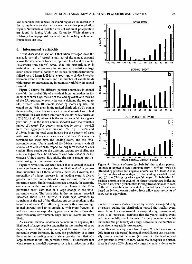
Figure 9 shows, for different percent anomalies in annual snowfall, the probability of attendant large anomalies in the number of snow days, the size of the leading event, and the size of the 75th-percentile event (the event defining the top quar- tile; if there were 100 events sorted by increasing size, this would be the 75th event in the ranked distribution). To obtain these results, percent anomalies in annual snowfall were first computed for each station and year in the SNOTEL record as ((S-(S))/(S))100, where S is the annual snowfall for a given year and (S) is the mean annual snowfall over the available period of record. The percent anomalies in annual snowfall were then aggregated into bins of 10% (e.g., -5-5% and 5-15%). From the total cases in each bin the percent of cases with positive and negative anomalies of at least 25% was de- termined for snow days, the leading event, and the 75th- percentile event. Use is made of the 24-hour events, with all anomalies calculated with respect to long-term means at each station. Since results for the different regions are similar, the results in Figure 9 can be taken to characterize statistics for the western United States. Essentially, the same results are ob- tained using the running-sum events.
Figure 9 reveals the expected result that as annual snowfall anomalies become more positive, the likelihood of large pos- itive anomalies in all three variables increases. However, the probability of a large increase in the leading event is always greater than the probability of a large increase in the 75th- percentile event. Similar conclusions are drawn if, for example, one compares the probability of a large change in the 75th- percentile event with that of a large change in the 95th- percentile event. The basic idea is that as annual snowfall increases, there is an increase in snow days, attended by stretching of the tail of the distributions corresponding to the larger event sizes. Put differently, years with above-average annual snowfall tend to be associated with more frequent as well as stronger snow-producing processes. Within a favorable snow-producing environment, large snowfall events are more likely.
As seasonal snowfall anomalies become more negative, the likelihood of large negative anomalies in the number of snow days, the size of the leading event, and the size of the 75th- percentile event increases. In turn, the probability of a large decrease in the leading event is always greater than that of a large decrease in the 75th-percentile event. This indicates that when seasonal snowfall decreases, there is a reduction in the
lOO
8o
m 6o
• 40
2o
o
-60 -50 -40 -30 -20 -lO oo
SNOW DAYS
10 20 30 40 50 60
LEADING EVENT
,,m, 6o
• 40
o ,, ,= ,! ..... B, [] .... -60 -50 -40 -30 -20 -10 00 10 20 30 40 50 60
75TH PERCENTILE EVENT
• 60
• 40
,!1 o .... . ,. ,. . ....... -60 -50 -40 -30 -20 -10 00 10 20 30 40 50 60
ANNUAL SNOWFALL ANOMALY (% MEAN)
Figure 9. Percent of cases (probability) that a given percent anomaly in annual snowfall (ranging from -60% to +60%) is attended by positive and negative anomalies of at least 25% in (a) the number of snow days, (b) the leading snowfall event, and (c) the 75th-percentile snowfall event. Probabilities for positive anomalies for each of the three variables are indicated by solid bars, while probabilities for negative anomalies in each of the three variables are indicated by shaded bars. Results are based on 24-hour events derived from pillow measurements of snow water equivalent.
number of snow events attended by weaker snow-producing processes, pulling the distributions toward the smaller event sizes. In such an unfavorable snow-producing environment, there is an increased likelihood that the year's leading event will be especially small. In turn, for very negative snowfall anomalies the probability of a large decrease in the number of snow days is especially pronounced.
Another interesting result from Figure 9 is that even with a 20% increase (decrease) in annual snowfall, one can occasion- ally have a modest decrease (increase) in the leading and 75th-percentile event. In turn, when the snowpack is normal, there is about a 20% chance of a large increase or decrease in
686 SERREZE ET AL.: LARGE SNOWFALL EVENTS IN WESTERN UNITED STATES
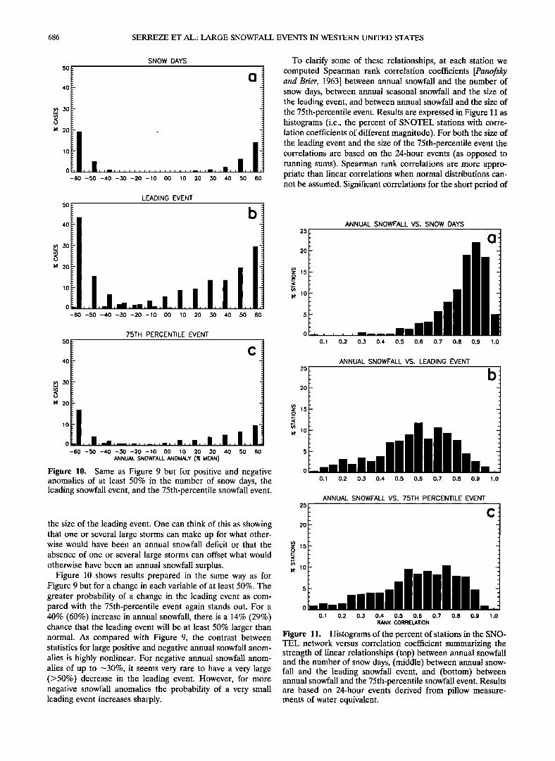
5O
SNOW DAYS
o
I• 20
lO
o
-60 -50 -40 -30 -20 -lO oo lO 20 30 40 50 60
5o
4o
m 3o
• 20
LEADING EVENT
b
-60 -50 -40 -30 -20 -10 O0 10 20 30 40 50 60
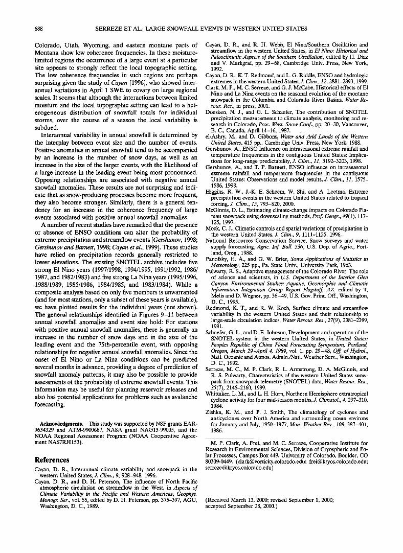
To clarify some of these relationships, at each station we computed Spearman rank correlation coefficients [Panofsky and Brier, 1963] between annual snowfall and the number of snow days, between annual seasonal snowfall and the size of the leading event, and between annual snowfall and the size of the 75th-percentile event. Results are expressed in Figure 11 as histograms (i.e., the percent of SNOTEL stations with corre- lation coefficients of different magnitude). For both the size of the leading event and the size of the 75th-percentile event the correlations are based on the 24-hour events (as opposed to running sums). Spearman rank correlations are more appro- priate than linear correlations when normal distributions can- not be assumed. Significant correlations for the short period of
25 ANNUAL SNOWFALL VS. SNOW DAYS
2O
z 15 _o
lO
75TH PERCENTILE EVENT o 50 O. 1 0.2 0.,.'3 0.4 0.5 0.6 0.7 0.8 0.9 1.0
c 40 ANNUAL SNOWFALL VS. LEADING EVENT
m 20 ro
• 20 z 1,5
.
I• lO
Figure 10. Same as Figure 9 but for positive and negative o anomalies of at least 50% in the number of snow days, the o.• o.2 o.3 o.4 o.5 o.6 o.7 o.8 o.9 •.o leading snowfall event, and the 75th-percentile snowfall event.
ANNUAL SNOWFALL VS. 75TH PERCENTILE EVENT 25
the size of the leading event. One can think of this as showing 2o that one or several large storms can make up for what other- wise would have been an annual snowfall deficit or that the
absence of one or several large storms can offset what would otherwise have been an annual snowfall surplus. •, lO- -
Figure l0 shows results prepared in the same way as for Figure 9 but for a change in each variable of at least 50%. The greater probability of a change in the leading event as com- pared with the 75th-percentile event again stands out. For a 0 40% (60%) increase in annual snowfall, there is a 14% (29%) o.• 0.2 0.3 0.4 0.5 0.6 0.7 0.8 0.9 •.o chance that the leading event will be at least 50% larger than RANK CORRœLATION normal. As compared with Figure 9, the contrast between Figure 11. Histograms of the percent of stations in the SNO-
TEL network versus correlation coefficient summarizing the statistics for large positive and negative annual snowfall anom- strength of linear relationships (top) between annual snowfall alies is highly nonlinear. For negative annual snowfall anom- and the number of snow days, (middle) between annual snow- alies of up to •--30%, it seems very rare to have a very large fall and the leading snowfall event, and (bottom) between (>50%) decrease in the leading event. However, for more annualsnowfall and the 75th-percentile snowfall event. Results negative snowfall anomalies the probability of a very small are based on 24-hour events derived from pillow measure- leading event increases sharply. ments of water equivalent.
SERREZE ET AL.' LARGE SNOWFALL EVENTS IN WESTERN UNITED STATES 687
record available at most SNOTEL sites tend to be those ex-
ceeding 0.60. Immediately apparent are the high correlations between an-
nual snowfall and the number of snow days. At over 70% of stations, correlations are 0.80 or higher. There are fewer high correlations between annual snowfall and precipitation (not shown). This occurs because for stations in warmer regions (e.g., the Pacific Northwest) much of the precipitation early and late in the season falls as rain. One would expect a strong correlation between annual snowfall and snow days just with a random distribution of event sizes. However, it is clear that the correlations are strengthened by the fact that when the number of snow days increases, the event sizes themselves increase. For roughly 50% of stations, correlations between annual snowfall and the leading event and between annual snowfall and the 75th-percentile event exceed 0.60. The more modest correla- tions as compared with those between annual snowfall and snow days are understood in that even with a modest positive annual snowfall anomaly, the leading and 75th-percentile event can have large negative anomalies. This is especially true with respect to near-normal annual snowfalls. Spatial plots of the station correlations used to construct Figure 11 reveal no evidence of regionality.
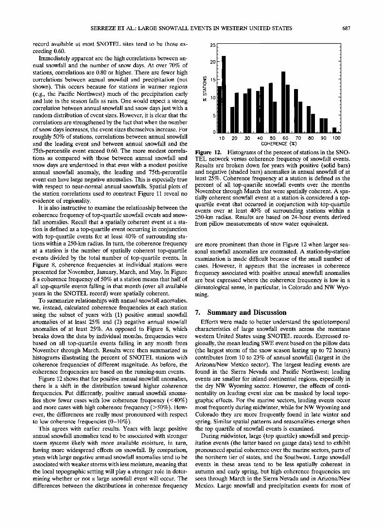
It is also instructive to examine the relationship between the coherence frequency of top-quartile snowfall events and snow- fall anomalies. Recall that a spatially coherent event at a sta- tion is defined as a top-quartile event occurring in conjunction with top-quartile events for at least 40% of surrounding sta- tions within a 250-km radius. In turn, the coherence frequency at a station is the number of spatially coherent top-quartile events divided by the total number of top-quartile events. In Figure 8, coherence frequencies at individual stations were presented for November, January, March, and May. In Figure 8 a coherence frequency of 50% at a station means that half of all top-quartile events falling in that month (over all available years in the SNOTEL record) were spatially coherent.
To summarize relationships with annual snowfall anomalies, we, instead, calculated coherence frequencies at each station using the subset of years with (1) positive annual snowfall anomalies of at least 25% and (2) negative annual snowfall anomalies of at least 25%. As opposed to Figure 8, which breaks down the data by individual months, frequencies were based on all top-quartile events falling in any month from November through March. Results were then summarized as histograms illustrating the percent of SNOTEL stations with coherence frequencies of different magnitude. As before, the coherence frequencies are based on the running-sum events.
Figure 12 shows that for positive annual snowfall anomalies, there is a shift in the distribution toward higher coherence frequencies. Put differently, positive annual snowfall anoma- lies show fewer cases with low coherence frequency (<40%) and more cases with high coherence frequency (>50%). How- ever, the differences are really most pronounced with respect to low coherence frequencies (0-10%).
This agrees with earlier results. Years with large positive annual snowfall anomalies tend to be associated with stronger storm systems likely with more available moisture, in turn, having more widespread effects on snowfall. By comparison, years with large negative annual snowfall anomalies tend to be associated with weaker storms with less moisture, meaning that the local topographic setting will play a stronger role in deter- mining whether or not a large snowfall event will occur. The differences between the distributions in coherence frequency
25
2O
m• 15
• lO
o
10 20 30 40 50 60 70 80 90 100
COHERENCE (%)
Figure 12. Histograms of the percent of stations in the SNO- TEL network versus coherence frequency of snowfall events. Results are broken down for years with positive (solid bars) and negative (shaded bars) anomalies in annual snowfall of at least 25%. Coherence frequency at a station is defined as the percent of all top-quartile snowfall events over the months November through March that were spatially coherent. A spa- tially coherent snowfall event at a station is considered a top- quartile event that occurred in conjunction with top-quartile events over at least 40% of surrounding stations within a 250-km radius. Results are based on 24-hour events derived
from pillow measurements of snow water equivalent.
are more prominent than those in Figure 12 when larger sea- sonal snowfall anomalies are contrasted. A station-by-station examination is made difficult because of the small number of
cases. However, it appears that the increases in coherence frequency associated with positive annual snowfall anomalies are best expressed where the coherence frequency is low in a climatological sense, in particular, in Colorado and NW Wyo- ming.
7. Summary and Discussion Efforts were made to better understand the spatiotemporal
characteristics of large snowfall events across the montane western United States using SNOTEL records. Expressed re- gionally, the mean leading SWE event based on the pillow data (the largest storm of the snow season lasting up to 72 hours) contributes from 10 to 23% of annual snowfall (largest in the Arizona/New Mexico sector). The largest leading events are found in the Sierra Nevada and Pacific Northwest; leading events are smaller for inland continental regions, especially in the dry NW Wyoming sector. However, the effects of conti- nentality on leading event size can be masked by local topo- graphic effects. For the marine sectors, leading events occur most frequently during midwinter, while for NW Wyoming and Colorado they are more frequently found in late winter and spring. Similar spatial patterns and seasonalities emerge when the top quartile of snowfall events is examined.
During midwinter, large (top quartile) snowfall and precip- itation events (the latter based on gauge data) tend to exhibit pronounced spatial coherence over the marine sectors, parts of the northern tier of states, and the Southwest. Large snowfall events in these areas tend to be less spatially coherent in autumn and early spring, but high coherence frequencies are seen through March in the Sierra Nevada and in Arizona/New Mexico. Large snowfall and precipitation events for most of
688 SERREZE ET AL.: LARGE SNOWFALL EVENTS IN WESTERN UNITED STATES
Colorado, Utah, Wyoming, and eastern montane parts of Montana show low coherence frequencies. In these moisture- limited regions the occurrence of a large event at a particular site appears to strongly reflect the local topographic setting. The low coherence frequencies in such regions are perhaps surprising given the study of Cayan [1996], who showed inter- annual variations in April 1 SWE to covary on large regional scales. It seems that although the interactions between limited moisture and the local topographic setting can lead to a het- erogeneous distribution of snowfall totals for individual storms, over the course of a season the local variability is subdued.
Interannual variability in annual snowfall is determined by the interplay between event size and the number of events. Positive anomalies in annual snowfall tend to be accompanied by an increase in the number of snow days, as well as an increase in the size of the larger events, with the likelihood of a large increase in the leading event being most pronounced. Opposing relationships are associated with negative annual snowfall anomalies. These results are not surprising and indi- cate that as snow-producing processes become more frequent, they also become stronger. Similarly, there is a general ten- dency for an increase in the coherence frequency of large events associated with positive annual snowfall anomalies.
A number of recent studies have remarked that the presence or absence of ENSO conditions can alter the probability of extreme precipitation and streamflow events [Gershunov, 1998; Gershunov and Barnett, 1998; Cayan et al., 1999]. These studies have relied on precipitation records generally restricted to lower elevations. The existing SNOTEL archive includes five strong E1 Nino years (1997/1998, 1994/1995, 1991/1992, 1986/ 1987, and 1982/1983) and five strong La Nina years (1995/1996, 1988/1989, 1985/1986, 1984/1985, and 1983/1984). While a composite analysis based on only five members is unwarranted (and for most stations, only a subset of these years is available), we have plotted results for the individual years (not shown). The general relationships identified in Figures 9-11 between annual snowfall anomalies and event size hold: For stations
with positive annual snowfall anomalies, there is generally an increase in the number of snow days and in the size of the leading event and the 75th-percentile event, with opposing relationships for negative annual snowfall anomalies. Since the onset of E1 Nino or La Nina conditions can be predicted several months in advance, providing a degree of prediction of snowfall anomaly patterns, it may also be possible to provide assessments of the probability of extreme snowfall events. This information may be useful for planning reservoir releases and also has potential applications for problems such as avalanche forecasting.
Acknowledgments. This study was supported by NSF grants EAR- 9634329 and ATM-9900687, NASA grant NAG13-99005, and the NOAA Regional Assessment Program (NOAA Cooperative Agree- ment NA67RJ0153).
References
Cayan, D. R., Interannual climate variability and snowpack in the western United States, J. Clim., 9, 928-948, 1996.
Cayan, D. R., and D. H. Peterson, The influence of North Pacific atmospheric circulation on streamflow in the West, in Aspects of Climate Variability in the Pacific and Western Americas, Geophys. Monogr. Ser., vol. 55, edited by D. H. Peterson, pp. 375-397, AGU, Washington, D.C., 1989.
Cayan, D. R., and R. H. Webb, E1 Nino/Southern Oscillation and streamflow in the western United States, in El Nino: Historical and Paleoclimatic Aspects of the Southern Oscillation, edited by H. Diaz and V. Markgraf, pp. 29-68, Cambridge Univ. Press, New York, 1992.
Cayan, D. R., K. T. Redmond, and L. G. Riddle, ENSO and hydrologic extremes in the western United States, J. Clim., 12, 2881-2893, 1999.
Clark, M.P., M. C. Serreze, and G. J. McCabe, Historical effects of E1 Nino and La Nina events on the seasonal evolution of the montane
snowpack in the Columbia and Colorado River Basins, Water Re- sour. Res., in press, 2001.
Doesken, N.J., and G. L. Schaefer, The contribution of SNOTEL precipitation measurements to climate analysis, monitoring and re- search in Colorado, Proc. West. Snow Conf., pp. 20-30, Vancouver, B.C., Canada, April 14-16, 1987. _
el-Ashry, M., and D. Gibbons, Water and Arid Lands of the Western United States, 415 pp., Cambridge Univ. Press, New York, 1988.
Gershunov, A., ENSO Influence on intraseasonal extreme rainfall and temperature frequencies in the contiguous United States: Implica- tions for long-range predictability, J. Clim., 11, 3192-3203, 1998.
Gershunov, A., and T. P. Barnett, ENSO influence on intraseasonal extreme rainfall and temperature frequencies in the contiguous United States: Observations and model results, J. Clim., 11, 1575- 1586, 1998.
Higgins, R. W., J.-K. E. Scheem, W. Shi, and A. Leetma, Extreme precipitation events in the western United States related to tropical forcing, J. Clim., 15, 793-820, 2000.
McGinnis, D. L., Estimating climate-change impacts on Colorado Pla- teau snowpack using downscaling methods, Prof. Geogr., 49(1), 117- 125, 1997.
Mock, C. J., Climatic controls and spatial variations of precipitation in the western United States, J. Clim., 9, 1111-1125, 1996.
National Resources Conservation Service, Snow surveys and water supply forecasting, Agric. Inf. Bull. 536, U.S. Dep. of Agric., Port- land, Oreg., 1988.
Panofsky, H. A., and G. W. Brier, Some Applications of Statistics to Meteorology, 225 pp., Pa. State Univ., University Park, 1963.
Pulwarty, R. S., Adaptive management of the Colorado River: The role of science and scientists, in U.S. Department of the Interior Glen Canyon Environmental Studies: Aquatic, Geomorphic and Climatic Information Integration Group Report Flagstaff, AZ, edited by T. Melis and D. Wegner, pp. 36-49, U.S. Gov. Print. Off., Washington, D.C., 1995.
Redmond, K. T., and R. W. Koch, Surface climate and streamflow variability in the western United States and their relationship to large-scale circulation indices, Water Resour. Res., 27(9), 2381-2399, 1991.
Schaefer, G. L., and D. E. Johnson, Development and operation of the SNOTEL system in the western United States, in United States/ Peoples Republic of China Flood Forecasting Symposium, Portland, Oregon, March 29-April 4, 1989, vol. 1, pp. 29-48, Off. of Hydrol., Natl. Oceanic and Atmos. Admin./Natl. Weather Serv., Washington, D.C., 1992.
Serreze, M. C., M.P. Clark, R. L. Armstrong, D. A. McGinnis, and R. S. Pulwarty, Characteristics of the western United States snow- pack from snowpack telemetry (SNOTEL) data, Water Resour. Res., 35(7), 2145-2160, 1999.
Whittaker, L. M., and L. H. Horn, Northern Hemisphere extratropical cyclone activity for four mid-season months, J. Climatol., 4, 297-310, 1984.
Zishka, K. M., and P. J. Smith, The climatology of cyclones and anticyclones over North America and surrounding ocean environs for January and July, 1950-1977, Mon. Weather Rev., 108, 387-401, 1986.
M.P. Clark, A. Frei, and M. C. Serreze, Cooperative Institute for Research in Environmental Sciences, Division of Cryospheric and Po- lar Processes, Campus Box 449, University of Colorado, Boulder, CO 80309-0449. ([email protected]; [email protected]; serreze@ kryos.colorado.edu)
(Received March 13, 2000; revised September 1, 2000; accepted September 28, 2000.)