combined project information documents / integrated...
TRANSCRIPT

The World Bank Municipal Development and Urban Resilience Project (P155201)
Apr 18, 2017 Page 1 of 28
For O
ffici
al U
se O
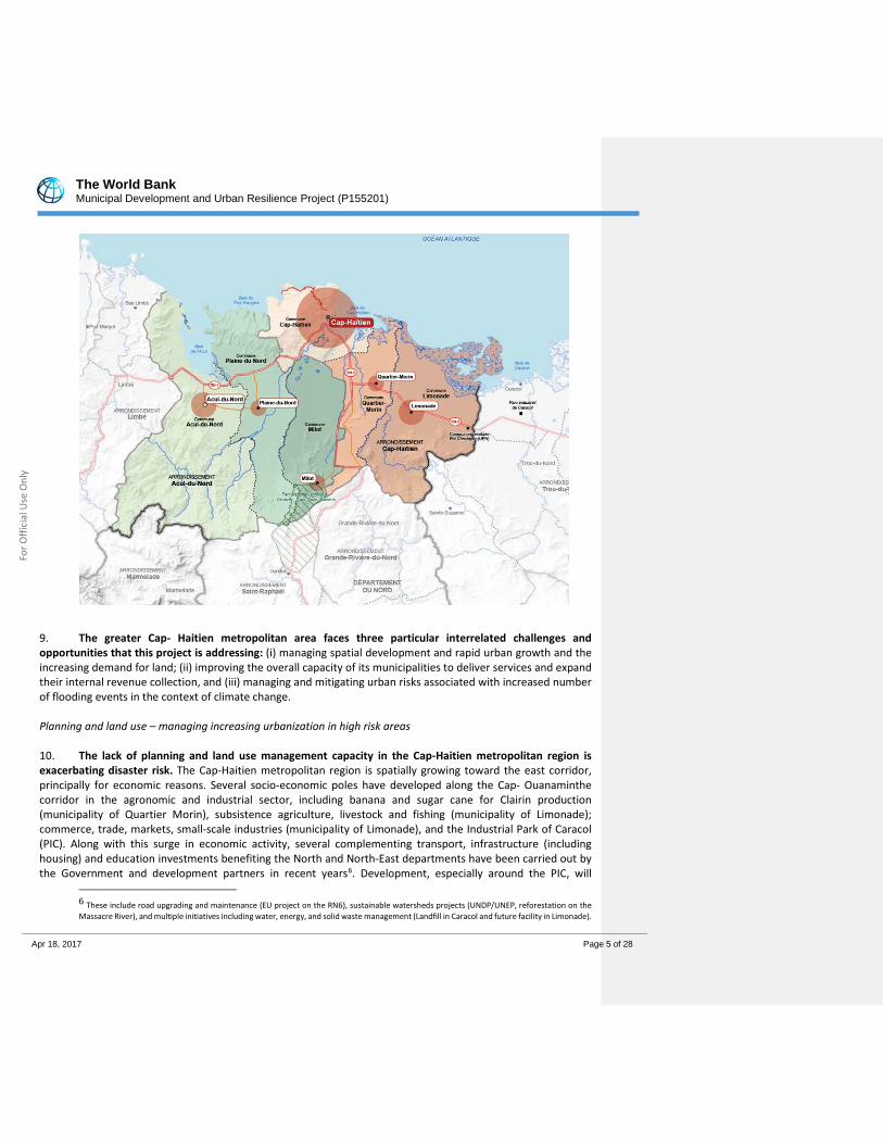
nly
Combined Project Information Documents / Integrated Safeguards Datasheet (PID/ISDS)
Appraisal Stage | Date Prepared/Updated: 18-Apr-2017 | Report No: ISDSA20861

The World Bank Municipal Development and Urban Resilience Project (P155201)
Apr 18, 2017 Page 2 of 28
For O
ffici
al U
se O
nly
BASIC INFORMATION
A. Basic Project Data
Country Project ID Project Name Parent Project ID (if any) Haiti P155201 Municipal Development and
Urban Resilience Project
Region Estimated Appraisal Date Estimated Board Date Practice Area (Lead) LATIN AMERICA AND CARIBBEAN
10-May-2017 20-Jun-2017 Social, Urban, Rural and Resilience Global Practice
Lending Instrument Borrower(s) Implementing Agency Investment Project Financing Ministry of Finance Ministry of Interior and Local
Authorities, Ministry of Public Works, Transport and Communications
Financing (in USD Million)
Financing Source Amount
Strategic Climate Fund Grant 7.00
IDA Grant 48.00
Total Project Cost 55.00
Environmental Assessment Category
B - Partial Assessment Have the Safeguards oversight and clearance functions been transferred to the Practice Manager? (Will not be disclosed) No Decision Track II-The review did authorize the preparation to continue Other Decision (as needed) Type here to enter text
B. Introduction and Context Country Context
1. Haiti’s geography, people, and history provide it with many opportunities. In addition to an illustrious early history, as the first independent nation in the region and the first nation in the world to be led to
Commented [1]: Enter optional comments

The World Bank Municipal Development and Urban Resilience Project (P155201)
Apr 18, 2017 Page 3 of 28
For O
ffici
al U
se O
nly
independence by former slaves, Haiti benefits from proximity and access to major markets, a young labor force, a dynamic diaspora, and substantial geographic, historical, and cultural assets. The country possesses untapped markets and a pent-up demand for the private sector to explore, including agribusiness, light manufacturing, and tourism. 2. However, the country continues to be affected by institutional fragility and setbacks in economic recovery, despite progress seen in the last five years. There have been significant advances in poverty reduction and economic growth in recent years – with the population living in extreme poverty declining from 31 percent to 23.8 percent between 2000 and 2012 and economic growth increasing from 2.9 percent in 2012 to 4.2 percent in 2013 (but contracting again to 2.8 in 2014 and 1.2 percent in 2015e)1. However, the country has not yet fully recovered from the devastating 2010 earthquake2, and continues to be affected by political and institutional fragility, as recently seen in the contested presidential elections in 2015 and the subsequent period of an interim governments3. 3. Haiti’s gradual growth and achievements in poverty reduction have been closely related with the rapid spatial transformation and urbanization that the country has seen in the last five decades, with almost six out of ten Haitians now living in urban areas. A recent World Bank poverty assessment demonstrated that urban areas have relatively fared better than rural areas, reflecting more non-agricultural employment opportunities, larger private transfers, more access to critical goods and services and narrowing inequality compared to rural areas. Extreme poverty in urban areas has reduced from almost 22 percent to 11 percent while in rural areas the number of extreme poor has stagnated at 37 percent in the period 2001 to 2012. 4. The rapid, and largely unplanned urbanization process combined with the relative centralization of economic activities and governance systems in Port-au-Prince has created substantial challenges in terms of service provision, exposure to natural hazards, and increased vulnerability in urban centers. Almost half of Haiti’s urban population lives in Port-au-Prince, and 65 percent of Haiti’s GDP is estimated to be generated in the capital city (2010). The increased pressure and demand for basic services in growing cities will need to be addressed to maintain the current gains associated with urbanization. The importance of enabling municipalities to govern more effectively, including better management of local responsibilities such as land management, revenue generation and provision of basic services. 5. Closely linked to the rapid urbanization, are the substantial challenges associated with natural hazards, in particular in urban areas. With 96 percent of its population living at risk, Haiti is considered one of the world’s most exposed countries to multiple natural hazards, acute shocks, and chronic stress. With relation to climate risks, Haiti ranked as the third most affected country to climate-related events from 1994 to 2013. Based on the analysis of historical data for the period 1976-2012, average damages and losses associated with hydro-meteorological events alone are estimated at an amount equivalent to almost 2 percent of GDP. Given the concentration of people and assets, urban areas are the most exposed to natural hazards, with 27 out of 140 municipalities situated in high risk flood-prone areas, while two-thirds of urban municipalities and over 70 percent of Haiti’s urban population is affected by hurricanes with medium to high impact. 6. In this context, the Haitian government views regional development, decentralization of state power, disaster risks management, and improved spatial management as key development priorities to further
1 Haitian Fiscal Year (October-September) 2 The earthquake caused an estimated US$7.8 billion in damages and losses (120 percent of the GDP) and close to 220,000 deaths. The recent Matthew hurricane damaged lager parts of the western part of the country and destroyed infrastructure and housing up to a value of 20 percent of GDP. 3 Recent presidential elections have taken place and a new president is expected to be formally inaugurated in February 2017.
The World Bank Municipal Development and Urban Resilience Project (P155201)
Apr 18, 2017 Page 4 of 28
For O
ffici
al U
se O
nly
leverage the positive impacts of urbanization and reduce the underlying risks of economic destruction resulting from natural disasters in areas of large population concentration. The Government’s national development strategy, the 2012 Strategic Development Plan for Haiti, identifies specific growth areas within the country to drive a more balanced economic growth and to enable secondary towns become growth poles for industry and job creation. The Strategic Development Plan of Haiti (Plan Stratégique de Développement d’Haïti – PSDH, 2012) points to the importance of investing in regional development including in secondary cities with the aim of achieving more balanced economic growth4, and on interventions to improve resilience, including urban resilience, while shifting more responsibility towards municipalities.
Sectoral and Institutional Context
7. Haiti’s urban growth rate between 1990 and 2014 was 2.9 percent, one of the highest in the Western Hemisphere, increasing to 3.8 percent in 2010-2015. At the same time, Haiti remains one of the most densely populated countries in the world, almost 400 people per km2 – on par with Rwanda and Burundi. Haiti is on the trajectory towards further urbanization – projections indicated that by 2030, 62 percent of the population will live in urban areas, and by 2050, the number will have increased to 70 percent, corresponding to adding several hundred thousand people in urban areas every year. The growth is driven by a mix of natural growth and rural-urban migration. Much of the urban growth has been concentrated in Port-au-Prince, but increasingly, secondary centers appear to be growing faster. 8. Cap-Haitien is the second largest city of Haiti, located in the Nord Department, with a 2015 population of 274,404 inhabitants as per official estimates5. Its broader metropolitan region, defined by the area of influence of the first ring of satellite MLAs (here referred to as municipal local authorities (MLAs) that surrounds Cap-Haitien, encompasses five municipal local authorities (Limonade – 55,000 persons, Quartier Morin - 27,000, Plaine du Nord – 41,000, Acul du Nord – 56,000, and Milot - 32,000), bringing the total population to around 486,000. Limonade and Quartier Morin in particular are contiguous urban areas that gradually are becoming or will become part of a greater Cap-Haitien metropolitan area (see map). No table of figures entries found. Map of the metropolitan area of Cap-Haitien
4 The strategy includes specific attention to the three regions, North, South and Central. The North remains of particular importance given its strategic location with international access and economic potential, e.g. in agriculture, torusim, and manufacturing. 5 National Statistical Institute (IHSI) estimates for 2015
The World Bank Municipal Development and Urban Resilience Project (P155201)
Apr 18, 2017 Page 5 of 28
For O
ffici
al U
se O
nly
9. The greater Cap- Haitien metropolitan area faces three particular interrelated challenges and opportunities that this project is addressing: (i) managing spatial development and rapid urban growth and the increasing demand for land; (ii) improving the overall capacity of its municipalities to deliver services and expand their internal revenue collection, and (iii) managing and mitigating urban risks associated with increased number of flooding events in the context of climate change. Planning and land use – managing increasing urbanization in high risk areas 10. The lack of planning and land use management capacity in the Cap-Haitien metropolitan region is exacerbating disaster risk. The Cap-Haitien metropolitan region is spatially growing toward the east corridor, principally for economic reasons. Several socio-economic poles have developed along the Cap- Ouanaminthe corridor in the agronomic and industrial sector, including banana and sugar cane for Clairin production (municipality of Quartier Morin), subsistence agriculture, livestock and fishing (municipality of Limonade); commerce, trade, markets, small-scale industries (municipality of Limonade), and the Industrial Park of Caracol (PIC). Along with this surge in economic activity, several complementing transport, infrastructure (including housing) and education investments benefiting the North and North-East departments have been carried out by the Government and development partners in recent years6. Development, especially around the PIC, will
6 These include road upgrading and maintenance (EU project on the RN6), sustainable watersheds projects (UNDP/UNEP, reforestation on the Massacre River), and multiple initiatives including water, energy, and solid waste management (Landfill in Caracol and future facility in Limonade).
The World Bank Municipal Development and Urban Resilience Project (P155201)
Apr 18, 2017 Page 6 of 28
For O
ffici
al U
se O
nly
significantly increase the metropolitan area’s population, putting pressure on land and service delivery in the surrounding municipalities, some of which are targeted by the Project. 11. Given the location of Cap Haitien and its historical urban growth pattern, there are few areas within the municipality that are adequate for expansion. There is limited land within the administrative boundary of the city to build safe housing, and people have been settling in high-risk zones where land is more affordable, such as in ravines, coastal areas, and the river banks of the Rivière Haut du Cap and Bassin Rhodo. Overall municipal capacity for planning and regulating land use is very limited, and therefore the metropolitan region has been unable to manage this increasing urban growth in high-risk areas. It is expected that Cap-Haitian’s population could reach 498,840 by 20307, forcing the city to reconsider the satellite towns around Cap-Haitien as potential areas for settlement. These cities are small municipalities but have the potential to constitute an urban system and will play a key role in the future spatial development of the area of Cap-Haitien. Promoting financial and technical support for better urban management and infrastructure and basic service provision in municipal areas 12. Despite strategies of spatial decentralization and emerging results in areas of expanding the level and training of staffing at MLA level, results have been limited and hampered by the lack of investment budgets available for the Municipal Local Authorities (MLAs) and the irregular support provided. New government policy commitments and the election of mayors in all MLAs across the country in 2016 provide new opportunities for strengthening local governance and service delivery. Several policies and government programs have been supporting the decentralization: the development of regional growth poles to counterbalance the dominance of Port-au-Prince is part of the national development priorities as outlined in the Strategic Development Plan of Haiti (PSDH, 2010); other initiatives are also currently under implementation and support both decentralization and regional integration including programmes to strengthen staffing at MLAs level and to expand revenue mobilization, in particular in urban MLAs. In April 2016, municipal elections led to the inauguration of publically elected mayors in all of Haiti’s MLAs for the first time after in almost 10 years (the last municipal elections were held in 2006). This development provides a new opportunity for energizing the management capacity and deepening the capacity of the state to deliver services and the local levels and enhances the opportunity of strengthening the social contract between the population and the leaders. 13. The metropolitan region of Cap-Haitien is a mix of consolidated old urban areas (such as Cap Haitien old town) with new developments and expansions of semi-urban and rural nature, across 3 core jurisdictions (Cap Haitien, Limonade, and Quartier Morin) and with 3 additional MLAs further outside from the urban core of Cap (Acule de Nord, Plaine de Nord and Milot). The capacity of municipalities in the metropolitan region varies substantially. A number municipalities struggle to pay operating costs, collect limited own source revenue and largely depend on the insufficient transfers from national government to finance public services and infrastructure improvements. As a result, financing available for capital investments is insufficient to provide the level of service required. These constraints are further exacerbated by the insufficient number of qualified technical staff at the municipal level. While some municipalities have local development and financing plans, these plans are not linked to their spatial and physical characteristics, and municipalities have yet to establish mechanisms for prioritizing investments based on local needs. Furthermore, most municipalities lack data systems to inform their decisions and take on their planning functions, as well as implementation and enforcement capacity in general and in particular for issuing building permits and monitoring compliance.
7 ERM, 2015. Table “Northern Region Population and Growth Projection (Source AIA Study)”, p38.
The World Bank Municipal Development and Urban Resilience Project (P155201)
Apr 18, 2017 Page 7 of 28
For O
ffici
al U
se O
nly
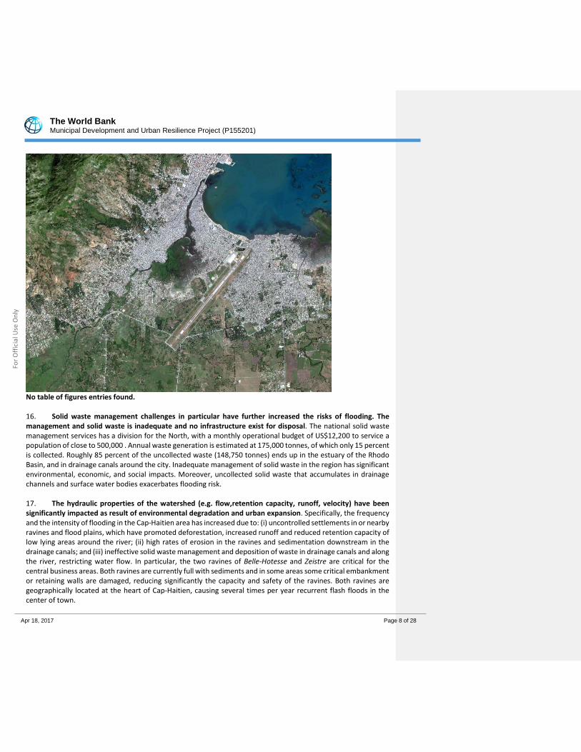
14. While relatively better off than most secondary cities, the Cap-Haitien metropolitan region is underserviced in key areas basic urban services, including roads and drainages, water and sanitation, solid waste management and access to energy; holding back the opportunity to harvest potential agglomeration benefits and to trigger the region’s economic development. The region reflects the national trend of decline in access to services in urban areas – i.e. access to water in urban areas has reduced from 91 to 65 percent at the national level in the last 20 years, and almost 74 percent live in informal settlements. In the North department specifically, approximately 74 percent of urban households rely on charcoal, and 24 percent of people have improved sanitation. An urgent need to increase urban resilience 15. The third major challenge facing the region is managing and mitigating urban risks associated with natural hazards, in particular floods. The Haut du Cap River passes through the Cap Haitien metropolitan area, and is part of hydrological system that gathers in the Bassin Rhodo, a large estuarine water basin. Since the 1980s, populations have illegally settled along the ecologically-sensitive river banks and flood plains. The general lack of housing opportunities in Cap-Haitien has driven residents to settle in flood areas, but within close proximity to job opportunities in the city center and the municipal market. Populations first settled in the mangrove areas, and for the last two decades have pursued informal and illegal land reclamation in the northern part of the Bassin Rhodo, while relying on the use of solid waste as primary fill material for embankments. An illegal real estate market is growing in such high risk areas, with an estimated 33,000 people (around 13 percent of the total population of the city of Cap Haitien) living in informal settlements in ravines, along river banks, and around water basins – they are thus highly exposed and vulnerable to flooding. Part of the solid waste used for embankments (as well as the waste generated by households) is carried further downstream and accumulates along the river banks and the mouth of the Rivière Haut du Cap, aggravating flood risks. No table of figures entries found. Map of the Haut du Cap River watershed
The World Bank Municipal Development and Urban Resilience Project (P155201)
Apr 18, 2017 Page 8 of 28
For O
ffici
al U
se O
nly
No table of figures entries found. 16. Solid waste management challenges in particular have further increased the risks of flooding. The management and solid waste is inadequate and no infrastructure exist for disposal. The national solid waste management services has a division for the North, with a monthly operational budget of US$12,200 to service a population of close to 500,000 . Annual waste generation is estimated at 175,000 tonnes, of which only 15 percent is collected. Roughly 85 percent of the uncollected waste (148,750 tonnes) ends up in the estuary of the Rhodo Basin, and in drainage canals around the city. Inadequate management of solid waste in the region has significant environmental, economic, and social impacts. Moreover, uncollected solid waste that accumulates in drainage channels and surface water bodies exacerbates flooding risk. 17. The hydraulic properties of the watershed (e.g. flow,retention capacity, runoff, velocity) have been significantly impacted as result of environmental degradation and urban expansion. Specifically, the frequency and the intensity of flooding in the Cap-Haitien area has increased due to: (i) uncontrolled settlements in or nearby ravines and flood plains, which have promoted deforestation, increased runoff and reduced retention capacity of low lying areas around the river; (ii) high rates of erosion in the ravines and sedimentation downstream in the drainage canals; and (iii) ineffective solid waste management and deposition of waste in drainage canals and along the river, restricting water flow. In particular, the two ravines of Belle-Hotesse and Zeistre are critical for the central business areas. Both ravines are currently full with sediments and in some areas some critical embankment or retaining walls are damaged, reducing significantly the capacity and safety of the ravines. Both ravines are geographically located at the heart of Cap-Haitien, causing several times per year recurrent flash floods in the center of town.
The World Bank Municipal Development and Urban Resilience Project (P155201)
Apr 18, 2017 Page 9 of 28
For O
ffici
al U
se O
nly
18. As such, recurrent rain events and flooding events have impacted Cap Haitien, resulting in loss of lives, and with significant negative repercussions on the local economy. Heavy rains in Cap-Haitian in 2012, 2014 and 2016 resulted in flooding, causing several deaths, and damage to homes and infrastructure (these floods are just the most recent ones, at least ten other major floods have impacted the area since 1940). In 2012, 10 deaths were recorded and more than 1,500 people were housed in shelters8. 19. Additional risks are added from the impacts of climate change in the Northern Region and its cities, particularly with regards to flooding and sea level rise. The Caribbean is amongst the most vulnerable areas to climate change and climate extremes in the world. Climate change modeling of the area shows that flooding risks will be further exacerbated by climate change - climate change patterns are expected to accentuate higher peak flows in rivers and backflow from the sea. Following the projections of the Intergovernmental Panel on Climate Change (IPCC) Fifth Assessment Report, the mean sea level would be 30–90 cm higher by 2100 than it is today. Recent NASA studies show that the mean sea level has risen by 8 cm since 1992. They also foresee that sea-level rise will be closer to the highest end of the predicted IPCC range. Giving this context, recent analysis undertaken by the IDB for the Emerging and Sustainable Cities Initiative (ESCI) include the spatial impact of sea level change and storm surge at 2 and 3 meter. 20. Based on the above, the proposed project will address these three priorities for the Greater metropolitan region of Cap Haitien: (i) strengthening municipal capacities for better management of land use and urban expansion; (ii) enhancing local government capacity for provision of infrastructure and basic service provision; and (iii) strengthening urban resilience by reducing risks associated with flooding and climate change related effects.
C. Proposed Development Objective(s) Development Objective(s) (From PAD) The Project Development of Objective is to (i) improve the technical and financial capacity of six municipalities in the metropolitan area of Cap-Haitian to plan, finance and deliver basic municipal services; and (ii) reduce climate risks and urban flooding in the city of Cap-Haitian. Key Results
21. The achievement of the PDO will will be monitored through the following indicators: (a) People provided with improved urban living conditions (core) (b) Number of individuals living in urban areas with a risk of flooding below 50-year return period (2 percent chance of exceeding in any one year)9; and (c) Number of total project beneficiaries (gender disaggregated) (core) Key intermediate indicators are likely to include: (a) Preparation and approval of strategy to improve Own Source Revenue by each Municipality; (b) Number of actions successfully implemented in urban development plans by each municipality; (c) Roads rehabilitated (non-rural) (km); (d) Number of municipalities achieving targets set in Revenue Enhancement Plans and O&M plans funded under the project; (e) Percentage of beneficiaries who report
8 In addition to the floods of 2012 and 2014, floods were also reported in the city in 1942, 1943, 1963, 1968, 1993, 1996, 2000, 2003, 2004, and 2007, and a minor flood occurred in 2013 and November 2016. 9 “2% chance of likelihood of a flood in any one year”
Commented [2]: Enter optional comments

The World Bank Municipal Development and Urban Resilience Project (P155201)
Apr 18, 2017 Page 10 of 28
For O
ffici
al U
se O
nly
improvements in living conditions as a result of project-funded investments (gender disaggregated); (g) Number of Cities with improved livability, sustainability, and/or management (core indicator – urban).
D. Project Description
22. The Project will contribute to the sustainable and resilient urban development of the metropolitan region of Cap-Haitien through a combination of (i) improved access to basic infrastructure promote livability and local economic development; (ii) building the capacity of municipalities for better urban management and enhanced accountability; and (iii) metropolitan level investments in flood risk reduction to address the high risk of flooding and improve the livelihoods of affected households. The Project is to be implemented over a period of six years, and will include the following four components at a total cost of US$52 M. Component 1: Municipal Investment Support and Capacity Building (US$ 15.0M). 23. Component 1 will support the six MLAs of the Cap Haitien metropolitan region10 to enable them to plan, finance, and manage resilient infrastructure and deliver local services in urban areas through a combination of investment support and capacity building initiatives. The component will also support planning for resilient metropolitan development to provide a coherent strategic framework for the development and implementation of local plans. A fundamental principle for this component is the importance of participation of communities in decision making as part of ensuring more sustainable outcomes and enhancing the social contract in local governance11 - successful sub-project implementation will improve credibility and accountability of municipal governments with their constituencies through visible service delivery improvements. The second principle for Component 1 interventions is allowing MLAs to build capacity through learning by doing approach, enabling their key staff through systematic and regular capacity support interventions and providing them with means to roll out development projects. Thirdly, all interventions under this component will be implemented on the basis of a MoU between each MLA and the project, with clearly established targets. 24. Sub-component 1.1: Urban Development Grant for Improvement of Local Infrastructure and Service Delivery (US$10m). This sub-component will provide municipalities with a line of financing that will support them in the implementation of municipal demand-driven sub-projects that aim at enhancing the provision of basic and resilient urban services, inter alia, rehabilitation of markets, rehabilitation and upgrading of roads and drainages, rehabilitation of public squares, drainages, expansion of electricity networks, etc. The project will include a window for pilot inter-municipal projects of metropolitan relevance responding to the priorities of several municipalities within the metropolitan area, if identified as priority for MLAs. 25. The criteria for selection of sub projects include criteria that projects are based on existing local development plans12 or have been selected on the basis of participatory planning process. The grant support will be implemented in two phases: (i) initially, under a first phase during first three year sof implementation, in order to ensure rapid results, an envelope will be made available to finance the investments already prioritized by the
10 Given the large investment in Cap Haitien MLA under Component 2, the MLA of Cap Haitien will only benefit from support under sub components 1.2 and 1.3. 11 The implementation of this component will build on the MICT’s flagship capacity building initiative (Programme d’Intervention du Nord et du Nord-Est or PINNE by its French acronym), and will be closely associated with other capacity building activities planned under the on-going LOKAL+ project, funded by USAID. 12 Such as Public Finance Plans Urban development Plan (PU) and Three-Year action plan
The World Bank Municipal Development and Urban Resilience Project (P155201)
Apr 18, 2017 Page 11 of 28
For O
ffici
al U
se O
nly
municipalities within the framework of the plans prepared under other initiatives13; and (ii) secondly, under the second phase and last three years of implementation, an additional envelope will be made available, the amount of which will depend on the performance of the municipalities. 26. The fund allocation will reflect the two phased approach, based on a simple population based formula, with the overall envelope roughly divided between the two phases. It is expected that each MLA will receive approximately between 750,000$ up to approximately US2m$ over the course of the project, depending on their performance. This represents a significant increase to their available capital budget (current annual total budgets range between around 100,000$ to 250,000$ for the five MLAs outside Cap Haitien proper which has a budget of almost 1,4m. US$). 27. Sub-component 1-2: Institutional strengthening and capacity building for municipalities (US$3m). This sub component will provide targeted support the strengthening of the institutional capacity of municipalities for management and administration (including financial management, procurement, monitoring, evaluation and communication), investment implementation and management, including participatory approaches, and mobilization of local revenues14. The support will be customized to the individual needs of the MLA in question on the basis of an agreed capacity support plan, and will be centered on a learning by doing approach. The support under this subcomponent will be provided along three different modalities, on the basis of an agreed plan for each MLA: (i) targeted training of managers, including the mayors and vice mayors for leadership strengthening and management capacity of the MLAs, (ii) targeted technical support for technical staff of the MLA through class room training in the selected thematic areas, (iii) just-in-time support through the Mobile Technical Support Team (MTST) that will be carrying out frequent visits and support to each of the municipality. 28. In addition, given the limited capacity of some of the MLAs, the sub component will provide logistical assistance to municipalities, including a small budget for basic operating costs, and budgets for the rehabilitation of buildings required for the basic functioning of the MLA15, the acquisition of basic office equipment (furniture, tables and chairs), as well as computer and office equipment required to support its activities. 29. Sub-Component 1-3: Support to Strengthen Spatial Management and Land Use Planning (US$2 m). This sub-component will support municipalities in better undertaking and executing improved land use planning and spatial management, and expand and implement strategic planning for the greater Cap Haitien metropolitan area. The support will be provided at two levels: (i) at the municipal level, support to MLAs for drafting, revision and implementation of Action Plans for their Urban Plans (Plans d’Urbanisme) and local development plans (Plan Developpement Communale) and support to application of land management tools, and (ii) at the regional level, support to MLAs and the departmental arm of the Ministry of Planning in Cap Haitien for updating, implementation and M&E of the regional plan for Region or Pôle Cap-Haitie and for the supervision of the
13 Such as Public Finance Financing Plans (PFCs) developed with the support of Lokal +, or the list of priority investments identified by the AGIL and PAST projects. 14 The detailed areas of support include: (i) municipal development: development/update of Communal Development Plans (CDPs), and related Investment Plans and Operations & Maintenance (O&M) Plans, including the portfolio of sub-projects envisaged under Sub-Component 1.1; (ii) resilient spatial planning municipal, including preparation and approval of building permits; (iii) fiduciary management: municipal finance and procurement; this will include the preparation and implementation of integrated Revenue Enhancement Plans to help MLAs generate a sustainable increase in local own-source revenues; and (iv) participatory processes and citizen’s engagement, through the Consultation Table (TCC). 15 For example, Acule de Nord has an old city hall that is highly dilapidated with limited sanitary and electricity and water facilities.

The World Bank Municipal Development and Urban Resilience Project (P155201)
Apr 18, 2017 Page 12 of 28
For O
ffici
al U
se O
nly
implementation of urban plans at MLA level. Component 2: Vulnerability Reduction and Climate Resilient Urban Infrastructure (US$31m, including US$6M from CIF) 30. This component contributes to improving the livability and promoting sustainable development in the Cap-Haitien metropolitan area by building urban resilience through investments that reduce vulnerability to flooding. An integrated urban watershed management approach is taken to reduce recurrent flooding in Cap Haitien, through two sub-components that address the main two causes of flooding: (i) a system of ravine in particular Belle-Hôtesse and Zetriye, discharging their water into the city and run through the historical and commercial center and cross all the main roads of Cap-Haitien, as well as discharging sediments and solid waste; and (ii) the insufficient discharge capacity of the Rivière Haut du Cap. The proposed structural and non-structural interventions build on results from several detailed technical and hydrological studies undertaken in the course of project preparation16 as well as damage assessment of several floods occurred in the project intervention areas during the last few years. 31. Sub-component 2-1: Integrated Management of the Urban Ravines (US$3.5m). The subcomponent will fund risk mitigation interventions targeting two ravines of the Cap-Haitien metropolitan region, which have been identified by local authorities as key priorities: Belle-Hôtesse and Zetriye. The proposed activities to be financed under this component are: (i) emergency works at critical (pre-identified) points, such as slope stabilization; (ii) sediment cleaning to restore the full flow capacity of the ravines; (iii) structural measures to control sedimentation, such as dissipaters to reduce stream velocity and to minimize runoff; and (iv) non-structural erosion reduction measures, inter alia community awareness campaign (in particular with a focus on management of construction sites), as well as green infrastructure and small agro-business activities. These measures will be piloted in the upper watershed of the ravines to reduce erosion, ultimately making the structural intervention more sustainable. 32. Sub-component 2-2: Investments in Flood Mitigation Management along the Rivière Haut du Cap and addressing the challenges of Bassin Rhodo (US$27.5 M). This sub-component aims at protecting recurring flooding of the Rivière Haut du Cap and the population living in the affected flood plains. The flood risk management challenges faced by the city are substantial, and given the overall budget envelope, the project will address a “first phase” of risk reduction works, as prioritized by the hydraulic studies performed during project preparations and the availability of project financing. The scenario identified for the ‘first phase’ corresponds to a strategy consisting of (i) investing downstream in the outlet that flows into the sea through 'non-regret' measures for the first 500 m (from the new bridge in the river mouth until the bridge RN3); and (ii) dredging the river upstream to the Blue Hill Bridge (about 4 km upstream from the sea). Additional funding (beyond this proposed operation) will be needed to finance proposed second and third phases that will address further needs upstream and in the surrounding area of the airport. Specific interventions that will be financed under this project include: (a) Dredging a channel into sea, downstream of the Chinese bridge with a width of 60 m and a depth of 3
16 A detailed flood risk assessment of Cap-Haitien, finalized in April 2015 under the Emergency Bridge Reconstruction and Vulnerability Reduction Project, as well as the Urban Development and Climate Change Study in the Northern Development Corridor study, completed in February 2015 by the Inter-American Development Bank. In addition, a detailed hydrological study of the river Haut du Cap and Bassin Rhodo has been finalized in November 2016, including 2D modeling using Lidar and DTM (using Telemac software), as well as a full bathymetry of the river and the open sea and mechanical sediment tests, in order to better understand the river hydraulic dynamic, identify flood mitigation measures and estimate areas and people beneficiating of the flood mitigation infrastructure. The hydrological study has the highest level of model sophistication and accuracy even made in Haiti and has been verified with an additional 1D model (using Sobek software).

The World Bank Municipal Development and Urban Resilience Project (P155201)
Apr 18, 2017 Page 13 of 28
For O
ffici
al U
se O
nly
m; (b) Enlarging the river outlet between the Chinese bridge and Bridge RN3 from the current 30-35 m width to 45 m width over 500 m, dredging up to 4 m depth, and stabilizing the riverbank with vertical sheet piles; (c) Dredging from the RN3 Bridge until the center of the Bassin Rhodo for a depth of 4 m and width of 60 m, and continue dredging from the center of the Bassin Rhodo until the Blue Hill Bridge for a depth of 3 m and width of 30 m; and (d) Resettling approximately 80 to a 100 households living along the expansion areas of the outlet, and managing of other social and environmental impacts resulting from the intervention17 on the basis of a detailed RAP and ESIA (both of which are under preparation and expected to be completed by end of March 2017). Figure 3: Map of the proposed hydraulic interventions under Component 2 (first phase will be financed under the MDURP)
17 This sub-component builds on recent projects funded by the United Nations Stabilization Mission in Haiti (MINUSTAH) on the segments of the Rivière Haut du Cap located upstream of the bridge RN3, which stabilized the east and west banks of the river. Both projects included some resettlement of highly vulnerable populations living on the river banks. On both sides, a concrete public promenade dotted with public installations for recreational purposes was also created to simultaneously serve as a strategy to prevent future illegal urban development. These projects, completed in 2012, did not include the cleaning or dredging of the river. Both projects have succeeded so far in their efforts to prevent illegal urbanization on the newly-developed river banks. The voluntary mobilization of local residents in ensuring the clearance of the area contributed greatly to such positive results.
The World Bank Municipal Development and Urban Resilience Project (P155201)
Apr 18, 2017 Page 14 of 28
For O
ffici
al U
se O
nly
33. Cleaning/dredging operations associated with removal of materials accumulated in the Rivière Haut du Cap will be carefully designed from removal to disposal stage so as to avoid illegal land filling/reclamation practice practices that has been observed in the downstream part of river or the estuarine water basin of Bassin Rhodo. The design will ensure proper handling and treatment of the removed materials18. Dredging activities will take place in a few different areas including estuarine areas, areas with low energy flows as well as torrential flows (ravines) in order to reduce sediment wet transportations and streamlining the dredging works. Therefore, sediments resulting from these operations will be of very heterogeneous nature. It is estimated that total sediments will amount to about 382,000 m3; 34. The nature and volumes of material require the development of a Sediment Management Plan as part of the Environmental and Social Management Plan (ESMP). The plan will include all necessary measures to ensure that actions are environmentally beneficial and logistically and economically feasible and to identify, prioritize, and manage chemically impacted sediments to protect marine community health. Few of the options for disposal of sediments include: ocean disposal, disposal in the sanitary landfill and use of sediments as fill material in nearby site. 35. Finally, given the scale of the flood risk, and the fact that this project will not be able to finance all required investments to mitigate all risks, the project will provide support to strengthen Government capacity in managing the flooding and basin over the long term. The project will therefore finance a comprehensive flood risk assessment and management plan, including climate change effects and urbanization trends for the entire river basin. The plan will address and identify a cost-effective set of options for priority measures that will further reduce flood risk in the downstream basin through sustainable flood management up to a certain safety level (measured as return period 1/20-1/50-1/100 years), including the neighborhood near the airport. 36. Structural and non-structural options will include considerations of climate change, such as those estimated in the climate change model recently completed by the IDB study estimating the change in the inundation area with and without climate change up to 6 percent for 50 years return period. Therefore, the hydrologic and hydraulic models for the watershed will account for the effect of climate change and will be based on the high resolution DTM (digital terrain model up to 10 cm resolution) available from the National Center for Geographical and Spatial Information (CNIGS) and financed under the DRM project. The study will also include additional options to reduce the amount and speed of rainwater runoff, particularly reducing risks for urban areas, such as ‘green’ measures in the upstream areas of the river Haut du Cap.19 Component 3: Contingent Emergency Response (US$0m) 37. The proposed Project includes a Contingent Emergency Response (CER) component, to respond rapidly at
18 The project will benefit from the proposed new operation from IDB to support improved solid waste collection that is currently in preparation, and a pilot operation by the French Development Agency (Agence Française de Développement – AFD) in Cap-Haitien (Quartier Morin and Petite Anse) for implementing pre-collection, sorting and transfer activities. 1. The IDB project is scheduled to be effective in 2017. It will finance the construction of a new sanitary landfill in Limonade and the development of a solid waste collection system. The landfill will receive estimated 33,000 tons of waste in 2017 and almost 90,000 tons by 2020. The MDUR will closely liaise with these operations so as to ensure reduced dumping and sedimentation in waterways. 19 The IDB Urban Development and Climate Change Study in the Northern corridor estimated flood reduction risks reduced up to 27 percent by increasing the interception of water in the upper reaches of the watershed, therefore decreasing the peak and total storm flow in intense rainfall events.
The World Bank Municipal Development and Urban Resilience Project (P155201)
Apr 18, 2017 Page 15 of 28
For O
ffici
al U
se O
nly
the GoH’s request in the event of an eligible emergency, including inter alia, the carrying out of emergency infrastructure reconstruction, rehabilitation and associated studies (Emergency Response Activities). Disbursements will be made against a list of critical goods or the procurement of goods, works, and consultant services required to support the immediate response and recovery needs of the GoH. If not disbursed 24 months prior to the closing date, the resources will be reallocated to other project components. Component 4: Project Management and Implementation Support (US$6m) 38. This component will finance the costs associated with strengthening and developing the institutional capacity for Project management, coordination, implementation, and monitoring and evaluation, as well as costs associated with supporting the project implementing agencies. Component 4will be divided into two sub-components. Sub-component 4.1 will finance the strengthening of UCP-MICT capacity for: (i) overall coordination of the Project including, consolidation of financial and progress reports; and (ii) management, coordination, implementation, monitoring and evaluation of the municipal strengthening and the investment planning capacities elements of the Project. Sub-component 4.2 will finance the strengthening of the capacity of the UCE-MTPTC for management coordination, implementation, monitoring, and evaluation of all civil works aspects of the project, including safeguards. 39. Component 4 will also finance the project communication strategy and outreach efforts, which will inform all components. The project will implement a communication strategy throughout implementation to promote citizen engagement, across all components. 40. The project will support the engagement of project beneficiaries in the preparation, implementation and monitoring of investment sub-projects funded under Component 1. A sub-group of beneficiaries with proper background will be trained to monitor at least the non-technical aspects of the construction (such as the presence of contractors, visual aspects of construction, etc.). This will regard particularly the members of the Sub-Project Implementation Committees when these committees are established.
Component Name: Component 1: Municipal Investment Support and Capacity Building Comments (optional) Component Name: Component 2: Vulnerability Reduction and Climate Resilient Urban Infrastructures Comments (optional) Component Name: Component 3: Contingent Emergency Response
The World Bank Municipal Development and Urban Resilience Project (P155201)
Apr 18, 2017 Page 16 of 28
For O
ffici
al U
se O
nly
Comments (optional) Component Name: Component 4: Project Management and Implementation Comments (optional)
E. Project location and Salient physical characteristics relevant to the safeguard analysis (if known)
Salient physical characteristics in the project area relevant to environmental and social safeguards include the following: Haiti is subject to extreme weather events such as droughts, hurricanes and tropical storms. Deforestation and steep slopes have intensified these risks. Loss of forest to charcoal and timber production and to agriculture since colonial days has reduced forest cover from 75% to 1.5%. Deforestation has contributed to high runoff, erosion, landslides, flooding, dust, loss of agricultural productivity, reduced rainfall, siltation of waterways and degradation of coral reefs and mangroves. An estimated 36 million tons of soil are lost in Haiti annually. Haiti is seismically active as it sits astride two shallow fault lines; it is vulnerable to earthquakes, especially in built-up areas. Although degraded, Haiti’s natural environment still contains areas with notable concentrations of globally or regionally threatened species, including numerous endemic ones. These Key Biodiversity Areas (KBAs) occur throughout Haiti, including in the direct vicinity of the Project. With predicted climate change, temperatures are projected to increase and rainfall is projected to decrease, which is likely to intensify droughts in the center of the country. Sea level is projected to rise between 0.13 and 0.56 m by 2090, which would threaten the project area. Future increases in number and intensity of tropical storms and hurricanes are likely, which would increase highly erosive rainfall, floods and storm surges. The DMRU will be implemented in the Department of the North. It has an area of 2,114.91 km2 and a population of 1,067,177 inhabitants; 538,875 live in urban areas while 528,302 live in rural areas. The population density is 505 inhabitants per square kilometer. Cap-Haïtien is a port city located to the west of Cap-Haitien Bay, at the mouth of the River Haut-du-Cap and overlooked by the Morne Jean which reaches 720 meters above sea level. The northern department has a rainy season that extends from September to June and a dry season from July to August. On the mornes, rainfall varies from 1000 to 1500 mm, and is slightly lower in the plain. The Northern Department is one of the least exposed to cyclones. However, deforestation of the slopes makes cities very vulnerable to flooding. Cap-Haïtien and the five neighboring municipalities are located in a watershed that has experienced advanced environmental degradation. The area is vulnerable
Commented [3]: Enter optional comments
The World Bank Municipal Development and Urban Resilience Project (P155201)
Apr 18, 2017 Page 17 of 28
For O
ffici
al U
se O
nly
F. Environmental and Social Safeguards Specialists on the Team
Vincent Roquet,Nicolas Kotschoubey,Asli Gurkan
IMPLEMENTATION
Type here to enter text
SAFEGUARD POLICIES THAT MIGHT APPLY
Safeguard Policies Triggered? Explanation (Optional)
Environmental Assessment OP/BP 4.01 Yes
The policy is triggered because potential environmental impacts are expected from Component 1 (upgrading of local market facilities, road works, development of open spaces) and Component 2 (works within ravines and waterways to control flooding, driving of sheet piles, and anti-erosion works). For C.1., as the exact nature and location of the works remains unknown, a “Framework” approach was adopted, in which each sub-project will be screened to determine what measures are required to mitigate environmental, social, health and safety impacts. Once the sites are known, site-specific Environmental Assessments or Environmental and Social Management Plans (ESMPs) will be prepared, according to the Framework, and implemented by the client prior to the start of any construction. The draft ESMF has been completed and consulted on in country, and the final ESMF will be disclosed by April 2017. For C.2., an Environmental and Social Impact Assessment (ESIA) is under preparation. The TOR for the ESIA has been consulted on in country; and the draft ESIA will be consulted on before the final ESIA is disclosed in country and on the WB’s website, following a deferred timeline (during implementation, and as a condition for disbursement). The start of
Commented [4]: Enter optional comments
Commented [5]: Enter optional comments

The World Bank Municipal Development and Urban Resilience Project (P155201)
Apr 18, 2017 Page 18 of 28
For O
ffici
al U
se O
nly
activities under C.2. will be contingent on the ESIA being finalized, approved and disclosed. The project is rated Category B. Finally, however, some of the risks that the project will address will also reduce environmental liabilities, for example, the project will remove waste from ravines, which will also improve the urban environment, and the project will stabilize slopes in the watershed and along riverbanks, which will have environmental benefits.
Natural Habitats OP/BP 4.04 Yes
Any works from Components 1 or 2 next to or within the Bassin Rhodo, a wetland near Cap Haitien city center, which provides habitat to Caribbean flamingos on an occasional basis, may have impacts on this natural habitat. Although the ecology of the Bassin Rhodo is heavily degraded in places, and under threat from uncontrolled urbanisation, some of the mangroves in the centre of the Bassin are still healthy. Any work within the Bassin Rodo will take into account the existing wetland hydrology, aquatic plants, wildlife and unplanned settlement in the Bassin. Under C.1., approaches will be explored to preserve and protect the Bassin Rhodo, which serves as a sediment trap, green space and flood buffer zone, including placing a physical boundary around it. Under C.2., the project will carry out mangrove plantation to replace any mangroves lost during works.
Forests OP/BP 4.36 Yes
The project could have impacts under C.1. on mangrove forests around the municipalities by financing coastal works and other investments. Since not all investments are known at appraisal, the ESMF will include screening, assessment, and management measures for Forests. Under C.2., compensatory planting of mangroves to replace those lost because of dredging works will be carried out, in the Bassin Rhodo or in the nearby Parc National des Troies Baies (Three Bays National marine Park).

The World Bank Municipal Development and Urban Resilience Project (P155201)
Apr 18, 2017 Page 19 of 28
For O
ffici
al U
se O
nly
Pest Management OP 4.09 No The project will not finance any pesticides, nor will it attempt to control pests, or agricultural pests.
Physical Cultural Resources OP/BP 4.11 Yes
While activities to be carried out under the Project are not expected to affect any known cultural heritage sites, impacts on physical cultural resources could occur, as Cap Haitien and surrounding municipalities are over 300 years old, and contain many historical monuments and buildings. If restoration of physical cultural resources is required under the project, for example of ancient bridges over the ravines (Component 2), this will have to be done in a historically acceptable way (through preservation and restoration). Also, technical specifications for works will include "chance find procedures" to be followed in the event that culturally significant materials are discovered during the execution of works. The ESMF will include screening, assessment, and management measures for physical cultural resources.
Indigenous Peoples OP/BP 4.10 No The policy is not triggered as there are no indigenous people in Haiti according to the definition under OP 4.10.
Involuntary Resettlement OP/BP 4.12 Yes
The social benefits of the project are mainly related to flood prevention and mitigation, better access to infrastructure services, and improved community health and safety as a result of ravine rehabilitation. Potential negative social impacts include land acquisition, resettlement, loss of economic livelihoods particularly for street vendors who are common and widespread in urban areas in Haiti. Other social risks are linked to illegal settlers and shortage of safe alternative land sites to resettle people in congested urban areas such as Cap Haitien. Temporary adverse impacts on access to basic services are possible, should the dismantled structures include schools, clinics, electric poles, water points etc. (all of which will be rebuilt under the project). The project is rated Category “B” from a social standpoint. The Social Safeguards Policy triggered is OP 4.12 on Involuntary Resettlement.

The World Bank Municipal Development and Urban Resilience Project (P155201)
Apr 18, 2017 Page 20 of 28
For O
ffici
al U
se O
nly
C.1 will most likely result in limited social and resettlement impacts through its planned support to upgrading of local market facilities, improvement of local roads, development of open spaces, etc. These impacts will be managed on the basis of a Resettlement Planning Framework (RPF) that has been prepared by the Government in compliance with World Bank safeguard policies, and that was discussed with local stakeholders in public consultations in February-March 2017. The main negative social impacts raised by C.2 are related to the involuntary resettlement of about 300 slum-dwelling households, required for the widening of the Bassin Rhodo outlet to the sea, and the loss of economic livelihoods linked to dozens of small informal sector businesses located downstream of Bassin Rhodo (workshops, eateries, etc.). A Preliminary Social Risk Assessment was carried out for the World Bank in May-July 2016 by a locally based international NGO (CECI) to evaluate the potential risks and opportunities related to resettlement along the Bassin Rhodo outlet. The study concluded on the feasibility of acquiring 15 m from the left bank of the Bassin Rhodo outlet (Quartier La Fossette) which is mainly occupied by social housing and recommended minimizing land takes on the right bank of the outlet (Shada 1) due to higher risk of social tensions. The study highlighted the challenges related to resettling households from the Bassin Rhodo outlet due to limited availability of land in Cap-Haitian. It also raised concerns regarding potential legacy issues related to previous resettlement operations conducted by local authorities over the past few years in the downtown area. The study recommended further consideration of three resettlement options for the Bassin Rhodo outlet: (i) in situ resettlement of affected households and businesses by acquiring an additional 10-meter strip of land on the left bank of the Bassin Rhodo outlet with one-story housing occupied by about 200 households and rebuilding with better quality two-story housing to accommodate resettled households; (ii) relocation of affected households and businesses to the Genie Payer area close to the airport that constitutes the priority extension zone for the municipality (7 km away); or (iii) relocation of affected
The World Bank Municipal Development and Urban Resilience Project (P155201)
Apr 18, 2017 Page 21 of 28
For O
ffici
al U
se O
nly
households and businesses close to the new Industrial Park area in Limonade (about 20 km away). National and local authorities have expressed support for each of these strategies and have identified a potential additional in situ resettlement site occupied by an abandoned CARE warehouse on the right bank of the Bassin Rhodo outlet. The assessment and management of issues related to C.2 will be ensured through the preparation of a Resettlement Action Plan (RAP) to be finalized after the current stage of project preparation in order to address all resettlement requirements in a socially sustainable manner before any works can start. An international consortium of environmental and social specialists (including local specialists) is currently preparing the RAP in compliance with World Bank safeguard policies. A first round of public consultations was carried out for the RAP in February 2017 and a second round of consultations is planned in April-May 2017.
Safety of Dams OP/BP 4.37 No No dams, as defined in the policy, will be financed, or included, in the project.
Projects on International Waterways OP/BP 7.50 No
The policy is not triggered as there are no international waterways, as defined in the policy, under the project.
Projects in Disputed Areas OP/BP 7.60 No The policy is not triggered as there are no disputed territories, as defined in the policy, under the project.
KEY SAFEGUARD POLICY ISSUES AND THEIR MANAGEMENT A. Summary of Key Safeguard Issues
1. Describe any safeguard issues and impacts associated with the proposed project. Identify and describe any potential large scale, significant and/or irreversible impacts:
Commented [6]: Enter optional comments
Commented [7]: Enter optional comments
The World Bank Municipal Development and Urban Resilience Project (P155201)
Apr 18, 2017 Page 22 of 28
For O
ffici
al U
se O
nly
Under C.1., impacts from construction are expected to be relatively minor and easy to manage; they relate to earthworks, noise, dust, sourcing and disposal of construction waste, health and safety of workers and the public, including traffic disruption. Under C.2., main impacts include disposal of debris, waste and sediment from ravines and waterways, which consists of municipal solid waste (MSW), sand, gravel and soft sediment (silt); impacts from operations to sort and separate waste from sediment; impacts associated to driving sheet-piles; construction impacts; and the loss of mangroves in the Bassin Rhodo. Modeling has shown that dredging activities will allow for improved drainage during times of flood, but will not significantly lower the water level during non-flood periods. Thus the hydrology of the Bassin Rhodo system will not be significantly altered, and the project will not promote drying out of the mangroves. Involuntary resettlement required for the widening of the Bassin Rhodo outlet will require full compensation for lost assets and livelihood restoration for about 300 affected households located in informal settlements on either side of the outlet. Initial public consultations have been carried out and socio-economic surveys are underway in compliance with the Bank’s policy on Involuntary Resettlement. 2. Describe any potential indirect and/or long term impacts due to anticipated future activities in the project area: A positive long-term impact of the project is that Phase I will deepen and widen the western boundary of the Bassin Rhodo; while a future Phase III of the project will reinforce the eastern boundary, thereby protecting the Bassin Rhodo. In addition to management and institutional measures that will be promoted under the project, this physical boundary will help to protect this urban water body in the long term, and maintain the multiple ecological benefits that it provides (silt retention, flood buffer, habitat, etc.) 3. Describe any project alternatives (if relevant) considered to help avoid or minimize adverse impacts.
Commented [8]: Enter optional comments
Commented [9]: Enter optional comments
The World Bank Municipal Development and Urban Resilience Project (P155201)
Apr 18, 2017 Page 23 of 28
For O
ffici
al U
se O
nly
The project has carried out numerous detailed studies and models to evaluate different alternatives. The main technical reason for opting for the current alternative (dredging from the Bay to the middle of Bassin Rhodo) was to ensure that the flood-reduction targets were met within the budget allocated. Thus the model determined the minimum depth and width of the channel required in order for the project to have the desired positive effect. The several different alternatives explored for disposal//treatment of sediment, by far the biggest impact of the project, took into consideration availability of land; cost; impacts of traffic, noise, dust of road transport; odors; timing; the status quo; etc., and selected the alternative that presented the least impacts. Deep-sea, offshore disposal is by far the preferred method worldwide, and presents the least impacts compared to onshore disposal. The site chosen for disposal is 9 km offshore, where the sea bed is 800 m below the surface; modeling shows that the impact onshore will be insignificant, and that the impact on the seabed, after dispersion of the sediment, will be minimal. Three resettlement options for the Bassin Rhodo outlet are under consideration and will be discussed in public consultations with households to be resettled: (i) in situ resettlement of affected households and businesses by acquiring an additional 10-meter strip of land on the left bank of the Bassin Rhodo outlet with one-story housing occupied by about 200 households and rebuilding with better quality two-story housing to accommodate resettled households; (ii) relocation of affected households and businesses to the Genie Payer area close to the airport that constitutes the priority extension zone for the municipality (7 km away); or (iii) relocation of affected households and businesses close to the new Industrial Park area in Limonade (about 20 km away). National and local authorities have expressed support for each of these strategies and have identified a potential additional in situ resettlement site occupied by an abandoned CARE warehouse on the right bank of the Bassin Rhodo outlet. 4. Describe measures taken by the borrower to address safeguard policy issues. Provide an assessment of borrower capacity to plan and implement the measures described. For C.1., mitigation measures, to be elaborated under the ESMF and RPF for each activity financed under C.1., will consist of standard construction and health and safety measures, control of noise, dust, traffic; providing personal protection equipment; consulting and communicating with the public; compensating affected households for lost assets; addressing grievances, etc. For C.2., mitigation measures, to be finalized in the ESIA, include disposal of sediment and MSW in a controlled way: landfilling in a sanitary landfill for MSW and contaminated sediment and and immersion offshore (deep-sea) for uncontaminated sediment. Loss of mangrove will be offset by plantation of mangrove in nearby areas (e.g., the Three Bays National Park). The RAP will provide the detailed breakdown of compensation payments and livelihood restoration measures required for physically and economically displaced households as well detailed plans of resettlement sites as required. 5. Identify the key stakeholders and describe the mechanisms for consultation and disclosure on safeguard policies, with an emphasis on potentially affected people. The key stakeholders are the population of the six target municipalities (totaling approximately 490,000 people), of which direct beneficiaries will be (i) the urban population of the five outlying municipalities (59,600) who will benefit
Commented [10]: Enter optional comments
Commented [11]: Enter optional comments

The World Bank Municipal Development and Urban Resilience Project (P155201)
Apr 18, 2017 Page 24 of 28
For O
ffici
al U
se O
nly
from enhanced delivery of municipal services and infrastructure; and (ii) approximately 71,000 urban inhabitants of the municipality of Cap-Haitian (or 40 percent of the municipality’s population) who will benefit from improved disaster risk (flood) reduction mitigation works, totaling around 170,000 direct beneficiaries. 51 percent of project beneficiaries will be female. The priorities of women will also be reflected in the process of identification of the Project’s small-scale municipal investments and will be required in the identification of investment priorities. About 300 households would be potentially affected by involuntary resettlement along the Bassin Rhodo outlet and are considered as key stakeholders to be involved in stakeholder consultations during project preparation and implementation.
B. Disclosure Requirements (N.B. The sections below appear only if corresponding safeguard policy is triggered) Environmental Assessment/Audit/Management Plan/Other
Date of receipt by the Bank Date of submission to InfoShop For category A projects, date of distributing the Executive Summary of the EA to the Executive Directors
27-Mar-2017 10-Apr-2017 "In country" Disclosure Haiti 17-Apr-2017
Comments The Draft ESMF and Draft RPF for Component 1 have been posted for comments on the Client’s website and were publicly consulted upon in April 2017 in all 6 municipalities targeted by the project of the Cap-Haitien area. The Draft ESIA and Draft RAP for Component 2 will be publicly disclosed in-country once they have been completed and approved for disclosure by the Bank.
Resettlement Action Plan/Framework/Policy Process Date of receipt by the Bank Date of submission to InfoShop
27-Mar-2017 10-Apr-2017 "In country" Disclosure Haiti 10-Apr-2017
Comments The Draft ESMF and Draft RPF for Component 1 have been posted for comments on the Client’s website and were publicly consulted upon in April 2017 in all 6 municipalities targeted by the project of the Cap-Haitien area.
Commented [12]: Enter optional comments
Commented [13]: Enter optional comments

The World Bank Municipal Development and Urban Resilience Project (P155201)
Apr 18, 2017 Page 25 of 28
For O
ffici
al U
se O
nly
The Draft ESIA and Draft RAP for Component 2 will be publicly disclosed in-country once they have been completed and approved for disclosure by the Bank.
C. Compliance Monitoring Indicators at the Corporate Level (to be filled in when the ISDS is finalized by the project decision meeting) (N.B. The sections below appear only if corresponding safeguard policy is triggered)
OP/BP/GP 4.01 - Environment Assessment Does the project require a stand-alone EA (including EMP) report? Yes If yes, then did the Regional Environment Unit or Practice Manager (PM) review and approve the EA report? NA Are the cost and the accountabilities for the EMP incorporated in the credit/loan? Yes
OP/BP 4.04 - Natural Habitats
Would the project result in any significant conversion or degradation of critical natural habitats? No If the project would result in significant conversion or degradation of other (non-critical) natural habitats, does the project include mitigation measures acceptable to the Bank? Yes
OP/BP 4.11 - Physical Cultural Resources Does the EA include adequate measures related to cultural property? Yes Does the credit/loan incorporate mechanisms to mitigate the potential adverse impacts on cultural property? Yes
OP/BP 4.12 - Involuntary Resettlement Has a resettlement plan/abbreviated plan/policy framework/process framework (as appropriate) been prepared? Yes
If yes, then did the Regional unit responsible for safeguards or Practice Manager review the plan? NA Is physical displacement/relocation expected? Yes Provide estimated number of people to be affected 300
Commented [14]: Enter optional comments
Commented [15]: Enter optional comments
Commented [16]: Enter optional comments
Commented [17]: Enter optional comments
The World Bank Municipal Development and Urban Resilience Project (P155201)
Apr 18, 2017 Page 26 of 28
For O
ffici
al U
se O
nly
Is economic displacement expected? (loss of assets or access to assets that leads to loss of income sources or other means of livelihoods) TBD
OP/BP 4.36 - Forests Has the sector-wide analysis of policy and institutional issues and constraints been carried out? Yes Does the project design include satisfactory measures to overcome these constraints? Yes Does the project finance commercial harvesting, and if so, does it include provisions for certification system? No
The World Bank Policy on Disclosure of Information Have relevant safeguard policies documents been sent to the World Bank's Infoshop? No Have relevant documents been disclosed in-country in a public place in a form and language that are understandable and accessible to project-affected groups and local NGOs? No
All Safeguard Policies Have satisfactory calendar, budget and clear institutional responsibilities been prepared for the implementation of measures related to safeguard policies? Yes Have costs related to safeguard policy measures been included in the project cost? Yes Does the Monitoring and Evaluation system of the project include the monitoring of safeguard impacts and measures related to safeguard policies? Yes Have satisfactory implementation arrangements been agreed with the borrower and the same been adequately reflected in the project legal documents? Yes
CONTACT POINT World Bank
Jonas Ingemann Parby
Commented [18]: Enter optional comments
Commented [19]: Enter optional comments
The World Bank Municipal Development and Urban Resilience Project (P155201)
Apr 18, 2017 Page 27 of 28
For O
ffici
al U
se O
nly
Sr Urban Spec.
Borrower/Client/Recipient
Ministry of Finance Jude Alix Patrick Salomon Minister of Finance [email protected]
Implementing Agencies
Ministry of Interior and Local Authorities Ruthland Anglade Director, Local Authorities [email protected]
Ministry of Public Works, Transport and Communications Alfred Piard Director, Public Works [email protected]
FOR MORE INFORMATION CONTACT
The InfoShop The World Bank 1818 H Street, NW Washington, D.C. 20433 Telephone: (202) 458-4500 Fax: (202) 522-1500 Web: http://www.worldbank.org/infoshop
APPROVAL
Task Team Leader(s): Jonas Ingemann Parby
Approved By
Safeguards Advisor:
Practice Manager/Manager:
Commented [20]: Enter optional comments
Commented [21]: Enter optional comments

The World Bank Municipal Development and Urban Resilience Project (P155201)
Apr 18, 2017 Page 28 of 28
For O
ffici
al U
se O
nly
Country Director: