community based disaster information management …adpc.net/v2007/ikm/online...
TRANSCRIPT
COMMUNITY BASED DISASTER INFORMATION MANAGEMENTSYSTEM: PERSPECTIVE BANGLADESH.
Dr. Hakikur Rahman, Sustainable Development Networking Programme,Bangladesh
ABSTRACT
The most efficient and effective disaster preparedness systems and capabilities for post-disaster responseare usually provided through volunteer contributions and local authority actions at the neighborhoodlevel. Specific actions are also needed at the appropriate level of local government, in collaboration withNGOs and private sector enterprises working in close coordination with community participants, fordisaster preparedness and capacity development with rapid implementation plan.
Active participation of local communities is essential for successful disaster reduction policy andpractice. Vulnerable communities in developing countries have experience and resources to preventlosses from disaster. Communities are rich in experiences of coping with natural disasters both inpreparedness and emergencies. Being knowledgeable about their own environments, often they would beable to predict on untoward incidents.
Community based disaster preparedness and mitigation activities are found to be the most effective waysof reducing disaster vulnerability. The first line of disaster response is at the local level, where simpleplanning and preparedness measures can substantially reduce the impacts of natural hazards.
With the vast territory, huge population and similar geoclimatic conditions, Indian sub-continent isexposed to common natural calamities. Located in the same basin, Bangladesh also suffers extensivelosses of lives with severe damages to property and crops in repeated disaster occurrences. During thepast 21 cyclones in the Bay of Bengal (Bangladesh and India) 1.25 million lives have been lost (BMTPC2001). Bangladesh has one of the highest vulnerability index to natural disaster.
The major natural disasters that effect Bangladesh are cyclones, floods, riverbank erosion, tornedoes,droughts and earthquakes. The CERD Disaster Database lists 93 disasters over the period 1986 to 1995.Of these, 40 were cyclones and 31 floods. The cyclone disasters in 1970 (300,000 dead) and 1991(138,000 dead) are among the worst natural disasters in the world (CRED, 2002).
At the national level, several government ministries and agencies are playing increasingly crucial role inthe overall disaster management system. Over the years NGOs have flourished and virtually grown into amass movement. A wide range of community-based disaster preparedness activities are beingimplemented mostly by NGOs.
With the advent of information and communication technologies, there has been increased demand ofICT based disaster management system at the national, regional and local platforms. National levelforecasting for cyclones and floods are managed by the Bangladesh Meteorological Department andBangladesh Water Development Board. Interactivity among these organizations and dissemination ofinformation to the local level at the earliest possible period with minimum time delay would strengthenthe disaster preparedness programmes. This would also put impact on livelihood of rural communities bymitigating losses during natural disasters.
Incorporating electronic communication media and existing information backbone a disastermanagement communication network can be formed in collaboration with agents involved in disasterpreparedness at remote locations. Utilizing regional set up of the Sustainable Development NetworkingProgramme (SDNP) of Bangladesh, a database resource can be superimposed on the geographicallydistributed database servers. A web site containing data and information on disaster plans can assist inmitigating damages in the event of disaster. Information on recovery techniques can be accumulated inthe database with link to other available resources.
General Papers
Regional Workshop on Best Practices in Disaster Mitigation416
INTRODUCTION
A major portion of South Asia is extremely vulnerable to both seismic and hydro-meteorological hazardssuch as floods, typhoons, droughts, and derivative disasters such as forest fires and landslides. Thisvulnerability is compounded by socio-economic conditions, which exacerbate the impact of disasters.These conditions include:
1) population strain- increasing number of people affected, and resulting in more people inhabitingmarginal lands;
2) environmental degradation- affecting the natural resiliency to disasters; and3) investments in infrastructure in hazard prone areas with increasing vulnerability and potential
loss of assets.In preparing for and implementing post-disaster relief, rehabilitation, reconstruction, and resettlement,governments at the appropriate levels, including local authorities, in partnership with all interestedparties, should establish reliable communications, and response and decision-making capabilities at thenational, local and community levels; and strengthen scientific and engineering capacities for damageassessment and monitoring and for special rehabilitation and reconstruction techniques (Article 178, cand f, Section IV C-11.Disaster prevention, Sustainable human settlements development in an urbanizingworld, Habitat Agenda.)
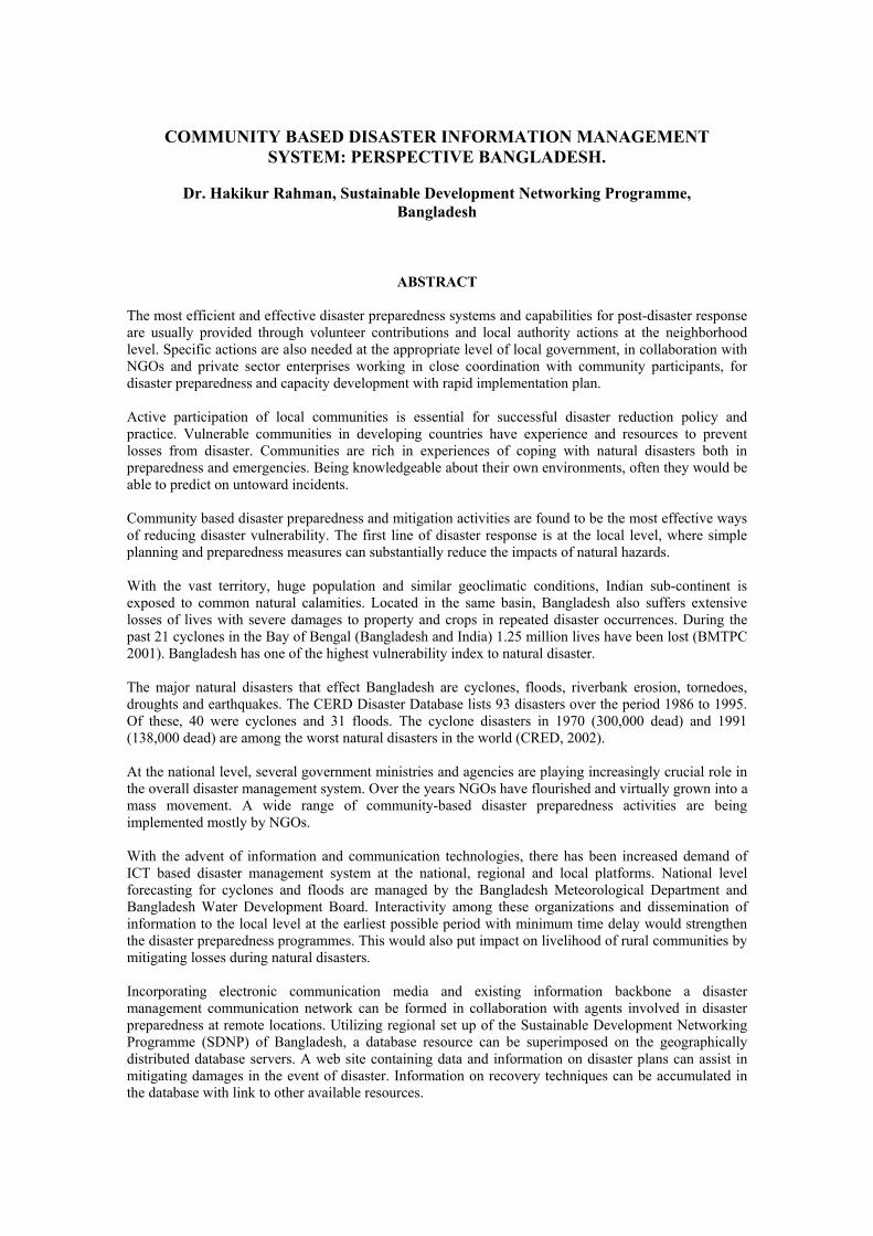
SDNP being a global catalyst of UNDP in Bangladesh acting towards implementing policies andinitiatives of Agenda 21has started its activity from 1998. It is highly logical that SDNP would be takinga leading role in information networking throughout the country by providing electronic connectivity toindividuals, corporate organizations, academics, researchers, government and non-government agenciesincluding UN and International bodies in Bangladesh. By incorporating IT methodologies on disasterpreparedness the network would easily be converted into mass information dissemination media forcommunity based disaster management system. Location of six regional nodes of SDNP is shown in thefollowing figure:
Electronic communications among the SDNP networks within the country is an explicit example ofcomputer network using minimum bandwidth sharing different localized servers and at the same timeoffering improved information services to the remotely located end users. Regional servers located atdivisional levels are added advantage of this network in reaching out the remote communitiesparticipating in community based activities. With minimum upgradation and effort the existing networkcan be utilized to accommodate electronic based disaster management network.
In order to prevent natural disasters governments at the appropriate levels, including local authorities,should promote and encourage broad-based participation in disaster preparedness activities by giving tothe population living in the vicinity of a dangerous activity adequate and regular information on the
General Papers
Regional Workshop on Best Practices in Disaster Mitigation 417
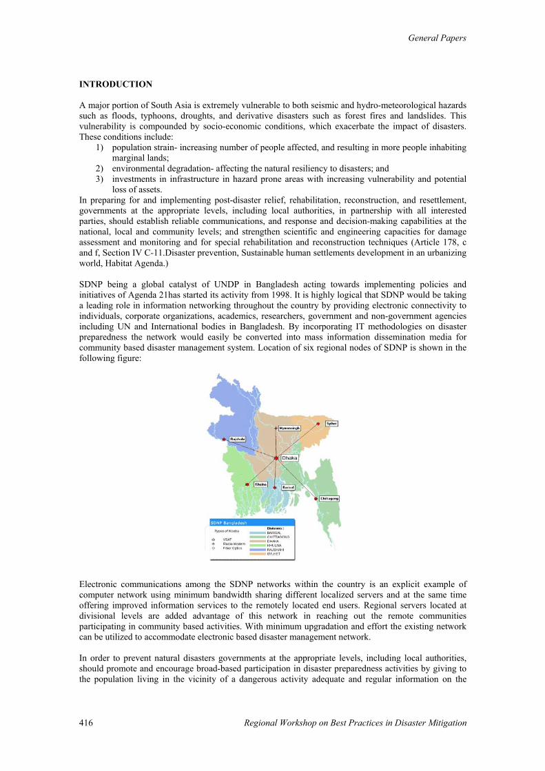
potential hazards. To intensify local level activities SDNP would like to establish information centres atcyclone shelters across the coastal belt of Bay of Bengal as shown in the figure below:
OBJECTIVES
Over the years the disaster management community has been emphasizing on developmental approach totop-down disaster management processes with recognition of significant role of communityorganizations, local government, state government, national government and above all communitiesthemselves.
Community based relief requires an effective relief agency of the government, one that initiates,facilitates, encourages, monitors, and matches the local community-based efforts. Without an effective[local government] relief agency, effective disaster management, community-based or top-down isimpossible. (Mihir Bhatt, Disaster Mitigation Institute, India.)
The SDN supported network can establish a disaster information management system to:
• Outreach programs to develop and implement mechanisms that increase community awareness andimprove management of natural hazard risks and vulnerabilities.
• Increase awareness and understanding at the community levels of the sectoral impact of naturalhazards
• Demonstrate strong training programs for community leaders, posses communication andcoordination mechanisms to facilitate preparedness and response capabilities
• Assist in monitoring, forecasting and early warning organizations and assist in warningdissemination incorporating forecasting through mass information dissemination system forcommunity disaster preparedness
• Enable vulnerable communities and local groups to understand climate forecasts and undertakecorresponding disaster preparedness and mitigation activities
General Papers
Regional Workshop on Best Practices in Disaster Mitigation418
• Incorporate innovative approaches and technologies for reducing risk to vulnerable communities,incorporating local context
METHODOLOGY
Networking minimizes the task of un-optimizes searching and sequencing in distributed environment.Individual stations connected to cluster of networks and eventually interconnected together using similarinfrastructures and optimized protocols are becoming popular throughout the virtual communities(Rahman, H., 2001).
Disaster mitigation can be divided into three action oriented programmes, namely; preparedness,response and post-disaster development. In this aspect community based initiatives are potentially moreresource efficient and better self sustained.
Establishing networking facilities in cyclone shelters and disaster preparedness centres, early warningsystems can be strengthened. Response time can be drastically reduced during sudden catastrophes.Utilizing database resources, information databank, knowledge networking the post-disaster developmentactivities can be rapidified with minimum effort and expenses.
A critical element of the USAID/DCHA/OFDA strategic plan is intermediate Result 1.4: “Increasedadoption of mitigation measures in countries at greatest risk of natural and human-caused disasters.” Forthis purpose, mitigation is defined as any sustained action that reduces or eliminates risk to people,livelihoods, and property from natural hazards. Mitigation is accomplished by reducing vulnerability,increasing the capacity of risk management systems, or by modifying, where possible, the hazard (APS,2002).
Commonwealth Of Learning (COL) of Canada has indicated interest in providing one band FM radiostations in cyclone shelters across the coastal belt of the northern region of the country where SDNP isgoing to establish virtual information centres to outreach the mission of cross cultural developmentinitiatives within the country. Few other Non Government Organizations (NGO) have also showninterest in forming institutional collaborations within fields of mutual interest. Negotiations are inprogress to include some other international organizations under the umbrella of sustainable developmentin Bangladesh.
Remote cyclone shelter across the coastal belt of the country could be taken under networking umbrellaof SDNP through dial up connection. Transformation of these cyclone shelters to virtual informationcentres is just a matter of time and in a very short period of time they would be given shape ofcommunity based learning points. Integrating the networks of SDNP, Bangladesh Open University(BOU) and similar organizations a programme can be initiated by publishing regular electronics journal,organizing email discussion forum and regional development activities incorporating grass-root leveldevelopment activities.
This information backbone can be utilized further for disseminating agricultural related information,consumer commodity related data, environment and ecological data, programme of distance education,different national awareness raising activities coming from SDNP server, BOU server and othernetworks linked to these server and networks. During evening time, the FM transmitters could be easilybe used as a community based radio station disseminating information covering mentioned activities asobtained throughout the day from the network. Towards disaster management approaches the networkcan support efforts to spread best practices in disaster preparedness and mitigation techniques throughoutthe region, especially among the three disaster prone South Asian countries; Bangladesh, India andNepal.
Divisionwise hazard maps, national level earthquake hazard maps, wind and cyclone hazard maps; andflood hazard maps, etc. can be created with specialists in this field and put into the servers for study,research, action and dissemination purposes. Risk Tables containing “distribution of houses bypredominant materials of roof and wall with level of damage risk” can be build and updated regularly by
General Papers
Regional Workshop on Best Practices in Disaster Mitigation 419
collecting data from field level data accumulators. The table can contain data on earthquake intensity,wind velocity and flood.
BARRIERS
In the long run, community efforts lack effectiveness if they are not supported and treated as animportant part of any integrated and sustainable disaster mitigation strategy. Thorough and effectivemonitoring plan should be implemented with modular pattern of close observance. Bottom-topapproaches seems applicable in rural communities. Local group will report to group supervisors and ineffect they will reach district and central level of monitoring teams.
Coordination among agencies acting in similar approaches delays effective output at the grass root levelwith increasing possibilities of duplication of efforts and un-optimization of resources.
CONCLUSIONS
During the International Decade for Natural Disaster Reduction 1990-2000, Yokohama meet declared afew important messages, Disaster Prevention, Mitigation and Preparedness are better that disasterresponse; disaster response alone yields temporary relief at a very high cost; and prevention contributesto lasting improvement in safety.
The following steps need to be taken for an effective disaster management system:� Identification of vulnerable locations;� Preparedness; and� Formulation of strategic implementation plan.
To achieve success in these aspects, creation of awareness for disaster reduction should be given primeimportance among policy initiators, decision makers and administrators at national and local levels,professional bodies, financial institutions, NGOs and voluntary organizations.
With its vast territory, large population and unique geoclimatic conditions, Indian sub-continent isexposed to natural catastrophes traditionally. Even today the natural hazards like floods, cyclones,droughts and earthquakes are not rare or unusual phenomena in the country. While the vulnerabilityvaries from region to region, a large part of the country is exposed to such natural hazards which oftenturn into disasters causing significant disruption of socio-economic life of communities leading to loss oflife and property (BMTPC, 2001.)
Following these consequences, a number of countries have adopted decentralized state structures andfunctions, accompanied with re-organizing government and civil bodies. In Bangladesh, Red CrescentSociety and qualition of NGOs have put forward a dependable platform in remote regions for disasterpreparedness and management. The scope of disaster management activities need to expand implyingparticipation of wider range of stakeholders in much wider range of activities. Local governmentinstitutions need to build up their capacities in order to meet the growing demands in the area of disastermanagement.
Capacity building at local and regional levels is needed for undertaking rapid-assessment surveys andinvestigations of the extent of damages in post-disaster periods.
Detailed databases need to be created on hazard occurrences containing damages caused to buildings andinfrastructures and the economic losses suffered and its accessibility should be ensured regardingpreparedness, and research data for effective pre and post disaster analysis with data on mitigationtechniques and action plans.
National level institutional mechanism should be enhanced to assist and advise in formulating short andlong term disaster preparedness, mitigation and prevention techniques.
General Papers
Regional Workshop on Best Practices in Disaster Mitigation420
REFERENCES
APS, 2002, Annual Program Statement (APS), USAID/DCHA/OFDA, Enhanced Disaster Preparednessin South Asia: Through Community-Based and Regional Approaches, April 24, 2002).
BMTPC, 2001, A Paradigm shift from Post-disaster reconstruction and relief to Pre-disaster Pro-activeapproach, Disaster Mitigation and Vulnerability Atlas of India, Building Material Technology PromotionCouncil, India, 2001.
CRED, 2002, "EM-DAT: The OFDA/CRED International Disaster Database, Université catholique deLouvain, Brussels, Belgium") http://www.cred.be/emdat/profiles/natural/banglade.htm
Rahman, H., 2001, Information Networking Through Distributed Nodes Sharing Minimum Bandwidth, apaper at ICACT2001 conference, The 3rd International Conference on Advanced CommunicationTechnology, February 6-8, 2001, Muju Resort, South Korea.
FACILITATING COMMUNITY INITIATIVES: UELCI EXPERIENCES ONDISASTER MITIGATION IN INDIA
Dhirendra Panda, United Evangelical Church in India
The United Evangelical Church in India (UELCI), a federation of 10 organizations, has been devoted tosocial developmental activities since 1970s. Its members belonging to these Churches are mostly Dalits,Adivasis, fisher-folk and backward communities, predominantly, settled in climatic Eco-zones in thecoast, forest and arid areas, which are affected by perpetual droughts, reoccurrence of cyclones, flashfloods and heavy rains. Among them many Church and Non-Church related Non-Governmentalorganisations are also working for the welfare of these communities.
The role UELCI in large-scale emergencies became pertinent after the Super Cyclone in Orissa in theyear 1999,when more than 10,000 people lost their lives and 2 lakhs families became homeless. TheGovernment of Orissa invited UELCI and its partners, who could effectively work in the crisis phaseand in the short term rehabilitation of the victims as repair of houses and providing livelihood assistanceetc. UELCI worked through the partners of a well-known and field based network called OrissaDevelopment Action Forum (ODAF) in the Super Cyclone affected areas.
Almost after 25 years of development and emergency assistance, UELCI has built up relationship withmany local NGOs in India through its programmes. In Orissa it has been successful in building allianceto engage in advocacy and lobby work against the policies and acts that were anti-people, anti-environment and anti-development,. The issues related Adivasis, Dalits and Fisher folk were part ofUELCI agenda. Displacement, Mega development projects that destroy local environment, commercialplantation, Land Acquisition ACT, V Schedule, Panchayati Raj, Conflict over control of naturalresources by the corporate-houses were some of the areas, where UELCI continues to collaborate andcooperate with network of NGOs and People’s Movements.
Its recent involvements in Rehabilitation of Victims
Orissa Super Cyclone in 1999 -2000Orissa Statewide Flood in 2001-2002Andhra Pradesh Cyclone in 2001-2002Gujarat Earthquake in 2001-2002Gujarat Communal Riots in 2002
Guiding Principles
Considering the recurrence of Disasters in India, it has been working for Sustainable DisasterManagement keeping the community development approaches at the core: which is a detachment fromtraditional “relief- delivery” approach. While the traditional approach relates to moving into work afterdisaster and moving out before proper rehabilitation emphasizing immediate relief service without caringfor the empowerment of community members, UELCI considers peoples empowerment as corner stonefor Community based Disaster Preparedness.
UELCI does not offer such models that does not fit with the taste, tune and texture of people within thegiven socio-economic realities
Rights based approach
Disaster victims have the right to be rehabilitated
It strongly believes that it is the responsibility of the state to take all necessary measures, short-term orlong-term, to protect its citizens from the fury of disasters. It struggles to influence public policy in favour of people through various democratic ways and means.
General Papers
Regional Workshop on Best Practices in Disaster Mitigation422
People Centered Disaster Preparedness/Management
Community members or victims are at the center of planning, decision making and execution of disastermanagement.
It networks among the victims, so that they can combine there efforts to prepare against Disasters.
Instead of creating centralised resource pool, it believes in developing local skills andknowledge.(Capacity Building Programmes)
Democratic Decision Making Process
Irrespective of religious belief, caste, colour, creed or gender bias each individual has equal right toparticipate in decision- making process.
Transparency
All the stakeholders are informed of the intentions or contentions of activities.
Community Development as the axis of Relief and Rehabilitation
UELCI work does not complete just with the completion of relief / rehabilitation work. Rather itfacilitates community empowerment and development.
Community Empowerment
Empowerment of community is the key to community based disaster management and its sustainability. LESSONS LEARNED
Through long-standing observations UELCI has been able to learn following things-
• Like some other Asian Countries, Nature has cursed India with disasters that cause widespreaddamage and devastation in India with a high frequency. Floods, Droughts, Cyclones, Earthquakes,Landslides and avalanches are some of the major natural Disasters that repeatedly and increasinglyaffecting India.
• However, the list of Disasters does not exhaust with these natural ones. There are man madetragedies like toxic-gas leak from Union Carbide industry in Bhopal, communal riots(Hindu vs.Muslim) in Gujarat killing more than 2500 innocent people and damaging thousands of houses etc.
• The disasters, every year, compel the developmental Agencies to put more time, energy and moneyfor it diverting their main agenda.
• Frequency of Disasters as Cyclone, Drought, Flood is now increasing year by year
• For example, the heat-wave in 1998 in Coastal Orissa (India) took away 1500 lives, in 1999 twomajor cyclones in Orissa (one Super Cyclone with a wind-speed of about 350 km/hour) affected 15million people,, and killed about 25000 people, in 2000 a severe drought affected 29 districts, in2001 an unprecedented Floods affected 24 districts out of 30.This current year people are facinganother severe most drought.
• In all those disasters extreme-behaviour of the climate is being marked. In 1998 Coastal Orissa hadreached a temperature about 500 C which was a record while normal temperature in Bhubaneswarremains around 400 C during the same season, which was unthinkable 20 years back. The flood in2001 was unprecedented due to its intensity and extensiveness.
General Papers
Regional Workshop on Best Practices in Disaster Mitigation 423
• This year Drought is considered a rare phenomenon not seen in the whole of last century. Theshortage of rainfall has broken 40 years record. This year less than 60% rainfall has been recordedall over India. Over 320 districts have been identified as Drought prone.
• It seems frequent changes in climate due to Global warming caused basically by human activitieswill not only make Disasters inevitable but also affect agriculture, health, livelihood with negativeimpacts. It is known to everybody that the industrialized and Developed countries are moreresponsible in this regard than the developing countries .
Globalization -Trade liberalisation increases Vulnerability
Trade liberalisation or Globalisation induced economic reforms has been creating more impoverishmentby largely reducing existing job opportunities, pushing further down the small, middle and marginalfarmers and wage labourers who are of the lower economic strata; slicing down social welfare schemescreating hindrance for the development of local infrastructure and preparedness. These lead to increasingvulnerability in the face of disasters of the common people in urban and rural India.
Riots and Wars
Increasing conflicts in between religions, communities, tribal vs non-tribals, dalits vs higher castes aregiving birth to disaster ie. Gujurat carnage.
We must not forget the disasters being faced by Afghanistan and other war-torn countries.
Considering above facts Disaster has become a regular part of Human life today. Development can notbe thought of without addressing the effects of Disaster. Now any Development thinker or worker cannotbut integrate Disaster Management with Developmental option. This is UELCI's foremost learning. Thusit will be its endeavor to slowly establish and anchor this approach in critical Disaster prone zone as amodel and experiment within not only Church related institutions, but also or Non-Government
Organization as well as through them building intervention for long term intervention.
Operational Strategy / Approaches adopted by UELCI
Application of various strategies/approaches UELCI found followings are proved to be successful:-
Links Disaster Mitigation efforts with political, Human Rights issues activists and organisations
• Involves a local experienced NGOs (having knowledge of the region, being culturally sensitive,active in the region and more pro-poor, capable to take up fight for justice) / CBOs / POs in DisasterOperations, besides involving community groups.
• Facilitates the formation of village-level development committees, the basic unit to spearheadDisaster Mitigation operations.
• Organise the Community members to demand fulfillment of their rights from the Government.
• Facilitates for the creation of local infrastructures by the community itself.
Beneficiary Selection:
• Disadvantaged section of the community as Dalits (untouchables), indigenous tribes, fisher-folks,women, children, disables etc.
• Economically marginalised people as agricultural land labourers, share croppers, marginal farmers,small farmers and people under below poverty line.
• Villages, non- attended or sparsely attended to by the Government or other NGOs.
General Papers
Regional Workshop on Best Practices in Disaster Mitigation424
• Beneficiaries selected on the basis of observation of experts, CBOs, local People's Representativesand is being done by the village level committee
Gender:
• Utmost emphasis on women participation for identification and address of women specific needsduring relief and rehabilitation works.
• Recruitment of mostly women as village level volunteers.
• Formation of women groups at village/hamlet level
Housing:
• Ensure community initiative through opting for replicable housing models and beneficiaries’involvement.
• In flood-prone and cyclone-prone areas Flood-resistant 'frames' (concrete pillars and tin-roofing) aresupported by UELCI, required unskilled manual labourers are put by the beneficiaries themselves.Food items are only supported to the persons engaged for this on per diem basis. Beneficiaries aremobilised to construct mud walls by themselves. Future Floods may wash away the mud only,which can be reconstructed by the beneficiary himself without depending on outside assistance.
• Advocates for and makes the community to avail of the entitled housing compensations from theState.
Food Distribution
Discourages free Food Distribution, where community initiative may be killed, except unavoidablesituations
• Provides food materials in lieu of labour contribution by the beneficiary for making their owncommunity infrastructure
• Assistance for Agriculture
• Seeds are supported to marginal/ small farmers through village committees under an agreement thatthe beneficiaries would return the seeds through the village committees after harvesting.
• Seed banks are opened with the seeds collected from villagers to meet future need duringCalamities.
Health and Sanitation
• With primary concern it helps the community to use safe drinking water
• Medicine kits are supplied to village committees.
• Village volunteers are trained/ oriented to administer medicines, where doctors or qualified staff arenot available
• Community medicine banks are created.
Some practical learning are: -
• Involvement of community members in the process makes the community establish their ownershipover the project, process and outcome.
General Papers
Regional Workshop on Best Practices in Disaster Mitigation 425
• Interaction amongst affected people, community leaders, experts, CBOs / Local NGOs and UELCIfacilitator during various phases beginning from damage assessment to implementation, impactassessment helps in joining the people's experience and experts’ knowledge.
• Targeting indigenous tribes, dalits (untouchables), agricultural labourers, marginal/ small farmersand other vulnerable people lying at the bottom-line of the society, ignoring their caste, creed,religious affiliations helps in bringing confidence among these marginalised people. Although itcreates casual tensions among the people at upper strata, it makes community to stand againstcommunal frenzy.
• Recruiting women as community volunteers and to work as community spokespersons helps inbuilding confidence and trust among women-folks and to take up women-specific problems inDisaster mitigation activities.
• Activating and involving local political workers in Disaster mitigation activities strengthensAdvocacy / lobbying actions to pressurize the Government authorities to provide compensations andother due benefits.
• Low cost housing or local community infrastructures and involvement of communities along withtheir own contribution inspires other marginalised sections, beyond the targeted areas to replicatethe models without feeling hopeless.
• Integrating Disaster management Programmes with community development efforts brings entirecommunity together and make the DMP sustainable.
• Experience from one Disaster helps the community to strengthen their coping up mechanism to faceanother Disaster of similar kind.
• Last but not the least; human endeavor to prevent and mitigate disasters can be successful only onthe help of an effective knowledge base. A country like India which is rich in knowledge, bothtraditional and modern needs to utilise this base for effective Disaster Management. The process ofrecording the data during any disaster situation has to be properly constituted for different type ofdisaster as each disaster situation is a unique event, which needs to be recorded for posterity to drawappropriate lessons.
HOSPITALS PREPAREDNESS FOR DISASTER: A CASE STUDY
Dr. P.K.Gupta, Indore, Institute of Management Studies, and Dr. Anil Mahajan, Devi Ahilya University, Indore.
ABSTRACT
21st century after seeing the uncertainties of societal well-being has witnessed an increased low intensityconflicts. These conflicts are taking shape of man made disasters the most recent disasters of this natureare Sep.11 attack on WTC and Dec 9 attack on Indian Parliament. Disasters in any form whether manmade or natural cause casualties & dislocation of different kinds of services which requires to be restoredat the earliest not only to restore normal life pattern but also to bring down panic reaction at its lowest.
The various services, which need preparedness for any kind of eventuality coming without any warning,are health, sanitation, water supply, electricity supply, security (law & order), transport etc.
Health being the most crucial service, from the point of view of caring & rehabilitation of injured &disposal formalities for dead, requires the highest state of alertness round the clock all 365 days of theyear without any relaxation of any kind for any reason.
As hospitals & emergency staff are the first persons to manage the consequences of any disaster,assessment of their preparedness is the most important for any government as well as public.
OBJECTIVE
Keeping this view in mind this study was undertaken in the form of a case study so as to assess howprepared are the Indian health services.
SAMPLE
Sampling was carried out in two stages. First the Indore city .an important industrial and educationalcentre of central India situated in the close vicinity of an important defense establishment of the countrywas chosen for this study. Then, ten hospitals representing the public, private & charitable sectors wereselected for this study.
DATA COLLECTION
Data were collected from CEO’S / Medical superintendents of the selected hospitals using aquestionnaire developed for purpose of study. The questionnaire was in line with international protocolsfor preparedness of disasters.
RESULTS
The study revealed that the studied hospitals presently are far from international protocols ofpreparedness for disasters. It was found that the awareness for preparedness is lacking.The study has been able to highlight various factors where disaster preparedness is lacking & researchershave made a no. of suggestions to prepare hospitals for meeting with any challenge faced by them.
General Paper
Regional Workshop on Best Practices in Disaster Mitigation 427
INTRODUCTION
After the incidences of September 11 at world trade center USA, December 13 at Parliament of INDIA &the earthquake in state of Gujarat, INDIA, the importance of disaster management has become quiteevident to even a lay person. As the tendency to take support of violence & threat to public life tohighlight demands is increasing, no city in world can be said to be free from risk of facing such cowardlyacts. So the responsibility of persons who tackle victims of disaster further increases along with theincidence of such unfortunate events whether those are man made or natural.
Obviously the first persons to deal with victims of any disaster are the emergency staff & the hospitals ofthat area. So it is quite logical for a hospital to be prepared to deal with disasters.
The problems in effectively dealing with disasters are manifold because accurate information andtraining is not readily available to emergency and disaster responders to meet the challenge effectively.
Concern about disasters is becoming increasingly relevant as increases in population density, populationshifts, and increasing technology make it likely that we will encounter disasters more frequently and thatthey will be more severe (Drabek, 1986:60, 70) There are several reasons for this:
1. Increasing Population Density: as areas become more densely populated, there are more potentialvictims when a disaster strikes
2. Increased Settlement in High-Risk areas. There is greater settlement in high-risk areas such as floodplains, earthquake faults, coastal hurricane areas, unstable hillsides, areas subject to wildland fires, andareas adjacent to hazardous waste landfills, airports, and nuclear power
EXAMPLES:
1.Each year floods cause loss to human & financial assets to the tune of millions in states of Bihar,eastern U.P.& Assam in our country.
2. Increased possibility of terrorist attacks in form of explosives, chemical, biological or radiologicalweapons is posing threat to almost all of democratic countries of the world.
3. More vulnerability of society to ethnic violence due to decreasing adjustability & political interferencewhich leads to horrifying incidences like Godhra mass killing & its aftermath in INDIA. Which hasincurred us cost to the tune of billions of rupees & of course lives the cost of which cannot be estimatedat all.
4. There is a proliferation of high-rise office buildings and hotels that subject their inhabitants to firethreats not experienced before.
OBJECTIVES OF STUDY
The objectives for this study are:
• To study level of preparedness for disaster in hospitals in Indore.• To suggest for bridging out various gaps found while conducting this study.
RESEARCH DESIGN:
The purpose of the study has been to assess how well the Indore Hospitals are prepared for managingthe disaster. Therefore, the study has been planned on the basis of Survey research design where in theresearch shall lead to the conclusion whether the Indore hospitals are adequately prepared to face anykind of eventuality involving a large number of casualties and injuries requiring immediate care.
General Papers
Regional Workshop on Best Practices in Disaster Mitigation428
SAMPLE DESIGN
In order to obtain the representative information from all the hospitals including the upcoming hospitalswhose construction is in progress. For the study various hospitals were selected on the basis of their size,location & current working status. The schematic plan for the selection of hospitals was as follows:
Firstly, the hospitals were grouped on the basis of the number of beds available to patients for treatmentas an indoor patient. They were classified into Two categories, viz.. A) Hospitals with bed capacity of more than 100 beds. B) Hospitals with bed capacity less than 100 beds.
Secondly, the hospitals with less than 100 beds capacity were further selected on basis of there locationso as to represent almost all the areas of the city i.e. the four areas (demarcated as north south east &west) of the city. TOOLS
The information for the evaluation of preparedness of Indore Hospitals for any eventuality was obtainedthrough the questionnaire named as Hospitals Preparedness for Disaster Management, developed on thebasis of guidelines from various resources including JCAHO (joint commission for accreditation ofhealth care organization) and the personal discussions with the various experts in disaster management.
The questionnaire developed for the study contained mainly dichotomous items.
There were few open-ended questions also to help respondents give their preparedness in terms of theinformation, which could not be elicited through dichotomous questions.
ANALYSIS AND DISCUSSION
Information received from following hospitals regarding preparedness for disasters was subjected to theanalysis:
Hospitals which are providing services
1. Maharaja Yeshwantrao Hospital2. T.Choithram Hospital & research centre,3. CHL-Apollo Hospital 4. Cloth market Hospital 5. Verma union hospital 6. Unique Hospital 7. Anand Hospital8. Suyash Hospital 9. Lifeline Hospital10. Mayur Hospital
Hospitals likely to start providing services soon
1. Bombay Hospital & research 2. Arihant Hospital
The respondents comprised of CEOs, Administrative Officers, Managers or Superintendents of therespective hospital. Only one respondent was included in the sample.
It was found that only Four respondent Hospitals comprising of Three from Private Sector and Only Onefrom Public Sector have developed or are in the process of developing some kind of infrastructure tomeet with the Disaster situation, but that too in normal routine manner.
General Paper
Regional Workshop on Best Practices in Disaster Mitigation 429
These Disaster preparedness programs are meagerly available to public and are far from the JCAHOcriterion.
Public Hospitals in Indore city are the largest in terms of facilities and services provided by any hospitalboth private as well as public sector. The main Public sector hospital has some disaster relatedpreparedness, possibly due to the fact that the hospital receives a large number VIP Visitors, whosesecurity is quite important. The hospital though requires to make adequate arrangements to meet anyeventuality, but it has not been able to meet the requirements.
Responses received from the respondents reveal that:
PRESENCE OF ADQUATE DISASTER PLANNING COMMITTEE:
Only 10% of the respondent hospitals have such disaster planning committee, to review time to time thehospitals’ effectiveness in dealing with the eventualities.
STAFF ORGANIZATION FOR DISASTER RESPONSE:
Only 10% hospitals have some staff to meet the eventualities. Probably such a lukewarm response to theappointment of a skilled staff to meet the disaster is due to the fact that the City is yet to face a majordisaster requiring specialized staff.
ADEQUATE SPACE FOR TREATING EMERGENCY PATIENTS
In spite of the fact that only 10% hospitals have disaster preparedness but 20% of the hospitals haveadequate space for treating mass casualities.
ADEQUATE SUPPLIES DURING DISATER
Since all hospitals have a facility of providing medicines to patients they keep sufficient inventory ofmedicines and the same can be utilized for Emergency purposes. This facility of adequate supplies isavailable in 30% of hospitals.
Criterion for Indoor- patients in case of emergency situations demanding extraordinary space for thetreatment of patients.
EXTERNAL COORDINATION AND CONDUCTION OF DISASTER DRILL
Of all the hospitals included in the sample, no hospital has any kind of external coordination andconduction of disaster drill. Probably, they do not engage themselves in such an activity because they donot feel it to be time and cost effective exercise and also they feel that in case of any disaster situationthey will be able to meet the situation with the existing training and expertise of the staff.
CONCLUSION
Out of twelve Hospitals (ten in working status & two to resume working in near future) only fourhospital have some system for disaster management but only one (public hospital) has adequateinfrastructure for management of disaster.
Not only do people sometimes fail to learn from the mistakes of others, but also they may even neglect tocorrect their own, previously noted deficiencies, that is why the preparedness of hospitals in regard toDisasters gets the lowest priority.
SUGGESTIONS
In order to prepare the hospitals for any kind of disaster situation, there is a need to implement thefollowing:
General Papers
Regional Workshop on Best Practices in Disaster Mitigation430
• Reducing apathy towards disaster preparedness through developing positive thinking for any kind ofeventuality. The apathy needs to be tackled on three fronts:
• Public Education to make aware of the consequences of the disasters
• Media awareness to inculcate positive and receptive attitude towards disaster preparedness
• School programs to educate young children of the ill effects of the disasters.
• Planning Check Points : This is required to assess the possibility of disasters and their magnitudes.
• Paper Plan Syndrome: The disaster plan besides being put on the paper it requires adequate trainingand periodical exercise by the concerned staff.
• First Wave Protocol: The possible emergencies needs to be classified in accordance with theCommittee on trauma of the American college of Surgeons in selection of facilities required fordifferent categories of casualties and their awareness among staff as well as other hospital staff.
• Routing exercise of patients in a previously decided number according to the nature of injury,facilities available in hospitals and the availability of attending staff needs to be carried out and aproper information should be made available to emergency responders.
INTER ORGANIZATIONAL PERSPECTIVE
Even if all the hospital are equipped with the well-designed disaster plan, they may ignore coordinatingwith other hospitals, public safety agencies and most important of all disaster experts who have donesome kind of study or work.
REFERENCES
Drabek: 1986:60, 70 an e-book “Disaster Response: Principles of Preparation and Coordination’ chapter1, ‘The Problem” on website http://216.202.128.19/dr/PDF/Chapter01.pdf
Heide,A.D.; Disaster response principles of preparation and coordination; an e-book on disastermanagement on web site of Center of excellence in disaster management and humanitarian assistance.
SEISMIC HAZARD ASSESSMENT IN DENPASAR – BALI
I Wayan Sengara, Engkon K.Kertapati, and I Gede Mahardika Susila, Institute ofTechnology, Bandung (ITB), Indonesia,
ABSTRACT
The high acceleration value in Bali area due to two sources zone: the Flores Backarc Thrusting and inter-intraplate subduction source zones. The thrust zone is evident in two segments: the Flores thrust zone isthe west and the Wetar thrust zone in the east. Both dip opposite to the sense of subduction of IndianOcean – Australian plate at the Jawa Trench and Timor Trough. The earthquake effects in Bali due toearthquake event are: ground shaking, liquefaction, ground failure and tsunami. The assessment wasbased on historical data as well as from deterministic hazard analysis considering maximum magnitudethat could be generated from potential faults and subduction source zone. The assessment was also basedon previous seismic hazard analysis available in the literature. The assessment provides peak groundacceleration (PGA) at baserock of values in the range of 0.25 – 0.4 g.
1.0 INTRODUCTION
Indonesia is a country where four of the earth’s main plates contribute to the seismic activities in theregion. This condition has caused most of Indonesian regions are potential to relatively high risk toearthquake. City of Denpasar is the capital of Bali Province is considered one of the most denselypopulated cities in this province. Regional earthquake map shows that north of Bali – on the west andEast Nusa Tenggara on the east side has one seismic source zone called Flores Back Arc Thrusting. Thisfault has historical earthquake activities such as the 1976 Seritit Earthquake and the 1992 FloresEarthquake. Other earthquake sources are interplate and intraplate subduction seismic source zone, suchas: the 1862 Buleleng Earthquake, the 1890 Negara Earthquake, caused walls and tumble down andreached VII MMI.
2.0 REGIONAL TECTONIC SETTING
The major tectonic feature in the region is the Sunda Arc,which extends approximately 5,600 kmbetween the Andaman Island in the northwest and the Banda Arc in the east. The island arc results fromconvergence and subduction of the Indo-Australian palte beneath Southeast Asia. The direction of plateconvergence between Southeast Asia and the Indo-Australia plates is assumed to be about north southand overall rate of convergence is probably abou 7.7 cm/year. Based on the inferred direction of platemotion and geologic evidence, the ralative motion appears to be normal to the arc at Jawa-Bali, andoblique near Sumatera. The normal driving of the underthrusting plate to the overriding plate isaccommodated thrust fault sistem (the Flores Backarc Thrusting) in the forelands of continental arc.
2.1 Java – Bali Segment of the Java Trench
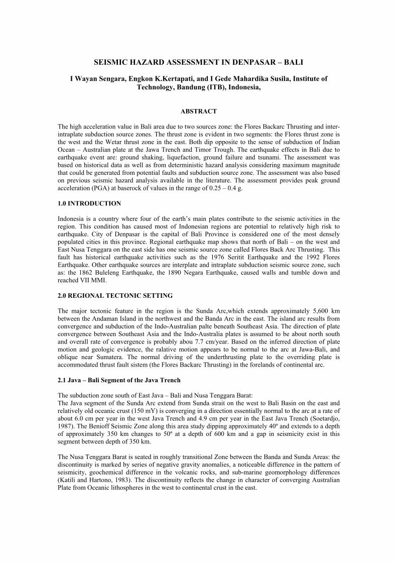
The subduction zone south of East Java – Bali and Nusa Tenggara Barat:The Java segment of the Sunda Arc extend from Sunda strait on the west to Bali Basin on the east andrelatively old oceanic crust (150 mY) is converging in a direction essentially normal to the arc at a rate ofabout 6.0 cm per year in the west Java Trench and 4.9 cm per year in the East Java Trench (Soetardjo,1987). The Benioff Seismic Zone along this area study dipping approximately 40º and extends to a depthof approximately 350 km changes to 50º at a depth of 600 km and a gap in seismicity exist in thissegment between depth of 350 km.
The Nusa Tenggara Barat is seated in roughly transitional Zone between the Banda and Sunda Areas: thediscontinuity is marked by series of negative gravity anomalies, a noticeable difference in the pattern ofseismicity, geochemical difference in the volcanic rocks, and sub-marine geomorphology differences(Katili and Hartono, 1983). The discontinuity reflects the change in character of converging AustralianPlate from Oceanic lithospheres in the west to continental crust in the east.
General Papers
Regional Workshop on Best Practices in Disaster Mitigation432
0
100
200
300
400
500
600
700
-12 -11 -10 -9 -8 -7 -6
Latitude
Dep
th (k
m)
Figure 1 Hypocenter profile of Bali Segment of Java Trench
2.2. Flores Back Arc Crust Thrust Fault.
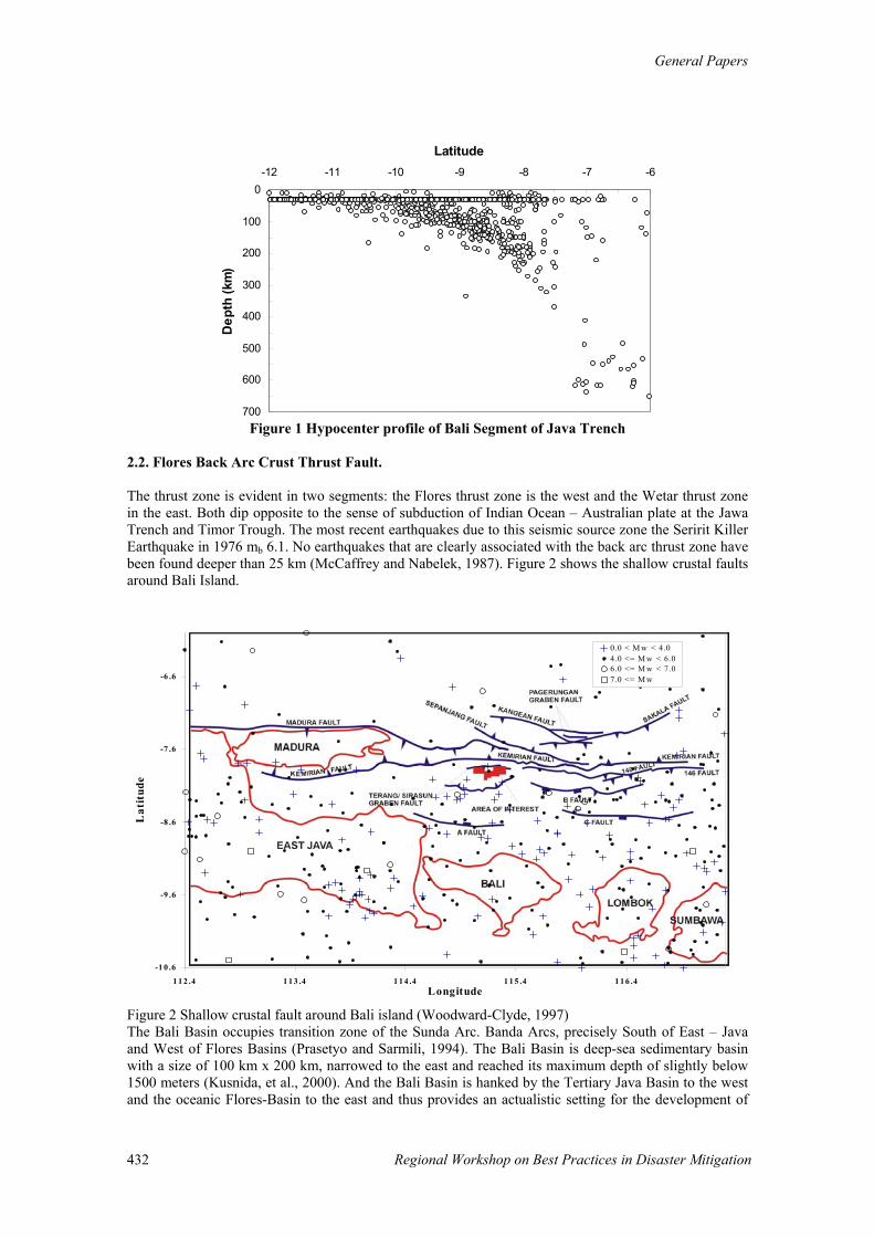
The thrust zone is evident in two segments: the Flores thrust zone is the west and the Wetar thrust zonein the east. Both dip opposite to the sense of subduction of Indian Ocean – Australian plate at the JawaTrench and Timor Trough. The most recent earthquakes due to this seismic source zone the Seririt KillerEarthquake in 1976 mb 6.1. No earthquakes that are clearly associated with the back arc thrust zone havebeen found deeper than 25 km (McCaffrey and Nabelek, 1987). Figure 2 shows the shallow crustal faultsaround Bali Island.
-1 0 .6
-9 .6
-8 .6
-7 .6
-6 .6
1 1 2 .4 1 1 3 .4 1 1 4 .4 1 1 5 .4 1 1 6 .4Longitude
Lat
itud
e
0.0 < M w < 4.04.0 <= M w < 6.06.0 <= M w < 7.07.0 <= M w
Figure 2 Shallow crustal fault around Bali island (Woodward-Clyde, 1997)The Bali Basin occupies transition zone of the Sunda Arc. Banda Arcs, precisely South of East – Javaand West of Flores Basins (Prasetyo and Sarmili, 1994). The Bali Basin is deep-sea sedimentary basinwith a size of 100 km x 200 km, narrowed to the east and reached its maximum depth of slightly below1500 meters (Kusnida, et al., 2000). And the Bali Basin is hanked by the Tertiary Java Basin to the westand the oceanic Flores-Basin to the east and thus provides an actualistic setting for the development of
General Paper
Regional Workshop on Best Practices in Disaster Mitigation 433
fold and thrust belt. The crust of the Bali Basin was transitional in thickness between oceanic andcontinental (Hamilton, 1979). The fold and thrust belts develop in the foreland of Continental arcs havebeen observed the dip angle of the subducting plate so that inferences about the deformation. The thrustbelt is evident in the two segments: the Flores thrust zone in the west and Wetar Thrust Zone in the eastand by one arc micro thrusts that may represent early by stages of subduction polarity reversal in the area(Nishimura & Suparka, 1985).
In the north, it is limited by an east-west trending Madura-Kangean High, which is acting as theSoutheastern border of the Sunda land. The southern part of this ridge is limited by an east west trending,Sepanjang Normal Fault (Letouzey, et al., 1990). In the east, the northwest-southeast lineationbathymetric Contour is presented as the eastern limit of the basin, and convinced to be continuing to theSaleh Bay depression in Sumba Island (Zen et al., 1992). The Bali Basin receives sedimentary infill fromthe north (Sunda shield), from the west (Madura strait) and principally from the south (Bali-Lombok).Around the longitude (114.60º-7.60º S) at 5.5 km depth, Kusnida et al. (2000) observed the 30 km x 40km dimension of doming of Moho physical discontinuity with east-west direction. Selater and Menard(1967) state that such structure indicates the up-welling of hot mantle material beneath active marginalbasin although of lack coherent spreading center typical of normal mid ocean ridges. Kusnida et al.(2000) suggest that it would be the initiation of back arc thermal stressing. A zone of huge slumping inthe affinity area probably indicates a sea-floor expression of this deep-seated up-doming structure(Kusnida et al., 2000).
In this area, surficial slump sears like structures seems to be formed by differential up lift of thebasement underneath. Back-arc thrusting in this area causes the structures tend to be grouped into twomain categories, as said above: those due to tectonic forces, magma intrusions (Silver et al., 1983), andcollision by Roo rise. Magma activity is probably important in weakening the thrust, however and in thisway aiding thrust development in the collision region.
The west part of Flores Thrust is the Bali Basin. It is narrow and shallow, and underlain by oceanic crust(Raitt, 1967; Hayes et al., 1978). But Silver et al. (1983) suggest that the Flores Thrust is disappearingbeneath the Bali Basin. The deepest part of the basin is along the south margin, and although it is filledwith sediments, (see above). Neotectonic for the study area/east Indonesia, it is assumed that the majorityof the shoreline features are result of Quaternary diastrophic, due to active tectonic movements andseismicity. And the Pleistocene period (2.5 million years ago) in Indonesia was characterized bypowerful mountain building. In some areas the arogenic movement was started in Pliocene Time (sevenmillion years ago) and in many parts it continued into Holocene and Resent Time such as in this areaTerraces distribution in north coast of East Nusa Tenggara (Central Flores to eastern Sumbawa) are highon the north Coast and low or absent on the south due to North-South tilting of Flores Island. All groupin the northern Flores have sunk in Pleistocene Time (2.5 million year ago) and estimated to have a rateof 1 mm per year. The up lift of Timor at a rate of 0.37-7.0 cm per years and the other outer islands to theeast due to the positive buoyancy to continental crust beneath the accretion wedge (Silver et al., 1985).The estimate rate of fracture zone movement in the north of Bali is approximately 0.1 to 0.3 mm peryear.
3. EARTHQUAKE HISTORY
The most recent earthquake felt in Denpasar is the Karangasem Earthquake, December 17, 1979.Significant damage was reported. 25 people person killed, more than 400 people seriously injured.Cracks in the road and land were observed along 0.5 km. The oldest damaging earthquake recorded inthis area was 1862 March 29, Buleleng Earthquake MMI VII. The source of this earthquake is theinterplate subduction zone.
Earthquake in Seririt in 1976 July 14, in Tabanan and Jembrana more than 75 % buildings and housesseverly damage 559 killed, 850 people seriously injured and some than 3200 injured. MMI VIII.
There were major large earthquakes reported in historical record prior to instrumental recording(NewComb and McCann, 1987). These events occurred in 1840, 1867 and 1875. Several large eventswere also recorded since 1903. The record of historic seismicity along the Java segment indicates that
General Papers
Regional Workshop on Best Practices in Disaster Mitigation434
within a period of about 300 years, no great intraplate earthquake hare occurred that were similar to the1833 and 1861 Sumatra events.
The significant earthquakes in this area were: Tulungagung earthquake of 05 July 1859 (MMI scale of VI, some buildings and houses suffereddamage), another Tulungagung Earthquake with a MMI scale of VII occurs on 20 August 1896,Bali Earthquake of 21 January 1917: ground slumps and ground slides were observed at various places.Many houses suffered damage and about 1500 people were killed due to groundslides, the MMI scale ofIX,The Gresik Earthquake of 19 June 1950 (MMI scale of VII).
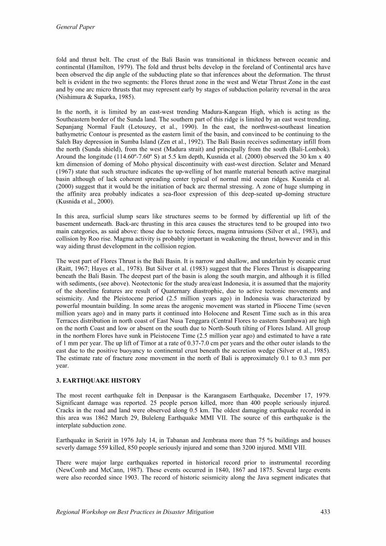
Figure 3 the earthquake distribution in Denpasar and vicinity area
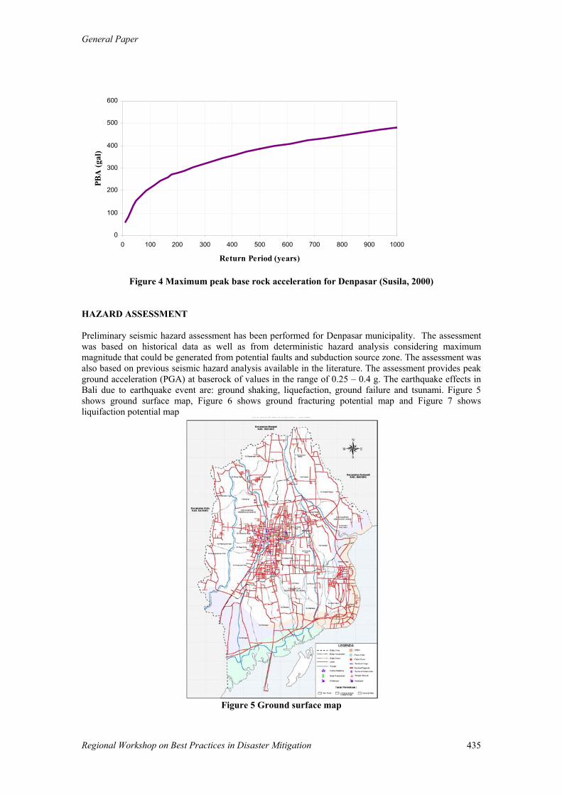
Figure 3 shows the earthquake distribution in Denpasar and vicinity area. The study that had beenconducted by Susila, 2000 as show in Figure 4, the maximum peak ground acceleration suggested around0.30 g with return period 500 year. The high acceleration value in Bali area due to two sources zone: the Flores Backarc Thrusting and inter-intraplate subduction source zones.
General Paper
Regional Workshop on Best Practices in Disaster Mitigation 435
0
100
200
300
400
500
600
0 100 200 300 400 500 600 700 800 900 1000
Return Period (years)
PBA
(gal
)
Figure 4 Maximum peak base rock acceleration for Denpasar (Susila, 2000)
HAZARD ASSESSMENT
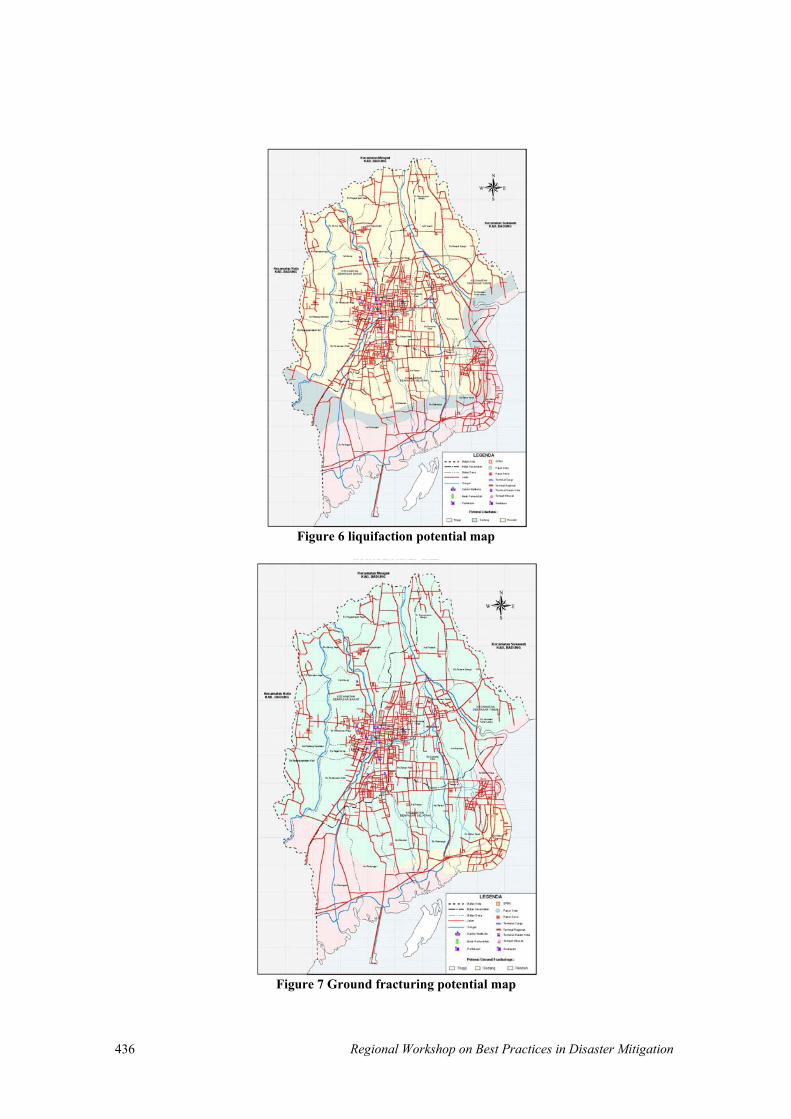
Preliminary seismic hazard assessment has been performed for Denpasar municipality. The assessmentwas based on historical data as well as from deterministic hazard analysis considering maximummagnitude that could be generated from potential faults and subduction source zone. The assessment wasalso based on previous seismic hazard analysis available in the literature. The assessment provides peakground acceleration (PGA) at baserock of values in the range of 0.25 – 0.4 g. The earthquake effects inBali due to earthquake event are: ground shaking, liquefaction, ground failure and tsunami. Figure 5shows ground surface map, Figure 6 shows ground fracturing potential map and Figure 7 showsliquifaction potential map
Figure 5 Ground surface map
Regional Workshop on Best Practices in Disaster Mitigation436
Figure 6 liquifaction potential map
Figure 7 Ground fracturing potential map
General Paper
Regional Workshop on Best Practices in Disaster Mitigation 437
REFERENCES
Crouse,C,B., 1992; Seismic Hazard Evaluation Offshore Northwest Java, Indonesia, Dames & Moore.,Inc.
McCaffrey. R., J.Nabelek, 1987; Earthquake, Gravity, and the Origin of Bali Basin, an Example ofa Nascent Continental Fold and thrust belt. Jour.of Geoph. Res. Vol. 92, No. 81, pp.441 – 460.
Borcherdt, R. D., (1994), “Estimates of Site-Dependent Response Spectra for Design (Methodology andJustification)”, Earthquake Spectra, Vol. 10, No. 4.
Das, B.M. (1993), “Principles of Soil Dynamics”, PWS-KENT Publishing Company, Boston.
Firmansjah, J., Irsyam, M., (1999), “Development of Seismic Hazard Map for Indonesia”, Proceeding ofNational Conference on Earthquake Engineering, Bandung.
Ishihara, K, (1993), “Manual For Zonation on Seismic Geotechnical Hazards,” Technical Committee forEarthquake Geotechnical Engineering, TC4, The Japanese Society of Soil Mechanics and FoundationEngineering.
Kertapati, E, K. (1999), “Probabilistic Estimates of the Seismic Ground Motion Hazard in Indonesia”,Proceeding of National Conference on Earthquake Engineering, Bandung.
Kramer, (1996),“Geotechnical Earthquake Engineering”, Prentice-Hall Inc Upper Suddle River, NewJersey.
Peraturan Perencanaan Tahan Gempa Indonesia Untuk Gedung, (1983) Direktorat Penyelidikan MasalahBangunan, Bandung, Indonesia (in Indonesia).
Sengara, I W., Surahman, A., Pribadi, K. S., (1999), “Seismic Hazard and Countermeasures in Bandung– Indonesia”, Bandung.
Sengara, I.W., Munaf, Y., Aswandi, and Susila, IG.M., (2000), “Seismic Risk and Site ResponseAnalysis for City of Bandung-Indonesia”, to be presented in Geotechnical Earthquake EngineeringConference, San Diego, March, 2001.
Shah, H. C., Boen, T., (1996), “Seismic Hazard Model for Indonesia”.
Structure Engineering Design Provision, (1997), ”Uniform Building Code (UBC97)”, Vol. 2,International Conference of Building Officials.
Susila, I G. M., (2000), “Seismic Risk and Site Specific Response Analyses for Denpasar”, Thesis,Geotechnical Engineering – Civil Engineering, Post Graduate Department, Institute of TechnologyBandung
Youngs, R. R., Chiou, S. J., Silva, W. J., Humphrey, J. R., (1997), “Strong Ground Motion AttenuationRelationship for Subduction Zone Earthquake”, Bulletin of Seismological Society of America Vol. 68,No. 1.
LANDSLIDE HAZARD AND RISK ASSESSMENT ON HILL COUNTRY OFSRI LANKA
Bandara Abeysinghe, National Building Research Organization Sri LankaYushiro IwaoDepartment of Civil Engineering,
Faculty of Science and Engineering, Saga University, Saga, Japan,
Nimal Arambepola, Asian Disaster Preparedness Center, Thailand
ABSTRACTThe Central Highlands of Sri Lanka underlain by highly folded and fractured metamorphic rocks ofdifferent grades of weathering have a high probability for landslides and rock-falls. Intense precipitationis a major factor contributing to the landslides. Despite repeated occurrences of landslides in Sri Lankainflicting losses in terms of life and property, very little has been done towards introducing scientificpractices for delineating the degrees of hazard, identifying elements at risk, and landslide riskassessment. A National Building Research Organization (NBRO) has already commenced production oflandslide hazard zonation maps covering the areas prone to landslides. The total vulnerable area isestimated to be around10,000km2 in seven administrative districts in the Central Highlands. The phase Iof the program which was supported by the UNDP/UNCHS was ended in July1995.It helped to buildinstitutional capacity in landslide hazard management and to produce maps covering two most vulnerabledistricts. Subsequently the Government of Sri Lanka has taken an important decision to continue theprogram into other landslides prone districts. Those maps and data are expected to provide an essentialinput to the risk assessment. The present study was based on an investigation carried out in Yatiyantotaarea at Kegalle district. The area was severely affected by the landslide incidents that occurred in 1997during the north - west monsoons. The landslide risk assessment is expected to facilitate determination ofrisk through scientific analysis of landslides. Development of a culture for, assessment of risk beforecommencement of major infrastructure development projects and establishment of human settlements inlandslide prone areas based on the risk criterion will be essential for sustainable development of thecentral hills of Sri Lanka.
INTRODUCTION
The hill country of Sri Lanka, underlain by highly folded and fractured metamorphic rocks has a highprobability for landslides. Intense precipitation is a major factor contributing to the occurrence oflandslides. 1986/89 major landslide disasters, promoted the Government of Sri Lanka to take serious noteof the losses and initiate appropriate measures for reduction of the impact of landslide disasters. As aresult the National Building Research Organisation under the Ministry of Urban Development, Housingand Construction supported by the United Nations Development Programme (UNDP) and UnitedNations Center for Human Settlements (UNCHS) for a building of institutional capacity in the field oflandslide studies and services. Landslide hazard zonation of central hill country of Sri Lanka made a startin 1990 under the Landslide Hazard Mapping Programme (LHMP). The phase I of the program ended inJuly 1995 and with that the UNDP/UNCHS assistance also came to an end. But the Government of SriLanka has taken an important decision to continue the program into other landslides prone districts. Hazard is confined to the expected occurrence of landslide, while risk involves the expected damageconsequences of landslides (lost of life or injured persons, cost of property and infrastructure facilitiesetc.). The engineering analysis of landslide risk has essentially two components, the probability ofoccurrence and the resulting consequences. In Sri Lanka, very little has been done towards introducingscientific practices of landslide risk assessment delineating the degrees of hazard, identifying elements atrisk, risk assessment and risk treatment. Landslide Studies and Services Division (LSSD) of NBRO hasalready produced a set of landslide hazard maps and Sri Lankan landslide database. These maps and datawould provide an essential input to the risk assessment. The landslide hazard zonation map is delineatesarea with different probability for initiate landsliding. But these maps are not available for every area ofthe landslide prone hill country. This paper describes application of philosophy of landslide riskassessment without using data from landslide hazard zonation map of the area.
General Paper
Regional Workshop on Best Practices in Disaster Mitigation 439
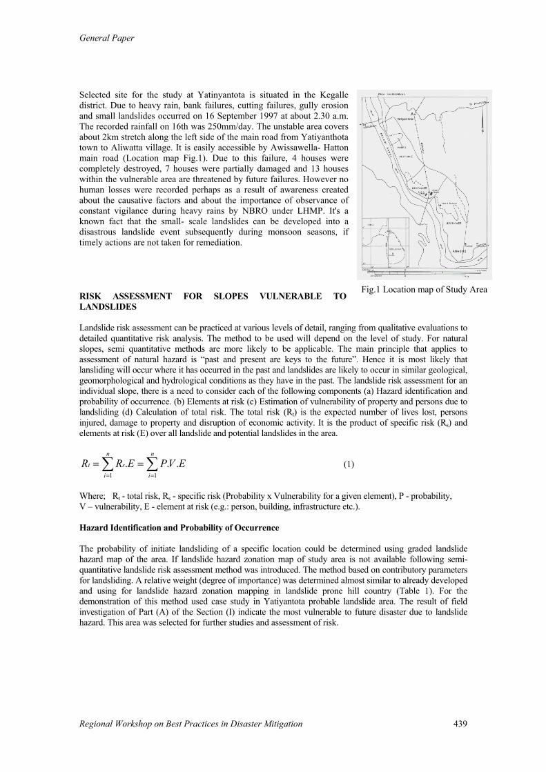
Selected site for the study at Yatinyantota is situated in the Kegalledistrict. Due to heavy rain, bank failures, cutting failures, gully erosionand small landslides occurred on 16 September 1997 at about 2.30 a.m.The recorded rainfall on 16th was 250mm/day. The unstable area coversabout 2km stretch along the left side of the main road from Yatiyanthotatown to Aliwatta village. It is easily accessible by Awissawella- Hattonmain road (Location map Fig.1). Due to this failure, 4 houses werecompletely destroyed, 7 houses were partially damaged and 13 houseswithin the vulnerable area are threatened by future failures. However nohuman losses were recorded perhaps as a result of awareness createdabout the causative factors and about the importance of observance ofconstant vigilance during heavy rains by NBRO under LHMP. It's aknown fact that the small- scale landslides can be developed into adisastrous landslide event subsequently during monsoon seasons, iftimely actions are not taken for remediation.
RISK ASSESSMENT FOR SLOPES VULNERABLE TOLANDSLIDES
Landslide risk assessment can be practiced at various levels of detail, ranging from qualitative evaluations todetailed quantitative risk analysis. The method to be used will depend on the level of study. For naturalslopes, semi quantitative methods are more likely to be applicable. The main principle that applies toassessment of natural hazard is “past and present are keys to the future”. Hence it is most likely thatlansliding will occur where it has occurred in the past and landslides are likely to occur in similar geological,geomorphological and hydrological conditions as they have in the past. The landslide risk assessment for anindividual slope, there is a need to consider each of the following components (a) Hazard identification andprobability of occurrence. (b) Elements at risk (c) Estimation of vulnerability of property and persons due tolandsliding (d) Calculation of total risk. The total risk (Rt) is the expected number of lives lost, personsinjured, damage to property and disruption of economic activity. It is the product of specific risk (Rs) andelements at risk (E) over all landslide and potential landslides in the area.
∑ ∑= =
==n
i
n
ist EVPERR
1 1... (1)
Where; Rt - total risk, Rs - specific risk (Probability x Vulnerability for a given element), P - probability, V – vulnerability, E - element at risk (e.g.: person, building, infrastructure etc.).
Hazard Identification and Probability of Occurrence
The probability of initiate landsliding of a specific location could be determined using graded landslidehazard map of the area. If landslide hazard zonation map of study area is not available following semi-quantitative landslide risk assessment method was introduced. The method based on contributory parametersfor landsliding. A relative weight (degree of importance) was determined almost similar to already developedand using for landslide hazard zonation mapping in landslide prone hill country (Table 1). For thedemonstration of this method used case study in Yatiyantota probable landslide area. The result of fieldinvestigation of Part (A) of the Section (I) indicate the most vulnerable to future disaster due to landslidehazard. This area was selected for further studies and assessment of risk.
Fig.1 Location map of Study Area
General Paper
Regional Workshop on Best Practices in Disaster Mitigation440
Table 1. Field checklist for ranking of landslide hazards (H)
Lithology(8)
01358
MarbleWeathered rockGranite, Gt.bt.gn, all othersCharnockite, Granulite,NBEQuartzite
3
Amount anddirection ofDip(8)
01234
Dip and scarp 70-90Dip and scarp 55-70Dip 10-30, scarp 45-55,inter.Dip 0-10, scarp 30-45Dip 30-55, scarp 0-30
4
DeviationAngle (6)
0246
25-12010-25 or 120-155155-1800-10
4
G1Bed rockgeologyandStructure(20)
Discontinuities(2)
02
AbsentPresent
2
G2
Overburdendeposits(10)
SoilThickness(10)
028910
Bed rockColl < 1, overburden < 2Coll 1-3, overburden 2-8Coll 3-8, overburden >8Coll > 8, overburden >8
2
G3Slopeangle(25)
Slope Angle(25)
515252010
>40°31°- 40°17°-31°11°-17°0-11°
25
G4
Hydrology (20)
Piezometerlevel(groundwater table)(20)
37101520
Below slip planeAbove slip planeBetween ground level &slip planeAt ground surfaceArtesian or above groundlevel
15
Landform (15)
38101215
Simple slope (no previousslides)Simple slope with surfacecracksOld slip but modified byerosionNew slip now stable noerosionRecent slip, erosion at toe
12
G5Landformandlanduse(25)
Landuse (10)
123578
10
Natural woods(undisturbed)Cleared and cultivated wellCleared for pasture landDisturbed by cattleControlled constructionDisturbed by constructionbut precautions takenHeavy construction
10
100 Total score 100 77

General Paper
Regional Workshop on Best Practices in Disaster Mitigation 441
According to Table 1 calculation pointed out the Part (A) area of Section (I) has a hazard factor H is 77.According to Table 2, this area was identified as most hazardous area. The probability for landsliding is
General Paper
Regional Workshop on Best Practices in Disaster Mitigation442
likely <95%. According to past historical records in hill country of Sri Lanka, annual general probability fordisastrous landslide in most hazard area is 10-2. Assuming 50% probability for landslide occurs within thestudy area and, according to total probability theory, annual probability for landsliding in part (A) is 0.5x10-
2. Also the field investigation helped to identify probable landslide boundary and type as landslide cumdebris flow.
Table 2. Relationship between hazard and probability of landslide occurrences
Hazard RangeQualitative Term used inHazard Zonation
Probabilistic Criterion Grade Indicative AnnualProbability
40≤H Safe Areas Very Unlikely <5% 10-5
5541 ≤≤ H Moderate Hazard Unlikely 5-20% 10-4
7056 ≤≤ H Hazard Likely 20-80% 10-3
10071 ≤≤ H Most Hazard Very Likely >95% 10-2
Element of Risk
When the probable landslide boundary is super imposed with the human settlements and infrastructuremap it was observed that (Part “A” of Section I) following human and properties are vulnerable to futurelandslide events (Table 3). Table 3. Elements at risk in Yatiyantota potential landslide
Area of thelandslide
Element at risk Propertyvalue1 (Rs.)
PersonValue2 (Rs.)
Headregion
2 houses/ 7 person 1000000 7 x 150000
Main body 5 houses/ 20 person50m footpath
5000000 100000
20 x 150000
Foot 1 house/ 5 person20m foot path2 shops/ 20 person1 church/ 50 personTelephone Exchanger
700000 50000300000020000001000000
5 x 150000
20 x 15000050 x 150000
Toe 1 house/ 3 person125m highway
7000001250000
3 x 150000 2 x 150000
1Property value is taken by considering the land, type and condition.2Although humans cannot be valued, since study required a figure tocalculate the amount of Rs. 150000.00 are considered. It is an amountpaid by insurance and average was considered.
Fig.2 Human Settlements and Infrastructure
Estimation of Vulnerability due to Landslide Hazards
Although the state of the art for identifying the elements and their economic value is relatively welldeveloped, the state of the art for assessment of vulnerability is in general primitive. The vulnerability is thedegree of loss to a given element or set of elements within the area affected by the landslide. It is expressedas a scale of 0 (no loss) to 1 (total loss), which are likely to have been determined from previous experienceor expert judgment. Vulnerabilities of property and persons were estimated for the study based on the pastlandslide history and expert judgment. The assumed values are given in Table 4.
Table 4. Estimation of landslide vulnerability for property and persons
General Paper
Regional Workshop on Best Practices in Disaster Mitigation 443
Area of the landslide Factors V Property V PersonsHead region High velocity, medium depth, little warning,
short escape distance0.7 0.3
Main body High velocity, high to medium depth, littlewarning, long escape distance
1.0 0.5
Foot Medium velocity, debris accumulation, somewarning, short escape distance
0.4 0.01
Toe Low velocity, more warning, short escapedistance, debris flow< mud flow
0.1 0.001
Calculation of Total Risk
Annual total risk (Rt) could be calculated as from Eq. (1),
∑=
=n
it EVPR
1
..
ni
persoi
propertyt RRR ∑∑==
+=4
1
4
1
.....)..........( )()()()( ++++= personBodypropertyBodypersonHeadpropertyHeadt RRRRR
[ { } ( ){ }( ) ( ){ }( ) ( ){ } ( ) ]5150000001.005.012500007000001.005.07515000001.005.0
100000020000003000000500007000004.005.0201500005.005.010000050000000.105.07)1500003.005.0()10000007.005.0(
××++×+××+++++×+××++×+××+××=Rt
MillionRsRt .5313.0≈
Therefore annual total risk in the potential landslide area is 0.5313 Million Rupees (In August 2002 general currency exchange rate of 96.00 Sri Lankan Rupees equal to 1U.S $)
Limitations of the Landslide Risk Assessment
As seen in the study, there are a number of limitations to risk analysis and assessment for slopes andlandslides;
• The judgments, content of the inputs may well result in values of assessed risks withconsiderable inherent uncertainty. More experience and understanding of the process mayimprove the reliability of the assessment.
• The variety of approaches that can reasonably be adopted to assess the landslide risk can resultin significant differences in the outcome if different practitioners consider the same problemseparately.
• Revisiting an assessment can lead to significant change due to increased data, by application ofa different method or changing the circumstances.
• The inability to recognize a significant hazard and the consequential underestimation of the risk.
• The methodology is currently not widely accepted and thus sometimes there may be an aversionto its application.
CONCLUDING REMARKS
General Paper
Regional Workshop on Best Practices in Disaster Mitigation444
Development of culture for risk analysis before commencement of major infrastructure developmentprojects and establishment of human settlements in landslide prone areas based on the risk criterion isdesired to be considered as an essential factor for sustainable development in areas prone to landslides inhill country of Sri Lanka.
The methodology for risk assessment given in this paper will facilitate determination of risk throughscientific analysis of landslide hazards in future. The expected total risk due to landslide disaster, cost formitigation actions and loss prevention costs may also be calculated through the given methodology. It isexpected to help non-technical decision-makers to assess the situation before taking appropriate futuristicmeasure. This methodology may be used for assessment of the risk in any landslide prone area in centralhighlands provided that sufficient basic data is available for assessment. The application areas ofproposed methodology are very wide and decision-making by authorities (Provincial Council, LocalGovernment Institutions, Insurance Companies, Lending Institutions etc) as well as individuals (effectedfamilies, victims, businessman etc) may be based on results obtained through assessments using theproposed methodology.
ACKNOWLEDGEMENTS
This paper forms a part of the research study conducted by the main author for doctoral studies in SagaUniversity, Japan, under the Monbusho scholarship awarded by the Japanese Government. Authors wishto thank Director General - NBRO and Head - LSSD/ NBRO for the permission granted to use field datain preparation of this paper. Authors also wish to acknowledge with gratitude the cooperation andassistance extended by all the members of the Landslide Hazard Mapping Project of NBRO during fieldstudies and mapping.
REFERENCES
Abeysinghe, B., Iwao, Y., Gunatilake, J., Arambepola, N. (2001) Landslide Risk Assessment in theCentral Highlands of Sri Lanka. Proc. 3rd Asian Symposium of Engineering Geology and theEnvironment. Yogyakarta, Indonesia, Sep. 3-6, 2001.
Abeysinghe, A.M.K.B., Bandara, R.M.S. and Arambepola, N.M.S.I., (1998) Development of aMethodology for Risk Assessment in Landslide Prone Areas of Sri Lanka – Geotechnical Approach.Proceedings of the Workshop on the Role of R&D Institutions in Natural Disaster Management,Colombo, 10-11 September 1998. pp10.1-10.5.
Arambepola, N.M.S.I., Abeysinghe, A.M.K.B. and Bandara, R.M.S., (1999) Risk Assessment forLandslides in the Central Hills of Sri Lanka. Abst. Proceeding of the International Symposium on Eng.Geol. Hydrogeology and Natural Disasters with Emphasis on Asia. Held in Kathmando, Nepal, 28-30Sep.1999. pp250.
Fell, R. and Harford, D. (1997) Landslide Risk Management, in ”Landslide Risk Assessment” Crudenand Fell (eds.), Balkema, Rotterdam, pp. 51 – 110.
Iwao, Y., Abeysinghe, B., Gunatilake, J. (2001) Identification of Landslide Areas Using TopographicalMaps. Proc 3rd International Summer Symposium, Japanese Society of Civil Engineers (JSCE), Tokyo,Japan, August 8th 2001, pp 221-224
Landslide Risk Management Concepts and Guidelines (2000), Australian Geomechanics Society, SubCommittee on Landslide Risk Management, pp.49-93.
Proceeding of the National Symposium on Landslides in Sri Lanka (1994), Organized by NationalBuilding Research Organisation, Colombo, 17-19 March 1994, Vol. 1.
Report of the IUGS Working Group on Landslides, Committee on Risk Assessment (1997) QuantitativeRisk Assessment for Slopes and Landslides – The State of the Art, Honolulu, February 1997.