d walton county profile finaldraft revised 083106 fileintegration of natural hazard considerations...
TRANSCRIPT

INTEGRATION OF THE LOCAL MITIGATION STRATEGY INTO THE LOCAL COMPREHENSIVE PLAN WALTON COUNTY PROFILE
DRAFT 8/31/2006 FLORIDA DEPARTMENT OF COMMUNITY AFFAIRS i
Executive Summary
The experiences of the 2004 Hurricane Season epitomize the importance of better integrating hazard mitigation activities into local comprehensive planning. Residents from all over the state experienced significant damages from Hurricanes Charley, Frances, Jeanne, and Ivan by either winds, tornadoes, surge, or flooding. But this was not the only time that we have experienced natural disaster, nor will it be the last. In 1992, Hurricane Andrew devastated South Florida. In 1998 and 1999, most counties in Florida experienced wildfires. In some cases, despite fire fighters best efforts, the fires advanced through neighborhoods and homes were lost. Every year in Central Florida, new sinkholes emerge swallowing homes and damaging infrastructure. The cost of recovery for these various disasters ranges from hundreds of thousands to billions of dollars, significantly taxing local, state, and federal financial sources. Losses covered through federal funding as a result of the 2004 hurricanes alone could reach as high as $7 billion. Worst of all, however, are the many lives that, directly or indirectly, are lost due to natural disasters. It is imperative that we reduce the human and financial costs of natural disasters. Through better integration of natural hazard considerations into local comprehensive planning, we can build safer communities. This profile of Walton County has been prepared as part of a statewide effort by the Florida Department of Community Affairs (DCA) to guide local governments on integrating hazard mitigation principles into local comprehensive plans. Through the process outlined in this profile, planners will be able to (1) convey Walton County’s existing and potential risk to identified hazards; (2) assess how well local hazard mitigation principles have been incorporated into the County’s Comprehensive Plan; (3) provide recommendations on how hazard mitigation can better be integrated into the Comprehensive Plan; and (4) determine if any enhancements could be made to the LMS to better support comprehensive planning. Best available statewide level data is provided to convey exposure and risk as well as to illustrate the vulnerability assessment component of the integration process. Summary of Recommendations Okaloosa County’s Comprehensive Plan has good integration of hazard mitigation principles and its LMS has adequate data and goals to support comprehensive planning. There are many goals, objectives, and policies that support risk reduction from hurricanes and floods in the LMS and Comprehensive Plan. However, there are always ways to strengthen such plans, and the following is a summary of options for the County to do so. Comprehensive Plan Preliminary Recommendations The following recommendations include hazard mitigation measures in which Walton County can continue to reduce or eliminate risks to storm surge, flood, wildfire and sinkhole. These recommendations pertain to the use of vacant lands and/or redevelopment practices. An assessment of whether the LMS goals and objectives are reflected in the comprehensive plan (and vice versa) is provided in the Preliminary Recommendations Matrix in Section 5. Based on the land use tabulations, most of the vacant acreage is susceptible to flood, tropical cyclone generated storm surge, wildfire and sinkholes. For more information about the methodology and data used for the land use tabulations, please refer to Section 2. Hazard Vulnerability in this hazards profile. Of the vacant lands, 7,563 acres are susceptible to Category 1 storm surge (CHZ), 37,437 acres are susceptible to Category 1 – 3 storm surge (HVZ), 75,724 are susceptible to 100-year flood, 12,412 acres are susceptible to wildfire, and 440 acres are susceptible to sinkholes. Susceptibility for surge, flood and wildfire are based on risk, whereas susceptibility for sinkhole is based on exposure. Therefore, further analysis is needed to determine the level of risk associated with sinkhole hazards.
INTEGRATION OF THE LOCAL MITIGATION STRATEGY INTO THE LOCAL COMPREHENSIVE PLAN WALTON COUNTY PROFILE
DRAFT 8/31/2006 FLORIDA DEPARTMENT OF COMMUNITY AFFAIRS ii
Storm Surge Approximately 59.5% of the 7,563 vacant acres in the Coastal High Hazard Area and 34.6% of the 37,437 vacant acres in the Hurricane Vulnerability Zone are to be developed for residential, commercial, industrial uses or public facilities, indicating that these risk reduction strategies should be considered prior to development of this vacant land.
• The Comprehensive Plan should continue to require proposed amendments to the Future Land Use Map and Comprehensive Plan that increase residential densities & commercial intensities in South Walton County to be reviewed by Walton County Emergency Management to gauge impacts on County’s hurricane evacuation efforts.
• The Comprehensive Plan should continue to require proposed plan amendments which would increase densities within hurricane evacuation zones 1-7 as designated in the Tri-State Hurricane Evacuation Study to be subject to review and transportation impact analysis to determine their impact upon hurricane evacuation times and routes, and require developments that will increase hurricane evacuation times to provide mitigation measures, such as transportation improvements and emergency van pools.
• The Comprehensive Plan should continue to require that the permitting of new development & redevelopment in Hurricane Evacuation Zones shall not result in increased hurricane evacuation times.
• The Comprehensive Plan should continue to require new sanitary sewer facilities in the Coastal High Hazard Area (CHHA), installed in accordance with standards of C-4.2.2, to be flood-proofed and backflow preventors to be fitted on new septic tanks.
• The Comprehensive Plan should continue to limit public expenditures that subsidize new development in the CHHA & shall direct future populations to areas outside the CHHA.
• The Comprehensive Plan should continue to prohibit public infrastructure in the CHHA except to provide public shoreline access, serve public parks, & protect or enhance natural resources.
• The Comprehensive Plan should continue to prohibit the creation of new lots (platting, lot splits, or other method) that lie in or contiguous to the CHHA.
• The County should consider denying requests for residential density increases within the CHHA, above what is included on the Future Land Use Map.
• The County should consider imposing density and intensity limitations during post-disaster redevelopment.
• The County should consider prohibiting septic tanks in the CHHA except in cases of excessive hardship where (1) no reasonable alternative exists, (2) a discharge from a septic tank will not adversely affect public health and will not degrade surface or ground water and (3) where the Health Department determines that soil conditions, water table elevation and setback provisions are adequate to meet state requirements.
• The Comprehensive Plan should consider not allowing new solid waste and commercial hazardous waste management facilities in the HVZ.
• The County should consider developing an inventory of transportation disadvantaged persons that would be affected by an evacuation order, and ensure the availability of adequate transportation for safe and timely evacuation of high risk areas.
INTEGRATION OF THE LOCAL MITIGATION STRATEGY INTO THE LOCAL COMPREHENSIVE PLAN WALTON COUNTY PROFILE
DRAFT 8/31/2006 FLORIDA DEPARTMENT OF COMMUNITY AFFAIRS iii
• The County should consider retrofitting essential public facilities that exist in the CHHA to mitigate impacts from surge.
• The County should consider prohibiting new schools in the CHHA and retrofitting new schools as shelters outside the HVZ, where possible.
• The County should consider only allowing new on-site shelters outside the HVZ, where possible.
• The County should consider requiring that the deeds for the sale of land or structures in hurricane vulnerable zones contain a hurricane hazard disclosure statement.
• The Comprehensive Plan should consider transfer of development rights from areas within the CHHA to outside the CHHA, as another measure to reduce density in the CHHA to reduce residential and commercial development in surge prone areas
• The Comprehensive Plan should consider prohibiting the development of nursing homes, adult congregate living facilities, hospitals, mobile homes, county funded facilities, and other high-risk developments inside the CHHA. Building these facilities out of harm’s way reduces risk to critical and essential government facilities, and lessens evacuation needs of the special needs population. In addition, the number of evacuees is reduced who are under medical supervision or need medical staff chaperones, potentially reducing hurricane evacuation clearance times.
Flood About 14.9% of the 75,724 vacant acres in the 100-year floodplain are to be developed for residential, commercial, industrial uses or public facilities, indicating that these risk reduction strategies should be considered prior to development of this vacant land.
• The Comprehensive Plan should continue to regulate development within & surrounding wetlands, dune systems, lake systems, river and bay systems, & flood prone areas & 100-year floodplain to conserve, appropriately use, & protect these resources.
• The Comprehensive Plan should continue to promote buffers between development and environmentally sensitive areas, as specified in the Conservation/Coastal Zone Element Policy C-3.2.1, including wetlands, water bodies such as lakes and streams, dunes, & coastal dune lakes to protect natural resources from development activities & impacts (e.g., stormwater runoff).
• The Comprehensive Plan should continue to require that future land uses shall not adversely impact the natural functions of drainage features.
• The Comprehensive Plan should continue to require development & redevelopment in a floodplain to use construction techniques which protect planned & existing development from flood hazards, maintain natural function of floodplain, & wetlands natural flow functions.
• The Comprehensive Plan should continue to pursue the adoption of land development regulations to ensure new development & redevelopment does not increase stormwater runoff or flooding problems. Level of service standards for drainage should ensure capacity of drainage structures for roads & other development are designed to meet facility needs.
• The Comprehensive Plan should continue to prohibit development in 10- and 25-year floodplains and require that development in the FEMA designated 100-year
INTEGRATION OF THE LOCAL MITIGATION STRATEGY INTO THE LOCAL COMPREHENSIVE PLAN WALTON COUNTY PROFILE
DRAFT 8/31/2006 FLORIDA DEPARTMENT OF COMMUNITY AFFAIRS iv
floodplain to have a gross density of 1du/20ac, or the underlying density, whichever is less.
• The County should consider including a policy for reducing repetitive (flood) loss properties such as at risk property acquisition or elevation.
• The County should consider including a policy to not approve variances to required flood elevations.
• The County should consider establishing an impact fee and/or other equitable user-oriented revenue sources for the construction of drainage facilities, either county-wide or in districts of high flooding potential.
• The County should consider prohibiting land filling which results in net loss of storage within in the 100-year floodplain.
• The County should consider promoting the use of vegetated swales, sodding, landscaping, and retention of natural vegetation as components of the drainage system for natural runoff through the use of landscape and subdivision ordinances.
• The County should consider requiring that developers incorporate wetland portions of sites within the 100-year floodplain as conservation easements.
• The County should consider requiring that the maintenance and operation of private stormwater systems is funded by private sources.
• The County should consider requiring areas that have not established base flood elevations to be studied prior to development.
• The County should consider calling for compensating storage calculations in all non-coastal flood hazard areas.
• The County should consider requiring any construction of shelters and essential public facilities to be outside of the 100-year floodplain.
Wildfire About 41% of the 12,412 vacant acres that are susceptible to wildfire are to be developed for residential, commercial, industrial uses or public facilities, indicating that these risk reduction strategies should be considered prior to development of this vacant land.
• The County should consider participating in the Firewise Medal Community program to reduce risks within the wildland urban interface.
• Where reasonable, consideration should be made to design structures and sites within the County to minimize potential for loss of life and property (e.g., outdoor sprinkler systems, fire-resistant building materials or treatments, and landscaping and site design practices); review proposals for subdivisions, lot splits, and other developments for fire protection needs during site plan review process; coordinate with fire protection service or agencies to determine guidelines for use and development in wildfire-prone areas.
• The County should consider requirement for all new development in wildfire prone areas to include and implement a wildfire mitigation plan specific to that development, subject to review and approval by the County Fire Rescue Department.
• The County should consider increasing public awareness of prescribed burning and require management plans for conservation easements that address reduction in wildfire fuels.
INTEGRATION OF THE LOCAL MITIGATION STRATEGY INTO THE LOCAL COMPREHENSIVE PLAN WALTON COUNTY PROFILE
DRAFT 8/31/2006 FLORIDA DEPARTMENT OF COMMUNITY AFFAIRS v
• The County should consider additional measures to reduce risk from wildfire, such as directing developers to manage natural areas around private recreational facilities with Best Management Practices (including prescribed burning), and using a natural resources management plan to acquire sensitive lands for which fire management planning is to occur.
Sinkhole About 6.5% of the 440 vacant acres that are susceptible to sinkholes are to be developed for residential, commercial, industrial uses or public facilities, indicating that these risk reduction strategies should be considered prior to development of this vacant land.
• The Comprehensive Plan should consider the implementation of policies for reducing risk from sinkholes such as publishing available sinkhole data and providing for consideration of sinkhole risk in land suitability analyses through the review process of land development codes, including stormwater management measures; coordinate with the Northwest Florida Water Management District to provide technical expertise to the public with regard to sinkhole risks; requiring new development to demonstrate clustered development to achieve open space to protect aquifer recharge; and prohibiting new stormwater management facilities from discharging untreated stormwater runoff into directly-connected sinkholes or the Floridan Aquifer.
• The County should consider the possibility of requiring sub-surface investigations of soil stability in areas suspected of sinkhole activity, per technical advice provided by the Northwest Florida Water Management District and other geo-technical experts.
• The County should consider the possibility of requiring buffers between proposed development and sinkholes, as deemed appropriate.
General
• The Comprehensive Plan should continue to require recommendations of any interagency hazard mitigation report which addresses future flood losses and is prepared in response to a presidential disaster declaration to be incorporated into the County’s Disaster Plan.
• The Comprehensive Plan should continue to encourage the improvement of emergency shelter capabilities by retrofitting existing public buildings to better serve as severe weather shelters and by encouraging large scale developments to provide on-site severe weather shelters that are outside the Category One hurricane evacuation areas.
• The Comprehensive Plan should continue to require the development and maintenance of a post-disaster redevelopment plan or adopt the Regional Planning Council’s plan.
• The Comprehensive Plan should reference the LMS in reducing the exposure of human life and public and private property to natural hazards.
• The Comprehensive Plan should require the establishment of criteria within the capital budgeting process to evaluate capital improvement projects that consider criteria for the elimination of future public hazards, consistent with LMS Guiding Principles.
• The Comprehensive Plan should require new development, redevelopment, zoning changes and land use plan amendments to be consistent with the LMS.
INTEGRATION OF THE LOCAL MITIGATION STRATEGY INTO THE LOCAL COMPREHENSIVE PLAN WALTON COUNTY PROFILE
DRAFT 8/31/2006 FLORIDA DEPARTMENT OF COMMUNITY AFFAIRS vi
• The County should consider creating an objective of policy that requires coordination with the LMS committee in updating the LMS to incorporate planning expertise, land use and development regulations.
• Include each hazard layer on the existing and future land use maps to determine where risks are possible to target hazard mitigation strategies.
• The Comprehensive Plan should consider including a policy to incorporate recommendations from existing and future interagency hazard mitigation reports into the Comprehensive Plan during the Evaluation and Appraisal Report process as determined feasible and appropriate by the Board of County Commissioners.
• The Comprehensive Plan should consider including a policy to incorporate applicable provisions of the Comprehensive Plan into the Comprehensive Emergency Management Plan and the Local Mitigation Strategy.
• Continue educating the public, especially those at high risk from hurricanes, floods and wildfires and make them aware of proactive steps they can take to mitigate damage.
Local Mitigation Strategy Preliminary Recommendations The following data and information could be included in an update of the LMS. This information could help convey how and where disasters impact the population and the built environment to support comprehensive planning.
• Include information on demographic, income, and special needs populations.
• Include a future land use map that includes hazard data layers to illustrate which future land use categories are susceptible to each hazard.
• Revise hazard maps to include data layers to illustrate population (i.e., density) or property (i.e., value) exposure.
• Provide a map of repetitive loss areas, and include a goal to mitigate repetitive loss properties.
• Provide loss estimates by land use in relation to the hazard.
• Use complementary, not contradictory data in the plans such as the LMS, CEMP, and Comprehensive Plan.
• Include a goal to support interagency involvement in evacuation planning.
• Include a goal to ensure adequate and safe public shelters are available in all locations in the County to prevent or reduce post-disaster homelessness, including adequate electrical supplies for cooking and to maintain sanitary conditions.
INTEGRATION OF THE LOCAL MITIGATION STRATEGY INTO THE LOCAL COMPREHENSIVE PLAN WALTON COUNTY PROFILE
DRAFT 8/31/2006 FLORIDA DEPARTMENT OF COMMUNITY AFFAIRS vii
Table of Contents
1. County Overview.............................................................................................1 2. Hazard Vulnerability .......................................................................................2 3. Existing Mitigation Measures.......................................................................10 4. Comprehensive Plan Review .......................................................................14 5. Recommendations........................................................................................16 6. Data Sources .................................................................................................38 Attachments.……………………………..……………………………………….…A-1
INTEGRATION OF THE LOCAL MITIGATION STRATEGY INTO THE LOCAL COMPREHENSIVE PLAN WALTON COUNTY PROFILE
DRAFT 8/31/2006 FLORIDA DEPARTMENT OF COMMUNITY AFFAIRS 1
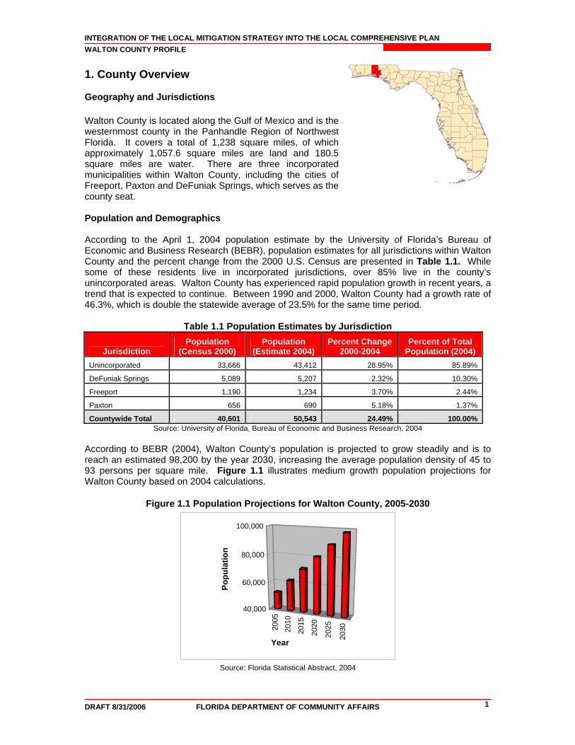
1. County Overview Geography and Jurisdictions Walton County is located along the Gulf of Mexico and is the westernmost county in the Panhandle Region of Northwest Florida. It covers a total of 1,238 square miles, of which approximately 1,057.6 square miles are land and 180.5 square miles are water. There are three incorporated municipalities within Walton County, including the cities of Freeport, Paxton and DeFuniak Springs, which serves as the county seat. Population and Demographics
According to the April 1, 2004 population estimate by the University of Florida’s Bureau of Economic and Business Research (BEBR), population estimates for all jurisdictions within Walton County and the percent change from the 2000 U.S. Census are presented in Table 1.1. While some of these residents live in incorporated jurisdictions, over 85% live in the county’s unincorporated areas. Walton County has experienced rapid population growth in recent years, a trend that is expected to continue. Between 1990 and 2000, Walton County had a growth rate of 46.3%, which is double the statewide average of 23.5% for the same time period.
Table 1.1 Population Estimates by Jurisdiction
Jurisdiction Population
(Census 2000) Population
(Estimate 2004) Percent Change
2000-2004 Percent of Total
Population (2004) Unincorporated 33,666 43,412 28.95% 85.89%
DeFuniak Springs 5,089 5,207 2.32% 10.30%
Freeport 1,190 1,234 3.70% 2.44%
Paxton 656 690 5.18% 1.37%
Countywide Total 40,601 50,543 24.49% 100.00% Source: University of Florida, Bureau of Economic and Business Research, 2004
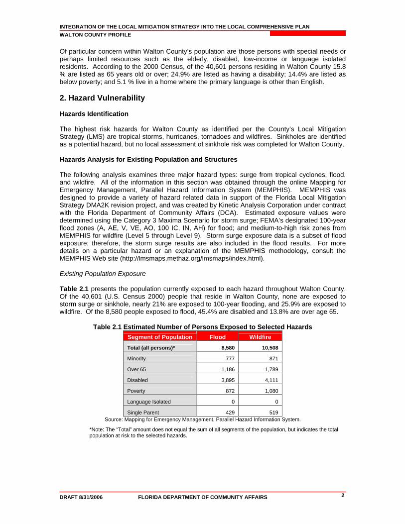
According to BEBR (2004), Walton County’s population is projected to grow steadily and is to reach an estimated 98,200 by the year 2030, increasing the average population density of 45 to 93 persons per square mile. Figure 1.1 illustrates medium growth population projections for Walton County based on 2004 calculations.
Figure 1.1 Population Projections for Walton County, 2005-2030
2005
2010
2015
2020
2025
2030
40,000
60,000
80,000
100,000
Popu
latio
n
Year
Source: Florida Statistical Abstract, 2004
INTEGRATION OF THE LOCAL MITIGATION STRATEGY INTO THE LOCAL COMPREHENSIVE PLAN WALTON COUNTY PROFILE
DRAFT 8/31/2006 FLORIDA DEPARTMENT OF COMMUNITY AFFAIRS 2
Of particular concern within Walton County’s population are those persons with special needs or perhaps limited resources such as the elderly, disabled, low-income or language isolated residents. According to the 2000 Census, of the 40,601 persons residing in Walton County 15.8 % are listed as 65 years old or over; 24.9% are listed as having a disability; 14.4% are listed as below poverty; and 5.1 % live in a home where the primary language is other than English. 2. Hazard Vulnerability Hazards Identification The highest risk hazards for Walton County as identified per the County’s Local Mitigation Strategy (LMS) are tropical storms, hurricanes, tornadoes and wildfires. Sinkholes are identified as a potential hazard, but no local assessment of sinkhole risk was completed for Walton County. Hazards Analysis for Existing Population and Structures The following analysis examines three major hazard types: surge from tropical cyclones, flood, and wildfire. All of the information in this section was obtained through the online Mapping for Emergency Management, Parallel Hazard Information System (MEMPHIS). MEMPHIS was designed to provide a variety of hazard related data in support of the Florida Local Mitigation Strategy DMA2K revision project, and was created by Kinetic Analysis Corporation under contract with the Florida Department of Community Affairs (DCA). Estimated exposure values were determined using the Category 3 Maxima Scenario for storm surge; FEMA’s designated 100-year flood zones (A, AE, V, VE, AO, 100 IC, IN, AH) for flood; and medium-to-high risk zones from MEMPHIS for wildfire (Level 5 through Level 9). Storm surge exposure data is a subset of flood exposure; therefore, the storm surge results are also included in the flood results. For more details on a particular hazard or an explanation of the MEMPHIS methodology, consult the MEMPHIS Web site (http://lmsmaps.methaz.org/lmsmaps/index.html). Existing Population Exposure Table 2.1 presents the population currently exposed to each hazard throughout Walton County. Of the 40,601 (U.S. Census 2000) people that reside in Walton County, none are exposed to storm surge or sinkhole, nearly 21% are exposed to 100-year flooding, and 25.9% are exposed to wildfire. Of the 8,580 people exposed to flood, 45.4% are disabled and 13.8% are over age 65.
Table 2.1 Estimated Number of Persons Exposed to Selected Hazards Segment of Population Flood Wildfire
Total (all persons)* 8,580 10,508
Minority 777 871
Over 65 1,186 1,789
Disabled 3,895 4,111
Poverty 872 1,080
Language Isolated 0 0
Single Parent 429 519 Source: Mapping for Emergency Management, Parallel Hazard Information System.
*Note: The “Total” amount does not equal the sum of all segments of the population, but indicates the total population at risk to the selected hazards.
INTEGRATION OF THE LOCAL MITIGATION STRATEGY INTO THE LOCAL COMPREHENSIVE PLAN WALTON COUNTY PROFILE
DRAFT 8/31/2006 FLORIDA DEPARTMENT OF COMMUNITY AFFAIRS 3
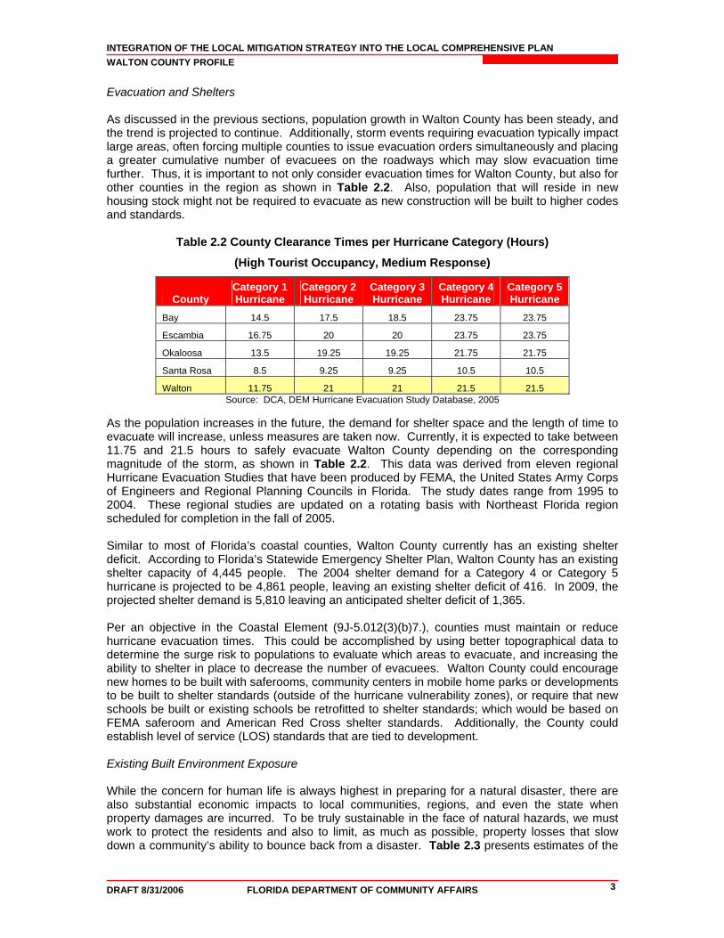
Evacuation and Shelters As discussed in the previous sections, population growth in Walton County has been steady, and the trend is projected to continue. Additionally, storm events requiring evacuation typically impact large areas, often forcing multiple counties to issue evacuation orders simultaneously and placing a greater cumulative number of evacuees on the roadways which may slow evacuation time further. Thus, it is important to not only consider evacuation times for Walton County, but also for other counties in the region as shown in Table 2.2. Also, population that will reside in new housing stock might not be required to evacuate as new construction will be built to higher codes and standards.
Table 2.2 County Clearance Times per Hurricane Category (Hours)
(High Tourist Occupancy, Medium Response)
County Category 1 Hurricane
Category 2 Hurricane
Category 3 Hurricane
Category 4 Hurricane
Category 5 Hurricane
Bay 14.5 17.5 18.5 23.75 23.75
Escambia 16.75 20 20 23.75 23.75
Okaloosa 13.5 19.25 19.25 21.75 21.75
Santa Rosa 8.5 9.25 9.25 10.5 10.5
Walton 11.75 21 21 21.5 21.5 Source: DCA, DEM Hurricane Evacuation Study Database, 2005
As the population increases in the future, the demand for shelter space and the length of time to evacuate will increase, unless measures are taken now. Currently, it is expected to take between 11.75 and 21.5 hours to safely evacuate Walton County depending on the corresponding magnitude of the storm, as shown in Table 2.2. This data was derived from eleven regional Hurricane Evacuation Studies that have been produced by FEMA, the United States Army Corps of Engineers and Regional Planning Councils in Florida. The study dates range from 1995 to 2004. These regional studies are updated on a rotating basis with Northeast Florida region scheduled for completion in the fall of 2005. Similar to most of Florida’s coastal counties, Walton County currently has an existing shelter deficit. According to Florida’s Statewide Emergency Shelter Plan, Walton County has an existing shelter capacity of 4,445 people. The 2004 shelter demand for a Category 4 or Category 5 hurricane is projected to be 4,861 people, leaving an existing shelter deficit of 416. In 2009, the projected shelter demand is 5,810 leaving an anticipated shelter deficit of 1,365. Per an objective in the Coastal Element (9J-5.012(3)(b)7.), counties must maintain or reduce hurricane evacuation times. This could be accomplished by using better topographical data to determine the surge risk to populations to evaluate which areas to evacuate, and increasing the ability to shelter in place to decrease the number of evacuees. Walton County could encourage new homes to be built with saferooms, community centers in mobile home parks or developments to be built to shelter standards (outside of the hurricane vulnerability zones), or require that new schools be built or existing schools be retrofitted to shelter standards; which would be based on FEMA saferoom and American Red Cross shelter standards. Additionally, the County could establish level of service (LOS) standards that are tied to development. Existing Built Environment Exposure While the concern for human life is always highest in preparing for a natural disaster, there are also substantial economic impacts to local communities, regions, and even the state when property damages are incurred. To be truly sustainable in the face of natural hazards, we must work to protect the residents and also to limit, as much as possible, property losses that slow down a community’s ability to bounce back from a disaster. Table 2.3 presents estimates of the
INTEGRATION OF THE LOCAL MITIGATION STRATEGY INTO THE LOCAL COMPREHENSIVE PLAN WALTON COUNTY PROFILE
DRAFT 8/31/2006 FLORIDA DEPARTMENT OF COMMUNITY AFFAIRS 4
number of structures in Walton County by occupancy type that are exposed to each of the hazards being analyzed. Exposure refers to the number of people or structures that are susceptible to loss of life, property damage and economic impact due to a particular hazard. The estimated exposure of Walton County’s existing structures to the storm surge, flood, wildfire and sinkhole hazards was determined through MEMPHIS.
Table 2.3 Estimated Number of Structures Exposed to Selected Hazards Occupancy Type Storm Surge* Flood Sinkhole Wildfire
Single Family 1,211 6,107 1 3,700
Mobile Home 107 8,644 0 2,153
Multi-Family 1,025 1,704 0 1,502
Commercial 132 852 0 423
Agriculture 18 5,424 0 3,321
Gov. / Institutional 13 712 2 719
Total 2,506 23,443 3 11,818 Source: Mapping for Emergency Management, Parallel Hazard Information System.
*Note: Storm surge related flooding building exposure results are a subset of the flood results. There are 35,264 structures exposed to at least one of the three hazards, of which most are single-family homes in subdivisions. Of these structures, approximately 66% are exposed to flood. Over 23,000 structures are located within the 100-year floodplain, of which 10.7% are exposed to storm surge induced flooding. Nearly 48% of the structures exposed to surge are single family homes. Typically, structures at risk from surge are high-value real estate due to their proximity to the ocean or tidally influenced water bodies such as the Gulf of Mexico and the Choctawhatchee Bay. According to the latest National Flood Insurance Program Repetitive Loss Properties list, as of March 2005, there are 126 repetitive loss properties in unincorporated Walton County. Under the National Flood Insurance Program (NFIP), repetitive loss properties are defined as “any NFIP-insured property that, since 1978 and regardless of any change(s) of ownership during that period, has experienced: a) four or more paid flood losses; or b) two paid flood losses within a 10-year period that equal or exceed the current value of the insured property; or c) three or more paid losses that equal or exceed the current value of the insured property.” Over 33% or 11,818 structures are exposed to wildfire, of which, 31.3% are single-family dwellings. Less than 1% or three structures are located within sinkhole susceptible areas, of which two-thirds are used for government/institutional purposes. In addition to understanding exposure, risk assessment results must also be considered for prioritizing and implementing hazard mitigation measures. The risk assessment takes into account the probability (how often) and severity (e.g., flood depth, storm surge velocity, wildfire duration) of the hazard as it impacts people and property. Risk can be described qualitatively, using terms like high, medium or low; or quantitatively by estimating the losses to be expected from a specific hazard event expressed in dollars of future expected losses. Although people and property are exposed to hazards, losses can be greatly reduced through building practices, land use, and structural hazard mitigation measures. The next section of this report examines the existing and future land use acreage in hazard areas. This information can be useful to consider where to implement risk reducing comprehensive planning measures.
INTEGRATION OF THE LOCAL MITIGATION STRATEGY INTO THE LOCAL COMPREHENSIVE PLAN WALTON COUNTY PROFILE
DRAFT 8/31/2006 FLORIDA DEPARTMENT OF COMMUNITY AFFAIRS 5
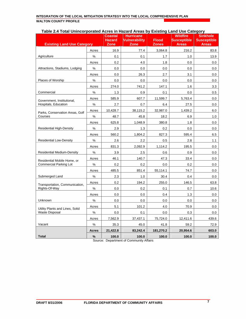
Analysis of Current and Future Vulnerability Based on Land Use The previous hazards analysis section discussed population and existing structures at risk from surge, flooding, wildfire and sinkholes according to MEMPHIS estimates. This section is used to demonstrate the County’s vulnerabilities to these hazards in both tabular format and spatially, in relation to existing and future land uses. DCA tabulated the total amount of acres and percentage of land in identified hazard exposure areas, sorted by existing land use category for the unincorporated areas. Existing land use data was acquired using the Florida Land Use Cover Classification System (FLUCCS) from the Florida Department of Environmental Protection (FDEP) and Northwest Florida Water Management District (NWFWMD) in 1995. DCA also tabulated the total amount of acres and percentage of land in the identified hazards areas sorted by their future land use category according to the local Future Land Use Map (FLUM), as well as the amount of these lands listed as vacant according to existing land use. Walton County future land use data was acquired from Walton County in October 2000 and might not reflect changes per recent future land use amendments. DCA has provided maps of existing land use within hazard areas based on the 1995 FLUCCS geographic information system (GIS) shapefiles. Maps of future land uses in hazard areas were developed using the Walton County future land use map dated October 2000. A series of maps were created as part of the analysis and are available as attachments to the county profile. All maps are for general planning purposes only. For the purposes of this profile, the identified hazard areas include the coastal hazards zone in relation to storm surge, hurricane vulnerability zones in relation to evacuation clearance times, flood zones in relation to the 100-year flood, wildfire susceptible areas, and sinkhole susceptible areas. In Attachment A, two maps present the existing and future land uses within the Coastal Hazards Zone (CHZ), which represents the Category 1 Hurricane Evacuation Zone joined with the Category 1 Storm Surge Zone. The areas that are most susceptible to storm surge are located in the coastal community of Freeport and along the Gulf of Mexico and the Choctawhatchee Bay. The total amount of land in the CHZ is 21,422.8 acres. As shown in Table 2.4, 48.7% are parks, conservation areas and golf courses; 35.3% are currently undeveloped; 3.9% are used for medium-density residential homes; and 2.9% are used for high-density residential homes. Table 2.5 shows that of the 7,562.9 undeveloped acres, 21.5% are designated as neighborhood planning area. The County is taking positive action in preserving this land to limit population in the CHHA to reduce vulnerability and additional evacuation or shelter demands. In Attachment B, two maps present the existing and future land uses within the Hurricane Vulnerability Zone (HVZ), which represents Category 1 to 3 Hurricane Evacuation Zones. The HVZ is predominantly located along the coasts of the Gulf of Mexico and the Choctawhatchee Bay. The total amount of land in the HVZ is 83,242.4 acres. As shown in Table 2.4, 45.8% are parks, conservation areas and golf courses; 45% are currently undeveloped; 2.5% are used for medium-density residential homes; and 2.9% are used for low-density residential homes. Table 2.5 shows that of the 37,437.1 undeveloped acres, 41.3% are designated for large scale agricultural use. The County is taking positive action in designating a large portion of the acreage as low to medium density to reduce vulnerability and limiting the amount of people who would need to evacuate or be sheltered from a hurricane. In Attachment C, two maps present the existing and future land uses within a 100-year flood zone. There are flood-prone areas scattered across the County. The total amount of land in the special flood hazard area is 181,270.2 acres. As shown in Table 2.4, 41.8% are currently undeveloped; 30.4% are submerged lands (water bodies); 18.2% are parks, conservation areas and golf courses; and 6.4% are used for government, institutional, hospitals or education purposes. Table 2.5 shows that of the 75,724 undeveloped acres, 45.9% are designated for general agricultural use. Since a large portion of the acreage is designated agricultural, the County has the opportunity to maintain this land use and low density development to prevent increased vulnerability to flooding. Although stormwater management systems are designed to

INTEGRATION OF THE LOCAL MITIGATION STRATEGY INTO THE LOCAL COMPREHENSIVE PLAN WALTON COUNTY PROFILE
DRAFT 8/31/2006 FLORIDA DEPARTMENT OF COMMUNITY AFFAIRS 6
eliminate flooding, these systems can fail during a storm if debris blocks drainage channels or culverts washout. In Attachment D, two maps present the existing and future land uses within wildfire susceptible areas. These areas are scattered across the county in the jurisdictions of DeFuniak Springs, Freeport, and Paxton. The total amount of land in the wildfire susceptible areas is 20,954.6 acres. As shown in Table 2.4, 59.2% are undeveloped lands; 27.5% are used for government, institutional, hospitals or education purposes; 6.9% are parks, conservation areas and golf courses; and 2.8% are used for low-density residential homes. Table 2.5 shows that of the 12,411.6 undeveloped acres, 43% are used for general agriculture. The County should continue to take measures to reduce wildfire risk within the urban/rural interface. In Attachment E, two maps present the existing and future land uses within sinkhole susceptible areas. There is a sinkhole susceptible area located east of DeFuniak Springs. The total amount of land in the sinkhole susceptible areas is 603 acres. As shown in Table 2.4, 72.9% are undeveloped lands; 27.5% are used for agriculture; 6.9% are used for transportation, communication and rights-of-way; and 1.1% is used for low-density residential homes. Table 2.5 shows that of the 439.6 undeveloped acres, 93.5% are designated for general agriculture. The County might want to conduct additional research to determine the level of risk associated with developing this acreage for urban residential use, so that mitigation measures can be implemented if warranted.
INTEGRATION OF THE LOCAL MITIGATION STRATEGY INTO THE LOCAL COMPREHENSIVE PLAN WALTON COUNTY PROFILE
DRAFT 8/31/2006 FLORIDA DEPARTMENT OF COMMUNITY AFFAIRS 7
Table 2.4 Total Unincorporated Acres in Hazard Areas by Existing Land Use Category
Existing Land Use Category
Coastal Hazard Zone
Hurricane Vulnerability
Zone Flood Zones
Wildfire Susceptible
Areas
Sinkhole Susceptible
Areas Acres 16.9 77.4 3,064.8 216.2 83.8
Agriculture % 0.1 0.1 1.7 1.0 13.9
Acres 0.2 4.0 1.8 0.0 0.0
Attractions, Stadiums, Lodging % 0.0 0.0 0.0 0.0 0.0
Acres 0.0 26.3 2.7 3.1 0.0
Places of Worship % 0.0 0.0 0.0 0.0 0.0
Acres 274.0 741.2 147.1 1.6 3.3
Commercial % 1.3 0.9 0.1 0.0 0.5
Acres 585.9 607.7 11,599.7 5,763.4 0.0 Government, Institutional, Hospitals, Education % 2.7 0.7 6.4 27.5 0.0
Acres 10,428.7 38,115.2 32,987.0 1,439.2 6.0 Parks, Conservation Areas, Golf Courses % 48.7 45.8 18.2 6.9 1.0
Acres 625.8 1,048.9 380.8 1.8 0.0
Residential High-Density % 2.9 1.3 0.2 0.0 0.0
Acres 560.2 1,804.2 827.3 595.4 6.5
Residential Low-Density % 2.6 2.2 0.5 2.8 1.1
Acres 831.3 2,092.9 1,114.2 195.5 0.0
Residential Medium-Density % 3.9 2.5 0.6 0.9 0.0
Acres 46.1 140.7 47.3 33.4 0.0 Residential Mobile Home, or Commercial Parking Lot % 0.2 0.2 0.0 0.2 0.0
Acres 485.5 851.4 55,114.1 74.7 0.0
Submerged Land % 2.3 1.0 30.4 0.4 0.0
Acres 0.2 194.2 255.0 146.5 63.8 Transportation, Communication, Rights-Of-Way % 0.0 0.2 0.1 0.7 10.6
Acres 0.0 0.0 0.4 1.3 0.0
Unknown % 0.0 0.0 0.0 0.0 0.0
Acres 5.1 101.2 4.0 70.9 0.0 Utility Plants and Lines, Solid Waste Disposal % 0.0 0.1 0.0 0.3 0.0
Acres 7,562.9 37,437.1 75,724.0 12,411.6 439.6
Vacant % 35.3 45.0 41.8 59.2 72.9
Acres 21,422.8 83,242.4 181,270.2 20,954.6 603.0
Total % 100.0 100.0 100.0 100.0 100.0 Source: Department of Community Affairs
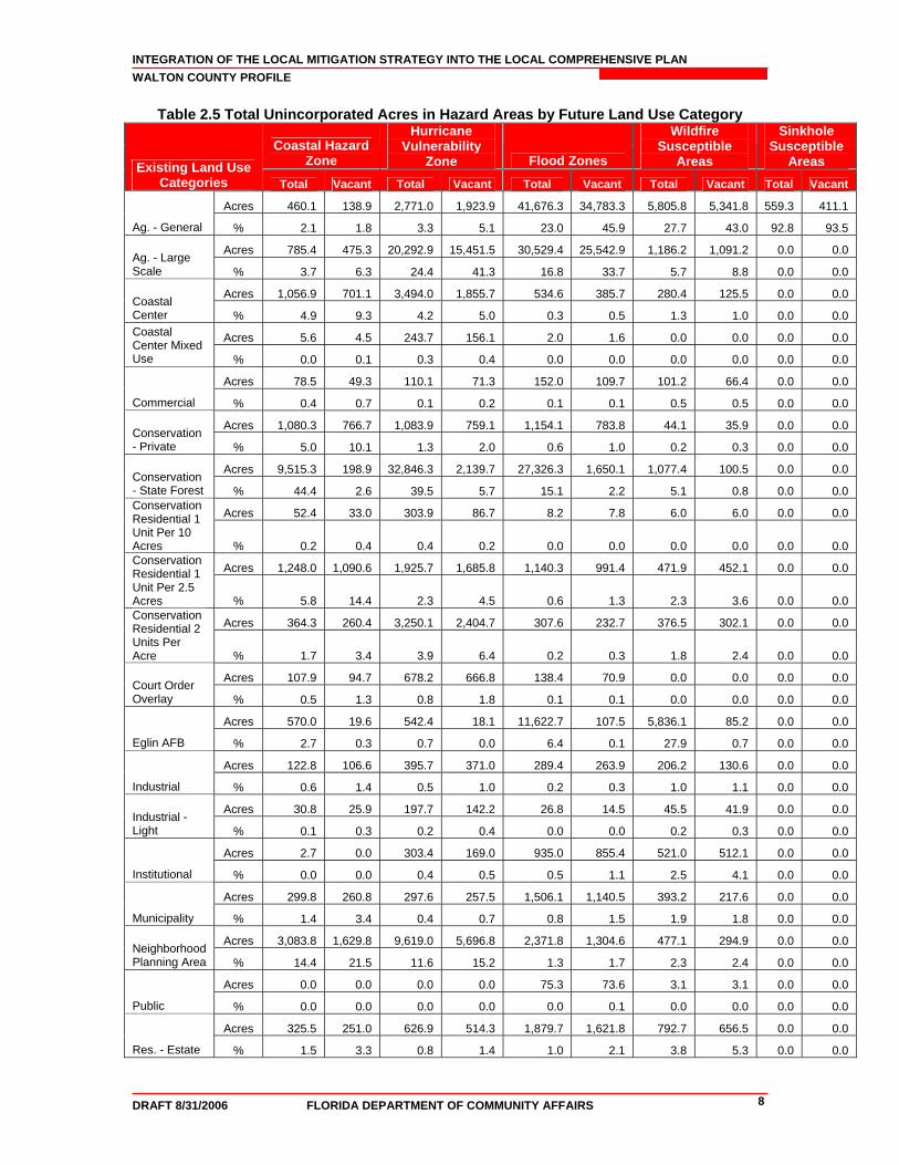
INTEGRATION OF THE LOCAL MITIGATION STRATEGY INTO THE LOCAL COMPREHENSIVE PLAN WALTON COUNTY PROFILE
DRAFT 8/31/2006 FLORIDA DEPARTMENT OF COMMUNITY AFFAIRS 8
Table 2.5 Total Unincorporated Acres in Hazard Areas by Future Land Use Category
Coastal Hazard Zone
Hurricane Vulnerability
Zone Flood Zones
Wildfire Susceptible
Areas
Sinkhole Susceptible
Areas Existing Land Use Categories Total Vacant Total Vacant Total Vacant Total Vacant Total Vacant
Acres 460.1 138.9 2,771.0 1,923.9 41,676.3 34,783.3 5,805.8 5,341.8 559.3 411.1
Ag. - General % 2.1 1.8 3.3 5.1 23.0 45.9 27.7 43.0 92.8 93.5
Acres 785.4 475.3 20,292.9 15,451.5 30,529.4 25,542.9 1,186.2 1,091.2 0.0 0.0 Ag. - Large Scale % 3.7 6.3 24.4 41.3 16.8 33.7 5.7 8.8 0.0 0.0
Acres 1,056.9 701.1 3,494.0 1,855.7 534.6 385.7 280.4 125.5 0.0 0.0 Coastal Center % 4.9 9.3 4.2 5.0 0.3 0.5 1.3 1.0 0.0 0.0
Acres 5.6 4.5 243.7 156.1 2.0 1.6 0.0 0.0 0.0 0.0 Coastal Center Mixed Use % 0.0 0.1 0.3 0.4 0.0 0.0 0.0 0.0 0.0 0.0
Acres 78.5 49.3 110.1 71.3 152.0 109.7 101.2 66.4 0.0 0.0
Commercial % 0.4 0.7 0.1 0.2 0.1 0.1 0.5 0.5 0.0 0.0
Acres 1,080.3 766.7 1,083.9 759.1 1,154.1 783.8 44.1 35.9 0.0 0.0 Conservation - Private % 5.0 10.1 1.3 2.0 0.6 1.0 0.2 0.3 0.0 0.0
Acres 9,515.3 198.9 32,846.3 2,139.7 27,326.3 1,650.1 1,077.4 100.5 0.0 0.0 Conservation - State Forest % 44.4 2.6 39.5 5.7 15.1 2.2 5.1 0.8 0.0 0.0
Acres 52.4 33.0 303.9 86.7 8.2 7.8 6.0 6.0 0.0 0.0 Conservation Residential 1 Unit Per 10 Acres % 0.2 0.4 0.4 0.2 0.0 0.0 0.0 0.0 0.0 0.0
Acres 1,248.0 1,090.6 1,925.7 1,685.8 1,140.3 991.4 471.9 452.1 0.0 0.0 Conservation Residential 1 Unit Per 2.5 Acres % 5.8 14.4 2.3 4.5 0.6 1.3 2.3 3.6 0.0 0.0
Acres 364.3 260.4 3,250.1 2,404.7 307.6 232.7 376.5 302.1 0.0 0.0 Conservation Residential 2 Units Per Acre % 1.7 3.4 3.9 6.4 0.2 0.3 1.8 2.4 0.0 0.0
Acres 107.9 94.7 678.2 666.8 138.4 70.9 0.0 0.0 0.0 0.0 Court Order Overlay % 0.5 1.3 0.8 1.8 0.1 0.1 0.0 0.0 0.0 0.0
Acres 570.0 19.6 542.4 18.1 11,622.7 107.5 5,836.1 85.2 0.0 0.0
Eglin AFB % 2.7 0.3 0.7 0.0 6.4 0.1 27.9 0.7 0.0 0.0
Acres 122.8 106.6 395.7 371.0 289.4 263.9 206.2 130.6 0.0 0.0
Industrial % 0.6 1.4 0.5 1.0 0.2 0.3 1.0 1.1 0.0 0.0
Acres 30.8 25.9 197.7 142.2 26.8 14.5 45.5 41.9 0.0 0.0 Industrial - Light % 0.1 0.3 0.2 0.4 0.0 0.0 0.2 0.3 0.0 0.0
Acres 2.7 0.0 303.4 169.0 935.0 855.4 521.0 512.1 0.0 0.0
Institutional % 0.0 0.0 0.4 0.5 0.5 1.1 2.5 4.1 0.0 0.0
Acres 299.8 260.8 297.6 257.5 1,506.1 1,140.5 393.2 217.6 0.0 0.0
Municipality % 1.4 3.4 0.4 0.7 0.8 1.5 1.9 1.8 0.0 0.0
Acres 3,083.8 1,629.8 9,619.0 5,696.8 2,371.8 1,304.6 477.1 294.9 0.0 0.0 Neighborhood Planning Area % 14.4 21.5 11.6 15.2 1.3 1.7 2.3 2.4 0.0 0.0
Acres 0.0 0.0 0.0 0.0 75.3 73.6 3.1 3.1 0.0 0.0
Public % 0.0 0.0 0.0 0.0 0.0 0.1 0.0 0.0 0.0 0.0
Acres 325.5 251.0 626.9 514.3 1,879.7 1,621.8 792.7 656.5 0.0 0.0
Res. - Estate % 1.5 3.3 0.8 1.4 1.0 2.1 3.8 5.3 0.0 0.0
INTEGRATION OF THE LOCAL MITIGATION STRATEGY INTO THE LOCAL COMPREHENSIVE PLAN WALTON COUNTY PROFILE
DRAFT 8/31/2006 FLORIDA DEPARTMENT OF COMMUNITY AFFAIRS 9
Coastal Hazard Zone
Hurricane Vulnerability
Zone Flood Zones
Wildfire Susceptible
Areas
Sinkhole Susceptible
Areas Existing Land Use Categories Total Vacant Total Vacant Total Vacant Total Vacant Total Vacant
Acres 0.0 0.0 0.0 0.0 2,948.9 2,477.6 1,771.6 1,690.7 0.0 0.0
Res. - Rural % 0.0 0.0 0.0 0.0 1.6 3.3 8.5 13.6 0.0 0.0
Acres 0.0 0.0 0.0 0.0 0.0 0.0 98.1 83.8 0.0 0.0 Res. - Rural Low Density % 0.0 0.0 0.0 0.0 0.0 0.0 0.5 0.7 0.0 0.0
Acres 1,936.8 1,294.6 2,561.9 1,784.3 4,089.7 2,487.5 828.2 657.9 43.7 28.5 Res. - Rural Village % 9.0 17.1 3.1 4.8 2.3 3.3 4.0 5.3 7.2 6.5
Acres 0.0 0.0 0.0 0.0 1,071.2 439.6 549.5 447.2 0.0 0.0
Res. - Urban % 0.0 0.0 0.0 0.0 0.6 0.6 2.6 3.6 0.0 0.0
Acres 0.0 0.0 407.7 322.4 38.8 26.5 30.8 20.7 0.0 0.0 Town Center One % 0.0 0.0 0.5 0.9 0.0 0.0 0.1 0.2 0.0 0.0
Acres 0.0 0.0 237.9 224.9 0.0 0.0 2.0 2.0 0.0 0.0 Town Center Two % 0.0 0.0 0.3 0.6 0.0 0.0 0.0 0.0 0.0 0.0
Acres 0.0 0.0 0.0 0.0 1.3 1.3 0.0 0.0 0.0 0.0
Unknown % 0.0 0.0 0.0 0.0 0.0 0.0 0.0 0.0 0.0 0.0
Acres 102.3 60.2 848.9 621.1 76.7 63.3 46.6 44.6 0.0 0.0 Village Mixed Use Center % 0.5 0.8 1.0 1.7 0.0 0.1 0.2 0.4 0.0 0.0
Acres 193.7 101.2 203.5 114.4 51,367.5 286.5 3.3 1.1 0.0 0.0
Water % 0.9 1.3 0.2 0.3 28.3 0.4 0.0 0.0 0.0 0.0
Acres 21,422.9 7,562.9 83,242.3 37,437.1 181,270.2 75,724.0 20,954.8 12,411.6 603.0 439.6
Total Acres % 100.0 100.0 100.0 100.0 100.0 100.0 100.0 100.0 100.0 100.0 Source: Department of Community Affairs
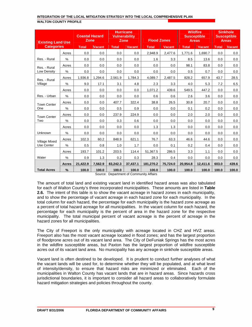
The amount of total land and existing vacant land in identified hazard areas was also tabulated for each of Walton County’s three incorporated municipalities. These amounts are listed in Table 2.6. The intent of this table is to show the vacant acreage in hazard zones in each municipality, and to show the percentage of vacant acreage in each hazard zone for each municipality. In the total column for each hazard, the percentage for each municipality is the hazard zone acreage as a percent of total hazard acreage for all municipalities. In the vacant column for each hazard, the percentage for each municipality is the percent of area in the hazard zone for the respective municipality. The total municipal percent of vacant acreage is the percent of acreage in the hazard zones for all municipalities. The City of Freeport is the only municipality with acreage located in CHZ and HVZ areas. Freeport also has the most vacant acreage located in flood zones; and has the largest proportion of floodprone acres out of its vacant land area. The City of DeFuniak Springs has the most acres in the wildfire susceptible areas, but Paxton has the largest proportion of wildfire susceptible acres out of its vacant land area. No municipality has any acreage in sinkhole susceptible areas. Vacant land is often destined to be developed. It is prudent to conduct further analyses of what the vacant lands will be used for, to determine whether they will be populated, and at what level of intensity/density, to ensure that hazard risks are minimized or eliminated. Each of the municipalities in Walton County has vacant lands that are in hazard areas. Since hazards cross jurisdictional boundaries, it is important to consider all hazard areas to collaboratively formulate hazard mitigation strategies and policies throughout the county.
INTEGRATION OF THE LOCAL MITIGATION STRATEGY INTO THE LOCAL COMPREHENSIVE PLAN WALTON COUNTY PROFILE
DRAFT 8/31/2006 FLORIDA DEPARTMENT OF COMMUNITY AFFAIRS 10
Table 2.6 Total Land and Existing Vacant Land in Hazard Areas by Municipal Jurisdiction
Coastal Hazard Zone
Hurricane Vulnerability
Zone Flood Zones Wildfire
Susceptible AreasFuture Land Use Category
Total Vacant Total Vacant Total Vacant Total Vacant
Acres 0.0 0.0 0.0 0.0 460.8 197.5 303.2 167.4
DeFuniak Springs % 0.0 0.0 0.0 0.0 100.0 42.9 100.0 55.2
Acres 286.7 248.6 284.7 246.1 924.3 825.5 89.4 43.7
Freeport % 100.0 86.7 100.0 86.5 100.0 89.3 100.0 48.9
Acres 0.0 0.0 0.0 0.0 1,116.2 512.3 38.1 34.3
Paxton % 0.0 0.0 0.0 0.0 100.0 45.9 100.0 90.1
Acres 286.7 248.6 284.7 246.1 2,501.3 1,535.3 430.7 245.4Total Municipal Acres % 100.0 86.7 100.0 86.5 100.0 61.4 100.0 57.0
Source: Department of Community Affairs 3. Existing Mitigation Measures The Local Mitigation Strategy is suited to be a repository for all hazard mitigation analyses (i.e., vulnerability and risk assessment), programs, policies and projects for the county and municipalities. The LMS identifies hazard mitigation needs in a community and alternative structural and nonstructural initiatives that can be employed to reduce community vulnerability to natural hazards. The LMS is multi-jurisdictional and intergovernmental in nature. Communities can reduce their vulnerability to natural hazards by integrating the LMS analyses and mitigation priorities into the local government comprehensive plan. As noted in DCA’s Protecting Florida’s Communities Guide, one significant strategy for reducing community vulnerability is to manage the development and redevelopment of land exposed to natural hazards. Where vacant land is exposed to hazard forces, local government decisions about allowable land uses, and the provision of public facilities and infrastructure to support those uses, can have major impacts on the extent to which the community makes itself vulnerable to natural hazards. Where communities are already established and land is predominately “built out,” local governments can take initiatives to reduce existing levels of vulnerability by altering current land uses both in the aftermath of disasters, when opportunities for redevelopment may arise, and under “blue sky” conditions as part of planned redevelopment initiatives. Per the DCA’s Protecting Florida’s Communities Guide, LMSes prepared pursuant to the state’s guidelines (Florida Department of Community Affairs, 1998) have three substantive components:
Hazard Identification and Vulnerability Assessment. This section identifies a community’s vulnerability to natural hazards. Under Florida rules, the HIVA is required to include, at a minimum, an evaluation of the vulnerability of structures, infrastructure, special risk populations, environmental resources, and the economy to any hazard to which the community is susceptible. According to FEMA, LMSes revised pursuant to the Disaster Mitigation Act of 2000 (DMA 2000) criteria must include maps and descriptions of the areas that would be affected by each hazard to which the jurisdiction is exposed, information on previous events, and estimates of future probabilities. Vulnerability should be assessed for the types and numbers of exposed buildings, infrastructure, and critical facilities with estimates of potential dollar losses. Plan updates will be required to assess the vulnerability of future growth and development.
Guiding Principles. This section lists and assesses the community’s existing hazard mitigation policies and programs and their impacts on community vulnerability. This
INTEGRATION OF THE LOCAL MITIGATION STRATEGY INTO THE LOCAL COMPREHENSIVE PLAN WALTON COUNTY PROFILE
DRAFT 8/31/2006 FLORIDA DEPARTMENT OF COMMUNITY AFFAIRS 11
section typically contains a list of existing policies from the community’s Comprehensive Plan and local ordinances that govern or are related to hazard mitigation. Coastal counties frequently include policies from their PDRPs.
Mitigation Initiatives. This component identifies and prioritizes structural and non-structural initiatives that can reduce hazards vulnerability. Proposals for amendments to Comprehensive Plans, land development regulations, and building codes are often included. Structural projects typically address public facilities and infrastructure, and buy-outs of private structures that are repetitively damaged by flood. Many of these qualify as capital improvement projects based on the magnitude of their costs and may also be included in the capital improvements elements of the counties’ and cities’ Comprehensive Plans.
The Walton County LMS (August 2004 version) was assessed to determine if the hazard analysis and vulnerability assessment (i.e., surge, flood, wildfire, and sinkhole) data can support comprehensive planning, whether the guiding principles include a comprehensive list of policies for the county and municipalities, and whether the LMS goals and objectives support comprehensive planning goals, objectives, and policies (GOP). Future updates to the assessment will include working with Walton County to determine if the capital improvement projects are included in the LMS hazard mitigation project list. Hazard Analysis and Vulnerability Assessment (Sections 4 and 5). The strengths and weaknesses of the Hazard Analysis and Vulnerability Assessment are as follows: Strengths:
• Provides a hazards analysis and a qualitative risk assessment for each hazard. • Includes a list of types and map of critical facilities. • Includes a GIS-based vulnerability assessment for facilities and properties in
identified hazard zones (flood, hurricane, tropical storm and storm surge). • Provides county property values for parcels in identified hazard zones. • Includes exposure values and potential dollar losses due to hazards based on TAOS
model predictions. • Includes a listing of repetitive loss properties as well as areas of the county that have
historically flooded (Appendix C).
Weaknesses: • Does not include information on demographic, income, and special needs population. • Does not include a future land use map. • Does not include future land use maps that include hazard data layers to illustrate
which future land use categories are susceptible to each hazard. • Hazard maps do not include data layers to illustrate population (i.e., density) or
property (i.e., value) exposure. Incorporating land use and population data into the risk assessment of the LMS provides a better source of data for planners to use in policy making and policy evaluation of the local comprehensive plan. The LMS also sets a standard for the quality of data that should be used in determining risk and thereby used to determine mitigation policies. Guiding Principles The Walton County LMS does not include a Guiding Principles section for the county nor each municipality that lists and assesses the community’s existing hazard mitigation policies and programs and their impacts on community vulnerability. Such a Guiding Principles section is
INTEGRATION OF THE LOCAL MITIGATION STRATEGY INTO THE LOCAL COMPREHENSIVE PLAN WALTON COUNTY PROFILE
DRAFT 8/31/2006 FLORIDA DEPARTMENT OF COMMUNITY AFFAIRS 12
found in most counties’ LMSes and is useful in providing the different jurisdictions ideas for enhancing their own plans or providing the LMS committee an analysis of where there may be weaknesses in implementing mitigation strategies. It is recommended that Walton County's next LMS update include a Guiding Principles section. LMS Goals and Objectives The Walton County LMS has goals and objectives that support mitigation principles that are found in the comprehensive plan. A list of the LMS goals and objectives pertaining to comprehensive planning can be found in Attachment F. An assessment of whether the LMS goals and objectives are reflected in the comprehensive plan (and vice versa) is provided in Table 5.1 as part of the preliminary recommendations. Final recommendations will result from a collaborative process between DCA, Walton County, and PBS&J. The following is a summary of the LMS goals and objectives that support comprehensive plan GOPs.
As part of the LMS mission statement, Walton County establishes that its LMS working group shall identify, refine, and administer policies, programs and projects that include the following: (1) policies that limit public expenditures in areas identified as subject to repetitive damage from disasters; (2) policies to ensure the protection of critical facilities such as prohibitions on constructing critical facilities in high hazard areas; (3) policies to eliminate development in hazard prone areas; (4) policies to regulate non-conforming land uses, particularly in areas subject to damage from disasters; (5) policies that regulate land use, beach and dune alteration, floodplains, non-point source stormwater run-off, and the design and location of sanitary sewer and septic tanks in hazard prone areas; (6) policies that prioritize the use of coastal areas for water-dependent uses such as public access and selective aquaculture; (7) policies that regulate watershed alterations (such as channelization, diking, damming, etc.) and wetland fill and development. Also policies that address restoration or enhancement of disturbed or degraded natural resources that can mitigate hazards (such as beach and dune systems and wetlands); (8) policies and procedures for post-storm reconstruction, such as building moratoria or special emergency permitting procedures; and (9) policies on the adopted local government building code and any areas associated with additional development restrictions, including coast construction jurisdiction, coastal building zones, and local land development practices as they relate to hazard mitigation.
Goal 1 establishes that Walton County will provide the communities with the programs and the administration to protect life and property. The key objectives under this goal include: (1) to develop a stormwater management plan that will mitigate drainage problems; (2) to participate in the National Flood Insurance Program created by FEMA and enforce the base flood elevation requirements; (3) to develop a coordination agreement on stormwater and flooding issues when there is a development contiguous to another Municipality to provide some joint review; (4) to provide fund source to address the mitigation strategies that have been stated; (5) to utilize the Working Group to develop new and improved mitigation programs, policies, ordinances to mitigate losses and to protect the public health and to provide safety welfare for their citizens; and (6) to develop and utilize an educational program for the citizens and for the employees of the county and municipalities. Goal 2 seeks to reduce the future expenses of the County, the municipalities, and their citizens by providing standards that will control developments in areas that are susceptible to damage by flooding and/or high winds. Key objectives under this goal include: (1) to construct public utilities to minimize or prevent flood damage and encourage the private utilities to follow a similar policy; (2) to adopt building standards to limit damage to private property by flooding or wind; and (3) to review critical facilities after an event to determine if additional protection is warranted. Goal 3 seeks to protect the environment and natural resources of the area by controlling development activities that would damage or destroy watersheds, wetlands, coastal resources, or other natural areas, which serve as natural buffers and help prevent extensive infrastructure damage. Key objectives include: (1) to adopt stormwater management plans that mitigate the
INTEGRATION OF THE LOCAL MITIGATION STRATEGY INTO THE LOCAL COMPREHENSIVE PLAN WALTON COUNTY PROFILE
DRAFT 8/31/2006 FLORIDA DEPARTMENT OF COMMUNITY AFFAIRS 13
additional runoff by development; (2) to protect the potable water aquifer, even though there is no recharge area in the County, by protecting wellheads to prevent the possibility of contamination getting into the water supply by the way of the well casing; (3) to promote the natural functions of wetlands and require that an impact on wetlands due to development be appropriately addressed or mitigated in kind; and (4) to protect watersheds by restricting development that alters the capacity of the watershed. Goal 4 establishes that the County and municipalities shall provide land use regulations to limit damage to developments. Key objectives include: (1) to restrict development in hazard prone areas to eliminate the potential of damage to structures and natural resources and adopt building codes that limit damage caused by local disasters such as wind loads and flood elevation; (2) to regulate development in hazard prone areas to provide an orderly development, thereby protecting structures and natural resources; and (3) to develop a post-disaster redevelopment plan to allow an orderly procedure or rebuilding and reconstruction and to have an approved policy that will help mitigate future disaster damages.
Maintaining consistent language for outlining goals and objectives in both the LMS and comprehensive plan presents a united front on decreasing risk in the county. While the LMS may not be able to regulate land use as the comprehensive plan does, having these common goals and objectives increases the likelihood of the jurisdictions of Walton County adopting and implementing corresponding policies that are legally enforceable. Comprehensive Emergency Operations Plan (CEMP) The Walton County CEMP does not include any specific goals or objectives, though it does reference the LMS document immediately in the beginning of Annex B: Mitigation Functions. Annex B of the CEMP discusses hazard mitigation in the context of standard operating procedures, activities, responsibilities and available programs that “do not otherwise occur within the community’s normal day-to-day operations.” This includes the post-disaster implementation of the Hazard Mitigation Grant Program and related disaster mitigation, response and recovery assistance programs, as well as pre-disaster mitigation programs such as the National Flood Insurance Program, Community Rating System and Flood Mitigation Assistance Program. The CEMP also indicates that the Planning and Zoning Department have developed and administers the comprehensive plan, which designates and regulates land use, densities and access issues of interest to emergency management. The Walton County CEMP does list Hazard Mitigation Plan Priorities pertaining to or tangentially related to comprehensive planning, as follows:
1. Protecting critical facilities such as power, communications, water, sewer, transportation, health medical, schools, police, security, fire and key businesses.
2. Increasing the amount of available shelter space so that the state’s shelter deficit is alleviated and that existing and proposed shelter space adequately provides for community needs.
3. Repairing and retrofitting existing non-conforming use structures damaged as a result of a disaster.
4. Support the state building codes that provide a regulatory framework and an institutional framework for reviewing local government amendments to such a common building code.
5. Encouraging local governments and state agencies to examine opportunities for acquisition of high hazard properties and for the relocation of damage-prone infrastructure.
Post-Disaster Redevelopment Plan (PDRP) The Walton County PDRP was not available for review at the time that this profile was developed.
INTEGRATION OF THE LOCAL MITIGATION STRATEGY INTO THE LOCAL COMPREHENSIVE PLAN WALTON COUNTY PROFILE
DRAFT 8/31/2006 FLORIDA DEPARTMENT OF COMMUNITY AFFAIRS 14
National Flood Insurance Program/Community Rating System Walton County and all of its municipalities participate in the National Flood Insurance Program (NFIP). Neither Walton County nor any of its municipalities currently participate in the NFIP Community Rating System )CRS).
4. Comprehensive Plan Review
Purpose and Intent The Walton County Comprehensive Plan (Adopted 1996) was reviewed for the purpose of developing this profile. This review was undertaken in order to assess what steps Walton County has taken to integrate hazard mitigation initiatives from their Local Mitigation Strategy (LMS) and hazard mitigation initiatives in general, into the local planning process. Each Element of the Plan was evaluated to establish the extent to which the principles from the LMS were incorporated into the objectives and policies of the existing Comprehensive Plan. Approach This review includes an assessment of storm surge, flooding and wildfire hazards. A preliminary list of objectives and policies currently contained in the Plan that pertain to hazard mitigation and any policies related to these hazards is found in Attachment G. The following is a discussion of the extent to which the Plan appears to address each of the hazards. Recent policy amendments may not have been available for review, or proposed policies might be in the process of creation, which address these hazards. As a result, this assessment is considered preliminary and subject to input from the local government. Summary of Findings The highest risk hazards for Walton County as identified per the County’s Local Mitigation Strategy (LMS) are tropical storms, hurricanes, tornadoes and wildfires. Sinkholes are not identified as a potential hazard risk. Therefore, sinkhole hazard is not addressed in this summary. The Comprehensive Plan contains several policies directly related to hazard mitigation and emergency preparedness. Policies address hurricane evacuation and hurricane evacuation times, shelter capacity, and infrastructure, and new development in the CHHA. The delineation and protection of the CHHA represent key components of the Comprehensive Plan. The creation of new lots (through platting, lot splits, or other method) that lie entirely within the Coastal High-Hazard Area is prohibited by the Plan. The creation of new lots contiguous to or partially within the Coastal High-Hazard Areas is also prohibited unless the newly created lot contains sufficient buildable area outside of the CHHA for the intended use. The County currently has a Post-Disaster Redevelopment Plan in place to aid in both short term recovery efforts and to provide guidance for long-term redevelopment. The Plan also contains extensive policies related to the protection of coastal resources. Those policies provide guidance for development and re-development in the CHHA. A Coastal Overlay has been adopted which provides specific measures to restrict and/or prevent damage to coastal systems. In addition, proposed amendments to the Future Land Use Map and to the Comprehensive Plan that increase residential densities and commercial intensities in South Walton County will be reviewed by Walton County Division of Emergency Management to gauge their impact on hurricane evacuation efforts. Flooding Flooding is addressed from two vantage points, the protection of natural drainage features, and protection of lives and properties through development standards and stormwater abatement.

INTEGRATION OF THE LOCAL MITIGATION STRATEGY INTO THE LOCAL COMPREHENSIVE PLAN WALTON COUNTY PROFILE
DRAFT 8/31/2006 FLORIDA DEPARTMENT OF COMMUNITY AFFAIRS 15
County flood hazard policies have a direct correlation to County hazard mitigation goals and objectives. There are policies in place to control drainage and stormwater associated with new development and to limit densities in floodplains in order to protect sensitive natural areas, lives and property. Flood mitigation provisions include a policy that the recommendations of any interagency hazard mitigation report which addresses future flood losses and is prepared in response to a Presidential Disaster Declaration will be incorporated into the County’s Disaster Plan. Development and redevelopment within a floodplain are required to practice construction techniques which protect development from flood hazards, maintain the natural function of the floodplain and wetlands natural flow functions, and minimize development impacts to natural wildlife habitats. The County regulates development within and surrounding wetlands, dune systems, lake systems, river and bay systems, wildlife habitat, fisheries, living marine resources and habitat, flood prone areas and the 100-year floodplain in order to conserve, appropriately use, and protect the resources. To further protect the natural functions of floodplains and flood prone areas, dredge and fill and clearing of natural vegetation will be permitted only to that extent needed to accommodate the immediate development site, consistent with the type of uses permitted in such areas by the Comprehensive Plan. Storm Surge and Evacuation Regarding hurricane evacuation, proposed developments and proposed amendments to the Future Land Use Map, must be coordinated with the recommendations of the Tri-State Hurricane Evacuation Study. Proposed plan amendments which would increase densities within hurricane evacuation zones 1-7 as designated in the Study, will be subject to review and a transportation impact analysis to determine their impact upon hurricane evacuation times and routes. Policy L-1.8.1 of the Future Land Use Element states that developments that will increase hurricane evacuation times will be required to provide mitigation measures such as transportation improvements, emergency van pools, and/or on-site emergency shelters. Measures must be designed to ensure there is no increase in evacuation times as a result of the proposed development. To ensure adherence to County Emergency Management objectives, Walton County Emergency Management Department will be included as a technical advisor in the development review process. Sheltering Similar to most of Florida’s coastal counties, Walton County currently has an existing shelter deficit. According to Florida’s Statewide Emergency Shelter Plan, Walton County has an existing shelter capacity of 4,445 people. The 2004 shelter demand for a Category 4 or Category 5 hurricane is projected to be 4,861 people, leaving an existing shelter deficit of 416. In 2009, the projected shelter demand is 5,810 leaving an anticipated shelter deficit of 1,365. The opportunity exists to construct new facilities to standards that will allow them to serve as shelters, and to construct future public facilities outside of floodplain areas. Plan policies include the provision that the County will improve its emergency shelter capabilities by retrofitting existing public buildings to better serve as severe weather shelters. In addition, the County will encourage large scale developments to provide on-site severe weather shelters that are outside Category One hurricane evacuation areas. Wildfire No policies pertaining to wildfire mitigation or management practices were found in the Comprehensive Plan.
INTEGRATION OF THE LOCAL MITIGATION STRATEGY INTO THE LOCAL COMPREHENSIVE PLAN WALTON COUNTY PROFILE
DRAFT 8/31/2006 FLORIDA DEPARTMENT OF COMMUNITY AFFAIRS 16
5. Recommendations For the Local Mitigation Strategy (LMS) to be effective in the decision-making process of growth management, its objectives and policies must be integrated into the Comprehensive Plan. The Plan is the legal basis for all local land use decisions. It is the document that outlines the fundamental regulatory provisions for all development, and should therefore state the broad measures of hazard mitigation to be implemented by other regulations such as neighborhood plans, land use codes and development regulations.
INTEGRATION OF THE LOCAL MITIGATION STRATEGY INTO THE LOCAL COMPREHENSIVE PLAN WALTON COUNTY PROFILE
DRAFT 8/31/2006 FLORIDA DEPARTMENT OF COMMUNITY AFFAIRS 17
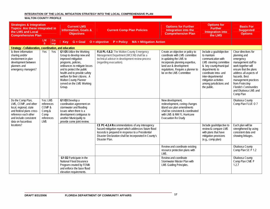
Strategies & Integration Topics: Are these integrated in the LMS and Local Comprehensive Plan
Current LMS Information, Goals &
Objectives Current Comp Plan Policies
Options for Further Integration into the
Comprehensive Plan
Options for Further
Integration into the LMS
Basis For Suggested
Options
LMS
Comp Key G = Goal O = objective P = Policy MA = Mitigation Action
Strategy - Collaboration, coordination, and education Is there information sharing and/or involvement in plan development between planners and emergency managers?
Yes Yes G1 O5 Utilize the Working Group to develop new and improved mitigation programs, policies, ordinances to mitigate losses and to protect the public health and to provide safety welfare for their citizens. A Walton County Planner served on the LMS Working Group.
FLU PL-1.8.2: The Walton County Emergency Management Department (WCEM) shall be a technical advisor in development review process (regarding evacuation).
Create an objective or policy to coordinate with LMS committee in updating the LMS to incorporate planning expertise, land use & development regulations. Require a planner to be on the LMS Committee
Include a goal/objective to maintain communication with LMS steering committee & key county/municipal departments to coordinate intra- and inter-departmental mitigation activities among jurisdictions and the public.
Clear directives for planning and emergency management staff to work together will ensure that the plans address all aspects of hazards. Best management practices from Protecting Florida's Communities and Okaloosa LMS and Comp Plan
G1 O3 Develop a coordination agreement on stormwater and flooding issues when there is a development contiguous to another Municipality to provide some joint review.
New development, redevelopment, zoning changes &land use plan amendments shall be consistent & coordinated with LMS & NW FL Hurricane Evacuation Re-Study
Okaloosa County Comp Plan FLUE O 7
CE PC-4.2.4 Recommendations of any interagency hazard mitigation report which addresses future flood losses& is prepared in response to a Presidential Disaster Declaration shall be incorporated in County’s Disaster Plan.
Include goal/objective to review & compare LMS with plans that have mitigation provisions (e.g., comp plan)
Each plan will be strengthened by using consistent data and showing linkages.
Review and coordinate existing resource protection plans with LMS.
Okaloosa County Comp Plan SE P 1.2
Do the Comp Plan, LMS, CEMP, and other local, regional, state and federal plans cross-reference each other and include consistent data on hazardous locations?
Yes: LMS references CEMP & Comp,& Comp references LMS
G1 O2 Participate in the National Flood Insurance Program created by FEMA and enforce the base flood elevation requirements.
Review and coordinate Stormwater Master Plan with LMS Guiding Principles.
Okaloosa County Comp Plan CME P 1.2.7
INTEGRATION OF THE LOCAL MITIGATION STRATEGY INTO THE LOCAL COMPREHENSIVE PLAN WALTON COUNTY PROFILE
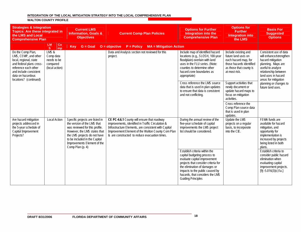
DRAFT 8/31/2006 FLORIDA DEPARTMENT OF COMMUNITY AFFAIRS 18
Strategies & Integration Topics: Are these integrated in the LMS and Local Comprehensive Plan
Current LMS Information, Goals &
Objectives Current Comp Plan Policies
Options for Further Integration into the
Comprehensive Plan
Options for Further
Integration into the LMS
Basis For Suggested
Options
LMS
Comp Key G = Goal O = objective P = Policy MA = Mitigation Action
Include map of identified hazard locations (e.g., SLOSH, 100-year floodplain) overlain with land uses in the FLU series. (Note: counties to determine other hazard zone boundaries as appropriate)
Include existing and future land uses on each hazard map, for those hazards identified as those that county is at most risk.
Support activities that newly document or update hazard maps to focus on mitigation activities.
Consistent use of data will enhance/strengthen hazard mitigation planning. Maps are useful to analyze relationship between land uses in hazard areas for mitigation planning or changes to future land uses.
Do the Comp Plan, LMS, CEMP, and other local, regional, state and federal plans cross-reference each other and include consistent data on hazardous locations? (continued)
LMS & Comp data needs to be compared (local action)
Data and Analysis section not reviewed for this project.
Cross reference the LMS source data that is used in plan updates to ensure that data is consistent and not conflicting.
Cross reference the Comp Plan source data that is used in plan updates.
During the annual review of the five-year schedule of capital improvements the LMS project list should be considered.
FEMA funds are available for hazard mitigation, and opportunity for implementation is increased by projects being listed in both plans.
Are hazard mitigation projects addressed in the 5-year schedule of Capital Improvement Projects?
Local Action
Specific projects are listed in the version of the LMS that was reviewed for this profile. However, the LMS states that the LMS projects do not have to be included in the Capital Improvements Element of the Comp Plan (p. 4)
CE PC-4.6.1 County will ensure that roadway improvements, identified in Traffic Circulation & Infrastructure Elements, are consistent with Capital Improvement Element of the Walton County Com Plan & are constructed to reduce evacuation times.
Establish criteria within the capital budgeting process to evaluate capital improvement projects that consider criteria for the elimination of damages or impacts to the public caused by hazards, that considers the LMS Guiding Principles
Update the LMS projects on a regular basis, to incorporate into the CIE.
Establish criteria to consider public hazard elimination when evaluating capital improvement projects. [9J-5.016(3)(c)1a.]
INTEGRATION OF THE LOCAL MITIGATION STRATEGY INTO THE LOCAL COMPREHENSIVE PLAN WALTON COUNTY PROFILE
DRAFT 8/31/2006 FLORIDA DEPARTMENT OF COMMUNITY AFFAIRS 19
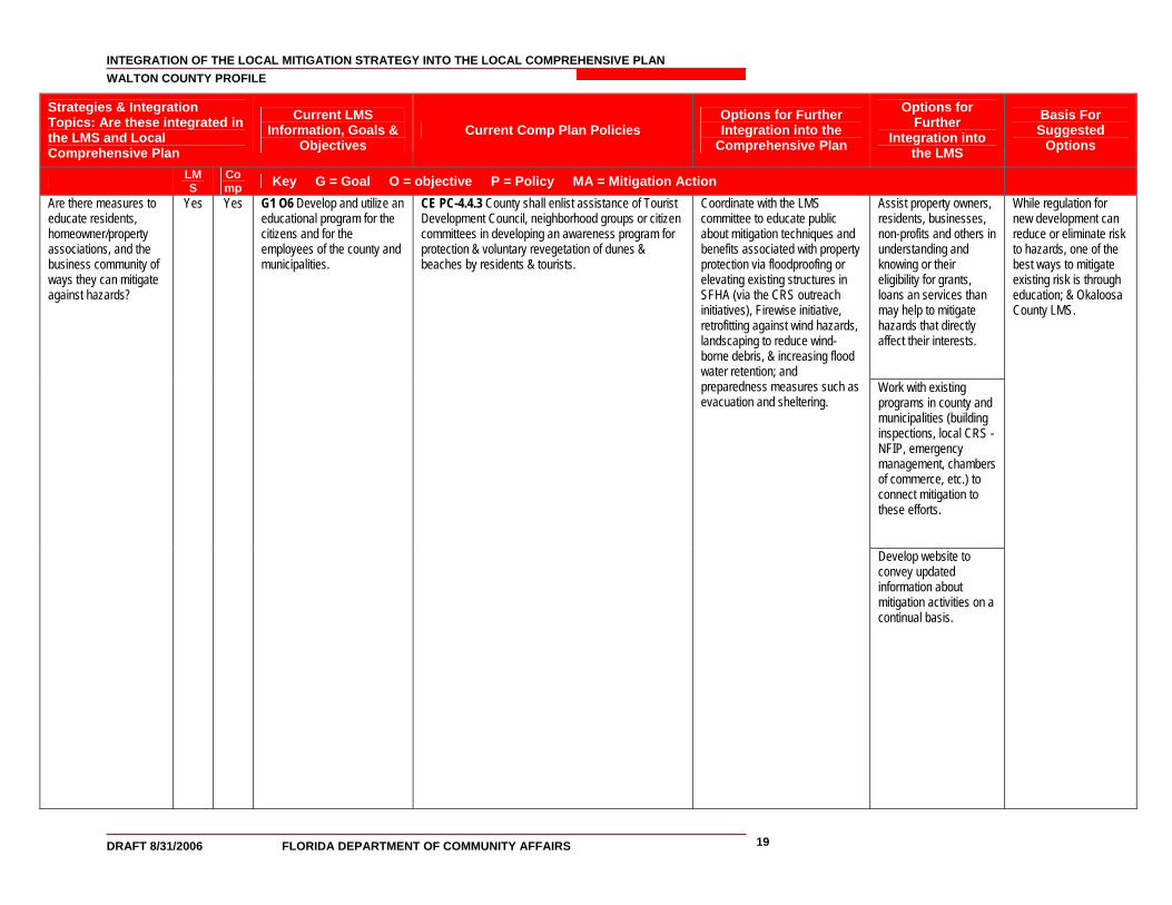
Strategies & Integration Topics: Are these integrated in the LMS and Local Comprehensive Plan
Current LMS Information, Goals &
Objectives Current Comp Plan Policies
Options for Further Integration into the
Comprehensive Plan
Options for Further
Integration into the LMS
Basis For Suggested
Options
LMS
Comp Key G = Goal O = objective P = Policy MA = Mitigation Action
Assist property owners, residents, businesses, non-profits and others in understanding and knowing or their eligibility for grants, loans an services than may help to mitigate hazards that directly affect their interests. Work with existing programs in county and municipalities (building inspections, local CRS -NFIP, emergency management, chambers of commerce, etc.) to connect mitigation to these efforts.
Are there measures to educate residents, homeowner/property associations, and the business community of ways they can mitigate against hazards?
Yes
Yes
G1 O6 Develop and utilize an educational program for the citizens and for the employees of the county and municipalities.
CE PC-4.4.3 County shall enlist assistance of Tourist Development Council, neighborhood groups or citizen committees in developing an awareness program for protection & voluntary revegetation of dunes & beaches by residents & tourists.
Coordinate with the LMS committee to educate public about mitigation techniques and benefits associated with property protection via floodproofing or elevating existing structures in SFHA (via the CRS outreach initiatives), Firewise initiative, retrofitting against wind hazards, landscaping to reduce wind-borne debris, & increasing flood water retention; and preparedness measures such as evacuation and sheltering.
Develop website to convey updated information about mitigation activities on a continual basis.
While regulation for new development can reduce or eliminate risk to hazards, one of the best ways to mitigate existing risk is through education; & Okaloosa County LMS.
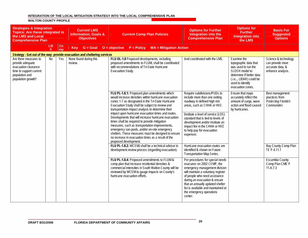
INTEGRATION OF THE LOCAL MITIGATION STRATEGY INTO THE LOCAL COMPREHENSIVE PLAN WALTON COUNTY PROFILE
DRAFT 8/31/2006 FLORIDA DEPARTMENT OF COMMUNITY AFFAIRS 20
Strategies & Integration Topics: Are these integrated in the LMS and Local Comprehensive Plan
Current LMS Information, Goals &
Objectives Current Comp Plan Policies
Options for Further Integration into the
Comprehensive Plan
Options for Further
Integration into the LMS
Basis For Suggested
Options
LMS
Comp Key G = Goal O = objective P = Policy MA = Mitigation Action
Strategy - Get out of the way: provide evacuation and sheltering services FLU OL-1.8 Proposed developments, including proposed amendments to FLUM, shall be coordinated with recommendations of Tri-State Hurricane Evacuation Study.
And coordinated with the LMS. Examine the topographic data that was used to run the SLOSH model to determine if better data (.i.e.., LIDAR) could be used to identify evacuation zones.
Science & technology can provide more accurate data, & enhance analysis.
Require subdivisions/PUDs to include more than one exiting roadway in defined high risk areas, such as CHHA or HVZ.
FLU PL-1.8.1: Proposed plan amendments which would increase densities within hurricane evacuation zones 1-7 as designated in the Tri-State Hurricane Evacuation Study shall be subject to review and transportation impact analysis to determine their impact upon hurricane evacuation times and routes. Developments that will increase hurricane evacuation times shall be required to provide mitigation measures, such as transportation improvements, emergency van pools, and/or on-site emergency shelters. These measures must be designed to ensure no increase in evacuation times as a result of the proposed development.
Institute a level of service (LOS) standard that is tied to levels of development and/or institute an impact fee in the CHHA or HVZ to help pay for evacuation expenses
Best management practices from Protecting Florida's Communities
FLU PL-1.8.2: WCEM) shall be a technical advisor in development review process (regarding evacuation).
Hurricane evacuation routes are identified & shown on Future Transportation Map Series.
Ensure that maps accurately reflect the amount of surge, wave action and flood caused by hurricanes.
Bay County Comp Plan TE P 4.11.1
Are there measures to provide adequate evacuation clearance time to support current population and population growth?
No
Yes
None found during this review.
FLU PL-1.8.4: Proposed amendments to FLUM & comp plan that increase residential densities & commercial intensities in South Walton County will be reviewed by WCEM to gauge impacts on County’s hurricane evacuation efforts.
Per procedures for special needs evacuees on 2002 CEMP, the emergency management division will maintain a voluntary register of people who need assistance during an evacuation & ensure that an annually updated shelter list is available and maintained at the emergency operations center.
Escambia County Comp Plan CME P 11.A.7.3
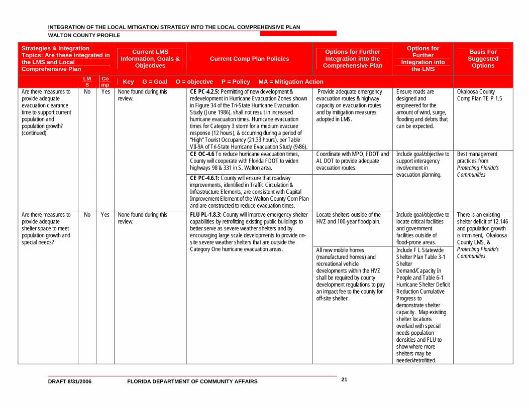
INTEGRATION OF THE LOCAL MITIGATION STRATEGY INTO THE LOCAL COMPREHENSIVE PLAN WALTON COUNTY PROFILE
DRAFT 8/31/2006 FLORIDA DEPARTMENT OF COMMUNITY AFFAIRS 21
Strategies & Integration Topics: Are these integrated in the LMS and Local Comprehensive Plan
Current LMS Information, Goals &
Objectives Current Comp Plan Policies
Options for Further Integration into the
Comprehensive Plan
Options for Further
Integration into the LMS
Basis For Suggested
Options
LMS
Comp Key G = Goal O = objective P = Policy MA = Mitigation Action
CE PC-4.2.5: Permitting of new development & redevelopment in Hurricane Evacuation Zones shown in Figure 34 of the Tri-State Hurricane Evacuation Study (June 1986), shall not result in increased hurricane evacuation times. Hurricane evacuation times for Category 3 storm for a medium evacuee response (12 hours), & occurring during a period of “High” Tourist Occupancy (21.33 hours), per Table VII-9A of Tri-State Hurricane Evacuation Study (9/86).
Provide adequate emergency evacuation routes & highway capacity on evacuation routes and by mitigation measures adopted in LMS.
Ensure roads are designed and engineered for the amount of wind, surge, flooding and debris that can be expected.
Okaloosa County Comp Plan TE P 1.5
CE OC-4.6 To reduce hurricane evacuation times, County will cooperate with Florida FDOT to widen highways 98 & 331 in S. Walton area.
Coordinate with MPO, FDOT and AL DOT to provide adequate evacuation routes.
Are there measures to provide adequate evacuation clearance time to support current population and population growth? (continued)
No
Yes
None found during this review.
CE PC-4.6.1: County will ensure that roadway improvements, identified in Traffic Circulation & Infrastructure Elements, are consistent with Capital Improvement Element of the Walton County Com Plan and are constructed to reduce evacuation times.
Include goal/objective to support interagency involvement in evacuation planning.
Best management practices from Protecting Florida's Communities
Locate shelters outside of the HVZ and 100-year floodplain.
Include goal/objective to locate critical facilities and government facilities outside of flood-prone areas.
Are there measures to provide adequate shelter space to meet population growth and special needs?
No
Yes
None found during this review.
FLU PL-1.8.3: County will improve emergency shelter capabilities by retrofitting existing public buildings to better serve as severe weather shelters and by encouraging large scale developments to provide on-site severe weather shelters that are outside the Category One hurricane evacuation areas.
All new mobile homes (manufactured homes) and recreational vehicle developments within the HVZ shall be required by county development regulations to pay an impact fee to the county for off-site shelter.
Include F L Statewide Shelter Plan Table 3-1 Shelter Demand/Capacity In People and Table 6-1 Hurricane Shelter Deficit Reduction Cumulative Progress to demonstrate shelter capacity. Map existing shelter locations overlaid with special needs population densities and FLU to show where more shelters may be needed/retrofitted.
There is an existing shelter deficit of 12,146 and population growth is imminent, Okaloosa County LMS, & Protecting Florida's Communities
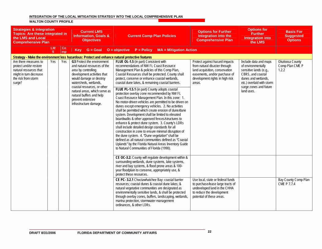
INTEGRATION OF THE LOCAL MITIGATION STRATEGY INTO THE LOCAL COMPREHENSIVE PLAN WALTON COUNTY PROFILE
DRAFT 8/31/2006 FLORIDA DEPARTMENT OF COMMUNITY AFFAIRS 22
Strategies & Integration Topics: Are these integrated in the LMS and Local Comprehensive Plan
Current LMS Information, Goals &
Objectives Current Comp Plan Policies
Options for Further Integration into the
Comprehensive Plan
Options for Further
Integration into the LMS
Basis For Suggested
Options
LMS
Comp Key G = Goal O = objective P = Policy MA = Mitigation Action
Strategy - Make the environment less hazardous: Protect and enhance natural protective features FLUE OL-1.5 (in part) Consistent with recommendations of NW FL Coast Resource Management Plan & policies of this Comp Plan, Coastal Resources shall be protected. County shall protect, conserve or enhance coastal wetlands, coastal dune lakes, & remaining coastal barriers.
FLUE PL-1.5.1 (in part) County adopts coastal protection overlay zone recommended by NW FL Coast Resource Management Plan. In this zone: 1. No motor-driven vehicles are permitted to be driven on dunes except emergency vehicles. 2. No activities shall be permitted which create erosion of dune/dune system. Development shall be limited to elevated boardwalks & other approved fences/structures to enhance & protect dune system. 3. County’s LDRs shall include detailed design standards for all construction in zone to ensure minimal disruption of the dune system. 4. “Dune vegetation” shall be defined as all natural communities defined as “Coastal Uplands” by the Florida Natural Areas Inventory Guide to Natural Communities of Florida (1990).
Protect against hazard impacts from natural disaster through land acquisition, conservation easements, and/or purchase of development rights in high risk areas.
Include data and maps of environmentally sensitive lands (e.g., CBRS, and coastal dunes and wetlands, etc.) overlaid with storm surge zones and future land uses.
Okaloosa County Comp Plan CME P 1.2.2
CE OC-3.2: County will regulate development within & surrounding wetlands, dune systems, lake systems, river and bay systems, & flood prone areas & 100-year floodplain to conserve, appropriately use, & protect these resources.
Are there measures to protect and/or restore natural resources that might in turn decrease the risk from storm surge?
Yes
Yes
G3 Protect the environment and natural resources of the area by controlling development activities that would damage or destroy watersheds, wetlands, coastal resources, or other natural areas, which serve as natural buffers and help prevent extensive infrastructure damage.
CE PC- 3.2.1 Choctawhatchee Bay: coastal barrier resources; coastal dunes & coastal dune lakes; & natural vegetative communities are designated as environmentally sensitive lands, & shall be protected through overlay zones, buffers, landscaping, wetlands, marina protection, stormwater management ordinances, & other LDRs.
Use local, state or federal funds to purchase/lease large tracts of undeveloped land in the CHHA to reduce the development potential of these areas.
Bay County Comp Plan CME P 7.7.4
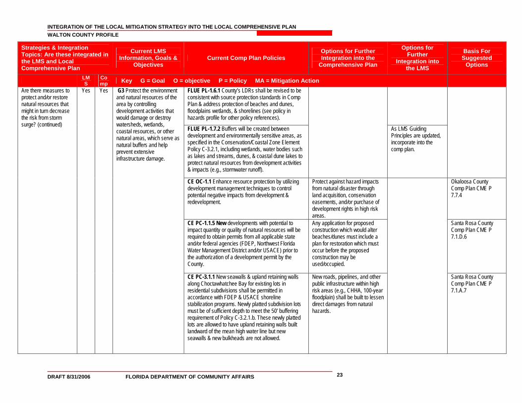
INTEGRATION OF THE LOCAL MITIGATION STRATEGY INTO THE LOCAL COMPREHENSIVE PLAN WALTON COUNTY PROFILE
DRAFT 8/31/2006 FLORIDA DEPARTMENT OF COMMUNITY AFFAIRS 23
Strategies & Integration Topics: Are these integrated in the LMS and Local Comprehensive Plan
Current LMS Information, Goals &
Objectives Current Comp Plan Policies
Options for Further Integration into the
Comprehensive Plan
Options for Further
Integration into the LMS
Basis For Suggested
Options
LMS
Comp Key G = Goal O = objective P = Policy MA = Mitigation Action
FLUE PL-1.6.1 County’s LDRs shall be revised to be consistent with source protection standards in Comp Plan & address protection of beaches and dunes, floodplains wetlands, & shorelines (see policy in hazards profile for other policy references).
FLUE PL-1.7.2 Buffers will be created between development and environmentally sensitive areas, as specified in the Conservation/Coastal Zone Element Policy C-3.2.1, including wetlands, water bodies such as lakes and streams, dunes, & coastal dune lakes to protect natural resources from development activities & impacts (e.g., stormwater runoff).
As LMS Guiding Principles are updated, incorporate into the comp plan.
CE OC-1.1 Enhance resource protection by utilizing development management techniques to control potential negative impacts from development & redevelopment.
Protect against hazard impacts from natural disaster through land acquisition, conservation easements, and/or purchase of development rights in high risk areas.
Okaloosa County Comp Plan CME P 7.7.4
CE PC-1.1.5 New developments with potential to impact quantity or quality of natural resources will be required to obtain permits from all applicable state and/or federal agencies (FDEP, Northwest Florida Water Management District and/or USACE) prior to the authorization of a development permit by the County.
Any application for proposed construction which would alter beaches/dunes must include a plan for restoration which must occur before the proposed construction may be used/occupied.
Santa Rosa County Comp Plan CME P 7.1.D.6
Are there measures to protect and/or restore natural resources that might in turn decrease the risk from storm surge? (continued)
Yes
Yes
G3 Protect the environment and natural resources of the area by controlling development activities that would damage or destroy watersheds, wetlands, coastal resources, or other natural areas, which serve as natural buffers and help prevent extensive infrastructure damage.
CE PC-3.1.1 New seawalls & upland retaining walls along Choctawhatchee Bay for existing lots in residential subdivisions shall be permitted in accordance with FDEP & USACE shoreline stabilization programs. Newly platted subdivision lots must be of sufficient depth to meet the 50' buffering requirement of Policy C-3.2.1.b. These newly platted lots are allowed to have upland retaining walls built landward of the mean high water line but new seawalls & new bulkheads are not allowed.
New roads, pipelines, and other public infrastructure within high risk areas (e.g., CHHA, 100-year floodplain) shall be built to lessen direct damages from natural hazards.
Santa Rosa County Comp Plan CME P 7.1.A.7
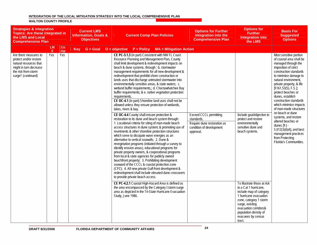
INTEGRATION OF THE LOCAL MITIGATION STRATEGY INTO THE LOCAL COMPREHENSIVE PLAN WALTON COUNTY PROFILE
DRAFT 8/31/2006 FLORIDA DEPARTMENT OF COMMUNITY AFFAIRS 24
Strategies & Integration Topics: Are these integrated in the LMS and Local Comprehensive Plan
Current LMS Information, Goals &
Objectives Current Comp Plan Policies
Options for Further Integration into the
Comprehensive Plan
Options for Further
Integration into the LMS
Basis For Suggested
Options
LMS
Comp Key G = Goal O = objective P = Policy MA = Mitigation Action
CE PC-3.1.3 (in part) Consistent with NW FL Coast Resource Planning and Management Plan, County shall limit development & redevelopment impacts on beach & dune systems, through : b. stormwater management requirements for all new development & redevelopment that prohibit shore construction or lands uses that discharge untreated stormwater into environmentally sensitive areas, & state waters; c. wetland buffer requirements,; d. Choctawhatchee Bay buffer requirements; & e. native vegetation protection requirements. CE OC-4.1 (in part) Shoreline land uses shall not be allowed unless they ensure protection of wetlands, lakes, rivers & bay.
Exceed CCCL permitting standards.
CE OC-4.4 County shall ensure protection & restoration to its dune and beach system through: 1. Locational criteria for siting of man-made beach access structures in dune system; & promoting use of revetments & other shoreline protection structures which serve to dissipate wave energies as an alternative to vertical seawalls; 2. Dune & revegetation programs (initiated through a survey to identify erosion areas), educational programs for private property owners, & cooperational programs from local & state agencies for publicly owned beachfront property; 3. Prohibiting development seaward of the CCCL & coastal protection zone (CPZ); 4. All new private Gulf-front development & redevelopment shall include elevated dune crossovers to provide private beach access.
Require dune restoration as condition of development approval.
Include goal/objective to protect and restore environmentally sensitive dune and beach systems.
Are there measures to protect and/or restore natural resources that might in turn decrease the risk from storm surge? (continued)
Yes
Yes
CE PC-4.2.1 Coastal High-Hazard Area is defined as the area encompassed by the Category I storm surge area as depicted in the Tri-State Hurricane Evacuation Study, June 1986.
To illustrate those at risk to a Cat 1 hurricane, include map of category 1 hurricane evacuation zone, category 1 storm surge, existing evacuation corridors& population density of evacuees by census tract.
Most sensitive portion of coastal area shall be managed through the imposition of strict construction standards to minimize damage to natural environment, private property, & life [§161.53(5), F.S.]; protect beaches or dunes, establish construction standards which minimize impacts of man-made structures on beach or dune systems, and restore altered beaches or dunes [9 J-5.012(3)(b)4], and best management practices from Protecting Florida's Communities.
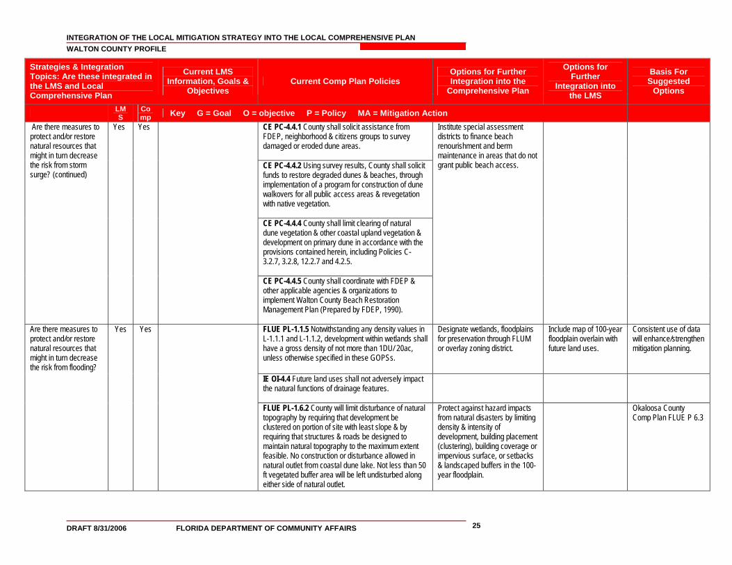
INTEGRATION OF THE LOCAL MITIGATION STRATEGY INTO THE LOCAL COMPREHENSIVE PLAN WALTON COUNTY PROFILE
DRAFT 8/31/2006 FLORIDA DEPARTMENT OF COMMUNITY AFFAIRS 25
Strategies & Integration Topics: Are these integrated in the LMS and Local Comprehensive Plan
Current LMS Information, Goals &
Objectives Current Comp Plan Policies
Options for Further Integration into the
Comprehensive Plan
Options for Further
Integration into the LMS
Basis For Suggested
Options
LMS
Comp Key G = Goal O = objective P = Policy MA = Mitigation Action
Yes Yes CE PC-4.4.1 County shall solicit assistance from FDEP, neighborhood & citizens groups to survey damaged or eroded dune areas.
CE PC-4.4.2 Using survey results, County shall solicit funds to restore degraded dunes & beaches, through implementation of a program for construction of dune walkovers for all public access areas & revegetation with native vegetation.
Are there measures to protect and/or restore natural resources that might in turn decrease the risk from storm surge? (continued)
CE PC-4.4.4 County shall limit clearing of natural dune vegetation & other coastal upland vegetation & development on primary dune in accordance with the provisions contained herein, including Policies C-3.2.7, 3.2.8, 12.2.7 and 4.2.5.
CE PC-4.4.5 County shall coordinate with FDEP & other applicable agencies & organizations to implement Walton County Beach Restoration Management Plan (Prepared by FDEP, 1990).
Institute special assessment districts to finance beach renourishment and berm maintenance in areas that do not grant public beach access.
FLUE PL-1.1.5 Notwithstanding any density values in L-1.1.1 and L-1.1.2, development within wetlands shall have a gross density of not more than 1DU/ 20ac, unless otherwise specified in these GOPSs.
Designate wetlands, floodplains for preservation through FLUM or overlay zoning district.
Include map of 100-year floodplain overlain with future land uses.
Consistent use of data will enhance/strengthen mitigation planning.
IE OI-4.4 Future land uses shall not adversely impact the natural functions of drainage features.
Are there measures to protect and/or restore natural resources that might in turn decrease the risk from flooding?
Yes Yes
FLUE PL-1.6.2 County will limit disturbance of natural topography by requiring that development be clustered on portion of site with least slope & by requiring that structures & roads be designed to maintain natural topography to the maximum extent feasible. No construction or disturbance allowed in natural outlet from coastal dune lake. Not less than 50 ft vegetated buffer area will be left undisturbed along either side of natural outlet.
Protect against hazard impacts from natural disasters by limiting density & intensity of development, building placement (clustering), building coverage or impervious surface, or setbacks & landscaped buffers in the 100-year floodplain.
Okaloosa County Comp Plan FLUE P 6.3
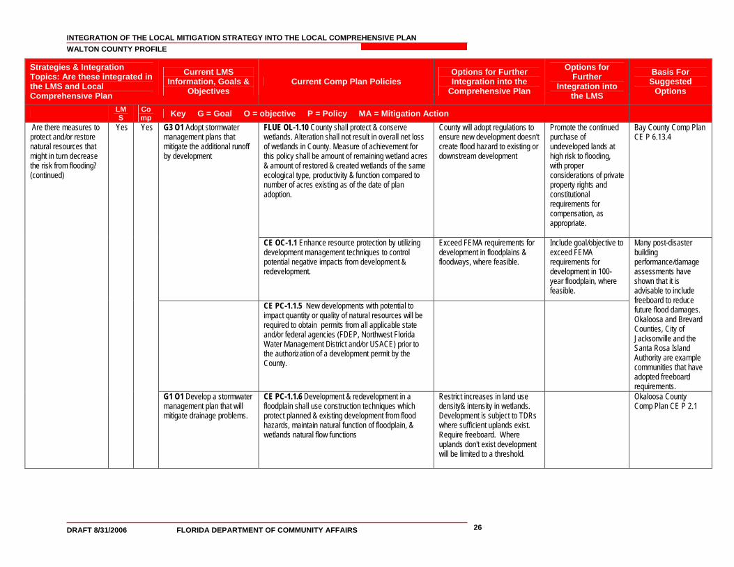
INTEGRATION OF THE LOCAL MITIGATION STRATEGY INTO THE LOCAL COMPREHENSIVE PLAN WALTON COUNTY PROFILE
DRAFT 8/31/2006 FLORIDA DEPARTMENT OF COMMUNITY AFFAIRS 26
Strategies & Integration Topics: Are these integrated in the LMS and Local Comprehensive Plan
Current LMS Information, Goals &
Objectives Current Comp Plan Policies
Options for Further Integration into the
Comprehensive Plan
Options for Further
Integration into the LMS
Basis For Suggested
Options
LMS
Comp Key G = Goal O = objective P = Policy MA = Mitigation Action
Are there measures to protect and/or restore natural resources that might in turn decrease the risk from flooding? (continued)
Yes
Yes
G3 O1 Adopt stormwater management plans that mitigate the additional runoff by development
FLUE OL-1.10 County shall protect & conserve wetlands. Alteration shall not result in overall net loss of wetlands in County. Measure of achievement for this policy shall be amount of remaining wetland acres & amount of restored & created wetlands of the same ecological type, productivity & function compared to number of acres existing as of the date of plan adoption.
County will adopt regulations to ensure new development doesn't create flood hazard to existing or downstream development
Promote the continued purchase of undeveloped lands at high risk to flooding, with proper considerations of private property rights and constitutional requirements for compensation, as appropriate.
Bay County Comp Plan CE P 6.13.4
CE OC-1.1 Enhance resource protection by utilizing development management techniques to control potential negative impacts from development & redevelopment.
Exceed FEMA requirements for development in floodplains & floodways, where feasible.
Include goal/objective to exceed FEMA requirements for development in 100-year floodplain, where feasible.
CE PC-1.1.5 New developments with potential to impact quantity or quality of natural resources will be required to obtain permits from all applicable state and/or federal agencies (FDEP, Northwest Florida Water Management District and/or USACE) prior to the authorization of a development permit by the County.
Many post-disaster building performance/damage assessments have shown that it is advisable to include freeboard to reduce future flood damages. Okaloosa and Brevard Counties, City of Jacksonville and the Santa Rosa Island Authority are example communities that have adopted freeboard requirements.
G1 O1 Develop a stormwater management plan that will mitigate drainage problems.
CE PC-1.1.6 Development & redevelopment in a floodplain shall use construction techniques which protect planned & existing development from flood hazards, maintain natural function of floodplain, & wetlands natural flow functions
Restrict increases in land use density& intensity in wetlands. Development is subject to TDRs where sufficient uplands exist. Require freeboard. Where uplands don't exist development will be limited to a threshold.
Okaloosa County Comp Plan CE P 2.1
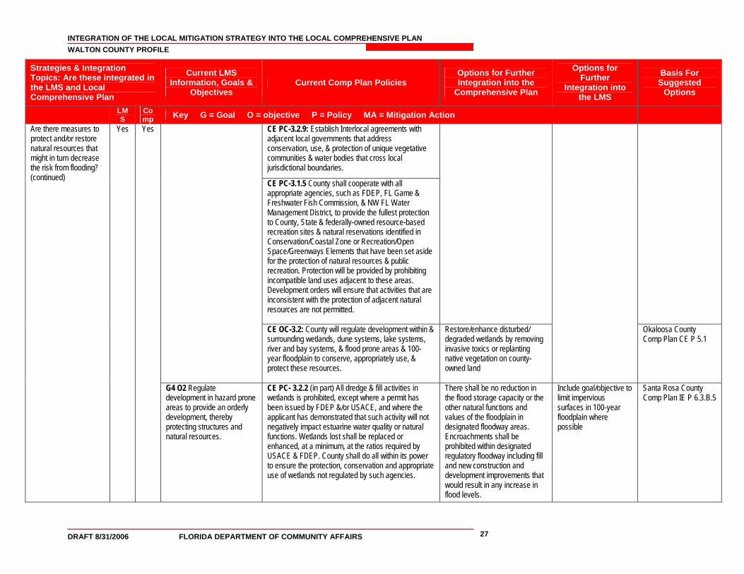
INTEGRATION OF THE LOCAL MITIGATION STRATEGY INTO THE LOCAL COMPREHENSIVE PLAN WALTON COUNTY PROFILE
DRAFT 8/31/2006 FLORIDA DEPARTMENT OF COMMUNITY AFFAIRS 27
Strategies & Integration Topics: Are these integrated in the LMS and Local Comprehensive Plan
Current LMS Information, Goals &
Objectives Current Comp Plan Policies
Options for Further Integration into the
Comprehensive Plan
Options for Further
Integration into the LMS
Basis For Suggested
Options
LMS
Comp Key G = Goal O = objective P = Policy MA = Mitigation Action
CE PC-3.2.9: Establish Interlocal agreements with adjacent local governments that address conservation, use, & protection of unique vegetative communities & water bodies that cross local jurisdictional boundaries.
CE PC-3.1.5 County shall cooperate with all appropriate agencies, such as FDEP, FL Game & Freshwater Fish Commission, & NW FL Water Management District, to provide the fullest protection to County, State & federally-owned resource-based recreation sites & natural reservations identified in Conservation/Coastal Zone or Recreation/Open Space/Greenways Elements that have been set aside for the protection of natural resources & public recreation. Protection will be provided by prohibiting incompatible land uses adjacent to these areas. Development orders will ensure that activities that are inconsistent with the protection of adjacent natural resources are not permitted.
CE OC-3.2: County will regulate development within & surrounding wetlands, dune systems, lake systems, river and bay systems, & flood prone areas & 100-year floodplain to conserve, appropriately use, & protect these resources.
Restore/enhance disturbed/ degraded wetlands by removing invasive toxics or replanting native vegetation on county-owned land
Okaloosa County Comp Plan CE P 5.1
Are there measures to protect and/or restore natural resources that might in turn decrease the risk from flooding? (continued)
Yes
Yes
G4 O2 Regulate development in hazard prone areas to provide an orderly development, thereby protecting structures and natural resources.
CE PC- 3.2.2 (in part) All dredge & fill activities in wetlands is prohibited, except where a permit has been issued by FDEP &/or USACE, and where the applicant has demonstrated that such activity will not negatively impact estuarine water quality or natural functions. Wetlands lost shall be replaced or enhanced, at a minimum, at the ratios required by USACE & FDEP. County shall do all within its power to ensure the protection, conservation and appropriate use of wetlands not regulated by such agencies.
There shall be no reduction in the flood storage capacity or the other natural functions and values of the floodplain in designated floodway areas. Encroachments shall be prohibited within designated regulatory floodway including fill and new construction and development improvements that would result in any increase in flood levels.
Include goal/objective to limit impervious surfaces in 100-year floodplain where possible
Santa Rosa County Comp Plan IE P 6.3.B.5
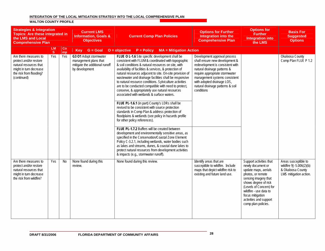
INTEGRATION OF THE LOCAL MITIGATION STRATEGY INTO THE LOCAL COMPREHENSIVE PLAN WALTON COUNTY PROFILE
DRAFT 8/31/2006 FLORIDA DEPARTMENT OF COMMUNITY AFFAIRS 28
Strategies & Integration Topics: Are these integrated in the LMS and Local Comprehensive Plan
Current LMS Information, Goals &
Objectives Current Comp Plan Policies
Options for Further Integration into the
Comprehensive Plan
Options for Further
Integration into the LMS
Basis For Suggested
Options
LMS
Comp Key G = Goal O = objective P = Policy MA = Mitigation Action
Are there measures to protect and/or restore natural resources that might in turn decrease the risk from flooding? (continued)
Yes Yes G3 O1 Adopt stormwater management plans that mitigate the additional runoff by development
FLUE O L-1.6 Site specific development shall be consistent with FLUM & coordinated with topographic & soil conditions & natural resources on site, with availability of facilities & services, & protection of natural resources adjacent to site. On-site provision of wastewater and drainage facilities shall be responsive to natural resource conditions. Sylviculture activities are to be conducted compatible with need to protect, conserve, & appropriately use natural resources associated with wetlands & surface waters.
FLUE PL-1.6.1 (in part) County’s LDRs shall be revised to be consistent with source protection standards in Comp Plan & address protection of floodplains & wetlands (see policy in hazards profile for other policy references).
Development approval process shall ensure new development & redevelopment is consistent with natural drainage patterns & require appropriate stormwater management systems consistent with adopted drainage LOS, natural drainage patterns & soil conditions
FLUE PL-1.7.2 Buffers will be created between development and environmentally sensitive areas, as specified in the Conservation/Coastal Zone Element Policy C-3.2.1, including wetlands, water bodies such as lakes and streams, dunes, & coastal dune lakes to protect natural resources from development activities & impacts (e.g., stormwater runoff).
Okaloosa County Comp Plan FLUE P 1.2
Are there measures to protect and/or restore natural resources that might in turn decrease the risk from wildfire?
Yes No None found during this review.
None found during this review. Identify areas that are susceptible to wildfire. Include maps that depict wildfire risk to existing and future land use.
Support activities that newly document or update maps, aerials photos, or remote sensing imagery that shows degree of risk (Levels of Concern) for wildfire - use data to focus mitigation activities and support comp plan policies.
Areas susceptible to wildfire 9J-5.006(2)(b) & Okaloosa County LMS mitigation action.
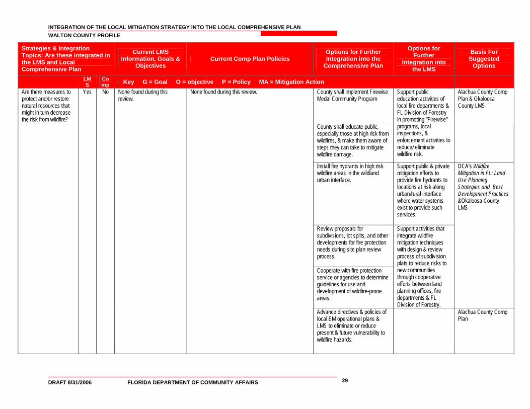
INTEGRATION OF THE LOCAL MITIGATION STRATEGY INTO THE LOCAL COMPREHENSIVE PLAN WALTON COUNTY PROFILE
DRAFT 8/31/2006 FLORIDA DEPARTMENT OF COMMUNITY AFFAIRS 29
Strategies & Integration Topics: Are these integrated in the LMS and Local Comprehensive Plan
Current LMS Information, Goals &
Objectives Current Comp Plan Policies
Options for Further Integration into the
Comprehensive Plan
Options for Further
Integration into the LMS
Basis For Suggested
Options
LMS
Comp Key G = Goal O = objective P = Policy MA = Mitigation Action
Are there measures to protect and/or restore natural resources that might in turn decrease the risk from wildfire?
No County shall implement Firewise Medal Community Program
County shall educate public, especially those at high risk from wildfires, & make them aware of steps they can take to mitigate wildfire damage.
Support public education activities of local fire departments & FL Division of Forestry in promoting "Firewise" programs, local inspections, & enforcement activities to reduce/ eliminate wildfire risk.
Alachua County Comp Plan & Okaloosa County LMS
Install fire hydrants in high risk wildfire areas in the wildland urban interface.
Support public & private mitigation efforts to provide fire hydrants to locations at risk along urban/rural interface where water systems exist to provide such services.
Review proposals for subdivisions, lot splits, and other developments for fire protection needs during site plan review process. Cooperate with fire protection service or agencies to determine guidelines for use and development of wildfire-prone areas.
Support activities that integrate wildfire mitigation techniques with design & review process of subdivision plats to reduce risks to new communities through cooperative efforts between land planning offices, fire departments & FL Division of Forestry.
DCA's Wildfire Mitigation in FL: Land Use Planning Strategies and Best Development Practices &Okaloosa County LMS
Yes
None found during this review.
None found during this review.
Advance directives & policies of local EM operational plans & LMS to eliminate or reduce present & future vulnerability to wildfire hazards.
Alachua County Comp Plan
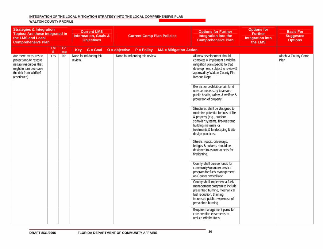
INTEGRATION OF THE LOCAL MITIGATION STRATEGY INTO THE LOCAL COMPREHENSIVE PLAN WALTON COUNTY PROFILE
DRAFT 8/31/2006 FLORIDA DEPARTMENT OF COMMUNITY AFFAIRS 30
Strategies & Integration Topics: Are these integrated in the LMS and Local Comprehensive Plan
Current LMS Information, Goals &
Objectives Current Comp Plan Policies
Options for Further Integration into the
Comprehensive Plan
Options for Further
Integration into the LMS
Basis For Suggested
Options
LMS
Comp Key G = Goal O = objective P = Policy MA = Mitigation Action
All new development should complete & implement a wildfire mitigation plan specific to that development, subject to review & approval by Walton County Fire Rescue Dept.
Restrict or prohibit certain land uses as necessary to assure public health, safety, & welfare & protection of property.
Structures shall be designed to minimize potential for loss of life & property (e.g., outdoor sprinkler systems, fire-resistant building materials or treatments,& landscaping & site design practices.
Streets, roads, driveways, bridges & culverts should be designed to assure access for firefighting.
County shall pursue funds for community/volunteer service program for fuels management on County owned land County shall implement a fuels management program to include prescribed burning, mechanical fuel reduction, thinning; increased public awareness of prescribed burning.
Are there measures to protect and/or restore natural resources that might in turn decrease the risk from wildfire? (continued)
Yes
No
None found during this review.
None found during this review.
Require management plans for conservation easements to reduce wildfire fuels.
Alachua County Comp Plan
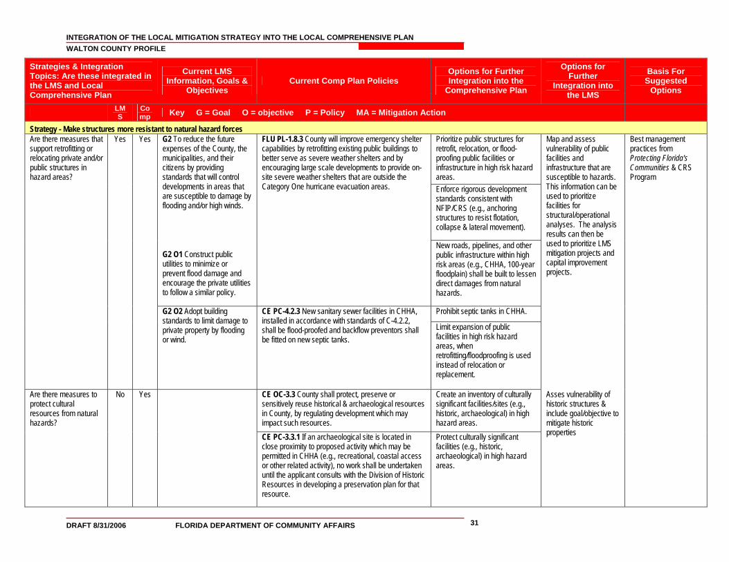
INTEGRATION OF THE LOCAL MITIGATION STRATEGY INTO THE LOCAL COMPREHENSIVE PLAN WALTON COUNTY PROFILE
DRAFT 8/31/2006 FLORIDA DEPARTMENT OF COMMUNITY AFFAIRS 31
Strategies & Integration Topics: Are these integrated in the LMS and Local Comprehensive Plan
Current LMS Information, Goals &
Objectives Current Comp Plan Policies
Options for Further Integration into the
Comprehensive Plan
Options for Further
Integration into the LMS
Basis For Suggested
Options
LMS
Comp Key G = Goal O = objective P = Policy MA = Mitigation Action
Strategy - Make structures more resistant to natural hazard forces Prioritize public structures for retrofit, relocation, or flood-proofing public facilities or infrastructure in high risk hazard areas.
G2 To reduce the future expenses of the County, the municipalities, and their citizens by providing standards that will control developments in areas that are susceptible to damage by flooding and/or high winds.
Enforce rigorous development standards consistent with NFIP/CRS (e.g., anchoring structures to resist flotation, collapse & lateral movement).
G2 O1 Construct public utilities to minimize or prevent flood damage and encourage the private utilities to follow a similar policy.
FLU PL-1.8.3 County will improve emergency shelter capabilities by retrofitting existing public buildings to better serve as severe weather shelters and by encouraging large scale developments to provide on-site severe weather shelters that are outside the Category One hurricane evacuation areas.
New roads, pipelines, and other public infrastructure within high risk areas (e.g., CHHA, 100-year floodplain) shall be built to lessen direct damages from natural hazards.
Prohibit septic tanks in CHHA.
Are there measures that support retrofitting or relocating private and/or public structures in hazard areas?
Yes Yes
G2 O2 Adopt building standards to limit damage to private property by flooding or wind.
CE PC-4.2.3 New sanitary sewer facilities in CHHA, installed in accordance with standards of C-4.2.2, shall be flood-proofed and backflow preventors shall be fitted on new septic tanks.
Limit expansion of public facilities in high risk hazard areas, when retrofitting/floodproofing is used instead of relocation or replacement.
Map and assess vulnerability of public facilities and infrastructure that are susceptible to hazards. This information can be used to prioritize facilities for structural/operational analyses. The analysis results can then be used to prioritize LMS mitigation projects and capital improvement projects.
CE OC-3.3 County shall protect, preserve or sensitively reuse historical & archaeological resources in County, by regulating development which may impact such resources.
Create an inventory of culturally significant facilities/sites (e.g., historic, archaeological) in high hazard areas.
Are there measures to protect cultural resources from natural hazards?
No Yes
CE PC-3.3.1 If an archaeological site is located in close proximity to proposed activity which may be permitted in CHHA (e.g., recreational, coastal access or other related activity), no work shall be undertaken until the applicant consults with the Division of Historic Resources in developing a preservation plan for that resource.
Protect culturally significant facilities (e.g., historic, archaeological) in high hazard areas.
Asses vulnerability of historic structures & include goal/objective to mitigate historic properties
Best management practices from Protecting Florida's Communities & CRS Program

INTEGRATION OF THE LOCAL MITIGATION STRATEGY INTO THE LOCAL COMPREHENSIVE PLAN WALTON COUNTY PROFILE
DRAFT 8/31/2006 FLORIDA DEPARTMENT OF COMMUNITY AFFAIRS 32
Strategies & Integration Topics: Are these integrated in the LMS and Local Comprehensive Plan
Current LMS Information, Goals &
Objectives Current Comp Plan Policies
Options for Further Integration into the
Comprehensive Plan
Options for Further
Integration into the LMS
Basis For Suggested
Options
LMS
Comp Key G = Goal O = objective P = Policy MA = Mitigation Action
G1 O2 Participate in the National Flood Insurance Program created by FEMA and enforce the base flood elevation requirements.
Identify structures that are repetitively damaged by coastal storms
Repetitive loss structures shall be inventoried or analyzed [9J-5.012(2)(e)2]
Enforce rigorous development standards consistent with the NFIP and CRS program
Okaloosa County Comp Plan
G2 O3 Develop a program that sets up a process to review repetitive loss property and flood prone areas for acquisition to mitigate the damages of the structures.
Perform an analysis for acquiring, relocating or elevating Repetitive Loss structures in the SFHA (100- year floodplain.
Include a goal/objective to mitigate repetitive loss properties.
Best management practices from Protecting Florida's Communities
Does the comp plan include measures to mitigate flood damage to Repetitive Loss structures?
Yes No
G1 O4 Provide fund source to address the mitigation strategies that have been stated.
None found during this review.
Initiate grant/ loan program to assist all property owners with financing elevating, floodproofing, or relocating existing repetitive loss structures in SFHA.
FEMA funds are available for hazard mitigation.
Are there measures to require compliance with or exceed building codes and/or design standards for certain hazard areas?
Yes Yes G1 O2 Participate in the National Flood Insurance Program created by FEMA and enforce the base flood elevation requirements.
IE OI-4.1 County shall adopt LDRs to ensure new development & redevelopment does not increase stormwater runoff or flooding problems. Level of service standards for drainage shall ensure capacity of drainage structures for roads & other development are designed to meet facility needs.
Adopt more stringent development standards than the NFIP in the 100-year floodplain (i.e., per CRS program).
Participate in the CRS, and exceed existing NFIP regulations.
The most sensitive portion of the coastal area shall be managed through the imposition of strict construction standards in order to minimize damage to the natural environment, private property, and life. (§161.53(5), F.S.)
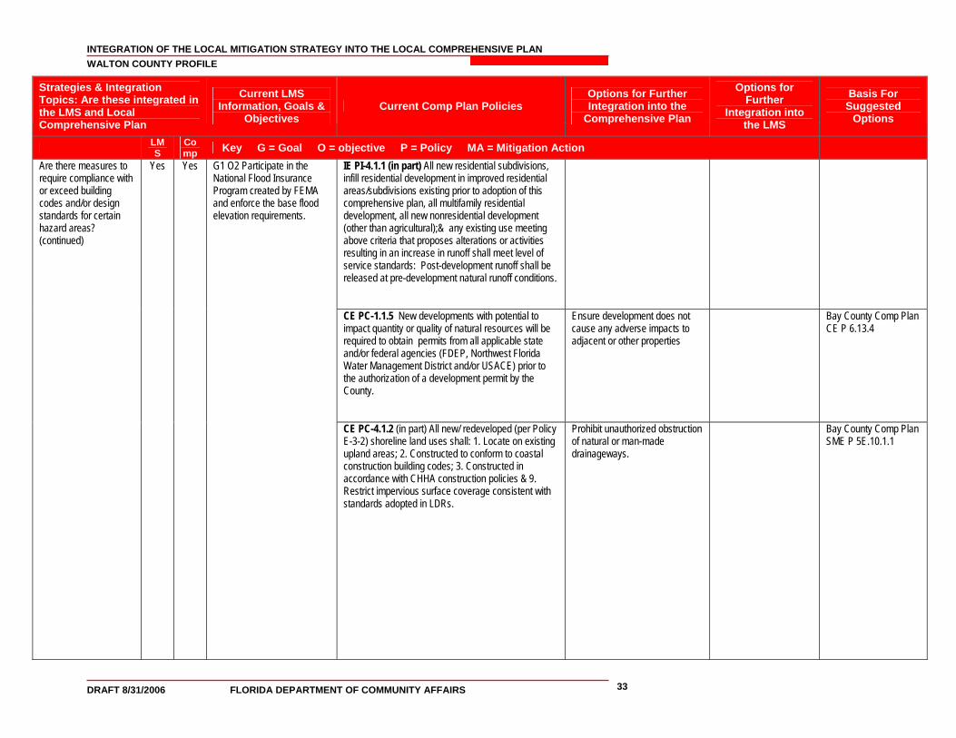
INTEGRATION OF THE LOCAL MITIGATION STRATEGY INTO THE LOCAL COMPREHENSIVE PLAN WALTON COUNTY PROFILE
DRAFT 8/31/2006 FLORIDA DEPARTMENT OF COMMUNITY AFFAIRS 33
Strategies & Integration Topics: Are these integrated in the LMS and Local Comprehensive Plan
Current LMS Information, Goals &
Objectives Current Comp Plan Policies
Options for Further Integration into the
Comprehensive Plan
Options for Further
Integration into the LMS
Basis For Suggested
Options
LMS
Comp Key G = Goal O = objective P = Policy MA = Mitigation Action
IE PI-4.1.1 (in part) All new residential subdivisions, infill residential development in improved residential areas/subdivisions existing prior to adoption of this comprehensive plan, all multifamily residential development, all new nonresidential development (other than agricultural);& any existing use meeting above criteria that proposes alterations or activities resulting in an increase in runoff shall meet level of service standards: Post-development runoff shall be released at pre-development natural runoff conditions.
CE PC-1.1.5 New developments with potential to impact quantity or quality of natural resources will be required to obtain permits from all applicable state and/or federal agencies (FDEP, Northwest Florida Water Management District and/or USACE) prior to the authorization of a development permit by the County.
Ensure development does not cause any adverse impacts to adjacent or other properties
Bay County Comp Plan CE P 6.13.4
Are there measures to require compliance with or exceed building codes and/or design standards for certain hazard areas? (continued)
Yes Yes G1 O2 Participate in the National Flood Insurance Program created by FEMA and enforce the base flood elevation requirements.
CE PC-4.1.2 (in part) All new/ redeveloped (per Policy E-3-2) shoreline land uses shall: 1. Locate on existing upland areas; 2. Constructed to conform to coastal construction building codes; 3. Constructed in accordance with CHHA construction policies & 9. Restrict impervious surface coverage consistent with standards adopted in LDRs.
Prohibit unauthorized obstruction of natural or man-made drainageways.
Bay County Comp Plan SME P 5E.10.1.1
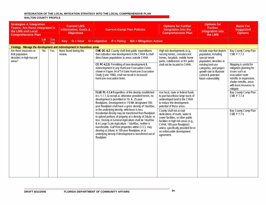
INTEGRATION OF THE LOCAL MITIGATION STRATEGY INTO THE LOCAL COMPREHENSIVE PLAN WALTON COUNTY PROFILE
DRAFT 8/31/2006 FLORIDA DEPARTMENT OF COMMUNITY AFFAIRS 34
Strategies & Integration Topics: Are these integrated in the LMS and Local Comprehensive Plan
Current LMS Information, Goals &
Objectives Current Comp Plan Policies
Options for Further Integration into the
Comprehensive Plan
Options for Further
Integration into the LMS
Basis For Suggested
Options
LMS
Comp Key G = Goal O = objective P = Policy MA = Mitigation Action
Strategy - Manage the development and redevelopment in hazardous areas CME OC-4.2: County shall limit public expenditures that subsidize new development in the CHHA & shall direct future populations to areas outside CHHA
Bay County Comp Plan CME P 7.7.3
CE PC-4.2.5: Permitting of new development & redevelopment in any Hurricane Evacuation Zones shown in Figure 34 of Tri-State Hurricane Evacuation Study (June 1986), shall not result in increased hurricane evacuation times.
High risk developments (e.g., nursing homes, convalescent homes, hospitals, mobile home parks, subdivisions or RV parks shall not be located in CHHA. Mapping is useful for
mitigation planning for issues such as evacuation route retrofits or expansions, shelter retrofits, areas with least resources to mitigate
Use local, state or federal funds to purchase/lease large tracts of undeveloped land in the CHHA to reduce the development potential of these areas.
Include map that depicts population, including special needs population, densities in existing land use categories, and project growth rate to illustrate current & potential future vulnerability
Bay County Comp Plan CME P 7.7.4
Are there measures to limit population densities in high-hazard areas?
No
Yes
None found during this review.
FLUE PL-1.1.4 Regardless of the density established in L-1.1.1, & except as otherwise provided herein, no development is permitted in 10- & 25-year floodplains. Development in FEMA designated 100-year floodplain shall have a gross density of 1du/20ac, or the underlying density, whichever is less. Residential density may be transferred from floodplain to upland portions of property at a density of 2du/ac or less. Density in General Agriculture shall be 1du/20ac & in Large Scale Agriculture - 1du/40ac; neither is transferable. Gulf front properties within CCCL may develop at 2du/ac in 100-year floodplain, or at underlying density if development is transferred out of floodplain.
County shall not accept dedications of roads, water & sewer facilities, or other public facilities in high risk areas (e.g., CHHA, 100-year floodplain) unless specifically provided for in an enforceable development agreement.
Bay County Comp Plan CME P 7.7.5
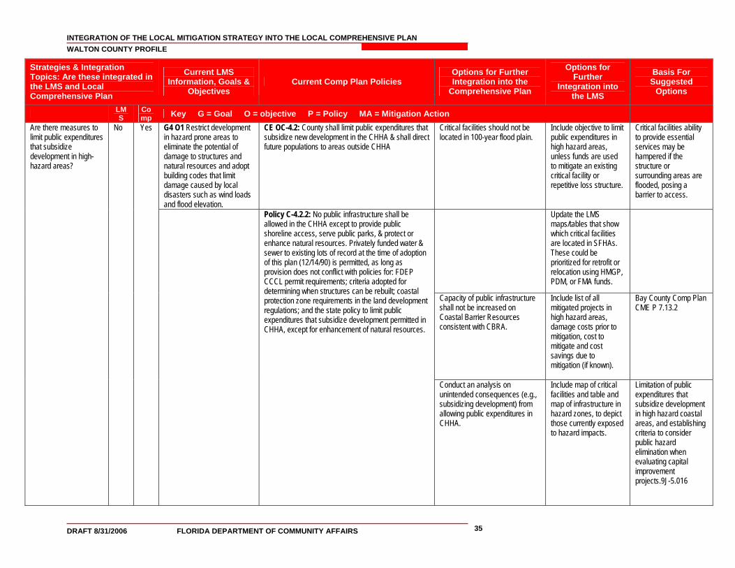
INTEGRATION OF THE LOCAL MITIGATION STRATEGY INTO THE LOCAL COMPREHENSIVE PLAN WALTON COUNTY PROFILE
DRAFT 8/31/2006 FLORIDA DEPARTMENT OF COMMUNITY AFFAIRS 35
Strategies & Integration Topics: Are these integrated in the LMS and Local Comprehensive Plan
Current LMS Information, Goals &
Objectives Current Comp Plan Policies
Options for Further Integration into the
Comprehensive Plan
Options for Further
Integration into the LMS
Basis For Suggested
Options
LMS
Comp Key G = Goal O = objective P = Policy MA = Mitigation Action
G4 O1 Restrict development in hazard prone areas to eliminate the potential of damage to structures and natural resources and adopt building codes that limit damage caused by local disasters such as wind loads and flood elevation.
CE OC-4.2: County shall limit public expenditures that subsidize new development in the CHHA & shall direct future populations to areas outside CHHA
Critical facilities should not be located in 100-year flood plain.
Include objective to limit public expenditures in high hazard areas, unless funds are used to mitigate an existing critical facility or repetitive loss structure.
Critical facilities ability to provide essential services may be hampered if the structure or surrounding areas are flooded, posing a barrier to access.
Update the LMS maps/tables that show which critical facilities are located in SFHAs. These could be prioritized for retrofit or relocation using HMGP, PDM, or FMA funds.
Capacity of public infrastructure shall not be increased on Coastal Barrier Resources consistent with CBRA.
Include list of all mitigated projects in high hazard areas, damage costs prior to mitigation, cost to mitigate and cost savings due to mitigation (if known).
Bay County Comp Plan CME P 7.13.2
Are there measures to limit public expenditures that subsidize development in high-hazard areas?
No
Yes
Policy C-4.2.2: No public infrastructure shall be allowed in the CHHA except to provide public shoreline access, serve public parks, & protect or enhance natural resources. Privately funded water & sewer to existing lots of record at the time of adoption of this plan (12/14/90) is permitted, as long as provision does not conflict with policies for: FDEP CCCL permit requirements; criteria adopted for determining when structures can be rebuilt; coastal protection zone requirements in the land development regulations; and the state policy to limit public expenditures that subsidize development permitted in CHHA, except for enhancement of natural resources.
Conduct an analysis on unintended consequences (e.g., subsidizing development) from allowing public expenditures in CHHA.
Include map of critical facilities and table and map of infrastructure in hazard zones, to depict those currently exposed to hazard impacts.
Limitation of public expenditures that subsidize development in high hazard coastal areas, and establishing criteria to consider public hazard elimination when evaluating capital improvement projects.9J-5.016
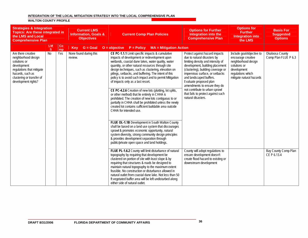
INTEGRATION OF THE LOCAL MITIGATION STRATEGY INTO THE LOCAL COMPREHENSIVE PLAN WALTON COUNTY PROFILE
DRAFT 8/31/2006 FLORIDA DEPARTMENT OF COMMUNITY AFFAIRS 36
Strategies & Integration Topics: Are these integrated in the LMS and Local Comprehensive Plan
Current LMS Information, Goals &
Objectives Current Comp Plan Policies
Options for Further Integration into the
Comprehensive Plan
Options for Further
Integration into the LMS
Basis For Suggested
Options
LMS
Comp Key G = Goal O = objective P = Policy MA = Mitigation Action
Are there creative neighborhood design solutions or development regulations that mitigate hazards, such as clustering or transfer of development rights?
No Yes None found during this review.
CE PC-1.1.1 Limit specific impacts & cumulative impacts of development or redevelopment upon wetlands, coastal dune lakes, water quality, water quantity, or other natural resources through site design techniques, such as clustering, elevation on pilings, setbacks, and buffering. The intent of this policy is to avoid such impact and to permit Mitigation of impacts only as a last resort.
CE PC-4.2.6 Creation of new lots (platting, lot splits, or other method) that lie entirely in CHHA is prohibited. The creation of new lots contiguous to or partially in CHHA shall be prohibited unless the newly created lot contains sufficient buildable area outside CHHA for intended use.
FLUE OL-1.1B Development in South Walton County shall be based on a land use system that discourages sprawl & promotes economic opportunity, natural system diversity, strong community design principles & provides development separation through public/private open space and land holdings.
Protect against hazard impacts due to natural disasters by limiting density and intensity of development, building placement (clustering), building coverage or impervious surface, or setbacks and landscaped buffers. Evaluate proposed plan amendments to ensure they do not contribute to urban sprawl that fails to protect against such natural disasters.
Include goal/objective to encourage creative neighborhood design solutions or development regulations which mitigate natural hazards
Okaloosa County Comp Plan FLUE P 6.3
FLUE PL-1.6.2 County will limit disturbance of natural topography by requiring that development be clustered on portion of site with least slope & by requiring that structures & roads be designed to maintain natural topography to the maximum extent feasible. No construction or disturbance allowed in natural outlet from coastal dune lake. Not less than 50 ft vegetated buffer area will be left undisturbed along either side of natural outlet.
County will adopt regulations to ensure development doesn't create flood hazard to existing or downstream development
Bay County Comp Plan CE P 6.13.4
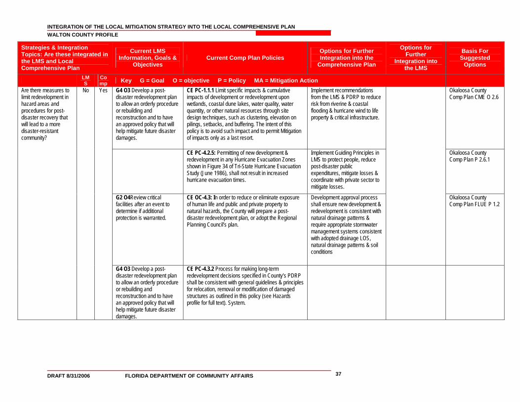
INTEGRATION OF THE LOCAL MITIGATION STRATEGY INTO THE LOCAL COMPREHENSIVE PLAN WALTON COUNTY PROFILE
DRAFT 8/31/2006 FLORIDA DEPARTMENT OF COMMUNITY AFFAIRS 37
Strategies & Integration Topics: Are these integrated in the LMS and Local Comprehensive Plan
Current LMS Information, Goals &
Objectives Current Comp Plan Policies
Options for Further Integration into the
Comprehensive Plan
Options for Further
Integration into the LMS
Basis For Suggested
Options
LMS
Comp Key G = Goal O = objective P = Policy MA = Mitigation Action
G4 O3 Develop a post-disaster redevelopment plan to allow an orderly procedure or rebuilding and reconstruction and to have an approved policy that will help mitigate future disaster damages.
CE PC-1.1.1 Limit specific impacts & cumulative impacts of development or redevelopment upon wetlands, coastal dune lakes, water quality, water quantity, or other natural resources through site design techniques, such as clustering, elevation on pilings, setbacks, and buffering. The intent of this policy is to avoid such impact and to permit Mitigation of impacts only as a last resort.
Implement recommendations from the LMS & PDRP to reduce risk from riverine & coastal flooding & hurricane wind to life property & critical infrastructure.
Okaloosa County Comp Plan CME O 2.6
CE PC-4.2.5: Permitting of new development & redevelopment in any Hurricane Evacuation Zones shown in Figure 34 of Tri-State Hurricane Evacuation Study (June 1986), shall not result in increased hurricane evacuation times.
Implement Guiding Principles in LMS to protect people, reduce post-disaster public expenditures, mitigate losses & coordinate with private sector to mitigate losses.
Okaloosa County Comp Plan P 2.6.1
G2 O4Review critical facilities after an event to determine if additional protection is warranted.
CE OC-4.3: In order to reduce or eliminate exposure of human life and public and private property to natural hazards, the County will prepare a post-disaster redevelopment plan, or adopt the Regional Planning Council’s plan.
Development approval process shall ensure new development & redevelopment is consistent with natural drainage patterns & require appropriate stormwater management systems consistent with adopted drainage LOS, natural drainage patterns & soil conditions
Okaloosa County Comp Plan FLUE P 1.2
Are there measures to limit redevelopment in hazard areas and procedures for post-disaster recovery that will lead to a more disaster-resistant community?
No Yes
G4 O3 Develop a post-disaster redevelopment plan to allow an orderly procedure or rebuilding and reconstruction and to have an approved policy that will help mitigate future disaster damages.
CE PC-4.3.2 Process for making long-term redevelopment decisions specified in County’s PDRP shall be consistent with general guidelines & principles for relocation, removal or modification of damaged structures as outlined in this policy (see Hazards profile for full text). System.
INTEGRATION OF THE LOCAL MITIGATION STRATEGY INTO THE LOCAL COMPREHENSIVE PLAN WALTON COUNTY PROFILE
DRAFT 8/31/2006 FLORIDA DEPARTMENT OF COMMUNITY AFFAIRS 38
6. Data Sources County Overview:
Florida Population Studies Bulletin 141: Projections of Florida Population by County, 2004–2030. Bureau of Economic and Business Research, Warrington College of Business, University of Florida. Gainesville, Florida. Florida Statistical Abstract – 2004 (38th Edition). Bureau of Economic and Business Research, Warrington College of Business, University of Florida. Gainesville, Florida. State and County QuickFacts. U.S. Census Bureau. Data derived from 2000 Census of Population and Housing.
Hazard Vulnerability:
Florida Repetitive Loss List March 05. Florida Department of Community Affairs, Division of Emergency Management, Flood Mitigation Assistance Office. March 2005. Mapping for Emergency Management, Parallel Hazard Information System (MEMPHIS). Florida Department of Community Affairs, Division of Emergency Management. Protecting Florida’s Communities – Land Use Planning Strategies and Best Development Practices for Minimizing Vulnerability to Flooding and Coastal Storms. Florida Department of Community Affairs, Division of Community Planning and Division of Emergency Management. September 2004. State of Florida 2004 Statewide Emergency Shelter Plan. Florida Department of Community Affairs, Division of Emergency Management.
GIS Data:
Flood Zone Source: FEMA FIRM GIS coverages (1996), supplied by University of Florida GeoPlan Center Florida Geographic Data Library Version 3.0.
• Areas with an “A_”, “V_”, “FPQ”, “D”, “100IC”, or “FWIC” value in the “Zone” field in these coverages were considered to be in the 100-year flood zone, and were used in the mapping/analysis.
Hurricane Evacuation Zone/Coastal High-Hazard Area (Category 1 Hurricane Evacuation Zone) Source: GIS coverage of hurricane zones compiled by Florida Department of Community Affairs/Division of Emergency Management (2003), from GIS data collected from county emergency management agencies in the State of Florida.
• Areas shown/analyzed are those areas in the above-referenced GIS coverage where the value in the field “Evac_cat” is equal to “Zone TS”, “Zone A/1”, “Zone B/2”, or “Zone C/3”, in the maps/tables for the Hurricane Vulnerability Zone.
• Areas shown/analyzed are those areas in the above-referenced GIS coverage where the value in the field “Evac_cat” is equal to “Zone TS” or “Zone A/1”, in the maps/tables for the Coastal Hazards Zone.
INTEGRATION OF THE LOCAL MITIGATION STRATEGY INTO THE LOCAL COMPREHENSIVE PLAN WALTON COUNTY PROFILE
DRAFT 8/31/2006 FLORIDA DEPARTMENT OF COMMUNITY AFFAIRS 39
Hurricane Storm Surge Zone GIS Data Source: GIS coverage of storm surge zones compiled by Florida Department of Community Affairs/Division of Emergency Management (2004), from various storm surge studies performed by regional planning councils and the U.S. Army Corps of Engineers.
• Areas shown/analyzed are those areas in the above-referenced GIS coverage where the value in the field “Category” is equal to “Tropical Storm” or “Category 1".
Sinkhole Hazard GIS Data Source: Kinetic Analysis Corporation web site (2005), at: http://lmsmaps.methaz.org/lmsmaps/final_cty/
• Areas shown/analyzed are those areas in the “Rawsink1.shp” GIS coverage supplied by KAC, where the value in the field “Gridcode” is 3 to 6, representing “High”, or Very High”, “Extremely High”, or “Adjacent”, based on the classification system used in the sinkhole hazard maps available at the above website.
Wildfire Susceptibility GIS Data Source: Florida Department of Agriculture and Consumer Services/Division of Forestry, Florida Fire Risk Assessment System (FRAS) data, 2004.
• Areas shown as “wildfire susceptible areas” and that were analyzed are those areas with a “Wildfire Susceptibility Index” value of greater than 10,000 (in north Florida counties) or greater than 0.1 (in south Florida counties)*, based on the FRAS model, and that are also within areas of forest or shrub vegetation or “low impact urban” land cover, based on the Florida Fish and Wildlife Conservation Commission “Florida Vegetation and Land Cover - 2003" GIS data.
The rating scale in the “Wildfire Susceptibility Index” GIS coverages has
a range of 0 to 100,000 in north Florida counties, and a range of 0 to 1.0 in south Florida counties.
Parks, Conservation Areas, Golf Courses “Parks, Conservation Areas, Golf Courses” existing land uses include all public and private conservation areas depicted on the statewide GIS coverage of conservation lands “flma_200501.shp”, produced by FDEP (2005). Municipal Boundaries Source: Boundaries of municipalities were extracted from the U.S. Census 2000 “Places” GIS coverage for the State of Florida.
INTEGRATION OF THE LOCAL MITIGATION STRATEGY INTO THE LOCAL COMPREHENSIVE PLAN WALTON COUNTY PROFILE
DRAFT 8/31/2006 FLORIDA DEPARTMENT OF COMMUNITY AFFAIRS A-1
ATTACHMENT A Maps of the Existing and Future Land Uses within Coastal Hazards Zone
INTEGRATION OF THE LOCAL MITIGATION STRATEGY INTO THE LOCAL COMPREHENSIVE PLAN WALTON COUNTY PROFILE
DRAFT 8/31/2006 FLORIDA DEPARTMENT OF COMMUNITY AFFAIRS A-2
ATTACHMENT B Maps of the Existing and Future Land Uses within Hurricane Vulnerability Zone
INTEGRATION OF THE LOCAL MITIGATION STRATEGY INTO THE LOCAL COMPREHENSIVE PLAN WALTON COUNTY PROFILE
DRAFT 8/31/2006 FLORIDA DEPARTMENT OF COMMUNITY AFFAIRS A-3
ATTACHMENT C Maps of the Existing and Future Land Uses within the 100-year Floodplain

INTEGRATION OF THE LOCAL MITIGATION STRATEGY INTO THE LOCAL COMPREHENSIVE PLAN WALTON COUNTY PROFILE
DRAFT 8/31/2006 FLORIDA DEPARTMENT OF COMMUNITY AFFAIRS A-4
ATTACHMENT D Maps of the Existing and Future Land Uses within Wildfire Susceptible Areas
INTEGRATION OF THE LOCAL MITIGATION STRATEGY INTO THE LOCAL COMPREHENSIVE PLAN WALTON COUNTY PROFILE
DRAFT 8/31/2006 FLORIDA DEPARTMENT OF COMMUNITY AFFAIRS A-5
ATTACHMENT E Maps of the Existing and Future Land Uses within Sinkhole Susceptible Areas
INTEGRATION OF THE LOCAL MITIGATION STRATEGY INTO THE LOCAL COMPREHENSIVE PLAN WALTON COUNTY PROFILE
DRAFT 8/31/2006 FLORIDA DEPARTMENT OF COMMUNITY AFFAIRS A-6
ATTACHMENT F Local Mitigation Strategy
Goals and Objectives Pertaining to Comprehensive Planning Walton County’s LMS includes the following goals and objectives that are directly related to local comprehensive planning and growth management: Policies (p. 14)
• Policies that limit public expenditures in areas identified as subject to repetitive damage from disasters
• Policies to ensure the protection of critical facilities such as prohibitions on
constructing critical facilities in high hazard areas • Policies to eliminate development in hazard prone areas • Policies to regulate non-conforming land uses, particularly in areas subject to
damage from disasters. • Policies that regulate land use, beach and dune alteration, floodplains, non-point
source stormwater run-off, and the design and location of sanitary sewer and septic tanks in hazard prone areas.
• Policies that prioritize the use of coastal areas for water-dependent uses such as
public access and selective aquaculture. • Policies that regulate watershed alterations (such as channellization, diking,
damming, etc.) and wetland fill and development. Also policies that address restoration or enhancement of disturbed or degraded natural resources that can mitigate hazards (such as beach and dune systems and wetlands).
• Policies and procedures for post-storm reconstruction, such as building moratoria or
special emergency permitting procedures. • Policies on the adopted local government building code and any areas associated
with additional development restrictions, including coast construction jurisdiction, coastal building zones, and local land development practices as they relate to hazard mitigation.
Goals and Objectives
• Goal 1 Provide the communities with the programs and the administration to protect life and property. (p.15)
o Objective 1 Develop a stormwater management plan that will mitigate drainage
problems. o Objective 2 Participate in the National Flood Insurance Program created by
FEMA and enforce the base flood elevation requirements.

INTEGRATION OF THE LOCAL MITIGATION STRATEGY INTO THE LOCAL COMPREHENSIVE PLAN WALTON COUNTY PROFILE
DRAFT 8/31/2006 FLORIDA DEPARTMENT OF COMMUNITY AFFAIRS A-7
o Objective 3 Develop a coordination agreement on stormwater and flooding issues when there is a development contiguous to another Municipality to provide some joint review.
o Objective 4 Provide fund source to address the mitigation strategies that have
been stated. o Objective 5 Utilize the Working Group to develop new and improved mitigation
programs, policies, ordinances to mitigate losses and to protect the public health and to provide safety welfare for their citizens.
o Objective 6 Develop and utilize an educational program for the citizens and for
the employees of the county and municipalities.
• Goal 2 To reduce the future expenses of the County, the municipalities, and their citizens by providing standards that will control developments in areas that are susceptible to damage by flooding and/or high winds. (p.15)
o Objective 1 Construct public utilities to minimize or prevent flood damage and
encourage the private utilities to follow a similar policy. o Objective 2 Adopt building standards to limit damage to private property by
flooding or wind. o Objective 3 Review critical facilities after an event to determine if additional
protection is warranted.
• Goal 3 Protect the environment and natural resources of the area by controlling development activities that would damage or destroy watersheds, wetlands, coastal resources, or other natural areas, which serve as natural buffers and help prevent extensive infrastructure damage. (p.16)
o Objective 1 Adopt stormwater management plans that mitigate the additional
runoff by development. o Objective 2 Protect the potable water aquifer, even though there is no recharge
area in the County, by protecting wellheads to prevent the possibility of contamination getting into the water supply by the way of the well casing.
o Objective 3 Promote the natural functions of wetlands and require that an impact
on wetlands due to development be appropriately addressed or mitigated in kind. o Objective 4 Protect watersheds by restricting development that alters the
capacity of the watershed.
• Goal 4 The County and Municipalities shall provide land use regulations to limit damage to developments. (p.16)
o Objective 1 Restrict development in hazard prone areas to eliminate the
potential of damage to structures and natural resources and adopt building codes that limit damage caused by local disasters such as wind loads and flood elevation.
o Objective 2 Regulate development in hazard prone areas to provide an orderly
development, thereby protecting structures and natural resources.
INTEGRATION OF THE LOCAL MITIGATION STRATEGY INTO THE LOCAL COMPREHENSIVE PLAN WALTON COUNTY PROFILE
DRAFT 8/31/2006 FLORIDA DEPARTMENT OF COMMUNITY AFFAIRS A-8
o Objective 3 Develop a post-disaster redevelopment plan to allow an orderly procedure or rebuilding and reconstruction and to have an approved policy that will help mitigate future disaster damages.
INTEGRATION OF THE LOCAL MITIGATION STRATEGY INTO THE LOCAL COMPREHENSIVE PLAN WALTON COUNTY PROFILE
DRAFT 8/31/2006 FLORIDA DEPARTMENT OF COMMUNITY AFFAIRS A-9
ATTACHMENT G Walton County Comprehensive Plan Excerpts Related to Hazard Mitigation
FUTURE LAND USE ELEMENT OBJECTIVE L-1.1A: Land Uses in North Walton County: The County shall discourage urban sprawl and promote compact development and the conservation of working landscapes through such techniques as the designation of appropriate agricultural densities, cluster development, mixed use areas that allow residents to work, shop, live, and recreate within one compact area, and the establishment of rural hamlets that promote infill development in existing rural communities while preserving the surrounding rural land uses, including agricultural and silvicultural uses. OBJECTIVE L-1.1B: Land Uses in South Walton County: Development within South Walton County shall be based on a land use system that discourages sprawl and promotes economic opportunity, natural system diversity, strong community design principles and provides development separation through public/private open space and land holdings. Policy L-1.1.4: Regardless of the density values established in L-1.1.1, and except as otherwise provided herein, no development is permitted within the 10-year and 25-year floodplains. Development within lands that are designated by FEMA as within the 100-year floodplain shall have a gross density of one (1) dwelling unit per twenty (20) acres, or the underlying density, whichever is less. Regardless of this density limitation, and with the exception of the Large Scale and General Agriculture land use categories, residential density may be transferred from the floodplain portions of the property to the upland portions of the property at a density of two (2) dwelling units per acre, or the underlying density, whichever is less, as applied to the entire property. Density within the 100-year floodplain in the General Agriculture land use category shall be one (1) dwelling unit per twenty (20) acres, and is not transferable. Density within the 100-year floodplain in the Large Scale Agriculture land use category shall be one (1) dwelling unit per forty (40) acres, and is not transferable. Gulf front properties within the CCCL may develop at two (2) dwelling units per acre in the 100-year floodplain, or at the underlying density if development is transferred out of the floodplain. Policy L-1.1.5: Notwithstanding any of the density values established in L-1.1.1 and L- 1.1.2, development within wetlands shall have a gross density of not more than one (1) unit per 20 acres, unless otherwise specified in these Goals, Objectives and Policies. OBJECTIVE L-1.5: Protection of Coastal Resources: Consistent with the recommendations of the Northwest Florida Coast Resource Management Plan and with the policies of this Comprehensive Plan for Walton County, Coastal Resources shall be protected. The County shall protect, conserve or enhance coastal wetlands, coastal dune lakes, living marine resources, remaining coastal barriers, and wildlife habitats. Policy L-1.5.1: The Northwest Florida Coast Resource Management Plan recommends the establishment of a coastal protection overlay zone. The County hereby adopts such a coastal protection overlay zone which extends seaward of the landward toe of the primary dune ridge or, where the toe cannot be determined, fifty feet (50’) landward of the crest of the primary dune or twenty-five feet (25’) landward of the top of the higher bluff regions where no primary dune exists. In this zone, the following shall apply: 1. No motor-driven vehicles are permitted to be driven on dunes with the exception of emergency vehicles responding to an emergency. 2. No activities shall be permitted which create erosion of dune or the dune system. Development within the coastal protection zone shall be limited to elevated boardwalks and other approved fences or structures that will enhance and protect the dune system. Natural dune vegetation within the overlay zone shall be disturbed only to the extent necessary to construct these boardwalks and related structures; however, in no case may more than 10 percent of the existing vegetation or
INTEGRATION OF THE LOCAL MITIGATION STRATEGY INTO THE LOCAL COMPREHENSIVE PLAN WALTON COUNTY PROFILE
DRAFT 8/31/2006 FLORIDA DEPARTMENT OF COMMUNITY AFFAIRS A-10
dune be disturbed. All boardwalks and any other constructed features will be constructed to allow potential animal movement and to maintain density and vigor of vegetation and to prevent blowouts. FDEP Standards and Regulations shall apply to such construction. 3. The County’s land development regulations shall include detailed design standards for all construction within the zone to ensure minimal disruption of the dune system. If these regulations render a property owner unable to build a single-family dwelling unit on an existing lot of record as of the date of plan adoption (December 14, 1990) that lies wholly within the zone, then the owner shall be allowed to construct a single-family residential dwelling unit, providing that the owner complies with all permit requirements of the FDEP and limits the extent of disturbance to the minimum area necessary to accommodate the dwelling unit and access driveway. 4. “Dune vegetation” shall be defined as all natural communities defined as “Coastal Uplands” by the Florida Natural Areas Inventory Guide to Natural Communities of Florida (1990), including Beach Dune, Coastal Berm, Coastal Grassland, and Coastal Strand vegetation. Policy L-1.5.2: The County shall not approve any construction seaward of the Coastal Construction Control Line, including construction of coastal or shore protection structures, until an applicant has received all necessary permits for such construction from the Florida Department of Environmental Protection and from any other state or federal agency with permitting authority over such construction. The County shall issue no development order or permit for construction on a new parcel (that is, a parcel created after January 5, 1993) if such new parcel lies entirely seaward of the Coastal Construction Control Line. All such development shall be consistent with policies as defined in Policies C.3.2.2, C.3.2.7, C.3.3.1, C.4.1.3 and C.4.2.1- 4.2.6.1 and C.4.3.2 and Policy 19.2.1 of the Walton County Capital Improvement Element of the Comprehensive Plan. OBJECTIVE L-1.6: Natural Resource Protection: Site specific development shall be consistent with the Future Land Use Map and shall be coordinated with the topographic and soil conditions and natural resources on the site, with the availability of facilities and services, and with the protection of natural resources adjacent to the site. On-site provision of wastewater and drainage facilities shall also be responsive to natural resource conditions. Silviculture activities are to be conducted in a manner compatible with the need to protect, conserve, and appropriately use natural resources associated with wetlands and surface waters. Policy L-1.6.1: The County’s land development regulations shall be revised to be consistent with the resource protection standards in the Comprehensive Plan and shall address the protection of: 1. Beaches and dunes (Future Land Use Element Policies L-1.5.1, L-1.5.2 and Conservation/Coastal Zone Policies C-4.4.1-4.4.8). 2. Floodplains (Future Land Use Element Policies I-4.4.1 and Conservation/Coastal Zone Policies C-3.2.3). 3. Wetlands (Future Land Use Policies L-1.1.1 and L-1.1.2 and Conservation/Coastal Zone Policy C-3.2.3). 4. Shorelines (Policy C-4.1.1 and C-4.1.2). Policy L-1.6.2: The County will limit the disturbance of the natural topography by requiring that development be clustered on the portion of the site with least slope and by requiring that structures and roads be designed to maintain the natural topography to the maximum extent feasible. No construction or disturbance will be allowed in the natural outlet from a coastal dune lake. A buffer area of not less than fifty (50) feet of vegetated area will be left undisturbed along either side of the natural outlet from the lake. Policy L-1.7.2: Buffers will be created between development and environmentally sensitive areas, as specified in the Conservation/Coastal Zone Element Policy C-3.2.1, including wetlands, water bodies such as lakes and streams, dunes, coastal dune lakes, and wildlife habitat areas. 1. The purpose of the buffer is to protect natural resources from the activities and impacts of development. The buffer should function to: a. Provide protection to the natural resources from intrusive activities and impacts of development such as trespassing, pets, vehicles, noise, lights, and stormwater runoff. b. Minimize the negative impacts of the uses upon each other or, preferably, to eliminate by the buffer such that the long-term existence and viability of the natural

INTEGRATION OF THE LOCAL MITIGATION STRATEGY INTO THE LOCAL COMPREHENSIVE PLAN WALTON COUNTY PROFILE
DRAFT 8/31/2006 FLORIDA DEPARTMENT OF COMMUNITY AFFAIRS A-11
resources, including wildlife populations, are not threatened by such impacts and activities. Any incompatibility between the uses is eliminated and the uses may be considered compatible. OBJECTIVE L-1.8 Hurricane Evacuation: Proposed developments, including proposed amendments to the Future Land Use Map, shall be coordinated with the recommendations of the Tri-State Hurricane Evacuation Study. Policy L-1.8.1: Proposed plan amendments which would increase densities within hurricane evacuation zones 1-7 as designated in the Tri-State Hurricane Evacuation Study shall be subject to review and transportation impact analysis to determine their impact upon hurricane evacuation times and routes. Developments that will increase hurricane evacuation times shall be required to provide mitigation measures, such as transportation improvements, emergency van pools, and/or on-site emergency shelters. These measures must be designed to ensure no increase in evacuation times as a result of the proposed development. Policy L-1.8.2: The Walton County Emergency Management Department shall be included as a technical advisor in the development review process. Policy L-1.8.3: The County will improve its emergency shelter capabilities by retrofitting existing public buildings to better serve as severe weather shelters and by encouraging large scale developments to provide on-site severe weather shelters that are outside the Category One hurricane evacuation areas. Policy L-1.8.4: Proposed amendments to the Future Land Use Map and to the comprehensive plan that increase residential densities and commercial intensities in South Walton County will be reviewed by the Walton County Division of Emergency Management to gauge their impacts upon the County’s hurricane evacuation efforts. OBJECTIVE L-1.10: Protection of Wetlands: Walton County shall protect and conserve wetlands. Alteration shall not result in an overall net loss of wetlands within the County. The measure of achievement for this policy shall be the amount of remaining wetland acres and the amount of restored and created wetlands of the same ecological type, productivity and function as compared to the number of acres existing as of the date of plan adoption. Policy L-1.10.2: The County shall maintain a wetlands inventory overlay in the Geographic Information System (GIS), including those areas determined to be jurisdictional by appropriate regulatory agencies having authority to designate areas as wetlands and which exercise jurisdiction over the wetlands so designated (e.g., the Florida Department of Environmental Protection and the U.S. Army Corps of Engineers). The wetlands GIS Layer shall be amended as necessary to include or exclude any areas added or removed or determined to be jurisdictional or non-jurisdictional by the above agencies. COASTAL ELEMENT OBJECTIVE C-1.1: Resource Protection: Enhance resource protection by utilizing development management techniques to control potential negative impacts from development and redevelopment. Policy C-1.1.1: Limit the specific impacts and cumulative impacts of development or redevelopment upon wetlands, coastal dune lakes, water quality, water quantity, wildlife habitats of listed species, living marine resources, or other natural resources through the use of site design techniques, such as clustering, elevation on pilings, setbacks, and buffering. The intent of this policy is to avoid such impact and to permit Mitigation of impacts only as a last resort. Policy C-1.1.3: The channeling of untreated runoff which does not meet the drainage level of service standard established in this plan directly into water bodies or other environmentally
INTEGRATION OF THE LOCAL MITIGATION STRATEGY INTO THE LOCAL COMPREHENSIVE PLAN WALTON COUNTY PROFILE
DRAFT 8/31/2006 FLORIDA DEPARTMENT OF COMMUNITY AFFAIRS A-12
sensitive areas by new development or redevelopment, new roads or road building shall be prohibited. Policy C-1.1.5: New developments with the potential to impact the quantity or quality of natural resources will be required to obtain the necessary permits from all applicable state and/or federal agencies (Florida Department of Environmental Protection, Northwest Florida Water Management District and/or U.S. Army Corps of Engineers) prior to the authorization of a development permit by the County. Policy C-1.1.6: Development and redevelopment within a floodplain shall use construction techniques which protect the planned and existing development from flood hazards, maintain the natural function of the floodplain, and wetlands natural flow functions, and minimize development impacts to natural wildlife habitats. OBJECTIVE C-3.1: Choctawhatchee Bay: The County will participate with Okaloosa County in programs to minimize pollution of Choctawhatchee Bay. Policy C-3.1.1: New seawalls and upland retaining walls along Choctawhatchee Bay for existing lots of record in residential subdivisions shall be permitted in accordance with shoreline stabilization programs for the Florida Department of Environmental Protection and the U.S. Army Corps of Engineers. Newly platted subdivision lots along Choctawhatchee Bay must be of sufficient depth to meet the 50' buffering requirement of Policy C-3.2.1.b. These newly platted lots are allowed to have upland retaining walls built landward of the mean high water line; however, new seawalls and new bulkheads are not allowed. Policy C-3.1.2: No pier, dock or walkway shall be located over submerged land which is vegetated with seagrasses except as necessary to reach waters at a depth of one foot below the lowest point of the boat, including the motor, at mean low tide. Boring to set pilings is allowed; however, any material removed must be disposed of at an upland site intended for this purpose. Unless vessel access would be prohibited, the docking terminus shall not be located over submerged vegetation areas, such as seagrass beds. Policy C-3.1.3: Consistent with the Northwest Florida Coast Resource Planning and Management Plan the County shall limit the impacts of development and redevelopment on wildlife habitat, living marine resources, and beach and dune systems, through the following measures: a. a marina siting ordinance which minimizes estuarine pollution, as described in C-3.1.2; b. stormwater management requirements for all new development and redevelopment that prohibit on shore construction or lands uses that discharge untreated stormwater into areas containing seagrass beds, oyster reefs, other marine nursery areas, and waters of the state; c. wetland buffer requirements, consistent with C-3.2.1; d. Choctawhatchee Bay buffer requirements consistent with C-3.2.1; and e. native vegetation protection requirements consistent with C-3.2.7. Policy C-3.1.4: The County shall cooperate with Bay enhancement programs of the Florida Department of Environmental Protection, the Northwest Florida Water Management District, and other agencies to improve and enhance recreational fishing. Policy C-3.1.5: The County shall cooperate with all appropriate agencies, such as the Department of Environmental Regulation, the FL Game & Freshwater Fish Commission, & the Northwest FL Water Management District, to provide the fullest protection to County, State & federally-owned resource-based recreation sites & natural reservations identified in the Conservation/Coastal Zone or Recreation/Open Space/Greenways Elements that have been set aside for the protection of natural resources & public recreation. Protection will be provided by prohibiting incompatible land uses adjacent to these areas. Development orders will ensure that activities that are inconsistent with the protection of adjacent natural resources are not permitted.
INTEGRATION OF THE LOCAL MITIGATION STRATEGY INTO THE LOCAL COMPREHENSIVE PLAN WALTON COUNTY PROFILE
DRAFT 8/31/2006 FLORIDA DEPARTMENT OF COMMUNITY AFFAIRS A-13
OBJECTIVE C-3.2: Protection of Environmentally Sensitive Areas: The County will regulate development within and surrounding wetlands, dune systems, lake systems, river and bay systems, wildlife habitat, fisheries, living marine resources and habitat, flood prone areas and the 100-year floodplain in order to conserve, appropriately use, and protect these resources. Policy C-3.2.1: Wetlands; Choctawhatchee Bay: living marine resources; coastal barrier resources; coastal dunes and coastal dune lakes; habitat of endangered, threatened or of species of special concern listed by the Florida Game and Freshwater Fish Commission and the natural vegetative communities are designated as environmentally sensitive lands, and shall be protected through overlay zones, buffers, landscaping, wetlands, marina protection, and stormwater management ordinances, and other land development regulations to protect the resource for future generations. The County shall establish the following buffer standards to protect environmentally sensitive lands: Policy C-3.2.2: All dredge & fill activities in wetlands is prohibited, except where a permit has been issued by the Florida Department of Environmental Protection and/or the U.S. Army Corps of Engineers, and where the applicant has demonstrated through professionally accepted and applied methodology that such activity will not negatively impact estuarine water quality, oyster beds, natural functions, or the habitat of any listed species. In such cases where the applicant demonstrates the above, wetlands lost shall be replaced or enhanced, at a minimum, at the ratios required by the U.S. Army Corps of Engineers and FDEP. All such activities shall not be approved prior to permit approval from the U.S. Army Corps of Engineers and/or FDER. The County shall do all within its power to ensure the protection, conservation and appropriate use of wetlands not regulated by such agencies. Policy C-3.2.9: Establish interlocal agreements with adjacent local governments that address the conservation, use, and protection of unique vegetative communities and water bodies that cross local jurisdictional boundaries. OBJECTIVE C-3.3: Historic & Archaeological Resources: The County shall protect, preserve or sensitively reuse historical and archaeological resources within the County, by regulating development which may impact such resources. Policy C-3.3.1: If an archaeological site is located in close proximity to any proposed activity which may be permitted within the Coastal High-Hazard Area (such as recreational, coastal access or other related activity), no work shall be undertaken until the applicant consults with the Division of Historic Resources in developing a preservation plan for that resource. The map of known resources shall be maintained at the County Building Department, and must be reviewed during development proposals. Policy C-3.3.2: All development (regardless of location) shall maintain a minimum 50 foot buffer from known archaeological uses. Policy C-3.3.3: The County shall coordinate with the Division of Historic Resources to establish historic preserves or parks at sites of known historical or archaeological significance. OBJECTIVE C-4.1: Shoreline Land Uses: During the development review process for all new development and redevelopment along shoreline areas, a shoreline use will not be approved if it shorelines. Shoreline land uses shall not be allowed unless they ensure protection of wetlands, lakes, rivers and bay, endangered species and their associated habitat, grassbeds, oysterbeds, recreational and commercial fisheries, and improving or maintaining estuarine, surface and groundwater quality. Policy C-4.1.2: All new or redeveloped (using rebuilding definition of Policy E-3-2) shoreline land uses shall: 1. Locate on existing upland areas; 2. Be constructed to conform to coastal construction building codes; 3. Be constructed in accordance with the policies for construction
INTEGRATION OF THE LOCAL MITIGATION STRATEGY INTO THE LOCAL COMPREHENSIVE PLAN WALTON COUNTY PROFILE
DRAFT 8/31/2006 FLORIDA DEPARTMENT OF COMMUNITY AFFAIRS A-14
within the Coastal High- Hazard Area; 4. Demonstrate that existing public utilities, infrastructure and services are in place to support the proposed use; 5. Not be in conflict with existing, conforming, adjacent land uses; 6. Provide public access where traditional public access points are directly affected by the development; 7. Landscape using native plant species; 8. Provide for the treatment of all discharge, including stormwater runoff, from land uses into bodies of water to incorporate standards for treatment adequate to meet the County’s adopted level of service standard for drainage facilities; and 9. Restrict impervious surface coverage consistent with standards adopted in land development regulations. OBJECTIVE C-4.2: Coastal High Hazard Area: It is the County’s objective to protect the population from the effects of hurricane storm damage by limiting development within the Coastal High-Hazard Area. Without this limitation, hurricane evacuation times, as well as the health and safety of that population allowed to develop within the Coastal High-Hazard area would be of concern to the County. Therefore, the County shall limit public expenditures that subsidize new development in the Coastal High-Hazard Area and the County shall direct future populations to areas outside the Coastal High-Hazard Area. Policy C-4.2.1: The Coastal High-Hazard Area is defined as the area encompassed by the Category I storm surge area as depicted in the Tri-State Hurricane Evacuation Study, June 1986. Policy C-4.2.2: No public infrastructure shall be allowed in the Coastal High-Hazard Area, except for that needed to provide public access to the shoreline, to serve public parks that have been approved by the County or by state and federal agencies, and to protect or enhance natural resources. Provision of water and sewer service at private expense to existing lots of record at the time of adoption of this plan (December 14,1990) is permitted, as long as such provision does not result in conflict with policies for: FDEP permit requirements for the Coastal Construction Control Line; criteria adopted for determining when structures can be rebuilt; coastal protection zone requirements in the land development regulations; and the state policy to limit public expenditures that subsidize development permitted in coastal high-hazard areas, except for enhancement of natural resources. Policy C-4.2.3: New sanitary sewer facilities if, the Coastal High-Hazard Area, installed in accordance with standards of C-4.2.2, shall be flood-proofed and backflow preventors shall be fitted on new septic tanks. Policy C-4.2.4: The recommendations of any interagency hazard mitigation report which addresses future flood losses and is prepared in response to a Presidential Disaster Declaration shall be incorporated into the County’s Disaster Plan. Policy C-4.2.5: Permitting of new development and redevelopment in any of the Hurricane Evacuation Zones shown in Figure 34 of the Tri-State Hurricane Evacuation Study (June 1986), shall not result in an increase in hurricane evacuation times, as of the date of adopted of this plan. Hurricane evacuation times as of the plan adoption date shall be defined as the clearance and evacuation times for a Category 3 storm with a forward speed of 15 miles per hour, a medium evacuee response, and occurring during a period of “High” Tourist Occupancy, as shown in Table VII-9A of the Tri-State Hurricane Evacuation Study (June 1986). These clearance and evacuation times are 12 hours and 21.33 hours respectively. Policy C-4.2.6: The creation of new lots (through platting, lot splits, or other method) that lie entirely within the Coastal High-Hazard Area is prohibited. The creation of new lots contiguous to or partially within the Coastal High-Hazard Areas shall be prohibited unless the newly created lot contains sufficient buildable area outside of the Coastal High Hazard Area for the intended use. OBJECTIVE C-4.3: Post Disaster Redevelopment. In order to reduce or eliminate exposure of human life and public and private property to natural hazards, the County will prepare a post disaster redevelopment plan, or adopt the Regional Planning Council’s plan. The following
INTEGRATION OF THE LOCAL MITIGATION STRATEGY INTO THE LOCAL COMPREHENSIVE PLAN WALTON COUNTY PROFILE
DRAFT 8/31/2006 FLORIDA DEPARTMENT OF COMMUNITY AFFAIRS A-15
policies shall become effective upon adoption of this plan (December 14, 1990) as interim measures for short-term recovery and long-term redevelopment activities prior to adoption of a formal post-disaster plan, consistent with the County’s Peacetime Emergency Plan. Policy C-4.3.1: The following post-disaster actions shall be considered short-term recovery measures: 1. Damage assessment to meet post-disaster assistance requirements and to aid in post disaster redevelopment decisions; 2. Debris removal; 3. Emergency protection measures including repairs to water, sewer, electric, and other public utilities to restore service; 4. Public assistance including temporary housing provision of food, water, toilets, and clothing. Policy C-4.3.2: The process for making long-term redevelopment decisions specified in the County’s post-disaster redevelopment plan shall be consistent with the following general guidelines and principles for the relocation, removal or modification of damaged structures: 1. The County adopts the following definitions for making decisions pertaining to redevelopment in the Coastal High Hazard Area. Based upon the following definitions, all rebuilding activities shall be subject to Coastal Construction Code Standards and Coastal High Hazard Area limitations: (a) “Repair” means the restoration of a portion of the structure, including the foundation of the structure, to its original design configuration or an equivalent structural standard. Repair of a structure assumes that a significant portion of the structure, including its foundation, remains intact. If the supported structure or its foundation has collapsed to the point that either the supported structure or the foundation requires substantial rebuilding, then such activity shall not constitute repair. If a structure, as a result of damage to either the supported structured or the foundation, is no longer habitable such structure shall be presumed to require substantial rebuilding. (b) “Rebuilding” means any construction activity, including alteration to an existing foundation, which would result in increased structural stability such that the survivability of the structure during a coastal storm is increased. Rebuilding shall also include any construction activity which, as noted above, involve the substantial rebuilding of either the supported structure or the foundation of the structure. 2. Rebuilding (as defined above) activities will be in accordance with FDEP’s requirements for development seaward of the Coastal Construction Control Line, and all structural requirements of the County’s Flooding and Coastal Construction Code. Further, prior to approving such redevelopment activities, the County shall require the developer to provide documentation that the structure being built is a landward as possible from the FEMA V-Zone and Coastal Construction Control Line. The applicant shall provide proof that the structure cannot be moved any further landward on the lot without causing harm to public health or safety. The County may vary building setback requirements in order to accomplish the intent of this policy. 3. The County shall keep a record of all repair and rebuilding activities. Structures may not be rebuilt “under the definition of rebuild” more than twice in any 100-year period in the V-Zone and Coastal Barriers Resource System. OBJECTIVE C-4.4: Beaches and Dunes: The county shall ensure protection and restoration to its dune and beach system through: 1. Locational criteria for siting of man-made beach access structures in the dune system; and promoting the use of revetments and other shoreline protection structures which serve to dissipate wave energies as an alternative to vertical seawalls; 2. Dune and revegetation programs, initiated through a survey which identifies dune erosion areas, and encompassing educational programs for private property owners, and cooperational programs from local and state agencies for publicly owned beachfront property. 3. Prohibiting development seaward of the Coastal Control Line (CCCL) and within the coastal protection zone (CPZ). If the CCCL is landward of the CPZ, then development between the CCCL and the CPZ must be consistent with Future Land Use Map and is subject to the permitting requirement of the Florida Department of Environmental Protection (FDEP) 4. All new private Gulf-front development and redevelopment shall include elevated dune crossovers to provide private access to the beach. Policy C-4.4.1: The County shall solicit assistance from the Department of Environmental Protection neighborhood and citizens groups in carrying out a survey of damaged or eroded dune areas.
INTEGRATION OF THE LOCAL MITIGATION STRATEGY INTO THE LOCAL COMPREHENSIVE PLAN WALTON COUNTY PROFILE
DRAFT 8/31/2006 FLORIDA DEPARTMENT OF COMMUNITY AFFAIRS A-16
Policy C-4.4.2: Using the results of the survey, the County shall solicit funds to restore degraded dunes and beaches, through implementation of a program for construction of dune walkovers for all public access areas and revegetation with native vegetation. Policy C-4.4.3: The County shall enlist the assistance of the Tourist Development Council, neighborhood groups or citizen committees in developing an awareness program for protection and voluntary revegetation of dunes and beaches by residents and tourists. Policy C-4.4.4: The County shall limit clearing of natural dune vegetation and other coastal upland vegetation and development on the primary dune in accordance with the provisions contained herein, including Policies C-3.2.7, 3.2.8, 12.2.7 and 4.2.5. Policy C-4.4.5: The County shall coordinate with the Department of Environmental Protection and other applicable agencies and organizations to implement the Walton County Beach Restoration Management Plan (Prepared by FDEP, 1990). The County’s restoration and protection program shall OBJECTIVE C-4.6: Hurricane Evacuation: In order to reduce hurricane evacuation times, the County will cooperate with the Florida FDOT in the widening of highways 98 & 331 in the S. Walton area. Policy C-4.6.1: The County will ensure that the roadway improvements, identified in the Traffic Circulation and Infrastructure Elements, are consistent with the Capital Improvement Element of the Walton County Comprehensive Plan and are constructed in order to reduce evacuation times. INFRASTRUCTURE ELEMENT OBJECTIVE I-2.1: Level of Service Standards: Maximize the use of existing facilities and discourage urban sprawl by eliminating the use of septic tanks and package plants within existing and planned service areas and prohibiting the extension of sanitary sewer facilities outside of existing and planned service as depicted on Map 1 in the Sanitary Sewer Sub-element. Where central facilities are available, the installation of septic tanks and package plants is not permitted. The Department of Health, in accordance with the provisions of Subsection 381.00655(b), F.S., will determine when existing septic systems must connect to central sewer. Such determinations will be made in the public interest based upon public health considerations. Within existing and planned service areas where central sewers are not currently available, all new development must, where permitted by the Florida Department of Environmental Protection, install a dry line at the time of construction and connect to the central facility when available. Policy I-2.1.1 The County hereby adopts the following level of service standards, and shall adopt land development regulations which ensure that existing and projected needs are met through provisions which ensure that development orders are not issued which degrade the level of service standards. See CIE-1.3.3. These level of service standards shall be used unless the applicant can demonstrate that the proposed use utilizes less capacity through historic records or studies of similar uses. OBJECTIVE I-4.1: Level of Service Standards: The County shall adopt land development regulations by the statutory deadline which ensure that new development and redevelopment does not increase stormwater runoff or flooding problems. The level of service standards for drainage shall ensure that the capacity of drainage structures for roads and other development are designed to meet facility needs. Policy I-4.1.1: The following level of service standard for drainage and stormwater management shall apply: 1. (a) All new residential subdivisions; (b) infill residential development within
INTEGRATION OF THE LOCAL MITIGATION STRATEGY INTO THE LOCAL COMPREHENSIVE PLAN WALTON COUNTY PROFILE
DRAFT 8/31/2006 FLORIDA DEPARTMENT OF COMMUNITY AFFAIRS A-17
improved residential areas or subdivisions existing prior to the adoption of this comprehensive plan; (c ) all multifamily residential development (including duplex, triplex and quadraplex); (d) all new nonresidential development (other than agricultural); and any existing use meeting the criteria of (a), (b), (c), or (d) above that proposes alterations or activities resulting in an increase in runoff shall meet the following standards: Water Quality and Quantity: Each development shall be responsible for storing and treating all post development runoff which exceed pre-development runoff. All storage facilities shall be designed with sufficient capacity to accommodate all runoff in excess of the runoff which would have resulted from the site if left in its natural, undeveloped condition, provided, however, that as a minimum, the first inch of rainfall will be retained. Storage Capacity: The storage capacity of all storage facilities must be at least as strict as DEP Chapter 17- 25, F.A.C., and FDOT Chapter 14-86, F.A.C., Rules for Drainage Connections (provided at end of this section). Post-development runoff shall be released at pre-development natural runoff conditions. OBJECTIVE I-4.4: Protect Natural Functions of Drainage Features: Future land uses shall not adversely impact the natural functions of drainage features. Policy I-4.4.1: To protect the natural functions of floodplains and flood prone areas, dredge and fill and clearing of natural vegetation will be permitted only to that needed to accommodate the immediate development site, consistent with the type of uses permitted in such areas by this plan. All such activities will be conducted in a manner which maintains the natural topography and hydrological functions of floodplains. Residential, commercial and industrial structures, as defined in Policy L-1.1.1, shall be clustered on the non-floodplain portions of a parcel or, where the entire parcel lies in the floodplain, structures shall be elevated on pilings. Compensatory storage shall be required for all development located in floodplains. Septic tanks and package plants are prohibited in floodplains. No hazardous or toxic materials may be stored within the 100-year floodplain, as defined by the Federal Emergency Management Agency.