dynamics of wood in stream networks of the western...
TRANSCRIPT

Dynamics of wood in stream networks of thewestern Cascades Range, Oregon
Nicole M. Czarnomski, David M. Dreher, Kai U. Snyder, Julia A. Jones, andFrederick J. Swanson
Abstract: We develop and test a conceptual model of wood dynamics in stream networks that considers legacies of forestmanagement practices, floods, and debris flows. We combine an observational study of wood in 25 km of 2nd- through5th-order streams in a steep, forested watershed of the western Cascade Range of Oregon with whole-network studies offorest cutting, roads, and geomorphic processes over the preceding 50 years. Statistical and simple mass balance analysesshow that natural process and forest management effects on wood input, transport processes, and decomposition accountfor observed patterns of wood in the stream network. Forest practices reduced wood amounts throughout the network; inheadwater streams these effects are fixed in stream segments bordered by cuts and roads, but in larger channels they arediffused along the channel by fluvial transport of wood. Landforms and roads limited delivery of wood by debris flows tomainstem channels. Network dynamics studies and watershed management plans should include spatial patterns of debrisflow initiation and runout, flood redistribution, and reduction of wood in the network by forest cutting and intentionalwood removal from channels on time scales of forest succession and recurrence of major floods.
Resume : Nous avons developpe et teste un modele conceptuel de la dynamique des bois dans des reseaux de cours d’eauqui tient compte de l’heritage des pratiques d’amenagement forestier, des inondations et du mouvement des debris. Nouscombinons une etude basee sur l’observation des bois sur 25 km de cours d’eau de 2e au 5e ordre dans un bassin versantboise et aux pentes abruptes situe dans la partie ouest des Cascades, en Oregon, a des etudes de reseau des coupes forest-ieres, des chemins et des processus geomorphologiques au cours des 50 dernieres annees. Des analyses statistiques et debilans simples de masse montrent que les effets des processus naturels et de l’amenagement forestier sur l’apport, les proc-essus de transport et la decomposition des bois expliquent les profils observes de presence des bois dans le reseau de coursd’eau. Les pratiques forestieres ont reduit les quantites de bois partout dans le reseau; dans les cours d’eau situes enamont, ces effets sont limites aux segments de cours d’eau bordes par des coupes et des chemins mais, dans les coursd’eau plus larges, ils sont repartis le long du cours d’eau par le transport fluvial des bois. Le relief et les chemins ont lim-ite l’apport de bois en limitant le mouvement des bois vers l’axe fluvial. Les etudes de dynamique de reseau et les plansd’amenagement de bassin versant devraient inclure le profil spatial du mouvement des debris, de son declenchement jus-qu’a ce qu’il cesse, de la redistribution causee par les inondations, de la diminution des bois dans le reseau a cause de lacoupe forestiere et de l’enlevement intentionnel des bois dans les cours d’eau, et cela a l’echelle de temps de la successionforestiere et de la recurrence des inondations majeures.
[Traduit par la Redaction]
Introduction
Since the mid-1970s a very large amount of literature hasaddressed the abundance, spatial patterns, and functions ofwood in streams (Gregory et al. 2003), but a general con-ceptual model of landscape-scale dynamics of wood instream networks is still emerging. Conceptual models ofwood in streams predict declining wood downstream, aswider channels recruit less wood and can transport largerpieces (Lienkaemper and Swanson 1987; Bilby and Ward1989; Marcus et al. 2002). Many natural processes andforest management practices — clear-cutting and plantationforestry, roads, floods, geomorphic processes, and othermechanisms — also influence wood dynamics in streams
(Keller and Swanson 1979; Reeves et al. 1995; Johnson etal. 2000; Benda et al. 2002). Wood dynamics in streamshave been described using wood budgets and routing analy-ses (Lancaster and Hayes 2001; Benda et al. 2002; Meleasonet al. 2003).
A general conceptual model of wood dynamics in streamnetworks could integrate these diverse threads and guide for-est and watershed managers. Forest regulations increasinglychallenge forest managers to predict wood in streams overlarge landscapes. The Aquatic Conservation Strategy of theNorthwest Forest Plan (USDA Forest Service and USDIBureau of Land Management 1994), for example, requiresforest management plans to consider the cumulative up-stream effects of harvest and roads as well as past effects of
Received 29 October 2007. Accepted 21 April 2008. Published on the NRC Research Press Web site at cjfr.nrc.ca on 8 July 2008.
N.M. Czarnomski1 and J.A. Jones. Department of Geosciences, Oregon State University, Corvallis, OR 97331, USA.D.M. Dreher and K.U. Snyder. Department of Forest Science, Oregon State University, Corvallis, OR 97331, USA.F.J. Swanson. USDA Forest Service, Pacific Northwest Research Station, Corvallis, OR 97331, USA.
1Corresponding author (e-mail: [email protected]).
2236
Can. J. For. Res. 38: 2236–2248 (2008) doi:10.1139/X08-068 # 2008 NRC Canada

floods and landslides on wood in streams. Equally challeng-ing for forest managers are questions about the effects ofroad decommissioning or forest management in riparian buf-fer zones on wood patterns in large stream networks.
Conceptual and technical advances in geospatial analysis,landscape ecology, and long-term ecosystem science providethe basis for a major advance in landscape perspectives onwood in streams. Landscape concepts, including interactionsbetween patchworks and networks, legacies, and networkdynamics, are relevant to wood in streams. Forest land-scapes consist of patchworks of forest stands of differentages established after disturbance events, including youngforests created by past forest cutting (Franklin and Forman1987; Ripple et al. 1991), networks of roads built to accessharvest units (Jones et al. 2000; Forman et al. 2003), and thestream network. Stream network morphology — a populationof channels and their confluences — helps predict the spatialdistribution of physical diversity in stream networks (Bendaet al. 2004a). During natural disturbances such as floods anddebris flows, forest patchworks and road and stream net-works interact, affecting movement of water, sediment, andwood (Swanson et al. 1998; Wemple et al. 2001). Biologicallegacies — biotic structures that persist from a predisturb-ance ecological system — shape ecological and physicalprocesses after natural and human disturbances (Dale et al.2005). Despite their relevance to wood in streams, no gen-eral conceptual model unites these concepts and techniquesto describe the dynamics of wood in managed and unman-aged forest stream networks.
Building on concepts in Swanson (2003), we develop anetwork dynamics conceptual framework to explain patternsof wood in stream networks. The conceptual framework(Fig. 1) considers how different combinations of wood
inputs from adjacent forest, debris flows, and fluvial redis-tribution are arranged in a landscape, producing variationsin wood in the stream network (Fig. 1a). The framework in-cludes wood contributions from streamside forests tostreams (Fig. 1b) by tree fragmentation, windthrow, bankerosion, and other processes (Keller and Swanson 1979;Lienkaemper and Swanson 1987; McDade et al. 1990;Johnson et al. 2000; Meleason et al. 2003). It also includeseffects of forest harvest, roads, and natural processes, suchas wildfire and windthrow, on delivery of wood to streams(Benda and Sias 1998; Zelt and Wohl 2004). Clear-cuttingremoves wood from streamside areas and may have involvedsalvage logging of downed trees from stream channels.Where mature (80–200 years old) and old-growth(>200 years old) forests are replaced, forest plantations pro-vide much smaller wood pieces to streams. Roads directlyreplace trees in streamside forests, may involve logging of‘‘hazard trees’’ in stands adjacent to streams, and provideaccess for salvage logging from streams.
The conceptual model also includes effects of debrisflows on wood in stream networks (Fig. 1c). Debris flowsare rapid movements of from hundreds to thousands of cubicmetres of sediment, soil, and organic matter, including largewood, down steep, narrow headwater channels (Swansonand Dyrness 1975; Benda et al. 2002; May and Gresswell2003; Reeves et al. 2003); they are common in steep, for-ested landscapes of the Pacific Northwest (Sidle et al. 1985;Benda and Cundy 1990; Snyder 2000). Debris flows maymove wood from a tributary to a mainstem and redistributewood within tributaries and the mainstem (May and Gress-well 2004; Bigelow et al. 2007). Clear-cutting, roads, andwildfire influence the initiation and stopping points of debrisflows (Swanson and Dyrness 1975; Wemple et al. 2001).
Fig. 1. Conceptual model of wood source and transport processes in a stream network. (a) a stream network (solid thin black lines) consistsof a set of locations at which tributaries join higher-order (3rd- to 5th-order) streams, referred to as ‘‘mainstem’’ streams in this paper;(b) wood delivery to streams along channel margins (open arrows) may be reduced by forest harvest (shaded box) and roads (thick brokenline); (c) debris flows (black arrows) from tributary streams may convey wood to the mainstem if the debris flow reaches the mainstem;(d) fluvial redistribution of wood may occur at low, intermediate, and high rates, depending on channel width.
Czarnomski et al. 2237
# 2008 NRC Canada

Thus, debris flow wood inputs interact with the pattern ofvegetation patches, roads, valley floor morphology, and flu-vial redistribution (Fig. 1b, 1c, and 1d).
The conceptual model also includes fluvial transport ofwood (Fig. 1d), which occurs when logs are floated or rolleddownstream (Braudrick et al. 1997; Gurnell et al. 2002). Thefluvial transport capacity of a stream segment is a functionof the ratios of wood piece length to channel width andpiece diameter to streamflow depth (Lienkaemper andSwanson 1987; Bilby and Ward 1989; Braudrick et al.1997). In general, fluvial transport of wood increases down-stream. Clear-cutting and roads increase peak flows in steep,forested watersheds (Jones and Grant 1996), with possibleindirect effects on wood movement.
This study examines the interacting effects of channelwidth, geomorphic processes, and the legacy of clearcutsand roads on wood inputs and redistribution in streamsfrom 1948, when forestry practices began, to 2002 in a200 km2 forested watershed in the western Cascade Range,Oregon. We distill these field observations into a landscape-scale conceptual model that considers spatial interactionsamong road and stream networks, forested patches, and flu-vial geomorphic processes to explain spatial and temporalpatterns of wood in the stream network and to contribute tothe emerging general framework for understanding the dy-namics of wood in stream networks.
Methods
Study areaThe study was conducted in 2002 in seven 1.5–5.0 km
long sections of 3rd- through 5th-order streams (upper, mid-dle, and lower Lookout, Mack, McRae, Quentin, and Cookcreeks) in the Blue River watershed in the central OregonCascades (44.28N, 122.28W) (Fig. 2, Table 1). The studyarea consists of deeply dissected mountainous terrain withhillslope gradients ranging from 20% to 80%, formed fromvolcanic rock with highly varied susceptibility to erosion(Swanson and James 1975). The climate is maritime; mostprecipitation falls from November to March, and meanmonthly temperature ranges from 2.1 8C in December to17.5 8C in August (Smith 2002). Annual precipitation rangesfrom 2300 mm in lower elevations, mainly as rain, to over3550 mm at upper elevations, primarily as snow (Swansonand Jones 2002). Forests in the study area are composed pri-marily of Douglas-fir (Pseudotsuga menziesii (Mirb.)Franco), western hemlock (Tsuga heterophylla (Raf.) Sarg.),and western redcedar (Thuja plicata Donn ex D. Don), withbigleaf maple (Acer macrophyllum Pursh), red alder (Alnusrubra Bong.), and willow (Salix spp.) common in riparianareas. Over 75% of the area consists of old-growth ormature forest stands regenerated after widespread fire(‘‘unmanaged forests’’), with maximum tree heights >70 m(Morrison and Swanson 1990). The remaining 25% of thestudy area is composed of forest plantations establishedafter clear-cutting (Fig. 2a).
Road construction and forest harvest from 1950 to 1990created a pattern of dispersed patch clearcuts (20–40 ha)accessible by several hundred kilometres of roads in thestudy area (Wemple et al. 1996). Most road constructionand harvest occurred from 1950 to the early 1970s in Look-
Fig. 2. Study streams in the upper Blue River drainage watershed,western Cascades, Oregon. Locations of seven study streams(boxes) relative to (a) clearcuts (young forest plantations) androads, coded by decade and (b) mapped debris flows in 1st orderchannels of the Lookout Creek watershed and parts of upper BlueRiver watershed, 1946–present (Dyrness 1967; Swanson and Dyr-ness 1975; Swanson et al. 1998; Snyder 2000). Cook and Quentincreeks were not included in past debris flow inventories, thoughevidence of debris flows were recorded during this study.
2238 Can. J. For. Res. Vol. 38, 2008
# 2008 NRC Canada

out Creek (including McRae and Mack Creek sample sites)and from 1960 through the 1980s in upper Blue River (Cookand Quentin sites) (Fig. 3; Jones and Grant 1996; Skaugsetand Wemple 1999). In-stream salvage logging occurred dur-ing the 1960s and early 1970s; this effect can be estimatedby proximity of roads and harvests to streams. Two largestorm events since 1950 (December 1964 – January 1965and February 1996) initiated extreme floods and debrisflows (Fig. 2b) (Swanson et al. 1998; Snyder 2000; Swansonand Jones 2002).
Field methodsA total of 25 km of stream length was surveyed in some
2nd-order and all 3rd-, 4th-, and 5th-order channels in Look-out Creek and selected 3rd and 4th-order channels in upperBlue River (Table 1, Fig. 2). All pieces of wood ‡10 cmdiameter and 1 m in length (minimum volume = 0.008 m3)in the active channel were located and measured. The activechannel was defined as the area in which wood movementwas affected by a 50 year flood event, using evidence fromthe 1996 flood that was still obvious in 2002, such as thecondition and arrangement of wood pieces (Swanson et al.1998). Each piece was classified as ‘‘single’’ (isolated) or aspart of an ‘‘accumulation’’ (‡3 pieces of in-stream woodwith >2 points of contact). Each piece was assigned to a100 m stream segment based on the location of its center-most point. Wood diameter and length were estimated usinga visual classification scheme incorporating three diameterclasses (10–30, 30–60, and >60 cm), and four length classes(1–5, 5–10, 10–20, and >20 m). Mean volume for each sizeand length class combination was calculated using an allo-metric relationship based on 414 field-measured pieces ofwood sampled from several randomly chosen locations inthe Lookout Creek watershed (Table 2). Wood volumes ofall pieces counted were summed and expressed per 100 mof stream length. Large pieces were defined as exceeding1.87 m3 and were 30–60 cm in diameter and >10 m inlength or >60 cm in diameter and >5 m in length (Table 2).The width of the active channel was measured using anImpulse laser surveyor at roughly 25 m intervals. Locations
(starting and ending points) of adjacent natural and humandisturbances (e.g., windthrow, bank erosion, harvest units,and roads) were noted (Czarnomski 2003; Dreher 2004).
Classification of stream segments by wood source andtransport process
Each of the stream segments was classified based on theage of adjacent streamside forest and the presence of roadsusing ArcView version 3.2 geographic information system(GIS) software (Czarnomski 2003). GIS layers of the streamnetwork, watershed boundaries, roads, and forest harvestpatches were obtained from Willamette National Forest.The stream layer was dynamically segmented (sensu Long-ley et al. 2001) into 50 m intervals and rectified to the fielddata using major landforms, harvest units, and road andstream intersections as reference points.
A stream segment was defined as ‘‘adjacent’’ to a harvestor road if ‡50% of its length was within 40 m of the harvestor road. Most wood is contributed by streamside forestsfrom within 40 m of the stream (Harmon et al. 1986;McDade et al. 1990; Swanson et al. 1990; Meleason et al.2003), but taller than the 60 m height commonly achievedby mature and old-growth Douglas-fir can contribute woodfrom greater distances. The percent length of each 50 mstream segment adjacent to a harvest unit or road was calcu-lated using GIS software for each of four harvest distanceson either side of the stream line: 0 m, 1–10 m, 10–20 m,and 20–40 m. These values were grouped into 0 m, 1–40 m,and >40 m for analysis.
Each stream segment in the Lookout Creek watershedalso was classified according to its fluvial transport capacityfor wood and whether a debris flow had entered thatsegment from a tributary in the past 50 years (Dreher2004). Segments affected by slow-moving earthflows weretoo few to be included in this analysis. Fluvial transportcapacity classes were defined based on stream order, meas-ured channel widths, and drainage areas: low (2nd-order, 4–10 m, 400–800 ha), intermediate (3rd–4th-order, 9–40 m,500–5000 ha), and high (5th-order, 18–62 m, 5000–6200 ha) fluvial transport capacity. Debris flow pathwayswere obtained from the H.J. Andrews Forest online spatialdatabase (www.fsl.orst.edu/lter/index.cfm), based on Snyder(2000). A stream segment was classified as affected bydebris flow if either (i) it was contained in the mappeddebris flow runout pathway from 1996 (two instances,mapped in Wondzell and Swanson 1999 and Johnson et al.2000) or (ii) a debris flow entered the channel from a tribu-tary within 300 m upstream of the segment between 1950and 1995 (six instances, mapped in Swanson et al. 1998and Snyder 2000) (Fig. 2b).
Statistical analysesWood volume was autocorrelated at up to 100 m but not
beyond 100 m (Czarnomski 2003), so observations werecombined into 250 segments 100 m long for analysis. Woodvolumes, numbers of large pieces, and numbers of accumu-lations (dependent variables) were related to fluvial transportcapacity, debris flow influence, and adjacency to harvest and(or) roads (independent variables) using analysis of variance(ANOVA, PROC MIXED in SAS version 8.2, SAS InstituteInc., Cary, North Carolina). To meet ANOVA assumptions,
Table 1. Characteristics of sampled streams in Lookout Creek andBlue River watersheds, Oregon.
Sectionof stream Order
Sampledlength(km)
Range ofdrainagearea (ha)
Channelwidth(m)
Channelgradient(8)
LookoutUpper 2 1.1 405–630 6±2 8.9±1.3
3 3.9 730–1710 12±3 7.7±2.1Mack 3 1.50 490–860 15±3 6.3±1.9McRae 3 2.05 515–830 12±3 4.1±1.7
4 1.85 1130–1445 19±4 3.1±0.6Middle 4 3.65 2575–3425 22±8 4.5±1.5
5 0.75 4985–5275 46±12 2.5±0.8Lower 5 5.0 5275–6240 27±8 1.7±0.6
Blue RiverCook 4 3.1 985–1800 18±3 2.3±0.8Quentin 4 2.1 1625–2215 19±3 2.0±1.2
Total 25.0
Czarnomski et al. 2239
# 2008 NRC Canada

stream segments with zero pieces of large wood wereremoved from analyses of large pieces. Dependent variableswere natural log-transformed for statistical analysis; groupmeans reported in results have been back-transformed.Independent variables were tested for independence prior toANOVA using c2 analyses (SAS version 8.2 PROC FREQ).Significant between-group differences were determinedusing post-hoc pairwise comparisons with p values adjustedusing a Bonferroni procedure (Ramsay and Schafer 1997).
Model of wood in streams over timeThe legacies of harvest and flood effects on wood volume
in a given stream segment play out over many decades inold-growth forest systems. To explore the temporal dynam-ics of the four types of wood dynamics in channels (Fig. 1),we simulated wood dynamics over time in streams, contrast-ing the effects of (i) low versus intermediate and high flu-vial transport capacity under mature and old-growth forestwith (ii) the effects of converting streamside forest to young
forest. The model predicted the wood volume in a streamsegment as
Vt ¼ Vt�1 e�k þ It � Ot
where Vt is the volume of wood in a stream (m3/ha) in timeperiod t; k is the decay constant, including loss from bio-logical decomposition, physical abrasion, and fragmentationof pieces less than the minimum size; It is the wood input tothe stream segment from adjacent forest and upstream intime period t; and Ot is the number of losses of woodgreater than the minimum size for decay from the streamsegment to downstream in time period t. Input rates in old-growth forest were 1.2 m3/100 m, which is consistent withlong-term data from Mack Creek (Meleason et al. 2003).Wood depletion by decomposition and fluvial transport ofparticulate organic matter to the banks or downstream seg-ments was assumed to be 2% per year, based on measuredrates from long-term log decomposition experiments (M.E.Harmon, unpublished data, 9 December 2006) and estimates
Fig. 3. Intensity of streamside clear-cutting (a) and roads (b) in the study streams. Cumulative proportion of streamside clearcut within 40 mof the stream, by decade. A value of 0.5 means that 50% of the length of the stream had a clearcut or road on one or both sides; a value of1.0 would mean that the entire stream length had a clearcut or road on one or both sides.
2240 Can. J. For. Res. Vol. 38, 2008
# 2008 NRC Canada

of wood residence time (Swanson et al. 1976). In model cal-culations, net wood export by fluvial processes was assumedto be zero for stream segments with low fluvial transport ca-pacity, but the floods of 1964 and 1996 were assumed tocause a net export of 6–15 years of annual inputs (7–20 m3/100 m) in streams with intermediate and high fluvial trans-port capacities, which is consistent with field observations atLookout Creek (Nakamura and Swanson 1993, 1994; Faus-tini 2000).
Results
Overall 20 299 pieces of wood with a total volume of17 688 m3 were measured in the 25 km of sampled streams.Mean values for a 100 m stream segment were 63 pieces ofwood, 7 pieces of large wood, and 49 m3 volume. Singlepieces of wood represented only 14% of pieces (2751pieces) and 16% of volume (2850 m3). More than 85% ofpieces were in accumulations anchored by large wood.Large wood represented only 8% of the number of pieces(1468 pieces), but represented 66% of wood volume(9818 m3). Most 100 m segments had between 10 and150 m3 volumes and between 20 and 150 pieces of wood.Less than 2% of surveyed stream lengths had fewer than 10pieces of wood per 100 m, and almost 6% of surveyedstream lengths had more than 150 m3 of wood per 100 m.The maximum number recorded was 465 pieces of woodwith a volume of 550 m3 per 100 m segment, in LookoutCreek. Harvests and roads were evenly distributed through-out the stream network (Fig. 2a). Most harvests in the1950s and 1960s had no riparian buffer, but after 1970 abouthalf of the harvests had buffers of 40 m (Fig. 3).
Virtually all debris flows that might have delivered woodintersected 4th- and 5th-order streams with high fluvialtransport capacities (Fig. 2b). Tributary junctions and streamsegments intersected by debris flows in Lookout Creek weredisproportionately concentrated at low elevation. Debrisflows intersected half to four-fifths of junctions linking 1st-or 2nd-order tributaries to 4th- or 5th-order streams, and all
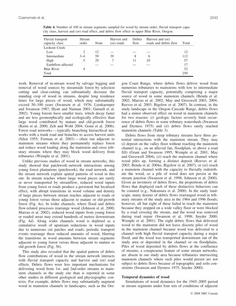
4th- and 5th-order stream segments experienced tertiarydebris flow runout (Table 3). Many debris flows stalled in1st-order channels without reaching a tributary junction.Only a few debris flows emerged from 1st-order channelsinto other 1st- or 2nd-order channels, and all of these contin-ued into a 4th- or 5th-order channel (Fig. 2b, Table 3). Nodebris flows intersected tributary junctions linking 1st-,2nd-, or 3rd-order tributaries to 3rd-order streams. Streamsegments affected by debris flow were evenly divided be-tween harvest and (or) road effects and no harvest and (or)road effects (Table 4).
The stream network in this study displayed four differentcombinations of wood source and transport processes at trib-utary junctions (Table 4, Figs. 2 and 4): (i) no debris flowsin the past 50 years and low to intermediate fluvial redistrib-ution of wood; (ii) debris flows that reached the mainstemand intermediate fluvial redistribution of wood; (iii) roads,debris flows that did not reach the mainstem, and intermedi-ate fluvial redistribution of wood; and (iv) roads, debrisflows that reached the mainstem, and high fluvial redistribu-tion of wood.
Overall, wood volumes decreased in the downstreamdirection, and controlling for position in the stream network,segments adjacent to young forest plantations or roads hadsignificantly less wood than those adjacent to mature orold-growth forest without roads (Fig. 5a). When only seg-ments adjacent to mature or old-growth forest were consid-ered, wood volumes and numbers of large pieces decreased,but not significantly, with increasing fluvial transportcapacity (Table 5). Controlling for fluvial transport capacity,stream segments intersected by a debris flow runout pathhad equivalent or significantly less wood than segments notin debris flow runout paths (Table 5).
Harvests and roads explained much of the variability ofwood in streams (Table 6). Wood volumes and numbers oflarge pieces were significantly higher in stream segmentsadjacent to unmanaged, mature, and old-growth forest com-pared with segments adjacent to 30- to 50-year-old forestplantations (former harvests) and (or) roads. Stream seg-ments with young forest plantations on both sides had sig-nificantly less wood than any other type of stream segment.All but one stream segment lacking wood altogether wereadjacent to harvests and (or) roads. Stream segments adja-cent to 30- to 50-year-old plantations (harvests in the 1950sand 1960s) had significantly less wood volume and fewerlarge pieces than stream segments adjacent to 20- to30-year-old plantations (harvests in the 1970s and 1980s)or mature and old-growth forest. Stream segments withriparian buffers <40 m had significantly less wood volumeand fewer large pieces than those with riparianbuffers >40 m.
Wood volume and numbers of large pieces were signifi-cantly lower in stream segments adjacent to mature or old-growth forest if they were located within 100 m upstreamor downstream of young forest plantations and roads, rela-tive to stream segments adjacent to mature or old-growthforest and more than 100 m from the nearest road or youngforest patch (Table 7). This effect was especially pro-nounced in streams with high fluvial transport capacity:stream segments with high fluvial transport capacity adja-cent to mature or old-growth forest but 100 m downstream
Table 2. Wood volume classes, based on numbers and meanvolumes (m3) of 414 pieces of wood measured in the field.
Length class
1 (1–5 m) 2 (5–10 m) 3 (10–30 m) 4 (>20 m)
Diameter class 1 (10–30 cm)N 180 43 10 3Mean 0.07 0.17 0.57 0.97SD 0.05 0.14 0.36 0.37
Diameter class 2 (31–60 cm)N 86 28 9 5Mean 0.47 1.13 2.44 3.70SD 0.26 0.51 0.89 0.97
Diameter class 3 (>60 cm)N 12 19 10 8Mean 1.84 3.30 7.13 18.42SD 0.95 1.05 1.92 8.57
Note: Volumes were calculated assuming a cylindrical shape, usingthe mean of the smallest and largest diameters. Values in boldface typeare wood piece sizes included in the counts of ‘‘large pieces.’’
Czarnomski et al. 2241
# 2008 NRC Canada

of young forest or roads had much lower wood volumesthan segments 100 m upstream of young forests or thancomparable stream segments with intermediate fluvial trans-port capacity (Fig. 5b).
According to simulations over time, harvest in the 1950sof old-growth forest adjacent to streams combined withwood removal observed in the study landscape during thefloods of 1964 and 1996 explain the wood volumesmeasured in 2002 (Fig. 6). Relative to wood regimes inunmanaged forests, simulated wood volumes declined bytwo-thirds from 1950 to 2005 in streams that had experi-enced (i) clear-cutting and plantation establishment on bothsides of the stream in 1955 or (ii) clear-cutting and planta-tion establishment on one side of the stream in 1955 plushigh net fluvial transport of wood from the stream segmentin floods of 1964 and 1996 (Fig. 6). Simulations reproducedwood volumes measured in 2002 (Fig. 6).
DiscussionSeveral features of the forest management and flood his-
tories of the study site influenced the landscape-scale pat-terns of wood in streams: (i) a high contrast in input ratesof large wood from mature and (or) old-growth versusyoung forest; (ii) the limited use of riparian buffers alongstreams; and (iii) distributed patch clear-cutting of old-growth occurred from 1948 to the early 1970s and thenlargely ceased, providing a landscape mosaic of patches ofyoung forest plantations in a matrix of mature and old-growth forest (Fig. 2). Long-term, landscape-scale recordsof dates, locations, and magnitudes of harvests, roads, debrisflows, floods, and various combinations of these factors(Table 4) made it is possible to disentangle their effects onwood in streams. Fluvial processes had three to five decadesand at least two extreme floods to assert their influences onwood patterns and dynamics. Because a 50 year floodoccurred 6 years before our sampling effort, the imprint offluvial redistribution was strong, rather than overprinted bydecades of wood input from streamside forests (Swanson2003). Despite these particular circumstances, the study pro-
vides support for a general conceptual model of wood instream networks.
Distribution and abundance of wood at the watershedscale and wood dynamics in the stream network
A general conceptual model of wood dynamics must con-sider combinations of fluvial transport, harvests and roads,and debris flow processes at tributary junctions (Fig. 4).Stream order was not sufficient to predict volumes and num-bers of large pieces of wood in stream networks becauseharvests and roads reduce wood and debris flows and fluvialtransport rearrange wood. Accurate prediction of wood instream networks requires a network dynamics approach(Benda et al. 2004b) that considers populations of tributaryjunctions, properties of tributary watersheds, and theireffects on wood dynamics.
This study did not find large decreases in wood down-stream in wider channels with higher fluvial transportcapacities as predicted or observed in many studies (Marcuset al. 2002; May and Gresswell 2003; Swanson 2003). Thisresult may be because some 5th-order channels in the studythat were classified as having high fluvial transport capacityare only 25–30 m wide, about the length of some largepieces, and some channels classified as intermediate werequite wide (Tables 1 and 2). Another explanation for thelack of a significant decline in wood with increasing fluvialtransport capacity is that fluvial export of wood from inter-mediate and high fluvial transport capacity segments wasbalanced by debris flows, which delivered wood primarilyto stream segments with intermediate and high fluvial trans-port capacities (Fig. 2b, Table 3).
Consistent with many studies, this study confirmed thatharvest and roads adjacent to streams were associated withsignificant and persistent reductions of wood in streamswhere <40 m buffer strips were used. Causes of decreasedwood in streams associated with roads and harvest includeintentional removal of wood from streams, replacement ofmature and old-growth streamside forests with roads oryoung forest, and altered wood transport in the stream net-
Table 3. Network structure effect on dynamics of wood movement via debris flows in Lookout Creek, Oregon,from 1946 to the present (see Fig. 2b): percentage of tributary junction types affected by debris flow transporta-tion tracks and percentage of stream network length affected by primary, secondary, and tertiary effects of debrisflows.
Order of contributing stream Percentage of stream length
Order ofreceiving stream 1 2 3 4 All* Network Primary effects{
Secondary andtertiary effects{
1 14 14 59 12 22 11 10 20 23 23 73 0 0 0 0 7 34 134 50 80 0 52 6 0 675 65 63 100 0 65 5 0 100All* 25 29 20 0 25 100 15 10
Note: Numbers for stream lengths affected by debris flows are from Snyder (2000).*The total number of contributing (receiving) streams with debris flows as a percentage of the total number of contributing
(receiving) streams in the network.{The primary disturbance zone refers to the debris flow runout track. The secondary disturbance zone extends from the
termination of a debris flow transportation track to the mainstem and includes riparian vegetation disturbance and sedimentdeposition by fluvial processes distinct from the debris flow. The tertiary disturbance zone refers to disturbance of riparianvegetation and the stream channel accentuated by the contribution of sediment and wood delivered by the debris flow (Snyder2000).
2242 Can. J. For. Res. Vol. 38, 2008
# 2008 NRC Canada
work. Removal of in-stream wood by salvage logging andremoval of wood sources by streamside forest by selectioncutting and clear-cutting can substantially decrease thestanding crop of wood in streams, despite long residencetimes for large pieces of wood, which may substantiallyexceed 50–100 years (Swanson et al. 1976; Lienkaemperand Swanson 1987; Hyatt and Naiman 2001; Gurnell et al.2002). Young forests have smaller trees, which decay fasterand are less geomorphically and ecologically effective thanlarge wood contributed by mature and old-growth forest(Keim et al. 2000; Zelt and Wohl 2004; Gomi et al. 2006).Forest road networks — typically branching hierarchical net-works with a trunk road and branches to access harvest units(Silen 1955; Forman et al. 2003) — often run adjacent tomainstem streams where they permanently replace forestand reduce wood loading along the mainstem and cross trib-utary streams where they may block wood delivery fromtributaries (Wemple et al. 2001).
Unlike previous studies of wood in stream networks, thisstudy showed that patchwork–network interactions amongyoung forest plantations (patchwork), the road network, andthe stream network explain spatial patterns of wood in thissite. In stream reaches where large wood pieces are rarelyor never transported by streamflow, reduced wood inputsfrom young forest or roads produce a persistent but localizedeffect, with abrupt transitions in wood volume and densityof large pieces between stream reaches adjacent to roads oryoung forest versus those adjacent to mature or old-growthforest (Fig. 4a). In wider channels, where flood and debrisflow-related processes rearrange wood (Johnson et al. 2000;Marcus et al. 2002), reduced wood inputs from young forestor roaded areas may extend hundreds of metres downstream(Fig. 4d). Along wider channels wood is depleted as acumulative result of upstream reductions in wood inputsdue to numerous cut patches and roads; periodic transportevents rearrange these reduced amounts of wood, blurringthe transitions in wood amounts between stream segmentsadjacent to young forest versus those adjacent to mature orold-growth forest (Fig. 5b).
This study also revealed that the spatial pattern of debrisflow contributions of wood in the stream network interactswith fluvial transport capacity and harvest and (or) roadeffects. Debris flows were less important mechanisms fordelivering wood from 1st- and 2nd-order streams to main-stem channels in the study site than is reported in someother studies in different geological and physiographic con-texts. For example, debris flows may substantially augmentwood in mainstem channels in landscapes, such as the Ore-
gon Coast Range, where debris flows deliver wood fromnumerous tributaries to mainstems with low to intermediatefluvial transport capacity, potentially comprising a majorsource of wood in some mainstem channels (Benda et al.2002; Marcus et al. 2002; May and Gresswell 2003, 2004;Reeves et al. 2003; Bigelow et al. 2007). In contrast, in thestudy landscape in the Oregon Cascade Range, debris flowshad a minor observed effect on wood in mainstem channelsfor two reasons: (i) geologic factors severely limit occur-rence of debris flows in some tributary watersheds (Swansonand Dyrness 1975) and (ii) debris flows rarely reachedmainstem channels (Table 3).
Debris flows from steep tributary streams have three po-tential interactions with the mainstem stream. They may(i) deposit on the valley floor without reaching the mainstemchannel (e.g., on an alluvial fan, floodplain, or above a roadfill) (Grant and Swanson 1995; Wemple et al. 2001; Mayand Gresswell 2004), (ii) reach the mainstem channel wherewood piles up, forming a distinct deposit (Reeves et al.2003; Benda et al. 2004a; Bigelow et al. 2007), or (iii) reacha mainstem channel with the capacity to fluvially redistrib-ute the wood, so a pile of wood does not persist at thestream junction (Swanson et al. 1998; Johnson et al. 2000).Given an inventory of debris flows, the proportions of debrisflows that displayed each of these distinctive behaviors canbe counted (e.g., Nakamura et al. 2000). In the study land-scape, many dozens of debris flows rearranged wood in trib-utary streams of the study area in the 1964 and 1996 floods;however, all but eight of these failed to reach the mainstembecause they stopped on a wide valley floor or were blockedby a road crossing the stream, and the wood was removedduring road repair (Swanson et al. 1998; Snyder 2000;Wemple et al. 2001). The eight debris flows that deliveredwood to the mainstem did not leave discrete piles of woodin the mainstem channel because wood was delivered to achannel with high fluvial transport capacity during a majorflood, and the wood was transported downstream out of thestudy area or deposited in the channel or on floodplains.Piles of wood deposited by debris flows at the confluenceof streams, a conspicuous feature of some stream networks,are absent in our study area because tributaries intersectingmainstem channels where such piles would persist are notsubject to debris flows because of topographic and soils con-straints (Swanson and Dyrness 1975; Snyder 2000).
Temporal dynamics of woodSimulations of wood dynamics for the 1945–2005 period
in stream segments under four sets of conditions of adjacent
Table 4. Number of 100 m stream segments sampled for wood by stream order, fluvial transport capa-city class, harvest and (or) road effect, and debris flow effect in upper Blue River, Oregon.
Fluvial transportcapacity class
Streamorder None
Harvest and(or) roads
Debrisflow
Harvest and (or)roads and debris flow Total
Lookout CreekLow 2 12 — — — 12Intermediate 3–4 59 39 8 6 112High 5 29 7 11 10 57Earthflow-affected — — — — 17
Blue River 4 52Total 250
Czarnomski et al. 2243
# 2008 NRC Canada

forest age and fluvial transport capacity accurately repro-duced the wood volumes measured in 2002. Simulationsindicate that over the 60 year period, 50%–66% reductionsin wood volume occurred in stream segments with harveston one side and low fluvial transport capacity as well as inthose with harvest on one side and high fluvial transportcapacity. Simulations show that without harvest, streamsegments with low fluvial transport capacity maintainedsteady wood volumes, and stream segments with intermedi-ate fluvial transport capacity maintained temporally fluctuat-ing but non-declining wood volumes, consistent with fieldobservations (Nakamura et al. 2000). Simulations suggestthat in streams with high fluvial transport capacity, additionsof wood contributed by debris flows are overwhelmed byfluvial rearrangement and net export, resulting in steady orreduced wood volumes in stream segments at the end ofdebris flow runout paths.
Implications for forest managementLegacies of past forest management practices persist in
both streamside vegetation and in-stream wood, even thoughforestry practices have changed greatly in the Pacific North-west region where this study took place. Current forestrypractices are no longer creating the same legacies on publiclands in the Pacific Northwest. Wider riparian buffers havebeen adopted since the 1960s, and road construction practi-ces have been modified to reduce impacts to streams. Sincethe early 1990s, clear-cutting of old-growth forest has nearlyceased on public forest lands, extensive (approximately50 m wide) riparian reserves (buffer strips) are employedalong streams, and plantations are thinned to foster old-growth stand characteristics in some areas.
A network dynamics model of wood in streams can guidelandscape plans for forest management (Fig. 4). The modelfocuses attention on the long-term function of streamsideforests as wood sources, relative to the ability of their adja-cent channel to retain or transport wood. The role of a forestpatch of a given age in wood dynamics depends on its loca-tion in the stream network, the upstream distribution of for-est patches and roads, and the likely rearrangement of the
Fig. 4. The stream network in this study was characterized by fourdifferent combinations of wood source and transport processes:(a) 2nd- to 3rd-order streams with young, mature, and old-growthforest adjacent to the stream, no debris flows in the past 50 years,and low to intermediate fluvial redistribution of wood in the chan-nel (upper Lookout and Mack); (b) 3rd- to 4th-order streams withyoung, mature, and old-growth forest adjacent to the stream, somedebris flows that reached the mainstem, and intermediate fluvial re-distribution of wood in the channel (McRae, Cook, and Quentin);(c) 4th and 5th order streams with young, mature, and old-growthforest and roads adjacent to the stream, debris flows did not reachthe mainstem, and intermediate fluvial redistribution of wood in thechannel (middle Lookout); and (d) 5th order streams with young,mature, and old-growth forest and roads adjacent to the stream,debris flows that reached the mainstem, and high fluvial redistribu-tion of wood in the channel (lower Lookout) (see Table 4).
Fig. 5. Interaction of fluvial transport with harvest, roads, debrisflow runout, and neighborhood effects on wood volume (m3/100 m)in streams of upper Blue River, Oregon. (a) Interaction of low, in-termediate, and high fluvial transport capacity classes with harvestand (or) road effects and effects of debris flow runout paths. (b)Interaction of intermediate and high fluvial transport capacityclasses with neighborhood effects.
2244 Can. J. For. Res. Vol. 38, 2008
# 2008 NRC Canada

wood it contributes to the adjacent channel, given the fluvialtransport capacity of that channel. This approach fostersconsideration of forestry practices according to their abilityto contribute wood both to adjacent channels and down-stream. For example, practices such as thinning of young
stands may accelerate growth of large trees that may befuture sources of wood for streams in areas where wood hasbeen depleted by removal of old-growth forests. Culvertreplacement by rolling dips on roads crossing streams mayfacilitate wood delivery to streams by debris flows from
Table 5. Effect of fluvial transport capacity and interactions of fluvial transport with debris flow runout paths on wood in streams inLookout Creek, Oregon.
Fluvial transport capacity class NVolume(m3/100 m) 95% CI N
No. of largepieces per 100 m 95% CI
No. of segments withzero large pieces
Fluvial transport capacityLow – fluvial 12 56.5a 26.1, 122.6 11 10a 4, 21 1Intermediate – fluvial 98 53.2a 40.6, 69.8 96 7a 6, 10 2High – fluvial 35 41.0a 26.1, 64.6 33 6a 4, 9 2
Debris flow runout and intermediate fluvial transport capacityIntermediate – fluvial 98 53.2a 11.9, 53.0 96 7a 3, 13 2Intermediate – debris flow 14 25.1b 40.1, 70.6 11 6a 6, 10 3
Debris flow runout and high fluvial transport capacityHigh – fluvial 35 41.0a 17.7, 68.1 33 6a 3, 10 2High – debris flow 22 34.7a 24.1, 69.9 21 5a 4, 10 1
Note: Seventeen segments with earthflow influence were removed from analysis, as well as segments with zero large pieces. The remainingsegments were divided into the fluvial transport capacity classes before analysis. Mean values followed by the same letter are not significantlydifferent at a Boneferroni-adjusted p < 0.05.
Table 6. Effect of adjacent harvest and road treatment, decade of harvest, and riparian buffer width on wood in streamsin the upper Blue River watershed, Oregon.
NVolume(m3/100 m) 95% CI N
No. of largepieces per 100 m 95% CI
No. of segmentswith zero largepieces
Harvest and road treatmentNone 155 65.2a 57.7, 80.6 154 9a 8, 11 1Harvest, one side 50 36.6b 25.2, 53.2 46 6b 4, 8 4Harvest, two sides 15 20.8c 10.5, 41.2 12 3c 2, 7 3Roads 12 29.5bc 13.8, 63.3 11 5bc 3, 11 1Harvestand roads 18 28.2bc 15.1, 52.6 17 4c 2, 6 1
Decade of harvestNo harvest 156 64.1a 51.0, 78.9 154 9a 8, 11 2Harvest in 1950s 35 32.9b 21.2, 51.0 31 5b 3, 8 4Harvest in 1960s 34 23.5b 15.0, 36.6 31 3c 2, 5 3Harvest in 1970s–1980s 13 67.0a 32.6, 137.6 13 9a 5, 17 0
Buffer width0 m from stream 55 28.3a 19.8, 40.5 51 4a 3, 6 41–40 m from stream 27 40.9a 24.6, 68.1 24 7b 4, 11 3>40 m from stream 156 64.1b 51.8, 79.2 154 9c 8, 11 2
Note: Mean values followed by the same letter are not significantly different at a Bonferroni-adjusted p < 0.05.
Table 7. Effect of neighboring upstream and downstream young forest plantations and roads on wood in streams in the upper BlueRiver watershed, Oregon.
Neighborhood class NVolume(m3/100 m) 95% CI N
No. of largepieces per100 m 95% CI
No. ofsegmentswith zeropieces
No young forest and (or) roads within 100 m 107 77.4a 60.2, 99.5 106 11a 9, 14 10–100 m upstream of young forest and (or) roads 25 44.3b 26.4, 74.4 25 6b 4, 10 0Young forest and (or) roads adjacent 95 31.0b 23.8, 40.5 86 5b 4, 6 90–100 m downstream of young forest and (or) roads 23 44.6b 26.0, 76.6 23 4b 4, 10 0
Note: Mean values followed by the same letter are not significantly different at a Bonferroni-adjusted p < 0.05.
Czarnomski et al. 2245
# 2008 NRC Canada

tributaries. Equally, the network-based approach fostersconsideration of stream channels according to their abilityto receive and retain wood from the entire upstream net-work, given likely geomorphic processes that deliver wood.For example, riparian buffers may be especially importantalong mainstem streams in wide, low-gradient valley floorsthat are unlikely to receive wood via debris flows from trib-utary channels and along mainstem channels where wood isfrequently rearranged. A network dynamics perspective alsomay help in planning restoration of wood in streams byindicating suitable locations for conifer planting in riparianzones and wood placement in streams.
Conclusions
This study introduced a landscape-scale perspective ofwood dynamics in streams that considers the interactingeffects of forest patches, road networks, and stream net-works on the sources and transport of wood in streams. For-est management practices from 50 years ago left discerniblelegacies in the form of depleted wood in certain portions ofthe study stream. Models such as those presented in thisstudy could be used to simulate landscape dynamics overtime and could be useful for predicting wood amounts. Thenetwork–patchwork perspective provides a basis for locatingforest management activities in the landscape to sustainwood in forested stream networks.
AcknowledgmentsThis research was supported by National Science Founda-
tion grants DEB-80-12162, BSR-85-14325, BSR-90-11663,DEB-96-32921, and DEB-02-18088 (H.J. Andrews Experi-
mental Forest Long-Term Ecological Research (LTER)), byUSDA Forest Service and US Geological Survey support oflong-term monitoring at the H.J. Andrews ExperimentalForest. Data and expertise were provided by J. Cissel,C. Creel, T. de Silva, G. Downing, D. Henshaw, A. Levno,G. Lienkaemper, J. Moreau, and S. Remillard. Two anony-mous reviewers provided valuable input on the manuscript.
ReferencesBenda, L.E., and Cundy, T.W. 1990. Predicting deposition of deb-
ris flows in mountain channels. Can. Geotech. J. 27: 409–417.doi:10.1139/t90-057.
Benda, L.E., and Sias, J.C. 1998. Landscape controls on woodabundance in streams. Study publication. Earth Systems Insti-tute, Seattle, Wash.
Benda, L.E., Bigelow, P., and Worsley, T.M. 2002. Recruitment ofwood to streams in old-growth and second-growth redwood for-ests, northern California, U.S.A. Can. J. For. Res. 32: 1460–1477. doi:10.1139/x02-065.
Benda, L., Andras, K., Miller, D., and Bigelow, P. 2004a. Conflu-ence effects in rivers: interactions of basin scale, network geo-metry, and disturbance regimes. Water Resour. Res. 40:W05402. doi:10.1029/2003WR002583.
Benda, L.N., Poff, L., Miller, D., Dunne, T., Reeves, G., Pess, G.,and Pollock, M. 2004b. The network dynamics hypothesis: howchannel networks structure riverine habitats. Bioscience, 54:413–427. doi:10.1641/0006-3568(2004)054[0413:TNDHHC]2.0.CO;2.
Bigelow, P.E., Benda, L.E., Miller, D.J., and Burnett, K.M. 2007.On debris flows, river networks, and the spatial structure ofchannel morphology. For. Sci. 53: 220–238.
Bilby, R.E., and Ward, J.W. 1989. Changes in characteristics andfunction of woody debris with increasing size of streams in
Fig. 6. Temporal dynamics of wood in steep, forested streams under four combinations of harvest and (or) roads and fluvial transport capa-city. Simulated clear-cutting and plantation establishment occurred in 1955 on one or both sides of the stream and simulated fluvial trans-port removed wood episodically at low, intermediate, or high rates in the floods of 1964 and 1996 (see text). Simulations were: (i) 20- to50-year-old forest on both sides of the stream (thick black broken line and squares), (ii) mature and (or) old-growth forest or 50-year-oldforest on one side of the stream and high removal of wood by floods in 1964 and 1996 (grey broken line, shaded and open circles), and(iii) mature or old-growth forest with low fluvial transport capacity of wood (thin black and thick grey solid lines and solid circles).
2246 Can. J. For. Res. Vol. 38, 2008
# 2008 NRC Canada
Western Washington. Trans. Am. Fish. Soc. 118: 368–378.doi:10.1577/1548-8659(1989)118<0368:CICAFO>2.3.CO;2.
Braudrick, C.A., Grant, G.E., Ishikawa, Y., and Ikeda, H. 1997.Dynamics of wood transport in streams: a flume experiment.Earth Surf. Processes Landforms, 22: 669–683. doi:10.1002/(SICI)1096-9837(199707)22:7<669::AID-ESP740>3.0.CO;2-L.
Czarnomski, N.M. 2003. Effects of harvest and roads on in-streamwood abundance in the Blue River Basin, Western Cascades,Oregon. M.Sc. thesis. Oregon State University, Corvallis, Ore.
Dale, V.H., Swanson, F.J., and Crisafulli, C.M. 2005. Ecologicalresponses to the 1980 eruption of Mount St. Helens. Springer-Verlag, New York.
Dreher, D.M. 2004. Effects of input and redistribution processes onin-stream wood abundance and arrangement in Lookout Creek,western Cascade Range, Oregon. M.Sc. thesis. Oregon StateUniversity, Corvallis, Ore.
Dyrness, C.T. 1967. Mass soil movements in the H.J. Andrews Ex-perimental Forest. Res. Pap. PNW-42. USDA For. Serv. PacificNorthwest Forest and Range Experiment Station, Portland, Ore.
Faustini, J.M. 2000. Stream channel response to peak flows in afifth-order mountain watershed. Ph.D. dissertation. Oregon StateUniversity, Corvallis, Ore.
Franklin, J.F., and Forman, R.T.T. 1987. Creating landscape pat-terns by forest cutting: ecological consequences and principles.Landsc. Ecol. 1: 5–18. doi:10.1007/BF02275261.
Forman, R.T.T., Sperling, D., Bissonette, J.A., Clevenger, A.P.,Cutshall, C.D., Dale, V.H., Fahrig, L. et al. 2003. Roadecology: science and solutions. Island Press, Washington, D.C.
Gomi, T., Johnson, A.C., Deal, R.L., Hennon, P.E., Orlikowska,E.H., and Wipfli, M.S. 2006. Factors affecting distribution ofwood, detritus, and sediment in headwater streams drainingmanaged young-growth red alder – conifer forests in southeastAlaska. Can. J. For. Res. 36: 725–737. doi:10.1139/x05-272.
Grant, G.E., and Swanson, F.J. 1995. Morphology and processes ofvalley floors in mountain streams, western Cascades, Oregon. InNatural and anthropogenic influences in fluvial geomorphology.Edited by J.E. Costa, A.J. Miller, K.W. Potter, and P.R. Wilcock.Geophysical Monograph 89, American Geophysical Union.pp. 83–101.
Gregory, S.V., Boyer, K.L., and Gurnell, A.M. 2003. The ecologyand management of wood in world rivers. Am. Fish. Soc. Symp.37.
Gurnell, A.M., Piegay, H., Swanson, F.J., and Gregory, S.V. 2002.Large wood and fluvial processes. Freshw. Biol. 47: 601–619.doi:10.1046/j.1365-2427.2002.00916.x.
Harmon, M.E., Franklin, J.F., Swanson, F.J., Sollins, P., Gregory,S.V., Lattin, J.D., Anderson, N.H., Cline, S.P., Aumen, N.G.,Sedell, J.R., Lienkaemper, G.W., Cromack, K., Jr., and Cum-mins, K.W. 1986. Ecology of coarse woody debris in temperateecosystems. Adv. Ecol. Res, 15: 133–302.
Hyatt, T.L., and Naiman, R.J. 2001. The residence time oflarge woody debris in the Queets River, Washington, USA.Ecol. Appl. 11: 191–202. doi:10.1890/1051-0761(2001)011[0191:TRTOLW]2.0.CO;2.
Johnson, S.L., Swanson, F.J., Grant, G.E., and Wondzell, S.M.2000. Riparian forest disturbances by a mountain flood — theinfluence of floated wood. Hydrol. Process. 14: 3031–3050.doi:10.1002/1099-1085(200011/12)14:16/17<3031::AID-HYP133>3.0.CO;2-6.
Jones, J.A., and Grant, G.E. 1996. Peak flow responses to clear-cutting and roads in small and large basins, western Cascades,Oregon. Water Resour. Res. 32: 959–974. doi:10.1029/95WR03493.
Jones, J.A., Swanson, F.J., Wemple, B.C., and Snyder, K.U. 2000.
Effects of roads on hydrology, geomorphology, and disturbancepatches in stream networks. Conserv. Biol. 14: 76–85. doi:10.1046/j.1523-1739.2000.99083.x.
Keim, R.F., Skaugset, A.E., and Bateman, S. 2000. Dynamics ofcoarse woody debris placed in three Oregon streams. For. Sci.46: 13–22.
Keller, E.A., and Swanson, F.J. 1979. Effects of large organic ma-terial on channel form and fluvial processes. Earth Surf. Process.4: 361–380. doi:10.1002/esp.3290040406.
Lancaster, S.T., and Hayes, S.K. 2001. Modeling sediment andwood storage and dynamics in small mountainous watersheds.In Geomorphic processes and riverine habitat. Edited by J.M.Dorava, D.R. Montgomery, B.B. Palcsak, and F.A. Fitzpatrick.Water and Science Application. American Geophysical Union,Washington, D.C. pp. 85–102.
Lienkaemper, G.W., and Swanson, F.J. 1987. Dynamics of largewoody debris in streams in old-growth Douglas-fir forests. Can.J. For. Res. 17: 150–156. doi:10.1139/x87-027.
Longley, P.A., Goodchild, M.F., Maguire, D.J., and Rhind, D.W.2001. Geographic information systems and science. John Wiley& Sons, Chichester, UK.
Marcus, W.A., Marston, R.A., Colvard, C.R., Jr., and Gray, R.D.2002. Mapping the spatial and temporal distributions of woodydebris in streams of the Greater Yellowstone Ecosystem, USA.Geomorphology, 44: 323–335. doi:10.1016/S0169-555X(01)00181-7.
May, C.L., and Gresswell, R.E. 2003. Large wood recruitment andredistribution in headwater streams in the southern OregonCoast Range, U.S.A. Can. J. For. Res. 33: 1352–1362. doi:10.1139/x03-023.
May, C.L., and Gresswell, R.E. 2004. Spatial and temporal patternsof debris-flow deposition in the Oregon Coast Range, USA.Geomorphology, 57: 135–149. doi:10.1016/S0169-555X(03)00086-2.
McDade, M.H., Swanson, F.J., McKee, W.A., Franklin, J.F., andVanSickle, J. 1990. Source distances for coarse woody debrisentering small streams in western Oregon and Washington. Can.J. For. Res. 20: 326–330. doi:10.1139/x90-047.
Meleason, M.A., Gregory, S.V., and Bolte, J.P. 2003. Implicationsof riparian management strategies on wood in streams of thePacific Northwest. Ecol. Appl. 13: 1212–1221. doi:10.1890/02-5004.
Morrison, P.H., and Swanson, F.J. 1990. Fire history and pattern ina Cascade Range landscape. USDA For. Serv. Gen. Tech. Rep.PNW-GTR-254.
Nakamura, F., and Swanson, F.J. 1993. Effects of coarse woodydebris on morphology and sediment storage of a mountainstream system in western Oregon. Earth Surf. Processes Land-forms, 18: 43–61. doi:10.1002/esp.3290180104.
Nakamura, F., and Swanson, F.J. 1994. Distribution of coarsewoody debris in a mountain stream, western Cascade Range,Oregon. Can. J. For. Res. 24: 2395–2403. doi:10.1139/x94-309.
Nakamura, F., Swanson, F.J., and Wondzell, S.M. 2000. Distur-bance regimes of stream and riparian systems — a disturbance-cascade perspective. Hydrol. Process. 14: 2849–2860. doi:10.1002/1099-1085(200011/12)14:16/17<2849::AID-HYP123>3.0.CO;2-X.
Ramsay, F.L., and Schafer, D.W. 1997. The statistical sleuth: acourse in methods of data analysis. Duxbury Press, London.
Reeves, G.H., Benda, L.E., Burnett, K.M., Bisson, P.A., and Sedell,J.R. 1995. A disturbance-based ecosystem approach to maintain-ing and restoring freshwater habitats of evolutionary significantunits of anadromous salmonids in the Pacific Northwest. Am.Fish. Soc. Symp. 17: 334–349.
Czarnomski et al. 2247
# 2008 NRC Canada

Reeves, G.H., Burnett, K.M., and McGarry, E.V. 2003. Sources oflarge wood in the main stem of a fourth-order watershed incoastal Oregon. Can. J. For. Res. 33: 1363–1370. doi:10.1139/x03-095.
Ripple, W.J., Bradshaw, G.A., and Spies, T.A. 1991. Measuringforest landscape patterns in the Cascade Range of Oregon,USA. Biol. Conserv. 57: 73–88. doi:10.1016/0006-3207(91)90108-L.
Sidle, R.C., Pearce, A.J., and O’Loughlin, C.L. 1985. Hillslope sta-bility and land use. Water Resources Monograph 11. AmericanGeophysical Union, Washington, D.C.
Silen, R.R. 1955. More efficient road patterns for a Douglas Firdrainage. Timberman, 56: 82–88.
Skaugset, A., and Wemple, B.C. 1999. The response of forest roadson steep, landslide-prone terrain in western Oregon to the Febru-ary 1996 storm. In Proceedings of the International MountainLogging and 10th Pacific Northwest Skyline Symposium. Editedby J. Session and W. Chung. International Union of ForestryResearch Organizations, Corvallis, Ore. pp. 193–203.
Smith, J.W. 2002. Mapping the thermal climate of the H.J. An-drews Experimental Forest, Oregon. M.Sc thesis. Oregon StateUniversity, Corvallis, Ore.
Snyder, K.U. 2000. Debris flows and flood disturbance in small,mountain watersheds. M.Sc. thesis. Oregon State University,Corvallis, Ore.
Swanson, F.J. 2003. Wood in rivers: a landscape perspective. InThe ecology and management of wood in world rivers. Editedby S.V. Gregory, K.L. Boyer, and A.M. Gurnell. Am. Fish. Soc.Symp. 37: 299–313.
Swanson, F.J., and Dyrness, C.T. 1975. Impact of clear-cutting androad construction on soil erosion by landslides in the westernCascade Range, Oregon. Geology, 3: 393–396. doi:10.1130/0091-7613(1975)3<393:IOCARC>2.0.CO;2.
Swanson, F.J., and James, M.E. 1975. Geology and geomorphologyof the H.J. Andrews Experimental Forest, western Cascades,Oregon. USDA For. Serv. Res. Pap. PNW-188. Pacific North-west Forest and Range Experiment Station, Portland, Ore.
Swanson, F.J., and Jones, J.A. 2002. Geomorphology and hydrol-
ogy of the H.J. Andrews Experimental Forest, Blue River, Ore-gon. In Field guide to geologic processes in Cascadia. Edited byG.W. Moore. Oregon Department of Geology and Mineral In-dustries, Special Paper 36. Nature of the Northwest InformationCenter, Portland, Ore. pp. 288–314.
Swanson, F.J., Lienkaemper, G.W., and Sedell, J.R. 1976. History,physical effects, and management implications of large organicdebris in western Oregon streams. USDA For. Serv. PacificNorthwest Forest and Range Experiment Station Gen. Tech.Rep. 56, Portland, Ore.
Swanson, F.J., Franklin, J.F., and Sedell, J.R. 1990. Landscape pat-terns, disturbance, and management in the Pacific Northwest,USA. In Changing landscapes: an ecological perspective. Editedby I.S. Zonneveld and R.T.T. Forman. Springer, New York.pp. 191–213.
Swanson, F.J., Johnson, S.L., Gregory, S.V., and Acker, S.A. 1998.Flood disturbance in a forested mountain landscape. Bioscience,48: 681–689. doi:10.2307/1313331.
USDA Forest Service and USDI Bureau of Land Management.1994. Record of decision for amendments to Forest Service andBureau of Land Management planning documents within therange of the northern spotted owl. USDA For. Serv. RegionalOffice, Portland, Ore.
Wemple, B.C., Jones, J.A., and Grant, G.E. 1996. Channel networkextension by logging roads in two basins, western Cascades,Oregon. Water Resour. Bull. 32: 1195–1207.
Wemple, B.C., Swanson, F.J., and Jones, J.A. 2001. Forest roadsand geomorphic process interactions, Cascade Range, Oregon.Earth Surf. Processes Landforms, 26: 191–204. doi:10.1002/1096-9837(200102)26:2<191::AID-ESP175>3.0.CO;2-U.
Wondzell, S.M., and Swanson, F.J. 1999. Floods, channel change,and the hyporheic zone. Water Resour. Res. 35: 555–567.doi:10.1029/1998WR900047.
Zelt, R.B., and Wohl, E.E. 2004. Channel and woody debris char-acteristics in adjacent burned and unburned watersheds a decadeafter wildfire, Park County, Wyoming. Geomorphology, 57:217–233. doi:10.1016/S0169-555X(03)00104-1.
2248 Can. J. For. Res. Vol. 38, 2008
# 2008 NRC Canada