executive summary barnum station - pace...
TRANSCRIPT

BARNUM STATION
BRID
GEPO
RT, C
ONNE
CTIC
UTJU
NE 2
013
Feasibility Study
EXECUTIVE SUMMARY
PREPARED FOR | Greater Bridgeport Regional Council City of Bridgeport
PREPARED BY |
IN ASSOCIATION WITH | Icon Architecture, Inc
Vantage Point Development Advisors
Vanasse Hangen Brustlin, Inc.


INTRODUCTIONBased on recent planning and development initiatives undertaken by the City of Bridgeport, as well as input received from area stakeholders, there is a strong desire for a new commuter rail station (“Barnum Station”) to be located along Barnum Avenue in East Bridgeport on the site of the former Remington factory. The new P. T. Barnum Station would improve transit and serve as a catalyst for redevelopment in the East Side, East End, and adjacent neighborhoods. In order to respond to this challenge, the City of Bridgeport, in conjunction with the Greater Bridgeport Regional Council (GBRC) became a partner in the New York-Connecticut Sustainable Communities Consortium with a goal of developing livable communities with mixed-income housing and employment at key transit nodes.
The purpose of the Bridgeport Barnum Station Feasibility Study is to determine whether the construction and operation of a second train station is physically and operationally possible and compatible with the existing Metro-North Railroad (MNR) and Amtrak service and assess the redevelopment opportunities on adjacent parcels.
Results of the analysis indicate it is feasible to construct and operate a new Barnum Station on the site of the former Remington factory. Further, the Study shows that the station has the potential to be a catalyst for redevelopment and revitalization in East Bridgeport, including creating jobs and providing additional housing options close to transit.
The full version of the Study is available on GBRC’s website at: http://www.gbrct.org/projects/environment-sustainability-2/ny-ct-sustainable-communities/bridgeport-barnum-station-feasibility-study/
Sustainable CommunitiesPartnership for Sustainable CommunitiesOn June 16, 2009, United States Secretary of Housing and Urban Development (HUD) Shaun Donovan, United States Secretary of Transportation (DOT) Ray LaHood, and United States Environmental Protection Agency (EPA) Administrator Lisa P. Jackson announced the formation of the interagency Partnership for Sustainable Communities. The mission of the Office of Sustainable Housing and Communities is to create strong, sustainable communities by connecting housing to jobs, fostering local innovation, and helping to build a clean energy economy (http://www.sustainablecommunities.gov/).
The Partnership for Sustainable Communities in Bridgeport is an example of collaborative problem-solving and unified government at its best. This Federal collaboration has encouraged HUD, DOT, and EPA to work together to focus resources not just on transportation, housing, or the environment, but on how to coordinate all three.
—Bridgeport Mayor Bill Finch
BARNUM STATION FEASIBILITY STUDY | Executive Sum
mary
1

2
New York-Connecticut Sustainable Communities ConsortiumThe New York-Connecticut Sustainable Communities Consortium contains 17 members comprised of city, county, and regional representatives, as well as an advisory board of 15 members that received a 2010 HUD Regional Planning Grant through the Regional Plan Association (RPA). The initiative integrates housing, economic development, transportation and environmental planning. The goal of the Consortium is to reposition the New York-Connecticut region to fully harness its innovation capabilities in a competitive global environment, build on its strong foundation of energy efficiency, and become as equitable as it is efficient. Its primary focus is to leverage the most extensive and robust transit system in the nation by developing livable communities with mixed-income housing and employment at key transit nodes (http://www.sustainablenyct.org/).
Livability PrinciplesThe Sustainable Communities Program, the New York-Connecticut Sustainable Communities Consortium, and the Barnum Station Feasibility Study were guided by HUD’s Six Livability Principles:
» Provide More Transportation Choices
» Promote Equitable, Affordable Housing
» Enhance Economic Competitiveness
» Support Existing Communities
» Coordinate Policies and Leverage Investment
» Value Communities and Neighborhoods
Project OverviewThe Barnum Station Feasibility Study was funded under the New York-Connecticut Sustainable Communities Program, which is one of 16 major activities being conducted by consortium members. The study seeks to determine the feasibility of constructing a second rail station in Bridgeport as a catalyst for revitalizing the East Side and East End neighborhoods. Barnum Station is envisioned as an anchor for mixed-use development on adjacent parcels and is a key element of the City of Bridgeport’s sustainability plan: BGreen 2020 (http://www.bgreenbridgeport.org/).
BARNUM STATION FEASIBILITY STUDY | Executive Sum
mary
2

SCOPE OF WORKThe Barnum Station Feasibility Study was conducted over an approximate one-year period and consisted of six main tasks.
» Public Participation and Outreach
» Existing Conditions/Data Collection
» Station Location/Fatal Flaw Analysis
» Build-Out/Ridership and Operational Analysis
» Alternatives Evaluation
» Final Documentation
In conjunction with the work, a number of technical reports/memoranda were produced:
» Technical Memorandum #1: Existing Conditions Analysis
» Technical Memorandum #2a: Site Station Locations/Fatal Flaw Analysis
» Technical Memorandum #2b: Station Area Concept Plans
» Market Overview
» Technical Memorandum #3a: Station Operational Feasibility Analysis
» Technical Memorandum #3b: Ridership Analysis
» Cost Estimate
The information, recommendations, and conclusions contained in these reports are summarized in this Executive Summary.
PROJECT CONTEXT AND GOALSLocal ContextThe proposed Barnum Station is to be located on the site of the former Remington factory, on Barnum Avenue. Helen Street borders the west side of the parcel and Seaview Avenue the east side. The site comprises approximately 16.7 acres of land and includes over 340,000 square feet of industrial floor space that is currently vacant. The elevated railroad right-of-way for the New Haven Main Line runs along the south side of the site. The site is located between the west end of the East Bridgeport Rail Yard (EBRY) and the long curve that starts at Hallett Street, crosses the PECK drawbridge and sweeps into the existing Bridgeport Intermodal Center on Water Street in the downtown. The existing downtown Bridgeport Station is approximately one mile from the planned Barnum Station site. Figure 2, City Context, illustrates the relationship of Barnum Station to Bridgeport Station and the EBRY, as well as the City of Bridgeport as a whole.
3
Figure 1: Barnum Station
BARNUM STATION FEASIBILITY STUDY | Executive Sum
mary
3

The Barnum Station study area is defined as a ½-mile radius around the site of Barnum Station, as depicted in Figure 3, Neighborhood Context. This area includes portions of seven census tracts (734, 736, 737, 738, 739, 740, and 743) and four neighborhoods: 1) Boston Avenue/Mill Hill, 2) East Side, 3) East End, and 4) North Bridgeport. The East Side neighborhood makes up the greatest portion of the study area. The area within a ¼-mile radius around the site is the core study area, where the focus of transit-oriented development would be expected to take place.
Fewer than 10 percent of the City of Bridgeport’s residents live in the study area. The study area is more diverse, younger, and has lower incomes than the City or Fairfield County
Project Goals and ObjectivesIn considering the feasibility of a commuter rail station in East Bridgeport, three goals were established:
» Determine whether a new station can be physically constructed.
» Determine whether a new station is operationally compatible with existing MNR and Amtrak service.
» Assess the redevelopment potential on adjacent properties.
The study was guided by the following objectives:
» Increase the availability of housing options in a transit-supportive location.
» Improve transit and promote transit-oriented development (TOD) in East Bridgeport.
» Improve access to jobs, education, and services.
65
34
2
1
Figure 2: City Context
Fairfield Metro Station
Ferry Terminal
Bridgeport Station
Bus Station
Proposed Barnum Station
East Bridgeport Rail Yard
City of Bridgeport boundary
Bridgeport Station
East Bridgeport Rail Yard
East Side
Yello
w M
ill C
hann
el
Steel Point
Bridgeport Harbor
Bridgeport Hospital
Lake Success
Barnum and Waltersville
School
Mill Hill/ Boston Avenue
Proposed Barnum Station
Bus Station
Ferry Terminal
Fairfield Metro Station
East End
Hydrology
River
Pond
Wetlands
Rail
Figure 3: Neighborhood Context
BARNUM STATION FEASIBILITY STUDY | Executive Sum
mary
4

» Decrease per-capita vehicle-miles-travelled (VMT) and transportation-related emissions for the corridor.
» Increase participation and decision-making in developing a long-range vision for the area around Barnum Station.
The Barnum Station Feasability Study continues the on-going long-term planning in the city, including furthering initiatives such as BGreen. In addition, it is consistent with other TOD initiatives in Connecticut and along the New Haven Line. A second station in Bridgeport would help residents and businesses of the city, specifically within the study area and surrounding neighborhoods, by providing better access to transit.
Public OutreachOne of the most important objectives of the feasibility study was increasing public participation and decision-making in the development of a long-range vision for the area around Barnum Station. With this objective in mind, public outreach was a focal element of the feasibility process. Outreach included the creation of a project website in English and Spanish (http://www.gbrct.org/projects/environment-sustainability-2/ny-ct-sustainable-communities/bridgeport-barnum-station-feasibility-study), which included background information on the project, notice of meetings and postings of interim project deliverables. Two advisory committees were established that were instrumental in soliciting feedback on the project:
» Technical Advisory Committee (TAC) – The TAC was comprised of key representatives from the City of Bridgeport, Greater Bridgeport Transit (GBT), the Connecticut Department of Transportation (ConnDOT), MNR, Metro-North Commuter Rail Council, RPA, Bridgeport Hospital, Housing Authority of the City of Bridgeport (Bridgeport Housing Authority), General Electric, and DuPont, among others.
» Community Advisory Committee (CAC) – The CAC was comprised of representatives from the East Side Neighborhood Revitalization Zone (NRZ), East End NRZ, local community organizations, business representatives, and property owners. These leaders represented their communities and acted as the conduit to share ideas and receive feedback with the general public.
The committees met during the study process to review work and provide feedback. In addition to the TAC/CAC meetings, a number of one-on-one meetings with key stakeholders occurred. These included meetings with the Bridgeport Housing Authority and Bridgeport Hospital to discuss the project and their development plans, as well as with ConnDOT to discuss the rail ridership and operations analysis. A public meeting was held at the conclusion
the
is pleased to invite you to a meeting of the Community Advisory Committee for the
Barnum Station Feasibility Study The meeting will be held onThursday, May 9th, 7:00 pm at the Margaret E. Morton Government Center City Hall Annex, 999 Broad Street, Bridgeport, CT
For more information and to RVSP, please contact: Meghan Sloan, Transportation Planner
tel: 203-366-5405 email: [email protected] www.gbrct.org
City of Bridgeportin partnership with the
Greater Bridgeport Regional Council
BARNUM STATION FEASIBILITY STUDY | Executive Sum
mary
5

of the project, as well. Finally, as part of its extensive public outreach strategy for implementing the HUD planning grant, the New York-Connecticut Sustainable Communities Consortium has held numerous forums and “town halls,” where an estimated 420 residents and stakeholders heard about the progress of the planning work and provided input.
The benefit of this outreach effort is that it has provided an opportunity for citizen input into the planning process. The process has allowed GBRC, the City of Bridgeport, and its consultants to solicit input from a broad range of perspectives.
HISTORY OF THE STUDY AREA AND SUMMARY OF EXISTING CONDITIONS History of the Study AreaThe study area’s rich industrial heritage helped shape development and the economy within the City of Bridgeport. The site and its factory buildings were formerly operated by the Remington Arms Corporation. The plant was established in 1867 and originally incorporated as the Union Metallic Cartridge Company. The plant was noted for its development of metallic cartridges. The company merged with Remington Arms and, in 1888, Bridgeport became home of its ammunitions plant. The Remington munitions factory developed the first paper shot shells successfully manufactured in the United States and was the first company to produce and make several other ammunition advancements. A unique component of the plant was the approximately 130-foot tall shot tower. The Remington Shot Tower is one of only a relatively few surviving shot towers in the United States.
One of the more prominent buildings in Bridgeport is Bridgeport Hospital. Situated on the top of Mill Hill, within a 10-15 minute walk of the proposed new station, the ten-story hospital dominates the skyline of East Bridgeport. The hospital was founded in 1878 and ground was broken in 1883. The hospital was created to provide health care to a growing immigrant population. In November 1884, the hospital began treating its first patients, primarily providing medical services to the poorest residents of the city. When it was established, Bridgeport Hospital became the first hospital in Fairfield County and only the third in the state. The Bridgeport School of Nursing was established at the same time and has been providing extraordinary programs ever since. Its first president of the board of trustees was P. T. Barnum, the noted philanthropist, entertainer, showman, State Legislator, and Mayor of the City of Bridgeport. The hospital is part of the Yale New Haven Health System and is the City’s largest employer with approximately 2,500 employees.
BARNUM STATION FEASIBILITY STUDY | Executive Sum
mary
6

Summary of Existing ConditionsAn integral part of conducting the feasibility study was undertaking a comprehensive review and analysis of existing site conditions including:
» Demographics » Pedestrian and bicycle facilities
» Land use and zoning » Vacant and/or underutilized land
» Traffic and parking » Environmental conditions
» Transit » Office and commercial market
Based upon the existing conditions analysis, a number of key issues and opportunities were identified in the study area, including:
» Strong anchors – The study area includes a number of strong anchors including Bridgeport Hospital, the newly constructed Waltersville and Barnum Elementary School, existing industrial uses (such as Lacey Manufacturing), and significant open space resources along the Yellow Mill Channel.
» Available land – Approximately 2/3 of the land within a 1/4-mile radius of Barnum Station is either vacant or underutilized.
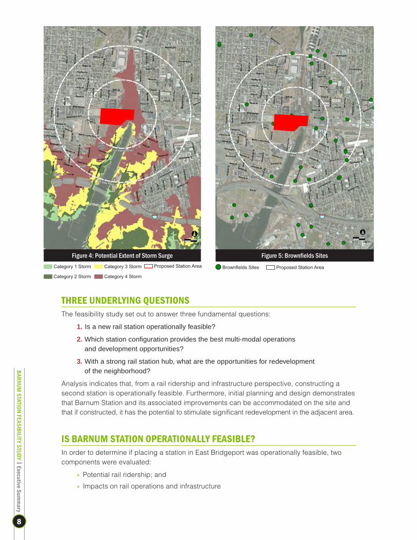
» Environmental conditions – There are a number environmental conditions in the study area that will affect redevelopment. These include floodplains and coastal conditions, especially given recent storms that have impacted Bridgeport. In addition, other environmental conditions in the study area include brownfields sites and contaminated buildings that will need to be remediated in order to facilitate redevelopment. (See Figures 4 and 5)
» Relationship to Yellow Mill Channel – There is the potential for water and recreation opportunities along the Yellow Mill Channel, including creation of a greenway, consistent with ongoing City planning efforts.
» Proximity to downtown Station – Due to Barnum Station’s proximity to the downtown Bridgeport Station, there are potential impacts on ridership and rail operations, as well as competition for real estate uses, that will need to be carefully considered.
» Transit ridership – The study area is currently well served by local GBT bus routes. There is the potential for additional local- and hospital-related demand, as well as more efficient north-south connections as area redevelopment takes place.
» Roadways – Analysis indicates that there is available capacity on study area roadways. There are opportunities for improving these roadways, particularly in taking a “complete streets” approach to accommodate not only vehicles, but pedestrians and bicyclists as well, particularly along Seaview Avenue.
» Neighborhood stabilization – Barnum Station has the potential to stabilize and encourage reinvestment in the East End and East Side neighborhoods.
» Market opportunities – In spite of the current state of the economy, analysis indicates that there is a potential market for new residential, retail, and flex/office spaces in the study area. There is an opportunity to complement, but not compete with various other development efforts within the City of Bridgeport, including Steel Point, Bridgeport Housing Authority redevelopment plans, and expansion of Bridgeport Hospital.
BARNUM STATION FEASIBILITY STUDY | Executive Sum
mary
7
THREE UNDERLYING QUESTIONSThe feasibility study set out to answer three fundamental questions:
1. Is a new rail station operationally feasible?
2. Which station configuration provides the best multi-modal operations and development opportunities?
3. With a strong rail station hub, what are the opportunities for redevelopment of the neighborhood?
Analysis indicates that, from a rail ridership and infrastructure perspective, constructing a second station is operationally feasible. Furthermore, initial planning and design demonstrates that Barnum Station and its associated improvements can be accommodated on the site and that if constructed, it has the potential to stimulate significant redevelopment in the adjacent area.
IS BARNUM STATION OPERATIONALLY FEASIBLE?In order to determine if placing a station in East Bridgeport was operationally feasible, two components were evaluated:
» Potential rail ridership; and
» Impacts on rail operations and infrastructure
Figure 5: Brownfields Sites
Brownfields Sites Proposed Station Area
Figure 4: Potential Extent of Storm Surge Proposed Station Area Category 3 Storm
Category 4 Storm
Category 1 Storm
Category 2 Storm
BARNUM STATION FEASIBILITY STUDY | Executive Sum
mary
8

Rail Ridership AnalysisAn integral part of conducting the feasibility study was achieving an understanding of the ridership potential at Barnum Station. Four scenarios were evaluated by ConnDOT using the Connecticut Statewide Travel Demand Model:
» Existing Conditions
» 2040 No-Build
» 2040 Partial Build
» 2040 Full Build
The 2040 No-Build assumed ConnDOT’s baseline 2040 land use forecasts. The 2040 Partial Build included the addition of Barnum Station and also assumed ConnDOT’s baseline 2040 land use forecasts. The 2040 Full Build included the addition of Barnum Station, but assumed a mixed-use, transit-oriented development land use build-out around the proposed station.
Analysis indicates that daily ridership along the New Haven Main Line in the 2040 Partial Build would increase with the addition of Barnum Station. In the peak-period, the anticipated ridership at Barnum Station would be primarily comprised of current ridership shifting from the Stratford and Bridgeport Stations rather than new riders, due to the convenience of the station location within the region. The ridership in the off-peak period would be a combination of existing riders shifting from the Stratford and Bridgeport Stations, as well as new riders. The new rail riders would be primarily short trips traveling between the Stratford, Barnum, and Bridgeport Stations. The addition of Barnum Station would improve regional mobility by bringing residents closer to their origin or destination (i.e., provide better access to employment). In addition, there would be a shift from bus to rail and walking. Under the 2040 Partial Build, daily ridership at Barnum Station would be equivalent to the current ridership at the Fairfield Town Center Station, almost twice the current ridership at the Stratford Station.
The 2040 Full Build alternative was also tested. However, due to limitations of the State model, it was not possible to extract meaningful results. The Barnum Station ridership for the 2040 Full Build will be revisited as part of the Bridgeport Regional TOD Pilot Study, which will be studying further how land use development, particularly TOD, affects rail ridership around regional rail stations along the greater Bridgeport regional New Haven rail line corridor.
It is important to note that there are strong ridership synergies between hospital employees shuttling between Bridgeport Hospital and Yale-New Haven Hospital. In addition, the Hospital’s expansion plans, including potential housing for nursing students, would further provide potential riders at Barnum Station not currently captured in the Statewide Model.
Rail Operations AnalysisExisting rail infrastructure constraints associated with providing a new station and its implications on operations along the New Haven Main Line were evaluated. The operations analysis took a conservative approach and was based on the capacity of the existing MNR system and it’s current schedule.
The operations analysis concluded that the addition of the new station would not negatively or adversely impact rail operations—if peak-period trains serving Barnum are limited to local trains only. Express and partial express trains would operate on their current schedules and would still access Bridgeport Station, but not Barnum Station. This, conservatively, would provide ten trains stopping at Barnum Station in the morning and evening peak-periods.
BARNUM STATION FEASIBILITY STUDY | Executive Sum
mary
9

Subsequent conversations with ConnDOT have indicated that Barnum Station could have the potential to also serve express and partial express trains. It is recommended that a full simulation of rail operations be undertaken in order to better delineate these findings and refine the recommendations.
WHAT IS THE BEST CONFIGURATION OF THE STATION?In order to determine the best location of Barnum Station, a platform configuration analysis was undertaken, followed by the development of station concept plans, which included alternative configurations for the location of Barnum Station itself and associated site improvements including parking and access.
Platform ConfigurationsThere is currently 1,050 feet of tangent track between the yard switches to the north and the curve to the south of the proposed Barnum Station. This is the length required for a new station platform.
There are three basic station platform configurations that can be considered for Barnum: 1) side platform, 2) center platform, and 3) some combination of a side and center platform. Each configuration has its advantages and disadvantages which can vary with the specifics of the site.
» Side platform stations typically require no modification of the tracks. Side platform stations usually require more vertical circulation provisions than center platform stations.
» Island/center platform stations entail widening of the track centers within the station and for a distance on either end of the station. Center platform stations offer riders the ability to transfer between trains without the need to change platforms, something side platform stations usually require.
» Stations with center and side platforms have the greatest requirement for vertical circulation provisions and require widened track centers for the center platform.
Three platform/station scenarios were considered for Barnum Station. Note that these options represent side platform and center and side platform stations, but do not include an island/center only station:
Scenario 1: Route Express Amtrak Trains to Barnum Station Side PlatformsThis scenario involves routing express Amtrak trains that operate on the inside tracks to a side platform configuration at Barnum Station.
Scenario 2: Provide Center and Side Platforms at Barnum Station This scenario would involve routing express Amtrak trains to an island/center platform configuration at Barnum Station, as well as including side platforms for local MNR service.
Scenario 3: Extend Existing MNR Express Service from Downtown Bridgeport Station to Barnum Station Side PlatformsThis scenario proposes revising some or all of the existing MNR express service trains to serve Barnum Station side platforms, instead of Bridgeport Station. Alternatively, these trains could stop at Barnum Station as well as Bridgeport Station, which would render them less “express” for Barnum and other northern/eastern riders, but unchanged for those commuting from Bridgeport to the south.
BARNUM STATION FEASIBILITY STUDY | Executive Sum
mary
10

AssessmentThe overall objective for Barnum Station is to provide the best possible access for patrons with the fewest possible impacts on rail operations for the lowest possible capital and operating cost. To that end, the following station design screening criteria were established:
» Guideway modifications » Access to the East Bridgeport Rail Yard (EBRY)
» Right-of-way (ROW) requirements » MNR and Amtrak approvals
» Track and signal modifications
Each of the platform/station scenarios was evaluated based on these criteria, as summarized:
Barnum Station Platform Fatal Flaws Analysis
ScenarioScreening Criteria
Guideway Modifications
ROW Requirements
Track and Signal Modifications Access to EBRY Approvals
1. Side Platforms
(Amtrak/Local)
None No additional ROW needed
Substantial track and signal modifications
Southern access to and from EBRY would be eliminated from Tracks 2 and 4, the tracks on the north side of the guideway.
Amtrak approval for additional station stop. MNR approval for additional station stop and elimination of EBRY access.
2. Amtrak Island
Platform/Local Side Platforms
New guideway required both north and south of Barnum Station for several hundred feet. New guideway 25 feet wider at Barnum Station, slowly tapering back to current width. New bridges over local roadways from Pulaski Street to Seaview Avenue. Seaview Avenue overpass replacement.
Addition of 25 feet of ROW at Barnum Station slowly tapering to current ROW on either side of Barnum Station.
Substantial track and signal modifications.
Southern access to and from EBRY potentially eliminated.
Amtrak approval of additional station stop. MNR approval for additional station stop and elimination of EBRY access.
3. Extend MNR
Service
None No additional ROW needed
No additional signal modifications
Not impacted MNR approval for additional station stop.
As demonstrated above, the creation of a station with an island platform would require the greatest impact. Providing side platforms would involve less impact, while extending existing MNR express service from Downtown to Barnum Station side platforms would require the least. To that end, the third scenario was identified as the preferred and most optimum platform configuration.
BARNUM STATION FEASIBILITY STUDY | Executive Sum
mary
11

Station Area Concept PlansBased upon existing rail constraints, the optimal platform configuration, and available land, four station concept alternatives were prepared. The alternatives were based upon the following assumptions:
» Station platform length is set at 1,050 feet.
» There will be no development within the 100- and 500-year floodplains.
» Bus access in both inbound (to downtown) and outbound directions would initially be only on the north side of the tracks with south access a future option.
» There would be a passage beneath the viaduct for pedestrians to cross between the north and south sides of the track.
The station design options are differentiated with respect to the following:
» In each scheme, existing and new roads are aligned in a way that best serves that particular design alternative.
» While there will be one cut and pedestrian passage under the viaduct, its location varies with each option.
» The location of the station changes within the set 1,050-foot platform length.
Station Design ProgramThe proposed program for Barnum Station would consist of a two-level station, as follows:
» Street level—5,400 square feet, includes a ticket office, enclosed waiting room, restrooms, and limited retail. This level would include the pedestrian passage.
» Platform level—1,680 square feet, with access and circulation outside of the platforms. The platform length would be 1,050 feet and would be 12 feet wide. Canopies would cover nine feet of the platform.
For all station concept options, vehicular drop-offs are located on both sides of the tracks, as well as bicycle racks and pedestrian sidewalks. Initially, bus pick-ups and drop-offs are only located on the north side of the tracks. Pedestrian access from the park and ride is marked with raised crosswalks. Bicycle access is encouraged with a canopy covered storage area. Information about bicycle routes in the area would be posted on wayfinding signs.
For all station concept options, future bus access to both the north and south sides and in both directions would be ensured. Turn radii at intersections would be sufficient to accommodate existing local buses, as well as the possibility of articulated buses.
The Father Panik Village site will play an integral role over the coming years in the City and Housing Authority’s combined efforts to replace the aging public housing units at Marina Village and create mixed-income, transit-oriented, walkable neighborhoods. While construction of Barnum Station will require the utilization of approximately 3 acres of land on the Father Panik Village site currently owned by the Bridgeport Housing Authority, the transit service and accessibility created by the station will ensure that the lower income residents of this redevelopment will have the highest quality access to regional employment opportunities and amenities and that there will be transit-driven demand for the market-rate component of the mixed-income redevelopment, providing necessary revenue to offset the subsidy required to support the affordable units.
Forty dwelling units-per-acre has been identified as a preliminary density goal based on the Bridgeport Housing Authority’s overall development strategy for its parcels in this area.
BARNUM STATION FEASIBILITY STUDY | Executive Sum
mary
12

Concept Options » Option 1: Church Street Realignment (Figure 6)—Option 1 locates the station to its western most extreme, near Hallett Street. Vehicular access to the southern site is provided by an expansion of Church Street, which would be widened to 30 feet, and offsetting Crescent Avenue. Taxi and kiss and ride accommodations alternate with five sawtooth bays of bus parking on the north side. Long-term parking is located to the north and east of the Station Access North Road, which reconnects with Barnum Avenue. This option has the potential for up to 965 parking spaces and up to 350 housing units.
» Option 2: East Washington Avenue Extension (Figure 7)—Option 2 locates the station at its furthest point east, closest to Bridgeport Hospital. Vehicular access to the northern site is supported by an extension of East Washington Avenue, which would continue into downtown. Taxi and kiss and ride accommodations are located on the side of the road closest to the parking lot while the bus drop-offs are on the side of the road closest to the station, prioritizing transit access over private vehicles. Long-term parking is located to the north and west of the Station Access North Road, which reconnects with Barnum Avenue. This option has the potential for up to 1,015 parking spaces and up to 350 housing units.
BARNUM STATION13OPTION 2
1 24 5
A3
2.90 acres149 spaces2.90 acres149 spaces
214 spaces 200 spaces
324 spaces
128 spaces
PPP
PP
P
Parking / Development
Greenway / Open Space
FEM
A 5
00yr
Flo
od
FEM
A 1
00yr
Flo
od
FEMA 500yr Flood
FEMA
100yr Flood
Barnum Ave
Crescent Ave
Seav
iew
Ave
Hal
lett
Ave
Church St
Martin Luther King Dr
Hel
en S
t
Caro
line
St
Pem
brok
e St
Wat
ervi
ew A
ve
Station Access South
Hal
lett
Ave
Pem
brok
e St
E. Washington Extension
Station Access North
0’ 150’ 300’ 600’
Road Re-Alignments
Road Removal
Vehicular Access
Bus Access
LEGEND
Alternative Church St Re-Alignments
Former Father Panik Village Site
Figure 7, Option 2: East Washington Avenue Extension
BARNUM STATION11OPTION 1
1 24 5
A
P
PP
P
P P2.90 acres149 spaces
191 spaces 350 spaces
Parking / Development
Greenway / Open Space
FEM
A 5
00yr
Flo
od
FEM
A 1
00yr
Flo
od
FEMA 500yr Flood
FEMA
100yr Flood
Barnum Ave
Crescent Ave
Seav
iew
Ave
Hal
lett
Ave
Church St
Martin Luther King Dr
Hel
en S
t
Caro
line
St
Pem
brok
e St
Wat
ervi
ew A
ve
Station Access South
Station Acces
s N
orth
Hal
lett
Ave
Pem
brok
e St
424 spaces
0’ 150’ 300’ 600’
Road Re-Alignments
Road Removal
Vehicular Access
Bus Access
LEGEND
Alternative Church St Re-Alignments
Former Father Panik Village Site
Figure 6, Option 1: Church Street Realignment
BARNUM STATION FEASIBILITY STUDY | Executive Sum
mary
13

» Option 3: Waterview Avenue Connection (Figure 8)—Option 3 supports an eastern station location by constructing a new road under the viaduct connecting Barnum Avenue to Waterview Avenue, just offset from the eastern edge of the station platform. Taxi and kiss and ride accommodations are located on the side of the road closest to the parking lot while the bus drop offs are on the side of the road closest to the station, prioritizing transit access over private vehicles. Long-term parking is located to the north and west of the Station Access North Road, which reconnects with Barnum Avenue. This option has the potential for up to 965 parking spaces and up to 350 housing units.
» Option 4: Helen Street Extension (Figure 9)—Option 4 moves the station to a relatively centered portion of the platform by extending Helen Street through the site. Taxi and kiss and ride accommodations are located off the North Station Access Road, on the side of the road closest to the parking lot while the bus drop-offs are on the side of the road closest to the station, prioritizing transit access over private vehicles. Long-term parking is located to the north and west of the Station Access North Road, which reconnects with Barnum Avenue. This option has the potential for up to 1,120 parking spaces and up to 345 units.
BARNUM STATION16OPTION 3
1 24 5
A
PPP
PP
P
Parking / Development
Greenway / Open Space
FEM
A 5
00yr
Flo
od
FEM
A 1
00yr
Flo
od
FEMA 500yr Flood
FEMA
100yr Flood
Barnum Ave
Crescent Ave
Seav
iew
Ave
Hal
lett
Ave
Church St
Martin Luther King Dr
Hel
en S
t
Caro
line
St
Pem
brok
e St
Wat
ervi
ew A
ve
Station Access South
Hal
lett
Ave
Pem
brok
e St
Station Access North
0’ 150’ 300’ 600’
32.90 acres149 spaces
214 spaces 200 spaces
424 spaces
128 spaces
Road Re-Alignments
Road Removal
Vehicular Access
Bus Access
LEGEND
Alternative Church St Re-Alignments
Alte
rnat
ive
Alig
nmen
t
Former Father Panik Village Site
Figure 8, Option 3: Waterview Avenue Connection
BARNUM STATION18OPTION 4
2.90 acres92 spaces
414 spaces
191 spaces324 spaces
49 spaces
1 24 5
A3
AA
PP
PP
P
Parking / Development
Greenway / Open Space
FEM
A 5
00yr
Flo
od
FEM
A 1
00yr
Flo
od
FEMA 500yr Flood
FEMA
100yr Flood
Barnum Ave
Crescent Ave
Seav
iew
Ave
Hal
lett
Ave
Church St
Martin Luther King Dr
Hel
en S
t
Caro
line
St
Pem
brok
e St
Wat
ervi
ew A
ve
Station Access South
Hal
lett
Ave
Pem
brok
e St
Station Access North
0’ 150’ 300’ 600’
Road Re-Alignments
Road Removal
Vehicular Access
Bus Access
LEGEND
Alternative Church St Re-Alignments
Former Father Panik Village Site
Figure 9, Option 4: Helen Street Extension
BARNUM STATION FEASIBILITY STUDY | Executive Sum
mary
14

Impact Evaluation of OptionsEach of the options was qualitatively evaluated based on the following impact categories:
» Rail and transit impacts » Land use impacts
» Traffic impacts » Environmental impacts
Barnum Station Concept Plan Evaluation Matrix
Option Pros Cons
1. Church Street Realignment
» Limited flood zone encroachment
» Least amount of new road construction
» Full block TOD potential
» Large dwell space for buses
» Least integration with existing and planned road network
» No new vehicular/bus access through viaduct
2. East Washington Avenue Extension
» Closer station location to Bridgeport Hospital
» East Washington Avenue extended for improved connection to downtown
» Opportunity for additional east/west bus route service
» Noise/open space buffer between potential development tracks
» Extensive floodplain encroachment for new Station Access North Road
» High infrastructure costs: new road construction full length of site
» No new vehicular/bus access through viaduct
3. Waterview Avenue Connection
» Closer station location to Bridgeport Hospital
» Station Access North Road extended fully through site
» Better vehicular connections through viaduct
» Opportunity for north/south bus route service through new viaduct
» Extensive floodplain encroachment for vehicular connections under viaduct
» High infrastructure costs: new road construction full length of site
» Two tunnels, higher infrastructure development costs
4. Helen Street Extension
» Primary thru-way to US 1/Boston Avenue reconnected to southside of tracks, Steel Point, and Housing Authority sites
» Full blocks available for future TOD
» Largest greenway/open space allowances
» No encroachment on floodplain zone
» Station location near midpoint of platform
» Potential for improved pedestrian safety and visibility under viaduct via combined vehicular and pedestrian connection
» Higher infrastructure costs due to second vehicular tunnel
GBT has highlighted, among other things, the need for north/south bus service connecting the Steel Point and Harbor area with the East Bridgeport Development Corridor more directly (through Barnum Station), since the closest north/south service is (to the west) on East Main Street and (to the east) on Central Avenue. It was suggested that a new north/south connection be provided up Hallett Street, through the south side of the proposed station, and along Waterview Avenue to Seaview Avenue. In addition, in order for any station plan to advance, the Seaview Avenue underpass would need to be widened and improved, including being able to provide requisite turning radii to safely accommodate buses. To that end, any future preferred station alternative should include a new north/south access connection and the appropriate improvements at the Seaview Avenue underpass.
BARNUM STATION FEASIBILITY STUDY | Executive Sum
mary
15

As the project moves forward, a preferred alternative, which may include components of one or more of the above options, will be identified and will undergo a more extensive, impact analysis.
Cost EstimateAn order-of-magnitude capital cost estimate was developed for the project, based upon Option 2, East Washington Avenue Extension. The estimated cost of $48 million in present day dollars (2013) is comprised of the following elements:
Station Infrastructure ............................................................ $7.9 millionIncludes two station buildings, elevators, stairways, a pedestrian tunnel and exit stairways and ramps.
Parking and Roadways .............................................................$11 millionIncludes 0.75 miles of roadways and 1,016 surface parking spaces.
Platforms ............................................................................ $7.4 millionIncludes two 1,050 feet long platforms with a 150-foot canopy each and retaining wall repairs (the platform extensions across Hallett Street are included in this item as bridges since they would have to be suspended over the roadway).
Catenary .............................................................................$1.2 millionIncludes new overhead catenary structures (five total).
Engineering Services .............................................................$6.7 millionBased on Federal Transit Administration (FTA) allowances, providing for Preliminary Engineering, Final Design, Project Management, Construction Administration and Management, Insurance, Legal Permits, Agency Review Fees, Surveys, Testing, Investigation and Inspection and Agency Force Account Work.
Construction Contingency ..................................................... $13.8 millionAn allowance of 50 percent to cover unknowns and additional design detail.
GRAND TOTAL ................................................................ $48 million
This compares to the actual $37.4 million cost for the recently constructed West Haven Station.
WHAT ARE THE DEVELOPMENT OPPORTUNITIES?In addition to the benefits associated with commuter rail accessibility, a new Barnum Station would serve as a catalyst for redevelopment in East Bridgeport. The last question looked at the potential development opportunities that would arise with the construction of a station.
Vacant and Underutilized ParcelsThe study area was once home to an expansive and world-known manufacturing base that included General Electric, Remington Arms, and Singer Sewing Company. As the manufacturing base left the area, old factory buildings were left vacant and underutilized.
As depicted in Figure 10, Vacant and/or Underutilized Parcels, approximately 2/3 of the core station area is either vacant or underutilized, including a number of larger parcels immediately adjacent to the proposed station and along major corridors in the study area including Barnum Avenue, Crescent Avenue, and Seaview Avenue. In contrast, there are fewer parcels beyond ¼-mile but within the ½-mile radius, with most of these being smaller parcels.
BARNUM STATION FEASIBILITY STUDY | Executive Sum
mary
16

Market OverviewA preliminary market overview was conducted in order to assess the market potential for development in the study area. The assessment reviewed current market conditions in 5- and 15-minute drive sheds around the station for residential and the Bridgeport-Stamford-Norwalk CT MSA for office, flex, and retail, and the likely impact current conditions will have over the near- and mid-term (through 2020) with respect to development within the study area. The overview identified initial residential, office, flex, and retail development opportunities over the next seven years (through 2020) based on trends in household growth, employment, retail expenditures, and current market conditions.
The Market Overview also considered other proposed and planned developments in the vicinity of Barnum Station including Steel Point, Seaview Plaza, General Electric, Lake Success Eco Business Park, and infill development in the East Side, East End and Mill Hill neighborhoods and any impacts these regional projects could have on the Barnum Station market and vice-versa. The analysis reflected discussions with the Bridgeport Housing Authority and Bridgeport Hospital regarding future plans. Current development incentive programs offered by the City of Bridgeport such as the Enterprise Zone Program, Brownfields Program, and Tax Credits were also taken into account. In order to provide a broader development perspective, the assessment examined case studies of similar projects nationwide (Hudson River waterfront in New Jersey; Charlotte, North Carolina; and Cleveland, Ohio) to evaluate the longer-term vision for East Bridgeport and the likely impact on the real estate market. The longer-term implications were examined with respect to the catalytic nature of this development and the addition of Barnum Station to the East Bridgeport market and a 30-minute drive shed around the station.
Based on current economic and market conditions, the analysis indicated that there is an initial, short- and medium-term market for residential, as well as some limited office/flex and retail. In addition, there is a longer-term expanded market for additional mixed-use development, as summarized below:
Near-, Medium-, and Long-Term Market Demand
Market Near-/Medium-Term (Through 2020) Long-Term (Beyond 2020)
Residential 950 units Additional 2,000 units
Office/Flex 100,000-175,000 sf Additional 340,000-580,000 sf
Retail 40,000 sf Additional 80,000 sf
Vacant and/or Underutilized Parcel
Proposed Station Area
Figure 10: Vacant and/or Underutilized Parcels
BARNUM STATION FEASIBILITY STUDY | Executive Sum
mary
17

The projected demand over the period through 2020 considers the competitive nature of the marketplace and the intrinsic implications associated with expansion within the study area. The supportable units and square footage presented are reasonable projections for the Barnum Station study area, and will be defined by the accessibility provided by the location of a new station, and realizing other planned projects within the study area.
The long-term vision for Barnum Station and portions of East Bridgeport are aggressive, considering current market conditions. However, as development and redevelopment initiatives continue to increase in the area, the comparative appeal of East Bridgeport and Barnum Station will enhance the development opportunities in the area. Further, with impactful interest in East Bridgeport coming from the City, the Bridgeport Housing Authority, and the Bridgeport Hospital, the resources are in place to transform the study area. Initial development around the station that is currently planned by these parties and private investors will induce further development. The introduction of Barnum Station to the market and the accessibility provided by transit will serve as a catalyst for future development and the success of the vision for the area.
Future Land Use Build Out and TOD PlanDrawing upon results from the Market Overview, a future land use build-out and TOD Plan was developed for selected parcels within the study area.
Sites Subject to ChangeThe first step in this build out/TOD plan was to identify those sites that were “subject to change”—those sites that exhibit the characteristics that could result in change of use. These characteristics include:
» Existing vacant land
» Existing development that is below current development potential
» Current developer interest and/or specific development proposals
In addition, parcels that were identified through coordination with the City of Bridgeport, the TAC, and CAC were also included. These “Sites Subject to Change” were then analyzed within the context of local and regional factors to determine the likelihood of change occurring over the next 20 to 25 years.
Figure 11, Potential Development shows the following 11 sites within the study area that were determined to have the potential of changing in the near future with or without the introduction of Barnum Station:
» Steel Point » Bridgeport Health/Department of Public Works
» Seaview Plaza » Barnum Station TOD
» Seaview Industrial Park » 547 Barnum Avenue
» Bridgeport Housing Authority » General Electric Redevelopment
» Housing Authority Infill » Bridgeport Hospital Expansion
» Lake Success Eco Business Park
BARNUM STATION FEASIBILITY STUDY | Executive Sum
mary
18

In addition, various sites along the Seaview Avenue Industrial Corridor and in the East Side, East End, and Mill Hill neighborhoods were determined to have the potential to change. A build-out of these sites was conducted in conjunction with market inputs to determine potential units and square footages that might occur in the near-, medium-, and long-term.
Infrastructure ImprovementsSeveral infrastructure improvements are proposed by the City of Bridgeport to enhance the study area and to implement the recommendations of BGreen 2020. These are noted in Figure 12, Green Infrastructure Plan and include:
» Greenway—A business incubator, community center, and new residential and retail development connecting the existing marina on Yellow Mill Channel to Barnum Station and, ultimately as a greenbelt to Beardsley Zoo and Lakeview Cemetery. The intent is to endow future generations with healthier ecological, social, and economic environments.
» Roadway improvements—Route 130 and short sections of Route 127, Pembroke Street, and Waterview Avenue will be widened to four lanes, with some addition of left turn lanes as appropriate as part of the Steel Point redevelopment project. Federal aid through the TIGER II program has been allocated to the City for these improvements. Grant Street, in front of the Bridgeport Hospital has been recently closed to promote pedestrian connections and safety.
Figure 11: Potential Development
Green StreetRoad Improvements
Current ProjectsRiparian Rehabilitation
Repair Riparian Corridor
Increase Street Tree Canopy
Connect w/Green Streets
Rehabilitate Yellow Mill Channel
Invest in Green Infrastructure
Figure 12: Green Infrastructure Plan
BARNUM STATION FEASIBILITY STUDY | Executive Sum
mary
19

TOD Plan Figure 13, TOD Land Uses identifies the major land use goals for the immediate station area and the larger East Side/East End neighborhoods. These goals are consistent with the existing land use pattern, the above-noted infrastructure improvements currently planned by the City of Bridgeport, and major institutional and commercial projects already in the development pipeline, as noted above under Sites Subject to Change.
The new station would anchor mixed-use, transit-oriented development on several adjacent vacant parcels located within walking distance of the station and Bridgeport Hospital. Large parcels available for redevelopment exist along Seaview Avenue. The ultimate uses in this area would include affordable, workforce housing critical to the East End and East Side neighborhoods. The new, high-quality transit access would also support commercial and institutional investment that would create jobs and greater prosperity for residents in these neighborhoods. The creation of Barnum Station would encourage re-investment throughout the area.
As noted, construction of Barnum Station would require use of approximately three acres of land currently owned by the Bridgeport Housing Authority. Locating a new station across from this site would ensure that residents of this redevelopment would have the highest quality access to regional employment opportunities and amenities and that there would be transit-driven demand for the market-rate component of the mixed-income redevelopment, providing necessary revenue to offset the subsidy required to support the affordable units.
Figure 13: TOD Land Uses
Medium Density HousingRetailMixed Use
Office/InstitutionalIndustrial
Mixed UseCommercial
Bridgeport Hospital Expansion
Transit Oriented Mixed Use
East SideNeighborhood
Infill
Mill HillNeighborhood
Infill
East EndNeighborhood
Infill
Re-ImagineSteel Point
Urban RetailDevelopment
TraditionalNeighborhoodDevelopment
IndustrialImprovements
New Identity forProposed Station Area
BARNUM STATION FEASIBILITY STUDY | Executive Sum
mary
20

CONCLUSIONS AND NEXT STEPSThe analysis conducted as part of the Barnum Station Feasibility Study demonstrated that it is feasible and desirable to construct a second commuter rail station in the City of Bridgeport, which will serve as a catalyst for economic development and revitalization in the East Side and East End neighborhoods in East Bridgeport.
In order to move forward, the feasibility study identifies a number of additional studies that would be necessary to advance the project. These include:
» A full rail operations simulation
» A refined rail ridership model to further delineate anticipated ridership generated by the station and adjacent redevelopment
» More detailed programming and design of the station itself
» Additional environmental impact analysis
The Barnum Station Feasibility Study can be incorporated into the Greater Bridgeport Regional Transit Oriented Development (TOD) Pilot Project; a planning assessment of alternative public transportation modes, development strategies of properties located in close proximity to public transportation centers, and potential linkages of neighborhoods and districts for pedestrians along the region’s commuter rail line in the City of Bridgeport, the Town of Stratford, and the Town of Fairfield. Specifically, the Regional TOD study aims to increase and enhance public transit services and associated development of properties of Downtown Stratford, including the existing MNR train station, commercial, retail and mixed use properties located in the downtown area, the Seaview Avenue corridor in Bridgeport, which includes the Port of Bridgeport, Steel Point Harbor, and the Lake Success Eco-Business Park, and the Commerce Drive area of Fairfield, which includes the Fairfield Metro Center MNR train station. The ultimate goal is to develop a model TOD ordinance for the Greater Bridgeport region. While Barnum Station is site-specific to Bridgeport’s East Side and East End neighborhoods, it is best to viewed from a regional context as the Barnum Station project offers increased opportunity for development along the rail corridor in the Greater Bridgeport region and providing increased access to public transportation for residents who live near transit centers.
BARNUM STATION FEASIBILITY STUDY | Executive Sum
mary
21
