exhibit - hawaii.govfiles.hawaii.gov/luc/declar_orders/dr1143_mahaulepu... · 2015-12-31 ·...
TRANSCRIPT

EXHIBIT A
Agricultural Land Assessment for
Maha'ulepo Farm LLC
Milia 'ulepu, Kaua'i
February 2011
EXHIBIT "A"
Prepared for: Maha'ulepii Farm LLC 3-1850 Kaumuali'i Highway LIhu'e, HI 96766
Prepared by: PBR Hawaii & Associates, Inc. lOOl Bishop Street, Suite 650 Honolulu, Hawai'i 96813
~'""'"
IntroductionJPur;pose
To support a Petition for Declaratory Order to Designate 'Important Agricultural Lands' (,IAL'), an Agricultural Lands Assessment was prepared for lands owned by Mahii'ulepU Farm LLC on Kaua'i.
HRS § 205-44(c) provides the standards and criteria to identify IAL. HRS § 205-44(a) pro'lide~thatJands identified a~ IALneed not meet every standard and criteria listed in~ HRS § 205-44(c); rather, lands meeting any of the criteria in HRS § 205-44(c) shall be given initial consideration, provided that the designation of IAL shall be made by weighing the standards and criteria with each other to meet the constitutionally mandated purposes in article XI, section 3, of the Hawaii Constitution and the objectives and policies for IAL in section 205-42 and 205-43. The standards and criteria of section 205-44(c) are as follows:
1) Land currently usedfor agricultural production; 2) Land with soil qualities and growing conditions that support agricultural
production offood, fiber, or fuel-and energy-producing crops; 3) Land identified under agricultural productivity rating systems, such as the
agricultural lands of importance to the State of Hawaii (ALISH) system adopted by the board of agriculture on January 28, 1977;
4) Land types associated with traditional native Hawaiian agricultural uses, such as taro cultivation, or unique agricultural crops and uses, such as coffee, vineyards, aquaculture, and energy production;
5) Land with sufficient quantities of water to support viable agricultural production;
6) Land whose designation as important agricultural lands is consistent with general, development and community plans of the county;
7) Land that contributes to maintaining a critical land mass important to agricultural operation productivity;
8) Land with or near support infrastructure conducive to agricultural productivity, such as transportation to markets, water or power.
The following assessment of the approximately 1,533 acres of Maha'ulepU Farm LLC lands proposed to be designated IAL provides an overview of the various characteristics of the subject lands. The attached exhibits (Figure 1 through Figure 8) illustrate and quantify the land characteristics of the proposed Mahii'ulepU Farm IAL.
Agricultural History of Maha'ulepU
Miihii 'ulepU is indeed an agriculturally significant place as it was one of the first places in the State where sugar was grown commercially.
As early as 1820, Chinese immigrants farmed sugar cane in small mills across the Kaua'i Island which included a mill at Miihii 'ulepU. These mills ran for roughly a dozen years,
up until 1832. These operations produced raw sugar and molasses that were consumed locally but they are not operated on a commercial scale'.
In 1835, Ladd and Company attempted to commercially produce sugarcane in Koloa. They obtained a 50 year lease signed by Kamehameha III and the Governor of Kaua'i. This lease was the first of its kind in Hawai'i and the first formal recognition of the right of someone other than a chief to control land '. Koloa Plantation was established in 1841and-hasthe-signifiGant distinction- of-being the first sugar lliantation in the State of Hawai'i.
After 10 years of struggling, Ladd and Company's venture failed but Koloa Plantation survived under new owners Robert Wood and a brother-in-law of one of the original owners.
In 1878, Koloa Plantation began growing roughly 875 acres of sugar cane in Maha'ulepfi Valley and sugar was cultivated in the area for well over a century. In 1897, Koloa Plantation dug wells to irrigate the ahupna'a of Maha'nlepfi to better provide water for the thirsty crop'.
In 1948, Grove Farm Company, Inc. purchased' Koloa Plantation l After nearly a century of independent sugar production, Grove Farm ceased sugar cultivation in 1974 and leased its Koloa lands, as well as the Koloa Mill, to McBryde Sugar Company. From 1974 until 1996, McBryde Sugar Company continued the sugar production. In September of 1996, McBryde Sugar Company had their last harvest and the Koloa Mill closed.
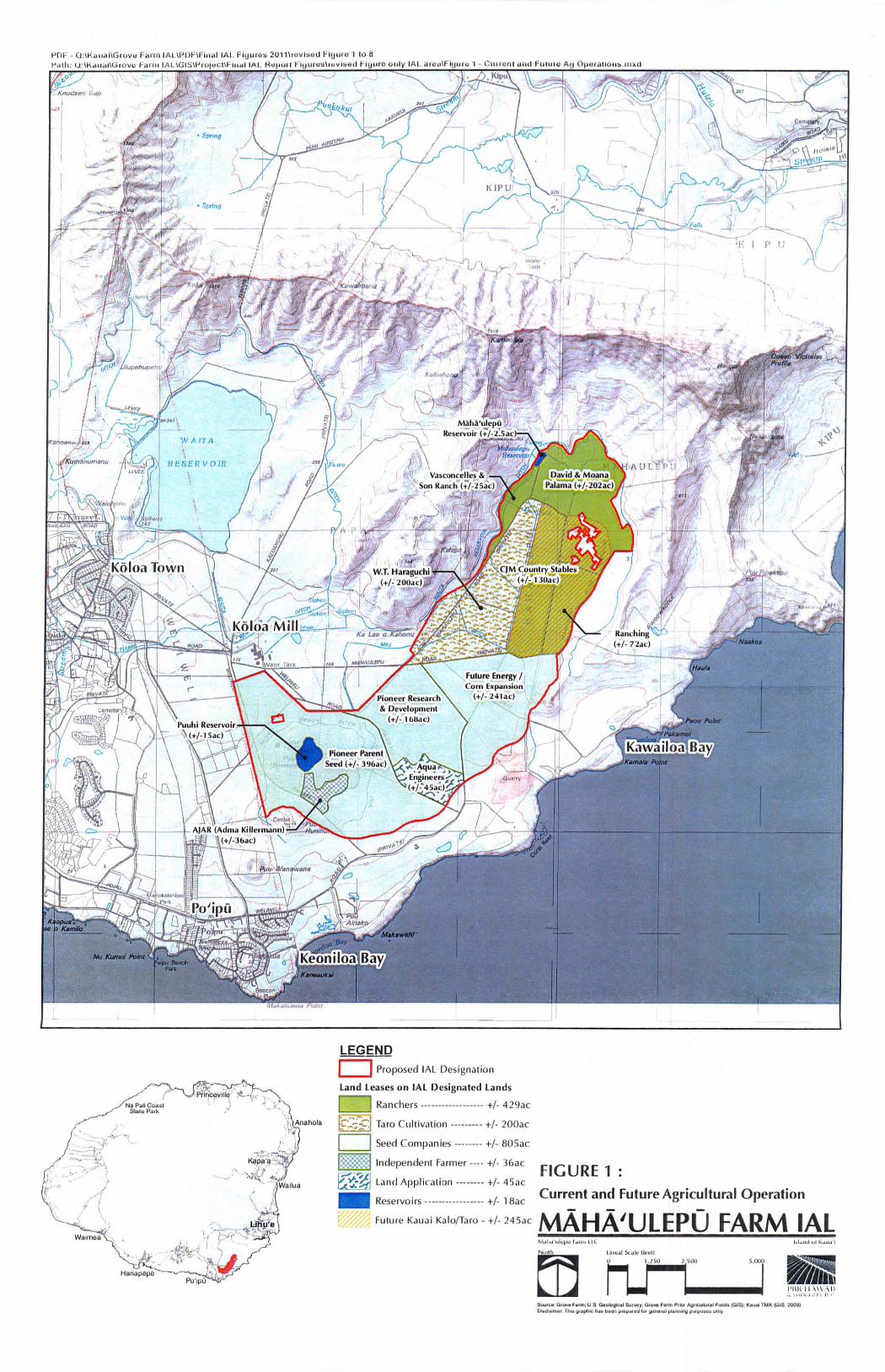
Figure 1: Current and Future Agricultural Operations
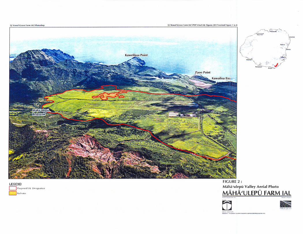
As described above, the area proposed to be designated TAL lands has a long history of agricultural usage. When McBryde Sugar Company ceased sugar production and closed the Koloa Mill in 1996, other opportunities were explored to ensure active agricultural utilization of the subject lands. Currently the subjected lands host a variety of lessees that span the spectrum from ranching to diversified agricultural operations. Figure 1 illustrates the current tenants on the proposed IAL lands. Figure 2 is the aerial view of Maha'ulepii Valley with the overlay of the proposed TAL parcel boundary in the valley.
According to Grove Farm Company's lease records, a portion of the Maha'nlepii area has served ranchers since as early as 1986, as evidenced by a ranching lease to William Lndington (currently Vasconcelles & Son Ranch and David & Moana Palama). As sugar was in the valley until the early 1990's, other ranchers didn't enter that specific area and begin their ranching operations until 2002, when CJM Country Stables and David & Moana Palama began their leases.
Taro cultivation in Maha'ulepii Valley was initiated with a lease to W. T. Haraguchi in 2007. A majority of the 445 acres of leased lands have been used as pasture land until
, Donohugh, Donald. The Story of Koloa: A Kaua'; Plantation Town. Honolulu: Mutual Publishing. 2001. Pg. 87, 88, 98,185

they are converted into taro fields. With a 20-year lease, W.T. Haraguchi plans to expand taro cultivation to over 400 acres which will nearly double the entire statewide production of this culturally significant crop. Other island taro farmers are interested in expanding the production of taro in MuM 'ulepil Valley as well.
Leases with a seed com company began in 1996. Currently, about 564 acres at Maha 'ulepil are under lease with Pioneer Parent Seed and Pioneer Research & Development. The lease term extends to 2019 and the tenants have plans to expand the leased area up to 805 acres for future bio-energy crops and com expansion.
In 1998, a lease of 36 acres land was also entered into with AJAR (Adam Killermann), an independent farmer, for agricultural operations in the adjacent area in Maha'ulepil.
Aque Engineers, Inc. providing water and wastewater services in Po'ipil, has leased 45 acres in Maha'ulepil since 2003. They are doing land application of using sludge from its sewer plants to grow grass that is harvested for animal feed. The sludge acts as soil amendment! fertilizer for growing the forage crop that is periodically harvested.
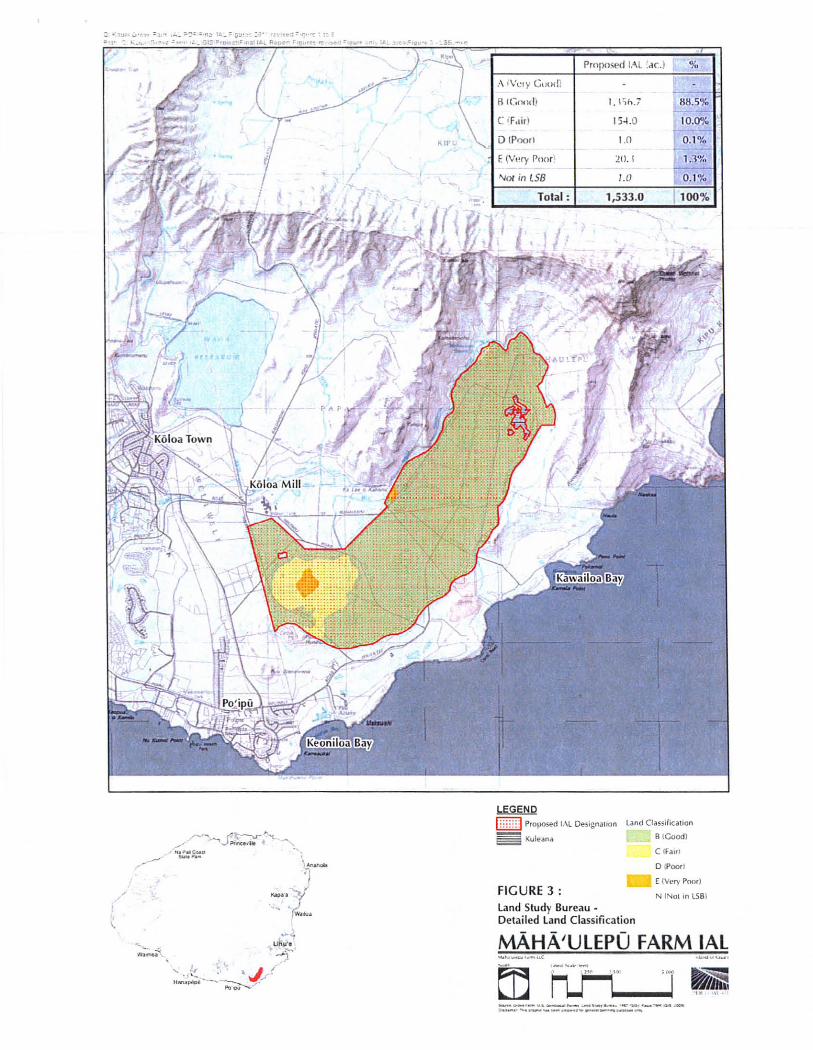
Figure 3: Agricultural Soils Productivity Ratings
The Detailed Land Classification System and Agricultural Land Productivity Ratings by the Land Study Bureau (LSB), University of Hawaii are based on a five-class productivity rating system using the letters A, B, C, D, and E, with A representing the class of highest productivity and E the lowest. As illustrated in Figure 3, about 88.5% of the proposed IAL lands are rated B. The balance of the proposed IAL lands, while rated C, D, E or N (Not in LSB) are either essential elements of the active agricultural operation (reservoirs, drainage ways, etc.) or the lands surrounded by the B rated lands.
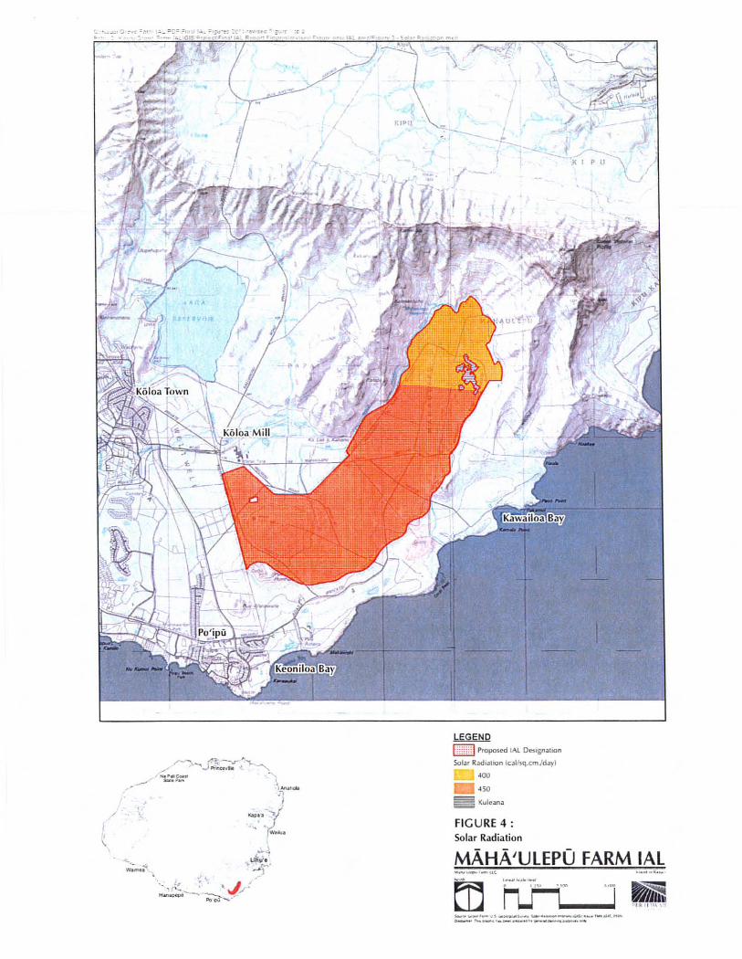
Figure 4: Solar Radiation
Based on the Sunshine Maps prepared in 1985 by the State Department of Business, Economic Development and Tourism, formerly known as the State Department of Planning and Economic Development, Energy Division, over 80.7% of the proposed IAL lands receive an annual average of 450 calories of solar energy per square centimeter per day and the balance of the lands receive an annual average 400 calories of solar energy per square centimeter per day.
Figure 5: Agricultural Lands of Importance to the State of Hawaii CALISHl
The Agricultural Lands of Importance to the State of Hawaii (ALISH) classification system was developed in 1977 by the State Department of Agriculture. The system was based primarily, but not exclusively, on the soil characteristics of lands and existing cultivation. There are three classes of ALISH lands - Prime, Unique, and Other. Approximately 77.9% of the proposed IAL lands are classified as Prime and Other ALISH: 41.5% Prime ALISH and 36.4% Other ALISH. The balance of the lands include essential elements of the active agricultural operation, such as the reservoirs and drainage ways, are classified Unclassified, or are not classified under ALISH classification.
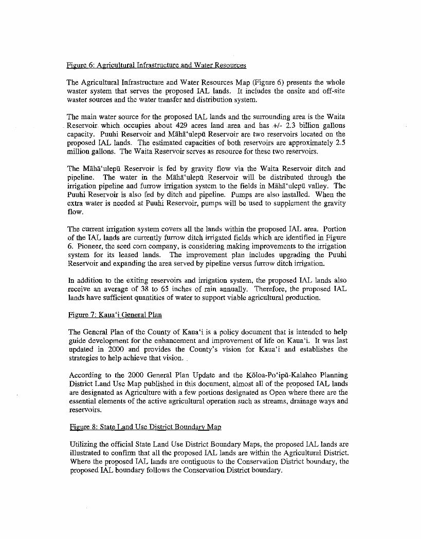
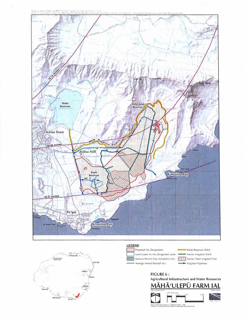
Figure 6: Agricultural Infrastructure and Water Resources
The Agricultural Infrastructure and Water Resources Map (Figure 6) presents the whole waster system that serves the proposed IAL lands. It includes the onsite and off-site waster sources and the water transfer and distribution system.
The main water source for the proposed IAL lands and the surrounding area is the Waita . Reservoir which occupies about 429 acres land ·area and has -+/- 2.3 billion gallons
capacity. Punhi Reservoir and Maha'ulepii Reservoir are two reservoirs located on the proposed IAL lands. The estimated capacities of both reservoirs are approximately 2.5 million gallons. The Waita Reservoir serves as resource for these two reservoirs.
The Maha'ulepii Reservoir is fed by gravity flow via the Waita Reservoir ditch and pipeline. The water in the Miiha'ulepii Reservoir will be distributed through the irrigation pipeline and furrow irrigation system to the fields in Maha'ulepii valley. The Puuhi Reservoir is also fed by ditch and pipeline. Pumps are also installed. When the extra water is needed at Puuhi Reservoir, pumps will be used to supplement the gravity flow.
The current irrigation system covers all the lands within the proposed IAL area. Portion of the IAL lands are currently furrow ditch irrigated fields which are identified in Figure 6. Pioneer, the seed com company, is considering making improvements to the irrigation system for its leased lands. The improvement plan includes upgrading the Puuhi Reservoir and expanding the area served by pipeline versus furrow ditch irrigation.
In addition to the exiting reservoirs and irrigation system, the proposed IAL lands also receive an average of 38 to 65 inches of rain annually. Therefore, the proposed IAL lands have sufficient quantities of water to support viable agricultural production.
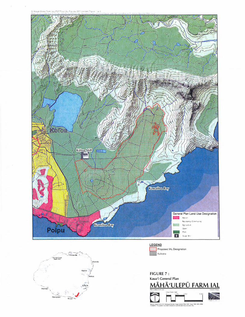
Figure 7: Kaua'i General Plan
The General Plan of the County of Kaua'i is a policy document that is intended to help guide development for the enhancement and improvement of life on Kaua'i. It was last updated in 2000 and provides the County's vision for Kaua' i aud establishes the strategies to help achieve that vision.
According to the 2000 Geueral PIau Update and the Koloa-Po'ipii-Kalaheo Planuing District Land Use Map published in this documeut, almost all of the proposed IAL lands are designated as Agriculture with a few portions designated as Open where there are the essential elements of the active agricultural operation such as streams, drainage ways and reservoirs.
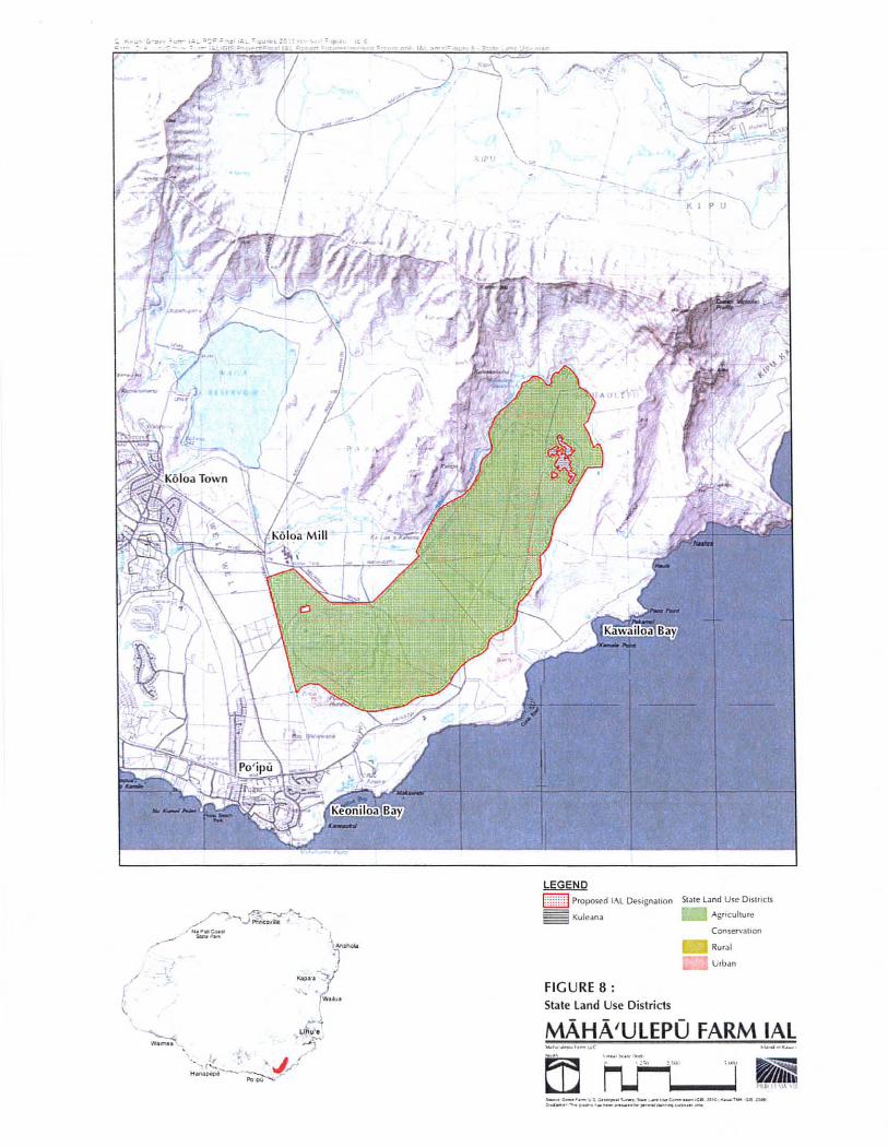
Figure 8: State Land Use District Boundary Map
Utilizing the official State Land Use District Boundary Maps, the proposed IAL lands are illustrated to confirm that all the proposed IAL lands are within the Agricultural District. Where the proposed IAL lands are contiguous to the Conservation District boundary, the proposed IAL boundary follows the Conservation District boundary.
PO F • C1 :IKd uai\Gl'Ovil F .. nn I ALlPDF\Fil~aIIAL Fi£lu foS 2011 1,ovise d fi£l uro'l to 8 i"'Cilh : U :IK",IH" IG ,ovu Fann I AL\GI 5\1~(Oluct \F IU .. IIAL
Vk_ut . .... GIq)
.t "
IlESERVOIR
\
r~r1,~ (fo- -v. P"}~'c~lVjii~ '~}Ll{-.: 0
Na PfoIU Coas. '..) ,f ~ ;. ~ ... SUlh. Pafk .. If.
~ ,: ' ,:blAnahol.
j:'~tA~ " ~\ / ~~~
\
' -. ,.;» ! I.- ' • •• ""
i:: ' ./ . " ( , .'f
- ..:; ) ,
;\ "
Hanapepe~~
, I
-"'- -
LEGEND
D Proposed IAL Designa !ion
Land Leases on IAl Designated Lands
D Ranchers ------------------ +/- 429ac
~ ~ Taro Cultiva tion --------- +/- 200ac
D Seed Companies -------- +/- aOSae
_ Independen! Farmer ---- +/- 36ae
~ Land Appl ica ti on --- ---- - +/- 45ac
_ Reservo irs --------- ---- ---- +/- 18ac
Fu ture Kauai Ka lo/Ta ro - +/- 245ac
',-1\ , '" ,
\ ~ " \ ....
/
FIGURE 1 :
Current and Future Agricultural Operation
~ .... ,<!
MAHA'ULEPO FARM IAL "w"~ · "lc ... u , .. "" 1I ~ .,'",k' ul ",,,,,,,',
rn l ~H,~1 x;lIc (jedl
hJ"" '1"" "'''I $w,(.: 0 . 00'. F.'1lI; U S O,".lOgIc:.' I .. " .. , : G ..... f .. m P,1Or Ag/l' ......... F,-"ll (G,SI : K.ulOl nllK toiS. 20(111, 0..0_,.,. 1111. fI •• phll: II_II .... ' ~, .. jHOI.lI ... 1/1'''.''''1'1''''''''11 ~ .. "" ... ""'~
h,mlAI
LEGEND
D" "" )<N'( " I\lJ)o.~!g ! !.ltll"!
c=J Kll h .. UM
Q,\K~,, ~i\G'''.r f l''" IAI.\ I'I)I \I in.IIAl rlK".n lQ ll \ ,~viH'd I ;Ku,e 1 to II
" /"'~;,:;, .. :~.,;.,- !
, " . /' / "1::1::' ~~_
I .,/ _ .• _-,: ~" \ .
\
:/ ,-, '" w_
L ",,' • , ~J
FIGURE 2:
............. ~ ' -') W._,. .J\ . ""k ,< ' J I --.. ~
Ma ha 'ulel)u Valiey Aerial rholn
MAHA'UlEPO FARM IAl .... , ...... ' . .. . m • • " ~~ .......... M'
ED • l' I UIt ! ~~\'tt
..... -" , .. _ ..... -......... __ ... _-
/ I
\.
'£ : I'. e , ~ i.e.
:\ (\.'el y Cumll
Ii l (;nll(1)
C IFdir)
LEGEND
1,I:;h,7
154.0
1.0
h :::: ~ PIOf>OSed IAL De§isn.lilOn
~Kul!!iI"a
Land ClolSsifica l ion
B (Good)
C ifoli ll
FIGURE 3 :
o (POOl I
l1li: E (V!!!)' POOl)
N INol In LS Bl
land Study Bureau -Detailed land Class ifi cation
MAHA'ULEPO FARM IAl
__ '_~"''-'''_:.-o_ ...... ,..,-. ._' _ _ , _ _ .' ..... _--_ ..... __ ... _--
" ,
---" / "-
I ~
~
w; .... ;f.
--s"...
1 -(
LEGEND
~m~d Proposed ,.-.l Oe~ilsnation Solar Radlallon (cal/sq.cmJd .. y)
' OU
450
Kuleana
FIGURE 4: Solar Radiation
MAHA'ULEPO FARM IAL ....... _ ,_ut
- '-'-'- ~" ... -- ...... -.--- -- ..... -.-- .... -.---.-........ ---.. ~

, , J
-
Proposed IAl Designation
Prime A1l5H
O,herAUSH
Unclassiiied
~ Kuleana
!'1I!l1l' tdu,.i
n Ih," ·,'in.:
· .... "m ' \ USII !l·j II
( -.
r FIGURE 5 : Agricultural lands of Importance to the Stale of Hawai'j
I
MAHA'UlEPO FARM IAl _ ... _" ...... ,
-"-'-""'-"-' --... .. ~- .".-. .... ,.. - , --",----_ ... _--- ....
~ ..... ::;.~ .. ~~., ....
f (.
/
LEGEND
1:: ::::1 Proposed IAL DeSignation _ Waita ReserVOir Di tch
c=J Laud Leases. 011 IAL DeSignated Lands - Furrow tmgatlon Onch
~ Kult:ana P.m:eI\ (I'<ot Included In tAll ~ Furro\\ Di tch Irngaloo F<eld
-- Aver~ge "nnu~1 RJiniJll tin. ) --... tmg':l\ ion Pipelines
FIGURE 6: Agricultu ral Infrastructure and Water Resources
MAHA'UlEPO FARM IAl .... "'_' ... 1..1.(
-.,,-.-~-........ ----". , :.-.0. ______ • • _____ _
C •• ~ .... _Jf::"'< ~~"T ... _ 1':'= ~., ' •. .,. ; ~ "'. ~O· . ~.~.t" i~1( j~ ;> •• _ • - '0 ,
/
\ ~"
uti ... ·• WA-;"";':c... . • ..01"
\ ... 'f~ : 'I. ~ •
H ..... ~ ... ·-' -..... 'ttI!/ PO I)':; .....
.... ""J.. .•
"',. -,,,. B 5~' '' '
LEGEND
1:::: ::1 Proposed lALOesignalion
~Kult'.n.a
FIG URE 7 : Kaua' j General Plan
MAHA'ULEPO FARM IAL _ ... _ ,._..u.
......- , ..... ,, ~ "'- ...... ,-_ ... _-, ..... '- , .... ,-........... __ .. __ ..... _------
LEGENp
F:g::1 ProJJOsed I. ... l Desigoation ~
~ Kuleana
FIGURE 8 : State l and Use Districts
If, }. t /~
.K ! P U
Stale land Use 0'51/1(15
.. ASriculture
Conserv,llion
" Rural U,b,ln
MAHA'UlEPO FARM IAl
ItIi 1 1:1111\1\ \11
EXHIBIT B
Agricultural Land Assessment for
Maha'ulepu Farm LLC
Maha ' ulepll, Kaua ' i
February 201 1
EXHIBIT " 8 " _.,.. .. _--"" .......
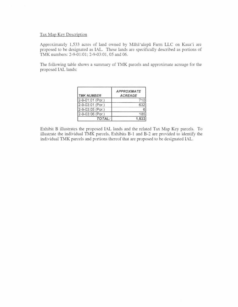
Tax Map Kev Description
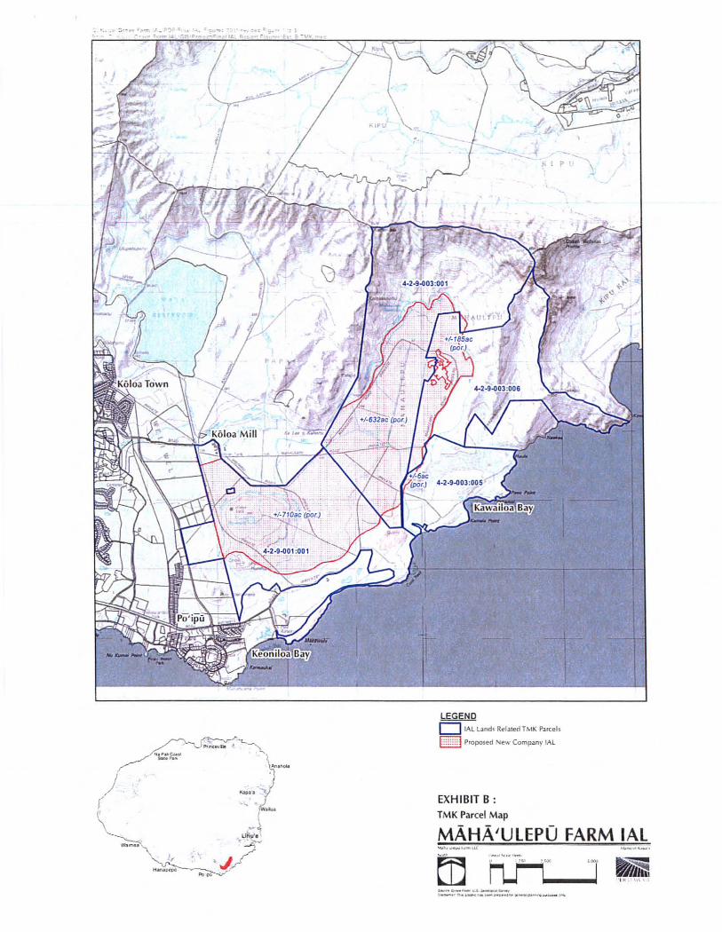
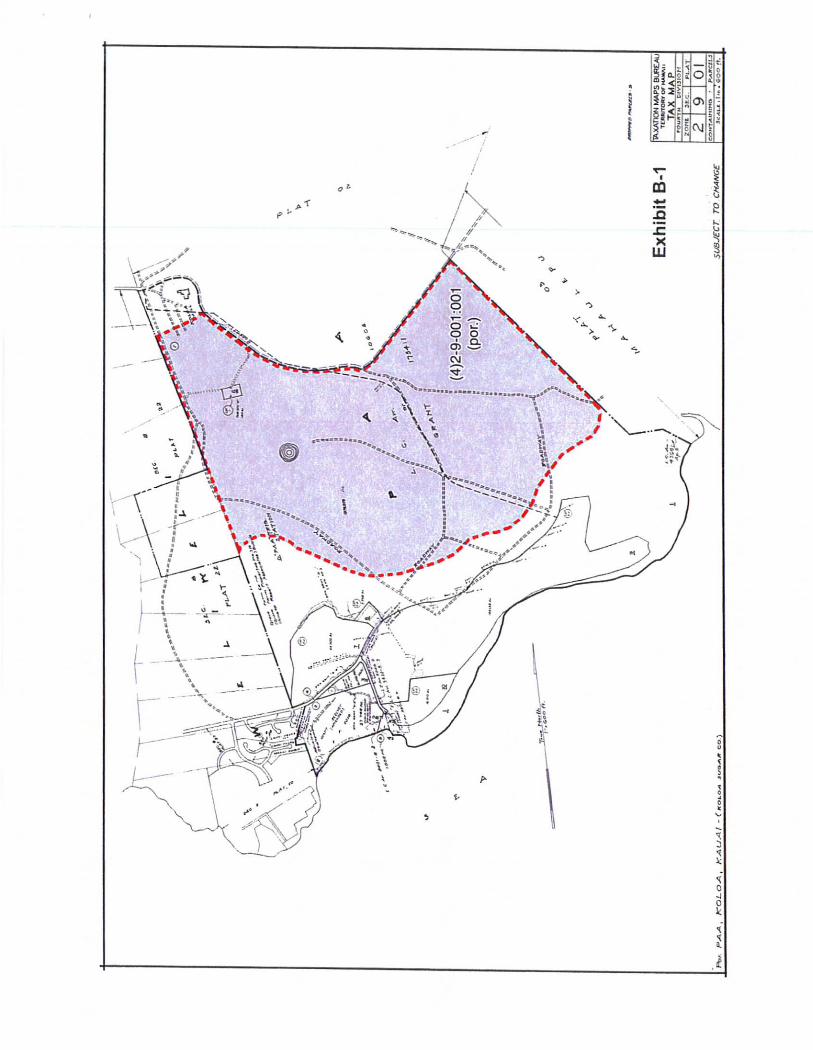
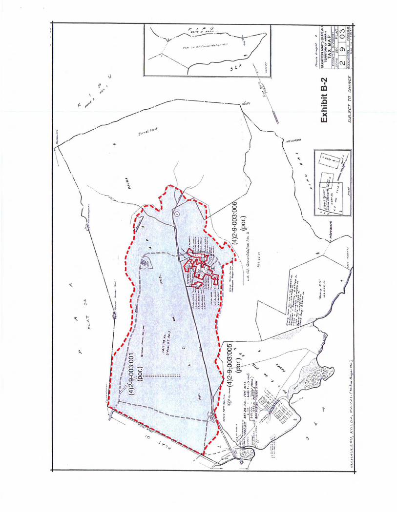
Approximate ly 1,533 acres of land owned by Maha' ulepii Farm LLC on Kaua ' i are proposed to be des ignated as IAL. These lands are spec ificall y described as portions of TMK numbers: 2-9-0 1:0 I; 2-9-03:0 1, 05 and 06.
The following table shows a summary of TMK parce ls and approximate acreage for the proposed lAL lands:
APPROXIMA TE TMK NUMBER ACREAGE 2-9-01:01 (Par.) 71 0 2-9-03:01 (Por. ) 632 2-9-03:05 (Por.) 6 2-9-03:06 (Por.) 185
TOTAL: 1,533
Exhibit B illustrates the proposed IAL lands and the related Tax Map Key parcels. To illustrate the individual TMK parce ls, Exhibits B- 1 and B-2 are prov ided to identify the individual TMK parcels and portions thereof that are proposed to be designated IAL.
.. , J
LEGEND o IflL Land< R@late"TMK Pan:;els
k ::::: J Proposed Ne ..... Company IAt
EXHIBIT B: TMK Parcel Map
MAHA'UlEPO FARM IAl
rn -"'!<'~'''''''
h.t1:-J ~ ' . v ' '' ,! __ '_U.a_ .. _ _ or ..... _ .... . _ .... ....... ____ _
4-
---
. • ./
• ~
• \
/
. •
i i
•
.... •
OJ
• (
1 : 1 ~
, ~/
\ ,
~ ,. ,
. . ':. •
• I , • , i ~--- .. ~ \ I \ I \ I , I , '
I {
~ ~ I I
" " I ,f . , 1
1
II
jJ ,I l!
• •
, ,
r::-----.- V· '-:"~ "'''4/ ~-.J
GI " .'
""I ".t- .~ ..
i