fourth five-year review report for
TRANSCRIPT

FOURTH FIVE-YEAR REVIEW REPORT FORDENZER and SCHAFER X-RAY COMPANY SUPERFUND SITE
OCEAN COUNTY, NEW JERSEY
Prepared by
U.S. Environmental Protection AgencyRegion 2
New York, N.Y.
--------------~~------------- C d k-22 ~/~~~------------~--------DateWalter Mugdan, Director
Emergency and Remedial Response Division
43747911111111111I11111111I111111111I111111111

Table of Comtemts LIST OF ABBREVIATIONS & ACRONYMS 3 I. INTRODUCTION 4
Site Background 4 FIVE-YEAR REVIEW SUMMARY FORM 7
II. RESPONSE ACTION SUMMARY 8 Basis for Taking Action 8 Response Actions 8 Status of Implementation 9 Institutional Control Summary Table 10 Operations, Maintenance and Monitoring 10
III. PROGRESS SINCE THE LAST REVIEW 10 Protectiveness Determination Table 11
IV. FIVE-YEAR REVIEW PROCESS 11 Community Notification, Involvement & Site Interviews 11 Data Review 11 Groundwater Sampling Results for Lead Summary Table 12 Figure 2, Pb in MW-3S 12 Figure 3, Pb in MW-5S 13 Figure 4, Pb in MW-7S 13 Figure 5, Pb in MW-10S 14 Site Inspection 14
V. TECHNICAL ASSESSMENT 15 QUESTION A: Is the remedy functioning as intended by the decision documents? 15
QUESTION B: Are the exposure assumptions, toxicity data, cleanup levels, and remedial action objectives (RAOs) used at the time of the remedy selection still valid? 15
QUESTION C: Has any other information come to light that could call into question the protectiveness of the remedy? 16
VI. ISSUES/RECOMMENDATIONS 17
VII. PROTECTIVNESS STATEMENT 17
VIII. NEXT REVIEW 17
APPENDIX A - REFERENCE LIST 18 Figure 1, Site Map 19
2

LIST OF ABBREVIATIONS & ACRONYMS ARAR Applicable or Relevant and Appropriate Requirement BNAs Base neutral/acid extractables CERCLA Comprehensive Environmental Response, Compensation, and Liability Act CFR Code of Federal Regulations CEA Classification Exception Area COPC Chemical of Potential Concern DES A Division of Environmental Science and Assessment ECO Ecological EPA United States Environmental Protection Agency FEMA Federal Emergency Management Agency FS Feasibility Study FYR Five-Year Review GWQS Groundwater Quality Standard ICs Institutional Controls MCL Maximum Contaminant Levels Mg/Kg milligrams/kilograms (ppm) MSL Mean Sea Level MW Monitoring Well NCP National Oil and Hazardous Substances Pollution Contingency Plan NJDEP New Jersey Department of Environmental Protection NJGWQS New Jersey Groundwater Quality Standards NPL National Priorities List O&M Operation and Maintenance OU Operable Unit Pb Lead ppb Parts per billion ppm Parts per million PRG Preliminary Remediation Goal PRP Potentially Responsible Party RAG Risk Assessment Guidance RAO Remedial Action Objectives RCRA Resource Conservation and Recovery Act RI Remedial Investigation ROD Record of Decision RPM Remedial Project Manager SARA Superfund Amendments and Reauthorization Act TAL Target Analyte List TBC To be considereds TCL Target Compound List UE Unlimited Exposure Ug/Kg Micrograms/Kilogram (ppb) Ug/L Micrograms/Liter (ppb) UU Unlimited Use VOC Volatile Organic Compounds WRA Well Restriction Area
3

L INTRODUCTION
The purpose of a Five-Year Review (FYR) is to evaluate the implementation and performance of a remedy in order to determine if the remedy is and will continue to be protective of human health and the environment. The methods, findings, and conclusions of reviews are documented in five-year review reports such as this one. In addition, FYR reports identify issues found during the review, if any, and document recommendations to address them.
The U.S. Environmental Protection Agency (EPA) is preparing this FYR pursuant to the Comprehensive Environmental Response, Compensation, and Liability Act (CERCLA) Section 121, consistent with the National Contingency Plan (NCP)(40 CFR Section 300.430(f)(4)(ii)), and considering EPA policy.
This is the fourth FYR for the Denzer and Schafer X-Ray Company Superfund Site. The triggering action for this policy review is the completion date of the previous FYR. The FYR has been prepared due to the fact that the remedial action will not leave hazardous substances, pollutants or contaminants on site above levels that allow for unlimited use and unrestricted exposure, (UU/UE) but requires five or more years to complete.
The Site consists of one Operable Unit (OU), which will be discussed in this FYR. OU1 addresses groundwater contamination at the Site.
The Denzer and Schafer X-Ray Superfund Site FYR was led by the Environmental Protection Agency (EPA) Remedial Project Manager (RPM), Matthew Westgate. Participants included Katherine Mishkin, Hydrogeologist, Urszula Filipowicz, Risk Assessor and Michael Clemetson, Ecological Risk Assessor. The review began on November 3, 2015 with a field inspection and groundwater sampling.
Site soils meet standards that allow for unlimited use without restriction and were not subject to CERCLA remedial actions. Upon completion of remedial activities, it is anticipated that groundwater will meet standards that allow for unlimited use without restriction. It is the policy of EPA to conduct FYRs when remedial activities, including monitoring, continue for more than five years. The first FYR for the Site was completed on September 27, 2001. A subsequent FYR was issued in September 2006, and an Addendum was completed in June 2007. The third FYR was completed in May 2011.
Site Background
Site Location
The Denzer & Schafer X-Ray Company is located on Block 858, Lot 46A on the north side of Hickory Lane (number 186) approximately 4,700 feet west of Route 9 in the Bayville area of Berkeley Township. The size of the property is approximately 10 acres. Barnegat Bay is approximately two miles to the east of the Site and Toms River is two miles to the north.
4

The Site is situated between two drainage systems. Potter Creek, which flows east to Barnegat Bay, is approximately 2,000 feet to the south. Wetlands associated with the headwaters of Mill Creek are 2,000 feet to the west and north. Mill Creek is a northeast flowing tributary of Toms River.
An unpaved access road runs across the north end of the Denzer & Schafer property roughly parallel to Hickory Lane. Single family residential neighborhoods are located to the north, northeast and east of the Site. Six commercial buildings and one residence are located to the west along Hickory Lane. Approximately 2,000 feet to the west are the Central Railroad of New Jersey tracks. A quarry and the Berkeley Township sewage treatment plant are immediately west of the tracks. A residential development exists to the south across Hickory Lane. (See Figure 1)
Physical Characteristics
The former Denzer & Schafer facility was located on a local topographic high about 50 feet above mean sea level (MSL). The immediate surrounding area is gently sloping, undeveloped and covered with pine trees. The wetlands associated with Potter and Mill Creeks are at an elevation of 30 feet above MSL. The surficial soil is classified as the Downer Loamy Sand. Typically, the soil is well-drained grayish brown, loamy sand.
Based on a review of flood insurance maps prepared by the Federal Emergency Management Agency (FEMA), the Site does not lie within the 100 or 500-year floodplain for either Mill or Potter Creeks.
Site Geology and Hydrology
The Site lies within the Atlantic Coastal Plain Physiographic Province. The coastal plain is a wedge-shaped series of unconsolidated sediments composed of clay, silt, sand and gravel of Tertiary and Cretaceous Age directly on the underlying crystalline igneous and metamorphic rocks that make up the basement complex. Thickness ranges from 0 feet near the fall line (Delaware River area) to 6,500 feet near Cape May County. In Berkeley Township, the Tertiary and Cretaceous age deposits are approximately 200 feet thick and are overlain by about 50 feet of flat lying Quaternary age deposits (Cape May Formation).
The main lithologic unit in the Site area is the Miocene age Cohansey Sand Formation, which is composed of yellowish-brown fine to coarse grained quartz sand interbedded with lenses of gravels, silts and clay. In Berkeley Township, it is thought to be about 250 feet thick and underlain by the Kirkwood Formation. The overlying Cape May Formation is fine to coarse quartz sand with interbedded clay and silt. The Cohansey-Kirkwood Aquifer is the major aquifer system of the New Jersey Coastal Plain.
Groundwater flow direction in the shallow aquifer is radial, reflecting the topographic high at the Site location. Deeper down, under the Cape May formation, the groundwater flow direction is to the northeast. A significant downward vertical gradient exists beneath the Site. Regional
5

groundwater flow direction in the area is to the east-northeast. Because these two formations are mostly sand, the permeability and hydraulic conductivity are high.
Land Use and Resource Use
The land surrounding the Site is partially undeveloped and forested with sandy soils. The developed land in the area of the Site is currently used for both commercial and residential purposes. During the time that the Denzer & Schafer X-Ray company was operating, the surrounding properties were mainly used for industrial or commercial businesses with some residential houses to the east along Hickory Lane and a larger residential development about 500 feet to the north. To the west, there was a lawn and garden service company, some other small businesses, the Ocean County Sewer Authority sewage treatment plant, and a quarry. During the late 1980s to early 1990s, another residential development consisting of approximately 180 homes was built to the south of the Site across Hickory Lane. Investigators visiting the Site in 2006 were told that a very large residential development was going to be built on the adjacent undeveloped land east of the Site. As of November 2015, no new homes were under construction, but construction of some of the street and curbs had been started. This property is included in the established Classification Exception Area/Well Restriction Area.
The abandoned Denzer & Schafer X-Ray facility buildings were demolished and shipped off-site for disposal in the mid-1990s by a developer. The property was then abandoned and Berkeley Township now uses the Site to store road construction materials.
History of Contamination
The Denzer & Schafer X-Ray Company was engaged in the reclamation of silver from microfilm and X-rays. Past activities at the facility have included the reclamation of silver by chemical stripping or incineration of used film. In 1974, the company switched from incineration to a caustic soda and salt silver reclamation process. Between 1974 and 1981, the facility disposed of its stripping solution by discharging it to the plant's subsurface sanitary septic system. Additionally, shredded and stripped film generated during the same time period (1974 to 1981) was stockpiled in an area just north of the process building. The stockpile of film waste was subsequently transferred to an off-site landfill. However, toward the latter years of operation, the stripped film waste began to be stored around the Site in cardboard containers.
Two Administrative Orders (January 1977 and May 1981) were issued to the Denzer & Schafer X-Ray Company by the New Jersey Department of Environmental Protection (NJDEP). NJDEP required Denzer & Schafer to cease discharging process waste into its septic system and to submit a proposal for permanent treatment and off-site disposal of its wastewater. From 1981 to 1991, process waste was transferred to on-site tanks for disposal off-site. Mr. Schafer conducted a groundwater investigation through mid 1984 which concluded that waste from past operations had contaminated groundwater at the Site
The old sanitary septic system, which received the process wastewater prior to 1981, has since been abandoned and filled with sand. After 1981, the newer septic system used to serve the Site was reportedly used for the disposal of sanitary waste only.
6

In addition to the silver recovery business, Microindustries, Inc., a microfilming service company, was located at the Site. Microindustries, Inc. was in operation from about 1970 to 1991 and has operated exclusively as a microfilming service company. Microfilm processing waste, such as photographic developers, acidic stop baths and fixers, were generated as part of the company's operations. These wastes were discharged to the plant's sanitary septic system prior to 1981. From 1981 to 1990, the microfilming process waste, reportedly about 25 gallons every six weeks, was transferred to the same on-site process wastewater storage tank used for storing the silver recovery process waste.
FIVE-YEAR REVIEW SUMMARY FORM
7

II. RESPONSE ACTION SUMMARY
Basis for Taking Action
A Remedial Investigation (RI) and Feasibility Study (FS) were undertaken by NJDEP under a cooperative agreement with EPA in 1986. A two-phased RI conducted by the state's contractor, SMC Environmental Services Group, was completed in April 1991. The surface water samples were generally free of priority pollutant compounds, However there were high levels of total coliform due to the sanitary wastewater system beneath an intermittent pond located on the property. Surface soil compound levels were all below NJDEP soil action levels. Silver was detected in the subsurface soils at the NJ Soil Action Level around the old septic system tank. No other samples were above action levels.
The first phase of groundwater sampling conducted in 1986 showed levels of volatile organics and some metals exceeding federal and state Drinking Water Maximum Contaminant levels (MCLs). NJDEP conducted additional groundwater sampling from 1992 to 1995. With respect to the volatile organic compounds, MCLs were not exceeded in any of the wells. Groundwater sampling results indicated that all metals, with the exception of lead, did not exceed MCLs in any monitoring well. The drinking water level for lead was slightly exceeded in three monitoring wells, two of which were located in the former leach field of the Denzer & Schafer facility. Air, surface water, and soil sampling results did not exceed action levels.
Human health risks were determined to be within the acceptable risk range; however, since MCLs were exceeded, it was determined that action was warranted to address future use of groundwater as a potential source of drinking water.
Ecological risks were not characterized because the contamination found is associated with ground water and no ecological exposure pathway exists.
Response Actions
Selected Remedy Following the completion of the RI/FS, a Record of Decision (ROD) for the Site was issued by EPA on September 28, 1995.
The goal of the remedy was to prevent any human exposure to contaminated groundwater.
The remedy selected in the ROD was No Action with long term monitoring. However, since at the time of the ROD the aquifer still exhibited low levels of contamination at the site itself, a monitoring program was warranted. A monitoring program was implemented which included monitoring of groundwater, surface water and sediment, including the intermittent pond directly east of the Denzer & Schafer X-Ray Company building, Potter Creek to the south and Mill Creek to the north. In addition, NJDEP established a Classification Exception Area based on the ground water monitoring to ensure that new wells will not be installed in the area without appropriate precautions.
8

Removal Actions
After the ROD was issued in 1995, the facility was abandoned by its owner, John Schafer, in March 1996. In April 1996, EPA conducted a Removal Assessment and removal action at the Site prompted by a public complaint of potentially hazardous materials left on the Site when the property was abandoned. As part of this action, the contents of seven 1,000-gallon tanks of caustic liquids were removed from inside the Site building, an underground storage tank was abandoned and removed, and other hazardous substances including 15 gallons of sodium thiosulfate, 200 drums and small containers of photographic chemicals, hydrochloric acid, flammable liquids and insecticides were removed from the Site. The ground surface was re-graded in the vicinity of the underground tank to eliminate the surface water pond which was found to contain coliform bacteria, evidence of a sanitary wastewater discharge.
Additionally, in 1997, under the authority and supervision of the NJDEP, Berkeley Village Development Corp., a housing developer in the area, demolished and disposed of the former facility building, abandoned and decommissioned the potable well and sanitary septic system and disposed of the stockpiled plastic and soil. The Site was landscaped in an effort to improve the aesthetics of this residential area. The ponded surface water bodies were re-graded and no longer exist, therefore, they are no longer available for sampling as specified in the 1995 ROD.
Status of Implementation
The organic contaminants found in the groundwater dissipated or degraded some time ago. The only residual contamination above MCLs that exists in the groundwater is lead and it is confined to an area near the former waste disposal field. EPA and NJDEP developed a monitoring program to sample surface water in the intermittent pond and groundwater in five remaining monitoring wells on an annual basis. However, the ground surface was re-graded in the vicinity of the intermittent pond, which eliminated the need to sample the surface water. EPA took over the groundwater sampling program in 2001, and continued through 2006/2007,2011 and 2015. Sampling frequency was reduced from annually to once every 5 years because of the static nature of the lead contamination in the shallow aquifer. Results from sampling conducted after the completion of the removal action in 1996 confirmed that additional surface water and soil sampling was not warranted.
Institutional Control Implementation
In January 1998, the NJDEP established a Classification Exception Area (CEA)/ Well Restriction Area (WRA) for the Cape May - Cohansey Aquifer beneath the Denzer & Schafer property and the adjacent 26-acre property to the east. In establishing a CEA for the impacted area, the NJDEP suspended the designated uses of the shallow aquifer until natural attenuation has restored the groundwater quality to Class IIA drinking water standards. A notice was attached to the deeds for the properties explaining that lead was present in the subsurface groundwater above health-based levels. Any potential purchasers of the property would be informed so they would not install potable wells in the upper 90 feet of the aquifer.
9
EPA published a Notice of Intent to Delete the Site from the National Priorities List in the Federal Register on August 18, 1998. The Site was deleted from the NPL on December 29, 1998.
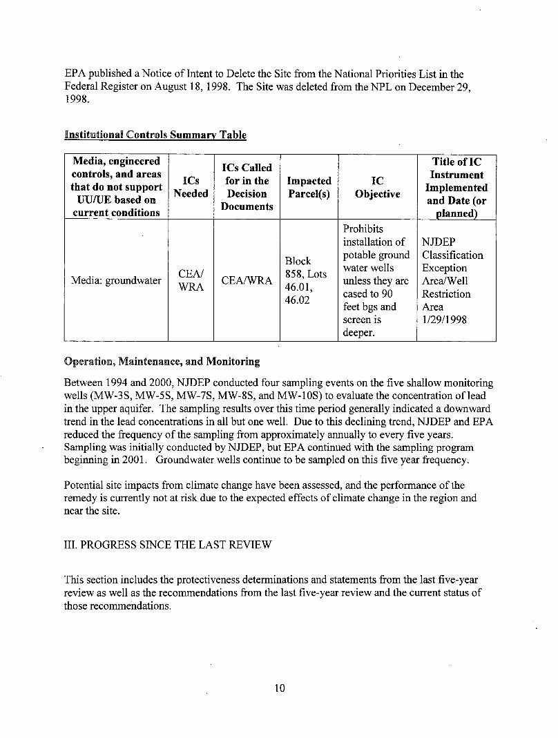
Institutional Controls Summary Table
Media, engineered controls, and areas that do not support UU/UE based on
current conditions
ICs Needed
ICs Called for in the Decision
Documents
Impacted Parcel(s)
IC Objective
Title of IC Instrument
Implemented and Date (or
planned)
Media: groundwater CEA/ WRA CEA/WRA
Block 858, Lots 46.01, 46.02
Prohibits installation of potable ground water wells unless they are cased to 90 feet bgs and screen is deeper.
NJDEP Classification Exception Area/Well Restriction Area 1/29/1998
Operation, Maintenance, and Monitoring
Between 1994 and 2000, NJDEP conducted four sampling events on the five shallow monitoring wells (MW-3S, MW-5S, MW-7S, MW-8S, and MW-10S) to evaluate the concentration of lead in the upper aquifer. The sampling results over this time period generally indicated a downward trend in the lead concentrations in all but one well. Due to this declining trend, NJDEP and EPA reduced the frequency of the sampling from approximately annually to every five years. Sampling was initially conducted by NJDEP, but EPA continued with the sampling program beginning in 2001. Groundwater wells continue to be sampled on this five year frequency.
Potential site impacts from climate change have been assessed, and the performance of the remedy is currently not at risk due to the expected effects of climate change in the region and near the site.
III. PROGRESS SINCE THE LAST REVIEW
This section includes the protectiveness determinations and statements from the last five-year review as well as the recommendations from the last five-year review and the current status of those recommendations.
10

Table 5: Protectiveness Determinations/Statements from the 2011 FYR
ou# Protectiveness Determination Protectiveness Statement
1 Protective The remedy at the Denzer & Schafer X-Ray Company Site is expected to be protective upon completion, and in the interim, exposure pathways that could result in unacceptable risks are being controlled. In addition, the State has established a Classification Exception Area to prevent exposure to contaminants until groundwater cleanup standards are achieved.
Sitewide Protective
There were no specific recommendations made in the 2011 Five Year Review.
IV. FIVE-YEAR REVIEW PROCESS
Community Notification. Involvement & Site Interviews
On November 19, 2015, EPA Region 2 posted a notice on its website indicating that it would be reviewing site cleanups and remedies at 32 Superfund sites and four federal facilities in New York and New Jersey, including the Denzer and Schafer site. The announcement can be found at the following web address: http://www2.epa.gov/sites/production/files/2015-11/documents/fy 16 fvr public website summarv.pdf. In addition to this notification, a public notice was made available by posting it on the Berkeley Township web site, on 7/11/2016, stating that there was a five-year review and inviting the public to submit any comments to the U.S. EPA. The results of the review and the report will be made available at the Site information repository located at Berkeley Township Public Library, 30 Station Road, Bayville, NJ 08721 or http://twp.berkelev.nj.us/index.aspx.
Data Review
In November 2015, samples were collected from four of the five monitoring wells (MW-5S, MW-7S, MW-8S, and MW-10S). MW-3S was not included in the monitoring program because it could not be located. With the exception of MW-8S (north east of the D&S building footprint), all sampling results show filtered lead concentrations remain above the state groundwater quality standard (GWQS) of 5 parts per billion (ppb). To better understand trends in each well, groundwater samples (filtered and unfiltered) were compared to samples collected since 1994 (see Table below).
These samples were submitted for volatile organics in addition to inorganic analysis. Sample results identified low concentrations of acetone (non detect to 5.6 pg/L), chloroform (non detect to 4.8 pg/L) and chloromethane (non detect to 0.83 pg/L).
11

Groundwater Sampling results for Lead, (all units in ug/L or ppb)
Year 1994 1996 1997 2000 2006 2011 2011 2015 2015
Location filtered filtered filtered filtered filtered unfiltered filtered unfiltered filtered MW-3s 4 19 29 17 18 28.6 14.5 N/A N/A MW-5S 48 123 30 61 23 37.6 12 12.5 7.6 MW-7S 16 4 2 4 Not
sampled 880
51*, 48* 0.7 2.3 28.8
MW-8S ND 3 ND ND 1 3.2 0.2 ND 3.8 4.6*
MW-10S 23 12 17 4 9 48.1 42*
69.5 27.9*
85.0 11.8
* indicates duplicate sample results
Figure 2. Lead concentrations in MW-3S from 1994 to 2015
filtered Pb in MW 3S 35 y = 0.0596X -102.32
S 30 4 29 R2 = 0.0024
B 25
~ 20 CO g 15 O
• 19 • is —4̂ 7
• 14.5
8 io JO
5 • 4 0 0 1990 1995 2000 2005 2010 2015
Year
12

Figure 3. Lead concentrations in MW-5S from 1994 to 2015.
filtered Pb in MW 5S
Year
Figure 4. Lead concentrations in MW-7S from 1994 to 2015.
filtered Pb in MW-7S
Year
13

Figure 5. Lead concentrations in MW-10S from 1994 to 2015
filtered Pb in MW 10S 80
3 70 • 69.5
a 60
§ 50
i 40
8 30 - - - - - —
u 20 • 23 -- " -Q
10 V l 2 # „ • 11.8
n • 5 u R"1 = 0.1119 1990 1995 2000 2005 2010 2015 2020
Year
The concentrations discussed above and shown in the trend graphs are for dissolved (filtered) concentrations of lead. Prior to 2011, only dissolved phase lead was sampled for in the groundwater. In 2011 and 2015, sampling events included both filtered and unfiltered samples. Generally, unfiltered samples show higher levels of lead concentrations because some of the lead is associated with tiny colloidal particles which are not caught in the filters and removed. There were some exceptions, (MW-7S and MW-8S in 2015) which are unexplained. Additional sampling may clarify the results in these wells. In summary, lead concentrations have remained below the NJDEP GWQS in MW-8S. Concentrations have been steady and slightly above the NJDEP GWQS in MW-3S. Lead levels are decreasing, but remaining above the NJDEP GWQS in MW-5S.
It is unclear why concentrations in MW-7S and MW-10 are showing an increasing trend, but more frequent groundwater monitoring would provide a better understanding of the current groundwater conditions and clarify whether seasonal fluctuations can account for the trends that are observed.
Site Inspection
The inspection of the Site was conducted on November 3, 2015. In attendance were Matthew Westgate, RPM, Robert Finke and Mark Denno, DESA Superfund Support Team of the U.S. EPA, Region 2. The purpose of the inspection was to assess the protectiveness of the remedy.
The physical site conditions are the same as they were five years ago in 2011. Site access by vehicles is controlled by guardrails in front of the property. Access is available by foot through the woods. The Site has some road construction materials stockpiled such as Jersey Barriers and dirt. There are signs of construction activity to the east, where a residential housing development is planned. The houses to the south across Flickory Lane are the same as in 2006, with no new
14

construction. Most of the Site is rural, wooded and undeveloped. Except for MW-3S, which could not be located, the four monitoring wells are in good shape and were locked. There were no signs of vandalism or trespassing and the vegetation appeared healthy and vigorous.
V. TECHNICAL ASSESSMENT
QUESTION A: Is the remedy functioning as intended by the decision documents?
The remedy selected in the 1995 ROD called for no action with monitoring and implementation of institutional controls.
Groundwater samples are collected every five years. With the exception of MS-7S, the remaining three wells samples continue to exceed lead NJDEP GWQS. It is recommended that the sampling frequency of groundwater be increased in order to better evaluate the current groundwater conditions and determine if fluctuations in lead concentrations are controlled by seasonal variations. Depending on the results of additional sampling, sampling of dowrigradient monitoring wells can be considered if necessary.
Implementation of Institutional Controls and Other Measures
In January 1998, NJDEP established a Classification Exception Area/Well Restriction Area on the Denzer & Schafer property Block 858, Lot 46.01 and the property directly to the east, Block 858, Lot 46.02. This was established because lead exceeded the Ground Water Quality Criteria between the ground surface and 40 feet below ground surface. Any potable well installed within this area must not include a screen which is within 90 feet of the ground surface.
QUESTION B: Are the exposure assumptions, toxicity data, cleanup levels, and remedial action objectives (RAOs) used at the time of the remedy selection still valid?
There have been no physical changes to the Site that would adversely affect the protectiveness of the remedy. Land use assumptions, exposure assumptions and pathways considered in the decision document followed the Risk Assessment Guidance for Superfund used by the Agency and remain valid. Although specific parameters may have changed since the time the risk assessment was completed, the process that was used remains valid.
The Human Health Risk Assessment performed during the RI indicated that the chemicals of concern present at the Site did not pose a significant risk to human health and the environment. The decision document called for no action with continued groundwater monitoring as the selected remedy. Residents in the vicinity of the Site are receiving public water, thus there is no direct exposure to contaminated groundwater through ingestion. Further, in 1998 NJDEP established a CEA/WRA for the property and the adjacent 26-acre property to the east. Although the Site area itself remains an undeveloped wooded lot, a portion of the 26-acre property to the east is currently undergoing residential development. In establishing a CEA for the impacted area, NJDEP suspended the designated uses of the shallow aquifer until natural attenuation has restored the groundwater quality to Class IIA drinking water standards. Therefore, the
15
CEA/WRA ensures that all current and potential future use of groundwater is an incomplete exposure pathway.
No remedial action objectives were identified in the ROD; therefore, they cannot be evaluated in this review. The remediation goals, however, were to prevent any human exposure to contaminated groundwater. Since there is no human exposure to the contaminated groundwater at the Site and residences in the vicinity have been connected to the public water supply, the remediation goals have been met and remain valid.
During the November 2015 sampling event, samples were analyzed for volatile organics in addition to inorganic analysis. Sample results identified low concentrations of acetone (non detect to 5.6 pg/L), chloroform (non detect to 4.8 pg/L) and chloromethane (non detect to 0.83 pg/L). These maximum concentrations were compared to corresponding Vapor Intrusion Screening Levels (VISLs) for groundwater established by the OSWER Technical Guide for Assessing and Mitigating the Vapor Intrusion Pathway from Subsurface Vapor Sources to Indoor Air (USEPA, 2015). This guidance was developed to supersede and replace the 2002 Draft OSWER Guidance used during the 2011 Five Year Review. Groundwater VISLs for the residential pathway, taking into account acceptable levels of cancer risk (1 x 10"6) and non-cancer hazard index (1) were used for the evaluation. Such levels of risk would be protective of any potential future residential receptor living in the homes currently under construction east of the Site. Results indicate that current volatile organic concentrations are well within an acceptable risk range. Furthermore, no buildings exist on the Site itself, hence vapor intrusion is not of concern.
Ecological Risk was not characterized because the contamination is present in the groundwater and no ecological pathway exists.
QUESTION C: Has any other information coine to light that could call into question the protectiveness of the remedy?
No other information has come to light that could call into question the protectiveness of the remedy.
16

VI. ISSUES/RECOMMENDATIONS OU(s): Issue Category: Monitoring
Note: If'other' is chosen, please provide an explanation in this box. OU(s):
Issue: Lead levels have increased in 2 of 4 wells. Volume of data is insufficient to get a clear understanding of trends
OU(s):
Recommendation: Increase sampling frequency to better understand lead trends
Affect Current Protectiveness
Affect Future Protectiveness
Party Responsible
Oversight Party
Milestone Date
No No EPA/State EPA/State August, 2019
VII. PROTECTIVENESS STATEMENT
Protectiveness Statement(s)
Operable Unit: Protectiveness Determination: Planned Addendum Short-term Protective Completion Date:
8/1/2019
Protectiveness Statement: The remedy at the Denzer & Schafer X-Ray Company Site currently protects human health and the environment in the short term because the State has established a Classification Exception Area (CEA)/Well Restriction Area (WRA) to prevent exposure to contaminants until groundwater cleanup standards are achieved. In order to be protective in the long term, the groundwater monitoring plan needs to be modified for additional sample collection to better understand plume.
VIII. NEXT REVIEW
The next five-year review report for the Denzer and Schafer X-Ray Company Superfund Site is required five years from the completion date of this review, in September 2021.
17

APPENDIX A - REFERENCE LIST
Table 2. List of Documents reviewed for the Fifth Five-Year Review
Record of Decision, Denzer and Schafer X-Ray Company, Bayville, Ocean County, NJ (9/29/95)
Five-Year Review, Denzer and Schafer X-Ray Company, Bayville, Ocean County, NJ (9/27/01)
Five-Year Review, Denzer & Schafer X-Ray Company, Bayville, Ocean County, NJ (09/01/06)
Five-Year Review Addendum, Denzer & Schafer X-Ray Company, Ocean County, NJ (June 1, 2007)
Five-Year Review, Denzer & Schafer X-Ray Company Site, Bayville, Ocean county, NJ (May, 2011)
18

Figure 1 On-Site Soil and Ground
-Water Sampling Locations ' • V.