gateway integrated transportation strategy and ... park service u.s. department of the interior...
TRANSCRIPT

National Park Service U.S. Department of the Interior Gateway National Recreation Area New York and New Jersey
Gateway Integrated Transportation Strategy and Implementation Plan
PMIS No. 76518 March 2004 John A. Volpe National Transportation Systems Center Research and Special Programs Administration U.S. Department of Transportation in association with Norris and Norris Associates

Standard Form 298 (Rev. 8/98)
REPORT DOCUMENTATION PAGE
Prescribed by ANSI Std. Z39.18
Form Approved OMB No. 0704-0188
The public reporting burden for this collection of information is estimated to average 1 hour per response, including the time for reviewing instructions, searching existing data sources, gathering and maintaining the data needed, and completing and reviewing the collection of information. Send comments regarding this burden estimate or any other aspect of this collection of information, including suggestions for reducing the burden, to Department of Defense, Washington Headquarters Services, Directorate for Information Operations and Reports (0704-0188), 1215 Jefferson Davis Highway, Suite 1204, Arlington, VA 22202-4302. Respondents should be aware that notwithstanding any other provision of law, no person shall be subject to any penalty for failing to comply with a collection of information if it does not display a currently valid OMB control number. PLEASE DO NOT RETURN YOUR FORM TO THE ABOVE ADDRESS. 1. REPORT DATE (DD-MM-YYYY) 2. REPORT TYPE 3. DATES COVERED (From - To)
4. TITLE AND SUBTITLE 5a. CONTRACT NUMBER
5b. GRANT NUMBER
5c. PROGRAM ELEMENT NUMBER
5d. PROJECT NUMBER
5e. TASK NUMBER
5f. WORK UNIT NUMBER
6. AUTHOR(S)
7. PERFORMING ORGANIZATION NAME(S) AND ADDRESS(ES) 8. PERFORMING ORGANIZATION REPORT NUMBER
9. SPONSORING/MONITORING AGENCY NAME(S) AND ADDRESS(ES) 10. SPONSOR/MONITOR'S ACRONYM(S)
11. SPONSOR/MONITOR'S REPORT NUMBER(S)
12. DISTRIBUTION/AVAILABILITY STATEMENT
13. SUPPLEMENTARY NOTES
14. ABSTRACT
15. SUBJECT TERMS
16. SECURITY CLASSIFICATION OF: a. REPORT b. ABSTRACT c. THIS PAGE
17. LIMITATION OF ABSTRACT
18. NUMBER OF PAGES
19a. NAME OF RESPONSIBLE PERSON
19b. TELEPHONE NUMBER (Include area code)

Contents Acknowledgments iii Executive Summary iv Evaluation criteria iv
Demand iv Visitor experience and NPS policy goals v Waterside and landside access strategies v Implementation feasibility v Finances v
Recommendations v Ferry dock and support infrastructure phasing v Ferry service routes and operations phasing vi Dock management and concession agreements vi
Other action-plan items vii Chapter 1 Introduction: Purpose, Rationale, and Goals 1 Background 2
Overview of current conditions 2 Sandy Hook 3 Jamaica Bay 3 Staten Island 3 Battery Park 4
Water transportation context 4 Reasons for expansion: purpose and rationale 4
9/11, the 2003 blackout, and New York-area trends 4 Stakeholder interest in ferry expansion 8 Water transportation plans 8 Gateway’s interest 10
Chronology (efforts to date) and supporting documentation 11 Chapter 2 Evaluation Criteria 13 Demand 13 Visitor experience and NPS policy goals 14
Enhanced visitor experience goals 14 Ferry operations, dock ownership and management goals 14 Year-round ferry landing goals (where applicable) 14
Waterside and landside access strategies 14 Implementation feasibility 15 Finances 15
Capital costs (waterside) 15 Capital costs (landside) 15 Management/maintenance 15 Funding sources/partnerships 16 Service scenarios, prioritization and phasing, and next steps 16
Chapter 3 Site Analysis: Sandy Hook/Fort Hancock 17 Unit overview 17
Ferry landing site and context 17 Ferry service history 18 Ferry landing redesign 20
Evaluation criteria 20 Demand 20 Visitor experience and NPS policy goals 23 Waterside and landside access strategies 25 Implementation feasibility 29 Finances 30
Implementation scenarios 32
Volpe Center Gateway Integrated Transportation Strategy, March 2004 i

Ridership projections 33 Prioritization, phasing, and action-plan items 34 Chapter 4 Site Analysis: Jamaica Bay/Riis Landing 35 Unit overview 35
Ferry landing site and context 36 Ferry service history 39 Ferry landing redesign 39
Evaluation criteria 40 Demand 40 Visitor experience and NPS policy goals 43 Waterside and landside access strategies 45 Implementation feasibility 51 Finances 52
Implementation scenarios 53 Prioritization, phasing, and action-plan items 55 Chapter 5 Site Analysis: Staten Island/Fort Wadsworth 56 Unit overview 56
Ferry landing site and context; ferry service history 57 Ferry landing design/development 59
Evaluation criteria 59 Demand 59 Visitor experience and NPS policy goals 61 Waterside and landside access strategies 61 Implementation feasibility 65 Finances 65
Implementation scenarios 67 Ridership projections 67
Chapter 6 Site Analysis: Battery Park 69 Unit overview 69
Ferry landing site and context 69 Evaluation criteria 71
Demand 71 Visitor experience and NPS policy goals 73 Waterside and landside access strategies 73 Implementation feasibility 78 Finances 78
Implementation scenarios 79 Ridership projections 80
Chapter 7 Service Scenarios, Prioritization, and Phasing 81 Prioritization and phasing by location 83
Sandy Hook 83 Jamaica Bay 85 Staten Island/Fort Wadsworth 87 Visitor support amenities 87 Battery Park 89
Chapter 8 Action Plan Recommendations and Next Steps 91 General recommendations and next steps 91
1. Refine procedures for collecting ferry ridership data 91 2. Collect new survey data for continuous market monitoring 91 3. Monitor operator costs to ensure effective concessions 91 4. Continue coordination with other New York Harbor stakeholders 92
Action items by location 92 Sandy Hook 92 Jamaica Bay 92 Staten Island/Fort Wadsworth 92 Battery Park 92
Volpe Center Gateway Integrated Transportation Strategy, March 2004 ii

Acknowledgments Over the past several years, many different people and agencies have assisted in transportation planning for Gateway National Recreation Area. In the recent preparation of this report, the assistance of the following is gratefully acknowledged: Joanne Conroy, Seastreak Barbara Jones, NY Waterway John Lancos, Gateway National Recreation Area Jackie Lowey, NY Waterway Rob Pirani, Regional Planning Association John Ruzich, NY Waterway Dena Saslaw, Gateway National Recreation Area Dave Stafford, Seastreak
Volpe Center Gateway Integrated Transportation Strategy, March 2004 iii

Executive Summary Gateway National Recreation Area, comprising various waterfront sites surrounding New York Harbor, is a heavily-visited unit of the National Park Service (NPS) that is increasing in popularity—there were more than 10 million visitors in 2002, up over 50% from 1999. Two of these sites—Sandy Hook in New Jersey and Riis Landing in Jamaica Bay, Queens—are now served by popular ferry routes. Several times on summer weekend days—ten times during each of 2001 and 2002—boats to Sandy Hook run full. Gateway is interested in expanding its water transportation services for several reasons: To maintain access to its sites and resources in the face of growing automobile congestion. For instance,
Sandy Hook’s parking areas routinely fill up during the summer season, making it very difficult to visit by car.
To better distribute visitors between heavily-used and more lightly-used park sites. Many park visitors who are seeking outdoor recreational activities now go to the nearest Gateway unit; they would make use of similar resources, less congested but farther away, if better transportation connections were available.
To broaden visitation across New York Harbor beyond those who live in proximity to Gateway units. To provide transportation alternatives for would-be visitors who do not own cars. To create better interpretive connections and an enhanced visitor experience using the important
thematic and historic element of New York Harbor, which should serve to unite Gateway as “the gateway to America.”
To coordinate its own transportation system with a burgeoning interest in expanded water transportation (especially for emergency-management purposes) among numerous New York-area stakeholders.
This report was prepared for the National Park Service by the U.S. Department of Transportation John A. Volpe National Transportation Systems Center. The information and technical analysis herein was carried out by Norris and Norris Associates, through Childs Engineering, Inc., under separate contract to the Park Service for fulfillment of the task plan pertaining to the relevant PMIS (No. 76518). The Volpe Center’s role, as tasked, was to develop the report structure and to accordingly organize, format, and edit the content provided. This report builds on the April 2001 National Parks of New York Harbor Waterborne Transportation Study, prepared by the Volpe Center, which used a demand and cost analysis to identify promising Gateway dock sites for service expansion. Along with the associated ferry routes identified in the 2001 report, those sites—Sandy Hook, Jamaica Bay/Riis Landing, and Staten Island/Fort Wadsworth, as well as Battery Park in Lower Manhattan (which houses Castle Clinton National Monument and is an important ferry access point)—are now examined, in this report, in the context of an integrated transportation strategy and implementation plan. Evaluation criteria Consistent evaluation criteria are used in this report to analyze each of the four dock sites and their associated ferry routes. The categorical evaluation consists of five components: demand, visitor experience and NPS policy goals, landside and waterside access strategies, implementation feasibility, and finances. Demand The report makes use of ridership data on water transportation services provided at Sandy Hook (from 1997) and at Riis Landing (from 2001), as well as the results of focus groups conducted in 2001 for Gateway by the Regional Plan Association. However, in terms of forecasting future demand for ferry services, several challenges exist: a lack of visitor-survey data since the 1970s, Gateway’s unique thematic and interpretive elements, the special appeal of ferries (especially in post-9/11 New York), and the general challenge of understanding the market for recreational/national-park transportation services as opposed to the home-to-work commuter services that are more usually modeled using well-established forecasting techniques.
Volpe Center Gateway Integrated Transportation Strategy, March 2004 iv

Nonetheless, the report, by drawing on the methodology developed for the 2001 Waterborne Transportation Study and by introducing new approaches to demand analysis, takes account of these circumstances to produce projected ridership figures for proposed new ferry routes. Visitor experience and NPS policy goals Gateway has an interest in promoting a positive visitor experience, and New York Harbor, currently under-utilized in this way, can be a powerful interpretive and thematic element as part of a visit to Sandy Hook, Jamaica Bay, or Staten Island—an important consideration when evaluating proposed new water transportation services. Also, it is important that any new services are evaluated according to the National Park Service’s mission and other established policy goals. Waterside and landside access strategies How proposed water transportation services would integrate with land-based transportation services is crucial to the success of any new operations. For each of the four sites, landside access strategies are discussed. Landside access ties in with physical implementation feasibility (especially disability access and environmental sensitivity), the visitor experience, and associated landside costs. Implementation feasibility Each dock-site and ferry-route possibility is subjected to an analysis of implementation feasibility—essentially, a “reality-check” physical assessment as to the possibility of expanding or introducing transportation services, given geographical, navigational, and environmental conditions. This report’s analysis proceeds from the 2001 study’s wider site evaluation, which recommended specific ferry landing locations and concept designs for those sites. Finances The finances component consists of four sections: capital costs (waterside), capital costs (landside), management/maintenance costs, and funding sources/partnerships. All costs are defined as those to be borne by Gateway. However, so that Gateway can negotiate the best possible concession/management arrangements, it is important that operators’ costs also be considered. Recommendations The categorical evaluation indicates a phased sequence of actions to enhance and expand upon existing Gateway ferry services. Generally, the goals are:
To proceed with construction of new and expanded ferry dock and support infrastructure facilities,
making use of funds already available for such purposes. To introduce expanded and new/demonstration services and operations in accordance with
demonstrated and forecast visitor demand (and operator interest). To continuously collect and monitor demand and cost data to ensure the viability of such services and
the effectiveness of dock management and concession agreements. Ferry dock and support infrastructure phasing 1. Construction of expanded dock at Riis Landing (Jamaica Bay).
The Riis dock expansion and support project is ready; $1.2m in funds are available, and designs and permits are complete. Bid and construction scheduled for October 2003–April 2004.
2. Design and permitting of Sandy Hook Landing.
Design and permitting of Sandy Hook will be based on the present concept design (completed in February 2002). Once design/permit funding ($300K) is acquired and that phase is undertaken, the new facility will be ready for construction. Depending on availability of funds, this could be completed during 2003–2004.
3. Fort Wadsworth (Staten Island) Interim Landing.
The floating barge currently at Riis Landing will be transported to Fort Wadsworth for interim use, pending design and permitting (which will require $400K). Probable schedule target: 2004 season.
Volpe Center Gateway Integrated Transportation Strategy, March 2004 v

4. Construction of Sandy Hook Landing. Once the design, environmental compliance, and permitting activities are completed, Sandy Hook Landing can be constructed, pending acquisition of additional funding (estimated at $1.5m). Given the likelihood of a thorough environmental review and permitting process, the probable schedule target for construction would be 2004–05 at the earliest.
5. Torpedo Pier restoration at Fort Wadsworth.
Restoration of the Torpedo Pier, to include a permanent floating ferry landing, requires final design and permits, bid, and construction. Funds have been appropriated, but this project is scheduled for 2006–07 at the earliest.
6. Battery Park Landing.
Final site transfer negotiations are required, followed by completion of planning, design, and permits, acquisition of funding (estimated $900K), bids, and then construction. Longer term: 2005–2007 time frame.
Ferry service routes and operations phasing The array of proposed routes and services is based on two of the services currently (summer 2003) in operation—Lower Manhattan/Battery Park to Sandy Hook and Lower Manhattan/Battery Park to Riis Landing. Proposed routes are either variations on (Fort Wadsworth) or extensions of (Jamaica Bay/Bayshore shuttles) these current services. 1. Jamaica Bay/Riis Landing service:
Expand services on completion of the landing, including: a. Manhattan to Riis; b. New Jamaica Bay shuttles; c. Expansion of excursions and charters; d. Starting year-round commuter service to Manhattan.
2. Sandy Hook service:
Continue current Manhattan service until permanent dock is completed; expand services after dock completion, including:
a. Expanded Manhattan services; b. New seasonal Bayshore intercept shuttles; c. Adding new excursion and charter services.
3. Staten Island/Fort Wadsworth service:
Start new services after completion of interim pier, including: a. Intermediate stops on Sandy Hook and Riis routes; b. Excursion and charter services for school, tour and excursion groups; c. Proposed Upper Bay Harbor Loop stop.
4. Battery Park service:
In the longer term, after completion of the new hub landing: a. All Manhattan services would be expected to stop at Battery Park; b. Shuttle connections from other Hudson or East River sites; c. Scheduled excursions to Gateway parks; d. Future links to Governors Island.
Dock management and concession agreements The following findings apply to management and concession agreements negotiated by Gateway for the private operation of its water-transportation services. Ferry service assumptions: All ferry service operating costs should be borne by private operators with
concession agreements, with ferry docks owned and managed by the parks. This arrangement is similar to those in effect with respect to all current ferry services to Gateway units, as well as services to other New York Harbor park units, including Statue of Liberty National Monument.
Volpe Center Gateway Integrated Transportation Strategy, March 2004 vi
Concession guidelines and agreements: A consistent set of concession guidelines and agreement procedures is needed for different park units and ferry routes. Different routes may be run by the same operators.
Variable concession terms: Terms may vary depending on whether the service is established or a start-up.
A new service or demonstration service, such as the 2003 Riis Landing-to-Manhattan route, may have a short term and more flexible conditions, whereas a more established route, such as Manhattan-to-Sandy Hook, may have a longer term and added conditions.
Fare structures: Fares will vary by route distance and frequency, to cover the costs of operation. Longer-
distance routes, such as Sandy Hook-to-Manhattan or Riis Landing-to-Manhattan, will have higher fares; shorter routes, such as the Bayshore intercept or the Jamaica Bay shuttles, should have lower fares. Agreements should encourage affordable fares and may require annual audits or other cost reporting tools so Gateway can ensure that realized operating margins are as predicted.
Continuous market assessment: Agreements could include operator requirements to conduct annual
rider surveys to be shared with Gateway units, enabling them to collect rider data and to assist in improving service and the visitor experience.
Other action-plan items Beyond phasing in the new ferry infrastructure and ferry services as prioritized in this report, several action-plan recommendations and next steps are identified for Gateway as a whole. These recommendations, based on the findings listed above, include: reconciling the means of ferry-rider data collection, conducting new visitor surveys (for the first time since the 1970s), continuously evaluating ferry route demand and cost calculations so as to ensure the effectiveness and efficiency of concession management agreements, and continuing to coordinate water-transportation initiatives with other New York Harbor parks and agency stakeholders interested in ferry services.
Volpe Center Gateway Integrated Transportation Strategy, March 2004 vii

Chapter 1 Introduction: Purpose, Rationale, and Goals Gateway National Recreation Area—comprising the Sandy Hook, Jamaica Bay, and Staten Island Units—was established by Congress in 1972 as one of the first urban parks in the National Park System. A popular destination for outdoor activities such as swimming, sunbathing, and picnicking, Gateway (as shown on the cover) covers more than 26,000 acres around New York Harbor, stretching from Sandy Hook in New Jersey to Jamaica Bay and Breezy Point in Queens, New York. In 2002, over 10 million people visited Gateway sites—more than a 50% increase from just three years earlier. Because Gateway’s sites are on the water, at the urban edge, it can be difficult for visitors to access them via land transportation—cars, buses, and rail. Some water transportation services—from points in Manhattan to Sandy Hook and to Riis Landing in Queens—are currently operated, providing additional, important links to these Gateway units. The ferry to Sandy Hook, in operation since the 1997 season, often runs full during summer weekend days—more than ten times in each of 2001 and 2002. As visitation continues to grow, traffic congestion and parking problems—as throughout the National Park System—begin to degrade the visitor experience. Improving the transportation system therefore becomes imperative if Gateway is to continue to provide its visitors an enjoyable experience. For a variety of reasons, expanding water transportation services seems to be the most promising way to improve access to Gateway. Two of these reasons—demonstrated and predicted visitor demand, and Gateway’s desire to utilize New York Harbor as an important thematic element in visits to its sites—are especially compelling. It is also noteworthy that visitor, operator, and agency interest in ferries has increased substantially following the September 11, 2001 terrorist attacks on the World Trade Center, which laid bare the vulnerability of the New York area road and rail infrastructure. Interest in ferries increased even further in the wake of the blackout of August 14–15, 2003; while the New York and New Jersey rail systems were inoperative, and other landside transportation methods were in chaos, ferries transported several times the usual number of daily passengers. This report aims to explain how and why Gateway’s water transportation system should be expanded as part of an integrated transportation strategy and implementation plan. Chapter 1 (this chapter) describes this purpose in more detail and provides additional background material. Chapter 2 outlines the evaluation criteria by which proposed transportation service expansions at three Gateway sites—Fort Hancock/Sandy Hook, Jamaica Bay/Riis Landing, and Staten Island/Fort Wadsworth—as well as Battery Park in Manhattan, the site of Castle Clinton National Monument, are assessed (Chapters 3–6). Chapter 7 outlines how, and with what priority, proposed transportation expansions could be phased in, and describes the resulting service scenarios. The concluding section, Chapter 8, lists recommendations for next steps, laying out a sequence of events toward implementation. This report was prepared for the National Park Service by the U.S. Department of Transportation John A. Volpe National Transportation Systems Center. The information and technical analysis herein was carried out by Norris and Norris Associates, through Childs Engineering, Inc., under separate contract to the Park Service for fulfillment of the task plan pertaining to the relevant PMIS (No. 76518). The Volpe Center’s role, as tasked, was to develop the report structure and to accordingly organize, format, and edit the content provided. This report expands upon earlier efforts, notably the April 2001 report National Parks of New York Harbor Waterborne Transportation Study, prepared by the Volpe Center in association with Norris and Norris, Cambridge Systematics, Inc., and the Childs Engineering Corporation (the “2001 report”). The 2001 report was a broad assessment of possible dock sites and ferry routes serving the parks of New York Harbor, and used a demand and cost analysis to identify promising Gateway dock sites for service expansion; this report begins with that report’s findings, proposing an integrated strategy and implementation plan for the sites and routes identified in 2001 as the most promising. This report also references the findings of the Regional Plan Association’s 2002 report, A Beach and Much More, which was conducted in cooperation with Gateway and also addressed PMIS No. 76518. (See the “Chronology” heading, below, for more details.)
Volpe Center Gateway Integrated Transportation Strategy, March 2004 1

Background Gateway National Recreation Area fills a unique role in connecting the nation’s largest metropolis with its historic waterfront and maritime heritage. Gateway’s Staten Island, Sandy Hook, and Jamaica Bay units offer some of the New York region’s most spectacular beaches, an internationally renowned wildlife refuge, salt marshes, fishing areas, hiking trails, fields, and a multiplicity of activities, cultural resources, and educational services. The location of these remarkable resources amidst urban neighborhoods and sprawling suburbs adds immeasurably to their value for area residents and visitors. Historic fortifications at each of the units testify to the strategic location of the sites in forming a literal gateway by sea to New York City and coastal New Jersey. Two important national-park resources—the Statue of Liberty and Ellis Island—are national symbols of freedom that beckon to visitors from across the United States and throughout the world. Castle Clinton, an historic fortification at the southern tip of Manhattan in Battery Park, is a national monument housing a visitor center for the national parks of Manhattan; ferries bound for Liberty and Ellis Islands depart from adjacent docks. Overview of current conditions Total Gateway visitation has been increasing sharply in recent years—in 2002, visitation was more than 50% higher than in 1999 (an increase of nearly 3.5 million visitors).
Table 1 Gateway visitation, 1999–2002 Sources: 2001 report, Gateway Public Affairs Office
Number % Number % Number % Number %
Jamaica Bay 2,367,081 35.6% 3,206,896 35.2% 3,831,151 41.1% 4,129,068 40.9%
Staten Island 2,001,527 30.1% 3,565,245 39.1% 3,267,529 35.0% 3,659,511 36.2%
Sandy Hook 2,287,449 34.4% 2,347,689 25.7% 2,225,870 23.9% 2,312,700 22.9%
Total% of 1999
2002
151.8%10,101,279
100.0%
2000
137.0%
2001
140.1%6,656,057 9,119,830 9,324,550
1999
Volpe Center Gateway Integrated Transportation Strategy, March 2004 2

Figure 1A Gateway visitation, 1999–2002 Sources: 2001 report, Gateway Public Affairs Office
0
2,000,000
4,000,000
6,000,000
8,000,000
10,000,000
12,000,000
1999 2000 2001 2002
Sandy Hook
Staten Island
Jamaica Bay
Sandy Hook Sandy Hook, on a peninsula at the northern end of New Jersey’s Atlantic shoreline, attracted 2,312,700 visitors in 2002. Although this represents a smaller fraction of visitors to Gateway than in 1999 (only 22.9% of Gateway visitors went to Sandy Hook in 2002, as against 34.4% in 1999), the actual number of annual visitors—about 2.3 million—has remained about the same since then. Ferry service began from Manhattan to Sandy Hook in 1997 and has been provided every season thereafter. Since 1998, ridership on this service—generally two or three morning departures from Manhattan and two afternoon/evening departures from Sandy Hook (details are in Chapter 3)—has been on the order of 5,000 annually, representing about 0.2% of Sandy Hook visitors. For the 2003 season, Sandy Hook’s ferry service was about the same as in 2002, with service provided by two operators—New York (NY) Waterway and Seastreak—offering departures from several points in Manhattan. A detailed description of current conditions at Sandy Hook can be found in Chapter 3. Jamaica Bay The Jamaica Bay unit covers several areas in Brooklyn and Queens and offers a variety of recreational activities. Visitation in 2002 was 4,129,068, 40.9% of the Gateway total. Both absolute and proportional visitation were up significantly from 1999, during which 2,367,081 visitors (35.6% of the Gateway total) visited Jamaica Bay sites. Water transportation services began to Riis Landing in 2001; in that year and in 2002, boats were operated as excursion services, with about 2,000 passengers per year. In 2003, NY Waterway offered summer-weekend service to Riis Landing from Manhattan, departing from two points twice in the morning. A detailed description of current conditions at Jamaica Bay can be found in Chapter 4. Staten Island 2002 visitation to the Staten Island unit, which includes former military facilities and a water-recreation area, was 3,659,511, nearly double the 1999 figure (2,001,527). Visitation to Staten Island also increased substantially as a fraction of total Gateway visitation, up from 30.1% of the total in 1999 to 36.2% of the total in 2002. A detailed description of current conditions at Staten Island can be found in Chapter 5.
Volpe Center Gateway Integrated Transportation Strategy, March 2004 3
Battery Park An overview of current conditions at Battery Park can be found in Chapter 6. Battery Park is not one of the units of the Gateway National Recreation Area, but Castle Clinton National Monument is a unit of the National Park Service, and had 2,431,755 visitors in 2002. Battery Park was examined for possible use as a ferry departure point and, in coordination with other ongoing efforts in Lower Manhattan, development as a water-transportation terminal. (Visitation data provided by Gateway National Recreation Area and Castle Clinton National Monument.) Water transportation context NY Waterway (with service to both Sandy Hook and Riis Landing) and Seastreak (serving Sandy Hook) are currently the two Gateway water-transportation concessionaires. Both firms operate a variety of other commuter and excursion services in New York Harbor. NY Waterway “carr[ies] more than 90 percent of the private ferry passengers in the harbor,” serving 60,000 passengers daily on 48 boats over 25 routes.* There are other water-transportation operators in New York Harbor, both public and private. The Staten Island Ferry, which runs from Lower Manhattan’s Whitehall Terminal to the St. George Ferry Terminal on Staten Island, is a public operation, run by the New York City Department of Transportation, and carries over 19 million passengers annually (65,000 during a typical workday).† Ferry services to Liberty and Ellis Islands, which are part of Statue of Liberty National Monument, are currently provided via a three-year concession agreement with Circle Line-Statue of Liberty Ferry, another private operator. 2002 visitation to the Statue of Liberty was 2,727,694. Reasons for expansion: purpose and rationale Except for Brooklyn and Queens, which have a land connection, the five boroughs of New York City have long been connected by a network of ferry services crisscrossing New York Harbor. Many thought that the opening of the Brooklyn Bridge in 1883 would end the importance of water transportation in New York Harbor—and indeed, during the next several decades, many more bridges and tunnels and rail links opened between New Jersey, Manhattan, Staten Island, Queens, and Brooklyn. Total travel—and traffic—in the area grew enormously. Even after the last major connection, the Verrazano-Narrows Bridge between Brooklyn and Staten Island, opened in 1964, traffic in the New York area has continued to grow still further. With the closing of the era of huge New York bridge and tunnel construction projects, planners turned to ferries as a low-cost and flexible way of providing additional transportation capacity, for both commuter and recreational travel. In at least one case, additional capacity was so desperately needed that ferries were even used to supplement existing rail transit service. 9/11, the 2003 blackout, and New York-area trends The September 11, 2001 attacks on the World Trade Center inflicted heavy damage to New York’s transportation system. Subway service in Lower Manhattan, and between Lower Manhattan and Brooklyn, was severely disrupted; rail transit service to New Jersey was cut off completely. Commuters turned to ferries. One ferry operator, NY Waterway, carried more than 160,000 people off Manhattan Island, several times the usual daily total.‡ Ferry ridership had been increasing anyway—as described above, increasing congestion in New York had led to a renewed interest in water transportation since the 1960s—but 9/11 produced a spike in passenger numbers. NY Waterway reported an increase in regular daily ridership from 33,000 to 52,000 after 9/11.§ Even after nearly all rail service was restored, ferry ridership remained strong. Also, during the massive electrical blackout of August 14–15, 2003, ferries, the only form of mass transportation operating effectively, carried hundreds of thousands of passengers. The New York Times
* New York Times, July 22, 2003 (NYT7/03). † New York City web site: www.ci.nyc.ny.us/html/dot/html/get_around/ferry/statfery.html. ‡ Associated Press, August 15, 2003 (AP8/03). § NYT7/03.
Volpe Center Gateway Integrated Transportation Strategy, March 2004 4

reported that “ferry lines grew to a third of a mile in Lower Manhattan” and that “many would-be passengers waited in line for more than two hours.”** NY Waterway alone carried more than 200,000 passengers—even more than in the aftermath of 9/11.†† Both incidents demonstrated the flexibility and quick-response capabilities of water transportation services. As a result of this recent success with ferries, many stakeholders—including the City and State of New York, the U.S. Coast Guard, the Metropolitan Transportation Authority, and New Jersey Transit—have expressed interest in maintaining a healthy and flexible water transportation system as an integral part of the regional transportation infrastructure. The flexibility of ferries, and the low-cost nature of their services (as compared to capital-intensive road or transit projects), afford a responsiveness that could be essential in the event of any future emergency-management needs. Figures 1B and 1C, below, show the routes currently in operation in New York Harbor.
** New York Times, August 15, 2003. †† AP8/03.
Volpe Center Gateway Integrated Transportation Strategy, March 2004 5

Figure 1B New York Harbor ferry routes (overview)
Volpe Center Gateway Integrated Transportation Strategy, March 2004 6

Figure 1C New York Harbor ferry routes (zoomed detail)
In the fourth quarter of 2002, the New York Metropolitan Council estimated average weekday ferry ridership at about 130,000—nearly half the average weekday ridership of the busiest commuter-rail system in the nation, the Long Island Rail Road. About half of this ferry ridership was represented by the Staten Island Ferry; the rest was accounted for by private operators (with NY Waterway having by far the largest market share). Private ferry ridership has actually been growing for several years, with a notable spike after 9/11, as shown in Figure 1D, below. Since November 2003, there has been a significant ridership decrease. The reason for this may consist of several components, including unusually cold winter weather and the reopening of Port Authority Trans-Hudson (PATH) rail service between New Jersey and Lower Manhattan (which was interrupted by 9/11).
Volpe Center Gateway Integrated Transportation Strategy, March 2004 7

Figure 1D Private ferry ridership in New York Harbor, 2001–2003 Source: Volpe Center
0
10,000
20,000
30,000
40,000
50,000
60,000
70,000
80,000
JAN FE
BM
ARAPR
ILM
AYJU
NEJU
LYAUG
SEPT
OCTNOV
DEC
2001
2002
2003
Stakeholder interest in ferry expansion Numerous agencies with overlapping transportation responsibilities have cooperated in the past with Gateway on transportation planning and management. Some of these stakeholder agencies that have expressed an interest in ferry expansion include: Metropolitan Transportation Authority (the New York transit agency). City of New York. State of New York. Lower Manhattan Development Corporation (the joint city/state agency set up in New York to manage
the rebuilding of Lower Manhattan). U.S. Coast Guard. Port Authority of New York and New Jersey. New Jersey Transit. Federal Transit Administration. Federal Emergency Management Administration (which is involved in the Lower Manhattan
rebuilding). Regional Plan Association (N.Y./N.J./Conn.). New York Metropolitan Transportation Council (the New York metropolitan planning organization, or
MPO). North Jersey Transportation Planning Authority (the MPO for northern New Jersey). Water transportation service providers.
Water transportation plans As a result of the recent successes of water transportation in New York Harbor, many stakeholders—including the City and State of New York, the U.S. Coast Guard, the National Park Service, the Metropolitan Transportation Authority, and New Jersey Transit—have expressed interest in maintaining a healthy and flexible water transportation system as part of an integrated regional transportation network. These organizations, along with private ferry operators, non-profit interest groups, and public planning agencies, are currently working both independently and in concert to develop a framework for the future development of water transportation in New York Harbor. This framework aims to make possible the continued expansion and enhancement of ferry service in the New York area. The Regional Plan Association, a non-profit organization serving the tri-state area, has called for a
significant expansion of ferry service in the New York region as a component of the rebuilding of the Lower Manhattan transportation network. As part of its role in the Empire State Transportation Alliance, the Regional Plan Association has recommended constructing a new intermodal ferry terminal at the Battery Maritime Building, connecting the Long Island Rail Road to high-speed ferry service, relocating the World Financial Center ferry landing to be closer to the business centers of Lower Manhattan, and creating a harbor-wide network of ferry terminals.
Volpe Center Gateway Integrated Transportation Strategy, March 2004 8

Governors Island National Monument, a new unit of the National Park Service, has begun a General Management Plan effort aimed at creating policy by which the park will be opened to public access. The Governors Island Preservation and Education Corporation, which administers the portion of Governors Island not part of the National Monument, is a major partner in this initiative.
Plans have been in place since the late 1990s to introduce high-speed ferry service between Lower
Manhattan and LaGuardia Airport. New York Waterway was chosen as the operator for this service in 1997, but the project has remained in the planning stages since then. These plans have been revived since 9/11, and are currently scheduled for implementation in late 2004, with a similar service planned for John F. Kennedy Airport in late 2005.
The Lower Manhattan Development Corporation, set up after 9/11 to coordinate the rebuilding of
Lower Manhattan, released a “Transportation Strategies” document in April 2003 in which expanded ferry services were highlighted.
The New York City Department of Transportation, as the primary municipal agency involved with
water transportation in New York Harbor, has undertaken a significant renovation of the two terminals serving the Staten Island Ferry, St. George’s Ferry Terminal on Staten Island and Whitehall Terminal in Lower Manhattan. These renovations will allow the terminals to accommodate additional passengers, while the improvements at the Whitehall Terminal will also provide for new links to public transit.
The Port Authority of New York and New Jersey is currently constructing a new $40 million ferry
terminal at the World Financial Center in Lower Manhattan. This terminal, when completed, will have five ferry slips and will be able to process 16,000 passengers per hour. The construction, which was scheduled to begin during the summer of 2003, is scheduled to take two years to complete.
In January 2003, NY Waterway undertook a $38 million reconstruction of its ferry terminal at West 38th
Street in Manhattan. Ferry operators are introducing new vessels into service—including high-speed catamarans, one of
which SeaStreak America reportedly launched in September 2003. In March of 2002, New York Governor George Pataki and New York Mayor Michael Bloomberg jointly
announced the establishment of two new ferry routes in the New York-New Jersey region. The first of these routes, a free water shuttle to transport commuters between the World Financial Center in Lower Manhattan and Pier 11 on the East River, operates every 15 minutes during the morning and evening rush hours. The second of the new routes carries passengers between the Hoboken Rail Terminal and Pier 11, with service every six minutes during rush hour. Service on other, existing routes was increased at the same time.
A new ferry service, the New York Water Taxi, was launched in September of 2002 to provide short-
distance water transportation in New York Harbor. The Water Taxi serves passengers traveling between Brooklyn and Lower Manhattan, and will likely expand to additional locations on the West Side of Manhattan. New commuter service from Red Hook, in Brooklyn, was announced in December 2003.
The Metropolitan Waterfront Alliance, a coalition of water-oriented organizations, is advocating the
development of a master plan for all waterborne transportation in the New York region. Its master plan concept—called the Harbor Loop—would lay out a vision for a region-wide network of water transportation, one in which passengers are transported, and cultural and economic linkages provided, between the communities of New York Harbor. (See Figure 1E, below.)
Volpe Center Gateway Integrated Transportation Strategy, March 2004 9

Figure 1E Metropolitan Waterfront Alliance “Harbor Loop” proposal Source: MWA, waterwire.net
Gateway’s interest Trends in the New York area partly explain why Gateway might be interested in expanding ferry services. Recent events and a surge in area ferry ridership make the present an excellent time for Gateway to consider how it might want to integrate its ferry services with the many other services offered in New York Harbor. Both commuter and recreational services have seen many more riders, and there is great interest among many different stakeholders. The time is right for Gateway to take stock of its water-transportation options.
Volpe Center Gateway Integrated Transportation Strategy, March 2004 10

From an interpretive perspective, water transportation is attractive to Gateway because ferry service has a built-in perceptual advantage over land-based modes as one means by which Gateway’s maritime heritage can be communicated to visitors. The common bond linking the various Gateway units is their integral relationship to the harbor—however, in the absence of effective water-transportation services, the harbor serves to divide Gateway, not to unite it. Adding new water transportation services can reinforce the essential nature of the fortifications, beaches, and natural areas of the park as features of the harbor, and can enable visitors to truly experience Gateway—including New York Harbor itself—as “the Gateway to America.” In addition, ferry service operators may provide informational materials or narrative interpretation to visitors while en route, as is currently done by concessionaires at Fort Sumter National Monument in South Carolina and the Boston Harbor Islands National Recreation Area in Massachusetts. Water transportation can also serve to improve access to Gateway resources in the face of escalating traffic congestion on area roadways. As visitation continues to grow, congestion, already a notorious problem in the New York area, will worsen, especially given the geography. One reason visitation to Sandy Hook has been level in recent years is that its automobile parking areas have reached their limits; one strategy with great potential to ease the transportation pressure on Sandy Hook—and also to improve access and to strengthen the interpretive message, even while allowing for increased visitation—would be to increase ferry service. Furthermore, an expansion of water transportation services may enable broader metropolitan-area visitation. Because some of Gateway’s recreational areas existed previously as non-federal park units, there is an anecdotal history of local visitation (e.g., New Jerseyans visit Sandy Hook; Brooklynites visit Riis Park). New ferries may enable new connections, allowing potential park visitors to consider innovative itineraries that allow them to explore resources of which they may not otherwise have been aware. Also, water connections enable visitation by those who do not own cars—in the New York area, a significant segment of the population. To date, though formal surveys have not been done, recreational ferry ridership appears to consist largely of younger, more affluent visitors, oriented toward outdoor recreational activities. The goal of increasing water transportation services would be to target as many market segments as possible, not simply to provide a new transportation opportunity to a particular group. As is logical with many new initiatives, this report explains in detail how demonstration services can be put in place, and how the lessons learned from those demonstrations can be applied to subsequent planning and implementation efforts. Chronology (efforts to date) and supporting documentation The following chronology is not intended to be an exhaustive list of predecessor efforts or reports, but a partial illustration of the origin of the current effort, how it has evolved, and the sources upon which it draws. January 2000: Gateway submits PMIS No. 56058, Phase I of its ferry-expansion effort, aiming to develop
docks at Riis Landing, Fort Wadsworth/Staten Island, and Fort Hancock/Sandy Hook. April 2001: The Volpe Center completes the report “National Parks of New York Harbor: Waterborne
Transportation Study,” which summarized the results of Gateway’s Phase I ferry-expansion effort. April 19, 2001: The National Park Service Transportation Assistance Group (TAG) visits Gateway and
reviews the Phase I report. Phase II (PMIS No. 76518), the implementation/financing plan, is approved subject to the TAG’s recommendations, which are contained in the TAG’s final report.
May 2001: NPS and the Regional Plan Association convene a three-day workshop to develop proposals for improving several Gateway facilities (summarized in the report “A Beach and Much More”; see below).
September 2002: Jeffrey M. Zupan of the Regional Plan Association issues a memo called “Opportunities for Better Access to Gateway National Recreation Area,” which will be integrated into the 2002 RPA report (see below).
September 2002: The firm Abeles Phillips Preiss & Shapiro, Inc., Planning & Real Estate Consultants, delivers a draft report to RPA and NPS entitled “Implementation Observations for Prospective Uses at Gateway National Park.” This report will also be integrated into the 2002 RPA report.
November/December 2002: Charles Norris of Norris & Norris Associates, having conducted technical analysis during 2002, delivers the first Phase II draft—which will become this report (the “Integrated Transportation Strategy and Implementation Plan”).
End 2002: The Regional Plan Association issues its report “A Beach and Much More,” describing proposed Jamaica Bay unit improvements.
Volpe Center Gateway Integrated Transportation Strategy, March 2004 11

January 2003: The TAG comments on the initial Phase II Norris draft, reiterating its recommendations. March 3, 2003: The Associate Director for Park Planning, Facilities, and Lands notes, in a memo to the
Regional Director, Northeast Region, that the Phase II report should adhere to the TAG recommendations, and that the report should be completed before additional funds are made available.
Spring 2003: The Volpe Center is tasked to restructure the Phase II report and to accordingly organize, format, and edit the Norris content.
August 2003: The Volpe Center releases a draft of this report, reorganized in its current form, to the TAG.
September 2003: The TAG conducts a second visit to Gateway to review progress and to determine how to proceed. Following the visit, a draft TAG report, including recommendations on changes to this study, is released.
March 2004: An updated draft of this study is released for final review and comment.
Volpe Center Gateway Integrated Transportation Strategy, March 2004 12

Chapter 2 Evaluation Criteria Analyzing the different route, service, and infrastructure possibilities requires consistent evaluation criteria, so that various options can be compared and prioritized. The criteria used in this report to evaluate each of the four sites under consideration—Sandy Hook/Fort Hancock, Jamaica Bay/Riis Landing, Staten Island/Fort Wadsworth, and Battery Park—are described below. Essentially, the evaluation consists of five components: demand, visitor experience and NPS policy goals, landside and waterside access strategies, implementation feasibility, and finances. Demand Any discussion of new transportation services begins with demand—both demonstrated visitor interest and forecast demand (market mode-split predictions). Demonstrated visitor interest can come in two forms—data showing ridership on existing ferry services, and data collected during surveys that ask park visitors whether, under what conditions, and at what fare they would ride ferries. Seasonal visitation numbers are available for the existing Sandy Hook service (for 1997–2002) and for Riis Landing recreational and excursion services (2001 and 2002)—although there are multiple, inconsistent sources for these data. This issue is described in Chapter 8. No visitor-survey data currently exists for ferry services; the last such survey was carried out in the 1970s. Therefore, this report recommends that Gateway work with the current ferry operators to conduct such a survey during the 2004 summer season (this, too, is discussed in more detail in Chapter 8). Market predictions can take several forms. First are general extrapolations based on census data (indicating demographics of park visitors and likely ferry riders), market conditions, overall park visitation, regional and national trends, and the attraction of ferry service compared to other transportation options (in terms of fare, travel time, convenience, and the visitor experience). Another type of prediction is that resulting from standard transportation-demand forecasting models, which is a more systematic way of calculating both absolute numbers and mode-split preferences. However, such models would require an extensive database of information on recreational travel choices of the potential ferry-rider market. Nonetheless, an attempt at compensating for the lack of suitable data was made in the 2001 Waterborne Transportation Study. That study noted a major problem with using standard demand-forecasting techniques in the Gateway case: substantially improved ferry service would attract new visitors to Gateway, and these visitors would expand the market beyond those who would be surveyed to collect base modeling data. Additional factors that need to be addressed to predict market demand are special or unusual conditions that may not be properly considered in traditional estimation or in existing transportation models. Such conditions, in the Gateway case, include: Increased ferry ridership in the New York area (especially since 9/11) and an increased interest in
expanding ferry services (as discussed in Chapter 1). The fact that, even if a demand-forecasting model for the New York metropolitan area is used, it may
not be possible to separate specific Gateway-visitation trips from other categories of non-work trips (if non-work trips are in fact included).
The market for park visitors—as, generally, with the market for non-work trips—is less readily characterized than the market for employment (typically used in demand modeling, the employment market is linked more closely to economic indicators in census data).
The atypical geography that characterizes Gateway units, making water transportation especially attractive, may not be fully accounted for in standard demand forecasting.
An emphasis on linking the ferry ride with the overall visitor experience, as connected to Gateway’s maritime connections and heritage.
Volpe Center Gateway Integrated Transportation Strategy, March 2004 13

Despite these limitations, the 2001 report, which comprehensively analyzed a very broad range of dock-site and ferry-route possibilities, identified several sites and routes that, based on conservative estimates of visitor demand, appeared more likely to be viable. These are the sites and routes further analyzed in this report (Chapters 3–6). Visitor experience and NPS policy goals As discussed in Chapter 1, Gateway has an interest in promoting a positive visitor experience, in line with stated National Park Service visitor-experience goals. Understanding how a proposed ferry service would improve the visitor experience is crucial in order to completely analyze that service, even if “visitor experience,” as a concept, may be hard to quantify. Also, each proposed service must be evaluated according to the mission of the National Park Service: “To preserve and protect the precious lands in our care and to provide for the enjoyment of those lands in a manner that will leave them unimpaired for future generations.” While some aspects of this mission, such as environmental compliance, are addressed by some of the other evaluation criteria presented in this report, it is also important to take a more qualitative look at how each proposed ferry service balances visitor access and resource protection. There are several key policy issues regarding future ferry service and an enhanced visitor experience. The limited seasonal services to Sandy Hook and Riis Landing, even at a relatively high fare, has attracted new visitors from Manhattan—sometimes at capacity levels—in recent years. The recommended implementation of phased dock improvements and ferry service expansion at all sites is based on the following goals, which have evolved through the 2001 Waterborne Transportation Study and the current implementation analysis: Enhanced visitor experience goals Ferry service should link the Gateway parks. Ferry services should attract new visitors and tap new markets in the New York metropolitan area,
particularly those with limited access to Gateway, including those who do not own automobiles. A ferry ride on New York Harbor is a major new visitor experience when combined with other park
attractions. Ferry service should extend the park use season to include summer weekdays and the spring and fall
shoulder seasons. Ferry user support facilities and amenities are needed to provide a new Gateway experience on arrival and
departure. Fare levels should be kept at affordable levels for different user groups: fares can be negotiated to some
extent with private operators to be consistent with the service (trip distance and operating cost) offered. Ferry operations, dock ownership and management goals Ferry operations to be provided as concessions by private operators without park subsidy. Direct NPS ferry
ownership and operation would be disproportionately costly, and Alternative Transportation Program funds cannot be used to pay ferry operating costs.
Competitive market-rate fares to cover all operator expenses: relatively high operating costs for Manhattan service may dictate high fare levels, but operator competition should keep them reasonable.
Ownership of docks by Gateway allows for multiple operator concessions: for competitive services and schedule agreements, the change from private operator dock (as at Sandy Hook) to park-owned dock is necessary.
Year-round ferry landing goals (where applicable) Year-round landing allows for expanded ferry season: a permanent dock is needed to allow for spring and
fall ferry operations. Permanent (Phase II) ferry landings for loading and unloading only: interim docks (as at Riis Landing) are
not intended for any long-term berthing, and need to be kept open for maximum ferry service operations.
Future phased expansion can accommodate additional vessel activities: depending on environmental impacts and funding, future dock expansion may allow for added ferry services and limited additional vessel use.
Waterside and landside access strategies
Volpe Center Gateway Integrated Transportation Strategy, March 2004 14

How proposed water transportation services would integrate with land-based transportation services is crucial to the success of any new operations. For each of the four sites, landside access strategies are discussed. Landside access ties in with physical implementation feasibility (especially disability access and environmental sensitivity), the visitor experience, and associated landside costs (see below). Implementation feasibility The term “implementation feasibility,” as used here, refers to shoreside infrastructure, vessels, and route- and navigation-related matters that must be considered for each proposed service. Elements generally addressed as part of implementation feasibility include required physical improvements to an existing or potential dock site, necessity of dredging or other environmental modifications (and overall environmental compliance requirements), dock site characteristics (including the condition of any existing docks), topography, current use and resource sensitivity, and navigational or waterside considerations, such as depth of sea bed, tidal currents, wind and sea exposure, and proximity to shipping lanes. Dock/terminal infrastructure, landside access, disabled accessibility, and the selected boats are also included in this portion of the analysis, as is the route itself—travel time, wake and wave conditions, and the overall rider experience, as well as navigational issues, such as speed restrictions, buoys, shallow or restricted areas, maritime traffic, and other constraints. Finances The finances component consists of four sections: capital costs (waterside), capital costs (landside), management/maintenance costs, and funding sources/partnerships. All costs are defined as those to be borne by Gateway. As part of its identification of the most promising dock-site and ferry-route possibilities, the 2001 report estimated operators’ capital (debt service) and operating costs. Although this report does not expand upon these estimates, Gateway should consider operators’ costs, for several reasons: Consideration of operators’ capital and operating costs will help to enable Gateway to negotiate the best
possible concession/management agreements. Having an independent means of cost estimation reduces reliance on information provided by
operators; even if less accurate, independent calculation can serve as a “reality check.” Because the paradigm is for private operators to provide nonsubsidized service, it is important that
Gateway invest in ferry infrastructure knowing on its own (not just based on operator assurance) that service to that infrastructure is viable and that, therefore, the infrastructure will be used.
Based on its own calculations, Gateway can more knowledgeably suggest new and innovative concession agreements, fare structures, and route, service, schedule, and vessel possibilities.
The cost-modeling techniques used in the 2001 report were first developed by the Volpe Center as part of a fast-ferry market analysis conducted for the U.S. Navy Office of Naval Research. Further application of these techniques to Gateway is discussed in Chapter 8. Capital costs (waterside) This sub-component refers to dock and terminal facilities—anything having a direct and physical water-access element. Dredging, navigational improvements, waterside environmental compliance and mitigation, and other non-landside investments are also considered waterside capital costs. Capital costs borne by operators on the waterside (e.g., vessel debt repayment) may also be considered (see above), but these costs are distinct, as they will not be borne by Gateway or NPS. Capital costs (landside) Landside capital costs include landside environmental mitigation efforts, possible intermodal components of dock and terminal facilities (e.g., a bus parking/transfer area), construction of or improvements to landside access linkages, and any other landside facilities or services. Management/maintenance As stated above, the primary goal of considering operator costs is for Gateway to be able to negotiate the best possible concession agreements. Major factors to be considered are: number of concessionaires, fares and discounts to be offered, routes and destinations, dates and times of service throughout the season (and
Volpe Center Gateway Integrated Transportation Strategy, March 2004 15

service frequency), the type(s) of vessel to be used, and cost-reporting procedures to ensure that expenses and fares in a concession agreement in force are relating to one another as anticipated. Each of the proposed services in later chapters is discussed from this management perspective. Also, any new facilities constructed will have associated maintenance costs, and these must be accounted for. It is unlikely that any of these costs, however, would be eligible for funding under the current (August 2003) Alternative Transportation Program; they would have to come from other sources. Furthermore, ATP funds cannot be used to pay for any type of transportation operating costs, including subsidies. Funding sources/partnerships How funds are obtained, and what other stakeholders are interested in collaborating to provide service, is an important consideration. Implementing one proposed service may cost twice as much as another—but, all else being equal, if the more expensive service is eligible for funding from a variety of different sources, or if external stakeholders are willing to provide funding or other operational resources, it may nonetheless rank as a higher priority for implementation. Importantly, there are two main categories of funds from the NPS perspective—funds already in hand and funds required. As part of the evaluation of each of the proposed services, this distinction will be made. Service scenarios, prioritization and phasing, and next steps Once each site is analyzed according to the evaluation criteria, it is possible to begin considering prioritization and phasing options, and to develop a systemwide service plan that includes the desired site and route combinations. How each route fits into an overall implementation plan affects its prioritization. Each of Chapters 3–6 includes implementation scenarios—that is, a general description of how new facilities and ferry routes can be phased in. Chapter 7 discusses in more detail prioritization and phasing of the entire system, by unit; Chapter 8 presents action plan recommendations and a roadmap to next steps.
Volpe Center Gateway Integrated Transportation Strategy, March 2004 16

Chapter 3 Site Analysis: Sandy Hook/Fort Hancock Unit overview Sandy Hook is located on a peninsula at the northern end of New Jersey’s Atlantic shoreline, just north of the town of Sea Bright and east of the town of Highlands. The unit covers approximately 1,665 land acres, including 13 miles of ocean beaches and sheltered bayside coves, hundreds of acres of ecologically significant barrier-beach vegetation, and, at the northern end of the lands, the facilities and fortifications of the Fort Hancock complex. The U.S. Coast Guard and U.S. Army Corps of Engineers maintain properties at the tip of Sandy Hook that are separate from the park. The National Park Service owns and administers the historic Sandy Hook Lighthouse.
Figure 2 Sandy Hook unit
Sandy Hook offers a wide range of recreational, historical, and ecological features that attract over 2 million visitors per year. The geography of the site is a major factor in visitation, with the “Hook” being a narrow peninsula at the north end of the New Jersey barrier beaches. Access to the park is limited by the single vehicular entrance gate just past an operable bridge crossing at the entrance to the Navesink River, and by limited amounts of beach parking in lots that regularly reach capacity early in the day on summer weekends, with thousands of would-be park visitors turned away at the gate. Upcoming bridge repairs at the landside entrance to the park are likely to reduce vehicular access during construction, encouraging development of alternative water access facilities for expanded ferry service. Ferry landing site and context The current ferry landing—next to the Chapel—is located at the north end of the Sandy Hook peninsula on the bay side, just to the south of the Coast Guard docks and compound. On the waterside, the site is semi-protected by the “hook” of sand that creates a small embayment and reduces exposure to ocean wave action entering the mouth of New York Harbor. Despite the relative proximity of the Chapel landing site to the Coast Guard docks, there is sufficient distance so that there is no conflict between ferry and Coast Guard vessel approaches.
Volpe Center Gateway Integrated Transportation Strategy, March 2004 17

On the landside, the Chapel dock site location is well situated for ferry visitors, being within walking distance of the north end beaches, as well as the historic attractions of Officers’ Row, the parade grounds, the lighthouse and fortifications of Fort Hancock. The 2001 report considered several ferry landing sites along the Sandy Hook Bay side of the peninsula and identified the Chapel location as the recommended location from both the waterside and landside. From the water, the location is preferential as being well protected from the prevailing northeast winds and relatively well protected from the southwest breezes, and is well situated with respect to existing ferry routes connecting Manhattan with several New Jersey Bayshore landings including Highlands, Atlantic Highlands, Belford and South Amboy. From the land, the site is well located with respect to the concentration of north end visitor attractions at Fort Hancock, and would help to balance ferry visitor arrivals with the predominant south gate vehicular access. In addition, the ferry landing would provide an alternative access point for the current redevelopment program for reuse of the historic 19th century buildings of Fort Hancock, which will provide added visitor amenities, including restaurants, shops and exhibits. Ferry service history The garrisoned Fort Hancock was once accessed by water on the bay side at several landing sites, prior to development of the south end bridge and road network. The south end of the peninsula has a history of being breached, or cut off by ocean wave actions, by severe storm events, effectively turning Sandy Hook into an island. Because of the fragile character of the shifting sand structure, combined with the narrow neck at the south end near the bridge and main gate, there will continue to be a possibility of breaches in the future. Ferry landings such as the historic Fort Hancock piers, and more recent Coast Guard facilities, have provided emergency access and egress by water during major storm conditions. More recently, seasonal passenger ferry service was reinstated in 1997, and has operated continuously to a temporary barge landing at the Chapel site. The pile-secured barge landing is currently maintained privately by the primary operator, NY Waterway. Each year, the barge is installed in June and removed and stored off site in September after the summer season. Scheduled ferry service from Manhattan has been provided from June through Labor Day, primarily on weekends. In 2002, NY Waterway granted permission for a second operator, Seastreak, to provide Manhattan service as part of Seastreak’s existing commuter operations from Highlands and Atlantic Highlands on the nearby Bayshore. In 2003, the scheduled services have been continued by the two operators. As part of their operating agreement with the Sandy Hook unit, NY Waterway has maintained a shuttle bus service for ferry passengers as well as other Sandy Hook visitors.
Table 2 Current (2003) Sandy Hook ferry services Source: NY Waterway and Seastreak
NY Waterway Seastreak
Fare (adult) $26 $25Fare (child) $13 $12
West 38th St., 9:00 AM
East 34th St., 10:30 AM
World Financial Ctr., 9:20 AM
Pier 11 (Wall St.), 11:00 AM
World Financial Ctr., 11:20 AM
4:45 PM
6:15 PM
Notes25 min. travel time on
catamaran
Return times
Departures
N/A
Volpe Center Gateway Integrated Transportation Strategy, March 2004 18

Figure 3 Current dock conditions at Sandy Hook (Chapel ferry dock) Source: Norris and Norris
Volpe Center Gateway Integrated Transportation Strategy, March 2004 19

Ferry landing redesign A marine engineering feasibility analysis was completed in February of 2002 by Childs Engineering, updating and providing greater detail than the preliminary analysis included in the 2001 report. After consideration of site environmental and construction factors at several Sandy Hook Bay side sites, the analysis recommended construction of a combined fixed and floating pier at Fort Hancock, at the site of the current interim ferry landing. Based on considerations of future pier uses in addition to the passenger ferry landing, the concept design was configured so that it would accommodate later berthing capacity expansion. The location of the proposed ferry landing is shown in Fig. 5. (Later in this chapter, the recommended concept design for the proposed new fixed and floating landing is illustrated and discussed.) A Federal Transit Administration (FTA) set-aside for ferry terminal construction under the Transportation Equity Act for the 21st Century (TEA-21) of $1m was approved through the New Jersey Department of Transportation; efforts are underway to transfer this funding to the Federal Lands Highway Program so that NPS can preserve it beyond fiscal year 2003. Based on the most recent concept design for a permanent landing, the capital grant would not be enough to construct the combined fixed pier and floating barge. Depending on the complexity of environmental approvals needed and the construction date, it is estimated that additional funds of approximately $1.9m are needed for final design, permitting and construction. Evaluation criteria Demand Table 3 shows the ridership history for ferry services to Sandy Hook.
Table 3 Sandy Hook ferry-service demand Source: Gateway Public Affairs Office
RidersScheduled
service daysLost days
Total one-way trips
Cumulative trips
1997 1,988 55 7 3,976 3,976
1998 5,250 26 1 10,500 14,476
1999 4,966 26 4 9,932 24,408
2000 4,412 26 8 8,824 33,232
2001 4,680 25 5 9,360 42,592
2002 5,411 45 5 10,822 44,054
The table shows a relatively consistent total annual ridership for the years 1997 through 2002. On closer inspection, however, there does appear to be gradual growth based on the actual number of days of operation on weekends (and in 2002, one operator provided service on weekdays for part of the season). It also appears that the more days of operation and the more scheduled services available, the greater the ridership. It should be noted that while the ferries were operated generally on the busiest visitor days to the park, the total number of days of operation versus the number of days the park was open was relatively small, especially considering the number of scheduled service dates lost due to inclement weather or special events. In addition, the actual number of round trips offered per weekend day (two, in most years) was quite limited in terms of offering park visitors a choice of arrival and departure times. The last column of the table shows the total number of riders over the six years of operation to date, indicating how many people have used the interim landing facility. Also, as mentioned earlier, during the summers of 2001 and 2002, boats ran full from Manhattan to Sandy Hook more than 20 times. If would-be park visitors did not have to be turned away from full boats, ridership figures would be higher. Proposed expansion of routes. Based on the preliminary findings of the 2001 report, there are several different visitor markets that provide potential ridership for existing and future ferry services at Sandy Hook. There appear to have been no significant changes in the visitation patterns since 2001. That report indicated that
Volpe Center Gateway Integrated Transportation Strategy, March 2004 20

the vast majority of current visitors consist of summer season auto users, predominantly from the neighboring Monmouth and Middlesex counties in New Jersey. A small portion of visitors (6–7%) are from New York State, many of whom are the current ferry riders from Manhattan. The primary future ridership markets identified in the 2001 report consisted of two distinct geographical areas and user groups: 1. Upper Bay residential communities along the Hudson and East Rivers: New visitors from Manhattan, New
Jersey/Hudson Shore, and some Brooklyn/Queens shore, for whom travel by car (or other land-based mode) is excessively long. This market would be potentially served by expanded scheduled ferry services from Manhattan, New Jersey communities such as Weehawken, Hoboken and Jersey City, and East River Brooklyn landings.
2. Adjacent New Jersey county residents: Existing auto visitors numbering in the thousands who are
routinely turned away from the Sandy Hook Gate on fair weather summer weekends because the parking areas are full. This market could be served by existing weekend ferry services from Bayshore ferry terminal intercept sites at Belford and South Amboy with the aid of traffic and parking information signs along Route 36.
Since the 2001 study, an additional future secondary market has also been identified: Manhattan service for year-round Fort Hancock visitors and tenants. Based on the commitment and start-up of the historic redevelopment of Fort Hancock buildings, a secondary year-round market may emerge for limited scheduled service stops on commuter routes. While this is an emerging market after substantial completion of the phased restoration projects, it may prove attractive to operators and visitors alike for a new multi-season access mode to Manhattan and the Upper Bay area. The 2001 report’s financial analysis indicated that expansion of ferry routes to Sandy Hook would depend largely on concessions by existing operators serving the Bayshore area of Monmouth County, taking advantage of the many empty or low-ridership trips that pass near by the Fort Hancock landing site on a year-round basis. Current operators include Seastreak and NY Waterway, which initiated commuter service from its new Belford terminal in October of 2002. Since 9/11, these operators have expanded their fleets and are seeking new routes to operate, particularly during the off-peak weekday and weekend periods.
Volpe Center Gateway Integrated Transportation Strategy, March 2004 21

Figure 4 Sandy Hook existing and potential new ferry routes
Potential Sandy Hook ferry routes are shown in Fig. 4, above. While the highest market demand is likely to remain on fair weather summer weekends, there are other time frames that could attract incremental ridership on already dedicated commuter routes or special group charters such as school activities or special tour events. Potential routes and scheduled services are listed below: 1. Summer seasonal weekend:
Manhattan Midtown East 34th Street/Battery Park/Brooklyn (currently operated by Seastreak)
Manhattan Midtown West 38th Street/Battery Park/New Jersey Hudson Shore (currently operated by NY Waterway)
South Amboy to Fort Hancock; Garden State Parkway and Route 9 Intercept (service currently operated by Seastreak; started in February 2002)
Belford to Fort Hancock, Route 36 Intercept (depends on completion of the Belford Terminal and parking and anticipated start of service by NY Waterway)
Sandy Hook to Riis Landing as scheduled excursion 2. Summer seasonal weekday:
Manhattan Midtown East 34th Street/Battery Park/Brooklyn (currently operated by Seastreak) as “back-haul” of commuter service
Volpe Center Gateway Integrated Transportation Strategy, March 2004 22

Manhattan Midtown West 38th Street/Battery Park/New Jersey Hudson Shore currently operated by NY Waterway ) as “back-haul” of future commuter service
3. Shoulder season:
Some scheduled service may be possible during spring and fall seasons for bicycling, fishing, birding, or programmed park events, and as Fort Hancock redevelopment proceeds.
Manhattan Midtown East 34th Street/Battery Park/Brooklyn (currently operated by Seastreak) as part of scheduled weekend service
Manhattan Midtown West 38th Street/Battery Park/New Jersey Hudson Shore currently operated by NY Waterway) as part of scheduled weekend service
4. Year-round:
Weekday peak hour service for Fort Hancock redevelopment tenants. Manhattan Midtown East 34th Street/Battery Park/Brooklyn (currently operated by
Seastreak) as “back-haul” of commuter service Manhattan Midtown West 38th Street/Battery Park/New Jersey Hudson Shore currently
operated by NY Waterway): as “back-haul” of future commuter service. It is also possible to envision ferry services operating to Sandy Hook for various special events, including chartered harbor defense tours, excursions, and educational and environmental tours. Also, expanded ferry services can be used during emergencies or for security purposes, in line with the discussion in Chapter 2, including storm or hurricane evacuation of NPS staff, Fort Hancock tenants, and the Coast Guard; emergency commuter operations; military access; and access in the case of medical or other incidents. These potential routes have been evaluated in accordance with the other categorical elements discussed in Chapter 2, as will be shown later in this chapter; the results of the analysis informed the implementation strategy and prioritization plan discussed later in this report. Detailed ridership projections for Sandy Hook—based on the demonstrated and predicted demand, and evaluated in connection with various infrastructure/service implementation scenarios—are described later in this section. Visitor experience and NPS policy goals Currently, the Sandy Hook visitor experience is heavily focused on seasonal weekend use of the excellent sea beaches and the variety of visitor facilities clustered around the car-parking areas. As described above, the Sandy Hook recreation area offers many other interesting but little-used attractions and activities that would appeal to both existing park visitors as well as potential new ones. The geography of the four-mile-long peninsula also affects the use of the different resources, with many visitors arriving by car at the south never reaching Fort Hancock and the other fortifications at the north end. Park visitation appears to be currently and historically predominantly focused on visitors within a 30- to 40-minute driving distance, including portions of the two nearest New Jersey counties, Monmouth and Middlesex. With the exception of the current ferry visitors from Manhattan, the park may be perceived and used as a New Jersey state park, rather than a New York Harbor park, let alone as a destination National Park. While the predominant use patterns are likely to continue, the interest in expanded alternative transportation is directed at providing a new ferry link to Manhattan and the greater New York Harbor area while also providing a dramatically different harbor visitor experience in Sandy Hook’s role as one of the three Gateway units. While Sandy Hook does not necessarily want to promote a major expansion of visitation simply for expansion’s sake, many of the resources are certainly capable of drawing new or repeat visitors during the shoulder seasons, and mid-week during the summer season. Several important projects are underway that should provide an enhanced array of attractions for visitors over the next few years. The completion of the bikeway link that is now under construction across the length of Sandy Hook offers a new three-season recreational and interpretive activity for local and more distant visitors. Also, many of the new collaborative initiatives with the Sandy Hook Development Corporation will incrementally restore and reuse the historic Fort Hancock buildings, with restaurants, exhibits and possibly lodging included for park visitors. The availability of ferry service during the shoulder seasons should provide the more distant Manhattan visitors with better access to these new attractions.
Volpe Center Gateway Integrated Transportation Strategy, March 2004 23

It has been noted that the ferry service itself provides a greatly enhanced visitor experience and is an attraction in itself. In other National Park contexts, such as the Boston Harbor Islands National Recreation Area in Massachusetts and the Golden Gate National Recreation Area in San Francisco Bay, California, the ferry trip and bay tours are cited by visitors as a major component of the park visit. Current seasonal ferry service is advertised as “Escape to the Beach,” and is evocative of a period when a trip from Manhattan and other Upper Bay boroughs included a refreshing ferry trip to the Jersey Shore, often connected by at each end by trolley or train. The current ferry services are capacity constrained and now require reservations for many summer weekends, with limited walk-on opportunities. Expanded ferry services are expected to provide additional round trips on weekends as well as seasonal weekday and shoulder season weekend service, thereby increasing capacity and choice for park visitors. At present, ferry visitors, compared to those who arrive at Sandy Hook by automobile, have what might be called an enhanced park experience by virtue of the ferry ride across Upper and Lower New York Bay, and arrival in the middle of Fort Hancock at the less visited north end of the peninsula. Ferry visitors on the two routes now operating can take advantage of the close proximity of the landing to the north area beaches by simply walking to them, or can use the shuttle bus to travel to more remote sites. For the current walkers, the pathway leads through the historic Fort Hancock campus, past the Sandy Hook Lighthouse and the remnants of 19th century fortifications. Components of the current summer weekend ferry visitor experience include: Two-hour cruise across New York Bay from midtown or lower Manhattan to Sandy Hook (75 minutes
each way). Choice of north end beaches and visitor compounds including changing areas, lifeguards, restaurants,
etc. Nearby historic attractions including the oldest operating lighthouse in America, 19th Century Fort
Hancock, and various 19th and 20th century fortifications. Limited seasonal schedule of ferry trips by NY Waterway and Seastreak of approximately 22 days per
year. In the future, as part of expanded services, it is projected that ferry visitors will be offered an enhanced experience that will include additional activities, programs, and amenities at Fort Hancock, in addition to the beaches and completed bikeway. A year-round dock will provide safe and reliable landing conditions, allowing for an expanded schedule of weekend and off-peak services, extending the season from spring through fall. The ferry visitor experience will also include opportunities for school and other educational or charter programs to Sandy Hook during weekdays and shoulder seasons. The projected enhanced ferry visitor experience would include: Multiple projected visitor uses and experiences:
o Two-hour cruise across New York Bay from midtown or lower Manhattan to Sandy Hook (60 minutes each way), with connecting shuttle ferries across the Hudson and East Rivers.
o Bayshore shuttle intercept on crowded summer weekends (20 minutes each way). o Bay tour charter destination and origin opportunities. o Fort Hancock redevelopment tenant connections to Manhattan.
Improved visitor orientation through information kiosk and wayfinding signage. Choice of north-end beaches and visitor compounds including changing areas, lifeguards, restaurants,
etc. Interpretive tours of nearby historic attractions including the Sandy Hook lighthouse, 19th Century Fort
Hancock, and various 19th and 20th century fortifications. Added visitor activities and support amenities within the restored Fort Hancock buildings, including
interpretive and orientation exhibits, restaurants, restrooms, and potential future lodging. Expanded recreational and eco-tour opportunities with the new bikeway and expanded shuttle-bus
services. Expanded capacity for educational and interpretive programs, during off-peak and shoulder seasons. Improved year-round landing and boarding experience at a permanent year-round dock. Expanded season and schedule of ferry trips by multiple concession operators to include spring and fall
shoulder season and weekday summer services (150 days a year). Long-term opportunity for expanded existing and future park co-operator institutional vessel
operations and programs with dock expansion (including MAST, Rutgers Marine Science, National Marine Fisheries, NOAA, etc.).
Volpe Center Gateway Integrated Transportation Strategy, March 2004 24

Waterside and landside access strategies Most people get to Sandy Hook by automobile. Primary auto access is via Route 36, a local east-west highway that connects to the Garden State Parkway, which carries about one-third of the auto trips to the park. Circulation within the unit is along the main north-south road, which connects with Route 36 at the Highlands bridge just south of Sandy Hook and runs the full length of the unit into the Fort Hancock/North Beach area. Within the park, secondary roads permit access to developed areas east and west of the main road. Delays are frequent on weekends during the summer season due to the opening of a drawbridge near the entrance, as well as parking closures when visitation is at peak levels during the summer. The parking areas at Sandy Hook are full on peak summer weekends, thereby limiting access to the park. During the summer of 2002, a first-stage Intelligent Transportation Systems (ITS) deployment began operation at Sandy Hook; ITS technologies were used to create a parking-management (and traveler-information) system that would help to efficiently distribute visitors among the various parking areas. The ITS system, designed and deployed quickly and inexpensively, achieved moderate success; plans are now in progress to update the system for the 2004 season. The nearest local transit service to Sandy Hook is provided by New Jersey Transit. The M24 bus runs between Red Bank and Highlands and stops at the park entrance. A bus rider would have to walk two miles from the bus stop to the nearest bathing beach. The other bathing beaches are approximately five miles into the park. Several operators provide regional bus service to the area, but none provides service to the park itself. As discussed earlier in this chapter, seasonal passenger ferry service has been provided to Sandy Hook since the summer of 1997, with ferries landing at the temporary, floating dock located at the parking lot at the Chapel at Fort Hancock. The privately owned and maintained floating “spud barge” dock is installed in the spring and removed in the fall by the owner, NY Waterway, to avoid exposure to the wind and wave action in the bay while the dock is not in use. The temporary dock is not considered accessible, as defined by the Americans With Disabilities Act (ADA), because of the variable ramp pitch, and because steps are located at the landside end of a short fixed connecting pier. Current landside support amenities are minimal, with no sheltered waiting, restrooms, or information signage at the landing. Many Fort Hancock visitor attractions are within walking distance of the ferry landing, but there is also a privately-operated shuttle bus, which provides a connection between the ferry terminal, the Sandy Hook Lighthouse, the Visitor Center, and three beaches. This 45-passenger capacity shuttle bus meets ferry arrivals and otherwise operates on an hourly schedule on weekends and holidays from mid-morning until late afternoon. The service is free for ferry riders, and costs $1 for other Sandy Hook visitors. A second internal bus service, the Bayshore Beach Trolley, has in the past operated periodically between businesses in the Highlands and the beaches within Sandy Hook. This service, primarily intended to encourage spending at local businesses (it is not geared toward internal park circulation), has not operated reliably over the past several years. Waterside landing and access components. Preliminary planning and design feasibility studies for docks and support facilities were completed during the course of the 2001 report. That report recommended that a year-round dock be built by the NPS to replace the temporary private landing facility currently in use. During 2001–2002, Childs Engineering completed a more extensive alternatives analysis with more detailed bathymetric surveys of the near shore areas available. Alternative sites were considered to the south and north of the existing landing location. Different landing configurations were also considered, including construction of an offshore rip-rap breakwater and dredging of a deeper vessel landing area. The more recent preliminary design evaluation (2001–02) resulted in recommendations that a permanent year-round facility be built, possibly in phases, and located immediately north of the existing landing at the Fort Hancock Chapel site. A fixed pier with built-in wave attenuation was recommended as being more cost-effective and easier to permit when compared with construction of a sizable offshore breakwater. The “Phase II” landing would include an ADA-compliant floating dock with ramps and a fixed pier with built-in wave attenuation, all supported by landside visitor amenities and transportation services.
Volpe Center Gateway Integrated Transportation Strategy, March 2004 25

Figure 5 Sandy Hook landing concept site plan, Phase II Source: Norris and Norris
The proposed Phase II permanent landing was designed to accommodate small- to medium-sized passenger ferries, and could be used for short-term pick-up and drop off of vessels with a draft of less than 9 feet. A concept plan for a more extensive Phase III pier extension was also prepared by Childs Engineering as part of the preliminary design assessment. The expanded facility would extend the Phase II fixed pier to provide greater dock capacity for ferry services as well as for the berthing and landing needs of current Sandy Hook tenant cooperator institutions and agencies. While year-round berthing for several larger vessels is technically feasible, it would require substantial additions to the fixed pier, as well as added floats, wave attenuation, and dredging. Future accommodation of NPS tenant vessels is considered desirable, but not essential to the public transportation demands to be met by the Phase II ferry dock. Therefore, it is anticipated that the supplemental funding needed for such Phase III expansion of the docks and floats would need to come from a broader consortium of outside funding sources than is anticipated for the transit-focused Phase II facilities. The proposed Phase II preliminary landing configuration and landside support facilities for Sandy Hook is shown in Fig. 5, above, including waterside and landside components. The permanent year-round ferry facility would include the following elements: New fixed pier with wave attenuation New floats and ramps Bus/tram dropoff Improvements to existing parking area
Volpe Center Gateway Integrated Transportation Strategy, March 2004 26

Sheltered waiting area near bulkhead Interpretive signage and exhibits Pathway connections to Fort Hancock and beaches
Ferry terminal landings and piers. The ferry landing development consists of two new phases to replace the existing temporary landing. The new Phase II landside facility plans are being coordinated with the Sandy Hook Development Corporation plans for renovation and reuse of various Fort Hancock buildings in the areas near the ferry landing. While Sandy Hook expects to acquire some remnant land parcels and buildings from the adjacent Coast Guard station north of the ferry landing site, the land transfer is not necessary for implementation of the new landing and support facilities. Phase II dock facilities at Sandy Hook were initially targeted for completion by the 2004 summer season at the earliest, depending on securing of additional funding, final design and permitting, and construction. Dates shown below are conjectural and for reference only, to give an idea as to how long the various tasks require, and indicate—at the time the first draft report was prepared—what the earliest feasible implementation dates could have been. As of March 2004, these dates will need to be pushed back.
Phase I: Temporary ferry landing (existing). Temporary removable seasonal floating dock and ramp currently in place with seasonal weekend service to Manhattan. The exposed float location is usable only during summer months in good weather. The float is detached and stored in a more protected setting over the winter months. (In operation seasonally from June 1997–Sept. 2003.) Phase II: Permanent ferry landing (preliminary design complete). Combined fixed pier and floating dock to provide a year-round pier and landing with wave protection. While dredging a channel to the pier site would be helpful, the permitting of the facility might be more time consuming and require a larger budget. Terminal concept design and cost estimate. (Complete Feb. ’02.) Final design and permitting. (’03–’04.) Funding grant of $1m received through New Jersey Department of Transportation/Federal
Transit Administration. (’02.) Additional funding commitment for ~$1.5m needed to supplement NJDOT grant effort. (’03 –
’04.) Bid and construction. (’04–’05.) Concession/landing agreements. (’04.) Expanded seasonal Manhattan service begins. (June ’04–’05.) Route 36 summer weekend intercept service from Bayshore begins. (July ’04–’05.)
Phase III: Expanded landing and berthing facilities (proposed). Additions to fixed pier and float system, with channel dredging. This optional phase would require a deeper channel for year-round deeper draft vessel berthing of Fort Hancock tenant institutions. Preliminary concepts for an expanded Phase III facility should be incorporated in the Phase II design and environmental review process (’03). Additional funding sources are needed for Phase III design permitting and construction. All Phase III additions would not necessarily be required for projected visitor ferry service demand. (It should be noted that at this preliminary stage of design, environmental and funding constraints may limit the scope of the Phase III expansion, and might require a later Phase IV.) Terminal expansion for co-operators berthing concept design, environmental impacts and cost
estimate. (’03–’04.) Final design and permitting. (’05–’06.) Funding commitment for expansion. (’05–’06.) Bid and construction. (’06–’07.) Expanded shoulder weekend and year round weekday service begins. (’06–’07.)
Landside visitor support components and access. The Chapel site is well situated with respect to emerging Fort Hancock resources, but requires basic visitor amenities. The site is exposed to wind and sun and needs a sheltered waiting area, bus drop-off, visitor information, and pathway connections to the Fort Hancock and the beach resources. The current gravel parking and drop-off area is used for all pedestrian access. Addition of ADA-accessible pathways, crosswalks, and signage is needed when the Phase II facility is built. As the Fort Hancock renovation and tenancy increases, there may be some ferry commuting from Manhattan to the Hook. Daily commuter service from Sandy Hook to Manhattan is not practical, but incidental use by NPS staff, the Coast Guard, and Fort Hancock tenants suggests the need for a limited amount of on-site parking.
Volpe Center Gateway Integrated Transportation Strategy, March 2004 27

All necessary emergency, security, and public safety devices should also be designed into the landside support system.
Phase II: Basic amenities and security needs—recommended for expansion of ferry service. (Completed by ’04 summer opening date.) Waiting shelter (summer season), with benches and water fountain. (Could be temporary
seasonal structure or part of adjacent building renovations.) ADA walkways, curb cuts and connections to sidewalk/path system. Lighting for potential night-time ferry use. Visitor information kiosk and courtesy phone. Interpretive signs and artifact display. Bus drop-off and turnaround. Parking for a minimum of 30 vehicles (could be accommodated at existing nearby lots). Required security and public safety devices.
Phase III: Expanded amenities and security needs—for extended operations in conjunction with Fort Hancock redevelopment and cooperator vessel berthing. (’05–’07.) Restrooms (could be in nearby restaurant or visitor center). Weather protected waiting shelter (four-season). Small landscaped mini-park with play equipment. Expanded parking to 50 spaces (within walking distance of 500 feet). Bike rental concession. Visitor bike storage.
Landside access and transportation. Expanded internal and external transit services, and transportation management, must be coordinated with ferry service expansion.
Internal transit: Completion of Sandy Hook Bicycle trail network. (’03–’04.) Expanded seasonal shuttle bus network. (June ’04.)
External transit: Improved Route 36 gate connections with scheduled inter-county bus system (June ’03.) Expand seasonal Bayshore shuttle bus network to Highlands, Middletown rail station, etc.
(’03–’04.) Implement seasonal bus bypass at entry gate. (’03–’04.)
Traffic and parking: Coordinate Route 36 bridge restoration and entry improvements with Monmouth County.
(’04–’05.) Information system components. An improved traveler information system is needed for the orientation of both new and existing visitors. While the information improvements recommended in association with the permanent ferry landing are primarily intended for those arriving by water, it is expected that the new wayfinding devices will be beneficial to other park visitors as well.
Internal to Sandy Hook: Signage and wayfinding. Add mobile/fixed message signage at entry gate for internal park use (with entry
modifications). Web site with visitor transportation, attraction and program information. (June ’03.)
External and Harborwide: Route 36/Highlands Bridge mobile traffic message signage using Intelligent Transportation
Systems (ITS) technology implemented. (June ’02.) Ferry route and service information expansion through operators and transit providers. (June
’04.) Expanded ITS signage system coordinated with Bayshore intercept ferry implementation.
(’04.) Coordinated multi-media traveler information system with other New York Harbor parks.
Volpe Center Gateway Integrated Transportation Strategy, March 2004 28

New visitor attractions. In addition to improved north-end access to existing underutilized visitor attractions around Fort Hancock and the northern beaches, other plans and improvements are under way, which will offer a broader array of attractions for both new and existing visitors. Not only will these attractions bring additional visitors to the park, they should encourage existing visitors to increase the frequency of their visits and make better use of the park during the shoulder seasons through development of new, corresponding interpretive and recreational programs.
Capital improvements: New bikeway with connections to Bayshore trail. (’03–’04.) Phased completion of Sandy Hook Development Corporation/Fort Hancock redevelopment
projects. (’03–’06.) Interpretive program: Interpretive defense and natural history signage and artifacts at ferry landing to be coordinated
with park-wide program. Expanded ecological interpretation with walk/bike/bus tour options. Historic harborwide fortification and defense network interpretive tours. (’03–’04.)
Implementation feasibility Evaluation of the feasibility of providing the marine elements of the proposed ferry terminal has proceeded through initial analysis. Much of the dock design feasibility is based on the experience with the current temporary pile-supported barge. Without any natural or man-made wave protection across Sandy Hook Bay, the dock location is exposed to the prevailing southwest winds, which intensify after the summer season, creating a substantial wave exposure over the long “fetch.” This effect makes docking difficult and exposes the barge and piles to damage. The owners determined early after its installation that it would be difficult to offer consistent service in the fall and spring, and have removed the barge, ramps and piles every September, stored them remotely, and reinstalled them in June. Since a primary objective of the proposed new dock was to allow for year-round installation and use of a permanent pier, it was determined that a different concept was needed to provide a protected landing area and adequate water depth for a range of ferry vessel uses. Local knowledge provided by current vessel operators was used in determining the proposed “L”-shaped pier configuration with wave attenuation on the northern and western faces.
Volpe Center Gateway Integrated Transportation Strategy, March 2004 29

Figure 6 Sandy Hook Phase II basin plan Source: Norris and Norris
Final design process. Further feasibility analysis is needed in conjunction with environmental reviews—by the New Jersey Department of Environmental Protection (NJDEP) and the U.S. Army Corps of Engineers—to determine the optimal configuration for the Phase II landing. A balance is needed between the configuration of a viable protected landing and the variety of potential environmental impacts from pier construction and dredging of the sandy bottom. Schematic final design should proceed in parallel with the environmental permitting. Environmental review and permit process. The environmental reviews are likely to require a full presentation of the findings of the alternatives and feasibility analysis to date and dock design marine engineering, as well as additional detailed assessments of bottom conditions, dredging requirements, navigation issues and physical impacts on marine life. The presence of the temporary pier for the past seven years should represent a valid precedent, and all of the studies to date, including the 2001 report and this current report, will be useful exhibits for such a process. Initial environmental discussions with NJDEP, marine scientists and other interests were conducted in December of 2001 to introduce the project concept and discuss critical review and study issues. Landside implementation feasibility. By contrast, the landside implementation feasibility is much easier to determine, since the relatively modest support needs are not seen as having any significant environmental impacts or requiring any permits. In addition, the landside terminal area is located on federal property, and so is not subject to the same state review and permit requirements as the marine components. The Sandy Hook unit foresees many of the support elements being incorporated with existing nearby buildings, and a minimization of new structures within the historic Fort Hancock setting. Finances The following description of estimated construction and management costs is focused on the waterside and landside facilities and services that would be park responsibilities, and, as described in Chapter 2, does not reflect capital or service costs to be borne by the ferry operators.
Volpe Center Gateway Integrated Transportation Strategy, March 2004 30

Waterside and landside capital costs. Preliminary construction cost estimates were prepared for dock facility and infrastructure improvements identified in the facility plans, based on approximate quantities derived from the facilities programs and site plans. Sandy Hook landing construction estimates include such marine elements as the fixed pile-supported dock with wave attenuation, the attached floating dock, movable and fixed ramps, lighting, utilities, and basin dredging improvements. The landside visitor support amenities include landing area landscaping, shelter and information kiosk, road and path improvements, parking, lighting and signage. Accurate cost estimates for the Sandy Hook site are based on concept-level design plans prepared by Childs Engineering in 2002, and will require more detailed designs than have been developed to date for more accurate estimates. It is assumed that both the interim and permanent ferry landings and associated waterside construction will be bid out to qualified marine contractors. Construction costs can vary greatly for landside support facilities depending on whether the facilities are built internally with NPS labor, or are outsourced by competitive bid. Cost estimates are unit-based and provided in 2003 dollars. Construction cost estimates are summarized in Table 4, below.
Table 4 Sandy Hook preliminary capital cost estimates Source: Norris and Norris
Cost
Dock Phase II (fixed pier with barge)
$2,685,000
Water design fees (6% of construction cost)
$150,000
Water permit fees (1.5-5% of construction cost)
$130,000
Land design fees and permits (10% of construction cost)
$18,500
Total cost $2,983,500
Waterside components
$2,500,000* $185,000
$150,000
Landside components
$130,000 (at 5%)
-
-
-
$18,500
Design and permit cost estimates. Based on the preliminary construction cost estimates for waterside and landside facilities, the anticipated costs for preparation of construction documents and the permit process have been prepared based on standard industry percentages. For Sandy Hook, preliminary discussions regarding environmental conditions indicate that any dredging or pile-supported pier may require a more extensive process for a new pier along the sandy shore than for the other proposed Gateway landing sites. The preliminary waterside and landside design and permitting costs are also included in Table 4, above. Management and maintenance costs. Assuming park ownership of the docks and administration of concession agreements, the primary management and maintenance costs to be borne by Gateway will include the following: Dock management and maintenance (including insurance). Concession agreements and administration. Landside support facility maintenance and staffing. Landside shuttle bus management (optional).
Some of these annualized expenses can be required as conditions of the ferry concession agreements. For example, the shuttle bus operation could be the responsibility of the ferry operators, similar to the current agreement with NY Waterway. Similarly, dock management and maintenance may be required as a concession condition, delegating responsibilities among multiple operators. It should be noted, however, that economies of scale and operation maturity will affect any concession agreements, especially if the ferry operations are competitive among several operators, and are achieving a
Volpe Center Gateway Integrated Transportation Strategy, March 2004 31

successful degree of ridership (probably in excess of 50% occupancy of available seats, keeping in mind that half of the weekend trips will be “dead-headed” or empty). Reasonable extra contributions to dock and land operating costs will be possible through concession agreements at such time as operators are competing for a right to serve an established market. This would suggest limited concession terms to allow for altered agreements at such time as ridership and service increases beyond the start-up phase. While the Sandy Hook service has been in place for seven years, it would still be considered to be in a start-up or ramp-up phase because of the limited schedule and services offered. Longer-term dock maintenance needs are also required. Contributions to a maintenance fund could be another concession agreement condition for operators. The Phase II pier facility float and ramps will require hauling and repair at 10-year intervals. The life cycle for the pier and floats is anticipated to be between 30 and 40 years, at which time substantial reconstruction and or replacement are likely to be needed. The amortization period for the dock should be calculated at 30 years for purposes of cost and benefit assessment. Ferry concessions and management agreements. Sandy Hook has the advantage of a history of concessions and management agreements with the current operator, albeit with a different dock ownership context. While a more specific agreement framework needs to be prepared, the following guidelines are suggested as elements to include in an operator concession agreement: 5-year agreement with termination and renewal conditions. Park solicits expression of interest with proposed schedules and fares from area operators, with focus
on current or emerging Bayshore operators. Limited number of operator concessions for each service type to encourage limited competition—e.g.,
2–3 operators for Manhattan services, 2–3 existing operators for Bayshore intercept shuttles, 2–3 charter operators, depending on market demand.
Require reduced-fare off-peak rates for school and educational groups. Operator contributions to and/or management of landside shuttle bus operation; allow ferry riders free
and others a set maximum fare (e.g., $1/passenger or $3/family). Operator contributions to annual and long-term maintenance. Guidelines for daily and seasonal dock maintenance. Park schedule coordination and landing slot management. No operating subsidies to be considered for regular services.
Funding sources and support partnerships. Sandy Hook has secured and has available a Federal Transit Administration (FTA) ferry discretionary grant of $1m through NJDOT. The projected cost of the Phase II landing facilities are expected to exceed this current grant amount by approximately $1.5m for construction, and by $300,000 for design and permitting. Potential sources for these funds include the same FTA grant program, the NPS Alternative Transportation program, other federal transportation programs, other stakeholder contributions, and/or foundation grants. Implementation scenarios Several service and ridership scenarios were developed to illustrate possible market opportunities. These scenarios are intended to be used for market surveys of current ferry users and park visitors. Step 1: Expansion after Phase II dock completion. (2004 at the earliest.) The most promising initial markets and routes, as indicated by the earlier demand analysis and the demand methodology outlined in the 2001 report, are expansion of the existing mid-town Manhattan seasonal weekend services to attract new visitors. These services rely on piggy-backing on existing Bayshore based services and can be expanded into weekday operations as part of the commuter back-haul, providing passengers on otherwise empty vessels. The two routes—operating three each per day, for 10 summer weekends, at an average of 100 passengers per trip—could bring up to 12,000 visitors to the park per season. They would require 2–3 shuttle buses with schedules to meet arriving and departing ferries. Depending on the market demand and impacts on Sandy Hook resources, the number of trips and operators could increase up to limits set by the park. Step 2: Further expansion after Phase II dock completion. (2005 at the earliest.) The next phase would be to expand seasonal weekday service from Manhattan and to provide peak summer weekend park-and-ride intercept service from designated terminals along Route 36 and Route 9, such as Belford and South Amboy.
Volpe Center Gateway Integrated Transportation Strategy, March 2004 32

The weekday service would utilize back-haul capacity on established commuter routes. It is estimated that with three round-trips per day offered by two operators from different Manhattan origin landings (East Side and West Side), and assuming an average of 35 riders per round trip for 5 days a week for 10 weeks, visitation could increase by up to 10,500. The weekend intercept service would allow more existing visitors into the park when congestion occurs at the Highlands Bridge and/or as parking areas fill up. Riders would be diverted by ITS mobile signs along the arterials indicating congestion ahead and directing visitors to the alternative lots. Such a system could be augmented by a Bayshore bus shuttle loop that would take visitors back to the lots at multiple intervals rather than relying on multiple afternoon ferry trips. Maintaining a low per-head fare will be a determining factor in the success of such a system, particularly for families. Capacity of such a system would be based on two morning departures per site with an average of 100 to 150 passengers on peak summer weekends. With two sites operating, this system would result in up to 10,000 additional visitors per summer. The internal shuttle bus system for the Manhattan service would handle the smaller loads, assuming the arrival schedules were staggered. Step 3: Expansion after Phase III dock completion. (2006–2007 at the earliest.) As the Fort Hancock redevelopment begins to attract year-round workers and shoulder-season visitors to the proposed B&B’s, an expanded market will emerge for new back-haul weekday commuter service from Manhattan as well as shoulder weekend service for visitors. The new services should be easily handled by the commuter services, by diverting a limited number of their trips to Fort Hancock as the market requires, or even on demand. The ridership would be much lower, with a likely average of less than 50 per trip. However, this would be attractive to operators, since the riders would be additional fares filling otherwise empty seats on trips being made anyway. Assuming two weekday roundtrips per day year-round, and two weekend trips for the shoulder season, at an average of 30 to 50 riders per trip, an additional 22,000 riders would be brought by ferry. A single shuttle bus might be needed for the weekend shoulder season. The year-round commuters would be within walking distance of the terminal. An additional market would be to establish shoulder season and off-peak summer season programs providing educational/interpretive tours for school and other public groups. By utilizing the scheduled ferry back-haul capacity from Manhattan or Bayshore, up to 10,000 additional park visitors could be added per year. Ridership projections Ridership projections based on these three implementation steps are shown in Table 5, below. The Manhattan-to-Sandy Hook projections are based on extrapolation of the Manhattan ridership history. Projections for other service types are based on assumptions regarding service levels and incremental growth patterns.
Table 5 Sandy Hook ridership projections based on implementation scenarios Sources: Norris and Norris; Childs Engineering
2001 2002 2003 2004 2005 2006 2007
Manhattan to Sandy Hook 4,680 5,411 9,400 12,000 17,250 22,500 28,120
2,000 5,000 10,000
(pilot) (1 site) (2 sites)
School/group outreach - - - - - 5,000 10,000
Ft. Hancock (year-round) - - - - - - 22,000
Total (park visitors) 4,680 5,411 9,400 14,000 22,250 37,500 50,120
Total (all users) 4,680 5,411 9,400 14,000 22,250 37,500 72,120
Bayshore shuttle 12,000- - -
Volpe Center Gateway Integrated Transportation Strategy, March 2004 33

Prioritization, phasing, and action-plan items Sandy Hook’s phasing can be summarized as follows: 1. Continue current Manhattan service until permanent dock is completed. 2. Design and permitting of Sandy Hook Landing.
Design and permitting of Sandy Hook will be based on the present concept design. Once design/permit funding ($300K) is acquired and that phase is undertaken, the new facility will be ready for construction. Depending on availability of funds, this could be completed during 2003–2004.
3. Construction of Sandy Hook Landing.
Once the design, environmental compliance, and permitting activities are completed, Sandy Hook Landing can be constructed, pending acquisition of additional funding (estimated at $1.5m).
4. Expand services after dock completion, including:
Expanded Manhattan services; New seasonal Bayshore intercept shuttles; Starting year-round commuter service to Manhattan.
Additional information can be found in Chapter 7 (which discusses prioritization and phasing in more detail) and Chapter 8 (which presents recommendations for action-plan items).
Volpe Center Gateway Integrated Transportation Strategy, March 2004 34

Chapter 4 Site Analysis: Jamaica Bay/Riis Landing Unit overview The Jamaica Bay unit includes Gateway’s Brooklyn and Queens sections. Divided into three distinct areas, the unit includes an historic airport (Floyd Bennett Field), a beach recreation area (Jacob Riis Park), a former military site (Fort Tilden), a wildlife refuge (Jamaica Bay) and an historic pier (Canarsie). Each of these sites offers a variety of recreational activities. Tennis, golf, boating and horseback riding opportunities are also offered by authorized concessionaires. Riis Park is a popular summer destination for swimming and other beach activities. It is famous for the ethnic diversity of its users, befitting a park honoring 19th century reformer Jacob Riis. Fort Tilden is an historic military base that includes sports fields, community gardens, and significant natural areas—including a mile of undeveloped beach and dunes. Both parks are important places on the Rockaway Peninsula—an area viewed by many as being a relatively unknown and underutilized bit of New York’s waterfront.‡‡
Figure 7 Jamaica Bay unit
Breezy Point lies south of Jamaica Bay on the western end of the Rockaway peninsula and contains approximately 1,059 acres and 4.5 miles of ocean beaches. This is the location of Riis Park (which was transferred to Gateway from New York City). Also located here are lands in the central portion and at the tip of the peninsula that were previously acquired by the city and donated to the park, and most of the lands and facilities within the Fort Tilden military complex. Two communities remain as enclaves of single-family
‡‡ Paragraph largely from “A Beach and Much More,” Regional Plan Association, 2002 (RPA).
Volpe Center Gateway Integrated Transportation Strategy, March 2004 35

houses within the unit boundary—the Breezy Point Cooperative and the community of Roxbury (both represented by the administration of the Cooperative). Virtually the entire Jamaica Bay/Breezy Point unit is surrounded by water. Beginning with a three-day workshop in May 2001, and continuing during 2001–2002, the Regional Plan Association (RPA), an independent regional planning authority, prepared a study entitled “A Beach and Much More,” which reported to NPS on proposed improvements to Riis Park and Landing and Fort Tilden. Six focus-group sessions were organized by a consultant, at which current and potential users of Jamaica Bay facilities provided information on improvements they would like to see. Outreach meetings were organized to solicit comments from Fort Tilden users and partners, Riis users, concessionaires, and partners, and civic and neighborhood organizations. Ferry landing site and context The Riis Landing area has been cited by the Regional Plan Association as a critical new park gateway to Manhattan, Brooklyn, and Queens.
Figure 8A Riis Landing location
Volpe Center Gateway Integrated Transportation Strategy, March 2004 36

Figure 8B Riis Landing location detail
Riis Landing is located in a recently vacated Coast Guard Basin, adjacent to the former Fort Tilden rail pier, that historically provided the ferry landing for the military installation. The Coast Guard Basin site was designated and confirmed as the preferred location for a Riis Landing ferry terminal in the 2001 report, because of close proximity to the major park attractions and availability of the established wave-barrier protected basin along the Rockaway Inlet. The Coast Guard abandoned their small cutter station in 2001 and is currently in the process of transferring the land to the Jamaica Bay/Breezy Point Gateway unit. Located next to the Marine Parkway Bridge, the landing site offers a new harborside entrance for visitor access by water to the nearby Riis Park and Fort Tilden attractions. Efforts were already well along at the time of the 2001 study by the Friends of Jamaica Bay/Riis Park to establish an interim floating landing to accommodate seasonal ferry service. The interim spud barge ferry landing (referred to herein as the completed Phase I) was placed in the Coast Guard basin during the summer of 2000.
Volpe Center Gateway Integrated Transportation Strategy, March 2004 37

Figure 9 Current dock conditions at Riis Landing Source: Norris and Norris
Volpe Center Gateway Integrated Transportation Strategy, March 2004 38
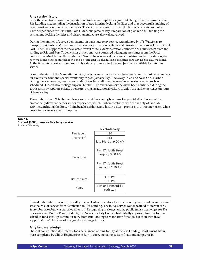
Ferry service history Since the 2001 Waterborne Transportation Study was completed, significant changes have occurred at the Riis Landing site, including the installation of new interim docking facilities and the successful launching of new transit and excursion ferry services. These initiatives mark the introduction of new water-oriented visitor experiences for Riis Park, Fort Tilden, and Jamaica Bay. Preparation of plans and full funding for permanent docking facilities and visitor amenities are also well advanced. During the summer of 2003, a demonstration passenger ferry service was initiated by NY Waterway to transport residents of Manhattan to the beaches, recreation facilities and historic attractions at Riis Park and Fort Tilden. In support of the new water transit route, a demonstration connector bus link system from the landing to Riis and Fort Tilden visitor attractions was sponsored with grant assistance from the Ford Foundation. Modeled on the established Sandy Hook seasonal ferry and circulator bus transportation, the new weekend service started at the end of June and is scheduled to continue through Labor Day weekend. At the time this report was prepared, only ridership figures for June and July were available for this new service. Prior to the start of the Manhattan service, the interim landing was used seasonally for the past two summers for excursion, tour and special event ferry trips in Jamaica Bay, Rockaway Inlet, and New York Harbor. During the 2002 season, services expanded to include fall shoulder-season excursion events, such as scheduled Hudson River foliage trips in October. The excursion services have been continued during the 2003 season by separate private operators, bringing additional visitors to enjoy the park experience on tours of Jamaica Bay. The combination of Manhattan ferry service and the evening bay tours has provided park users with a dramatically different harbor visitor experience, which—when combined with the variety of landside activities, including the Breezy Point beaches, fishing, and historic sites—promises to attract new users while providing a new water transit option.
Table 6 Current (2003) Jamaica Bay ferry service Source: NY Waterway
NY WaterwayFare (adult) $26
Fare (child) $13East 34th St., 9:00 AM
Pier 17, South Street Seaport, 9:30 AM
Pier 17, South Street Seaport, 11:30 AM
4:30 PM
6:30 PM
NotesBike or surfboard $1
each way
Return times
Departures
Considerable interest was expressed by several harbor operators for provision of year-round commuter and seasonal visitor service from Manhattan to Riis Landing. The initial service was scheduled to start in early September 2001, but was canceled after 9/11. Recognizing the longstanding public transit challenges for Far Rockaway and Breezy Point residents, the New York City Council had initially approved funding for fare subsidies for a start-up commuter ferry from Riis Landing to Manhattan for 2002, but then withdrew support after 9/11 because of realigned spending priorities. Ferry landing redesign Phase II construction documents, for a permanent landing facility at the Riis Landing Coast Guard Basin, were completed by Childs Engineering in July of 2003, including custom floats and ramps, basin
Volpe Center Gateway Integrated Transportation Strategy, March 2004 39

improvements, and initial support facilities. The Jamaica Bay/Breezy Point Unit has secured a commitment of New York State Department of Transportation funding for Riis Landing capital improvements, and continues to seek closure on fund transfer. Evaluation criteria Demand Since the opening of the Riis Landing interim dock, there has been a response by private operators to provide Manhattan ferry and seasonal excursion service for the parks. For the Manhattan and shuttle service market, the initial operator interest and concession agreement was for a combined year-round Manhattan and Sheepshead Bay service covering both recreational and commuter schedules. The one-boat service was scheduled to start on September 10, 2001, and was derailed by the events of 9/11 and the emergency expansion of existing Upper Bay ferry services. More recently, NY Waterway initiated a demonstration Manhattan ferry service on summer weekends during the 2003 season. While complete ridership numbers were not available for the weather constrained season, it could be expected that the initial start-up might attract ridership similar to the initial 1997 Sandy Hook service, in the range of 2,000 passengers. Ridership numbers for the 2003 season through July 31 are shown in Table 7, below.
Table 7 Jamaica Bay ferry-service demand Source: Gateway Public Affairs Office
Riders (excursion)
Riders (Manhattan ferry)
Riders (total)
Total one-way trips
Cumulative trips
2001 2,126 - 2,126 4,252 4,252
2002 1,865 - 1,865 3,730 7,982
2003 (through July 31)
N/A 1,107 1,107+ 2,214+ 10,196+
As described above for the excursion market, such operations were initiated in the summer of 2001 and have continued through 2003 (although 2003 excursion ridership numbers were not available at the time this report was prepared). The total ridership numbers for of 2,126 passengers in 2001 and 1,865 riders in 2002 may appear modest at present, but should be expected to grow over the coming years with improved dock and support facilities, including parking. The excursion activities may be regarded as a small but important niche in terms of variety of visitor experience offered at Riis and Fort Tilden, in much the same way that the excursion offerings at Canarsie Pier are part of the overall set of activity choices there. Proposed expansion of routes. The 2001 Waterborne Transportation Study identified several different potential ferry services and priorities for such services. Little has changed with respect to the types of potential service, but the actual implementation of excursion and Manhattan-to-Riis service during the period from 2001 to 2003 provides a new base on which to assess market demand and priorities. As with the Sandy Hook market assessment, the period following 9/11 has also provided an altered context for new ferry services in several significant ways. The types of services identified as having potential for offering new transit alternatives and/or enhancing the visitor experience to Riis Park and Fort Tilden (as well as for other Jamaica Bay Gateway sites) include: 1. Manhattan to Riis Landing (with future connections to Fort Wadsworth): Analogous to the successful ferry
routes linking Manhattan residents to Sandy Hook since 1997, the Manhattan-to-Riis service initiated in the summer of 2003 by NY Waterway provides new park visitors with an attractive alternative to the lengthy and circuitous land-based transit options. The ferry trip also provides the new park visitor experience of traversing New York Harbor and experiencing the Upper Harbor, as well as the Brooklyn and Staten Island shoreline from the water. The new visitor experience thus becomes the combination of the water and land experience. Since the primary visitor base for Riis Park and Fort Tilden consists of Rockaway residents (and other Brooklyn and Queens residents), the midtown and lower Manhattan visitor pool represents a large new market. The RPA focus groups indicated that some Manhattan
Volpe Center Gateway Integrated Transportation Strategy, March 2004 40

residents would be interested in ferry trips to Riis Park if the right beach amenities and activities were in place, and that they were willing to pay up to $30 round-trip for a ferry ride across the harbor—in fact, this option was “deemed much more attractive than taking the Long Island Rail Road [from Manhattan]
and connecting bus to Jones Beach—a service that now attracts 36,000 people a year.”§§ In fact, the RPA report concluded that residents “would choose Riis Park over Jones Beach despite a higher cost for the ferry.” “Has anyone ever taken the ferry out to Fire Island?” asked one focus-group member, referring to Fire Island National Seashore on Long Island. “It’s part of the reward.”
2. Sheepshead Bay and Canarsie Pier ferry shuttle connections: The shorter-distance links from Sheepshead
Bay in Brooklyn across the Rockaway Inlet, and from Canarsie Pier in Queens across Jamaica Bay to Riis Landing, were also identified as likely future seasonal connections. Of the two, the Sheepshead Bay link showed promise of reaching potential new visitor markets by virtue of a possible proximate (walking distance) transit terminal near the head of the bay; participants in the RPA focus groups in 2001 were reported to have “embraced” the idea. The operator initially interested in the Manhattan service in 2001 proposed to operate such a shuttle, and was enthusiastic about the Sheepshead Bay market demand. The Canarsie Pier connection was seen to be a potential additional service for Queens residents already familiar with the Canarsie Pier site, and less likely to attract a totally new set of visitors. Nonetheless, the Canarsie Pier link seemed a worthwhile opportunity for park vistors to experience the natural attractions and wildlife of Jamaica Bay. The shuttle ferry service links could be with the same operators and equipment as the Manhattan routes, or could be run by separate operators utilizing smaller, slower vessels for the shorter distances. Again, the water crossing itself would be a major attraction, and fares could be kept at lower levels because of the shorter distances.
3. Excursion and charter services: Another important use of the Riis Landing dock has been for a variety of
privately run excursion and charter services. The close proximity of residential communities on the Rockaway Peninsula and the mainland (along Flatbush Avenue and the Belt Parkway) provides a market for scheduled seasonal excursions and charter operations. Such services started in 2001 after the opening of the interim dock, and have continued to expand through the 2002 and 2003 seasons. Destinations for these cruises are along the Rockaway Inlet and Lower Bay to the west and Jamaica Bay to the east. A variety of offerings on weekdays and weekends from May through September attracted a reported 2,126 passengers in 2001 and 1,865 riders in 2002. No results were available for excursion and charter services for the 2003 season at the time this report was prepared. So far, the temporary parking area at the Rail Pier site has been adequate for the excursion and charter volumes, but will need to be expanded as more services are added.
Gateway to Manhattan commuter services: There has been growing interest on the part of Rockaway Peninsula residents for a commuter ferry from Riis Landing to Manhattan, particularly since 9/11 and the increased traffic and transit congestion that followed. The circuitous and time-consuming land transit options have long posed difficulties for the many Manhattan commuters from the Rockaways. As the Breezy Point summer communities are attracting more year-round residents, there is a new potential market at the west end of the peninsula. During the 2003 weekend demonstration service, there have reportedly been requests by riders to extend hours of operation to weekday commuter hours. While the commuter operation would not be directly for park visitors, such scheduled ferries would provide a built-in weekday return trip for Manhattan residents to Riis and Fort Tilden, and also allow for school or other group visits to the park at off-peak and off-season periods. Expanded ferry routes to Riis Landing would depend on existing and new private operators providing seasonal service from Manhattan, Brooklyn and Queens, coupled with potential year-round services from the Rockaway peninsula to Manhattan. In addition, existing routes serving Jamaica Bay and Sheepshead Bay would be expanded to include shuttle service to Canarsie Pier. In addition to NY Waterway, interest in operating future services has been expressed by Seastreak and other New York Harbor operators. Primary differences in the projected Riis Landing services for summer visitors and year-round Rockaway commuters, compared to the similar-distance routes to Sandy Hook, relate to the demographics of the user groups. Both summer and year-round ferry riders to Riis Landing are likely to be much more price-sensitive, and fares will need to be relatively low to attract large numbers of users. RPA confirmed that, reporting that the Port Authority of New York and New Jersey had determined that Manhattan-to-Rockaway service would not succeed unless fares were low enough (and unless the facilities were improved).
§§ RPA.
Volpe Center Gateway Integrated Transportation Strategy, March 2004 41

Figure 10 Jamaica Bay existing and potential new ferry routes
Proposed Riis Landing ferry routes are shown in Fig. 10, above. Potential routes and schedule services are listed below: 1. Summer seasonal weekend:
Manhattan Midtown East 34th Street/Battery Park/Brooklyn to Riis Landing (service initiated during 2003 season)
Manhattan Midtown West 38th Street/Battery Park/New Jersey Hudson Shore to Riis Landing
Sheepshead Bay to Riis Landing Shuttle Canarsie Pier to Riis Landing Sandy Hook to Riis Landing as potential scheduled excursion
2. Summer seasonal weekday:
Manhattan Midtown East 34th Street/Battery Park/Brooklyn to Riis Landing as “back-haul” of future commuter service
and/or Manhattan Midtown West 38th Street/Battery Park/New Jersey Hudson Shore to Riis
Landing as “back-haul” of future commuter service 3. Shoulder season:
Volpe Center Gateway Integrated Transportation Strategy, March 2004 42

Manhattan Midtown East 34th Street/Battery Park/Brooklyn to Riis Landing Manhattan Midtown West 38th Street/Battery Park/New Jersey Hudson Shore to Riis
Landing 4. Year-round/commuter:
Riis Landing to Manhattan Battery Park/East 34th Street and/or Riis Landing to Manhattan Battery Park/West 38th Street
It is also possible to envision ferry services operating to Riis Landing for various special events, including chartered harbor defense tours, excursion cruises of Jamaica Bay and Rockaway Inlet (as at present), Jamaica Bay Wildlife Refuge interpretive tours, and educational and environmental tours. Also, expanded ferry services can be used during emergencies or for security purposes, in line with the discussion in Chapter 2, including storm or hurricane evacuation of NPS staff and park visitors; emergency commuter operations; military access; and access in the case of medical or other incidents. These potential routes have been evaluated in accordance with the other categorical elements discussed in Chapter 2, as will be shown later in this chapter; the results of the analysis informed the implementation strategy and prioritization plan discussed later in this report. Visitor experience and NPS policy goals Currently, the Riis Park/Fort Tilden visitor experience, like that at Sandy Hook, is heavily focused on seasonal weekend use of the excellent beaches and the variety of visitor recreation facilities clustered around the two neighboring sites. In addition, there is already a fair amount of shoulder-season activity at the landing, including the excursion and charter ferry services that draw visitors in the spring, fall and summer mid-week, as do the Riis Park and Fort Tilden sites in terms of sports venues. As at Sandy Hook, the Riis/Tilden/Breezy Point recreation area offers many other interesting but lightly used attractions and activities that would appeal to both existing park visitors as well as potential new ones, including art studios, fishing, bike trails, natural areas, and historic fortifications, as well as an underutilized natural sea beach to the south of the more developed Riis Park beach and pavilion area. There are also the adjacent residential neighborhoods and cabana clubs of Breezy Point that provide an additional audience for park activities. Critical to an enhanced visitor experience is improved access and mobility around the extended Riis/Tilden site for all visitors, including ferry riders. The potential to enhance and enliven the visitor experience is well documented in the RPA report “A Beach and Much More.” According to the RPA research, current park visitation appears to be presently (and historically) drawn from residents within a 20- to 30-minute driving or bus-trip distance, which includes portions of the two nearest boroughs of Brooklyn and Queens. Again, with similarities to Sandy Hook (with the exception of the current ferry visitors from Manhattan), the park is perceived and used as a New York City park. Although this is historically correct, it means that park users do not perceive it as a New York Harbor park, let alone as a destination National Park. While the predominant visitor-use patterns are likely to continue for the majority of users, expanded alternative transportation can provide a new ferry link to Manhattan and the greater New York Harbor area while also providing a dramatically different harbor-based visitor experience of the Rockaway Inlet and Jamaica Bay, and new accessibility to the Riis/Tilden corner of the Gateway triangle. Combined Jamaica Bay unit visitation has increased dramatically during the past few years, more than at the other Gateway units (as shown in Table 1, from 2.37 million in 1999 to 4.13 million in 2002), and so the park is not necessarily promoting a major expansion of visitation for its own sake. However, the rapidly improving resources are certainly capable of drawing new or repeat visitors during the shoulder seasons and mid-week during the summer season. Several important projects are underway that should provide an enhanced array of attractions for visitors over the next few years. The historic restoration of the Bathing Pavilion with changing and shower areas, as well as new concessions, promises to address the most commonly cited visitor concerns. Road and pathway improvements will provide much needed access and an enhanced intra-park circulation system. The mapping and promotion of an inherent internal bikeway system can offer a new three-season recreational and interpretive activity for local and more distant visitors. The improvements to the Riis Landing basin, scheduled for this fall, will make permanent and further enhance the new harborside gateway to Riis/Tilden and will create an opportunity for a new activity center. The property transfer of the basin from the Coast Guard will allow for further visitor amenities and appropriate concessions. The RPA report outlines the components of a phased development plan for the new Riis Landing Gateway, including the Basin and Rail Pier Yard, as well as cross-boulevard links to Fort
Volpe Center Gateway Integrated Transportation Strategy, March 2004 43

Tilden. The expansion of ferry service during the shoulder seasons, and possible year-round Rockaway commuter services, should provide Manhattan visitors with access to these new attractions. The Riis Landing to Manhattan ferry service itself provides a greatly enhanced visitor experience of New York Harbor and the Rockaway Inlet. With current excursions and future shuttles to Sheepshead Bay, Canarsie Pier, and possibly Floyd Bennett Field, the water experience of the harbor and park will be extended to Jamaica Bay. The current start-up 2003 summer ferry service is evocative of ferry links from Manhattan and other Upper Bay boroughs to Coney Island or the Rockaways, with pedestrian and transit connections at either end. Riis Landing excursion and charter services during the past few summers have offered nearby residents at Breezy Point, the Rockaways and Brooklyn an opportunity to enjoy the recreation area from the water. The current ferry visitor experience requires a 10- to 15-minute walk to the Riis beaches, or a short bus ride. For the current walkers, the pathway leads through the Fort Tilden campus, past the Sandy Hook Lighthouse and the remnants of 19th and 20th century fortifications. Components of the current summer weekend ferry experience include:
Two-hour cruise across New York Bay from lower or midtown Manhattan to Riis Landing (50 to 65 minutes each way).
Choice of Riis Park beaches, golf course and visitor facilities, or Fort Tilden historic and recreational facilities.
Lifeguards are provided at the Riis beach areas, while changing areas, and food concessions are minimal.
Nearby historic attractions at 19th and 20th century Fort Tilden installations, including former Nike missile installations.
Limited seasonal schedule of ferry trips by NY Waterway of approximately 22 days per year, plus scheduled excursion and charter trips from May through October.
An enhanced park experience by ferry for current and future visitors by ferry could include an Upper Bay tour, the Brooklyn shore of the Lower Bay, and the Rockaway Inlet between Breezy Point and Sheepshead Bay. While the water arrival at Riis Landing may be similar geographically to the approach from the Marine Highway Bridge, it is distinctly different at the water level and speed of the ferry. Projected ferry visitors will be offered an enhanced experience that will include Fort Tilden recreation and art venues and the completed Bath House restoration and concessions. Also in design are improved vehicular and pedestrian circulation and signage systems, to help provide a safe and more functional pathway and bikeway system. Walking distances from Riis Landing and nearby Fort Tilden parking areas can be shortened to the beaches and other resources with these circulation improvements (reversing the fact that past emphasis on arrival by car or bus has minimized the attention paid to pedestrian and bicycle links). Currently, the paths are indirect and poorly marked, and vestigal chain-link fences and undergrowth discourage walking connections. The permanent dock, watersheet reorganization and breakwater restoration will provide safe and reliable landing conditions, allowing for an expanded schedule of weekend and off-peak services, extending the season from spring through fall. The ferry visitor experience will also include opportunities for school and other educational or charter programs to the extensive Riis/Tilden resources during weekdays and shoulder seasons. A potential future commuter ferry would work well with Riis Landing in terms of complementary weekday use of the landing and parking while providing extensive “back-haul” weekday trips for park visitors from Manhattan. The projected enhanced ferry visitor experience would include: Two-hour cruise across New York Bay from lower or midtown Manhattan to Riis Landing (50-65
minutes each way), with connecting shuttle ferries across the Hudson and East Rivers and possible stops at Fort Wadsworth.
Sheepshead Bay and Canarsie Pier shuttle service on crowded summer weekends (15 to 20 minutes each way).
Jamaica Bay tour charter destination and origin opportunities. Riis Basin/Rail Pier concession connections to Manhattan, such as a small inn, shops, and restaurants. Rockaway-to-Manhattan year-round commuter ferry.
Volpe Center Gateway Integrated Transportation Strategy, March 2004 44

Improved visitor orientation through improved pedestrian and bikeways, information kiosk and wayfinding signage.
Choice of beaches and visitor compounds including changing areas, lifeguards, restaurants, etc. Interpretive tours of nearby historic 19th and 20th century fortifications and other harbor defense
attractions. Added visitor activities and support amenities within the restored Riis Bath House, Fort Tilden
buildings, and Riis Basin/Rail Pier building concessions, including interpretive and orientation exhibits, restaurants, restrooms, and potential future lodging.
Expanded recreational and eco-tour opportunities with new circualtion improvements, bikeway, and expanded shuttle bus.
Expanded capacity for educational, interpretive, art, and recreation programs during off-peak and shoulder seasons.
Improved year-round landing and boarding experience at a permanent year-round dock. Expanded season and schedule of ferry trips by multiple concession operators to include spring and fall
shoulder season and weekday summer services (150 days a year). Waterside and landside access strategies Most visitors arrive at Riis and Tilden by automobile; RPA estimates a figure of 85–90%. Since only two bridges (the Gil Hodges and the Cross Bay Veterans Memorial) connect to the Rockaway peninsula, traffic conditions at peak times can become quite congested. Nonetheless, as the RPA report says, “All of Brooklyn and most of Queens can reach Riis faster than they can reach Jones Beach,” an alternative beach in Nassau County, to the east, although Coney Island, in Brooklyn, is easier to reach from certain areas of Brooklyn. The RPA’s 2001 focus groups indicated that many visitors tend to try to anticipate traffic delays, and plan their visits accordingly. In his September 2002 memo, the RPA’s Jeff Zupan notes that “of the 1.7 million households in [Brooklyn and Queens], 54 percent in Brooklyn and 34 percent in Queens do not have an automobile available, according to the 2000 U.S. Census. This means that there are about 475,000 households in Brooklyn and 266,000 households in Queens without cars.” However, not many visitors arrive by transit, despite the presence of several bus lines and nearby subway stations. The Zupan memo says that the highest concentrations of non-automobile-owning households in Brooklyn and Queens are actually in the neighborhoods furthest from Gateway—“necessitating the longest transit trips”—although it also reports that focus-group respondents “would be willing to travel one hour plus, given an attractive destination.” RPA focus-group participants were enthusiastic about ferry service to Riis. As mentioned earlier in this chapter, excursion services began in 2001, and Manhattan service in 2003. The interim Phase I landing and adjacent parking have been adequate for needs of these limited operations, but will need substantial alteration to allow for expanded summer park water transit and potential commuter operations. As at Sandy Hook, the temporary dock is not considered ADA-accessible because of the ramp pitch and the steps located at the landside end. The freeboard height of the used barge is also too high for most vessels using the facility. Visitor amenities are limited to a rough, unstriped parking area on the adjacent site. Portions of the basin breakwater are in poor condition and in need of repair, and the basin itself includes several derelict finger piers that limit navigation of ferry vessels using the landing. Waterside landing and access components. During the spring of 2003, construction documents were completed and funding of $1.4m was secured for implementation of a Phase II permanent landing, basin repairs, dock reorganization, and initial visitor support amenities. The current proposed Phase II landing improvements for Riis Landing are shown in Fig. 11, below. (The proposed relocation of the Riis float is described in greater detail in Chapter 5, which discusses Fort Wadsworth.) Included in the construction package would be the following elements, referenced by number.
1. Basin breakwater repairs and stabilization. 2. Basin removal of diagonal finger piers. 3. Relocation of small boat floats within the basin. 4. Removal of deteriorated marine railway tracks. 5. New replacement spud barge and ramps. 6. Pathway connection to Rail Pier Yard with covered waiting shelter. 7. Interpretive signs and artifact display. 8. Expanded striped parking area adjacent to the landing.
Volpe Center Gateway Integrated Transportation Strategy, March 2004 45

9. Pathway connection improvements to Fort Tilden and Riis Park. 10. Signalized pedestrian crossing at Rockaway Point Boulevard.
A later phase of landside support elements (Phase III) will be needed as new ferry services are implemented; this phase would include restrooms, benches, an information kiosk, improved pathway connections and crosswalks to the Coast Guard building and Fort Tilden, a bus/tram dropoff, additional parking areas adjacent and at Fort Tilden, and landscaping of the basin area. With respect to expanded ferry services, the major variables would seem to be such factors as the start-up schedule, fare structure, and weekday ridership demand for a year-round commuter ferry. Should a potential commuter service attract ridership of greater than 200 daily commuter passengers, site plans would require additional Phase III parking on both the adjacent rail pier site and across the road at Fort Tilden, along with associated pathways, signage, and waiting shelters. Phase II ferry terminal. A new permanent dock is to be installed in the Coast Guard Basin, replacing the current temporary spud barge; construction is scheduled for the fall of 2003. Primary terminal uses would be for Riis Park and Fort Tilden visitors, including expanded seasonal ferry service from Battery Park, Fort Wadsworth and other feeder sites around Upper New York Bay. Potential secondary seasonal park uses of the terminal would be shuttle connections to Canarsie Pier and excursions to Jamaica Bay. As a means of supporting the park ferry services, ferry operators have expressed an interest in providing year-round commuter service from the site for Rockaway and Breezy Point residents. These combined uses would require a variety of landside support services. The site concept plan for the basin and Rail Pier yard are shown in Fig. 11, below; the design for the permanent ferry dock and reorganization of the basin floats and piers is shown in Fig. 12.
Volpe Center Gateway Integrated Transportation Strategy, March 2004 46

Figure 11 Riis Landing concept site plan, Phase II Source: Norris and Norris
The Coast Guard basin has good water depth in most areas. Marine inspections of the breakwater found it to be fundamentally sound and likely to have a good 10–15+ years of useful life remaining as long as minor repairs are made to the outer western arm, in terms of combined repair and selective removal of the damaged end section. Vessel operators expressed concerns about removal of the end of the south arm; they felt such action would add considerable wave action within the basin, and create berthing and boarding problems. Construction drawings include reorganization of the floats and fixed piers within the basin to create a larger vessel turning basin within the breakwater. The existing oversized spud barge (approximately 30• by 100•) would be relocated to the Torpedo Pier at Fort Wadsworth, and replaced with a smaller custom built barge of 20• by 90•. The new float would be connected to the adjacent Fort Tilden Rail Pier site by a fixed wooden pier and a moveable 50•-by-6• ramp. An additional 20• fixed ramp would be located on the float to complete the ADA access needs for the local tide range. The ferry float would be held in place with spud piles and would provide primary berthing on both sides of the float. An option would be included addition of a future bow-loading bumper. It is expected, however, that short- to mid-term berthing needs can be accommodated with a single 90• berth by assigning docking time slots to coordinate boat activity. For smaller ferries, a lower freeboard float of 10• by 20• could be attached to the inboard side of the main float.
Volpe Center Gateway Integrated Transportation Strategy, March 2004 47

Figure 12 Riis Landing Phase II basin plan Source: Norris and Norris
The reorganization of the basin shown in Fig. 12, above, indicates how additional berthing is provided while allowing for a larger turning basin for the larger ferries and smaller Park Police and NPS vessels. The smaller ferry landing replaces the existing barge in the southwest corner of the basin, allowing enough room for a catamaran with a 30-foot beam to berth comfortably on the west side of the float. The two diagonal fixed piers on the south bulkhead are replaced with the two relocated 2• freeboard floats and ramps, currently on the east bulkhead. The south bulkhead then becomes the new site for the longer floating dock which currently lies next to the former marine railway basin. The south breakwater would be repair and stabilization of most of the deteriorating north end, and reinforcement of the new end section. The new opening would maintain the current protection from wave action. The relocation of the smaller existing floats in more protected areas of the basin, and would allow for berthing of ferries on both faces of the ferry landing. These alterations would result in an equal number of small-vessel berthing locations by reusing the existing floats, while at the same time creating a much larger turning basin for all vessels, including the largest ferries. Future dates shown below are conjectural and for reference only, to give an idea as to how long the various tasks require, and indicate the earliest feasible implementation dates as of the time of the first draft of this report.
Phase I: Temporary ferry landing (existing). Temporary ferry landing with spud barge in operation (completed in May ’01, in operation ’01–’02).
Volpe Center Gateway Integrated Transportation Strategy, March 2004 48

Services include demonstration of commuter/seasonal recreation, Manhattan and other shuttle services, and seasonal excursion services. (In operation seasonally from May ’02—Sept. ’03.) Phase II: Permanent ferry landing and basin modifications (design and construction drawings complete). Includes basin improvements and new spud barge. Final design and permitting. (Completed Dec. ’01, amended June ’03.) Funding committed for basin construction by New York State DOT. (Dec. ’01 and Mar. ’03.) Bids and construction. (Oct. ’03–Apr. ’04.) Concession and landing agreements. (Fall and winter ’03–’04.) New recreational service begins: Manhattan (’03); Sheepshead Bay/Canarsie Pier (’04–’05). New Manhattan commuter services begin. (’04–’05.)
Landside visitor support components and access. The landside support facilities need to enhance the visitor experience include immediate ferry terminal site improvements and supporting visitor-circulation improvements at Fort Tilden and Riis Park. The initial Phase II landside improvements for the Rail Pier Yard and Basin are shown in Fig. 11. Visitor facilities can be provided in phases as the immediate Coast Guard Basin and Rail Pier sites are redeveloped. Since the summer excursion and charter operations are likely to continue and expand, Phase II improvements should include night lighting. As more visitor attractions are incorporated into renovated and new buildings at the Basin and Rail Pier sites, expanded amenities can help create a new visitor attraction around the ferry landing similar in character to Canarsie Pier. There are several site plan options for organizing support needs and visitor amenities. The options would utilize the resources at the two adjacent Riis Landing sites in different ways through phased improvements. The general plan, however, would be to locate most or all of the ferry landing support activities at the NPS-owned Rail Pier site, including sheltered waiting areas, restrooms, vehicular drop-off, and ferry parking, as well as other visitor amenities. In addition to ferry support needs, the two sites combined offer an opportunity for a new gateway to the Breezy Point park resources in the form of a lively bay side waterfront park, organized around the ferry landing. The Rail Pier site occupies approximately 5.6 acres, with 550 feet of each front on the Rockaway Inlet. The rail pier pile field extends 220 feet from the bulkhead. The site is large enough to accommodate the needed ferry support uses as well as other potential visitor attractions. While there are various site development plans possible, one conceptual approach for organizing the site might be similar to the character and uses included in the recent renovations at Canarsie Pier. The site should eventually become a ferry gateway and new visitor destination for ferry riders as well as Breezy Point and Rockaway residents. Site features should include the following: Ferry support functions. These could be organized primarily along the east property line, keeping the
dock access point in the same general location as at present. The ferry visitor orientation center would be included in a small pavilion near the dock entrance. A waiting area and restrooms would be included, as well as a visitor information kiosk, with activity choices for the Jamaica Bay/Breezy Point park sites as well as ferry and shuttle bus schedules.
Pedestrian path network. The former military supply site has no sidewalks or pathways connecting to the
nearby Fort Tilden and ocean beach at Jacob Riis. A clear, safe, and well-maintained set of pedestrian and bicycle paths needs to be developed to connect to the park attractions, continuing to and through Fort Tilden. The boulevard crossing will require a pedestrian-activated stoplight and well-marked crosswalk, most likely at the existing lighted intersection and site entrance.
Vehicular access. The access road and vehicular drop-off would be located nearby. Visitor parking for
100 to 150 cars would be provided on the Rail Pier site, with additional parking to be provided in Phase III at Fort Tilden just across the boulevard, in landscaped clusters farther from the water to be shared by ferry riders, commuters, and other site attractions.
Perimeter waterfront boardwalk. As the Coast Guard property is transferred to the park, the chain-link
fence could be removed and a public boardwalk could be developed along a portion of the western basin edge. In Phase III, the basin boardwalk could be extended along the bayside beach with steps providing access to portions that are exposed at different tide conditions. If feasible, a fishing pier might be developed on portions of the remaining rail pier pile structure.
Volpe Center Gateway Integrated Transportation Strategy, March 2004 49

Activity areas. Several different outdoor activity areas could be developed sequentially away from the
ferry landing entrance and along the waterfront. In Phase II, benches and picnic tables could be incorporated on the land side of the boardwalk. In Phase III, a children’s play area could be included with a nautical theme. A small amphitheater and stage could be included as a focal element.
Landscaping. The site is at present mostly hardscape, with the exception of a lawn and mature trees near
the boulevard, which should be retained. Complementary site landscaping would need to be developed in Phase II and III to enhance the park gateway by transforming the former industrial site.
Interpretation. An interpretive program needs to be developed to be implemented in Phases II and III.
The varied military history of the Fort Tilden and the social history of Riis Park site provide ample material for the historic interpretation, while the natural history of Breezy Point and Rockaway can provide a contrasting interpretive theme. Phase I interpretive elements can be clustered around the ferry landing and waiting shelter. In Phase III, the stories can unfold along the pathways and at visitor stations in Fort Tilden.
Indoor activities and concessions. The remaining buildings could be incrementally redeveloped to create
a four-season site. The remaining structures could accommodate a combination of concessions, including a restaurant, café, and gift shop. NPS might consider some use of the buildings, such as a Breezy Point visitor and interpretive center with meeting areas. Such facilities could be made available to nearby Breezy Point residents for community meetings and events.
The adjacent Coast Guard site consists of approximately 1.7 acres of land with an additional 1.9 acres of watersheet in the protected basin area. With respect to the property, the Coast Guard has closed down all operations at the site, and is in the process of transferring a large portion of it, including buildings and dock-management responsibilities, to NPS. The site contains several buildings and a limited amount of ground area. Vehicular circulation to the site is limited by its proximity to the off ramps of the bridge to the north. A transition plan has been prepared for the site to allocate building space and vessel storage needs for the Harbor Park Police and other tenants. The Jamaica Bay/Breezy Point Gateway unit has already made initial, interim improvements at the ferry landing. The site has been planned for reuse as a seamless extension of the Rail Pier site. The large colonial Coast Guard building has potential for a variety of adaptive reuses, including a small waterfront inn and restaurant, as discussed in the 2002 RPA report. The boat shed could house maritime exhibits or may continue to be used as an active Park Police outpost. The boardwalk could be continued around other portions of the basin. All necessary emergency, security, and public safety devices should also be designed into the landside support system.
Phase II: Basic landside visitor amenities—needed for expansion of ferry service. (Completed by ’04 summer opening date.) Waiting shelter (summer season), with benches, water fountain, interpretive signs, and artifact
display. ADA walkways, curb cuts and connections to sidewalk/path system. Lighting for night use. Visitor information kiosk and courtesy phone. Interim parking for 200 cars. Bus drop-off and turnaround. Required security and public safety devices.
Phase III: Expanded visitor amenities—for extended operations in conjunction with Coast Guard basin and rail pier/storage yard redevelopment. (’04–’06.) Restrooms (could be in nearby restaurant, Park Police, or visitor center). Permanent waiting shelter (four-season, for commuters). Expanded parking to 400 spaces (to include Fort Tilden sites). Landscaped mini-park along shore with play equipment. Bike rental and storage.
Landside access and transportation. As ferry services are expanded, pedestrian and transit links will need to be improved to provide full access to the array of existing and emerging visitor attractions. Internal and external transit connections to Riis Landing will need to be expanded. Auto and pedestrian access improvements to Riis Landing can be coordinated through improved roadway and bridge signage.
Volpe Center Gateway Integrated Transportation Strategy, March 2004 50

Internal transit and roadway: New seasonal shuttle bus network from Riis Landing to Fort Tilden and Riis Park beaches.
(Pilot service Jun.–Sept. ’03.) Designated pedestrian sidewalk/path network with connections to Riis Park and Fort Tilden
beaches and recreational areas. (June ’04.) Rockaway Point Boulevard pedestrian-activated crosswalk signal at Riis Landing. (June ’04.) Designated bicycle trail system. (June ’04.)
External transit and roadway: Improved connections with scheduled borough and Rockaway bus routes. (June ’04.) Bridge and roadway approach signage to indicate access/egress for Riis Landing. (June ’04.)
Information system components. Access to and between Fort Tilden and Riis Park resources is not well marked or signed, leading to particular confusion for first-time visitors. Improvements in signage and wayfinding systems are needed within Riis Park and Fort Tilden to benefit both current and new park visitors. Riis Landing also needs to be integrated with harborwide information systems. Emergency and public safety information should also be incorporated at the Riis Landing site.
Internal to Jamaica Bay unit: Signage and wayfinding system at Riis Landing, both within Fort Tilden and throughout Riis
Park and beaches. (June ’04.) Web site with visitor transportation, attraction and program information. (June ’04.) Information kiosk at Riis Landing. (June ’04.)
External and harborwide: Ferry route and service information expansion through operators and transit providers. (June
’04.) Coordinated multi-media information system with other New York Harbor parks. (’04.)
New visitor attractions. Many new and improved attractions have been planned, funded, and are being completed in phases, for the short and longer term, for both Riis Park and Fort Tilden. The development of Riis Landing as a new Gateway attraction for ferry visitors and local residents can be phased as new concessions are established in renovated structures at the Basin and Rail Pier. Mid- to longer-range plans for Riis and Tilden improvements are described in the 2002 RPA report, and can serve as the basis for a broader action plan for enhancing the park resources.
Capital improvements: Restored Riis Park Bath House. (’04.) Riis Landing building reuse concessions (restaurant, inn, shops, bicycle rental, etc.). (’04–’06.)
Interpretive program: Fort Tilden/Rockway arts community events. (’03.) Historic harborwide fortification and defense network tours. (’04–’05.) Recreation programs at Riis Park and Fort Tilden. (’03 and beyond.)
Implementation feasibility The implementation feasibility assessment for Riis Landing is somewhat less complicated than for Sandy Hook in the 2001 Waterborne Transportation Study. There are several compelling reasons to modify the existing basin rather than seek a new site: The Coast Guard Basin already exists as an established, wave-protected small harbor. Design and permitting of a similar, protected, year-round basin would be costly and time-consuming,
and would necessitate consideration of the coast Guard Basin as an alternative anyway. The Coast Guard has followed through on plans to leave the site and transfer ownership to the Jamaica
Bay/Breezy Point park unit. There appears to be enough watersheet area for a new landing and manuevering room for the expected
ferries. Relatively simple repairs of the breakwater and reorganization of the watersheet are needed. The site is well located with respect to Fort Tilden and the Riis beaches for pedestrian connections. The neighboring Rail Pier Yard offers additional site area and buildings for visitor support and
amenities.
Volpe Center Gateway Integrated Transportation Strategy, March 2004 51

The initial temporary dock installation generally proved to be a success, although it also indicated needed watersheet improvements.
Final design process. The final design was completed in July of 2003, modifying the preliminary design prepared in 2002. Additional modifications to the watersheet and repairs to the outer end of the breakwater were added to the original design. Environmental process. All reviews and permit procedures are complete and construction can proceed. Since the installation of the permanent dock was essentially a rehabilitation of an existing group of marine structures, no major new environmental reviews or permits were needed. The removal of condemned timber piers and the reconstruction of others were also regarded as improvements. Within the basin, no dredging or other major new maritime structures were required. The addition of a removable pile-supported floating barge did not trigger any further environmental reviews or permits. Landside implementation feasibility. The landside implementation feasibility is also easy to achieve, since the relatively modest support needs are not seen as having any significant environmental impacts or requiring any permits. As at Sandy Hook, the landside terminal area is located on federal property and so is not subject to the same state review and permit requirements as the marine components. The Jamaica Bay unit foresees many of the visitor support and amenity elements being phased in over time and incorporated with concessions in existing nearby buildings, minimizing construction of new structures within the historic setting. Finances The following description of estimated construction and management costs is focused on the waterside and landside facilities and services that would be park responsibilities, and, as described in Chapter 2, does not reflect capital or service costs to be borne by the ferry operators. Waterside and landside capital costs. Preliminary cost estimates for the Phase II permanent dock installation and basin reorganization do not include recently requested changes in repairing the full breakwater or modifications to the barge and basin. Based on the final design drawings completed in 2001, Phase II terminal costs were then estimated at $725,000, including permitting and other contingencies. With changes to the wave barrier repair, basin modifications and inflation, this estimate had to be increased, and is now approximately $925,000. This estimate includes a new floating dock and fittings, ramp system, breakwater modifications, finger pier demolition, and basin reorganization. A preliminary cost estimate for the Phase II immediate landside support facilities on the Rail Pier is $165,000. Included are site improvements such as a temporary information kiosk, waiting shelter, sidewalks, initial parking and bus turnaround, and lighting and signage. This cost estimate does not include construction of Fort Tilden access infrastructure, utilities, or landside support facilities, which are intended to be covered by a separate roadway improvement program.
Volpe Center Gateway Integrated Transportation Strategy, March 2004 52

Table 8 Jamaica Bay preliminary capital cost estimates Sources: Norris and Norris, Childs Engineering
Cost
Dock Phase II (new barge and basin modifications)
$925,000
Water design fees (1.5% of construction cost)
$10,800
Water permit fees (1.5-5% of construction cost)
-
Land design fees and permits (2% of construction cost)
$3,300
Total cost $939,100
Complete
-
-
-
$3,300
Waterside components
$925,000 $165,000
$10,800
Landside components
Design and permit cost estimates. The design and permitting for the Phase II permanent landing and support facilities have been completed at this time. The only additional services anticipated would be for management of the bid process, as well as construction management and oversight. Management and maintenance costs. Riis Landing can benefit from the recent Manhattan demonstration service and excursion experiences, as well as from the longer-operating Sandy Hook service and agreements. Both sites have the advantage of a history of concessions and management agreements with the current operator (NY Waterway), albeit with different dock ownership contexts at the two sites. While a more specific agreement framework should be prepared, the following guidelines (similar to those proposed for Sandy Hook) are suggested as elements to include in an operator concession agreement: Five-year agreement with termination and renewal conditions. Park solicits expression of interest with proposed schedules and fares from area operators, with focus
on current or emerging operators. Limited number of operator concessions for each service type to encourage limited competition—e.g.,
2–3 operators for Manhattan services, 2–3 existing operators for shuttles, 2–3 charter operators, depending on market demand.
Require reduced-fare off-peak rates for school and educational groups. Operator contributions to (and/or management of) landside shuttle bus operation; allow ferry riders
free and others a set maximum fare (e.g., $1/adult passenger; $3/family). Operator contributions to annual and long-term maintenance. Guidelines for daily and seasonal dock maintenance. Park schedule coordination and landing slot management. No operating subsidies to be considered for regular services.
Funding sources and support partnerships. Riis Landing has secured and has available an FTA ferry discretionary grant of $1.1 m through the New York State Department of Transportation. The projected cost of the Phase II landing facilities is not expected to exceed this current grant amount of $1.1m, or $10,000 for design and permitting. Potential sources for these funds include the same FTA grant program, the NPS Alternative Transportation Program, other federal transportation programs, other stakeholder contributions, and/or foundation grants. Implementation scenarios Several service and ridership scenarios were developed to illustrate possible market opportunities. In addition to providing a feasible sequence of steps to expand ferry services, the scenarios are intended to be used for market surveys of current ferry users and park visitors.
Volpe Center Gateway Integrated Transportation Strategy, March 2004 53

Step 1: Expansion after Phase II dock construction. (2004 at the earliest.) Expand on 2003 summer weekend service to Manhattan and add shuttles to Sheepshead Bay. Add year-round commuter service as a demonstration project. Continue/expand summer excursion services evenings and weekends. This step requires a new seasonal shuttle-bus operation with current vessels, assuming some riders will walk to beaches and other attractions. Commuter service bus shuttle would be provided by operator as needed. Shuttle bus services could start as a concession to a local operator with suitable vehicles. Estimated annual ridership assuming two-vessel operation (could be two separate one-vessel operators): 25,600 commuters (100 per day) and approximately 6,000 summer visitors from Manhattan and Sheepshead Bay. Step 2: Further expansion after Phase II dock construction. (2005–2006 at the earliest.) Expand commuter service to a two-boat or four-boat (two-operator) operation with added parking. Expand seasonal weekend and weekday Manhattan service with commuter operator(s). Add a seasonal Canarsie Pier shuttle to provide new access to Riis Beach with landside bus transit connections to the Canarsie Pier area. This step would require additional seasonal shuttle bus services, possibly owned by NPS but operated as a non-subsidy concession.Estimated annual ridership, assuming two-vessel operation (could be two two-vessel operators): 51,200 commuters (200 per day) and approximately 12,000 summer visitors from Manhattan and Sheepshead Bay. Step 3: Additional expansion. (2006–2007 at the earliest.) Add shoulder season weekend service as Basin and Rail Pier concessions expand. Develop school outreach program for park history and interpretive tours during shoulder seasons. School/group outreach annual ridership estimate: 4,000–6,000. Ridership projections, based on implementation scenarios. Ridership projections based on the three implementation steps are shown in Table 9, below. The Manhattan-to-Riis Landing projections are based on extrapolation of the Manhattan-to-Sandy Hook ridership history, combined with early ridership reports for the 2003 Manhattan-to-Riis service. The comparison with Sandy Hook is particularly useful because of market and service parallels: the Manhattan market pool and projected departure points are the same, the trip distance and equipment needed are very similar, and the Park attractions for visitors are also similar, with a long barrier beach, extensive natural areas, and historic coastal defense fortifications. Projections for other service types are based on assumptions regarding service levels and incremental growth patterns. Ridership estimates are also based in part on the 2001 Waterborne Transportation Study and on RPA’s 2002 report.
Table 9 Jamaica Bay ridership projections based on implementation scenarios Source: Norris and Norris
2001 2002 2003 2004 2005 2006 2007
Manhattan to Riis Landing - - 2,000 4,000 6,000 8,000 10,000
Sheepshead/Riis/ Canarsie shuttle
- - - 2,000 3,000 4,000 5,000
25,600 38,400 51,200 76,800
(100/day) (150/day) (200/day) (300/day)
Excursion and charter (10%/year)
2,100 1,900 2,200 2,420 2,660 2,930 3,220
School/group outreach - - - - - 4,000 6,000
Total (park visitors) - - 4,200 8,420 11,660 18,930 24,220
Total (all users) - - 4,200 34,020 50,060 70,130 101,020
Manhattan commuter - - -
Volpe Center Gateway Integrated Transportation Strategy, March 2004 54

(It should be noted that the commuter service is a major variable in terms of start-up date, and accounts for a disproportionate number of projected riders in the table above.) Prioritization, phasing, and action-plan items The initial Phase I of Riis Landing is already completed and consists of the current temporary ferry dock installed in the basin, which has served for start-up excursion service to the site during the 2001 and 2002 seasons and demonstration Manhattan start-up water transit service during the 2003 season. Phase II would consist of the installation of the new float, reorganization of the basin piers and floats, repair of the breakwater, and improvements to the adjacent Ft. Tilden Rail Pier site, as described above. The Phase II construction drawings should be completed and ready to go to bid by October 2003. Funding to cover Phase II improvements ($1.4m) has been secured from the New York State Department of Transportation and transferred to the Federal Lands Highways Program. Minimal if any permitting is anticipated for Phase II. If bids can be received by the end of October 2003, with the funding that is available, Phase II could be implemented by spring 2004 for the coming summer season. Additional information can be found in Chapter 7 (which discusses prioritization and phasing in more detail) and Chapter 8 (which presents recommendations for action-plan items).
Volpe Center Gateway Integrated Transportation Strategy, March 2004 55

Chapter 5 Site Analysis: Staten Island/Fort Wadsworth Unit overview Gateway’s Staten Island unit extends along the southeastern shore of the island and includes sites at Fort Wadsworth, Miller Field, and Great Kills Park (Fig. 13, below). Hoffman and Swinburne Islands are also part of this unit, although they are closed to visitors. Each of the three actively used sites is distinct in terms of uses, resources, and visitation. Fort Wadsworth, located next to the Verrazano-Narrows Bridge, adjacent to the Arrochar residential section, is a former military installation. Miller Field (226 acres), located in the Grant City/New Dorp section of Staten Island, is a former army airfield. Great Kills Park (1,000 acres), located to the south of Miller Field in the Oakwood section, is a well-used water recreation resource.
Figure 13 Staten Island unit
In many respects, the Staten Island unit is a local park for borough residents, with the exception of Fort Wadsworth, which attracts visitors from the New York region and is expected to draw visitors from other U.S. and international destinations. Fort Wadsworth serves as the starting point for the New York City Marathon—involving some 32,000 runners—each November. All of the pre-race activities, as well as the actual start of the race itself, take place at this location. In addition, Fort Wadsworth serves as the finishing point for the five-borough Bike New York ride, which takes place on the first Sunday in May and draws more than 30,000 cyclists. Both of these major events present an opportunity for excursion ferry services from Brooklyn and Manhattan to a new dock at Fort Wadsworth, which was identified in the 2001 Waterborne Transportation Study as being an appropriate site for a ferry landing.
Volpe Center Gateway Integrated Transportation Strategy, March 2004 56

Ferry landing site and context; ferry service history There is currently no landing suitable for public ferry service at Fort Wadsworth, and no such service is provided. However, the 2001 report identified the historic Torpedo Pier site as an appropriate location for development. Current conditions at Torpedo Pier are shown in Fig. 14.
Volpe Center Gateway Integrated Transportation Strategy, March 2004 57

Figure 14 Current dock conditions at Fort Wadsworth (Torpedo Pier) Source: Norris and Norris
Volpe Center Gateway Integrated Transportation Strategy, March 2004 58

Ferry landing design/development Plans for Torpedo Pier development include an interim limited-use vessel landing (Phase I), followed by a proposed interim floating ferry landing (Phase II) and full restoration of the historic pier, including an attached floating ferry landing (Phase III). Temporary Phase I float facilities attached to the Torpedo Pier, for official NPS and government small vessels (including emergency access by military vessels), were briefly in place during the summer of 2002. According to reports, a lightweight, marina-type float was attached to the main granite pier and bottom anchored. Within a short time, wave and wake action from passing ships in the Verrazano Narrows severely damaged the floats, and they were removed. Such ambient wake conditions will need to be taken into account in designing the Phase II dock and ramp system. A larger Phase II float and ramp would be intended for use by public ferries; these would also be attached to the Torpedo Pier, with possible use of the current Riis Landing spud barge (after permanent landing and basin improvements). A permanent Phase III landing would be added in conjunction with the planned restoration of the Torpedo Pier, currently scheduled for 2005–06. Funding has been identified for the future Phase III Torpedo Pier restoration, but not as yet for the Phase II interim landing. Phase II costs can be minimized if the existing Riis landing barge is used. Evaluation criteria Demand Since there is no ferry ridership to Staten Island/Fort Wadsworth at present, there are no historical service data from which to draw. Proposed expansion of routes. The 2001 report indicated that ferry routes to the site would depend on new operators providing seasonal service from Manhattan, Brooklyn, Queens, and the Jersey Hudson shore. The services would rely on existing Sandy Hook and proposed Riis Landing routes that pass close by the Torpedo Pier and could make an intermediate stop there. Such service can begin as soon as there is a public landing available at the Torpedo Pier. The proposed Upper Bay Harbor Loop could also include service to Fort Wadsworth. The establishment of an NPS landing at Battery Park (see next chapter) is also important for attracting new visitors to Fort Wadsworth, including “overflow” from visitors to the Statue of Liberty and Ellis Island. Additional special-events services could include Harbor defense tours and educational charters. The start of the annual New York Marathon could also benefit from special charters and shuttles to a Torpedo Pier Landing. No commuter service is anticipated from Fort Wadsworth, since there is limited vehicular access to the site and little or no nearby space available for parking, and also because the current Staten Island Ferry provides frequent free service with good transit connections.
Volpe Center Gateway Integrated Transportation Strategy, March 2004 59

Figure 15 Fort Wadsworth potential new ferry routes
Proposed Fort Wadsworth ferry routes are shown in Fig. 15, above. The following proposed and potential routes are identified in chronological order of start-up: 1. Summer seasonal weekend:
Manhattan Midtown East 34th Street/Battery Park/Brooklyn to Torpedo Pier (possible ’04 start)
Manhattan Midtown West 38th Street/Battery Park/New Jersey Hudson Shore to Torpedo Pier (possible ’04 start)
Torpedo Pier to Sandy Hook (possible ’04 start) Torpedo Pier to Riis Landing (possible ’04 start) Fort Wadsworth/Torpedo Pier as a Harbor Loop stop (start date unknown—
approximately 2005) 2. Summer seasonal weekday:
Manhattan Midtown East 34th Street/Battery Park/Brooklyn to Torpedo Pier (possible 2005 start as backhaul on commuter routes)
Manhattan Midtown West 38th Street/Battery Park/New Jersey Hudson Shore to Torpedo Pier (possible 2005 start as backhaul on commuter routes)
Torpedo Pier to Sandy Hook (possible 2005 start as backhaul on commuter routes) Torpedo Pier to Riis Landing (possible 2005 start as backhaul on commuter routes)
Volpe Center Gateway Integrated Transportation Strategy, March 2004 60

Fort Wadsworth/Torpedo Pier as a Harbor Loop stop 3. Shoulder season:
Fort Wadsworth/Torpedo Pier as a Harbor Loop stop 4. Year-round/commuter:
(None) It is also possible to envision ferry services operating to Fort Wadsworth for various special events, including chartered harbor defense tours, excursions, and educational and environmental tours. Also, expanded ferry services can be used during emergencies or for security purposes, in line with the discussion in Chapter 2, including storm or hurricane evacuation of NPS staff; Coast Guard operations; emergency commuter operations; military access; and access in the case of medical or other incidents. These potential routes have been evaluated in accordance with the other categorical elements discussed in Chapter 2, as will be shown later in this chapter; the results of the analysis informed the implementation strategy and prioritization plan discussed later in this report. Detailed ridership projections for Fort Wadsworth—based on the demonstrated and predicted demand, and evaluated in connection with various infrastructure/service implementation scenarios—are described later in this section. Visitor experience and NPS policy goals At present, without a functioning landing, there are no opportunities for visitors to experience Fort Wadsworth from the water. There are limited public-transit connections to the fort, focused on providing connections for weekday commuters to work destinations. Vehicular access is also daunting for anyone unfamiliar with the exits from the Staten Island Expressway. Getting there is presently one of the major challenges for visitors. Once on campus, the mixture of multiple military activities and the substantial resident population seems to create ambiguity for visitors seeking park activities and resources. The substantial historical and natural resources seem hidden or screened by the military presence at the fort and by the lack of clearly marked directions and wayfinding devices. There are several key policy issues regarding future ferry service and an enhanced visitor experience at Fort Wadsworth. While Fort Wadsworth lacks sea beach resources, it has several spectacular historic fortifications and educational facilities in addition to geographically different natural resources, with high bluffs and elevated harbor views. The Verrazano-Narrows Bridge and its Staten Island abutments are engineering marvels that could also be interpreted for visitors. Educational programs are being developed at Fort Wadsworth for school (and other) groups from Staten Island and other boroughs. The various historic fortifications, such as the restored Battery Weed and the adjacent Torpedo Pier at Fort Wadsworth, are currently interpreted at the visitor center, and are being incorporated into harborwide defense tour programs. The ferry landings will provide an alternative to current bus and auto access modes. Waterside and landside access strategies Fort Wadsworth has not had a ferry landing or small vessel dock since the Torpedo Pier fell into disrepair and ceased to be fully usable over 40 years ago, following the serious damage caused by Hurricane Donna in 1960. As described above, a temporary small-boat float was installed during the summer of 2002. A new permanent ferry landing has been envisioned for Fort Wadsworth since initial surveys and preliminary plans were prepared for restoration of the historic Torpedo Pier in the mid 1990s. Based on the preliminary reconstruction plans, funds were committed for the restoration of the fixed granite pier, addition of a floating ferry landing, and stabilization of the adjacent bulkhead. The current target time frame for construction of the full Torpedo Pier is slated for 2006. The 2001 Waterborne Transportation Study recommended that an interim ferry landing float (Phase II) be installed in the near term so that water transportation connections would not need to wait for the full Torpedo Pier project to be completed. After 9/11, efforts began to install a smaller interim float for official military and NPS vessel use in advance of the interim ferry landing (what was described earlier as Phase I). The proposed facilities program consists of these two interim phases and a final permanent phase.
Volpe Center Gateway Integrated Transportation Strategy, March 2004 61

The ferry landings are intended to serve passenger ferries only, for visitors to Fort Wadsworth from Manhattan and other Upper Bay sites, as well as for occasional use by Fort Wadsworth residents for recreational connections to Manhattan. Unlike proposed Sandy Hook and Riis Landing services, the Fort Wadsworth routes are not expected to be used for commuter services and therefore will not require parking nearby. The Port Authority of New York and New Jersey has issued an Request for Qualifications for new passenger commuter ferry services from the South Beach of Staten Island, at a site located southwest of Fort Wadsworth on the Lower Bay. The impact on Fort Wadsworth of such new ferry services from that landing location, if they begin, needs to be evaluated with respect to the proposed Phase II Torpedo Pier. While it is possible that service to this alternative location might be a substitute for the proposed interim Fort Wadsworth site, it is still likely that the proposed Phase II plans for the Torpedo Pier will still be recommended, because of the uncertainty of the South Beach initiative. While the initial Phase I small-vessel landing was not intended to be used for public ferry service, it served as an instructive first step since it included basic infrastructure improvements, such as road and pathway connections to the landing location, as well as basic security devices. The Phase I pier was installed as a 50• by 5• float and ramp for use by NPS’s 40-foot cutters and other small craft operating in New York’s Upper and Lower Bays. The float and ramp were installed during the summer of 2002, and oriented perpendicular to the shore outboard and east of the Torpedo Pier structure. Siting of the float and ramp also required a basic assessment of the Torpedo Pier’s structural conditions, and identification of usable portions of the Pier for pedestrian use. Siting and vessel use of the pier has served as a useful demonstration project which should be helpful in preparation of the Phase II and Phase II designs. For example, local bottom conditions and water depths for pile driving were found to be more difficult than anticipated. Also, ambient wake and current conditions have dictated short-term loading and unloading, and have precluded any layover uses of the small floats. It is anticipated that use of heavier-displacement spud barges and different orientation would provide improved landing conditions. Phase II would consist of a larger floating dock capable of handling larger vessels, such as the 149-to-400-passenger commuter ferries currently passing Fort Wadsworth en route from Manhattan to the Bayshore area of the Lower Bay. The 2001 report proposed two options for the interim pier: reuse of the current spud barge from Riis Landing at such time as a new permanent float is installed (scheduled for spring of 2004), or construction and implementation of a new float and ramp, designed to be compatible with the Torpedo Pier restoration. The use of the existing Riis Landing spud barge would be cost-effective since it would not require funding of a new landing facility, and could be rapidly installed once a safe walkway across the existing Torpedo Pier is identified. The costs for reuse and relocation of the Riis Landing float to Fort Wadsworth were estimated in the 2001 report at approximately $400,000, including engineering and permitting, but exclusive of landside support facilities and infrastructure costs. Alternatively, the construction and installation of a new landing float and ramp would necessitate more extensive final design for the Torpedo Pier restoration. Design and construction of the a new 90•-by-20• float and ramp system was estimated in the 2001 report to cost approximately $800,000, including landing engineering and permitting, but exclusive of the final Torpedo Pier restoration design and landside support facilities. In either case, design and engineering tasks are required for the landing and support facilities, followed by a bid process and construction.
Volpe Center Gateway Integrated Transportation Strategy, March 2004 62

Figure 16 Fort Wadsworth/Torpedo Pier concept site plan, Phase II Source: Norris and Norris
The Phase II landing and support facilities for Fort Wadsworth at the Torpedo Pier would consist of the following elements as shown in Fig. 16, above:
Interim or permanent floats and ramps Walkway across Torpedo Pier, connecting with existing Battery Weed circulation Service access road to Torpedo Pier Lighting and signage Information kiosk and sheltered waiting/interpretive signs and artifact display Bus/tram pick-up and drop-off
The ferry landing recommended for the full Phase III restoration of the Torpedo Pier and bulkhead would consist of a new float and ramps, tailored to the fully restored pier and its intended uses. The pier restoration concept plans were described in detail in a 1995–96 report by Langan Engineering and Environmental Services entitled “Pier/Seawall Evaluation and Ferry Feasibility Study.” This current report, as well as the 2001 report, provide updated information from the 1995–96 Langan study, and supersede the ferry feasibility portion of the Langan study with respect to ferry landing design, demand, and route feasibility. Detailed
Volpe Center Gateway Integrated Transportation Strategy, March 2004 63

designs, construction documents and permits are needed before proceeding with the Phase III implementation. Waterside landing and access components. Until the recent installation of the temporary floats, the existing Torpedo Pier site was not actively used for several decades, and a deteriorating pile field remains at the outboard end of remaining sections of the granite pier.
Figure 17 Fort Wadsworth Phase II basin plan Source: Norris and Norris
As shown in Fig. 17, above, the Phase II landing would consist of a floating barge to be installed north of the existing Torpedo Pier structure, connected to the shore with a moveable 50•-by-6• ramp. A fixed ramp of 20• by 6• would be installed on the float. The combined fixed and movable ramp system and connections to the existing Torpedo Pier would be needed to provide ADA access. The navigation conditions at the Verrazano Narrows, with a strong river and tidal current, require that the floating dock be oriented parallel to the shore, to allow for upstream docking. In addition, an anchor would be deployed at the north end, facing the stronger combined river and ebb tidal flow. If the timing is right with respect to the installation of the proposed permanent dock at Riis Landing, the existing 30•-by-100• barge could be relocated and used as the Phase I dock at the Torpedo Pier, as depicted in the concept plan. Alternatively, a barge currently located at Canarsie Pier might be appropriated. If neither are available, a new 90• by 20• float dock could be used at Fort Wadsworth, with the intention of reusing it as part of the permanent installation in conjunction with the Torpedo Pier restoration. Landside access and transportation. The standard array of ferry support facilities will need to be developed at the Fort Wadsworth site, including a waiting shelter, rest rooms, vehicle drop-off and shared parking area, as well as security and public-safety needs. Initially (in Phase I), there would need to be installation of safe pedestrian paths connecting to the ferry landing, most likely along the recently reopened and improved road
Volpe Center Gateway Integrated Transportation Strategy, March 2004 64

connection to the pier. An expansion of the current temporary walkway with railings across the pier itself is likely to be needed to provide safe access to the ferry landing ramps. Since the site near Battery Weed is somewhat remote and vertically separated from other Fort Wadsworth attractions, there will need to be clear pathway links up the access road with directional signage. It may also be necessary to offer a shuttle bus link for peak periods and for groups arriving by ferry. In Phase I, some of the visitor conveniences may be shared with Battery Weed. However, a sheltered waiting area for the ferries, with schedule and park orientation information, should be located near the foot of the Torpedo Pier. Electricity will also need to be provided to the Battery Weed area. Implementation feasibility The implementation feasibility assessment for Fort Wadsworth was less complicated than for Sandy Hook in the 2001 Waterborne Transportation Study. There are several compelling reasons to relocate the current interim Riis Landing barge to Fort Wadsworth until such time as the final design for the Torpedo Pier is started: The Torpedo Pier landing site already exists as an established, protected site just north of Battery Weed
and the Verrazano-Narrows Bridge supports. The restoration plans for the Torpedo Pier (prepared in 1997) include a floating landing for passenger
vessels. Design and permitting of a new pier and floating dock would be costly and time-consuming, and would
necessitate consideration of the Torpedo Pier as an alternative anyway. The site is well located with respect to Battery Weed, and other Fort Wadsworth attractions, but will
require bus or trolley links to the upper campus areas. The current condition of the surface area of the granite Torpedo Pier was found to be in relatively good
condition for pedestrian use.
Final design process. There are few constraints foreseen for the installation of the Phase II interim landing facility. While alternative Staten Island and Fort Wadsworth sites were considered in the 2001 study, placing the landing at the Torpedo Pier appears to be the obvious site choice. The proposed relocation of the interim Riis Landing barge and use as an interim landing was found to be a cost-effective means of providing a substantial landing with adequate size and displacement to withstand the wake and wash created by passing shipping through the Narrows. The preliminary design for the Phase II interim landing was completed by Childs Engineering as part of the 2001 report. Final design and permitting are required in the fall of 2003 if the barge is to be relocated directly from the Riis site. A more substantial design and permit process for the permanent Phase III landing will be needed later, as part of the final Torpedo Pier restoration project design. Environmental review and permit process. The proposed preliminary design calls for a bottom-anchored barge which has minimal environmental impacts and generally does not trigger substantial permit requirements. Based on preliminary designs reviewed, it is not anticipated that the proposed permanent Phase III Torpedo Pier restoration and attached permanent floating barge will require significant environmental and permit reviews, since the site is a long-established docking location and no new impacts will be created. Landside implementation feasibility. The interim Phase II landside implementation feasibility is also easy to achieve, since the relatively modest support needs are not seen as having any significant environmental impacts or requiring any permits. As with the other two Gateway landing sites, the landside terminal area at Fort Wadsworth is located on federal property and not subject to the same state review and permit requirements as the marine components. The Fort Wadsworth unit foresees many of the permanent visitor support and amenity elements being phased in with the restoration of the Torpedo Pier, scheduled to take place during the 2006–2007 time frame. Also, importantly, internal shuttle bus links for visitors are needed at Fort Wadsworth to connect the topographically separated upper and lower level resources linking the parking areas and the external ferry and bus transit modes. Finances The following description of estimated construction and management costs is focused on the waterside and landside facilities and services that would be park responsibilities, and, as described in Chapter 2, does not reflect capital or service costs to be borne by the ferry operators.
Volpe Center Gateway Integrated Transportation Strategy, March 2004 65

Waterside and landside capital costs. Preliminary cost estimates for the Phase II interim dock installation are based on the 2001 preliminary designs prepared by Childs Engineering, assuming relocation of the Riis Landing interim barge to the Torpedo Pier site. No wave protection is included at the Verrazano Narrows site. Additional design and permit reviews will be needed prior to installation. The designs and cost estimates for the permanent Phase III landing need to be included in the final design for the Torpedo Pier restoration. The cost estimate for Phase II includes a reused floating dock and fittings, a new ramp system, and custom connections to the existing Torpedo Pier. A preliminary cost estimate for the Phase II immediate landside support facilities on and adjacent to the Torpedo Rail Pier is $145,000. Included are site improvements such as temporary walkways, a temporary information kiosk, a waiting shelter, an initial parking and bus turnaround, and lighting and signage. The cost estimate does not include construction of permanent Torpedo Pier restoration and bulkhead stabilization, or permanent visitor support facilities.
Table 10 Fort Wadsworth preliminary capital cost estimates Source: Norris and Norris
Cost
Dock Phase II (relocate Riis spud barge)
$545,000
Water design fees (5% of construction cost)
$20,000
Water permit fees (1.5-5% of construction cost)
$8,000
Land design fees and permits (10% of construction cost)
$14,500
Total cost $587,500
Waterside components
$400,000 $145,000
$20,000
Landside components
$8,000
-
-
-
$14,500
Design and permit cost estimates. Since the proposed landing installation is to be a bottom-anchored barge, minimal environmental reviews and permits are anticipated. Preliminary designs have been completed at this time. Ferry concessions and management agreements. The Fort Wadsworth landing can benefit from the recent Manhattan demonstration service and excursion experiences of the other two Gateway units. It is likely that the primary Manhattan route will be shared or “piggy-backed” on the Riis-to-Manhattan and Sandy Hook-to-Manhattan services as a scheduled intermediate stop. Therefore, coordination of concession agreements among the three units is key. While a more specific agreement framework needs to be prepared, the following guidelines (similar to those proposed for Sandy Hook and Riis Landing) are suggested as elements to include in an operator concession agreement: 5-year agreement with termination and renewal conditions. Park solicits expression of interest with proposed schedules and fares from area operators, with focus
on current or emerging operators. Limited number of operator concessions for each service type to encourage limited competition—e.g.,
2–3 operators for Manhattan services, 2–3 existing operators for shuttles, 2–3 charter operators, depending on market demand.
Require reduced-fare off-peak rates for school and educational groups. Operator contributions to and/or management of landside shuttle bus operation. Operator contributions to annual and long-term maintenance. Guidelines for daily and seasonal dock maintenance. Park schedule coordination and landing slot management. No operating subsidies to be considered for regular services.
Volpe Center Gateway Integrated Transportation Strategy, March 2004 66

Funding sources and support partnerships. Fort Wadsworth has funding committed for the Phase III Torpedo Pier restoration, but none identified for an interim Phase II pier. The projected cost of the Phase II landing facilities is expected to be approximately $545,000 for construction of land and water elements, and $42,000 for design and permitting. Potential sources for these funds include FTA grant programs, the NPS Alternative Transportation Program, other federal transportation programs, other stakeholder contributions, and/or foundation grants. Implementation scenarios Several service and ridership scenarios were developed to illustrate possible market opportunities. These scenarios are intended to be used for market surveys of current park visitors. Step 1: Initiation of service. (2004 at the earliest.) Initiate service to midtown and downtown Manhattan through stops on selected schedule of Sandy Hook and Riis services. Promote service to Sandy Hook and Riis Landing on a continuation of those routes, primarily for Staten Island residents. Add a Harbor Loop stop if service is introduced during Phase I. Predominantly seasonal weekend services to start in Phase I. Average of 30 to 50 visitors per trip for up to 8 round trips per day; would result in 6,400 new visitors per season. Requires one shuttle bus meeting all ferries, since the lower battery site is vertically separated from much of the Fort Wadsworth attractions (except Battery Weed). Step 2: Expansion of service. (2004–2006 at the earliest.) Expand Manhattan service to shoulder seasons as Riis and Sandy Hook service increases, and as new concessions such as the Officers’ Club come on line. Expand service to Sandy Hook and Riis Landing as well. Add Harbor Loop stop as service expands in Upper Bay. Add peak and shoulder season special events such as educational groups and harbor defense tours. Step 3: Further expansion. (2006–2008 at the earliest.) Expand all services as permanent Torpedo Pier is completed. Ridership projections Ridership projections based on these three implementation steps are shown in Table 11, below. Projections are based on assumptions regarding service levels and incremental growth patterns, on the research conducted for the 2001 report, and on available ridership data from the existing Sandy Hook and Riis services. The estimated ridership of the projected Manhattan-to-Fort Wadsworth ferry route can be related to the Sandy Hook ridership from 1997 to the present: although the visitor attractions are different, the Manhattan market pool and projected departure points are the same, and the trip distance to Fort Wadsworth from Manhattan is about half the distance to Sandy Hook. The vessel types can be the same or smaller, since they would be traveling in more protected waters. Initial ridership projections for Manhattan to Fort Wadsworth are extrapolated as a percentage (25%) of combined actual and projected ridership from Manhattan to both Sandy Hook and Riis Landing.
Volpe Center Gateway Integrated Transportation Strategy, March 2004 67

Table 11 Fort Wadsworth ridership projections based on implementation scenarios Source: Norris and Norris
2003 2004 2005 2006 2007
Manhattan -- Ft. Wadsworth -- Riis
- 3,000 4,500 5,500 6,500
Manhattan -- Ft. Wadsworth -- Sandy Hook
- 1,500 2,500 3,000 4,000
Upper Bay Harbor loop - - 2,000 4,000 6,000
School/group outreach - - - 5,000 10,000
Special events (e.g., New York Marathon)
- - - - 22,0
Total (all users) - 4,500 9,000 17,500 48,500
00
Volpe Center Gateway Integrated Transportation Strategy, March 2004 68

Chapter 6 Site Analysis: Battery Park Unit overview Battery Park is located at the southernmost tip of Manhattan. Ferries depart from there to Statue of Liberty and Ellis Island National Monuments; the park itself is the site of Castle Clinton National Monument. The exposed location at the southern tip of Manhattan is susceptible to all wake and wash conditions of the converging Hudson River and East River shipping channels, which cause considerable wave action along the curving face. Battery Park has excellent transit connections to Manhattan and the other boroughs of New York City, with multiple subway lines and the Whitehall Terminal (departure point for the publicly-operated Staten Island Ferry) nearby. Ferry landing site and context At the time the first draft of this report was prepared, an interim multi-slip, floating passenger ferry landing has been operating at Battery Park at Pier A/Slip A as the alternative Lower Manhattan ferry terminal replacement for the World Financial Center since shortly after 9/11. While the Pier A facility was intended to be temporary, it filled an important role in the expanded commuter ferry network, and proved useful to downtown commuters. There has been some interest expressed in considering location of a permanent commuter pier at or near Battery Park, possibly using a version of the prototype facility to be constructed as an expanded terminal at World Financial Center. Depending on how long the interim Pier A floats remain in place, the landing could potentially be used for Gateway ferry service during the 2004 season. The Marine Inspection Office (MIO)/Coast Guard facility next to the Staten Island South Ferry Building has three finger piers and several small basins protected by stone jetties. This site offers several opportunities for new ferry landings while affording some protection from the ambient wake and wash conditions. Current conditions at the Pier A terminal and at the MIO site are shown in Fig. 18, on the next page.
Volpe Center Gateway Integrated Transportation Strategy, March 2004 69

Figure 18 Current dock conditions at Battery Park Source: Norris and Norris
Volpe Center Gateway Integrated Transportation Strategy, March 2004 70

As mentioned above, services from the Battery Park area include routes to Statue of Liberty and Ellis Island National Monuments and to Staten Island (on the public ferry). Plans for reconstruction of the transportation infrastructure after 9/11, as proposed in April 2003 by the Lower Manhattan Development Corporation, include an expansion and consolidation of ferry-terminal infrastructure. Also, as Governors Island National Monument undergoes development, Battery Park is being considered as the Manhattan origin for ferry trips to that location. Evaluation criteria Demand (Since there are no ferries currently operating from Battery Park to the Gateway sites, there is no ridership history or current status to report.) Proposed expansion of routes. The addition of a landing and services at Battery Park is critical to the linking Gateway to Manhattan. Services to Sandy Hook and Riis Landing could be initiated as early as 2004 if landing rights to the temporary Port Authority floats at Pier/Slip A could be secured. Services to Fort Wadsworth could be added as soon as the temporary public landing at the Torpedo Pier is installed there. Other feeder routes from the Hudson and East Rivers could also be introduced, particularly for seasonal weekend service, as landing space is made available. On a more permanent basis, the proposed planning and construction of an NPS terminal at the Marine Inspection Office (MIO) site would allow greater capacity and flexibility for Gateway routes and feeder services. Alternatively, if there is a permanent Battery Park commuter landing constructed (at the Slip A site or at the MIO site), there would be opportunities for NPS landing rights for the Gateway ferries, although scheduling landing slots might be more challenging. If it appears that there is a possibility of a permanent commuter ferry landing at Battery Park, then a more comprehensive plan for ferry terminals and landings is needed to establish the most appropriate locations for the combined Gateway routes, Statue and Ellis landings, and commuter and excursion/charter operations. While all such Gateway service plans will at some point need to be coordinated with emerging Statue and Ellis concessions as well as other Battery Park commuter operations, it is assumed for purposes of this report that the actual Statue-Ellis landings will remain separate in Phase II, or the 2003–2005 time frame. At such time as the master plan for the MIO site resumes, consideration of the relationship of the proposed Gateway ferry facilities and services to other Battery Park ferry routes should be explored. One possible Phase III option to consider would be to expand the MIO landing facilities to accommodate the Statue and Ellis routes after the new operating contract is let. The feasibility of incorporating the larger vessels and landside security operations at the MIO site needs careful study because of the high volume of visitors and the physical limitations of the MIO site, since the existing masonry piers are compact and in varying stages of disrepair. However, consolidating all harbor-park ferry routes at a single Battery Park location would have merit if the Statue/Ellis security and screening facilities can be effectively incorporated. This consolidation could encourage diversion of the overflow Statue and Ellis visitors to other ferry routes and harbor attractions. The first step in the planning for a permanent Gateway ferry facility would be to prepare a comprehensive ferry master plan for all terminal facilities at Battery Park. The option of a feasibility study for an expanded MIO facility should be considered as one approach in the comprehensive planning, but remains to be evaluated in greater detail before such improvements are included as a specific implementation recommendation.
Volpe Center Gateway Integrated Transportation Strategy, March 2004 71

Figure 19 Battery Park potential new ferry routes
Proposed Battery Park ferry routes are shown in Fig. 19, above. Potential routes and schedule services are listed below; these services, from the MIO site, were identified and will require further evaluation when and if a decision is made to move forward with the site transfer and landing design. (The focus is on short- and mid-term ferry links to the previously described Gateway units.) 1. Summer seasonal weekend:
Queens/Manhattan Midtown East 34th Street to Battery Park to Torpedo Pier Jersey Hudson Shore/Manhattan Midtown West 38th Street to Battery Park Battery Park to Torpedo Pier to Sandy Hook Battery Park to Torpedo Pier to Riis Landing Battery Park as a Harbor Loop stop
2. Summer seasonal weekday:
Manhattan Midtown East 34th Street to Battery Park to Sandy Hook (as backhaul on commuter routes)
Manhattan Midtown West 38th Street to Battery Park to Sandy Hook (as backhaul on commuter routes)
Manhattan Midtown East 34th Street to Battery Park to Riis Landing (as backhaul on commuter routes)
Volpe Center Gateway Integrated Transportation Strategy, March 2004 72

Manhattan Midtown West 38th Street to Battery Park to Riis Landing (as backhaul on commuter routes)
Battery Park as a Harbor Loop stop 3. Shoulder season:
Manhattan Midtown East 34th Street to Battery Park to Torpedo Pier to Sandy Hook (proposed for ’04–’05 start or as market demands)
Manhattan Midtown West 38th Street to Battery Park to Torpedo Pier to Sandy Hook (proposed for ’04–’05 start or as market demands)
Manhattan Midtown East 34th Street to Battery Park to Torpedo Pier to Riis Landing (proposed for ’04–’05 start or as market demands)
Manhattan Midtown West 38th Street to Battery Park to Torpedo Pier to Riis Landing (proposed for ’04–’05 start or as market demands)
Battery Park as a Harbor Loop Stop 4. Year-round/commuter:
(None) It is also possible to envision ferry services operating to Battery Park for various special events, including chartered harbor defense tours, excursion cruises, and interpretive, educational, and environmental tours. Also, expanded ferry services can be used during emergencies or for security purposes, in line with the discussion in Chapter 2, including storm or hurricane evacuation of NPS staff and park visitors; emergency commuter operations; military access; and access in the case of medical or other incidents. These potential routes have been evaluated in accordance with the other categorical elements discussed in Chapter 2, as will be shown later in this chapter; the results of the analysis informed the implementation strategy and prioritization plan discussed later in this report. Visitor experience and NPS policy goals The enhanced park experience by ferry for future Battery Park visitors will include all visitor experiences described for the three Gateway destinations in the previous sections. In addition to experiencing the rejuvenated park itself, the important added visitor attraction at Battery Park would be multiple choices of ferry trips and park experiences. While it is expected that the majority of trip choices will continue to be to the Statue of Liberty and to Ellis Island, attractive additional choices will include seasonal trips to the seashore and beaches at Riis or Sandy Hook, defense and fortification tours of Fort Wadsworth and other harbor sites, interpretive tours of the Upper and Lower Bay areas, and connecting trips to Jamaica Bay and other harbor park sites. For many New Yorkers, as well as for out-of-town visitors, the new extended ferry routes will provide their first experience of New York Harbor from the water, including the more familiar Upper Bay sites as well as the Lower Bay water experiences of the Narrows, the Brooklyn and Staten Island shorelines, Sandy Hook Bay, Coney Island, and the Rockaway Inlet between Breezy Point and Sheepshead Bay. Waterside and landside access strategies Provision of a Gateway hub ferry landing at Battery Park was considered essential to the program for ferry access to the parks of New York Harbor as proposed in the 2001 Waterborne Transportation Study. The proposed site and program for such a landing at the Marine Inspection Offices slips remains the preferred landing location. Since the Waterborne Transportation Study was completed in April of 2001, the post-9/11 location of the interim floating barge landing (Pier or Slip A) at the northwest end of the esplanade provides a new option for a short-term landing for Sandy Hook and Riis Landing services (Phase I) beginning in June of 2004, if the floats are still in use. As a permanent site, the MIO slips remain the preferred location (Phase II), since the interim Slip A is intended to be in use temporarily. If a permanent commuter landing is considered for Battery Park, as has been discussed informally, the possibility of sharing such a facility for NPS use should be considered. The Battery Park esplanade currently serves as the major departure point for the Statue of Liberty and Ellis Island, in addition to the temporary floating terminal for commuter and water-taxi services. The northernmost granite slip at the MIO site is currently used for NPS and other official small vessel boarding, but is not used as a public landing. The MIO site is proposed to be the location of a new passenger ferry landing for NPS use, and serve as the Manhattan hub for new core ferry routes to the Gateway Park sites. In addition, it is also identified as a potential stop on the proposed Harbor Loop ferry system, which would offer year-round links to a string of East River and Hudson River parks and neighborhood ferry landings.
Volpe Center Gateway Integrated Transportation Strategy, March 2004 73

These needs translate into a substantial expansion of ferry berthing area at the MIO site, if all of the existing and proposed services are to be accommodated. Waterside landing and access components. There are seven existing bulkhead slips along the Battery Park promenade, which are expected to continue in use by the larger harbor ferries (such as Circle Line-Statue of Liberty), which have concession agreements and landing rights. These berthing locations are exposed to wind and wave action, do not meet ADA requirements, and may not have the flexibility to accommodate new Gateway ferry services. A new dock location is therefore recommended to handle potential new services and operators. The proposed new ferry landing at Battery Park is recommended for installation at the Marine Inspection Office piers site. Depending on demand levels, it may be developed in one, two or more phases. The proposed Phase II concept site plan design is shown in Fig. 20, below. The MIO site offers several potential benefits when compared to the current bulkhead slips. The existing three granite finger piers provide more protection for vessel berthing than the exposed bulkhead sites by breaking down the ambient and wind generated wave action. With three protected slip areas, there is room for multiple landing sites. The site is currently federally owned and maintained by the Coast Guard, and could be transferred to the NPS, whereas the bulkhead slips are owned by the state and available to NPS on a limited-use basis. The current site has limited use as a small ferry landing on the east face of the easternmost finger, serving Coast Guard and NPS needs. The concept landing design shown in Fig. 21, below, includes a spud-supported float of 90• by 20•, with a 4•-0•• freeboard placed perpendicular to the bulkhead between two of the fixed pier structures. Access to the floating landing would be by a 50• -by-6• movable ramp and a 20•-by-6• fixed ramp on the float. The berthing of vessels could be either side loading or end loading. Choice of the slip used would depend on the vessel berthing requirements, water depths and finger pier conditions, all of which would require further evaluation prior to a final design. The benefits of a floating pier would be provision of ADA access, and flexibility to accommodate a wider range of vessels—from the larger catamarans most likely to be providing Gateway service, to smaller vessels which might serve Governors Island, the Harbor Loop, or other new water transportation routes.
Volpe Center Gateway Integrated Transportation Strategy, March 2004 74

Figure 20 Battery Park concept site plan, Phase II Source: Norris and Norris
Landside visitor support components and access. The MIO site has excellent nearby transit connections, including subway and bus links and the Staten Island Ferry at the nearby Whitehall terminal. Pedestrian connections to the Battery Park promenade would be needed by creating a water’s-edge walkway and connecting directly at the west and east ends. A sheltered waiting area and information kiosk would be needed near the ferry ramp connection. Restrooms could be included in the waiting shelter or incorporated in neighboring buildings. Signage would be needed directing visitors to the park, Castle Clinton, and transportation links including other ferry landings. Vehicular drop-offs would be at the east end near Whitehall. Parking for ferry users would be available at nearby commercial facilities. The more general context of historic Battery Park has for the most part been dramatically improved over the past five years, with major improvements to pathways and landscaping. The flower gardens have once again become a showplace and have transformed the once well-worn park site. However, 9/11 has taken a toll on the park in terms of two temporary structures: a security tent for screening visitors to the Statue of Liberty and Ellis Island, and the large 6-slip floating ferry landing at Pier A that has been used for commuter ferries during the closure of the World Financial Center landing. These two waterfront tent structures serve to block portions of the spectacular 180-degree panoramic views of New York Harbor.
Volpe Center Gateway Integrated Transportation Strategy, March 2004 75

Figure 21 Battery Park Phase II basin plan Source: Norris and Norris
Phasing of improvements. A multi-phase implementation plan for the Marine Inspection Office ferry terminal site is first and foremost dependent on NPS acquiring rights to use the MIO facility. Phase I would consist of an initial float landing implementation in a selected slip location, along with basic landside access and support improvements. Phase II would include a second float landing installation at such time as ferry services expanded. One additional phase would be possible if future berthing demand so warrants. Next steps would include agreements with the Coast Guard for lease or transfer of the property to NPS, followed by final design, funding and implementation of the Phase 1 pier. An assessment of the options for making the existing promenade bulkhead slips ADA accessible would also be needed at such time as the federal regulations are in place and plans for the next concession agreements for Statue and Ellis are determined. If a permanent commuter landing is seriously considered for Battery Park, preparation of a comprehensive master plan would be advised to include all future NPS and other ferry demands and terminal needs. The proposed siting of the Phase II landing and support facilities at the MIO site are shown in Fig. 20, above. The major elements of the Phase II plan include the following elements: Pier and bulkhead stabilization at MIO slips Permanent new floats and ramps Battery Park esplanade and walkway extension along bulkhead to ferry landing New walkway/sidewalk connection to Whitehall Terminal apron and bus drop-off area Lighting and signage Information kiosk and sheltered waiting at east end Interpretive signs and artifact display
Volpe Center Gateway Integrated Transportation Strategy, March 2004 76

As proposed for the Gateway landings, the Marine Inspection Office site components at Battery Park could be constructed in phases to correspond to increases in visitor demand and expanding ferry services. The following implementation phasing sequence represents an approach to phasing, building on actions already taken at the site. The phasing sequence includes master planning and design steps as well as component construction.
Phase I: Temporary floating ferry landing (Slip A; existing). Installation of temporary passenger ferry pier with six slips. (2001; post-9/11.) Request use of interim pier for seasonal off-peak use for Gateway sites. (June 2004.) Establish seasonal off-peak landing rights with operators serving Gateway sites. (June ’04.) Implement Battery Park service (Pier A) to Sandy Hook and Riis Landing through interim
stops on routes originating at midtown. (June ’04.) Phase II: Permanent NPS ferry landing (proposed). Installation of permanent NPS pier at MIO site. (’04–’05.) NPS negotiates use/acquisition of MIO slips with Coast Guard. (’03–’04.) Complete master plan for future ferry terminal needs for Battery Park. (’04.) Survey MIO slip, bathymetry and bulkhead conditions. (’04.) Design and permitting of permanent MIO pier facility. (’04.) Waterside/landing funding commitments of approximately $800K. (’04–’05.) Landside funding commitments of approximately $180K. (’04–’05.) Bid and construction of MIO landing. (’05.) Landing rights and/or concession agreements with operators. (’05.) Begin service from MIO pier to Fort Wadsworth, Sandy Hook, and Riis Landing. (June ’06.) Continue service to Statue and Ellis from other Battery Park berth locations.
Phase III: Expanded permanent NPS ferry landing (proposed/optional). Installation of additional slips at permanent NPS pier at MIO site to accommodate other new
concession services (such as Governors Island, Harbor Loop). (’05–’07.) Design and permitting of expanded permanent MIO pier facility. (’05–’06.) Funding commitments of additional $800K. (’06.) Bid and construction of MIO landing. (’06.) Landing rights and/or concession agreements with operators. (’06.) Begin service from MIO pier to Fort Wadsworth, Sandy Hook, and Riis Landing. (June ’07.) Possible relocation of services to Statue and Ellis to MIO facility. (’07.)
Landside visitor support components and access:
Phase I: Interim amenities. For interim Gateway service, to be located primarily at Castle Clinton. (’04.) Phase II: Permanent amenities. Add visitor support amenities at MIO site. (’05–’06.) Partial extension of promenade to MIO landing. Sheltered waiting area at MIO. Restrooms in MIO building. Interim security screening facility for Statue and Ellis visitors at or near Pier A. Security and public safety equipment.
Phase III: Expanded permanent amenities. Visitor support amenities at MIO site. (’06–’07.) Complete extension of promenade to MIO landing. Added sheltered waiting area at MIO. Expanded restrooms in MIO building. Long-term security screening facility for Statue and Ellis visitors at or near Pier A.
Landside access and transportation. The proposed Battery Park/MIO site is particularly well-served by public transportation and vehicular access, with further transit improvements currently committed and underway. Indeed, this site was selected in part because of its ideal and unique waterfront transit location in Manhattan with respect to several converging subway lines and terminal access from Manhattan and Brooklyn, combined with ferry links to Staten Island, New Jersey and other boroughs along the Hudson and East Rivers. No other intermodal waterfront sites exist along the midtown or Lower Manhattan shoreline.
Volpe Center Gateway Integrated Transportation Strategy, March 2004 77

Therefore, no new transit services are expected to be needed. Interim, short-term, and long-term use of existing subway, bus, ferry and parking facilities should provide excellent access to a broad array of potential Gateway visitors. Information system components. An improved information system at Battery Park and the MIO site will be essential to enhancing visitor access. Battery Park is a popular destination and departure point for out-of-town visitors to New York Harbor parks, as well as a location used by New York City residents. Improved wayfinding and general information about tour options can build on the excellent central orientation point operated by NPS at Castle Clinton. Several extensions of this established information network are recommended at such time as the MIO landing and new ferry services are implemented:
Internal to Battery Park: Interim signage and wayfinding for new Gateway and Statue/Ellis services. (’03–’04.) Permanent wayfinding and signage for Gateway and Statue/Ellis services. (’04–’05.) Expanded web site with visitor transportation, attraction, and program information. (June ’04.)
External and Harborwide: Coordination of information and promotion with operators, public transit providers, tourism
and visitor services, hotels, etc. (’04.) Coordinated multi-media information system with other New York Harbor parks. (’04.)
New visitor attractions. Improved visitor attractions and programs can also be implemented along with the new landing and ferry links.
Capital improvements: Completion of the promenade improvements and park landscaping plan. (’04–’05.) Interpretive program: Provide landing for new Upper Bay harbor loop (’05) to tie in with other park and cultural
sites. Future ferry link to Governors Island. (’05–’06.) Castle Clinton as primary site on expanded and integrated New York Harbor defense tour.
(’04.) Interpretive signs and artifact display.
Implementation feasibility The preliminary feasibility analysis conducted as part of the 2001 Waterborne Transportation Study remains valid regarding the proposed site for the Lower Manhattan Gateway Hub terminal, although with one qualification: if a permanent commuter terminal were to take the place of the temporary Pier A facility, an alternative location for the NPS landing might be incorporated in such a plan. As of this writing, no such plans for a permanent floating commuter landing are under consideration. Therefore, this report focuses on the MIO site as the best location for a permanent Gateway landing. The feasibility of the MIO site from the waterside may be assessed in terms of the technical marine characteristics of the site, current finger pier conditions, the availability of the waterfront section of the site, and potential competing marine uses. Landside feasibility may be assessed in terms of the pedestrian and service access to the landing, competing uses of the MIO facility and its parking area, continuity of the promenade, and information and wayfinding needs. Finances Estimated construction and design figures are based on the original preliminary concept designs for the landing and are subject to change depending on condition surveys and inflation factors. See Table 12, below.
Volpe Center Gateway Integrated Transportation Strategy, March 2004 78

Table 12 Battery Park preliminary capital cost estimates Source: Norris and Norris
Cost
Dock Phase II (new barge and ramps)
$855,000
Water design fees (6% of construction cost)
$10,800
Water permit fees (1.5-5% of construction cost) (@ 3%)
$20,250
Land design fees and permits (10% of construction cost)
$18,000
Total cost $904,050
Waterside components
$675,000 $180,000
$40,500
Landside components
$20,250
-
-
-
$18,000
Ferry concessions and management agreements. The Battery Park/MIO landing concession agreements need to be closely coordinated with other Gateway ferry agreements, as each route agreement would benefit from being tied into the Lower Manhattan hub. Therefore, coordination of concession agreements among the three units is key. While a more specific agreement framework needs to be prepared, the following guidelines (similar to those proposed for Sandy Hook, Riis Park and Fort Wadsworth) are suggested as elements to include in future operator concession agreements: 5-year agreement with termination and renewal conditions. Gateway solicits expression of interest with proposed schedules and fares from area operators for use of
the Battery Park landing at such time as the landing is available. Limited number of operator concessions for each Gateway route to match landing schedule capacity
and to encourage limited competition; e.g., 2–3 operators for Manhattan services, 2–3 existing operators for shuttles, 2–3 charter operators, depending on market demand.
Require reduced-fare off-peak rates for school and educational groups. Operator contributions to annual and long-term maintenance. Guidelines for daily and seasonal dock maintenance. Park schedule coordination and landing-slot management. No operating subsidies to be considered for regular services.
Funding sources and support partnerships. There has been no funding sought, and therefore there is no funding available at present, for the Battery Park/MIO landing. More efforts are needed to determine the availability of partial use of the site, followed by more detailed condition surveys and a master-plan analysis. Based on the preliminary dock design, the projected cost of the Phase II landing facilities, shown in Table 12, above, is expected to be approximately $850,000 for construction of land and water elements, and $79,000 for design and permitting. This excludes any finger pier repair and/or bulkhead stabilization. The extent of those needs will require a separate condition survey unless one is already available from the Coast Guard. Potential sources for capital construction funds include FTA grant programs, the NPS Alternative Transportation Program, other federal transportation programs, other stakeholder contributions, and/or foundation grants. Implementation scenarios The amount of service at the temporary and new Battery Park landings will be dependent largely on the timing and attractiveness of the new Gateway routes, as well as on new information systems and joint park unit and operator marketing programs. Intensive promotional marketing is always needed in advance of start-up of new services and expansion of existing routes.
Volpe Center Gateway Integrated Transportation Strategy, March 2004 79

Step 1: Initiation of service. (2004 at the earliest.) Add stops on Sandy Hook, Riis, and Fort Wadsworth service at temporary Battery Park Slip A landing. Projected ridership would be estimated at between 50 to 75% of combined Sandy Hook, Riis and Fort Wadsworth seasonal ridership. The remainder would board at other midtown or Upper Bay landings. Step 2: Expansion of service. (2006–2007 at the earliest.) Expand Sandy Hook, Fort Wadsworth and Riis services at new MIO landing. Projected ridership would be estimated at between 50 to 75% of combined Sandy Hook, Riis and Fort Wadsworth ridership. Step 3: Further expansion. (2007–2008 at the earliest.) Add Harbor Loop and other shuttle connections to East River boroughs (Brooklyn, Queens, Bronx), and New Jersey Hudson shore locations including Liberty State Park, Jersey City, and Hoboken. Ridership projections The projected ridership at Battery Park/MIO based on the service scenarios is shown in Table 13, below. The ridership projections are based on an extrapolation of the ridership projections for the three Gateway sites from the previous sections.
Table 13 Battery Park ridership projections based on implementation scenarios Source: Norris and Norris
2004 2005 2006 2007
Manhattan -- Sandy Hook 4,500 8,500 11,000 14,000
Manhattan -- Riis - 3,000 4,000 5,000
Manhattan -- Fort Wadsworth
- - - -
Upper Bay harbor loop - - - -
School/group outreach - - 5,000 10,000
Special events - - - 11,000
Total (park visitors) 4,500 11,500 20,000 40,000
Volpe Center Gateway Integrated Transportation Strategy, March 2004 80

Chapter 7 Service Scenarios, Prioritization, and Phasing Figs. 22 and 23, below, show the existing and proposed ferry landings and routes discussed in this report. Tables 14–17, on the following pages, summarize the phasing and prioritization of the integrated strategy and implementation plan.
Figure 22 Gateway existing and proposed ferry landings
Volpe Center Gateway Integrated Transportation Strategy, March 2004 81

Figure 23 Composite existing and proposed ferry routes
Volpe Center Gateway Integrated Transportation Strategy, March 2004 82

Prioritization and phasing by location Sandy Hook
Priority Phase I Phase II Phase III Ferry routes
High
Seasonal weekend ’97–’03
2-season weekend and weekday
3-season
Terminal site
High Complete New pier and floats
Expand pier & floats
Visitor support amenities High Minimally complete
Standard base elements
Expand facilities
Ridership demand analysis
High; continuous monitoring process
Limited service: midtown market
Expand market and operators: monitor and adjust
Expand market: monitor and adjust
Wat
ersi
de
tran
spo
rtat
ion
pla
nn
ing
Terminal funding
High; combined sources
Complete Partial—FTA/ NJDOT for $1m; $1.5m needed
Added new funding needed
Transit, internal (shuttle bus) High (for ferry) Complete Plans
needed Monitor and adjust
Transit, external (rail/bus link) Medium Complete Plans needed; mitigation for Route 36 bridge repair
Monitor and adjust
Traffic management: internal pedestrian and bicycle access
Medium Plans in progress
Complete Plans
Monitor and adjust
Traffic management, external—Route 36 ITS
Medium Complete Ongoing monitoring Needed
Monitor and adjust
Lan
dsi
de
tran
spo
rtat
ion
pla
nn
ing
Parking management
Medium—applicability at intercept sites
N/A Plans needed, plus implementa-tion
Monitor and adjust
Battery Park; joint marketing campaign; ITS/borough/city for Bayshore intercept
High None Plans and coordina-tion needed
Coordination needed
ITS/
visi
tor
info
rmat
ion
sy
stem
s
Upper Bay parks, Harbor Loop and other feeder shuttles, ITS/state transportation, and Statue and Ellis Islands
Medium None Plans and coordina-tion needed
Coordination needed
Park resource development plans: new ferry visitor attractions
High Complete Park plans in process; fort reuse plans complete
Long range plans needed
Volpe Center Gateway Integrated Transportation Strategy, March 2004 83

Priority Phase I Phase II Phase III
Waterside terminal facilities design High Complete Final plans and permits needed
Long range plans and permits needed
Landside terminal facilities design High Complete Final plans and permits needed
Long range plans needed
Waterside terminal construction
High Complete ’04 ’05–’06
Landside terminal construction
High; coordinate with ferry terminal
Complete ’04 ’05–’06
Ferry agreements and route implementation
High; coordinate ahead of terminal construction
Complete ’03–’04 ’05–’06
Landside transportation implementation
High; coordinate with route agreements
Complete ’04 ’05–’06
Ferr
y te
rmin
al im
ple
men
tati
on
/sit
e fa
cilit
ies
pla
ns
Marketing campaign implementation
High; coordinate with route agreements, start-up
Complete ’03–’04 ’05–’06
Volpe Center Gateway Integrated Transportation Strategy, March 2004 84

Jamaica Bay
Priority Phase I Phase II Ferry routes
High
Seasonal excursion ’01–’02
’03 Manhattan demo; 3-season; year-round commuter
Terminal site
High Complete Complete: new barge and basin modifications
Visitor support amenities High Minimally complete Partial design: standard base elements
Ridership demand analysis
Continuous monitoring
Limited market and service
Expand market and operators: monitor and adjust
Wat
ersi
de
tran
spo
rtat
ion
pla
nn
ing
Terminal funding
High; combined sources
Complete Complete—New York for $800K; $200K needed
Transit, internal High (for ferry) None Demo in ’03; plans
needed Transit, external Medium None Needed
Traffic management: internal pedestrian and bicycle access
Medium Incomplete Needed
Traffic management, external
Medium Complete Needed
Lan
dsi
de
tran
spo
rtat
ion
pla
nn
ing
Parking management
High for commuter and excursion parking
Complete for excursion
Phase II and III needed
Battery Park; joint marketing campaign; ITS/borough/city
High None Plans and coordination needed
ITS/
visi
tor
info
rmat
ion
sy
stem
s
Upper Bay parks, Statue and Ellis Islands, and ITS/state transportation
Medium None Plans and coordination needed
Park resource development plans: new ferry visitor attractions
High Complete Park plans in process
Waterside terminal facilities design High Complete Long-range plans
needed Landside terminal facilities design High Complete Long-range plans
needed Waterside terminal construction
High Complete ’03
Landside terminal construction
High; coordinate construction with terminal
Complete ’03
Ferr
y te
rmin
al
imp
lem
enta
tio
n/s
ite
faci
litie
s p
lan
s
Ferry agreements and route implementation
High; coordinate ahead of terminal construction
Complete ’03
Volpe Center Gateway Integrated Transportation Strategy, March 2004 85

Priority Phase I Phase II Landside transportation implementation
High; coordinate with route agreements
Complete ’03
Marketing campaign implementation
High; coordinate with route agreements, start-up
Complete ’03
Volpe Center Gateway Integrated Transportation Strategy, March 2004 86

Staten Island/Fort Wadsworth
Priority Phase I Phase II Phase III Ferry routes
High
N/A Plans to link with Sandy Hook and Riis routes
Plan expanded
Terminal site
High N/A Final relocation design
Coordinate with Torpedo Pier restoration
Visitor support amenities High N/A Initial interim support
Permanent facilities with Torpedo Pier
Ridership demand analysis
High N/A Plug into Sandy Hook and Riis surveys
Plug into Sandy Hook and Riis surveys
Wat
ersi
de
tran
spo
rtat
ion
pla
nn
ing
Terminal funding
High N/A Needs funding
Add funding to Torpedo Pier planning
Transit, internal (shuttle bus) High N/A Demonstra-
tion circulator bus/trolley
Expand bus/trolley
Transit, external (rail/bus link) Medium N/A Improve Staten Island bus links
Improve Staten Island bus links
Traffic management: internal pedestrian and bicycle access
Medium N/A Wayfinding and interpretive plan
Wayfinding and interpretive plan
Traffic management, external
Medium N/A Signage Signage
Lan
dsi
de
tran
spo
rtat
ion
pla
nn
ing
Parking management
Low N/A Management of existing
Management of existing
Battery Park; joint marketing campaign
High N/A Plans and coordina-tion needed
Coordination needed
ITS/
visi
tor
info
rmat
ion
sy
stem
s
Upper Bay parks, Harbor Loop and other feeder shuttles, ITS/borough/state transportation, and Statue and Ellis Islands
Medium N/A Plans and coordina-tion needed
Coordination needed
Park resource development plans: new ferry visitor attractions
High N/A
Education and interpretive views
Restaurants, lodging, interpretive views
Volpe Center Gateway Integrated Transportation Strategy, March 2004 87

Priority Phase I Phase II Phase III Waterside terminal facilities design High Complete Preliminary
complete Long range plans needed
Landside terminal facilities design High Complete Preliminary complete
Long range plans needed
Waterside terminal construction
High Needed ’03–’04
Needed ’06–’07
Long range plans needed
Landside terminal design High Complete Preliminary complete
Long range plans needed
Landside transportation implementation
High Complete Preliminary complete
Long range plans needed
Ferr
y te
rmin
al im
ple
men
tati
on
/sit
e fa
cilit
ies
pla
ns
Marketing campaign implementation
High Needed Needed Long range plans needed
Volpe Center Gateway Integrated Transportation Strategy, March 2004 88

Battery Park
Priority Phase I Phase II Ferry routes
High
Current Gateway routes
Planned for Gateway sites
Terminal site
High Interim use of Pier A in ’04; landing in place
Needs master plan and detailed design (’04–’05)
Visitor support amenities Medium In place Needs master plan and detailed design (’04–’05)
Ridership demand analysis
Medium Current routes as base
Annualized demand model
Wat
ersi
de
tran
spo
rtat
ion
p
lan
nin
g
Terminal funding
High Start process Complete funding
Transit, internal Low (all transit is
external to site) N/A N/A
Transit, external High In place, with improvements planned
Planned improvements to be completed
Traffic management: internal pedestrian and bicycle access
Medium N/A Apron plans needed
Traffic management, external
Low (most access by transit)
N/A Bus drop-off plans to be coordinated with New York City
Lan
dsi
de
tran
spo
rtat
ion
pla
nn
ing
Parking management
Low (light demand)
N/A On-site plan at MIO apron: parking for non-ferry
ITS with Upper Bay parks
Medium As needed As needed
Battery Park High—information system
At Castle Clinton Plans for park, Castle, and MIO
Statue and Ellis Medium Plan information links
Plan information links
Gateway park units Medium Plan information links
Plan information links
ITS/borough Medium Plan information links
Plan information links
ITS/state transportation Medium Plan information links
Plan information links
ITS/
visi
tor
info
rmat
ion
sys
tem
s
Joint marketing campaign
High Plans and coordination with NPS & operators
Plans and coordination with NPS & operators
Park resource development plans: new ferry visitor attractions
Medium/high Development plans in place; need to promote Gateway ferry routes
Coordination with NPS and city; need to promote Gateway ferry routes
Volpe Center Gateway Integrated Transportation Strategy, March 2004 89

Priority Phase I Phase II Site acquisition High Initiate negotiations
with Coast Guard (’04)
Complete transfer of apron and approaches (’05)
Waterside terminal design Medium Preliminary complete Long-range plans needed (’04–’05)
Landside terminal design
Medium Preliminary complete Long-range plans needed (’04–’05)
Landside transportation design
Medium Complete Complete
Waterside terminal implementation
Medium Needed (’04–’05) Needed (’05–’06)
Landside transportation
High Complete Complete
Ferr
y te
rmin
al im
ple
men
tati
on
/sit
e fa
cilit
ies
pla
ns
Marketing campaign implementation
High Needed for Pier A routes (’04–’05)
Needed for MIO routes (’05–’06)
Volpe Center Gateway Integrated Transportation Strategy, March 2004 90

Chapter 8 Action Plan Recommendations and Next Steps Each of the four sites discussed has an associated set of action items—these were presented in Chapters 3–6 and are reiterated below (“action items by location”). A set of “general recommendations and next steps,” pertaining to Gateway as a whole, is also presented. General recommendations and next steps 1. Refine procedures for collecting ferry ridership data It is important to note that there is some inconsistency in the available ridership data on ferry services to date. The Gateway public-affairs office provided the official numbers listed in Table 3 for Sandy Hook and Table 7 for Riis Landing; however, the current operators of those services, NY Waterway and Seastreak, provided somewhat different totals in the course of assembling this report—even though, presumably, they provided Gateway with the numbers that Gateway made available. When it was noted, also, that NY Waterway’s ridership totals to and from Sandy Hook were not the same, a NY Waterway representative suggested that riders embark in Manhattan, debark at Sandy Hook, but do not return to Manhattan by ferry—even though NY Waterway sells only (rather expensive) round-trip tickets. In short, there appears to be an unmet need for consistent collection and formatting of ridership data. It is recommended that standard procedures for collecting, formatting, reporting, and maintaining ridership data be established between Gateway and its service operators. 2. Collect new survey data for continuous market monitoring As discussed earlier in this report, particularly in Chapter 2 (“Demand”), the development of a market demand model for seasonal, recreational ferry service to Sandy Hook, Riis Landing, and Fort Wadsworth has proven to be a formidable challenge. Although this report, based on the analysis in the 2001 Waterborne Transportation Study, was nonetheless able to provide a market assessment, by taking account of numerous special factors, it is recommended that Gateway continuously monitor existing and predicted ferry demand as it goes forward with its ferry-service implementation, because as expanded water transportation services are offered, the market will also expand—perhaps significantly. A positive loop will be created: as both expansions of existing services and new/demonstration services expand the ferry-ridership market, Gateway will, through continuous monitoring, be able to better understand that market, and will be better able to predict future-phase demand. A crucial part of continuous market monitoring is the regular collection of park-visitor survey data—such as origin-destination, demographics, schedule and amenity preferences, visitor experience, and fare sensitivity. With high-quality and up-to-date survey information, standard transportation modeling techniques will become more useful. Contract operators may be willing to collect and report such data from ferry riders even without being formally required to do so, although it is recommended that operator collection and reporting be done only after the techniques and processes for collecting, reporting, and reconciling data be improved (see Recommendation No. 1, above). Gateway staff will probably have to collect data from visitors arriving by landside modes. 3. Monitor operator costs to ensure effective concessions Just as Gateway should monitor the demand for ferry services, to ensure that its expansion plans are succeeding, there should be monitoring of operators’ costs, in order to ensure the effectiveness of the concession and management agreements (as described in Chapter 2, “Finances”). Since the paradigm for Gateway ferry service is that operators will not receive a public subsidy to cover their operating costs, it is important that Gateway be assured that its infrastructure investments will produce facilities that operators think are viable and will therefore want to use. As Gateway goes forward with implementation of expanded ferry services, and as continuous market assessment is carried out (as described in Recommendation No. 2, above), it is also recommended that Gateway monitor its operators’ costs, either by requiring cost reporting as a contract condition, by using some customized version of the Volpe Center ferry-cost model described in Chapter 2, or both. Gateway will
Volpe Center Gateway Integrated Transportation Strategy, March 2004 91

then be able to constantly review its concession agreements, ensuring that it is focusing on viable services, that fares on those services are set properly, and that its other objectives are being met. 4. Continue coordination with other New York Harbor stakeholders Other New York Harbor parks—Statue of Island National Monument, Governors Island National Monument, Castle Clinton National Monument—have, by their nature, a strong interest in water transportation, as do the stakeholders listed in Chapter 1. Gateway should continue its ongoing dialogue with all of these stakeholders so that its ferry implementation is responsive to any changes in the New York Harbor area. Action items by location Sandy Hook Synthesized from the analysis in Chapter 3 and the prioritization and phasing plan presented in Chapter 7, the immediate next steps needed to implement the Phase II landing at Sandy Hook are as follows: 1. Detailed Phase II pier and landing design and permitting. 2. Detailed Phase II landside support facilities design. 3. Landside transportation link planning. 4. Draft operator franchise and dock management agreements. 5. Phase II landing and support facilities construction. 6. Expanded ferry service implementation. 7. Finalization of integrated harborwide transportation system plans. 8. Preparation of a long-term terminal Gateway master plan for the Fort Hancock landing site, including
Phase III expansion and visitor amenities. Jamaica Bay Synthesized from the analysis in Chapter 4 and the prioritization and phasing plan presented in Chapter 7, the immediate next steps for construction of the Riis Landing terminal and the related Riis Park/Fort Tilden water and land transportation improvements are as follows: 1. Transfer of Coast Guard Basin property to NPS. 2. Solicitation of construction bids (September/October 2003). 3. Construction of Riis Landing facilities by spring of 2004 for seasonal services. 4. Finalized management agreements with operators. 5. Completion of planning and implementation of landside transportation and circulation components for
phased implementation. 6. Implementation of new and expanded 2004 ferry services. 7. Adoption of land and water transportation components of an integrated harborwide transportation
system plan. 8. Preparation of a long-term Terminal Gateway Master Plan for the Riis Basin/Rail Pier landing site,
including Phase III expansion and visitor amenities. 9. Secure funding for Phase III implementation components. Staten Island/Fort Wadsworth Synthesized from the analysis in Chapter 5 and the prioritization and phasing plan presented in Chapter 7, the immediate next steps for construction of the Fort Wadsworth terminal and the related water and land transportation improvements are as follows: 1. Phase II and III ferry landing design. 2. Internal shuttle bus and external bus service planning. 3. Continued resource program development. 4. Coordination with other Gateway ferry service concessions. 5. Identification of interim facility funding needs, sources, and commitments. 6. Preparation of long-term plans for the landing site, including Phase III expansion and visitor amenities,
in coordination with the Torpedo Pier restoration plans. Battery Park Synthesized from the analysis in Chapter 6 and the prioritization and phasing plan presented in Chapter 7, the immediate next steps to pursue transportation improvements at Battery Park are as follows:
Volpe Center Gateway Integrated Transportation Strategy, March 2004 92

Volpe Center Gateway Integrated Transportation Strategy, March 2004 93
1. Negotiations with the Port Authority for seasonal use of the temporary Slip A facility for 2003–04 (or as long as the landing continues to be active).
2. Completion of a comprehensive ferry plan process for future Battery Park landings for Gateway connections as well as for other ferry routes and services.
3. Marine engineering and design feasibility to determine slip stability and terminal configuration. 4. Property management negotiations for use of the Marine Inspection Office slips (if finally selected). 5. Coordination with Statue and Ellis concession and security plans. 6. Identification of funding sources for Phase II landing and support facilities. 7. Construction of Phase II MIO landing and support facilities. 8. Adoption of MIO water transportation services as components of an integrated harborwide
transportation system plan.

Volpe Center DRAFT Guide to NPS Document Design Standards, November 17, 2004 1
As the nation’s principal conservation agency, the Department of the Interior has the responsibility for most of our nationally owned public lands and natural resources. This includes fostering sound use of our land and water resources; protecting our fish, wildlife, and biological diversity; preserving the environmental and cultural values of our parks and historic places; and providing for the enjoyment of life through outdoor recreation. The department assesses our energy and mineral resources and works to ensure that their development is in the best interests of all our people by encouraging stewardship and citizen participation in their care. The department also has a major responsibility for American Indian reservation communities and for people who live in island territories under U.S. administration. NPS D-384 / July 2005