geocarta nautica universale #333 - cartographic imagesgeocarta nautica universale #333.1 2 the new...
TRANSCRIPT
Geocarta Nautica Universale #333.1
1
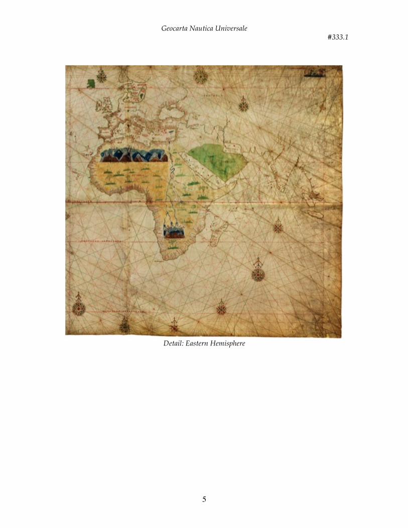
Title: Geocarta Nautica Universale Date: 1523 Author: Giovanni [Juan] Vespucci Description: This large map is attributed to Giovanni [Juan] Vespucci, born in Florence in 1486, who was the nephew of the great navigator Amerigo Vespucci. The latter, who collaborated in 1512 by Juan Diaz de Solis, pilot major of the Casa de la contratación Seville which was responsible for forming the new map Oficial del Estado (Padrón real), and he became pilot major in 1513; in 1515 it was part of the junta in charge of correcting the navigation chart (carta de navegar) as a result of the review of Raya, the line found after the bull of Pope Alexander VI sent to the Spanish royal May 4, 1493 (the Treaty of Tordesillas), which established the division of the world into two spheres of influence, Spanish and Portuguese. The Geocarta Nautica Universale [Great Universal Maritime Chart], as defined in the recording inventory) is the first known map, drawn before the Junta de Badajoz (before 1524), which takes into account the results of the circumnavigation of the globe by Magellan’s expedition (1522); therefore it is the first map that shows the complete representation of the Pacific Ocean. The chart comes with six sheets of rectangular parchment joined together and is built on two circles, with the center on the equator tangent at the Line of Demarcation, which are arranged on the circumference of the thirty-two wind roses from which branch lines of the winds, crossing, divide the paper into “rumble of wind,” traditionally regarded as indications of direction for sailors. Like the contemporary manuscripts cartographic products, the map does not take into account the curvature of the earth; this defect is irrelevant to the Mediterranean, but would cause serious errors for transoceanic navigation. The large pink ornament placed on the equator has four gold prongs and four in blue for the eight principal winds, sixteen in the red. The other ornamental roses are all topped by twin spires golden, red, green, blue. The continents are colored yellow; the coasts are delineated with great precision with an outside line drawn in gold and replicated inside the green coast. The islands are colored gold, green, blue, and red (except Florida). The island of Rhodes is covered by the cross of the Knights of Jerusalem who ruled until 1522, forming the only Christian bulwark against the growing spread of Ottoman power. Toponyms perpendicularly to the coasts are indicated in black with the more important places and islands in red. The smaller islands are indicated in various colors. Groups of dots on the other hand indicate shallows & reefs. Colored lines indicate the equator, the tropics, and polar circles. The Amazon rainforest is displayed through a thick, wide clump of tall trees with flying parrots on the edge of them; the Nile stretches across the African continent to its mythic sources of the Mountains of the Moon and the Athlas Mountains are represented by a series of hills, topped by skeletal trees to indicate the extreme aridity, which vary in color with increasing altitude: the lowest brown, blue intermediates, and blue the highest. The Arabian Peninsula is a desert colored green. Europe, Africa and Asia as far as India are accurately reproduced and there is a dense set of names that indicate the ports, harbors and sailing to the city, but the main interest is the “new world” and the vast newly discovered ocean that stretched west of South America: a huge waterway to finally reach the rich lands of the East traveling West. Spices and selected raw materials were the treasures, but most of all it was the lure of an Empire “on which the sun never sets.”
Geocarta Nautica Universale #333.1
2
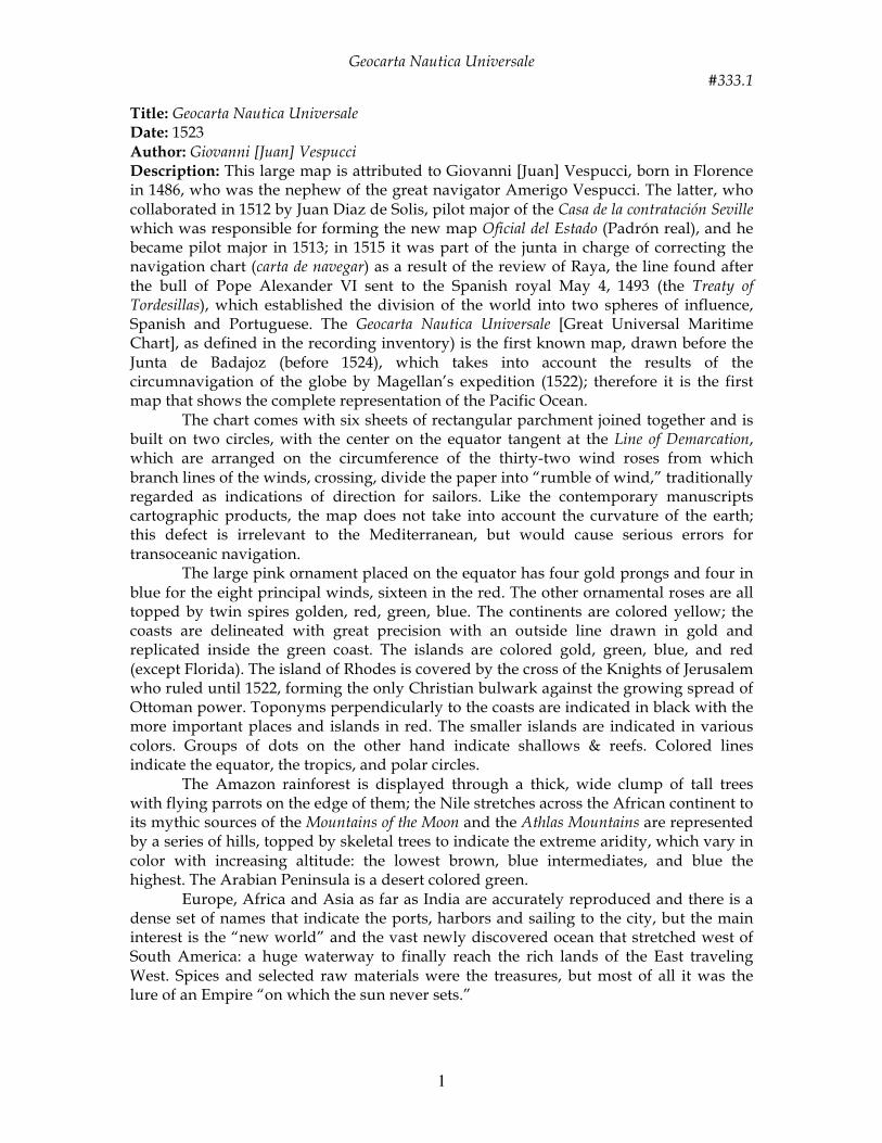
The New World in this map shows a very accurate relationship and image of all of the aspects of the Caribbean Sea and especially the West Indies, Hispaniola, Cuba, Jamaica, South America, Central America, Yucatan (as a peninsula), the Gulf of Mexico and there is also a blank space. East of this blank space, in its proper relation to Cuba, is a fairly accurately shaped uncolored peninsula labeled Isla Florida [Island of Florida] with only the lower portion drawn and nothing above it. If the date is correct (which it probably is not) this would be the first map to show the Florida peninsula properly labeled, shaped or positioned -- except for the Freducci map which is a manuscript portolan [nautical] chart. Tierra del Fuego and the Straight of Magellan are shown but not labeled so it was probably done after Juan Sebastian Del Cano’s return from the Magellan voyage around the world. The sources of the map information seem to be a mixture of Spanish and Portuguese and maybe other authentic sources. Locations: Royal Library of Turin Size: 112 x 261.5 cm/ 3 feet 8 inches x 8 feet 7 inches
Detail of the Caribbean area

Geocarta Nautica Universale #333.1
3
Detail: Western Hemisphere

Geocarta Nautica Universale #333.1
4
Geocarta Nautica Universale #333.1
5
Detail: Eastern Hemisphere

Geocarta Nautica Universale #333.1
6
Detail: the Mountains of the Moon in Africa (the purported source of the Nile River)
Detail: the Athlas Mountains in Africa