gis data available for alberta transportation projects · gis data available for alberta...
TRANSCRIPT
05/07/2012
1
GIS Data available for Alberta Transportation Bridge Planning Projects
Many GIS data sets are available from Alberta Transportation (TRANS) and external providers for use on
TRANS projects. This data is valuable during the initial stages of a project (such as using DEM and
satellite layers to develop a preliminary highway alignment) but can also be useful during the later
stages (such as using cadastral layers to determine right of way requirements).
A GIS platform is required to use these data sets. The Bridge Planning group of TRANS uses Global
Mapper (purchase and demo version available from https://www.bluemarblegeo.com/). This document
describes the data sets available, sources, and application in TRANS bridge planning projects.
GIS data sets available through TRANS may be managed by the Highway Geomatics group or the Bridge
Planning group within the Technical and Program Services Branch. Some GIS data is available from the
Bridge Planning group at http://www.transportation.alberta.ca/PlanningTools/Data/GIS/, accessible
through the Guide to Bridge Planning Tools (http://www.transportation.alberta.ca/4869.htm). Some
data is only available on request and on a site specific basis; these require a data sharing agreement to
be signed.
Data requests contacts are:
Highway Geomatics Group Bridge Planning Group Mark Bajgar Caroline Watt [email protected] [email protected] 780‐644‐1706 780‐415‐1013
*Note, when requesting data, please reference the TRANS project and include a figure and/or description of the coverage area
required.
GIS data sets can be used for various applications, some of the uses in the bridge planning field include:
drainage area delineation
historical air photo review (lateral stream mobility, land use changes, geotechnical instabilities)
channel parameter determination (bed width, top width, bank height, stream slope)
land ownership, RoW requirements
stream navigability
interaction with software, such as TRANS in‐house BPG.xls (roadway alignment and profile
generation, bridge fill layout, design of river engineering works, 3D visualization)
maps, sketches, and figures for reports
05/07/2012
2
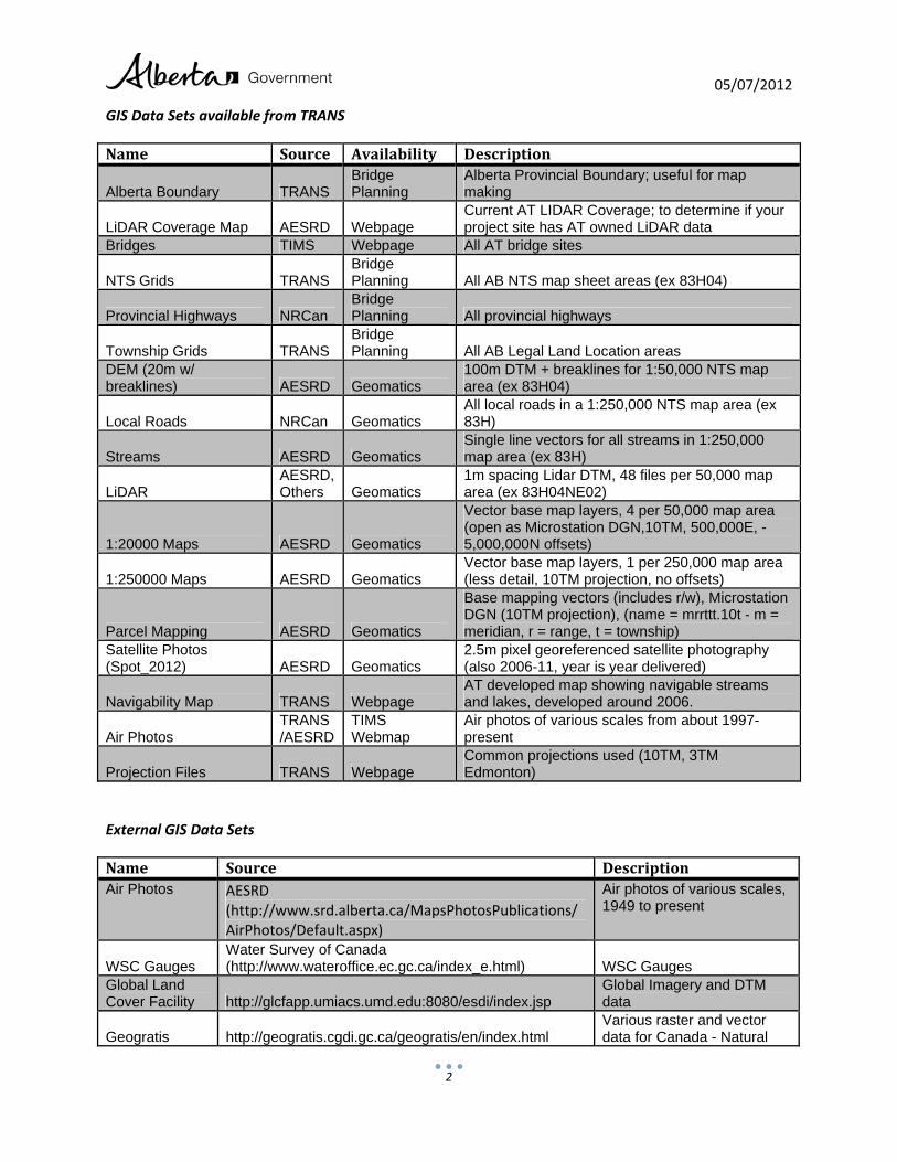
GIS Data Sets available from TRANS
Name Source Availability Description
Alberta Boundary TRANS Bridge Planning
Alberta Provincial Boundary; useful for map making
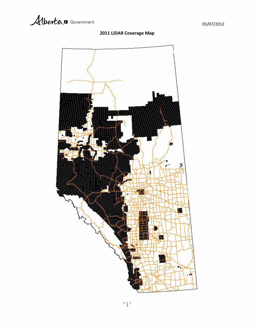
LiDAR Coverage Map AESRD Webpage Current AT LIDAR Coverage; to determine if your project site has AT owned LiDAR data
Bridges TIMS Webpage All AT bridge sites
NTS Grids TRANS Bridge Planning All AB NTS map sheet areas (ex 83H04)
Provincial Highways NRCan Bridge Planning All provincial highways
Township Grids TRANS Bridge Planning All AB Legal Land Location areas
DEM (20m w/ breaklines) AESRD Geomatics
100m DTM + breaklines for 1:50,000 NTS map area (ex 83H04)
Local Roads NRCan Geomatics All local roads in a 1:250,000 NTS map area (ex 83H)
Streams AESRD Geomatics Single line vectors for all streams in 1:250,000 map area (ex 83H)
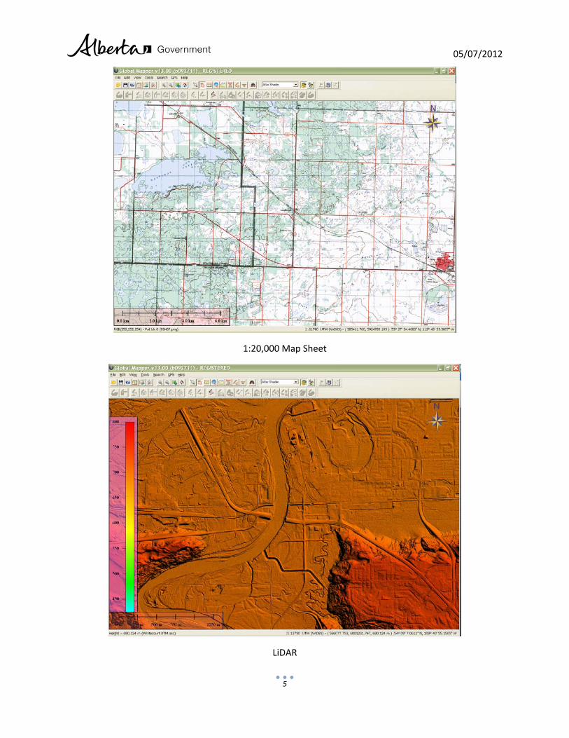
LiDAR AESRD, Others Geomatics
1m spacing Lidar DTM, 48 files per 50,000 map area (ex 83H04NE02)
1:20000 Maps AESRD Geomatics
Vector base map layers, 4 per 50,000 map area (open as Microstation DGN,10TM, 500,000E, -5,000,000N offsets)
1:250000 Maps AESRD Geomatics Vector base map layers, 1 per 250,000 map area (less detail, 10TM projection, no offsets)
Parcel Mapping AESRD Geomatics
Base mapping vectors (includes r/w), Microstation DGN (10TM projection), (name = mrrttt.10t - m = meridian, r = range, t = township)
Satellite Photos (Spot_2012) AESRD Geomatics
2.5m pixel georeferenced satellite photography (also 2006-11, year is year delivered)
Navigability Map TRANS Webpage AT developed map showing navigable streams and lakes, developed around 2006.
Air Photos TRANS /AESRD
TIMS Webmap
Air photos of various scales from about 1997- present
Projection Files TRANS Webpage Common projections used (10TM, 3TM Edmonton)
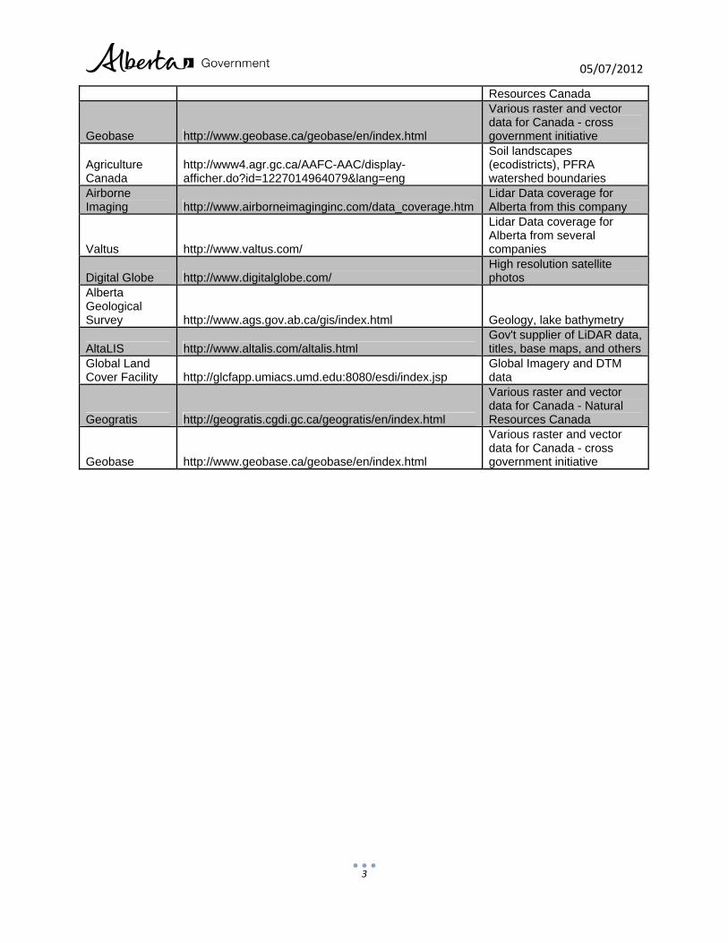
External GIS Data Sets
Name Source DescriptionAir Photos AESRD
(http://www.srd.alberta.ca/MapsPhotosPublications/AirPhotos/Default.aspx)
Air photos of various scales, 1949 to present
WSC Gauges Water Survey of Canada (http://www.wateroffice.ec.gc.ca/index_e.html) WSC Gauges
Global Land Cover Facility http://glcfapp.umiacs.umd.edu:8080/esdi/index.jsp
Global Imagery and DTM data
Geogratis http://geogratis.cgdi.gc.ca/geogratis/en/index.html Various raster and vector data for Canada - Natural
05/07/2012
3
Resources Canada
Geobase http://www.geobase.ca/geobase/en/index.html
Various raster and vector data for Canada - cross government initiative
Agriculture Canada
http://www4.agr.gc.ca/AAFC-AAC/display-afficher.do?id=1227014964079&lang=eng
Soil landscapes (ecodistricts), PFRA watershed boundaries
Airborne Imaging http://www.airborneimaginginc.com/data_coverage.htm
Lidar Data coverage for Alberta from this company
Valtus http://www.valtus.com/
Lidar Data coverage for Alberta from several companies
Digital Globe http://www.digitalglobe.com/ High resolution satellite photos
Alberta Geological Survey http://www.ags.gov.ab.ca/gis/index.html Geology, lake bathymetry
AltaLIS http://www.altalis.com/altalis.html Gov't supplier of LiDAR data, titles, base maps, and others
Global Land Cover Facility http://glcfapp.umiacs.umd.edu:8080/esdi/index.jsp
Global Imagery and DTM data
Geogratis http://geogratis.cgdi.gc.ca/geogratis/en/index.html
Various raster and vector data for Canada - Natural Resources Canada
Geobase http://www.geobase.ca/geobase/en/index.html
Various raster and vector data for Canada - cross government initiative
05/07/2012
4
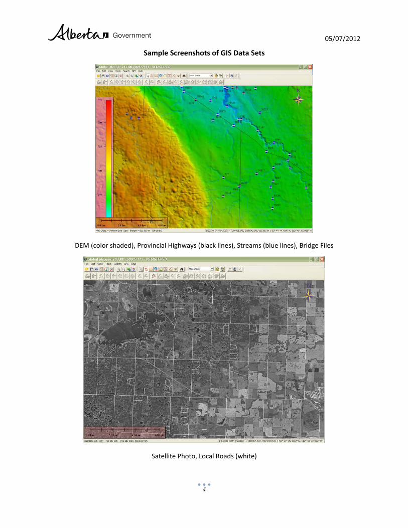
Sample Screenshots of GIS Data Sets
DEM (color shaded), Provincial Highways (black lines), Streams (blue lines), Bridge Files
Satellite Photo, Local Roads (white)
05/07/2012
5
1:20,000 Map Sheet
LiDAR
05/07/2012
6
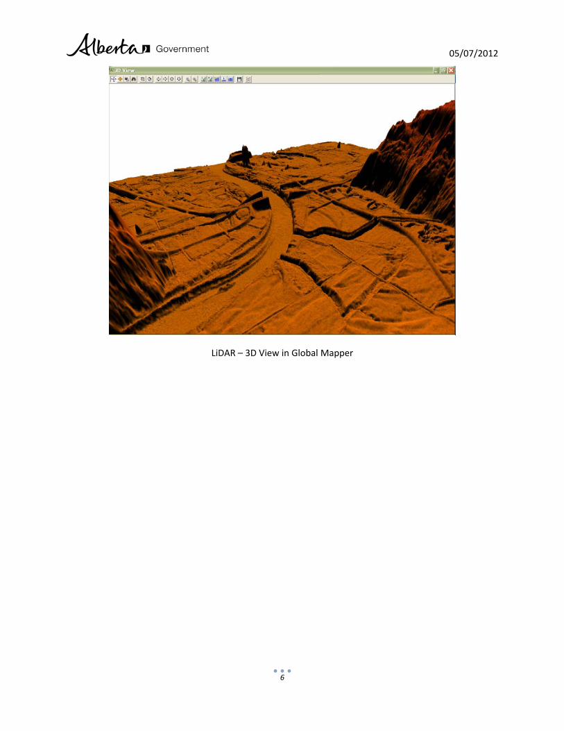
LiDAR – 3D View in Global Mapper
05/07/2012
7
2011 LiDAR Coverage Map