hses 1ete c06.qxd 5/16/04 9:12 am page 171 6.3 water...
TRANSCRIPT

Running Water and Groundwater 171
6.3 Water Beneath the Surface
Reading StrategyPreviewing Copy the table below. Beforeyou read the section, rewrite the green topicheadings as how, why, and what questions. Asyou read, write an answer to each question.
Key ConceptsWhere is groundwater andhow does it move?
How do springs form?
What are someenvironmental threats togroundwater supplies?
How and where do mostcaverns form?
What landforms arecommon in an area ofkarst topography?
Vocabulary◆ zone of saturation◆ groundwater◆ water table◆ porosity◆ permeability◆ aquifer◆ spring◆ geyser◆ well◆ artesian well◆ cavern◆ travertine◆ karst topography◆ sinkhole
Question Answer
How does watermove underground?
The ground beneath your feet isn’t as solid as you might think. Itincludes countless tiny pore spaces between grains of soil and sedi-ment. It also contains narrow joints and fractures in bedrock. Togetherthese spaces add up to an immense volume of tiny openings wherewater collects underground and moves.
Underground water in wells and springs provides water for cities,crops, livestock, and industry. In the United States, it is the drinking waterfor more than 50 percent of the population. It also provides 40 percent ofthe irrigation water and more than 25 percent of industry’s needs.
Distribution and Movement of WaterUndergroundWhen rain falls, some of the water runs off, some evaporates, and the restsoaks into the ground to become subsurface water. The amount of waterthat ends up underground in an area depends on the steepness of slopes,the nature of surface materials, the intensity of rainfall, and the type andamount of vegetation.
Distribution Some of the water soaks into the ground, but it doesnot travel far. Molecular attraction holds it in place as a surface film onsoil particles. This near-surface zone is called the belt of soil moisture.Roots, voids left by decayed roots, and animal and worm burrows criss-cross this zone. These features help rainwater seep into soil.
FOCUS
Section Objectives6.11 Describe the location and
movement of groundwater.6.12 Describe the formation of a
spring.6.13 Explain environmental threats
to water supplies.6.14 Describe the formation of
caverns.6.15 Describe landforms in karst
areas.
Build VocabularyParaphrase Students may find termssuch as porosity, permeability, aquifer,and artesian unfamiliar. Encouragestudents to create their own definitionsfor these terms to help them remembertheir meaning.
Reading Strategy
Sample answers
Question Answer
How does water move by twisting and turningunderground? through interconnected
small openings
How does a spring when the water tableform? intersects the ground
surface
What is a well? a hole bored into thezone of saturation
What are some overuse andenvironmental contaminationproblems associatedwith groundwater?
What kind of terrain irregular terrain withdo Karst areas have? many sinkholes
INSTRUCT
Distribution andMovement of WaterUndergroundBuild Science SkillsInferring After students read p. 171,ask: On sloping land, which wouldlikely result in more groundwater: aquick thunderstorm or the samevolume of water from a longer, gentlerain? Why? (the gentle rain because thewater would have more time to soak intothe ground rather than run off the land)Logical
L2
2
L2
L2
Reading Focus
1
Running Water and Groundwater 171
Section 6.3
HSES_1eTE_C06.qxd 5/16/04 9:12 AM Page 171

172 Chapter 6
Much of the water insoil seeps downward until itreaches the zone of saturation.The zone of saturation is thearea where water fills all of the
open spaces in sediment androck. Groundwater is the water
within this zone. The upper limit ofthe zone of saturation is the water table,
as you can see in Figure 14. The area abovethe water table where the soil, sediment, and
rock are not saturated is the zone of aeration. Wellscannot pump water from this zone. The water clings too
tightly to the rocks and soil. Only below the water table—where waterpressure is great enough to allow water to enter wells—can water bepumped.
Movement The flow and storage of groundwater vary dependingon the subsurface material. The amount of groundwater that can bestored depends on porosity. Porosity is the percentage of the totalvolume of rock or sediment that consists of pore spaces. Spacesbetween sedimentary particles form pore spaces. Joints, faults, and cav-ities also are formed by the dissolving of soluble rocks such aslimestone.
Rock or sediment may be very porous and still block water’smovement. The permeability of a material is its ability to release afluid. Groundwater moves by twisting and turning throughinterconnected small openings. The groundwater moves moreslowly when the pore spaces are smaller. If the spaces between par-ticles are too small, water cannot move at all. For example, clay hashigh porosity. But clay is impermeable because its pore spaces are sosmall that water can’t move through them.
Impermeable layers that get in the way or prevent water movementare aquitards. Larger particles, such as sand, have larger pore spaces.Water moves through them easily. Permeable rock layers or sedimentsthat transmit groundwater freely are aquifers. Aquifers are importantbecause they are the source of well water.
SpringsA spring forms whenever the water table intersects the ground
surface. A spring is a flow of groundwater that emerges naturally atthe ground surface, as shown in Figure 15. Springs form when anaquitard blocks downward movement of groundwater and forces itto move laterally.
Figure 14 This diagram showsthe relative positions of manyfeatures associated withsubsurface water.Applying Concepts What is thesource of the spring in the centerof the illustration?
Figure 15 A spring flows from avalley wall into a stream.
Unsuccessfulwell
Successfulwell
Perchedwater table
Spring
Aquitard
Main water table
Zone ofaeriation
Zone ofsaturation
172 Chapter 6
Section 6.3 (continued)
Water TablePurpose Students visually see theboundary between the zone ofsaturation and the zone of aeration.
Materials large clear plastic cup; clean,dry sand; water
Procedure Fill the cup about two-thirds full with the clean sand. Slowlypour the water on top of the sand andallow it to filter down to the bottom.Add enough water so that the cup isapproximately half full of water.
Expected Outcome Students shouldbe able to clearly see the separationbetween the sand that contains waterand the sand that does not have waterin its pore space. Identify this boundaryfor them as the water table. Studentscan then infer what would happen tothe water table in times of drought orexcessive rainfall.
L2
Customize for English Language Learners
Have students work in pairs to think of waysthat groundwater can be conserved. Examplesinclude shutting off the faucet when brushingyour teeth, taking shorter showers, and
running the dishwasher only when full.Strengthen discussion skills by having studentsshare their examples with the class.
HSES_1eTE_C06.qxd 5/16/04 9:13 AM Page 172

Running Water and Groundwater 173
Hot Springs A hot spring is 6°C to 9°C warmerthan the mean annual air temperature where thespring occurs. There are more than 1000 hot springsin the United States
Temperatures in deep mines and oil wells usuallyrise with an increase in depth at an average of 2°C per100 meters. So when groundwater circulates at greatdepths, it becomes heated. If it rises to the surface, thewater may emerge as a hot spring. This process heatsmany hot springs in the eastern United States.However, more than 95 percent of the hot springs inthe United States are in the West. The source of heatfor most of these hot springs is cooling igneous rock.In some places, hot acidic groundwater mixes withminerals from adjacent rock to form thick, bubblingmineral springs called mudpots.
Geysers A geyser is an intermittent hot spring orfountain in which a column of water shoots up withgreat force at various intervals. Geysers often shoot upcolumns of water 30 to 60 meters. After the jet ofwater stops, a column of steam rushes out—usuallywith a thundering roar. Perhaps the most famousgeyser in the world is Old Faithful in YellowstoneNational Park. It erupts about once each hour.
Geysers occur where extensive undergroundchambers exist within hot igneous rocks. Follow theformation of a geyser in Figure 16. As relatively coolgroundwater enters the chambers, the surroundingrock heats it. The weight of the overlying water cre-ates great pressure at the bottom of the chamber. Thispressure prevents the water from boiling at thenormal surface temperature of 100°C. However, theheat makes the water expand, and it forces some ofthe water out at the surface. This loss of water reducesthe pressure in the chamber. The boiling point drops.Some of the water deep within the chamber thenturns to steam and makes the geyser erupt. Followingthe eruption, cool groundwater again seeps into thechamber. Then the cycle begins again.
What is a geyser?
Water tableCavern
Warm ash andlava flows
Heat flow
Outflow
Steam
Steam
Heat flow
Geysereruption
Emptychambers
Heat flow
Steam
Figure 16 A Groundwater enters undergroundcaverns and fractures in hot igneous rock whereit is heated to near its boiling point. B Heatingcauses the water to expand, with some beingforced out at the surface. The loss of waterreduces the pressure on the remaining water,thus reducing its boiling temperature. Some ofthe water flashes to steam. C The rapidlyexpanding steam forces the hot water out of thechambers to produce a geyser. The emptychambers fill again, and the cycle starts anew.
A
B
C
Geyser Eruption CycleSpringsBuild Reading LiteracyRefer to p. 502D in Chapter 18, whichprovides the guidelines for visualizing.
Visualize Have students keep theirbooks closed. Tell them to listencarefully while you read the section ongeysers. Ask students to describe howthey visualize what is occurring underground at a geyser. Invite students towork in pairs to discuss how theyvisualized the process.Visual
Use Visuals
Figure 16 Have the students study thediagram showing the geyser eruptioncycle. Ask: What heats thegroundwater in the undergroundcaverns? (hot igneous rock) Whathappens to the water when it isheated? (The water expands. Somewater is forced to the surface; some turnsto steam.) How is a geyser produced?(Expanding steam forces the hot water outof the chambers.)Visual, Verbal
L1
L1
Running Water and Groundwater 173
Yellowstone National Park is home toapproximately two thirds of the geysers onEarth. Included in these is one of the mostfamous geysers, Old Faithful. Despite its name,Old Faithful can be rather unpredictable. Itusually erupts every 76 minutes but it canrange from 35 minutes to 2 hours. The time
between eruptions depends upon the lengthof the previous eruption.
Old Faithful can shoot up water to 60 m.This is not the largest geyser, however.Steamboat Geyser, also located in Yellowstone,is the largest geyser in the world. It can shootwater 90 m into the air.
Facts and Figures
Answer to . . .
Figure 14 The source of the spring isthe higher water table within the zoneof aeration.
A geyser is an intermit-tent hot spring or
fountain in which a column of watershoots up at various intervals.
HSES_1eTE_C06.qxd 5/16/04 9:13 AM Page 173

Figure 17 A cone of depressionin the water table often formsaround a pumping well. If heavypumping lowers the water table,some wells may be left dry.
Cone of depression
Dry wellDry well
Former water table
Lowered water table
Well Well Well
Before heavypumping
After heavypumping
174 Chapter 6
For: Links on aquifers
Visit: www.SciLinks.org
Web Code: 2064
Q I have heard people say thatsupplies of groundwater can belocated using a forked stick. Canthis actually be done?
A What you describe is a prac-tice called “water dowsing.” Inthe classic method, a personholding a forked stick walksback and forth over an area.When water is detected, thebottom of the “Y” is supposedto be attracted downward.
Geologists and engineers areextremely doubtful, to say theleast. Case histories and demon-strations may seem convincing,but when dowsing is exposed toscientific scrutiny, it fails. Most“successful” examples of waterdowsing occur in places wherewater would be hard to miss. Ina region of adequate rainfall andfavorable geology, it is difficultto drill and not find water!
WellsA well is a hole bored into the zone of saturation. Irrigation for agri-culture is by far the single greatest use of well water in the UnitedStates—more than 65 percent of groundwater used annually.Industrial uses of groundwater rank a distant second, followed bythe amount used by homes.
The level of the water table may change considerably during a year.The level can drop during the dry season and rise following periods ofrain. To ensure a continuous water supply, a well must penetrate farbelow the water table. The water table around the well drops when-ever a substantial amount of water is withdrawn from a well. Thiseffect is called drawdown, and it decreases with an increase in distancefrom the well. The result of a drawdown is a cone of depression in thewater table. This cone of depression is shown in Figure 17. For mostsmall domestic wells, the cone of depression is tiny. However, whenwells are used for irrigation or industry, a very wide and steep cone ofdepression can result.
Water must be pumped out of most wells. However, water rises onits own in some wells, sometimes overflowing the surface. An artesianwell is any formation in which groundwater rises on its own underpressure. For such a situation to occur, two conditions must exist. First,water must be in an aquifer that is tilted so that one end is exposed atthe surface, where it can receive water. Second, there must be aquitardsboth above and below the aquifer to stop the water from escaping. Thepressure created by the weight of the water above forces the water torise when a well taps the aquifier.
How does an artesian well differ from most wells?
174 Chapter 6
WellsUse VisualsFigure 17 Ask students to compare thewells in both diagrams in Figure 17. Ask:As you can see in the diagrams, twoof the wells went dry as a result ofheavy pumping and one well stayedproductive. What rule of well diggingcan you deduce from this example?(When digging a well, be sure to sink itwell below the average water table.)Visual, Logical
Use CommunityResourcesInvite a hydrologist or waterconservationist to speak to the classon ways to conserve the use ofgroundwater. The Soil and WaterConservation Society can provide a listof local chapters and resources. Toprepare for the presentation, havestudents research current positions onwater conservation. They can developa list of questions to ask the speaker.Interpersonal, Verbal
L2
L1
Section 6.3 (continued)
Download a worksheet on aquifersfor students to complete, and findadditional teacher support fromNSTA SciLinks.
HSES_1eTE_C06.qxd 5/16/04 9:14 AM Page 174

Running Water and Groundwater 175
Environmental Problems Associatedwith GroundwaterAs with many valuable natural resources, groundwater is being threat-ened at an increasing rate. Overuse and contamination threatensgroundwater supplies in some areas.
Treating Groundwater as a Nonrenewable ResourceGroundwater seems like an endlessly renewable resource. However, sup-plies are finite. In some regions, the amount of water available torecharge an aquifer is much less than the amount being withdrawn.
The High Plains provides one example of severe groundwaterdepletion. In some parts of the region, intense irrigation has gone onfor a long time. Even if pumping were to stop now, it could take thou-sands of years for the groundwater to be fully replenished.
The ground may sink when water is pumped from wells faster thannatural processes can replace it. As water is withdrawn, the groundsubsides because the weight of the overburden packs relatively loosesediment grains more tightly together.
This type of subsidence is extreme in the San Joaquin Valley ofCalifornia, as shown in Figure 18. Land subsidence due to groundwaterwithdrawal for irrigation began there in the mid-1920s. It exceeded eightmeters by 1970. During a drought in 1976 and 1977, heavy groundwa-ter pumping led the ground to sink even more. Land subsidence affectedmore than 13,400 square kilometers of irrigable land—one half theentire valley.
Groundwater Contamination The pollution of groundwateris a serious matter, particularly in areas where aquifers provide much ofthe water supply. Common sources of groundwater pollution are sewagefrom septic tanks, farm wastes, and inadequate or broken sewers.
If sewage water that is contaminated with bacteria enters thegroundwater system, it may become purified through naturalprocesses. The harmful bacteria can be mechanically filtered by thesediment through which the water passes, destroyed by chemical oxi-dation, and/or assimilated by other organisms. For purification tooccur, however, the aquifer must be of the correct composition.
For example, extremely permeable aquifers have such large open-ings that contaminated groundwater may travel long distances withoutbeing cleansed. In this case, the water flows too quickly and is not incontact with the surrounding material long enough for purification tooccur. This is the problem at Well 1 in Figure 19A.
What are some common sources of groundwaterpollution?
Figure 18 The marks on theutility pole indicate the level ofthe surrounding land in yearspast. Between 1925 and 1975 thispart of the San Joaquin Valleysank almost 9 meters because ofthe withdrawal of groundwaterand the resulting compaction of sediments.
EnvironmentalProblems Associatedwith GroundwaterIntegrate HealthGroundwater Contamination Arseniccontamination of groundwater is acommon problem. Arsenic is a knowncarcinogen. It was once an ingredient inpesticides used on apple orchards. Manycommunities now are testing old appleorchards and finding that there aresignificant amounts of arsenic in theirsoil, which seeps into the groundwater.The Environmental Protection Agency(EPA) recently revised the standard forsafe levels of arsenic in drinking water.Prior to January 22, 2001, the acceptablelevel was 50 parts per billion. Nowpublic water systems must comply withthe new acceptable level of 10 parts perbillion by January 23, 2006. This willserve as a further level of protection ofour groundwater resources. Ask studentsto research other types of groundwatercontamination and steps that have beentaken to prevent or eliminate it. Pairs ofstudents can present short reports to theclass.Interpersonal, Verbal
L2
Running Water and Groundwater 175
Answer to . . .
In an artesian well,water rises on its own,
instead of being pumped.
Common sources ofgroundwater pollution
are sewage from septic tanks, farmwastes, and inadequate or brokensewers.
Drilling a well can be a daunting task. Notonly do you have to locate the source of wateron your property and determine how muchwater is available, you have to estimate theamount of water that you, your family, andpossibly your business will need. The followingare estimates that can be used to determinethe peak demand that will be placed on a well.
For a single family home, figure on 190 to285 L of water a day per person. Maintenance
of an average lawn and garden requires 190 to3800 L per day. Farmers are faced with a morechallenging estimate. For example, dairy cattlerequire 133 L per day per animal for drinkingwater. A goat requires 7.6 L per day; each pigrequires 15.2 L, a horse 45.6 L per day. A flockof 100 chickens requires 19 to 38 L of drinkingwater per day and a flock of 100 turkeys needs38 to 68 L per day.
Facts and Figures
HSES_1eTE_C06.qxd 5/16/04 9:14 AM Page 175

However, when the aquifer is composed of sand or permeablesandstone, the water can sometimes be purified after traveling only afew dozen meters through it. The openings between sand grains arelarge enough to permit water movement, yet the movement of thewater is slow enough to allow enough time for its purification. This isthe case at Well 2 in Figure 19B.
Other sources and types of contamination also threaten supplies,as you can see in Figures 20 and 21. These include fertilizers that arespread across the land, pesticides, and highway salt. In addition, chem-icals and industrial materials—some hazardous—may leak frompipelines, storage tanks, landfills, and holding ponds. As rainwateroozes through the refuse, it may dissolve contaminants. If this mate-rial reaches the water table, it will mix with and contaminategroundwater. In coastal areas, heavy use can deplete aquifers, causingunderground saltwater to enter wells.
Once the source of the problem has been identified and eliminated,the most common practice is to abandon the water supply. Abandoningthe water supply allows the pollutants to flush out gradually. It’s theleast costly and easiest solution, but the aquifer must stay unused foryears. To speed up this process, engineers sometimes pump out andtreat polluted water. The aquifer then recharges naturally, or the treatedwater is pumped back in. This process can be risky, because there is noway to be sure that treatment has removed all the pollution. Preventionremains the most effective solution to groundwater contamination.
Some substances in groundwater are natural. Ions of substances(from adjacent rock) such as calcium and iron make some water “hard.”Hard water forms scum with soap instead of suds. It can also depositresidue that clogs pipes. But hard water is generally not a health risk.
Well 1 deliveringcontaminated water
Cavernous limestone
Septictank
0 10 meters
Well 2 deliveringclean water
Contaminatedwater
Permeable sandstone
Septictank
5
176 Chapter 6
Figure 20 Agricultural chemicalssprayed on farm fields can seepinto soil and contaminateunderground water supplies.
Figure 19 A Although thecontaminated water has traveledmore than 100 meters beforereaching Well 1, the water movestoo quickly through thecavernous limestone to bepurified. B As the discharge fromthe septic tank percolatesthrough the permeablesandstone, it is purified in a shortdistance.
Figure 21 If landfills leak,harmful waste buried in them canescape into groundwater.
B
A
176 Chapter 6
Build Science SkillsApplying Concepts After reading thesection on Groundwater Contamination,present the following problem tothe class. Imagine you are anenvironmental scientist and havebeen called in to solve a groundwatercontamination problem. Some peoplehave noticed that their well water hasa funny smell and taste and they thinkthat the contamination is comingfrom a farmer who lives upstream.The farmer insists that he is notcontaminating the water supply andsuggests instead that a large chemicalfactory farther upstream is to blame.How can you determine where thecontamination is originating?(Answers will vary but students mayrecognize a few places to start. Forexample, they should suggest determiningthe type of contamination. Is the watersupply being contaminated by fertilizer, forexample? Identifying the contaminant willhelp in pinpointing the source. They alsomay recognize that by testing thegroundwater upstream and downstreamfrom the farmer, they may be able toidentify if the contamination is occurringupstream or downstream of the farm.)Logical, Intrapersonal
L2
Section 6.3 (continued)
The Environmental Protection Agency (EPA)recognizes that groundwater needs tobe treated as a nonrenewable resource. Theyhave strict regulations on public water suppliesbut have no control over private wells and watersources. They do, however, have some sugges-tions for homeowners with private wells toensure that this vital resource remains protected.They advise homeowners to• periodically inspect exposed portions of thewell for settling or damaged well casings.
• create a slope in the area around the well todrain runoff away from the well.• have the well tested each year for bacteriaand nitrates and other possible contaminants.• avoid using pesticides, herbicides, fuels, andother contaminants near the well.• inspect septic systems regularly.• refrain from disposing of hazardous materialin septic systems or abandoned wells.
Facts and Figures
HSES_1eTE_C06.qxd 5/16/04 9:15 AM Page 176

Running Water and Groundwater 177
CavernsThe most spectacular results of ground-water’s ability to erode rock arelimestone caverns. Soluble rocks, espe-cially limestone, underlie millions ofsquare kilometers of Earth’s surface.Limestone is nearly insoluble in purewater. But water containing small quan-tities of carbonic acid dissolves it easily.Most natural water contains the weakacid because rainwater dissolves carbondioxide from the air and decayingplants. Therefore, when groundwatercomes in contact with limestone, thecarbonic acid reacts with calcite in therocks. Calcium bicarbonate forms. Asgroundwater carries away calcium car-bonate in solution, it slowly erodesrock. A cavern is a naturally formedunderground chamber, such as the oneyou see in Figure 22. There are thousands of caverns in the UnitedStates. Most are fairly small, but some have spectacular dimensions.Carlsbad Caverns in southeastern New Mexico is a famous example.One chamber has an area equivalent to 14 football fields, and it is highenough to fit the U.S. Capitol building inside it.
Erosion forms most caverns at or below the water table in thezone of saturation. Here, acidic groundwater follows lines of weaknessin the rock, such as joints and bedding planes. As time passes, the dis-solving process slowly creates cavities and enlarges them into caverns.Material the groundwater dissolves eventually flows into streams andthen the ocean.
The features that produce the greatest curiosity for most cavernvisitors are depositional stone formations. These formations give somecaverns a wonderland appearance. They form from seemingly endlessdripping of water over great spans of time. The calcium carbonate thatis left behind produces the limestone we call travertine. These cavedeposits are commonly called dripstone.
Although the formation of caverns takes place in the zone of sat-uration, the deposition of dripstone features is not possible until thecaverns are above the water table in the zone of aeration. The forma-tion of caverns in the zone of aeration commonly occurs as nearbystreams cut their valleys deeper. As the elevation of the stream drops,the water table also lowers, leaving the caverns high and largely dry.
Figure 22 The dissolving actionof groundwater creates caverns.These dripstone features are inThree Fingers Cave in New Mexico.
CavernsUse VisualsFigure 22 Challenge studentsto imagine themselves as thespelunker(cave explorer) in thephotograph. Ask: What temperatureand overall climate would be in theThree Fingers Cave? (Climate wouldbe cool and very damp.)Visual
Build Reading LiteracyRefer to p. 474D in Chapter 17, whichprovides guidelines for the monitor yourunderstanding strategy.
Monitor Your Understanding Havestudents read the section on caverns.When students reach the end of thatsection, have them write the main ideasof that section. Have students askthemselves, “Did I have any troublereading this section? If so, why?”Invite students to come up with theirown strategies to improve theirunderstanding of cavern formation andfeatures. Have students use their ownstrategies as they continue reading.Intrapersonal, Verbal
L2
L1
Running Water and Groundwater 177
Customize for Inclusion Students
Hearing Impaired Reinforce the lesson’scontent by providing a variety of visualexamples. Be sure to spend time on all the visualexamples provided in the text. In addition, youmay wish to provide a visual display of howlimestone can be dissolved in a dilute acid.
Place several drops of hydrochloric acid on asample of limestone. Students will observe abubbling action. Challenge students toimagine how this action could, over a longperiod of time, create an underground cavern.
HSES_1eTE_C06.qxd 5/16/04 9:15 AM Page 177

178 Chapter 6
Dripstone Features Perhaps the most famil-iar dripstone features are stalactites. Stalactites areicicle-like stone pendants that hang from the ceilingof a cavern. They form when water seeps throughcracks in the cavern ceiling. When water reaches airin the cave, some of the dissolved carbon dioxideescapes from the drop and calcite begins to separateout. Deposition occurs as a ring around the edge ofthe water drops. As drops fall, each one leaves a tinytrace of calcite behind. This calcite creates a hollowlimestone tube called a soda straw, as shown inFigure 23. Often the hollow tube becomes pluggedor its supply of water increases. When a stalactitebecomes plugged or the water supply increases, thewater flows and deposits along the outside of thetube. As deposition continues, the stalactite takes onthe more common conical shape.
Stalagmites are formations that develop on thefloor of a cavern and reach up toward the ceiling.The water supplying the calcite for stalagmitegrowth falls from the ceiling and splatters over thesurface of the cavern floor. As a result, stalagmitesdo not have a central tube. They are usually more
massive and more rounded on their upper ends than stalactites. Givenenough time, a downward-growing stalactite and an upward-growingstalagmite may join to form a column.
Karst TopographyMany areas of the world have landscapes that have been shaped largelyby the dissolving power of groundwater. These areas are said to havekarst topography. This term comes from the Krs region of Slovenia,where such topography is strikingly developed. In the United States,karst landscapes occur in many areas that are underlain by limestone.These areas include parts of Kentucky, Tennessee, Alabama, southernIndiana, and central northern Florida.
Karst areas typically have irregular terrain, with manydepressions called sinkholes. A sinkhole is a depression produced ina region where groundwater has removed soluble rock. In the lime-stone areas of Florida, Kentucky, and southern Indiana, there are tensof thousands of these depressions. They vary in depth from just ameter or two to more than 50 meters.
What is a dripstone deposit?
Figure 23 Soda straw stalactitesin Great Basin National Park’sLehman Caves. Relating Cause and EffectWhat part do these drops ofwater play in the formation ofthe stalactites?
For: Links on sinkholes
Visit: www.SciLinks.org
Web Code: cjn-2065
178 Chapter 6
Karst TopographyBuild Science SkillsInferring Describe for students thecharacteristics of “hard” water. Watercontaining a lot of dissolved mineralscan impact the performance of soap andleave a residue behind on fixtures andshower curtains. Ask students if theythink the water may be hard in a karstregion, and if so, what mineral is mostlikely dissolved in the groundwater? (Thewater is hard in a karst region due to thecalcium dissolved in the water from theerosion of the limestone under ground.)Logical
Integrate ChemistryAcid Rain on Karst TopographyExplain to students that chemical andpower plants release sulfur dioxide andnitrogen monoxide into the air. Thesechemicals combine with precipitation tobecome acid rain. Acid rain harmsplants, animals, and soil. It also affectskarst topography because limestone isvulnerable to the effects of acid. Havestudents research the effects of acid rainon karst topography. Ask each studentto prepare a presentation that includes agraph or chart of data collected.Verbal, Logical
L2
L2
Section 6.3 (continued)
Download a worksheet on sinkholesfor students to complete, and findadditional teacher support fromNSTA SciLinks.
HSES_1eTE_C06.qxd 5/16/04 9:16 AM Page 178
Section 6.3 Assessment
Reviewing Concepts1. Where is groundwater located under the
surface?
2. How does water move underground?
3. What are some environmental threats togroundwater supplies?
4. How and where do most caverns form?
5. What landforms are common in an area ofkarst topography?
Critical Thinking6. Comparing and Contrasting What is the
difference between stalactites and stalagmites?
7. Analyzing Concepts How is groundwater anonrenewable resource?
8. Analyzing Concepts Explain why cavernsform in the zone of saturation, while dripstonefeatures form in the zone of aeration?
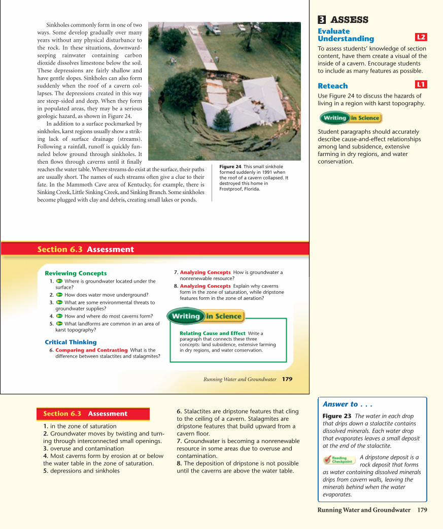
Sinkholes commonly form in one of twoways. Some develop gradually over manyyears without any physical disturbance tothe rock. In these situations, downward-seeping rainwater containing carbondioxide dissolves limestone below the soil.These depressions are fairly shallow andhave gentle slopes. Sinkholes can also formsuddenly when the roof of a cavern col-lapses. The depressions created in this wayare steep-sided and deep. When they formin populated areas, they may be a seriousgeologic hazard, as shown in Figure 24.
In addition to a surface pockmarked bysinkholes, karst regions usually show a strik-ing lack of surface drainage (streams).Following a rainfall, runoff is quickly fun-neled below ground through sinkholes. Itthen flows through caverns until it finallyreaches the water table. Where streams do exist at the surface, their pathsare usually short. The names of such streams often give a clue to theirfate. In the Mammoth Cave area of Kentucky, for example, there isSinking Creek, Little Sinking Creek, and Sinking Branch. Some sinkholesbecome plugged with clay and debris, creating small lakes or ponds.
Running Water and Groundwater 179
Relating Cause and Effect Write aparagraph that connects these threeconcepts: land subsidence, extensive farmingin dry regions, and water conservation.
Figure 24 This small sinkholeformed suddenly in 1991 whenthe roof of a cavern collapsed. Itdestroyed this home inFrostproof, Florida.
ASSESSEvaluateUnderstandingTo assess students’ knowledge of sectioncontent, have them create a visual of theinside of a cavern. Encourage studentsto include as many features as possible.
ReteachUse Figure 24 to discuss the hazards ofliving in a region with karst topography.
Student paragraphs should accuratelydescribe cause-and-effect relationshipsamong land subsidence, extensivefarming in dry regions, and waterconservation.
L1
L2
3
Running Water and Groundwater 179
Answer to . . .
Figure 23 The water in each dropthat drips down a stalactite containsdissolved minerals. Each water dropthat evaporates leaves a small depositat the end of the stalactite.
A dripstone deposit is arock deposit that forms
as water containing dissolved mineralsdrips from cavern walls, leaving theminerals behind when the waterevaporates.
6. Stalactites are dripstone features that clingto the ceiling of a cavern. Stalagmites aredripstone features that build upward from acavern floor.7. Groundwater is becoming a nonrenewableresource in some areas due to overuse andcontamination.8. The deposition of dripstone is not possibleuntil the caverns are above the water table.
Section 6.3 Assessment
1. in the zone of saturation2. Groundwater moves by twisting and turn-ing through interconnected small openings.3. overuse and contamination4. Most caverns form by erosion at or belowthe water table in the zone of saturation.5. depressions and sinkholes
HSES_1eTE_C06.qxd 5/16/04 9:17 AM Page 179

180 Chapter 6
The Ogallala Aquifer—How Long Will the Water Last?
The High Plains extend from the western Dakotassouth to Texas. Despite being a land of little rain,this is one of the most important agricultural regionsin the United States. The reason is a vast supply ofgroundwater that makes irrigation possible through-out most of the region. The source of most of thiswater is the Ogallala Formation, the largest aquiferin the United States.
Geologically, the Ogallala Formation consists of anumber of sandy and gravelly rock layers. The sedi-ments came from the erosion of the RockyMountains and were carried eastward by sluggishstreams. Erosion has removed much of the forma-tion from eastern Colorado, severing the Ogallala’sconnection to the Rockies.
The Ogallala Formation, the largest aquifer in theUnited States, averages 60 meters thick. However,in some places it is as thick as 180 meters thick.Groundwater in the aquifer originally traveleddownslope from the Rocky Mountains and from sur-face precipitation that soaked into the ground overthousands of years. Because of its high porosity andgreat size, the Ogallala Formation accumulated alarge amount of groundwater—enough to fill LakeHuron! Today, with the connection between theaquifer and the Rockies gone (erosion has removedmuch of the formation in eastern Colorado), all ofthe Ogallala’s recharge must come from the meagerrainfall of the Plains.
In the late 1800s, people first started to use theOgallala for irrigation. However, the capacity ofpumps available at the time limited water with-drawal. Then in the 1920s, large-capacity irrigationpumps were invented. High Plains’ farmers begantapping the Ogallala for irrigation. Today, there arenearly 170,000 wells irrigating more than 65,000square kilometers of land.
The increase in irrigation has caused a drastic dropin the Ogallala’s water table, especially in the HighPlains. Declines in the water table of 3 to 15 metersare common. In places, however, the water table isnow 60 meters below its original level.
Although the decline in the water table has slowed inparts of the southern High Plains, substantial pump-ing continues—often in excess of recharge. Thefuture of irrigated farming here is clearly in jeopardy.
The southern High Plains will return sooner or laterto dry-land farming. The transition will come soonerand with fewer ecological and economic crises if theagricultural industry is weaned gradually from itsdependence on groundwater irrigation. If nothingis done until all the accessible water in the Ogallalaaquifer has been removed, the transition will be eco-logically dangerous and economically dreadful.*
*National Research Council. Solid-Earth Sciences and Society.Washington, DC: National Academy Press, 1993, p. 148.
MN
IA
SDWY
CO
NM
TX
OK
KS
NE
Mexico
RO
CK
YM
OU
NT
AIN
S
Og
al l
al a
Fo
rm
at
ion
Figure 25 The Ogallala Formation underlies about450,000 square kilometers of the High Plains, makingit the largest aquifer in the United States.
180 Chapter 6
The Ogallala Aquifer—How Long Will theWater Last?Background• Dry-land farming is a system of
producing crops without irrigation insemi-arid regions. These regions oftenreceive less than 50 cm of rainfall peryear. Dry-land farmers usually rebuildsoil moisture by allowing the land tobe unplanted or mulched in alternateyears.
• In May, 2003, the United Statesgovernment provided $53 million toaid Western farmers and ranchersimpacted by drought. About half ofthis funding went to farmers andranchers in the High Plains. The fundshelped implement technologies andpractices to conserve water to relievethe long-term impact of drought onthe region.
Teaching Tips• Ask students to research dry-land
farming and other methods thatreduce agricultural dependence uponirrigation. Have them create apresentation with visuals that wouldeducate people about these methodsand the importance of finding asolution to the decline in the HighPlains water table.
• Have students find out about regionsin the world where there are largesupplies of groundwater. Ask studentsto address these questions: What isthe source of the groundwater? Howis groundwater used by people in theregion? How are they accessing it? Isthe water table in danger of becominglow? If so, what are plans to helpremedy the situation?
Visual
L2
HSES_1eTE_C06.qxd 5/16/04 9:17 AM Page 180