iii.g vegetation and wildlife 1. introduction and
TRANSCRIPT
Northeast Interstate Logistics Center DEIS Vegetation and Wildlife
III.G-1
III.G Vegetation and Wildlife
1. Introduction and Principal Conclusions
For the reasons described below, the proposed project would not result in any
significant adverse impacts to vegetation or wildlife.
The project site is former agricultural land. The uplands on the site were originally
maintained as agricultural fields and pastures associated with a dairy farm, but are now
mostly overgrown with trees and invasive shrubs and vines such as autumn olive,
multiflora rose, mile-a-minute, and oriental bittersweet. No buildings remain on the
property, although roads and utility poles are still present.
The wetlands on the property contain a variety of vegetative habitats. Most of the
wetlands on the site are deciduous wooded swamps that are seasonally or
intermittently flooded, with the exception of the farm ponds which likely remain
ponded year-round. To the east of Pugsley Road, the northern portion of Wetland 6
at the base of the hillside is wetter than the remainder of the wetlands on the site,
and contains an area of emergent wetland habitat with deep muck soils. This area of
Wetland 6 is suitable habitat (hydrology and soils) for Bog Turtles (Glyptemys
muhlenbergii), a federal-listed Threatened species and a state-listed Endangered
species. However, because no project impacts are proposed to Wetland 6, the
project will have no impacts to these turtles, should they be present.
The remainder of the uplands on the site are potential summer habitat for the
Northern Long-eared Bat (Myotis septentrionalis), also referred to as the northern
myotis, which is a Federal and State listed Threatened species. The Northern Long-
eared Bat is primarily associated with uplands and mature interior forest habitat, but
will utilize a diversity of forest habitats for roosting, foraging, and raising young.
Impacts to the Northern long-eared Bat are avoided by not cutting potential roost
trees during the bat pup’s rearing months of June 1 through July 31.

Northeast Interstate Logistics Center DEIS Vegetation and Wildlife
III.G-2
2. Existing Conditions
The project will not impact any significant vegetation. The great majority of the
disturbance area is situated on abandoned farmland, with the dominant vegetation
non-native invasive vines and shrubs. Only 0.05 acres of forested wetlands/emergent
march community are proposed to be disturbed, and this limited impact is mitigated
as described in Section III.D (“Surface Water and Wetlands”, and Figure III.D-2
“Wetlands Map”).
The only protected wildlife species that may occur on the site are the Northern Long-
eared Bat, and the Bog Turtle. No bat hibernacula are present on the site, where
hibernation and reproduction occur. Roost trees may occur on the site, however,
impacts to bat roosting will be avoided by not cutting potential roost trees during the
bat pup’s rearing months of June 1 through July 31. Regarding the Bog Turtle, the only
potential habitat found on the site occurs in Wetland 6. Because no project impacts
are proposed to Wetland 6, the project will have no impacts to these turtles, should
they be present.
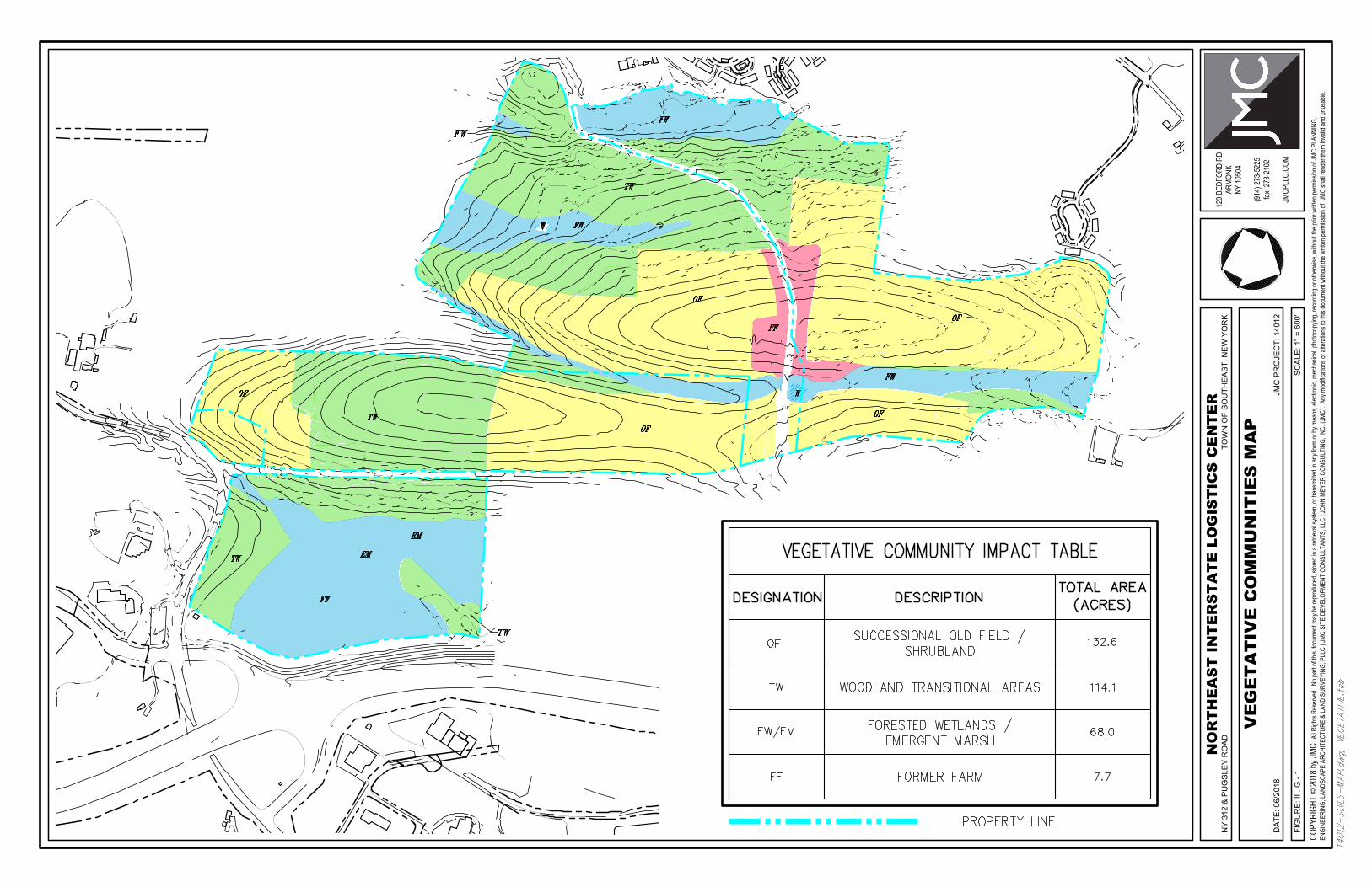
a. General Types And Characteristics Of Vegetative Communities
The project site currently supports four broad vegetative communities:
successional old field and shrubland, woodland transitional areas (including
hedgerows and young second growth forest), forested wetlands, and emergent
marsh / scrub shrub wetlands (Figure III.G-1). Wetlands comprise about 20% of
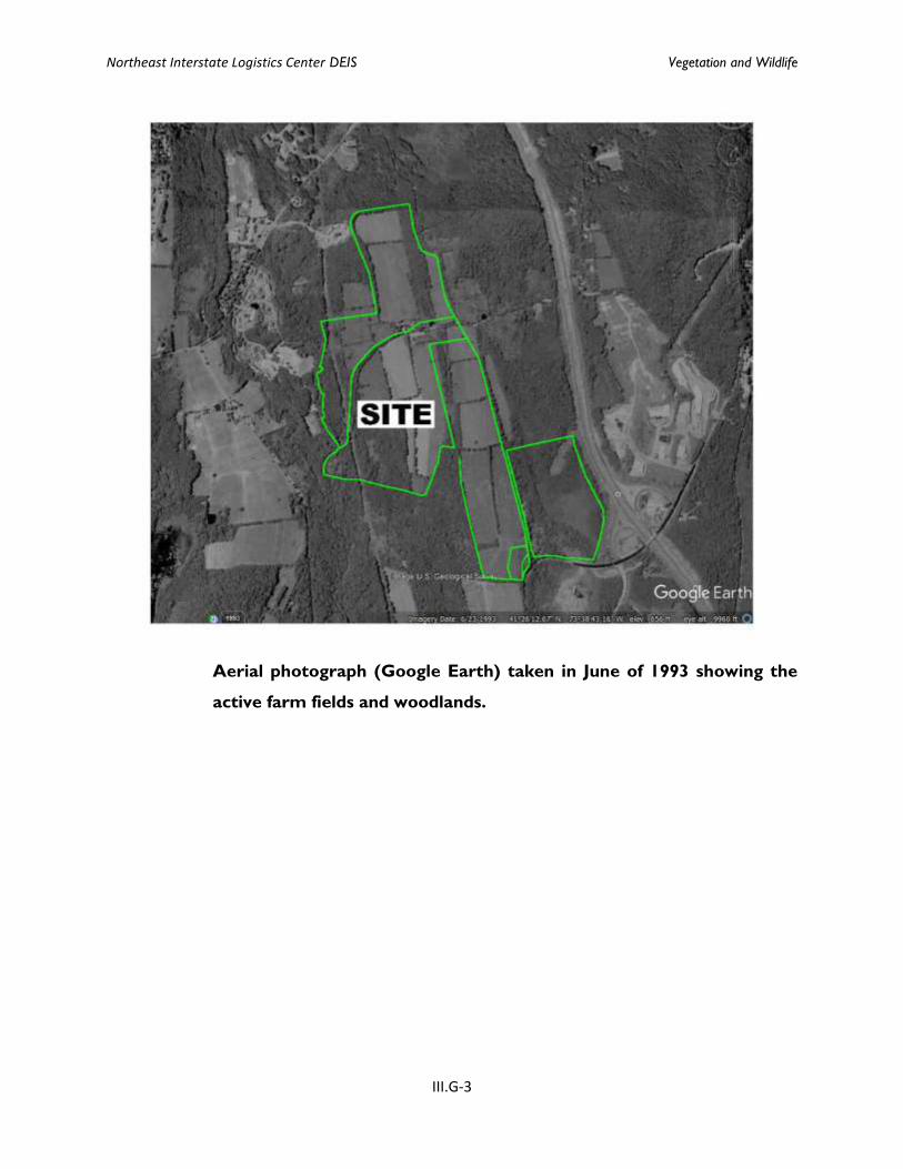
the site, with uplands making up the remainder. As seen in the aerial photographs
below, most of the upland portions of the site have undergone transition from
active farmland to abandoned farmland over the last 20 to 25 years, while the
wetlands have remained largely undisturbed.
Northeast Interstate Logistics Center DEIS Vegetation and Wildlife
III.G-3
Aerial photograph (Google Earth) taken in June of 1993 showing the
active farm fields and woodlands.

Northeast Interstate Logistics Center DEIS Vegetation and Wildlife
III.G-4
Aerial photo (Google Earth) from April of 2016 showing successional
old fields replacing former farmland.
The dominate vegetative communities on the upland portions of the site are
successional old field and successional shrubland. The portions of the site that
were most recently farmed, and therefore were periodically mowed, are
characterized by forbs and grasses such as goldenrods (Solidago altissima, S.
nemoralis, S. rugosa, S. juncea, S. canadensis, and Euthamia graminifolia), bluegrasses
(Poa pratensis, P. compressa), timothy (Phleum pratense), quackgrass (Elymus repens),
smooth brome (Bromus inermis), orchard grass (Dactylis glomerate), evening
primrose (Oenothera biennis), old-field cinquefoil (Potentilla simplex), New England
aster (Sympyotrichum novae-angliae), wild strawberry (Fragaria virginiana), Queen-
Northeast Interstate Logistics Center DEIS Vegetation and Wildlife
III.G-5
Anne's-lace (Daucus carota), ragweed (Ambrosia artemisiifolia), and hawkweeds
(Hieracium spp.). Portions of the uplands that were abandoned earlier are
dominated by shrubs including gray dogwood (Cornus racemosa), silky dogwood (C.
amomum), arrowwood (Viburnum dentatum), raspberries (Rubus spp.), sumac (Rhus
typhina, R. glabra), and eastern red cedar (Juniperus virginiana).
However, the dominant vegetation in these former fields is now non-native
invasive vines and shrubs, including multiflora rose (Rosa multiflora), Russian and
autumn olive (Elaeagnus angustifolia, E. umbellata), Japanese barberry (Berberis
thunbergii), winged euonymus (Euonymus alatus), hawthorne (Crataegus spp.),
buckthorns (Rhamnus cathartica, Frangula alnus), and shrubby honeysuckles
(Lonicera tatarica, L. morrowii, L. maacckii). In some areas, non-native invasive vines
such as bittersweet (Celastrus orbiculatus) and mile-a-minute (Persicaria perfoliate)
have become so abundant that the native species are in serious decline.
The old fields were typically bordered by hedgerows of mature trees, including
maples (Acer saccharum, A. rubrum, A. platanoides), hickories (Carya ovata, C. glabra),
and oaks (Quercus rubra and Q. alba), and seedlings of some trees are found near
the field edges. However, as with the successional fields, the hedgerows are heavily
vine infested and the trees in the central portion of the site are generally in decline.
However, most of the wetlands on the site are forested and these areas show
much less evidence of past disturbance.
The forested wetlands on the site are best characterized as red maple hardwood
swamps. Vegetation in these wetlands includes red maple (Acer rubrum), American
elm (Ulmus americana), and green ash (Fraxinus pennsylvanica) trees and saplings,
multiflora rose (Rosa multiflora), silky dogwood (Cornus amomum), Japanese
barberry (Berberis thunbergii), and spicebush (Lindera benzoin) shrubs, Asiatic
bittersweet (Celastrus orbiculata), Virginia creeper (Parthenocissus quinquefolia), and
poison ivy (Toxicodendron radicans) vines, along with skunk cabbage (Symplocarpus
foetidus), tussock sedge (Carex stricta), white hellebore (Veratrum viride), jewelweed
Northeast Interstate Logistics Center DEIS Vegetation and Wildlife
III.G-6
(Impatiens capensis), clearweed (Pilea pumila), false nettle (Boehmeria cylindrica),
royal fern (O. regalis), and marsh fern (Thelypteris palustris), cinnamon fern
(Osmunda cinnamomea), sensitive fern (Onoclea sensibilis), Japanese stilt-grass
(Microstegium vimineum), and garlic mustard (Alliaria petiolata). The forested
wetlands on the site have developed in hydric mineral soils and are often
associated with watercourses.
Finally, the wetlands to the east of Pugsley Road and north of Route 312, and on
either side of the Barrett Road wetland crossing in the central portion of the site,
are best characterized as emergent wetland and scrub shrub wetlands. The
emergent wetlands are dominated by sedges (Carex stricta, C. lurida), tearthumbs
(Polygonum sagittatum, P. arifolium), blue vervain (Verbena hastata), manna grass
(Glyceria sp.), ferns (Osmunda cinnamomea), false nettle (Boehmeria cylindrica), and
goldenrod (Solidago sp.). The portion of the emergent wetland immediately south
of the Barrett Road crossing is now also partially dominated by common reed
(Phragmites australis) and purple loosestrife (Lythrum salicaria). These emergent
wetlands differ from the other wetlands on the site by having either open water
(north of Barrett Road) or deeper muck soils and an open canopy. In the southern
portion of the wetland east of Pugsley Road and immediately north of Route 312,
the emergent marsh transitions to a scrub shrub swamp, and drainage becomes
more channelized, eventually forming the watercourse that flows under Route
312. This portion of the wetland is dominated by shrubs including alders (Alnus
sp.), willows (Salix sp.), dogwoods (Cornus sericea, C. amomum, C. racemosa), swamp
azalea (Rhododendron viscosum), highbush blueberry (Vaccinium corymbosum), male-
berry (Lyonia ligustrina), spicebush (Lindera benzoin), wild raisin (Viburnum nudum),
and arrowwood (Viburnum dentatum). Scattered young trees are present along the
edges, such as red maple (Acer rubrum), American elm (Ulmus americana), and green
ash (Fraxinus pennsylvanica).
Northeast Interstate Logistics Center DEIS Vegetation and Wildlife
III.G-7
b. List Of Wildlife Species Found Or Expected On The Site, Including
Endangered, Threatened Or Species Of Special Concern, And
Associated Habitats
As described above, the uplands are mainly successional young trees, along with
invasive shrubs and vines that dominate the previously farmed fields. Despite the
large land area, the upland habitats and cover types on site provide limited habitat
for large mammals (other than white-tail deer) which require more open
understory for travel and feeding. However, the dense shrub cover now found in
the uplands provides excellent habitat for nesting song birds and small mammals.
The wooded cover types (the forested uplands and the red maple-hardwood
swamp) provide nesting and food opportunities for a variety of species. White-
tailed deer (Odocoileus virginianus) and Eastern coyote (Canis latrans) populations
are well established in the vicinity and evidence of these species were present on
site. Other mammals that are common to the forest habitat include raccoon
(Procyon lotor), gray squirrel (Sciurus carolinensis), eastern chipmunk (Tamius
straiatus), Virginia opossum (Didelphis virginiana), striped skunk (Mephitis mephitis),
rabbits (Sylvilagus spp.), white-footed mouse (Peromyscus leucopus), voles (Microtis
spp.) and moles (Scalopus aquaticus or Condylura cristata). Oak, beech, and hickory
trees provide mast (food) which is used by many species including deer, wild
turkey, squirrels, chipmunks, and mice. In addition, any dead-and-down wood and
standing dead trees (snags) within the wooded cover types can enhance the habitat
value for species such as woodpeckers and other cavity nesters, amphibians (some
of which live beneath rotting logs), and furbearing animals which use tree cavities.
Some trees in the uplands may provide roosting habitat for bats, mainly along the
edge of the open areas, where solar exposure is possible, and insects are readily
available for food.
The forested wetlands provide important breeding habitat for many wetland-
dependent species, such as northern spring peeper (Pseudacris crucifer crucifer),
Northeast Interstate Logistics Center DEIS Vegetation and Wildlife
III.G-8
American toad (Bufo americanus americanus), wood frog (Rana sylvatica), and
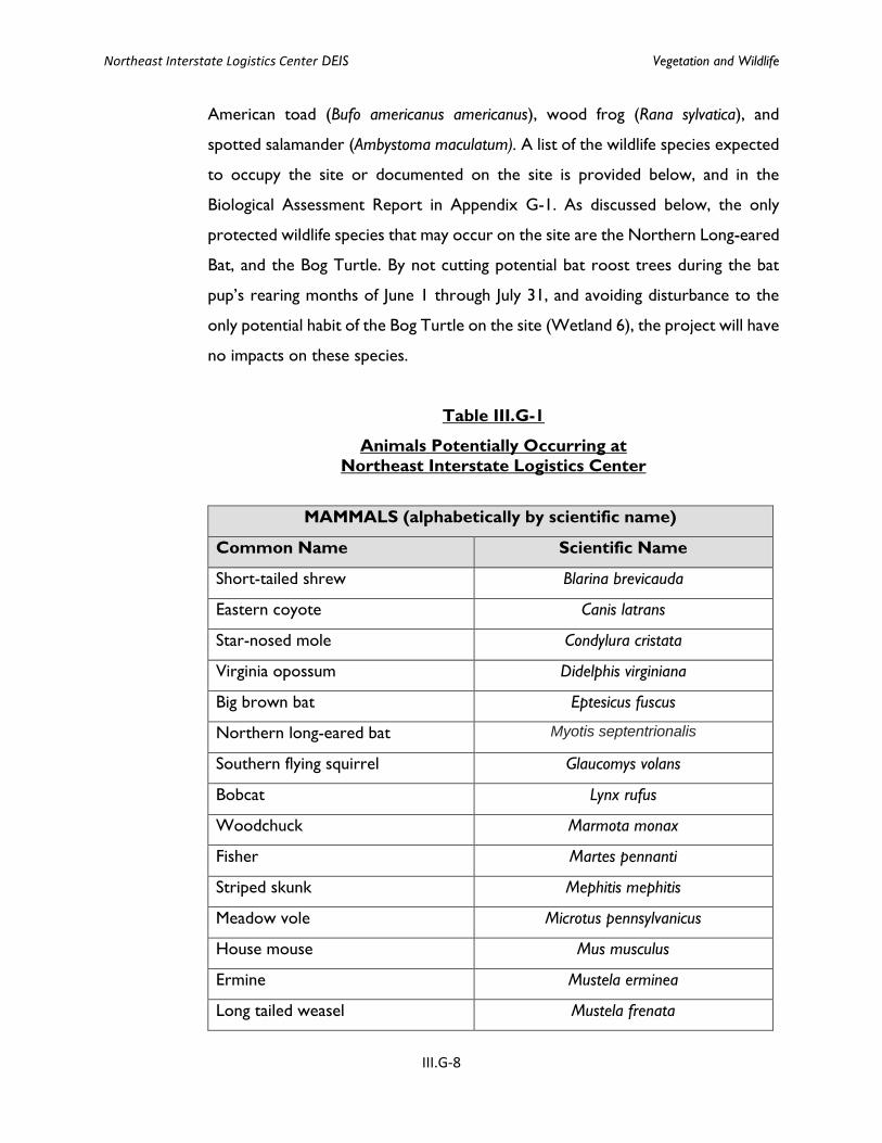
spotted salamander (Ambystoma maculatum). A list of the wildlife species expected
to occupy the site or documented on the site is provided below, and in the
Biological Assessment Report in Appendix G-1. As discussed below, the only
protected wildlife species that may occur on the site are the Northern Long-eared
Bat, and the Bog Turtle. By not cutting potential bat roost trees during the bat
pup’s rearing months of June 1 through July 31, and avoiding disturbance to the
only potential habit of the Bog Turtle on the site (Wetland 6), the project will have
no impacts on these species.
Table III.G-1
Animals Potentially Occurring at
Northeast Interstate Logistics Center
MAMMALS (alphabetically by scientific name)
Common Name Scientific Name
Short-tailed shrew Blarina brevicauda
Eastern coyote Canis latrans
Star-nosed mole Condylura cristata
Virginia opossum Didelphis virginiana
Big brown bat Eptesicus fuscus
Northern long-eared bat Myotis septentrionalis
Southern flying squirrel Glaucomys volans
Bobcat Lynx rufus
Woodchuck Marmota monax
Fisher Martes pennanti
Striped skunk Mephitis mephitis
Meadow vole Microtus pennsylvanicus
House mouse Mus musculus
Ermine Mustela erminea
Long tailed weasel Mustela frenata
Northeast Interstate Logistics Center DEIS Vegetation and Wildlife
III.G-9
Mink Mustela vison
Little brown myotis Myotis lucifugus
Northern myotis Myotis septentrionalis
White-tailed deer Odocoileus virginianus
Muskrat Ondatra zibethicus
White-footed mouse Peromyscus leucopus
Raccoon Procyon lotor
Norway rat Rattus norvegicus
Eastern mole Scalopus aquaticus
Gray squirrel Sciurus carolinensis
Masked shrew Sorex cinereus
Water shrew Sorex palustris
Eastern cottontail Sylvilagus floridanus
Eastern chipmunk Tamias striatus
Black bear Ursus americanus
Gray fox Vrocyon cinereoargenteus
Red fox Vulpes vulpes
REPTILES AND AMPHIBIANS
Common Name Scientific Name
Spotted salamander Ambystoma maculatum
Northern two-lined salamander Eurycea bislineata
Redback salamander Plethodon cinereus
Red-spotted newt Notophthalmus v. viridescens
Eastern American toad Bufo a. americanus
Gray treefrog Hyla versicolor
Northern spring peeper Pseudacris c. crucifer
Bullfrog Rana catesbeiana
Green frog Rana clamitans melonota
Northeast Interstate Logistics Center DEIS Vegetation and Wildlife
III.G-10
Pickerel frog Rana palustris
Northern leopard frog Rana pipiens
Wood frog Rana sylvatica
Common snapping turtle Chelydra s. serpentina
Painted turtle Chrysemys picta
Spotted turtle Clemmys guttata
Bog turtle Glyptemys muhlenbergii
Eastern box turtle Terrapene c. carolina
Northern black racer Coluber c. constrictor
Black rat snake Elaphe o. obsoleta
Northern water snake Nerodia s. sipedon
Northern brown snake Storeria d. dekayi
Northern redbelly snake Storeria o. occipito-maculata
Eastern garter snake Thamnophis s. sirtalis
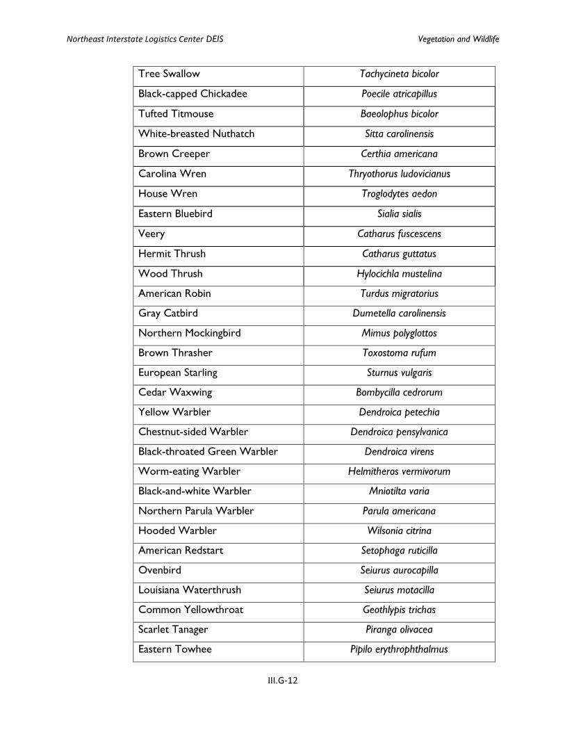
BIRDS
Common Name Scientific Name
Mute Swan Cygnus olor
Canada Goose Branta canadensis
Wood Duck Aix sponsa
Mallard Anas platyrhynchos
Mallard x Am. Black Duck Hybrid Anas platyrhynchos x A. rubripes
Great Blue Heron Ardea Herodias
Green Heron Butorides virescens
Turkey Vulture Cathartes aura
Black Vulture Coragyps atratus
Cooper's Hawk Accipiter cooperii
Red-tailed Hawk Buteo jamaicensis
American Kestrel Falco sparverius

Northeast Interstate Logistics Center DEIS Vegetation and Wildlife
III.G-11
Great Horned Owl Bubo virginianus
Eastern Screech-Owl Megascops asio
Killdeer Charadrius vociferus
Rock Pigeon Columba livia
Mourning Dove Zenaida macroura
Ruby-throated Hummingbird Archilochus colubris
Ruffed Grouse Bonasa umbellus
Wild Turkey Meleagris gallopavo
Red-bellied Woodpecker Melanerpes carolinus
Yellow-bellied Sapsucker Sphyrapicus varius
Pileated Woodpecker Dryocopus pileatus
Downy Woodpecker Picoides pubescens
Hairy Woodpecker Picoides villosus
Northern Flicker Colaptes auratus
Eastern Wood-Pewee Contopus virens
Willow Flycatcher Empidonax traillii
Eastern Phoebe Sayornis phoebe
Great Crested Flycatcher Myiarchus crinitus
Eastern Kingbird Tyrannus tyrannus
Blue-gray Gnatcatcher Polioptila caerulea
Ruby-crowned Kinglet Regulus calendula
Golden-crowned Kinglet Regulus satrapa
Yellow-throated Vireo Vireo flavifrons
Warbling Vireo Vireo gilvus
Red-eyed Vireo Vireo olivaceus
Blue Jay Cyanocitta cristata
American Crow Corvus brachyrhynchos
Yellow-billed Cuckoo Coccyzus americanus
Northern Rough-winged Swallow Stelgidopteryx serripennis
Barn Swallow Hirundo rustica
Northeast Interstate Logistics Center DEIS Vegetation and Wildlife
III.G-12
Tree Swallow Tachycineta bicolor
Black-capped Chickadee Poecile atricapillus
Tufted Titmouse Baeolophus bicolor
White-breasted Nuthatch Sitta carolinensis
Brown Creeper Certhia americana
Carolina Wren Thryothorus ludovicianus
House Wren Troglodytes aedon
Eastern Bluebird Sialia sialis
Veery Catharus fuscescens
Hermit Thrush Catharus guttatus
Wood Thrush Hylocichla mustelina
American Robin Turdus migratorius
Gray Catbird Dumetella carolinensis
Northern Mockingbird Mimus polyglottos
Brown Thrasher Toxostoma rufum
European Starling Sturnus vulgaris
Cedar Waxwing Bombycilla cedrorum
Yellow Warbler Dendroica petechia
Chestnut-sided Warbler Dendroica pensylvanica
Black-throated Green Warbler Dendroica virens
Worm-eating Warbler Helmitheros vermivorum
Black-and-white Warbler Mniotilta varia
Northern Parula Warbler Parula americana
Hooded Warbler Wilsonia citrina
American Redstart Setophaga ruticilla
Ovenbird Seiurus aurocapilla
Louisiana Waterthrush Seiurus motacilla
Common Yellowthroat Geothlypis trichas
Scarlet Tanager Piranga olivacea
Eastern Towhee Pipilo erythrophthalmus
Northeast Interstate Logistics Center DEIS Vegetation and Wildlife
III.G-13
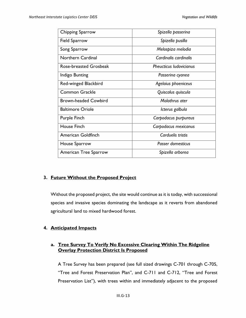
Chipping Sparrow Spizella passerina
Field Sparrow Spizella pusilla
Song Sparrow Melospiza melodia
Northern Cardinal Cardinalis cardinalis
Rose-breasted Grosbeak Pheucticus ludovicianus
Indigo Bunting Passerina cyanea
Red-winged Blackbird Agelaius phoeniceus
Common Grackle Quiscalus quiscula
Brown-headed Cowbird Molothrus ater
Baltimore Oriole Icterus galbula
Purple Finch Carpodacus purpureus
House Finch Carpodacus mexicanus
American Goldfinch Carduelis tristis
House Sparrow Passer domesticus
American Tree Sparrow Spizella arborea
3. Future Without the Proposed Project
Without the proposed project, the site would continue as it is today, with successional
species and invasive species dominating the landscape as it reverts from abandoned
agricultural land to mixed hardwood forest.
4. Anticipated Impacts
a. Tree Survey To Verify No Excessive Clearing Within The Ridgeline
Overlay Protection District Is Proposed
A Tree Survey has been prepared (see full sized drawings C-701 through C-705,
“Tree and Forest Preservation Plan”, and C-711 and C-712, “Tree and Forest
Preservation List”), with trees within and immediately adjacent to the proposed
Northeast Interstate Logistics Center DEIS Vegetation and Wildlife
III.G-14
limits of disturbance surveyed. Section III.C Visual Resources” of the DEIS
discusses extensively the measures taken by the project to comply with or to be
substantially less than the maximums permitted by the Town’s ridgeline protection
provisions. Figures III.C-3 and III.C-4 in Section III.C illustrate that the project will
remove trees at a ratio substantially below the maximum number of trees
permitted by the Town, and preserve existing trees within the ridgeline and
adjacent areas where practicable. As shown on the above noted figures, the areas
around Buildings #1 and #2 will have 2.9 trees removed per quarter acre where
up to 10 are permitted to be removed per the ridgeline provisions, and the areas
around Buildings #3 and #4 will have 1.4 trees removed per quarter acre. Thus,
the project conforms with and is substantially below the tree removal criteria
threshold of the ridgeline protection provisions.
In addition, a row of mature deciduous trees will remain between Building 4 and
the Twin Brook Manor development.
Thousands of additional existing trees on the site which have not been surveyed
will be preserved.
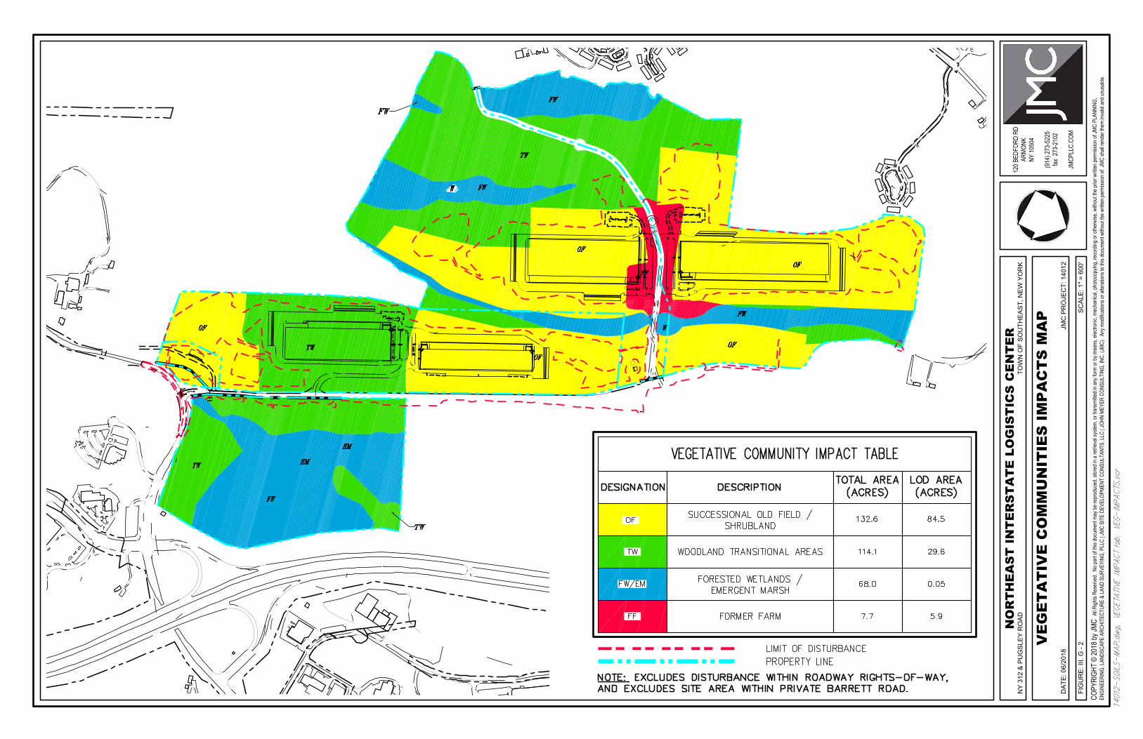
b. Project Design In Relation To Existing Significant Vegetation
As described above, the uplands are mainly successional young trees, along with
invasive shrubs and vines that dominate the previously farmed fields. Potential
adverse impacts to vegetation and wildlife habitats have been avoided to the
maximum extent practical by utilizing portions of the property which are former
agricultural fields. Figure III.G-2 illustrates the location and extent of disturbance
to the vegetative communities on the site, with the proposed project site plan
overlain to illustrate disturbance and preservation areas. The majority of site
disturbance (84.5 acres) is to the successional old field/shrubland vegetative
community. 29.6 acres of disturbance is proposed to the woodland transitional
areas, and 5.9 acres of disturbance to the former farm vegetative community. Only
Northeast Interstate Logistics Center DEIS Vegetation and Wildlife
III.G-15
0.05 acres of disturbance is proposed to the forested wetlands/emergent marsh
community, as discussed in Section III.D Surface Water and Wetlands of the DEIS.
Minor permanent encroachments into the wetland would occur only at the
existing on-site road crossing (improvements at the Barrett Road wetland crossing
between Wetlands 4 and 5), and will be mitigated by the measures discussed in
Section III.D.
c. Loss Of Wildlife Habitat
The proposed project is designed to utilize portions of the property that were
previously used for farming and are therefore primarily in the old field and
transitional woodland vegetative communities. As described above, these
communities are extensive on the site, so loss of vegetative cover type or wildlife
habitat are not of concern. However, there are two protected wildlife species that
have been identified as potential inhabitants for this site, and alteration of the
vegetative cover could impact both of these species. Therefore, potential impacts
to each species have been evaluated, and are discussed below.
Northern Long-eared Bat
The Northern Long-eared Bat has a range that includes much of the eastern and
north-central United States (which includes New York State). Reproduction
(fertilization) and hibernation occurs in or near very specific areas consisting of
caves or mines (called hibernacula). However, Northern Long-eared Bats are
opportunistic in choosing summer feeding and/or roosting habitat, and they can
use a variety of habitats, including those found on the site.
According to a map prepared by the DEC, Northern Long-eared Bat Occurrences
by Town,1 the Town of Southeast contains confirmed winter occurrences of
Northern Long-eared Bats (which would indicate the presence of one or more
hibernacula). The USF&WS lists approximate latitude/longitude measurements of
1 http://www.dec.ny.gov/animals/106090.html
Northeast Interstate Logistics Center DEIS Vegetation and Wildlife
III.G-16
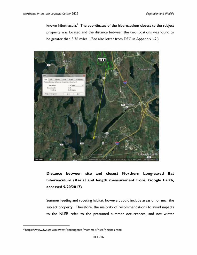
known hibernacula.2 The coordinates of the hibernaculum closest to the subject
property was located and the distance between the two locations was found to
be greater than 3.76 miles. (See also letter from DEC in Appendix I-2.)
Distance between site and closest Northern Long-eared Bat
hibernaculum (Aerial and length measurement from: Google Earth,
accessed 9/20/2017)
Summer feeding and roosting habitat, however, could include areas on or near the
subject property. Therefore, the majority of recommendations to avoid impacts
to the NLEB refer to the presumed summer occurrences, and not winter
2 https://www.fws.gov/midwest/endangered/mammals/nleb/nhisites.html
Northeast Interstate Logistics Center DEIS Vegetation and Wildlife
III.G-17
occurrences, since none have been documented as being located near the site.
The main threat to this bat is white-nose syndrome (which has no causal
connection to site development activities, such as the proposed project), which is
the reason it is listed for state and federal protection. Significant population
declines have not been observed due to loss or degradation of summer habitat.
Therefore, the main threat to this species from development of the proposed
project would be direct mortality of the bats if trees are removed while the bats
are roosting.
The USF&WS issued a final rule for the Northern Long-eared Bat on January 13,
2016 (effective February 16, 2016). In accordance with this ruling, requirements
and recommendations were provided to avoid impacts to the NLEB.3 In areas of
the country where white-nose syndrome is present (which includes the subject
property), if there are no hibernacula within a quarter mile of the site or known
maternal roost trees on or within 150 feet of the site, then there would be no
development restrictions at any time of year with regard to the northern long-
eared bat. However, because there is no certainty that there would not be
occupied maternal roost trees, potential roost trees must not be cut down during
the bat’s pup rearing months (June 1 through July 31).
Bog Turtle
Bog Turtles inhabit a variety of wetland types throughout their range, but generally
are found in small, open-canopy, herbaceous sedge meadows and fens that are
bordered by more-thickly vegetated wooded areas. These open-canopy meadows
and fens form the primary habitat for foraging, reproduction, and basking for this
species, while nearby closed-canopy, densely-vegetated wetlands may be used for
hibernation. Primary Bog Turtle habitat is typically associated with seepage or
spring-fed emergent wetlands and is often found near the headwaters of streams
3 Northern Long-eared Bat Project Review Fact Sheet - New York Field Office (last modified May 2016), found at:
https://www.fws.gov/northeast/nyfo/es/NYSpecies.htm (accessed September 20, 2017).
Northeast Interstate Logistics Center DEIS Vegetation and Wildlife
III.G-18
or small tributaries within a riparian wetland complex. This habitat is often
transitional between drier upland areas and other types of wetland, such as
wooded swamp or marsh. Bog Turtles will also utilize other types of wetlands as
dispersal or travel corridors between their preferred habitat patches. (US F&WS,
May 2001, revised April 2006)4.
Direct impacts to Bog Turtle habitat have been completely avoided because the
only potential Bog Turtle habitat on the site is associated with Wetland 6, and no
wetland impacts are proposed to Wetland 6, nor is any work proposed within 200
feet of the potential Bog Turtle habitat. The improvements to the site access road
(Pugsley Road) and to the intersection at Route 312 include encroachments into
the wetland buffer of Wetland 6, but this would occur in the southwest corner of
the wetland, outside of the area identified as potential Bog Turtle habitat, and at
an existing road intersection. Finally, there are no proposed changes to the
drainage patterns in this portion of the site, so the hydrology of the emergent
marsh wetland will not be impacted by the development.
5. Mitigation Measures
a. Landscaping Plan
As discussed in Section III.C “Visual Resources”, extensive evergreen trees and
other plantings are proposed, as depicted on the Landscaping Plans (drawings C-
501 through C-505). A total of 420 trees are proposed, including 332 evergreen
trees and 88 deciduous trees. the vast majority of which are located within the
ridgelines. Most of the trees are proposed adjacent to the building perimeter
parking areas to maximize the screening of the buildings and parking. In addition,
approximately 2,800 shrubs will be planted throughout the site.
4U. S. Fish and Wildlife Service, Bog Turtle (Clemmys muhlenbergii) Northern Population, Recovery Plan, May 2001, revised April 2006.
Northeast Interstate Logistics Center DEIS Vegetation and Wildlife
III.G-19
b. Maintenance Of Existing Vegetation
As described in this section, potential adverse impacts to vegetation and wildlife
habitats have been avoided to the maximum extent practical by utilizing portions
of the property which are former agricultural fields. Preservation of the remaining
successional old field/shrubland habitats on the site, as well as protection of the
wetland corridors on the site will provide shelter and nesting habitat for song birds
and small mammals, as well as wetland dependent species that are presently found
on the site. Finally, limiting tree clearing to the fall and winter months will avoid
potential impacts to any bats that may be using the site as summer habitat.
p:\2014\14012\admin\deis\deis\deis with redlined completeness responses 05-2018\iii.g vegetation and wildlife.docx
FIG
UR
E: I
II. G
- 1
DA
TE: 0
6/20
18
NY
312
& P
UG
SLE
Y R
OA
D
VE
GE
TA
TIV
E C
OM
MU
NIT
IES
MA
PTO
WN
OF
SO
UTH
EA
ST,
NE
W Y
OR
K
SC
ALE
: 1" =
600
'
JMC
PR
OJE
CT:
140
12
NO
RT
HE
AS
T I
NT
ER
ST
AT
E L
OG
IST
ICS
CE
NT
ER
120 B
EDFO
RD R
DAR
MONK
NY 10
504
(914
) 273
-522
5fax
273
-210
2
JMCP
LLC.
COM
COPY
RIGH
T ©
2018
by JM
C Al
l Righ
ts Re
serve
d. N
o par
t of th
is do
cume
nt ma
y be r
epro
duce
d, sto
red i
n a re
trieva
l sys
tem, o
r tra
nsmi
tted i
n any
form
or by
mea
ns, e
lectro
nic, m
echa
nical,
photo
copy
ing, r
ecor
ding o
r othe
rwise
, with
out th
e prio
r writt
en pe
rmiss
ion of
JMC
PLAN
NING
,EN
GINE
ERIN
G, LA
NDSC
APE
ARCH
ITEC
TURE
& LA
ND S
URVE
YING
, PLL
C | J
MC S
ITE
DEVE
LOPM
ENT
CONS
ULTA
NTS,
LLC
| JOH
N ME
YER
CONS
ULTI
NG, IN
C. (J
MC).
Any
mod
ificati
ons o
r alte
ratio
ns to
this
docu
ment
witho
ut the
writt
en pe
rmiss
ion of
JMC
shall
rend
er th
em in
valid
and u
nusa
ble.
FIG
UR
E: I
II. G
- 2
DA
TE: 0
6/20
18
NY
312
& P
UG
SLE
Y R
OA
D
VE
GE
TA
TIV
E C
OM
MU
NIT
IES
IM
PA
CT
S M
AP
TOW
N O
F S
OU
THE
AS
T, N
EW
YO
RK
SC
ALE
: 1" =
600
'
JMC
PR
OJE
CT:
140
12
NO
RT
HE
AS
T I
NT
ER
ST
AT
E L
OG
IST
ICS
CE
NT
ER
120 B
EDFO
RD R
DAR
MONK
NY 10
504
(914
) 273
-522
5fax
273
-210
2
JMCP
LLC.
COM
COPY
RIGH
T ©
2018
by JM
C Al
l Righ
ts Re
serve
d. N
o par
t of th
is do
cume
nt ma
y be r
epro
duce
d, sto
red i
n a re
trieva
l sys
tem, o
r tra
nsmi
tted i
n any
form
or by
mea
ns, e
lectro
nic, m
echa
nical,
photo
copy
ing, r
ecor
ding o
r othe
rwise
, with
out th
e prio
r writt
en pe
rmiss
ion of
JMC
PLAN
NING
,EN
GINE
ERIN
G, LA
NDSC
APE
ARCH
ITEC
TURE
& LA
ND S
URVE
YING
, PLL
C | J
MC S
ITE
DEVE
LOPM
ENT
CONS
ULTA
NTS,
LLC
| JOH
N ME
YER
CONS
ULTI
NG, IN
C. (J
MC).
Any
mod
ificati
ons o
r alte
ratio
ns to
this
docu
ment
witho
ut the
writt
en pe
rmiss
ion of
JMC
shall
rend
er th
em in
valid
and u
nusa
ble.