kanata lakes nea boundary definition, … international 191102 kanata lakes - environmental...
TRANSCRIPT
ESG INTERNATIONAL
191102 KANATA LAKES - ENVIRONMENTAL EVALUATION and MITIGATION (Web version)
KANATA LAKES
NEA BOUNDARY DEFINITION,
SHIRLEYS BROOK and
TREE CUTTING MITIGATION
A report prepared for the City of Ottawa
by ESG International Inc.
November, 2002
Important noticeThis Web Edition of the Report was prepared by the Kanata Lakes Community Association as a service tothe general Ottawa Community. The Report was originally submitted by KNL Development Inc. to the Cityof Ottawa in June of 2003 in support of an Official Plan Amendment Proposal, Plan of Subdivision Proposal,and Zoning By-law Amendment Proposal for a new major development.
The aim of publishing this Report on the web is to help residents and interest groups assess thedevelopment proposals submitted to the City of Ottawa by KNL Development Inc. For technical reasons,maps and diagrams had to be resized, and therefore should be used to gain a conceptual impression only.While every effort was made to maintain accuracy of the content, no responsibility can be assumed for anyerrors that may have arisen during the translation process from printed copy to electronic form. By readingthis electronic version of the Report you accept the full responsibility for your use of its content. For a printedoriginal of the Report, please contact the City of Ottawa. The kind permission of the City of Ottawa toprepare this electronic version is gratefully acknowledged.
Mik Svilans,
VP Environment,
Kanata Lakes Community Association
10th September 2003.
ESG INTERNATIONAL
191102 KANATA LAKES - ENVIRONMENTAL EVALUATION and MITIGATION (Web version) Page i
TABLE OF CONTENTS1.0 INTRODUCTION .......................................................................................................................... 1
2.0 METHODOLOGY ......................................................................................................................... 4
2.1 Terrestrial Environment..................................................................................................... 4
2.2 Shirley’s Brook.................................................................................................................. 5
3.0 DESCRIPTION of the EXISTING ENVIRONMENT................................................................... 5
3.1 Natural Environment Area................................................................................................. 5
3.1.1 Wetlands ........................................................................................................... 6
3.1.2 Upland Habitat .................................................................................................. 6
3.1.3 Linkages and Other Functions .......................................................................... 7
3.1.4 Definition of NEA Boundaries ......................................................................... 8
3.2 Shirley’s Brook................................................................................................................ 10
4.0 DESCRIPTION of ENVIRONMENTAL IMPACTS .................................................................. 11
4.1 Natural Environment Area Level of Impact Analysis ..................................................... 11
4.2 Shirley’s Brook Realignment........................................................................................... 12
5.0 MITIGATION of IMPACTS ........................................................................................................ 13
5.1 Natural Environment Area............................................................................................................ 13
5.1.1 Remediation and Restoration Principles......................................................... 13
5.1.2 Area by Area Remediation Plans .................................................................... 15
5.1.3 Development Guidelines for Adjacent Lands................................................. 16
5.2 Shirley’s Brook................................................................................................................ 18
5.2.1 Natural Channel Design ............................................................................................... 18
5.2.2 Development Guidelines for Adjacent Lands .............................................................. 19
6.0 CONCLUSIONS........................................................................................................................... 21
7.0 REFERENCES ............................................................................................................................. 21
FIGURES
1. Study Area, NEA Lines and Vegetation Communities ....................................................... 2
2. Impacted Areas .................................................................................................................... 3
3. Restoration Recommendations .......................................................................................... 14
4. Shirley’s Brook Realignment............................................................................................. 20
APPENDICES
A. Photographs of Site Representative Features
B. Vegetation and Wildlife Species Lists
ESG INTERNATIONAL
191102 KANATA LAKES - ENVIRONMENTAL EVALUATION and MITIGATION (Web version) Page 1
1.0 INTRODUCTION
This report is the technical environmental study carried out to determine the Natural EnvironmentArea (NEA) boundaries and the aquatic habitat associated with Shirley's Brook in the vicinity of thelands owned by KNL Developments Inc. on the west and east sides of the Goulbourn Forced Road,between the Beaver Pond to the east and the First Line Road allowance (the existing wooden hydropole line) to the west. Lands on the east side of the Goulbourn Forced Road south of the Beaver Pondare already developed and are not included in the scope of this report. The study area for the report isdepicted on Figure 1.
The NEA boundaries within the study area were originally addressed at a conceptual level in the1980s, as described in the planning study completed by D. W. Kennedy Consulting Ltd. A primaryobjective of this study is to evaluate the original concept NEA lines utilizing the natural environmentand social criteria described in this report.
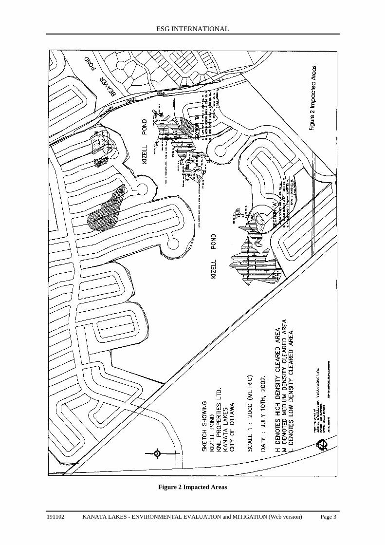
This report was expanded to include identification of areas impacted by the unauthorized treecutting in the early spring of 2002 between Goulbourn Forced Road and the First Line Roadallowance. The tree cutting involved removal of approximately 2,200 stems of deciduous andconiferous trees ranging in average size for each species from 33cm to 97cm diameter at breastheight. White ash, red maple, bur oak, white spruce, white elm, basswood and white cedar were themost frequently cut species. The majority of trees were removed in three general locations, as shownon Figure 2, among upland coniferous habitat south of the Kizell Pond and upland deciduous habitatnorth of the Kizell Pond to the west of the Goulbourn Forced Road, and among deciduous swamphabitat to the east of the First Line Road allowance. In addition to the actual removal of trees, damageof small tree stems and other vegetation was extensive as a result of the search for trees to be cut andthe skidding of the harvested trees. Note that the delineation of the NEA boundaries did not considerthe tree removal that occurred in March and April of 2002.
For the purpose of boundary delineation, the trees and associated habitat were considered to beintact. Mitigation measures are also presented to address this tree cutting.
This report does not represent an Environmental Impact Statement (EIS) for the proposeddevelopment. An EIS, including a monitoring plan, will be required for the proposed residentialdevelopment utilizing the concepts in the Environmental Impact Statement Draft Guidelines (RMOC,1998a) and the Natural Heritage Reference Manual (OMNR, I 999).
Specifically this report describes:
• the existing environmental conditions of the site, including the terrestrial, wetland andaquatic features;
• the evaluation of the Natural Environment Area (NEA) boundaries;
• the impact associated with the tree removal that occurred in March and April;
• mitigation measures for the tree removal, including restoration of the landscape; and,
• mitigation measures for the realignment of Shirley's Brook.

ESG INTERNATIONAL
191102 KANATA LAKES - ENVIRONMENTAL EVALUATION and MITIGATION (Web version) Page 2
Figure 1 Study Area, Vegetation Communities and NEA Lines
ESG INTERNATIONAL
191102 KANATA LAKES - ENVIRONMENTAL EVALUATION and MITIGATION (Web version) Page 3
Figure 2 Impacted Areas
ESG INTERNATIONAL
191102 KANATA LAKES - ENVIRONMENTAL EVALUATION and MITIGATION (Web version) Page 4
The Kanata Lakes North Neighbourhood Park Facilities Program Update prepared by CorushSunderland Wright Limited describes the recreational trail system, interpretative opportunities andother social components of the Kanata Lakes North evaluation. Information on stormwatermanagement is described in the Kanata Lakes North Serviceability Study completed by GummingCockburn Limited.
2.0 METHODOLOGY
2.1 Terrestrial EnvironmentMany existing studies described the features and functions of the terrestrial environment. Theprincipal documents are:
• Kanata Lakes Study Area Natural Environment Assessment (Brunton, 1992);
• Shirley’s Brook and Watts Creek Sub-Watershed Study (Dillon, 1999);
• Environmental and Servicing Reviewing of the West Kanata Lakes Area (DRAFT,CH2MHILL, 2001 ); and,
• a Review of Campeau Lands within the South March Highlands Conservation Lands (F.F.Slaney & Company Ltd., 1978).
The vegetation communities, significant plant and wildlife species and ecological functions werereviewed and verified under 2002 conditions with detailed spring fieldwork in 2002. Observations ofbreeding birds were completed on May 29th, May 30th, and June 18th, 2002. The breeding bird workwas conducted between 05:30 and 08:30 each morning. Weather conditions were ideal for thebreeding surveys as winds were light and skies were clear. Additional vegetation and casual wildlifeobservations were undertaken later in the morning for each of the dates listed above, and on June 26th,2002. Casual vegetation and wildlife observations were also noted as part of the many field visitscompleted with the study team and agency staff in August and September, 2002. As part of thesurveys, potential habitat for amphibians and reptiles was examined, including the underside of logsand other woody debris. The Natural Heritage Information Centre database was reviewed to identifyother potential species of interest in the vicinity of the site.
In addition to the background documentation, colour aerial photography (1999, 1:15,000) wasused to assess the natural environment features in the general vicinity of the study area describedabove. The Natural Heritage Information Centre (NHIC) database was utilised to providecharacteristics of the vegetation species identified with respect to wetland affinity, weediness,introduced plants, potential impact on native flora, and level of disturbance (Oldham et al., 1995).The system provides an assessment of the sensitivity and character of the vegetation through theapplication of the Floristic Quality Index (FQI), Wetness Index and Weediness Index. The FQIprovides an index to measure the presence of conservative (sensitive) plants and for comparingdifferent natural areas. The Weediness Index quantifies the potential invasiveness of non-nativeplants, and, in combination with the percentage of non-native plants can be used as an indicator ofdisturbance. The Wetness Index provides levels of probability that a particular species will occur inwetland or upland habitats. Detailed explanations of these systems and species lists are presented inAppendix B.
ESG INTERNATIONAL
191102 KANATA LAKES - ENVIRONMENTAL EVALUATION and MITIGATION (Web version) Page 5
Ecological units were defined based on species present, the wetness index of the species,dominant species, locations of standing water and other drainage observations; health, age,topography and soil conditions. The ecological units are described using the terminologyrecommended by the Ecological Land Classification system (Lee et al., 1998).
Other aspects of the surveys included photographs of site representative features and observations onthe level of disturbance from human activities and non-native flora and fauna.
Brownell and Larson (1995), RMOC (1998b) and NHIC (2001) were used to identify nationally,provincially and regionally rare vascular plants, birds and other wildlife.
2.2 Shirley’s BrookThe aquatic habitat associated with Shirley’s Brook west of the Goulbourn Forced Road wasinvestigated in November 2001 and April 2002. This provided examination of the habitat underrelatively dry conditions (November survey) and wetter conditions after snowmelt and frequent rainevents (April survey).
Following Ministry of Natural Resources protocols, the aquatic habitat was surveyed byexamining watercourse form, riparian corridor characteristics and in-stream structure. Watercourseform addresses the meandering of the channel and the riffle/pool/run/glide ratios. The ripariancorridor characteristics include extent of stream cover and other riparian vegetation attributes, streambank stability and any associated erosion and linkages to other features. Instream structure examinesthe exposed substrate, extent of in-stream cover such as aquatic vegetation, submerged shelters,undercut banks and boulders, the wetted and channel widths and the water depth.
3.0 DESCRIPTION of the EXISTING ENVIRONMENT
3.1 Natural Environment AreaAs pan of the larger Carp Ridge and South March Highlands Area, the Kanata Lakes study areaprovides a complex series of habitats that are unusual for the Region of Ottawa-Carleton (Brunton,1992). The majority of the general area has been impacted to some extent by human disturbancessuch as logging since the 1800s, cattle grazing (primarily north of the Nepean - Arnprior Railwayline), and agriculture (cropland west of the Goulbourn Forced Road). In 1870 much of the area wasalso impacted by what is known as the "Great Fire" (Brunton, 1992).
The Kanata Lakes area is characterised by upland vegetation that transitions abruptly to wetlandsin depressional areas. The flora and fauna are dominated by a high number of southern species with aslight northern influence (Brunton, 1992). The majority of the 500 flora species found within theKanata Lakes area are typical or common in the Region (Brunton, 1992). The exceptions are thosespecies that are considered to be northern species and a few uncommon or rare southern flora(Brunton, 1992). Furthermore, 108 of the 500 species are considered to be non-native and areassociated with the railroad and the Goulbourn Forced Road (Brunton, 1992).
ESG INTERNATIONAL
191102 KANATA LAKES - ENVIRONMENTAL EVALUATION and MITIGATION (Web version) Page 6
The most common vegetation types are the early and late successional upland deciduous forest.The early successional community has a long history of disturbance due to fires, logging, andagricultural development (Brunton, 1992). Marshes are common in the vicinity of the Beaver Pondand along inputs to the pond, especially from the west. The vegetation communities of particularnatural history interest in our study area include late succession deciduous forest, late successionmixed forest, bedrock outcrops and wetlands.
The forested areas well to the west of the Goulbourn Forced Road represent the West BlockNatural Environment Area proposed by Brunton (1992), while the forests east of the GoulbournForced Road represent the south portion of the Trillium Woods Natural Environment Area describedby Brunton (1992). The forested portions of the study area east of the Goulbourn Forced Road andfurther to the west of the Forced Road are part of the 425 hectare candidate Provincially-significantSouth March Highlands life science Area of Natural and Scientific Interest (Brunton, 1992b). Theentire study area is part of the South March Highlands Natural Area as defined in the former Regionof Ottawa-Carleton's Natural Environment System Strategy (Brunton, 1997).
3.1.1 Wetlands
The marshes to the east and west of Goulbourn Forced Road are dominated by broad-leaved cattail,with reed-canary grass, purple loosestrife and narrow-leaved cattail common (Figure 1, Photo 3,Appendix A). Slender willow and red-osier dogwood shrubs are scattered throughout the marshes.Rice cut grass, joe-pye-weed and spotted jewelweed are other common vegetation. Species of noteidentified by Brunton (1992) included green bur-reed and water-pepper, the latter is still consideredregionally significant (RMOC, 1998). Eggs belonging to the Blanding's turtle, the only regionallysignificant non-avian fauna reported by Brunton (1992) in the general study area, were reported bySlaney (1978). Blanding's turtle was observed in Kizell Pond during the 2002 field surveys and wasreported by Brunton (2001) in the ponds along the First Line Road allowance. The open waterportions of the Beaver and Kizell Ponds and adjacent marsh areas also provide habitat for waterfowl.Several black ducks and mallards were observed, along with adult and immature wood ducks in theKizell Pond.
3.1.2 Upland Habitat
Sugar maple forests, with good representation of American beech and yellow birch forest are themost common forest communities along the north side of both the Beaver and Kizell Ponds (Photo 1,Appendix A). This forest is younger further north of Kizell Pond and closer to the Goulbourn ForcedRoad. The ironwood and black cherry associations are generally located north of the Nepean-Arnprior Railway line, however common associate tree species in our study area included white ash,red oak and basswood. Sugar maple trees (diameter at breast height (dbh) in the range of 70 cm) arerepresentative of the larger trees in the more mature forest.
ESG INTERNATIONAL
191102 KANATA LAKES - ENVIRONMENTAL EVALUATION and MITIGATION (Web version) Page 7
Good regeneration of balsam fir and white cedar was noted in some areas, and portions of theforest west of Goulbourn Forced Road are reflected of mixed forest conditions rather than deciduousforest (Figure 1). The forests are representative of a relatively high overall floristic quality of thevegetation with a slightly degraded to intact landscape prior to tree removal in March and April of2002. A typical percentage of non-native plant species (21 percent in 2002) for a natural area inSouthern Ontario were observed.
This natural area provides high forest coverage, with several area-sensitive breeding birdsreported by Brunton (1992) including scarlet tanager, ovenbird, American redstart, black-and-whitewarbler, veery, pileated woodpecker, barred owl and ruffed grouse. With the exception of the barredowl, all of these area sensitive bird species were observed during the 2002 field surveys. Additionalarea sensitive breeding bird species noted in 2002 included blue-headed vireo, scarlet tanager, pinewarbler and winter wren. The blue-headed vireo is considered a regionally-rare breeding bird(Brownell and Larson, 1995). The high quantity of snags and dying elms in the area provide nestingand perching sites for such species as the pileated woodpecker and red-headed woodpecker (Slaney,1978) (Photo 5, Appendix A). The latter woodpecker is considered ‘possibly rare’ on a regional basisby Brownell and Larson (1995), and has not been reported recently in the study area.
Several rare flora species were reported in the mature forests by Brunton (1992). Plants stillconsidered regionally significant (RMOC, 1998) included maidenhair spleenwort, hairy woodrush,downy rattlesnake-plantain, white vervain, burreed sedge, showy orchis, virginia spring beauty andlong-spurred violet.
Younger mixed forests are located east of the First Line Road allowance and south of the cattailmarsh (Figure 1).
Small areas of bedrock outcrops are scattered throughout the forested areas, especially to the westof the Goulbourn Forced Road (Photo 2, Appendix A). The number of bedrock outcrops increasescloser to the First Line Road allowance. The largest of these areas is approximately two hectares insize. Regionally significant plant species reported in this community by Brunton (1992) includedrusty woodsia and maidenhair spleenwort.
3.1.3 Linkages and Other Functions
The forests in the study area are linked to the adjacent natural areas via remnant woody vegetationand wetlands and Trillium Woods in the east portion of the study area. These natural areas provide awildlife corridor which enable birds and other wildlife to penetrate away from the core South MarchHighlands and Carp Hills natural areas, and inland from the Ottawa River via smaller natural areas tothe north-east (Dillon, 1999).
The forested portions of the study area have had little site fragmentation. These pristine forestedareas have high aesthetic qualities and provide a variety of wildlife habitat. Cattle grazing and otheragricultural activity have had little impact on the more mature forests. However, there are a largenumber of trails, especially to the north of Kizell Pond, on the west side of the Goulbourn ForcedRoad. Erosion was observed along many of these trails, apparently in association with mountain bikeactivity. Several mountain bike structures have been erected.
ESG INTERNATIONAL
191102 KANATA LAKES - ENVIRONMENTAL EVALUATION and MITIGATION (Web version) Page 8
3.1.4 Definition of NEA Boundaries
As stated in the introduction to this report, the NEA boundaries were conceptually defined, withoutthe benefit of detailed field assessments, in the 1980s through the 40 percent agreement. This conceptdefinition was the starting point for the definition of the NEA boundaries completed in this study.The Official Plans of both the City of Kanata and the Regional Municipality of Ottawa-Carleton statethat the boundaries are approximate and can be altered without an amendment to the Official Plan(s.5.4.1.2 and s.5.4.2.2, RMOC Official Plan; s.6.4.2. l, City of Kanata Official Plan).
The following environmental factors were used in evaluating the detailed location of the NEAboundaries:
• Representation of diverse natural features
• marsh and swamp wetlands
• coniferous, mixed and deciduous forests
• bedrock knolls
• Protection of the sensitive natural features
• suitable setback from the wetland habitat and edges of the forests
• Topography
• locate boundaries beyond greater slopes
• Recreation
• ensure lines provide enough space for trails and vistas of the interesting features
Note that the delineation of the NEA boundaries did not consider the tree removal that occurred inMarch and April of 2002. For the purpose of boundary delineation, the trees and associated habitatwere considered to be intact.
The proposed NEA boundaries include wetlands and open water associated with the Kizell Pondand the Beaver Pond and suitable adjacent lands to protect the wetlands. The wetland habitat isgenerally cattail marsh along with deciduous swamp habitat in the west portion of the study area, eastof the First Line Road allowance. The wetlands were included as they represent a different habitatrelative to the adjacent upland forests and they are contiguous with wetland habitat to the west(Photos 3 and 4, Appendix A). The extent of adjacent lands required to protect the wetlands was afunction of the slope stability, which was generally very good throughout the study area, a reflectionof the minimal overburden in many areas, the topography, and the establishment of the riparianvegetation. In addition to the marshes and open water associated with the Kizell and Beaver Ponds,additional wetlands and woodlands pools have been included within the NEA boundaries on the northside of both the Kizell and Beaver Ponds (Photo 4, Appendix A). These areas provide habitat foramphibians, breeding birds and other wildlife.
ESG INTERNATIONAL
191102 KANATA LAKES - ENVIRONMENTAL EVALUATION and MITIGATION (Web version) Page 9
Having retained the existing wetlands within the NEA boundaries, large tracts of deciduous andmixed forests were incorporated within the NEA boundaries north of the Kizell Pond, and smallercedar and deciduous forests were included on the south side of Kizell Pond. In addition to the corearea of upland forest on the north side of Kizell Pond, major bedrock knolls were incorporated intothe NEA boundary (Photos 1 and 2, Appendix A). This provided retention of a variety of uplandhabitat benefiting both wildlife and the nature appreciation experience of the area. The NEAboundary on the north side of the Kizell Pond was designed to be large enough to include a coreprotected forested area of a minimum of 10 hectares for area sensitive breeding birds (Photo l,Appendix A).
The NEA boundaries include existing trails, or the space required for new trail alignments, onboth sides of Kizell Pond and the north side of Beaver Pond. These are discussed in more detail in therecreational report produced by Corush Sunderland Wright Limited. To ensure that a recreationaltrail alignment that protected the more sensitive environmental features while providing the desiredexperiences could be achieved within the NEA boundaries, a corridor for the trail alignment wasselected in the field with staff' from Corush Sunderland Wright and the City. In some areas on thenorth side of the Kizell Pond, east of the major outcroppings, the NEA boundary was extended five toten metres to the north to accommodate the preferred location of a new trail alignment.
The NEA boundaries proposed in this report and the conceptual boundaries developed in the1980s are generally similar. There was an increase in protected area of approximately two hectares(five acres) on the east side of the Goulbourn Forced Road, north of the Beaver Pond, to addephemeral ponds and more forested and swamp habitat. The NEA boundary on the south side of theKizell Pond is similar to the original boundary. On the north side of the Kizell Pond, west of theGoulbourn Forced Road, the NEA boundary has been decreased closer to the Forced Road relative tothe concept NEA boundaries to delete upland meadow and early successional forest habitat. Inaddition, a portion of the upland forest habitat to the north of the bedrock knolls, west of the FirstLine road allowance, was not retained as this habitat is very common in the Kanata Lakes/SouthMarch area, and the habitat did not add to the diversity of the area. The total NEA lands, asdesignated in this study, on the west side of the Goulbourn Forced Road are in the order of 35hectares (87.6 acres).
The eastern most pocket of land, north-east of the Beaver Pond, has been identified as "OpenSpace". This area was not included in the NEA boundaries due to a relatively high level ofdisturbance from a wooden pole hydro line, trails and extensive areas without a closed canopy ofwoody vegetation. However the lands are valuable as a recreational linkage to the lands to the north.Given the extent of existing and proposed development in the vicinity of the Beaver Pond, a naturallinkage between the NEA lands along the Beaver Pond and Trillium Woods to the north was notconsidered beneficial from a biological sink perspective. Efforts should be concentrated onconnecting Trillium Woods to South March Highlands to the north-west.
ESG INTERNATIONAL
191102 KANATA LAKES - ENVIRONMENTAL EVALUATION and MITIGATION (Web version) Page 10
3.2 Shirley’s BrookAt the time of a November, 2001 survey, there was no flow in the channel of Shirley’s Brook west ofthe Goulbourn Forced Road, although there was a defined stream channel and some pools of standingwater. The defined stream channel and woody debris suggested that flows are present for a portion ofa typical year, and flow was observed on April 10, 2002, after a period of recent rains and snowmelt.On April 10, the channel contained water that varied in depth from 37 to 70cm. The wetted width ofthe watercourse varied between 1 and 4 metres.
The habitat of Shirley’s Brook west of the Goulbourn Forced Road can be divided into two reaches.The reach within the first 100 metres upstream, west, of the Goulbourn Forced Road has an extensiveamount of stream cover from woody vegetation in the riparian corridor. The substrate consists ofbedrock outcrops and coarse material, such as rubble and cobble, which also provides some instreamstructure and the woody vegetation affords good stream cover. The lowflow channel is well definedamong the bedrock.
The majority of the study area, that is the reach of Shirley’s Brook from 100 metres upstream of theGoulbourn Forced Road to the First Line Road allowance, has very limited overhanging vegetation.The sediment was composed of fines (clay, sand and silt). The majority of the watercourse wasvegetated throughout with terrestrial plants and in the upstream locations with some shrubs,indicating that this portion of Shirley’s Brook is an ephemeral, or intermittent, watercourse.
A small flooded area of reed canary grass was located approximately 125 metres upstream of theGoulbourn Forced Road. Although this area appears to provide some potential spawning habitat forfish such as Northern pike, fish as large as pike could not move through the many culverts and narrowsets of runs and cascades associated with Shirley’s Brook downstream. Further west, Shirley’s Brookflows between two cultivated fields and the channel appears to have been historically straightened.There was generally at least a one-metre width of reed canary grass between the edge of theagricultural fields and the channel, however in some areas there was no buffer. A small woodenbridge, providing access to the south agricultural field, did not appear to inhibit flow.
Approximately 750 metres upstream, west, of the Goulbourn Forced Road, Shirley’s Brook branchesin two, with both branches channelized. One branch continues to the north towards the Nepean-Arnprior Railway line, while the other branch continues in an east-west orientation towards the FirstLine Road allowance. Immediately downstream of the First Line Road allowance, most of the flow inthe channel of Shirley’s Brook was contained behind a berm that appeared to be a historical beaverdam.
Approaching the Nepean-Arnprior Railway line, the branch runs along the south side of the railline towards the First Line Road allowance. The upstream side of a culvert under an agriculturalaccess trail appears to block water during periods of flow. A culvert has been removed south of therail line, and ponding may also occur upstream of this area.
ESG INTERNATIONAL
191102 KANATA LAKES - ENVIRONMENTAL EVALUATION and MITIGATION (Web version) Page 11
The area to the west of the branching of Shirley’s Brook between the Goulbourn Forced Roadand the unopened First Line Road allowance (hydro line) coincides approximately with the reachdescribed as Type l, or critical, habitat in the Shirley’s Brook and Watts Creek sub-watershed study.Ms. Jennifer Harker at Dillon Consulting, the author of the sub-watershed study, was contacted todetermine the source of this designation, as the 2001/2002 field review gave no indication that thehabitat would be considered Type 1. Ms. Harker was unable to provide any supporting field notes orother information for the Type 1 designation. She suggested that the area be re-examined, which iswhat we have done. Similarly City of Ottawa staff indicated that they do not have any backgroundinformation on the reach classification.
No fish were observed in the study area in either the autumn or spring field visits. Thechannelized nature of the watercourse, lack of spring fish observations, limited stream cover andabsence of instream structure greatly limits the fish habitat potential of this reach. The mostimportant function that this reach provides is the contribution of base flow to the downstream reachesof Shirley’s Brook. Although the fish habitat on-site is very limited beyond the first 100 metres westof the Goulbourn Forced Road, given the downstream contributions, defined channel and presence ofspring flow, it is recommended that the reach beyond the forested area west of the Goulbourn ForcedRoad be considered intermittent degraded, or Type 3, fish habitat. The fish habitat within the forestadjacent to the Forced Road would be considered Type 2, or important, fish habitat.
The edges of the Beaver Pond were electrofished for the Terry Fox Drive EnvironmentalAssessment Study (Dillon, 2001). Central mudminnows dominated this catch, although pumpkinseed,brook stickleback, fathead minnow and goldfish were also captured.
4. 0 DESCRIPTION of ENVIRONMENTAL IMPACTS
4.1 Natural Environment Area Level of Impact AnalysisThe total amount of area within the NEA boundaries defined in Section 3.1.4 damaged by the treeremoval in March and April of 2002 was approximately four hectares (ten acres) (Figure 2). Withinthe NEA boundary major tree removal occurred in the cedar upland forest south of the Kizell Pond,immediately west of the Goulbourn Forced Road, and the ash and maple swamp to the west of theKizell Pond, east of the First Line Road allowance (Photos 7 and 8, Appendix A). Tree removal alsooccurred at the edge of the wetland habitat west of the Goulbourn Forced Road, on the south side ofthe pond
The vegetation communities within the NEA boundary on the north side of Kizell Pond, west ofthe Goulbourn Forced Road were not impacted except for a portion of the upland deciduous forestcontiguous with the impacted swamp in the west portion of the study area.
Major tree removal occurred outside of the NEA boundary in the upland deciduous forest northof the Kizell Pond, immediately west of the Goulbourn Forced Road. Some tree removal alsooccurred among upland deciduous forests on the south side of Kizell Pond, to the south of the NEAboundary.
ESG INTERNATIONAL
191102 KANATA LAKES - ENVIRONMENTAL EVALUATION and MITIGATION (Web version) Page 12
There was no damage to the deciduous forests on the north side of Beaver Pond, east of theGoulbourn Forced Road.
Protection of trees and other vegetation not removed as logs was poor. There was significantindiscriminate damage to the vegetation by logging equipment. Many smaller trees appeared to be cutor damaged only for access to larger trees. In addition, several swaths of run-over trees and shrubsindicate that much damage was done to the woody vegetation as a result of surveying with heavymachinery for potential trees to be removed.
The potential impacts associated with the proposed residential development will be reviewed indetail as part of the Environmental Impact Statement. Potential impacts of development of theadjacent lands on the NEA features and functions could be direct or indirect. The direct impactscould include intrusions into the NEA boundaries by construction equipment and stormwatermanagement infrastructure, or during the operational component, by the adjacent residents, their petsand a greater presence of associated urban wildlife. Indirect impacts that could occur duringconstruction include release of untreated surface flow towards the NEA boundaries, which couldcontain contaminants from improper maintenance of machinery and from accidents and malfunctionssuch as spills during refuelling of equipment. Adjacent residents could also create indirect impactsthrough the introduction of non-native and invasive species and removal of woody vegetationadjacent to the NEA boundaries. Such impacts could stress the native species within the NEA lands.
4.2 Shirley’s Brook RealignmentThe more sensitive aquatic habitat in the study area is within the initial 100 metres of Shirley’s Brookupstream, or west, of the Goulbourn Forced Road. This habitat should either be left in the currentconditions with a minimum fifteen metre naturalized buffer from any adjacent development, orrelocated to the north where there will be less potential for disturbances from adjacent activity. If thelatter solution is selected, additional details will be added to the fish habitat compensation packagedescribed in Section 5.2.
Given the extremely limited on-site aquatic habitat, as described in Section 3.2, further upstreamof Goulbourn Forced Road, it is recommended that the watercourse to south of the Nepean - ArnpriorRailway line be realigned to permit a natural channel design of the reach outside of the core portionof the development. This will ultimately provide greater aquatic habitat and less impact on thewatercourse as it will be contained within a naturalized open space area as described in Section 5.2.Placement of proper functioning culverts and removal of existing berms will improve the on-sitehabitat relative to existing conditions and should increase the downstream contribution to baseflow.
As long as existing baseflow is maintained and proper sediment and erosion control measures areundertaken during construction, no notable impact on downstream fish habitat is anticipated.
ESG INTERNATIONAL
191102 KANATA LAKES - ENVIRONMENTAL EVALUATION and MITIGATION (Web version) Page 13
5.0 MITIGATION of IMPACTS
5.1 Natural Environment Area5.1.1 Remediation and Restoration Principles
The following site remediation and restoration principles will be incorporated into the site work to becompleted as a result of the tree removal that occurred in March and April of 2002. These principlesare summarized in Figure 3. This site work should be completed as soon as possible to minimizefurther disturbance, and ideally before the spring thaw in 2003.
Plantings:
• planting of native tree and shrub species such as white cedar, white spruce, red maple, sugarmaple and black ash. Seedlings will be required for reforestation due to shallow growingconditions in the area;
• planting of ground cover native species such as bunchberry, asters, wild sarsaparilla,starflower and wild lily-of the-valley;
• selective pruning of trees that were damaged during the removal of adjacent trees to reducesusceptibility to disease and promote new growth; and,
• opportunities to transplant young saplings into disturbed areas and buffers from land that willbe developed in the future or saplings that may be damaged during restoration activities.
Wildlife Habitat:
• retain dead trees (snags) in the terrestrial habitat to provide wildlife habitat; 0 other wildlifehabitat should be encouraged with retention of brushes and rockpiles;
• bird platforms, purple martin houses and bat boxes are other examples of measures toenhance wildlife habitat;
• within the wetland habitat submerged and emergent plants should be planted; and, o rockslabs and logs could be positioned for sunning and improving aquatic habitat.
Removal of Woody Debris:
• avoid additional damage to regenerating deciduous and coniferous stems and ground covervegetation during removal of debris by avoiding use of heavy equipment and minimizing theextent of debris removal;
• avoid removal of woody debris from sensitive areas, including wetlands, but remove debriswhere it will improve conditions for stems to regenerated;
• remove stems over 8cm diameter. Unless in proximity to a recreational trail, other debrisshould remain as wildlife habitat;
• retain existing woody debris that occurred as natural deadfall prior to the tree removal in2002. Exceptions may be made in areas where pre-existing woody debris compromise theaesthetics associated with the recreational trail system;
• woody debris should be removed before spring 2003 to avoid destruction of newly createdhabitat in the debris;
• stumps in proximity to the recreational trail should be ground down to the existing surfaceelevation to improve the aesthetics viewed from the trail. Care will be required to ensure thestump removal does not aggravate existing damage to the surface conditions; and,
• selective stumps should be designated for alternative uses such as bird feeders, benches orbases for interpretative displays.

ESG INTERNATIONAL
191102 KANATA LAKES - ENVIRONMENTAL EVALUATION and MITIGATION (Web version) Page 14
Figure 3 Restoration recommendations
ESG INTERNATIONAL
191102 KANATA LAKES - ENVIRONMENTAL EVALUATION and MITIGATION (Web version) Page 15
5.1.2 Area by Area Remediation Plans
In consultation with the project landscape architects, an on-site remediation plan will be developedfor each impacted area. The remediation plan will incorporate the principles listed in Section 5. I .1and will include site specific application of the principles based on the extent of impact for an area,the growing conditions, access to the area, and the proximity to the recreational trail system. Forexample in portions of the impacted deciduous forest south of the Kizell Pond and east of the FirstLine Road allowance that are not near the recreational trail, it is recommended that the tree stumpsand smaller woody debris remain. In closer proximity to the recreational trail, such as in theconiferous forest immediately west of the Goulbourn Forced Road, the tree stumps should be grounddown to the surface level and a greater proportion of tile woody debris removed (Photo 6, AppendixA).
In the deciduous swamp to the east of the First Line Road allowance, due to access concerns in thesoft substrate, it is recommended that the stumps and woody debris remain. More disturbances to thewetland habitat are anticipated than any benefit associated with the removal.
Figure 2 identifies the location of low, medium and high areas of impact. Low areas wereidentified as those in which very few trees were cut and there was limited woody debris left in placeor the debris can be relatively easily removed. Approximately 0.46 hectares (1.1 acres) of lowimpacted area was designated within the NEA boundaries. Many regenerating stems appeared to stillbe viable and there was minimal disturbance to ground cover vegetation or the ground itself. Mediumareas contained more removed trees but there were still many trees left or there were few trees, andno large trees, in the area prior to the tree cutting. The medium areas contained no large areas ofbrush piles that cannot be relatively easily removed and a good representation of healthy regeneratingstems and ground cover was still available with limited damage to the surface integrity.Approximately 0.52 hectares (1.3 acres) of medium impacted area was designated within the NEAboundaries. High impact areas had many trees removed and/or large trees removed. There was oftenextensive woody debris and notable damage had occurred to the ground cover, regenerating stemsand/or surface integrity. The majority of the impacted area was designated high, approximately threehectares (7.6 acres) (Figure 2).
The levels of impact will assist in delineation of the on-site restoration plans for each area. Forexample, in areas of low impact, more woody debris is likely to remain in place providing it does notcompromise the success of regenerating stems or the aesthetic appeal of the recreational trail system.The requirements for plantings in these areas will be minimal. More removal of woody debris,treatment of stumps and plantings will be required in the medium and high levels of impact. Thewoody debris to be removed should generally be chipped and the product removed off site unless itcan be utilized for recreational trails or as part of the mitigation measures such as a protection areaadjacent to the construction fencing, as described below.
It is imperative that the restoration and rehabilitation plans be completed under the supervision ofa qualified professional who will identify the prescribed treatments not only on an area by area basisbut also individual stumps and limbs. All work should be undertaken with a minimal amount of heavyequipment and should be completed outside of the growing season, ideally when the ground is frozenbut minimal snow cover is present.
ESG INTERNATIONAL
191102 KANATA LAKES - ENVIRONMENTAL EVALUATION and MITIGATION (Web version) Page 16
5.1.3 Development Guidelines for Adjacent Lands
This section will be fleshed out in detail as part of the Environmental Impact Statement. TheEnvironmental Impact Statement will address additional items such as human intrusions into theNEA lands, impacts and mitigation associated with the stormwater management plan and phasing ofthe development. At this stage, the Serviceability Study for the Kanata Lakes North prepared byCumming Cockburn Limited and the Kanata Lakes North Neighbourhood Park Facilities ProgramUpdate prepared by Corush Sunderland Wright Limited have been reviewed. The concepts andsolutions presented in these documents are consistent with the objective of preservation of theimportant features and functions of the NEA lands. For example, the phasing of development withinthe Serviceability Study recommends development of the lands south of the Kizell Pond first. Theselands are adjacent to existing residences east of the Goulbourn Forced Road and development underconstruction to the south. This phasing will not `land-lock' natural environment features by firstdeveloping lands that are furthest from existing development. Detailed analysis at the subdivisionapplication stage should focus on fine-tuning the location of the storm sewer outlets to avoidsensitive features, control of sedimentation and other protection measures during construction of theoutlets, and ensuring the outlets and associated infrastructure do not conflict with the recreationaltrails. Detailed mitigation measures need to be developed for the construction of the recreationaltrails to ensure disruptions to adjacent sensitive features are avoided. The potential impacts of thetrail operations on the surrounding environment need to be fleshed out and appropriate mitigationmeasures developed.
To protect the edge of the NEA lands, as defined in Section 3. I .4, a buffer of I O or I 5 metres isrecommended adjacent to the NEA boundaries. The extent of this buffer is a function of thevegetation communities and topography adjacent to the NEA boundary. For example, on the southside of the Kizell Pond, west of Goulbourn Forced Road, the recommended buffer could be only tenmetres as the woody vegetation adjacent to the NEA lands is limited and the topography is gentlysloping. On the north side of the Kizell Pond, approximately 300 metres west of Goulbourn ForcedRoad, the lands adjacent to the NEA boundary are generally forested and the topography is moreundulating. In this location a I S metre buffer will be recommended. The buffers will be furtherdelineated as part of the EIS.
From a natural environment perspective, the function of the buffer is primarily to protect theedges of the NEA lands. The boundaries of the NEA lands have already taken into account a buffer toprotect the more sensitive features such as the wetland habitats and steep slopes. Thus the buffer doesnot represent a setback from top-of bank for example, but is an additional buffer from a boundary thatalready includes typical setbacks from the sensitive features.
Where the recommended buffer is currently void of woody vegetation, native tree and shrubplantings are desirable to increase the naturalization of the buffer and add to its protective function.
ESG INTERNATIONAL
191102 KANATA LAKES - ENVIRONMENTAL EVALUATION and MITIGATION (Web version) Page 17
If the recommended buffer is insufficient to protect an existing treed edge along the NEAboundary during construction, then the width of the setback should be increased. For example ifblasting requirements dictate that a ten metre buffer will not adequately protect the root structure ofthe trees representing the existing forest edge then the setback must be increased. The extent ofblasting in proximity to the buffer will be a function of the specific development plans for each lot(i.e. the location of the building footprint) and the associated servicing requirements. In areasadjacent to the buffers where blasting is required, consideration should be given to pre-shearing therock to create a crack between the trees' critical root zone perimeter (approximately 15 times the dbhof the trees) and the blasting work, and the ground around the trees adjacent to blast areas should bemoistened to increase soil adhesion and assist in retaining root-soil contacts during blasting.
The outside edge of the buffer must be clearly delineated with construction fencing to ensure noentry of machinery into the buffer area and adjacent NEA lands and to prevent grading, soilcompaction and other potential impacts on the core of the root system of trees within at the edge ofthe NEA lands. Wood chips should be placed on the development side of the construction fencing tohelp prevent the compaction of soil surrounding fine feeding roots and further discourage entry intothe buffer areas.
Due to the extent of bedrock near the surface and associated blasting requirements for installationof services, retention of individual trees outside of the NEA lands and buffers is difficult. Thefollowing mitigation measures are recommended for general tree retention and protection of wildlifehabitat.
• where retention of regenerating stems will not be feasible due to their location in a lot, thestems should be considered for transplanting to provide a source of native trees whereblasting, grading or construction access will require planting after development;
• planting of native trees should be encouraged on a lot by lot basis to assist in replacing thetrees removed;
• in all areas the extent of vegetation removal should be limited as much as the blasting andgrading requirements will permit; and,
• to protect breeding birds, tree removal should not occur between May I5~' and July 7~',unless a breeding bird survey is conducted and trees removed within five days of the survey.
ESG INTERNATIONAL
191102 KANATA LAKES - ENVIRONMENTAL EVALUATION and MITIGATION (Web version) Page 18
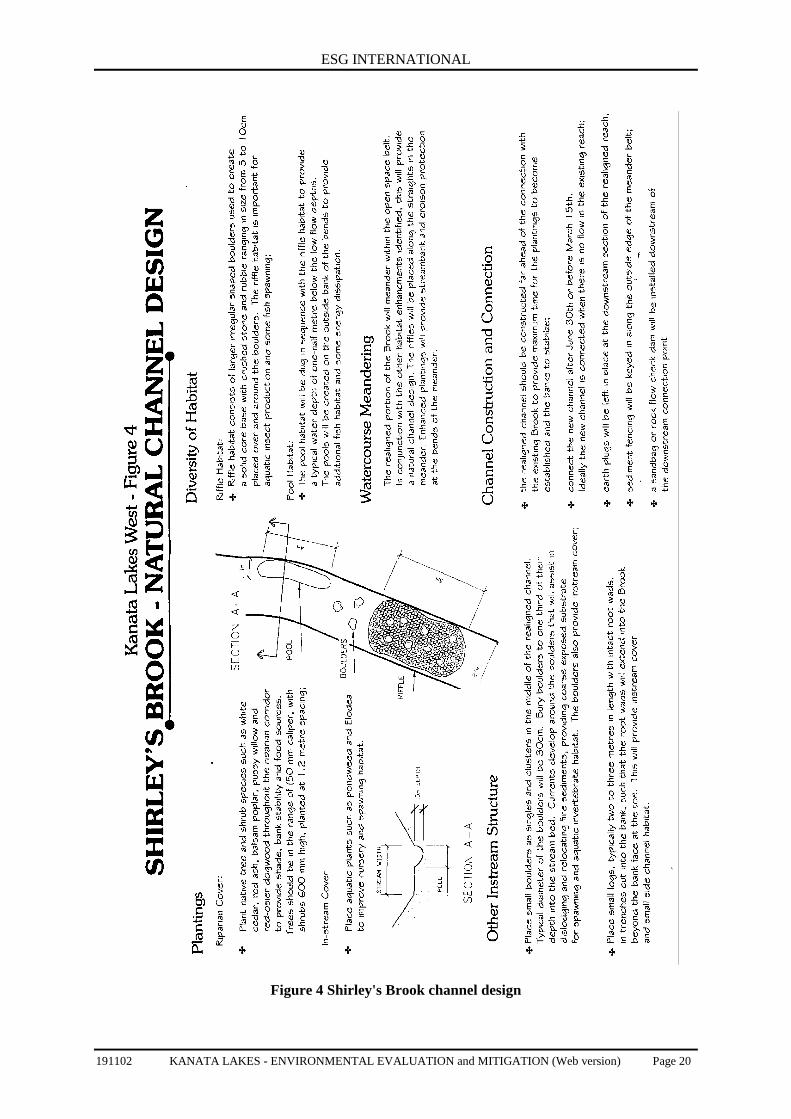
5.2 Shirley’s BrookAs discussed in Section 3.2, with the exception of the first 100 metres upstream of the GoulbournForced Road, the fish habitat on-site is very limited. As indicated in Section 4.2, it is proposed torelocate the reach upstream of the Forced Road to a corridor adjacent to the Nepean-ArnpriorRailway line. In this location the reach will be able to meander within a 30 metre naturalizedcorridor. This will improve the on-site aquatic habitat characteristics while maintaining the existingdownstream contributions. The relocation of this reach of Shirley’s Brook will result in a harmfulalteration, disruption or destruction of fish habitat, as defined under the Federal Fisheries Act. Thissection will outline the benefits of relocating the reach. The enhancement measures recommendedbelow will form the basis of a compensation agreement to be developed with the agencies as part ofthe Fisheries Act authorization. The measures must ensure that the aquatic habitat in the relocatedreach will be improved over the existing conditions. If the relocation of Shirley’s Brook includes thehabitat immediately west of the Goulbourn Forced Road, then the extent of compensation will beincreased to ensure an improvement in overall aquatic habitat.
5.2.1 Natural Channel Design
To provide the opportunity for an improvement in fish habitat over existing conditions the realignedreach must be maintained as an open channel rather than a piped, underground system. A majorbenefit of realigning this reach of Shirley’s-Brook will be an improvement in the sinuosity ormeandering of the watercourse. It is recommended that the reach be designed to permit meanderingwith the naturalized thirty metre wide swath. This will allow natural channel design whilemaintaining an appropriate buffer from the developed portion of the site.
Other aspects of natural channel design that will provide an improvement over existingconditions include riparian plantings to provide increased stream cover, greater instream structurethrough placement of logs (submerged shelters) and boulders, and an improvement in the extent ofpool and rifle habitat. The natural features will be spaced to avoid large areas of uniform conditions,and be positioned in physically stable locations. The pool habitat will be dug to provide a typicalwater depth of one-half metre below the low flow depths. Pool habitat will also be ultimately createdin the vicinity of the placed boulders. Riffle habitat will consist of individual sections of crush stoneand rubble ranging in size from 5 to 10 em. All riffle coarse material will be washed before use. Therifle habitat will be created in sequence with the pool habitat. The riffle habitat is important foraquatic insect production and some fish spawning. The low flow water depth at the riffle habitatshould be approximately 15 cm.
The number of culverts required along the reach will be much less than the culverts required ifthe reach was to be left in its existing location, where the number of residential street crossings wouldhave been much greater.
Figure 4 describes the concepts for the enhancement of aquatic habitat features and ripariancorridor plantings. Detailed plans will be provided in the Environmental Impact Statement and theapplication to the Department of Fisheries and Oceans. Only native trees and shrubs will be plantedas part of the riparian vegetation, including balsam poplar, red ash, pussy willow and black willow. Inaddition to the bank stability, instream habitat, energy dissipation and reduction of erosion potential,the natural riparian vegetation will improve groundwater regime, provide shade and detritus, increasevegetative diversity and enhance the terrestrial habitats.
The realigned channel should be dug welt in advance of the actual flow relocation to give themaximum time for the natural vegetation to become established along the stream banks and to avoidthe use of erosion control blankets where possible. Woody vegetation removal associated with therealigned channel preparation will be limited as the area is a combination of agricultural fields andcultural meadows. A native seed mix should be used in areas where the natural vegetation has notbecome established. To minimize potential impacts on downstream fish habitat, no in-stream work,including connection to the existing watercourse will occur between March 15th and June 30th.

ESG INTERNATIONAL
191102 KANATA LAKES - ENVIRONMENTAL EVALUATION and MITIGATION (Web version) Page 19
5.2.2 Development Guidelines for Adjacent Lands
The riparian corridor will be planted with native shrub and tree species to ensure an adequate bufferfrom the realigned reach within which there will be no development. Planting of the riparian corridorwith native shrub and tree species is essential to provide maximum stream cover, treatment andcorridor functions. A detailed planting plan will be developed. The required natural buffer from thechannel is considered minimal due to the limited existing terrestrial features, stable soils, lack ofsensitive on-site aquatic habitat and level topography of the area.
ESG INTERNATIONAL
191102 KANATA LAKES - ENVIRONMENTAL EVALUATION and MITIGATION (Web version) Page 20
Figure 4 Shirley's Brook channel design
ESG INTERNATIONAL
191102 KANATA LAKES - ENVIRONMENTAL EVALUATION and MITIGATION (Web version) Page 21
6. 0 CONCLUSIONS
The forested portions of the study area are dominated by mature and early successional deciduousforests with mixed and coniferous forests also present. The majority of the flora species found withinthe Kanata Lakes area are typical or common in the Region. The forests are representative of arelatively high overall floristic quality of the vegetation with a slightly degraded to intact landscapeprior to tree removal in March and April of 2002.
The NEA boundaries are similar to the initial NEA boundaries described in the 1980’s. They providefor retention of a core forested area, providing habitat for area sensitive birds in the west portion ofthe study area, as well as wetland habitats and associated upland forests throughout the study area.
The tree removal impact in non-development lands was greatest on the south side of the Kizell Pondimmediately west of the Goulbourn Forced Road, within the forests east of the First Line Roadallowance and the deciduous swamp immediately to the east of the First Line Road allowance.Mitigation measures are provided to restore the areas of tree removal.
Measures are also provided to ensure that impacts on the NEA boundaries as a result ofimplementation of the Concept Plan will be minimal. This includes establishment of buffers beyondthe NEA boundaries.
Beyond 100 metres west of the Goulbourn Forced Road, the aquatic habitat of Shirley’s Brook isconsidered degraded. With natural channel design, it is believed that the habitat of this reach can beimproved over existing conditions through realignment of the reach to south of the railway track,away from the core of the development area.
7. 0 REFERENCES
Banfield, A. W. F. 1974. The Mammals of Canada. University of Toronto Press. ISBN 0-80202137-9.438 pp.
Brownell, V.R. and B.M.I-l. Larson. 1995. An Evaluation Framework for Natural Areas in theRegional Municipality of Ottawa-Carleton. 2 Vol.
Brunton, D.F. 1992. Life Science Areas of Natural and Scientific Interest in Site District 6-12.Unpublished Manuscript. 225 pp.
Brunton, D.F. 1992. Kanata Lakes Study Area. Natural Environment Assessment. Prepared forGenstar Development Corporation and City of Kanata. February, 1992. 130 pp.
Brunton, D.F. 1997. Summary: Natural Area Reports for Natural Areas West of Rideau River (500series). Prepared for the Regional Municipality of Ottawa-Carleton, Planning and DevelopmentApprovals Department. 164 pp.
Brunton, D.F. 2000. Natural Environment Implications of the Terry Fox Drive Alignment in theSouth March Highlands. Prepared for the Region of Ottawa-Carleton. September 14, 2000.
25 pp.
Brunton, D.F. 2001. Natural Environment Assessment: Beaver Pond Sanitary Sewer Line Corridor,Kanata, City of Ottawa. Prepared for Urbandale Corporation. September 2001. 25 pp. & append.
Dillon Consulting. 1999. Shirley’s Brook and Watt's Creek Subwatershed Study. SummaryDocument. June 1999.
Dillon Consulting. 2001. Draft Design Brief for Terry Fox Drive. Preliminary Design - Phase IAssignment. June, 2001. 16 pp & append.
F.F. Slaney & Co. Ltd. 1978. A review of Campeau Land within the South March HighlandsConservation Lands. 86 pp.
ESG INTERNATIONAL
191102 KANATA LAKES - ENVIRONMENTAL EVALUATION and MITIGATION (Web version) Page 22
Geological Survey of Canada. 1977. Surficial Materials and Terrain Features Ottawa-Hull. Map1425A.
Lee, H.T., W.D. Bakowsky, J. Riley, J. Bowies, M. Puddister, P. Uhlig and S. McMurray. 1998.Ecological Land Classification for Southern Ontario: First Approximation and its Application.Ontario Ministry of Natural Resources, Southcentral Science Section, Science Development andTransfer Branch. SCSS Field Guide FG-02.
Oldham, M.J., W.D Bakowsky and D.A. Sutherland. 1995. Floristic Quality Assessment System forSouthern Ontario. Natural Heritage Information Centre, Ontario Ministry of Natural Resources. 68 p.
Ontario Ministry of Natural Resources. 1999. Natural Heritage Reference Manual for Policy 2.3 ofthe Provincial Policy Statement. June 1999. 127 pp.
Regional Municipality of Ottawa-Carleton. 1997. Official Plan. Regional Municipality of Ottawa-Carleton. 170 p & schedules & annex.
Regional Municipality of Ottawa-Carleton. 1998a. Environmental Impact Statement Guideline.DRAFT. 66 p.
Regional Municipality of Ottawa-Carleton. 1998b. Distributionally Significant Vascular Flora of theRegional Municipality of Ottawa-Carleton, Ontario. DRAFT. 30 p.
Wilhelm, G. S. and L. A. Masters. 1995. Floristic Quality Assessment in the Chicago Region andApplication Computer Programs. The Morton Arboretum, Lisle, Illinois. 65 pp.

ESG INTERNATIONAL
191102 KANATA LAKES - ENVIRONMENTAL EVALUATION and MITIGATION (Web version) Page 23
APPENDIX A
PHOTOS OF SITE REPRESENTATIVE FEATURES
(This has been prepared as a separate electronic document.)

ESG INTERNATIONAL
191102 KANATA LAKES - ENVIRONMENTAL EVALUATION and MITIGATION (Web version) Page 24
APPENDIX B
PLANT and WILDLIFE SPECIES LISTS(This has been prepared as a separate electronic document.)