kassab travel center planning application no. 2016-112
TRANSCRIPT
KASSAB TRAVEL CENTER Planning Application No. 2016-112
Municipal Code Amendment (MCA) No. 2017-02 Conditional Use Permit (CUP) No. 2018-03
Commercial Design Review (CDR) No. 2016-17State Clearinghouse No. 2019029048
ENVIRONMENTAL REVIEW NO. 2018-02 (RECIRCULATED DRAFT INITIAL STUDY/MITIGATED NEGATIVE DECLARATION)
Prepared By: CITY OF LAKE ELSINORE
130 South Main Street Lake Elsinore, CA 92530
Applicant: KARAKI-WESTERN STATES
JOSEPH KARAKI 4887 E. LA PALMA AVE STE 707
ANAHEIM CA 92807
Environmental Consultant: Sagecrest Planning+Environmental 2400 East Katella Avenue, Suite 800
Anaheim, CA 92806
September 2019
Kassab Travel Center Project Recirculated Draft Initial Study/Mitigated Negative Declaration
This Page Intentionally Left Blank
Kassab Travel Center Project Recirculated Draft Initial Study/Mitigated Negative Declaration
Table of Contents I. INTRODUCTION ............................................................................................................................ 1
A. PURPOSE ................................................................................................................................. 1 B. CALIFORNIA ENVIRONMENTAL QUALITY ACT ........................................................................ 1 C. INTENDED USES OF INITIAL STUDY AND MITIGATED NEGATIVE DECLARATION.................... 2 D. CONTENTS OF INITIAL STUDY ................................................................................................. 3 E. SCOPE OF ENVIRONMENTAL ANALYSIS .................................................................................. 4 F. TIERED DOCUMENTS, INCORPORATION BY REFERENCE, AND TECHNICAL STUDIES ............. 4
II. PROJECT DESCRIPTION ................................................................................................................ 8 A. PROJECT LOCATION AND SETTING ......................................................................................... 8 B. PROJECT DESCRIPTION ........................................................................................................... 8
III. ENVIRONMENTAL CHECKLIST .................................................................................................. 36 A. BACKGROUND ....................................................................................................................... 36 B. ENVIRONMENTAL FACTORS POTENTIALLY AFFECTED ......................................................... 37 C. DETERMINATION .................................................................................................................. 38 D. INITIAL STUDY CHECKLIST ..................................................................................................... 39
IV. ENVIRONMENTAL ANALYSIS .................................................................................................... 47 I. AESTHETICS ............................................................................................................................ 47 II. AGRICULTURE AND FORESTRY RESOURCES .......................................................................... 51 III. AIR QUALITY ......................................................................................................................... 54 IV. BIOLOGICAL RESOURCES ..................................................................................................... 69 V. CULTURAL RESOURCES ......................................................................................................... 84 VI. ENERGY ................................................................................................................................ 91 VII. GEOLOGY AND SOILS .......................................................................................................... 92 VIII. GREENHOUSE GAS EMISSIONS .......................................................................................... 98 IX. HAZARDS AND HAZARDOUS MATERIALS ........................................................................... 100 X. HYDROLOGY AND WATER QUALITY .................................................................................... 105 XI. LAND USE AND PLANNING ................................................................................................. 111 XII. MINERAL RESOURCES ....................................................................................................... 113 XIII. NOISE ................................................................................................................................ 115 XIV. POPULATION AND HOUSING ........................................................................................... 126 XV. PUBLIC SERVICES ............................................................................................................... 127 XVI. RECREATION .................................................................................................................... 131 XVII. TRANSPORTATION .......................................................................................................... 133 XVIII. TRIBAL CULTURAL RESOURCES ...................................................................................... 163 XIX. UTILITIES AND SERVICE SYSTEMS .................................................................................... 165 XX. WILDFIRE ........................................................................................................................... 168 XXI. MANDATORY FINDINGS OF SIGNIFICANCE ...................................................................... 170
VI. PERSONS AND ORGANIZATIONS CONSULTED ....................................................................... 173 VII. REFERENCES .......................................................................................................................... 175

Kassab Travel Center Project Recirculated Draft Initial Study/Mitigated Negative Declaration
Figures Figure 1: Regional Location Map .................................................................................................. 12 Figure 2: Project Vicinity Map ....................................................................................................... 14 Figure 3: Site Plan ......................................................................................................................... 16 Figure 4: Conceptual Landscape Plan ........................................................................................... 18 Figure 5: Truck/Recreational Vehicle Turning Templates ............................................................ 20 Figure 6: Right of Way Improvements .......................................................................................... 22 Figure 7: Conceptual Grading Plan ............................................................................................... 24 Figure 8: C-Store Elevations .......................................................................................................... 26 Figure 9: Canopy Elevations .......................................................................................................... 28 Figure 10: Drive-Through Elevations............................................................................................. 30 Figure 11: Wall and Fence Plan ..................................................................................................... 32 Figure 12: Site Photos ................................................................................................................... 34
Tables
Table 1 - SCAQMD Regional Criteria Pollutant Emission Thresholds of Significance ................... 56 Table 2 - SCAQMD Local Air Quality Thresholds of Significance .................................................. 57 Table 3 - Construction-Related Regional Criteria Pollutant Emissions ......................................... 60 Table 4 - Construction-Related Local Criteria Pollutant Emissions .............................................. 61 Table 5 - Operational Regional Criteria Pollutant Emissions ........................................................ 61 Table 6 - Operations-Related Local Criteria Pollutant Emissions ................................................. 63 Table 7 - Proposed Project Greenhouse Gas Annual Emissions ................................................... 99 Table 8 - Worst Case Construction Noise Levels at Nearest Receptors ..................................... 116 Table 9 - Operational Noise Levels at the Nearby Commercial Uses Prior to Mitigation .......... 118 Table 10 - Mitigated Operational Noise Levels at the Nearby Commercial Uses ...................... 119 Table 11 - Existing Year Project Traffic Noise Contributions ...................................................... 120 Table 12 - Existing Plus Ambient Project Traffic Noise Contributions ........................................ 120 Table 13 - Cumulative Project Traffic Noise Contributions ........................................................ 121 Table 14 - Vibration Source Levels for Construction Equipment ............................................... 123 Table 15 - Project Construction Equipment Vibration Levels and Distances to City Threshold . 123 Table 16 - Study Area Existing Street System Summary ............................................................. 135 Table 17 - Existing plus Project Intersection Levels of Service ................................................... 137 Table 18 - Existing plus Ambient Growth plus Project Intersection Levels of Service .............. 140 Table 19 - Cumulative Projects Trip Generation Estimates ....................................................... 143 Table 20 - Existing plus Ambient Growth plus Project plus Cumulative Projects ....................... 145 Table 21 - Existing and Existing plus Project Queuing Analysis .................................................. 149 Table 22 - Existing and Existing plus Ambient Growth plus Project Queueing Analysis ............ 151 Table 23 - Existing plus Ambient Growth plus Project plus Cumulative Queuing Analysis ........ 153 Table 24 - Existing Plus Project LOS with Mitigation Measures ................................................. 158 Table 25 - Existing Plus Ambient Growth plus Project LOS with Mitigation Measures .............. 158 Table 26 - Existing Plus Ambient Growth plus Project plus Cumulative Projects LOS with Mitigation Measures ................................................................................................................... 159 Table 27 - Project Fair Share ....................................................................................................... 159
Kassab Travel Center Project Recirculated Draft Initial Study/Mitigated Negative Declaration
Appendices Appendix A - Air Quality and Greenhouse Gas Emissions Impact Analysis, Kassab Travel Center Project, City of Lake Elsinore, Vista Environmental, September 2018 (Revised March 2019) Appendix B - Habitat Assessment for Kassab Travel Center, Psomas, April 2018 Appendix C - Cultural Resources Assessment Report for the Kassab Travel Center Project, City of Lake Elsinore, Cogstone, February 2018 Appendix D - Paleontological Resources Technical Report For The Kassab Travel Center Project, City Of Lake Elsinore, Cogstone, August 2017 Appendix E - Geotechnical Investigation Report Proposed Kassab Travel Center 29301 Riverside Drive, Geoboden Inc., December 2017 Appendix F - Infiltration/Percolation Testing for Stormwater Retention Proposed Kassab Travel Center, Geoboden Inc., December 2017 Appendix G - Phase I Environmental Site Assessment, 29301 Riverside Drive, Lake Elsinore, California 92530, GeoRox Engineering, March 2016 Appendix H - Hydrology Study, Rahman Engineering Service, Inc. January 2019 Appendix I - Project Specific Water Quality Management Plan, Kassab Travel Center, Rahman Engineering Services, January 2019 Appendix J - Noise Impact Analysis, Kassab Travel Center Project, City of Lake Elsinore, Vista Environmental, October 2018 (Revised July 2019) Appendix K - Traffic Impact Study, Kassab Travel Center, City of Lake Elsinore, CA, Dudek, August 2018, (Revised March 2019) Appendix L – Service Planning Letter #3069-0, Elsinore Valley Municipal Water District, March 23, 2018 Appendix M – Response to Comments on The Draft Initial Study/Mitigated Negative Declaration Environmental Review No. 2018-02, City of Lake Elsinore, August 2019
Kassab Travel Center Project Recirculated Draft Initial Study/Mitigated Negative Declaration
1 | P a g e
I. INTRODUCTION
A. PURPOSE
This document is an Initial Study for evaluation of environmental impacts resulting from implementation of the Kassab Travel Center Project. For purposes of this document, this application will be called the “Proposed Project”.
B. CALIFORNIA ENVIRONMENTAL QUALITY ACT
As defined by Section 15063 of the California Environmental Quality Act (CEQA) Guidelines, an Initial Study is prepared primarily to provide the Lead Agency with information to use as the basis for determining whether an Environmental Impact Report (EIR), Negative Declaration, or Mitigated Negative Declaration would be appropriate for providing the necessary environmental documentation and clearance for any proposed project.
According to CEQA Guidelines Section 15065, an EIR is deemed appropriate for a particular proposal if the following conditions occur:
$ The proposal has the potential to substantially degrade quality of the environment. $ The proposal has the potential to achieve short-term environmental goals to the disadvantage
of long-term environmental goals. $ The proposal has possible environmental effects which are individually limited but cumulatively
considerable. $ The proposal could cause direct or indirect adverse effects on human beings.
According to Section 21080(c)(1) of CEQA and Section 15070(a) of the CEQA Guidelines, a Negative Declaration can be adopted if it can be determined that the project will not have a significant effect on the environment.
According to Section 21080(c)(2) of CEQA and Section 15070(b) of the CEQA Guidelines, a Mitigated Negative Declaration can be adopted if it is determined that although the Initial Study identifies that the project may have potentially significant effects on the environment, revisions in the project plans and/or mitigation measures, which would avoid or mitigate the effects to below the level of significance, have been made or agreed to by the applicant.
This Initial Study has determined that the Proposed Project may result in potentially significant environmental effects but that said effects can be reduced to below the level of significance through the implementation of mitigation measures and therefore, a Mitigated Negative Declaration is deemed the appropriate document to provide the necessary environmental evaluations and clearance.

Kassab Travel Center Project Recirculated Draft Initial Study/Mitigated Negative Declaration
2 | P a g e
This Initial Study and Mitigated Negative Declaration are prepared in conformance with the California Environmental Quality Act of 1970, as amended (Public Resources Code, Section 21000 et seq.); the State Guidelines for Implementation of the California Environmental Quality Act (“CEQA Guidelines”), as amended (California Code of Regulations, Title 14, Chapter 3, Section 15000, et. seq.); applicable requirements of the City of Lake Elsinore; and the regulations, requirements, and procedures of any other responsible public agency or agency with jurisdiction by law.
The City of Lake Elsinore City Council is designated the Lead Agency, in accordance with Section 15050 of the CEQA Guidelines. The Lead Agency is the public agency which has the principal responsibility for carrying out or approving a project which may have significant effects upon the environment.
C. INTENDED USES OF INITIAL STUDY AND MITIGATED NEGATIVE DECLARATION
This Initial Study and Mitigated Negative Declaration are informational documents which are intended to inform the City of Lake Elsinore decision-makers, other responsible or interested agencies, and the general public of the potential environmental effects of the Proposed Project. The environmental review process has been established to enable public agencies to evaluate environmental consequences and to examine and implement methods of eliminating or reducing any potentially adverse impacts. While CEQA requires that consideration be given to avoiding environmental damage, the Lead Agency and other responsible agencies must balance adverse environmental effects against other public objectives, including economic and social goals (CEQA Guidelines Section 15021).
The City of Lake Elsinore City Council, as Lead Agency, has determined that environmental clearance for the Proposed Project can be provided with a Mitigated Negative Declaration. The Initial Study and Notice of Availability and Intent to Adopt prepared for the Mitigated Negative Declaration was circulated for a period of 30 days for public and agency review from February 8, 2019 through March 11, 2019. Five comments were received on the document, as detailed in Appendix M – Response to Comments on The Draft Initial Study/Mitigated Negative Declaration Environmental Review No. 2018-02, City of Lake Elsinore, August 2019 that were considered by the Lead Agency before it acted on the Proposed Project. Pursuant to CEQA Guidelines Section 15073.5 (a) and in response to comments received, the City of Lake Elsinore is recirculating the Draft Initial Study/Mitigated Negative Declaration due to substantial revisions after public notice of its availability but prior to its adoption. Pursuant to CEQA Guidelines Section 15073.5(b)(1), a new, avoidable significant effect was identified associated with vibration impacts, and MM NOI-3 was added to restrict the use of construction equipment within proximity to the property line, which would reduce the potential impact to less than significant.
Kassab Travel Center Project Recirculated Draft Initial Study/Mitigated Negative Declaration
3 | P a g e
Pursuant to CEQA Guidelines Section 15073.5(b)(2), proposed mitigation measure MM NOI -1 associated with construction noise would not reduce potential effects to less than significant, therefore, MM NOI – 1 was revised to state that no stationary equipment would be operated within 50 feet of the northwest and southwest property lines and that construction of the proposed sound wall detailed in MM NOI-2 be completed prior to the start of site preparation or grading activities for the Proposed Project, which would reduce the potential impact to less than significant. For clarity of review, substantial revisions to the previously circulated Draft IS/MND are shown in underline for additional information and strikeout for information that has been deleted. With the above stated revisions to MM NOI-1 and addition of MM NOI – 3, potential impacts associated with the construction and operation of the Proposed Project remain less than significant with mitigation. Therefore, preparation of a draft Environmental Impact Report was not required pursuant to CEQA Guidelines Section 15073.5(d).
D. CONTENTS OF INITIAL STUDY
This Initial Study is organized to facilitate a basic understanding of the existing setting and environmental implications of the Proposed Project.
I. INTRODUCTION presents an introduction to the entire report. This section identifies City of Lake Elsinore contact persons involved in the process, scope of environmental review, environmental procedures, and incorporation by reference documents.
II. PROJECT DESCRIPTION describes the Proposed Project. A description of discretionary approvals and permits required for project implementation is also included.
III. ENVIRONMENTAL CHECKLIST FORM contains the City’s Environmental Checklist Form. The checklist form presents results of the environmental evaluation for the Proposed Project and those areas that would have either a potentially significant impact, a less than significant impact with mitigation incorporated, a less than significant impact, or no impact.
IV. ENVIRONMENTAL ANALYSIS provides the background analysis supporting each response provided in the environmental checklist form. Each response checked in the checklist form is discussed and supported with sufficient data and analysis. As appropriate, each response discussion describes and identifies specific impacts anticipated with project implementation. In this section, mitigation measures are also set forth, as appropriate, that would reduce potentially significant adverse impacts to levels of less than significance.
V. MANDATORY FINDINGS presents the background analysis supporting each response provided in the environmental checklist form for the Mandatory Findings of Significance set forth in Section 21083(b) of CEQA and Section 15065 of the CEQA Guidelines.
VI. PERSONS AND ORGANIZATIONS CONSULTED identifies those individuals consulted and involved in the preparation of this Initial Study and Mitigated Negative Declaration.
VII. REFERENCES lists bibliographical materials used in preparation of this document.
Kassab Travel Center Project Recirculated Draft Initial Study/Mitigated Negative Declaration
4 | P a g e
E. SCOPE OF ENVIRONMENTAL ANALYSIS
For evaluation of environmental impacts, each question from the Environmental Checklist Form is stated and responses are provided according to the analysis undertaken as part of the Initial Study. All responses will take into account the whole action involved, including offsite as well as onsite, cumulative as well as project-level, indirect as well as direct, and construction as well as operational impacts. Project impacts and effects will be evaluated and quantified, when appropriate. To each question, there are four possible responses, including: 1. No Impact: A “No Impact” response is adequately supported if the referenced sources show
that the impact simply does not apply to the Proposed Project. 2. Less Than Significant Impact: Development associated with project implementation will have
the potential to impact the environment. These impacts, however, will be less than the levels of thresholds that are considered significant and no additional analysis is required.
3. Less Than Significant With Mitigation Incorporated: This applies where incorporation of mitigation measures has reduced an effect from “Potentially Significant Impact” to a “Less Than Significant Impact”. The Lead Agency must describe the mitigation measures and explain how the measures reduce the effect to a less than significant level.
4. Potentially Significant Impact: Future implementation will have impacts that are considered significant and additional analysis and possibly an EIR are required to identify mitigation measures that could reduce these impacts to less than significant levels.
F. TIERED DOCUMENTS, INCORPORATION BY REFERENCE, AND TECHNICAL STUDIES Information, findings, and conclusions contained in this document are based on the incorporation by reference of tiered documentation and technical studies that have been prepared for the Proposed Project which are discussed in the following section.
a) Tiered Documents
As permitted in Section 15152(a) of the CEQA Guidelines, information and discussions from other documents can be included into this document. Tiering is defined as follows: “Tiering refers to using the analysis of general matters contained in a broader EIR (such as the one prepared for a general plan or policy statement) with later EIRs and negative declarations on narrower projects; incorporating by reference the general discussions from the broader EIR; and concentrating the later EIR or negative declaration solely on the issues specific to the later project.”
For this document, the “Lake Elsinore General Plan Final EIR” (prepared in 1990) and the serves as the broader document, since it analyzes the entire City area, which includes the Project Site. However, as discussed, site-specific impacts, which the broader document (Lake Elsinore General Plan Final EIR) cannot adequately address, may occur for certain issue areas. This document, therefore, evaluates each environmental issue alone and will rely upon the analysis contained within the Lake Elsinore General Plan Final EIR with respect to remaining issue areas.
Kassab Travel Center Project Recirculated Draft Initial Study/Mitigated Negative Declaration
5 | P a g e
Tiering also allows this document to comply with Section 15152(b) of the CEQA Guidelines, which discourages redundant analyses, as follows: “Agencies are encouraged to tier the environmental analyses which they prepare for separate but related projects including the general plans, zoning changes, and development projects. This approach can eliminate repetitive discussion of the same issues and focus the later EIR or negative declaration on the actual issues ripe for decision at each level of environmental review. Tiering is appropriate when the sequence of analysis is from an EIR prepared for a general plan, policy or program to an EIR or negative declaration for another plan, policy, or program of lesser scope, or to a site-specific EIR or negative declaration.”
Further, Section 15152(d) of the CEQA Guidelines states: “Where an EIR has been prepared and certified for a program, plan, policy, or ordinance consistent with the requirements of this section, any lead agency for a later project pursuant to or consistent with the program, plan, policy, or ordinance should limit the EIR or negative declaration on the later project to effects which: (1) Were not examined as significant effects on the environment in the prior EIR; or (2) Are susceptible to substantial reduction or avoidance by the choice of specific revisions in the project, by the imposition of conditions or other means.”
b) Incorporation by Reference
Incorporation by reference is a procedure for reducing the size of EIRs and is most appropriate for including long, descriptive, or technical materials that provide general background information, but do not contribute directly to the specific analysis of the project itself. This procedure is particularly useful when an EIR or Negative Declaration relies on a broadly-drafted EIR for its evaluation of cumulative impacts of related projects (Las Virgenes Homeowners Federation v. County of Los Angeles [1986, 177 Ca.3d 300]). If an EIR or Negative Declaration relies on information from a supporting study that is available to the public, the EIR or Negative Declaration cannot be deemed unsupported by evidence or analysis (San Francisco Ecology Center v. City and County of San Francisco [1975, 48 Ca.3d 584, 595]). This document incorporates by reference the document from which it is tiered, the Lake Elsinore General Plan Final Environmental Impact Report, published in 1990. This document is referred to as the “General Plan EIR”.
When an EIR or Negative Declaration incorporates a document by reference, the incorporation must comply with Section 15150 of the CEQA Guidelines as follows:
$ The incorporated document must be available to the public or be a matter of public record (CEQA Guidelines Section 15150[a]). The General Plan EIR shall be made available, along with this document, at the City of Lake Elsinore, Community Development Department, 130 South Main Street, Lake Elsinore, CA 92530, ph. (951) 674-3124.
Kassab Travel Center Project Recirculated Draft Initial Study/Mitigated Negative Declaration
6 | P a g e
$ This document must be available for inspection by the public at an office of the lead agency (CEQA Guidelines Section 15150[b]). This document is available at the City of Lake Elsinore, Community Development Department, 130 South Main Street, Lake Elsinore, CA 92530, ph. (951) 674-3124.
$ This document must summarize the portion of the document being incorporated by reference or
briefly describe the information that cannot be summarized. Furthermore, this document must describe the relationship between the incorporated information and the analysis in the General Plan EIR (CEQA Guidelines Section 15150[c]). As discussed above, the General Plan EIR addresses the entire City of Lake Elsinore and provides background and inventory information and data which apply to the Project Site. Incorporated information and/or data is cited in the appropriate sections.
$ This document must include the State identification number of the incorporated document
(CEQA Guidelines Section 15150[d]). The State Clearinghouse Number for the General Plan EIR is 91122065.
$ The material to be incorporated in this document will include general background information
(CEQA Guidelines Section 15150[f]).
Kassab Travel Center Project Recirculated Draft Initial Study/Mitigated Negative Declaration
7 | P a g e
c) Technical Studies
Appendix A - Air Quality and Greenhouse Gas Emissions Impact Analysis, Kassab Travel Center Project, City of Lake Elsinore, Vista Environmental, September 2018, (Revised March 2019) Appendix B - Habitat Assessment for Kassab Travel Center, Psomas, April 2018 Appendix C - Cultural Resources Assessment Report for the Kassab Travel Center Project, City of Lake Elsinore, Cogstone, February 2018 Appendix D - Paleontological Resources Technical Report For The Kassab Travel Center Project, City Of Lake Elsinore, Cogstone, August 2017 Appendix E - Geotechnical Investigation Report Proposed Kassab Travel Center 29301 Riverside Drive, Geoboden Inc., December 2017 Appendix F - Infiltration/Percolation Testing for Stormwater Retention Proposed Kassab Travel Center, Geoboden Inc., December 2017 Appendix G - Phase I Environmental Site Assessment, 29301 Riverside Drive, Lake Elsinore, California 92530, GeoRox Engineering, March 2016 Appendix H - Hydrology Study, Rahman Engineering Service, Inc. January 2019 Appendix I - Project Specific Water Quality Management Plan, Kassab Travel Center, Rahman Engineering Services, January 2019 Appendix J - Noise Impact Analysis, Kassab Travel Center Project, City of Lake Elsinore, Vista Environmental, October 2018, (Revised July 2019) Appendix K - Traffic Impact Study, Kassab Travel Center, City of Lake Elsinore, CA, Dudek, August 2018, (Revised March 2019) Appendix L – Service Planning Letter #3069-0, Elsinore Valley Municipal Water District, March 23, 2018 Appendix M – Response to Comments on The Draft Initial Study/Mitigated Negative Declaration Environmental Review No. 2018-02, City of Lake Elsinore, February 2019

Kassab Travel Center Project Recirculated Draft Initial Study/Mitigated Negative Declaration
8 | P a g e
II. PROJECT DESCRIPTION
A. PROJECT LOCATION AND SETTING The Proposed Project is located in the City of Lake Elsinore (City); in the western portion of Riverside County, California (Figure 1 - Regional Vicinity Map and Figure 2 – Project Vicinity Map). The Project Site is within the United States Geological Survey (USGS) “Lake Elsinore, California” 7.5 minute quadrangle (1988) and located in the central portion of the City, north of State Route 74 (SR-74). The Project Site consists of two parcels (APNs 378-030-007 and 378-030-009) approximately 2.84 gross acres (2.39 net acres) in size. The net acreage represents the portion of the property that is proposed for development, after right-of-way (ROW) dedications. The Project Site is currently vacant, undeveloped land. The Project Site is relatively flat and situated at an elevation of approximately 1,268 feet above mean sea level (msl). Surface drainage (precipitation that does not infiltrate into the subsurface soils) follows the topographical gradient which is generally toward the south/southwest towards Lake Elsinore. The rectangular-shaped site is bounded to the northwest by commercial and industrial uses, to the southwest by vacant land that has recently been approved by the City for commercial development, to the northeast by Collier Avenue and a self-storage facility, and to the southeast by the intersection of Riverside Drive and Collier Avenue, with vacant land beyond. Vacant land is located north of the site across Collier Avenue, and south of the site across Riverside Drive. Riverside Drive is a State Route (SR-74) and subject to the jurisdiction of the California Department of Transportation (Caltrans). Collier Avenue is a City street designated as Major in the City’s Roadway Classifications in the General Plan. Freeway access to the Project Site is provided via Interstate 15 (I-15). Vehicular access to the Project Site is provided via a driveway entrance on Collier Avenue and from the side of the road on Riverside Drive, as there is no curb, gutter or sidewalk on Riverside Drive. Riverside Drive is currently one lane in the westbound direction along the frontage of the Project Site with an additional lane that tapers at the west property line. Collier Avenue is improved to three southbound lanes with a curb, gutter, and sidewalk.
B. PROJECT DESCRIPTION The Proposed Project consists of applications for a Municipal Code Amendment (MCA No. 2017-02), a Conditional Use Permit (CUP No. 2018-03), and a Commercial Design Review (CDR No. 2016-17) which collectively are being processed under Planning Application No. 2016-112.
Municipal Code Amendment No. 2017-02 (MCA 2017-02) proposes an amendment to the Municipal Code to allow for drive-through establishments as a use subject to approval of a Conditional Use Permit in the Commercial Manufacturing (C-M) Zone.
Conditional Use Permit No. 2018-03 (CUP 2018-03) and Commercial Design Review No. 2016-17 (CDR 2016-17) are proposing to establish a new travel center consisting of 8,360 square foot (SF)
Kassab Travel Center Project Recirculated Draft Initial Study/Mitigated Negative Declaration
9 | P a g e
convenience store with concurrent sale of alcoholic beverages (Type 21 ABC), three (3) quick serve restaurants, two (2) covered gas dispensing areas totaling 6,092 SF with a maximum throughput of 5.8 million gallons of gasoline per year, and a free standing 2,543 SF fast food restaurant with drive through on 2.39 net acres after right-of-way dedication. The Proposed Project would have a 0.162 floor area ratio (FAR) and 16.2 percent lot coverage. The maximum height of the buildings would be 26 feet. Hardscape, landscape, on-site stormwater management improvements, signs, a trash enclosure, area lighting, and bicycle parking would be constructed as part of the Proposed Project.
The Project Site is currently vacant and there are no structures or existing pavement to be demolished. Construction of the Proposed Project consists of site preparation, demolition of existing trees, grading, excavation for underground storage tanks, building construction, architectural coating, and paving. Project grading is anticipated to begin late 2019 with construction commencing in early 2020. Project buildout is expected to be completed by late 2020.
The Project Site would be accessed by one vehicular driveway each on Collier Avenue and Riverside Drive. Riverside Drive is a State Highway, SR-74, and is under the jurisdiction of Caltrans. The Property Owner/Developer would improve Riverside Drive to Caltrans standards in the Highway Capacity Manual for an Urban Arterial roadway to its ultimate right-of-way, which requires 96 feet from curb-to-curb. The Property Owner/Developer would dedicate between 21 feet and 36 feet (street tapers in toward the west) in order to allow their half-section of Riverside Drive to be consistent with the Urban Arterial (half) cross section (center median, three travel lanes, six-foot bike lane, and six-foot sidewalk – in one direction). With the street dedication on the north side (project frontage), the pavement width would be approximately 74 feet (48 feet from curb face to new centerline, plus 26 feet of existing pavement on the south side of the street). The Proposed Project would follow Caltrans standards to improve its section of Riverside Drive. Street improvements on the north side of Riverside Drive (SR-74), along the Project Site’s frontage, would conform with Caltrans roadway design standards.
Collier Avenue is a Major roadway as shown in the City’s Roadway Classification of the General Plan. The street is improved with three southbound lanes, two northbound lanes, curb, gutter, and sidewalk. Collier Avenue, along the Project Site’s frontage, is not constructed to its ultimate Major roadway width of 80 feet, curb-to-curb. It is approximately 76 feet, curb-to-curb. The Property Owner/Developer would dedicate approximately ten feet in order to allow its half-section of Collier Avenue to be consistent with the Major roadway (half) cross section (center median, two travel lanes, six-foot bike lane, and five-foot sidewalk – in one direction). Street improvements on the west side of Collier Avenue, along the Project Site’s frontage, would conform with City roadway design standards. • Widened roadway, with curb-and-gutter, on the west side of the centerline to include:
o Widened sidewalk/landscape/parkway from six feet to ten feet o New six-foot wide bike lane (Class II – striped, on-pavement)

Kassab Travel Center Project Recirculated Draft Initial Study/Mitigated Negative Declaration
10 | P a g e
The vehicular driveway would be 50 feet wide, start 258 feet west of the corner of Riverside Drive and Collier Avenue, and would be restricted to right in and right out turns only. Vehicles wishing to proceed access Collier Avenue would exit the Project Site on Collier Avenue. The median of Riverside Drive would be improved to a raised median that would restrict vehicles to a right in/right out only movement.
The Project Site would include 17 vehicular parking spaces for the C-Store, 13 for the quick-serve area of the C-Store, 27 parking spaces for the fast food restaurant, for a total of 59 vehicular parking spaces, which meets the City’s parking requirements. Of these parking spaces, four would be for Handicap parking and six would be for Clean Air Vehicle parking. In addition, there are three RV parking spaces and a service loading area along the northern property line, and up to eight RVs and/or trucks can park at the RV fueling station canopy. Pedestrian access would be provided along the streets fronting the Project Site, as well as from the sidewalk connecting to the Fast Food restaurant and C-Store. Bicycle parking would be provided at the Fast Food restaurant and the C-Store.
The Project Site would be graded and improved with building construction, parking lot paving, and landscaping. The Proposed Project includes approximately 13,040 SF of landscaping, which is 12.47% landscape coverage. Landscaping would be in the street setback and interior property line setbacks along the perimeter of the Project Site, as well as around the buildings. The Proposed Project includes a monument sign at the corner of Collier Avenue and Riverside Drive, fueling station price signs, and signs for the Drive-through menu boards.
Kassab Travel Center Project Recirculated Draft Initial Study/Mitigated Negative Declaration
11 | P a g e
This Page Intentionally Left Blank
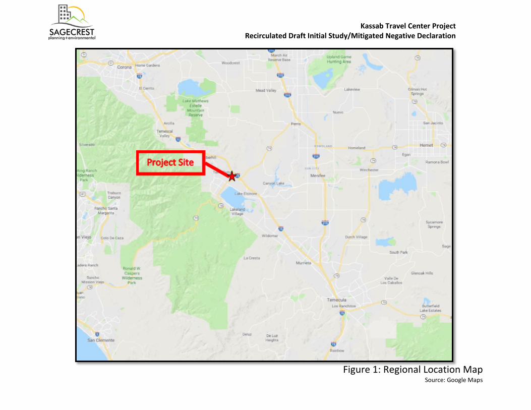
Figure 1: Regional Location Map Source: Google Maps
Kassab Travel Center Project Recirculated Draft Initial Study/Mitigated Negative Declaration

Kassab Travel Center Project Recirculated Draft Initial Study/Mitigated Negative Declaration
13 | P a g e
This Page Intentionally Left Blank
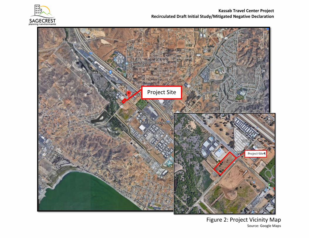
Figure 2: Project Vicinity Map Source: Google Maps
Project Site
Kassab Travel Center Project Recirculated Draft Initial Study/Mitigated Negative Declaration

Kassab Travel Center Project Recirculated Draft Initial Study/Mitigated Negative Declaration
15 | P a g e
This Page Intentionally Left Blank
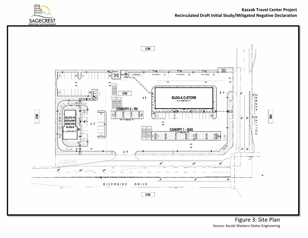
Figure 3: Site Plan Source: Karaki Western States Engineering
Kassab Travel Center Project Recirculated Draft Initial Study/Mitigated Negative Declaration

Kassab Travel Center Project Recirculated Draft Initial Study/Mitigated Negative Declaration
17 | P a g e
This Page Intentionally Left Blank

Figure 4: Conceptual Landscape Plan Source: Karaki Western States Engineering
Kassab Travel Center Project Recirculated Draft Initial Study/Mitigated Negative Declaration
Kassab Travel Center Project Recirculated Draft Initial Study/Mitigated Negative Declaration
19 | P a g e
This Page Intentionally Left Blank
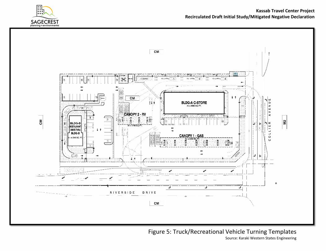
Figure 5: Truck/Recreational Vehicle Turning Templates Source: Karaki Western States Engineering
Kassab Travel Center Project Recirculated Draft Initial Study/Mitigated Negative Declaration

Kassab Travel Center Project Recirculated Draft Initial Study/Mitigated Negative Declaration
21 | P a g e
This Page Intentionally Left Blank
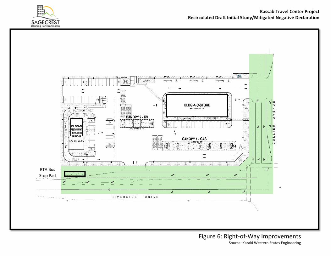
Figure 6: Right-of-Way Improvements Source: Karaki Western States Engineering
RTA Bus Stop Pad
Kassab Travel Center Project Recirculated Draft Initial Study/Mitigated Negative Declaration

Kassab Travel Center Project Recirculated Draft Initial Study/Mitigated Negative Declaration
23 | P a g e
This Page Intentionally Left Blank
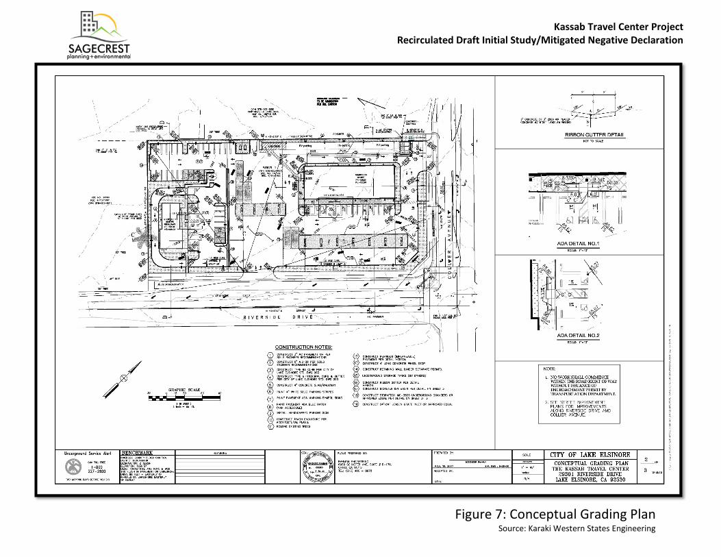
Figure 7: Conceptual Grading Plan Source: Karaki Western States Engineering
Kassab Travel Center Project Recirculated Draft Initial Study/Mitigated Negative Declaration

Kassab Travel Center Project Recirculated Draft Initial Study/Mitigated Negative Declaration
25 | P a g e
This Page Intentionally Left Blank
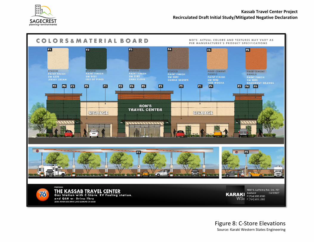
Figure 8: C-Store Elevations Source: Karaki Western States Engineering
Kassab Travel Center Project Recirculated Draft Initial Study/Mitigated Negative Declaration

Kassab Travel Center Project Recirculated Draft Initial Study/Mitigated Negative Declaration
27 | P a g e
This Page Intentionally Left Blank
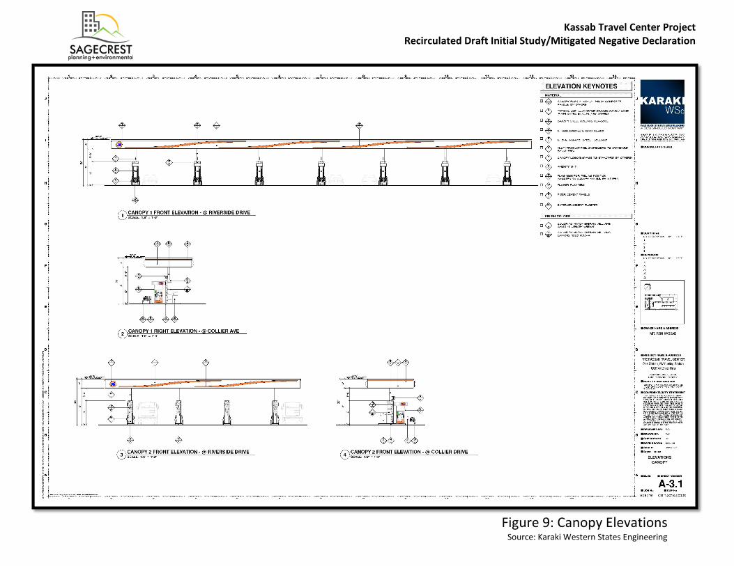
Figure 9: Canopy Elevations Source: Karaki Western States Engineering
Kassab Travel Center Project Recirculated Draft Initial Study/Mitigated Negative Declaration

Kassab Travel Center Project Recirculated Draft Initial Study/Mitigated Negative Declaration
29 | P a g e
This Page Intentionally Left Blank

Figure 10: Drive-Through Elevations Source: Marks Architects
Kassab Travel Center Project Recirculated Draft Initial Study/Mitigated Negative Declaration
Kassab Travel Center Project Recirculated Draft Initial Study/Mitigated Negative Declaration
31 | P a g e
This Page Intentionally Left Blank
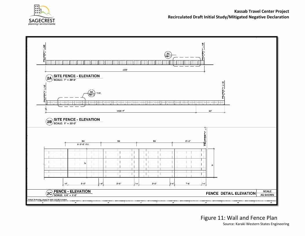
Figure 11: Wall and Fence Plan Source: Karaki Western States Engineering
Kassab Travel Center Project Recirculated Draft Initial Study/Mitigated Negative Declaration

Kassab Travel Center Project Recirculated Draft Initial Study/Mitigated Negative Declaration
33 | P a g e
This Page Intentionally Left Blank

Figure 12: Site Photos Source: Sagecrest Planning and Environmental
Collier Avenue Facing Southwest
Collier Avenue Facing West
Riverside Drive Facing Northeast
Riverside Drive Facing Northwest
Kassab Travel Center Project Recirculated Draft Initial Study/Mitigated Negative Declaration
Kassab Travel Center Project Recirculated Draft Initial Study/Mitigated Negative Declaration
35 | P a g e
This Page Intentionally Left Blank

Kassab Travel Center Project Recirculated Draft Initial Study/Mitigated Negative Declaration
36 | P a g e
III. ENVIRONMENTAL CHECKLIST
A. BACKGROUND 1. Project Title: Kassab Travel Center 2. Lead Agency Name and Address:City of Lake Elsinore, 130 South Main Street, Lake Elsinore, CA 92530
3. Contact Person and Phone Number: Attn: Damaris Abraham, Senior Planner(951) 674-3124 [email protected]
4. Project Location:29301 Riverside Drive, Lake Elsinore, CA 92530
5. Project Sponsor’s Name and Address:KARAKI-Western StatesJoseph Karaki4887 E. La Palma Ave Ste 707Anaheim CA 92807
6. General Plan Designation: The Project Site is currently designated as Limited Industrial inthe Land Use Element of the Lake Elsinore General Plan and would be consistent with theGeneral Plan Designation.
7. Zoning: The Project Site is currently zoned Commercial Manufacturing (C-M). Allowable uses in the C-M Zone include service stations. Eating places/fast food establishments (excluding drive-in and drive-through establishments) are subject to a Conditional Use Permit. The ProposedProject would require a Municipal Code Amendment (MCA 2017-02) to allow for drive-throughestablishments as a use subject to approval of a Conditional Use Permit in the C-M Zone.
8. Description of Project:The Proposed Project would be a new travel center consisting of an 8,360 square foot (SF)convenience store with concurrent sale of alcoholic beverages (Type 21 ABC), three (3) quickserve restaurants, two (2) covered gas dispensing areas totaling 6,092 SF with a maximumthroughput of 5.8 million gallons of gasoline per year, and a free standing 2,543 SF fast foodrestaurant with a drive-through on 2.39 net acres after right-of-way dedication. The ProposedProject would have a 0.162 floor area ratio (FAR) and 16.2 percent lot coverage. The maximumheight of the buildings would be 26 feet. Hardscape, landscape, on-site stormwater management improvements, signs, a trash enclosure, area lighting, and bicycle parking would be constructed as part of the Proposed Project.
9. Surrounding Land Uses and Setting: The Project Site is approximately 2.84 gross acre (2.39net acres) and contains two rectangular-shaped parcels located west of the intersection ofRiverside Drive and Collier Avenue. The net acreage represents the portion of the property thatis proposed for development, after right-of-way (ROW) dedications. The Project Site is currently vacant, undeveloped land. The Project Site is relatively flat and situated at an elevation ofapproximately 1,268 feet above mean sea level (msl). Surface drainage (precipitation that does

Kassab Travel Center Project Recirculated Draft Initial Study/Mitigated Negative Declaration
37 | P a g e
not infiltrate into the subsurface soils) follows the topographical gradient which is generally toward the south/southwest towards Lake Elsinore. Vehicular access to the Project Site is provided via a driveway entrance on Collier Avenue and from the side of the road on Riverside Drive, as there is no curb, gutter or sidewalk on Riverside Drive. Riverside Drive is currently one lane in the westbound direction along the frontage of the Project Site with an additional lane that tapers at the west property line. Collier Avenue is improved to three southbound lanes with a curb, gutter, and sidewalk. The Project Site consists of two vacant parcels located in a mixed undeveloped and commercial area of the City. The site is surrounded by vacant property to the southwest, west and south; and commercial/industrial uses to the north and east. Specially, commercial/industrial uses consist of self-storage to the northeast across Collier Avenue, recreational vehicle sales and auto parts sales to the northwest, and concrete manufacturing, auto care and recycling facilities diagonally across the intersection of Riverside Drive and Collier Avenue to the east. 10. Other Public Agencies Whose Approval is Required: California Department of Transportation (Caltrans) South Coast Air Quality Management District (SCAQMD)
B. ENVIRONMENTAL FACTORS POTENTIALLY AFFECTED The environmental factors checked below would be potentially affected by this project, involving at least one impact that is a “Potentially Significant Impact,” as indicated by the checklist on the following pages.
Aesthetics Agricultural and Forestry Resources Air Quality
Biological Resources Cultural Resources Geology/Soils
Greenhouse Gas Emissions Hazards & Hazardous
Materials Hydrology / Water Quality
Land Use / Planning Mineral Resources Noise
Population / Housing Public Services Recreation
Transportation / Traffic Tribal Cultural Resources Utilities / Service
Systems
Mandatory Findings of Significance

Kassab Travel Center Project Recirculated Draft Initial Study/Mitigated Negative Declaration
39 | P a g e
D. INITIAL STUDY CHECKLIST
Potentially Significant
Impact
Less Than Significant
With Mitigation
Incorporated
Less Than Significant
Impact
No
Impact
I. AESTHETICS. Would the project: a) Have a substantial adverse effect on a scenic vista? b) Substantially damage scenic resources, including,
but not limited to, trees, rock outcroppings, and historic buildings within a state scenic highway?
c) In non-urbanized areas, substantially degrade the existing visual character or quality of public views of the site and its surroundings? (Public views are those that are experienced from publicly accessible vantage point). If the project is in an urbanized area, would the project conflict with applicable zoning and other regulations governing scenic quality?
d) Create a new source of substantial light or glare which would adversely affect day or nighttime views in the area?
II. AGRICULTURE AND FORESTRY RESOURCES. In determining whether impacts to agricultural resources are significant environmental effects, lead agencies may refer to the California Agricultural Land Evaluation and Site Assessment Model (1997) prepared by the California Dept. of Conservation as an optional model to use in assessing impacts on agriculture and farmland. In determining whether impacts to forest resources, including timberland, are significant environmental effects, lead agencies may refer to information compiled by the California Department of Forestry and Fire Protection regarding the state’s inventory of forest land, including the Forest and Range Assessment project; and forest carbon measurement methodology provided in Forest Protocols adopted by the California Air Resources Board. Would the project:
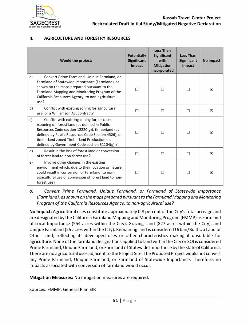
a) Convert Prime Farmland, Unique Farmland, or Farmland of Statewide Importance (Farmland), as shown on the maps prepared pursuant to the Farmland Mapping and Monitoring Program of the California Resources Agency, to non-agricultural use?
b) Conflict with existing zoning for agricultural use, or a Williamson Act contract?
c) Conflict with existing zoning for, or cause rezoning of, forest land (as defined by Public Resources Code section 4526), or timberland zoned Timberland Production (as defined by Government Code section 51104(g))?
d) Result in the loss of forest land or conversion of forest land to non-forest uses?
e) Involve other changes in the existing environment which, due to their location or nature, could result in conversion of Farmland to non-agricultural use?

Kassab Travel Center Project Recirculated Draft Initial Study/Mitigated Negative Declaration
40 | P a g e
Potentially Significant
Impact
Less Than Significant
With Mitigation
Incorporated
Less Than Significant
Impact
No
Impact
III. AIR QUALITY. Where available, significance criteria established by the applicable air quality management district or air pollution control district may be relied upon to make the following determinations. Would the project:
a) Conflict with or obstruct implementation of the applicable air quality plan?
b) Result in a cumulatively considerable net increase of any criteria pollutant for which the project region is non-attainment under an applicable federal or state ambient air quality standard?
c) Expose sensitive receptors to substantial pollutant concentrations?
d) Result in other emissions (such as those leading to odors) affecting a substantial number of people?
IV. BIOLOGICAL RESOURCES. Would the project: a) Have a substantial adverse effect, either directly or
through habitat modifications, on any species identified as a candidate, sensitive, or special status species in local or regional plans, policies, or regulations, or by the California Department of Fish and Game or U.S. Fish and Wildlife Service?
b) Have a substantial adverse effect on any riparian habitat or other sensitive natural community identified in local or regional plans, policies, regulations or by the California Department of Fish and Game or U.S. Fish and Wildlife Service?
c) Have a substantial adverse effect on state or federally protected wetlands (including, but not limited to, marsh, vernal pool, coastal, etc.) through direct removal, filling, hydrological interruption, or other means?
d) Interfere substantially with the movement of any native resident or migratory fish or wildlife species or with established native resident or migratory wildlife corridors, or impede the use of native wildlife nursery sites?
e) Conflict with any local policies or ordinances protecting biological resources, such as a tree preservation policy or ordinance?
f) Conflict with the provisions of an adopted Habitat Conservation Plan, Natural Community Conservation Plan, or other approved local, regional, or state habitat conservation plan?
V. CULTURAL RESOURCES. Would the project: a) Cause a substantial adverse change in the
significance of a historical resource pursuant to
Kassab Travel Center Project Recirculated Draft Initial Study/Mitigated Negative Declaration
41 | P a g e
Potentially Significant
Impact
Less Than Significant
With Mitigation
Incorporated
Less Than Significant
Impact
No
Impact
§15064.5 of the California Code of Regulations? b) Cause a substantial adverse change in the
significance of an archaeological resource pursuant to §15064.5 of the California Code of Regulations?
c) Disturb any human remains, including those interred outside of formal cemeteries?
VI. ENERGY. Would the project: a) Result in potentially significant environmental
impact due to wasteful, inefficient, or unnecessary consumption of energy resources, during project construction or operation?
b) Conflict with or obstruct a state or local plan for renewable energy or energy efficiency?
VII. GEOLOGY AND SOILS. Would the project: a) Directly or indirectly cause potential substantial
adverse effects, including the risk of loss, injury, or death involving:
i) Rupture of a known earthquake fault, as delineated on the most recent Alquist-Priolo Earthquake Fault Zoning Map, issued by the State Geologist for the area or based on other substantial evidence of a known fault? Refer to Division of Mines and Geology Special Publication 42.
ii) Strong seismic ground shaking? iii) Seismic-related ground failure, including
liquefaction?
iv) Landslides? b) Result in substantial soil erosion or the loss of
topsoil?
c) Be located on a geologic unit or soil that is unstable, or that would become unstable as a result of the project, and potentially result in on- or off-site landslide, lateral spreading, subsidence, liquefaction or collapse?
d) Be located on expansive soil, as defined in Table 18-1-B of the Uniform Building Code (1994), creating substantial risks to life or property?
e) Have soils incapable of adequately supporting the use of septic tanks or alternative wastewater disposal systems where sewers are not available for the disposal of wastewater?
f) Directly or indirectly destroy a unique paleontological resource or site or unique geologic
Kassab Travel Center Project Recirculated Draft Initial Study/Mitigated Negative Declaration
42 | P a g e
Potentially Significant
Impact
Less Than Significant
With Mitigation
Incorporated
Less Than Significant
Impact
No
Impact
feature? VIII. GREENHOUSE GAS EMISSIONS. Would the project: a) Generate greenhouse gas emissions, either directly
or indirectly, that may have a significant impact on the environment?
b) Conflict with an applicable plan, policy or regulation adopted for the purpose of reducing the emissions of greenhouse gases?
IX. HAZARDS AND HAZARDOUS MATERIALS. Would the project: a) Create a significant hazard to the public or the
environment through the routine transport, use, or disposal of hazardous materials?
b) Create a significant hazard to the public or the environment through reasonably foreseeable upset and accident conditions involving the release of hazardous materials into the environment?
c) Emit hazardous emissions or handle hazardous materials or acutely hazardous materials, substances, or waste within one-quarter mile of an existing or proposed school?
d) Be located on a site which is included on a list of hazardous materials sites compiled pursuant to Government Code Section 65962.5 and, as a result, would it create a significant hazard to the public or the environment?
e) For a project located within an airport land use plan or, where such a plan has not been adopted, within two miles of a public airport or public use airport, would the project result in a safety hazard or excessive noise for people residing or working in the project area?
f) Impair implementation of or physically interfere with an adopted emergency response plan or emergency evacuation plan?
g) Expose people or structures, either directly or indirectly to a significant risk of loss, injury or death involving wildland fires?
X. HYDROLOGY AND WATER QUALITY. Would the project: a) Violate any water quality standards or waste
discharge requirements or otherwise substantially degrade surface or ground water quality?
b) Substantially decrease groundwater supplies or interfere substantially with groundwater recharge
Kassab Travel Center Project Recirculated Draft Initial Study/Mitigated Negative Declaration
43 | P a g e
Potentially Significant
Impact
Less Than Significant
With Mitigation
Incorporated
Less Than Significant
Impact
No
Impact
such that the project may impede sustainable groundwater management of the basin?
c) Substantially alter the existing drainage pattern of the site or area, including through the alteration of the course of a stream or river or through the addition of impervious surfaces in a manner which would:
(i) result in substantial erosion or siltation on- or off-site;
(ii) substantially increase the rate or amount of surface runoff in a manner, which would result in flooding on- or off-site;
(iii) create or contribute runoff water which would exceed the capacity of existing or planned stormwater drainage systems or provide substantial additional sources of polluted runoff; or,
(iv) impede or redirect flood flows? d) In flood hazard, tsunami, or seiche zones, risk
release of pollutants due to project inundation?
e) Conflict with or obstruct implementation of a water quality control plan or sustainable groundwater management plan?
XI. LAND USE AND PLANNING. Would the project: a) Physically divide an established community? b) Cause a significant environmental impact due to a
conflict with any applicable land use plan, policy, or regulation adopted for the purpose of avoiding or mitigating an environmental effect?
XII. MINERAL RESOURCES. Would the project: a) Result in the loss of availability of a known mineral
resource that would be of value to the region and the residents of the state?
b) Result in the loss of availability of a locally-important mineral resource recovery site delineated on a local general plan, specific plan or other land use plan?
XIII. NOISE. Would the project result in: a) Generation of a substantial temporary or
permanent increase in ambient of noise levels in the vicinity of the project in excess of standards established in the local general plan or noise ordinance, or other applicable standards of other agencies?
b) Generation of excessive groundborne vibration or
Kassab Travel Center Project Recirculated Draft Initial Study/Mitigated Negative Declaration
44 | P a g e
Potentially Significant
Impact
Less Than Significant
With Mitigation
Incorporated
Less Than Significant
Impact
No
Impact
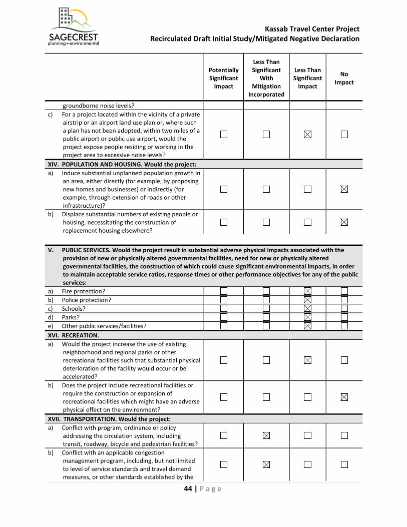
groundborne noise levels? c) For a project located within the vicinity of a private
airstrip or an airport land use plan or, where such a plan has not been adopted, within two miles of a public airport or public use airport, would the project expose people residing or working in the project area to excessive noise levels?
XIV. POPULATION AND HOUSING. Would the project: a) Induce substantial unplanned population growth in
an area, either directly (for example, by proposing new homes and businesses) or indirectly (for example, through extension of roads or other infrastructure)?
b) Displace substantial numbers of existing people or housing, necessitating the construction of replacement housing elsewhere?
V. PUBLIC SERVICES. Would the project result in substantial adverse physical impacts associated with the
provision of new or physically altered governmental facilities, need for new or physically altered governmental facilities, the construction of which could cause significant environmental impacts, in order to maintain acceptable service ratios, response times or other performance objectives for any of the public services:
a) Fire protection? b) Police protection? c) Schools? d) Parks? e) Other public services/facilities? XVI. RECREATION. a) Would the project increase the use of existing
neighborhood and regional parks or other recreational facilities such that substantial physical deterioration of the facility would occur or be accelerated?
b) Does the project include recreational facilities or require the construction or expansion of recreational facilities which might have an adverse physical effect on the environment?
XVII. TRANSPORTATION. Would the project: a) Conflict with program, ordinance or policy
addressing the circulation system, including transit, roadway, bicycle and pedestrian facilities?
b) Conflict with an applicable congestion management program, including, but not limited to level of service standards and travel demand measures, or other standards established by the
Kassab Travel Center Project Recirculated Draft Initial Study/Mitigated Negative Declaration
45 | P a g e
county congestion management agency for designated roads or highways?
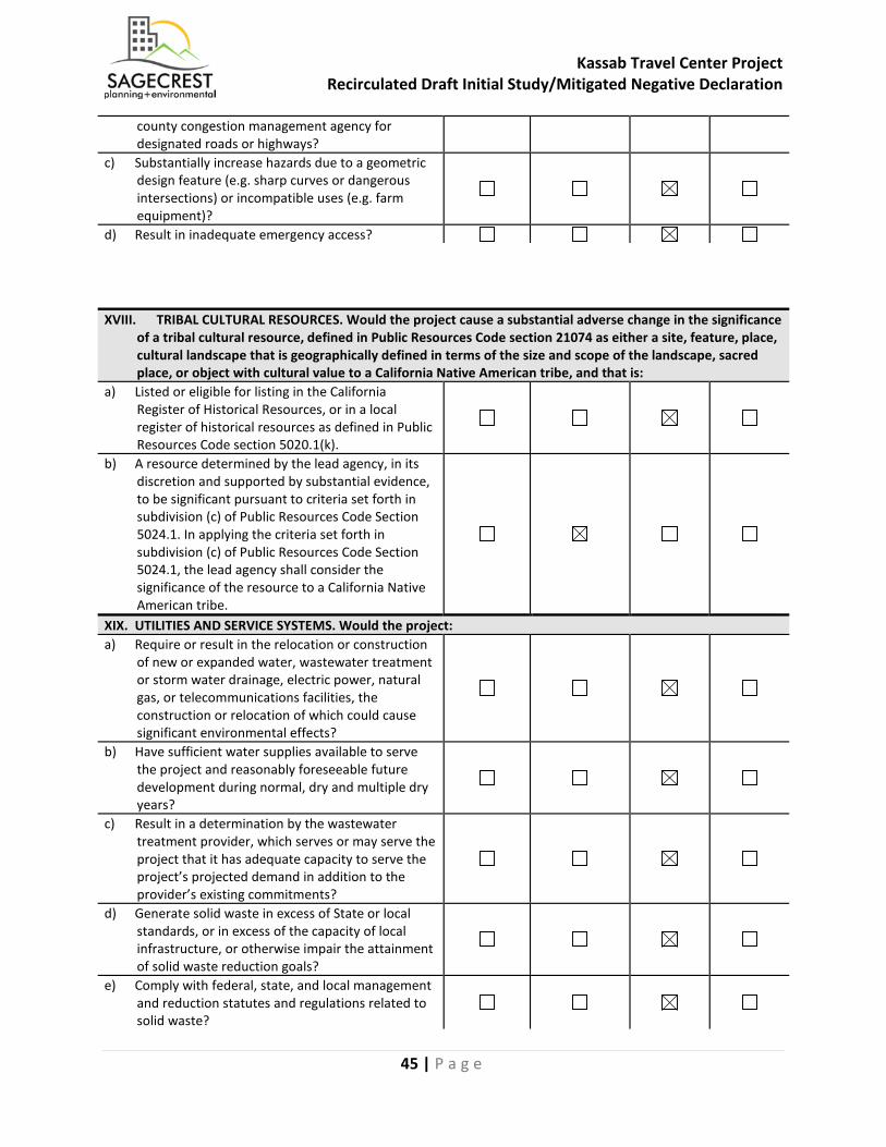
c) Substantially increase hazards due to a geometric design feature (e.g. sharp curves or dangerous intersections) or incompatible uses (e.g. farm equipment)?
d) Result in inadequate emergency access? XVIII. TRIBAL CULTURAL RESOURCES. Would the project cause a substantial adverse change in the significance
of a tribal cultural resource, defined in Public Resources Code section 21074 as either a site, feature, place, cultural landscape that is geographically defined in terms of the size and scope of the landscape, sacred place, or object with cultural value to a California Native American tribe, and that is:
a) Listed or eligible for listing in the California Register of Historical Resources, or in a local register of historical resources as defined in Public Resources Code section 5020.1(k).
b) A resource determined by the lead agency, in its discretion and supported by substantial evidence, to be significant pursuant to criteria set forth in subdivision (c) of Public Resources Code Section 5024.1. In applying the criteria set forth in subdivision (c) of Public Resources Code Section 5024.1, the lead agency shall consider the significance of the resource to a California Native American tribe.
XIX. UTILITIES AND SERVICE SYSTEMS. Would the project: a) Require or result in the relocation or construction
of new or expanded water, wastewater treatment or storm water drainage, electric power, natural gas, or telecommunications facilities, the construction or relocation of which could cause significant environmental effects?
b) Have sufficient water supplies available to serve the project and reasonably foreseeable future development during normal, dry and multiple dry years?
c) Result in a determination by the wastewater treatment provider, which serves or may serve the project that it has adequate capacity to serve the project’s projected demand in addition to the provider’s existing commitments?
d) Generate solid waste in excess of State or local standards, or in excess of the capacity of local infrastructure, or otherwise impair the attainment of solid waste reduction goals?
e) Comply with federal, state, and local management and reduction statutes and regulations related to solid waste?
Kassab Travel Center Project Recirculated Draft Initial Study/Mitigated Negative Declaration
46 | P a g e
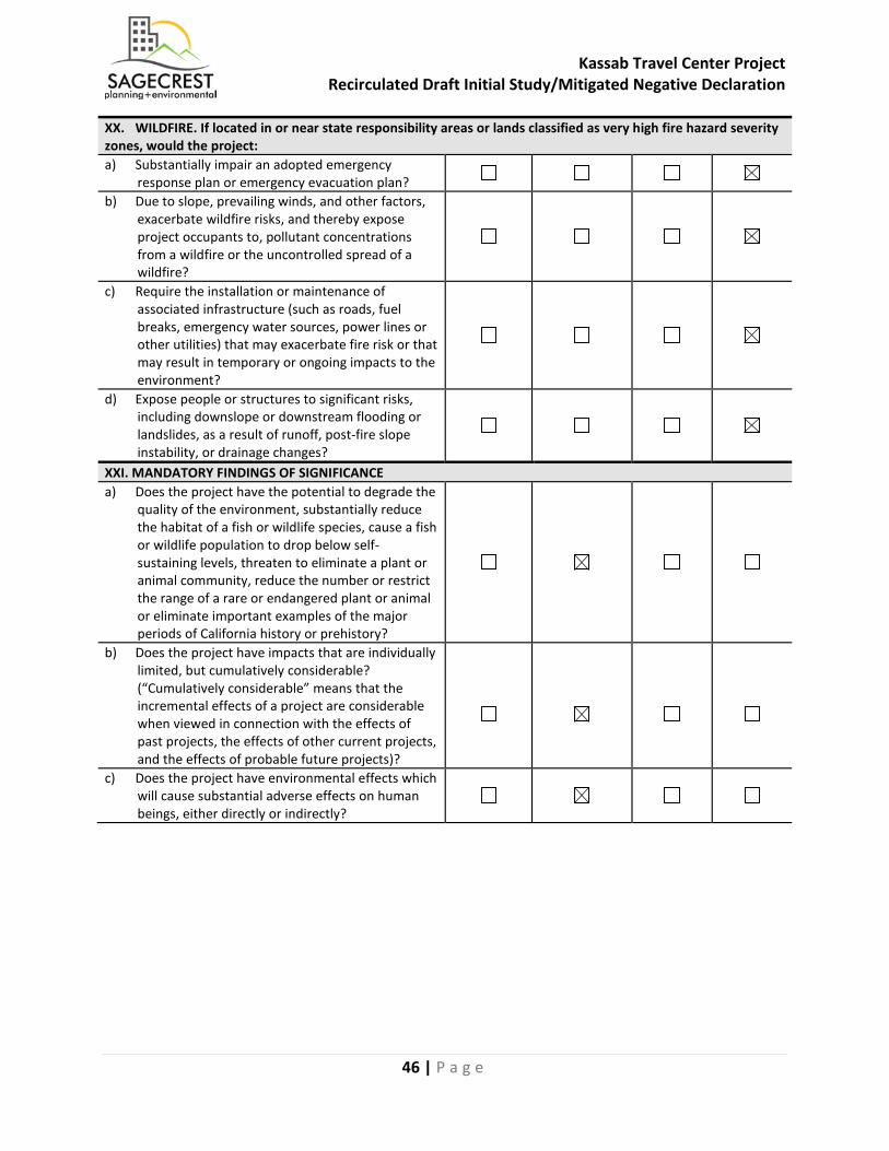
XX. WILDFIRE. If located in or near state responsibility areas or lands classified as very high fire hazard severity zones, would the project: a) Substantially impair an adopted emergency
response plan or emergency evacuation plan?
b) Due to slope, prevailing winds, and other factors, exacerbate wildfire risks, and thereby expose project occupants to, pollutant concentrations from a wildfire or the uncontrolled spread of a wildfire?
c) Require the installation or maintenance of associated infrastructure (such as roads, fuel breaks, emergency water sources, power lines or other utilities) that may exacerbate fire risk or that may result in temporary or ongoing impacts to the environment?
d) Expose people or structures to significant risks, including downslope or downstream flooding or landslides, as a result of runoff, post-fire slope instability, or drainage changes?
XXI. MANDATORY FINDINGS OF SIGNIFICANCE a) Does the project have the potential to degrade the
quality of the environment, substantially reduce the habitat of a fish or wildlife species, cause a fish or wildlife population to drop below self-sustaining levels, threaten to eliminate a plant or animal community, reduce the number or restrict the range of a rare or endangered plant or animal or eliminate important examples of the major periods of California history or prehistory?
b) Does the project have impacts that are individually limited, but cumulatively considerable? (“Cumulatively considerable” means that the incremental effects of a project are considerable when viewed in connection with the effects of past projects, the effects of other current projects, and the effects of probable future projects)?
c) Does the project have environmental effects which will cause substantial adverse effects on human beings, either directly or indirectly?
Kassab Travel Center Project Recirculated Draft Initial Study/Mitigated Negative Declaration
47 | P a g e
IV. ENVIRONMENTAL ANALYSIS This section provides an evaluation of the impact categories and questions contained in the Environmental Checklist. A complete list of the reference sources applicable to the following source abbreviations is contained in Section VII, References, of this document.
I. AESTHETICS
Would the project: Potentially Significant
Impact
Less Than Significant
with Mitigation
Incorporated
Less Than Significant
Impact No Impact
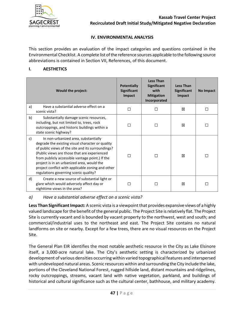
a) Have a substantial adverse effect on a scenic vista? ☐ ☐ ☒ ☐
b) Substantially damage scenic resources, including, but not limited to, trees, rock outcroppings, and historic buildings within a state scenic highway?
☐ ☐ ☒ ☐
c) In non-urbanized area, substantially degrade the existing visual character or quality of public views of the site and its surroundings? (Public views are those that are experienced from publicly accessible vantage point.) If the project is in an urbanized area, would the project conflict with applicable zoning and other regulations governing scenic quality?
☐ ☐ ☒ ☐
d) Create a new source of substantial light or glare which would adversely affect day or nighttime views in the area?
☐ ☐ ☒ ☐
a) Have a substantial adverse effect on a scenic vista?
Less Than Significant Impact: A scenic vista is a viewpoint that provides expansive views of a highly valued landscape for the benefit of the general public. The Project Site is relatively flat. The Project Site is currently vacant and is bounded by vacant property to the northwest, west and south; and commercial/industrial uses to the northeast and east. The Project Site contains no natural landforms on site or nearby. Except for a few trees, there are no visual resources on the Project Site. The General Plan EIR identifies the most notable aesthetic resource in the City as Lake Elsinore itself, a 3,000-acre natural lake. The City’s aesthetic setting is characterized by urbanized development of various densities occurring within varied topographical features and interspersed with undeveloped natural areas. Scenic resources within and surrounding the City include the lake, portions of the Cleveland National Forest, rugged hillside land, distant mountains and ridgelines, rocky outcroppings, streams, vacant land with native vegetation, parkland, and buildings of historical and cultural significance such as the cultural center, bathhouse, and military academy.
Kassab Travel Center Project Recirculated Draft Initial Study/Mitigated Negative Declaration
48 | P a g e
General Plan Goal 12 recommends policies to preserve valued public views throughout the City. The Project Site is located over one mile north from Lake Elsinore (water body) and does not propose any building heights in excess of those that are allowed by the City’s Zoning Code. Distant views of the mountains and ridgelines can be seen from the Project Site. However, the maximum building height would be approximately one story and 26 feet. The convenience store would be set back 53’2” from Collier Avenue and the restaurant would be set back 41 feet from Riverside Drive, minimizing impacts to surrounding mountain views from the adjacent streets. A monument sign is proposed at the intersection of Riverside Drive and Collier Avenue, and price signs for fuel would be located at project entries on Riverside Drive and Collier Avenue. Views of the scenic resources within and surrounding the City are the prominent scenic vistas in the area. However, the Proposed Project would not impede any of these views. Therefore, potential impacts associated with a scenic vista would be less than significant.
Mitigation Measures: No mitigation measures are required.
Sources: General Plan EIR, Google Earth, Project Description
b) Substantially damage scenic resources, including, but not limited to, trees, rock outcroppings, and historic buildings within a state scenic highway?
Less Than Significant Impact: The Project Site is currently vacant land with ten existing trees on 2.84-acres. The Project Site is located on the corner of Riverside Drive and Collier Avenue, which are the local designations for State Route 74 (SR-74). SR-74 runs generally east/west from Interstate 5 (I-5) on the Pacific Coast in San Juan Capistrano to Route 111 in Palm Desert. The most easterly 48-mile portion of SR-74 is designated as a State Scenic Highway. The balance of SR-74, including the portion near the Project Site, is an Eligible State Scenic Highway, but has not been officially designated. However, the Project Site is relatively flat and unimproved, and there are no existing rock outcroppings or historic buildings present on the Project Site. Any potential visual impacts would be addressed through the City’s design review process. The Project Site does not contain any scenic resources, rock outcroppings, or historic buildings. The City has local ordinances that protect the City’s streetscape and trees. The City’s Municipal Code includes a City Tree Preservation Ordinance (Ord. 1256). There are approximately 10 trees, none of which are protected or close to the shore of Lake Elsinore, that would be removed as a result of the Proposed Project. The Proposed Project would comply with Ord. 1256 to ensure the preservation of trees and the local streetscape. The City of Lake Elsinore has also determined that certain species of palm trees in the family Palmaceae are locally significant resources through the City Significant Palm Tree Ordinance (Ord. 1160). However, no palms occur on the Project Site. Therefore, through compliance with local ordinances and the City’s design review process, potential impacts associated with scenic resources within a state scenic highway would be less than significant.
Mitigation Measures: No mitigation measures are required.
Sources: General Plan EIR, LEMC

Kassab Travel Center Project Recirculated Draft Initial Study/Mitigated Negative Declaration
49 | P a g e
c) In non-urbanized area, substantially degrade the existing visual character or quality of public views of the site and its surroundings? (Public views are those that are experienced from publicly accessible vantage point.) If the project is in an urbanized area, would the project conflict with applicable zoning and other regulations governing scenic quality??
Less Than Significant Impact: According to mapping information from the Southern California Association of Governments (SCAG), which is based on U.S. Census data for urbanized areas, the Project Site is not located within an urbanized area. The Proposed Project would not substantially degrade the existing visual character or quality of the site and its surroundings. The Project Site consists of two vacant parcels located in a mixed undeveloped and commercial area of the City. The site is surrounded by vacant property to the northwest, west and south; and commercial/industrial uses to the northeast and east. The Proposed Project would include construction of an 8,360 SF convenience store with concurrent sale of alcoholic beverages (Type 21 ABC), three (3) quick serve restaurants, two (2) covered gas dispensing areas totaling 6,092 SF with a maximum throughput of 5.8 million gallons of gasoline per year, and a free standing 2,543 SF fast food restaurant with drive through. No structures are being proposed that would diminish the existing visual character of the area or block views of the distant mountains and ridgelines. The Proposed Project is consistent with the intended land use for the area and meets development standards guiding the visual character of the site. In addition, the Proposed Project would provide right-of-way and develop half width street improvements along the Project Site’s frontage of Riverside Drive and Collier Avenue, including curbs, and sidewalks. The resulting aesthetic would be more organized, unified and urban, compared to the existing conditions. While the Proposed Project would markedly change the visual quality of the Project Site, it would not degrade the existing visual character or quality of the site or surroundings. Therefore, potential impacts associated with the visual character or quality of the site and its surroundings would be less than significant. Mitigation Measures: No mitigation measures are required Sources: Project Description
d) Create a new source of substantial light or glare which would adversely affect day or nighttime views in the area?
Less Than Significant Impact: According to the City’s General Plan, light and glare impacts to the Mount Palomar Observatory are of concern to the City. Areas of light pollution impacts have been identified through a “ring analysis,” where primary impacts to the Observatory are within a 30-mile radius, and secondary impacts are up to 45 miles. According to the General Plan Figure 4.12, the Project Site is within the 45-mile secondary impacts radius. The Proposed Project would introduce light features to the vacant Project Site. Accordingly, the new buildings and associated components would include lighting features typical of commercial developments, such as security lighting and indoor lighting. However, while the Proposed Project would introduce new sources of light, all lighting fixtures would comply with Lake Elsinore Municipal Code (LEMC) Section 17.112.040 Lighting (for Nonresidential Development). Section 17.112.040 requires all outdoor lighting fixtures in excess of 60 watts to be oriented and shielded to prevent direct illumination above the
Kassab Travel Center Project Recirculated Draft Initial Study/Mitigated Negative Declaration
50 | P a g e
horizontal plane passing through the luminaire and prevent any glare or illumination on adjacent properties or streets. This section of the LEMC encourages the use of low-pressure sodium vapor lighting due to the City’s proximity to the Mount Palomar Observatory. The Proposed Project would also introduce new sources of daytime glare due to the new building surfaces and vehicles traveling to and from the site. However, the glare created by the proposed development would be consistent with the levels of glare that are emitted by the surrounding development. The Proposed Project would not create a new source of substantial light or glare which would adversely affect day or nighttime views in the area. Therefore, potential impacts associated with light or glare would be less than significant. Mitigation Measures: No mitigation measures are required. Sources: LEMC, General Plan
Kassab Travel Center Project Recirculated Draft Initial Study/Mitigated Negative Declaration
51 | P a g e
II. AGRICULTURE AND FORESTRY RESOURCES
Would the project: Potentially Significant
Impact
Less Than Significant
with Mitigation
Incorporated
Less Than Significant
Impact No Impact
a) Convert Prime Farmland, Unique Farmland, or Farmland of Statewide Importance (Farmland), as shown on the maps prepared pursuant to the Farmland Mapping and Monitoring Program of the California Resources Agency, to non-agricultural use?
☐ ☐ ☐ ☒
b) Conflict with existing zoning for agricultural use, or a Williamson Act contract? ☐ ☐ ☐ ☒
c) Conflict with existing zoning for, or cause rezoning of, forest land (as defined in Public Resources Code section 12220(g)), timberland (as defined by Public Resources Code Section 4526), or timberland zoned Timberland Production (as defined by Government Code section 51104(g))?
☐ ☐ ☐ ☒
d) Result in the loss of forest land or conversion of forest land to non-forest use? ☐ ☐ ☐ ☒
e) Involve other changes in the existing environment which, due to their location or nature, could result in conversion of Farmland, to non-agricultural use or conversion of forest land to non-forest use?
☐ ☐ ☐ ☒
a) Convert Prime Farmland, Unique Farmland, or Farmland of Statewide Importance (Farmland), as shown on the maps prepared pursuant to the Farmland Mapping and Monitoring Program of the California Resources Agency, to non-agricultural use?
No Impact: Agricultural uses constitute approximately 0.8 percent of the City’s total acreage and are designated by the California Farmland Mapping and Monitoring Program (FMMP) as Farmland of Local Importance (554 acres within the City), Grazing Land (827 acres within the City), and Unique Farmland (25 acres within the City). Remaining land is considered Urban/Built Up Land or Other Land, reflecting its developed uses or other characteristics making it unsuitable for agriculture. None of the farmland designations applied to land within the City or SOI is considered Prime Farmland, Unique Farmland, or Farmland of Statewide Importance by the State of California. There are no agricultural uses adjacent to the Project Site. The Proposed Project would not convert any Prime Farmland, Unique Farmland, or Farmland of Statewide Importance. Therefore, no impacts associated with conversion of farmland would occur. Mitigation Measures: No mitigation measures are required. Sources: FMMP, General Plan EIR
Kassab Travel Center Project Recirculated Draft Initial Study/Mitigated Negative Declaration
52 | P a g e
b) Conflict with existing zoning for agricultural use, or a Williamson Act contract?
No Impact: The Proposed Project is not located within or adjacent to a Williamson Act contract as there are no Williamson Act agricultural preserves located within the City. The Project Site is zoned as Commercial Manufacturing (C-M) and surrounded by manufacturing and is public/institutional zoning designations. The Proposed Project would not conflict with existing zoning for agricultural use or a Williamson Act contract. Therefore, no impacts associated with agricultural uses or a Williamson Act contract would occur. Mitigation Measures: No mitigation measures are required. Sources: DOC WA, General Plan EIR, Zoning Map)
c) Conflict with existing zoning for, or cause rezoning of, forest land (as defined by Public Resources Code section 4526), or timberland zoned Timberland Production (as defined by Government Code section 51104(g))?
No Impact: The Project Site is within the City of Lake Elsinore which does not have zoning designated for forest land, timberland, or timberland zoned Timberland Production within City limits. The site does not contain forestland or timberland. There is no conflict with existing zoning and no cause for rezoning of land related to forestland or timberland. Therefore, no impacts associated with forest land or timberland would occur. Mitigation Measures: No mitigation measures are required. Sources: General Plan, Zoning Map
d) Result in the loss of forest land or conversion of forest land to non-forest uses?
No Impact: As indicated in Section II(c), the City does not have a zoning designation for forest land, timberland, or timberland zoned Timberland Production within City limits. In addition, the Project Site is currently vacant and is bounded by vacant property to the northwest, west and south; and commercial/industrial uses to the northeast and east. The Proposed Project would not result in the loss of forest land or conversion of forest land to non-forest uses. Therefore, no impacts associated with forest land would occur. Mitigation Measures: No mitigation measures are required. Sources: General Plan, Zoning Map
Kassab Travel Center Project Recirculated Draft Initial Study/Mitigated Negative Declaration
53 | P a g e
e) Involve other changes in the existing environment which, due to their location or nature, could result in conversion of Farmland to non-agricultural use?
No Impact: The historical use of the site consisted of a water reservoir from 1938 to 1978, followed by the development of an unknown square structure from at least 1978 to at least 1985, and since then the site has been occupied by what appears to be native vegetation (undeveloped). The surrounding properties historically were utilized for agricultural purposes. However, any agricultural setting that may have existed around the Proposed Project area has been developed with modern commercial, industrial, and transportation uses. No agricultural activities are presently occurring on-site. The existing condition on-site is vacant and undeveloped. The Proposed Project would be consistent with the existing zoning designation of Commercial Manufacturing (C-M). The Proposed Project does not result in conversion of Farmland to non-agricultural use. Therefore, no impacts associated with farmland would occur. Mitigation Measures: No mitigation measures are required. Sources: Phase I ESA (Appendix G), Project Description, Zoning Map
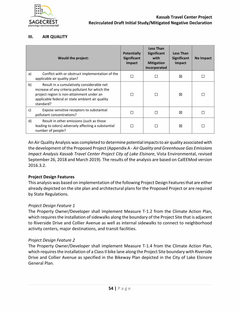
Kassab Travel Center Project Recirculated Draft Initial Study/Mitigated Negative Declaration
54 | P a g e
III. AIR QUALITY
Would the project: Potentially Significant
Impact
Less Than Significant
with Mitigation
Incorporated
Less Than Significant
Impact No Impact
a) Conflict with or obstruct implementation of the applicable air quality plan? ☐ ☐ ☒ ☐
b) Result in a cumulatively considerable net increase of any criteria pollutant for which the project region is non-attainment under an applicable federal or state ambient air quality standard?
☐ ☐ ☒ ☐
c) Expose sensitive receptors to substantial pollutant concentrations? ☐ ☐ ☒ ☐
d) Result in other emissions (such as those leading to odors) adversely affecting a substantial number of people?
☐ ☐ ☒ ☐
An Air Quality Analysis was completed to determine potential impacts to air quality associated with the development of the Proposed Project (Appendix A - Air Quality and Greenhouse Gas Emissions Impact Analysis Kassab Travel Center Project City of Lake Elsinore, Vista Environmental, revised September 26, 2018 and March 2019). The results of the analysis are based on CalEEMod version 2016.3.2. Project Design Features This analysis was based on implementation of the following Project Design Features that are either already depicted on the site plan and architectural plans for the Proposed Project or are required by State Regulations. Project Design Feature 1 The Property Owner/Developer shall implement Measure T-1.2 from the Climate Action Plan, which requires the installation of sidewalks along the boundary of the Project Site that is adjacent to Riverside Drive and Collier Avenue as well as internal sidewalks to connect to neighborhood activity centers, major destinations, and transit facilities. Project Design Feature 2 The Property Owner/Developer shall implement Measure T-1.4 from the Climate Action Plan, which requires the installation of a Class II bike lane along the Project Site boundary with Riverside Drive and Collier Avenue as specified in the Bikeway Plan depicted in the City of Lake Elsinore General Plan.
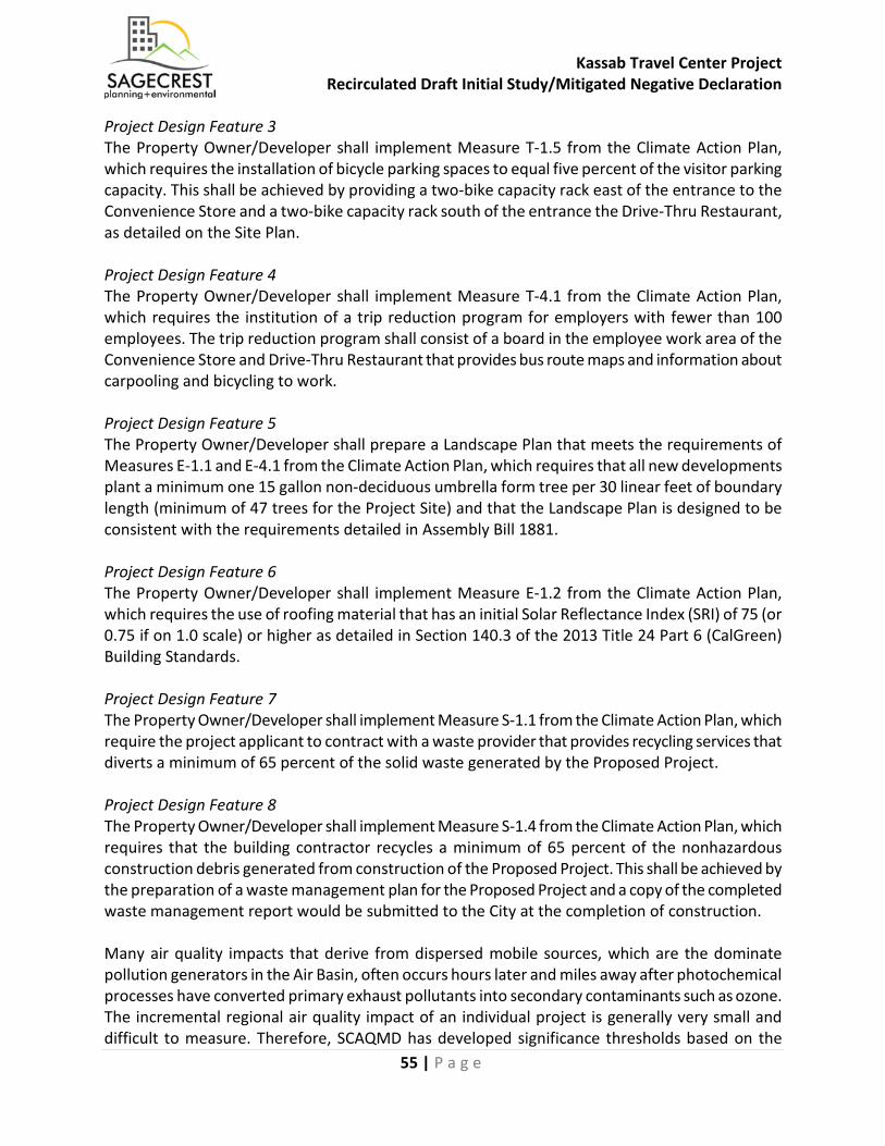
Kassab Travel Center Project Recirculated Draft Initial Study/Mitigated Negative Declaration
55 | P a g e
Project Design Feature 3 The Property Owner/Developer shall implement Measure T-1.5 from the Climate Action Plan, which requires the installation of bicycle parking spaces to equal five percent of the visitor parking capacity. This shall be achieved by providing a two-bike capacity rack east of the entrance to the Convenience Store and a two-bike capacity rack south of the entrance the Drive-Thru Restaurant, as detailed on the Site Plan. Project Design Feature 4 The Property Owner/Developer shall implement Measure T-4.1 from the Climate Action Plan, which requires the institution of a trip reduction program for employers with fewer than 100 employees. The trip reduction program shall consist of a board in the employee work area of the Convenience Store and Drive-Thru Restaurant that provides bus route maps and information about carpooling and bicycling to work. Project Design Feature 5 The Property Owner/Developer shall prepare a Landscape Plan that meets the requirements of Measures E-1.1 and E-4.1 from the Climate Action Plan, which requires that all new developments plant a minimum one 15 gallon non-deciduous umbrella form tree per 30 linear feet of boundary length (minimum of 47 trees for the Project Site) and that the Landscape Plan is designed to be consistent with the requirements detailed in Assembly Bill 1881. Project Design Feature 6 The Property Owner/Developer shall implement Measure E-1.2 from the Climate Action Plan, which requires the use of roofing material that has an initial Solar Reflectance Index (SRI) of 75 (or 0.75 if on 1.0 scale) or higher as detailed in Section 140.3 of the 2013 Title 24 Part 6 (CalGreen) Building Standards. Project Design Feature 7 The Property Owner/Developer shall implement Measure S-1.1 from the Climate Action Plan, which require the project applicant to contract with a waste provider that provides recycling services that diverts a minimum of 65 percent of the solid waste generated by the Proposed Project. Project Design Feature 8 The Property Owner/Developer shall implement Measure S-1.4 from the Climate Action Plan, which requires that the building contractor recycles a minimum of 65 percent of the nonhazardous construction debris generated from construction of the Proposed Project. This shall be achieved by the preparation of a waste management plan for the Proposed Project and a copy of the completed waste management report would be submitted to the City at the completion of construction. Many air quality impacts that derive from dispersed mobile sources, which are the dominate pollution generators in the Air Basin, often occurs hours later and miles away after photochemical processes have converted primary exhaust pollutants into secondary contaminants such as ozone. The incremental regional air quality impact of an individual project is generally very small and difficult to measure. Therefore, SCAQMD has developed significance thresholds based on the
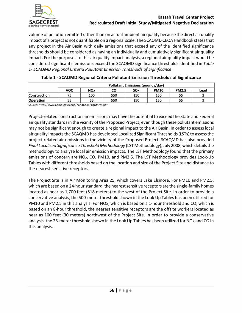
Kassab Travel Center Project Recirculated Draft Initial Study/Mitigated Negative Declaration
56 | P a g e
volume of pollution emitted rather than on actual ambient air quality because the direct air quality impact of a project is not quantifiable on a regional scale. The SCAQMD CEQA Handbook states that any project in the Air Basin with daily emissions that exceed any of the identified significance thresholds should be considered as having an individually and cumulatively significant air quality impact. For the purposes to this air quality impact analysis, a regional air quality impact would be considered significant if emissions exceed the SCAQMD significance thresholds identified in Table 1- SCAQMD Regional Criteria Pollutant Emission Thresholds of Significance.
Table 1 - SCAQMD Regional Criteria Pollutant Emission Thresholds of Significance
Pollutant Emissions (pounds/day) VOC NOx CO SOx PM10 PM2.5 Lead
Construction 75 100 550 150 150 55 3 Operation 55 55 550 150 150 55 3 Source: http://www.aqmd.gov/ceqa/handbook/signthres.pdf Project-related construction air emissions may have the potential to exceed the State and Federal air quality standards in the vicinity of the Proposed Project, even though these pollutant emissions may not be significant enough to create a regional impact to the Air Basin. In order to assess local air quality impacts the SCAQMD has developed Localized Significant Thresholds (LSTs) to assess the project-related air emissions in the vicinity of the Proposed Project. SCAQMD has also provided Final Localized Significance Threshold Methodology (LST Methodology), July 2008, which details the methodology to analyze local air emission impacts. The LST Methodology found that the primary emissions of concern are NO2, CO, PM10, and PM2.5. The LST Methodology provides Look-Up Tables with different thresholds based on the location and size of the Project Site and distance to the nearest sensitive receptors. The Project Site is in Air Monitoring Area 25, which covers Lake Elsinore. For PM10 and PM2.5, which are based on a 24-hour standard, the nearest sensitive receptors are the single-family homes located as near as 1,700 feet (518 meters) to the west of the Project Site. In order to provide a conservative analysis, the 500-meter threshold shown in the Look Up Tables has been utilized for PM10 and PM2.5 in this analysis. For NOx, which is based on a 1-hour threshold and CO, which is based on an 8-hour threshold, the nearest sensitive receptors are the offsite workers located as near as 100 feet (30 meters) northwest of the Project Site. In order to provide a conservative analysis, the 25-meter threshold shown in the Look Up Tables has been utilized for NOx and CO in this analysis.
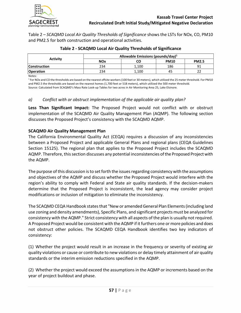
Kassab Travel Center Project Recirculated Draft Initial Study/Mitigated Negative Declaration
57 | P a g e
Table 2 – SCAQMD Local Air Quality Thresholds of Significance shows the LSTs for NOx, CO, PM10 and PM2.5 for both construction and operational activities.
Table 2 - SCAQMD Local Air Quality Thresholds of Significance
Activity Allowable Emissions (pounds/day)1
NOx CO PM10 PM2.5 Construction 234 1,100 186 91 Operation 234 1,100 45 22 Notes: 1 For NOx and CO the thresholds are based on the nearest offsite workers (100 feet or 30 meters), which utilized the 25 meter threshold. For PM10 and PM2.5 the thresholds are based on the nearest homes (1,700 feet or 518 meters), which utilized the 500 meter threshold. Source: Calculated from SCAQMD’s Mass Rate Look-up Tables for two acres in Air Monitoring Area 25, Lake Elsinore.
a) Conflict with or obstruct implementation of the applicable air quality plan?
Less Than Significant Impact: The Proposed Project would not conflict with or obstruct implementation of the SCAQMD Air Quality Management Plan (AQMP). The following section discusses the Proposed Project’s consistency with the SCAQMD AQMP. SCAQMD Air Quality Management Plan The California Environmental Quality Act (CEQA) requires a discussion of any inconsistencies between a Proposed Project and applicable General Plans and regional plans (CEQA Guidelines Section 15125). The regional plan that applies to the Proposed Project includes the SCAQMD AQMP. Therefore, this section discusses any potential inconsistencies of the Proposed Project with the AQMP. The purpose of this discussion is to set forth the issues regarding consistency with the assumptions and objectives of the AQMP and discuss whether the Proposed Project would interfere with the region’s ability to comply with Federal and State air quality standards. If the decision-makers determine that the Proposed Project is inconsistent, the lead agency may consider project modifications or inclusion of mitigation to eliminate the inconsistency. The SCAQMD CEQA Handbook states that "New or amended General Plan Elements (including land use zoning and density amendments), Specific Plans, and significant projects must be analyzed for consistency with the AQMP." Strict consistency with all aspects of the plan is usually not required. A Proposed Project would be consistent with the AQMP if it furthers one or more policies and does not obstruct other policies. The SCAQMD CEQA Handbook identifies two key indicators of consistency: (1) Whether the project would result in an increase in the frequency or severity of existing air quality violations or cause or contribute to new violations or delay timely attainment of air quality standards or the interim emission reductions specified in the AQMP. (2) Whether the project would exceed the assumptions in the AQMP or increments based on the year of project buildout and phase.
Kassab Travel Center Project Recirculated Draft Initial Study/Mitigated Negative Declaration
58 | P a g e
Criterion 1 - Increase In The Frequency Or Severity Of Violations Based on the air quality modeling analysis contained in the Air Quality Impact Analysis, short-term regional construction air emissions would not result in significant impacts based on SCAQMD regional thresholds of significance or local thresholds of significance. The ongoing operation of the Proposed Project would generate air pollutant emissions that are inconsequential on a regional basis and would not result in significant impacts based on SCAQMD thresholds of significance. The analysis for long-term local air quality impacts showed that local pollutant concentrations would not be projected to exceed the air quality standards. Therefore, a less than significant long-term impact would occur and no mitigation would be required. Based on the information provided above, the Proposed Project would be consistent with the first criterion. Criterion 2 - Exceed Assumptions In The AQMP Consistency with the AQMP assumptions is determined by performing an analysis of the Proposed Project with the assumptions in the AQMP. The emphasis of this criterion is to ensure the analyses conducted for the Proposed Project is based on the same forecasts as the AQMP. The AQMP is developed through use of the planning forecasts provided in the RTP/SCS and FTIP. The RTP/SCS is a major planning document for the regional transportation and land use network within Southern California. The RTP/SCS is a long-range plan that is required by federal and state requirements placed on SCAG and is updated every four years. The FTIP provides long-range planning for future transportation improvement projects that are constructed with state and/or federal funds within Southern California. Local governments are required to use these plans as the basis of their plans for the purpose of consistency with applicable regional plans under CEQA. For the Proposed Project, the City of Lake Elsinore Business District, adopted December 13, 2011, defines the assumptions that are represented in AQMP. The Project Site is designated as Limited Industrial in the Business District Plan and is zoned Commercial Manufacturing (CM). The Proposed Project would be consistent with the current land use designation and would not require a General Plan Amendment or zone change. The Proposed Project would not exceed the AQMP assumptions for the Project Site and is found to be consistent with the AQMP for the second criterion. Therefore, potential impacts associated with an inconsistency with the SCAQMD AQMP would be less than significant. Mitigation Measures: No mitigation measures are required. Sources: AQ/GHG Analysis (Appendix A)
Kassab Travel Center Project Recirculated Draft Initial Study/Mitigated Negative Declaration
59 | P a g e
b) Result in a cumulatively considerable net increase of any criteria pollutant for which the project region is non-attainment under an applicable federal or state ambient air quality standard (including releasing emissions, which exceed quantitative thresholds for ozone precursors)?
Less Than Significant Impact: The Proposed Project would not result in a cumulatively considerable net increase of any criteria pollutant for which the project region is non-attainment under an applicable Federal or State ambient air quality standard (including releasing emissions which exceed quantitative thresholds for ozone precursors). Cumulative projects include local development as well as general growth within the project area. However, as with most development, the greatest source of emissions is from mobile sources, which travel throughout the local area. Therefore, from an air quality standpoint, the cumulative analysis would extend beyond any local projects and when wind patterns are considered would cover an even larger area. Accordingly, the cumulative analysis for the Proposed Project’s air quality must be generic by nature. The project area is out of attainment for ozone and PM10 and PM2.5 particulate matter. In accordance with CEQA Guidelines Section 15130(b), this analysis of cumulative impacts incorporates a three-tiered approach to assess cumulative air quality impacts.
• Consistency with the SCAQMD project specific thresholds for construction and operations; • Project consistency with existing air quality plans; and • Assessment of the cumulative health effects of the pollutants.
Consistency with Project Specific Thresholds Construction-Related Regional Impacts The Project Site is located in the South Coast Air Basin, which is currently designated by the EPA for federal standards as a non-attainment area for ozone and PM2.5 and by CARB for the state standards as a non-attainment area for ozone, PM10, and PM2.5. Table 3 – Construction-Related Regional Criteria Pollutant Emissions shows that the regional ozone, PM10, and PM2.5 emissions associated with construction of the Proposed Project would result in less than significant regional emissions of VOC and NOx (ozone precursors), PM10, and PM2.5 during construction of the Proposed Project. None of the analyzed criteria pollutants would exceed the regional emissions thresholds during site preparation, grading, or the combined building construction, paving, and architectural coatings phases. Therefore, potential regional air quality impacts associated with construction of the Proposed Project would be less than significant.

Kassab Travel Center Project Recirculated Draft Initial Study/Mitigated Negative Declaration
60 | P a g e
Table 3 - Construction-Related Regional Criteria Pollutant Emissions
Activity Pollutant Emissions (pounds/day)
VOC NOx CO SO2 PM10 PM2.5 Site Preparation1 Onsite 1.76 21.54 11.91 0.02 1.47 0.85 Offsite 0.06 0.71 0.48 0.00 0.13 0.04 Total 1.82 22.25 12.39 0.02 1.60 0.89 Grading1 Onsite 2.03 22.74 10.15 0.02 3.63 2.30 Offsite 0.08 0.72 0.57 0.00 0.16 0.05 Total 2.11 23.46 10.72 0.02 3.79 2.35 Building Construction Onsite 2.56 18.91 15.25 0.03 1.09 1.04 Offsite 0.13 0.98 1.01 0.00 0.27 0.08 Total 2.69 19.89 16.26 0.03 1.36 1.12 Paving Onsite 1.68 11.59 11.81 0.02 0.66 0.61 Offsite 0.08 0.05 0.60 0.00 0.17 0.05 Total 1.76 11.64 12.41 0.02 0.83 0.66 Architectural Coatings Onsite 16.86 1.68 1.83 0.00 0.11 0.11 Offsite 0.02 0.01 0.16 0.00 0.05 0.01 Total 16.88 1.69 1.99 0.00 0.16 0.12 Combined Building Construction, Paving, and Architectural Coatings 21.33 33.22 30.66 0.05 2.35 1.90
SCQAMD Thresholds 75 100 550 150 150 55 Exceeds Threshold? No No No No No No Notes: 1 Site Preparation and Grading based on adherence to fugitive dust suppression requirements from SCAQMD Rule 403. 2 Onsite emissions from equipment not operated on public roads. 3 Offsite emissions from vehicles operating on public roads. Source: CalEEMod Version 2016.3.2. Construction-Related Local Impacts Construction-related air emissions may have the potential to exceed the State and Federal air quality standards in the project vicinity, even though these pollutant emissions may not be significant enough to create a regional impact to the Air Basin. The local air quality emissions from construction were analyzed through utilizing the methodology described in Localized Significance Threshold Methodology (LST Methodology), prepared by SCAQMD, revised October 2009. The LST Methodology found the primary criteria pollutant emissions of concern are NOx, CO, PM10, and PM2.5. In order to determine if any of these pollutants require a detailed analysis of the local air quality impacts, each phase of construction was screened using the SCAQMD’s Mass Rate LST Look-up Tables which were developed by the SCAQMD in order to readily determine the daily onsite emissions of CO, NOx, PM10, and PM2.5. Table 4 – Construction Related Local Criteria Pollutant Emissions shows that none of the analyzed criteria pollutants would exceed the local emissions thresholds during the site preparation or grading phase or the combined building construction, paving, and architectural coatings phases. Therefore, potential local air quality impacts associated with construction of the Proposed Project would be less than significant.
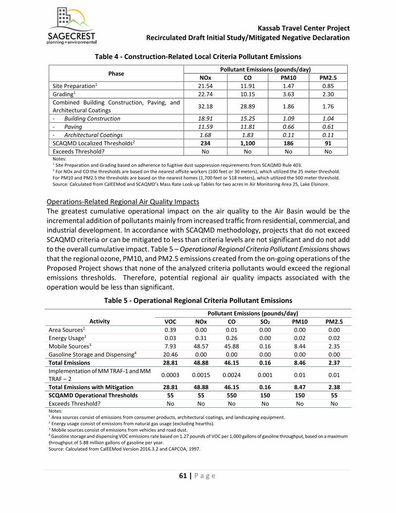
Kassab Travel Center Project Recirculated Draft Initial Study/Mitigated Negative Declaration
61 | P a g e
Table 4 - Construction-Related Local Criteria Pollutant Emissions
Phase Pollutant Emissions (pounds/day)
NOx CO PM10 PM2.5 Site Preparation1 21.54 11.91 1.47 0.85 Grading1 22.74 10.15 3.63 2.30 Combined Building Construction, Paving, and Architectural Coatings 32.18 28.89 1.86 1.76
- Building Construction 18.91 15.25 1.09 1.04 - Paving 11.59 11.81 0.66 0.61 - Architectural Coatings 1.68 1.83 0.11 0.11 SCAQMD Localized Thresholds2 234 1,100 186 91 Exceeds Threshold? No No No No Notes: 1 Site Preparation and Grading based on adherence to fugitive dust suppression requirements from SCAQMD Rule 403. 2 For NOx and CO the thresholds are based on the nearest offsite workers (100 feet or 30 meters), which utilized the 25 meter threshold. For PM10 and PM2.5 the thresholds are based on the nearest homes (1,700 feet or 518 meters), which utilized the 500 meter threshold. Source: Calculated from CalEEMod and SCAQMD’s Mass Rate Look-up Tables for two acres in Air Monitoring Area 25, Lake Elsinore.
Operations-Related Regional Air Quality Impacts The greatest cumulative operational impact on the air quality to the Air Basin would be the incremental addition of pollutants mainly from increased traffic from residential, commercial, and industrial development. In accordance with SCAQMD methodology, projects that do not exceed SCAQMD criteria or can be mitigated to less than criteria levels are not significant and do not add to the overall cumulative impact. Table 5 – Operational Regional Criteria Pollutant Emissions shows that the regional ozone, PM10, and PM2.5 emissions created from the on-going operations of the Proposed Project shows that none of the analyzed criteria pollutants would exceed the regional emissions thresholds. Therefore, potential regional air quality impacts associated with the operation would be less than significant.
Table 5 - Operational Regional Criteria Pollutant Emissions
Activity
Pollutant Emissions (pounds/day) VOC NOx CO SO2 PM10 PM2.5
Area Sources1 0.39 0.00 0.01 0.00 0.00 0.00 Energy Usage2 0.03 0.31 0.26 0.00 0.02 0.02 Mobile Sources3 7.93 48.57 45.88 0.16 8.44 2.35 Gasoline Storage and Dispensing4 20.46 0.00 0.00 0.00 0.00 0.00 Total Emissions 28.81 48.88 46.15 0.16 8.46 2.37 Implementation of MM TRAF-1 and MM TRAF – 2 0.0003 0.0015 0.0024 0.001 0.01 0.01
Total Emissions with Mitigation 28.81 48.88 46.15 0.16 8.47 2.38 SCQAMD Operational Thresholds 55 55 550 150 150 55 Exceeds Threshold? No No No No No No Notes: 1 Area sources consist of emissions from consumer products, architectural coatings, and landscaping equipment. 2 Energy usage consist of emissions from natural gas usage (excluding hearths). 3 Mobile sources consist of emissions from vehicles and road dust. 4 Gasoline storage and dispensing VOC emissions rate based on 1.27 pounds of VOC per 1,000 gallons of gasoline throughput, based on a maximum throughput of 5.88 million gallons of gasoline per year. Source: Calculated from CalEEMod Version 2016.3.2 and CAPCOA, 1997.
Kassab Travel Center Project Recirculated Draft Initial Study/Mitigated Negative Declaration
62 | P a g e
Operations-Related Local Air Quality Impacts Project-related air emissions may have the potential to exceed the State and Federal air quality standards in the project vicinity, even though these pollutant emissions may not be significant enough to create a regional impact to the Air Basin. The Proposed Project has been analyzed for the potential local CO emission impacts from the project-generated vehicular trips and from the potential local air quality impacts from on-site operations. The following analysis analyzes the vehicular CO emissions and local impacts from on-site operations. Local CO Hotspot Impacts from Project-Generated Vehicular Trips CO is the pollutant of major concern along roadways because the most notable source of CO is motor vehicles. For this reason, CO concentrations are usually indicative of the local air quality generated by a roadway network and are used as an indicator of potential local air quality impacts. Local air quality impacts can be assessed by comparing future without and with project CO levels to the State and Federal CO standards of 20 ppm over one hour or 9 ppm over eight hours. At the time of the 1993 Handbook, the Air Basin was designated nonattainment under the CAAQS and NAAQS for CO. With the turnover of older vehicles, introduction of cleaner fuels, and implementation of control technology on industrial facilities, CO concentrations in the Air Basin and in the state have steadily declined. In 2007, the Air Basin was designated in attainment for CO under both the CAAQS and NAAQS. SCAQMD conducted a CO hot spot analysis for attainment at the busiest intersections in Los Angeles during the peak morning and afternoon periods and did not predict a violation of CO standards1. Since the nearby intersections to the Proposed Project are much smaller with less traffic than what was analyzed by the SCAQMD, no local CO Hotspot are anticipated to be created from the Proposed Project and no CO Hotspot modeling was performed. Therefore, potential long-term local air quality impacts associated with operation would be less than significant. Local Criteria Pollutant Impacts from Onsite Operations Project-related air emissions from onsite sources such as architectural coatings, landscaping equipment, and onsite usage of natural gas appliances may have the potential to create emissions areas that exceed the State and Federal air quality standards in the project vicinity, even though these pollutant emissions may not be significant enough to create a regional impact to the Air Basin. Table 6 – Operations Related Local Criteria Pollutant Emissions shows the onsite emissions from the CalEEMod model that includes area sources, energy usage, vehicles, and off-road equipment operating on site and the calculated emissions thresholds would not exceed the local NOx, CO, PM10 and PM2.5 thresholds of significance. Therefore, potential local air quality impacts associated with operation would be less than significant.
1 The four intersections analyzed by the SCAQMD were: Long Beach Boulevard and Imperial Highway; Wilshire Boulevard and Veteran Avenue; Sunset Boulevard and Highland Avenue; and La Cienega Boulevard and Century Boulevard. The busiest intersection evaluated (Wilshire and Veteran) had a daily traffic volume of approximately 100,000 vehicles per day with LOS E in the morning and LOS F in the evening peak hour.
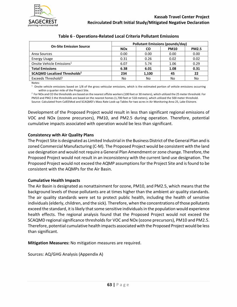
Kassab Travel Center Project Recirculated Draft Initial Study/Mitigated Negative Declaration
63 | P a g e
Table 6 - Operations-Related Local Criteria Pollutant Emissions
On-Site Emission Source Pollutant Emissions (pounds/day)
NOx CO PM10 PM2.5 Area Sources 0.00 0.00 0.00 0.00 Energy Usage 0.31 0.26 0.02 0.02 Onsite Vehicle Emissions1 6.07 5.74 1.06 0.29 Total Emissions 6.38 6.01 1.08 0.31 SCAQMD Localized Thresholds2 234 1,100 45 22 Exceeds Threshold? No No No No Notes: 1 Onsite vehicle emissions based on 1/8 of the gross vehicular emissions, which is the estimated portion of vehicle emissions occurring within a quarter mile of the Project Site. 2 For NOx and CO the thresholds are based on the nearest offsite workers (100 feet or 30 meters), which utilized the 25 meter threshold. For PM10 and PM2.5 the thresholds are based on the nearest homes (1,700 feet or 518 meters), which utilized the 500 meter threshold. Source: Calculated from CalEEMod and SCAQMD’s Mass Rate Look-up Tables for two acres in Air Monitoring Area 25, Lake Elsinore.
Development of the Proposed Project would result in less than significant regional emissions of VOC and NOx (ozone precursors), PM10, and PM2.5 during operation. Therefore, potential cumulative impacts associated with operation would be less than significant. Consistency with Air Quality Plans The Project Site is designated as Limited Industrial in the Business District of the General Plan and is zoned Commercial Manufacturing (C-M). The Proposed Project would be consistent with the land use designation and would not require a General Plan Amendment or zone change. Therefore, the Proposed Project would not result in an inconsistency with the current land use designation. The Proposed Project would not exceed the AQMP assumptions for the Project Site and is found to be consistent with the AQMPs for the Air Basin. Cumulative Health Impacts The Air Basin is designated as nonattainment for ozone, PM10, and PM2.5, which means that the background levels of those pollutants are at times higher than the ambient air quality standards. The air quality standards were set to protect public health, including the health of sensitive individuals (elderly, children, and the sick). Therefore, when the concentrations of those pollutants exceed the standard, it is likely that some sensitive individuals in the population would experience health effects. The regional analysis found that the Proposed Project would not exceed the SCAQMD regional significance thresholds for VOC and NOx (ozone precursors), PM10 and PM2.5. Therefore, potential cumulative health impacts associated with the Proposed Project would be less than significant. Mitigation Measures: No mitigation measures are required. Sources: AQ/GHG Analysis (Appendix A)
Kassab Travel Center Project Recirculated Draft Initial Study/Mitigated Negative Declaration
64 | P a g e
c) Expose sensitive receptors to substantial pollutant concentrations?
Less Than Significant Impact: The Proposed Project would not expose sensitive receptors to substantial pollutant concentrations. The local concentrations of criteria pollutant emissions produced in the nearby vicinity of the Project Site, which may expose sensitive receptors to substantial concentrations, have been calculated in Section III(a) for both construction and operations. The discussion below also includes an analysis of the potential impacts from toxic air contaminant emissions. The nearest sensitive receptors are the single-family homes that are located as near as 1,700 feet southwest of the Project Site. Construction-Related Sensitive Receptor Impacts Construction of the Proposed Project may expose sensitive receptors to substantial pollutant concentrations of localized criteria pollutant concentrations and from toxic air contaminant emissions created from onsite construction equipment. Local Criteria Pollutant Impacts from Construction The local air quality impacts from construction of the Proposed Project would not exceed the local NOx, CO, PM10 and PM2.5 thresholds of significance. Therefore, potential local air quality impacts associated with construction of the Proposed Project would be less than significant. Toxic Air Contaminants Impacts from Construction The greatest potential for toxic air contaminant emissions would be related to diesel particulate matter (DPM) emissions associated with heavy equipment operations during construction of the Proposed Project. According to SCAQMD methodology, health effects from carcinogenic air toxics are usually described in terms of “individual cancer risk”. “Individual Cancer Risk” is the likelihood that a person exposed to concentrations of toxic air contaminants over a 70-year lifetime would contract cancer, based on the use of standard risk-assessment methodology. Given the relatively limited number of heavy-duty construction equipment and the short-term construction schedule, the Proposed Project would not result in a long-term (i.e., 70 years) substantial source of toxic air contaminant emissions and corresponding individual cancer risk. In addition, California Code of Regulations Title 13, Article 4.8, Chapter 9, Section 2449 regulates emissions from off-road diesel equipment in California. This regulation limits idling of equipment to no more than five minutes, requires equipment operators to label each piece of equipment and provide annual reports to CARB of their fleet’s usage and emissions. This regulation also requires systematic upgrading of the emission Tier level of each fleet, and currently no commercial operator is allowed to purchase Tier 0 or Tier 1 equipment and by January 2023 no commercial operator is allowed to purchase Tier 2 equipment. In addition to the purchase restrictions, equipment operators need to meet fleet average emissions targets that become more stringent each year between years 2014 and 2023. Therefore, potential short-term toxic air contaminant impacts associated with construction would be less than significant.
Kassab Travel Center Project Recirculated Draft Initial Study/Mitigated Negative Declaration
65 | P a g e
Operations-Related Sensitive Receptor Impacts The on-going operations of the Proposed Project may expose sensitive receptors to substantial pollutant concentrations of local CO emission impacts from the project-generated vehicular trips and from the potential local air quality impacts from onsite operations. The following analyzes the vehicular CO emissions. Local criteria pollutant impacts from onsite operations, and toxic air contaminant impacts. Local CO Hotspot Impacts from Project-Generated Vehicle Trips CO is the pollutant of major concern along roadways because the most notable source of CO is motor vehicles. For this reason, CO concentrations are usually indicative of the local air quality generated by a roadway network and are used as an indicator of potential impacts to sensitive receptors. No local CO Hotspots are anticipated to be created at any nearby intersections from the vehicle traffic generated by the Proposed Project. Therefore, potential impacts to offsite sensitive receptors associated with substantial pollutant concentrations from the operation of the Proposed Project would be less than significant. Local Criteria Pollutant Impacts from Onsite Operations The local air quality impacts from the operation of the Proposed Project would occur from onsite sources such as architectural coatings, landscaping equipment, and onsite usage of natural gas appliances. Operation of the Proposed Project would not exceed the local NOx, CO, PM10 and PM2.5 thresholds of significance. Therefore, potential impacts to local air quality associated with on-site emissions from the on-going operations of the Proposed Project would be less than significant. Operations-Related Toxic Air Contaminant Impacts The Proposed Project would include an 18-fueling position gas and diesel station that would have a maximum throughput of 5.88 million gallons of gasoline per year. The Emission Inventory and Risk Assessment Guidelines for Gasoline Dispensing Stations (Gas Station Risk Assessment), prepared by SCAQMD, January 2007, analyzed the TAC emissions and associated cancer risks from gasoline dispensing facilities at locations throughout the Air Basin. It should be noted that the Proposed Project would also sell diesel fuel, however the Gas Station Risk Assessment did not find diesel fueling activities as a source of substantial TAC emissions and therefore this analysis has been limited to the analysis of TAC emissions created from gasoline dispensing stations. The Gas Station Risk Assessment provides residential cancer risk Look Up Tables that are based on the wind patterns from representative monitoring stations throughout Southern California. The Norco Monitoring Station data from the Look Up Tables was utilized as that is the nearest location to the Project Site. Based on a worst-case analysis of the nearest homes being located as near as 500 meters (1,640 feet) downwind from the gas fuel dispensers, the Look Up Tables show that a one million gallon per year gas throughput gas station would create a residential cancer risk of 0.02 per million persons. Based on the formula provided in the Gas Station Risk Assessment, the Proposed Project with a throughput of 5.88 million gallons per year would create a cancer risk of 0.12 per million persons. The project-related cancer risk of 0.12 per million persons would be within the SCAQMD’s threshold of 10 per million. Therefore, potential impacts associated with the
Kassab Travel Center Project Recirculated Draft Initial Study/Mitigated Negative Declaration
66 | P a g e
TAC emissions and associated cancer risks to the nearby residents from the proposed gas station would be less than significant. Potential impacts to sensitive receptors associated with substantial pollutant concentrations from the operation of the Proposed Project would be a less than significant. Mitigation Measures: No mitigation measures are required. Sources: AQ/GHG Analysis (Appendix A)
Kassab Travel Center Project Recirculated Draft Initial Study/Mitigated Negative Declaration
67 | P a g e
d) Result in other emissions (such as those leading to odors) adversely affecting a substantial number of people?
Less Than Significant Impact: Based on the Proposed Project’s construction and operational characteristics, the Proposed Project would not result in odor emissions that could adversely affect a substantial number of people. There are no other potential sources of emissions associated with the Proposed Project that could adversely affect a substantial number of people, aside from the localized emissions that are addressed separately above under Section III.c above. Potential odor impacts have been analyzed separately for construction and operations below. Individual responses to odors are highly variable and can result in a variety of effects. Generally, the impact of an odor results from a variety of factors such as frequency, duration, offensiveness, location, and sensory perception. The frequency is a measure of how often an individual is exposed to an odor in the ambient environment. The intensity refers to an individual’s or group’s perception of the odor strength or concentration. The duration of an odor refers to the elapsed time over which an odor is experienced. The offensiveness of the odor is the subjective rating of the pleasantness or unpleasantness of an odor. The location accounts for the type of area in which a potentially affected person lives, works, or visits; the type of activity in which he or she is engaged; and the sensitivity of the impacted receptor. Sensory perception has four major components: detectability, intensity, character, and hedonic tone. The detection (or threshold) of an odor is based on a panel of responses to the odor. There are two types of thresholds: the odor detection threshold and the recognition threshold. The detection threshold is the lowest concentration of an odor that would elicit a response in a percentage of the people that live and work in the immediate vicinity of the Project Site and is typically presented as the mean (or 50 percent of the population). The recognition threshold is the minimum concentration that is recognized as having a characteristic odor quality, this is typically represented by recognition by 50 percent of the population. The intensity refers to the perceived strength of the odor. The odor character is what the substance smells like. The hedonic tone is a judgment of the pleasantness or unpleasantness of the odor. The hedonic tone varies in subjective experience, frequency, odor character, odor intensity, and duration. Construction-Related Odor Impacts Potential sources that may emit odors during construction activities include the application of coatings such as asphalt pavement, paints and solvents and from emissions from diesel equipment. The objectionable odors that may be produced during the construction process would be temporary and would not likely be noticeable for extended periods of time beyond the Project Site’s boundaries. Due to the transitory nature of construction odors, potential impacts associated with construction odors would be less than significant. Potential Operations-Related Odor Impacts The Proposed Project would consist of the development of an 18-pump gas station and associated convenience store, a fast-food restaurant with a drive-thru window, and a parking lot. Potential
Kassab Travel Center Project Recirculated Draft Initial Study/Mitigated Negative Declaration
68 | P a g e
sources that may emit odors during the on-going operations of the Proposed Project would primarily occur from odor emissions from gas dispensing activities and from the trash storage areas. Pursuant to SCAQMD Rule 461 the proposed gas station would be required to utilize gas dispensing equipment that minimizes vapor and liquid leaks and requires that the equipment be maintained at proper working order, which would minimize odor impacts occurring from the gasoline and diesel dispensing facilities. Pursuant to City regulations, permanent trash enclosures that protect trash bins from rain as well as limit air circulation would be required for the trash storage areas. Due to the distance of the nearest receptors from the Project Site and through compliance with SCAQMD’s Rule 461 and City trash storage regulations, potential impacts associated with on-going operational odors would be less than significant. Mitigation Measures: No mitigation measures are required. Sources: AQ/GHG Analysis (Appendix A)
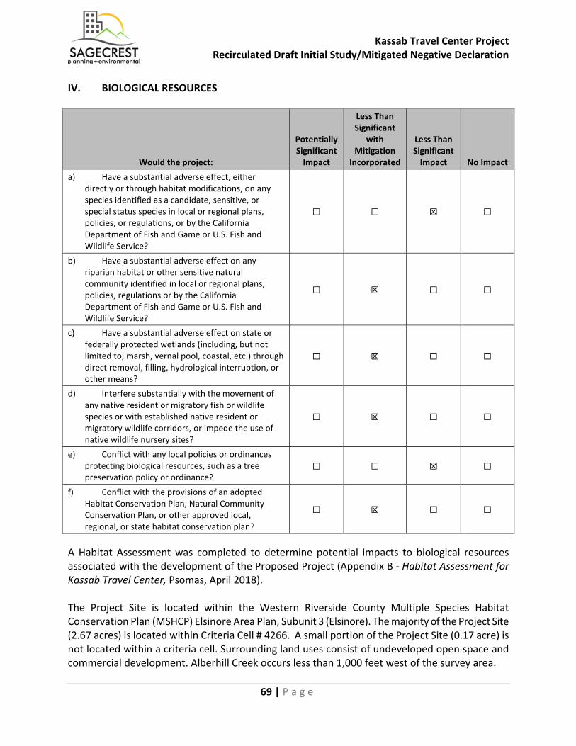
Kassab Travel Center Project Recirculated Draft Initial Study/Mitigated Negative Declaration
69 | P a g e
IV. BIOLOGICAL RESOURCES
Would the project:
Potentially Significant
Impact
Less Than Significant
with Mitigation
Incorporated
Less Than Significant
Impact No Impact a) Have a substantial adverse effect, either
directly or through habitat modifications, on any species identified as a candidate, sensitive, or special status species in local or regional plans, policies, or regulations, or by the California Department of Fish and Game or U.S. Fish and Wildlife Service?
☐ ☐ ☒ ☐
b) Have a substantial adverse effect on any riparian habitat or other sensitive natural community identified in local or regional plans, policies, regulations or by the California Department of Fish and Game or U.S. Fish and Wildlife Service?
☐ ☒ ☐ ☐
c) Have a substantial adverse effect on state or federally protected wetlands (including, but not limited to, marsh, vernal pool, coastal, etc.) through direct removal, filling, hydrological interruption, or other means?
☐ ☒ ☐ ☐
d) Interfere substantially with the movement of any native resident or migratory fish or wildlife species or with established native resident or migratory wildlife corridors, or impede the use of native wildlife nursery sites?
☐ ☒ ☐ ☐
e) Conflict with any local policies or ordinances protecting biological resources, such as a tree preservation policy or ordinance?
☐ ☐ ☒ ☐
f) Conflict with the provisions of an adopted Habitat Conservation Plan, Natural Community Conservation Plan, or other approved local, regional, or state habitat conservation plan?
☐ ☒ ☐ ☐
A Habitat Assessment was completed to determine potential impacts to biological resources associated with the development of the Proposed Project (Appendix B - Habitat Assessment for Kassab Travel Center, Psomas, April 2018). The Project Site is located within the Western Riverside County Multiple Species Habitat Conservation Plan (MSHCP) Elsinore Area Plan, Subunit 3 (Elsinore). The majority of the Project Site (2.67 acres) is located within Criteria Cell # 4266. A small portion of the Project Site (0.17 acre) is not located within a criteria cell. Surrounding land uses consist of undeveloped open space and commercial development. Alberhill Creek occurs less than 1,000 feet west of the survey area.
Kassab Travel Center Project Recirculated Draft Initial Study/Mitigated Negative Declaration
70 | P a g e
Cell # 4266 contributes to the assembly of Proposed Linkage 2 and encompasses meadow, marsh, riparian scrub, woodland, and forest habitat along Alberhill Creek and adjacent grassland. Conserved areas would connect to meadow, marsh, and grassland proposed for conservation in Cell # 4169 to the north. Conservation in the cell ranges from 30 to 40 percent of the cell, focusing on the western portion of the cell. Areas designated as Public/Quasi-Public Lands are located approximately 0.5 mile to the southwest of the survey area. Pursuant to the provisions of the MSHCP, all discretionary development projects within a Criteria Area are to be reviewed for compliance with the “Property Owner Initiated Habitat Evaluation and Acquisition Negotiation Strategy” (LEAP) process or equivalent process. The LEAP process “ensures that an early determination will be made of what properties are needed for the MSHCP Conservation Area, that the owners of property needed for the MSHCP Conservation Area are compensated, and that owners of land not needed for the MSHCP Conservation Area shall receive Take Authorization of Covered Species Adequately Conserved through the Permits issues to the County and Cities pursuant to the MSHCP.” A portion of the Project Site is located within Criteria Cell # 4266. A formal and complete LEAP application, LEAP 2018-01 was submitted to the City on January 23, 2018 and a Joint Project Review (JPR) 18-03-29-01 was completed on May 15, 2018 with the Regional Conservation Agency (RCA) and concurrence from the California Department of Fish and Wildlife and the U.S. Fish and Wildlife Service (collectively, the Wildlife Agencies) on May 21, 2018. The following vegetation type and other areas occur in the survey area: ruderal, bare ground, and developed. Ruderal (weedy) vegetation occurs throughout much of the survey area. The dominant species are grayish shortpod mustard (Hirschfeldia incana) and London rocket (Sisymbrium irio). Other common herbaceous species include fiddleneck (Amsinckia sp.), Russian thistle (Salsola tragus), and annual bur-sage (Ambrosia acanthicarpa). Evidence of ground-disturbance (e.g., mowing, tilling) during a prior season was noted during the survey; vegetation had not been disturbed this season. Ornamental China berry (Melia azedarach) trees occur in the center of the survey area along with a few small Mexican palo verde (Parkinsonia aculeata). Ruderal vegetation follows the non-native grassland subassociation of the Grasslands vegetation association of the MSHCP habitat accounts (Dudek 2003). Unvegetated areas consist of bare ground and developed. The portion of the survey area adjacent to Riverside Drive is bare, while a paved sidewalk is adjacent to Collier Avenue. These areas correspond to the Residential/Urban/Exotic vegetation association of the MSHCP habitat accounts (Dudek 2003).
a) Have a substantial adverse effect, either directly or through habitat modifications, on any species identified as a candidate, sensitive, or special status species in local or regional plans, policies, or regulations, or by the California Department of Fish and Game or U.S. Fish and Wildlife Service?
Less Than Significant Impact: The Habitat Assessment investigated the likelihood of impact to special status plant and wildlife species in the vicinity of the Project Site. Special status resources include plant and wildlife species and vegetation types. These species have generally been afforded this recognition by federal and State resource agencies and by private conservation organizations (e.g., the CNPS). In general, the principal reason an individual taxon (e.g., species, subspecies, or
Kassab Travel Center Project Recirculated Draft Initial Study/Mitigated Negative Declaration
71 | P a g e
variety) is given such recognition is a documented or perceived decline or limitation of its population size, geographic range, and/or distribution that results, in most cases, from habitat loss. The Riverside County Board of Supervisors approved the MSHCP in 2003 and received permitting approval from the U.S. Fish and Wildlife Service (USFWS) in June 2004. This plan establishes Criteria Areas (i.e., reserves) to adequately conserve many species listed as Threatened and Endangered by the USFWS and the CDFW. Impacts on Covered Species would be considered fully mitigated with the City’s participation in the MSHCP program. Except for a few species (e.g., least Bell’s vireo, which is a Riparian/Riverine species), focused surveys are not required for Covered Species and no additional permitting would be necessary. According to the RCIP Summary Report Generator, focused plant surveys are not required for Criteria Area or Narrow Endemic plant species. Based on the literature review, nine species not covered by the MSHCP have been reported in the vicinity of the survey area: chaparral sand-verbena (Abronia villosa var. aurita), sticky dudleya (Dudleya viscida), Tecate cypress (Hesperocyparis forbesii), mesa horkelia (Horkelia cuneata var. puberula), Robinson’s peppergrass (Lepidium virginicum var. robinsonii), intermediate monardella (Monardella hypoleuca ssp. intermedia), white rabbit-tobacco (Pseudognaphalium leucocephalum), San Bernardino aster (Symphyotrichum defoliatum), and California screw moss (Tortula californica). Given the ruderal nature of the survey area and apparent periodic ground disturbance, these species are not expected to occur in the survey area. Therefore, no impacts associated with these species would occur. Smooth tarplant (Centromadia pungens ssp. laevis), a species with a California Rare Plant Rank of 1B.1, has potential to occur in the survey area because suitable habitat and soils for the species are present. In addition, it was reported to occur in a disturbed lot less than 1,000 feet away. Smooth tarplant is a Criteria Area species covered by the MSHCP. Because the survey area is located outside an “Additional Survey Needs Area” for smooth tarplant (Exhibit 4), any impacts on the species, if present, would be considered mitigated with the City’s participation in the MSHCP. According to the RCIP Summary Report Generator, focused surveys are not required for burrowing owl or other Additional Survey Needs species. Impacts to all other special status wildlife species with potential to occur in the survey area that would typically require mitigation in California Environmental Quality Act (CEQA) documentation are covered by the City’s participation in the MSHCP. Therefore, potential impacts associated with special status wildlife species would be less than significant. Stephens’ Kangaroo Rat In response to the federal listing of Stephens’ kangaroo rat (Dipodomys stephensi), the Riverside County Habitat Conservation Agency (RCHCA) was formed. Its purpose is to acquire and manage habitat for the Stephens’ kangaroo rat and other associated special status species. The RCHCA Stephens’ Kangaroo Rat Habitat Conservation Plan (HCP) was developed to meet the requirements of the program’s Federal Endangered Species Act Section 10(a) permit. The HCP for this species is managed by the RCHCA. The HCP establishes a Reserve System where activities in the core reserve areas are limited and/or restricted. Areas outside the Reserve System are within a designated Fee Area. The survey area is located within a designated Fee Area. For projects within a Fee Area,
Kassab Travel Center Project Recirculated Draft Initial Study/Mitigated Negative Declaration
72 | P a g e
focused surveys for the Stephens’ kangaroo rat are not required, and all potential impacts are mitigated through the RCHCA. Therefore, potential impacts associated with Stephens’ kangaroo rat would be less than significant. Mitigation Measures: No mitigation measures are required. Sources: Habitat Assessment (Appendix B)
b) Have a substantial adverse effect on any riparian habitat or other sensitive natural community identified in local or regional plans, policies, regulations or by the California Department of Fish and Game or U.S. Fish and Wildlife Service?
Less Than Significant Impact With Mitigation Incorporated: As defined by Section 6.1.2 of the MSHCP, Riparian/Riverine areas are lands that contain habitat dominated by trees, shrubs, persistent emergents, or emergent mosses and lichens, which occur close to or depend upon soil moisture from a nearby fresh water source or areas with fresh water flow during all or a portion of the year (Dudek 2003). No rivers, streams, or other watercourses (or vegetation associated with these features) were observed in the survey area. The closest riparian vegetation is located in a flood-control channel less than 200 feet southwest of the survey area; denser, more mature riparian habitat occurs in Alberhill Creek, approximately 600 feet west of the survey area. Since the Proposed Project would not directly impact Riparian/Riverine areas, a Determination of Biologically Equivalent or Superior Preservation (DBESP) is not required. The Proposed Project would not directly impact riparian bird species (least Bell’s vireo, southwestern wouldow flycatcher, and western yellow-billed cuckoo) by removing their habitat. However, construction noise and human activity may indirectly impact riparian bird species if they occur in the flood-control channel’s adjacent riparian habitat, approximately 200 feet southwest of the Project Site. These activities are not expected to impact species in Alberhill Creek, since it is more than 500 feet from project activities. Indirect impacts on riparian bird species could be avoided or minimized if construction activities, or at least the most noise-intensive portions of construction, can be limited to the season when these migratory birds are not present in California (i.e., September 16 to March 14). While indirect impacts should be avoided, if possible, there is no requirement to limit construction timing adjacent to riparian habitat. The MSHCP requires additional surveys for certain species for projects in certain locations. Pursuant to MSHCP Figure 6-2 (Criteria Area Species Survey Area), Figure 6-3 (Amphibian Species Survey Areas with Criteria Area), Figure 6-4 (Burrowing Owl Survey Areas with Criteria Area), Figure 6-5 (Mammal Species Survey Areas With Criteria Area), burrowing owl surveys and surveys for Criteria Area species are required for the subject property prior to approval of a development proposal. Therefore, for MSHCP consistency, additional focused rare plant surveys for these species are required. The property is not within a Criteria Area Species Survey Area (CASSA), and CASSA surveys are not required. It is also not within survey areas for amphibian species (MSHCP Figure 6-
Kassab Travel Center Project Recirculated Draft Initial Study/Mitigated Negative Declaration
73 | P a g e
3) burrowing owls (Figure 6-4) or mammal species (MSHCP Figure 6-5) and surveys for those species are not required. However, as a mitigation measure for the Proposed Project (MM BIO-3), the City of Lake Elsinore will require a pre-construction presence/absence survey for burrowing owl to be conducted within 30 days of the commencement of project-related grading or other land disturbance activities to ensure that the species has not moved onto the site since completion of the surveys. MM BIO-1 includes measures from the MSHCP “Guidelines Pertaining to Urban/Wildlands Interface” (Section 6.1.4) to ensure that the Proposed Project would be consistent with the MSHCP and ensure protection of adjacent riparian/riverine habitats to not be indirectly impacted by long-term changes in water quality, increased noise, or increased night lighting. MM BIO-2 includes measures from the MSHCP “Construction Guidelines” (Section 7.5.3) to minimize indirect impacts to adjacent riparian or riverine resources by requiring Best Management Practices to protect water quality. With implementation of the recommendations in the Habitat Assessment, consistent with the MSHCP and LEMC, MM BIO-1, MM BIO-2 and MM BIO-3, the Proposed Project would not have a substantial adverse effect on any riparian habitat or other sensitive natural community identified in local or regional plans, policies, regulations or by the California Department of Fish and Game or U.S. Fish and Wildlife Service and potential impacts would be less than significant. Mitigation Measures: MM BIO-1: Prior to the issuance of a grading permit, the Property Owner/Developer shall include a note on the plans that outlines the following requirements from Section 6.1.4 of the MHSCP: Drainage: 1. Prepare and follow a Storm Water Pollution Prevention Plan (SWPPP) as required by the
National Pollutant Discharge Elimination System (NPDES) General Construction Permit requirements.
2. Implement the measures in the Project Specific Water Quality Management Plan (Appendix I): a. Drainage flows will be captured by the proposed ribbon gutters toward the proposed BMPs. b. Washwater containing any cleaning agent or degreaser and discharge will be collected to
the sanitary sewer and not to a storm drain. c. Storm drain inlets will be marked “only rain down the storm drain”. Stormwater pollution
prevention information will be provided to new site owners, lessees, or operators. A Lease agreement will include the following: “tenant shall not allow anyone to discharge anything to storm drains or store or deposit materials so as to create a potential discharge to storm drains”.
Toxics: Follow Guidelines in Lake Elsinore Municipal Code Section 17.112.090 pertaining to gasoline dispensing establishments including a minimum 30-foot setback of gasoline pumps and pump islands from any property line. Measures identified above to protect water quality will minimize the effects of runoff of toxics into adjacent habitat areas.
Kassab Travel Center Project Recirculated Draft Initial Study/Mitigated Negative Declaration
74 | P a g e
Lighting: Comply with Lake Elsinore Municipal Code Section 17.112.040 Lighting (for Nonresidential Development) that all outdoor lighting fixtures in excess of 60 watts are oriented and shielded to prevent glare or direct illumination on adjacent properties. All exterior lighting shall be shielded away from the MSHCP Conservation Area to protect species within the MSHCP Conservation Area from direct night lighting. Shielding shall be incorporated in project designs to ensure ambient lighting in the MSHCP Conservation Area is not increased. Noise: Consistent with MM NOI-2, the Property Owner/Developer would construct a minimum 8-foot high masonry wall on the northwest and southwest property lines of the Project Site. With implementation of MM NOI-2, the combined noise levels at the adjacent commercial uses would be 58 dBA at the northwest property line and would be 51 dBA at the southwest property line, which are within both the City’s daytime and nighttime noise standards for commercial land uses and below the 60dBA threshold recommended by the Wildlife Agencies. Invasives: 1. Review the Landscaping Plan by a qualified Biologist to ensure that invasive species are not
included in the plant palette. If possible, the Landscape Plan should use low water-using plants to be consistent with Assembly Bill 1881.
2. Require contractors to wash construction vehicles prior to delivery to the Project Site in order to minimize weed seeds entering the construction area via vehicles. The construction contractor shall track-clean or use other methods of vehicle cleaning to prevent weed seeds from entering/exiting the Project Site on vehicles.
3. Use wattles for erosion control that are certified as weed-free. Barriers: Use landscaping and/or fencing to discourage public access and illegal dumping in adjacent habitat areas. Vegetation Removal: Remove vegetation outside the peak nesting season for raptors (February 1 to June 30) and the peak nesting season for birds (March 1 to June 30). If vegetation removal would occur between February 1 and June 30, the Property Owner/Developer shall have a pre-construction survey for active raptor/bird nests completed by a qualified Biologist, who may place restrictions on construction activities in the vicinity of any active nest until the nest is no longer active.

Kassab Travel Center Project Recirculated Draft Initial Study/Mitigated Negative Declaration
75 | P a g e
MM BIO-2: Prior to the issuance of a grading permit, the Property Owner/Developer shall include a note on the plans that outlines the following requirements from Section 7.5.3 of the MSHCP: Construction Minimization Measures: 1. Plans for water pollution and erosion control will be prepared for all Discretionary Projects
involving the movement of earth in excess of 50 cubic yards. The plans will describe sediment and hazardous materials control, dewatering or diversion structures, fueling and equipment management practices, use of plant material for erosion control. Plans will be reviewed and approved by the County of Riverside and participating jurisdiction prior to construction.
2. Timing of construction activities will consider seasonal requirements for breeding birds and migratory non-resident species. Habitat clearing will be avoided during species active breeding season defined as March 1 to June 30.
3. Sediment and erosion control measures will be implemented until such time soils are determined to be successfully stabilized.
4. Short-term stream diversions will be accomplished by use of sand bags or other methods that will result in minimal in-stream impacts. Short-term diversions will consider effects on wildlife.
5. Silt fencing or other sediment trapping materials will be installed at the downstream end of construction activities to minimize the transport of sediments off-site.
6. Settling ponds where sediment is collected will be cleaned in a manner that prevents sediment from re-entering the stream or damaging/disturbing adjacent areas. Sediment from settling ponds will be removed to a location where sediment cannot re-enter the stream or surrounding drainage area. Care will be exercised during removal of silt fencing to minimize release of debris or sediment into streams.
7. No erodible materials will be deposited into water courses. Brush, loose soils, or other debris material will not be stockpiled within stream channels or on adjacent banks.
8. The footprint of disturbance will be minimized to the maximum extent feasible. Access to sites will occur on pre-existing access routes to the greatest extent possible.
9. Equipment storage, fueling and staging areas will be sited on non-sensitive upland habitat types with minimal risk of direct discharge into riparian areas or other sensitive habitat types.
10. The limits of disturbance, including the upstream, downstream and lateral extents, will be clearly defined and marked in the field. Monitoring personnel will review the limits of disturbance prior to initiation of construction activities.
11. During construction, the placement of equipment within the stream or on adjacent banks or adjacent upland habitats occupied by Covered Species that are outside of the project footprint will be avoided.
12. Exotic species removed during construction will be properly handled to prevent sprouting or regrowth.
13. Training of construction personnel will be provided. 14. Ongoing monitoring and reporting will occur for the duration of the construction activity to
ensure implementation of best management practices. 15. When work is conducted during the fire season (as identified by the Riverside County Fire
Department) adjacent to coastal sage scrub or chaparral vegetation, appropriate fire-fighting equipment (e.g., extinguishers, shovels, water tankers) shall be available on the site during all phases of project construction to help minimize the chance of human-caused wildfires.
Kassab Travel Center Project Recirculated Draft Initial Study/Mitigated Negative Declaration
76 | P a g e
16. Shields, protective mats, and/or other fire preventative methods shall be used during grinding, welding, and other spark-inducing activities. Personnel trained in fire hazards, preventative actions, and responses to fires shall advise contractors regarding fire risk from all construction-related activities.
17. Active construction areas shall be watered regularly to control dust and minimize impacts to adjacent vegetation.
18. All equipment maintenance, staging, and dispensing of fuel, oil, coolant, or any other toxic substances shall occur only in designated areas within the proposed grading limits of the Project Site. These designated areas shall be clearly marked and located in such a manner as to contain run-off.
19. Waste, dirt, rubble, or trash shall not be deposited in the Conservation Area or on native habitat.
MM BIO-3: Burrowing Owl Surveys. Prior to the issuance of a grading permit, the Property Owner/Developer shall conduct focused burrowing owl surveys and a pre-construction burrowing owl survey within the Project Site and 150-meter Survey Area surrounding the Project Site. The focused surveys should occur during the breeding season between March 1 and August 31 but may be conducted any time of year. Four separate focused surveys must occur during favorable weather conditions on the Project Site and Survey Area during early morning hours (from one hour before sunrise until two hours after sunrise) or late afternoon hours (from two hours before sunset to one hour after sunset) and may occur on consecutive days. After completion of the surveys, a final report shall be submitted to the City of Lake Elsinore Planning Division and the RCA Monitoring Program Administrator, which discusses survey methods, transect widths, duration, weather conditions and results of the survey. The report will discuss any additional required mitigation for MSHCP consistency. Following the focused surveys, an initial pre-construction survey must occur within 30 days of initiating construction activities, according to the Western Riverside County Regional Conservation Authority (RCA) Burrowing Owl Survey Instructions for the Plan Area (2006). After completion of the surveys, a final report shall be submitted to the City of Lake Elsinore Planning Division and the RCA Monitoring Program Administrator, which discusses survey methods, transect widths, duration, weather conditions and results of the survey. The report will discuss any additional required mitigation for MSHCP consistency. A final pre-construction survey shall also occur within 24 hours of initial vegetation clearing or grading activities, followed by a memo report of the results. Sources: Habitat Assessment (Appendix B)

Kassab Travel Center Project Recirculated Draft Initial Study/Mitigated Negative Declaration
77 | P a g e
c) Have a substantial adverse effect on state or federally protected wetlands (including, but not limited to, marsh, vernal pool, coastal, etc.) through direct removal, filling, hydrological interruption, or other means?
Less Than Significant Impact With Mitigation Incorporated: Riparian/Riverine Resources As defined by Section 6.1.2 of the MSHCP, Riparian/Riverine areas are lands that contain habitat dominated by trees, shrubs, persistent emergents, or emergent mosses and lichens, which occur close to or depend upon soil moisture from a nearby fresh water source or areas with fresh water flow during all or a portion of the year (Dudek 2003). No rivers, streams, or other watercourses (or vegetation associated with these features) were observed in the survey area. The closest riparian vegetation is located in a flood-control channel less than 200 feet southwest of the survey area; denser, more mature riparian habitat associated with Collier Marsh (and included as part of Proposed Linkage 2) occurs in Alberhill Creek, approximately 600 feet west of the survey area. The Proposed Project would not directly impact this linkage, wetland habitat associated with Collier Marsh, or habitat of key plant and wildlife populations associated with this proposed linkage (i.e., San Diego ambrosia, least Bell’s vireo, yellow warbler, yellow-breasted chat, downy woodpecker, and southwestern willow flycatcher). Since the Proposed Project would not directly impact Riparian/Riverine areas, a Determination of Biologically Equivalent or Superior Preservation (DBESP) is not required. While the Proposed Project would not directly impact riparian bird species (least Bell’s vireo, southwestern willow flycatcher, and western yellow-billed cuckoo) by removing their habitat, construction noise and human activity may indirectly impact riparian bird species if they occur in the flood-control channel’s adjacent riparian habitat, approximately 200 feet southwest of the Project Site. These activities are not expected to impact species in Alberhill Creek, since it is more than 500 feet from Proposed Project activities. Indirect impacts on riparian bird species could be avoided or minimized if construction activities, or at least the most noise-intensive portions of construction, can be limited to the season when these migratory birds are not present in California (i.e., September 16 to March 14). While indirect impacts should be avoided, if possible, there is no requirement to limit construction timing adjacent to riparian habitat. MM BIO-1 includes measures from the MSHCP “Guidelines Pertaining to Urban/Wildlands Interface” (Section 6.1.4) to ensure that the Proposed Project would be consistent with the MSHCP and ensure protection of adjacent riparian/riverine habitats to not be indirectly impacted by long-term changes in water quality, increased noise, or increased night lighting. MM BIO-2 includes measures from the MSHCP “Construction Guidelines” (Section 7.5.3) to minimize indirect impacts to adjacent riparian or riverine resources by requiring Best Management Practices to protect water quality. “Waters of the U.S.”/“Waters of the State” Section 404 of the Federal Clean Water Act (CWA) and Section 1602 of the California Fish and Game Code regulate activities affecting resources under the jurisdiction of the USACE and the CDFW, respectively. “Waters of the U.S.”, under the jurisdiction of the USACE include navigable coastal and inland waters, lakes, rivers, streams, and their tributaries; interstate waters and their
Kassab Travel Center Project Recirculated Draft Initial Study/Mitigated Negative Declaration
78 | P a g e
tributaries; wetlands adjacent to such waters; intermittent streams; and other waters that could affect interstate commerce. The CDFW has jurisdictional authority over resources associated with rivers, streams, and lakes. Section 401 of the CWA provides the Regional Water Quality Control Board (RWQCB) with the authority to regulate, through a Water Quality Certification, any proposed federally permitted activity that may affect water quality. The RWQCB also has jurisdiction over isolated wetlands and waters under the Porter-Cologne Water Quality Control Act. No drainages, waterbodies, or other water resources under the regulatory authority of the USACE, the CDFW, or the RWQCB were observed in the survey area. Riparian habitat is adjacent to the west. Therefore, there would be no impacts on jurisdictional resources and no permits, agreements, or certifications would be required from these agencies. Vernal Pools As defined by Section 6.1.2 the MSHCP, vernal pools are seasonal wetlands that occur in sunken areas that have wetland soils, vegetation, and hydrology during the wetter portion of the growing season, but lack hydrology and/or vegetation during the drier portion of the year (Dudek 2003). No basins, ponds, or obvious depressional features were observed during the survey. However, a small area exhibiting surface soil cracks was present in the southwest portion of the survey area. Surface soil cracks, where clay sediment is deposited by infiltration and evaporation of water, are an indicator of hydrology and possible ponding. If the area holds surface water, it may provide habitat for vernal pool branchiopods (i.e., fairy shrimp). One fairy shrimp, Riverside fairy shrimp (Streptocephalus woottonii), was reported from the literature review in the vicinity of the Proposed Project (CDFW 2017a). Given that the survey was conducted during the dry season, it was not possible to directly determine whether this area holds water for any length of time. However, it is unlikely that the area ponds. A review of aerial Google Earth1 imagery shows no indication of surface water or soil saturation over multiple years and seasons. In addition, the soil type mapped in the survey area is not considered hydric (USDA NRCS 2017). This area would not be considered a “vernal pool” because indicator plant species (e.g., woolly-marbles [Psilocarphus brevissimus], toad rush [Juncus bufonius], or water crassula [Crassula aquatica]) are not likely to be present; plant species observed in the immediate area consist of horseweed (Erigeron canadensis), stinknet (Oncosiphon piluliferum), annual bur-sage, and grayish shortpod mustard, which are considered upland or facultative upland species. For these reasons, fairy shrimp are not expected to occur in the survey area. MM BIO-1 includes measures from the MSHCP “Guidelines Pertaining to Urban/Wildlands Interface” (Section 6.1.4) to ensure that the Proposed Project would be consistent with the MSHCP and ensure protection of adjacent riparian/riverine habitats to not be indirectly impacted by long-term changes in water quality, increased noise, or increased night lighting. MM BIO-2 includes measures from the MSHCP “Construction Guidelines” (Section 7.5.3) to minimize indirect impacts to adjacent riparian or riverine resources by requiring Best Management Practices to protect water quality. With implementation of the recommendations in the Habitat Assessment, consistent with
Kassab Travel Center Project Recirculated Draft Initial Study/Mitigated Negative Declaration
79 | P a g e
the MSHCP and LEMC, MM BIO-1 and MM BIO-2, potential impacts associated with federally protected wetlands would be less than significant. Mitigation Measures: MM BIO-1 and MM BIO-2, as defined in Section IV.b, above. Sources: Habitat Assessment (Appendix B)
d) Interfere substantially with the movement of any native resident or migratory fish or wildlife species or with established native resident or migratory wildlife corridors, or impede the use of native wildlife nursery sites?
Less Than Significant Impact With Mitigation Incorporated: Indirect impacts, often called “edge effects”, are those that affect the quality of nearby wildlife habitat resulting from disturbance by construction (such as noise, dust, and urban pollutants) and/or the long-term use of the site. MSHCP Criteria Area Cell 4266, which overlaps the survey area, could be impacted by these edge effects. The Proposed Project partially overlaps MSHCP Criteria Cell 4266 (2.67 acres within the Cell, 0.17 acre outside the Cell). Lands within Cell 4266 would provide for Proposed Linkage 2, which occurs approximately 600 feet west of the Project Site. Although the Proposed Project would not directly impact Proposed Linkage 2, it could generate edge effects. During construction, runoff carrying excessive silt or petroleum residues from construction equipment could potentially impact water quality and, in turn, affect plant and wildlife species using habitat adjacent to the Project Site. Grading and other construction activities would disturb soils and result in the accumulation of dust on the surface of the leaves of trees, shrubs, and herbs. Temporary construction noise has the potential to disrupt foraging, nesting, roosting, and/or denning activities for a variety of wildlife species. Following construction, urban runoff from project infrastructure or landscaping could permanently impact water quality during operation of the Proposed Project. Landscaping associated with the Proposed Project may introduce new, invasive species to the surrounding open space. An increase in the number of nighttime light and glare sources could affect the behavioral pattern of nocturnal and crepuscular (i.e., active at dawn and dusk) wildlife. The Property Owner/Developer would be required to follow the Urban/Wildlands Interface Guidelines in Section 6.1.4 of the MSHCP to minimize urban/wildlands interface issues in the nearby Criteria Area. These include measures related to indirect impacts such as water quality (drainage), use of toxics, night lighting, indirect noise, invasive plant and wildlife species, protection of habitat areas (barriers), and grading/land development adjacent to habitat areas and are included as MM BIO-2.
Kassab Travel Center Project Recirculated Draft Initial Study/Mitigated Negative Declaration
80 | P a g e
Trees in the survey area and immediate vicinity have potential to be used for nesting by raptors such as the American kestrel (Falco sparverius). Regulations prohibit activities that “take, possess or destroy” any raptor nest or egg (California Fish and Game Code §§3503, 3503.5, and 3513). The noise and disturbance associated with construction may disturb a nesting raptor if present immediately adjacent to the project impact area. If construction would be initiated during the raptor nesting season (generally between February 1 and June 30), a pre-construction survey would be required to ensure that no raptor nests are impacted. If an active nest is present, construction may be temporarily restricted in the immediate vicinity of the nest until raptor nesting is complete. The survey area has potential to be used by nesting birds, which are protected by the Migratory Bird Treaty Act (MBTA). Birds have potential to nest in any of the survey area’s vegetation, bare ground, and also on adjacent structures. The MBTA prohibits activities that result in the direct take (defined as the killing or possession) of a migratory bird. If construction would be initiated during the peak bird nesting season (March 1 to June 30, as defined by Section 7.5.3 of the MSHCP), a pre-construction survey would be required per MM BIO-4 to ensure that no nests are impacted. If an active nest is present, construction may be restricted in the immediate vicinity of the nest. MM BIO-1 includes measures from the MSHCP “Guidelines Pertaining to Urban/Wildlands Interface” (Section 6.1.4) to ensure that the Proposed Project would be consistent with the MSHCP and ensure protection of adjacent riparian/riverine habitats to not be indirectly impacted by long-term changes in water quality, increased noise, or increased night lighting. MM BIO-2 includes measures from the MSHCP “Construction Guidelines” (Section 7.5.3) to minimize indirect impacts to adjacent riparian or riverine resources by requiring Best Management Practices to protect water quality. With implementation of the recommendations in the Habitat Assessment, consistent with the MSHCP and LEMC, MM BIO-1 and MM BIO-2, potential impacts associated with the movement of any native resident or migratory fish or wildlife species would be less than significant. Mitigation Measures: MM BIO-1, MM BIO-2, as defined in Section IV.b, above. MM BIO-4: Nesting Bird Pre-Construction Surveys. In order to avoid violation of the federal Migratory Bird Treaty Act (MBTA) and California Fish and Wildlife Code, site-preparation activities (removal of trees and vegetation) shall be avoided to the greatest extent possible during the nesting season (generally March 1 to August 15). If site-preparation activities are to occur during the nesting season, a pre-construction nesting survey shall be conducted within 30 days prior to the commencement of construction (if between March 1 and August 15). A qualified biologist shall perform the nesting survey that will consist of a single visit to ascertain whether there are active raptor nests within 500 feet of the project footprint or other protected bird nests within 300 feet of the project footprint. Nests will be searched for in the trees and shrubs. This survey shall identify the species of nesting bird and to the degree feasible, nesting stage (e.g., incubation of eggs, feeding of young, near fledging). Nests shall be mapped (not by using GPS because close encroachment may cause nest abandonment). The follow-up nesting survey shall be conducted for five (5) consecutive days and no more than three (3) days prior to clearing. If an active nest is observed, the nest location shall be fenced off
Kassab Travel Center Project Recirculated Draft Initial Study/Mitigated Negative Declaration
81 | P a g e
surrounding an adequate radius buffer zone as determined by biological monitor. The buffer zone shall not be disturbed until the nest is inactive. Biological monitoring shall occur during vegetation removal activities. Sources: Habitat Assessment (Appendix B), MSHCP, LEMC
e) Conflict with any local policies or ordinances protecting biological resources, such as a tree preservation policy or ordinance?
Less Than Significant Impact: The Proposed Project would be consistent with local policies and ordinances related to biological resources. The City’s Municipal Code includes a City Tree Preservation Ordinance (Ord. 1256) that protects the City’s streetscape and trees. There are approximately 10 trees growing on the Project Site. These trees would be removed as part of this Project. The Proposed Project would comply with Ord. 1256 to ensure the preservation of trees and the local streetscape. Ord. 1256 requires that a City business license be obtained prior to pruning, treating, or removing street or park trees within the City. Additionally, no species other than those included in the City’s official street tree species list would be planted without written permission of the City Tree Committee. Tree spacing, distance from curbs and sidewalks, and other aesthetic guidelines shall be followed in accordance with Ord. 1256. The City of Lake Elsinore has also determined that certain species of palm trees in the family Palmaceae are locally significant resources through the City Significant Palm Tree Ordinance (Ord. 1160). However, no palms occur on the Project Site. In addition, the MSHCP requires that Project Sites be evaluated for several factors to assess how they meet MSHCP criteria. This information is used to determine whether a Project Site should be acquired as part of the habitat reserve or whether it should be allowed for development. The biological resources evaluation also assists the Lead Agency in determining whether additional mitigation would be required for Criteria Area or Additional Survey Needs Species. According to the Riverside County Integrated Project (RCIP) Conservation Summary Report Generator, the Proposed Project is in designated MSHCP “Criteria Area” Cell 4266. The general habitat assessment for the Proposed Project includes assessments for riparian/riverine areas (and associated species) and vernal pools (and associated species) pursuant to MSHCP Section 6.1.2; urban/wildlands interface issues pursuant to MSHCP Section 6.1.4; and areas under the jurisdictions of the U.S. Army Corps of Engineers (USACE) and/or the California Department of Fish and Wildlife (CDFW) as discussed in MSHCP Section 6.1.2. This report has been prepared in accordance with the MSHCP guidelines. Therefore, potential impacts associated with conflict with local policies or ordinances would be less than significant. Mitigation Measures: No mitigation measures are required. Sources: Habitat Assessment (Appendix B), MSHCP, LEMC
Kassab Travel Center Project Recirculated Draft Initial Study/Mitigated Negative Declaration
82 | P a g e
f) Conflict with the provisions of an adopted Habitat Conservation Plan, Natural Community Conservation Plan, or other approved local, regional, or state habitat conservation plan?
Less Than Significant Impact With Mitigation Incorporated: The Western Riverside County Multiple Species Habitat Conservation Plan (MSHCP) requires that Project Sites be evaluated for a number of factors to assess how they meet MSHCP criteria. This information is used to determine whether a Project Site should be acquired as part of the habitat reserve or whether it should be allowed for development. The biological resources evaluation also assists the Lead Agency in determining whether additional mitigation would be required for Criteria Area or Additional Survey Needs Species. According to the Riverside County Integrated Project (RCIP) Conservation Summary Report Generator, the Proposed Project is in designated MSHCP “Criteria Area” Cell 4266. The general habitat assessment for the Proposed Project includes assessments for riparian/riverine areas (and associated species) and vernal pools (and associated species) pursuant to MSHCP Section 6.1.2; urban/wildlands interface issues pursuant to MSHCP Section 6.1.4; and areas under the jurisdictions of the U.S. Army Corps of Engineers (USACE) and/or the California Department of Fish and Wildlife (CDFW) as discussed in MSHCP Section 6.1.2. The Riverside County Board of Supervisors approved the MSHCP in 2003 and received permitting approval from the U.S. Fish and Wildlife Service (USFWS) in June 2004. This plan establishes Criteria Areas (i.e., reserves) to adequately conserve many species listed as Threatened and Endangered by the USFWS and the CDFW. Impacts on Covered Species would be considered fully mitigated with the City’s participation in the MSHCP program. Except for a few species (e.g., least Bell’s vireo, which is a Riparian/Riverine species), focused surveys are not required for Covered Species and no additional permitting would be necessary. The Proposed Project would not directly impact Proposed Linkage 2, wetland habitat associated with Collier Marsh, or habitat of key plant and wildlife populations associated with this proposed linkage (i.e., San Diego ambrosia, least Bell’s vireo, yellow warbler, yellow-breasted chat, downy woodpecker, and southwestern willow flycatcher). Indirect impacts would be avoided/minimized by implementing the Urban/Wildlands Interface Guidelines in Section 6.1.4 of the MSHCP. The Proposed Project would not conflict with the conservation goals of Cell 4266. Conservation in the cell ranges from 30 to 40 percent of the cell, focusing on the western portion of the cell. The Proposed Project would impact 2.67 acres of the Criteria Cell along the its eastern boundary, which represents approximately 1.7 percent of the 158-acre cell (0.17 acre of the survey area is not located within a Criteria Cell). Biological Issues and Considerations for Subunit 3 (Elsinore):
• Wetlands including Temescal Wash, Collier Marsh, Alberhill Creek, Lake Elsinore and the floodplain east of Lake Elsinore (including marsh Habitats) would not be impacted by the Proposed Project. Implementation of the Urban/Wildlands Interface Guidelines in Section 6.1.4 of the MSHCP will maintain water quality of nearby wetlands (Collier Marsh and Alberhill Creek).
Kassab Travel Center Project Recirculated Draft Initial Study/Mitigated Negative Declaration
83 | P a g e
• Clay soils supporting Munz’s onion are not present in the survey area. • Travers-Willow-Domino soil series are not present in the survey area. • Potential foraging habitat for raptors would be impacted, but the Proposed Project would
not impact sage scrub-grassland ecotone habitat. The loss of 2.84 acres of raptor foraging habitat is not expected to substantially decrease the amount of raptor foraging habitat in the region.
• Habitat for mountain plover in the survey area is considered marginally suitable and there are no recent occurrences known from the vicinity (most are east of Perris).
• Northern harrier is not expected to breed in the survey area. • Given the surrounding urban development, the survey area does not provide a linkage area
for bobcat, although bobcat is expected to use Proposed Linkage 2 located 600 feet west of the survey area.
• The survey area is not in an area requiring focused surveys for San Diego ambrosia per Section 6.1.3 of the MSHCP. The population at Alberhill and Nichols Road would not be impacted by the Proposed Project.
• Core and Linkage habitat for western pond turtle is not present in the survey area. • A Core Area for Riverside fairy shrimp is not present in the survey area. • Core and Linkage habitat for Quino checkerspot butterfly is not present in the survey area.
MM BIO-1 includes measures from the MSHCP “Guidelines Pertaining to Urban/Wildlands Interface” (Section 6.1.4) to ensure that the Proposed Project would be consistent with the MSHCP and ensure protection of adjacent riparian/riverine habitats to not be indirectly impacted by long-term changes in water quality, increased noise, or increased night lighting. MM BIO-2 includes measures from the MSHCP “Construction Guidelines” (Section 7.5.3) to minimize indirect impacts to adjacent riparian or riverine resources by requiring Best Management Practices to protect water quality. MM BIO-3 requires a pre-construction presence/absence survey for burrowing owl to be conducted within 30 days of the commencement of project-related grading or other land disturbance activities to ensure that the species has not moved onto the site since completion of the surveys. MM BIO-4 requires a pre-construction nesting bird survey, if construction is initiated during the peak bird nesting season (March 1 to June 30, as defined by Section 7.5.3 of the MSHCP) to ensure that no nests are impacted. With implementation of the recommendations in the Habitat Assessment, consistent with the MSHCP and LEMC, MM BIO-1, MM BIO-2, MM BIO-3, and MM BIO-4, the Proposed Project would not conflict with the provisions of an adopted Habitat Conservation Plan, Natural Community Conservation Plan, or other approved habitat conservation plan and potential impacts would be less than significant. Mitigation Measures: MM BIO-1, MM BIO-2, MM BIO-3, and MM BIO-4 Sources: Habitat Assessment (Appendix B), MSHCP, LEMC
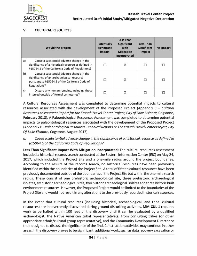
Kassab Travel Center Project Recirculated Draft Initial Study/Mitigated Negative Declaration
84 | P a g e
V. CULTURAL RESOURCES
Would the project: Potentially Significant
Impact
Less Than Significant
with Mitigation
Incorporated
Less Than Significant
Impact No Impact
a) Cause a substantial adverse change in the significance of a historical resource as defined in §15064.5 of the California Code of Regulations?
☐ ☒ ☐ ☐
b) Cause a substantial adverse change in the significance of an archaeological resource pursuant to §15064.5 of the California Code of Regulations?
☐ ☒ ☐ ☐
c) Disturb any human remains, including those interred outside of formal cemeteries? ☐ ☒ ☐ ☐
A Cultural Resources Assessment was completed to determine potential impacts to cultural resources associated with the development of the Proposed Project (Appendix C – Cultural Resources Assessment Report for the Kassab Travel Center Project, City of Lake Elsinore, Cogstone, February 2018). A Paleontological Resources Assessment was completed to determine potential impacts to paleontological resources associated with the development of the Proposed Project (Appendix D - Paleontological Resources Technical Report For The Kassab Travel Center Project, City Of Lake Elsinore, Cogstone, August 2017).
a) Cause a substantial adverse change in the significance of a historical resource as defined in §15064.5 of the California Code of Regulations?
Less Than Significant Impact With Mitigation Incorporated: The cultural resources assessment included a historical records search conducted at the Eastern Information Center (EIC) on May 24, 2017, which included the Project Site and a one-mile radius around the project boundaries. According to the results of the records search, no historical resources have been previously identified within the boundaries of the Project Site. A total of fifteen cultural resources have been previously documented outside of the boundaries of the Project Site but within the one-mile search radius. These consist of one prehistoric archaeological site, three prehistoric archaeological isolates, six historic archaeological sites, two historic archaeological isolates and three historic built environment resources. However, the Proposed Project would be limited to the boundaries of the Project Site and would not result in any alterations to the previously recorded historical resources. In the event that cultural resources (including historical, archaeological, and tribal cultural resources) are inadvertently discovered during ground-disturbing activities, MM-CUL-1 requires work to be halted within 100 feet of the discovery until it can be evaluated by a qualified archaeologist, the Native American tribal representative(s) from consulting tribes (or other appropriate ethnic/cultural group representative), and the Community Development Director or their designee to discuss the significance of the find. Construction activities may continue in other areas. If the discovery proves to be significant, additional work, such as data recovery excavation or
Kassab Travel Center Project Recirculated Draft Initial Study/Mitigated Negative Declaration
85 | P a g e
resource recovery, may be warranted and would be discussed in consultation with the appropriate regulatory agency and/or tribal group. With implementation of MM-CUL-1, potential impacts to historical resources would be less than significant. Mitigation Measures: MM-CUL-1: Unanticipated Resources. The Developer/Permit Holder or any successor in interest shall comply with the following for the life of this permit. If during ground disturbance activities, unanticipated cultural resources are discovered, the following procedures shall be followed:
1. All ground disturbance activities within 100 feet of the discovered cultural resource shall be halted until a meeting is convened between the developer, the Project Archaeologist, the Native American tribal representative(s) from consulting tribes (or other appropriate ethnic/cultural group representative), and the Community Development Director or their designee to discuss the significance of the find.
2. The developer shall call the Community Development Director or their designee immediately upon discovery of the cultural resource to convene the meeting.
3. At the meeting with the aforementioned parties, the significance of the discoveries shall be discussed and a decision is to be made, with the concurrence of the Community Development Director or their designee, as to the appropriate mitigation (documentation, recovery, avoidance, etc.) for the cultural resource.
4. Further ground disturbance shall not resume within the area of the discovery until a meeting has been convened with the aforementioned parties and a decision is made, with the concurrence of the Community Development Director or their designee, as to the appropriate mitigation measures.
Sources: Cultural Resources Assessment (Appendix C), City of Lake Elsinore
b) Cause a substantial adverse change in the significance of an archaeological resource pursuant to §15064.5 of the California Code of Regulations?
Less Than Significant With Mitigation Incorporated: Cogstone performed a records search at the Eastern Information Center (EIC) on May 24, 2017, which included the Project Site and a one-mile radius around the project boundaries. According to the results of the records search, no cultural resources have been previously identified within the boundaries of the Project Site. A total of fifteen cultural resources have been previously documented outside of the boundaries of the Project Site but within the one-mile search radius. These consist of one prehistoric archaeological site, three prehistoric archaeological isolates, six historic archaeological sites, two historic archaeological isolates and three historic built environment resources. However, the Proposed Project would be limited to the boundaries of the Project Site and would not result in any alterations to the previously recorded cultural resources. The cultural resources assessment also included a pedestrian field survey of the Project Site conducted on May 24, 2017. The field survey did not identify any cultural resources within or immediately adjacent to the Project Site.
Kassab Travel Center Project Recirculated Draft Initial Study/Mitigated Negative Declaration
86 | P a g e
The results of the cultural resources assessment concluded that there are no known cultural resources identified or recorded within the boundaries of the Project Site. However, there still remains the possibility that undiscovered buried archaeological resources might be encountered during construction. Cogstone requested a Sacred Lands File (SLF) records search from the Native American Heritage Commission (NAHC) on June 6, 2017. The NAHC responded on June 7, 2017 indicating that no known resources were within the project area. Cogstone prepared consultation invitation letters to the Native American Tribes on the City’s AB52 consultation list that were mailed on December 20, 2017. The City received a response from three tribes, and a summary of the consultation is provided in Section XVII, Tribal Cultural Resources. In the event that cultural resources (including historical, archaeological, and tribal cultural resources) are inadvertently discovered during ground-disturbing activities, MM-CUL-1 has been included to require work to be halted within 100 feet of the discovery until it can be evaluated by a qualified archaeologist, the Native American tribal representative(s) from consulting tribes (or other appropriate ethnic/cultural group representative), and the Community Development Director or their designee to discuss the significance of the find. Construction activities may continue in other areas. If the discovery proves to be significant, additional work, such as data recovery excavation or resource recovery, may be warranted and would be discussed in consultation with the appropriate regulatory agency and/or tribal group. In addition, MM CUL-2 requires implementation of a Cultural Resource Monitoring Program to address details of all activities that must be completed and procedures to be followed regarding cultural resources. MM CUL-3 requires the Property Owner/Developer to enter into Tribal Monitoring Agreement(s) with Native American Tribe(s) that have requested monitoring through the AB 52 consultation with the City. MM CUL-4 requires that a Phase IV Cultural Resources Monitoring Report be prepared and submitted to the City after ground disturbing activities have been concluded. With implementation of MM CUL-1, MM CUL-2, MM CUL-3, and MM CUL-4, potential impacts associated with archeological resources would be less than significant. Mitigation Measures: MM-CUL-1, as defined in Section V.a. above.
Kassab Travel Center Project Recirculated Draft Initial Study/Mitigated Negative Declaration
87 | P a g e
MM CUL-2: Archaeologist/CRMP. Prior to issuance of grading permits, the Property Owner/Developer shall provide evidence to the Community Development Department that a Secretary of Interior Standards qualified and certified Registered Professional Archaeologist (RPA) has been contracted to implement a Cultural Resource Monitoring Program (CRMP) that addresses the details of all activities that must be completed and procedures that must be followed regarding cultural resources associated with this project. The CRMP document shall be provided to the Community Development Director or their designee for review and approval prior to issuance of the grading permit. The CRMP provides procedures to be followed and are to ensure that impacts on cultural resources will not occur without procedures that would reduce the impacts to less than significant. These measures shall include, but shall not be limited to, the following: Archaeological Monitor - An adequate number of qualified monitors shall be present to ensure that all earth-moving activities are observed and shall be on-site during all grading activities for areas to be monitored including off-site improvements. Inspections will vary based on the rate of excavation, the materials excavated, and the presence and abundance of artifacts and features. The frequency and location of inspections will be determined by the Project Archaeologist, in consultation with the Tribal monitor. Cultural Sensitivity Training - The Project Archaeologist and a representative designated by the consulting Tribe(s) shall attend the pre-grading meeting with the contractors to provide Cultural Sensitivity Training for all Construction Personnel. Training will include a brief review of the cultural sensitivity of the Project and the surrounding area; what resources could potentially be identified during earthmoving activities; the requirements of the monitoring program; the protocols that apply in the event unanticipated cultural resources are identified, including who to contact and appropriate avoidance measures until the find(s) can be properly evaluated; and any other appropriate protocols. This is a mandatory training and all construction personnel must attend prior to beginning work on the Project Site. A sign-in sheet for attendees of this training shall be included in the Phase IV Monitoring Report. Unanticipated Resources - If previously unidentified potentially significant cultural resources are discovered, the Archaeological and/or Tribal Monitor(s) shall have the authority to divert or temporarily halt ground disturbance operations in the area of discovery to allow evaluation of potentially significant cultural resources. The Project Archaeologist, in consultation with the Tribal monitor(s) shall determine the significance of the discovered resources. The Community Development Director or their designee must concur with the evaluation before construction activities will be allowed to resume in the affected area. Before construction activities are allowed to resume in the affected area, the artifacts shall be recovered and features recorded using professional archaeological methods. The Project Archaeologist shall determine the amount of material to be recovered for an adequate artifact sample for analysis. Isolates and clearly non-significant deposits shall be minimally documented in the field and the monitored grading can proceed.
Kassab Travel Center Project Recirculated Draft Initial Study/Mitigated Negative Declaration
88 | P a g e
Cultural Resources Disposition - If Native American cultural resources are discovered during the course of grading (inadvertent discoveries), the following procedures shall be carried out for final disposition of the discoveries: One or more of the following treatments, in order of preference, shall be employed with the tribes. Evidence of such shall be provided to the Community Development Department:
1. Preservation-In-Place of the cultural resources, if feasible. Preservation in place means avoiding the resources, leaving them in the place where they were found with no development affecting the integrity of the resources. 2. Relocation of the resources on the Project property. The measures for relocation shall include, at least, the following: Measures and provisions to protect the future reburial area from any future impacts in perpetuity. Relocation shall not occur until all legally required cataloging and basic recordation have been completed, with an exception that sacred items, burial goods and Native American human remains are excluded. Any reburial process shall be culturally appropriate. Listing of contents and location of the reburial shall be included in the confidential Phase IV report. The Phase IV Report shall be filed with the City under a confidential cover and not subject to Public Records Request. 3. If relocation is not agreed upon by the Consulting Tribes then the resources shall be curated at a culturally appropriate manner at a Riverside County curation facility that meets State Resources Department Office of Historic Preservation Guidelines for the Curation of Archaeological Resources ensuring access and use pursuant to the Guidelines. The collection and associated records shall be transferred, including title, and are to be accompanied by payment of the fees necessary for permanent curation. Evidence of curation in the form of a letter from the curation facility stating that subject archaeological materials have been received and that all fees have been paid, shall be provided by the landowner to the City. There shall be no destructive or invasive testing on sacred items, burial goods and Native American human remains. Results concerning finds of any inadvertent discoveries shall be included in the Phase IV monitoring report.
Phase IV Report - A final archaeological report shall be prepared by the Project archaeologist and submitted to the Community Development Director or their designee prior to the issuance of a final grading permit. The report shall follow County of Riverside requirements and shall include at a minimum: a discussion of the monitoring methods and techniques used; the results of the monitoring program including any artifacts recovered; an inventory of any resources recovered; updated DPR forms for all sites affected by the development; final disposition of the resources including GPS data; artifact catalog and any additional recommendations. A final copy shall be submitted to the City, Project Applicant, the Eastern Information Center (EIC), and the Tribe. MM CUL-3: Tribal Monitoring. Prior to the issuance of a grading permit, the Property Owner/Developer shall contact the consulting Native American Tribe(s) that have requested monitoring through consultation with the City during the AB 52 and/or the SB 18 process (“Monitoring Tribes”). The Property Owner/Developer shall coordinate with the Tribe(s) to develop individual Tribal Monitoring Agreement(s). A copy of the signed agreement(s) shall be provided to the City of Lake Elsinore Planning Department prior to the issuance of a grading permit. The
Kassab Travel Center Project Recirculated Draft Initial Study/Mitigated Negative Declaration
89 | P a g e
Agreement shall address the treatment of any known tribal cultural resources (TCRs) including the Proposed Project’s approved mitigation measures and conditions of approval; the designation, responsibilities, and participation of professional Tribal Monitors during grading, excavation and ground disturbing activities; project grading and development scheduling; terms of compensation for the monitors; and treatment and final disposition of any cultural resources, sacred sites, and human remains/burial goods discovered on the site per the Tribe(s) customs and traditions and the City’s mitigation measures/conditions of approval. The Tribal Monitor will have the authority to stop and redirect grading in the immediate area of a find in order to evaluate the find and determine the appropriate next steps, in consultation with the Project archaeologist. MM CUL-4: Phase IV Report. Upon completion of the implementation phase, a Phase IV Cultural Resources Monitoring Report shall be submitted that complies with the Riverside County Planning Department's requirements for such reports for all ground disturbing activities associated with this grading permit. The report shall follow the County of Riverside Planning Department Cultural Resources (Archaeological) Investigations Standard Scopes of Work posted on the County website. The report shall include results of any feature relocation or residue analysis required as well as evidence of the required cultural sensitivity training for the construction staff held during the required pre-grade meeting. Sources: Cultural Resources Assessment (Appendix C), City of Lake Elsinore
c) Disturb any human remains, including those interred outside of formal cemeteries?
Less Than Significant Impact With Mitigation Incorporated: In the unexpected event human remains are found, those remains would require proper treatment, in accordance with applicable laws. Procedures of conduct following the discovery of human remains on non-federal lands have been mandated by California Health and Safety Code (CHSC) §7050.5, PRC §5097.98 and the California Code of Regulations (CCR) §15064.5(e). According to the provisions in CEQA, should human remains be encountered, all work in the immediate vicinity of the burial must cease, and any necessary steps to insure the integrity of the immediate area must be taken. The County Coroner would be immediately notified. The Coroner must then determine whether the remains are Native American. If the Coroner determines the remains are Native American, the Coroner has 24 hours to notify the Native American Heritage Commission (NAHC), who would, in turn, notify the person they identify as the most likely descendent (MLD) of any human remains. Further actions would be determined, in part, by the desires of the MLD. The MLD has 48 hours from being allowed access to the Project Site to make recommendations regarding the disposition of the remains following notification from the NAHC of the discovery. If the MLD does not make recommendations within 48 hours, the owner shall, with appropriate dignity, reinter the remains in an area of the property secure from further disturbance. Alternatively, if the owner does not accept the MLD’s recommendations, the owner or the descendent may request mediation by the NAHC. MM CUL-5 outlines the actions to be taken in the event of unexpected discovery of human remains. With compliance with existing regulations and procedures outlined in the CHSC and the CCR, and implementation on MM CUL-5, potential impacts associated with disturbance of human remains would be less than significant.
Kassab Travel Center Project Recirculated Draft Initial Study/Mitigated Negative Declaration
90 | P a g e
Mitigation Measures: MM CUL-5: Discovery of Human Remains. If human remains (or remains that may be human) are discovered at the Project Site during grading or earthmoving, the construction contractors, project archaeologist and/or designated Native American Monitor shall immediately stop all acclivities within 100 feet of the find. The Property Owner/Developer shall then inform the Riverside County Coroner and the City of Lake Elsinore Community Development Department immediately, and the coroner shall be permitted to examine the remains as required by California Health and Safety Code Section 7050.5(b). Section 7050.5 requires that excavation be stopped in the vicinity of discovered human remains until the coroner has made the necessary findings as to origin. If human remains are determined to be Native American, the Property Owner/Developer shall comply with the state law relating to the disposition of Native American burials that fall within the jurisdiction of the NAHC (PRC Section 5097). The coroner shall contact the NAHC within 24 hours and the NAHC would make the determination of most likely descendant(s). The MLD shall complete his or her inspection and make recommendation or preference for treatment within 48 hours of being granted access to the site. Treatment and disposition of the remains shall be determined in consultation with the most likely descendant(s) to determine the most appropriate disposition of human remains and any associated grave artifacts. In the event that the Property Owner/Developer and the MLD are in disagreement regarding the disposition of the remains. State law would apply and the mediation process would occur with the NAHC, if requested (see PRC Section 5097.98(e) and 5097.94(k)). The specific location of Native American burials and reburials are confidential and may not be disclosed to the general public. The locations would be documented by the consulting archaeologist in conjunction with the various stakeholders and a report of findings would be filed with the Eastern Information Center. A Sacred Lands File form would be submitted to the NAHC by the project archaeologist and the Monitoring Tribe(s). According to the California Health and Safety Code, six or more human burial at one location constitutes a cemetery (Section 81 00), and disturbance of Native American cemeteries is a felony (Section 7052). Sources: Cultural Resources Assessment (Appendix C), City of Lake Elsinore
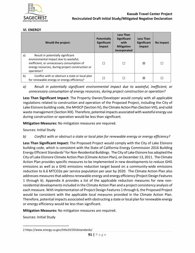
Kassab Travel Center Project Recirculated Draft Initial Study/Mitigated Negative Declaration
91 | P a g e
VI. ENERGY
Would the project: Potentially Significant
Impact
Less Than Significant
with Mitigation
Incorporated
Less Than Significant
Impact No Impact
a) Result in potentially significant environmental impact due to wasteful, inefficient, or unnecessary consumption of energy resources, during project construction or operation?
☐ ☐ ☒ ☐
b) Conflict with or obstruct a state or local plan for renewable energy or energy efficiency? ☐ ☐ ☒ ☐
a) Result in potentially significant environmental impact due to wasteful, inefficient, or unnecessary consumption of energy resources, during project construction or operation?
Less Than Significant Impact: The Property Owner/Developer would comply with all applicable regulations related to construction and operation of the Proposed Project, including the City of Lake Elsinore building code, the MHSCP (Section IV), the Climate Action Plan (Section VIII), and solid waste management (Section XIX). Therefore, potential impacts associated with wasteful energy use during construction or operation would be less than significant.
Mitigation Measures: No mitigation measures are required.
Sources: Initial Study
b) Conflict with or obstruct a state or local plan for renewable energy or energy efficiency?
Less Than Significant Impact: The Proposed Project would comply with the City of Lake Elsinore building code, which is consistent with the State of California Energy Commission 2016 Building Energy Efficient Standards2 for Non-Residential Buildings. The City of Lake Elsinore has adopted the City of Lake Elsinore Climate Action Plan (Climate Action Plan), on December 13, 2011. The Climate Action Plan provides specific measures to be implemented in new developments to reduce GHG emissions as well as a GHG emissions reduction target based on a community-wide emissions reduction to 6.6 MTCO2e per service population per year by 2020. The Climate Action Plan also addresses measures that address renewable energy and energy efficiency (Project Design Features 1 through 6). Appendix A provides a list of the applicable reduction measures for new non-residential developments included in the Climate Action Plan and a project consistency analysis of each measure. With implementation of Project Design Features 1 through 6, the Proposed Project would be consistent with the applicable local measures provided in the Climate Action Plan. Therefore, potential impacts associated with obstructing a state or local plan for renewable energy or energy efficiency would be less than significant.
Mitigation Measures: No mitigation measures are required.
Sources: Initial Study
2 https://www.energy.ca.gov/title24/2016standards/
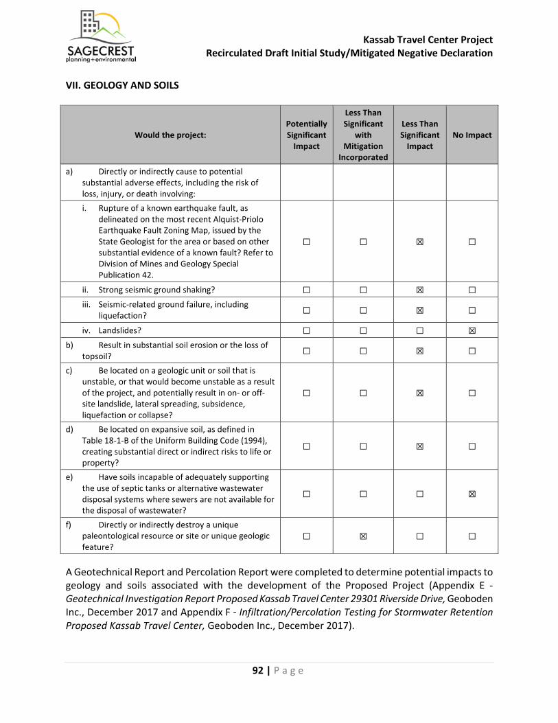
Kassab Travel Center Project Recirculated Draft Initial Study/Mitigated Negative Declaration
92 | P a g e
VII. GEOLOGY AND SOILS
Would the project: Potentially Significant
Impact
Less Than Significant
with Mitigation
Incorporated
Less Than Significant
Impact No Impact
a) Directly or indirectly cause to potential substantial adverse effects, including the risk of loss, injury, or death involving:
i. Rupture of a known earthquake fault, as delineated on the most recent Alquist-Priolo Earthquake Fault Zoning Map, issued by the State Geologist for the area or based on other substantial evidence of a known fault? Refer to Division of Mines and Geology Special Publication 42.
☐ ☐ ☒ ☐
ii. Strong seismic ground shaking? ☐ ☐ ☒ ☐ iii. Seismic-related ground failure, including
liquefaction? ☐ ☐ ☒ ☐
iv. Landslides? ☐ ☐ ☐ ☒ b) Result in substantial soil erosion or the loss of
topsoil? ☐ ☐ ☒ ☐
c) Be located on a geologic unit or soil that is unstable, or that would become unstable as a result of the project, and potentially result in on- or off-site landslide, lateral spreading, subsidence, liquefaction or collapse?
☐ ☐ ☒ ☐
d) Be located on expansive soil, as defined in Table 18-1-B of the Uniform Building Code (1994), creating substantial direct or indirect risks to life or property?
☐ ☐ ☒ ☐
e) Have soils incapable of adequately supporting the use of septic tanks or alternative wastewater disposal systems where sewers are not available for the disposal of wastewater?
☐ ☐ ☐ ☒
f) Directly or indirectly destroy a unique paleontological resource or site or unique geologic feature?
☐ ☒ ☐ ☐
A Geotechnical Report and Percolation Report were completed to determine potential impacts to geology and soils associated with the development of the Proposed Project (Appendix E - Geotechnical Investigation Report Proposed Kassab Travel Center 29301 Riverside Drive, Geoboden Inc., December 2017 and Appendix F - Infiltration/Percolation Testing for Stormwater Retention Proposed Kassab Travel Center, Geoboden Inc., December 2017).
Kassab Travel Center Project Recirculated Draft Initial Study/Mitigated Negative Declaration
93 | P a g e
a) Directly or indirectly cause potential substantial adverse effects, including the risk of loss, injury, or death involving:
i) Rupture of a known earthquake fault, as delineated on the most recent Alquist-Priolo Earthquake Fault Zoning Map, issued by the State Geologist for the area or based on other substantial evidence of a known fault? Refer to Division of Mines and Geology Special Publication 42.
Less Than Significant Impact: According to the findings of the geotechnical investigation, the Project Site does not lie within nor is adjacent to an earthquake fault zone as defined by the State of California in the Alquist-Priolo Earthquake Fault Zoning Act. Although the Project Site is not within an Earthquake Fault Zone, it is located in a seismically active area of Southern California. The type and magnitude of seismic hazards that may affect the Project Site are dependent on both the distance to causative faults and the intensity and duration of the seismic event. The Elsinore (Glen Ivy) rev fault is the closest known active fault, located 1.91-km of the site with an anticipated maximum moment magnitude (Mw) of 7.7. Although the probability of primary surface rupture is considered low, ground shaking hazards caused by earthquakes along regional active faults do exist and are accounted for in the design and construction of the proposed structures. Structures proposed for the Project Site would be constructed to the standards prescribed by the California Building Code (CBC), which would reduce risks associated with seismic activity. Therefore, potential impacts associated with people or structures from a surface rupture would be less than significant. Mitigation Measures: No mitigation measures are required. Sources: Geotechnical Investigation (Appendix E)
ii) Strong seismic ground shaking?
Less Than Significant Impact: The site is situated in a seismically active area that has historically been affected by generally moderate to occasionally high levels of ground motion. The site lies in relative close proximity to several seismically active faults; therefore, during the life of the proposed improvements, the City and surroundings also have the potential to experience significant ground shaking as a result of seismic activity on a number of the Peninsular Ranges’ other active faults as shown in Section 3.11 Geology & Soils of the Lake Elsinore General Plan EIR. The Proposed Project would be designed and constructed in accordance with seismic design requirements of the current California Building Code (CBC), which would address potential impacts related to potential ground shaking. Therefore, potential impacts associated with strong seismic ground shaking would be less than significant. Mitigation Measures: No mitigation measures are required. Sources: General Plan EIR, Geotechnical Investigation (Appendix E)
Kassab Travel Center Project Recirculated Draft Initial Study/Mitigated Negative Declaration
94 | P a g e
iii) Seismic-related ground failure, including liquefaction?
Less Than Significant Impact: The geotechnical investigation for the Proposed Project evaluated the potential for seismic-related ground failure, including liquefaction, at the Project Site. Liquefaction is the loss of soil strength or stiffness due to increasing pore-water pressure during severe ground shaking. Liquefaction is associated primarily with loose (low density), saturated, fine- to medium-grained, cohesion-less soils. For liquefaction to occur, all of three key ingredients are required: liquefaction-susceptible soils, groundwater within a depth of 50 feet or less, and strong earthquake shaking. Soils susceptible to liquefaction are generally saturated loose to medium dense sands and non-plastic silt deposits below the water table. Based on the results of the geotechnical investigation, the Project Site has low potential for liquefaction as groundwater was encountered at 15 feet below ground surface (bgs), historic high groundwater at the site is as deep as 50 feet, and soil materials are clayey soil. Prior to the issuance of a grading permit, the Property Owner/Developer of the Proposed Project would be required to submit grading and foundation plans to the City for review to demonstrate compliance with the City’s grading requirements as well as any applicable recommendations contained in the geotechnical report. The Proposed Project would be designed and constructed in accordance with CBC requirements which would reduce risks associated with liquefaction. Therefore, potential impacts to people or structures from liquefaction shaking would be less than significant. Mitigation Measures: No mitigation measures are required. Sources: Geotechnical Investigation (Appendix E)
iv) Landslides?
No Impact: Landslides result from the downward movement of earth or rock materials that have been influenced by gravity. In general, landslides occur due to various factors including steep slope conditions, erosion, rainfall, groundwater, adverse geologic structure, and grading impacts. The Project Site is generally flat and is surrounded by similar topography and no significant slopes are proposed as part of the project design. The California Department of Conservation GIS map does not show any landslide overlay on the Project Site. The Project Site is in the Business District of the General Plan and its slope is less than 15%. Potential landslide impacts would be concentrated in districts with steep slopes of more than 30% and in Hillside Residential land use designations, including the Northwest Sphere, Lake View Sphere, Lakeland Village, Alberhill, North Central Sphere, Meadowbrook, Lake Elsinore Hills, and Riverview Districts of the General Plan. Therefore, no impacts associated with landslides would occur. Mitigation Measures: No mitigation measures are required. Sources: General Plan EIR, Riverside County GIS, Geotechnical Investigation (Appendix E)
Kassab Travel Center Project Recirculated Draft Initial Study/Mitigated Negative Declaration
95 | P a g e
b) Result in substantial soil erosion or the loss of topsoil?
Less Than Significant Impact: The Project Site is currently vacant and unimproved. Construction activity associated with development may result in wind driven soil erosion and loss of topsoil due to grading activities. However, all construction and grading activities would comply with City’s grading ordinance (LEMC 15.04) using BMPs, including the use of fiber rolls, street sweeping, sandbag barriers, straw bale barriers, and storm drain inlet protection. The Proposed Project would implement BMPs to control project runoff and protect water quality, which would limit operational impacts as a result of the Proposed Project. Upon project completion, the Project Site would be developed with a gas station and convenience store, fast food restaurant, paved surfaces, and landscaping, which would prevent substantial erosion from occurring. Therefore, potential impacts associated with soil erosion would be less than significant. Mitigation Measures: No mitigation measures are required. Sources: LEMC, PWQMP (Appendix I)
c) Be located on a geologic unit or soil that is unstable, or that would become unstable as a result of the project, and potentially result in on- or off-site landslide, lateral spreading, subsidence, liquefaction or collapse?
Less Than Significant Impact: Seismically-induced lateral spreading involves primarily lateral movement of earth materials due to ground shaking. For lateral spreading to occur, the liquefiable zone must be continuous, unconstrained laterally, and free to move along gently sloping ground toward an unconfined area. Lateral spreading results in near-vertical cracks with predominantly horizontal movement of the soil mass involved. A gentle slope in the ground face or the presence of a slope face nearby can cause the ground to slide or spread on layers of liquefied soil. The Project Site is generally flat and there is no slope. The Project Site is not located in an area of landslide potential. The geotechnical investigation recommends over excavation of the Project Site during grading to replace the top four to five feet of surface soils with engineered fill compacted to at least 85 percent. The Proposed Project would be constructed in compliance with the recommendations in the geotechnical investigation and the CBC. Therefore, potential impacts associated with unstable soil would be less than significant. Mitigation Measures: No mitigation measures are required. Sources: Geotechnical Investigation (Appendix E)
Kassab Travel Center Project Recirculated Draft Initial Study/Mitigated Negative Declaration
96 | P a g e
d) Be located on expansive soil, as defined in Table 18-1-B of the Uniform Building Code (1994), creating substantial direct or indirect risks to life or property?
Less Than Significant Impact: Based on the geotechnical investigation, the near-surface soils within the Project Site are generally anticipated to possess a Low expansion potential. The Proposed Project would be constructed to the recommendations in the geotechnical study and to the standards prescribed by the CBC, as amended by the City. Therefore, potential impacts associated with expansive soils would be less than significant.
Mitigation Measures: No mitigation measures are required.
Sources: Geotechnical Investigation (Appendix E)
e) Have soils incapable of adequately supporting the use of septic tanks or alternative wastewater disposal systems where sewers are not available for the disposal of wastewater?
No Impact: The Project Site would be served by a public sewer system. The Proposed Project would not include the use of septic tanks or alternative wastewater disposal systems. Therefore, no impacts associated with septic tanks or alternative wastewater disposal systems would occur.
Mitigation Measures: No mitigation measures are required.
Sources: Project Description
f) Directly or indirectly destroy a unique paleontological resource or site or unique geologic feature?
Less Than Significant with Mitigation Incorporated: Cogstone performed a paleontological record search and pedestrian reconnaissance survey as part of the Paleontological Resources Technical Report (Appendix D), which found no records of fossils in the project area, nor fossils on the Project Site. The proposed maximum depth of cuts is six to seven feet below the current ground surface. Only Holocene to late Pleistocene axial channel deposits may be impacted by the Proposed Project construction activities. No late Pleistocene fossils were identified within five miles of the Project Site in sediments comparable to those within the study area. Based on other finds from California valley areas, late Pleistocene fossils typically begin appearing between 8 to 10 feet deep. On this basis, it is considered unlikely that fossils meeting significance criteria would be encountered on the Project Site. However, there is a possibility that undiscovered buried paleontological resources might be encountered during construction of the Proposed Project. The Proposed Project would implement MM-GEO-1, which requires that in the event paleontological resources are inadvertently discovered during ground-disturbing activities, work within 50 feet of the discovery shall be halted until a qualified paleontologist can evaluate it. Construction activities may continue in other areas. If the discovery proves to be significant, additional work, such as data recovery excavation or resource recovery, may be warranted and would be discussed in consultation with the City and appropriate regulatory agency. With implementation of MM GEO-1, potential impacts associated with paleontological resources would be less than significant.
Kassab Travel Center Project Recirculated Draft Initial Study/Mitigated Negative Declaration
97 | P a g e
Mitigation Measures: MM GEO-1: Paleontological Monitoring. If fossil remains are encountered during site development:
1. All site earthmoving shall be ceased within 50 feet of where the fossil remains are encountered. Earthmoving activities may be diverted to other areas of the site.
2. The owner of the property shall be immediately notified of the fossil discovery who will in turn immediately notify the City of the discovery.
3. The Property Owner/Developer shall retain a qualified paleontologist. 4. The paleontologist shall determine the significance of the encountered fossil remains. 5. Paleontological monitoring of earthmoving activities will continue thereafter on an as-
needed basis by the paleontologist during all earthmoving activities that may expose sensitive strata. Earthmoving activities in areas of the project area where previously undisturbed strata would be buried but not otherwise disturbed will not be monitored. The supervising paleontologist will have the authority to reduce monitoring once he/she determines the probability of encountering any additional fossils has dropped below an acceptable level.
6. If fossil remains are encountered by earthmoving activities when the paleontologist is not onsite, these activities would be diverted around the fossil site and the paleontologist called to the site immediately to recover the remains.
7. Any recovered fossil remains would be prepared to the point of identification and identified to the lowest taxonomic level possible by knowledgeable paleontologists. The remains then would be curated (assigned and labeled with museum* repository fossil specimen numbers and corresponding fossil site numbers, as appropriate; places in specimen trays and, if necessary, vials with completed specimen data cards) and catalogued, an associated specimen data and corresponding geologic and geographic site data would be archived (specimen and site numbers and corresponding data entered into appropriate museum repository catalogs and computerized data bases) at the museum repository by a laboratory technician. The remains will then be accessioned into the museum* repository fossil collection, where they would be permanently stored, maintained, and, along with associated specimen and site data, made available for future study by qualified scientific investigators.
* The City must be consulted on the repository/museum to receive the fossil material prior to being curated. Sources: Cultural Resources Assessment (Appendix C), Paleontological Resources Technical Report (Appendix D), City of Lake Elsinore

Kassab Travel Center Project Recirculated Draft Initial Study/Mitigated Negative Declaration
98 | P a g e
VIII. GREENHOUSE GAS EMISSIONS
Would the project: Potentially Significant
Impact
Less Than Significant
with Mitigation
Incorporated
Less Than Significant
Impact No Impact
a) Generate greenhouse gas emissions, either directly or indirectly, that may have a significant impact on the environment?
☐ ☐ ☒ ☐
b) Conflict with an applicable plan, policy or regulation adopted for the purpose of reducing the emissions of greenhouse gases?
☐ ☐ ☒ ☐
A Greenhouse Gas Emissions Impact Analysis was completed to determine potential impacts to greenhouse gas emissions associated with the development of the Proposed Project (Appendix A - Air Quality and Greenhouse Gas Emissions Impact Analysis Kassab Travel Center Project City of Lake Elsinore, Vista Environmental, revised September 26, 2018 and March 2019). The results of the analysis are based on CalEEMod version 2016.3.2.
a) Generate greenhouse gas emissions, either directly or indirectly, that may have a significant impact on the environment?
Less Than Significant Impact: The Proposed Project would not generate GHG emissions, either directly or indirectly, that may have a significant impact on the environment. The Proposed Project would consist of the development of an 18-pump gas station and associated convenience store, a fast-food restaurant with a drive-thru window, and a parking lot. The City of Lake Elsinore has adopted the City of Lake Elsinore Climate Action Plan (CAP), on December 13, 2011, which states:
Specifically, the CAP is designed to serve as the programmatic tiering document for the purposes of CEQA within the City of Lake Elsinore for GHG emissions, by which applicable projects will be reviewed. If a proposed development project can demonstrate it is consistent with the applicable emissions reduction measures included in the CAP, the programs and standards that would be implemented as a result of the CAP, and the General Plan Update growth projections, the project’s environmental review pertaining to GHG impacts may be streamlined as allowed by CEQA Guidelines Sections 15152 and 15183.5.
In order to show consistency with the CAP, quantification of the Proposed Project’s GHG emissions are not required. However, the Proposed Project’s GHG emissions have been provided for informational purposes only. The GHG emissions from the Proposed Project were analyzed for year 2020 conditions. Table 7- Proposed Project Greenhouse Gas Annual Emissions shows that for the year 2020, the Proposed Project would create 2,219.09 MTCO2e per year, which is within the SCAQMD’s draft threshold of significance for all land use types of 3,000 MTCO2e per year. It should be noted that the Year 2020 emissions are based on approved statewide GHG reduction measures and the required GHG reduction measures provided in the City’s Climate Action Plan. Therefore, potential impacts associated with greenhouse gas emissions would be less than significant.

Kassab Travel Center Project Recirculated Draft Initial Study/Mitigated Negative Declaration
99 | P a g e
Table 7 - Proposed Project Greenhouse Gas Annual Emissions
Category Greenhouse Gas Emissions (Metric Tons per Year)
CO2 CH4 N2O CO2e Area Sources1 0.00 0.00 0.00 0.00 Energy Usage2 132.50 0.00 0.00 133.11 Mobile Sources3 2,057.31 0.23 0.00 2,062.96 Solid Waste4 3.95 0.23 0.00 9.80 Water and Wastewater5 4.46 0.03 0.00 5.36 Construction6 8.93 0.00 0.00 8.97 Vegetation7 -1.11 Total GHG Emissions 2,207.15 0.49 0.00 2,219.09
SCAQMD Draft Threshold of Significance for All Land Uses 3,000 Notes: 1 Area sources consist of GHG emissions from consumer products, architectural coatings, and landscaping equipment. 2 Energy usage consists of GHG emissions from electricity and natural gas usage. 3 Mobile sources consist of GHG emissions from vehicles. 4 Waste includes the CO2 and CH4 emissions created from the solid waste placed in landfills. 5 Water includes GHG emissions from electricity used for transport of water and processing of wastewater. 6 Construction emissions amortized over 30 years as recommended in the SCAQMD GHG Working Group on November 19, 2009. 7 Vegetation sequestration amortized over 30 years. 8 Mitigation Measures: No mitigation measures are required.
Sources: AQ/GHG Impact Analysis (Appendix A)
b) Conflict with an applicable plan, policy or regulation adopted for the purpose of reducing the emissions of greenhouse gases?
Less Than Significant Impact: The Proposed Project would not conflict with any applicable plan, policy or regulation of an agency adopted for the purpose of reducing GHG emissions. The City of Lake Elsinore has adopted the City of Lake Elsinore Climate Action Plan (CAP), on December 13, 2011. The CAP provides specific measures to be implemented in new developments to reduce GHG emissions. Appendix A, Table N provides a list of the applicable reduction measures for new non-residential developments included in the Climate Action Plan and a project consistency analysis of each measure. With implementation of Project Design Features 1 through 8, the Proposed Project would be consistent with the applicable local measures provided in the CAP as well as the programs and standards that would be implemented as a result of the CAP. Section III(a) shows that the Proposed Project is consistent with the General Plan Update growth projections. The Proposed Project would comply with the CAP’s local measures and reduction targets and would not conflict with the applicable plan for reducing GHG emissions. Therefore, potential impacts associated with conflict with a plan, policy, or regulation to reduce greenhouse gas emissions would be less than significant. Mitigation Measures: No mitigation measures are required. Sources: AQ/GHG Impact Analysis (Appendix A)
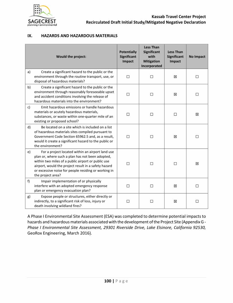
Kassab Travel Center Project Recirculated Draft Initial Study/Mitigated Negative Declaration
100 | P a g e
IX. HAZARDS AND HAZARDOUS MATERIALS
Would the project: Potentially Significant
Impact
Less Than Significant
with Mitigation
Incorporated
Less Than Significant
Impact No Impact
a) Create a significant hazard to the public or the environment through the routine transport, use, or disposal of hazardous materials?
☐ ☐ ☒ ☐
b) Create a significant hazard to the public or the environment through reasonably foreseeable upset and accident conditions involving the release of hazardous materials into the environment?
☐ ☐ ☒ ☐
c) Emit hazardous emissions or handle hazardous materials or acutely hazardous materials, substances, or waste within one-quarter mile of an existing or proposed school?
☐ ☐ ☐ ☒
d) Be located on a site which is included on a list of hazardous materials sites compiled pursuant to Government Code Section 65962.5 and, as a result, would it create a significant hazard to the public or the environment?
☐ ☐ ☒ ☐
e) For a project located within an airport land use plan or, where such a plan has not been adopted, within two miles of a public airport or public use airport, would the project result in a safety hazard or excessive noise for people residing or working in the project area?
☐ ☐ ☐ ☒
f) Impair implementation of or physically interfere with an adopted emergency response plan or emergency evacuation plan?
☐ ☐ ☒ ☐
g) Expose people or structures, either directly or indirectly, to a significant risk of loss, injury or death involving wildland fires?
☐ ☐ ☒ ☐
A Phase I Environmental Site Assessment (ESA) was completed to determine potential impacts to hazards and hazardous materials associated with the development of the Project Site (Appendix G - Phase I Environmental Site Assessment, 29301 Riverside Drive, Lake Elsinore, California 92530, GeoRox Engineering, March 2016).
Kassab Travel Center Project Recirculated Draft Initial Study/Mitigated Negative Declaration
101 | P a g e
a) Create a significant hazard to the public or the environment through the routine transport, use, or disposal of hazardous materials?
Less Than Significant Impact: During construction, there would be a minor level of transport, use, and disposal of hazardous materials and wastes that are typical of construction projects. This would include fuels and lubricants for construction machinery, coating materials, etc., as well as for the transport of the gas and diesel fuels to the Project Site. The proposed fuel storage tanks associated with the gas and diesel stations would be required to follow specific protocols for handling, transporting, and storing the fuel onsite. All hazardous materials are required to be utilized and transported in accordance with their labeling pursuant to federal and state law. Routine construction control measures and best management practices for hazardous materials storage, application, waste disposal, accident prevention and clean-up would be sufficient to reduce potential impacts to a less than significant level. The operation of the proposed convenience store and fast food restaurant would not be expected to generate hazardous waste or create the routine transport, use, or disposal of hazardous materials. The Proposed Project would involve the installation of Underground Storage Tanks (USTs) to serve the fueling station. Rule 461 of the South Coast Air Quality Management District (SCAQMD) governs the operation of gasoline stations and requires that all underground storage tanks are equipped with a “CARB certified” enhanced vapor recovery system, all fill tubes are equipped with vapor tight caps, all dry breaks are equipped with vapor tight seals, a spill box shall be installed to capture any gasoline spillage, and all equipment is required to be properly maintained per CARB regulations. All gasoline dispensing units are required to be equipped with a “CARB certified” vapor recovery system, the dispensing system components shall always maintain vapor and liquid tight connections and the breakaway coupling shall be equipped with a poppet valve that shall close when coupling is separated. Rule 461 also provides several additional requirements including detailed maintenance, testing, reporting and recordkeeping requirements for all gas stations. The gas station would also be subject to permit and inspection by the Hazardous Materials Division of the County Fire Department. Sections 2729 through 2732 of the California Code of Regulations (CCR) provide requirements for the reporting, inventory, and release response plans for hazardous materials. These requirements establish procedures and minimum standards for hazardous material plans, inventory reporting and submittal requirements, emergency planning/response, and training. In addition, all regulated substance handlers are required to register with local fire or emergency response departments per the California Accidental Release Prevention Program (CalARP). Locally, this is overseen by the Riverside County Department of Environmental Health, Hazardous Materials Branch. The division reviews and approves an Emergency/Contingency Plan for regulated facilities. The plan outlines precautions and procedures necessary to protect the facility from accidental release of hazardous materials and provides emergency remediation to minimize effects should an accidental spill occur. Annual updates and review of the plan are required to ensure compliance and adequacy. The Riverside County Department of Environmental Health, Hazardous Materials Branch administers the CalARP Program in the area. The CalARP Program was established to prevent accidental release of substances that pose the greatest risk of
Kassab Travel Center Project Recirculated Draft Initial Study/Mitigated Negative Declaration
102 | P a g e
immediate harm to the public and the environment. The Program requires facilities to proactively prevent and prepare for chemical accidents. The proposed facility would be subject to Program requirements for regulated substances including preparation of a risk management plan (RMP) to include an off-site consequence analysis, compliance audit, certified program elements, and a seismic assessment. Existing risk management and response requirements would ensure potential risks associated with accidental releases of hazardous materials are minimized. Therefore, potential impacts associated with the risk of exposure of the public and/or the environment to hazardous waste, either used or transported on site, would be less than significant. Mitigation Measures: No mitigation measures are required. Sources: CCR, Code of Federal Regulations, Health and Safety Code, Phase I ESA (Appendix G)
b) Create a significant hazard to the public or the environment through reasonably foreseeable upset and accident conditions involving the release of hazardous materials into the environment?
Less Than Significant Impact: The Proposed Project would be required to comply with all applicable federal, state and local laws and regulations pertaining to the transport, use, disposal, handling, and storage of hazardous waste during the construction phase to reduce the likelihood and severity of accidents during transit. Proper handling of the use and disposal of hazardous materials associated with the gas station would reduce the potential for exposure. The operation of the proposed convenience store and fast food restaurant would not be expected to generate hazardous waste or create the routine transport, use, or disposal of hazardous materials. Once the fuel storage tanks are constructed, there would be continued routine maintenance. Rule 461 of the South Coast Air Quality Management District (SCAQMD) governs the operation of gasoline stations and requires that all underground storage tanks are equipped with a “CARB certified” enhanced vapor recovery system, all fill tubes are equipped with vapor tight caps, all dry breaks are equipped with vapor tight seals, a spill box shall be installed to capture any gasoline spillage, and all equipment is required to be properly maintained per CARB regulations. Proper handling of the use and disposal of hazardous materials would reduce the potential for exposure. Therefore, potential impacts associated with accidental release of hazardous materials into the environment would be less than significant. Mitigation Measures: No mitigation measures are required. Sources: CCR, Code of Federal Regulations, Health and Safety Code
Kassab Travel Center Project Recirculated Draft Initial Study/Mitigated Negative Declaration
103 | P a g e
c) Emit hazardous emissions or handle hazardous materials or acutely hazardous materials, substances, or waste within one-quarter mile of an existing or proposed school?
No Impact: There are no existing or proposed schools within a quarter mile of the Proposed Project. The closest school site is Temescal Canyon High School, located approximately 0.3 miles to the north. As previously discussed, the Proposed Project would be required to comply with all applicable federal, state and local laws and regulations pertaining to the transport, use, disposal, handling, and storage of hazardous waste during the construction phase to reduce the likelihood and severity of accidents during transit. Proper handling of the use and disposal of hazardous materials associated with the gas station would reduce the potential for exposure of any school in proximity to the Project Site to hazardous materials. Therefore, no impact associated with hazardous materials within on-quarter mile of a school would occur. Mitigation Measures: No mitigation measures are required. Sources: Google Maps
d) Be located on a site which is included on a list of hazardous materials sites compiled pursuant to Government Code Section 65962.5 and, as a result, would it create a significant hazard to the public or the environment?
Less Than Significant Impact: Based on the California Department of Toxic Substances Control, EnviroStor Site/Facility Search, the Project Site is not included on a list of hazardous materials sites pursuant to Government Code Section 65962.5. The Project Site was not identified in the database search as a site of environmental concern. However, the Phase I ESA identified one environmental issue related to a neighboring site, EZ Products. EZ Products, 17999 Collier Avenue, is located approximately 200 to the northwest of the Project Site and is presumed to be higher elevation (hydrogically up/cross gradient). EZ Products is an active manufacturer of bolt, nut, screw, rivet, and washers. According to the regulatory database, this facility is listed as a RCRA-SQG, FINDS and ECHO site. Online research from the California DTSC Hazardous Waste Tracking System revealed evidence of tetrachloroethylene (PERC) on site for the years 1999 (1.48 tons), 2000 (0.34 tons), and 2001 (2.13 tons). According to the EPA ECHO website and the regulatory database, this facility specified a three-year period of no violations. Based on the amount of PERC onsite (3.95 tons), inferred direction of groundwater flow, and relative distance from the Project Site, this facility represents an environmental issue. However, based on the lack of documented release, this site is not expected to represent an environmental concern to the Project Site, at this time. Therefore, potential impacts associated with hazardous materials sites would be less than significant. Mitigation Measures: No mitigation measures are required. Sources: Phase I ESA (Appendix G), https://www.envirostor.dtsc.ca.gov/public/map/?myaddress=29031+Riverside+Drive+Lake+Elsinor
Kassab Travel Center Project Recirculated Draft Initial Study/Mitigated Negative Declaration
104 | P a g e
e) For a project located within an airport land use plan or, where such a plan has not been adopted, within two miles of a public airport or public use airport, would the project result in a safety hazard or excessive noise for people residing or working in the project area?
No Impact: The Proposed Project is not be located within an airport land use plan or within two miles of a public airport or public use airport. Therefore, no impacts associated with safety hazards or excessive noise in proximity to an airport would occur. Mitigation Measures: No mitigation measures are required. Sources: General Plan, Google Earth
f) Impair implementation of or physically interfere with an adopted emergency response plan or emergency evacuation plan?
Less Than Significant Impact: The Proposed Project would be required to comply with all applicable fire code requirements for construction and access to the Project Site and as such, would be reviewed by the City Fire Department to determine the specific fire requirements applicable to ensure compliance with these requirements. This review would ensure that the Proposed Project would provide adequate emergency access to and from the Project Site. The City Engineer and the City Fire Department would review any modifications to existing roadways to ensure that adequate emergency access and/or emergency response would be maintained. The Proposed Project does not propose any changes that would impact the City’s Emergency Preparedness Plan or the Riverside County Operational Area Multi-Jurisdictional Local Hazard Mitigation Plan. Therefore, potential impacts associated with interference with an adopted emergency response or evacuation plan would be less than significant. Mitigation Measures: No mitigation measures are required. Sources: General Plan EIR
g) Expose people or structures, either directly or indirectly, to a significant risk of loss, injury or death involving wildland fires?
Less Than Significant Impact: According to the California Department of Forestry and Fire Protection, Riverside County Fire Hazard Severity Zone Maps and the City of Lake Elsinore General Plan EIR Figure 3.10-2 (City of Lake Elsinore Wildfire Susceptibility), the Project Site is not located in a High or Very High Fire Hazard Severity Zone. The Project Site is vacant and bounded by vacant land to the northwest, south and west and by commercial/industrial uses to the northeast and east. As part of the plan check process, the Project Site plan would undergo a fire, life, and safety review by the City Fire Department to determine the specific fire requirements applicable to ensure compliance with these requirements. Therefore, impacts associated with wildland fires would be less than significant. Mitigation Measures: No mitigation measures are required. Sources: California Department of Forestry and Fire Protection, Riverside County Fire Hazard Severity Zone Maps, General Plan EIR Figure 3.10-2 - City of Lake Elsinore Wildfire Susceptibility
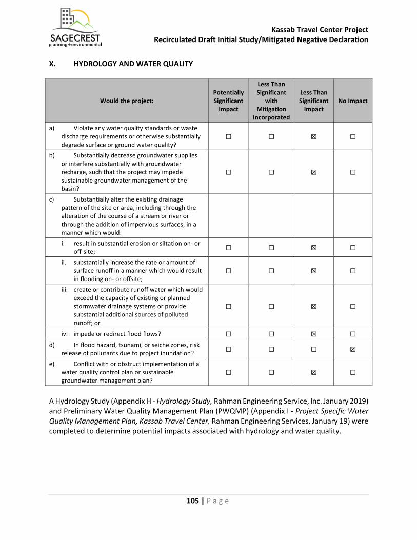
Kassab Travel Center Project Recirculated Draft Initial Study/Mitigated Negative Declaration
105 | P a g e
X. HYDROLOGY AND WATER QUALITY
Would the project: Potentially Significant
Impact
Less Than Significant
with Mitigation
Incorporated
Less Than Significant
Impact No Impact
a) Violate any water quality standards or waste discharge requirements or otherwise substantially degrade surface or ground water quality?
☐ ☐ ☒ ☐
b) Substantially decrease groundwater supplies or interfere substantially with groundwater recharge, such that the project may impede sustainable groundwater management of the basin?
☐ ☐ ☒ ☐
c) Substantially alter the existing drainage pattern of the site or area, including through the alteration of the course of a stream or river or through the addition of impervious surfaces, in a manner which would:
i. result in substantial erosion or siltation on- or off-site; ☐ ☐ ☒ ☐
ii. substantially increase the rate or amount of surface runoff in a manner which would result in flooding on- or offsite;
☐ ☐ ☒ ☐
iii. create or contribute runoff water which would exceed the capacity of existing or planned stormwater drainage systems or provide substantial additional sources of polluted runoff; or
☐ ☐ ☒ ☐
iv. impede or redirect flood flows? ☐ ☐ ☒ ☐ d) In flood hazard, tsunami, or seiche zones, risk
release of pollutants due to project inundation? ☐ ☐ ☐ ☒
e) Conflict with or obstruct implementation of a water quality control plan or sustainable groundwater management plan?
☐ ☐ ☒ ☐
A Hydrology Study (Appendix H - Hydrology Study, Rahman Engineering Service, Inc. January 2019) and Preliminary Water Quality Management Plan (PWQMP) (Appendix I - Project Specific Water Quality Management Plan, Kassab Travel Center, Rahman Engineering Services, January 19) were completed to determine potential impacts associated with hydrology and water quality.

Kassab Travel Center Project Recirculated Draft Initial Study/Mitigated Negative Declaration
106 | P a g e
a) Violate any water quality standards or waste discharge requirements or otherwise substantially degrade surface or ground water quality?
Less than Significant Impact: The Santa Ana Regional Water Quality Control Board (SARWQCB) sets water quality standards for all ground and surface waters within the Project’s region. Water quality standards are defined under the Clean Water Act to include both the beneficial uses of specific water bodies and the levels of water quality that must be met and maintained to protect those uses (water quality objectives). Construction of the Proposed Project would include grading, excavation, and other earthmoving activities that have the potential to cause erosion that could subsequently degrade water quality and/or violate water quality standards. As required by the Clean Water Act, the Proposed Project would comply with the Santa Ana Municipal Separate Storm Sewer (MS4) National Pollution Discharge Elimination System (NPDES) Permit. The NPDES MS4 Permit Program, which is administered in the project area by Riverside County and is issued by the Santa Ana Regional Water Quality Control Board (RWQCB), regulates storm water and urban runoff discharges from developments to natural and constructed storm drain systems in the City of Lake Elsinore. Since the Proposed Project would disturb one or more acres of soil, construction activities would be subject to the Construction General Permit (NPDES General Permit No. CAS000002, Waste Discharge Requirements, Order No. 2009-0009-DWQ, adopted September 2, 2009 and effective as of July 2, 2010) issued by the State Water Resources Control Board (SWRCB). The Construction General Permit requires implementation of a Storm Water Pollution Prevention Plan (SWPPP) for site clearing, grading, and disturbances such as stockpiling or excavation. The SWPPP would generally contain a site map showing the construction perimeter, proposed buildings, storm water collection and discharge points, general pre- and post-construction topography, drainage patterns across the site, and adjacent roadways. Development of the Project Site would add impervious surfaces through associated parking lot and parking, sidewalks, and drive aisles. By increasing the percentage of impervious surfaces on the Project Site, less water would percolate into the ground and more surface runoff would be generated. Paved areas and streets would collect dust, soil and other impurities that would then be assimilated into surface runoff during rainfall events. Operation of the Proposed Project has the potential to release pollutants resulting from replacing vacant land with roadways, walkways, and parking lots. These improvements may potentially impact water quality. However, according to the Project Specific Water Quality Management Plan (Appendix I), the impervious area would be 92,011 SF, or 78 percent impervious, and the balance of the Project Site, 12,466 SF or 12 percent, would be pervious with the use of landscape areas. All drainage flows would be captured by proposed ribbon gutters towards the proposed BMPs. The Preliminary WQMP has been submitted to the City Public Works Department for review. Prior to issuance of a grading or building permit, the Property Owner/Developer would be required to submit a final WQMP to the City for approval. The Proposed Project incorporates site design, source controls and treatment control BMPs to address storm water runoff. The building rooftops shall drain back to landscape areas, where
Kassab Travel Center Project Recirculated Draft Initial Study/Mitigated Negative Declaration
107 | P a g e
possible, for natural filtration. Most of the flows from the Project Site would occur over impervious surfaces that discharge to proposed ribbon gutters. Infiltration, Harvest and Use, and Bioretention BMPs are also included to treat storm water runoff before it leaves the Project Site. Therefore, potential impacts associated with violations of water quality or water discharge requirements would be less than significant. Mitigation Measures: No mitigation measures are required. Sources: PWQMP (Appendix I)
b) Substantially decrease groundwater supplies or interfere substantially with groundwater recharge, such that the project may impede sustainable groundwater management of the basin?
Less Than Significant Impact: According to General Plan EIR, the Project Site is located within the Elsinore Groundwater Management Zone (GMZ). Since the City has a large amount of vacant land, substantial changes to recharge systems could occur from development of the vacant parcels. In order to reduce pollutants, the City has implemented policies to minimize pollutants in the local and regional waterways, which includes water that percolates into the groundwater through Water Resources Policies 4.1, 4.2, and 4.3. Water Resources Policies 4.1 and 4.2 require development projects to acquire a National Pollutant Discharge Elimination System (NPDES) permit and implement Best Management Practices (BMPs) to reduce pollutants. Water Resources Policy 4.3 requires the City to review future development project’s beneficial uses during the environmental review stage. Therefore, potential impacts associated with depletion of or interference with groundwater would be less than significant. Mitigation Measures: No mitigation measures are required. Sources: General Plan EIR, PWQMP (Appendix I)
c) Substantially alter the existing drainage pattern of the site or area, including through the alteration of the course of a stream or river or through the addition of impervious surfaces, in a manner which would:
i) Result in substantial erosion or siltation on- or off-site;
Less Than Significant Impact: The Proposed Project would preserve the existing drainage pattern. Per the PWQMP, high points were designated at locations to match the proposed drainage pattern with the existing drainage pattern. Therefore, development of the Proposed Project would not significantly alter the existing drainage pattern of the Project Site or increase the amount of runoff. The Proposed Project would not involve an alteration of the course of a stream or river. Erosion and siltation impacts potentially resulting from the Proposed Project would, for the most part, occur during the Proposed Project’s site preparation and earthmoving phase. However, implementation of the NPDES permit requirements, as they apply to the Project Site, would reduce potential erosion, siltation, and water quality impacts. Therefore, potential impacts associated with erosion or siltation would be less than significant.
Kassab Travel Center Project Recirculated Draft Initial Study/Mitigated Negative Declaration
108 | P a g e
Mitigation Measures: No mitigation measures are required. Sources: PWQMP (Appendix I)
ii) Substantially increase the rate or amount of surface runoff in a manner, which would result in flooding on- or off-site?
Less Than Significant Impact: The Proposed Project would not substantially alter the existing drainage pattern of the Project Site. In addition, the Proposed Project would not involve an alteration of the course of a stream or river. A modular wetlands biofiltration system would be installed in Drainage Management Area (DMA) B to capture and treat runoff. Outflows would be discharged into the City’s existing drainage system. Therefore, potential impacts associated with an increase in the rate or amount of surface runoff resulting in flooding would be less than significant. Mitigation Measures: No mitigation measures are required. Sources: PWQMP (Appendix I)
iii) Create or contribute runoff water which would exceed the capacity of existing or planned stormwater drainage systems or provide substantial additional sources of polluted runoff;
Less Than Significant Impact: The modular wetlands biofiltration system in DMA B would retain and treat runoff from the Project Site. Non-structural BMPs such as activity restrictions, basin inspection, street sweeping, and common area landscape maintenance and litter control would also contribute towards runoff control and water quality protection. In addition, the Proposed Project would be required to comply with the NPDES permit requirements to reduce any potential water quality impacts. The Proposed Project would not create or contribute runoff water that would exceed the capacity of the drainage systems or provide additional sources of polluted runoff. The amount of water runoff is not expected to exceed stormwater drainage capacity. The Property Owner/Developer shall prepare a SWPPP for construction activity associated with the Proposed Project. The SWPPP shall be maintained at the construction site for the entire duration of construction. The objectives of the SWPPP are to identify pollutant sources that may affect the quality of storm water discharge and to implement BMPs to reduce pollutants in storm water discharges during construction and post construction in compliance with NPDES. Projects that comply with NPDES standards would result in a less than significant impact. In addition, storm drains located within the City limits are maintained by the City as well as by the Riverside County Flood Control and Water Conservation District. Storm runoff within the City is generally intercepted by a network of City facilities and then conveyed into regional facilities. All downstream conveyance channels that would receive runoff from the Project Site are engineered and regularly maintained to ensure flow capacity. Therefore, potential impacts associated with runoff would be less than significant. Mitigation Measures: No mitigation measures are required. Sources: General Plan EIR, PWQMP (Appendix I)
Kassab Travel Center Project Recirculated Draft Initial Study/Mitigated Negative Declaration
109 | P a g e
iv. Impede or redirect flood flows?
Less Than Significant Impact: According to the Federal Emergency Management Agency (FEMA), the western portion of the Project Site is within the 0.2% annual chance of flood hazard zone and is not within a 100-year flood hazard area. The Proposed Project has been designed to include drainage basins that would reduce post-development runoff rates in accordance with the requirements of the City of Lake Elsinore and RCFCWCD. Because the Proposed Project has been designed to attenuate post-development runoff from the site, Project-related runoff would not substantially increase the rate or amount of surface runoff in downstream areas in a manner that would result in flooding on- or off-site. Additionally, the Proposed Project would not impede or redirect flood flows. Therefore, potential impacts associated with flood flows would be less than significant. Mitigation Measures: No mitigation measures are required. Sources: FEMA; PWQMP (Appendix I)
d) In flood, tsunami, or seiche zones, risk release of pollutants due to project inundation?
No Impact: According to the Federal Emergency Management Agency (FEMA), the western portion of the Project Site is within the 0.2% annual chance of flood hazard zone and is not within a 100-year flood hazard area. Seiches are large waves generated in enclosed bodies of water in response to ground shaking. The Project Site is surrounded by a relatively flat and urbanized area. The Project Ste is located approximately 1.25 miles northeast of Lake Elsinore, which lacks significant potential for a damaging seiche because of its low depth, and presence of flood control devices constructed by the U.S. Army Corps of Engineers, including the berm fill at the southern end of the lake. The Project Site is located at least 24 miles from the ocean and approximately 1,267 feet above mean sea level (MSL). Due to the location of the Project Site, and topography of the surrounding locale, it is also not likely that mudflows would inundate the site. Therefore, no impacts associated with inundation by flood, tsunami, or seiche would occur. Mitigation Measures: No mitigation measures are required. Sources: General Plan EIR
e) Conflict with or obstruct implementation of a water quality control plan or sustainable groundwater management plan?
Less than Significant Impact: The Project Site is located within the Santa Ana River watershed, which is regulated by the Santa Ana Regional Water Quality Control Board (RWQCB). The RWQCB has developed a “Water Quality Control Plan” for the Santa Ana River Basin (herein, “Basin Plan”). The Basin Plan establishes water quality standards for the ground and surface waters of the region. The Basin Plan includes an implementation plan describing the actions by the RWQCB and others that are necessary to achieve and maintain the water quality standards. The RWQCB regulates waste discharges to minimize and control their effects on the quality of the region’s ground and surface water. Permits are issued under several programs and authorities. The terms and
Kassab Travel Center Project Recirculated Draft Initial Study/Mitigated Negative Declaration
110 | P a g e
conditions of these discharge permits are enforced through a variety of technical, administrative, and legal means. The RWQCB ensures compliance with the Basin Plan through its issuance of National Pollutant Discharge Elimination System (NPDES) Permits, issuance of Waste Discharge Requirements (WDR), and Water Quality Certifications pursuant to Section 401 of the Clean Water Act (CWA). In conformance with these requirements, the Applicant has prepared a Water Quality Management Plan (WQMP), included as Appendix I, which demonstrates that the Proposed Project’s drainage plan would meet all applicable requirements of the Basin Plan, including requirements and conditions of approval associated with NPDES permits, issuance of WDRs, and Water Quality Certifications. Therefore, the Proposed Project would not conflict with the Basin Plan, and potential impacts associated with implementation of a water quality control plan would be less than significant. According to General Plan EIR, the Project Site is located within the Elsinore Groundwater Management Zone (GMZ). Since the City has a large amount of vacant land, substantial changes to recharge systems could occur from development of the vacant parcels. In order to reduce pollutants, the City has implemented policies to minimize pollutants in the local and regional waterways, which includes water that percolates into the groundwater through Water Resources Policies 4.1, 4.2, and 4.3. Water Resources Policies 4.1 and 4.2 require development projects to acquire a National Pollutant Discharge Elimination System (NPDES) permit and implement Best Management Practices (BMPs) to reduce pollutants. Water Resources Policy 4.3 requires the City to review future development project’s beneficial uses during the environmental review stage. Therefore, the Proposed Project would not conflict with any sustainable groundwater management plans, and potential impacts associated with implementation of a groundwater management plan would be less than significant. Mitigation Measures: No mitigation measures are required. Sources: General Plan EIR, PWQMP (Appendix I)
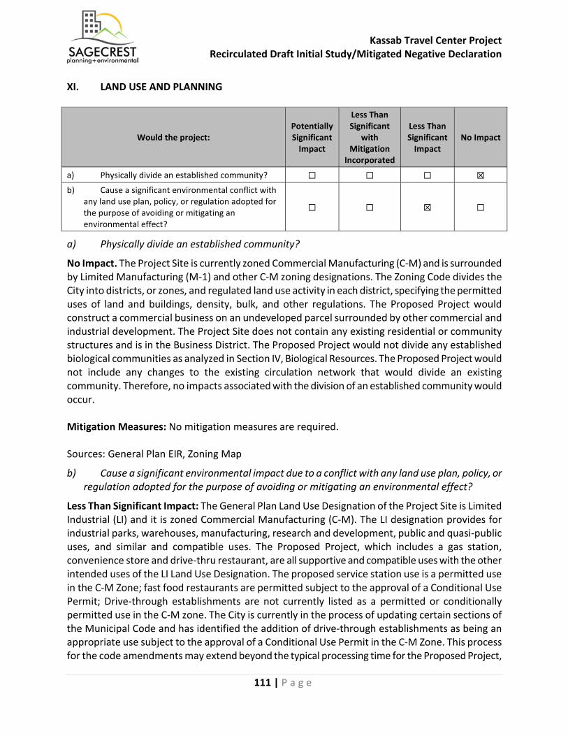
Kassab Travel Center Project Recirculated Draft Initial Study/Mitigated Negative Declaration
111 | P a g e
XI. LAND USE AND PLANNING
Would the project: Potentially Significant
Impact
Less Than Significant
with Mitigation
Incorporated
Less Than Significant
Impact No Impact
a) Physically divide an established community? ☐ ☐ ☐ ☒ b) Cause a significant environmental conflict with
any land use plan, policy, or regulation adopted for the purpose of avoiding or mitigating an environmental effect?
☐ ☐ ☒ ☐
a) Physically divide an established community?
No Impact. The Project Site is currently zoned Commercial Manufacturing (C-M) and is surrounded by Limited Manufacturing (M-1) and other C-M zoning designations. The Zoning Code divides the City into districts, or zones, and regulated land use activity in each district, specifying the permitted uses of land and buildings, density, bulk, and other regulations. The Proposed Project would construct a commercial business on an undeveloped parcel surrounded by other commercial and industrial development. The Project Site does not contain any existing residential or community structures and is in the Business District. The Proposed Project would not divide any established biological communities as analyzed in Section IV, Biological Resources. The Proposed Project would not include any changes to the existing circulation network that would divide an existing community. Therefore, no impacts associated with the division of an established community would occur. Mitigation Measures: No mitigation measures are required. Sources: General Plan EIR, Zoning Map
b) Cause a significant environmental impact due to a conflict with any land use plan, policy, or regulation adopted for the purpose of avoiding or mitigating an environmental effect?
Less Than Significant Impact: The General Plan Land Use Designation of the Project Site is Limited Industrial (LI) and it is zoned Commercial Manufacturing (C-M). The LI designation provides for industrial parks, warehouses, manufacturing, research and development, public and quasi-public uses, and similar and compatible uses. The Proposed Project, which includes a gas station, convenience store and drive-thru restaurant, are all supportive and compatible uses with the other intended uses of the LI Land Use Designation. The proposed service station use is a permitted use in the C-M Zone; fast food restaurants are permitted subject to the approval of a Conditional Use Permit; Drive-through establishments are not currently listed as a permitted or conditionally permitted use in the C-M zone. The City is currently in the process of updating certain sections of the Municipal Code and has identified the addition of drive-through establishments as being an appropriate use subject to the approval of a Conditional Use Permit in the C-M Zone. This process for the code amendments may extend beyond the typical processing time for the Proposed Project,
Kassab Travel Center Project Recirculated Draft Initial Study/Mitigated Negative Declaration
112 | P a g e
the City recommended that the Applicant include a Municipal Code Amendment request to be processed concurrently with the Conditional Use Permit and Commercial Design Review applications. The Proposed Project as designed meets all development standards as identified in the Municipal Code, including but not limited to setbacks, building heights, parking spaces, drive aisles, and floor area ratio. Upon completion of the Municipal Code Amendment to allow drive-through establishments in the C-M Zone as a conditionally permitted use, the Proposed Project would be consistent with all applicable existing and planned land use policies and regulations of the Lake Elsinore Municipal Code and General Plan. Therefore, potential impacts associated with conflict with a land use plan, policy or regulation would be less than significant. Mitigation Measures: No mitigation measures are required. Sources: General Plan EIR, General Plan Land Use Map, Zoning Map
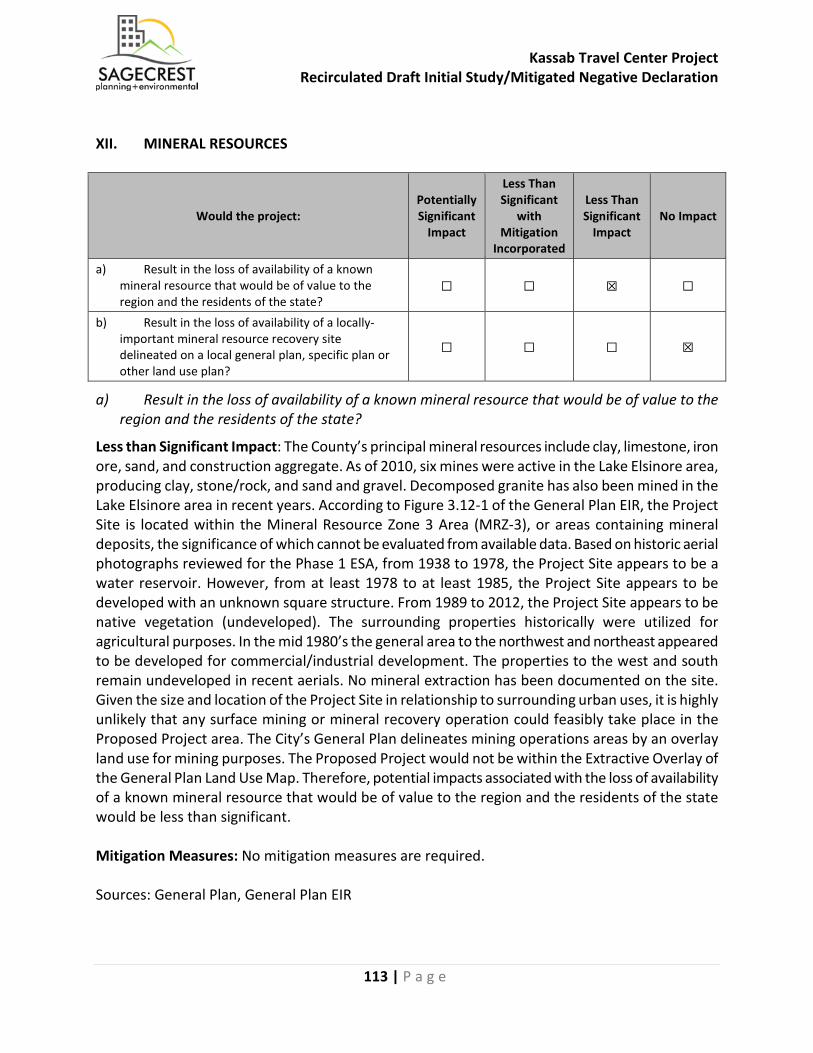
Kassab Travel Center Project Recirculated Draft Initial Study/Mitigated Negative Declaration
113 | P a g e
XII. MINERAL RESOURCES
Would the project: Potentially Significant
Impact
Less Than Significant
with Mitigation
Incorporated
Less Than Significant
Impact No Impact
a) Result in the loss of availability of a known mineral resource that would be of value to the region and the residents of the state?
☐ ☐ ☒ ☐
b) Result in the loss of availability of a locally-important mineral resource recovery site delineated on a local general plan, specific plan or other land use plan?
☐ ☐ ☐ ☒
a) Result in the loss of availability of a known mineral resource that would be of value to the region and the residents of the state?
Less than Significant Impact: The County’s principal mineral resources include clay, limestone, iron ore, sand, and construction aggregate. As of 2010, six mines were active in the Lake Elsinore area, producing clay, stone/rock, and sand and gravel. Decomposed granite has also been mined in the Lake Elsinore area in recent years. According to Figure 3.12-1 of the General Plan EIR, the Project Site is located within the Mineral Resource Zone 3 Area (MRZ-3), or areas containing mineral deposits, the significance of which cannot be evaluated from available data. Based on historic aerial photographs reviewed for the Phase 1 ESA, from 1938 to 1978, the Project Site appears to be a water reservoir. However, from at least 1978 to at least 1985, the Project Site appears to be developed with an unknown square structure. From 1989 to 2012, the Project Site appears to be native vegetation (undeveloped). The surrounding properties historically were utilized for agricultural purposes. In the mid 1980’s the general area to the northwest and northeast appeared to be developed for commercial/industrial development. The properties to the west and south remain undeveloped in recent aerials. No mineral extraction has been documented on the site. Given the size and location of the Project Site in relationship to surrounding urban uses, it is highly unlikely that any surface mining or mineral recovery operation could feasibly take place in the Proposed Project area. The City’s General Plan delineates mining operations areas by an overlay land use for mining purposes. The Proposed Project would not be within the Extractive Overlay of the General Plan Land Use Map. Therefore, potential impacts associated with the loss of availability of a known mineral resource that would be of value to the region and the residents of the state would be less than significant. Mitigation Measures: No mitigation measures are required. Sources: General Plan, General Plan EIR

Kassab Travel Center Project Recirculated Draft Initial Study/Mitigated Negative Declaration
114 | P a g e
b) Result in the loss of availability of a locally-important mineral resource recovery site delineated on a local general plan, specific plan or other land use plan?
No Impact: The City’s General Plan delineates mining operations areas by an overlay land use for mining purposes. The Proposed Project would not be within the Extractive Overlay of the General Plan Land Use Map. The Proposed Project would not result in the loss of availability of a locally-important mineral resource recovery site delineated on a local general plan, specific plan or other land use plan. Therefore, no impacts associated with loss of a mineral resource recovery site would occur. Mitigation Measures: No mitigation measures are required. Sources: General Plan
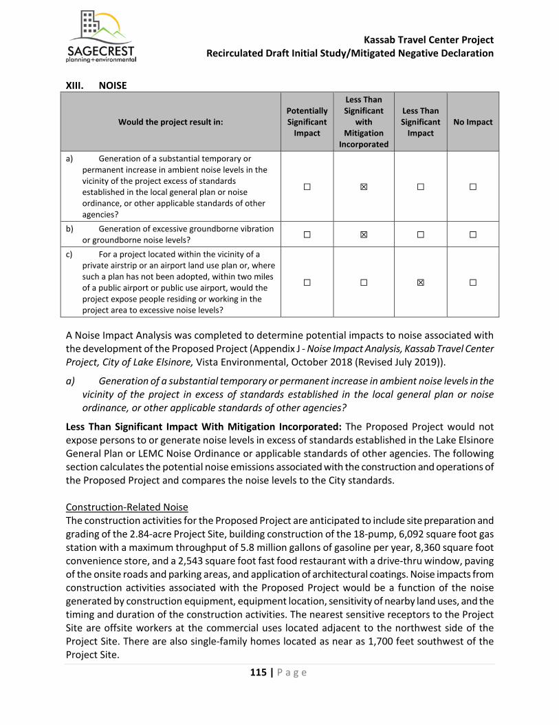
Kassab Travel Center Project Recirculated Draft Initial Study/Mitigated Negative Declaration
115 | P a g e
XIII. NOISE
Would the project result in: Potentially Significant
Impact
Less Than Significant
with Mitigation
Incorporated
Less Than Significant
Impact No Impact
a) Generation of a substantial temporary or permanent increase in ambient noise levels in the vicinity of the project excess of standards established in the local general plan or noise ordinance, or other applicable standards of other agencies?
☐ ☒ ☐ ☐
b) Generation of excessive groundborne vibration or groundborne noise levels? ☐ ☒ ☐ ☐
c) For a project located within the vicinity of a private airstrip or an airport land use plan or, where such a plan has not been adopted, within two miles of a public airport or public use airport, would the project expose people residing or working in the project area to excessive noise levels?
☐ ☐ ☒ ☐
A Noise Impact Analysis was completed to determine potential impacts to noise associated with the development of the Proposed Project (Appendix J - Noise Impact Analysis, Kassab Travel Center Project, City of Lake Elsinore, Vista Environmental, October 2018 (Revised July 2019)).
a) Generation of a substantial temporary or permanent increase in ambient noise levels in the vicinity of the project in excess of standards established in the local general plan or noise ordinance, or other applicable standards of other agencies?
Less Than Significant Impact With Mitigation Incorporated: The Proposed Project would not expose persons to or generate noise levels in excess of standards established in the Lake Elsinore General Plan or LEMC Noise Ordinance or applicable standards of other agencies. The following section calculates the potential noise emissions associated with the construction and operations of the Proposed Project and compares the noise levels to the City standards. Construction-Related Noise The construction activities for the Proposed Project are anticipated to include site preparation and grading of the 2.84-acre Project Site, building construction of the 18-pump, 6,092 square foot gas station with a maximum throughput of 5.8 million gallons of gasoline per year, 8,360 square foot convenience store, and a 2,543 square foot fast food restaurant with a drive-thru window, paving of the onsite roads and parking areas, and application of architectural coatings. Noise impacts from construction activities associated with the Proposed Project would be a function of the noise generated by construction equipment, equipment location, sensitivity of nearby land uses, and the timing and duration of the construction activities. The nearest sensitive receptors to the Project Site are offsite workers at the commercial uses located adjacent to the northwest side of the Project Site. There are also single-family homes located as near as 1,700 feet southwest of the Project Site.
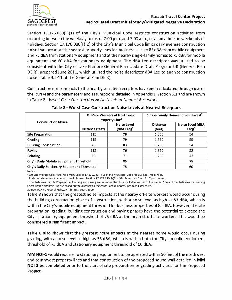
Kassab Travel Center Project Recirculated Draft Initial Study/Mitigated Negative Declaration
116 | P a g e
Section 17.176.080(F)(1) of the City’s Municipal Code restricts construction activities from occurring between the weekday hours of 7:00 p.m. and 7:00 a.m., or at any time on weekends or holidays. Section 17.176.080(F)(2) of the City’s Municipal Code limits daily average construction noise that occurs at the nearest property lines for business uses to 85 dBA from mobile equipment and 75 dBA from stationary equipment and at the nearby single-family homes to 75 dBA for mobile equipment and 60 dBA for stationary equipment. The dBA Leq descriptor was utilized to be consistent with the City of Lake Elsinore General Plan Update Draft Program EIR (General Plan DEIR), prepared June 2011, which utilized the noise descriptor dBA Leq to analyze construction noise (Table 3.5-11 of the General Plan DEIR). Construction noise impacts to the nearby sensitive receptors have been calculated through use of the RCNM and the parameters and assumptions detailed in Appendix J, Section 6.1 and are shown in Table 8 - Worst Case Construction Noise Levels at Nearest Receptors.
Table 8 - Worst Case Construction Noise Levels at Nearest Receptors
Construction Phase
Off-Site Workers at Northwest Property Line1
Single-Family Homes to Southwest2
Distance (feet) Noise Level (dBA Leq)3
Distance (feet)
Noise Level (dBA Leq)3
Site Preparation 115 78 1,850 54 Grading 115 79 1,850 55 Building Construction 70 83 1,750 54 Paving 115 76 1,850 52 Painting 70 71 1,750 43 City’s Daily Mobile Equipment Threshold 85 75 City’s Daily Stationary Equipment Threshold 75 60 Notes: 1 Off-Site Worker noise threshold from Section17.176.080(F)(2) of the Municipal Code for Business Properties. 2 Residential construction noise threshold from Section 17.176.080(F)(2) of the Municipal Code for Type I Areas. 3 The distances for Site Preparation, Grading and Paving are based on the distance to the center of the Project Site and the distances for Building Construction and Painting are based on the distance to the center of the nearest proposed structure. Source: RCNM, Federal Highway Administration, 2006
Table 8 shows that the greatest noise impacts at the nearby off-site workers would occur during the building construction phase of construction, with a noise level as high as 83 dBA, which is within the City’s mobile equipment threshold for business properties of 85 dBA. However, the site preparation, grading, building construction and paving phases have the potential to exceed the City’s stationary equipment threshold of 75 dBA at the nearest off-site workers. This would be considered a significant impact. Table 8 also shows that the greatest noise impacts at the nearest home would occur during grading, with a noise level as high as 55 dBA, which is within both the City’s mobile equipment threshold of 75 dBA and stationary equipment threshold of 60 dBA.
MM NOI-1 would require no stationary equipment to be operated within 50 feet of the northwest and southwest property lines and that construction of the proposed sound wall detailed in MM NOI-2 be completed prior to the start of site preparation or grading activities for the Proposed Project.

Kassab Travel Center Project Recirculated Draft Initial Study/Mitigated Negative Declaration
117 | P a g e
As detailed in the RCNM User Guide, the loudest stationary equipment utilized during construction would be a generator that creates a noise level at 81 dB Lmax or 78 dBA Leq at 50 feet. A sound wall provides a minimum of 5 dB of attenuation when it is high enough to break the line-of-sight between the noise source and receiver (Caltrans, 2013). As such, implementation of MM NOI-1 would reduce the noise level of stationary equipment to 73 dBA Leq or below, which is within the City’s stationary equipment threshold. Therefore, with implementation of MM NOI-1, construction-related noise impacts would be reduced to within the City noise standards and potential impacts associated with construction noise would be less than significant. Operational-Related Noise The operation of the Proposed Project may generate onsite noise levels that exceed City standards at the existing nearby sensitive receptors. The operation of the Proposed Project may create an increase in onsite noise levels from rooftop mechanical equipment, air/water machine, gas fueling activities, parking lot activities, delivery truck activities, and onsite operation of a drive-thru speaker. Section 17.176.060(A) of the Municipal Code limits onsite noise sources to 65 dBA between 7:00 a.m. and 10:00 p.m. and 60 dBA between 10:00 p.m. and 7:00 a.m. at the adjacent existing commercial property on the northwest side and the proposed commercial property on the southwest side of the Project Site. Section 8.06.060(A) also provides residential noise standards, however the nearest residential uses are located 1,700 feet to the southwest and due to the distance, no noise impacts are anticipated to the nearby residential uses. In order to determine the noise impacts from rooftop mechanical equipment, parking lot activities, delivery truck activities, air/water machine, gas fueling activities, and drive thru speakers, reference noise measurements were taken of each noise source and are shown in Table 9 - Operational Noise Levels at the Nearby Commercial Uses Prior to Mitigation, which also shows the anticipated noise level from each source at the nearest offsite receptors.
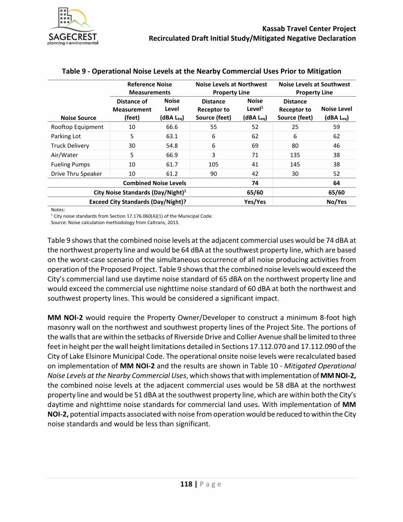
Kassab Travel Center Project Recirculated Draft Initial Study/Mitigated Negative Declaration
118 | P a g e
Table 9 - Operational Noise Levels at the Nearby Commercial Uses Prior to Mitigation
Noise Source
Reference Noise Measurements
Noise Levels at Northwest Property Line
Noise Levels at Southwest Property Line
Distance of Measurement
(feet)
Noise Level
(dBA Leq)
Distance Receptor to
Source (feet)
Noise Level1
(dBA Leq)
Distance Receptor to
Source (feet) Noise Level
(dBA Leq) Rooftop Equipment 10 66.6 55 52 25 59 Parking Lot 5 63.1 6 62 6 62 Truck Delivery 30 54.8 6 69 80 46 Air/Water 5 66.9 3 71 135 38 Fueling Pumps 10 61.7 105 41 145 38 Drive Thru Speaker 10 61.2 90 42 30 52
Combined Noise Levels 74 64 City Noise Standards (Day/Night)1 65/60 65/60
Exceed City Standards (Day/Night)? Yes/Yes No/Yes Notes: 1 City noise standards from Section 17.176.060(A)(1) of the Municipal Code. Source: Noise calculation methodology from Caltrans, 2013.
Table 9 shows that the combined noise levels at the adjacent commercial uses would be 74 dBA at the northwest property line and would be 64 dBA at the southwest property line, which are based on the worst-case scenario of the simultaneous occurrence of all noise producing activities from operation of the Proposed Project. Table 9 shows that the combined noise levels would exceed the City’s commercial land use daytime noise standard of 65 dBA on the northwest property line and would exceed the commercial use nighttime noise standard of 60 dBA at both the northwest and southwest property lines. This would be considered a significant impact. MM NOI-2 would require the Property Owner/Developer to construct a minimum 8-foot high masonry wall on the northwest and southwest property lines of the Project Site. The portions of the walls that are within the setbacks of Riverside Drive and Collier Avenue shall be limited to three feet in height per the wall height limitations detailed in Sections 17.112.070 and 17.112.090 of the City of Lake Elsinore Municipal Code. The operational onsite noise levels were recalculated based on implementation of MM NOI-2 and the results are shown in Table 10 - Mitigated Operational Noise Levels at the Nearby Commercial Uses, which shows that with implementation of MM NOI-2, the combined noise levels at the adjacent commercial uses would be 58 dBA at the northwest property line and would be 51 dBA at the southwest property line, which are within both the City’s daytime and nighttime noise standards for commercial land uses. With implementation of MM NOI-2, potential impacts associated with noise from operation would be reduced to within the City noise standards and would be less than significant.
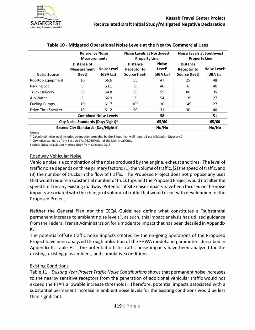
Kassab Travel Center Project Recirculated Draft Initial Study/Mitigated Negative Declaration
119 | P a g e
Table 10 - Mitigated Operational Noise Levels at the Nearby Commercial Uses
Noise Source
Reference Noise Measurements
Noise Levels at Northwest Property Line
Noise Levels at Southwest Property Line
Distance of Measurement
(feet) Noise Level
(dBA Leq)
Distance Receptor to
Source (feet)
Noise Level1
(dBA Leq)
Distance Receptor to
Source (feet) Noise Level1
(dBA Leq) Rooftop Equipment 10 66.6 55 47 25 48 Parking Lot 5 63.1 6 46 6 46 Truck Delivery 30 54.8 6 55 80 35 Air/Water 5 66.9 3 54 135 27 Fueling Pumps 10 61.7 105 30 145 27 Drive Thru Speaker 10 61.2 90 31 30 40
Combined Noise Levels 58 51 City Noise Standards (Day/Night)2 65/60 65/60
Exceed City Standards (Day/Night)? No/No No/No Notes: 1 Calculated noise level includes attenuation provided by the 8-foot high wall required per Mitigation Measure 2. 2 City noise standards from Section 17.176.060(A)(1) of the Municipal Code. Source: Noise calculation methodology from Caltrans, 2013. Roadway Vehicular Noise Vehicle noise is a combination of the noise produced by the engine, exhaust and tires. The level of traffic noise depends on three primary factors: (1) the volume of traffic, (2) the speed of traffic, and (3) the number of trucks in the flow of traffic. The Proposed Project does not propose any uses that would require a substantial number of truck trips and the Proposed Project would not alter the speed limit on any existing roadway. Potential offsite noise impacts have been focused on the noise impacts associated with the change of volume of traffic that would occur with development of the Proposed Project. Neither the General Plan nor the CEQA Guidelines define what constitutes a “substantial permanent increase to ambient noise levels”, as such, this impact analysis has utilized guidance from the Federal Transit Administration for a moderate impact that has been detailed in Appendix K. The potential offsite traffic noise impacts created by the on-going operations of the Proposed Project have been analyzed through utilization of the FHWA model and parameters described in Appendix K, Table H. The potential offsite traffic noise impacts have been analyzed for the existing, existing plus ambient, and cumulative conditions. Existing Conditions Table 11 – Existing Year Project Traffic Noise Contributions shows that permanent noise increases to the nearby sensitive receptors from the generation of additional vehicular traffic would not exceed the FTA’s allowable increase thresholds. Therefore, potential impacts associated with a substantial permanent increase in ambient noise levels for the existing conditions would be less than significant.
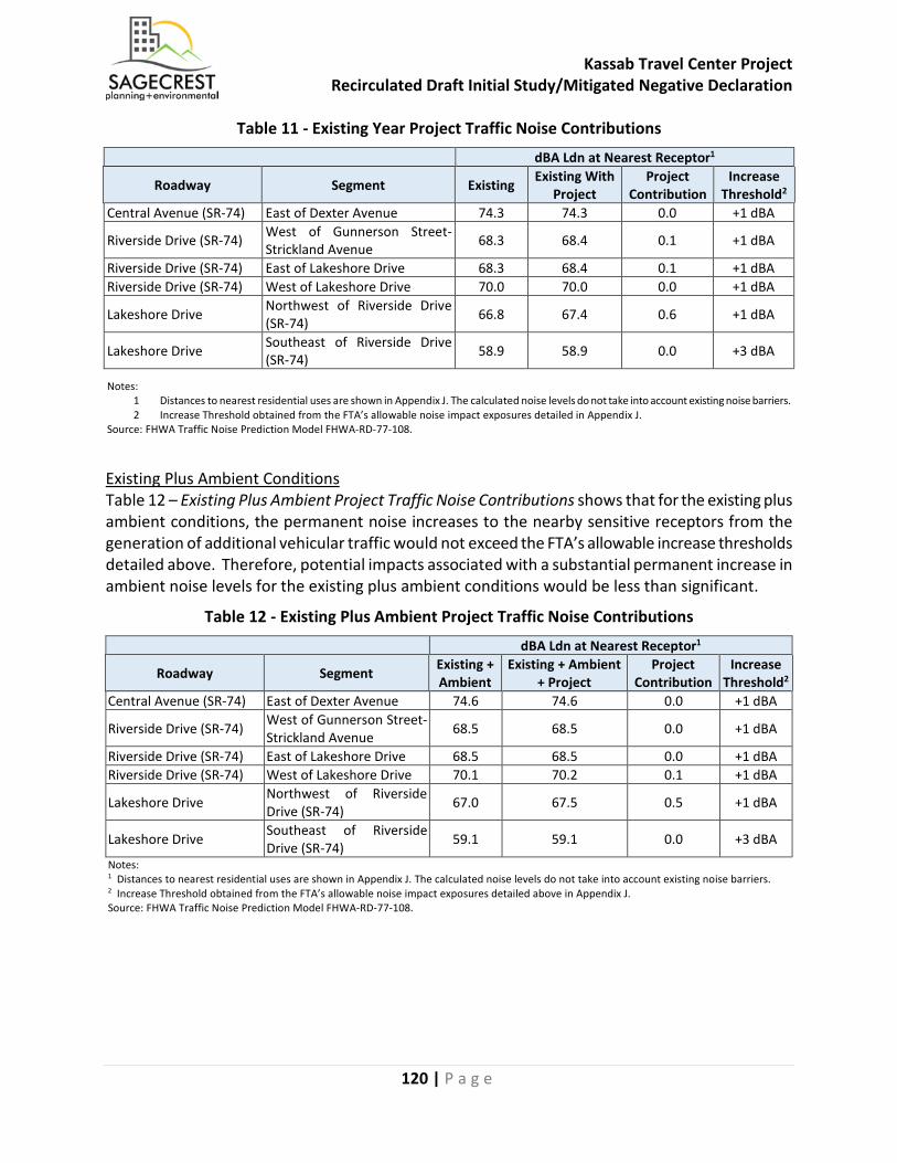
Kassab Travel Center Project Recirculated Draft Initial Study/Mitigated Negative Declaration
120 | P a g e
Table 11 - Existing Year Project Traffic Noise Contributions dBA Ldn at Nearest Receptor1
Roadway Segment Existing Existing With Project
Project Contribution
Increase Threshold2
Central Avenue (SR-74) East of Dexter Avenue 74.3 74.3 0.0 +1 dBA
Riverside Drive (SR-74) West of Gunnerson Street-Strickland Avenue 68.3 68.4 0.1 +1 dBA
Riverside Drive (SR-74) East of Lakeshore Drive 68.3 68.4 0.1 +1 dBA Riverside Drive (SR-74) West of Lakeshore Drive 70.0 70.0 0.0 +1 dBA
Lakeshore Drive Northwest of Riverside Drive (SR-74) 66.8 67.4 0.6 +1 dBA
Lakeshore Drive Southeast of Riverside Drive (SR-74) 58.9 58.9 0.0 +3 dBA
Notes: 1 Distances to nearest residential uses are shown in Appendix J. The calculated noise levels do not take into account existing noise barriers. 2 Increase Threshold obtained from the FTA’s allowable noise impact exposures detailed in Appendix J.
Source: FHWA Traffic Noise Prediction Model FHWA-RD-77-108.
Existing Plus Ambient Conditions Table 12 – Existing Plus Ambient Project Traffic Noise Contributions shows that for the existing plus ambient conditions, the permanent noise increases to the nearby sensitive receptors from the generation of additional vehicular traffic would not exceed the FTA’s allowable increase thresholds detailed above. Therefore, potential impacts associated with a substantial permanent increase in ambient noise levels for the existing plus ambient conditions would be less than significant.
Table 12 - Existing Plus Ambient Project Traffic Noise Contributions dBA Ldn at Nearest Receptor1
Roadway Segment Existing + Ambient
Existing + Ambient + Project
Project Contribution
Increase Threshold2
Central Avenue (SR-74) East of Dexter Avenue 74.6 74.6 0.0 +1 dBA
Riverside Drive (SR-74) West of Gunnerson Street-Strickland Avenue 68.5 68.5 0.0 +1 dBA
Riverside Drive (SR-74) East of Lakeshore Drive 68.5 68.5 0.0 +1 dBA Riverside Drive (SR-74) West of Lakeshore Drive 70.1 70.2 0.1 +1 dBA
Lakeshore Drive Northwest of Riverside Drive (SR-74) 67.0 67.5 0.5 +1 dBA
Lakeshore Drive Southeast of Riverside Drive (SR-74) 59.1 59.1 0.0 +3 dBA
Notes: 1 Distances to nearest residential uses are shown in Appendix J. The calculated noise levels do not take into account existing noise barriers. 2 Increase Threshold obtained from the FTA’s allowable noise impact exposures detailed above in Appendix J. Source: FHWA Traffic Noise Prediction Model FHWA-RD-77-108.
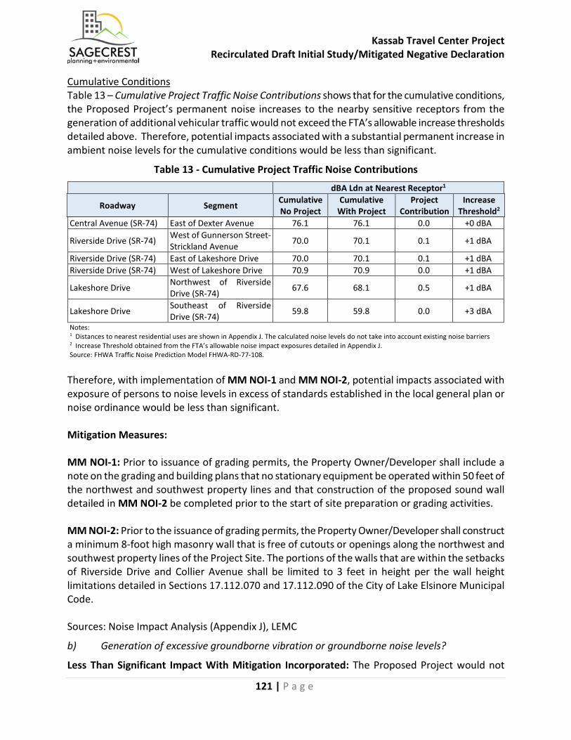
Kassab Travel Center Project Recirculated Draft Initial Study/Mitigated Negative Declaration
121 | P a g e
Cumulative Conditions Table 13 – Cumulative Project Traffic Noise Contributions shows that for the cumulative conditions, the Proposed Project’s permanent noise increases to the nearby sensitive receptors from the generation of additional vehicular traffic would not exceed the FTA’s allowable increase thresholds detailed above. Therefore, potential impacts associated with a substantial permanent increase in ambient noise levels for the cumulative conditions would be less than significant.
Table 13 - Cumulative Project Traffic Noise Contributions dBA Ldn at Nearest Receptor1
Roadway Segment Cumulative No Project
Cumulative With Project
Project Contribution
Increase Threshold2
Central Avenue (SR-74) East of Dexter Avenue 76.1 76.1 0.0 +0 dBA
Riverside Drive (SR-74) West of Gunnerson Street-Strickland Avenue 70.0 70.1 0.1 +1 dBA
Riverside Drive (SR-74) East of Lakeshore Drive 70.0 70.1 0.1 +1 dBA Riverside Drive (SR-74) West of Lakeshore Drive 70.9 70.9 0.0 +1 dBA
Lakeshore Drive Northwest of Riverside Drive (SR-74) 67.6 68.1 0.5 +1 dBA
Lakeshore Drive Southeast of Riverside Drive (SR-74) 59.8 59.8 0.0 +3 dBA
Notes: 1 Distances to nearest residential uses are shown in Appendix J. The calculated noise levels do not take into account existing noise barriers 2 Increase Threshold obtained from the FTA’s allowable noise impact exposures detailed in Appendix J. Source: FHWA Traffic Noise Prediction Model FHWA-RD-77-108. Therefore, with implementation of MM NOI-1 and MM NOI-2, potential impacts associated with exposure of persons to noise levels in excess of standards established in the local general plan or noise ordinance would be less than significant. Mitigation Measures: MM NOI-1: Prior to issuance of grading permits, the Property Owner/Developer shall include a note on the grading and building plans that no stationary equipment be operated within 50 feet of the northwest and southwest property lines and that construction of the proposed sound wall detailed in MM NOI-2 be completed prior to the start of site preparation or grading activities. MM NOI-2: Prior to the issuance of grading permits, the Property Owner/Developer shall construct a minimum 8-foot high masonry wall that is free of cutouts or openings along the northwest and southwest property lines of the Project Site. The portions of the walls that are within the setbacks of Riverside Drive and Collier Avenue shall be limited to 3 feet in height per the wall height limitations detailed in Sections 17.112.070 and 17.112.090 of the City of Lake Elsinore Municipal Code. Sources: Noise Impact Analysis (Appendix J), LEMC
b) Generation of excessive groundborne vibration or groundborne noise levels?
Less Than Significant Impact With Mitigation Incorporated: The Proposed Project would not
Kassab Travel Center Project Recirculated Draft Initial Study/Mitigated Negative Declaration
122 | P a g e
expose persons to or generation of excessive groundborne vibration or groundborne noise levels. The following section analyzes the potential vibration impacts associated with the construction and operations of the Proposed Project. Construction-Related Vibration Impacts The construction activities for the Proposed Project are anticipated to include site preparation and grading of the 2.84-acre Project Site, building construction of the 18-pump, 6,092 square foot gas station with a maximum throughput of 5.8 million gallons of gasoline per year, 8,360 square foot convenience store, and a 2,543 square foot fast food restaurant with a drive-thru window, paving of the onsite roads and parking areas, and application of architectural coatings. The nearest off-site receptors to the Project Site are the commercial uses located adjacent to the northwest side of the Project Site. There are also single-family homes located as near as 1,700 feet west of the Project Site. Section 17.176.080(G) of the City’s Municipal Code restricts the operation of any device that creates a vibration which is above the vibration threshold of any individual at or beyond the property boundary of the source. Section 17.176.020 of the Municipal Code defines the “Vibration perception threshold” as motion velocity of 0.01 inch per second over the range of one to 100 Hz. Construction activity can result in varying degrees of ground vibration, depending on the equipment used on the Project Site. Operation of construction equipment causes ground vibrations that spread through the ground and diminish in strength with distance. Buildings in the vicinity of the construction site respond to these vibrations with varying results ranging from no perceptible effects at the low levels to slight damage at the highest levels. Table 14 – Vibration Source Levels for Construction Equipment shows typical vibration created by different types of construction equipment quantified by extensive research into vibration created by construction equipment conducted by the Federal Transit Administration (Federal Transit Administration, 2006). The data in Table 14 provides a reasonable estimate of vibration levels for a wide range of soil conditions. Since the City of Lake Elsinore utilizes the root mean square (RMS) amplitude descriptor (Section 17.176.020 Definitions of the Municipal Code), the RMS values were also shown in Table 14 and were calculated by dividing the peak particle velocity (PPV) by a crest factor of 4, which is the same crest factor utilized by the FTA to convert between PPV and dBV or Lv.

Kassab Travel Center Project Recirculated Draft Initial Study/Mitigated Negative Declaration
123 | P a g e
Table 14 - Vibration Source Levels for Construction Equipment
Equipment
Peak Particle Velocity at 25 feet
(inches/second)
Approximate Vibration Level (Lv) at 25 feet1
Root Mean Square Velocity at 25 feet2
(inches/second)
Pile driver (impact) Upper range Typical
1.518 0.644
112 104
0.380 0.161
Pile driver (sonic) Upper range typical
0.734 0.170
105 93
0.184 0.043
Clam shovel drop (slurry wall) 0.202 94 0.051
Hydromill (slurry wall) In soil In rock
0.008 0.017
66 75
0.002 0.004
Vibratory Roller 0.210 94 0.053 Hoe Ram 0.089 87 0.022 Large bulldozer 0.089 87 0.022 Caisson drill 0.089 87 0.022 Loaded trucks 0.076 86 0.019 Jackhammer 0.035 79 0.009 Small bulldozer 0.003 58 0.001 Notes: 1 RMS velocity in decibels (VdB) re 1 micro-inch/second 2 Root Mean Square Velocity (RMS) calculated by dividing the Peak Particle Velocity by a crest factor of 4. Source: Federal Transit Administration, May 2006. In order to determine potential impacts of construction vibration, Table 15 – Project Construction Equipment Vibration Levels and Distances to City Threshold shows the equipment listed in Table 14 that would be utilized during construction of the Proposed Project, the vibration levels created from each type of equipment at 25 feet, and the minimum distance that the equipment would need to be setback from the property line in order to meet the City’s vibration threshold of 0.01 inch-per-second rms.
Table 15 - Project Construction Equipment Vibration Levels and Distances to City Threshold
Equipment Root Mean Square Velocity at 25 feet1
(inches/second)
Minimum Distance Required to create a Vibration Level of 0.01 inch-per-second RMS1
(feet) Large Bulldozer 0.022 50 Loaded Truck (on dirt road) 0.019 43 Jackhammer 0.009 23 Small Bulldozer 0.001 2.5 Notes: 1 Calculated based on an attenuation through ground rate of 1.1. Source: Federal Transit Administration, May 2006.
Kassab Travel Center Project Recirculated Draft Initial Study/Mitigated Negative Declaration
124 | P a g e
Table 15 shows that all listed equipment have the potential to exceed the City’s vibration threshold of 0.01 inch-per-second RMS at the adjacent commercial properties. This would be considered a significant impact. MM NOI-3 restricts the operation of the following equipment within the listed distances from the shared property lines with the adjacent commercial uses during construction of the Proposed Project: • Large Bulldozer - 50 feet from shared property line; • Loaded Truck (on dirt road) – 43 feet from shared property line; • Jackhammer – 23 feet from shared property line; and • Small Bulldozer – 2.5 feet from shared property line. With implementation of MM NOI-3, the construction-related vibration level would be reduced to within threshold of perception as required by Section 17.176.080(G) of the City’s Municipal Code. Therefore, potential vibration impacts associated with construction would be less than significant. Operations-Related Vibration Impacts The Proposed Project would consist of the development of an 18-pump gas station and associated convenience store, a fast food restaurant with a drive-thru window, and a parking lot. The Proposed Project would result in the operation of semi-trucks on the Project Site, which are a known source of vibration. The nearest off-site receptors to the Proposed Project are adjacent to the northwest side of the Project Site. Section 17.176.080 of the City’s Municipal Code limits vibration activities to vibration levels that are not above an individual person’s vibration threshold at or beyond the property boundary where the source is located. Section 17.176.020 of the Municipal Code defines the “Vibration perception threshold” as motion velocity of 0.01 inch per second over the range of one to 100 Hz. It should be noted that the 0.01 inch per second RMS vibration level, is equivalent to 68 VdB. Caltrans has done extensive research on vibration level created along freeways and State Routes and their vibration measurements of highways have never exceeded 0.08 inches per second PPV or 0.02 inch per second RMS or 86 VdB at 15 feet from the center of the nearest lane, with the worst combinations of heavy trucks traveling at highway speeds (Caltrans, 2013). The FTA has also researched the impact of vehicle and train speed in relation to vibration level and found that doubling the speed usually results in a vibration level increase of 4 to 6 dBV (Federal Transit Administration, 2006). Since it is unlikely that any truck operating on the Project Site would exceed 15 miles per hour, which is approximately one quarter typical highway speeds, it is anticipated that the worst-case onsite vibration level would be 8 VdB lower, which equates to 80 VdB or 0.01 inch per second RMS at 15 feet from the center of the nearest travel lane.
The center of the nearest travel lane for where truck activities would occur onsite is as near as 25 feet from the nearest shared property line with the adjacent commercial uses. Based on typical propagation rates of groundborne vibration, the vibration level at the nearest shared property line would be 0.006 inch per second RMS. This would be within the City’s 0.01 inch per second RMS threshold. Therefore, potential impacts associated with operations related vibration would be less than significant.
Kassab Travel Center Project Recirculated Draft Initial Study/Mitigated Negative Declaration
125 | P a g e
Mitigation Measures: MM NOI-3: Prior to the issuance of grading permits, the Property Owner/Developer shall include a note on the grading and building plans that restricts the operation of the following equipment within the listed distances from the shared property lines with the adjacent commercial uses during construction of the Proposed Project: • Large Bulldozer - 50 feet from shared property line; • Loaded Truck (on dirt road) – 43 feet from shared property line; • Jackhammer – 23 feet from shared property line; and • Small Bulldozer – 2.5 feet from shared property line. Sources: Noise Impact Analysis (Appendix J), LEMC
c) For a project located within the vicinity of a private airstrip or an airport land use plan or, where such a plan has not been adopted, within two miles of a public airport or public use airport, would the project expose people residing or working in the project area to excessive noise levels?
Less Than Significant Impact: The Proposed Project is not located within an airport land use plan or within two miles of a public airport or public use airport. The nearest private airport is Skylark Airport, located approximately five miles southeast of the Project Site. The Project Site is located outside of the 60 dBA CNEL noise contours of this airport and the site observations during the noise measurements found that although aircraft noise is occasionally audible at the Project Site, the noise created by the aircraft is not loud enough to measurably increase the ambient noise levels, which is primarily created by Riverside Drive and Collier Avenue. Therefore, potential impacts associated with excessive noise relating to a public airport or a private airport would be less than significant. Mitigation Measures: No mitigation measures are required. Sources: Noise Impact Analysis (Appendix J)

Kassab Travel Center Project Recirculated Draft Initial Study/Mitigated Negative Declaration
126 | P a g e
XIV. POPULATION AND HOUSING
Would the project: Potentially Significant
Impact
Less Than Significant
with Mitigation
Incorporated
Less Than Significant
Impact No Impact
a) Induce substantial unplanned population growth in an area, either directly (for example, by proposing new homes and businesses) or indirectly (for example, through extension of roads or other infrastructure)?
☐ ☐ ☐ ☒
b) Displace substantial numbers of existing people or housing, necessitating the construction of replacement housing elsewhere?
☐ ☐ ☐ ☒
a) Induce substantial unplanned population growth in an area, either directly (for example, by proposing new homes and businesses) or indirectly (for example, through extension of roads or other infrastructure)?
No Impact: The Proposed Project consists of the development of a convenience store, gas station, and fast food restaurant, which may directly induce growth through the addition of new businesses. The population is expected to increase from approximately 38,185 in the City in 2005 to 318,856 in the City and its sphere of influence in 2030. Residents who work within Lake Elsinore are primarily employed in services positions, manufacturing businesses, construction, and retail trade. The Proposed Project would provide employment opportunities for City residents. The Proposed Project would be consistent with the Limited Industrial land use designation contained in the City’s General Plan which provides for an estimated 16,424,826 square feet of industrial uses. The Proposed Project comprises approximately 0.2 percent of the City’s planned industrial uses. The Proposed Project would be also considered infill development and is consistent with surrounding uses. Therefore, no impacts associated with unplanned population growth would occur.
Mitigation Measures: No mitigation measures are required.
Sources: General Plan Land Use Map, General Plan EIR, Project Description
b) Displace substantial numbers of existing people or housing, necessitating the construction of replacement housing elsewhere?
No Impact: The Project Site is currently vacant and would be developed with a gas station, convenience store, and fast food restaurant. In addition, the Proposed Project is zoned Commercial Manufacturing (C-M) and has a general plan land use designation of Limited Industrial (L-I) and not intended for residential use. Therefore, the development of a commercial use on-site would not result in the displacement of substantial numbers of existing people or housing, which could necessitate the construction of replacement housing elsewhere. Therefore, no impacts associated with the displacement of substantial numbers of people or housing would occur.
Mitigation Measures: No mitigation measures are required.
Sources: Project Description, Zoning Map
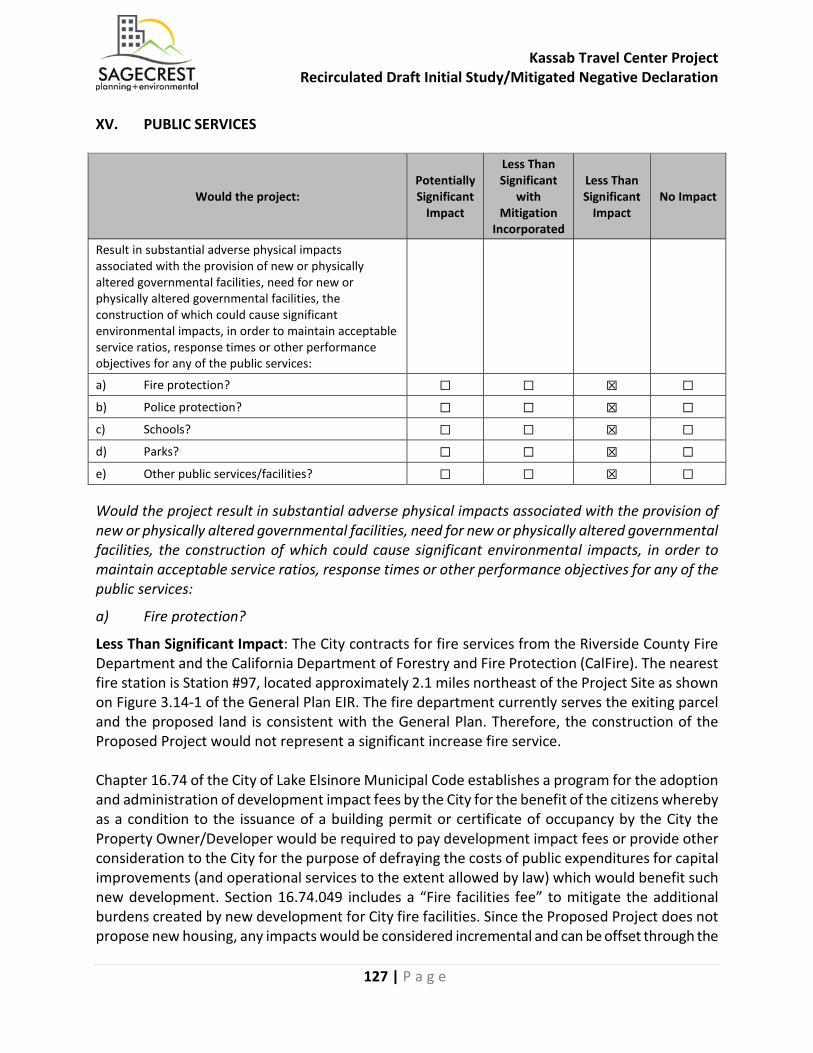
Kassab Travel Center Project Recirculated Draft Initial Study/Mitigated Negative Declaration
127 | P a g e
XV. PUBLIC SERVICES
Would the project: Potentially Significant
Impact
Less Than Significant
with Mitigation
Incorporated
Less Than Significant
Impact No Impact
Result in substantial adverse physical impacts associated with the provision of new or physically altered governmental facilities, need for new or physically altered governmental facilities, the construction of which could cause significant environmental impacts, in order to maintain acceptable service ratios, response times or other performance objectives for any of the public services:
a) Fire protection? ☐ ☐ ☒ ☐
b) Police protection? ☐ ☐ ☒ ☐
c) Schools? ☐ ☐ ☒ ☐
d) Parks? ☐ ☐ ☒ ☐
e) Other public services/facilities? ☐ ☐ ☒ ☐
Would the project result in substantial adverse physical impacts associated with the provision of new or physically altered governmental facilities, need for new or physically altered governmental facilities, the construction of which could cause significant environmental impacts, in order to maintain acceptable service ratios, response times or other performance objectives for any of the public services:
a) Fire protection?
Less Than Significant Impact: The City contracts for fire services from the Riverside County Fire Department and the California Department of Forestry and Fire Protection (CalFire). The nearest fire station is Station #97, located approximately 2.1 miles northeast of the Project Site as shown on Figure 3.14-1 of the General Plan EIR. The fire department currently serves the exiting parcel and the proposed land is consistent with the General Plan. Therefore, the construction of the Proposed Project would not represent a significant increase fire service. Chapter 16.74 of the City of Lake Elsinore Municipal Code establishes a program for the adoption and administration of development impact fees by the City for the benefit of the citizens whereby as a condition to the issuance of a building permit or certificate of occupancy by the City the Property Owner/Developer would be required to pay development impact fees or provide other consideration to the City for the purpose of defraying the costs of public expenditures for capital improvements (and operational services to the extent allowed by law) which would benefit such new development. Section 16.74.049 includes a “Fire facilities fee” to mitigate the additional burdens created by new development for City fire facilities. Since the Proposed Project does not propose new housing, any impacts would be considered incremental and can be offset through the
Kassab Travel Center Project Recirculated Draft Initial Study/Mitigated Negative Declaration
128 | P a g e
payment of the appropriate development impact fees. The Proposed Project would also be required to comply with all applicable fire code requirements for construction and access to the site and as such, would be reviewed by the City Fire Department to determine the specific fire requirements applicable to ensure compliance with these requirements. The Proposed Project would not result in substantial adverse physical impacts related to fire protection. Therefore, potential impacts associated with fire protection would be less than significant. Mitigation Measures: No mitigation measures are required. Sources: General Plan EIR Figure 3.14-1 Police and Fire Stations, LEMC
b) Police protection?
Less Than Significant Impact: Police protection services are provided by the Lake Elsinore Police Department (LEPD) under contract by the Riverside County Sheriff's Department (RCSD). The Lake Elsinore Police Department/Sheriff's Station is located at 333 Limited Avenue, approximately 2.7 miles southeast of the Project Site. Chapter 16.74 of the City’s Municipal Code establishes a program for the adoption and administration of development impact fees by the City for the purpose of defraying the costs of public expenditures for capital improvements (and operational services to the extent allowed by law) which would benefit such new development. The Proposed Project would participate in this development impact fee program to mitigate impacts to police protection resources. Any potential impacts would be considered incremental and can be offset through the payment of the development impact fee. The Proposed Project would not result in substantial adverse physical impacts related to police protection. Therefore, potential impacts associated with police projection would be less than significant. Mitigation Measures: No mitigation measures are required. Sources: General Plan EIR Figure 3.14-1 Police and Fire Stations, LEMC
c) Schools?
Less Than Significant Impact: The Project Site is located within the Lake Elsinore Unified School District (LEUSD) which serves most of the City of Lake Elsinore, all of the cities of Canyon Lake and Wildomar, and a portion of unincorporated Riverside County as shown in Figure 3.14-3 of the General Plan EIR. The Property Owner/Developer would be required to pay school impact fees as levied by the LEUSD, which would provide funding for school facilities. Since the Proposed Project does not propose new housing, any potential impacts would be considered incremental and can be offset through the payment of the appropriate development impact fees. The Proposed Project would not result in substantial adverse physical impacts related to schools. Therefore, potential impacts associated with schools would be less than significant. Mitigation Measures: No mitigation measures are required. Sources: General Plan EIR Figure 3.14-3 – Schools and District Boundaries
Kassab Travel Center Project Recirculated Draft Initial Study/Mitigated Negative Declaration
129 | P a g e
d) Parks?
Less Than Significant Impact: Since the Proposed Project does not propose residential uses, a direct increase in park uses is not expected as a result of Project implementation. Indirect impacts to park facilities from commercial development would be the occasional use of a park during a lunch or dinner break. Section 16.34.060 in Chapter 16.34 (Required Improvements) for the City’s Municipal Code requires that prior to the issuance of a building permit, the Property Owner/Developer pay fees for the purposes set forth in that section. Paragraph D of Section 16.34.060 describes the City’s Park Capital Improvement Fund and describes that the City Council has the option to request dedication for park purposes or in lieu thereof, request that the Property Owner/Developer pay a fee for the purpose of purchasing the land and developing and maintaining the City park system. As is consistent with all commercial projects, the Property Owner/Developer would be required to pay park fees to the City for the purpose of establishing, improving and maintaining park land within the City. Since the Proposed Project does not propose new housing, any potential impacts would be considered incremental and can be offset through the payment of the appropriate park fees. The Proposed Project would not result in substantial adverse physical impacts related to parks. Therefore, potential impacts associated with parks would be less than significant. Mitigation Measures: No mitigation measures are required. Sources: General Plan EIR, LEMC
e) Other public services/facilities?
Less Than Significant Impact: The City of Lake Elsinore is part of the Riverside County Library System. The nearest City of Lake Elsinore library to the Project Site is the Lake Elsinore Branch Library at 600 West Graham Avenue, approximately 2.7 miles southeast of the Project Site. Section 16.34.060 in Chapter 16.34 (Required Improvements) of the City’s Municipal Code requires that prior to the issuance of a building permit, the Property Owner/Developer pay fees for the purposes set forth in that section. Paragraph B of Section 16.34.060 describes the City’s Library Mitigation Fee and states that an in-lieu fee for future construction of library improvements shall be paid to the City to assure the necessary library facilities are provided the community. Since the Proposed Project does not propose new housing, any impacts would be considered incremental and can be offset through the payment of the appropriate library mitigation fees. Therefore, potential impacts associated with libraries would be less than significant.
Kassab Travel Center Project Recirculated Draft Initial Study/Mitigated Negative Declaration
130 | P a g e
Chapter 16.74 of the City’s Municipal Code establishes a program for the adoption and administration of development impact fees by the City for the purpose of defraying the costs of public expenditures for capital improvements (and operational services to the extent allowed by law) which would benefit such new development. Section 16.74.048 includes an “Animal shelter facilities fee” to mitigate the additional burdens created by new development for animal facilities. In addition, the Property Owner/Developer would be required to pay City Hall & Public Works fees, Community Center Fees, and Marina Facilities Fees prior to the issuance of building permits. Therefore, potential impacts associated with other public services and facilities would be less than significant. Mitigation Measures: No mitigation measures are required. Sources: General Plan EIR, LEMC

Kassab Travel Center Project Recirculated Draft Initial Study/Mitigated Negative Declaration
131 | P a g e
XVI. RECREATION
Would the project: Potentially Significant
Impact
Less Than Significant
with Mitigation
Incorporated
Less Than Significant
Impact No Impact
a) Increase the use of existing neighborhood and regional parks or other recreational facilities such that substantial physical deterioration of the facility would occur or be accelerated?
☐ ☐ ☒ ☐
b) Include recreational facilities or require the construction or expansion of recreational facilities which might have an adverse physical effect on the environment?
☐ ☐ ☐ ☒
a) Would the project increase the use of existing neighborhood and regional parks or other recreational facilities such that substantial physical deterioration of the facility would occur or be accelerated?
Less Than Significant Impact. The City of Lake Elsinore Parks and Recreation Master Plan 2008 – 2030 establishes a goal of providing five acres of park space per 1,000 residents. The Proposed Project does not include elements (e.g., residential development) that would result in substantial increased demands for neighborhood or regional parks or other recreational facilities. Indirect impacts to park facilities from commercial development would be the occasional use of a park during a lunch or dinner break. As shown on Figure 3.15-1 – Parks of the General Plan EIR, there are no parks located within a half mile of the Project Site. Therefore, it is unlikely that the Proposed Project would increase the use of existing parks. As described in Section XIV(d), the Property Owner/Developer would be required to pay park fees to the City for the purpose of establishing, improving and maintaining parkland within the City. Since the Proposed Project does not propose new housing, any impacts would be considered incremental and can be offset through the payment of the appropriate park fees. The Proposed Project would not increase the use of existing neighborhood and regional parks or other recreational facilities such that substantial physical deterioration of the facility would occur or be accelerated. Therefore, potential impacts associated with parks or recreational facilities would be less than significant. Mitigation Measures: No mitigation measures are required. Sources: General Plan EIR Figure 3.15-1 - Parks
Kassab Travel Center Project Recirculated Draft Initial Study/Mitigated Negative Declaration
132 | P a g e
b) Does the project include recreational facilities or require the construction or expansion of recreational facilities which might have an adverse physical effect on the environment?
No Impact. The Proposed Project involves the construction of a gas station, convenience store, and fast food restaurant. The Property Owner/Developer would be required to pay park fees to the City for the purpose of establishing, improving and maintaining park land within the City. The Proposed Project does not include recreational facilities and does not require the construction or expansion of recreational facilities which might have an adverse physical effect on the environment. Therefore, no impacts associated with recreational facilities would occur. Mitigation Measures: No mitigation measures are required. Sources: General Plan EIR, Project Description
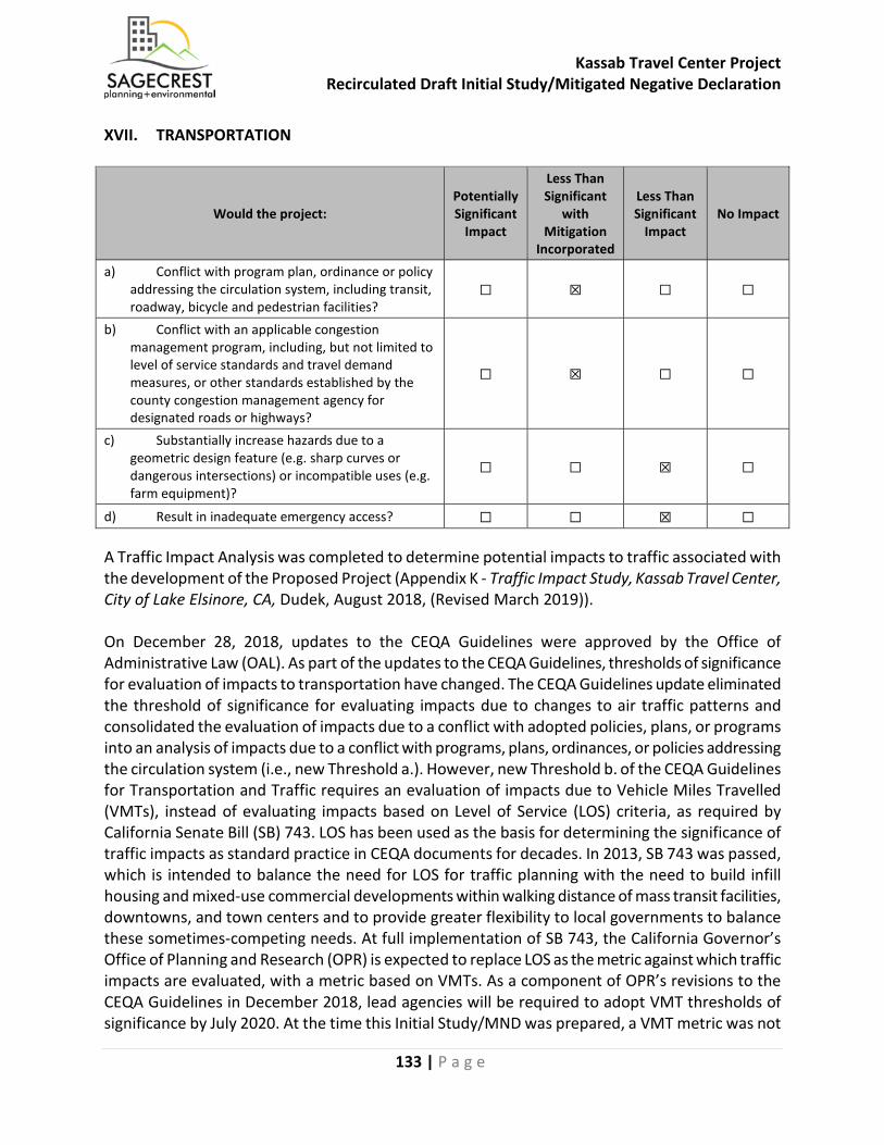
Kassab Travel Center Project Recirculated Draft Initial Study/Mitigated Negative Declaration
133 | P a g e
XVII. TRANSPORTATION
Would the project: Potentially Significant
Impact
Less Than Significant
with Mitigation
Incorporated
Less Than Significant
Impact No Impact
a) Conflict with program plan, ordinance or policy addressing the circulation system, including transit, roadway, bicycle and pedestrian facilities?
☐ ☒ ☐ ☐
b) Conflict with an applicable congestion management program, including, but not limited to level of service standards and travel demand measures, or other standards established by the county congestion management agency for designated roads or highways?
☐ ☒ ☐ ☐
c) Substantially increase hazards due to a geometric design feature (e.g. sharp curves or dangerous intersections) or incompatible uses (e.g. farm equipment)?
☐ ☐ ☒ ☐
d) Result in inadequate emergency access? ☐ ☐ ☒ ☐
A Traffic Impact Analysis was completed to determine potential impacts to traffic associated with the development of the Proposed Project (Appendix K - Traffic Impact Study, Kassab Travel Center, City of Lake Elsinore, CA, Dudek, August 2018, (Revised March 2019)). On December 28, 2018, updates to the CEQA Guidelines were approved by the Office of Administrative Law (OAL). As part of the updates to the CEQA Guidelines, thresholds of significance for evaluation of impacts to transportation have changed. The CEQA Guidelines update eliminated the threshold of significance for evaluating impacts due to changes to air traffic patterns and consolidated the evaluation of impacts due to a conflict with adopted policies, plans, or programs into an analysis of impacts due to a conflict with programs, plans, ordinances, or policies addressing the circulation system (i.e., new Threshold a.). However, new Threshold b. of the CEQA Guidelines for Transportation and Traffic requires an evaluation of impacts due to Vehicle Miles Travelled (VMTs), instead of evaluating impacts based on Level of Service (LOS) criteria, as required by California Senate Bill (SB) 743. LOS has been used as the basis for determining the significance of traffic impacts as standard practice in CEQA documents for decades. In 2013, SB 743 was passed, which is intended to balance the need for LOS for traffic planning with the need to build infill housing and mixed-use commercial developments within walking distance of mass transit facilities, downtowns, and town centers and to provide greater flexibility to local governments to balance these sometimes-competing needs. At full implementation of SB 743, the California Governor’s Office of Planning and Research (OPR) is expected to replace LOS as the metric against which traffic impacts are evaluated, with a metric based on VMTs. As a component of OPR’s revisions to the CEQA Guidelines in December 2018, lead agencies will be required to adopt VMT thresholds of significance by July 2020. At the time this Initial Study/MND was prepared, a VMT metric was not

Kassab Travel Center Project Recirculated Draft Initial Study/Mitigated Negative Declaration
134 | P a g e
published by OPR, and the City of Lake Elsinore in its capacity as Lead Agency, as well as surrounding local agencies in which the Proposed Project’s traffic would circulate, use LOS as the significance criteria for evaluating a project’s traffic impacts. For this reason, a LOS metric and not a VMT metric is appropriately used in this Initial Study/MND. Trip Generation The trip generation for the project was calculated using trip rates from the Institute of Transportation Engineers’ Trip Generation, 9th Edition (ITE 2012). Pass-by trip reductions for retail uses allow for a reduction of project trips at all offsite intersections as it assumes that existing and/or baseline (background) traffic, already traveling on the street network, would deviate from their pattern and create a pass-by trip to a retail use. For example, a driver that is already traveling from his office, back to his home (which is called the “primary” trip), may now decide to pass-by a retail use (e.g., to purchase goods or food, or utilize services, like banks or gas stations) now that this use is on his way home. At that point, his existing trip through the street network is now a pass-by trip to the retail use, and not a creation of a new trip on the street network by the retail use. Pass-by trip reduction percentages were researched in ITE’s Trip Generation Manual for the Proposed Project’s retail uses. The Proposed Project would generate a total of 4,190 daily trips, 298 AM peak hour trips, and 326 PM peak hour trips. With the application of pass-by trip reductions, the project would generate a net total of approximately 1,919 daily trips, 129 AM peak hour trips, and 148 PM peak hour trips. Trip Distribution and Assignment Based on the location of the Project Site, it is likely that most project trips would utilize the freeway ramps at Nichols Road and Central Avenue to travel on Interstate 15. Other project traffic would be distributed through Central Avenue and Riverside Drive. The Proposed Project’s trip distribution is shown in Appendix K, Figure 4. The resulting project trip assignment is shown on Appendix K, Figure 5. In addition, the project driveway trip assignment, detailing the total trip generation at driveways, is shown in Appendix K, Figure 6. Pass-by trip information is provided in Appendix K, Figure 7, detailing inbound and outbound pass-by trips. Existing Conditions Street System Characteristics of the existing street system in the vicinity of the Proposed Project are shown in Table 16 - Study Area Existing Street System Summary. Access to the project is proposed to be provided from a driveway on Collier Avenue and one driveway on Riverside Drive (SR-74). Riverside Transit Agency (RTA) Routes 8 and 22 provide weekday and weekend service along Collier Avenue (SR-74). There is a bus stop on the east side of Collier Avenue (SR-74) north of Riverside Drive. This stop is directly across the Project Site.
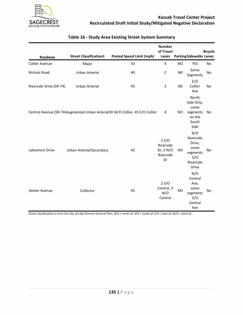
Kassab Travel Center Project Recirculated Draft Initial Study/Mitigated Negative Declaration
135 | P a g e
Table 16 - Study Area Existing Street System Summary
Roadway Street Classification1 Posted Speed Limit (mph)
Number of Travel
Lanes Parking Sidewalks Bicycle Lanes
Collier Avenue Major 50 4 NO YES No
Nichols Road Urban Arterial 40 2 N0 Some Segments No
Riverside Drive (SR-74) Urban Arterial 45 2 N0 E/O
Collier Ave
No
Central Avenue (SR-74) Augmented Urban Arterial 30 W/O Collier, 45 E/O Collier 4 NO
North Side Only,
some segments
on the South Side
No
Lakeshore Drive Urban Arterial/Secondary 45
2 S/O Riverside Dr, 5 N/O Riverside
Dr
NO
N/O Riverside
Drive, some
segments S/O
Riverside Drive
No
Dexter Avenue Collector 45
2 S/O Central, 3
N/O Central
NO
N/O Central
Ave, some
segments S/O
Central Ave
No
Street classification is from the City of Lake Elsinore General Plan, N/O = north of, S/O = south of, E/O = east of, W/O = west of
Kassab Travel Center Project Recirculated Draft Initial Study/Mitigated Negative Declaration
136 | P a g e
a) Conflict with program plan, ordinance or policy addressing the circulation system, including transit, roadway, bicycle and pedestrian facilities?
Less Than Significant Impact With Mitigation Incorporated: Existing Plus Project Traffic Analysis This section documents project-generated impacts on the surrounding transportation system and at the study intersections during the Existing plus Project condition. Traffic Volumes Existing plus Project traffic volumes were determined by adding the project traffic volumes to the Existing traffic volumes. Appendix K, Figure 10 shows the Existing plus Project weekday AM and PM peak hour traffic volumes. Intersection Operations An intersection operations analysis was conducted to evaluate the Existing plus Project weekday AM and PM peak hour conditions. Intersection operations were calculated using the LOS methodology described previously. Project-related improvements to the existing traffic controls or geometrics were assumed for Collier Avenue/Riverside. These improvements are as follows:
• Restripe existing northbound through-right to through-left-right movement • Reconfigure southbound approach to reflect cut into existing median to create larger
storage length for Collier Avenue driveway inbound access. o Restripe existing southbound through lane to shared through-left movement
The remainder of the traffic controls and geometrics illustrated in Appendix K, Figure 8 were assumed. The Proposed Project is expected to widen the north side of Riverside Drive along the project frontage. Table 17 - Existing plus Project Intersection Levels of Service provides a comparison between the Existing plus Project and Existing conditions for the weekday AM and PM peak hours. As shown in Table 17, most of the study area intersections are forecast to operate at LOS D or better with the project, except for the following intersections:
• I-15 NB Ramps/Nichols Road (remains at LOS F during the AM peak hour) • Collier Avenue/Nichols Road (LOS D to LOS E during the PM peak hour) • Gunnerson Street-Strickland Avenue/Riverside Drive (SR-74) (remains at LOS F during both
peak hours) These intersections would be considered significantly impacted as the project would contribute its traffic to an intersection that is forecast to operate less that the City standard of LOS D or would cause an intersection that is operating at LOS D or better, to LOS E or F. Mitigation measures for these intersections are discussed in the mitigation section.
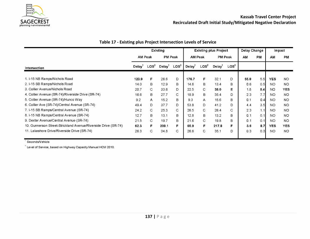
Kassab Travel Center Project Recirculated Draft Initial Study/Mitigated Negative Declaration
137 | P a g e
Table 17 - Existing plus Project Intersection Levels of Service
Kassab Travel Center Project Recirculated Draft Initial Study/Mitigated Negative Declaration
138 | P a g e
Existing plus Ambient Growth plus Project Traffic Analysis This section documents project-generated impacts on the surrounding transportation system and at the study intersections during the Existing plus Ambient Growth plus Project condition. Central Plaza Project The Central Plaza project is currently under construction on the southeast corner of Collier Avenue (SR-74)/Central Avenue (SR-74). The Proposed Project would widen the roadways along its frontage as well as provide the following alterations in geometry to the intersection:
• Northbound approach would consist of one left turn lane, two through lanes, and two right turn lanes with overlap phasing
These alterations have been included within the analysis for Existing plus Ambient Growth plus Project scenario in addition to the Existing plus Ambient Growth plus Project plus Cumulative Projects scenario. Due to these improvements over existing geometrics, some analyzed peak hours would contain a decrease in delay as compared to baseline condition. Traffic Volumes Existing plus Ambient Growth plus Project traffic volumes were determined by adding a growth rate of two (2) percent per year to the existing traffic volumes as directed by the City Traffic Engineer. Then, the project traffic volumes were added to the Existing plus Ambient Growth traffic volumes. Appendix K, Figure 11 shows the Existing plus Ambient Growth plus Project weekday AM and PM peak hour traffic volumes. Intersection Operations An intersection operations analysis was conducted to evaluate the Existing plus Ambient Growth plus Project weekday AM and PM peak hour conditions. Intersection operations were calculated using the LOS methodology described previously. Project-related improvements to the existing traffic controls or geometrics were assumed for Collier Avenue/Riverside as well as the improvements listed for the Central Plaza Project. These improvements are as follows:
• Modification to the existing traffic signal to accommodate new improvements • Restripe existing northbound through-right to through-left-right movement • Reconfigure southbound approach to reflect cut into existing median to create larger
storage length for Collier Avenue driveway inbound access. o Restripe existing southbound through lane to shared through-left movement
The remainder of the traffic controls and geometrics illustrated in Appendix K, Figure 8 were assumed. The Proposed Project is expected to widen the north side of Riverside Drive along the project frontage in the future, but the specific geometrics are unknown at this time. Table 18 - Existing plus Ambient Growth plus Project Intersection Levels of Service provides a comparison between the Existing plus Ambient Growth plus Project and Existing conditions for the weekday AM and PM peak hours.
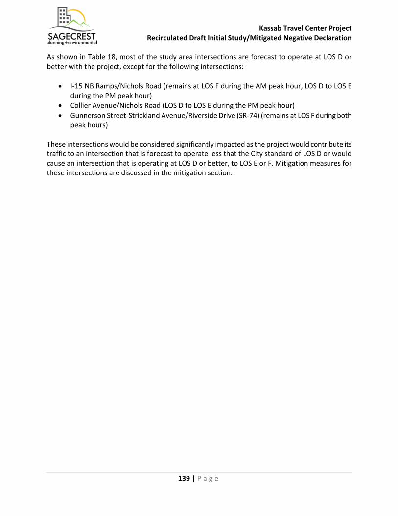
Kassab Travel Center Project Recirculated Draft Initial Study/Mitigated Negative Declaration
139 | P a g e
As shown in Table 18, most of the study area intersections are forecast to operate at LOS D or better with the project, except for the following intersections:
• I-15 NB Ramps/Nichols Road (remains at LOS F during the AM peak hour, LOS D to LOS E during the PM peak hour)
• Collier Avenue/Nichols Road (LOS D to LOS E during the PM peak hour) • Gunnerson Street-Strickland Avenue/Riverside Drive (SR-74) (remains at LOS F during both
peak hours) These intersections would be considered significantly impacted as the project would contribute its traffic to an intersection that is forecast to operate less that the City standard of LOS D or would cause an intersection that is operating at LOS D or better, to LOS E or F. Mitigation measures for these intersections are discussed in the mitigation section.
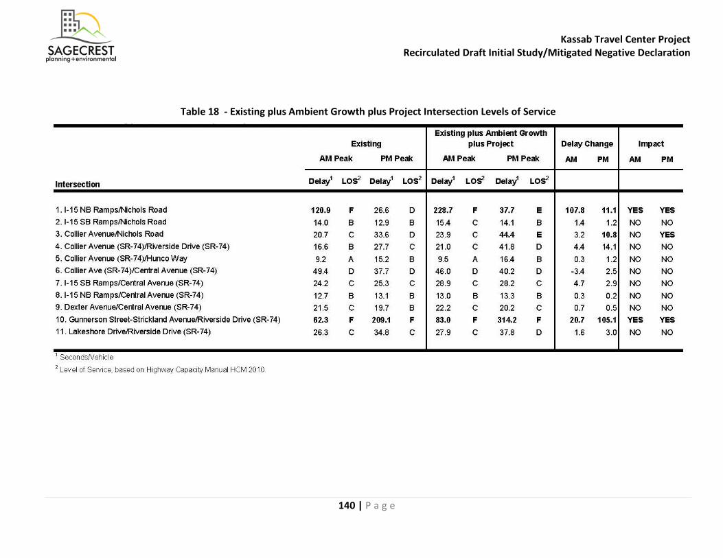
Kassab Travel Center Project Recirculated Draft Initial Study/Mitigated Negative Declaration
140 | P a g e
Table 18 - Existing plus Ambient Growth plus Project Intersection Levels of Service

Kassab Travel Center Project Recirculated Draft Initial Study/Mitigated Negative Declaration
141 | P a g e
This Page Intentionally Left Blank
Kassab Travel Center Project Recirculated Draft Initial Study/Mitigated Negative Declaration
142 | P a g e
Existing plus Ambient Growth plus Project plus Cumulative Projects Traffic Analysis This section documents project-generated impacts in the cumulative condition on the surrounding transportation system and at the study intersections during the Existing plus Ambient Growth plus Project plus Cumulative Projects condition. Traffic Volumes Existing plus Ambient Growth plus Project plus Cumulative Projects traffic volumes were determined by adding a growth rate of two (2) percent per year to the existing traffic volumes as directed by the City Traffic Engineer. In addition, any traffic from cumulative (approved/ pending) projects were added to the study area intersections. City staff provided a list of cumulative projects. Most of the projects were collated from the nearby Central Plaza project as well as other traffic impact studies. Appendix D of the Traffic Impact Analysis (Appendix K) provides information concerning the distribution and assignment of these projects, as well as the exact locations of each. Trip generation estimates for these projects are based on application of trip rates from the Institute of Transportation Engineers’ Trip Generation, 9th Edition (ITE 2012), and are presented in Table 19 - Cumulative Projects Trip Generation Estimates. As shown in Table 19, the cumulative projects in the study area would generate approximately 472,917 daily trips, 30,065 AM peak hour trips and 45,496 PM peak hour trips. The resulting Existing plus Ambient Growth plus Project plus Cumulative Projects Peak Hour Traffic Volumes are illustrated in Appendix K, Figure 13. Intersection Operations An intersection operations analysis was conducted in the study area to evaluate the Existing plus Ambient Growth plus Project plus Cumulative Projects weekday AM and PM peak hour conditions with the project. Intersection operations were calculated using the LOS methodology described previously. The approved Central Plaza project would be improving its frontages along Collier Avenue and Central Avenue (SR-74) with the following roadway improvements:
• Collier Avenue/Central Avenue (SR-74) o addition of second northbound through lane o addition of second northbound right turn lane
• I-15 southbound ramps/Central Avenue (SR-74)
o addition of third eastbound through lane

Kassab Travel Center Project Recirculated Draft Initial Study/Mitigated Negative Declaration
143 | P a g e
Table 19 - Cumulative Projects Trip Generation Estimates

Kassab Travel Center Project Recirculated Draft Initial Study/Mitigated Negative Declaration
144 | P a g e

Kassab Travel Center Project Recirculated Draft Initial Study/Mitigated Negative Declaration
145 | P a g e
The Proposed Project would be expected to widen the north side of Riverside Drive along the project frontage in the future, but the specific geometrics are unknown at this time. Table 20 - Existing plus Ambient Growth plus Project plus Cumulative Projects Intersection Levels of Service provides the Existing plus Ambient Growth plus Project plus Cumulative Projects conditions for the weekday AM and PM peak hours. As shown in Table 20, all of the study area intersection are forecast to operate at LOS D or better with the project, except for the following intersections:
• I-15 NB Ramps/Nichols Road (LOS F during both peak hours) • Collier Avenue/Nichols Road (LOS E during the AM peak hour and LOS F during the PM peak
hour) • Collier Avenue (SR-74)/Central Avenue (SR-74) (LOS E during both peak hours) • I-15 SB Ramps/Central Avenue (SR-74) (LOS F during the PM peak hour) • Dexter Avenue/Central Avenue (SR-74) (LOS E during the AM peak hour) • Gunnerson Street-Strickland Avenue/Riverside Drive (SR-74) (LOS F during both peak hours)
These intersections would be considered impacted as they would already contribute to an LOS that is less that the City standard of LOS D. Mitigation measures for these intersections are discussed in the mitigation section.
Table 20 - Existing plus Ambient Growth plus Project plus Cumulative Projects
Intersection Levels of Service
Kassab Travel Center Project Recirculated Draft Initial Study/Mitigated Negative Declaration
146 | P a g e
Roadway Segment Analysis The Proposed Project is forecast to generate a net of approximately 1,919 average daily trips. An average daily traffic (ADT) roadway segment analysis for the following segments was conducted, based on input from City Staff:
• Riverside Drive (SR-74), west of Collier Avenue • Collier Avenue, north of Riverside Drive (SR-74) • Collier Avenue, south of Riverside Drive (SR-74)
Traffic volumes for Collier Avenue, north of Riverside Drive (SR-74) were collected in May 2017. Traffic volumes for Collier Avenue between Riverside Drive (SR-74) and Central Avenue were collected in June 2017. Traffic volumes for Riverside Drive (SR-74), west of Collier Drive were collected in August 2017. Riverside Drive (SR-74), west of Collier Avenue is currently operating at LOS E-F under existing conditions and is forecast to continue to operate at LOS E-F under Existing plus Ambient Growth plus Project Conditions, as well as with the addition of traffic from cumulative projects (Existing plus Ambient Growth plus Project plus Cumulative Projects). Collier Avenue, south of Riverside Drive (SR-74) in the Existing plus Ambient Growth plus Project plus Cumulative Projects condition is forecast to degrade to LOS F with the addition of Cumulative Project traffic. Currently, Riverside Drive (SR-74), along the Project Site’s frontage, is also not constructed to its ultimate Urban Arterial width of 96 feet, curb-to-curb. It is currently unimproved (i.e., no curb-and-gutter), and has approximately 48 to 52 feet of pavement. The Property Owner/Developer would dedicate between 21 feet and 36 feet (street tapers in toward the west) in order to allow their half-section of Riverside Drive to be consistent with the Urban Arterial (half) cross section (center median, three travel lanes, six-foot bike lane, and six-foot sidewalk – in one direction). The Proposed Project would follow Caltrans standards to improve its section of Riverside Drive. Street improvements on the north side of Riverside Drive (SR-74), along the Project Site’s frontage, would conform with Caltrans roadway design standards. The roadway segment of Riverside Drive west of Collier Avenue is part of the Transportation Uniform Mitigation Fee (TUMF) network and will be improved to its ultimate width utilizing fee credits. However, with the improvements listed above, and the addition of project traffic (approximately 540 ADT), this segment of Riverside Drive (SR-74) is forecast to continue to operate at LOS E-F under both conditions.
Kassab Travel Center Project Recirculated Draft Initial Study/Mitigated Negative Declaration
147 | P a g e
Special Issues: Queuing, Collier Avenue/Riverside Drive Geometry, Truck Turn Radii, Class II Bike Lane, and Pedestrian Safety Analyses This section documents the following special issues requested to be addressed by City staff and Caltrans:
o Intersection queuing o Collier Avenue (SR-74)/Riverside Drive (SR-74) conceptual geometry o On-site truck turn radii o Class II bicycle lane on Riverside Drive (SR-74) o Pedestrian safety analysis
Queuing Analysis A queuing analysis was conducted to determine the vehicle queues for turning movements at the study area intersections. In addition, the queuing analysis illustrates how much the queuing might increase with the addition of traffic from the Proposed Project. The queuing analysis is based on the Synchro LOS analysis which reports the 95th percentile (design) queues, consistent with HCM 2010. Existing plus Project Table 21 - Existing and Existing plus Project Queuing Analysis presents the queuing analysis for the Existing and Existing plus Project scenario. Table 21 also illustrates the existing turning pocket length, if available, and the change in the queue length with the addition of the project. It should be noted that all of the queue lengths shown below are also exceeded in the Existing (without project) condition. As shown in Table 21, the following intersections/movements are expected to exceed the existing turn pocket (queue storage) length in the Existing plus Project condition:
• I-15 NB Ramps/Nichols Road o NBR pocket length = 50’, queue length = 76’
• I-15 SB Ramps/Nichols Road o SBR pocket length = 50’, queue length = 67’
• Collier Avenue (SR-74)/Hunco Way o SBL pocket length = 220’, queue length = 265’
• Collier Avenue (SR-74)/Central Avenue (SR-74) o EBL pocket length = 150’, queue length = 179’ o NBL pocket length = 100’, queue length = 127’ o NBR pocket length = 50’, queue length = 85’
• I-15 SB Ramps/Central Avenue (SR-74) o SBL pocket length = 100’, queue length = 149’ o SBR pocket length = 100’, queue length = 165’
• I-15 NB Ramps/Central Avenue (SR-74) o NBL pocket length = 100’, queue length = 175’ o NBR pocket length = 100’, queue length = 162’
• Dexter Avenue/Central Avenue (SR-74) o NBL pocket length = 120’, queue length = 142’

Kassab Travel Center Project Recirculated Draft Initial Study/Mitigated Negative Declaration
148 | P a g e
• SBR pocket length = 150’, queue length = 188’Lakeshore Drive/Riverside Drive (SR-74) o EBL pocket length = 150’, queue length = 199’ o EBR pocket length = 225’, queue length = 341’ o NBL pocket length = 130’, queue length = 185’ o SBL pocket length = 150’, queue length = 204’
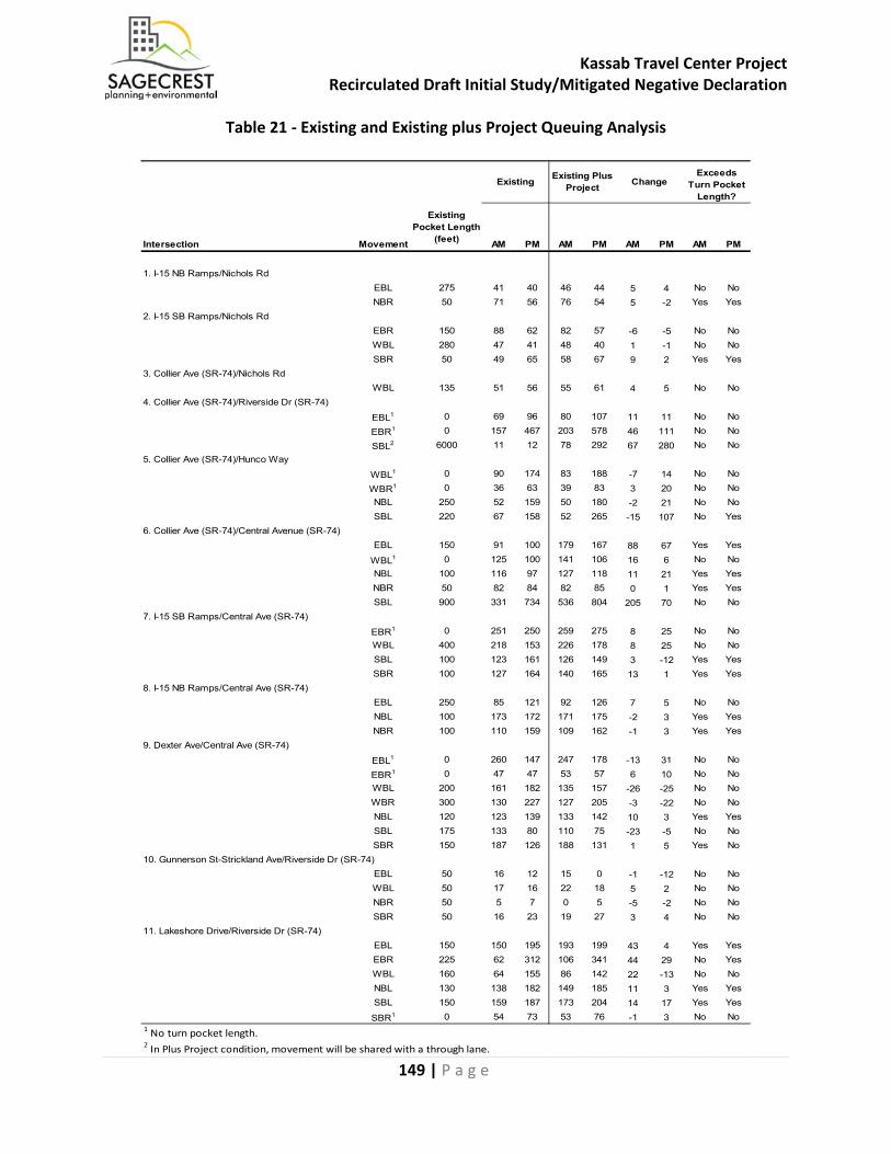
Kassab Travel Center Project Recirculated Draft Initial Study/Mitigated Negative Declaration
149 | P a g e
Intersection Movement
Existing Pocket Length
(feet) AM PM AM PM AM PM AM PM
1. I-15 NB Ramps/Nichols RdEBL 275 41 40 46 44 5 4 No NoNBR 50 71 56 76 54 5 -2 Yes Yes
2. I-15 SB Ramps/Nichols RdEBR 150 88 62 82 57 -6 -5 No NoWBL 280 47 41 48 40 1 -1 No NoSBR 50 49 65 58 67 9 2 Yes Yes
3. Collier Ave (SR-74)/Nichols RdWBL 135 51 56 55 61 4 5 No No
4. Collier Ave (SR-74)/Riverside Dr (SR-74)
EBL1 0 69 96 80 107 11 11 No No
EBR1 0 157 467 203 578 46 111 No No
SBL2 6000 11 12 78 292 67 280 No No5. Collier Ave (SR-74)/Hunco Way
WBL1 0 90 174 83 188 -7 14 No No
WBR1 0 36 63 39 83 3 20 No NoNBL 250 52 159 50 180 -2 21 No NoSBL 220 67 158 52 265 -15 107 No Yes
6. Collier Ave (SR-74)/Central Avenue (SR-74)EBL 150 91 100 179 167 88 67 Yes Yes
WBL1 0 125 100 141 106 16 6 No NoNBL 100 116 97 127 118 11 21 Yes YesNBR 50 82 84 82 85 0 1 Yes YesSBL 900 331 734 536 804 205 70 No No
7. I-15 SB Ramps/Central Ave (SR-74)
EBR1 0 251 250 259 275 8 25 No NoWBL 400 218 153 226 178 8 25 No NoSBL 100 123 161 126 149 3 -12 Yes YesSBR 100 127 164 140 165 13 1 Yes Yes
8. I-15 NB Ramps/Central Ave (SR-74)EBL 250 85 121 92 126 7 5 No NoNBL 100 173 172 171 175 -2 3 Yes YesNBR 100 110 159 109 162 -1 3 Yes Yes
9. Dexter Ave/Central Ave (SR-74)
EBL1 0 260 147 247 178 -13 31 No No
EBR1 0 47 47 53 57 6 10 No NoWBL 200 161 182 135 157 -26 -25 No NoWBR 300 130 227 127 205 -3 -22 No NoNBL 120 123 139 133 142 10 3 Yes YesSBL 175 133 80 110 75 -23 -5 No NoSBR 150 187 126 188 131 1 5 Yes No
10. Gunnerson St-Strickland Ave/Riverside Dr (SR-74)EBL 50 16 12 15 0 -1 -12 No NoWBL 50 17 16 22 18 5 2 No NoNBR 50 5 7 0 5 -5 -2 No NoSBR 50 16 23 19 27 3 4 No No
11. Lakeshore Drive/Riverside Dr (SR-74)EBL 150 150 195 193 199 43 4 Yes YesEBR 225 62 312 106 341 44 29 No YesWBL 160 64 155 86 142 22 -13 No NoNBL 130 138 182 149 185 11 3 Yes YesSBL 150 159 187 173 204 14 17 Yes Yes
SBR1 0 54 73 53 76 -1 3 No No1 No turn pocket length.2 In Plus Project condition, movement will be shared with a through lane.
Existing Existing Plus Project Change
Exceeds Turn Pocket
Length?
Table 21 - Existing and Existing plus Project Queuing Analysis
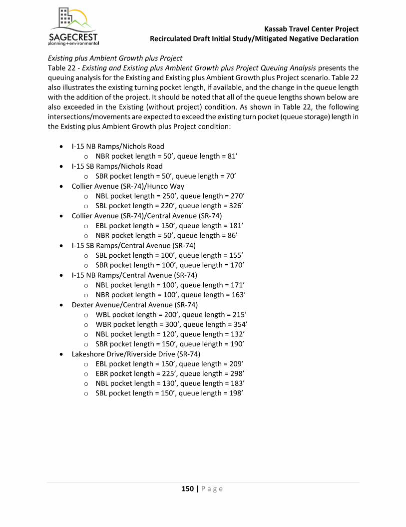
Kassab Travel Center Project Recirculated Draft Initial Study/Mitigated Negative Declaration
150 | P a g e
Existing plus Ambient Growth plus Project Table 22 - Existing and Existing plus Ambient Growth plus Project Queuing Analysis presents the queuing analysis for the Existing and Existing plus Ambient Growth plus Project scenario. Table 22 also illustrates the existing turning pocket length, if available, and the change in the queue length with the addition of the project. It should be noted that all of the queue lengths shown below are also exceeded in the Existing (without project) condition. As shown in Table 22, the following intersections/movements are expected to exceed the existing turn pocket (queue storage) length in the Existing plus Ambient Growth plus Project condition:
• I-15 NB Ramps/Nichols Road o NBR pocket length = 50’, queue length = 81’
• I-15 SB Ramps/Nichols Road o SBR pocket length = 50’, queue length = 70’
• Collier Avenue (SR-74)/Hunco Way o NBL pocket length = 250’, queue length = 270’ o SBL pocket length = 220’, queue length = 326’
• Collier Avenue (SR-74)/Central Avenue (SR-74) o EBL pocket length = 150’, queue length = 181’ o NBR pocket length = 50’, queue length = 86’
• I-15 SB Ramps/Central Avenue (SR-74) o SBL pocket length = 100’, queue length = 155’ o SBR pocket length = 100’, queue length = 170’
• I-15 NB Ramps/Central Avenue (SR-74) o NBL pocket length = 100’, queue length = 171’ o NBR pocket length = 100’, queue length = 163’
• Dexter Avenue/Central Avenue (SR-74) o WBL pocket length = 200’, queue length = 215’ o WBR pocket length = 300’, queue length = 354’ o NBL pocket length = 120’, queue length = 132’ o SBR pocket length = 150’, queue length = 190’
• Lakeshore Drive/Riverside Drive (SR-74) o EBL pocket length = 150’, queue length = 209’ o EBR pocket length = 225’, queue length = 298’ o NBL pocket length = 130’, queue length = 183’ o SBL pocket length = 150’, queue length = 198’
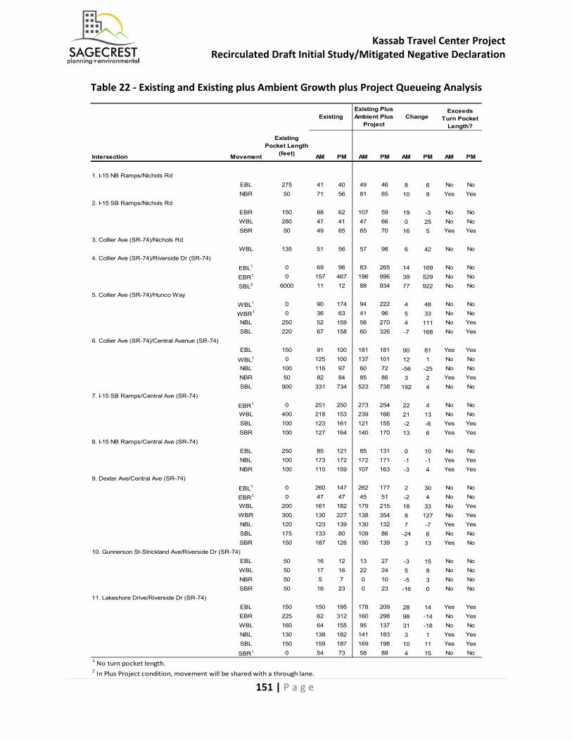
Kassab Travel Center Project Recirculated Draft Initial Study/Mitigated Negative Declaration
151 | P a g e
Table 22 - Existing and Existing plus Ambient Growth plus Project Queueing Analysis
Intersection Movement
Existing Pocket Length
(feet) AM PM AM PM AM PM AM PM
1. I-15 NB Ramps/Nichols RdEBL 275 41 40 49 46 8 6 No NoNBR 50 71 56 81 65 10 9 Yes Yes
2. I-15 SB Ramps/Nichols RdEBR 150 88 62 107 59 19 -3 No NoWBL 280 47 41 47 66 0 25 No NoSBR 50 49 65 65 70 16 5 Yes Yes
3. Collier Ave (SR-74)/Nichols RdWBL 135 51 56 57 98 6 42 No No
4. Collier Ave (SR-74)/Riverside Dr (SR-74)
EBL1 0 69 96 83 265 14 169 No No
EBR1 0 157 467 196 996 39 529 No No
SBL2 6000 11 12 88 934 77 922 No No5. Collier Ave (SR-74)/Hunco Way
WBL1 0 90 174 94 222 4 48 No No
WBR1 0 36 63 41 96 5 33 No NoNBL 250 52 159 56 270 4 111 No YesSBL 220 67 158 60 326 -7 168 No Yes
6. Collier Ave (SR-74)/Central Avenue (SR-74)EBL 150 91 100 181 181 90 81 Yes Yes
WBL1 0 125 100 137 101 12 1 No NoNBL 100 116 97 60 72 -56 -25 No NoNBR 50 82 84 85 86 3 2 Yes YesSBL 900 331 734 523 738 192 4 No No
7. I-15 SB Ramps/Central Ave (SR-74)
EBR1 0 251 250 273 254 22 4 No NoWBL 400 218 153 239 166 21 13 No NoSBL 100 123 161 121 155 -2 -6 Yes YesSBR 100 127 164 140 170 13 6 Yes Yes
8. I-15 NB Ramps/Central Ave (SR-74)EBL 250 85 121 85 131 0 10 No NoNBL 100 173 172 172 171 -1 -1 Yes YesNBR 100 110 159 107 163 -3 4 Yes Yes
9. Dexter Ave/Central Ave (SR-74)
EBL1 0 260 147 262 177 2 30 No No
EBR1 0 47 47 45 51 -2 4 No NoWBL 200 161 182 179 215 18 33 No YesWBR 300 130 227 138 354 8 127 No YesNBL 120 123 139 130 132 7 -7 Yes YesSBL 175 133 80 109 86 -24 6 No NoSBR 150 187 126 190 139 3 13 Yes No
10. Gunnerson St-Strickland Ave/Riverside Dr (SR-74)EBL 50 16 12 13 27 -3 15 No NoWBL 50 17 16 22 24 5 8 No NoNBR 50 5 7 0 10 -5 3 No NoSBR 50 16 23 0 23 -16 0 No No
11. Lakeshore Drive/Riverside Dr (SR-74)EBL 150 150 195 178 209 28 14 Yes YesEBR 225 62 312 160 298 98 -14 No YesWBL 160 64 155 95 137 31 -18 No NoNBL 130 138 182 141 183 3 1 Yes YesSBL 150 159 187 169 198 10 11 Yes Yes
SBR1 0 54 73 58 88 4 15 No No1 No turn pocket length.2 In Plus Project condition, movement will be shared with a through lane.
Exceeds Turn Pocket
Length?Existing
Existing Plus Ambient Plus
ProjectChange
Kassab Travel Center Project Recirculated Draft Initial Study/Mitigated Negative Declaration
152 | P a g e
Existing plus Ambient Growth plus Project plus Cumulative Projects Table 23 - Existing plus Ambient Growth plus Project plus Cumulative Queuing Analysis presents the queuing analysis for the Existing plus Ambient Growth plus Project plus Cumulative Projects scenario. Table 23 also illustrates the existing turning pocket length, if available, and the change in the queue length with the addition of the project. It should be noted that most of the queue lengths shown below are also exceeded in the Existing condition. As shown in Table 23, the following intersections/movements are expected to exceed the existing turn pocket (queue storage) length in the Existing plus Ambient Growth plus Project plus Cumulative Projects condition:
• I-15 NB Ramps/Nichols Road o NBR pocket length = 50’, queue length = 86’
• I-15 SB Ramps/Nichols Road o SBR pocket length = 50’, queue length = 85’
• Collier Avenue/Nichols Road o WBL pocket length = 135’, queue length = 231’
• Collier Avenue (SR-74)/Hunco Way o NBL pocket length = 250’, queue length = 279’ o SBL pocket length = 220’, queue length = 312’
• Collier Avenue (SR-74)/Central Avenue (SR-74) o EBL pocket length = 150’, queue length = 207’ o NBL pocket length = 100’, queue length = 106’ o NBR pocket length = 50’, queue length = 78’
• I-15 SB Ramps/Central Avenue (SR-74) o SBL pocket length = 100’, queue length = 171’ o SBR pocket length = 100’, queue length = 169’
• I-15 NB Ramps/Central Avenue (SR-74) o NBL pocket length = 100’, queue length = 168’ o NBR pocket length = 100’, queue length = 154’
• Dexter Avenue/Central Avenue (SR-74) o WBL pocket length = 200’, queue length = 274’ o WBR pocket length = 300’, queue length = 425’ o NBL pocket length = 120’, queue length = 147’ o SBR pocket length = 150’, queue length = 202’
• Lakeshore Drive/Riverside Drive (SR-74) o EBL pocket length = 150’, queue length = 250’ o EBR pocket length = 225’, queue length = 356’ o WBL pocket length = 160’, queue length = 193’ o NBL pocket length = 130’, queue length = 181’ o NBR pocket length = 300’, queue length = 334’ o SBL pocket length = 150’, queue length = 199’
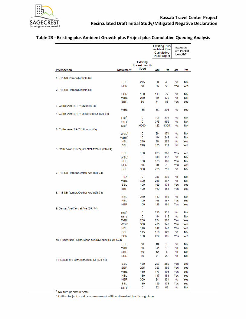
Kassab Travel Center Project Recirculated Draft Initial Study/Mitigated Negative Declaration
153 | P a g e
Table 23 - Existing plus Ambient Growth plus Project plus Cumulative Queuing Analysis
Kassab Travel Center Project Recirculated Draft Initial Study/Mitigated Negative Declaration
154 | P a g e
Collier Avenue (SR-74)/Central Avenue (SR-74) Conceptual Geometry Per the City’s General Plan Roadway Classifications (Figure 2.3 of General Plan), Collier Avenue, north of Riverside Drive (along the Project Site’s frontage), is classified as a Major roadway with four lanes and a 100-foot right-of-way (80 feet, curb-to-curb). Riverside Drive (SR-74), west of Collier Avenue (along the Project Site’s frontage), is classified as an Urban Arterial with six lanes and a 120-foot right-of-way (96 feet, curb-to-curb). Currently, Collier Avenue, along the Project Site’s frontage, is not constructed to its ultimate Major roadway width of 80 feet, curb-to-curb. It is approximately 76 feet, curb-to-curb. The Property Owner/Developer would dedicate approximately ten feet in order to allow their half-section of Collier Avenue to be consistent with the Major roadway (half) cross section (center median, two travel lanes, six-foot bike lane, and five-foot sidewalk – in one direction). Street improvements on the west side of Collier Avenue, along the Project Site’s frontage, would conform with City roadway design standards. These improvements would be constructed to be consistent with the General Plan and the City’s Standard Plans. Currently, Riverside Drive (SR-74), along the Project Site’s frontage, is also not constructed to its ultimate Urban Arterial width of 96 feet, curb-to-curb. It is currently unimproved (i.e., no curb-and-gutter), and has approximately 48 to 52 feet of pavement. The Property Owner/Developer would dedicate between 21 feet and 36 feet (street tapers in toward the west) in order to allow their half-section of Riverside Drive to be consistent with the Urban Arterial (half) cross section (center median, three travel lanes, six-foot bike lane, and six-foot sidewalk – in one direction). With the street dedication on the north side (project frontage), the pavement width would be approximately 74 feet (48 feet from curb face to new centerline, plus 26 feet of existing pavement on the south side of the street). The Property Owner/Developer would follow Caltrans standards to improve its section of Riverside Drive. Street improvements on the north side of Riverside Drive (SR-74), along the Project Site’s frontage, would conform with Caltrans roadway design standards. On-site Truck Turning Radii As shown in the site plan for the Proposed Project, truck turning templates for a semi-trailer truck (heavy truck) or fuel transport truck have been placed on the two driveways (driveway on Riverside Drive, and driveway on Collier Avenue). The truck turning templates have also been placed at the (underground) fuel storage tanks on site. All truck turning templates show there is adequate space for large trailer trucks and recreational vehicles (RVs) to maneuver through the Project Site and driveways. The Proposed Project is not designed, nor intended, to serve heavy, long-haul trucks, but mainly to serve local residents, visitors, and RVs traveling through the area (on I-15 or SR-74). Also, fuel distribution trucks typically arrive at the site to refill the underground storage tanks during the off-peak hours of the business (i.e., late nights, or early mornings).
Kassab Travel Center Project Recirculated Draft Initial Study/Mitigated Negative Declaration
155 | P a g e
Class II Bicycle Lane on Riverside Drive (SR-74) The Property Owner/Developer would dedicate between 21 feet and 36 feet (street tapers in toward the west) in order to allow their half-section of Riverside Drive to be consistent with the Urban Arterial (half) cross section (center median, three travel lanes, six-foot bike lane, and six-foot sidewalk – in one direction). With the street dedication on the north side (project frontage), the pavement width would be approximately 74 feet (48 feet from curb face to new centerline, plus 26 feet of existing pavement on the south side of the street). Street improvements on the north side of Riverside Drive (SR-74), along the Project Site’s frontage, include a new six-foot wide bike lane (Class (II – striped, on-pavement) consistent with the City’s General Plan Circulation Element. Pedestrian Safety Analysis Pedestrian facilities, in the form of sidewalks, are proposed along the Project Site’s frontages on Collier Avenue and Riverside Drive. These sidewalks are shown to be five feet in width on Collier Avenue and six feet in width on Riverside Drive; and, would be constructed to be consistent with Caltrans and the City’s Standard Plans. The proposed sidewalk on the west side of Collier Avenue would connect to the existing sidewalk north of the Project Site, which provides continuous pedestrian access to the adjacent retail and industrial uses, including the Outlets at Lake Elsinore, further to the north. The proposed sidewalk on the north side of Riverside Drive would be constructed just along the project frontage, as there are no other existing pedestrian facilities to connect with west of the Project Site. On site, pedestrian connections, in the form of landscape cut-outs connected to striped crosswalks, are provided adjacent to the gas station convenience mart (on Collier Avenue), and adjacent to the fast-food restaurant (on Riverside Drive). Pedestrians using these connections from the sidewalks on Collier Avenue and Riverside Drive would have direct access to those buildings. Additionally, pedestrian crosswalks and internal sidewalks are provided from each building (convenience mart and fast-food restaurant) to their respective trash enclosure areas. The locations of these crosswalks provide the shortest path from the buildings to the trash enclosures, reducing the length of time employees are in vehicle paths while going to the trash enclosures. The on-site parking areas have been designed to be as close to the buildings as possible, and the buildings have surrounding sidewalks to keep patrons off the vehicle drive aisles.
Kassab Travel Center Project Recirculated Draft Initial Study/Mitigated Negative Declaration
156 | P a g e
Mitigation Measures: The incorporation of the MM TRAF-1, MM TRAF-2, MM TRAF-3, MM TRAF-4, MM TRAF-5, and MM TRAF-6 defined below would reduce the Proposed Project’s impacts to a level of less than significant per the City’s significance criteria. MM TRAF – 1: Prior to issuance of Certificate of Occupancy, the Property Owner/Developer shall pay its fair-share to construct the following improvements
• Intersection #1: I-15 NB Ramps/Nichols Road – – Although the peak hour volumes at this intersection would satisfy the peak hour signal warrant for the AM peak hour, a signal is not needed to improve LOS back to LOS D or better. The following improvement is needed to mitigate intersection LOS:
o Convert this intersection into an all-way-stop. With this mitigation, the intersection is forecast to operate at LOS B during both the AM and PM.
MM TRAF – 2: Prior to issuance of Certificate of Occupancy, the Property Owner/Developer shall construct the following improvements
• Intersection #3: Collier Avenue/Nichols Road – Although the peak hour volumes at this intersection would satisfy the peak hour signal warrant for the PM peak hour, a signal is not needed to improve LOS back to LOS D or better. The following improvement would mitigate intersection LOS without the installation of a traffic signal:
o Convert this intersection into an all-way-stop. With this mitigation, the intersection is forecast to operate at LOS D during the AM peak hour and LOS C during the PM peak hour.
In order to analyze the potential air quality impacts associated with the implementation of MM TRAF-1 and MM TRAF-2, the intersection delays for Intersections #1 and #3 were analyzed and the greatest increase in delay from implementation of an all-way stop would occur at Intersection #3 for the Existing + Ambient + Cumulative + Project AM Peak hour scenario. The delay without mitigation is 4.2 seconds per vehicle and the delay with mitigation is 27.4 seconds per vehicle, which equates to a 23.2 second per vehicle increase. The traffic volume for this intersection is 1,159 vehicles per hour for the AM Peak hour, resulting in an additional 26,889 seconds or 7.47 hours of idling during the AM Peak hour. The 7.47 hours were calculated against the idling emission rates provided in the CalEEMod model run for Light Duty Trucks, which found that the additional idling would create 0.13 grams of ROG (0.0003 pounds), 0.67 grams of NOx (0.0015 pounds), 1.10 grams of CO (0.0024 pounds), 0.001 grams of SOx, 0.01 grams of PM10, and 0.01 grams of PM2.5. As shown on Table 5 in Section III(b), potential air quality impacts as a result of implementation of MM TRAF – 1 and MM TRAF – 2 would be less than significant.

Kassab Travel Center Project Recirculated Draft Initial Study/Mitigated Negative Declaration
157 | P a g e
MM TRAF – 3: Prior to issuance of Certificate of Occupancy, the Property Owner/Developer shall construct the following improvements
• Intersection #6: Collier Avenue (SR-74)/Central Avenue (SR-74) – The following improvement is needed to mitigate intersection LOS:
o Modify existing traffic signal to accommodate new improvements. o Restripe two southbound through lanes to one southbound through and one
southbound through-left lane. With this mitigation, the intersection is forecast to operate at LOS D during both the AM and PM peak hour.
MM TRAF – 4: Prior to issuance of Certificate of Occupancy, the Property Owner/Developer shall pay its fair-share to construct the following improvements
• Intersection #7: I-15 SB Ramps/Central Avenue (SR-74) – The following improvement is needed to mitigate intersection LOS:
o Install a third eastbound through lane and install a second (dual) southbound left turn lane. With this mitigation, the intersection is forecast to operate at LOS C during the AM peak hour.
MM TRAF – 5: Prior to issuance of Certificate of Occupancy, the Property Owner/Developer shall pay its fair-share to construct the following improvements
• Intersection #9: Dexter Avenue /Central Avenue (SR-74) – The following improvement is needed to mitigate intersection LOS:
o Change northbound left turn phasing to protected-permitted. With this mitigation, the intersection is forecast to operate at LOS D during the AM peak hour.
MM TRAF – 6: Prior to issuance of Certificate of Occupancy, the Property Owner/Developer shall pay its fair-share to construct the following improvements
• Intersection #10: Gunnerson Street-Strickland Avenue/Riverside Drive (SR-74) –The following improvement is needed to mitigate intersection LOS:
o Convert this intersection into a signalized intersection when the traffic volumes would satisfy signal warrants. With this mitigation, the intersection is forecast to operate at LOS B during the AM peak hour and LOS C during the PM peak hour.
Table 24 – Existing Plus Project LOS with Mitigation Measures, and Table 25 – Existing Plus Ambient Growth plus Project LOS with Mitigation Measures show that with implementation of MM TRAF-1 through MM TRAF-6; potential impacts to Intersection 1, Intersection 3, and Intersection 10 would be less than significant.
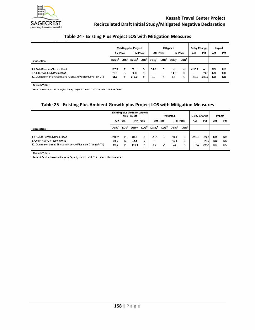
Kassab Travel Center Project Recirculated Draft Initial Study/Mitigated Negative Declaration
158 | P a g e
Table 24 - Existing Plus Project LOS with Mitigation Measures
Table 25 - Existing Plus Ambient Growth plus Project LOS with Mitigation Measures

Kassab Travel Center Project Recirculated Draft Initial Study/Mitigated Negative Declaration
159 | P a g e
Table 26 – Existing Plus Ambient Growth plus Project plus Cumulative Projects LOS with Mitigation Measures shows that with implementation of MM TRAF-1 through MM TRAF-6, potential cumulative impacts to Intersection 1, Intersection 3, Intersection 6, Intersection 7, Intersection 9, and Intersection 10 would be less than significant.
Table 26 - Existing Plus Ambient Growth plus Project plus Cumulative Projects LOS with Mitigation Measures
Table 27 – Project Fair Share shows the percentage of the total cost of the improvements listed in the mitigation measures that require a Fair Share contribution to the improvements required of the Property Owner/Developer.
Table 27 - Project Fair Share

Kassab Travel Center Project Recirculated Draft Initial Study/Mitigated Negative Declaration
160 | P a g e
Summary All roadway segments operate at LOS D or better and would operate within the City’s standard of LOS D, except for Riverside Drive (SR-74), west of Collier Avenue. This segment is currently operating at LOS E-F under existing conditions and is forecast to continue to operate at LOS E-F under Existing plus Ambient Growth plus Project conditions, as well as with the addition of traffic from cumulative projects (Existing plus Ambient Growth plus Project plus Cumulative Projects). Collier Avenue, south of Riverside Drive (SR-74) in the Existing plus Ambient Growth plus Project plus Cumulative Projects condition is forecast to degrade to LOS F with the addition of Cumulative Project traffic. The Proposed Project would restripe the southbound approach at Collier Avenue/Riverside Drive (SR-74) to consist of one right lane and one shared-left lane in order to construct an additional northbound left-turn lane for the Collier Avenue driveway. The Proposed Project would provide two driveways, along Riverside Drive (SR-74) and Collier Avenue. As per discussion with Caltrans, the Riverside Drive driveway would be restricted to right in right out movements. The Collier Avenue driveway, as per approval from the City, would be constructed as a full access driveway with two approaching southbound lanes, and one northbound left turn lane providing access to the site. For both driveways there would be one lane for entering and one lane for exiting, with a width of 50 feet, providing ample space for larger vehicles to enter the site without restricting vehicles exiting. Currently, Riverside Drive (SR-74), along the Project Site’s frontage, is also not constructed to its ultimate Urban Arterial width of 96 feet, curb-to-curb. It is currently unimproved (i.e., no curb-and-gutter), and has approximately 48 to 52 feet of pavement. The Property Owner/Developer would dedicate between 21 feet and 36 feet (street tapers in toward the west) in order to allow their half-section of Riverside Drive to be consistent with the Urban Arterial (half) cross section (center median, three travel lanes, six-foot bike lane, and six-foot sidewalk – in one direction). The Proposed Project would follow Caltrans standards to improve its section of Riverside Drive. Street improvements on the north side of Riverside Drive (SR-74), along the Project Site’s frontage, would conform with Caltrans roadway design standards. The roadway segment of Riverside Drive, west of Collier Avenue is part of the TUMF network and is to be improved to its ultimate width using fee credits. However, with the project improvements listed above, and the addition of project traffic (approximately 540 ADT), this segment of Riverside Drive (SR-74) is forecast to continue to operate at LOS E-F under both conditions. The Proposed Project’s fair share percentage for the roadway segment of Riverside Drive (SR-74), west of Collier Avenue would be 5.2 percent. Collier Avenue, south of Riverside Drive (SR-74), with the addition of project traffic (approximately 1,056 ADT), this segment of Collier Avenue (SR-74) is forecast to continue to operate LOS E-F under Existing plus Ambient Growth plus Project conditions. The Proposed Project’s fair share percentage for the roadway segment of Collier Avenue, south of Riverside Drive (SR-74) would be 9.6 percent. Sources: Traffic Impact Analysis (Appendix K)
Kassab Travel Center Project Recirculated Draft Initial Study/Mitigated Negative Declaration
161 | P a g e
b) Conflict with an applicable congestion management program, including, but not limited to level of service standards and travel demand measures, or other standards established by the county congestion management agency for designated roads or highways?
Less Than Significant Impact With Mitigation Incorporated: Each county in California is required to develop a Congestion Management Program (CMP) that analyzes at the links between land use, transportation and air quality. Riverside County Transportation Commission (RCTC) is the designated agency in Lake Elsinore for Congestion Management Plans (CMP). The Project Site is located on the northwesterly side of Riverside Drive (SR-74) and Collier Avenue (SR-74). The City has coordinated with the California Department of Transportation (Caltrans) with the review of the Proposed Project, as Caltrans is the owner and operator of the State Highway System (SHS). All the study intersections and roadway segments, with the exception of the intersection of Collier Avenue/Nichols Road, are facilities monitored in the Riverside County CMP (2011). These facilities have been analyzed within the technical Traffic Impact Analysis (Dudek, 2018) for potential impacts and mitigation measures (where required) and have been summarized within Section XVI(a). Where impacts are present, the Proposed Project would mitigate as needed, and pay into the Riverside County Transportation Uniform Mitigation Fees (TUMF). Additionally, CMP LOS criteria is LOS E or better, and the study area has been analyzed with the City’s criteria of LOS D or better. Therefore, all analysis results and mitigation measures reported in the TIA will also meet the CMP LOS criteria of LOS E or better and there would be no conflict between the Project and the Riverside County CMP. Currently, Riverside Drive (SR-74), along the Project Site’s frontage, is not constructed to its ultimate Urban Arterial width of 96 feet, curb-to-curb. It is currently unimproved (i.e., no curb-and-gutter), and has approximately 48 to 52 feet of pavement. The Property Owner/Developer would dedicate between 21 feet and 36 feet (street tapers in toward the west) in order to allow their half-section of Riverside Drive to be consistent with the Urban Arterial (half) cross section (center median, three travel lanes, six-foot bike lane, and six-foot sidewalk – in one direction). The Proposed Project would follow Caltrans standards to improve its section of Riverside Drive. Street improvements on the north side of Riverside Drive (SR-74), along the Project Site’s frontage, would conform with Caltrans roadway design standards. The roadway segment of Riverside Drive, west of Collier Avenue is part of the TUMF network and is to be improved to its ultimate width using fee credits. However, with the project improvements listed above, and the addition of project traffic (approximately 540 ADT), this segment of Riverside Drive (SR-74) is forecast to continue to operate at LOS E-F under both conditions. The Proposed Project’s fair share percentage for the roadway segment of Riverside Drive (SR-74), west of Collier Avenue would be 5.2 percent. Collier Avenue, south of Riverside Drive (SR-74), with the addition of project traffic (approximately 1,056 ADT), this segment of Collier Avenue (SR-74) is forecast to continue to operate LOS E-F under Existing plus Ambient Growth plus Project conditions. The Proposed Project’s fair share percentage for the roadway segment of Collier Avenue, south of Riverside Drive (SR-74) would be 9.6 percent.
Kassab Travel Center Project Recirculated Draft Initial Study/Mitigated Negative Declaration
162 | P a g e
With implementation of MM TRAF-1 through MM TRAF-6, potential impacts associated with conflict with a CMP would be less than significant. Mitigation Measures: MM TRAF-1, MM TRAF-2, MM TRAF-3, MM-TRAF 4, MM TRAF -5 and MM TRAF-6 Sources: General Plan EIR, RCTC CMP, TCA, Traffic Impact Analysis (Appendix K)
c) Substantially increase hazards due to a geometric design feature (e.g. sharp curves or dangerous intersections) or incompatible uses (e.g. farm equipment)?
Less than Significant Impact. The Proposed Project would not increase hazards due to design features or incompatible uses. The Proposed Project would be consistent with the on-site and surrounding zoning designations, and implementation of the Proposed Project would not introduce incompatible uses to the Project Area. The Proposed Project would not include any offsite features that would extend into the public right-of-way or otherwise interfere with circulation or result in traffic hazards. The Proposed Project has been designed to limit the turning movements on Riverside Drive to right-in, right-out only, therefore eliminating left turn movements from the driveway that would cross the median and potentially cause traffic conflicts with the Riverside Drive/Collier Avenue intersection. Therefore, potential impacts associated with hazardous geometric design features would be less than significant. Mitigation Measures: No mitigation measures are required. Sources: General Plan EIR, Zoning Map, Project Description
d) Result in inadequate emergency access?
Less Than Significant Impact: The Proposed Project would be constructed on a vacant lot on the northwest corner of Collier Avenue and Riverside Drive, both of which would be improved to their ultimate right-of-way along the frontage of the Project Site as part of the Proposed Project. The Project Site would be accessible by emergency vehicles at each of its two driveways, one each on Collier Avenue and Riverside Drive. Therefore, potential impacts to emergency access would be less than significant. Mitigation Measures: No mitigation measures are required. Sources: Project Description, Traffic Impact Analysis (Appendix K)
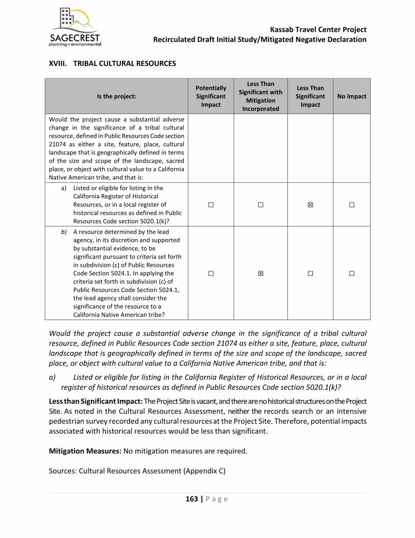
Kassab Travel Center Project Recirculated Draft Initial Study/Mitigated Negative Declaration
163 | P a g e
XVIII. TRIBAL CULTURAL RESOURCES
Is the project: Potentially Significant
Impact
Less Than Significant with
Mitigation Incorporated
Less Than Significant
Impact No Impact
Would the project cause a substantial adverse change in the significance of a tribal cultural resource, defined in Public Resources Code section 21074 as either a site, feature, place, cultural landscape that is geographically defined in terms of the size and scope of the landscape, sacred place, or object with cultural value to a California Native American tribe, and that is:
a) Listed or eligible for listing in the California Register of Historical Resources, or in a local register of historical resources as defined in Public Resources Code section 5020.1(k)?
☐ ☐ ☒ ☐
b) A resource determined by the lead agency, in its discretion and supported by substantial evidence, to be significant pursuant to criteria set forth in subdivision (c) of Public Resources Code Section 5024.1. In applying the criteria set forth in subdivision (c) of Public Resources Code Section 5024.1, the lead agency shall consider the significance of the resource to a California Native American tribe?
☐ ☒ ☐ ☐
Would the project cause a substantial adverse change in the significance of a tribal cultural resource, defined in Public Resources Code section 21074 as either a site, feature, place, cultural landscape that is geographically defined in terms of the size and scope of the landscape, sacred place, or object with cultural value to a California Native American tribe, and that is:
a) Listed or eligible for listing in the California Register of Historical Resources, or in a local register of historical resources as defined in Public Resources Code section 5020.1(k)?
Less than Significant Impact: The Project Site is vacant, and there are no historical structures on the Project Site. As noted in the Cultural Resources Assessment, neither the records search or an intensive pedestrian survey recorded any cultural resources at the Project Site. Therefore, potential impacts associated with historical resources would be less than significant. Mitigation Measures: No mitigation measures are required. Sources: Cultural Resources Assessment (Appendix C)
Kassab Travel Center Project Recirculated Draft Initial Study/Mitigated Negative Declaration
164 | P a g e
b) A resource determined by the lead agency, in its discretion and supported by substantial evidence, to be significant pursuant to criteria set forth in subdivision (c) of Public Resources Code Section 5024.1. In applying the criteria set forth in subdivision (c) of Public Resources Code Section 5024.1, the lead agency shall consider the significance of the resource to a California Native American tribe?
Less than Significant Impact with Mitigation Incorporated. Assembly Bill 52 (AB 52), signed into law in 2014, amended CEQA and established new requirements for tribal notification and consultation. AB 52 applies to all projects for which a notice of preparation or notice of intent to adopt a negative declaration/mitigated negative declaration is issued after July 1, 2015. AB 52 also broadly defines a new resource category of tribal cultural resources and established a more robust process for meaningful consultation that includes:
• Prescribed notification and response timelines; • Consultation on alternatives, resource identification, significance determinations, impact
evaluation, and mitigation measures; and • Documentation of all consultation efforts to support CEQA findings.
A tribe must submit a written request to the relevant lead agency if it wishes to be notified of projects within its traditionally and culturally affiliated area. The lead agency must provide written, formal notification to the tribes that have requested it within 14 days of determining that a project application is complete or deciding to undertake a project. The tribe must respond to the lead agency within 30 days of receipt of the notification if it wishes to engage in consultation on the project, and the lead agency must begin the consultation process within 30 days of receiving the request for consultation. Consultation concludes when either 1) the parties agree to mitigation measures to avoid a significant effect, if one exists, on a tribal cultural resource, or 2) a party, acting in good faith and after reasonable effort, concludes that mutual agreement cannot be reached. AB 52 also addresses confidentiality during tribal consultation per Public Resources Code §21082.3(c). On December 20, 2017, the City provided written notification of the Project in accordance with AB 52 to all of the Native American tribes that requested to receive such notification from the City. Of the tribes notified, the Rincon Band of Luiseño Indians, the Pechanga Band of Luiseno Indians, and the Soboba Band of Luiseño Indians requested formal government-to-government consultation under AB 52. The City met with Pechanga on May 21, 2018 and with Soboba on May 22, 2018. The City sent recommended mitigation measures to both Pechanga and Soboba on September 5, 2018 and to Rincon September 19, 2018. Consultation with Soboba was concluded on September 19, 2018, with Pechanga on November 7, 2018, and with Rincon on January 30, 2019. As a result of these consultations, with implementation of MM CUL-1 through MM CUL-5 in Section V, Cultural Resources of this Initial Study, AB52 consultation with Soboba and Pechanga have been concluded and potential impacts associated with Tribal Cultural Resources would be less than significant.
Mitigation Measures: MM CUL-1, MM CUL-2, MM CUL-3, MM CUL-4, and MM CUL-5
Sources: Cultural Resources Assessment (Appendix C), City of Lake Elsinore

Kassab Travel Center Project Recirculated Draft Initial Study/Mitigated Negative Declaration
165 | P a g e
XIX. UTILITIES AND SERVICE SYSTEMS
Would the project: Potentially Significant
Impact
Less Than Significant
with Mitigation
Incorporated
Less Than Significant
Impact No Impact
a) Require or result in the relocation or construction of new or expanded water, wastewater treatment or storm water drainage, electric power, natural gas, or telecommunications facilities, the construction or relocation of which could cause significant environmental effects?
☐ ☐ ☒ ☐
b) Have sufficient water supplies available to serve the project and reasonably foreseeable future development during normal, dry and multiple dry years?
☐ ☐ ☒ ☐
c) Result in a determination by the wastewater treatment provider, which serves or may serve the project that it has adequate capacity to serve the project’s projected demand in addition to the provider’s existing commitments?
☐ ☐ ☒ ☐
d) Generate solid waste in excess of State or local standards, or in excess of the capacity of local infrastructure, or otherwise impair the attainment of solid waste reduction goals?
☐ ☐ ☒ ☐
e) Comply with federal, state, and local management and reduction statutes and regulations related to solid waste?
☐ ☐ ☒ ☐
The Applicant was issued a Will Serve letter by the Elsinore Valley Municipal Water District (Appendix L – Service Planning Letter #3069-0, Elsinore Valley Municipal Water District, March 23, 2018).
a) Require or result in the relocation or construction of new or expanded water, wastewater treatment or storm water drainage, electric power, natural gas, or telecommunications facilities, the construction or relocation of which could cause significant environmental effects?
Less Than Significant Impact: The Proposed Project would be within the service boundary for the EVMWD. The EVMWD issued Service Planning Letter #3069-0 (Appendix L) to the Applicant on March 23, 2018, in which the EVMWD determined that water is available to serve the Proposed Project and a sewer line extension would be required on Collier Avenue, which would be constructed as part of the Proposed Project. The Proposed Project would be served by the existing water and wastewater treatment facilities, and the Property Owner/Developer would pay all development impacts fees associated with water and wastewater service. Therefore, potential impacts associated with water or wastewater treatment facilities would be less than significant.
Mitigation Measures: No mitigation measures are required.
Sources: EVMWD, General Plan EIR, LEMC, Service Planning Letter (Appendix L)
Kassab Travel Center Project Recirculated Draft Initial Study/Mitigated Negative Declaration
166 | P a g e
b) Have sufficient water supplies available to serve the project and reasonably foreseeable future development during normal, dry and multiple dry years?
Less Than Significant Impact: EVMWD obtains its potable water supplies from imported water from Metropolitan Water District (MWD), local surface water from Canyon Lake, and local groundwater from the Elsinore Basin. According to EVMWD’s 2015 Urban Water Management Plan (UWMP), EVMWD has determined that its current and anticipated future supplies are sufficient to meet the projected dry-year and multiple dry-year demand. The EVMWD issued Service Planning Letter #3069-0 (Appendix L) to the Applicant on March 23, 2018, in which the EVMWD determined that water is available to serve the Proposed Project and a sewer line extension would be required on Collier Avenue, which would be constructed as part of the Proposed Project. There are sufficient water supplies as well as water shortage contingency plans to protect existing and future water needs within the EVMWD service area. Therefore, potential impacts associated with water supplies would be less than significant. Mitigation Measures: No mitigation measures are required. Sources: EVMWD, General Plan EIR, Service Planning Letter (Appendix L)
c) Result in a determination by the wastewater treatment provider, which serves or may serve the project that it has adequate capacity to serve the project’s projected demand in addition to the provider’s existing commitments?
Less Than Significant Impact: The EVMWD is responsible for the City’s wastewater treatment plant. The EVMWD issued Service Planning Letter #3069-0 (Appendix L) to the Applicant on March 23, 2018, in which the EVMWD determined that water is available to serve the Proposed Project and a sewer line extension would be required on Collier Avenue, which would be constructed as part of the Proposed Project. The Property Owner/Developer would be required to pay development impacts fees. Therefore, potential impacts associated with wastewater treatment capacity would be less than significant. Mitigation Measures: No mitigation measures are required. Sources: EVMWD, Service Planning Letter (Appendix L)
d) Generate solid waste in excess of State or local standards, or in excess of the capacity of local infrastructure, or otherwise impair the attainment of solid waste reduction goals?
Less Than Significant Impact. CR&R, Inc. Environmental Services is the solid waste disposal service provider for the City of Lake Elsinore and parts of Riverside County. Riverside County Department of Waste Resources (RCDWR) facilitates waste management services for Riverside County. These services are provided on a countywide basis, and each private or public entity determines which landfill or transfer station to use, which is mostly based on geographic proximity. The landfills typically used by the City of Lake Elsinore are the El Sobrante, Badlands, and Lamb Canyon Landfills. All three of the landfills are Class III municipal solid waste landfills. El Sobrante Landfill is expected to reach capacity by 2045. Badlands Landfill is expected to reach capacity by 2024 and Lamb Canyon Landfill by 2021. Both Badlands and Lamb Canyon Landfills have the potential to expand
Kassab Travel Center Project Recirculated Draft Initial Study/Mitigated Negative Declaration
167 | P a g e
their facilities and capacity. Chapter 14.12 of the LEMC requires that project applicant divert a minimum of 50 percent of construction and demolition debris, and the Property Owner/Developer would meet this requirement. The existing landfills have sufficient capacity to serve the Proposed Project, and recycling and green waste collection would reduce overall solid waste generated. Therefore, potential impacts associated with solid waste disposal would be less than significant. Mitigation Measures: No mitigation measures are required. Sources: General Plan EIR, LEMC
e) Comply with federal, state, and local statutes and regulations related to solid waste?
Less Than Significant Impact: The California Integrated Waste Management Act of 1989 (AB 939, Sher, Chapter 1095, Statutes of 1989 as amended [IWMA]) under the Public Resource Code requires that local jurisdictions divert at least 50 percent of all solid waste generated by January 1, 2000, and 50% diversion each year following. As of 2006, the City achieved a 50 percent waste diversion rate. In addition, Chapter 14.12 of the LEMC requires that project applicant divert a minimum of 50 percent of construction and demolition debris, and the Property Owner/Developer would meet this requirement. The Proposed Project would comply with federal, state, and local statutes and regulations related to solid waste. Therefore, potential impacts associated with solid waste would be less than significant. Mitigation Measures: No mitigation measures are required. Sources: General Plan EIR, PRC, LEMC
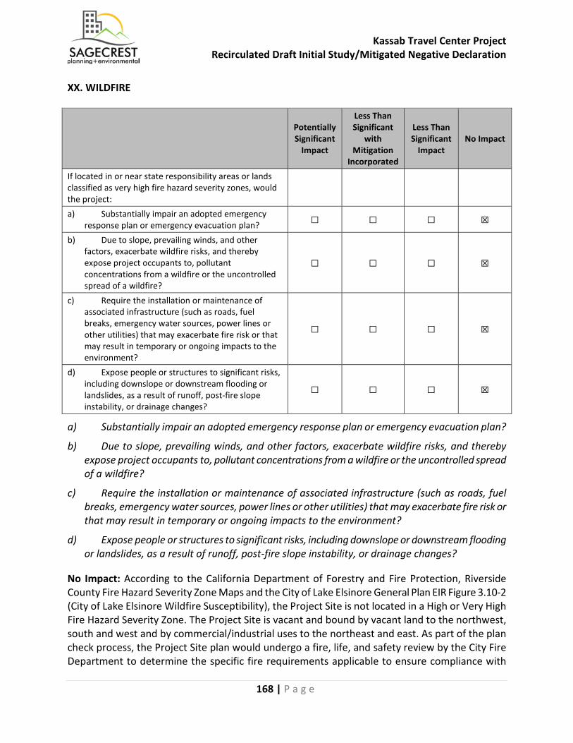
Kassab Travel Center Project Recirculated Draft Initial Study/Mitigated Negative Declaration
168 | P a g e
XX. WILDFIRE
Potentially Significant
Impact
Less Than Significant
with Mitigation
Incorporated
Less Than Significant
Impact No Impact
If located in or near state responsibility areas or lands classified as very high fire hazard severity zones, would the project:
a) Substantially impair an adopted emergency response plan or emergency evacuation plan? ☐ ☐ ☐ ☒
b) Due to slope, prevailing winds, and other factors, exacerbate wildfire risks, and thereby expose project occupants to, pollutant concentrations from a wildfire or the uncontrolled spread of a wildfire?
☐ ☐ ☐ ☒
c) Require the installation or maintenance of associated infrastructure (such as roads, fuel breaks, emergency water sources, power lines or other utilities) that may exacerbate fire risk or that may result in temporary or ongoing impacts to the environment?
☐ ☐ ☐ ☒
d) Expose people or structures to significant risks, including downslope or downstream flooding or landslides, as a result of runoff, post-fire slope instability, or drainage changes?
☐ ☐ ☐ ☒
a) Substantially impair an adopted emergency response plan or emergency evacuation plan?
b) Due to slope, prevailing winds, and other factors, exacerbate wildfire risks, and thereby expose project occupants to, pollutant concentrations from a wildfire or the uncontrolled spread of a wildfire?
c) Require the installation or maintenance of associated infrastructure (such as roads, fuel breaks, emergency water sources, power lines or other utilities) that may exacerbate fire risk or that may result in temporary or ongoing impacts to the environment?
d) Expose people or structures to significant risks, including downslope or downstream flooding or landslides, as a result of runoff, post-fire slope instability, or drainage changes?
No Impact: According to the California Department of Forestry and Fire Protection, Riverside County Fire Hazard Severity Zone Maps and the City of Lake Elsinore General Plan EIR Figure 3.10-2 (City of Lake Elsinore Wildfire Susceptibility), the Project Site is not located in a High or Very High Fire Hazard Severity Zone. The Project Site is vacant and bound by vacant land to the northwest, south and west and by commercial/industrial uses to the northeast and east. As part of the plan check process, the Project Site plan would undergo a fire, life, and safety review by the City Fire Department to determine the specific fire requirements applicable to ensure compliance with

Kassab Travel Center Project Recirculated Draft Initial Study/Mitigated Negative Declaration
169 | P a g e
these requirements. Therefore, no impacts associated with wildland fires would occur. Mitigation Measures: No mitigation measures are required. Sources: California Department of Forestry and Fire Protection, Riverside County Fire Hazard Severity Zone Maps, General Plan EIR Figure 3.10-2 - City of Lake Elsinore Wildfire Susceptibility
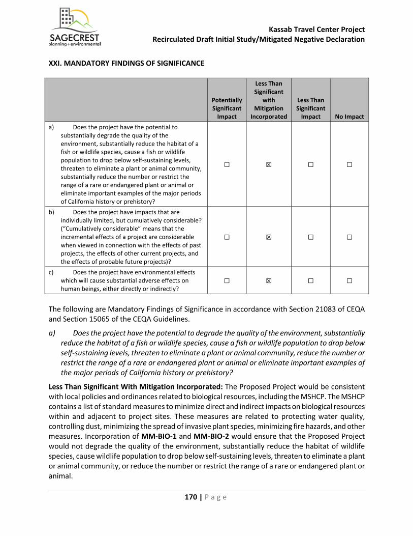
Kassab Travel Center Project Recirculated Draft Initial Study/Mitigated Negative Declaration
170 | P a g e
XXI. MANDATORY FINDINGS OF SIGNIFICANCE
Potentially Significant
Impact
Less Than Significant
with Mitigation
Incorporated
Less Than Significant
Impact No Impact a) Does the project have the potential to
substantially degrade the quality of the environment, substantially reduce the habitat of a fish or wildlife species, cause a fish or wildlife population to drop below self-sustaining levels, threaten to eliminate a plant or animal community, substantially reduce the number or restrict the range of a rare or endangered plant or animal or eliminate important examples of the major periods of California history or prehistory?
☐ ☒ ☐ ☐
b) Does the project have impacts that are individually limited, but cumulatively considerable? (“Cumulatively considerable” means that the incremental effects of a project are considerable when viewed in connection with the effects of past projects, the effects of other current projects, and the effects of probable future projects)?
☐ ☒ ☐ ☐
c) Does the project have environmental effects which will cause substantial adverse effects on human beings, either directly or indirectly?
☐ ☒ ☐ ☐
The following are Mandatory Findings of Significance in accordance with Section 21083 of CEQA and Section 15065 of the CEQA Guidelines.
a) Does the project have the potential to degrade the quality of the environment, substantially reduce the habitat of a fish or wildlife species, cause a fish or wildlife population to drop below self-sustaining levels, threaten to eliminate a plant or animal community, reduce the number or restrict the range of a rare or endangered plant or animal or eliminate important examples of the major periods of California history or prehistory?
Less Than Significant With Mitigation Incorporated: The Proposed Project would be consistent with local policies and ordinances related to biological resources, including the MSHCP. The MSHCP contains a list of standard measures to minimize direct and indirect impacts on biological resources within and adjacent to project sites. These measures are related to protecting water quality, controlling dust, minimizing the spread of invasive plant species, minimizing fire hazards, and other measures. Incorporation of MM-BIO-1 and MM-BIO-2 would ensure that the Proposed Project would not degrade the quality of the environment, substantially reduce the habitat of wildlife species, cause wildlife population to drop below self-sustaining levels, threaten to eliminate a plant or animal community, or reduce the number or restrict the range of a rare or endangered plant or animal.
Kassab Travel Center Project Recirculated Draft Initial Study/Mitigated Negative Declaration
171 | P a g e
According to the cultural resources assessment prepared for the Proposed Project, no cultural resources have been recorded within the Project Site, and the Project Site does not contain any resources that are important to major periods of California history or prehistory. However, fifteen cultural resources have been previously documented outside of the boundaries of the Project Site but within the one-mile search radius. These consist of one prehistoric archaeological site, three prehistoric archaeological isolates, six historic archaeological sites, two historic archaeological isolates and three historic built environment resources. Although the Project Site doesn’t contain any documented cultural resources, there still remains the possibility that undiscovered, buried resources (including archaeological and tribal cultural resources) might be encountered during construction. Incorporation of MM-CUL-1, MM CUL-2, MM CUL-3, MM CUL-4, MM CUL-5, and MM GEO-1 would reduce any potential impacts to any undiscovered resources to less than significant and ensure that the Proposed Project would not eliminate important examples of the major periods of California history or prehistory. Mitigation Measures: MM-BIO-1, MM-BIO-2, MM-CUL-1, MM CUL-2, MM CUL-3, MM CUL-4, MM CUL-5, and MM GEO-1 Sources: Kassab Travel Center Project Initial Study
b) Does the project have impacts that are individually limited, but cumulatively considerable? (“Cumulatively considerable” means that the incremental effects of a project are considerable when viewed in connection with the effects of past projects, the effects of other current projects, and the effects of probable future projects)?
Less Than Significant With Mitigation Incorporated: The Proposed Project would result in potentially significant project-specific impacts to biological resources, cultural resources, noise, tribal cultural resources, and transportation/traffic impacts. However, all mitigation measures have been identified that would reduce these impacts to less than significant levels. The Air Quality and Transportation/Traffic analyses of this document considered cumulative impacts in their respective analyses, and mitigation measures would be required to reduce cumulative impacts associated with Transportation/Traffic. No additional mitigation measures would be required to reduce cumulative impacts to less than significant levels. Mitigation Measures: MM TRAF-1, MM TRAF-2, MM TRAF-3, MM-TRAF 4, MM TRAF -5, MM TRAF-6 Sources: Kassab Travel Center Project Initial Study
Kassab Travel Center Project Recirculated Draft Initial Study/Mitigated Negative Declaration
172 | P a g e
c) Does the project have environmental effects which will cause substantial adverse effects on human beings, either directly or indirectly?
Less Than Significant With Mitigation Incorporated: All potential impacts of the Proposed Project have been identified, and mitigation measures have been provided, where applicable, to reduce potential impacts to less than significant levels. Upon implementation of mitigation measures, the Proposed Project would not have the potential to result in substantial adverse impacts on human beings either directly or indirectly. Mitigation Measures: No additional mitigation measures would be required. Sources: Kassab Travel Center Project Initial Study
Kassab Travel Center Project Recirculated Draft Initial Study/Mitigated Negative Declaration
173 | P a g e
VI. PERSONS AND ORGANIZATIONS CONSULTED This section identifies those persons who prepared or contributed to the preparation of this document. This section is prepared in accordance with Section 15129 of the CEQA Guidelines. City of Lake Elsinore Richard J. MacHott, LEED Green Associate, Planning Manager Damaris Abraham, Senior Planner Nick Lowe, PE|MS, Consultant Traffic Engineer Dina Purvis, Senior Engineering Technician California Department of Fish and Wildlife and the U.S. Fish and Wildlife Service (the Wildlife Agencies) Carly Beck, Environmental Scientist, California Department of Fish and Wildlife Regional Conservation Authority, Western Riverside County Elizabeth Dionne, RCA Ecological Resources Specialist California Department of Transportation – District 8 Kwasi Agyakwa, Transportation Planner Sagecrest Planning and Environmental Christine Saunders, Senior Project Manager Josh Haskins, Principal Dudek Dennis Pascua, Transportation Services Manager Mladen Popovic, MURP, AICP Candidate, Environmental Analyst/Transportation Planner Vista Environmental Greg Tonkovich, AICP Marisa Jue Psomas Amber Heredia Allison D. Rudalevige
Kassab Travel Center Project Recirculated Draft Initial Study/Mitigated Negative Declaration
174 | P a g e
Cogstone Holly Duke, Task Manager/Archaeologist Molly Valasik, M.A., Registered Professional Archaeologist Megan Wilson, Archaeologist/GIS Specialist Sherri Gust, Anthropologist Kim Scott, Principal Paleontologist Geoboden, Inc. Cyrus Radvar, Principal Engineer GeoRox Engineering Alex Shirazi, P.E. Rahman Engineering Services, Inc. Moksudur Rahman, P.E. Karaki Western States Engineering Joseph Karaki, President Florentino Mendoza, Project Manager Ray Ojeda, Project Manager
Kassab Travel Center Project Recirculated Draft Initial Study/Mitigated Negative Declaration
175 | P a g e
VII. REFERENCES The following documents were used as information sources during preparation of this document. Except as noted, they are available for public review at the City of Lake Elsinore, Community Development Department, 130 South Main Street, Lake Elsinore, CA 92530, ph. (951) 674-3124. Appendix A - Air Quality and Greenhouse Gas Emissions Impact Analysis, Kassab Travel Center Project, City of Lake Elsinore, Vista Environmental, September 2018, (Revised March 2019) Appendix B - Habitat Assessment for Kassab Travel Center, Psomas, April 2018 Appendix C - Cultural Resources Assessment Report for the Kassab Travel Center Project, City of Lake Elsinore, Cogstone, February 2018 Appendix D - Paleontological Resources Technical Report For The Kassab Travel Center Project, City Of Lake Elsinore, Cogstone, August 2017 Appendix E - Geotechnical Investigation Report Proposed Kassab Travel Center 29301 Riverside Drive, Geoboden Inc., December 2017 Appendix F - Infiltration/Percolation Testing for Stormwater Retention Proposed Kassab Travel Center, Geoboden Inc., December 2017 Appendix G - Phase I Environmental Site Assessment, 29301 Riverside Drive, Lake Elsinore, California 92530, GeoRox Engineering, March 2016 Appendix H - Hydrology Study, Rahman Engineering Service, Inc. January 2019 Appendix I - Project Specific Water Quality Management Plan, Kassab Travel Center, Rahman Engineering Services, January 2019 Appendix J - Noise Impact Analysis, Kassab Travel Center Project, City of Lake Elsinore, Vista Environmental, October 2018, (Revised July 2019) Appendix K - Traffic Impact Study, Kassab Travel Center, City of Lake Elsinore, CA, Dudek, August 2018, (Revised March 2019) Appendix L – Service Planning Letter #3069-0, Elsinore Valley Municipal Water District, March 23, 2018 Appendix M – Response to Comments on The Draft Initial Study/Mitigated Negative Declaration Environmental Review No. 2018-02, City of Lake Elsinore, February 2019
Kassab Travel Center Project Recirculated Draft Initial Study/Mitigated Negative Declaration
176 | P a g e
California Department of Conservation. (2015, September). California Farmland Conversion Report 2015. Retrieved June 12, 2017, from California Department of Conservation: http://www.conservation.ca.gov/dlrp/fmmp/Documents/fmmp/pubs/2010- 2012/FCR/FCR%202015_complete.pdf Elsinore Valley Municipal Water District, 2015 Urban Water Management Plan, June 2016 (http://www.evmwd.com/civicax/filebank/blobdload.aspx?blobid=31890) accessed October 1, 2018 CR&R Incorporated Environmental Services, City of Lake Elsinore, http://crrwasteservices.com/cities/california/county-of-riverside/city-of-lake-elsinore/ accessed October 1, 2018