longevity and progressive abandonment of the rocky...
TRANSCRIPT

2006) 265–278www.elsevier.com/locate/geomorph
Geomorphology 78 (
Longevity and progressive abandonment of the Rocky Flats surface,Front Range, Colorado
Catherine A. Riihimaki a,⁎, Robert S. Anderson b,c, Elizabeth B. Safran d,David P. Dethier e, Robert C. Finkel f, Paul R. Bierman g
a Department of Geology, Bryn Mawr College, 101 N. Merion Ave., Bryn Mawr, PA 19010, USAb INSTAAR, University of Colorado, Campus Box 450, Boulder, CO 80309, USA
c Department of Geological Sciences, University of Colorado, Campus Box 399, Boulder, CO 80309, USAd Environmental Studies Program, Lewis and Clark College, 0615 S.W. Palatine Hill Rd., Portland, OR 97219, USA
e Department of Geosciences, Williams College, Williamstown, MA 01267, USAf Center for Accelerator Mass Spectrometry, Lawrence Livermore National Laboratory, MS L-206, 7000 East Ave, Livermore,
CA 94550-9234, USAg Geology Department, University of Vermont, Burlington, VT 05405, USA
Received 4 August 2005; received in revised form 23 January 2006; accepted 24 January 2006Available online 6 March 2006
Abstract
The post-orogenic evolution of the Laramide landscape of the western U.S. has been characterized by late Cenozoic channelincision of basins and their adjacent ranges. One means of constraining the incision history of basins is dating the remnants ofgravel-capped surfaces above modern streams. Here, we focus on an extensive remnant of the Rocky Flats surface between Goldenand Boulder, Colorado, and use in situ-produced 10Be and 26Al concentrations in terrace alluvium to constrain the Quaternaryhistory of this surface. Coal and Ralston Creeks, both tributaries of the South Platte River, abandoned the Rocky Flats surface andformed the Verdos and Slocum pediments, which are cut into Cretaceous bedrock between Rocky Flats and the modern streamelevations. Rocky Flats alluvium ranges widely in age, from >2Ma to ∼400ka, with oldest ages to the east and younger ages closerto the mountain front. Numerical modeling of isotope concentration depth profiles suggests that individual sites have experiencedmultiple resurfacing events. Preliminary results indicate that Verdos and Slocum alluvium along Ralston Creek, which is slightlylarger than Coal Creek, is several hundred thousand years old. Fluvial incision into these surfaces appears therefore to progressheadward in response to downcutting of the South Platte River. The complex ages of these surfaces call into question anycorrelation of such surfaces based solely on their elevation above the modern channel.© 2006 Elsevier B.V. All rights reserved.
Keywords: Cosmogenic nuclide; Incision; Terrace; Front Range; Denver basin
⁎ Corresponding author. Tel.: +1 610 526 7971; fax: +1 610 5265086.
E-mail addresses: [email protected] (C.A. Riihimaki),[email protected] (R.S. Anderson), [email protected](E.B. Safran), [email protected] (D.P. Dethier), [email protected](R.C. Finkel), [email protected] (P.R. Bierman).
0169-555X/$ - see front matter © 2006 Elsevier B.V. All rights reserved.doi:10.1016/j.geomorph.2006.01.035
1. Introduction
The modern structure of the Rocky Mountainlandscape in Wyoming and northern Colorado wasdetermined during the Laramide Orogeny 80–50Ma(e.g., Dickinson et al., 1988) by deep-seated thrusting
266 C.A. Riihimaki et al. / Geomorphology 78 (2006) 265–278
that abutted crystalline basement rock of the rangesagainst easily eroded pre- and synorogenic sediments ofintermontane basins. Subsequently, the topography ofthis region has further evolved in the absence of strongtectonic forcing. The modern high relief of the regionformed during the late Cenozoic, as extensive channelincision formed deep canyons in the ranges andexhumed the basins (e.g., Epis and Chapin, 1975;Mears, 1993; Anderson et al., 2006). Remnant alluvialsurfaces, high above modern streams within sedimen-tary basins, record past stream elevations during this lateCenozoic incision (Hunt, 1954; Scott, 1962, 1975;Madole, 1991; Chadwick et al., 1997). Understandingthe timing and the mechanics of formation andpreservation of these surfaces is a prerequisite tointerpreting the timing and regional pattern of streamincision.
The Denver basin, just east of the Colorado FrontRange, contains a series of Pleistocene pediments andstrath terraces (henceforth called terraces or surfaces)that reflect periodic incision of, and lateral planationby, tributaries in response to downcutting of the SouthPlatte River, the effective local base level (e.g., Hunt,1954; Scott, 1962, 1975). Age constraints on thesesurfaces are limited to isolated ash deposits (e.g., Izettand Wilcox, 1982) and fossils (e.g., Scott, 1960)within the capping gravel deposits, and to semi-quantitative assessments of soil development (e.g.,Scott, 1962; Birkeland et al., 1999; references cited inShroba and Carrara, 1996). Terraces at the sameelevation above base level are generally assumed to beisochronous (e.g., Reheis et al., 1991 and referencestherein), in contrast to mapping of Lava Creek B ashdeposits that indicates regionally variable erosion ratessince 640 ka (Dethier, 2001) and numerical modelingthat suggests individual strath-terrace formation canspan tens of thousands of years (Hancock andAnderson, 2002).
In this paper, we use concentrations measured interrace alluvium of the in situ-produced terrestrialcosmogenic nuclides 10Be and 26Al (TCNs) to constrainthe exposure ages and depositional histories of surfacesthat abut the Front Range. These data allow us to assessthe time span over which streams deposited andreworked the terrace alluvium, and therefore toconstrain the spatial pattern of stream incision into thesurfaces. Our results indicate that stream incision isspatially non-uniform and landscape morphology isnon-steady in this region. We conclude by suggestingthat the pattern of landscape evolution at the mountainfront is a function of drainage area of the streamsdraining the Front Range.
2. TCN background
Production of 10Be and 26Al occurs through threemain processes: nucleon spallation, negative muoncapture and fast muon reactions. Each process has adistinctive extinction rate as a function of depth belowthe surface. The concentration of TCNs in sedimentarydeposits therefore depends on both the initial exposurehistory of the sediment prior to deposition as well as theexposure and erosion history of the deposit afterdeposition (see Bierman, 1994; Gosse and Phillips,2001). The concentration of 26Al and 10Be in quartzwithin a noneroding sedimentary deposit can beexpressed as
N ¼ Ninhe�t=s þ sPð1� e�t=sÞ ð1Þ
where Ninh is the inherited concentration at the time ofdeposition, t is the time since deposition, τ is the meanlife of the nuclide (τ26Al=1.02±0.04Myr, Norris et al.,1983; τ10Be=2.18±0.09Myr, Hofmann et al., 1987), andP is the elevation-, latitude- and depth-correctedproduction rate from nucleon spallation and muogenicprocesses (e.g., Granger and Smith, 2000). Theproduction rate is approximated by
P ¼ fspPspe�z=L0 þ fmuðPmu;1e
�z=L1 þ Pmu;2e�z=L2
þ Pmu;3e�z=L3Þ ð2Þ
where fsp and fmu are latitude and altitude correctionfactors for spallation and muogenic production; Psp isthe high-latitude, sea-level nucleon spallation produc-tion rate; Pmu,1, Pmu,2 and Pmu,3 are high-latitude, sea-level muogenic production rates; L0, L1, L2 and L3 arethe attenuation length scales for each production rate;and z is the sample depth (Stone, 2000; Granger andMuzikar, 2001). The attenuation length scales eachdepend on the density ρ of the rock or sediment. Usingthis calculated production rate and assuming aninherited concentration and depth history for eachsample, the exposure age of the deposit can be modeled(Eq. (1)). In some cases, depth profiles can allow forindependent calculation of the inherited concentration(e.g., Anderson et al., 1996; Hancock et al., 1999; Perget al., 2001).
3. Stream profiles and terrace morphology
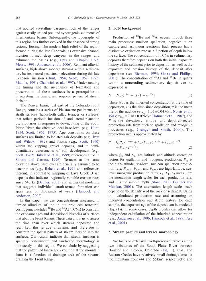
We focus on extensive, well-preserved terraces alongtwo tributaries of the South Platte River betweenBoulder and Golden, Colorado (Fig. 1). Coal andRalston Creeks have relatively small drainage areas atthe mountain front (44 and 55km2, respectively) and

Fig. 1. (A) Shaded-relief map of the Rocky Flats region showing sample locations (circles indicate surface samples, crosses indicate depth profiles)and major surfaces (short dashes; black=Rocky Flats, yellow=Verdos, cyan=Slocum). Long dashes mark the boundary between the Front Rangeand Denver basin. Red star indicates the location of a Lava Creek B deposit above Ralston Creek. Inset map shows the course of each creek to theircommon junction along the South Platte River and the location of a Lava Creek B deposit above the South Platte River (red star in inset map). (B)Profiles of Coal, Ralston, and North and Middle Boulder Creeks; and profiles of Rocky Flats and Verdos along Coal Creek (CC) and Verdos alongRalston Creek (RC). Dashed line shows the boundary between the range and basin. The elevation of the streams at this boundary differs by ∼300m.The Ralston Creek profile at the mountain front has been interpolated across Ralston Reservoir.
267C.A. Riihimaki et al. / Geomorphology 78 (2006) 265–278
exit the mountain front at relatively high elevations(1975 and 1800 m, respectively; Fig. 1B). Severalnearby streams have larger drainage areas within the
range and are more deeply incised into the mountainfront. For example, Boulder Creek, 15km to the north ofCoal Creek, has a 250-km2 drainage basin that extends

268 C.A. Riihimaki et al. / Geomorphology 78 (2006) 265–278
to the glaciated crest of the Front Range and exits themountain front at 1650m. Coal Creek merges withBoulder Creek 38km downstream of the mountainfront and with St. Vrain Creek 50km downstreambefore entering the South Platte River 80km down-stream (Fig. 2). Ralston Creek merges with Clear Creek20km downstream of the mountain front and with theSouth Platte 32km downstream. Thus, the Ralstonchannel network upstream of the confluence of St.Vrain Creek and South Platte River, including segmentsof Clear Creek and South Platte River, has a significantlylarger drainage area than the Coal network upstream ofthe same point.
The Rocky Flats (RF) surface (Scott, 1960)–the mostextensive high surface in this area (Shroba and Carrara,1996)–is best preserved at the mouth of Coal Creek.This broadly concave surface projects into the Denverbasin to an elevation ∼100m above the South PlatteRiver (Scott, 1962). The existing eastern edge of the RFsurface has been incised by up to 75m. However, reliefabove several modern streams monotonically declinestoward the mountain front, where the RF surface mergessmoothly with the Coal Creek channel profile (Fig. 1B).
Lower, gravel-capped terraces in the Denver basinhave been named the Verdos (VRDS), Slocum (SLCM),Louviers and Broadway surfaces (Scott, 1960). Two ofthe best-preserved examples are found between the RFsurface and Ralston Creek, where the VRDS surface is∼45m and the SLCM surface ∼25m above the creek(Fig. 1B).
The gravel caps of the RF, VRDS, and SLCMsurfaces vary in thickness from 1 to 30m because ofrelief on the underlying bedrock; typical gravel
Fig. 2. Drainage areas of the Ralston (black) and Coal (gray) channelnetworks versus distance upstream of where the two networks merge(star). Dashed lines show the location of the mountain front along eachnetwork. Stepped increases in drainage area indicate the confluence oftwo streams.
thickness is 1–5m (Shroba and Carrara, 1996). Despitethe smooth topography of the RF surface, recent detailedmapping of the gravel thickness has revealed paleo-channels filled with as much as 30m of gravel (Knepper,2005). The alluvium tends to be clast-supported andpoorly sorted; clasts within the alluvium range indiameter from ∼1 to 20cm and boulders on the surfacereach 75cm. The RF alluvium is weathered and oxidizedto depths that locally exceed 5m and the upper severalmeters support a series of complex, strongly developedsoils (Van Horn, 1976; Madole, 1991; Birkeland et al.,1999). Sharp, eroded contacts between buried soils andoverlying sediment in this soil sequence suggest that thealluvial deposits have been modified by resurfacingevents involving erosion and redeposition. Buried soilswithin the VRDS alluvium likewise illustrate long-termmodification of the alluvium by Ralston Creek (Birke-land et al., 1999). Periodic burial by loess likely hasoccurred on the RF surface, as it has on other surfaces inthe Rocky Mountain basins (e.g., Hancock et al., 1999).However, presently mappable loess deposits are >25kmeast of the mountain front (Muhs et al., 1999).
4. Conceptual models of terrace dissection
The approximate timing of fluvial incision into theeastern portions of the RF surface can be estimated fromconstraints on the age of VRDS surfaces east of the fieldarea. The gravels that cap these surfaces contain LavaCreek B ash and are therefore ∼640ka (inset of Fig. 1A;Scott, 1962; Izett andWilcox, 1982; Shroba and Carrara,1996). There is an additional Lava Creek B deposit northof Ralston Creek at the mountain front (Fig. 1A; VanHorn, 1976), but it has been reworked and deposited withalluvial fan sediment that has no clear age relationshipwith the neighboring VRDS alluvium (Birkeland et al.,1999). The elevations and ages of the VRDS graveldeposits along the South Platte River imply local incisionrates of 50–100m Ma−1 for the South Platte River since640ka (Izett and Wilcox, 1982; Dethier, 2001). Assum-ing the incision rates have persisted since the earlyPleistocene, the eastern portion of the RF surface waslikely incised and therefore abandoned at ∼1–2Mabased on its projected elevation 100m above the SouthPlatte River.
Incision by the South Platte River into the easternpart of the RF surface at 1–2Ma does not necessarilyindicate that Coal Creek began to incise into the westernportion of the surface at that time. The spatial pattern ofdeclining incision of Coal Creek into the RF surfacetoward the mountain front can be explained by: (i) oneor more headward-propagating waves of incision that

Table 1Location, depth and TCN production-rate correction factors for eachsample
Sample Depth(m) a
Altitude(m)
Longitude(°W)
Latitude(°N)
fspb fmu
b
Rocky FlatsCAR1 9.60±1 1859 105.23 39.91 4.14 2.17CAR2 7.00±1 1859 105.23 39.91 4.14 2.17CAR3 6.30±1 1859 105.23 39.91 4.14 2.17CAR4 1.60±1 1859 105.23 39.91 4.14 2.17CAR5 0.00±1 1859 105.23 39.91 4.14 2.17DPD1 3.76±0.3 1890 105.24 39.89 4.23 2.20DPD2 2.96±0.3 1890 105.24 39.89 4.23 2.20DPD3 2.36±0.3 1890 105.24 39.89 4.23 2.20DPD4 1.96±0.3 1890 105.24 39.89 4.23 2.20DPD5 1.56±0.3 1890 105.24 39.89 4.23 2.20DPD6 1.06±0.3 1890 105.24 39.89 4.23 2.20DPD7 0.61±0.3 1890 105.24 39.89 4.23 2.20DPD8 0.36±0.3 1890 105.24 39.89 4.23 2.20DPD9 0.13±0.3 1890 105.24 39.89 4.23 2.20RF1 0.00±0.1 1934 105.25 39.87 4.36 2.24RF2 0.00±0.1 1933 105.25 39.87 4.35 2.23RF3 0.00±0.1 1933 105.25 39.87 4.35 2.23RF4 0.00±0.1 1932 105.25 39.87 4.35 2.23RF5 0.00±0.1 1932 105.25 39.87 4.35 2.23EL1 0.00±0.1 1890 105.25 39.92 4.23 2.20EL2 0.00±0.1 1890 105.25 39.92 4.23 2.20
VerdosVRDS1 0.00±0.1 1848 105.23 39.84 4.10 2.16VRDS2 0.00±0.1 1835 105.23 39.84 4.06 2.15VRDS3 0.00±0.1 1836 105.23 39.84 4.07 2.15
SlocumSLCM1 0.00±0.1 1793 105.22 39.82 3.94 2.11SLCM2 0.00±0.1 1793 105.22 39.82 3.94 2.11a Depth error from thickness of layer sample and human disturbance
of surface.b After Stone (2000).
269C.A. Riihimaki et al. / Geomorphology 78 (2006) 265–278
have not yet reached the mountain front; or (ii)simultaneous incision along the length of terrace-traversing streams that has been more rapid indownstream reaches. The first scenario permits modi-fication of capping gravel deposits close to the mountainfront during incision of the eastern margin of thepediment, while the second scenario implies a moreuniform date of surface abandonment. The complexseries of buried soils within RF alluvium are consistentwith the first scenario, but there are few additionalconstraints on the spatial pattern of Coal Creek incision.The spatial distribution of capping gravel ages, modeledusing in situ-produced 26Al and 10Be, suggests ageranges for these presently undated surfaces delineatingthe pattern of pediment incision.
5. Sampling scheme
We sampled four sites on the RF surface, and one siteeach on the VRDS and SLCM surfaces (Fig. 1, Table 1)(surfaces mapped by Trimble and Machette, 1979). Siteson RF surface consisted of surface samples and depthprofiles and ranged between 1.5 and 3.7km from themountain front (Fig. 1). The two depth profiles allowedus to examine the possibility of complex histories of thesurface at each site.
Surface samples were collected from the outer rinds(<5cm thick) of surface boulders. From the RF, VRDSand SLCM surfaces, we collected the outer rinds of 4, 3and 2 boulders, respectively. Sample RF5 is anamalgamated sample of 30 pebbles, each 1–5cm indiameter. Sample locations were sufficiently removed(>30m) from the edges of the pediments and terracesthat post-depositional mass wasting and fluvial erosionwere negligible. We sampled upper surfaces of large,Precambrian quartzite boulders that showed no evidenceof recent erosion; upwind sides were commonlyventifacted, indicating lack of boulder rotation. Tominimize the likelihood that sampled rock was onceburied by loess, all surface boulder samples were takenfrom >20cm above the modern ground surface. Giventhe flatness of the topographic surfaces sampled and theirdistances from the range front, topographic shielding atour sample locations was negligible.
Depth profiles included a 4-m profile consisting ofsand and pebbles (collected by D.P. Dethier; referred toas “DPD profile”) and a 10-m profile consisting ofgravel clasts 5–15cm in diameter (collected by C.A.Riihimaki; referred to as “CAR profile”). Given thedifficulty of excavating vertical exposures in graveldeposits, we opportunistically sampled profiles thatwere exposed in mining and engineering operations.
The DPD profile was exposed temporarily duringrealignment of an irrigation canal, while the CARsamples were exposed during gravel mining opera-tions. The original depths of the CAR samples areuncertain because the gravel-pit surface was reworkedduring mining. Based on the elevation of the top of theprofile relative to adjacent, unmodified parts of thegravel cap, up to 2m of surface gravel may have beenremoved. Samples CAR2 and CAR4 were collectedfrom a single vertical exposure, while the othersamples were collected from a stepped exposure on adifferent wall of the gravel pit, ∼20m away. Bothexposures revealed significant weathering in thesubsurface down to depths >4m. We observed noevidence of significant bioturbation in either profile.We also observed no striking textural unconformitiesin the CAR profile and we therefore conclude that the

Table 2Variables used in Eq. (2)
Variable Value-10Be Value-26Al
Pna 5.0±0.3 atoms g−1 year−1 30.4±1.9 atoms g−1 year−1
Pmu,1b 0.09 atoms g−1 year−1 0.72 atoms g−1 year−1
Pmu,2b 0.02 atoms g−1 year−1 0.16 atoms g−1 year−1
Pmu,3b 0.02 atoms g−1 year−1 0.19 atoms g−1 year−1
L0b 160/ρ cm 160/ρ cm
L1b 738/ρ cm 738/ρ cm
L2b 2688/ρ cm 2688/ρ cm
L3b 4360/ρ cm 4360/ρ cm
a From Stone (2000).b From Granger and Muzikar (2001).
270 C.A. Riihimaki et al. / Geomorphology 78 (2006) 265–278
gravel at this location was deposited in several closelyspaced events.
In contrast, changes in color and sand/gravel ratiosin the DPD profile indicate that this profile contains atleast two paleosols, the tops of which are at depths of1.9 and 0.35m. At depths <0.20m, we observed littleweathering, indicating that the gravel is relativelyyoung and likely derived from minor slope washduring historic times. The accumulation of TCNs inthis topmost layer probably occurred prior to deposi-tion at this site, rather than in situ. We conclude thatthe DPD profile includes at least two major and oneminor depositional event.
Based on the samples' field settings (Table 1), we cancalculate the appropriate variables for Eq. (2) (Table 2).We assume that individual clasts are not eroding and thatdepth profiles undergo surface erosion only in rareevents. We also assume that single clasts have a rockdensity of 2.7g cm−3, while gravel deposits have a bulkdensity of 1.89g cm−3 (using a rock density of 2.7gcm−3 and a porosity of 30%).
6. Laboratory methodology
For the DPD profile, samples were processed at theUniversity of Vermont. These sediment samples weresieved to isolate the sand fraction (250–850μm). Forsample DPD9, pebbles with diameters <4cm werecrushed and added to the sand fraction so that sufficientquartz (9 to 40g, μ=34g) was available for analysis.Samples were processed for 10Be and 26Al usingstandard techniques including extraction of the aliquotsfor ICP-AES analysis of stable Al directly from HFsolution before dry down (Bierman and Caffee, 2001).Yields for Be spikes averaged 98% for all samples and,for the two Al blanks associated with these samples, theAl yields were 100.7% and 98.9%. The DPD sampleswere spiked with 250μg of Be carrier and variableamounts of Al carrier to ensure at least 2000μg of Al
were present for analysis. All accelerator mass spectro-metric (AMS) analyses were made at LawrenceLivermore National Laboratory, are referenced tostandards produced by K. Nishiizumi, and are correctedfor ratios measured in blanks processed along with thesamples. Measured ratios ranged from 1.3×10⁻¹² to7.4×10−12 for 10Be/9Be and 7.4×10⁻¹³ to 1.1×10⁻¹¹
for 26Al/27Al. Blank subtractions were minimal, onaverage <1% of the measured ratios. The average, fullypropagated uncertainty of the DPD profile analyses is2.5% and 4.7% for 10Be and 26Al, respectively.
All other samples were processed at University ofCalifornia at Santa Cruz. Samples EL1-2 were processedby G. Hancock in 1998, CAR samples were processed byC. Riihimaki in 2000, and RF, VRDS and SLCM sampleswere processed by C. Riihimaki in 2003. The sampleswere crushed and sieved to 250–500μm (the initial grainsizes are given in Section 5). We used selective chemicaldissolution to separate and purify 15–50g quartz fromthis grain-size fraction (Kohl and Nishiizumi, 1992). Wespiked samples with 0.25–0.5mg of 9Be and 1mg of27Al. For samples processed in 2003, we extractedaliquots for ICP analysis of stable Al directly from HFsolution before dry down; for earlier samples, aliquotswere extracted after dry down. We measured stable Alconcentrations by optical emission spectrometry (ICP-OES) and by mass spectrometry (ICP-MS) at Universityof California at Santa Cruz and assigned 5% error to thesemeasurements.We used standard treatments of HF, HNO3
and HClO4, and separated Al and Be through ionexchange to prepare Be and Al targets for measurementon the Lawrence Livermore National Laboratory accel-erator mass spectrometer. Measured 10Be/Be and 26Al/Alratios were normalized to the ICN 10Be (using a half-lifeof 1.5×10⁶years) and the National Bureau of Standards26Al standards. Measured ratios ranged from 3.65×10⁻¹³
to 1.14×10− 11 for 10Be/9Be and 1.04×10− 14 to1.57×10−11 for 26Al/27Al. Blank subtractions wereminimal, on average <1% of the measured ratios, exceptfor the Al blank subtraction of the CAR-profile measure-ments, which was 8%. The average, fully propagateduncertainty of the CAR-profile analyses is 5.5% and 16%for 10Be and 26Al, respectively. The average, fullypropagated uncertainty of the surface-sample analyses is5.2% and 6.0% for 10Be and 26Al, respectively.
7. Depth profiles
7.1. Results
In both depth profiles, concentrations generallydecrease with depth (Table 3), as expected from the

Table 3TCN concentrations for CAR and DPD profiles
Sample [10Be] (105 atoms/g) [26Al] (106 atoms/g) [26Al]/[10Be]
CAR1 6.14±0.34 0.18±0.05 0.29±0.09CAR2 4.03±0.22 1.07±0.21 2.66±0.54CAR3 5.26±0.29 0.83±0.16 1.59±0.31CAR4 9.59±0.53 3.47±0.25 3.62±0.33CAR5 48.16±2.55 13.90±0.90 2.89±0.24DPD1 7.76±0.25 3.28±0.15 4.23±0.24DPD2 9.83±0.26 4.06±0.19 4.13±0.22DPD3 10.50±0.24 4.05±0.21 3.86±0.22DPD4 12.00±0.28 5.45±0.26 4.54±0.24DPD5 13.10±0.30 6.72±0.32 5.13±0.27DPD6 16.20±0.38 8.71±0.41 5.38±0.28DPD7 23.70±0.70 12.10±0.56 5.11±0.28DPD8 31.90±0.71 16.90±0.79 5.30±0.27DPD9 26.40±0.63 13.90±0.64 5.27±0.27
Fig. 3. Reduced χ2 goodness-of-fit for the DPD profile versus assumederosion rates in the Coal Creek basin for the two-event model. Thisprofile independently constrains the basin-averaged erosion rate at 19±3m Ma−1.
271C.A. Riihimaki et al. / Geomorphology 78 (2006) 265–278
decrease in TCN production rates with depth. Theshallowest sample in the DPD profile is a notableexception, with significantly lower concentrations thanthe subjacent, deeper sample. The low concentrations inthe topmost layer can be explained by relatively recentdeposition, an interpretation that is consistent with thelack of weathering in this layer. The ratio R alsodecreases with depth, although this decrease within theDPD profile is not smooth, abruptly decreasing at adepth of ∼2m, the top of a paleosol. Shallow sampleswithin the DPD profile have a ratio of ∼5, while R indeeper samples is ∼4. The CAR profile has higher 10Beconcentrations at shallow depths than the DPD profile,but lower concentrations at greater depths. R decreasesfrom 3.62 to 1.59, anomalously low values suggestingthat Al was not conserved during processing of theUCSC samples prior to 2003. We therefore interpretages for this profile based only on the 10Beconcentrations.
7.2. Interpretation of depth profiles
The interpretation of exposure ages based on theprofile concentrations requires a numerical model ofgravel deposition and reworking. Gravel deposits onbeveled bedrock surfaces are commonly assumed tohave been emplaced in a single episode; rapiddeposition is assumed to have been followed by aperiod of either stability (Hancock et al., 1999; Perg etal., 2001) or steady erosion (Wolkowinsky and Granger,2004) until sample collection. In contrast, the presenceof paleosols and the complicated 26Al/10Be ratio profileat the DPD site indicate a history that includes more thanone depositional event. We explore a variety ofdepositional scenarios using a numerical model tocalculate the expected TCN concentrations and ratios
in each RF depth profile. For the model, we calculate thetotal surface production rates at the altitude and latitudeof the sample sites to be 20.8–21.9 atoms g−1 year−1 for10Be and 126.6–133.3 atoms g−1 year−1 for 26Al inquartz (Stone, 2000).
We present modeled TCN concentrations and ratiosin the DPD profile for two scenarios: (i) a singleepisode of deposition followed by a long period ofstability and (ii) an episode of deposition, a period ofstability, stripping of the top layer of the deposit anddeposition of new sediment, followed by a secondperiod of stability. For each scenario, the near-surfaceratio of ∼5.3 requires that there has been very recentstripping of the surface as well. We determined thebest overall fit for each profile by minimizing thereduced χ2 value, in which the deviations from the fitwere normalized using measurement uncertainties andwere divided by the degrees of freedom. The timingand the amount of initial stripping and subsequentdeposition, as well as the thickness of recent stripping,were varied systematically over more than 10,000model runs. We did not attempt to include depositionof the shallowest sample in our model because itrepresents a relatively small-scale reworking ofsediment that likely accumulated a significant concen-tration of TCNs prior to the reworking. We neglectthis sample in assessing the model's fit. Wegenerously assign errors of 15% to accommodateanalytical errors (<5%) and uncertainty in modelparameters (e.g., Ninh).
The one- and two-event models allow calculation ofthe inherited concentration Ninh and an initial

272 C.A. Riihimaki et al. / Geomorphology 78 (2006) 265–278
concentration ratio because the model fit is sensitive tothe inherited TCN concentrations (Fig. 3). Aninherited 10Be concentration of 9.9×10⁵ atoms g−1
quartz and an initial concentration ratio 26Al/10Be of6.05 produce the best fit to the data in both the one andtwo event models, values consistent with a basin-averaged erosion rate of 19±3m Ma−1 at a meanelevation of 2500m in the headwaters of the Coal Creekcatchment. If the erosion rate is either doubled orhalved, the model cannot adequately fit the concentra-tion and R profiles simultaneously, resulting in high χ2
values. The 19-m Ma−1 erosion rate is consistent withHolocene erosion rates of neighboring Deer Creek, 21.9±1.3m Ma−1, constrained by 10Be concentrations inmodern sediments (Dethier et al., 2002). The DeerCreek catchment is comparable to Coal Creek in size,elevation, and lithology. Modern Coal Creek sediment isunsuitable for a similar erosion rate analysis becausesignificant human development in the headwaters haspotentially affected the source of modern streamsediment and therefore 10Be concentrations in modernsediment.
For the single-age scenario, the TCN data are best fitby a surface age of 780±115ka, with 1.2±0.2m ofrecent stripping. Although this model adequatelyreproduces the concentration profiles (Fig. 4A), it failsto reproduce the strong gradient in R and the distinctpaleosol at 2-m depths (Fig. 4B). The two-event model(Figs. 4 and 5) succeeds in reproducing this feature. In
Fig. 4. (A) Concentrations of 10Be (gray circles) and 26Al (black squares) in(dashed) and two-age model (solid). (B) 26Al/10Be data from DPD profile wreduced χ2 goodness-of-fit for the DPD profile as a function of age of the shalis shown with star. The contour interval is 1.0.
the two-step model, we iteratively solve for two ages(for samples below and above 2-m depth) and thethickness of gravel removed during the two hypothe-sized stripping events. The best-fitting age of the lowergravels is 930±140ka, while that for the upper 2m is550±80ka. Because exposure of the paleosurface from930 to 550ka to cosmic rays would have generated TCNconcentrations at the paleosurface significantly greaterthan inherited concentrations, a 3.1-m layer of gravelmust have been removed prior to the second deposi-tional event to prevent anomalously high nuclideconcentrations at the 2-m horizon. Deposition withoutstripping the surface layer would have preserved highTCN concentrations at the 2-m horizon, with lower TCNvalues below and above that horizon. We calculate thatthe younger deposit was originally 3m thick and wassubsequently stripped by 1m, possibly by loessdeflation.
The history of the CAR profile is less well constrainedbecause of the wide vertical spacing of samples andbecause Al likely was lost during laboratory analysis.Assuming that the deposited sediment had the sameinherited concentrations as the DPD sediment, the verylow 10Be concentrations in deep samples suggest that thebase of the profile is >1Ma. Our best-fitting, single-agemodel (Fig. 6) suggests a surface age of 2.1±0.3Mawithrecent surface stripping of 1.7m. This recent strippingcould in fact be from the mining operations, but couldalternatively be from erosion of a loess cap. Lack of
the DPD profile with best-fitting profiles from the single-age modelith best-fitting profiles from both models. (C) Contour plot showing
low (<2-m depth) sediment and depth of stripping event at 0 ka. Best fit

Fig. 5. (A) Schematic plot of the evolution of the RF surface elevation through time, showing two major depositional events and two stripping events.(B–D) Modeled evolution of 10Be (black) and R (gray) for the DPD profile, with (B) deposition at 930ka and stasis from 930 to 550ka, (C) strippingof 3.1m and deposition of 2.9m at 550ka followed by stasis from 550 to 0ka, and (D) stripping of 1.0m at 0ka. Dashed lines show the initial values of10Be and R for each time period, while solid lines show values at the end of the period. Gray boxes show layer of gravel stripped at the end of eachperiod.
273C.A. Riihimaki et al. / Geomorphology 78 (2006) 265–278
reliable 26Al measurements prevents the testing of morecomplex depositional histories at this site.
8. Surface clasts
8.1. Results
Concentrations of 10Be in RF surface samples were108±25 (105 atoms) g−1, higher than 10Be concentra-tions in VRDS and SLCM samples, which were 65±10(105 atoms) g−1 and 53±5 (105 atoms) g−1, respectively(Table 4). The concentration ratio 26Al/10Be (R) is 4.9±0.9 for RF samples, very similar to the VRDS andSLCM values of 5.0±0.7 and 5.2±0.6, respectively.There is no discernable trend in concentrations based onthe height of the boulder sampled; RF5, the amalgam-
ated-pebble sample had the second highest 10Beconcentration and an intermediate ratio, R. Except forthe EL samples, we consider 26Al measurements ofthese samples to be more reliable than the measurementsfor CAR profiles, because ICP aliquots were extractedprior to dry down for the surface samples.
8.2. Interpretation
The calculation of exposure ages of these surfacesamples requires knowledge of the inherited concentra-tions of TCNs and the exposure history of the samples.The DPD profile indicates that Ninh in the Coal Creekdrainage is set on average by the basin-averaged erosionrate of 19±3m Ma−1. However, individual clastssampled on the surface may have experienced a

Fig. 6. (A) 10Be concentrations in CAR profile with best-fitting model profile for single-age case. The samples came from two exposures(distinguished by open and closed symbols). (B) Contour plot showing reduced χ2 goodness-of-fit for the CAR profile as function of age of the profileand depth of the recent stripping event. Best fit is shown with star. The contour interval is 0.1.
274 C.A. Riihimaki et al. / Geomorphology 78 (2006) 265–278
significantly higher or lower erosion rate prior totransport to and deposition at the mountain front, andtherefore may have a significantly different value ofNinh. Individual clasts may likewise have been buried byvarying thicknesses of sediment during their exposurehistory. To constrain the exposure ages and burial depthsof the RF boulders, we model the evolution of 10Beconcentrations and R values in clasts buried at fixeddepths ranging from 0 to 2m (Fig. 7). We assume that
Table 4TCN concentrations and exposure ages for surface samples
Sample [10Be] (105
atoms g−1)[26Al] (106
atoms g−1)[26Al]/[10Be]
Rocky FlatsRF1 77.90±3.98 40.50±2.31 5.20±0.40RF2 144.00±7.34 69.60±3.98 4.83±0.37RF3 93.40±4.82 45.20±2.58 4.84±0.37RF4 107.00±5.54 53.70±3.07 5.02±0.39RF5 124.00±6.36 60.30±3.44 4.86±0.37EL1 82.35±2.73 26.98±0.95 3.28±0.16EL2 129.60±6.80 81.15±2.86 6.26±0.40Average±1σ 108.32±25.15 53.92±18.30 4.90±0.88
VerdosVRDS1 54.25±2.80 23.74±1.35 4.38±0.34VRDS2 67.09±3.48 31.65±2.04 4.72±0.39VRDS3 74.44±3.86 42.95±2.45 5.77±0.44Average±1σ 65.26±10.22 32.78±9.66 4.95±0.73
SlocumSLCM1 56.30±2.92 26.84±2.01 4.77±0.43SLCM2 49.41±2.56 27.59±1.58 5.58±0.43Average±1σ 52.86±4.87 27.21±0.53 5.17±0.58
the burial depths remain constant throughout theexposure of the clasts. We use three different basin-averaged erosion rates to achieve results that span awide range of possible values of Ninh. By comparing the10Be concentrations and R values for RF samples to themodel results, we determine a range of possibleexposure ages and burial depths for the samples (Fig. 7).
Exposure ages of surface boulders and the amalgam-ated pebble sample from the RF surface based on ratios26Al/10Be versus 10Be concentrations range from 400 to1000ka, with average burial depths of <0.6m (Fig. 7).The ages indicate that these boulders were depositedduring the time when the DPD profile was deposited andmodified (1–0.5Ma). Because the RF samples were at0-m depth at the time of collection, the sedimentarycover would have been removed recently, possibly byloess deflation. Our interpretation of recent stripping ofsediment from above these samples is consistent withour interpretation that 1–2m of sediment has beenstripped recently from above the DPD and CARprofiles. The EL samples have 10Be concentrationsthat fall within the range of RF values, indicating thatthese samples are likely the same age. However, becausethe 26Al values are unreliable, we cannot fully analyzethe depositional history of these samples.
The TCN concentrations of the few VRDS andSLCM samples are lower than they are in RF samples,consistent with the relative dating of these deposits asyounger than the RF deposits. However, low R ratios ofsome of these samples and high R ratios for othersindicate that their exposure history on these surfacesmay be complex. Assuming that these samples have also

Fig. 7. Modeled evolution of 10Be concentrations and 26Al/10Be ratiosfor clasts that are deposited on the RF surface with inheritedconcentrations set by basin-averaged erosion rates in the headwatersof (A) 5mMa−1, (B) 19mMa−1 and (C) 100mMa−1. Solid lines showthe trajectories of clasts at fixed burial depths of 0–2m (0.4-mintervals) and dashed lines indicate 200-kyr isochrons. RF samples(triangles) plot at 400–1000ka and burial depths <0.6m.
Fig. 8. Schematic maps of (A) alluvium ages and (B) thicknesses ofrecently stripped sediment on the Rocky Flats surface (see Fig. 1 forsymbols). Dashed contour lines in (A) show the progressive incision ofCoal Creek, with ages indicating the approximate time that streamsbegan to incise at that location. Dashed contour lines in (B) showincreasing sedimentary thicknesses away from the mountain front.
275C.A. Riihimaki et al. / Geomorphology 78 (2006) 265–278
experienced a 19-m Ma−1 erosion rate in the RalstonCreek headwaters and that they were buried by 0.5m ofsediment after deposition at the mountain front, theexposure ages are∼500–1000ka for the VRDS samplesand ∼600–700ka for the SLCM samples. Assuming no
burial, these ages drop to 200–400ka and 200–300ka,respectively.
9. Surface ages
We conclude that the alluvial history of the RFsurface is complicated; no single age is appropriate forthe entire deposit at some sites, nor may one assign asingle age for the entire surface (Fig. 8A). Lava Creek Bash deposits that constrain the age of the VRDS surfaceand hence the incision rate of the South Platte Riversuggest incision into the eastern part of the RF surfacebegan 1–2Ma. Our modeling of the CAR profile, whichis at our sample site farthest downstream along CoalCreek, suggests that alluvium in this region is ∼2Ma,corresponding to the timing of the South Platte Riverincision into the RF surface. The base of the DPDprofile, 4 km upstream from the CAR site, appears todate from ∼1Ma, while the upper 2 m is ∼0.5Ma.This second event, which entails both stripping andredeposition of ∼3m of gravel, suggests that westernportions of the RF surface continued to be reworked by

276 C.A. Riihimaki et al. / Geomorphology 78 (2006) 265–278
Coal Creek well after incision had abandoned sitesfarther east. Surface boulders on the western portion ofthe RF likewise have exposure ages consistent withdeposition well after the South Platte River beganincision into the distal reaches of the RF surface. Theseboulders could have been deposited during the sameevents that deposited the DPD profile. Finally, themodern Coal Creek remains unincised into the RFsurface at the mountain front. These results andobservations strongly suggest that the RF surface hasbeen progressively abandoned from east to west,reflecting headward propagation of an incision wavealong Coal Creek.
Modeling of burial histories of depth profiles andsurface clasts suggests that the RF surface has beenrecently stripped of sediment, with thicknesses ofstripped sediment increasing to the east, away fromthe mountain front (Fig. 8B). Although it is possible thathuman activity removed some sediment, particularlyabove the CAR profile, it is also possible that the RFsurface was once covered by loess that has only recentlybeen eroded. Loess deflation likely explains thestripping of sediment above the DPD profile and surfacesamples. The potential for recent anthropogenic and/ornatural surface modification should therefore be con-sidered when calculating the exposure ages of depositswithin the Denver basin, even for deposits near themountain front.
TCN concentrations in modern Coal Creek sediment(Dethier et al., 2002) and our calculated inheritedconcentrations from the DPD profile indicate that theCoal Creek catchment upstream of the RF surface has asignificantly lower average erosion rate (∼20m Ma−1)than local rates of stream incision by the South PlatteRiver (50–100m Ma−1; Dethier, 2001). These resultsstrongly suggest that the Front Range–Denver basinregion is not a steady-state landscape (Willett andBrandon, 2002) but is evolving transiently, with highesterosion rates in the basin (Anderson et al., 2006). This isconsistent with a model of stream incision in whichwaves of incision propagate upstream from the basininto the range, with the rate of propagation tied tohydrographic characteristics and size of individualtributaries. For the Coal Creek catchment, the incisionhas yet to propagate into the Front Range, resulting in asteady, low erosion rate of the headwaters since at least1Ma.
The incision history of Ralston Creek remainsrelatively unconstrained, but further dating of theVRDS and SLCM surfaces should indicate whetherRalston Creek has also experienced headward incision.Given that Ralston Creek has incised 150m deeper at the
mountain front than Coal Creek, Ralston Creek appearsto have a greater ability to incise than Coal Creek at themountain front. The more rapid incision by RalstonCreek than by Coal Creek may be the result of Ralston's20% larger drainage area at the mountain front andconsistently larger drainage area downstream (Fig. 2).This result is consistent with stream incision models inwhich stream power, which is proportional to drainagearea, controls the rate of erosional-wave propagation(e.g., Tucker and Whipple, 2002). An erosional wavebeginning at the common downstream points of the Coaland Ralston Creek networks (Fig. 2) would propagatemore rapidly upstream along the Ralston Creek networkbecause of its higher discharge, while the wave wouldpropagate relatively slowly along the Coal Creeknetwork. This effect is further enhanced if there existsa threshold of stream power (hence of drainage area)required for channel incision, effectively making therelationship between incision and basin area nonlinearfor small drainage areas. Other possible explanationsinclude subtle interbasin differences in lithology,precipitation patterns, and sediment transport.
10. Conclusions
TCN-based ages of the Rocky Flats, Verdos andSlocum surfaces may be explained by differentialincision of tributaries in response to an eroding trunkstream. The profiles of streams draining the Front Rangeand Denver basin are transiently adjusting to the SouthPlatte River that began incising into the eastern portionof the RF surface ∼1–2Ma. Upstream propagation ofincision waves causes diachronous abandonment ofpediments near the mountain front, suggesting that nosingle age is appropriate for these extensive surfaces.Modeling of TCN depth profiles suggests that individ-ual sites have complex depositional histories likelyinvolving multiple depositional and stripping events.Because the time of abandonment of a given surface isdetermined by the power of its associated stream,surfaces at the same elevation above two differentstreams should not necessarily have the same age.Finally, as a corollary to these observations, we note thatthe persistence of an extensive remnant of the RFsurface results from the small area and thus low streampower of Coal Creek.
Acknowledgements
This work was supported by a grant from theNational Science Foundation (EAR-0003604), an NSFGraduate Student Fellowship (to CAR) and a University

277C.A. Riihimaki et al. / Geomorphology 78 (2006) 265–278
of California Presidential Postdoctoral Fellowship (toEBS). LLNL work was done under the auspices of theU.S. Department of Energy under Contract No. W-7405-Eng-48. We thank Stephanie Kampf, Greg Stock,Mary Elizabeth Smith, Jennifer Ha, Graham Gilbert,Niels Zellers, Taylor Schildgen and Marc Caffee fortheir assistance. Comments by Darryl Granger, NoahSnyder and two anonymous reviewers greatly improvedthis manuscript.
References
Anderson, R.S., Repka, J.L., Dick, G.S., 1996. Explicit treatment ofinheritance in dating depositional surfaces using in situ Be-10 andAl-26. Geology 24 (1), 47–51.
Anderson, R.S., Riihimaki, C.A., Safran, E.B., MacGregor, K.R, 2006.Facing reality: late Cenozoic evolution of smooth peaks, glaciallyornamented valleys and deep river gorges of Colorado's FrontRange. In: Willett, S.D., Hovius, N., Brandon, M.T., Fisher, D.M.(Eds.), Tectonics, Climate, and Landscape Evolution. GeologicalSociety of America Special Publication, vol. 398. GeologicalSociety of America, Boulder, CO. Chapter 25.
Bierman, P.R., 1994. Using in situ produced cosmogenic isotopes toestimate rates of landscape evolution: a review from thegeomorphic perspective. Journal of Geophysical Research 99(B7), 13885–13896.
Bierman, P.R., Caffee, M.W., 2001. Slow rates of rock surface erosionand sediment production across the Namib Desert and escarpment,southern Africa. American Journal of Science 301, 326–358.
Birkeland, P.W., Miller, D.C., Patterson, P.E., Price, A.B., Shroba,R.R., 1999. Soil-geomorphic Relationships Near Rocky Flats,Boulder and Golden, Colorado Area, with a Stop at the Pre-Fountain Formation Paleosol of Wahlstrom (1948). GeologicalSociety of America Field Trip, vol. 18. 13 pp.
Chadwick, O.A., Hall, R.D., Phillips, F.M., 1997. Chronology ofPleistocene glacial advances in the central Rocky Mountains.Geological Society of America Bulletin 109 (11), 1443–1452.
Dethier, D.P., 2001. Pleistocene incision rates in the western UnitedStates calibrated using Lava Creek B tephra. Geology 29 (9),783–786.
Dethier, D.P., Ouimet, W.B., Bierman, P.R., Finkel, R.C., 2002. Long-term erosion rates derived from 10Be in sediment from smallcatchments, northern Front Range and southern Wyoming.Abstracts with Programs - Geological Society of America 34 (6),409.
Dickinson, W.R., Klute, M.A., Hayes, M.J., Janecke, S.U., Lundin,E.R., McKittrick, M.A., Olivares, M.D., 1988. Paleogeographicand paleotectonic setting of Laramide sedimentary basins in thecentral Rocky-Mountain region. Geological Society of AmericaBulletin 100 (7), 1023–1039.
Epis, R.C., Chapin, C.E., 1975. Geomorphic and tectonic implicationsof the post-Laramide, late Eocene erosion surface in the southernRocky Mountains. In: Curtis, B.F. (Ed.), Cenozoic History of theSouthern Rocky Mountains. Geological Society of AmericaMemoir, vol. 144, pp. 45–74. Geological Society of America,Boulder, CO.
Gosse, J.C., Phillips, F.M., 2001. Terrestrial in situ cosmogenicnuclides: theory and application. Quaternary Science Reviews 20(14), 1475–1560.
Granger, D.E., Muzikar, P.F., 2001. Dating sediment burial with insitu-produced cosmogenic nuclides: theory, techniques, andlimitations. Earth and Planetary Science Letters 188, 269–281.
Granger, D.E., Smith, A.L., 2000. Dating buried sediments usingradioactive decay and muogenic production of Al-26 and Be-10. Nuclear Instruments and Methods in Physics Research.Section B, Beam Interactions with Materials and Atoms 172,822–826.
Hancock, G.S., Anderson, R.S., 2002. Numerical modeling of fluvialstrath-terrace formation in response to oscillating climate.Geological Society of America Bulletin 114 (9), 1131–1142.
Hancock, G.S., Anderson, R.S., Chadwick, O.A., Finkel, R.C., 1999.Dating fluvial terraces with Be-10 and Al-26 profiles: applicationto the Wind River, Wyoming. Geomorphology 27 (1–2), 41–60.
Hofmann, H.J., Beer, J., Bonani, G., Vongunten, H.R., Raman, S.,Suter, M., Walker, R.L., Wolfli, W., Zimmermann, D., 1987. Be-10—half-life and AMS-standards. Nuclear Instruments and Methodsin Physics Research. Section B, Beam Interactions with Materialsand Atoms 29 (1–2), 32–36.
Hunt, C.B., 1954. Pleistocene and recent deposits in the Denver area,Colorado. U.S. Geological Survey Bulletin 996-C, 91–140.
Izett, G.A., Wilcox, R.E., 1982. Map showing localities and inferreddistributions of the Huckleberry Ridge, Mesa Falls, and LavaCreek ash beds (Pearlette family ash beds) of Pliocene andPleistocene age in the western United States and southern Canada.U.S. Geological Survey Miscellaneous Investigations Series MapI-1325.
Knepper, D.H., 2005. Bedrock erosion surface beneath the Rocky Flatsalluvial fan, Jefferson and Boulder Counties, Colorado. TheMountain Geologist 42 (1), 1–10.
Kohl, C.P., Nishiizumi, K., 1992. Chemical isolation of quartz formeasurement of in situ-produced cosmogenic nuclides. Geochi-mica et Cosmochimica Acta 56 (9), 3583–3587.
Madole, R.F., 1991. Quaternary geology of the northern GreatPlains: Colorado Piedmont section. In: Morrison, R.B. (Ed.),Quaternary Nonglacial Geology: Conterminous U.S. GeologicalSociety of America The Geology of North America K-2,Boulder, CO, pp. 456–462.
Mears Jr., B., 1993. Geomorphic history of Wyoming and high-levelerosion surfaces. In: Snoke, A.W., Steidtmann, J.R., Roberts, S.M.(Eds.), Geology of Wyoming. Geological Survey of WyomingMemoir, vol. 5, pp. 608–626.
Muhs, D.R., Aleinikoff, J.N., Stafford, T.W., Kihl, R., Been, J.,Mahan, S.A., Cowherd, S., 1999. Late Quaternary loess innortheastern Colorado: Part I. Age and paleoclimatic significance.Geological Society of America Bulletin 111 (12), 1861–1875.
Norris, T.L., Gancarz, A.J., Rokop, D.J., Thomas, K.W., 1983. Half-life of Al-26. Journal of Geophysical Research 88, B331–B333.
Perg, L.A., Anderson, R.S., Finkel, R.C., 2001. Use of a new Be-10and Al-26 inventory method to date marine terraces, Santa Cruz,California, USA. Geology 29 (10), 879–882.
Reheis, M.C., Palmquist, R.C., Agard, S.S., 1991. Quaternary historyof southern and central Rocky Mountain basins: Bighorn basin. In:Morrison, R.B. (Ed.), Quaternary Nonglacial Geology: Contermi-nous U.S. Geological Society of America The Geology of NorthAmerica K-2, pp. 409–416.
Scott, G.R., 1960. Subdivision of the Quaternary alluvium east of theFront Range near Denver, Colorado. Geological Society ofAmerica Bulletin 71, 1541–1543.
Scott, G.R., 1962. Geology of the Littleton Quadrangle, Jefferson,Douglas, and Arapahoe Counties, Colorado. U.S. GeologicalSurvey Bulletin 1121-L, 1–53.

278 C.A. Riihimaki et al. / Geomorphology 78 (2006) 265–278
Scott, G.R., 1975. Cenozoic surfaces and deposits in the southernRocky Mountains. In: Curtis, B.F. (Ed.), Cenozoic History of theSouthern Rocky Mountains. Geological Society of AmericaMemoir, vol. 144, pp. 227–248. Geological Society of America,Boulder, CO.
Shroba, R.R., Carrara, P.E., 1996. Surficial Geologic Map of theRocky Flats Environmental Technology Site and Vicinity,Jefferson and Boulder Counties, Colorado. U.S. GeologicalSurvey.
Stone, J.O., 2000. Air pressure and cosmogenic isotope production.Journal of Geophysical Research-Solid Earth 105, 23753–23759.
Trimble, D.E., Machette, M.N., 1979. Geology of the Greater DenverArea, Front Range Urban Corridor, Colorado. U.S. GeologicalSurvey.
Tucker, G.E., Whipple, K.X., 2002. Topographic outcomes predictedby stream erosion models: sensitivity analysis and intermodelcomparison. Journal of Geophysical Research-Solid Earth 107(B9) (art. no.-2179).
Van Horn, R., 1976. Geology of the golden quadrangle, Colorado. U.S.Geological Survey Professional Paper 872 (116 pp.).
Willett, S.D., Brandon, M.T., 2002. On steady states in mountain belts.Geology 30 (2), 175–178.
Wolkowinsky, A.J., Granger, D.E., 2004. Early Pleistocene incision ofthe San Juan River, Utah, dated with Al-26 and Be-10. Geology32, 749–752.